|
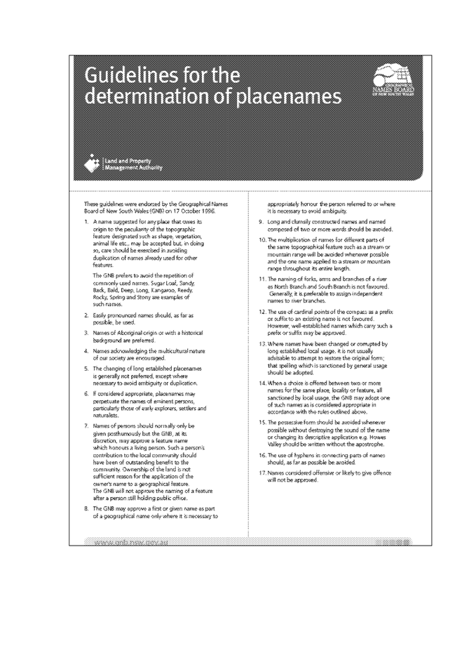
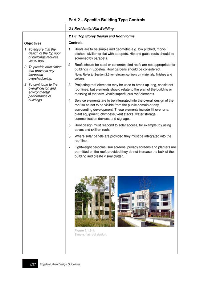
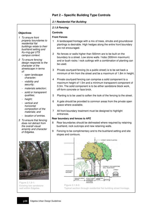
APPENDIX No: 1 - 2012 NSW Local Government Aboriginal Network Conference - Merit Awards Nomination Form - held in Grafton 15 - 17 August 2012 |
|
Item No: GB.2 |

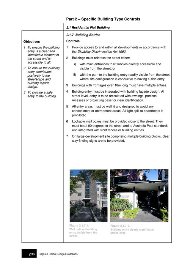
Ordinary Meeting of Council
TO BE HELD ON Tuesday, 12 June 2012 AT 7.00pm
Level 3 Council Chambers
Agenda
** ** ** ** ** **
NOTE: For Full Details, See Council’s Website –
www.kmc.nsw.gov.au under the link to business papers
DECLARATIONS OF INTEREST
Confirmation of Reports to be Considered in Closed Meeting
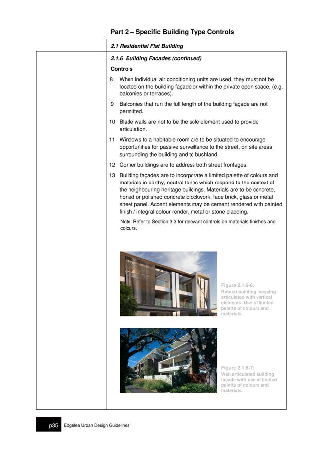
Address the Council
NOTE: Persons who address the Council should be aware that their address will be tape recorded.
Documents Circulated to Councillors
CONFIRMATION OF MINUTEs
Minutes of Ordinary Meeting of Council 9
File: S02131
Meeting held 22 May 2012
Minutes numbered 124 to 142
minutes from the Mayor
MM.1 Relocation of HMS Sirius Sculpture - Portsmouth, England 35
File: S03603
I was recently contacted by Stephen Bailey, Head of Cultural Services from the City of Portsmouth, England about the relocation of the HMS Sirius sculpture.
An exact replica of the sculpture currently situated in Bicentennial Park, West Pymble, the HMS Sirius was sent to Portsmouth where the First Fleet set sail to Australia in 1787. It was a gift from the people of Australia given by the Municipality of Ku-ring-gai and supported by the City of Sydney. It was presented to the citizens of Portsmouth on 13 May 1991.
Ku-ring-gai Council commissioned Victor Cusack to design and build the bronze HMS Sirius sculpture, which was completed in 1988.
Mr Bailey wrote to inform me the sculpture has been relocated to a prime new spot next to the harbour entrance at Gunwharf Quays.
The lovely sculpture was previously in the main shopping arcade in the centre of Portsmouth, but they felt that location was not showing the work in the most suitable environment or informed position.
As a key part of the recognition of the role Portsmouth played as the departure point for the First Fleet on 13 May 1787, the City of Portsmouth felt it would be more appropriate if the work was moved nearer to the entrance to the harbour, one side of which still has a very similar outlook to that which our ancestors would have seen 225 years ago.
Gunwharf Quays has very kindly agreed to host the sculpture and are currently fabricating a new base to enable the work to be displayed at its best.
Alderman Syd Rapson, who was the Lord Mayor of Portsmouth at the time of the original unveiling in 1991 and the Chair of the Portsmouth branch of the Britain Australia Society, Mr Brian Hall have also been involved.
On 18 May I attended a meeting of the Arthur Phillip Chapter of the Fellowship of First Fleeters held at the Old Gordon School meeting rooms. Chapter members, especially those who have previously visited Portsmouth, thoroughly supported the new location for the sculpture.
Sculpture Victor Cusack, who is due to visit England, intends to inspect the relocated work on 5 September.
Victor Cusack was present in Portsmouth for the original unveiling of his work twenty years ago. Coincidentally, he will be in England later this year and arrangements have now been made for him to inspect the relocated sculpture on 5 September.
I am very pleased this important sculpture has been given a fitting home and would like to thank the City of Portsmouth and all involved in the sculpture’s relocation.
MM.2 National Disability Insurance Scheme - NDIS 37
File: S02119
In November I brought Council’s attention to the announcement by the Productivity Commission’s report for the Federal Government into an Australian Government funded Disability Care and Support Scheme (a.k.a. “a National Disability Insurance Scheme – NDIS”).
As part of its report the Commission said “The current disability support system is underfunded, unfair, fragmented, and inefficient. It gives people with a disability little choice, no certainty of access to appropriate supports and little scope to participate in the community”.
It was noted that a significant number of people in Ku-ring-gai have much to gain from the proposed NDIS. According to the latest ABS Census data, Ku-ring-gai has close to 3000 residents who indicated they required assistance in their day to day activities because of a disability, long-term health condition, or old age.
The following recommendation was carried unanimously:
That Council show its official support for the establishment of a “National Disability Insurance Scheme” by promoting the campaign through Council’s website and relevant newsletters, and through the issuing of a media release to this effect.
That the Mayor on behalf of Council make representations to all relevant Commonwealth and State Ministers and Members of Parliament urging their support for the National Disability Insurance Scheme.
I am pleased to report that the Federal Treasurer announced in the recent budget that the Government has committed $1.0 billion over four years for the first stage of the National Disability Insurance Scheme (NDIS), to be established in up to four locations from 2013–14. The locations will be determined through negotiations between the Australian Government and the states and territories. In its first year, the NDIS will provide care and support for up to 10 000 people with significant and permanent disability. This will increase to 20 000 people from 2014–15.
I can also report, at its latest meeting, the NSROC board supported a motion by Willoughby Council to show support for the NDIS by writing to the Prime Minister and Federal Opposition Leader urging the introduction be expedited as a matter of urgency.
MM.3 Home and Community Care Services in Ku-ring-gai 39
File: S02119
I have been approached by a number of residents recently about the dire state of Home and Community Care services in the Ku-ring-gai region. Home and Community Care services assist frail older people to remain independently in their own home for as long as possible and thereby reducing the likelihood of premature admission to a residential facility.
The aged care sector is undergoing significant changes at present with the responsibility for funding of Home and Community Care programs moving from the NSW Department of Ageing Disability and Home Care to the Commonwealth Department of Health and Ageing (DoHA). From July 2012 the Commonwealth will assume full funding and operational responsibility for aged care services. I feel that there is not enough funding for these support services for residents in the Ku-ring-gai region. Apart from long waiting lists (if you are lucky enough to be on one), Ku-ring-gai has the highest proportion (with the exception of Hunters Hill) of its population over 65 years in the Sydney Metropolitan Area.
In exploring this issue, I have become very concerned about the inequitable funding across the region for HACC services. There is an expressed need for a linen service from people unable to change and launder their own bed sheets, pillow cases etc. Unfortunately the Ku-ring-gai area does not have access to a dedicated service. I have discovered that in Northern Sydney there are only 3 stand alone linen services. As an alternative to a linen service, eligible residents may be able to have their linen changed if they are in receipt of a HACC service, specifically domestic assistance. Generally the maximum service they are able to access is 2 hours per fortnight. Currently there are no vacancies for domestic assistance anywhere in Ku-ring-gai and waiting lists have been closed since January 2012. This is unacceptable for the many residents in need.
Transport is another area of great concern for those wishing to stay living independently in their own homes. Getting to and from medical appointments or being able to do your own shopping or keeping up social contacts are essential activities and are the foundation of being able to remain living independently in the community. The Hornsby Ku-ring-gai Community Transport organisation based in Turramurra provides a terrific transport service to local residents including bus, individual cars and a subsidised taxi service. Recently they placed a ceiling on the subsidised taxi trips of 300km per annum and only for medical appointments. Since its inception in 2008 the total passenger trips have increased from 893 to an expected 40,000 in this year. This alone demonstrates the incredible demand for this service and the importance it plays in helping the more vulnerable members of our community.
Clients who need more complex care can be referred for assessment to the Aged Care Assessment Team (ACAT) at Hornsby Hospital. Following this assessment they may be eligible for a Community Aged Care Package (CACP) or an Extended Aged Care at Home Package (EACH). These packages typically provide registered nursing care, personal care, transport or home help etc. Discussions with the Aged Care Assessment Team Manager for this region highlighted that the turn over on the waiting lists for both Community Aged Care Packages and Extended Aged Care at Home Packages is extremely slow. The vacancy rates are averaging only 1 per month so the majority of applicants either go into care or make alternative arrangements.
The following table provides an indicative numbers on waiting lists and the average period before a client will get a package:
|
SERVICE TYPE |
NUMBER ON WAITING LIST |
TIME ON WAITING LIST |
|
CACP |
195 |
> 4- 6 months |
|
Dementia CACP |
30 |
> 4- 6 months |
|
Chinese CACP |
4 |
> 12 months |
|
EACH |
131 |
> 1-2 years |
|
EACH D |
5 |
< 6 months |
|
Chinese EACH |
15 |
> 1- 2 years |
The demand for home support services is certain to increase due to our ageing population and policies at both State and Commonwealth Government level encouraging ageing in place. Demand for services is currently outstripping supply in a number of services areas and likely to continue in the future. Council needs to take a proactive stance and lobby our local members of parliament and relevant government departments to address the issue of undersupply of services critical to the wellbeing of our residents.
Petitions
Recommendations from Committee
RC.1 Minutes of Ku-ring-gai Traffic Committee 41
File: CY00022/4
Meeting held 1 December 2011
Minutes numbered KTC17 to KTC19
GENERAL BUSINESS
i. The Mayor to invite Councillors to nominate any item(s) on the Agenda that they wish to have a site inspection.
ii. The Mayor to invite Councillors to nominate any item(s) on the Agenda that they wish to adopt in accordance with the officer’s recommendation allowing for minor changes without debate.
GB.1 Contractual Conditions of Senior Staff 46
File: S03271
To report to Council on the contractual conditions of senior staff in accordance with Section 339 of the Local Government Act 1993.
Recommendation:
That Council receive and note the report.
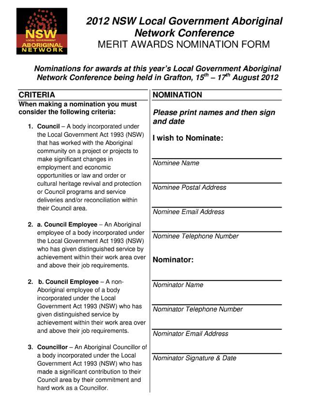
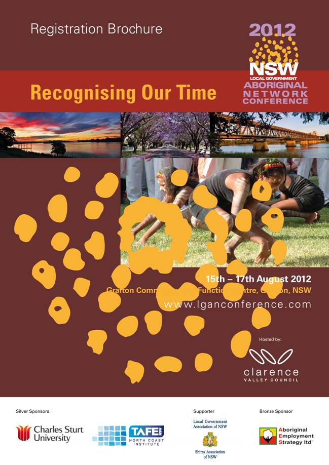
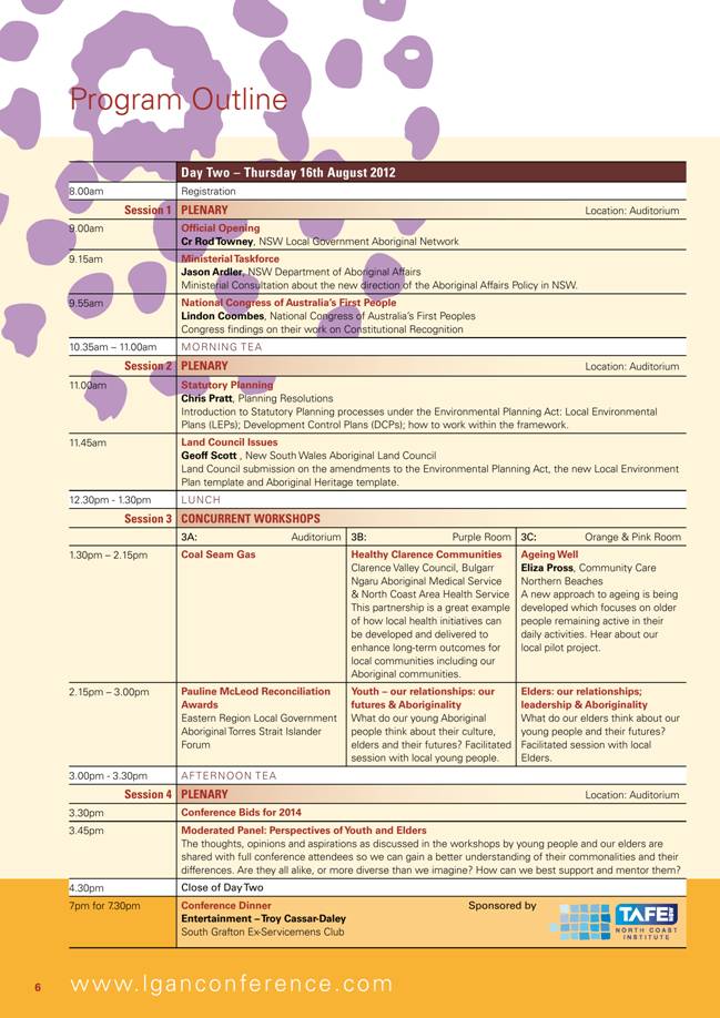
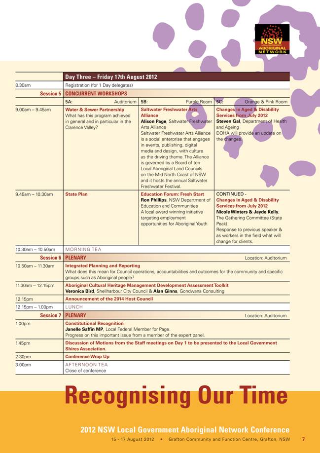
GB.2 NSW Local Government Aboriginal Network Conference 2012 49
File: S02414
To advise Council of the NSW Local Government Aboriginal Network Conference 2012.
Recommendation:
That any Councillors interested in attending the NSW Local Government Aboriginal Network Conference 2012 advise the General Manager by Friday, 29 June 2012.
GB.3 8 Telegraph Road, Pymble - Demolition of Existing In-ground Pool and Construction of New In-ground Pool 66
File: DA0032/10
Ward: St Ives
Applicant: Glendinning Minto & Associates Pty Ltd
Owner: Mr G J Cox
Demolition of existing in-ground pool and construction of a new in-ground pool
Recommendation:
Approval.
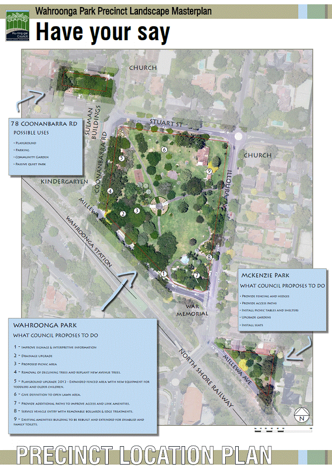
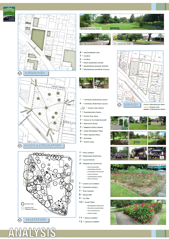
GB.4 Wahroonga Park Precinct Draft Landscape Masterplan 97
File: S04480
To seek Council's approval to place the Wahroonga Park Precinct draft Landscape Masterplan (encompassing Wahroonga Park, McKenzie Park and 78 Coonabarra Road) on public exhibition.
Recommendation:
That Council place the Wahroonga Park Precinct draft Landscape Masterplan on public exhibition for a minimum of 28 days including an exhibition and information session to be held in Wahroonga Park on a suitable weekend to enable community dialogue with Council staff. Also that the amended plan incorporating community comment be reported back to Council for consideration and adoption.
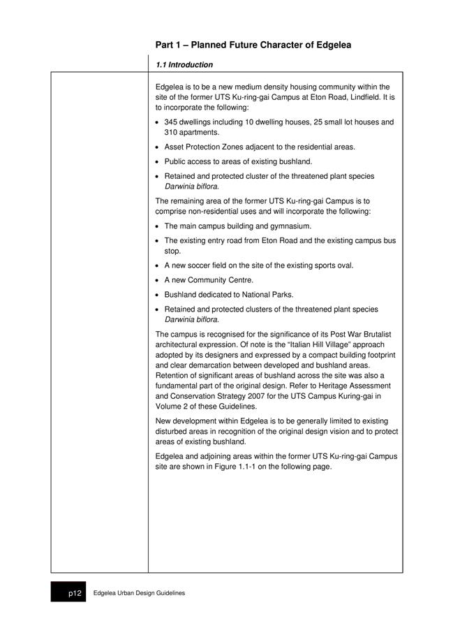
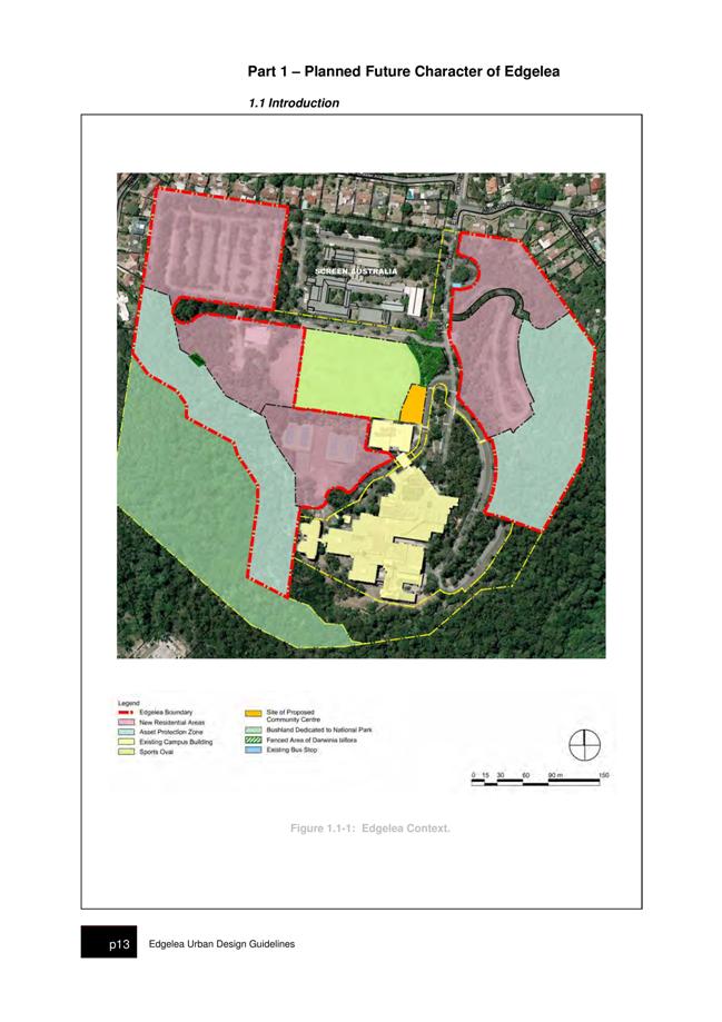
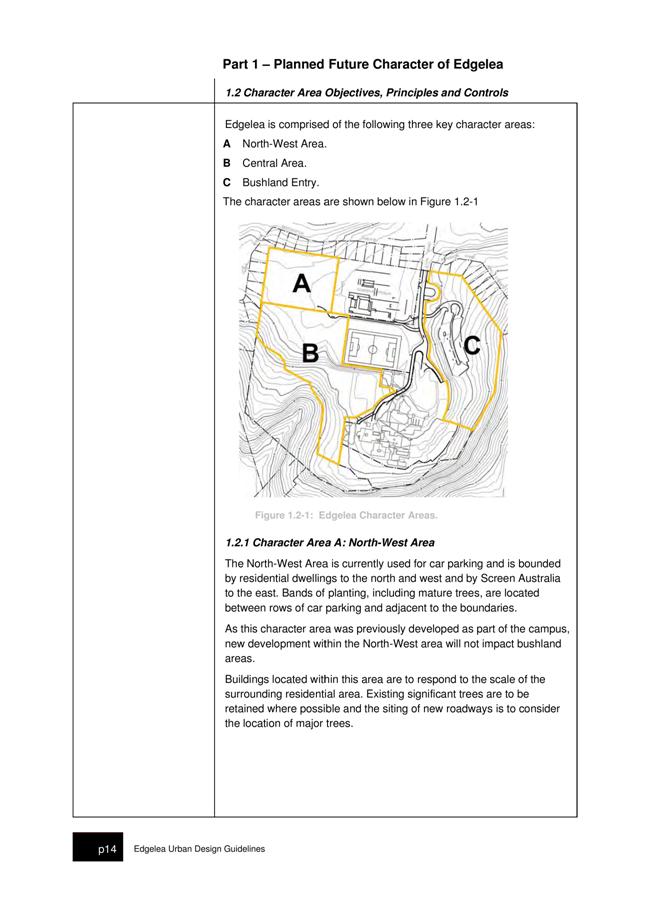
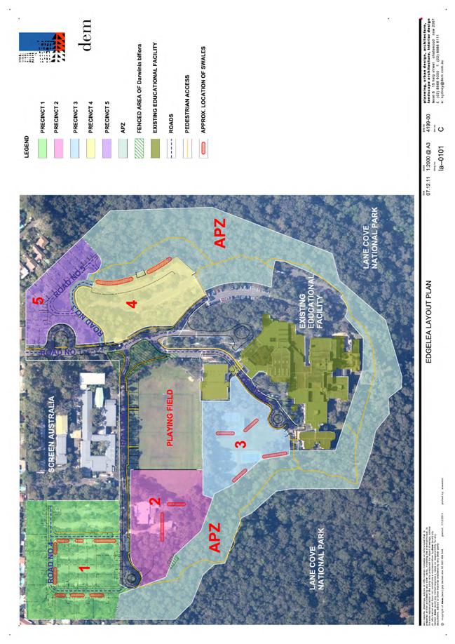
GB.5 Edgelea Urban Design Guidelines 121
File: DA0677/11
To have Council consider Urban Design Guidelines for the future development of Edgelea within the former UTS Ku-ring-gai Campus in Lindfield.
Recommendation:
That Council approve the Edgelea Urban Design Guidelines subject to amendments.
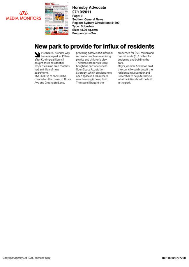
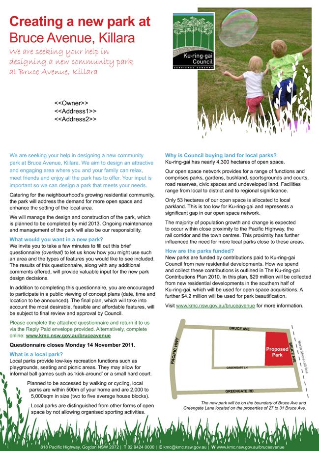
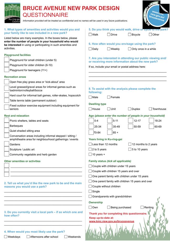
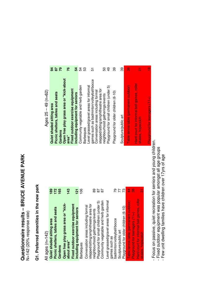
GB.6 Consideration of the Concept Design Plan for the new Bruce Avenue Park, Killara 308
File: S08975
To seek Council's endorsement of the concept design plan for the new park on Bruce Avenue, Killara.
Recommendation:
That Council endorse the concept design plan for the new park on Bruce Avenue, Killara as the basis on which staff prepare construction documentation including plans, details and sections and specifications, and tender documentation.
GB.7 Draft Development Control Plan No. 58 - Council Land South Turramurra 347
File: S08281
To have Council adopt for exhibition the draft Ku-ring-gai Development Control Plan South Turramurra Corridor No. 58.
Recommendation:
That the draft Ku-ring-gai Development Control Plan South Turramurra Corridor No. 58 be placed on public exhibition.
GB.8 Amendments to Parks Generic Plan of Management 374
File: S06604/2
For Council to amend the Parks Generic Plan of Management with the inclusion of properties acquired for parks since the plan of management was adopted by Council in 2005.
Recommendation:
That Council amend the Parks Generic Plan of Management to include the 14 properties acquired for parks by Council since 2005. Also that Council amend the Action Plan section of the Parks Generic Plan of Management to give the General Manager authority to automatically amend the Plan of Management to include any properties acquired by Council in the future for use as a park.
Extra Reports Circulated to Meeting
BUSINESS WITHOUT NOTICE – SUBJECT TO CLAUSE 241 OF GENERAL REGULATIONS
Questions Without Notice
Inspections Committee – SETTING OF TIME, DATE AND RENDEZVOUS
Confidential Business to be dealt with in Closed Meeting
C.1 Acquisition of Land - St Ives 1
File: S09321
In accordance with the Local Government Act 1993 and the Local Government (General) Regulation 2005, in the opinion of the General Manager, the following business is of a kind as referred to in section 10A(2)(c), of the Act, and should be dealt with in a part of the meeting closed to the public.
Section 10A(2)(c) of the Act permits the meeting to be closed to the public in respect of information that would, if disclosed, confer a commercial advantage on a person with whom the Council is conducting (or proposes to conduct) business.
The matter is classified confidential because it deals with the proposed acquisition and/or disposal of property.
It is not in the public interest to release this information as it would prejudice Council’s ability to acquire and/or dispose of the property on appropriate terms and conditions.
Report by Director Strategy and Environment dated 17 May 2012
John McKee
General Manager
** ** ** ** ** **
|
Present: |
The Mayor, Councillor J Anderson (Chairperson) (Roseville Ward) Councillor E Malicki (Comenarra Ward) Councillors E Keays & C Szatow (Gordon Ward) Councillor R Duncombe (Roseville Ward) Councillors T Hall & C Hardwick (St Ives Ward) Councillors I Cross & D McDonald (Wahroonga Ward) |
|
|
|
|
Staff Present: |
General Manager (John McKee) Acting Director Corporate (Tino Caltabiano) Director Development & Regulation (Michael Miocic) Director Operations (Greg Piconi) Director Strategy & Environment (Andrew Watson) Acting Director Community (Danny Houseas) Manager Records & Governance (Matt Ryan) Minutes Secretary (Sigrid Banzer) |
The Meeting commenced at 7.00pm
The Mayor offered the Prayer
|
124 |
Apologies
File: S02194
Councillor Rakesh Duncombe tendered an apology for lateness.
Councillor Steven Holland tendered an apology for non-attendance [family reasons] and requested leave of absence.
NOTE: The Director Community, Janice Bevan tendered apologies for non-attendance.
|
|
|
Resolved:
(Moved: Councillors Keays/McDonald)
A. That the apology by Councillor Duncombe be accepted.
B. That the apology by Councillor Holland be accepted and leave of absence granted.
CARRIED UNANIMOUSLY |
DECLARATIONS OF INTEREST
The Mayor adverted to the necessity for Councillors and staff to declare a Pecuniary Interest/Conflict of Interest in any item on the Business Paper.
The Mayor, Councillor Jennifer Anderson declared a Conflict of Interest in Item GB.9 - Suspension of Covenants, Agreements and Instruments - Advice from Department of Planning and Infrastructure due to a previous declaration regarding a covenant issue next door to her private home and she will be asking the Deputy Mayor to take the Chair at that point and will leave the Chamber during debate of the item.
DOCUMENTS CIRCULATED TO COUNCILLORS
The Mayor adverted to the documents circulated in the Councillors’ papers and advised that the following matters would be dealt with at the appropriate time during the meeting:
|
Late Items: |
Refer MM.2 - Mayoral Minute - Recognition of Local Veterans |
CONFIRMATION OF MINUTEs
|
125 |
Minutes of Ordinary Meeting of Council
File: S02131
|
|
|
Meeting held 8 May 2012 Minutes numbered 111 to 123
|
|
|
Resolved:
(Moved: Councillors Cross/Szatow)
That Minutes numbered 111 to 123 circulated to Councillors were taken as read and confirmed as an accurate record of the proceedings of the Meeting.
CARRIED UNANIMOUSLY
|
minutes from the Mayor
|
126 |
VALE William Ferrier Thomson
File: S04813 Vide: MM.1
|
|
|
On behalf of Ku-ring-gai Council I would like to pay tribute to the life of William Ferrier Thomson who passed away as a result of a long illness on 7 April 2012 aged 86 years.
William (Bill) Thomson was elected to Ku-ring-gai Council on 20 September 1980 and served as an Alderman representing Comenarra Ward until 1983. He was Deputy Mayor in 1982.
An architect by profession and a long term resident of Turramurra, Alderman William Thomson was valued for his integrity and the expertise he provided in helping to maintain the quality of the built environment and open space in Ku-ring-gai.
In the early 1970s, while working for the Department of Housing and Construction, William Thomson was involved in the design and construction of the CSIRO National Measurement Laboratory at Lindfield.
During World War II he served as a leading aircraftsman with the Royal Australian Air Force.
He was a member of St Andrews Uniting Church in South Turramurra and was the supervising architect when the church was built in 1970.
After 37 years at Turramurra, Mr Thomson moved to Burradoo, a village south of Bowral.
On behalf of Ku-ring-gai Council I would like to express our sincere condolences to his wife Margaret, sons Ross and Philip and granddaughters Amelia, Rebecca and Laura.
|
|
|
Resolved:
A. That the Mayoral Minute be received and noted.
B. That we stand for a minute’s silence to honour the life of William Ferrier Thomson.
C. That the Mayor write to William’s family enclosing a copy of the Mayoral Minute.
CARRIED UNANIMOUSLY |
One Minute Silence was observed
|
127 |
Recognition of Local Veterans
File: S04813 Vide: MM.2
The following members of the public addressed Council:
A Guterres D Browning
|
|
|
In 1940 Winston Churchill made it clear just how crucial air force fighters were during World War II when he said, "The fighters are our salvation, but the bombers alone provide the means of victory." More than 55,000 members of Bomber Command died during the war; their average age was 22. 3,550 of these were Australians. But it will be only this year on June 28 that the airmen of Bomber Command will receive official recognition when the Queen unveils a memorial in the UK.
The Royal New Zealand Air Force is fitting out a Boeing 757 to business class standards for NZ war veterans to attend the dedication and unveiling of the RAF Bomber Command Memorial in London. The NZ Government will also meet all accommodation, food and insurance costs. Up to forty (40) veterans will be going from NZ. Originally, the Australian Federal Government was funding places for only eight Australian veterans.
I spoke to Mr Ross Pearson OAM, 89, of Lindfield, who was a wireless operator/gunner during the war. Mr Pearson told me the “boys” of the Bomber Command Commemorative Day Foundation gather regularly for meetings. They include pilots, navigators and bomb aimers from Warrawee, Wahroonga and St Ives, none of whom could afford the trip next month. They are among about 40 Bomber Command veterans who would like to attend.
Mr Pearson explained how many of the “boys” are frail-aged and would find it impossible to make such a trip without a carer. He quoted Don Browning, 88, of Warrawee, who flew 37 combat missions. Mr Browning said medical tests and travel insurance meant it was hard for many to make it on their own. “Once you’re over 80, the price of travel insurance skyrockets, assuming you can find an insurer.”
I am pleased to advise that following a public outcry, the Australian government now plans to take thirty (30) veterans with its official party to the June 28 unveiling in London. A dedicated team including doctors, nurses and RAAF personnel will support the mission. Further support, including a travel subsidy of $5,000 and assistance to participate in Australian commemorative services, will also be provided for all other Bomber Command veterans who travel independently to attend the dedication. The Minister for Veteran Affairs said “Veterans can still apply for a grant facilitated through the RAAF Association to help them get to London.”
|
|
|
Resolved:
A. I recommend that this Council write to Mr Pearson confirming our gratitude and support and wishing those attending the unveiling a rewarding experience and a safe return home.
B. That an amount of $10,000 be given as a donation to the veterans for the Bomber Command Commemorative Day Foundation London appeal.
CARRIED UNANIMOUSLY |
Councillor Duncombe arrived
GENERAL BUSINESS
|
128 |
Request for Legal Assistance - Blacktown City Council
File: S02046 Vide: GB.1
|
|
|
To seek Council's instructions in relation to a request for assistance with legal costs by Blacktown City Council, recommended by the Local Government Association of NSW and Shires Association of NSW.
|
|
|
Resolved:
(Moved: Councillors Keays/Duncombe)
That Council contribute to the Blacktown City Council's legal costs in the amount of $202.12.
CARRIED UNANIMOUSLY |
|
129 |
2011 to 2012 Budget Review - 3rd Quarter ended 31 March 2012
File: FY00467/2 Vide: GB.2
|
|
|
To report on the review of actual expenditure and income against the budget for the year ended 31 March 2012.
|
|
|
Resolved:
(Moved: Councillors Keays/Cross)
A. That the Budget Review report as at 31 March 2012 be adopted.
B. That the Restricted Assets Report Forecast to 30 June 2012 as at 31 March 2012, as shown on page 6 of the report, be noted.
C. That the Reserve movements contained in the report be approved.
CARRIED UNANIMOUSLY
|
|
130 |
Mayor and Councillor Fees - Local Government Remuneration Tribunal Report 2012
File: S03158/2 Vide: GB.6
|
|
|
To determine the Mayor and Councillor fees payable from 1 July 2012.
|
|
|
Resolved:
(Moved: Councillors Keays/Hardwick)
That, from 1 July 2012, the Councillor fee be set at $17,060 and the Mayoral fee be set at $37,230.
CARRIED UNANIMOUSLY |
|
131 |
185 Fox Valley Road, Wahroonga - Subdivision of Land - 1 Lot into 3 Lots
File: DA0030/12 Vide: GB.7
|
||||||
|
|
To determine Development Application No 0030/12, which proposes a three lot Torrens title subdivision.
|
||||||
|
|
Resolved:
(Moved: Councillors Keays/Malicki)
THAT Council, as the consent authority, grant development consent to DA 030/12 for a three (3) lot subdivision on land at 185 Fox Valley Road, Wahroonga, for a period of two (2) years from the date of the Notice of Determination, subject to the following conditions:
CONDITIONS THAT IDENTIFY APPROVED PLANS:
1. Approved subdivision plan
The development must be carried out in accordance with the following plan listed below and endorsed with Council’s stamp, except where amended by other conditions of this consent:
Reason: To ensure that the development is in accordance with the determination.
CONDITIONS TO BE SATISFIED PRIOR TO DEMOLITION, EXCAVATION OR CONSTRUCTION:
2. Road opening permit
The opening of any footway, roadway, road shoulder or any part of the road reserve shall not be carried out without a road opening permit being obtained from Council (upon payment of the required fee) beforehand.
Reason: Statutory requirement (Roads Act 1993 Section 138) and to maintain the integrity of Council’s infrastructure.
CONDITIONS TO BE SATISFIED PRIOR TO THE ISSUE OF THE CONSTRUCTION CERTIFICATE OR PRIOR TO DEMOLITION, EXCAVATION OR CONSTRUCTION (WHICHEVER COMES FIRST):
3. Infrastructure restorations fee
To ensure that damage to Council Property as a result of construction activity is rectified in a timely matter:
a) All work or activity taken in furtherance of the development the subject of this approval must be undertaken in a manner to avoid damage to Council Property and must not jeopardise the safety of any person using or occupying the adjacent public areas.
b) The applicant, builder, developer or any person acting in reliance on this approval shall be responsible for making good any damage to Council Property, and for the removal from Council Property of any waste bin, building materials, sediment, silt, or any other material or article.
c) The Infrastructure Restoration Fee must be paid to the Council by the applicant prior to both the issue of the Construction Certificate and the commencement of any earthworks or construction.
d) In consideration of payment of the Infrastructure Restorations Fee, Council will undertake such inspections of Council Property as Council considers necessary and also undertake, on behalf of the applicant, such restoration work to Council Property, if any, that Council considers necessary as a consequence of the development. The provision of such restoration work by the Council does not absolve any person of the responsibilities contained in (a) to (b) above. Restoration work to be undertaken by the Council referred to in this condition is limited to work that can be undertaken by Council at a cost of not more than the Infrastructure Restorations Fee payable pursuant to this condition.
e) In this condition:
“Council Property” includes any road, footway, footpath paving, kerbing, guttering, crossings, street furniture, seats, letter bins, trees, shrubs, lawns, mounds, bushland, and similar structures or features on any road or public road within the meaning of the Local Government Act 1993 (NSW) or any public place; and
“Infrastructure Restoration Fee” means the Infrastructure Restorations Fee calculated in accordance with the Schedule of Fees & Charges adopted by Council as at the date of payment and the cost of any inspections required by the Council of Council Property associated with this condition.
Reason: To maintain public infrastructure.
CONDITIONS TO BE SATISFIED DURING THE DEMOLITION, EXCAVATION AND CONSTRUCTION PHASES:
4. Prescribed conditions
The applicant shall comply with any relevant prescribed conditions of development consent under clause 98 of the Environmental Planning and Assessment Regulation. For the purposes of section 80A (11) of the Environmental Planning and Assessment Act, the following conditions are prescribed in relation to a development consent for development that involves any building work:
· The work must be carried out in accordance with the requirements of the Building Code of Australia. · In the case of residential building work for which the Home Building Act 1989 requires there to be a contract of insurance in force in accordance with Part 6 of that Act, that such a contract of insurance is in force before any works commence.
Reason: Statutory requirement.
5. Hours of work
Demolition, excavation, construction work and deliveries of building material and equipment must not take place outside the hours of 7.00am to 5.00pm Monday to Friday and 8.00am to 12 noon Saturday. No work and no deliveries are to take place on Sundays and public holidays.
Excavation or removal of any materials using machinery of any kind, including compressors and jack hammers, must be limited to between 7.30am and 5.00pm Monday to Friday, with a respite break of 45 minutes between 12 noon 1.00pm.
Where it is necessary for works to occur outside of these hours (ie) placement of concrete for large floor areas on large residential/commercial developments or where building processes require the use of oversized trucks and/or cranes that are restricted by the RTA from travelling during daylight hours to deliver, erect or remove machinery, tower cranes, pre-cast panels, beams, tanks or service equipment to or from the site, approval for such activities will be subject to the issue of an "outside of hours works permit" from Council as well as notification of the surrounding properties likely to be affected by the proposed works.
Note: Failure to obtain a permit to work outside of the approved hours will result in on the spot fines being issued.
Reason: To ensure reasonable standards of amenity for occupants of neighbouring properties.
6. Road reserve safety
All public footways and roadways fronting and adjacent to the site must be maintained in a safe condition at all times during the course of the development works. Construction materials must not be stored in the road reserve. A safe pedestrian circulation route and a pavement/route free of trip hazards must be maintained at all times on or adjacent to any public access ways fronting the construction site. Where public infrastructure is damaged, repair works must be carried out when and as directed by Council officers. Where pedestrian circulation is diverted on to the roadway or verge areas, clear directional signage and protective barricades must be installed in accordance with AS1742-3 (1996) “Traffic Control Devices for Work on Roads”. If pedestrian circulation is not satisfactorily maintained across the site frontage, and action is not taken promptly to rectify the defects, Council may undertake proceedings to stop work.
Reason: To ensure safe public footways and roadways during construction.
7. Services
Where required, the adjustment or inclusion of any new utility service facilities must be carried out by the applicant and in accordance with the requirements of the relevant utility authority. These works shall be at no cost to Council. It is the applicants’ full responsibility to make contact with the relevant utility authorities to ascertain the impacts of the proposal upon utility services (including water, phone, gas and the like). Council accepts no responsibility for any matter arising from its approval to this application involving any influence upon utility services provided by another authority.
Reason: Provision of utility services.
8. Erosion control
Temporary sediment and erosion control and measures are to be installed prior to the commencement of any works on the site. These measures must be maintained in working order during construction works up to completion. All sediment traps must be cleared on a regular basis and after each major storm and/or as directed by the Principal Certifying Authority and Council officers.
Reason: To protect the environment from erosion and sedimentation.
9. Sydney Water Section 73 Compliance Certificate
The applicant must obtain a Section
73 Compliance Certificate under the Sydney Water Act 1994. An
application must be made through an authorised Water Servicing
Reason: Statutory requirement.
10. No storage of materials beneath trees
No activities, storage or disposal of materials shall take place beneath the canopy of any tree protected under Council's Tree Preservation Order at any time.
Reason: To protect existing trees.
11. Removal of refuse
All builders' refuse, spoil and/or material unsuitable for use in landscape areas shall be removed from the site on completion of the building works.
Reason: To protect the environment.
12. On site retention of waste dockets
All demolition, excavation and construction waste dockets are to be retained on site, or at suitable location, in order to confirm which facility received materials generated from the site for recycling or disposal.
· Each docket is to be an official receipt from a facility authorised to accept the material type, for disposal or processing. · This information is to be made available at the request of an Authorised Officer of Council.
Reason: To protect the environment.
CONDITIONS TO BE SATISFIED PRIOR TO THE ISSUE OF A SUBDIVISION CERTIFICATE:
13. Consent from Hornsby Council
The applicant is to obtain any necessary development consent for the subdivision of part of the proposed residual lot 701 located on the land in Hornsby Shire from Hornsby Shire Council prior to the registration of the subdivision certificate.
Reason: Statutory requirement
14. Boundary setback distances
Prior to the issue of the Subdivision Certificate the applicant shall submit details to the Principal Certifying Authority, certifying that existing and proposed buildings will be compliant with the Building Code of Australia.
Reason: Statutory requirement.
15. Drainage easements
The applicant shall create drainage easements over the locations of any pipelines, detention basins or other water management measures which are proposed to extend from one new lot into another in conjunction with approvals granted on the site including MP 10_0070 for the alterations to the Hospital.
Reason: To ensure that drainage structures will be fully contained within the proposed allotments or will be fully covered by easements upon registration of the plan of subdivision.
16. Sydney Water Section 73 Compliance Certificate
Prior to release of the linen plan/issue of the subdivision certificate, the Section 73 Sydney Water compliance certificate which refers to the subdivision application must be obtained and submitted to the Council.
Reason: Statutory requirement.
17. Requirements of public authorities for connection to services
Prior to the issue of the Subdivision Certificate, the Principal Certifying Authority shall be satisfied that the applicant has complied with the requirements of any public authorities (e.g. Energy Australia, Sydney Water, Telstra Australia, AGL, etc) in regard to the connection, relocation and/or adjustment of the services affected by the proposed subdivision. All costs related to the relocation, adjustment or support of services are the responsibility of the applicant.
Note: Details of compliance with the requirements of any relevant public authorities are to be submitted to the Principal Certifying Authority.
Reason: To ensure that services are available to the allotments of land.
18. Infrastructure repair – subdivision works
Prior to issue of the Subdivision Certificate, any infrastructure within the road reserve along the frontage of the subject site or within close proximity, which has been damaged as a result of subdivision works, must be fully repaired to the satisfaction of Council’s Development Engineer and at no cost to Council.
Reason: To protect public infrastructure.
19. Submission of 88b instrument
Prior to the issue of the Subdivision Certificate, the applicant must submit an original instrument under Section 88B of the Conveyancing Act with the plan of subdivision, plus six (6) copies to Council. Ku-ring-gai Council must be named as the authority whose consent is required to release, vary or modify the burdens.
Reason: To create all required easements, rights-of-carriageway, positive covenants, restrictions-on-use or other burdens/benefits as may be required.
20. Easement for access and temporary parking
The terms of the easement for access and temporary parking are to require the easement to be released before an Occupation Certificate is issued for Stage 1 of the main hospital redevelopment. The easement is to be released by registration of a request form at the office of NSW Land and Property Information.
Reason: To ensure that the requisite number of parking spaces is provided on the site at all times.
21. Submission of plans of subdivision (Torrens Title)
For endorsement of the subdivision certificate, the applicant shall submit an original plan of subdivision plus 6 copies, suitable for endorsement by Council. The following details must be submitted with the plan of subdivision and its copies:
a) the endorsement fee current at the time of lodgement b) the 88B instrument plus 6 copies c) all surveyor’s and/or consulting engineers’ certification(s) required under this subdivision consent d) The Section 73 (Sydney Water) Compliance Certificate for the subdivision. e) Proof of payment of S94 contribution
Council will check the consent conditions on the subdivision. Failure to submit the required information will delay endorsement of the linen plan and may require payment of rechecking fees. Plans and copies of subdivision must not be folded. Council will not accept bonds in lieu of completing subdivision works.
Reason: Statutory requirement.
22. General easement/R.O.W. provision and certification
Prior to issue of the Subdivision Certificate, a registered surveyor is to provide details to Council that all physical structures are fully contained within the proposed allotments or will be fully covered by the proposed burdens upon registration of the final plan of subdivision. Alternatively, where the surveyor is of the opinion that creation of burdens and benefits is not required, then proof to this effect must be submitted to the Principal Certifying Authority.
Reason: To ensure that all physical structures are fully contained within the proposed allotments or will be fully covered by the proposed burdens upon registration of the final plan of subdivision.
CARRIED UNANIMOUSLY |
|
132 |
78B Lucinda Avenue, Wahroonga - Alterations and Additions
File: DA0015/12 Vide: GB.8
|
||||||
|
|
To determine Development Application No DA0015/12 for alterations and additions to 78B Lucinda Avenue, Wahroonga.
|
||||||
|
|
Resolved:
(Moved: Councillors Keays/Malicki)
PURSUANT TO SECTION 80(1) OF THE ENVIRONMENTAL PLANNING AND ASSESSMENT ACT, 1979
THAT Council, as the consent authority, is of the opinion that the objections under State Environmental Planning Policy No. 1 – Development Standards to Clauses 43(3) and 60C of the Ku-ring-gai Planning Scheme Ordinance are well founded. Council is also of the opinion that strict compliance with the development standards is unreasonable and unnecessary in the circumstances of this case.
AND
THAT Council, as the consent authority, being satisfied that the objections under SEPP No. 1 are well founded and also being of the opinion that the granting of consent to DA 0015/12 is consistent with the aims of the Policy, grant development consent to DA 0015/12 for alterations and additions on land at 78B Lucinda Avenue, Wahroonga, for a period of two (2) years from the date of the Notice of Determination, subject to the following conditions:
CONDITIONS THAT IDENTIFY APPROVED PLANS:
1. Approved architectural plans and documentation (new development)
The development must be carried out in accordance with work shown in colour on the following plans and documentation listed below and endorsed with Council’s stamp, except where amended by other conditions of this consent.
Reason: To ensure that the development is in accordance with the determination.
2. Inconsistency between documents
In the event of any inconsistency between conditions of this consent and the drawings/documents referred to above, the conditions of this consent prevail.
Reason: To ensure that the development is in accordance with the determination.
3. No demolition of extra fabric
Alterations to, and demolition of the existing building shall be limited to that documented on the approved plans (by way of notation). No approval is given or implied for removal and/or rebuilding of any portion of the existing building which is shown to be retained.
Reason: To ensure compliance with the development consent.
CONDITIONS TO BE SATISFIED PRIOR TO DEMOLITION, EXCAVATION OR CONSTRUCTION:
4. Road opening permit
The opening of any footway, roadway, road shoulder or any part of the road reserve shall not be carried out without a road opening permit being obtained from Council (upon payment of the required fee) beforehand.
Reason: Statutory requirement (Roads Act 1993 Section 138) and to maintain the integrity of Council’s infrastructure.
5. Notice of commencement
At least 48 hours prior to the commencement of any development (including demolition, excavation, shoring or underpinning works), a notice of commencement of building or subdivision work form and appointment of the principal certifying authority form shall be submitted to Council.
Reason: Statutory requirement.
6. Notification of builder’s details
Prior to the commencement of any development or excavation works, the Principal Certifying Authority shall be notified in writing of the name and contractor licence number of the owner/builder intending to carry out the approved works.
Reason: Statutory requirement.
7. Structural adequacy (alterations and additions)
Prior to commencement of any development or excavation works, the Principal Certifying Authority shall be satisfied that that those components of the building to be retained and/or altered will be structurally sound and able to withstand the excavation and demolition process.
C1. Note: Evidence from a qualified practising structural engineer, demonstrating compliance with the above and detailing, where relevant, means of support for those parts of the retained building shall be provided to the Principal Certifying Authority.
Reason: To ensure that the development can be undertaken in accordance with accepted construction practices as indicated on the endorsed development plans, without the need for modification of the consent.
8. Construction waste management plan
Prior to the commencement of any works, the Principal Certifying Authority shall be satisfied that a waste management plan, prepared by a suitably qualified person, has been prepared in accordance with Council’s DCP 40 – Construction and Demolition Waste Management.
The plan shall address all issues identified in DCP 40, including but not limited to: the estimated volume of waste and method for disposal for the construction and operation phases of the development.
Note: The plan shall be provided to the Certifying Authority.
Reason: To ensure appropriate management of construction waste.
CONDITIONS TO BE SATISFIED PRIOR TO THE ISSUE OF THE CONSTRUCTION CERTIFICATE:
9. External finishes and materials (alterations and additions)
Prior to the issue of the Construction Certificate, The Certifying Authority shall be satisfied that external finishes of the building/s are consistent with the character of the existing house and streetscape.
Note: Details of the colour, finish and substance of all external materials, including schedules and a sample board of materials and colours, are to be submitted to the Certifying Authority.
Reason: To protect the streetscape and the integrity of the approved development.
10. Long service levy
In accordance with Section 109F(i) of the Environmental Planning and Assessment Act a Construction Certificate shall not be issued until any long service levy payable under Section 34 of the Building and Construction Industry Long Service Payments Act 1986 (or where such levy is payable by instalments, the first instalment of the levy) has been paid. Council is authorised to accept payment. Where payment has been made elsewhere, proof of payment is to be provided to Council.
Reason: Statutory requirement.
11. Builder’s indemnity insurance
The applicant, builder, developer or person who does the work on this development, must arrange builder’s indemnity insurance and submit the certificate of insurance in accordance with the requirements of Part 6 of the Home Building Act 1989 to the Certifying Authority for endorsement of the plans accompanying the Construction Certificate.
It is the responsibility of the applicant, builder or developer to arrange the builder's indemnity insurance for residential building work over the value of $20,000. The builder's indemnity insurance does not apply to commercial or industrial building work or to residential work valued at less than $20,000, nor to work undertaken by persons holding an owner/builder's permit issued by the Department of Fair Trading (unless the owner/builder's property is sold within 7 years of the commencement of the work).
Reason: Statutory requirement.
12. Utility provider requirements
Prior to issue of the Construction Certificate, the applicant must make contact with all relevant utility providers whose services will be impacted upon by the development. A written copy of the requirements of each provider, as determined necessary by the Certifying Authority, must be obtained. All utility services or appropriate conduits for the same must be provided by the developer in accordance with the specifications of the utility providers.
Reason: To ensure compliance with the requirements of relevant utility providers.
CONDITIONS TO BE SATISFIED PRIOR TO THE ISSUE OF THE CONSTRUCTION CERTIFICATE OR PRIOR TO DEMOLITION, EXCAVATION OR CONSTRUCTION (WHICHEVER COMES FIRST):
13. Infrastructure restorations fee
To ensure that damage to Council Property as a result of construction activity is rectified in a timely matter:
a) All work or activity taken in furtherance of the development the subject of this approval must be undertaken in a manner to avoid damage to Council Property and must not jeopardise the safety of any person using or occupying the adjacent public areas.
b) The applicant, builder, developer or any person acting in reliance on this approval shall be responsible for making good any damage to Council Property, and for the removal from Council Property of any waste bin, building materials, sediment, silt, or any other material or article.
c) The Infrastructure Restoration Fee must be paid to the Council by the applicant prior to both the issue of the Construction Certificate and the commencement of any earthworks or construction.
d) In consideration of payment of the Infrastructure Restorations Fee, Council will undertake such inspections of Council Property as Council considers necessary and also undertake, on behalf of the applicant, such restoration work to Council Property, if any, that Council considers necessary as a consequence of the development. The provision of such restoration work by the Council does not absolve any person of the responsibilities contained in (a) to (b) above. Restoration work to be undertaken by the Council referred to in this condition is limited to work that can be undertaken by Council at a cost of not more than the Infrastructure Restorations Fee payable pursuant to this condition.
e) In this condition:
“Council Property” includes any road, footway, footpath paving, kerbing, guttering, crossings, street furniture, seats, letter bins, trees, shrubs, lawns, mounds, bushland, and similar structures or features on any road or public road within the meaning of the Local Government Act 1993 (NSW) or any public place; and
“Infrastructure Restoration Fee” means the Infrastructure Restorations Fee calculated in accordance with the Schedule of Fees & Charges adopted by Council as at the date of payment and the cost of any inspections required by the Council of Council Property associated with this condition.
Reason: To maintain public infrastructure.
CONDITIONS TO BE SATISFIED DURING THE DEMOLITION, EXCAVATION AND CONSTRUCTION PHASES:
14. Prescribed conditions
The applicant shall comply with any relevant prescribed conditions of development consent under clause 98 of the Environmental Planning and Assessment Regulation. For the purposes of section 80A (11) of the Environmental Planning and Assessment Act, the following conditions are prescribed in relation to a development consent for development that involves any building work:
· The work must be carried out in accordance with the requirements of the Building Code of Australia · In the case of residential building work for which the Home Building Act 1989 requires there to be a contract of insurance in force in accordance with Part 6 of that Act, that such a contract of insurance is in force before any works commence.
Reason: Statutory requirement.
15. Hours of work
Demolition, excavation, construction work and deliveries of building material and equipment must not take place outside the hours of 7.00am to 5.00pm Monday to Friday and 8.00am to 12 noon Saturday. No work and no deliveries are to take place on Sundays and public holidays.
Excavation or removal of any materials using machinery of any kind, including compressors and jack hammers, must be limited to between 7.30am and 5.00pm Monday to Friday, with a respite break of 45 minutes between 12 noon 1.00pm.
Where it is necessary for works to occur outside of these hours (ie) placement of concrete for large floor areas on large residential/commercial developments or where building processes require the use of oversized trucks and/or cranes that are restricted by the RTA from travelling during daylight hours to deliver, erect or remove machinery, tower cranes, pre-cast panels, beams, tanks or service equipment to or from the site, approval for such activities will be subject to the issue of an "outside of hours works permit" from Council as well as notification of the surrounding properties likely to be affected by the proposed works.
Note: Failure to obtain a permit to work outside of the approved hours will result in on the spot fines being issued.
Reason: To ensure reasonable standards of amenity for occupants of neighbouring properties.
16. Approved plans to be on site
A copy of all approved and certified plans, specifications and documents incorporating conditions of consent and certification (including the Construction Certificate if required for the work) shall be kept on site at all times during the demolition, excavation and construction phases and must be readily available to any officer of Council or the Principal Certifying Authority.
Reason: To ensure that the development is in accordance with the determination.
17. Statement of compliance with Australian Standards
The demolition work shall comply with the provisions of Australian Standard AS2601: 2001 The Demolition of Structures. The work plans required by AS2601: 2001 shall be accompanied by a written statement from a suitably qualified person that the proposal contained in the work plan comply with the safety requirements of the Standard. The work plan and the statement of compliance shall be submitted to the satisfaction of the Principal Certifying Authority prior to the commencement of any works.
Reason: To ensure compliance with the Australian Standards.
18. Site notice
A site notice shall be erected on the site prior to any work commencing and shall be displayed throughout the works period.
The site notice must:
· be prominently displayed at the boundaries of the site for the purposes of informing the public that unauthorised entry to the site is not permitted · display project details including, but not limited to the details of the builder, Principal Certifying Authority and structural engineer · be durable and weatherproof · display the approved hours of work, the name of the site/project manager, the responsible managing company (if any), its address and 24 hour contact phone number for any inquiries, including construction/noise complaint are to be displayed on the site notice · be mounted at eye level on the perimeter hoardings/fencing and is to state that unauthorised entry to the site is not permitted
Reason: To ensure public safety and public information.
19. Use of road or footpath
During excavation, demolition and construction phases, no building materials, plant or the like are to be stored on the road or footpath without written approval being obtained from Council beforehand. The pathway shall be kept in a clean, tidy and safe condition during building operations. Council reserves the right, without notice, to rectify any such breach and to charge the cost against the applicant/owner/builder, as the case may be.
Reason: To ensure safety and amenity of the area.
20. Construction signage
All construction signs must comply with the following requirements:
· are not to cover any mechanical ventilation inlet or outlet vent · are not illuminated, self-illuminated or flashing at any time · are located wholly within a property where construction is being undertaken · refer only to the business(es) undertaking the construction and/or the site at which the construction is being undertaken · are restricted to one such sign per property · do not exceed 2.5m2 · are removed within 14 days of the completion of all construction works
Reason: To ensure compliance with Council's controls regarding signage.
21. Road reserve safety
All public footways and roadways fronting and adjacent to the site must be maintained in a safe condition at all times during the course of the development works. Construction materials must not be stored in the road reserve. A safe pedestrian circulation route and a pavement/route free of trip hazards must be maintained at all times on or adjacent to any public access ways fronting the construction site. Where public infrastructure is damaged, repair works must be carried out when and as directed by Council officers. Where pedestrian circulation is diverted on to the roadway or verge areas, clear directional signage and protective barricades must be installed in accordance with AS1742-3 (1996) “Traffic Control Devices for Work on Roads”. If pedestrian circulation is not satisfactorily maintained across the site frontage, and action is not taken promptly to rectify the defects, Council may undertake proceedings to stop work.
Reason: To ensure safe public footways and roadways during construction.
22. Services
Where required, the adjustment or inclusion of any new utility service facilities must be carried out by the applicant and in accordance with the requirements of the relevant utility authority. These works shall be at no cost to Council. It is the applicants’ full responsibility to make contact with the relevant utility authorities to ascertain the impacts of the proposal upon utility services (including water, phone, gas and the like). Council accepts no responsibility for any matter arising from its approval to this application involving any influence upon utility services provided by another authority.
Reason: Provision of utility services.
23. Erosion control
Temporary sediment and erosion control and measures are to be installed prior to the commencement of any works on the site. These measures must be maintained in working order during construction works up to completion. All sediment traps must be cleared on a regular basis and after each major storm and/or as directed by the Principal Certifying Authority and Council officers.
Reason: To protect the environment from erosion and sedimentation.
24. Drainage to existing system
Stormwater runoff from all new impervious areas and subsoil drainage systems shall be piped to the existing site drainage system. The installation of new drainage components must be completed by a licensed contractor in accordance with AS3500.3 (Plumbing Code) and the BCA. No stormwater runoff is to be placed into the Sydney Water sewer system. If an illegal sewer connection is found during construction, the drainage system must be rectified to the satisfaction of Council and Sydney Water.
Reason: To protect the environment.
25. No storage of materials beneath trees
No activities, storage or disposal of materials shall take place beneath the canopy of any tree protected under Council's Tree Preservation Order at any time.
Reason: To protect existing trees.
26. Removal of refuse
All builders' refuse, spoil and/or material unsuitable for use in landscape areas shall be removed from the site on completion of the building works.
Reason: To protect the environment.
27. On site retention of waste dockets
All demolition, excavation and construction waste dockets are to be retained on site, or at suitable location, in order to confirm which facility received materials generated from the site for recycling or disposal.
· Each docket is to be an official receipt from a facility authorised to accept the material type, for disposal or processing. · This information is to be made available at the request of an Authorised Officer of Council.
Reason: To protect the environment.
CONDITIONS TO BE SATISFIED PRIOR TO THE ISSUE OF AN OCCUPATION CERTIFICATE:
28. Infrastructure repair
Prior to issue of the Occupation Certificate, the Principal Certifying Authority must be satisfied that any damaged public infrastructure caused as a result of construction works (including damage caused by, but not limited to, delivery vehicles, waste collection, contractors, sub contractors, concrete vehicles) is fully repaired to the satisfaction of Council Development Engineer and at no cost to Council.
Reason: To protect public infrastructure.
CARRIED UNANIMOUSLY |
|
133 |
Waste and Sustainability Improvement Program (WaSIP)
File: S02294 Vide: GB.11
|
|
|
To advise Council of the 2011/2012 Waste & Sustainability Improvement Program Certificate which requires Council to consider its domestic waste stream and resolve initiatives which met the performance standards and outcomes of the State’s Waste Plan.
|
|
|
Resolved:
(Moved: Councillors Keays/Cross)
That Council resolve to continue with the current Waste Plan objective to consider disposal of all or part of its domestic waste via an alternative waste processing technology with a view to meeting the 66% waste reduction target to landfill by 2014.
CARRIED UNANIMOUSLY |
|
134 |
North Turramurra Recreational Area Easement
File: S08873 Vide: GB.12
|
|
|
To seek approval to create an easement for electrical supply over Council land described as North Turramurra Golf Course Lot 9 DP434369.
|
|
|
Resolved:
(Moved: Councillors Keays/Cross)
A. That Council approve the creation of an easement over North Turramurra Golf Course Lot 9 DP434369.
B. That Council authorise the Mayor and General Manager to execute all associated documentation for the creation and registration of the easement.
C. That Council authorise the affixing of the Common Seal to the Section 88B instrument for the creation of the easement and right of way.
CARRIED UNANIMOUSLY |
Standing Orders were suspended following
a Motion moved by Councillors Malicki and Cross
to deal with items where there are speakers
was CARRIED UNANIMOUSLY
The Mayor, Councillor J Anderson declared a Conflict of Interest
in respect of the following item -
GB.9 - Suspension of Covenants, Agreements and Instruments -
Advice from Department of Planning and Infrastructure
and withdrew from the Chamber taking no part
in discussion and voting on the item
The Deputy Mayor, Councillor Elaine Malicki assumed the Chair
|
135 |
Suspension of Covenants, Agreements and Instruments - Advice from Department of Planning and Infrastructure
File: S09084 Vide: GB.9
The following members of the public addressed Council:
B Mason R Middleton
|
|
|
To have Council consider advice from the Department of Planning and Infrastructure in relation to Council’s resolution 6 March, 2012 for the Suspension of Covenants, Agreements and Instruments - Planning Proposal.
|
|
|
Resolved:
(Moved: Councillors Cross/Malicki)
That Council, in accordance with Section 58 (4) of the Environmental Planning and Assessment Act, 1979 request that the Minister not proceed to determine the Planning Proposal for the inclusion of a suspension of covenants, agreements and instruments under the Ku-ring-gai Planning Scheme Ordinance.
For the Resolution: Councillors Duncombe, Hardwick, Keays, Malicki, McDonald, Szatow and Cross
Against the Resolution: Councillor Hall
|
The Mayor, Councillor J Anderson returned
and assumed the Chair
|
136 |
One Association Update - List of Delegates and Addresses for Voting
File: FY00260/6 Vide: GB.3
|
|
|
To provide Councillors with information relating to the issue of One Association to represent Local Government in NSW.
|
|
|
Resolved:
(Moved: Councillors Malicki/Szatow)
A. That Council appoint the Mayor, the Deputy Mayor and the longest serving Councillors from each of the other Wards as voting delegates.
B. That the General Manager advise the Local Government Association of the full names and private mailing addresses of the voting delegates.
CARRIED UNANIMOUSLY |
|
137 |
Investment Report as at 30 April 2012
File: S05273 Vide: GB.4
|
|
|
To present to Council investment allocations and returns on investments for April 2012.
|
|
|
Resolved:
(Moved: Councillors Hall/Duncombe)
A. That the summary of investments and performance for April 2012 be received and noted.
B. That the Certificate of the Responsible Accounting Officer be noted and the report adopted.
C, That the Acting Director Corporate report back on the outcome of Council’s decision of 20 March 2012 to consider legal proceedings against the Royal Bank of Scotland.
CARRIED UNANIMOUSLY |
|
138 |
Analysis of Land and Environment Court Costs - 3rd Quarter, 2011 to 2012
File: S05948 Vide: GB.5
|
|
|
To report legal costs in relation to development control matters in the Land & Environment Court for the year to date as at 31 March 2012.
|
|
|
Resolved:
(Moved: Councillors Hall/Duncombe)
That the analysis of Land and Environment Court costs for the year to date as at
CARRIED UNANIMOUSLY |
|
139 |
Sustainability Reference Committee - Notes of Meeting held 26 March 2012
File: S07619 Vide: GB.10
|
|
|
To bring to the attention of Council the proceedings of the Sustainability Reference Committee (SRC) meeting held on Monday, 26 March 2012 and the results of a feedback survey on the functionality of the Committee.
|
|
|
Resolved:
(Moved: Councillors Malicki/Szatow)
A. That the notes and attachments of the Sustainability Reference Committee Meeting held on Monday, 26 March 2012 be received and noted.
B. That Council endorses the Sustainability Reference Committee Meeting bi-monthly instead of quarterly, effective from May 2012, following feedback sought from the Committee on the desired meeting frequency.
CARRIED UNANIMOUSLY |
Motions of which due Notice has been given
|
140 |
Further Independent Peer Review Heritage Conservation Areas - North
File: CY00318/3 Vide: NM.1
|
|
|
Notice of Motion from Councillor McDonald dated 9 May 2012
Numerous studies have been conducted in Ku-ring-gai Council over many years to ascertain the cultural significance of heritage conservation areas (HCAs). The most recent study undertaken for the northern areas of Ku-ring-gai is the Paul Davies Pty Ltd (2010) Northern Heritage Conservation Area Review.
This study reviewed areas previously identified in other studies as potential heritage conservation areas, in particular the Urban Conservation Areas Studies undertaken by Godden Mackay Logan from 2001-2005. Several recommendations from the Paul Davies study were contrary to the recommendations of the Godden Mackay Logan studies and or were excluded from that study and for this reason it is suggested that Council engage an independent consultant to peer review the work of the recently completed HCA North for the following precincts:
• Gilroy Road, Turramurra excluding 2, 4, 6 and 8; • Eastern Road, Turramurra (eastern side numbers 9-17 and 23-43); • Fox Valley Road, Wahroonga (from Pacific Highway to Lucinda Avenue).
It should be noted that the independent review is purely an assessment based upon heritage considerations and other planning considerations and constraints are to be considered in conjunction with the recommendations of the peer review.
|
|
|
Resolved:
(Moved: Councillors McDonald/Cross)
During debate a Motion was moved by Councillors Duncombe and Cross that voting on the following item be in seriatum and was CARRIED
For the Motion: The Mayor, Councillor J Anderson, Councillors Duncombe, Hardwick, Keays, McDonald, Szatow, Malicki and Cross
Against the Motion: Councillor Hall
A. That an independent heritage peer review be commissioned for the following as potential heritage conservation areas:
For Part A of the Resolution: The Mayor, Councillor J Anderson, Councillors Duncombe, Hardwick, Keays, McDonald, Szatow and Cross
Against Part A of the Resolution: Councillors Malicki and Hall
i. Gilroy Road, Turramurra (excluding 2,4,6 and 8);
For Part Ai. the Resolution: The Mayor, Councillor J Anderson, Councillors Duncombe, Hardwick, Keays, McDonald, Szatow, Hall and Cross
Against Part Ai. of the Resolution: Councillor Malicki
ii. Eastern Road,Turramurra (eastern side numbers 9-17 and 23-43); and
For Part Aii. of the Resolution: The Mayor, Councillor J Anderson, Councillors Duncombe, Keays, McDonald, Szatow and Cross
Against Part Aii. of the Resolution: Councillors Hardwick, Malicki and Hall
iii. Fox Valley Road, Wahroonga (from Pacific Highway to Lucinda Avenue).
For Part Aiii. of the Resolution: The Mayor, Councillor J Anderson, Councillors Duncombe, Hardwick, Keays, Malicki, McDonald, Szatow and Cross
Against Part Aiii. of the Resolution: Councillor Hall
B. That the peer review be brought back to Council upon completion.
C. On analysis of the peer review, a separate report be produced that assesses how to manage the relevant planning matters relating to the properties identified in the report as significant for potential HCAs in the defined area.
D. That the General Manager write to the Minister outlining the contents of Council’s Resolution in relation to the pending Peer Review of the subject sites and that Council’s correspondence will reiterate ongoing updates with the Minister pending the outcome of the review. Until a positive response is received from the Minister, the abovementioned peer reviews as relating to the Local Centres LEP are not to be commissioned by Council.
For Parts B to D of the Resolution: The Mayor, Councillor J Anderson, Councillors Duncombe, Hardwick, Keays, McDonald, Szatow and Cross
Against Parts B to D of the Resolution: Councillors Hall and Malicki
|
QUESTIONS WITHOUT NOTICE
|
141 |
Support for the Aged
File: FY00382/4 Vide: QN.1
|
|
|
Question Without Notice from Councillor T Hall
Would the General Manager provide details of the Delivery Program and Operational Plan (Budget) adopted on 8 May 2012 of the initiatives to support the aged (over 55 years) in this community, please?
Answer by the General Manager
The Director of Community will do that and formerly report back to Council by memorandum.
|
|
142 |
Defects in Ku-ring-gai Strata Building New Construction
File: S06413 Vide: QN.2
|
|
|
Question Without Notice from Councillor T Hall
I ask the General Manager that in view of the University of NSW Research Study released yesterday, some 85% of new strata buildings have defects.
How many building defects complaints have been received by this Council in the term of this Council to date and what action was taken in respect of each complaint including those pending, please?
Answer by Director Development and Regulation
Will take that on notice.
|
The Meeting closed at 9.36 pm
The Minutes of the Ordinary Meeting of Council held on 22 May 2012 (Pages 1 - 27) were confirmed as a full and accurate record of proceedings on 12 June 2012.
__________________________ __________________________
General Manager Mayor / Chairperson
|
Ordinary Meeting of Council - 12 June 2012 |
MM.1 / 35 |
|
|
|
|
Item MM.1 |
S03603 |
|
|
25 May 2012 |
Mayoral Minute
Relocation of HMS Sirius Sculpture - Portsmouth, England
I was recently contacted by Stephen Bailey, Head of Cultural Services from the City of Portsmouth, England about the relocation of the HMS Sirius sculpture.
An exact replica of the sculpture currently situated in Bicentennial Park, West Pymble, the HMS Sirius was sent to Portsmouth where the First Fleet set sail to Australia in 1787. It was a gift from the people of Australia given by the Municipality of Ku-ring-gai and supported by the City of Sydney. It was presented to the citizens of Portsmouth on 13 May 1991.
Ku-ring-gai Council commissioned Victor Cusack to design and build the bronze HMS Sirius sculpture, which was completed in 1988.
Mr Bailey wrote to inform me the sculpture has been relocated to a prime new spot next to the harbour entrance at Gunwharf Quays.
The lovely sculpture was previously in the main shopping arcade in the centre of Portsmouth, but they felt that location was not showing the work in the most suitable environment or informed position.
As a key part of the recognition of the role Portsmouth played as the departure point for the First Fleet on 13 May 1787, the City of Portsmouth felt it would be more appropriate if the work was moved nearer to the entrance to the harbour, one side of which still has a very similar outlook to that which our ancestors would have seen 225 years ago.
Gunwharf Quays has very kindly agreed to host the sculpture and are currently fabricating a new base to enable the work to be displayed at its best.
Alderman Syd Rapson, who was the Lord Mayor of Portsmouth at the time of the original unveiling in 1991 and the Chair of the Portsmouth branch of the Britain Australia Society, Mr Brian Hall have also been involved.
On 18 May I attended a meeting of the Arthur Phillip Chapter of the Fellowship of First Fleeters held at the Old Gordon School meeting rooms. Chapter members, especially those who have previously visited Portsmouth, thoroughly supported the new location for the sculpture.
Sculpture Victor Cusack, who is due to visit England, intends to inspect the relocated work on 5 September.
Victor Cusack was present in Portsmouth for the original unveiling of his work twenty years ago. Coincidentally, he will be in England later this year and arrangements have now been made for him to inspect the relocated sculpture on 5 September.
I am very pleased this important sculpture has been given a fitting home and would like to thank the City of Portsmouth and all involved in the sculpture’s relocation.
|
A. That a letter be sent to Mr Bailey advising of Council’s full support for the relocation of the sculpture to Gunwharf Quays.
B. That a letter from Council be given to Mr Cusack to personally deliver to Portsmouth to mark the occasion of his visit to the relocated sculpture
|
|
Jennifer Anderson Mayor |
|
|
Ordinary Meeting of Council - 12 June 2012 |
MM.2 / 37 |
|
|
|
|
Item MM.2 |
S02119 |
|
|
29 May 2012 |
Mayoral Minute
National Disability Insurance Scheme - NDIS
In November I brought Council’s attention to the announcement by the Productivity Commission’s report for the Federal Government into an Australian Government funded Disability Care and Support Scheme (a.k.a. “a National Disability Insurance Scheme – NDIS”).
As part of its report the Commission said “The current disability support system is underfunded, unfair, fragmented, and inefficient. It gives people with a disability little choice, no certainty of access to appropriate supports and little scope to participate in the community”.
It was noted that a significant number of people in Ku-ring-gai have much to gain from the proposed NDIS. According to the latest ABS Census data, Ku-ring-gai has close to 3000 residents who indicated they required assistance in their day to day activities because of a disability, long-term health condition, or old age.
The following recommendation was carried unanimously:
That Council show its official support for the establishment of a “National Disability Insurance Scheme” by promoting the campaign through Council’s website and relevant newsletters, and through the issuing of a media release to this effect.
That the Mayor on behalf of Council make representations to all relevant Commonwealth and State Ministers and Members of Parliament urging their support for the National Disability Insurance Scheme.
I am pleased to report that the Federal Treasurer announced in the recent budget that the Government has committed $1.0 billion over four years for the first stage of the National Disability Insurance Scheme (NDIS), to be established in up to four locations from 2013–14. The locations will be determined through negotiations between the Australian Government and the states and territories. In its first year, the NDIS will provide care and support for up to 10 000 people with significant and permanent disability. This will increase to 20 000 people from 2014–15.
I can also report, at its latest meeting, the NSROC board supported a motion by Willoughby Council to show support for the NDIS by writing to the Prime Minister and Federal Opposition Leader urging the introduction be expedited as a matter of urgency.
|
That Council write to the Prime Minister Julia Gillard, the Federal Opposition Leader Tony Abbott and our local Federal MP Paul Fletcher congratulating them on their support for the legislation and reinforcing the need evident within our local community.
|
|
Jennifer Anderson Mayor |
|
|
Ordinary Meeting of Council - 12 June 2012 |
MM.3 / 38 |
|
|
|
|
Item MM.3 |
S02119 |
|
|
31 May 2012 |
Mayoral Minute
Home and Community Care Services in Ku-ring-gai
I have been approached by a number of residents recently about the dire state of Home and Community Care services in the Ku-ring-gai region. Home and Community Care services assist frail older people to remain independently in their own home for as long as possible and thereby reducing the likelihood of premature admission to a residential facility.
The aged care sector is undergoing significant changes at present with the responsibility for funding of Home and Community Care programs moving from the NSW Department of Ageing Disability and Home Care to the Commonwealth Department of Health and Ageing (DoHA). From July 2012 the Commonwealth will assume full funding and operational responsibility for aged care services. I feel that there is not enough funding for these support services for residents in the Ku-ring-gai region. Apart from long waiting lists (if you are lucky enough to be on one), Ku-ring-gai has the highest proportion (with the exception of Hunters Hill) of its population over 65 years in the Sydney Metropolitan Area.
In exploring this issue, I have become very concerned about the inequitable funding across the region for HACC services. There is an expressed need for a linen service from people unable to change and launder their own bed sheets, pillow cases etc. Unfortunately the Ku-ring-gai area does not have access to a dedicated service. I have discovered that in Northern Sydney there are only 3 stand alone linen services. As an alternative to a linen service, eligible residents may be able to have their linen changed if they are in receipt of a HACC service, specifically domestic assistance. Generally the maximum service they are able to access is 2 hours per fortnight. Currently there are no vacancies for domestic assistance anywhere in Ku-ring-gai and waiting lists have been closed since January 2012. This is unacceptable for the many residents in need.
Transport is another area of great concern for those wishing to stay living independently in their own homes. Getting to and from medical appointments or being able to do your own shopping or keeping up social contacts are essential activities and are the foundation of being able to remain living independently in the community. The Hornsby Ku-ring-gai Community Transport organisation based in Turramurra provides a terrific transport service to local residents including bus, individual cars and a subsidised taxi service. Recently they placed a ceiling on the subsidised taxi trips of 300km per annum and only for medical appointments. Since its inception in 2008 the total passenger trips have increased from 893 to an expected 40,000 in this year. This alone demonstrates the incredible demand for this service and the importance it plays in helping the more vulnerable members of our community.
Clients who need more complex care can be referred for assessment to the Aged Care Assessment Team (ACAT) at Hornsby Hospital. Following this assessment they may be eligible for a Community Aged Care Package (CACP) or an Extended Aged Care at Home Package (EACH). These packages typically provide registered nursing care, personal care, transport or home help etc. Discussions with the Aged Care Assessment Team Manager for this region highlighted that the turn over on the waiting lists for both Community Aged Care Packages and Extended Aged Care at Home Packages is extremely slow. The vacancy rates are averaging only 1 per month so the majority of applicants either go into care or make alternative arrangements.
The following table provides an indicative numbers on waiting lists and the average period before a client will get a package:
|
SERVICE TYPE |
NUMBER ON WAITING LIST |
TIME ON WAITING LIST |
|
CACP |
195 |
> 4- 6 months |
|
Dementia CACP |
30 |
> 4- 6 months |
|
Chinese CACP |
4 |
> 12 months |
|
EACH |
131 |
> 1-2 years |
|
EACH D |
5 |
< 6 months |
|
Chinese EACH |
15 |
> 1- 2 years |
The demand for home support services is certain to increase due to our ageing population and policies at both State and Commonwealth Government level encouraging ageing in place. Demand for services is currently outstripping supply in a number of services areas and likely to continue in the future. Council needs to take a proactive stance and lobby our local members of parliament and relevant government departments to address the issue of undersupply of services critical to the wellbeing of our residents.
|
A. That Council write to the Commonwealth Department of Health and Ageing and the New South Wales Department of Ageing Disability and Home Care outlining the inequities of funding for this region, and request that additional funding be considered in any funding allocation rounds.
B. That Council write to the local State and Commonwealth Members of Parliament seeking their support for increased funding for home support services in Ku-ring-gai and Northern Sydney services network.
C. That this matter be placed on the agenda of the next Northern Sydney Regions of Councils (NSROC) conference focussing on Whole of Region Ageing Strategy for discussion and possible joint action.
|
|
Jennifer Anderson Mayor |
|
HELD ON Thursday, 1 December 2011
|
Present: |
Director Operations (Mr Greg Piconi, A/Chairperson) Roads and Maritime Services (Ms Kathryn Hawkins) Representing Police Local Area Command Kuring-gai (Snr Const Debbie Birmingham) Police Local Area Command Kuring-gai (Insp David Hogg) Police Local Area Command Kuring-gai (Snr Sgt John Branwhite) Representing Police Local Area Command North Shore (Sgt Glen Marks) Representing Member for Davidson (Mr Robert Forster) |
|
|
|
|
Staff Present: |
Manager Traffic and Transport (Mr George Koolik) Senior Ranger (Mr Lindsay Woods) |
|
|
|
|
Others Present: |
Resident – Mr Brent Fuller, Pibrac Avenue, Warrawee (Item 3 only) Resident – Mr Ian Darling, Pibrac Avenue, Warrawee (Item 3 only) Resident – Mr Brian Lang, Pibrac Avenue, Warrawee (Item 3 only) |
|
|
|
|
Apologies: |
Ku-ring-gai Council (Councillor Elise Keays, Chairperson) Representing Member for Ku-ring-gai (Ms Mary O’Dea) Fire & Rescue NSW (Superintendent Kel McNamara) Representing Bicycle NSW (Mr Robert Chambers) Traffic Team Leader (Mr Deva Thevaraja) |
The Meeting commenced at 9.00am
DECLARATIONS OF INTEREST
No interest was declared.
CONFIRMATION OF MINUTEs
GENERAL BUSINESS
|
KTC18 |
File: CY00022/3 Vide: GB.2
|
|
|
To determine the Ku-ring-gai Traffic Committee meeting dates for 2012.
|
|
|
That the Ku-ring-gai Traffic Committee meetings in 2012 be scheduled for the dates shown below:
23 February 22 March 19 April 24 May 21 June 19 July 23 August 20 September 25 October 22 November
|
|
KTC19 |
File: TM12/03 Vide: GB.3
|
|
|
To consider existing parking restrictions in Pibrac Avenue , Warrawee.
|
|
|
The Committee’s Comments:
Mr Brian Lang addressed the Committee on behalf of himself and two other residents of Pibrac Avenue. He identified three issues, which are the number of accidents in the street (before and after the restrictions were changed), proposed changes to parking arrangements outside 6 Pibrac Avenue, and the fact that all directly affected residents of the street agree with the current restrictions. He tabled a submission which suggests that there has been a reduction in accidents since the restrictions were installed in 2010, parking outside No.6 would obstruct visibility of motorists in the narrow part of Pibrac Avenue and he questioned two of the submissions which previously indicated they agreed with altering the existing restrictions. He requested the existing restrictions remain unaltered.
The Manager Traffic and Transport tabled recent communications from residents of 2a and 25 Pibrac Avenue. The first submission clarifies that the resident disagrees with removing the existing restrictions and again requesting a Loading Zone to provide parking for visiting tradesmen. The second submission expresses concerns with pedestrian safety when vehicles turn at the end of the narrow section of Pibrac Avenue , where there is also a path leading to Warrawee station. This resident considers that there is insufficient visibility for both pedestrians and motorists in this part of the street.
A communication from the Representative of the Member for Ku-ring-gai expressing support for the recommendation was tabled. The Representative also expressed appreciation for the further resident consultation undertaken by Council.
The Committee discussed the merits of reinstating unrestricted parking in front of No.6 and agreed that parking near the narrow section could compromise driver visibility.
|
|
|
A. That the strong resident agreement to the overall parking arrangements in Pibrac Avenue be noted.
B. That the existing parking restrictions in Pibrac Avenue remain unaltered but that road safety in the street continue to be monitored.
C. That residents of Pibrac Avenue be informed of Council’s decision.
|
general discussion
1. Eastern Arterial Road, St Ives
The Representative of Roads and Maritime Services (RMS) informed the Committee of the safety review being undertaken of decommissioned fixed speed cameras, including the camera in Eastern Arterial Road. As part of the safety review, RMS is undertaking audits to consider what road safety measures might need to be introduced to address existing road safety risks.
Council has made a submission to the review panel expressing concerns that removal of the camera and warning signs on its approaches could result in increased traffic speeds and crashes, including on the sweeping downhill curve in Eastern Arterial Road near property numbers 74 to 96. Council has lodged a submission with RMS for Black Spot funding to address problems with this curve.
The Representative of RMS informed the Committee that the curve which is of concern will be considered as being in the area of influence of the decommissioned speed camera even though it is outside the usual 500m distance.
As an interim measure, until the proposed Black Spot work can be funded and completed, RMS will consider the suggestion that only a single lane be provided for the southbound downhill movement through the curve towards the camera, subject to Council preparing a Traffic Management Plan for approval of RMS. As well, additional temporary ‘Slippery When Wet’ signs will be installed by RMS.
2. Burns Road at McRae Place, Turramurra
The Manager Traffic and Transport tabled a communication from a resident of McRae Place who expresses concern with eastbound vehicles in Burns Road forming a second lane as they pass McRae Place. His concern is that these vehicles cause an additional hazard to westbound right-turning vehicles in Burns Road at the intersection. The Committee agreed that there is only a single lane for eastbound vehicles in Burns Road until after McRae Place and that there is insufficient road width for a second lane to form. The Committee agreed that providing kerb and gutter or other physical obstructions as requested, would not be safe and could not be supported. After the meeting Council’s staff meet with the Representative of the RMS on site to further consider whether any infrastructure measures could be taken to address the concern expressed.
3. Coonanbarra Road at Pacific Highway, Wahroonga
The Representative of the Local Area Command Kuring-gai raised concerns with the level of non-compliance with the peak period ‘No Right Turn’ restriction in Coonanbarra Road at Pacific Highway. He informed the Committee of complaints with the illegal movements and asked whether a better traffic arrangement could be considered. He advised that over the past year, 1,375 infringement notices have been issued to motorists performing this illegal movement. He also advised that during this period, 475 infringement notices were issued to motorists performing the illegal right turn movement from Illoura Avenue into Millewa Avenue during the AM peak.
The Committee noted the Wahroonga Traffic & Parking Study undertaken by Council in 2008, in consultation with local stakeholders. That study did not recommend changes to the existing intersection arrangements. The Committee also noted that increased ‘green’ time could not be provided in the signals for traffic in Coonanbarra Road and Ada Avenue, as well as a fact that there is a crest on Pacific Highway at this intersection.
4. Lady Game Drive, Killara
The Representative of the Local Area Command Kuring-gai raised concerns with the number of accidents recently attended by Police on Lady Game Drive in which eastbound traffic have lost control on the curve west of De Burgh Road. He expressed concern with the possibility that the road surface might be excessively slippery in wet weather. The A/Chairperson informed the Police representative that he would investigate the pavement conditions on this curve.
5. General Matter – Long Term On-Street Parking of Non-Resident Vehicles
The Representative of the Member for Davidson tabled an undated and unsigned letter from The Hon. Duncan Gay MLC, Minister for Roads and Ports, to The Hon. Barry O’Farrell, MP, Premier and Member for Ku-ring-gai, regarding representations from a constituent, about the problem of parked vehicles, including trailers, boats and large vans, being parked in suburban streets, often not belonging to nearby residents, creating traffic hazards. This problem is not unique to Ku-ring-gai. In his response, the Minister advises:
I am advised that it would be inappropriate to impose a general prohibition under the Road Transport Legislation, for which I am responsible, as there is no evidence that they (trailers) present a greater safety risk than parked cars and light trucks.
Ms Willis is advised to continue to direct her enquiries to Ku-ring-gai Council as it has authority to implement site-specific signposted parking restrictions where it is believed that a parked vehicle, of any type, presents an unacceptable safety risk.
The Meeting closed at 9.50am
|
Ordinary Meeting of Council - 12 June 2012 |
GB.1 / 45 |
|
|
|
|
Item GB.1 |
S03271 |
|
|
7 May 2012 |
Contractual Conditions of Senior Staff
EXECUTIVE SUMMARY
Purpose of Report
To report to Council on the contractual conditions of senior staff in accordance with Section 339 of the Local Government Act 1993.
Background
Section 339 of the Local Government Act 1993 states:
The General Manager must, at least once annually, report to Council on the contractual conditions of senior staff.
Comments
Section 339 of the Local Government Act 1993 requires the General Manager to report to Council annually on the contractual conditions of senior staff. In relation to Ku-ring-gai Council this requirement relates to the following five (5) positions of Director and the position of General Manager.
|
Position |
Present Incumbent |
|
General Manager |
John McKee |
|
Director Community |
Janice Bevan |
|
Director Corporate |
Vacant |
|
Director Development & Regulation |
Michael Miocic |
|
Director Operations |
Greg Piconi |
|
Director Strategy & Environment |
Andrew Watson |
Total package amounts and conditions are contained in Confidential Attachment A1.
In accordance with the Local Government Act 1993 and the Local Government (General) Regulation 2005, in the opinion of the General Manager, the attachment relates to business of a kind referred to in Section 10A(2)(a), of the Act, and should be dealt with in a part of the meeting closed to the media and public.
Section 10A(2)(a) of the Act permits the meeting to be closed to the public for business relating to personnel matters concerning particular individuals (other than Councillors).
This report also confirms that the five (5) Directors have had their performance assessments undertaken in a timely manner and all Directors are to have considered at a satisfactory level or above. Additionally it is noted that the next round of performance assessments for the Directors are due to be completed between 1 July 2012 and 30 September 2012.
Governance Matters
This report is submitted for Council’s consideration in accordance with Section 339 of the Local Government Act 1993 which states:
The General Manager must, at least once annually, report to Council on the contractual conditions of senior staff.
Risk Management
If this report is not presented to Council on an annual basis Council does not comply with the requirements of s.339 of the Local Government Act 1993. Apart from non-compliance with the statutory obligations there is a minor reputational risk for Council if the report is not presented on an annual basis as it may be considered that the Council is not being fully transparent in reporting the contractual conditions of senior staff.
Financial Considerations
There are no financial considerations associated with this report.
Social Considerations
There are no social considerations associated with this report.
Environmental Considerations
There are no environmental considerations associated with this report.
Community Consultation
None undertaken or required.
Internal Consultation
None undertaken or required.
Summary
Section 339 of the Local Government Act 1993 states:
The General Manager must, at least once annually, report to Council on the contractual conditions of senior staff.
This report is submitted to Council in accordance with the above requirement of the Local Government Act 1993.
|
That Council receive and note the report.
|
|
Matt Ryan Manager Records & Governance |
Tino Caltabiano Acting Director Corporate |
|
Senior Staff Contract Conditions |
|
Confidential |
|
Ordinary Meeting of Council - 12 June 2012 |
GB.2 / 48 |
|
|
|
|
Item GB.2 |
S02414 |
|
|
21 May 2012 |
NSW Local Government Aboriginal Network Conference 2012
EXECUTIVE SUMMARY
|
purpose of report: |
To advise Council of the NSW Local Government Aboriginal Network Conference 2012. |
|
|
|
|
background: |
Council has been provided a registration brochure to advise of the upcoming 2012 NSW Local Government Aboriginal Network Conference. The Conference is to be held in Clarence Valley from 15 to 17 August 2012. |
|
|
|
|
comments: |
The aim of the Conference is to provide a forum for enhancing the profile of Aboriginal communities, their skills and their culture. The Conference will provide an opportunity for all elected officials, local government employees, industry representatives and community groups to come together and discuss emerging issues that are concerning Aboriginals in NSW. |
|
|
|
|
recommendation: |
That any Councillors interested in attending the NSW Local Government Aboriginal Network Conference 2012 advise the General Manager by Friday, 29 June 2012. |
Purpose of Report
To advise Council of the NSW Local Government Aboriginal Network Conference 2012.
Background
Council has been provided a registration brochure to advise of the upcoming 2012 NSW Local Government Aboriginal Network Conference. The Conference is to be held in Clarence Valley from 15 to 17 August 2012.
The aim of the Conference is to provide a forum for enhancing the profile of Aboriginal communities, their skills and their culture. This conference will provide an opportunity for all elected officials, local government employees, industry representatives and community groups to come together and discuss emerging issues that are concerning Aboriginals in NSW.
Comments
A copy of draft NSW Local Government Aboriginal Network Conference program and registration information have been included as an attachment to the report (Attachment A1). Further information can be found by visiting www.lganconference.com.
Governance Matters
The policy on Payment of Expenses and Provision of Facilities to Councillors provides for Council to meet the reasonable costs of Councillors attending conferences authorised by resolution of Council.
Risk Management
There are no risk management considerations associated with the report.
Financial Considerations
The early bird registration fee for the conference is $650.00 per delegate.
Social Considerations
There are no social considerations associated with the report.
Environmental Considerations
There are no environmental considerations associated with the report.
Community Consultation
None undertaken or required.
Internal Consultation
None undertaken or required.
Summary
Council has been provided a registration brochure to advise of the upcoming 2012 NSW Local Government Aboriginal Network Conference. The Conference is to be held in Clarence Valley from 15 to 17 August 2012.
The aim of the Conference is to provide a forum for enhancing the profile of Aboriginal communities, their skills and their culture. The Conference will provide an opportunity for all elected officials, local government employees, industry representatives and community groups to come together and discuss emerging issues that are concerning Aboriginals in NSW.
|
That any Councillors interested in attending the NSW Local Government Aboriginal Network Conference 2012 advise the General Manager by Friday, 29 June 2012.
|
|
Matt Ryan Manager Records & Governance |
Tino Caltabiano Acting Director Corporate |
|
A1View |
2012 NSW Local Government Aboriginal Network Conference - Merit Awards Nomination Form - held in Grafton 15 - 17 August 2012 |
|
2012/114775 |
|
APPENDIX No: 1 - 2012 NSW Local Government Aboriginal Network Conference - Merit Awards Nomination Form - held in Grafton 15 - 17 August 2012 |
|
Item No: GB.2 |
|
Ordinary Meeting of Council - 12 June 2012 |
GB.3 / 65 |
|
|
|
|
Item GB.3 |
DA0032/10 |
|
|
18 May 2012 |
development application
Summary Sheet
|
Report title: |
8 Telegraph Road, Pymble - Demolition of Existing In-ground Pool and Construction of New In-ground Pool |
|
ITEM/AGENDA NO: |
GB.3 |
|
Application No: |
DA0121/12 |
|
Property Details: |
8 Telegraph Road Pymble Lot & DP No: Lot A DP 334852 Site area (m2): 1246m2 Zoning: Residential 2(c2) |
|
Ward: |
|
|
Proposal/Purpose: |
Demolition of existing in-ground pool and construction of a new in-ground pool. |
|
Type of Consent: |
Local |
|
Applicant: |
Glendinning Minto & Associates Pty Ltd |
|
Owner: |
Mr G J Cox |
|
Date Lodged: |
17 April 2012 |
|
Recommendation: |
Approval. |
Purpose of Report
To determine development application No.0121/12 for demolition of an existing in-ground pool and construction of a new in-ground pool.
Consideration of variation Pursuant to SEPP No. 1
Council’s attention is directed to Circular PS 08-014 (see attachment) from the NSW Department of Planning concerning the determination by Council of Development Applications where a variation of a development standard is sought under the provisions of SEPP No. 1.
The circular requires all development applications which involve a variation greater than 10% under the provisions of SEPP No. 1 to be determined by full Council and not by Council staff under delegated authority.
The maximum built-upon area allowed by clause 60C(2) of the KPSO is 60%. The existing built-upon area of the site is 74% and the proposed development results in a reduction in built-upon area to 73%. Accordingly, a SEPP No. 1 objection has been submitted. As the proposal still involves a variation of more than 10% beyond Council’s maximum built-upon area requirement, the application is referred to full Council for determination.
Executive Summary
Issues: Built-upon area
Submissions: None
Land & Environment Court Appeal: N/A
Recommendation: Approval
History
Site
The site has historically been used for residential purposes.
DA history
· BA87/01141 Alts and adds – approved 8 July 1987
· BA87/01582 Pool – approved 20 August 1987
The Site
Site description
The site is located on the northern side of Telegraph Road. The site is rectangular in shape and is 20.035 metres in width, 62.19 metres in depth and 1246m2 in area. The site is generally flat though has a slight fall to the rear.
Existing development on the site comprises a two storey dwelling house with a detached carport/garage in the front setback. There is an existing pool in the rear yard, as well as a tennis court.
Surrounding development
The site is surrounded by residential development. The adjoining site to the east is known as No. 10 Telegraph Road and contains a single storey dwelling with swimming pool to the rear. The adjoining site to the west is a double allotment known as No. 4 Telegraph Road. It contains a two storey dwelling with a swimming pool to the rear and a tennis court within the eastern side setback. This property is listed as a heritage item under the KPSO.
The Proposal
The application proposes demolition and removal of the existing in-ground swimming pool and paving and construction of a new pool in a different location and configuration, with associated paving.
The existing pool is located centrally to the rear of the dwelling, whilst the proposed pool is to be located at the rear of the dwelling towards the eastern side boundary.
The proposed pool has a length of 14.4 metres, maximum width of 4 metres and a capacity of 69,000L. The proposed pool is surrounded by pavers and is to be fenced in accordance with the Swimming Pools Act.
It is proposed to locate the filter within the eastern side setback of the dwelling. A new 3325L rainwater tank will be located beneath the driveway.
Amended plans received 2 May 2012
The amended plans included the provision of additional sections and elevations.
The application was not notified to the owners/residents of adjoining properties until the amended plans were received.
Consultation
Community
In accordance with Development Control Plan No. 56, owners of surrounding properties were given notice of the application. No submissions were received.
Within Council
Landscaping
Council's Landscape and Tree Assessment Officer commented on the proposal as follows:
Plans/reports sighted
|
Plan/document |
Designer |
Drawing No. |
Date |
|
Architectural |
AG Quality Pools |
1 – 9/9 of 2011 Project No. AG118 |
August 2011 |
|
Site analysis |
Right Angle Design & Drafting Pty Ltd |
P1 of Job No. RADD1136 |
January 2012 |
|
Survey |
Survcheck Surveyors |
Ref: 3087D |
6 December 2011 |
|
Stormwater |
|
|
|
|
Landscape |
Right Angle Design & Drafting Pty Ltd |
LA1 of Job No. RADD1136 |
January 2012 |
|
BASIX |
Planning & Infrastructure |
Cert. No.: A136558 |
12 April 2012 |
|
SOEE |
Glendinning Minto & Associates P/L |
|
April 2012 |
|
Arborist’s Report |
|
|
|
Site characteristics
The greater majority of vegetation within the site consists of exotic tree and shrub species. The site is situated within Blue Gum High Forest Endangered Ecological Community natural habitat range although it is not in located within an area of environmental significance.
Tree impacts
Not applicable
Landscape plan/tree replenishment
The extent of proposed landscape works amounts to re-turfing two small areas of existing built upon area within the rear garden and changing two small areas of driveway to garden space for which no details are given.
The site should support a minimum number of six canopy replenishment trees in accordance with 4.3.6 Tree Replenishment of Council’s Development Control Plan No. 38. However, it currently supports only one Eucalyptus sideroxylon (Red Ironbark) in senescent condition located close to the centre of its front boundary. However, due to insufficient space to accommodate six additional canopy trees, two such trees should be provided across the street frontage to partly meet this requirement.
Stormwater plan
The proposed 3325L rainwater tank is appropriately located beneath the existing driveway and should not impact upon established trees and shrubs.
BASIX
Not applicable for the planting of indigenous or low water use species within a specified area of the site.
Conclusion
This application is supported.
Comment
Council’s Landscape Officer has recommended a condition allowing removal of the Eucalyptus sideroxylon (Red Ironbark) (Condition 21). Conditions have also been recommended requiring tree replenishment, landscaping details, removal of refuse and storage of materials (Conditions 6, 22-24 and 27).
Engineering
Council's Team Leader - Engineering Assessment has no objection to the proposed development, subject to the inclusion of standard conditions (Conditions 18-20, 25, 28 and 30).
Statutory Provisions
State Environmental Planning Policies
State Environmental Planning Policy (SEPP) No. 1 - Development Standards
Clause 60C(2) of the KPSO states that the maximum built-upon area on land on which a
dwelling-house is erected is 60%.
The existing built-upon area of the site is 74% and exceeds this maximum. The proposed
development results in a reduction in built-upon area to 73%. Accordingly, a SEPP No. 1 objection has been lodged, which is considered below.
State Environmental Planning Policy No. 55 – Remediation of Land
The provisions of SEPP 55 require Council to consider the potential for a site to be contaminated. The subject site has a history of residential use and as such, it is unlikely to contain any contamination and further investigation is not warranted in this case.
Sydney Regional Environmental Plan No. 20 – Hawkesbury-Nepean River
SREP 20 applies to land within the catchment of the Hawkesbury Nepean River. The general aim of the plan is to ensure that development and future land uses within the catchment are considered in a regional context. The Plan includes strategies for the assessment of development in relation to water quality and quantity, scenic quality, aquaculture, recreation and tourism.The proposed development is considered to achieve the relevant aims under this policy.
State Environmental Planning Policy (Building Sustainability Index: BASIX) 2004
A valid BASIX certificate has been submitted. The certificate demonstrates compliance with the provisions of the SEPP and adequately reflects all amendments to the application.
Local Content (LEP, KPSO, etc)
Ku-ring-gai Planning Scheme Ordinance
Part A: Development standards
|
Development standard |
Proposed |
Complies |
|
Site area: 1246m2 |
||
|
Built upon areas 60% (747.6m2)(max) |
73% (912.6m2) |
NO |
Built-upon area (clause 60C[2]):
The existing built-upon area of the site is 74% and exceeds the maximum of 60%. The proposed development results in a reduction in built-upon area to 73% as it is proposed to remove the existing pool, associated paving and part of the driveway and to construct a new pool with associated paving.
A SEPP No. 1 objection has been submitted by the applicant and is assessed as follows:
whether the planning control is a development standard
Clause 60C of the Ku-ring-gai Planning Scheme Ordinance states:
(1) This clause applies to any land on which a dwelling-house is, or is proposed to
be erected or extended, or on which development ancillary to the dwelling has
been or is proposed to be, carried out.
(2) The maximum built-upon area of land to which this clause applies is 60%.
(4) In this clause –
“Built upon area” means the area of a site containing any built structure (whether covered or uncovered), any building, carport, terrace, pergola, hardsurface
recreation area, swimming pool, tennis court, driveway, parking area
or any like structure, but excluding minor landscape features.
The maximum built-upon area provision in Clause 60C(2) is a development standard.
the purpose/object of the standard
The objectives of clause 60C are unstated in the KPSO.
The relevant specific aims and objective for residential zones as stated in schedule 9 of the KPSO
are as follows:
(d) any building or development work on a site avoids total or near total site
utilisation by maintaining a reasonable proportion of the site as a soft
landscaping area
A relevant objective is included in section 4.2.7 of DCP No. 38 which states:
Development should maintain a reasonable proportion of the site as soft landscaping to ensure that the predominant landscape character of the locality is maintained or enhanced.
whether compliance with the development standard is consistent with the aims of the policy and whether compliance hinders the attainment of objects specified in section 5(a)(i) and (ii) of the EP & A Act
SEPP No. 1 provides flexibility for development standards where compliance would be
unreasonable or hinder the attainment of objects of section 5(a)(i) and (ii) of the Act.
The objects of the Act are:
(i) to encourage the proper management, development and conservation of natural and
artificial resources including agricultural land, natural areas, forests, minerals, water,
cities, towns and villages for the purpose of promoting the social and economic welfare
of the community and a better environment.
(ii) Section 5(a)ii encourages the co-ordination of the orderly and economic use and
development of land.
The proposed development is consistent with the objects of the Act and represents an orderly and
economic use of the land.
whether compliance with the standard is unreasonable or unnecessary in the circumstances of the case
The following is an extract from the applicant’s SEPP No. 1 objection:
- The existing built-upon area is 918.9m2 or 74% and the resultant development will result in a built-upon area of 912.6m2 or 73%.
- The existing non-compliant built-upon area is 74%. The proposal will result in a 1% reduction in built-upon area.
- There will be no discernible change to the existing site development.
- The proposed development will not result in any adverse amenity impacts to adjoining properties.
Comment
A large proportion of the existing built-upon area is attributable to the existing tennis court
which contains artificial turf. The tennis court has an area of 450m2 and comprises 36% of
the total built-upon area of the site.
The proposed works are confined to the rear of the dwelling and will not dominate the
streetscape or impact upon the landscape character of the locality. In addition, the proposed
development retains the existing screen planting located on the site. It also improves the useability of the private open space.
The proposed non-compliance is the product of the existing approved development on the site, and the proposal results in a reduction in the extent of the existing non-compliance. For these
reasons and those listed above, it is agreed that compliance with the standard is
unreasonable and unnecessary in the circumstances of the case.
Part B: Aims and objectives for residential zones:
The development: (i) provides satisfactory levels of solar access & privacy to surrounding properties; (ii) is of a bulk, scale and design, characteristic of the area; (iii) maintains adequate levels of soft landscaping; (iv) provides suitable egress/ingress for vehicles; and (v) maintains the landscape quality of the municipality. Consequently, the aims and objectives for residential development as outlined by Schedule 9 have been satisfied.
Policy Provisions (DCPs, Council policies, strategies and management plans)
POLICY PROVISIONS
Development Control Plan No. 38 - Ku-ring-gai Residential Design Manual
|
Development Control |
Proposed |
Complies |
|
4.2 Building form: |
||
|
Built-upon area (s.4.2.7) 50% (623m2) (max)
|
73% (912.6m2) |
NO |
|
4.3 Open space & landscaping: |
||
|
Soft landscaping area (4.3.3) 50% (623m2) (min)
|
27% (336.42m2) |
NO |
|
Tree replenishment (s.4.3.6) 6 Trees required
|
1 tree existing |
NO |
|
Useable open space (s.4.3.8) Min depth 5m and min area 50m2
|
Depth 33m Area 660m2
|
YES YES |
|
4.4 Privacy & security: |
||
|
The existing screen planting adjacent to the eastern side boundary is to be retained. The proposed pool has a comparable coping height to the existing pool and will not result in any adverse privacy impacts to the nearest adjoining property, No. 10 Telegraph Road.
|
||
|
4.6 Ancillary facilities: |
||
|
Swimming pools (s.4.6.1) |
|
|
|
Setback from boundary: 2m |
800mm |
NO |
|
Pool coping <500mm above ground level |
645mm above existing ground level at northern end |
NO |
|
Pool excavation not below the canopy of trees
|
proposed pool is not below the canopy of any existing trees |
YES |
Built-upon area (s.4.2.7) and Soft landscaping area (s.4.3.3)
DCP No. 38 states that two storey dwellings on allotments of between 1200m2 and 1500m2 in area should have a maximum built-upon area of 50% and a minimum soft landscaping area of 50%. The objective of these requirements is to maintain a reasonable proportion of the site as soft landscaping to ensure that the predominant landscape character of the locality is maintained or enhanced. The requirements also aim to ensure that there is sufficient soft landscaping area to accommodate the required number of canopy trees, provide an optimal area of private open space, avoid the creation of drainage problems and allow for screen planting between buildings.
The existing built-upon area of the site is 74% and exceeds the maximum built-upon area of 50%.
The proposed development entails removal of the existing pool and paving and parts of the driveway and construction of a new pool with associated paving. The proposal results in a reduction in built-upon area to 73% and an increase in soft landscaping area of 6.3m2 over the existing situation. The proposal does not result in removal of any existing screen planting and will provide an optimal area of turfed private open space directly to the rear of the dwelling.
The proposal does not result in removal of any existing canopy trees or screen planting, nor does it result in a reduction in private open space. Furthermore, the proposed development does not result in any drainage problems, as all stormwater will be directed to the existing system. Whilst the applicant has not proposed removal of any canopy trees, Council’s Landscape Officer has recommended removal of one existing tree in poor health and provision of two new trees. The proposed development will therefore result in more canopy trees associated with the site than the current situation.
Tree replenishment (s.4.3.6)
The subject site has an area of 1246m2. Section 4.3.6 of DCP No. 38 specifies that lots of between 1001m2 and 1500m2 should support seven canopy trees. The objective of this requirement is to maintain and restore the treed character of Ku-ring-gai.
The subject site currently supports one canopy tree which is in poor condition. Council’s Landscape Officer has recommended a condition allowing removal of the tree. Council’s Landscape Officer has also advised that there is insufficient area on the site for the required six canopy trees. Consequently, a condition requiring the provision of two canopy trees is recommended – one to replace the tree to be removed and one additional. The trees are to be located across the site’s street frontage, which is the optimal location for their long term health and retention.
Swimming pools (s.4.6.1)
Setback
Section 4.6.1 of DCP No. 38 states that swimming pool coping must be set back a minimum of 2 metres from all property boundaries. The objective of this control is to ensure that there is sufficient area adjacent to the property boundary for substantial landscaping to minimise potentially adverse impacts such as noise, glare and visual intrusion.
The proposed brick feature wall is set back 800mm from the eastern side boundary and does not comply with the numeric setback requirement of the DCP. Nonetheless, it is noted that the existing pool is set back 1 metre from this boundary and that the existing screen planting is to be retained (Figure 1). The existing hedge prevents overlooking of the adjoining property, No. 10 Telegraph Road, and the proposal will not result in any adverse noise, glare or visual impacts.
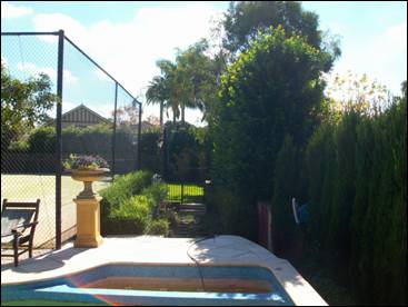
Figure 1: Existing pool and hedge to be retained
Coping height
The DCP also states that the coping of swimming pools should be a maximum of 500mm above existing ground level. The objective of this control is to minimise visual and privacy impacts to adjoining properties.
The proposed pool is a maximum of 645mm above existing ground level at its northern end. However, the proposed coping height is the same as that of the existing pool (RL 170.75) and the proposed development will not result in any additional privacy impacts than the existing pool. The proposed pool will not result in any adverse visual impacts to the adjoining property, No. 10 Telegraph Road, as it is screened by the existing planting which is to be retained.
Likely Impacts
The proposed development is not likely to result in any adverse impacts with regard to privacy, stormwater or visual impacts.
Suitability of the Site
The site is zoned for residential purposes and is suitable for the proposed development.
Public Interest
The approval of the application is considered to be in the public interest.
Conclusion
Having regard to the provisions of section 79C of the Environmental Planning and Assessment Act 1979, the proposed development is considered to be satisfactory. Therefore, it is recommended that the application be approved.
|
THAT Council, as the consent authority, is of the opinion that the objection under State Environmental Planning Policy No. 1 – Development Standards to clause 60(2) of the Ku-ring-gai Planning Scheme Ordinance is well founded. The Council is also of the opinion that strict compliance with the development standard is unreasonable and unnecessary in the circumstances of this case.
AND
THAT Council, as the consent authority, being satisfied that the objection under SEPP No. 1 is well founded and also being of the opinion that the granting of consent to DA0121/12 is consistent with the aims of the Policy, grant development consent to DA0121/12 for Demolition of existing in-ground pool and construction of a new in-ground pool on land at No. 8 Telegraph Road Pymble for a period of two (2) years from the date of the Notice of Determination, subject to the following conditions:
Conditions that identify approved plans:
1. Approved architectural plans and documentation (new development)
The development must be carried out in accordance with work shown in colour on the following plans and documentation listed below and endorsed with Council’s stamp, except where amended by other conditions of this consent.
Reason: To ensure that the development is in accordance with the determination.
2. Inconsistency between documents
In the event of any inconsistency between conditions of this consent and the drawings/documents referred to above, the conditions of this consent prevail.
Reason: To ensure that the development is in accordance with the determination.
Conditions to be satisfied prior to demolition, excavation or construction:
3. Road opening permit
The opening of any footway, roadway, road shoulder or any part of the road reserve shall not be carried out without a road opening permit being obtained from Council (upon payment of the required fee) beforehand.
Reason: Statutory requirement (Roads Act 1993 Section 138) and to maintain the integrity of Council’s infrastructure.
4. Notice of commencement
At least 48 hours prior to the commencement of any development (including demolition, excavation, shoring or underpinning works), a notice of commencement of building or subdivision work form and appointment of the principal certifying authority form shall be submitted to Council.
Reason: Statutory requirement.
5. Notification of builder’s details
Prior to the commencement of any development or excavation works, the Principal Certifying Authority shall be notified in writing of the name and contractor licence number of the owner/builder intending to carry out the approved works.
Reason: Statutory requirement.
Conditions to be satisfied prior to the issue of the construction certificate:
6. Amendments to approved landscape plan
Prior to the issue of a Construction Certificate, the Principal Certifying Authority shall be satisfied that the approved landscape plans, listed below and endorsed with Council’s stamp, have been amended in accordance with the requirements of this condition as well as other conditions of this consent:
The above landscape plan(s) shall be amended in the following ways:
· Show 2 canopy replenishment trees, 1 of which shall be a locally occurring native species selected from the Blue Gum High Forest Critically Endangered Ecological Community final determination species list, across the site’s street frontage.
· Show proposed planting within the new garden area adjacent to the driveway.
Prior to the issue of the Construction Certificate, the Principal Certifying Authority shall be satisfied that the landscape plan has been amended are required by this condition.
Note: An amended plan, prepared by a landscape architect or qualified landscape designer shall be submitted to the Certifying Authority.
Reason: To ensure adequate landscaping of the site.
7. Long service levy
In accordance with Section 109F(i) of the Environmental Planning and Assessment Act a Construction Certificate shall not be issued until any long service levy payable under Section 34 of the Building and Construction Industry Long Service Payments Act 1986 (or where such levy is payable by instalments, the first instalment of the levy) has been paid. Council is authorised to accept payment. Where payment has been made elsewhere, proof of payment is to be provided to Council.
Reason: Statutory requirement.
8. Builder’s indemnity insurance
The applicant, builder, developer or person who does the work on this development, must arrange builder’s indemnity insurance and submit the certificate of insurance in accordance with the requirements of Part 6 of the Home Building Act 1989 to the Certifying Authority for endorsement of the plans accompanying the Construction Certificate.
It is the responsibility of the applicant, builder or developer to arrange the builder's indemnity insurance for residential building work over the value of $20,000. The builder's indemnity insurance does not apply to commercial or industrial building work or to residential work valued at less than $20,000, nor to work undertaken by persons holding an owner/builder's permit issued by the Department of Fair Trading (unless the owner/builder's property is sold within 7 years of the commencement of the work).
Reason: Statutory requirement.
Conditions to be satisfied prior to the issue of the construction certificate or prior to demolition, excavation or construction (whichever comes first):
9. Infrastructure restorations fee
To ensure that damage to Council Property as a result of construction activity is rectified in a timely matter:
a) All work or activity taken in furtherance of the development the subject of this approval must be undertaken in a manner to avoid damage to Council Property and must not jeopardise the safety of any person using or occupying the adjacent public areas.
b) The applicant, builder, developer or any person acting in reliance on this approval shall be responsible for making good any damage to Council Property, and for the removal from Council Property of any waste bin, building materials, sediment, silt, or any other material or article.
c) The Infrastructure Restoration Fee must be paid to the Council by the applicant prior to both the issue of the Construction Certificate and the commencement of any earthworks or construction.
d) In consideration of payment of the Infrastructure Restorations Fee, Council will undertake such inspections of Council Property as Council considers necessary and also undertake, on behalf of the applicant, such restoration work to Council Property, if any, that Council considers necessary as a consequence of the development. The provision of such restoration work by the Council does not absolve any person of the responsibilities contained in (a) to (b) above. Restoration work to be undertaken by the Council referred to in this condition is limited to work that can be undertaken by Council at a cost of not more than the Infrastructure Restorations Fee payable pursuant to this condition.
e) In this condition:
“Council Property” includes any road, footway, footpath paving, kerbing, guttering, crossings, street furniture, seats, letter bins, trees, shrubs, lawns, mounds, bushland, and similar structures or features on any road or public road within the meaning of the Local Government Act 1993 (NSW) or any public place; and
“Infrastructure Restoration Fee” means the Infrastructure Restorations Fee calculated in accordance with the Schedule of Fees & Charges adopted by Council as at the date of payment and the cost of any inspections required by the Council of Council Property associated with this condition.
Reason: To maintain public infrastructure.
Conditions to be satisfied during the demolition, excavation and construction phases:
10. Prescribed conditions
The applicant shall comply with any relevant prescribed conditions of development consent under clause 98 of the Environmental Planning and Assessment Regulation. For the purposes of section 80A (11) of the Environmental Planning and Assessment Act, the following conditions are prescribed in relation to a development consent for development that involves any building work:
· The work must be carried out in accordance with the requirements of the Building Code of Australia · In the case of residential building work for which the Home Building Act 1989 requires there to be a contract of insurance in force in accordance with Part 6 of that Act, that such a contract of insurance is in force before any works commence.
Reason: Statutory requirement.
11. Hours of work
Demolition, excavation, construction work and deliveries of building material and equipment must not take place outside the hours of 7.00am to 5.00pm Monday to Friday and 8.00am to 12 noon Saturday. No work and no deliveries are to take place on Sundays and public holidays.
Excavation or removal of any materials using machinery of any kind, including compressors and jack hammers, must be limited to between 7.30am and 5.00pm Monday to Friday, with a respite break of 45 minutes between 12 noon 1.00pm.
Where it is necessary for works to occur outside of these hours (ie) placement of concrete for large floor areas on large residential/commercial developments or where building processes require the use of oversized trucks and/or cranes that are restricted by the RTA from travelling during daylight hours to deliver, erect or remove machinery, tower cranes, pre-cast panels, beams, tanks or service equipment to or from the site, approval for such activities will be subject to the issue of an "outside of hours works permit" from Council as well as notification of the surrounding properties likely to be affected by the proposed works.
Note: Failure to obtain a permit to work outside of the approved hours will result in on the spot fines being issued.
Reason: To ensure reasonable standards of amenity for occupants of neighbouring properties.
12. Approved plans to be on site
A copy of all approved and certified plans, specifications and documents incorporating conditions of consent and certification (including the Construction Certificate if required for the work) shall be kept on site at all times during the demolition, excavation and construction phases and must be readily available to any officer of Council or the Principal Certifying Authority.
Reason: To ensure that the development is in accordance with the determination.
13. Use of road or footpath
During excavation, demolition and construction phases, no building materials, plant or the like are to be stored on the road or footpath without written approval being obtained from Council beforehand. The pathway shall be kept in a clean, tidy and safe condition during building operations. Council reserves the right, without notice, to rectify any such breach and to charge the cost against the applicant/owner/builder, as the case may be.
Reason: To ensure safety and amenity of the area.
14. Toilet facilities
During excavation, demolition and construction phases, toilet facilities are to be provided, on the work site, at the rate of one toilet for every 20 persons or part of 20 persons employed at the site.
Reason: Statutory requirement.
15. Recycling of building material (general)
During demolition and construction, the Principal Certifying Authority shall be satisfied that building materials suitable for recycling have been forwarded to an appropriate registered business dealing in recycling of materials. Materials to be recycled must be kept in good order.
Reason: To facilitate recycling of materials.
16. Construction signage
All construction signs must comply with the following requirements:
· are not to cover any mechanical ventilation inlet or outlet vent · are not illuminated, self-illuminated or flashing at any time · are located wholly within a property where construction is being undertaken · refer only to the business(es) undertaking the construction and/or the site at which the construction is being undertaken · are restricted to one such sign per property · do not exceed 2.5m2 · are removed within 14 days of the completion of all construction works
Reason: To ensure compliance with Council's controls regarding signage.
17. Road reserve safety
All public footways and roadways fronting and adjacent to the site must be maintained in a safe condition at all times during the course of the development works. Construction materials must not be stored in the road reserve. A safe pedestrian circulation route and a pavement/route free of trip hazards must be maintained at all times on or adjacent to any public access ways fronting the construction site. Where public infrastructure is damaged, repair works must be carried out when and as directed by Council officers. Where pedestrian circulation is diverted on to the roadway or verge areas, clear directional signage and protective barricades must be installed in accordance with AS1742-3 (1996) “Traffic Control Devices for Work on Roads”. If pedestrian circulation is not satisfactorily maintained across the site frontage, and action is not taken promptly to rectify the defects, Council may undertake proceedings to stop work.
Reason: To ensure safe public footways and roadways during construction.
18. Services
Where required, the adjustment or inclusion of any new utility service facilities must be carried out by the applicant and in accordance with the requirements of the relevant utility authority. These works shall be at no cost to Council. It is the applicants’ full responsibility to make contact with the relevant utility authorities to ascertain the impacts of the proposal upon utility services (including water, phone, gas and the like). Council accepts no responsibility for any matter arising from its approval to this application involving any influence upon utility services provided by another authority.
Reason: Provision of utility services.
19. Erosion control
Temporary sediment and erosion control and measures are to be installed prior to the commencement of any works on the site. These measures must be maintained in working order during construction works up to completion. All sediment traps must be cleared on a regular basis and after each major storm and/or as directed by the Principal Certifying Authority and Council officers.
Reason: To protect the environment from erosion and sedimentation.
20. Drainage to existing system
Stormwater runoff from all new impervious areas and subsoil drainage systems shall be piped to the existing site drainage system. The installation of new drainage components must be completed by a licensed contractor in accordance with AS3500.3 (Plumbing Code) and the BCA. No stormwater runoff is to be placed into the Sydney Water sewer system. If an illegal sewer connection is found during construction, the drainage system must be rectified to the satisfaction of Council and Sydney Water.
Reason: To protect the environment.
21. Approved tree works
Approval is given for the following works to be undertaken to trees on the site:
Removal or pruning of any other tree on the site is not approved, excluding species exempt under Council’s Tree Preservation Order.
Reason: To ensure that the development is in accordance with the determination.
22. No storage of materials beneath trees
No activities, storage or disposal of materials shall take place beneath the canopy of any tree protected under Council's Tree Preservation Order at any time.
Reason: To protect existing trees.
23. Removal of refuse
All builders' refuse, spoil and/or material unsuitable for use in landscape areas shall be removed from the site on completion of the building works.
Reason: To protect the environment.
24. Canopy replenishment trees to be planted
The 2 canopy replenishment trees to be planted shall be maintained in a healthy and vigorous condition until they attain a height of 5.0 metres whereby they will be protected by Council’s Tree Preservation Order. Any of the trees found faulty, damaged, dying or dead shall be replaced with the same species.
Reason: To maintain the treed character of the area.
25. On site retention of waste dockets
All demolition, excavation and construction waste dockets are to be retained on site, or at suitable location, in order to confirm which facility received materials generated from the site for recycling or disposal.
· Each docket is to be an official receipt from a facility authorised to accept the material type, for disposal or processing. · This information is to be made available at the request of an Authorised Officer of Council.
Reason: To protect the environment.
Conditions to be satisfied prior to the issue of an Occupation Certificate:
26. Compliance with BASIX Certificate
Prior to the issue of an Occupation Certificate, the Principal Certifying Authority shall be satisfied that all commitments listed in BASIX Certificate No. A136558 have been complied with.
Reason: Statutory requirement.
27. Completion of landscape works
Prior to the release of the Occupation Certificate, the Principal Certifying Authority is to be satisfied that all landscape works, including the removal of all noxious and/or environmental weed species, have been undertaken in accordance with the approved plan(s) and conditions of consent.
Reason: To ensure that the landscape works are consistent with the development consent.
28. Infrastructure repair
Prior to issue of the Occupation Certificate, the Principal Certifying Authority must be satisfied that any damaged public infrastructure caused as a result of construction works (including damage caused by, but not limited to, delivery vehicles, waste collection, contractors, sub contractors, concrete vehicles) is fully repaired to the satisfaction of Council Development Engineer and at no cost to Council.
Reason: To protect public infrastructure.
29. Swimming pool (part 1)
Prior to the issue of the Occupation Certificate, the Principal Certifying Authority shall be satisfied that:
C1 1. Access to the pool/spa shall be restricted by a child resistant barrier in accordance with the regulations prescribed in the Swimming Pools Act, 1992:
(a) The pool shall not be filled with water or be allowed to collect stormwater until the child resistant barrier is installed; and (b) The barrier is to conform to the requirements of AS 1926-1 2007 Fences and Gates for Private Swimming Pools.
Reason: To ensure the safety of children.
2. Any mechanical equipment associated with the swimming pool and/or spa pool shall be located in a sound-attenuating enclosure and positioned as shown on th approved plans. The Principal Certifying Authority shall be satisfied that the sound levels associated with the swimming pool/spa filtration system and associated mechanical equipment do not exceed 5dB(A) above the background noise level at the boundaries of the site.
Reason: To protect the amenity of surrounding properties.
30. Pool overflow to sewer
Prior to issue of the Occupation Certificate a high level overflow pipe is to be provided from the back of the skimmer box to the filter backwash line discharging to the sewer. This line must not directly vent the receiving Sydney Water sewer. This requirement is to collect stormwater overflow from the swimming pool surface only. A certificate from the installer, indicating compliance with this condition, must be submitted to the Principal Certifying Authority prior to issue of the Occupation Certificate.
Reason: To provide satisfactory drainage.
Conditions to be satisfied at all times:
31. Swimming pool (part 2)
At all times:
1. Access to the swimming pool must be restricted by fencing or other measures as required by the Swimming Pools Act 1992. 2. Noise levels associated with spa/pool pumping units shall not exceed 5dB(A) at the boundaries of the site. 3. Devices or structures used for heating swimming pool water must not be placed where they are visible from a public place. 4. For the purpose of health and amenity, the disposal of backwash and/or the emptying of a swimming pool into a reserve, watercourse, easement or storm water drainage system is prohibited. These waters are to discharge via a permanent drainage line into Sydney Water's sewer in accordance with Australian Standard AS3500.2 section 10.9. Permission is to be obtained from Sydney Water prior to the emptying of any pool to the sewer. 5. Lighting from the swimming pool and other communal facilities shall not detrimentally impact the amenity of other premises and adjacent dwellings.
Reason: Health and amenity.
|
||||||||||||||||||||||||||||
|
Brodee Gregory Senior Assessment Officer |
Selwyn Segall Team Leader - Development Assessment North |
|
Corrie Swanepoel Manager Development Assessment Services |
Michael Miocic Director Development & Regulation |
|
A1View |
Location sketch |
|
2012/126712 |
|
|
|
A2View |
Zoning extract |
|
2012/126758 |
|
|
A3View |
Site and site analysis plan |
|
2012/095218 |
|
|
A4View |
Elevations and sections |
|
2012/127386 |
|
|
A5View |
Landscape plans |
|
2012/095211 |
|
|
A6View |
SEPP1 objection |
|
2012/095215 |
|
|
A7View |
Planning Circular PS08-014 |
|
2010/063222 |
|
Ordinary Meeting of Council - 12 June 2012 |
GB.4 / 95 |
|
|
|
|
Item GB.4 |
S04480 |
|
|
27 March 2012 |
Wahroonga Park Precinct Draft Landscape Masterplan
EXECUTIVE SUMMARY
|
purpose of report: |
To seek Council's approval to place the Wahroonga Park Precinct draft Landscape Masterplan (encompassing Wahroonga Park, McKenzie Park and 78 Coonabarra Road) on public exhibition. |
|
|
|
|
background: |
The Wahroonga Park Precinct draft Landscape Masterplan is the sixth district park masterplan to be undertaken by Council since Council resolved in 2006 to prepare masterplans for all of Council’s fifteen District Parks. The masterplan for Wahroonga Park has been expanded to include the two (2) adjoining parks being McKenzie Park and 78 Coonanbarra Road, Wahroonga. The draft Landscape Masterplan does not involve extensively developing the precinct, but rather conserving it and introducing additional facilities to improve amenity, improve access and increase user comfort. |
|
|
|
|
comments: |
The Wahroonga Park Precinct draft Landscape Masterplan provides a vision for the embellishment of these parks based on community feedback. It will allow Council to carry out staged improvements to park amenity and infrastructure by prioritising allocation of available s.94 funding and guide the allocation of additional funding as it becomes available. |
|
|
|
|
recommendation: |
That Council place the Wahroonga Park Precinct draft Landscape Masterplan on public exhibition for a minimum of 28 days including an exhibition and information session to be held in Wahroonga Park on a suitable weekend to enable community dialogue with Council staff. Also that the amended plan incorporating community comment be reported back to Council for consideration and adoption. |
Purpose of Report
To seek Council's approval to place the Wahroonga Park Precinct draft Landscape Masterplan (encompassing Wahroonga Park, McKenzie Park and 78 Coonabarra Road) on public exhibition.
Background
Demand for developed open space in Ku-ring-gai is increasing. Predicted increases in the population will have a significant impact on the ability of our existing parks to cater for the needs of current and future residents and expanding shopping centres. Developing existing parks that have the capacity can provide improved recreation opportunities for this population increase.
Council resolved in 2006 to prepare masterplans for all of Council’s 15 district parks including Wahroonga Park. District Parks have features that attract people from outside the immediate neighbourhood for a range of reasons, such as the unique landscape and heritage character of Wahroonga Park. District parks offer a range of recreational opportunities such as passive shady places and gardens, active areas for play, events/ social/ picnic spaces and large open space areas. Additionally, district parks have toilet facilities and cater for people who travel to the park and stay for a number of hours, as well as attracting local visitors/ residents.
The masterplan for Wahroonga Park has been expanded to include the two (2) adjoining undeveloped local parks being McKenzie Park and 78 Coonanbarra Road. The Wahroonga War Memorial has not been included in this plan as it fittingly presents no opportunities for recreation or development (Attachment A1).
Wahroonga Park (1.84ha) is considered by many to be Ku-ring-gai’s most popular park. It has local heritage value because it is culturally significant as an example of an ornamental built landscape strongly associated with a community group, the Wahroonga Progress Association. Since the 1890s, the Wahroonga Progress Association was active in seeking improvements to the local area. In 1913, the land yet to become the site of Wahroonga Park was described as:
swampy ground covered by blackberry with 3 private residences at the northeast corner fronting Stuart Street and a humpy on the land that was occupied by an elderly gent who ran the local horse-drawn cab for passengers to and from the railway station. The Progress Association saw the site as an area requiring “careful combined treatment to make ‘the gateway’ to our district worthy of the traditions of Wahroonga”.
The 1929 Report of the Progress Association attributed:
“the rapid growth and improvement in every part” of the Park “to the work of many people” acknowledging that “there have been gifts of plants and trees, of materials, of labour, of skill and time, the money value of which would amount to a large sum, while the real worth as an indication of public spirit – community spirit – could not be expressed in terms of money.”
It is significant as an example of a public park designed and built to a 1920s style using fashionable feature trees and gardens of exotic flowering plants. It is also significant because of its largely intact design, character and fabric. Wahroonga Park is highly valued by the community as an area for passive recreation and leisure and for special community events.
McKenzie Park is a small grassy reserve (1385m2) adjacent to the railway line between Illoura Avenue and Illoura Lane with two (2) significant large Eucalyptus trees along the northern edge and some smaller scattered trees throughout. It was acquired by Council in 1970 and has remained open grass with some ornamental trees. It has no designated recreation uses and no facilities. The name McKenzie Park was assigned by the Geographical Names Board in 1991.
78 Coonanbarra Road is a small undeveloped reserve (765m2) given to Council in 1973 as a result of development of apartments at 80 – 84 Coonanbarra Road. It was given to provide a quiet rest area for the use of local residents. It contains several exotic shade trees, an Ausgrid power kiosk and twp (2) park seats. This site requires an official name based on early history in this particular area of Wahroonga. The proposed naming will be presented as part of the final masterplan and the preferred name will be subject to approval by the Geographical Names Board (Attachment A2).
Because of the constraints against development within these parks, such as local heritage significance, small size and established landscape character, input from the community has been focussed on examining what activities may be encouraged and what activities are to be discouraged. This input guides embellishment that can make improvements for users without significant negative impacts on heritage and character. The draft Landscape Masterplan does not involve extensively developing the precinct, but rather conserving it and introducing additional facilities to improve amenity, improve access and increase user comfort.
Comments
The preparation of this draft masterplan has been guided by the local community through consultation surveys. The information gained from the surveys and meetings with stakeholders has been used to develop the draft Masterplan for exhibition.
The draft Landscape Masterplan is included as Attachment A3-A8. The draft Landscape Masterplan for the precinct is presented as posters describing the existing site and proposed improvements. The posters include Precinct History and Heritage, Analysis, Playground Upgrade, Wahroonga Park Masterplan, McKenzie Park Masterplan and 78 Coonanbarra Road Masterplan.
The draft Landscape Masterplan aims to:
· Integrate sustainable principles into park design.
· Incorporate elements that are important to the community and user groups.
· Balance the concerns of all community groups.
· Provide a holistic approach to design that allows improvements to occur in stages as funding becomes available.
· Respect the established character and local heritage qualities of Wahroonga Park.
· Retain a passive recreation focus including key Community events during the year.
· Create a defined ‘sense of place’ and use for McKenzie Park and 78 Coonanbarra Road.
· Prioritise facility and infrastructure improvements to add to user comfort and satisfaction over the next 5 to 10 years.
· Improve the asset value by providing new assets, and replacement, conservation and reconstruction of dilapidated and aged infrastructure.
Key aspects of the masterplan are discussed below.
1. Landscape Character
· Retain the tranquil 1920s atmosphere - undeveloped, uncluttered, group new facilities.
· Add new and embellish the existing gardens which are integral to the experience of the landscape setting.
· Remove over mature and unsafe avenue trees as assessed in the Arborist’s Report and replace with appropriate and suitable feature planting of exotic or native species which reinforce the original character.
· Maintain the existing fabric in good condition and conserve or replace like for like. In accordance with the Burra Charter, “Do as much as necessary, and as little as possible”.
· Maintain the open spaces and enclosed canopied character of the parks whilst retaining sightlines and visibility for safety and risk management.
· Consider interpretive signage in appropriate locations to give information about local history, the park and its established vegetation.
· Design minor structures such as signs, picnic shelters, gateways and fences to be in context with the existing structures such as the seats, central arbour and rotunda.
· Draw on the historic photos of the park to recreate some elements, such as tree seats.
· Undertake embellishment of McKenzie Park and 78 Coonanbarra Road to be visually congruent with the established character of Wahroonga Park.
2. Access and circulation
· Provide co-ordinated name and information signage at key access points to the parks.
· Repair or renew the existing path network within the park using compatible materials.
· Construct new path networks to facilitate barrier free access to get to, and to get around, the parks and to link facilities such as toilets, playground and picnic area.
· Improve nature strip access pathways by grading and reconstruction and improve kerb access as part of routine maintenance practices and to accommodate new avenue feature tree planting.
· Relocate the Council vehicle access point from between parked cars on Stuart Street to adjacent to the Bus stop on Illoura Street. Secure permitted vehicle access points with removable bollards.
· Consider illegal vehicle access points and install barriers such as bollards, stone edging or tree planting and hedges to prevent this access but still admit pedestrians and enable visibility.
· Facilitate access to the wombat crossing on Stuart Street as the safest place to cross for supervised school groups, and develop improved path links.
· Improve disabled access, deliveries and patient drop-off at ‘The House in the Park’ by constructing on-site parking for two (2) authorised vehicles adjacent to the building.
· Restrict garbage trucks causing damage to surfaces when driving through the park to empty bins by relocating bins or enforcing alternate methods of collection.
· Retain the time restricted road parking around the parks as supported by park users.
3. Infrastructure upgrade
· Implement playground upgrade for completion by 2013. (This is being undertaken early in 2012/13 financial year as a separate approved capital works project).
· Demolish the existing toilet block (this building is not of heritage significance and is in poor condition and not accessible) and construct a new toilet block including sustainable, accessible and family friendly toilets that can cater for all precinct users.
· Assess existing sewer infrastructure for renewal during toilet block works.
· Install drainage to redirect standing water over pathways and into the stormwater system after rain events.
· Assess existing post top lighting as provided by Ausgrid and determine a replacement schedule to meet LED energy efficient, aesthetic and functional requirements in compliance with Australian Standards and Ausgrid LED Decorative Lighting Tender (to be finalised for 2013 implementation).
· Seek assistance from a reputable sculptor to have the ‘Don Quixote’ bronze sculpture by Diana Hunt (deceased) repaired.
4. Facilities
· Upgrade facilities which are damaged or require asset maintenance, such as park furniture.
· Investigate Council’s response to vandalism and methods of increasing surveillance and reducing malicious damage in the parks.
· Add facilities such as picnic shelters, furniture and edge controls such as bollards, hedges and fencing to facilitate use for passive recreation and community comfort and safety.
· Consider providing new leisure elements such as outdoor chess tables and a walking labyrinth in the smaller parks to create interest.
· Maintain the ‘House in the Park’ building as a leased community health facility, but undertake a heritage assessment and feasibility study to determine if other uses for Council could be viable and profitable, such as a Coffee Kiosk to the rear basement area or a café when the current lease expires. These uses would be subject to further feasibility, consultation and approvals. Concerns to be addressed include retaining park ambience, additional noise, parking, commercialism, and no need for a café as they are available at the nearby Wahroonga town centre and Coonanbarra Road.
5. Events
· Wahroonga Park is the site of annual events which are supported by the wider community, such as Twilight Concerts in the Park, and the Australia Day Public Citizenship Ceremony.
· Additional events may be considered within the constraints of the physical site and its cultural significance, particularly activities related to the arts, such as open-air theatre, poetry readings and music recitals. Some events will require Development Approval prior to being confirmed. “Art in the Park” has been suggested as an annual activity which could be supported by Council and sponsored by local art groups, service clubs such as Rotary and the local Chamber of Commerce.
· Possible infrequent events in the park that build community could be supported, such as Community Markets, and activities supporting the annual Wahroonga Fair in December.
· The use of Wahroonga Park for weddings and other civil ceremonies is popular throughout the year and this use is encouraged as revenue generating.
· Use by Active Ku-ring-gai programs and accredited personal trainers will be retained.
6. Sustainability and Environment
· Incorporate energy efficient measures into all new and retrofitted facilities, such as LED lights, skylights and use of roof water for toilet flushing.
· Implement sustainable horticultural practices and recycle and compost garden materials collected during maintenance activities.
· Consider the end of life sustainability and environmental credentials of all materials and facilities before purchase, for example, using furniture made from certified FSC timber, playground equipment that meets ISO 14001 Environmental Management.
· Interpret the history of Wahroonga Park to promulgate local knowledge to future generations.
7. Tree Management
· Using tree assessments received from Consultants Arborist and advice from Council’s staff who manage trees on Council Property, (Tree Maintenance Supervisor, Parks Maintenance Supervisor and Tree Preservation and Contracts Co-ordinator), identify trees to be removed because of risk and safety issues and prioritise removal.
· Implement a plan of staged removal and replanting, using suitably sized species which are suitable and significant for Avenue planting, to restore landscape and visual character.
· Investigate the possibility of Aerial Bundle Cabling (ABC) to the streets around the park to enable trees to grow without pruning costs and damage.
· Plan replanting of Millewa Avenue along the railway line and park boundary with suitable canopy feature trees to link with Wahroonga War Memorial as a commemorative avenue to mark the centenary of the start of WW1 in 2015 (similar to the ‘Avenue to the Fallen’ in Tryon Road Lindfield).
· Undertake replanting in suitable soils with allowance for roots as they grow to reduce damage to pavements, kerbs and drainage systems.
· Investigate feasibility of sustainable reuse of timber from removed trees for park furniture, or other nominated uses where timber is suitable.
Governance Matters
This community land classified as ‘Park’ is owned by Council and managed under the Generic Parks Plan of Management adopted by Council in 2005. Council included the preparation of District Park Landscape Master Plans into the Community Development section of Council’s 2005-2009 Management Plan. The current Delivery Program and Operational Plan 2011 -12 under Capital Works and Major Projects 2011-2012 lists Wahroonga Park for “Landscape Works Associated With Playground Upgrade and Masterplan”. The Action that “Council endorses district park masterplan for Wahroonga Park” is listed in the Delivery Program and Draft Operational Plan 2012 – 2013.
This landscape masterplan will assist Council in ensuring that section 94 funds collected for these parks are used to the best effect for the local community and within a reasonable timeframe.
Risk Management
The Wahroonga Park Precinct District Landscape Plan will assist Council to reduce risk. The current risk at these sites is exacerbated by the degraded asset condition of the infrastructure and facilities which are close to failure or that may not give equitable access to park users, such as the toilet block. Degraded facilities can foster vandalism and lack of ownership by the community. Wahroonga Park, similar to many areas adjacent to the Railway, is frequently vandalised and graffiti is common. The risk of vandalism is the high cost of repairs or replacement, damaged facilities presenting a hazard to park users and the nuisance and inconvenience whilst repairs are undertaken. Reducing vandalism reduces Council’s risk. Improving a facility increases ownership, vigilance, use and interest from the community and assists to reduce vandalism.
Trees identified as failing or unstable present a very real risk to Council because of the hazard which exists for park users. The removal of these trees and replacement with more suitable species will significantly reduce Councils risk and public danger (Attachment A9).
During construction, risks in relation to site safety and work health and safety (WHS) will be the responsibility of the appointed contractor. Risk management, WHS systems and financial security are all key selection criteria for potential contractors to address during the tender process.
The financial risk in relation to the draft Landscape Masterplan is the subsequent community expectation that all works contained within the plan are able to be implemented. Should a tender process result in the cost of works exceeding the funds allocated in the project budget, it would be necessary to report this to Council as part of the tender approval or as part of quarterly budget review process. Such a report would likely recommend altering the scope of the project, allocate additional funding from other sources, or reallocate funding from other projects.
Financial Considerations
Adopted District Park Masterplans are used to inform the development of the Parks Development Program in Council’s annual Capital Works Program and future section 94 (S.94) plans. Each masterplan is expected to be implemented over a 10 year period, subject to funding.
The draft Landscape Masterplan provides Council with a long term view on the management of the Parks. It will enable staged works as funding becomes available, with the knowledge that all projects are in keeping with, and will contribute to, a long term vision for the park. Some works are of an operational nature and can be completed within existing recurrent budgets and others would be subject to current section 94 funds, future capital works and/or grant proposals.
The majority of the funding for the implementation of the Masterplan will come from Section 94 development contributions. Council has been levying developers for the upgrading of Wahroonga Park, McKenzie Park and 78 Coonanbarra Road since the adoption of its Development Contributions Plan in 2004.
The actual financial commitment resulting from this Masterplan is dependent on competing priorities and funding availability, including recurrent budget, s.94 plans, external grants, partnerships with stakeholders, service clubs and local business, and future Environmental Levy plans.
A more detailed budget estimate and prioritisation of upgrade works will be provided as part of the final District Landscape Masterplan.
Social Considerations
The plan provides additional leisure and passive recreation facilities and amenities for a wider range of users than exists currently, particularly families, older people and children. The proposed new facilities are designed to encourage the interaction of community through meeting places and places for enjoying the outdoors. The park upgrades will also assist to spread the more passive recreational use into the little used parks, reducing crowding and allowing some spaces to be set aside for quieter pursuits.
Environmental Considerations
None of the park sites contain any areas classified or managed as bushland or areas classified under threatened species legislation. The adjacent residential land contains some remnant Blue Gum High Forest and Sydney Turpentine Ironbark Forest but the single specimen tree (Angophora costata) within Wahroonga Park was planted, based on photographic evidence indicating the land was cleared before development. There are two (2) large Eucalyptus trees on the edge of McKenzie Park which are being retained.
The proposed works will benefit the environment by:
· Reducing impacts of weed source trees through removal – Camphor laurels which have been identified as failing health or unstable will be removed - within the Spring Gully Creek catchment.
· Reducing the use of potable water for toilet flushing and electricity through photovoltaic cells for lighting, by the design of a new toilet block incorporating sustainable principles.
· Reducing erosion of bare soil areas in 78 Coonanbarra Road by planting, mulching or turfing.
· Replacing the existing playground with equipment that has whole of life recycling potential under ISO14001.
As part of standard construction practice, suitable environmental management controls will be required to be implemented during any works. Specific environmental requirements, procedures and precautionary treatments will include erosion control, drainage control measures and silt management.
Community Consultation
All those who have provided input to the development of the draft Landscape Masterplan have been notified of this report going to Council.
The preparation of this draft masterplan has been guided by the local community feedback from several sources. Local residents and stakeholder groups were invited to comment on the proposed playground upgrade and 606 letters were sent out on 14 November 2011, generating 7 responses, and 2 letters from children. A Benchmark Park User Satisfaction Survey Program by IOSS Consultants was undertaken in the first half of 2011 and Wahroonga Park was included for a targeted face to face response from people within the park. On 5 March 2012 a consultation survey was mailed to 278 local residents and stakeholders and included in the ‘Have Your Say’ section of Council’s website. 48 responses were received. Information gained from this consultation has been used to develop the draft Masterplan for exhibition.
Results of the surveys are discussed below.
· 606 letters were sent to residents and stakeholder groups regarding the playground upgrade works in Wahroonga Park on 14 November 2011 and they were advised that “Further consultation to guide a Masterplan for the embellishment of the rest of the park area is planned for early 2012” A copy of this letter was sent to Councillors and the information was placed on the Council website. There were 4 responses supporting Council’s playground proposal and specifically mentioning the need for toilet upgrades and park refurbishment.
· On 5 March 2012, a letter and accompanying Survey and reply paid envelope was sent out to 278 residents and stakeholders including the Wahroonga Chamber of Commerce and the Rotary Club of Wahroonga, and Councillors were also advised. This letter stated “To assist us in preparing a Landscape Masterplan that is relevant to the community, we are seeking feedback from local residents, park users and stakeholders. Please fill in the following survey and return to Council in the attached 'reply paid' envelope prior to 16 April 2012. Alternatively fill out the survey online”.
48 surveys were received and collated. It was found that the majority of park users use the park on a daily basis and that the park is used every day of the week including weekends.
Most park users walk to the park and then stay for one to three hours. Families use the park for Play/ Exercise activities or Picnic/ Relaxing purposes. They view the "large open spaces" in the park as the main attraction. Users have commented they prefer no change or possibly additional seating/shelter and lighting only.
The public hate to see vandalism and rubbish in the park and do not support skateboard riding in the park.
When questioned on possible ideas for park upgrading - a new amenities building featured very highly with a drinking fountain along with additional seating and shelters in the park. Users would like the park character to remain unchanged but allow for the formalising of an amenities building. The proposed playground upgrade is supported.
When queried about the parks at 78 Coonanbarra Road and McKenzie Park, park users see these as being made formally into passive spaces by building benches, tables and paths. The wording "Open Space and Relaxation” features highly in the hand written comments section.
· In addition a survey was carried out between February and July 2011 by IOSS Consultants as part of the Benchmark Park Users Satisfaction Survey in Sydney and Central Coast Region.
This survey found that the main areas of discussion were amenities and playground.
The playground issues will be addressed when the new playground is constructed, scheduled for second half of 2012. Users commented on amenities and drinking fountains and a need for additional seats and shelters. There were requests for better toilet maintenance with toilet lighting and bins and better paths surrounding the toilets. Additional car parking and fencing were raised but were in the minority in this survey.
The proposed draft Landscape Masterplan has addressed these issues.
Once the draft plan has been exhibited and a community consultation forum is held on site, the draft plan will be amended as required and presented to Council for adoption.
Internal Consultation
Internal consultation has been undertaken, including discussion and development of surveys, with relevant staff in Community, Strategy & Environment and Operations prior to sending out. A copy of the survey and mail out was sent to Councillors for information. Operations maintenance staff and supervisors have been consulted on site to determine maintenance issues and asset condition, and pedestrian safety was discussed on site with Operations Design staff. The new toilet block concept building has been subject to internal review with Operations, Community and Strategy and Environment Staff. The arborists reports were scrutinised by Operations Tree Management staff. Internal consultation is supportive of the landscape masterplan.
Summary
In November 2006 Council resolved to develop Landscape Masterplans for District Parks. Council is now preparing a Landscape Masterplan for Wahroonga Park and the adjoining parkland at McKenzie Park and 78 Coonanbarra Road.
Landscape masterplans encourage community consultation to input into the process of upgrading a park. The masterplan will identify embellishments that will improve a park, such as increasing recreation opportunities, integrating sustainability principles, and improving facilities. This will enable staged works as funding becomes available, with the knowledge that all projects are in keeping with, and will contribute to, a long term vision for the park. Expenditure for embellishment will be sourced from development contributions. Landscape masterplans assist Council in ensuring that these funds are used to the best effect for the local community within a reasonable timeframe.
The draft masterplan when exhibited will draw further input from Community and stakeholder groups and assist to complete a final District Landscape Masterplan for the Wahroonga Park Precinct to be brought back to Council for adoption.
|
A. That Council place the Wahroonga Park Precinct draft Landscape Masterplan on public exhibition for a minimum of 28 days including an exhibition and information session to be held in Wahroonga Park on a suitable weekend to enable community dialogue with Council staff.
B. That the amended plan incorporating community comment be reported back to Council for consideration. |
|
Alison Walker Principal Landscape Architect |
Roger Faulkner Team Leader Sport & Recreation Planning |
|
Ian Dreghorn Manager Strategic Projects |
Andrew Watson Director Strategy & Environment |
|
A1View |
Wahroonga Park Precinct Draft Masterplan: Precinct Location Plan |
|
2012/134307 |
|
|
|
A2View |
Naming proposal - 78 Coonanbarra Road Wahroonga |
|
2012/134330 |
|
|
A3View |
Sheet 1: History and Heritage |
|
2012/134292 |
|
|
A4View |
Sheet 2: Analysis |
|
2012/134298 |
|
|
A5View |
Sheet 3: Wahroonga Park Masterplan |
|
2012/134305 |
|
|
A6View |
Sheet 4: Playground Upgrade |
|
2012/134309 |
|
|
A7View |
Sheet 5: McKenzie Park Masterplan |
|
2012/134300 |
|
|
A8View |
Sheet 6: 78 Coonanbarra Road Masterplan |
|
2012/134304 |
|
|
A9View |
Risk Management Tool - Wahroonga Park Precinct Landscape Masterplan |
|
2012/133319 |
|
APPENDIX No: 9 - Risk Management Tool - Wahroonga Park Precinct Landscape Masterplan |
|
Item No: GB.4 |
|
Task or Activity |
Risk Type or Source |
Risk Description |
Pre Treatment/ Control
Risk Score |
Existing Treatments/ Control Measures |
Post Treatment/ Control
Risk Score |
|
Wahroonga Park Precinct District Landscape Masterplan |
COMPLIANCE - Legal |
Failure to provide Accessible Toilets under Disability Discrimination Act. |
Medium - 5 |
Build new toilet block. |
Low - 1 |
|
|
COMPLIANCE - Governance |
*Failure to undertake listed actions in the adopted Plan of
Management for the sites. |
Moderate - 4 |
Complete identified actions and undertake expenditure of available funds guided by adopted Masterplan. |
Moderate - 3 |
|
|
PEOPLE - Injury and Disease (includes workers and community) |
* Toilets cannot be cleaned properly due to damaged surfaces and
sewer pipe has holes with potential for disease and injury. |
High - 6 |
*Build new toilet block including new store area to W&HS
requirements and new sewer works. |
Moderate - 3 |
|
|
ENVIRONMENT - Environmental effects |
*Weed species seeding continue to sustain spread of weeds in
surrounding area. |
High - 6 |
*Remove failing weed trees &roots to replace with
appropriate plantings |
Moderate - 3 |
|
|
ENVIRONMENT - Social/ cultural heritage |
*Without Masterplan potential for damage or removal of heritage
fabric |
Medium - 5 |
Complete Masterplan, exhibit, co-ordinate feedback, prioritise actions and expenditure to guide works as they occur. |
Low - 2 |
|
|
STRATEGIC - Corporate Objectives |
*Without Masterplan, Corporate Objectives from Operational and
Delivery Plan cannot be met |
Moderate - 3 |
Meet objectives of operational and Delivery Plan and Council's Resolution. |
Low - 2 |
|
|
STRATEGIC - Service Delivery/ Reputation |
*Without Masterplan, Council appears unwilling or unable to meet
its own requirements and those of its constituents |
Moderate - 3 |
Complete Masterplan, and use to deliver improvements recognised by the community as a direct result of their input, leading to better use, positive feedback and improved care and maintenance. |
Low - 2 |
|
|
OPERATIONAL - Direct Operational Impact |
*Failure to improve run down infrastructure increases incidences of vandalism and directly increases costs for repair, replacement and community inconvenience *Failure to remove identified failing trees directly
de-motivates maintenance staff and increases workplace anxiety for public
safety. |
High - 6 |
Remove failing trees, improve condition of asset to remove direct impact on Council and Operations. |
Moderate - 3 |
|
|
OPERATIONAL - Financial/ Marketing/ Customers |
*Income from booked events such as weddings and attendance at community events declines as degraded asset becomes less marketable *Complaints and dissatisfaction from customers increase negative
view of Council |
High - 6 |
Better asset conditions mean greater appreciation and use by the community and less unwanted damage - more users mean more ownership and more care by the community. |
Moderate - 3 |
|
|
OPERATIONAL - Property |
Undeveloped Property which is set aside for recreation and leisure becomes the target of unwanted or unsuitable activities because it appears unused - such as weed growth, littering, infrastructure for Ausgrid, illegally parked cars, dumping, encroachments |
Moderate - 4 |
Develop parks to provide leisure amenity and increase use and ownership by locals. |
Moderate - 3 |
|
Ordinary Meeting of Council - 12 June 2012 |
GB.5 / 118 |
|
|
|
|
Item GB.5 |
DA0677/11 |
|
|
10 April 2012 |
Edgelea Urban Design Guidelines
EXECUTIVE SUMMARY
|
purpose of report: |
To have Council consider Urban Design Guidelines for the future development of Edgelea within the former UTS Ku-ring-gai Campus in Lindfield. |
|
|
|
|
background: |
A Concept Approval under part 3A of the Environmental Planning & Assessment Act, 1979 for the redevelopment of the UTS Ku-ring-gai Campus in Lindfield was issued on 11 June 2008. The conditions of the Concept Approval require the preparation of Urban Design Guidelines for the development to be adopted by Council prior to the determination for the first development application. |
|
|
|
|
comments: |
The proponent has prepared draft Urban Design Guidelines in close consolation with Council’s Urban Planning and Development and Regulation staff. The proposed Urban Design Guidelines will be the primary document used to inform the built element of the development of the Edgelea site. |
|
|
|
|
recommendation: |
That Council approve the Edgelea Urban Design Guidelines subject to amendments. |
Purpose of Report
To have Council consider Urban Design Guidelines for the future development of Edgelea within the former UTS Ku-ring-gai Campus in Lindfield.
Background
On 11 June 2008 a Concept Approval under part 3A of the Environmental Planning and Assessment Act, 1979 was issued for UTS Ku-ring-gai Campus in Lindfield for the development of up to 345 residential dwellings and the adaptive reuse of an existing campus buildings for mixed use purposes. The site was also included as a state significant site under Schedule 3 of State Environmental Planning Policy (Major Development) 2005 (MD SEPP).
Following the initial concept approval and gazettal, UTS made two minor modifications to the Concept Plan, subdivided the site into super lots and sold the substantive part to the site to Defence Housing Australia (DHA) in late 2010. DHA are undertaking the development of the residential components of the Concept Approval and have named the future development “Edgelea”.
Since acquiring the site from UTS, DHA has sought and has had approved further modifications (Modification 3 and Modification 4) to the Concept Plan approval.
Modification 3 to the Concept Plan approval involved changes to the requirements for the location of the community facility and the timing for the dedication of the sports field, roads and the community facility. Modification 3 was approved by Department of Planning and Infrastructure (DOPI) in November 2011.
Associated with Modification 3 were amendments to provisions in Schedule 3 of the MD SEPP including adding community facilities as a permissible land use within the RE1 Public Recreation zone, removing the maximum height limit in the RE1 Public Recreation zone, and minor amendments to zone boundaries. The amendment to Schedule 3 of the MD SEPP was gazetted on 16 December 2011.
Modification 4 of the Concept approval involved amending Figure 1 referred to in clause B3(1) of the Concept Approval so as to allow greater flexibility in the maximum number of dwellings within each development precinct. The modification did involve an increase in the overall maximum number of 345 dwellings permitted under the entire Concept Plan. The Modification also amended Figure 1 to incorporate modified road layouts, an indicative subdivision pattern and indicative building footprints. Modification 4 was approved by DOPI in May 2012.
The additional changes to Figure 1 of the Concept Plan made by Modification 4 are consistent with the draft Urban Design Guidelines the proponent has submitted to Council and their current development application before Council.
There is a current application before the Department of Planning and Infrastructure from DHA to further amend Schedule 3 of the MD SEPP to allow interim land use for 'Exhibition and Sales Office' in the Zone RE1 Public Recreation.
On 13 December 2011 Council endorsed a draft Voluntary Planning Agreement (VPA) with DHA and for the provision of development contributions as required by the Concept Plan Approval. This included the construction and delivery of a community facility, an adult size soccer field and curtilage and the dedication of roads.
DHA lodged their first Development Application (DA) for Edgelea on 9 December 2012. This DA is for subdivision and early works that are consistent with the Concept Plan Approval for the site. Specifically, this DA seeks approval for:
· community title subdivision of Lot 1 in DP 111638;
· construction of a new full sized adult artificial turf soccer field and associated landscaping and parking;
· upgrading and extension of internal roads and intersections and associated landscaping;
· augmentation of services; and
· provision of stormwater infrastructure.
The DA was placed on public exhibition in January/February 2012 along with the draft VPA between DHA and Council and explanatory note, pursuant to of Section 93F of the Environmental Planning and Assessment Act 1979. Council staff are currently assessing the application which is schedule to come before Council for determination shortly.
Comments
Requirements for the preparation of Urban Design Guidelines (UDGs)
The relevant environmental planning instrument (EPI) for the development of Edgelea is State Environmental Planning Policy (Major Development), 2005 (MD SEPP). As the Ku-ring-gai Planning Scheme Ordinance (KPSO) does not apply to the site, Council is unable to apply any of its existing Development Control Plans (DCPs) to the assessment of development applications. Nor can Council prepare a new DCP under s74C of the EP&A Act to apply to land covered by the MD SEPP as it is not the relevant planning authority in relation to a SEPP.
The development of the former UTS Ku-ring-gai site is to be in accordance with the Major Project Concept Approval MP06_130. The Concept Approval imposes conditions that require the development be generally consistent with the terms of the Concept Approval as well as the requirement for the preparation of specific management plans and further studies. The conditions require the preparation of Urban Design Guidelines as follows:
B1. Urban Design Guidelines
(1) The Design Guidelines referred to on page 2 of the revised Statement of Commitments are to have regard to DCP 55 Railway/Pacific Highway Corridor St Ives centre adopted by Council on 14 December 2004 and DCP 38 Residential Design Manual adopted by Council on 20 December 2001;
(2) The Urban Design Guidelines must be approved by Council before the first Development Application can be determined.
In response to this condition, the proponent has prepared draft Urban Design Guidelines in close consultation with Council’s Urban Planning and Development and Regulation staff. The proposed Urban Design Guidelines are included as Attachment A1. As required by the Concept Approval, and in the absence of a development control plan applying to the site, the UDGs will be the primary document used to inform the built element of the development of the Edgelea site.
Content and Structure of Edgelea Urban Design Guidelines
The Edgelea Urban Design Guidelines establish principles, objectives and controls to govern future design outcomes on the site. The aims of the Urban Design Guidelines are to:
• provide designers, builders and consent authority with design requirements for Edgelea; and
• establish the design criteria for future development applications.
In accordance with Condition B1(1), the preparation of the Urban Design Guidelines has given regard to Council’s DCP 55 and 38. They have also given regard to the former Ku-ring-gai Town Centres DCP 2010, particularly in relation to the structure of the document and the revised controls for residential flat buildings. The Town Centres DCP involved a significant review of DCP 55 and is considered to have more refined and improved controls that address issues that have arisen in the implementation of DCP 55.
The Guidelines also acknowledge that the development of Edgelea is in a very different context to that of development under LEP 194 and DCP 55. It is not 5 storey infill developments in an existing street, and therefore the direct translation of many of the controls from DCP 55 was not appropriate. The unique contextual issues of the site relate to the heritage listed UTS campus building and the landscape setting of the site. As a result, the Guidelines address the heritage significance of the campus and the way in which buildings are to be integrated with their surroundings so that they will contribute to and enhance the overall ambience and bushland character of the site.
The Guidelines adopt a place-based planning approach by defining the desired future character of Edgelea and developing a place-specific built form. Like Council’s more contemporary DCPs, the document incorporates principles, objectives and controls to support the character statement and provide a framework for design decisions in bushland:
· Principles underpin the preferred future character of Edgelea and establish the design direction for buildings and landscaped open space.
· Objectives, for a range of design elements, identify the outcomes the proposed development is required to achieve.
· Controls outline ways in which the objectives can be met and establish design requirements against which the proposed development will be assessed
The urban design guidelines include detailed controls for the different forms of development envisaged including:
· Residential Flat buildings.
· Small lot housing.
· Dwelling houses.
Controls for the development of the community centre that is to be dedicated to Council under the terms of the VPA are also included.
The Guidelines also contains general development controls that apply to all development on the site. These controls address issues such as:
· Landscape for Biodiversity and Bushfire Management.
· Earthworks and Slope.
· Materials, Finishes and Colours.
· Sustainability of Building Materials.
· Access, Car Parking and Pedestrian Movement.
· Waste Management.
· Social Impact.
Landscape controls.
Condition B2 of the Terms of Approval for the Concept Plan requires the preparation of a Landscape Management Plan which in turn is to be integrated with the urban design guidelines, as follows:
B2. Landscaping
(1) The Landscape Management Plan referred to on page 5 of the revised Statement of Commitments is to be integrated with the urban design guidelines referred to in B1(1) of this Consent and is to demonstrate:
(a) maintenance of the bushland setting of the site;
(b) heavy landscaping between the access road and proposed adjoining development; and
(c) heavy landscaping between the existing main building and any future development on its northern side.
(2) The plan referred to in B2(1) is to be provided to or with the first application of development on the Site.
The Landscape Management Plan has been prepared for the site and submitted to Council. All relevant elements of the Landscape Management Plan have been integrated with the Urban Design Guidelines, primarily under Part 5 – Landscape Controls and provides detail as to the maintenance of the bushland setting, as well as the provision of heavy landscaping as required by Condition B2(1).
In addition, landscaping has been considered within the Bushfire Management Plan, with the landscaping controls contained in the Urban Design Guidelines not compromising the ability of the site to be managed for the purposes of safe bushfire management. However, should the way bushfire is to be managed on site change and demand or require the Urban Design Guidelines to be amended, then amended Urban Design Guidelines will need to be reported to Council prior to the determination of the first DA in order to satisfy condition B1 (2) of the concept approval.
Heritage controls
The main complex of buildings and gymnasium and footbridge that comprise the UTS Ku-ring-gai Campus are identified as Local Heritage Items under Schedule 3 of the MD SEPP. Development on the site such as alterations to roadways or other forms of development that fall within this legal curtilage as well as other development ‘within the vicinity’ shall be managed under the heritage provisions under Part 30 of Schedule 3 to the MD SEPP
The original Concept Plan application included a detailed heritage assessment and the preparation of a conservation strategy for the site (Heritage Assessment and Conservation Strategy, 2007 for the UTS Campus Ku-ring-gai – Graham Brooks and Associates Pty Ltd). The Urban Design Guidelines acknowledge heritage nature of the main buildings and their setting within the overall site and have identified the following key project objectives:
· Conserve and use the main buildings in a manner that respects their architectural character.
· New development to respect the well resolved direct relationships between buildings and the surrounding bushland.
· Minimise new intervention into the bushland by concentrating new development in those sections of the site that have already been previously impacted by development.
· Retain and reuse the main internal road network as the primary onsite vehicle circulation routes.
In addition, the Guidelines have, where possible, embedded the key conservation strategies identified in the Graham Brooks and Associates Pty Ltd report within relevant principles, objectives and controls.
Proposed amendments
The final Edgelea Urban Design Guidelines were submitted by the proponent along with the DA for the first stage of development for the site. Council staff have reviewed these final Urban Design Guidelines and are the view that they are satisfactory subject to the amendments identified below.
1. Part 2 Building siting/layout
Add the following control within the site layout sections for all 3 building types:
“Buildings must not be located on or within a drainage depression, easement, or piped drainage system.”
Comment:
This is to ensure adequate drainage and future access to drainage areas for maintenance.
2. Part 2.1.1 – Building Siting
Add an additional objective: “To maintain views to and from the main campus building”
Comment:
The amendment seeks to ensure that views from the heritage listed campus building are respected in the siting and layout of buildings.
3. Part 2.1.3 – Building setbacks and site coverage
Under Encroachments amend Control 3 to:
“3 Ground floor private terraces/courtyards may encroach into the setback areas with a minimum setback of:
i) 4m to the site boundary where the minimum setback is 6m;
ii) 6m to the site boundary where the minimum setback is 8-10m.”
Comment:
The wording of control 3 is ambiguous in the proposed guidelines. This amendment is to ensure encroachments allow the provision of deep soil landscaping, and to encourage building articulation.
4. Part 2.1.13.3 – Ground Floor Apartments
Incorporate an appropriate diagram to demonstrate this control.
Comment:
This will clarify a complex control. An appropriate diagram was included at Part 3C.15 - 3 in the former Ku-ring-gai (Town Centres) DCP. A similar diagram would be appropriate in this case.
5. Parts 2.2 Small lot housing and 2.3 Dwelling House
All references in Part 2 to ‘soft landscaping’ are to be changed to ‘landscaped area’.
Comment:
The definition of ‘landscaped area’ in the Standard LEP instrument is very similar to the use of the term ‘soft landscaping’ in Council’s DCP 38 – the Ku-ring-gai Residential Design Manual. The use of ‘landscaped area’ would ensure consistency, and avoid confusion.
6. Part 3.2 – Earthworks and Slope
a) Amend control 4 to read:
“On small lot housing and dwelling house sites, retaining walls must not exceed 0.9m in height above existing ground level. For other development types, retaining wall height should be limited by terracing the site.”
Comment:
Control 4 requires retaining walls to a maximum height of 900mm. This is too restrictive to be applied across this, sometimes steep, site development such as residential flat buildings. The proposed control would allow more flexibility for developments other than dwelling houses.
b) Add the following control:
“For any dwelling house or small lot dwelling, excavation within the building footprint must not exceed 1.0m depth relative to ground level (existing), fill must not exceed 0.9m relative to ground level, with a maximum level difference across the building footprint of 1.8m.”
c) An appropriate diagram is to be included to clarify the control. An appropriate diagram was included at Part 4.3 - 3 in the former Ku-ring-gai (Town Centres) DCP. A similar diagram would be appropriate in this case.
Comment:
The amendment would ensure that the low density residential development within the site, which is located near existing low density areas, respects the natural topography of the site, and is compatible with the surrounding low density development. The diagram would clarify the control.
Current application for amendment to Schedule 3 of the MD SEPP
There is a current application before the Department of Planning and Infrastructure from DHA to further amend Schedule 3 of the MD SEPP to allow interim land use for 'Exhibition and Sales Office' in the Zone RE1 Public Recreation.
The amendment is being justified on the basis that due to the scale of the future development under the Concept Plan, DHA require a temporary exhibition and sales office for the sales and marketing of the future dwellings. This temporary aspect of the development was not considered by the Concept Plan and was not a land use provided in Schedule 3 of the MD SEPP.
DHA has identified that the most suitable location for the exhibition and sales office would be within the community facility building. By locating the exhibition and sales office within the future community centre, DHA will be able to utilise the building during the redevelopment of the site. DHA will convert the building into a community facility and then in accordance with the VPA dedicate it to Council.
An 'exhibition and sales office' is not a permissible use in the RE1 zone under Clause 11 of Part 30 of Schedule 3 the MD SEPP, therefore the proposed exhibition and sales office would be prohibited.
The following clause is proposed to be included into Part 30 of Schedule 3 of the MD SEPP:
## Interim land use for exhibition and sales office
(1) Despite any other provision of this Part, development consent may be granted for development on land in Zone RE1 Public Recreation for an exhibition and sales office.
(2) Development consent must not be granted unless the consent authority is satisfied that:
(a) the use will not prejudice the subsequent carrying out of development on the land in accordance with this Part and any other applicable environmental planning instrument, and
(b) the use will not adversely impact on any adjoining land or the amenity of the neighbourhood, and
(c) the use will operate for a maximum period of 4 years.
(3) In this clause:
exhibition and sales office means a building or place, used for apartment, house and land sales, advisory services, and other associated purposes.
It is noted that the proposal to locate the exhibition and sales office within the future community centre for a maximum period of four (4) years is not inconsistent with the terms of the VPA DHA has with Council and would not delay the handing over of the community facility.
Governance Matters
As the development of the Edgelea site will be under State Environmental Planning Policy (Major Development), 2005, Council is unable to apply any of its existing Development Control Plans (DCPs) to the assessment of development applications. In lieu of a DCP applying to the site, the Concept Plan approval requires Council to approve Urban Design Guidelines to be the primary document used to inform the built element of the development of the Edgelea site.
Risk Management
There are no risk management issues associated with this report.
Financial Considerations
The cost of the preparation of the Edgelea Urban Design Guidelines has been largely borne by DHA. The cost to Council has been incurred from the staffing budgets for Strategy & Environment and Development and Regulation for those staff that liaised and met with DHA’s consultants preparing the Guidelines.
Social Considerations
Social considerations were considered by the former Department of Planning in the Concept Plan approval process. The Urban Design Guidelines include social impact considerations under Part 3 – General controls.
Environmental Considerations
Environmental considerations were considered by the former Department of Planning in the Concept Plan approval process. This resulted in a number of specific conditions being placed on the Concept Approval specifically addressing the environmental issues and constraints of the site. Where possible, the conditions of the Concept Approval relating to environmental considerations have been embedded in the Urban Design Guidelines.
Further environmental considerations will be assessed with each development application submitted as the development progresses.
Community Consultation
As the Urban Design Guidelines do not constitute a Development Control Plan under Section 74C of the EP&A Act, their preparation is not subject to the community consultation provisions of the Act and EP&A Regulations.
Internal Consultation
The Urban Design Guidelines have been prepared by the proponent in close consultation with Council’s Urban Planning and Development and Regulation staff.
Summary
On 11 June 2008 a Concept Approval under part 3A of the Environmental Planning and Assessment Act, 1979 was issued for UTS Ku-ring-gai Campus in Lindfield for the development of up to 345 residential dwellings and the adaptive reuse of an existing campus buildings for mixed use purposes. The site was also included as a state significant site under Schedule 3 of State Environmental Planning Policy (Major Development) 2005 (MD SEPP).
The development of the former UTS Ku-ring-gai site is to be in accordance with the Major Project Concept Approval MP06_130. The Concept Approval imposes conditions that require the development to be generally consistent with the terms of the Concept Approval as well as the requirement for the preparation of specific management plans and further studies This includes a requirement for the preparation of Urban Design Guidelines for the development to be adopted be Council prior to the determination for the first development application. The Urban Design Guidelines will be the primary document used to inform the built element of the development of the Edgelea site
The proponent has prepared draft Urban Design Guidelines in close consolation with Council’s Urban Planning and Development and Regulation staff. The final Edgelea Urban Design guidelines were submitted by the proponent along with the DA for the first stage of development for the sight. Council staff have reviewed these final Urban Design Guidelines and are of the view that they are satisfactory subject to some minor amendments.
|
A. That Council approve the final Edgelea Urban Design Guidelines subject to the following amendments:
1. Part 2 Building siting/layout - Add the following control within the site layout sections for all 3 building types:
“Buildings must not be located on or within a drainage depression, easement, or piped drainage system.”
2. Part 2.1.1 – Building Siting - Add an additional objective:
“To maintain views to and from the main campus building”
3. Part 2.1.3 – Building setbacks and site coverage - Under Encroachments amend Control 3 to:
“3 Ground floor private terraces/courtyards may encroach into the setback areas with a minimum setback of:
i) 4m to the site boundary where the minimum setback is 6m; ii) 6m to the site boundary where the minimum setback is 8-10m.”
4. Part 2.1.13.3 – Ground Floor Apartments - Incorporate a diagram the same as or similar to figure Part 3C.15 –1 in the former Ku-ring-gai (Town Centres) DCP
5. Parts 2.2 Small lot housing and 2.3 Dwelling House - All references in Part 2 to ‘soft landscaping’ are to be changed to ‘landscaped area’.
6. Part 3.2 – Earthworks and Slope:
a) Amend control 4 to read:
“On small lot housing and dwelling house sites, retaining walls must not exceed 0.9m in height above existing ground level. For other development types, retaining wall height should be limited by terracing the site.”
b Add the following control:
“For any dwelling house or small lot dwelling, excavation within the building footprint must not exceed 1.0m depth relative to ground level (existing), fill must not exceed 0.9m relative to ground level, with a maximum level difference across the building footprint of 1.8m.”
B. Incorporate
a diagram the same as or similar to Figure Part 4.3 –1 in the former
|
|
Craige Wyse Team Leader Urban Planning |
Antony Fabbro Manager Urban & Heritage Planning |
|
Andrew Watson Director Strategy & Environment |
|
|
A1View |
Urban Design Guidelines - 100 Eton Road Lindfield |
|
2012/047511 |
|
Ordinary Meeting of Council - 12 June 2012 |
GB.6 / 305 |
|
|
|
|
Item GB.6 |
S08975 |
|
|
1 May 2012 |
Consideration of the Concept Design Plan for the new Bruce Avenue Park, Killara
EXECUTIVE SUMMARY
|
purpose of report: |
To seek Council's endorsement of the concept design plan for the new park on Bruce Avenue, Killara. |
|
|
|
|
background: |
At the meeting of October 8, 2010 Council resolved to acquire three (3) of these properties known as Nos. 27, 29 and 31 Bruce Avenue, Killara as part of Council’s open space acquisition program. The properties were subsequently purchased. |
|
|
|
|
comments: |
Staff have undertaken a design process including site analysis; a community survey; development of a concept plan; an on-line exhibition and finally preparation of a final concept design plan for Council endorsement. |
|
|
|
|
recommendation: |
That Council endorse the concept design plan for the new park on Bruce Avenue, Killara as the basis on which staff prepare construction documentation including plans, details and sections and specifications, and tender documentation. |
Purpose of Report
To seek Council's endorsement of the concept design plan for the new park on Bruce Avenue, Killara.
Background
On May 11, 2010, Council resolved to proceed with investigation and negotiations to acquire a number of residential properties for a new park in Killara.
At the meeting of October 8, 2010 Council resolved to acquire three properties known as nos. 27, 29 and 31 Bruce Avenue, Killara for local open space. The properties were subsequently purchased. Following acquisition Council then resolved (in part) at the Ordinary Meeting of Council 6 November 2011:
“That Council approve an amount $240,000 from the development contributions category: Local Parks and Sporting Facilities (South) under Ku-ring-gai Contributions Plan 2010 into a new project account to commence initial design and construction processes for the new Bruce Avenue park in Killara”.
Council staff subsequently commenced the design process.
Comments
Council staff have undertaken a design process including site analysis and preparation of a final concept design plan.
1. Site analysis
Site Opportunities
The site is bounded by roads on three sides, providing direct pedestrian links with adjacent residential developments and entry to the park from Bruce Avenue and Greengate Lane. Parking with level access to the park is available in Bruce Avenue. The street frontages also provide passive surveillance opportunities into and out of the site.
The existing site is gently sloping with a northern aspect and is characterised by a mix of mature native and exotic evergreen and deciduous canopy trees and variety of shrub and ground cover understorey. The existing trees to be retained will provide the framework and character for further planting and define areas of different use and character.
Currently the site is separated into three lots reflecting the existing house footprints. These level areas may be retained to accommodate park uses such as an open grassed free play area and a playground. Smaller level areas will be suitable for quieter passive recreation areas. There is approximately a four meter change in level between the high point on Greengate Lane down to Bruce Avenue. This creates an opportunity to create views across the site and passive surveillance between areas.
There is an existing swimming pool located at a low point in the north east corner of the site. The shell of the pool could possibly be retained and reused to incorporate a water reuse system. Stormwater would be collected and redirected from Bruce Avenue into the modified pool to collect and filter the water before discharging into the stormwater system or possibly using the water to water the parks lawns and trees.
Other materials which could be salvaged during the demolition process and reused in the design include paving bricks, fences and plants.
Site Constraints
Parking around the site is limited as Bruce Avenue to the north of the site is currently the only street wide enough for parking. The proposed design for the upgrade works, (new pavement and kerb and gutters) for Bruce Avenue (east) and Greengate Lane do not include kerbside parking as they are not wide enough to accommodate both traffic and parking.
Vegetation to the perimeter and particularly the 2 eastern corners of the site needs to be designed to maintain clear pedestrian and vehicular sightlines. Vegetation should be kept back from the corners allowing clear sightlines with the perimeter planting be maintained at a low height. The increased surrounding residential development will result in additional vehicular traffic. Currently there are no footpaths adjacent to the site - the new road design should allow for footpaths in the verge to provide a safe separation between pedestrian and vehicle.
The railway corridor embankment to the east of the site is currently overgrown with vegetation creating an unattractive view from the park. The Customer Relations Unit at RailCorp has been contacted to discuss collaborative works between RailCorp and Council to remove the weeds and improve the condition of the embankment.
The site has a level difference between Greengate Lane and Bruce Avenue of approximately 4 meters. Earthworks will be required to achieve usable level spaces linked by both stairs and an accessible path.
Residences in Bruce Avenue and Greengate Lane adjacent to the western park boundary require privacy, and solar access. Planting design to the western boundary of the park could provide privacy whilst allowing solar to living areas. Active noisy recreational activities such as the playground should be located away from the residential properties if possible.
The park is within walking distance of the Greengate Hotel and on route to the Killara Railway Station. To minimise the potential of night time use, the park design will need to consider the selection and location of park spaces, furniture, materials and consideration of lighting strategy.
2. Final Design Concept Plan
The final concept design is based on staff site analysis and results of the resident survey and on-line exhibition. The process was well advertised via local newspapers, letters to occupiers and e-mails (refer COMMUNITY CONSULTATION for details).
The following is a description of the concept design; the plan is attached to this report in Attachment A1.
Design Concept
The design concept is to provide a local park with a range of spaces each with a different character and function. The park provides new pedestrian paths for easy public access through and around the park. The design aims to provide a safe, open and child-friendly venue that is walking distance for local residents. The project also proposes reconstruction of Bruce Avenue and part of Greengate Lane, this work will include re-surfacing and new kerbs, gutters and footpaths
The park design proposes the following key elements:
(a) An Open Grassed Area
- Play space suitable for informal games.
- Stepped grassed amphitheatre embankment for informal community events and performances.
- Planting to include a mix of native and exotic canopy trees and shrubs to complement the garden character of the neighbourhood.
- Low understorey planting allowing views into and across the park for passive surveillance.
(b) Picnic Shelter and Meeting Area
- Contemporary design of shelter to reflect canopy and understorey character of Ku-ring-gai's vegetation (designed by students from UTS).
- Robust concrete, steel and timber construction.
- Centrally located to park amenities.
- Equal access design.
- Solar panels on roof to power park lighting.
(c) Children’s Playground
- Equipment designed for children aged 2-10 years set in a rubber soft fall area.
- Constructed from brightly coloured panels and play elements and galvanised steel frame.
- Play elements include, multi play unit (slides, swing, climbing ropes, play shelters) see-saw, spring rocker.
- Shaded sitting areas.
- Accessible bubbler located adjacent to the playground and picnic shelter.
(d) Character Garden
- A quiet garden space for passive activities such as sitting, yoga, bocce or Tai Chi.
- Perimeter path and shaded seating areas.
- Flat open grassed area.
- Planting character to reflect gardenesque / orchard style of former residence.
- Retain street front picket fence to reflect character of former residence.
(e) Footpaths and Access
- Main entry from Bruce Avenue.
- 3 metre wide tree-lined path connects with entry off Greengate Lane.
- Wide gently graded concrete paths through park areas, suitable for walking, toddler bikes and wheelchairs.
- Seating adjacent to paths and bicycle racks and litter bins located at the entries.
- Perimeter fence to park set amongst the gardens for safety of young children.
Governance Matters
Ku-ring-gai is planning for the provision of up to 10,000 additional dwellings from 2004 to 2036, a process which is well underway. The new residents of these dwellings will still generate pro-rata demand for open space just as the residents of the new dwellings currently being developed under LEP 194 generate demand. All are being, and will continue to be, duly levied their fair share of contributions under the current Contributions Plan. The core development catchment areas in Ku-ring-gai Contributions Plan 2010 also include all 2(d3) land zoned under LEP 194.
Under the Ku-ring-gai Contributions Plan 2010 (or its predecessors) the Council has purchased three (3) properties on the corner of Bruce Avenue and Greengate Lane in Killara for a new local park. The park will be approximately 2,600m² total area which will substantially meet the demand created by new residents in the local area. The delivery of a large new park is important to demonstrate to the community and local developers that Ku-ring-gai Council is committed to meeting its obligations to utilise development contributions for the purpose of delivering new parks in close proximity to new development - that being the purpose for which these contributions were levied.
Risk Management
There are minimal risks to Council in adopting this plan. There are however a number of risks if Council does not approve this plan, these include:
· community dissatisfaction with Council having announced the park and then not proceeded;
· criticism from developers, residents and the State Government for not expending development contributions; and
· delay in construction meaning the project may run over to 2014.
Financial Considerations
The construction of the new local park in Killara is planned to commence in early 2013 with the park opening in late 2013. The table below shows Council will be allocating a total budget of about $1.26m for the design and construction of the park. The costs associated with the construction of the new park are entirely funded from development contributions.
|
Bruce Avenue Park Draft Budget |
|
|
Area |
2,653sqm |
|
|
|
|
Development Contributions potential budget |
|
|
Total embellishment* Stage 1 @ $475 / m2 |
$1,260,175 |
|
Preliminary budget for the community consultation, concept design, documentation for the demolition work, surveyor, engineering, demolition and site clearance, preliminary project management. |
$238,900 |
As noted elsewhere in this report Council resolved at the Ordinary Meeting of Council held 6 November 2011 to transfer funds of $240,000 from the development contributions reserves to a new Bruce Avenue Park project account.
This has allowed staff to prepare design plans, commence consulting with the community, gain complying development certificates for demolition. The next steps will be to prepare tender documents and undertake demolition in early December 2012.
This budget may be supplemented with funds from other Council accounts to fund works such as road works and sustainability initiatives in order to coordinate works in the locality and provide maximum public benefit.
Social Considerations
The provision of new parks will provide additional outdoor community spaces that will support and encourage the integration of the new residents of Ku-ring-gai, both among residents of the new dwellings being built and those moving into to larger existing housing vacated by Ku-ring-gai’s older population downsizing into smaller local accommodation.
The park will provide a location for healthy outdoor pursuits for residents living in nearby apartments.
Environmental Considerations
Environmental considerations are part of the design development process. To ensure Council meets its legislative requirements a Review of Environmental Factors (REF) will be prepared.
Development consent is not required as the lots have been acquired for a new local park as Public Reserve under Part 2 Division 3 (s49) of the Local Government Act, 1993.
Community Consultation
A series of community information and consultation activities were undertaken that involved engagement with residents living in close proximity to the proposed new Bruce Avenue park.
1. Press release
On the 11 October 2011 Council issued a press release announcing that Council had purchased the land for a new park and was commencing a consultation and design process. On the 19 October 2011 the North Shore Times published a front page article with the title
“$5.8m spent on a park for me and my friends?” “YAY”.
On the 27th October 2011 the Hornsby Advocate published an article on page 9 with the title
“New park to provide for influx of residents”.
Refer Attachment A2 and A3.
2. Resident postal survey
On the 1 November 2011 Council mailed over 700 households living within about 500 metres of the new park. Residents were asked how they would like to use the new park and what types of features they would like to see included. The questionnaire was open until Monday 14 November. A sample of the resident survey is provided in Attachment A4.
The results of the questionnaire, along with additional comments offered, provided valuable input for the new park design decisions. Nearly 70 per cent of the 140 people who responded to the survey lived in units, many with young children. They regularly drove to nearby parks to access suitable play equipment and open grassed areas. Along with younger families, more and more downsizers are moving into the area, often with grand parenting responsibilities. Full details of resident responses can be found in Attachment A5.
3. On-line exhibition – draft concept plan
On the 15 May 2012 Council again sent out over 1,000 letters to residents seeking feedback on a draft concept plan for the park. The mail out included the design for the new park with justifications for the key features and reference to the earlier survey conducted in 2011. The survey link was also placed on Council’s homepage to capture other interested residents. Residents were given an open comment box to make any comments in relation to the design; closing date for written comments was 31 May 2012.
41 residents provided written comment on the concept design through the Council webpage www.kmc.nsw.gov.au/bruceavenue. The key results are summarised below.
(a) Strong support for the new park project
· Almost all respondents were pleased with the new park project and supportive of the concept design.
· Many respondents recognised the need for such a park, especially with the increase of apartment developments in the area.
· Typical comments include:
“Very good draft design for the proposed park”
“I think it is a great idea, my children would love somewhere close by to get out and play in the park.”
(b) Suggestions for improvements
A number of respondents identified the following features as ‘nice to have’ in the new park:
· BBQ area.
· Toilets.
· Off leash area for dogs.
· Extra on street parking.
· An outdoor ping pong table.
· A continuous toddler's bicycle track, allowing children to cycle the entire outer circumference of the open grassed area.
· More picnic benches.
· A more interesting playground.
Examples of other parks across Australia with desirable features were mentioned by some respondents.
(c) Non support for the proposed park
Less than five comments were received claiming the project ‘not necessary’ or a ‘waste of money’.
(d) Findings from the community comments
· These comments are in line with the 2011 Bruce Park survey and indicate overwhelming public support for the new park.
· The local community are pleased with the concept design. Nearly all comments were positive of the design and the other residents that were mailed the design package either liked the design or did not feel strongly against it to comment.
· There are a number of features still desired by the community that should be examined by council in the next stage of the design process. A bbq area and public toilet is not proposed to be considered for this park as its size and function does not allow such uses (these facilities are generally provided in district scale parks such as Gordon Recreation Grounds or Roseville Park). In terms of dog off-leash areas Council has provided a large number of dog off-leash areas across Ku-ring-gai and it is not intended to utilise local parks for such a facility. Facilities that will be considered for possible incorporation within the park during any further stage of design might include:
* Extra on street parking.
* An outdoor ping pong table.
* A continuous toddler's bicycle track, allowing children to cycle the entire outer circumference of the open grassed area.
* More picnic benches.
* A more interesting playground.
Full details of resident responses can be found in Attachment A7.
Internal Consultation
Internal consultation with the Operations Department has been undertaken in accordance with the Business and Internal Consultation Process policy.
A Managers workshop held on 7 November 2011. All Council managers were invited to this event. A copy of the presentation is in Attachment A6.
The next step will be to forward the plans to all relevant Operations managers for comment. A further meeting will be held to discuss any amendments prior to commencing documentation.
Summary
Staff have undertaken a comprehensive consultation process with residents. A draft concept plan was prepared based on a site analysis and the results of a community survey. The draft concept design was then exhibited on-line for 3 weeks allowing residents the opportunity to comment on the plan. Forty-one (41) written responses were received. These comments are in-line with the 2011 Bruce Park survey and indicate overwhelming public support for the new park. These comment show the local community are pleased with the concept design. Nearly all comments were positive and the other residents that were mailed the design package either liked the design or did not feel strongly against it to comment.
There are a number of features still desired by the community that could be examined by Council in any further stage of design. These include:
· Extra on street parking.
· An outdoor ping pong table.
· A continuous toddler's bicycle track, allowing children to cycle the entire outer circumference of the open grassed area.
· More picnic benches.
· A more interesting playground.
The design concept is to provide a local park with a range of spaces each with a different character and function. The design aims to provide a safe, open and child-friendly venue that is walking distance for local residents. The park design proposes the following key elements:
· an open grassed area;
· a picnic shelter and meeting area;
· a children’s playground;
· a character garden;
· footpaths and access ways; and
· restoration of the road way of Bruce Avenue and part of Greengate Lane .
The park will be approximately 2,600 m² total area which will substantially meet the demand created by new residents in the local area. Delivery of a new park is important to demonstrate to the community and local developers that Ku-ring-gai Council is committed to meeting its obligations to utilise development contributions for the purpose of delivering new parks in close proximity to new development.
Council will be allocating a total budget of approximately $1.2m for the design and construction of the park. The costs associated with the construction of the new park are entirely funded from development contributions.
If the concept plan is adopted by Council internal consultation with Operations Department will commence immediately as per the Business and Internal Consultation Process policy. It is proposed to call tenders in late 2012 with construction planned to commence in early/mid 2013 and the park opening in late 2013.
It is noted that the new park will require an appropriate name and the best way to do this would be through a public competition.
|
A. That Council endorse the final design concept plan for the new park on Bruce Avenue, Killara as the basis on which staff prepare construction documentation including plans, details and sections and specifications; and tender documentation.
B. That Council commence a competition for the naming of the new park.
|
|
Bill Royal Team Leader Urban Design |
Antony Fabbro Manager Urban & Heritage Planning |
|
Andrew Watson Director Strategy & Environment |
|
|
A1View |
Bruce Avenue Killara - new park final concept plan |
|
2012/110092 |
|
|
|
A2View |
Bruce Avenue Park Killara - North Shore Times - 19 October 2011 |
|
2011/238522 |
|
|
A3View |
Bruce Avenue Park Killara - Hornsby Advocate - 27 October 2011 |
|
2012/127156 |
|
|
A4View |
Bruce Avenue Park Killara - resident survey |
|
2012/127175 |
|
|
A5View |
Bruce Avenue Park Killara - resident survey report |
|
2012/127185 |
|
|
A6View |
Bruce Avenue Park Killara - managers workshop presentation - November 2011 |
|
2012/127197 |
|
|
A7View |
Bruce Avenue Park Killara - findings of concept design mail out |
|
2012/135983 |
|
APPENDIX No: 6 - Bruce Avenue Park Killara - managers workshop presentation - November 2011 |
|
Item No: GB.6 |
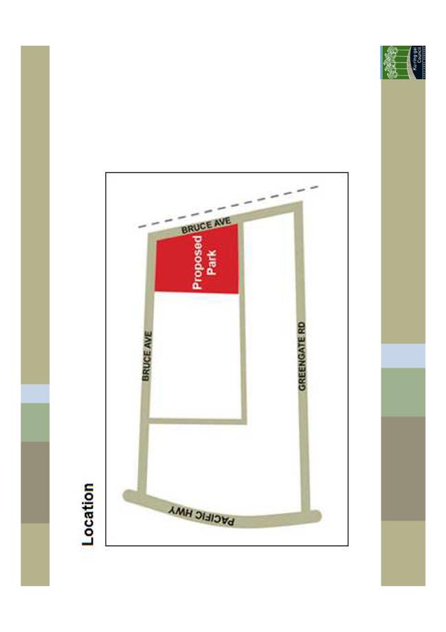
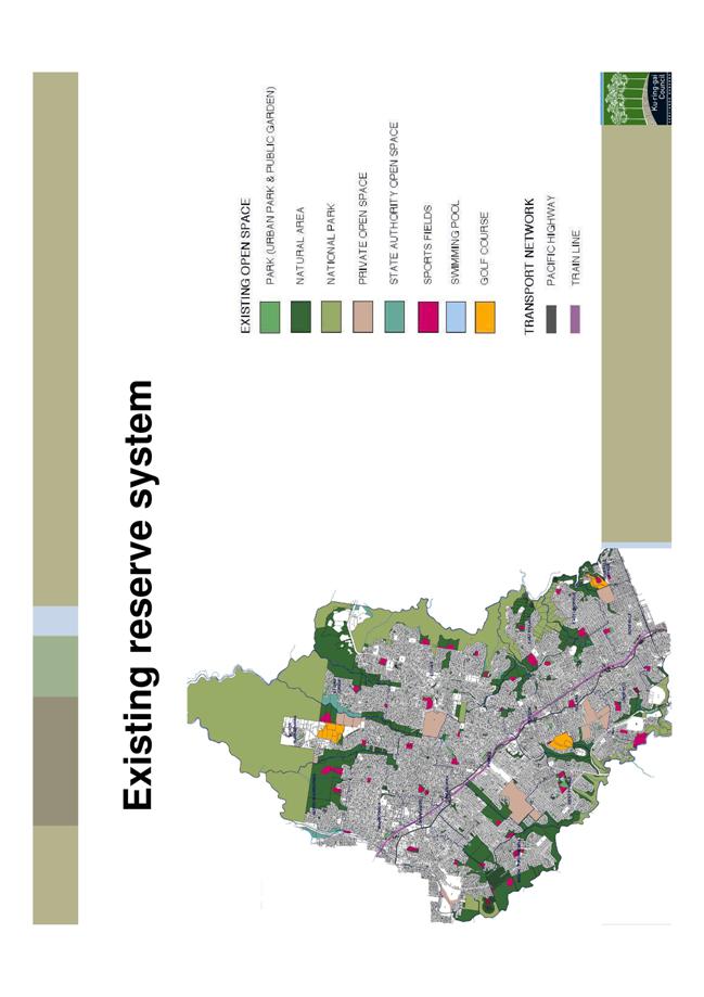
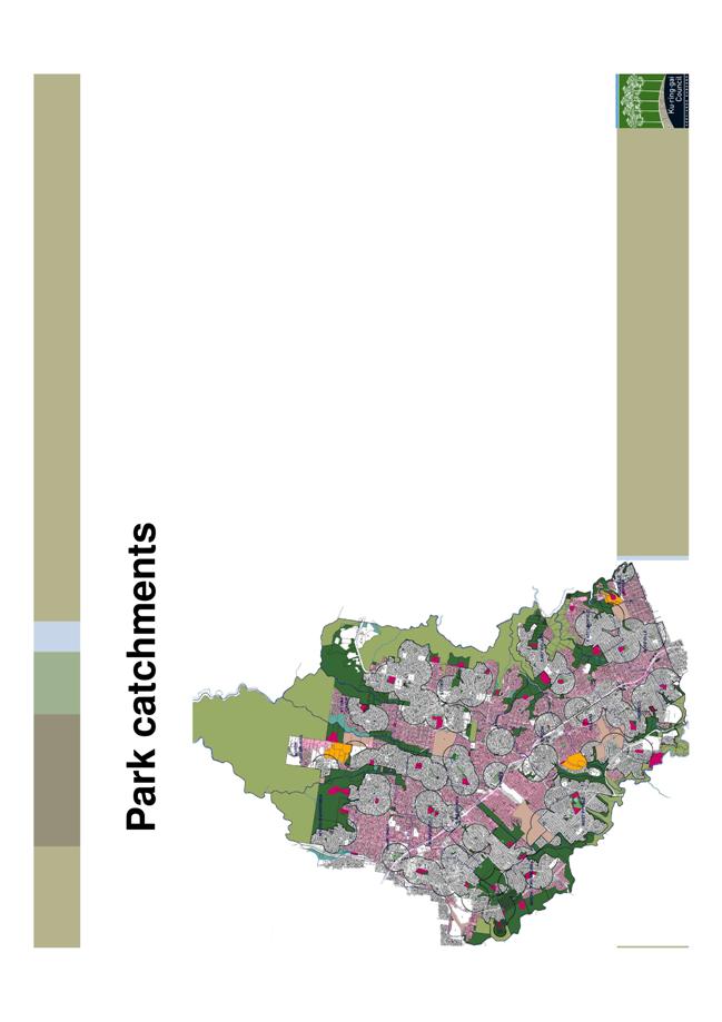
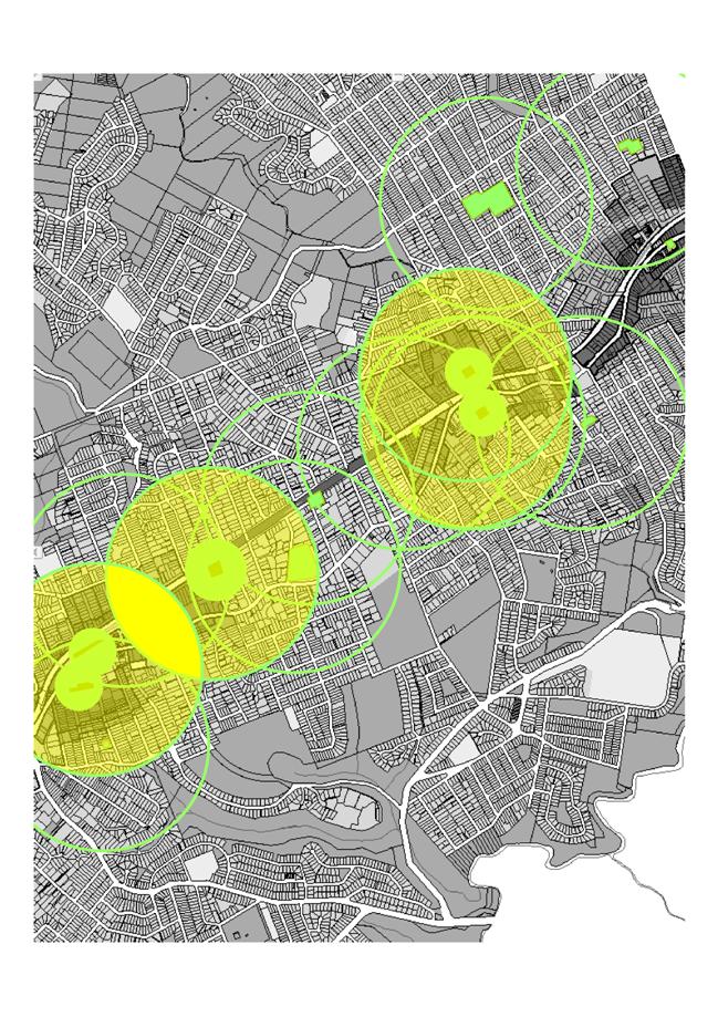
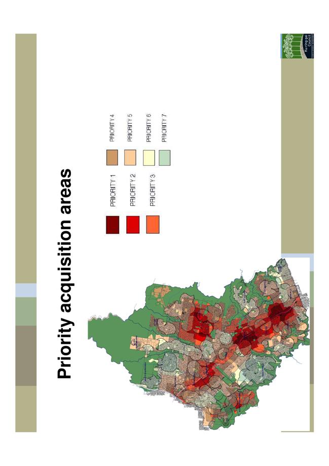
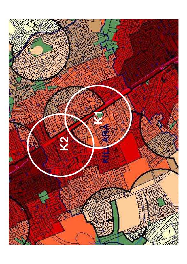
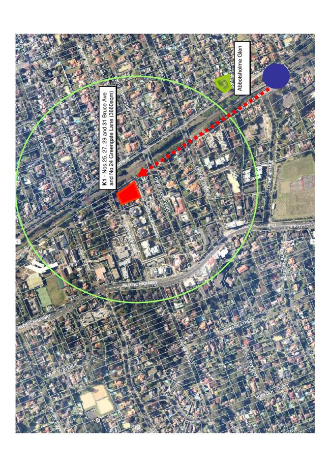
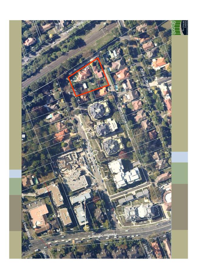
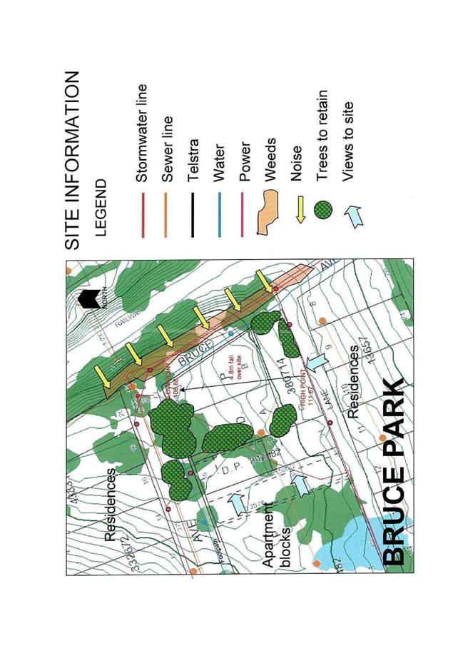
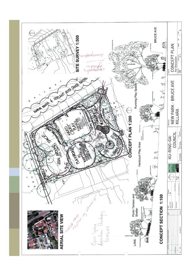
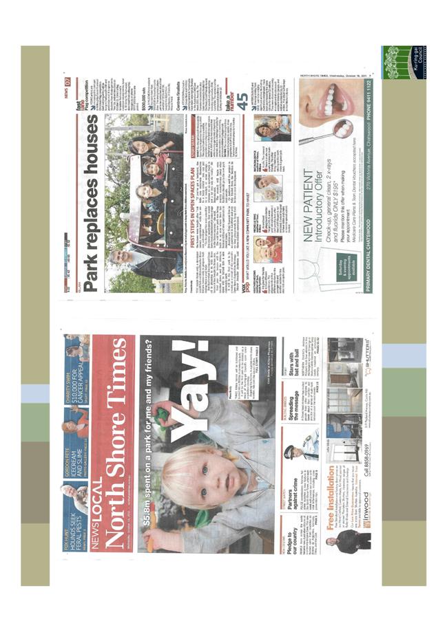
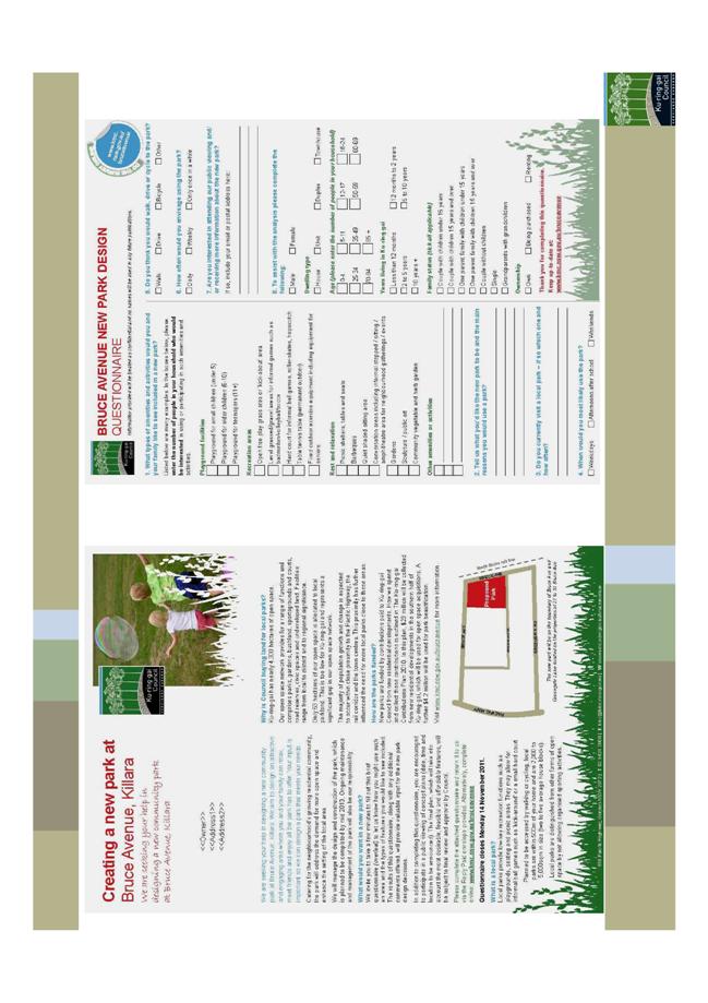
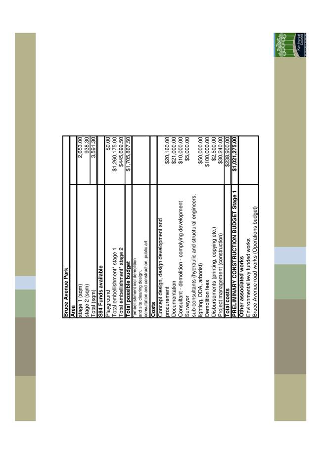
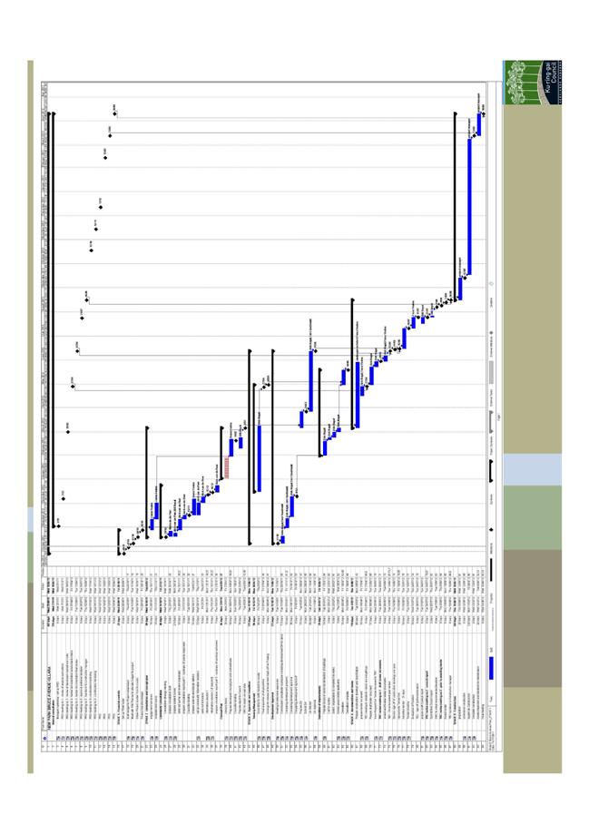
|
APPENDIX No: 7 - Bruce Avenue Park Killara - findings of concept design mail out |
|
Item No: GB.6 |
Attachment A7
Bruce Avenue Design Concept – Comments from the Local Community
Notification of the concept design for the new park at Bruce Avenue Killara was mailed to over 1000 local households. The mail out included the design for the new park with justifications for the key features and reference to the earlier survey conducted in 2011.
41 residents provided comment on the concept design through the Council webpage www.kmc.nsw.gov.au/bruceavenue
Key results
Strong support for the new park project
· Almost all respondents were pleased with the new park project and supportive of the concept design.
· Many respondents recognised the need for such a park, especially with the increase of apartment developments in the area
“Very good draft design for the proposed park”
“I thin it is a great idea, my children would love somewhere close by to get out and play in the park.”
Suggestions for improvements
· A number of respondents identified the following features as ‘nice to have’ in the new park:
o BBQ area
o Toilets
o Off leash area for dogs
o Extra parking
o Ping pong table
Examples of other parks across Australia with desirable features were mentioned by some respondents.
Non support for the proposed park
· Less than five comments were received claiming the project ‘not necessary’ or a ‘waste of money’.
Findings from the community comments
· These comments are inline with the 2011 Bruce Park survey and indicate overwhelming public support for the new park.
· The local community are pleased with the concept design. Nearly all comments were positive of the design and the other residents that were mailed the design package either liked the design or did not feel strongly against it to comment.
· There are a number of features still desirable by the community that should be examined by the design team, in particular BBQ area.
|
Ordinary Meeting of Council - 12 June 2012 |
GB.7 / 344 |
|
|
|
|
Item GB.7 |
S08281 |
|
|
23 May 2012 |
Draft Development Control Plan No. 58 - Council Land South Turramurra
EXECUTIVE SUMMARY
|
purpose of report: |
To have Council adopt for exhibition the draft
Ku-ring-gai Development Control Plan South Turramurra |
|
|
|
|
background: |
Ku-ring-gai Council and the NSW Department of Planning Office of Strategic Lands jointly own land in South Turramurra that is in the process of being planned and developed for new residential subdivision. A draft Development Control Plan (DCP) has been prepared to guide the future subdivision and residential development of the site. |
|
|
|
|
comments: |
An independent consultant has prepared a draft DCP for Council’s consideration. The DCP if adopted by Council will be placed on exhibition seeking further input from the public. Submissions will then be reported back to Council prior to any decision on the final form of the DCP. |
|
|
|
|
recommendation: |
That the draft Ku-ring-gai Development Control Plan South Turramurra Corridor No. 58 be placed on public exhibition. |
Purpose of Report
To have Council adopt for exhibition the draft Ku-ring-gai Development Control Plan South Turramurra Corridor No. 58.
Background
The subject site was previously part of a proposed B2 road corridor that would link the F3 Freeway with the M2 Motorway. The B2 road corridor proposal was abandoned by the NSW State government in 1996.
In January 2006 Ku-ring-gai Local Environmental Plan No. 201 was gazetted by the NSW Minister for Planning. This LEP rezoned a significant section of the former road corridor to Residential 2(c) and 6(a) Recreation under the Ku-ring-gai Planning Scheme Ordinance (KPSO).
On 10 August 2010 Council endorsed a Project Delivery Agreement with the NSW Land & Property Management Authority - Office of Strategic Lands. Under this agreement both parties propose to develop the land for residential purposes for subdivision and release. The proposed residential development will be a low density urban development.
On 30 March 2012 Local Environmental Plan no 216, a further amendment to the Ku-ring-gai Planning Scheme Ordinance, was gazetted to rezone part of the former roads to Residential 2 (c) and reclassify Council’s holdings to Operational land.
In accordance with the project delivery agreement between Council and the NSW Department of Planning - Office of Strategic Lands, planning for the residential development is now being implemented. The next key stages are the preparation of a development control plan, followed by the lodgement of development application for residential subdivision of the site.
Comments
A draft development control plan has been prepared by Don Fox Planning Pty Ltd that applies to the land referred to as the South Turramurra Corridor (Attachment A1).
The Structure of the DCP is set out in three (3) sections:
Section 1 – Introduction (this section), identifies the name of the Plan, its commencement date, the purpose, aims and objectives of the Plan, the land to which the Plan applies and the Plan’s relationship to other plans and policies.
It should be noted that DCP 58 is intended to complement the provisions of and is to be applied in conjunction with other Council DCPs. All other DCPs, including DCP 38 – The Ku-ring-gai Residential Design Manual, will continue to be applied to development of the site. However, the provisions of DCP 58 will prevail over other DCPs in cases where there are inconsistencies.
Section 2 – Background briefly outlines the master planning process and investigative studies that have been undertaken in order to formulate this Plan.
Section 3 – Environmental Management sets out the objectives, development controls and submission requirements relating to flora and fauna, riparian land and water cycle management;
The Appendices include a list of reference material used in the preparation of this Plan.
The Purpose and Objectives of the DCP are reproduced below:
This Plan has been prepared to supplement the Ku-ring-gai Planning Scheme Ordinance (KPSO) and Development Control Plan No. 38 (DCP No. 38) The Ku-ring-gai Residential Design Manual by setting out additional planning controls for future development in the South Turramurra Corridor. Accordingly, the objectives of this Plan are as follows:
(a) To adopt and implement the relevant aims, objectives and provisions of the Ku-ring-gai Planning Scheme Ordinance pertaining to subdivision and low density residential development and to provide additional planning controls for development in the South Turramurra Corridor;
(b) To adopt and implement the relevant aims, objectives and controls of DCP No. 38 to ensure appropriate low density residential development controls for dwellings in the South Turramurra Corridor;
(c) To manage the environmental impacts of development, particularly in regard to flora and fauna and water cycle management; and
(d) To ensure that the configuration of new residential lots is generally consistent with the established subdivision pattern within the South Turramurra locality.
It is worth noting that the Project Delivery Agreement (PDA) between Ku-ring-gai Council Land & Property Management Authority – Office of Strategic Lands in part states under the Development Objectives the following:
The Land will be prepared for release (including any necessary subdivision) so as to:
(d) ensure that the subdivision design includes sustainable urban design parameters such as building materials, solar access and alignment, cross-flow ventilation, setbacks, floor space, access, parking and landscaping provisions. The development control plan is also to include opportunities for alternative power sources and maximum opportunities for water reuse;
In regard the draft DCP being able to satisfy the above, the most significant limiting factor is State Environmental Planning Policy (Building Sustainability Index: BASIX) 2004, which states:
9 Development control plans do not apply to BASIX commitments
(1) The competing provisions of a development control plan under Division 6 of Part 3 of the Act, whenever made, are of no effect to the extent to which they aim:
(a) to reduce consumption of mains-supplied potable water, or reduce emissions of greenhouse gases, in the use of a building to which this Policy applies or in the use of the land on which such a building is situated, or
(b) to improve the thermal performance of a building to which this Policy applies.
Many of the elements listed in the PDA are BASIX related and therefore under the statutory planning provisions cannot be addressed in a development control plan. However, this does not prevent the DCP dealing with other matters such as stormwater management and water quality, riparian lands and flora and fauna issues.
Governance Matters
As part of the project planning phase under the PDA the draft DCP is now being reported to Council seeking endorsement for public exhibition. If adopted for exhibition the plan will be reported back to Council at the end of the exhibition period for consideration of submissions.
Risk Management
The draft DCP provides guidance for Council, Office of Strategic Lands and the community for the future residential development of the site. The draft DCP is therefore considered a good planning outcome to reduce uncertainty and ensure local planning controls are considered and assessed in conjunction with the next stage of the preparation and lodgement of a development application for the subdivision of the site. It is acknowledged that overly prescriptive DCP provisions may increase development costs and may reduce the marketability of the land. Conversely, a DCP which does not deliver outcomes consistent with the broader wishes of the community would be seen as being overly beneficial for Council and inconsistent with the PDA. Beyond this is the potential to set an undesirable precedent.
Financial Considerations
The draft DCP has been prepared in accordance with the Project Delivery Agreement. As such Council has commissioned the independent consultant. The cost of preparing the DCP is borne by the project.
Social Considerations
The local community has been consulted throughout the project. The overall residential development of the site will make provision for the local community through additional low density housing, additional local open space, upgrading local pedestrian and cycle linkages along the riparian corridor to improve access to the local transport network.
Environmental Considerations
The draft DCP under Section 3 – Environmental Management, sets out the objectives, development controls and submission requirements relating to flora and fauna, riparian land and water cycle management.
Community Consultation
If adopted by Council, the draft DCP will be placed on public exhibition for 28 days, advertised in local press and to the surrounding residents. Submissions will then be reported back to Council prior to any decision on the final form of the DCP.
The draft DCP reflects input from previous consultation processes and the reclassification public hearing. In this respect, the final report of Mr Ludvick, the hearing Chair stated:
The issues that will need to be addressed in detail in the development control plan and the specific development application to be prepared following the reclassification include:
• the provision of a satisfactorily designed public accessway between Barwon Avenue and Chisholm Street;
• the provision of a satisfactorily designed riparian corridor through the land and the implementation of stormwater measures to prevent downstream flooding;
• the recommendations of the Flora and Fauna Survey & Constraints Assessment prepared by Ambrose Ecological Services Pty Ltd.
Internal Consultation
The draft DCP was prepared by external consultants appointed under the PDA. Appropriate and relevant feedback has been provided by Council staff on the technical planning matters and background history of the site.
Summary
Ku-ring-gai Council and the NSW Department of Planning - Office of Strategic Lands jointly own land in South Turramurra that in the process of being planned and developed for new residential subdivision.
The draft DCP provides guidance for Council, Office of Strategic Lands and the community for the future residential development of the site. If adopted by Council, the draft DCP Council will be placed on exhibition seeking further input from the public. Submissions will then be reported back to Council prior to any decision on the final form of the DCP.
|
A. That Council adopt the draft Ku-ring-gai Development Control Plan South Turramurra Corridor No. 58 for the purpose of public exhibition.
B. That the draft Ku-ring-gai Development Control Plan South Turramurra No. 58 be placed on public exhibition in accordance with the Environmental Planning & Assessment Regulation 2000 for a period of 28 days.
C. That a report be brought back to Council at the end of the exhibition period.
|
|
Antony Fabbro Manager Urban & Heritage Planning |
Craige Wyse Team Leader Urban Planning |
|
Andrew Watson Director Strategy & Environment |
|
|
A1View |
South Turramurra Corridor Development Control Plan |
|
2012/138615 |
|
APPENDIX No: 1 - South Turramurra Corridor Development Control Plan |
|
Item No: GB.7 |
|
|
APPENDIX No: 1 - South Turramurra Corridor Development Control Plan |
|
Item No: GB.7 |
Prepared by:
Don Fox Planning Pty Limited
In association with:
Ku-ring-gai Council
Locked Bag 1056
Pymble NSW 2073
Telephone: (02) 9424 0000
Facsimile: (02) 9424 0001
e-mail: kmc@kmc.nsw.gov.au
internet: www.kmc.nsw.gov.au
Disclaimer
Every effort has been made to provide accurate and complete information. However, the authors assume no responsibility for any direct, indirect, incidental, or consequential damages arising from the use of information in this document.
Copyright Notice
No part of this publication may be reproduced in any form, or stored in a database or retrieval system, or transmitted or distributed in any form by any means, electronic, mechanical photocopying, recording, or otherwise without written permission from Ku-ring-gai Council. All rights reserved.
Copyright © 2012, Ku-ring-gai Council
|
APPENDIX No: 1 - South Turramurra Corridor Development Control Plan |
|
Item No: GB.7 |
Table of Contents
1 Introduction 1
1.1 Name of this Plan 1
1.2 Land to which this Plan applies 1
1.3 Commencement of this Plan 1
1.4 Savings and transitional arrangements 1
1.5 Purpose and Objectives of this Plan 2
1.6 Structure of this Plan 2
1.7 Relationship with other plans, reports and policies 3
2 Background 4
2.1 B2 Road Corridor 4
2.2 Residential Subdivision 4
3 Environmental Management 5
3.1 Riparian Land Objectives 5
3.2 Biodiversity 6
3.3 Riparian Land & Water Cycle Management 6
3.4 Street Network, Public Open Space and Access 7
3.5 Lot Layout 8
3.6 General Site Landscaping 9
3.7 Public Utilities and Services 10
Figures
1. Map – land to which this plan applies
2. Solar Lots
Appendices
A. Plant Species List for Public and Private Land
B. Indicative Road Sections
C. References
|
APPENDIX No: 1 - South Turramurra Corridor Development Control Plan |
|
Item No: GB.7 |
1 Introduction
1.1 Name of this Plan
This Plan is the Ku-ring-gai Council Development Control Plan No. 58 - South Turramurra Corridor (the “Plan”).
1.2 Land to which this Plan applies
This Plan applies to land within the Ku-ring-gai local government area (LGA) known as the South Turramurra Corridor as shown on the Map (Figure 1).
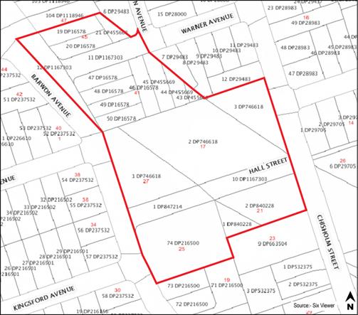 |
Figure 1: Map – land to which this Plan applies.
1.3 Commencement of this Plan
This Plan has been prepared pursuant to the provisions of the Environmental Planning and Assessment Act 1979 (the Act) and the Environmental Planning and Assessment Regulation 2000 (the Regulation) and takes effect from [RELEVANT DATE TO BE INSERTED] 2012, being the date on which public notice was published, pursuant to the Regulation.
1.4 Savings and transitional arrangements
There are no savings or transitional provisions under this Plan. If a development application has been made prior to the date of commencement of this Plan in relation to land to which this Plan applies and the application has not been determined before that date, the application shall be determined in accordance with this Plan.
1.5 Purpose and Objectives of this Plan
This Plan has been prepared to complement the Ku-ring-gai Planning Scheme Ordinance (KPSO) and Development Control Plan No. 38 (DCP No. 38) The Ku-ring-gai Residential Design Manual by setting out additional planning controls for future development in the South Turramurra Corridor. Accordingly, the objectives of this Plan are as follows:
(a) To adopt and implement the relevant aims objectives and provisions of the Ku-ring-gai Planning Scheme Ordinance pertaining to subdivision and low density residential development and to provide additional planning controls for development in the South Turramurra Corridor;
(b) To adopt and implement the relevant aims, objectives and controls of DCP No. 38 to ensure appropriate low density residential development controls for dwellings in the South Turramurra Corridor;
(c) To manage the environmental impacts of development, particularly in regard to flora and fauna and water cycle management; and
(d) To ensure that the configuration of new residential lots is generally consistent with the established subdivision pattern within the South Turramurra locality.
1.6 Structure of this Plan
This Plan is arranged into three (3) sections:
Section 1 – Introduction (this section), identifies the name of the Plan, its commencement date, the purpose, aims and objectives of the Plan, the land to which the Plan applies and the Plans relationship to other plans and policies.
Section 2 – Background, briefly outlines the master planning process and investigative studies that have been undertaken in order to formulate this Plan;
Section 3 – Environmental Management, sets out the objectives, development controls and submission requirements relating to flora and fauna, the Riparian Land and water cycle management;
The Appendices to this Plan include a list of reference material used in the preparation of this Plan.
1.7
Relationship with other plans, reports and policies
This Plan complements the provisions of, and should be read in conjunction with, the Act and Regulation, KPSO, State Environmental Planning Policy (Building Sustainability Index: BASIX) 2004, Planning for Bushfire Protection 2006 and other relevant Development Control Plans (DCPs) and polices adopted by Council including, but not limited to:
· DCP No. 38 – The Ku-ring-gai Residential Design Manual;
· DCP No. 40 – Construction and Demolition Waste Management;
· DCP No. 43 – Car Parking Code;
· DCP No. 46 – Exempt and Complying Development;
· DCP No. 47 – Water Management Plan; and
· The Ku-ring-gai Subdivision Code.
· Ku-ring-gai Council Weed Management Policy Revised Edition 2007.
Where there is an inconsistency between this Plan and any other DCP or Code, irrespective of whether any other DCP or Code was made either before or after the commencement of this Plan, this Plan prevails to the extent of any inconsistency.
2
Background
2.1 B2 Road Corridor
The land subject to this Plan was formerly part of a proposed road corridor which has since been abandoned. Future development options associated with the South Turramurra Corridor have been the subject of review and consultation since 2003.
2.2 Residential Subdivision
Land within the abandoned road corridor is predominantly zoned Residential 2(c) under the KPSO. The site is also part unzoned, but the two (2) minor portions of the site which remain unzoned are proposed to be zoned Residential 2(c) as part of Council’s comprehensive LEP review.
Subdivision of the site is likely to be carried out jointly between Ku-ring-gai Council and the Minister Administering the Environmental Planning and Assessment Act 1979.
The Residential 2(c) zone typically accommodates low density one and two storey residential dwellings on allotments that are approximately 929m2 in area, however a significant number of allotments within the surrounding locality are less than 929m2. Future subdivision of the site will need to be the subject of a separate development application that demonstrates amongst other things, consistency with the established low density residential character of the South Turramurra locality.
3.1 Riparian Land Objectives
(a) To improve the connectivity and continuity of riparian vegetation and habitat;
(b) To revegetate and manage the Riparian Land to improve ecological values as described in the Ku-ring-gai Riparian Policy (December 2004);
(c) To remove and eradicate noxious and environmental weeds and decrease the abundance of non-locally indigenous plant species from the Riparian Land;
(d) To rehabilitate, revegetate and stabilise the Riparian Land to reduce the potential for bed and creek bank erosion;
(e) To assess and manage stormwater flows from the site and adjacent urban areas;
(f) To allow realignment of the existing creek;
(g) To protect and/or provide habitat for terrestrial and aquatic fauna;
(h) To provide a riparian buffer to counter edge effects on the urban interface as shown in figure 2.
Development Controls
1. The Riparian Land is to be restored and rehabilitated, through the removal of weed species, decreasing the abundance of non-locally indigenous plant species and revegetated with locally indigenous plant species;
2. A Vegetation Management Plan (VMP) is to be prepared for any Riparian Land and for public land. The VMP must include management actions, plant densities, responsibilities, maintenance and monitoring;
3. Road crossings of the Riparian Land are discouraged but where proposed, road crossings are to be designed to maintain riparian connectivity;
4. A suitable interface between the Riparian Land and urban development (e.g. roads, passive open space) is to be provided;
5. All services (e.g. power, water, and sewerage, water retention tanks) are to be outside of the Core Riparian Zone unless the impact on riparian functions is demonstrated to be minimal;
6. Any Riparian Land design must consider reshaping, rock armouring, revegetation and potential for public access;
7. The Riparian Land may be within private or public ownership;
8. Any fencing fronting the Riparian Land is to be a maximum height of 1.2 metres with use of high quality materials incorporating native landscaping;
9. Provide bushfire asset protection zones outside the Core Riparian Zone.
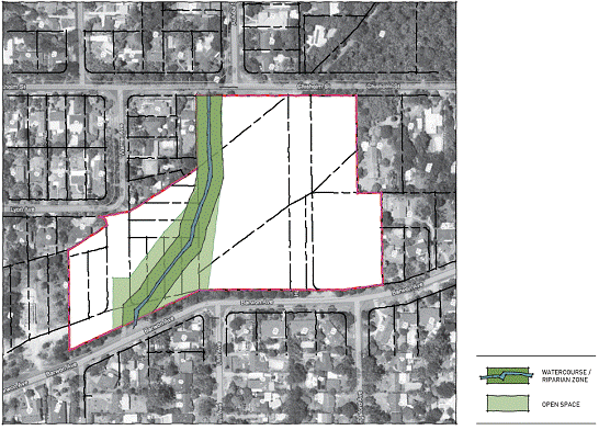
Figure 2: RIPARIAN ZONE
3.2 Biodiversity
Objectives
(a) To ensure that significant Threatened Communities are retained, protected and restored;
(b) To facilitate the restoration, revegetation and ongoing management of retained natural vegetation within the site, and particularly within the Riparian Land;
(c) To improve and maintain native fauna habitat values.
Development Controls
1. A Tree Survey Plan is to be submitted as part of any development application for subdivision of land to which this Plan applies. The Plan is to identify the location, type and condition of all existing trees and is to indicate those trees proposed to be removed and those to be retained;
2. Where possible, existing locally indigenous vegetation and fauna habitat is to be retained and restored either within public open space or within private allotments.
3.3 Riparian Land & Water Cycle Management
Objectives
(a) To minimise the potential creek bank erosion and the potential impact of flooding both within the Riparian Land, adjoining development and downstream of the development;
(b) To provide a neutral or beneficial effect on the existing watercycle quality;
(c) To provide flood free access and evacuation routes for an average predicted 1 in 100 year flood event;
(d) To incorporate best practice stormwater and watercourse management principles and strategies;
(e) To ensure that any proposed development does not affect adjoining and downstream properties:
(i) by degrading stormwater quality; or
(ii) by increasing flooding.
(f) To provide opportunities for reuse of stormwater in the form of underground water storage facilities where it is considered to have a community benefit and promote water recycling that is likely to benefit local community facilities.
Development Controls
1. All development is to incorporate water sensitive urban design (WSUD). A stormwater management plan incorporating WSUD principles is to be submitted with any development application for subdivision of land. The plan is to include water cycle management measures generally in accordance with Council’s civil engineering advice and documentation;
2. On site stormwater detention is to be provided in accordance with Council’s “On Site Stormwater Detention Technical Specification”;
3. A rainwater retention tank is to be provided with a minimum capacity of 250m3, to accommodate water recycling associated with development on land to which this Plan applies, for the benefit of nearby community facilities;
4. As far as is possible, overland flow frequency and runoff volumes should replicate pre-development circumstances. Any subdivision development application submitted should include modelling to demonstrate how pre-development and post-development flows have been calculated.
5. Pollutant reduction targets for the subdivision of land to which this Plan applies are to be as follows:
- 90% reduction in gross pollutants
- 85% reduction in Total Suspended Solids
- 65% reduction in Total Phosphorous
- 45% reduction in Total Nitrogen
Pollution reduction targets are to be calculated in accordance with the methodology outlined in the Ku-ring-gai Development Control Plan No. 47 – Water Management.
3.4 Street Network, Public Open Space and Access
Objectives
(a) To provide a safe and functional street network with appropriate vehicular and pedestrian access that is able to service an allotment layout that is consistent with established low density residential development in the South Turramurra locality.
(b) To link the South Turramurra Corridor site with its surroundings;
(c) To facilitate access to regional transport opportunities;
(d) To link and extend local open space;
(e) To reflect the streetscape and character of the surrounding area;
(f) To improve local pedestrian permeability and visual access to the Riparian Land;
(g) To provide vehicular and dedicated pedestrian access between Chisholm Street and Barwon Avenue alongside the Riparian Land, in addition to any roads that will provide access to all lots.
Development Controls
1. Provide a vehicle connection between Chisholm Street and Barwon Avenue
2. The Chisholm Street/Barwon Avenue connection should generally align with existing street intersections
3. Provide access and a street frontage to the Riparian Land
4. Riparian Land and new roads/carriageways are to be designed generally in accordance with Appendix B.
5. A footpath should be provided on at least one side of each street.
6. Public pedestrian access is to be provided that connects Chisholm Street and Barwon Avenue. This should occur adjacent to the carriageway and wherever possible connect through the Riparian Land;
7. Footpaths and boardwalks are to be a minimum of 1.2m wide and be designed in accordance with Australian Standard 1428:1-4 (also refer to Appendix B);
8. Streets are to have a total road reserve up to 16 metres wide comprising a 6 metre wide carriageway and verges on both sides ranging between 4.3 metres and 5.7 metres wide with use of grassed swales for drainage where possible (Appendix B);
9. Where possible, on-street parking shall be integrated within the turf nature strip.
3.5 Lot Layout
Objectives
(a) To provide a range and mix of lot sizes to suit a variety of dwelling types consistent with those distributed throughout the South Turramurra locality;
(b) To provide lots that are oriented to optimise solar access to facilitate micro-climate management, including the application of energy conservation principles.
Development Controls
1. Lots should front streets and overlook open space to improve personal and property security;
2. Lots should be orientated so that one axis is within 30º east and 20º west of true solar north (Figure 2);
3. Reduce the number of lots that have a street on the northern boundary;
4. Dwelling houses on the lots should take into account the orientation of the lot.
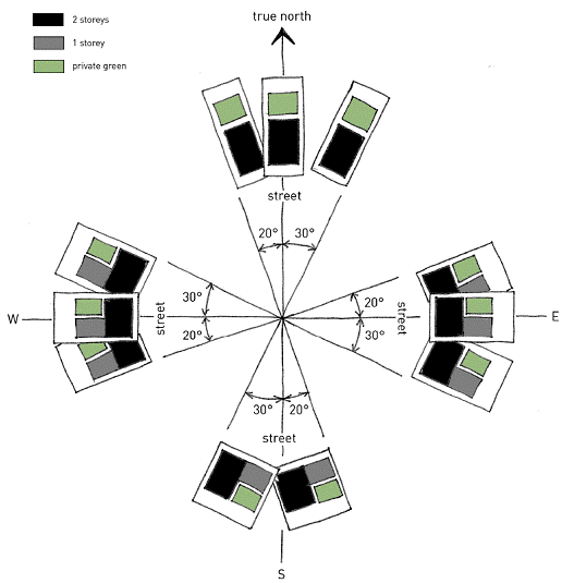
Figure 2: Solar Lots
3.6 General Site Landscaping
Objectives
(a) To enhance the landscape setting and site biodiversity.
Development Controls
1. All planting within 40m of the of the centre of the watercourse shall be native species of local provenance in accordance with the Vegetation Management Plan;
2. For lots not within the area nominated in 3.6(1), 50% of all plantings on the site must be selected from the ‘Desired Species’ within the Plant Species List in Appendix A;
3. Plants in the prohibited section of the Plant Species List are not to be planted in any part of the land to which this Plan applies;
4. All planting on the site is to have regard to the controls prescribed in DCP38.
3.7 Public Utilities and Services
Objectives
(a) To ensure that public utilities and services can be provided without unnecessary visual blight or adverse impact on the streetscape or character of the area.
Development Controls
1. Subject to agreement by the electricity authority, electricity kiosks/substations are to be appropriately located and suitably landscaped so that these structures do not dominate the streetscape or any entrance/exit to the site;
2. All electricity power lines in new streets are to be located underground;
3. Where practicable, all stormwater infrastructure on public land is to be located so that it is not visually prominent.
Appendix A – Plant Species List for Public and Private Land
species listing for street & public domain trees
|
Common Name |
Botanical Name |
|
Medium Tree |
|
|
Broad-leaved Scribbly Gum |
Eucalyptus haemaasioma |
|
|
|
|
Tall Tree |
|
|
Sydney Red Gum |
Angophora costata |
|
Red Bloodwood |
Corymbia gummifera |
|
Brown Stringybark |
Eucalyptus capitellata |
|
Grey Gum |
Eucalyptus punctata |
|
Silvertop Ash |
Eucalyptus sieberi |
|
|
|
|
Main Road / Residential - Native Tree Mix |
|
|
Lilly Pilly |
Acmena smithii (Local provenance stock) |
|
Sydney Red Gum |
Angophora costata |
|
Rough-barked Apple |
Angophora floribunda |
|
Yellow Blood Wood |
Corymbia eximia |
|
Blueberry Ash |
Elaeocarpus reticulatus |
|
Red Bloodwood |
Eucalyptus gummifera |
|
Grey Ironbark |
Eucalyptus paniculata |
|
Blackbutt |
Eucalyptus paniculata |
|
Sydney Blue Gum |
Eucalyptus saligna |
|
Cheese Tree |
Glochidion fernandii |
|
Brush Box |
Lophostemon confertus |
|
Turpentine |
Syncarpia glomulifera |
|
Water Gum |
Tristaniopsis laurina |
|
|
|
|
Feature Trees - Exotic / Native |
|
|
Ivory Curl Tree |
Buckinghamia celissima |
|
Jacaranda |
Jacaranda mimosifolia |
|
Indian Summer Crepe Myrtle Mauve |
Lagerstroemia indica x L.fauriei |
Desired Species for dwelling lots
Please refer to the Ku-ring-gai Residential Design Manual DCP No. 38
Prohibited Species
Species in this section are prohibited and are not to be planted on the land to which this Plan applies.
1. Any species identified under the Noxious Weeds Act (1993)
2. Any noxious, environmental or urban environmental weeds identified in Ku-ring-gai Council Weed Management Policy Revised Edition 2007.
3. Exotic perennial grasses as confirmed by Schedule 2 of the Threatened Species Conservation Act 1995.
4. Any species in the following table:
|
Common Name |
Botanical Name |
|
Agapanthus |
Agapanthus orientalis |
|
African Lovegrass |
Eragrostis curvula |
|
Albizia/Crested Wattle |
Paraserianthes lophantha |
|
Bindii |
Soliva pterosperma |
|
Black Locust |
Robinia pseudoacacia |
|
Broom |
Genista spp. (all cultivars & hybrids) |
|
Capeweed |
Arctotheca calendula |
|
Catsear |
Hypochaeris radicata |
|
Chilean Whitlow |
Paronychia brasiliana |
|
Chickweed |
Stellaria media |
|
Chinese Pistachio |
Pistacia chinensis |
|
Chinese Tallow |
Sapium sebiferum |
|
Clover |
Trifolium spp. |
|
Common Couch (Prohibited in Riparian Land only) |
Cynodon dactylon |
|
Coreopsis |
Coreopsis lanceolata |
|
Cootamundra Wattle |
Acacia baileyana |
|
Creeping Buttercup |
Ranunculus repens |
|
Crofton Weed |
Ageratina adenophora |
|
Crowsfoot/Crab Grass |
Eleusine indica |
|
Cudweed Gnaphalium spp. |
Gnaphalium spp. |
|
Dandelion |
Taraxacum officinale |
|
Date Palm |
Phoenix canariensis |
|
Dock |
Rumex spp. |
|
Ecklonia |
Aristea ecklonia |
|
Ehrharta |
Ehrharta spp. |
|
Fat Hen |
Chenopodium album |
|
Fennel |
Foeniculum vulgare |
|
Fireweed |
Senecio madagascariensis |
|
Fishbone Fern |
Nephrolepis cordifolia |
|
Fleabane |
Conyza spp. |
|
Formosan Lily |
Lilium formosanum |
|
Ginger Lily |
Hedychium gardneranum |
|
Golden Robinia |
Robinia pseudoacacia "Frisia" |
|
Green Amaranth |
Amaranthus viridis |
|
Hemlock |
Conium maculatum |
|
Honeysuckle |
Lonicera japonica |
|
Hydrocotyle |
Hydrocotyle bonariensis |
|
Illawarra Flame Tree |
Brachychiton acerifolius |
|
Impatiens/Busy Lizzie |
Impatiens balsamina |
|
Inkweed |
Phytolacca octandra |
|
Isotoma |
Isotoma fluviatillis |
|
Japanese Knotweed |
Persicaria capitata |
|
Jasmine |
Jasminum polyanthum |
|
Kikuyu Grass (Prohibited in Riparian Land only) |
Pennisetum clandestinum |
|
Liquidambar |
Liquidambar styraciflua |
|
Medic/Burr |
Medic Medicago spp. |
|
Mist Flower |
Ageratina riparia |
|
Monbretia |
Crocosmia x crocosmiiflora |
|
Moth Vine |
Araujia sericiflora |
|
Mouse Ear Chickweed Cerastium glomeratum |
Cerastium glomeratum |
|
Mullumbimby Couch |
Cyperus brevifolius |
|
Nut Grass |
Cyperus rotundus |
|
Onion Weed |
Nothoscordum borbonicum |
|
Paddy's Lucerne |
Sida rhombifolia |
|
Palm Grass |
Setaria palmifolia |
|
Paspalum |
Paspalum dilatatum |
|
Passionfruit |
Passiflora edulis |
|
Pearlwort |
Sagina procumbens |
|
Plantain |
Plantago spp. |
|
Potato Vine |
Solanum jasminoides |
|
Purple Top |
Verbena bonariensis |
|
Queensland Silver Wattle |
Acacia podalyriifolia |
|
Rambutan |
Alectryon tomentosum |
|
Rice Paper Plant |
Tetrapanax papyriferus |
|
Sand Rocket |
Diplotaxis tenuifolia |
|
Scaly Tree Fern |
Cyathea cooperi |
|
Scurfy Pea Bush |
Psoralea pinnata |
|
Seaside Daisy |
Erigeron karvinskianus |
|
Silky Oak |
Grevillea robusta |
|
Spider Plant |
Chlorophytum comosum |
|
Summer Grass |
Digitaria ciliaris |
|
Summer Grass/Crab Grass |
Digitaria sanguinalis |
|
Vetch |
Vicia spp. |
|
Virginia Creeper |
Parthenocissus quinquefolia |
|
Western Australia Bluebell |
Sollya heterophylla |
|
White Root Lobelia |
Pratia concolor |
|
Wild Tobacco Tree |
Solanum mauritianum |
|
Wild Watsonia |
Watsonia meriana c. Bulbillifera |
|
Yellow Kangaroo Paw |
Angiozanthos flavidus |
Appendix B – Indicative Road Sections

Appendix C – References
The following legislation, plans and policies, studies, technical guides and other information have been considered during the formulation of this Plan:
Environmental Planning and Assessment Act 1979
Environmental Planning and Assessment Regulation 2000
Threatened Species Conservation Act 1995.
Noxious Weeds Act (1993)
Ku-ring-gai Planning Scheme Ordinance
State Environmental Planning Policy (Building and Sustainability Index: BASIX) 2004
Ku-ring-gai Development Control Plan No. 38 – The Ku-ring-gai Residential Design Manual
Ku-ring-gai Development Control Plan No. 40 – Construction and Demolition Waste Management
Ku-ring-gai Development Control Plan No. 43 – Car Parking Code
Ku-ring-gai Development Control Plan No. 46 – Exempt and Complying
Ku-ring-gai Development Control Plan No. 47 – Water Management
Ku-ring-gai Draft Stormwater Quality Modelling Guidelines
Planning for Bushfire Protection 2006
Ku-ring-gai Subdivision Code
Ku-ring-gai Local Environmental Plan No. 201
Ku-ring-gai Local Environmental Plan No. 216
NSW Roads and Traffic Authority (October 2002 – Version 2.2), Guide to Traffic Generating Development
Ku-ring-gai Council Weed Management Policy Revised Edition 2007
Ku-ring-gai Riparian Policy (December 2004)
|
Ordinary Meeting of Council - 12 June 2012 |
GB.8 / 369 |
|
|
|
|
Item GB.8 |
S06604/2 |
|
|
28 May 2012 |
Amendments to Parks Generic Plan of Management
EXECUTIVE SUMMARY
|
purpose of report: |
For Council to amend the Parks Generic Plan of Management with the inclusion of properties acquired for parks since the plan of management was adopted by Council in 2005. |
|
|
|
|
background: |
Under the Local Government Act, 1993 (as amended) all land classified as Community Land must be managed in accordance with a plan of management adopted by Council. Council adopted the Parks Generic Plan of Management (PGPOM) in September 2005 to guide the management of all parks not covered by a site specific plan of management. |
|
|
|
|
comments: |
Council currently manages 165 parks under the PGPOM, 16 of which are either fully or partly on Crown Land and the rest are Council-owned land. Since the adoption of the PGPOM in 2005 Council has used s.94 development contributions to acquire 14 properties currently classified as community land for the creation of five new parks. It is appropriate for the properties to be categorised as “park” and included in Council’s PGPOM. For administrative efficiency it is also appropriate that Council resolve to include a new action or “catch-clause” in the PGPOM which gives the General Manager the authority to automatically amend the PGPOM to include any properties acquired in the future for use as a park. |
|
|
|
|
recommendation: |
That Council amend the Parks Generic Plan of Management to include the 14 properties acquired for parks by Council since 2005. Also that Council amend the Action Plan section of the Parks Generic Plan of Management to give the General Manager authority to automatically amend the Plan of Management to include any properties acquired by Council in the future for use as a park. |
Purpose of Report
For Council to amend the Parks Generic Plan of Management with the inclusion of properties acquired for parks since the plan of management was adopted by Council in 2005.
Background
Under the Local Government Act, 1993 (as amended) (the Act) all land classified as Community Land must be managed in accordance with a plan of management adopted by Council. Council adopted the Parks Generic Plan of Management (PGPOM) in September 2005 to guide the management of all parks not covered by a site specific plan of management.
Comments
Council currently manages 165 parks under the PGPOM, 16 of which are either fully or partly on Crown Land and the rest are Council-owned land. Since the adoption of the PGPOM in 2005 Council has used funds collected under the Section 94 Development Contributions Plan 2004-2009 to acquire 14 properties for the creation of five (5) new parks, as listed in Table 1.
Table 1. Properties acquired for parks by Council since 2005.
|
LMU No. |
Property |
Suburb |
Land Area (m2) |
Land Classification |
Planned use |
Current use as at June 2012 |
|
964 |
9 Dumaresq St |
Gordon |
1,463 |
Community |
Future open space |
Residential lease |
|
964 |
15 Dumaresq St |
Gordon |
964.44 |
Community |
Future open space |
Residential lease |
|
964 |
17 Dumaresq St |
Gordon |
1037.26 |
Community |
Future open space |
Residential lease |
|
967 |
23 Duff St |
Turramurra |
689 |
Community |
Future open space |
Residential lease |
|
967 |
25 Duff St |
Turramurra |
695.5 |
Community |
Future open space |
Residential lease |
|
967 |
1 Allan Ave |
Turramurra |
585.6 |
Community |
Future open space |
Residential lease |
|
973 |
27 Bruce Ave |
Killara |
929.5 |
Community |
Future open space |
Residential lease |
|
973 |
29 Bruce Ave |
Killara |
885.2 |
Community |
Future open space |
Residential lease |
|
973 |
31 Bruce Ave |
Killara |
834.7 |
Community |
Future open space |
Residential lease |
|
821 |
2 Gilroy Rd |
Turramurra |
670 |
Community |
Future open space |
Residential lease |
|
821 |
4 Gilroy Rd |
Turramurra |
650.3 |
Community |
Future open space |
Residential lease |
|
821 |
6 Gilroy Rd |
Turramurra |
650.3 |
Community |
Future open space |
Residential lease |
|
821 |
8 Gilroy Rd |
Turramurra |
629.4 |
Community |
Future open space |
Residential lease |
|
971 |
12 Woonona Ave |
Wahroonga |
929.5 |
Community |
Open space |
Vacant land |
These properties have all been classified by Council as community land. It is appropriate for the properties to be categorised as “park” and included in Council’s PGPOM.
For administrative efficiency it is also appropriate that Council resolve to include a new action or “catch-clause” in the PGPOM which gives the General Manager the authority to automatically amend the PGPOM to include any properties acquired in the future for use as a park. It is recommended that the following catch-clause be included in Section 4.6 of the PGPOM:
· 4.6 Distribution
It is an unnecessary administrative burden for Council to have to resolve to amend the Parks Generic Plan of Management by way of a report to Council following each property acquisition for new parkland. Therefore to ensure that future acquisitions for new parks are covered in the Parks Generic Plan of Management it would be more efficient for Council to automatically update the Parks Generic Plan of Management following any property acquisition.
· 4.6 Action Plan
Automatically update the Parks Generic Plan of Management following any property acquisition without the requirement to seek a Council resolution to make the amendment.
Council will continue to lease the properties as residential properties until they are ready to be embellished as parks. Council is permitted to do this as it is expressly authorised in the PGPOM and under Section 46 of the Act. Section 46 Leases, licences and other estates in respect of community land-generally states that:
(1) A lease, licence or other estate in respect of community land:
(b) may be granted, in accordance with an express authorisation in the plan of management and such provisions of the plan of management as apply to the granting of the lease, licence or other estate:
…….
(iv) for a residential purpose in relation to housing owned by the council.
Governance Matters
Under the Local Government Act, 1993 (as amended) all land classified as Community Land must be managed in accordance with a plan of management adopted by Council. It is considered that the PGPOM is the appropriate plan of management for Council to include all properties acquired for use as a park that are classified community land.
Risk Management
The inclusion of properties acquired for use as a park into the PGPOM ensures that Council is meeting its obligations under the Act. Consequently, Council’s risk of using and managing the properties inappropriately is reduced.
Financial Considerations
There are no financial implications for Council to consider by including newly acquired properties in the appropriate plan of management. This is a simple administrative task.
Social Considerations
As the recommended amendments to the PGPOM are straightforward administrative requirements under the Act, there are no social considerations to be discussed.
Environmental Considerations
As the recommended amendments to the PGPOM are straightforward administrative requirements under the Act, there are no environmental considerations to be discussed.
Community Consultation
As the recommended amendments to the PGPOM are straightforward administrative requirements under the Act, it is not considered that they are significant enough to trigger a formal public exhibition of the amendments. Following adoption of the report the amended PGPOM will be updated on Council’s website as soon as practicable.
Internal Consultation
Officers from the Operations, Strategy and Environment and Community Directorates have been consulted during the preparation of this report.
Summary
Under the Local Government Act, 1993 (as amended) all land classified as Community Land must be managed in accordance with a plan of management adopted by Council. Council adopted the Parks Generic Plan of Management (PGPOM) in September 2005 to guide the management of all parks not covered by a site specific plan of management.
Since the adoption of the PGPOM Council has used s.94 development contributions to acquire 14 properties for the creation of five (5) new parks which are currently classified as Community Land. It is appropriate for the properties to be categorised as “park” and included in Council’s PGPOM, and for any properties that are acquired by Council for a park to be automatically included in the PGPOM.
|
A. That Council amend the Parks Generic Plan of Management to include the 14 properties acquired for parks by Council since 2005, as listed in the report.
B. That Council amend the Action Plan section of the Parks Generic Plan of Management to give the General Manager authority to automatically amend the Plan of Management to include any properties acquired in the future for use as a park where they are classified as Community Land at the time of acquisition.
|
|
Roger Faulkner Team Leader Sport & Recreation Planning |
Ian Dreghorn Manager Strategic Projects |
|
Andrew Watson Director Strategy & Environment |
|