|
APPENDIX No: 1 - Call for Local Government Association conference motions 2012 |
|
Item No: GB.2 |

Ordinary Meeting of Council
TO BE HELD ON Tuesday, 17 July 2012 AT 7.00pm
Level 3 Council Chambers
Agenda
** ** ** ** ** **
NOTE: For Full Details, See Council’s Website –
www.kmc.nsw.gov.au under the link to business papers
DECLARATIONS OF INTEREST
Confirmation of Reports to be Considered in Closed Meeting
Address the Council
NOTE: Persons who address the Council should be aware that their address will be tape recorded.
Documents Circulated to Councillors
CONFIRMATION OF MINUTEs
Minutes of Ordinary Meeting of Council 10
File: S02131
Meeting held 26 June 2012
Minutes numbered 163 to 187
Minutes of Ordinary Meeting of Council
File: S02131
Meeting held 12 June 2012
RAF Bomber Command Memorial - Letter of Appreciation - Correspondence tabled by Councillor Tony Hall
That it be noted that Councillor Tony Hall tabled a letter of appreciation from Mr Keith Campbell of Wahroonga regarding Council's donation to assist Bomber Command Veterans to attend the dedication of the Bomber Command Memorial in London on 28 June 2012.
minutes from the Mayor
Petitions
Recommendations from Committee
RC.1 Minutes of Ku-ring-gai Traffic Committee 57
File: CY00022/4
Meeting held 24 May 2012
GENERAL BUSINESS
i. The Mayor to invite Councillors to nominate any item(s) on the Agenda that they wish to have a site inspection.
ii. The Mayor to invite Councillors to nominate any item(s) on the Agenda that they wish to adopt in accordance with the officer’s recommendation allowing for minor changes without debate.
GB.1 Amendment to Council Meeting Schedule for 2012 60
File: S02355
To propose an amendment to Council’s adopted meeting cycle for 2012 to cancel the proposed Ordinary Meeting of Council scheduled to be held on Tuesday, 11 September 2012.
Recommendation:
That the Ordinary Meeting of Council scheduled to be held on Tuesday, 11 September 2012 be cancelled and that public notice of the cancellation be placed on Council’s website.
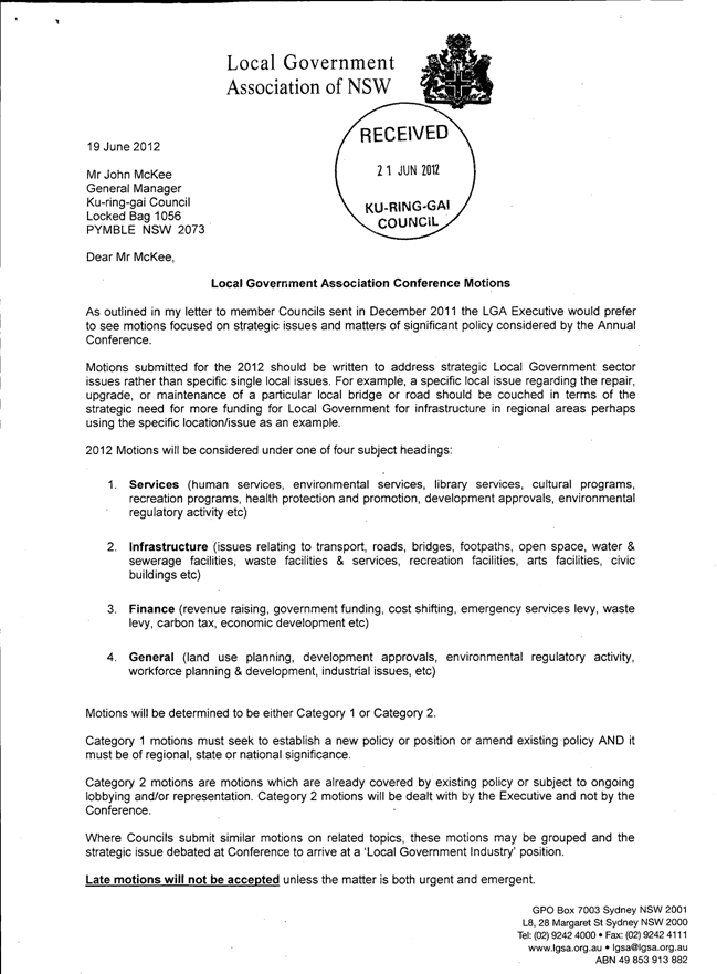
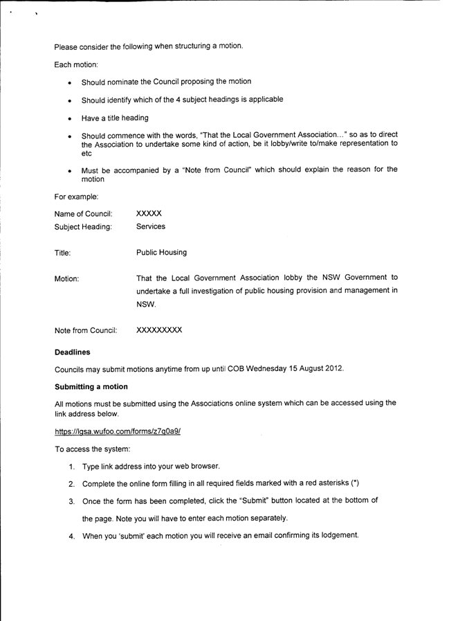
GB.2 Call for Motions - Local Government Association Conference 63
File: CY00210/4
To consider an invitation from the Local Government and Shires Association (LGSA) to submit motions to the 2012 Local Government Association (LGA) Conference.
Recommendation:
That Councillors consider whether they propose to submit any motions to the conference and supply those to the General Manager by Tuesday, 31 July 2012 who will then provide a further report to Council on Tuesday, 14 August 2012.
GB.3 Setting of Date for the Election of Mayor and Deputy Mayor - 2012/2013 70
File: S03662
To give consideration to setting the date for the 2012/2013 election of the Mayor and Deputy Mayor.
Recommendation:
That the 2012/2013 election of Mayor and Deputy Mayor be held at the Ordinary Meeting of Council on Tuesday, 18 September 2012 and that Council consider which Reference and Advisory Committees they wish to hold during the term at the Ordinary Meeting of Council to be held on Tuesday, 9 October 2012 and that the 2012/2013 election of Chairpersons and Deputy Chairpersons of Council’s Reference and Advisory Committees, be held at the Ordinary Meeting of Council to be held on Tuesday, 23 October 2012 and that Council consider the appointment of various Community Committee members/delegates to Council’s Reference and Advisory Committees at the Ordinary Meeting of Council to be held on Tuesday, 23 October 2012.
GB.4 Use of Council Resources and Electoral Material in 2012 Local Government Elections 74
File: S08820
To advise Councillors of a Division of Local Government (DLG) Circular regarding use of Council resources and electoral material in relation to the upcoming 2012 local government elections.
Recommendation:
That the advice from the Division of Local Government on the use of Council resources and electoral material be received and noted.
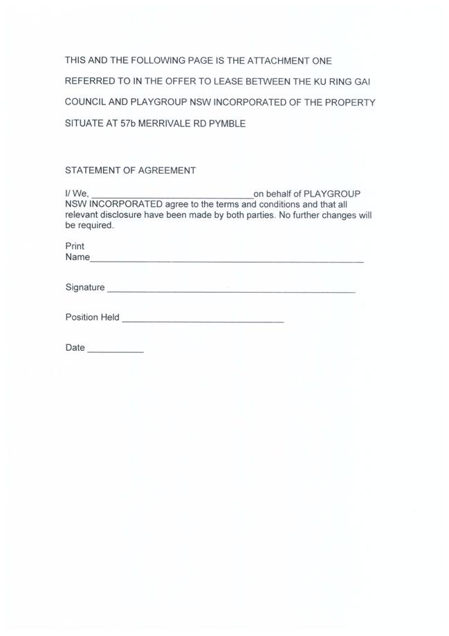
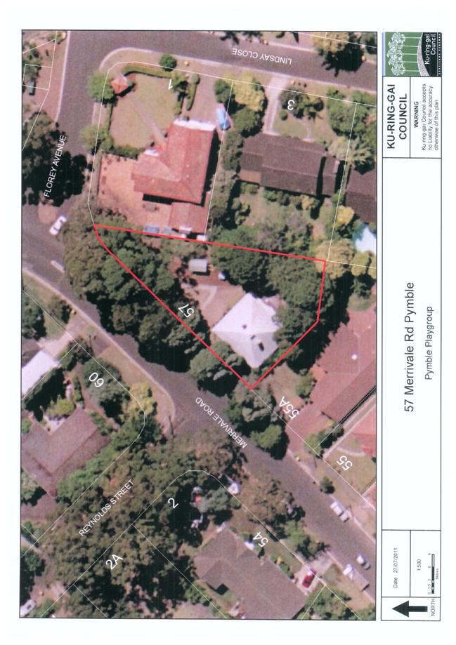
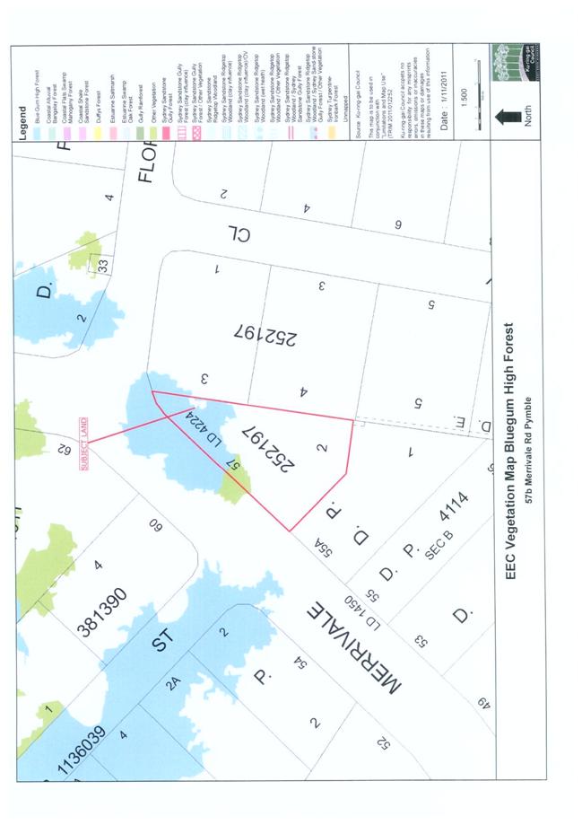
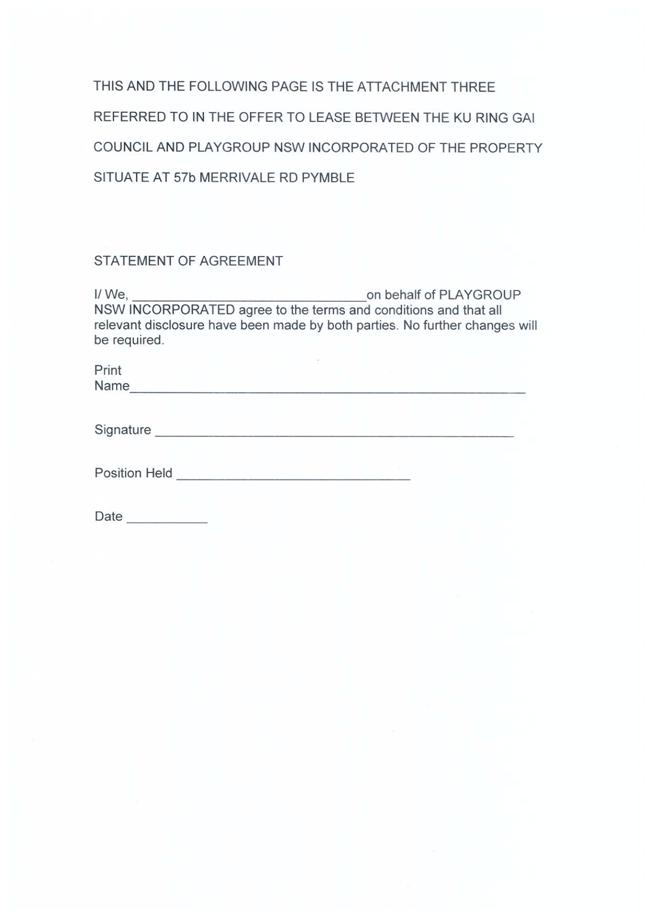
GB.5 Pymble Playgroup - Lease Renewal for 57 Merrivale Road, Pymble 79
File: S02531
For Council to consider granting a ten (10) year lease to Playgroup NSW Incorporated (Pymble Playgroup) for the premises located at 57 Merrivale Road, Pymble (the Premises).
Recommendation:
That Council grant to Playgroup NSW Incorporated a ten (10) year lease of the premises located at 57 Merrivale Road, Pymble and that the Mayor and General Manager sign the documentation and affix the Common Seal to the lease documents.
GB.6 Community Reference Committee - Minutes of Meeting 95
File: S07621
To advise Council of the minutes of the Community Reference Committee meeting held on 2 May 2012.
Recommendation:
That Council receive and note the Community Reference Committee meeting minutes from 2 May 2012.
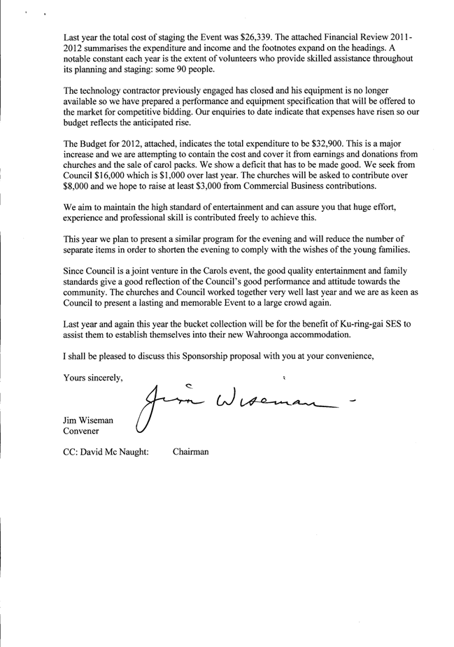
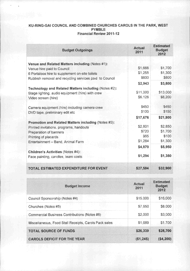
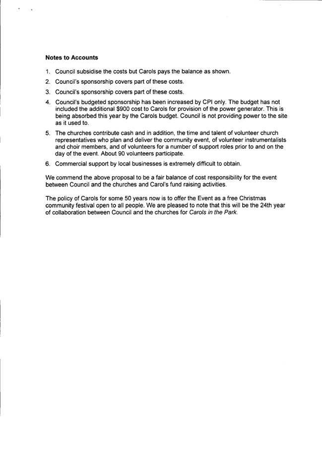
GB.7 Carols in the Park - Sponsorship Proposal 105
File: FY00275/4
To advise Council of a sponsorship request from the Combined Churches to present Carols in the Park.
Recommendation:
That Council determine whether to sponsor Carols in the Park for 2012, and should Council agree to sponsor Carols in the Park, Council also determine the amount for sponsorship.
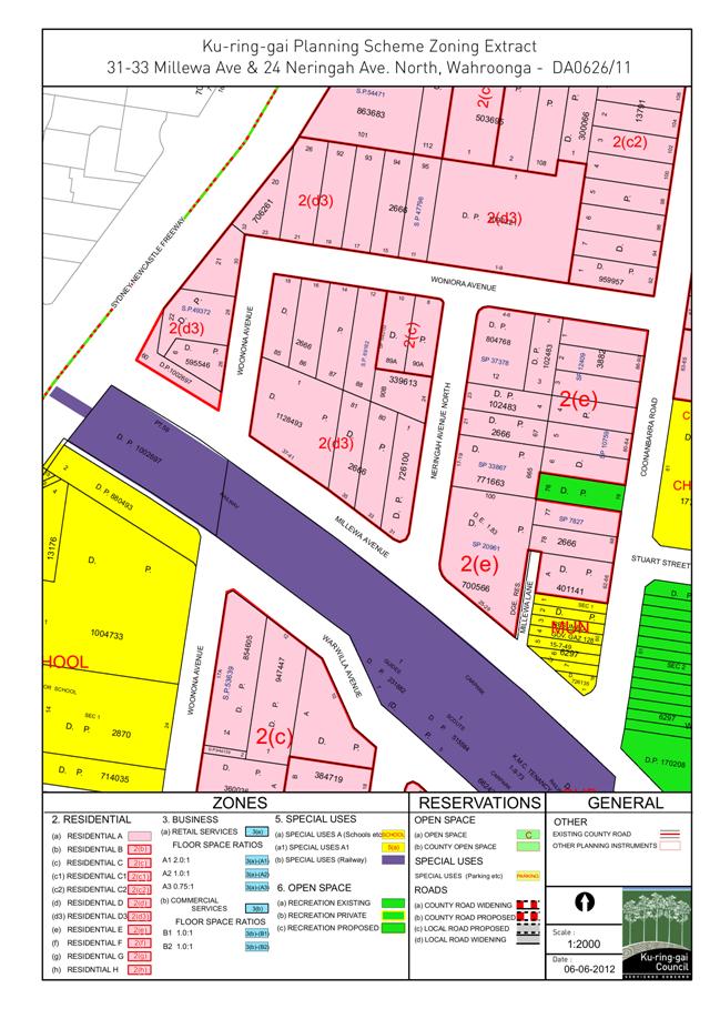
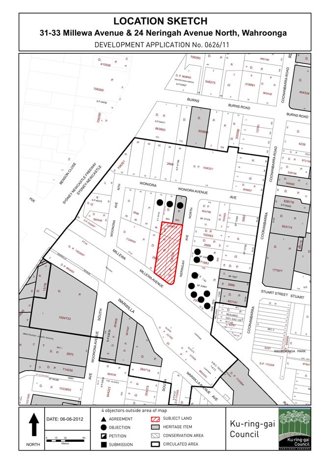
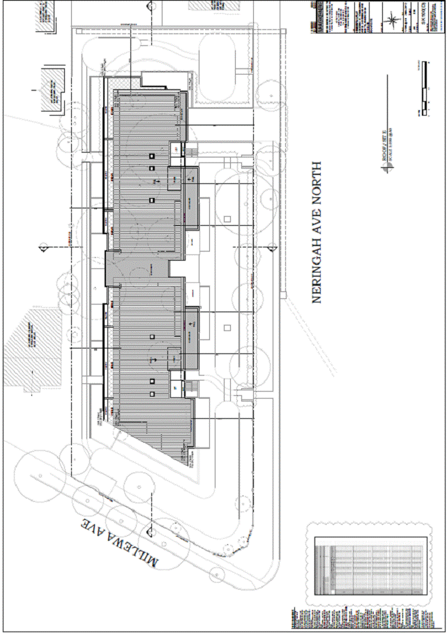
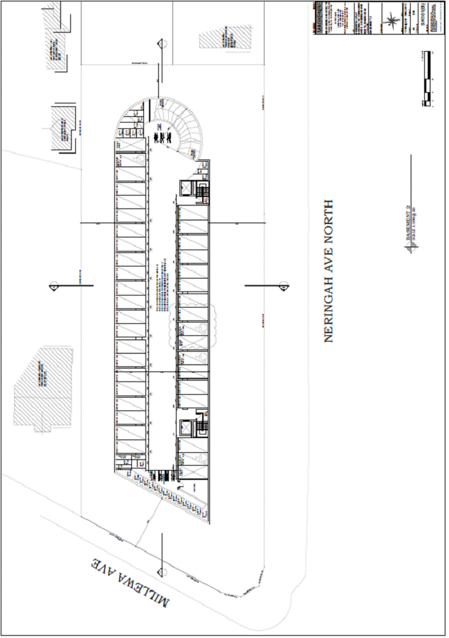
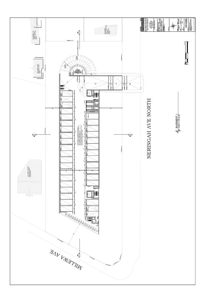
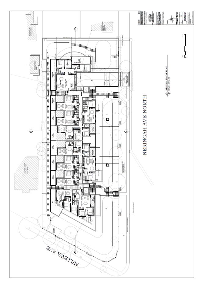
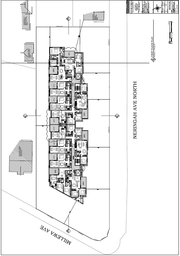
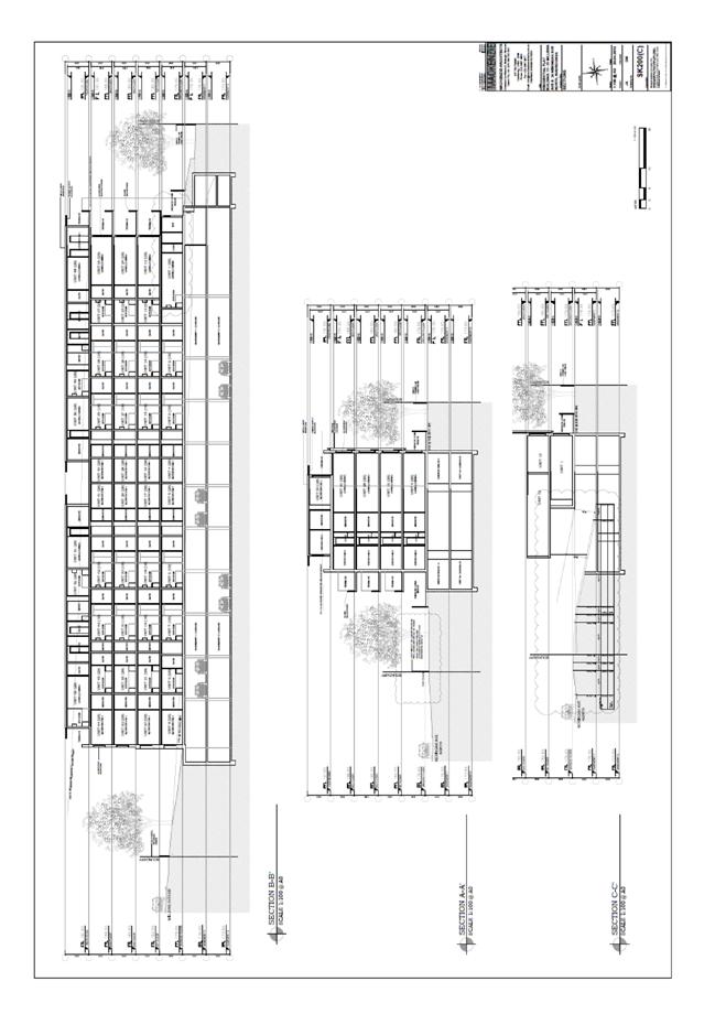
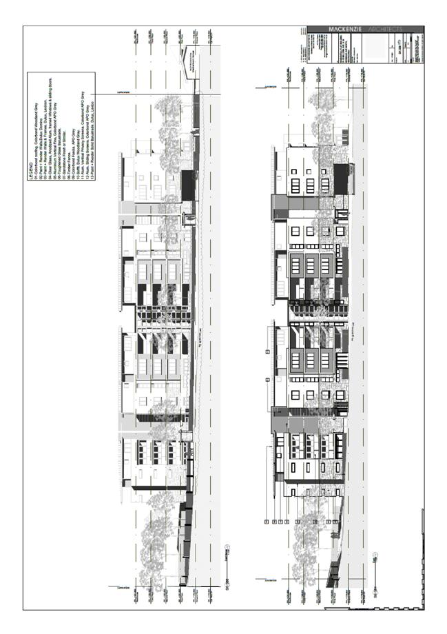
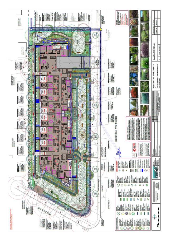
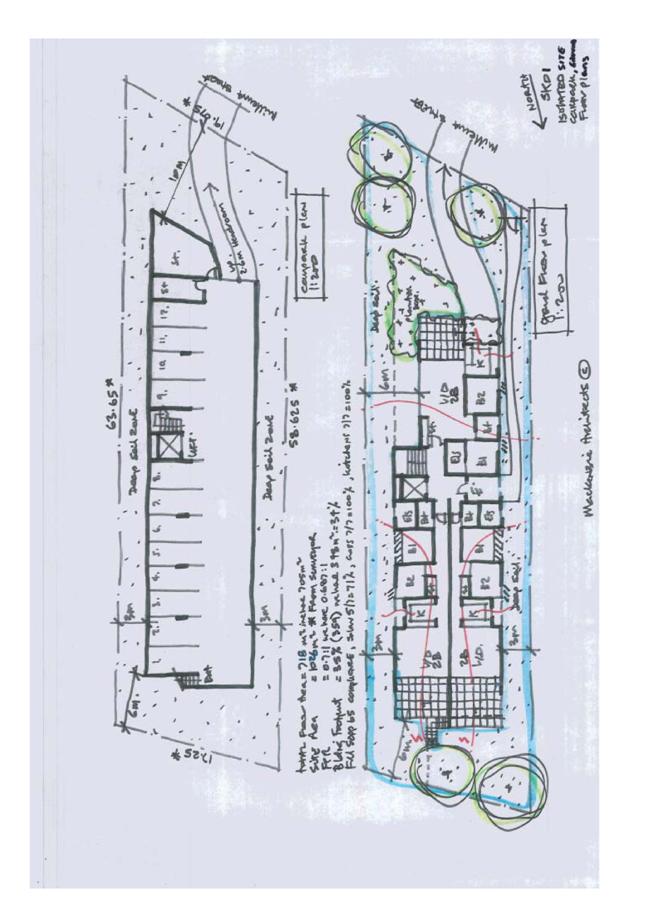
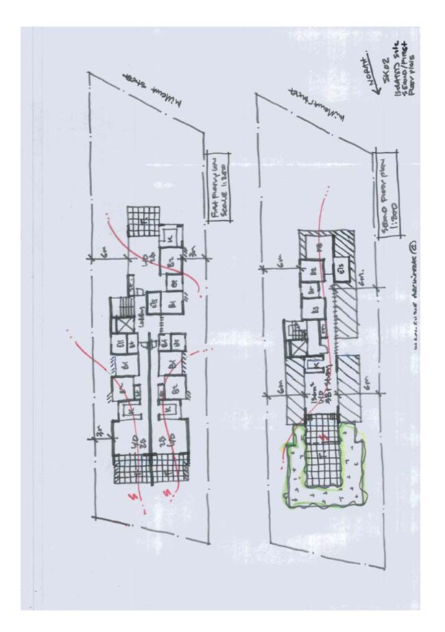
GB.8 31 - 33 Millewa Avenue & 24 Neringah Avenue North Wahroonga - Demolition of Existing Structures, Consolidation of Allotments and Construction of a Residential Flat Development for 53 Dwellings, including Basement Car Park and Landscaping 113
File: DA0626/11
Ward: Wahroonga
Applicant: Mackenzie Architects
Owner: John Foster, Michelle Ritchie, Anne Knight, Diana Connelly, Shirley Read, Margaret Davidson
Demolition of existing structures, consolidation of allotments and construction of a residential flat development for 53 dwellings, including basement car park and landscaping.
Recommendation:
Approval.
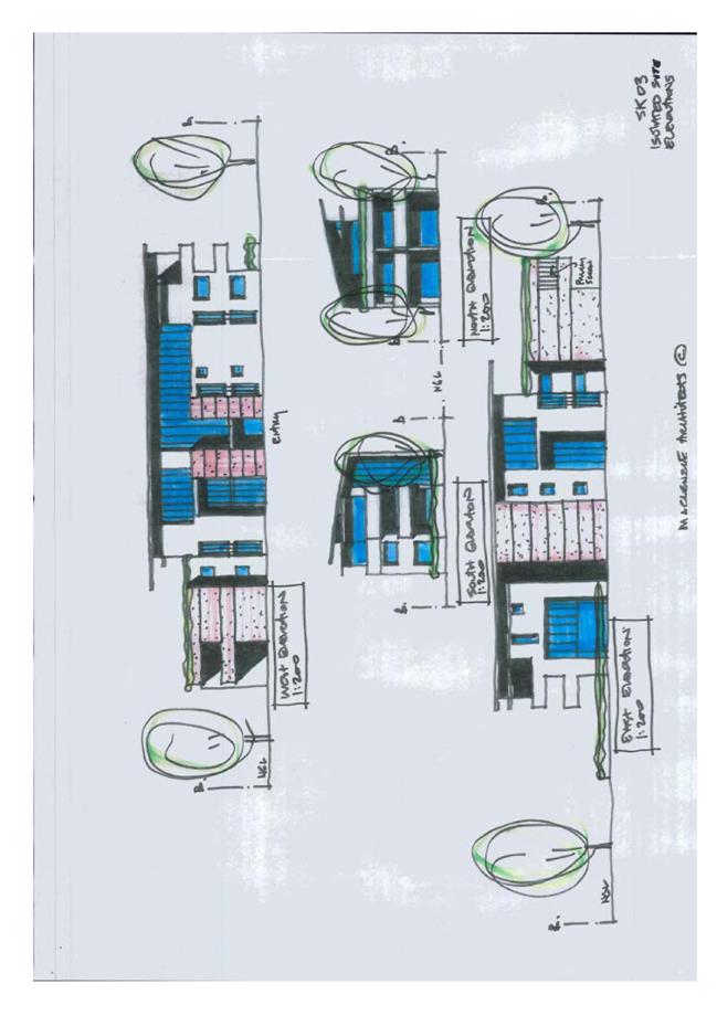
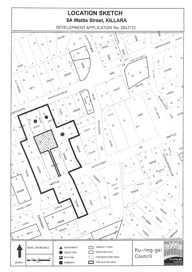
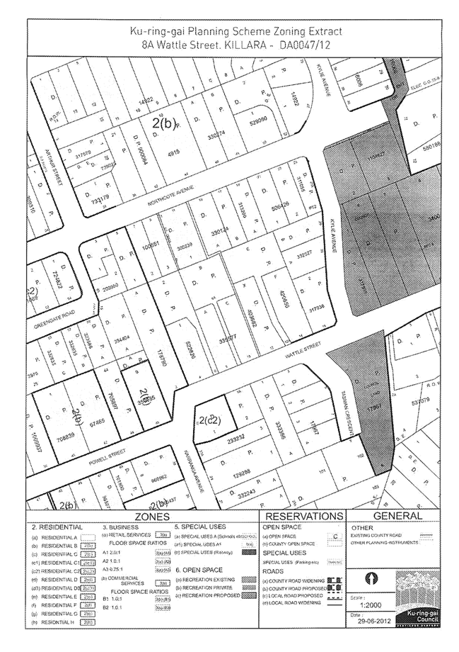
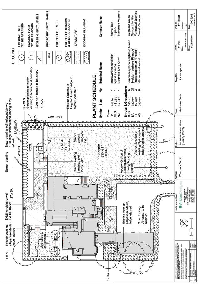
GB.9 8A Wattle Street, Killara - Alterations, Additions and a New Pool 196
File: DA0047/12
Ward: Gordon
Applicant: Mrs Justine Cottle
Owner: Mrs J L Cottle
Alterations, additions and a new pool.
Recommendation:
Approval.
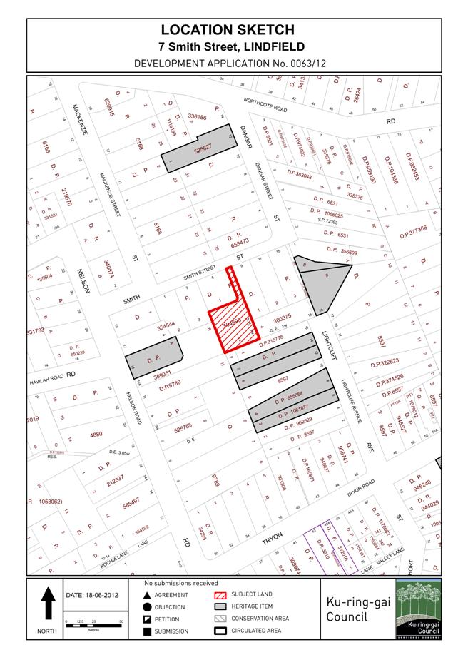
GB.10 7 Smith Street, Lindfield - Alterations and Additions, New Garage and Associated Works 233
File: DA0063/12
Ward: Roseville
Applicant: Mr Craig Robert Morris
Owner: Mrs Caroline Louise Morris, Mr Craig Robert Morris
To determine Development Application DA0063/12 proposing alterations and additions, a new garage and associated works.
Recommendation:
Approval.
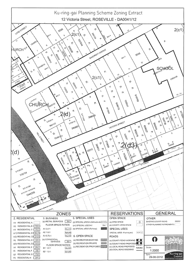
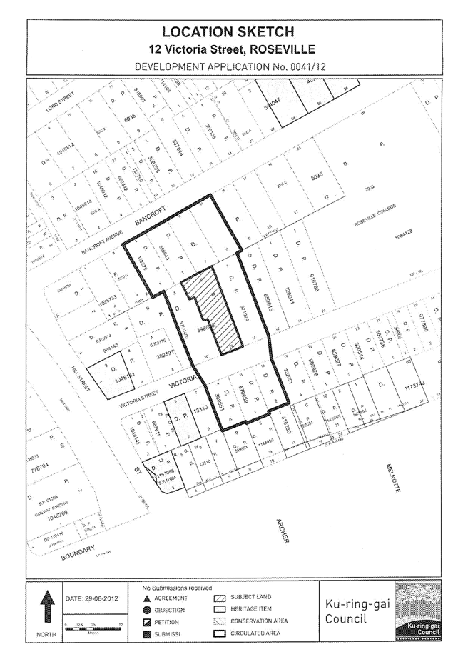
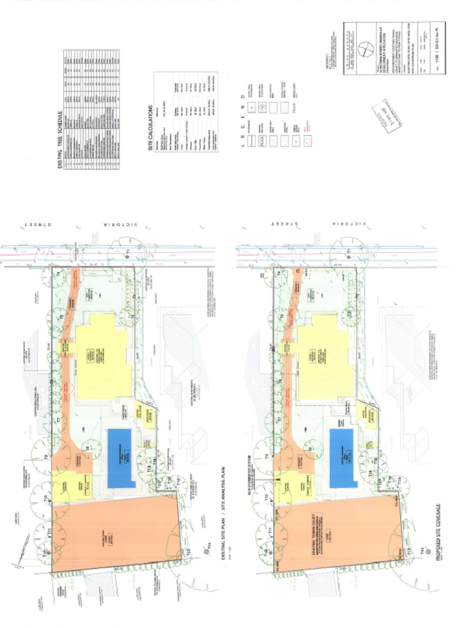
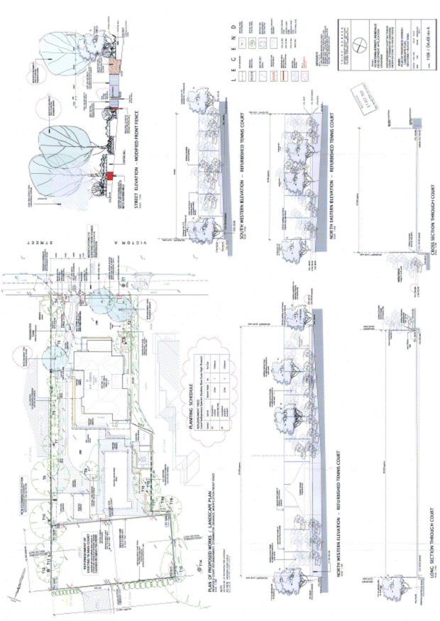
GB.11 12 Victoria Street, Roseville - Alterations and Additions to Front Fence and Stormwater Management to Tennis Court 266
File: DA0041/12
Ward: Roseville
Applicant: Alex Hunyor and Alison Peters
Owner: Alex Hunyor and Alison Peters
Alterations and additions to front fence and stormwater management to tennis court.
Recommendation:
Approval.
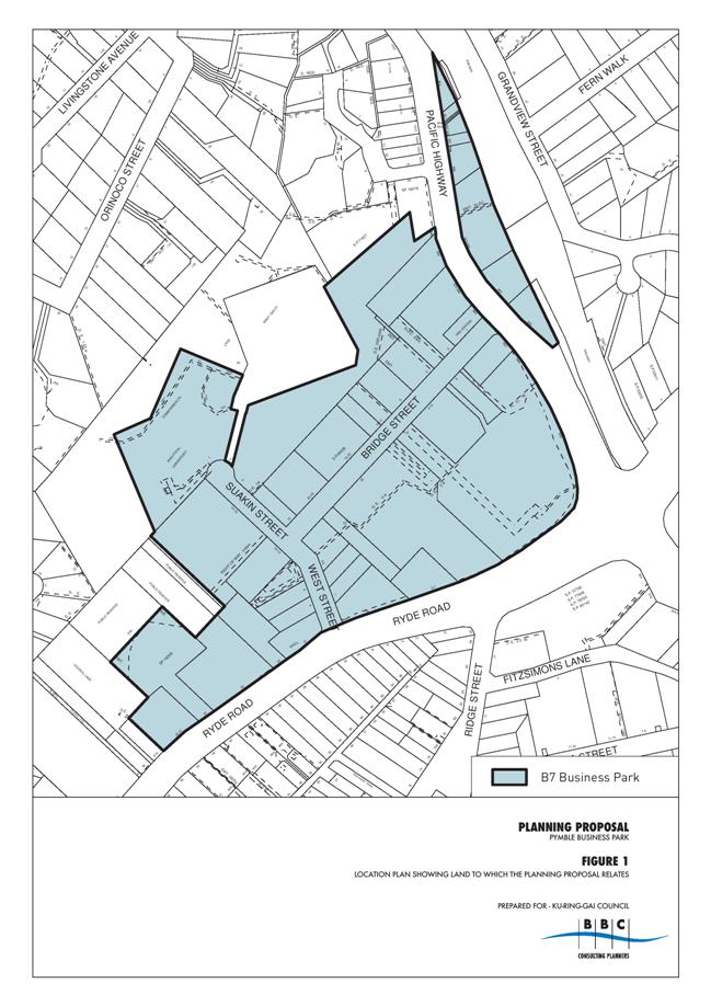
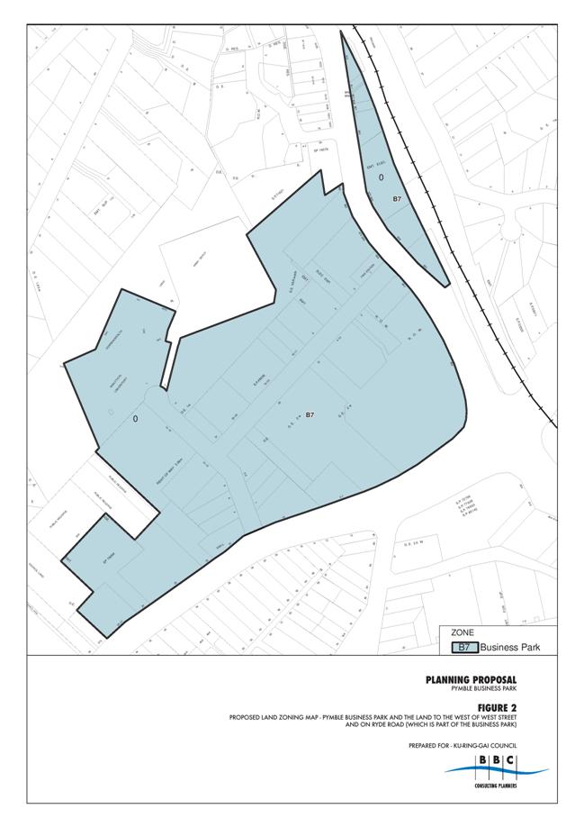
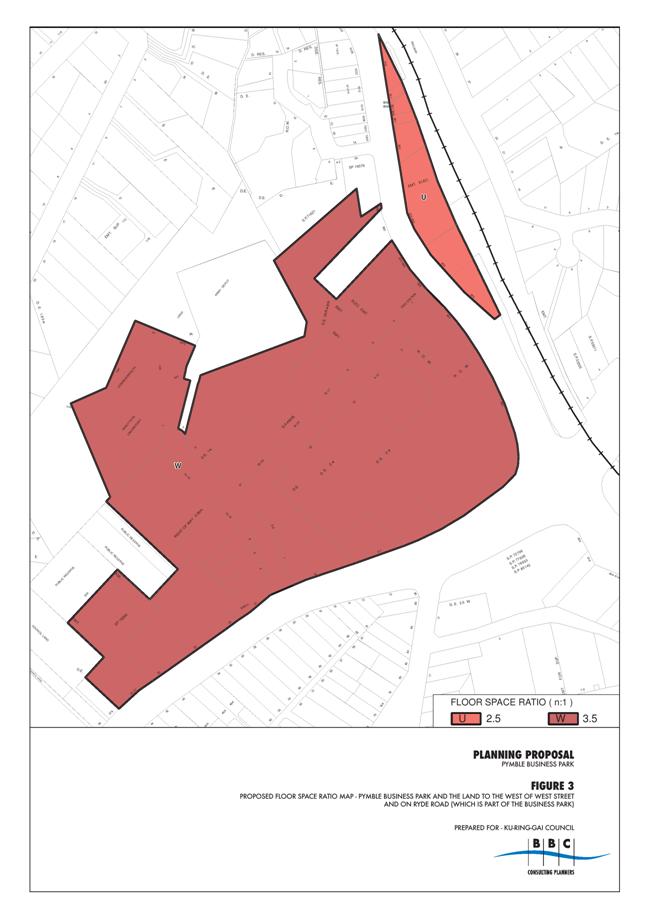
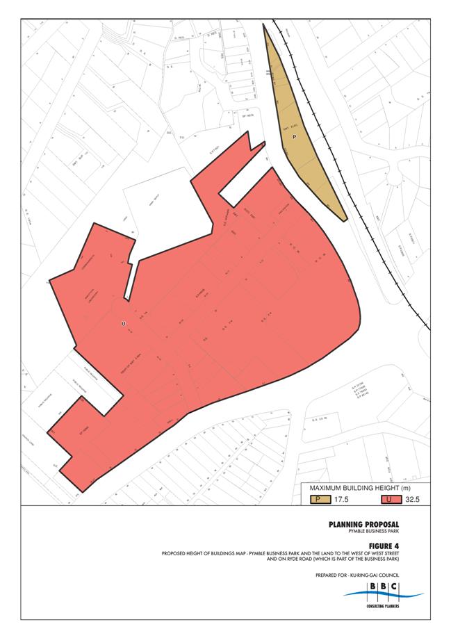
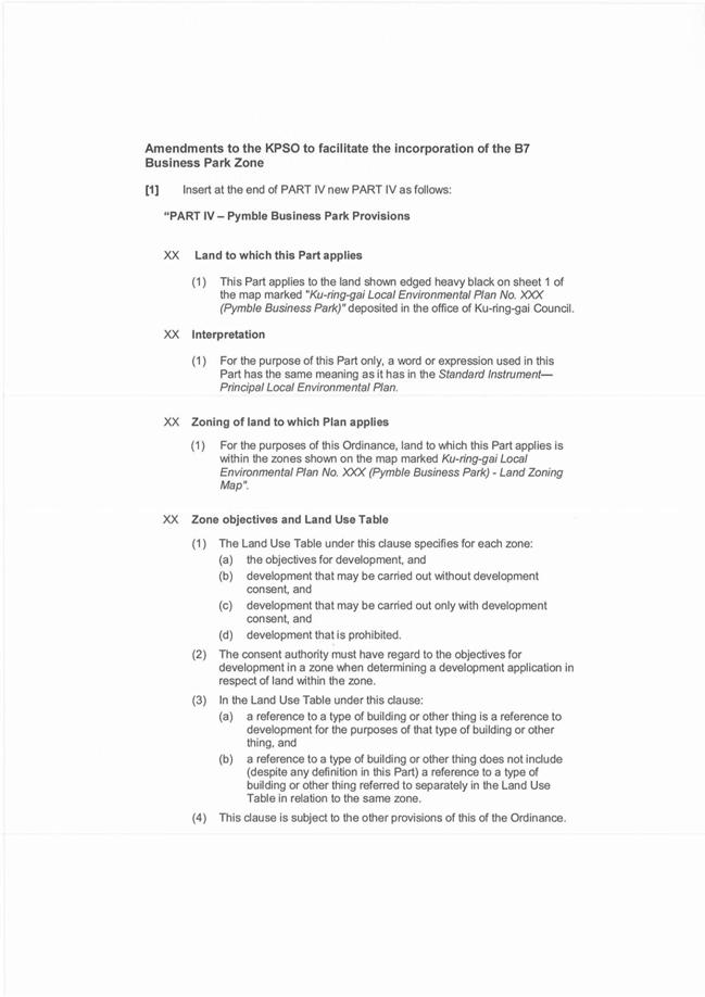
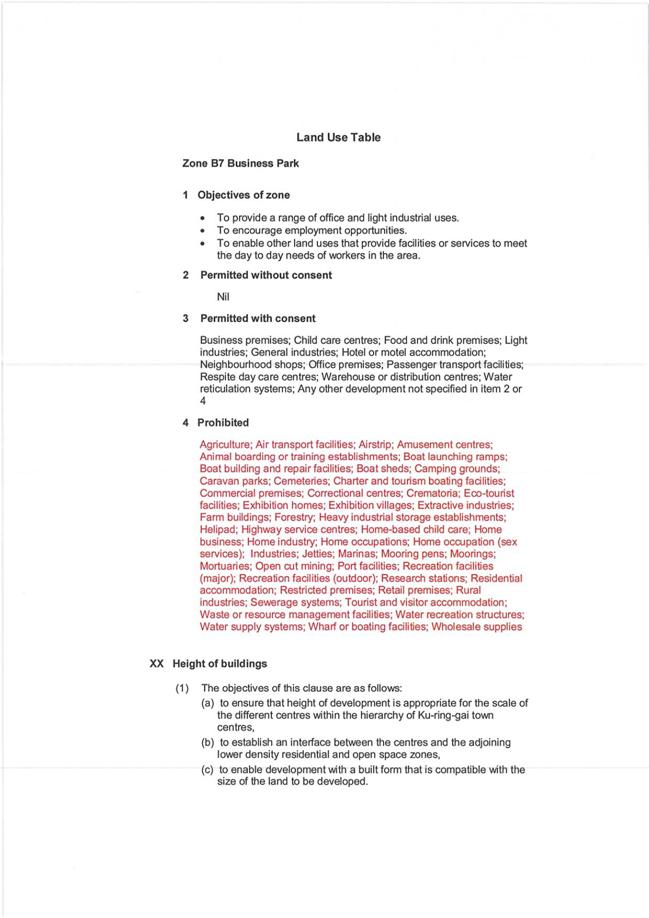
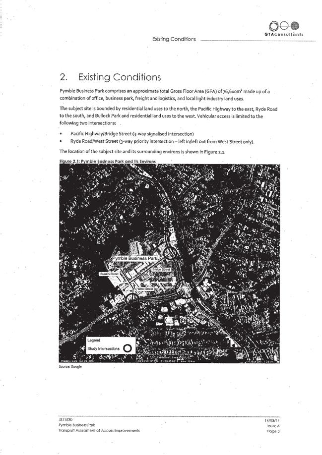
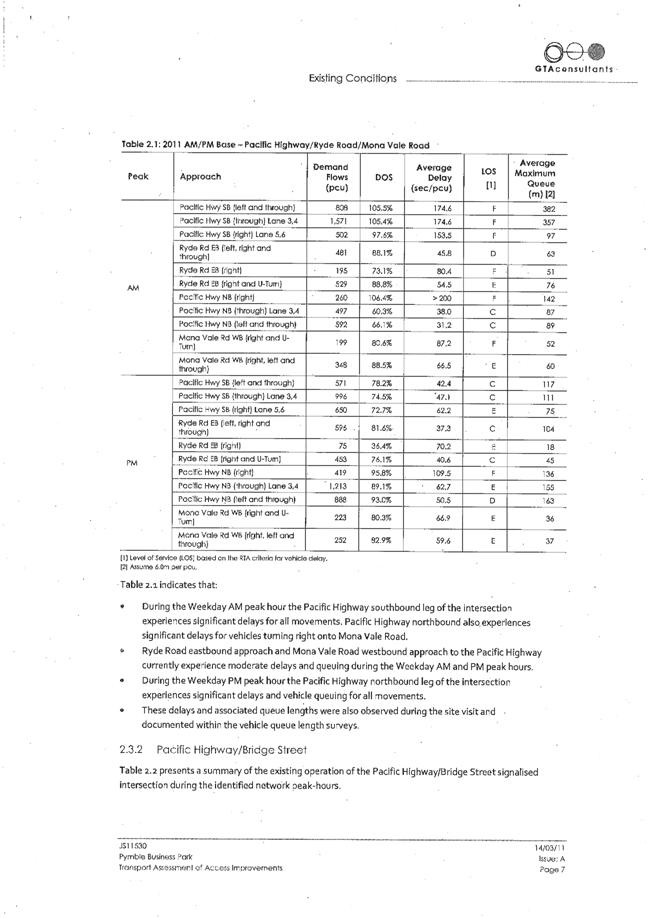
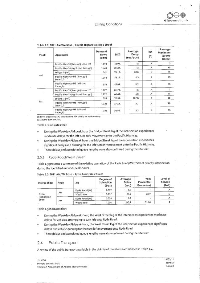
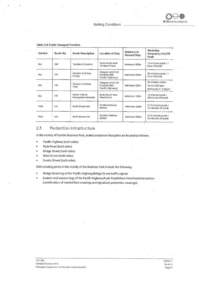
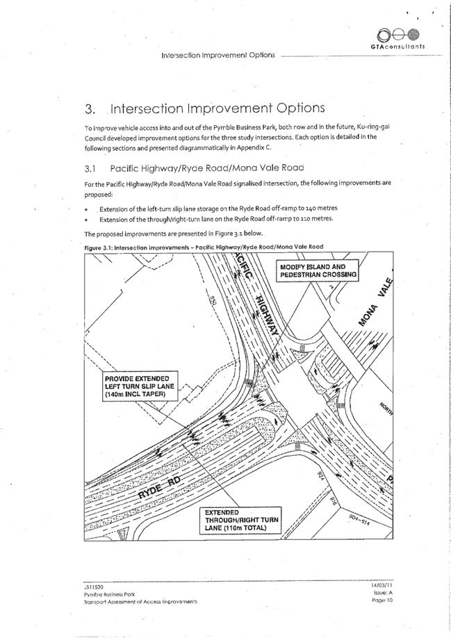
GB.12 Planning Proposal - Pymble Business Park- Assessment of Submissions 297
File: S09007
To have Council consider the submissions on the Planning Proposal Pymble Business Park.
Recommendation:
That Council vary the Planning Proposal as outlined in the report and forward the revised Planning Proposal to the Minister for Planning and Infrastructure.
GB.13 205 Mona Vale Road, St Ives - Lease Renewal 460
File: S07252
For Council to consider the lease renewal of 205 Mona Vale, St Ives, to the current tenants for a five (5) year term
Recommendation:
That Council enter into a lease agreement for a further five (5) years with Lasamart Pty Ltd, in the terms and conditions contained within the report
GB.14 Bicycle Reference Committee - Notes of Meeting held 4 April 2012 465
File: S02696
To bring to the attention of Council the proceedings of the Bicycle Reference Committee meeting held on Wednesday, 4 April 2012.
Recommendation:
That the notes of the Bicycle Reference Committee meeting of 4 April 2012 be received and noted.
GB.15 EOI 12/2012 - Road and Footpath Sweeping Contract 471
File: S09260
To consider Expressions of Interest (EoI) for Council’s road and footpath sweeping service.
Recommendation:
That Council proceed with a Selective Tender for its Roads and Footpath Sweeping Contract and that the four (4) Expressions of Interest respondents be invited to tender for these services.
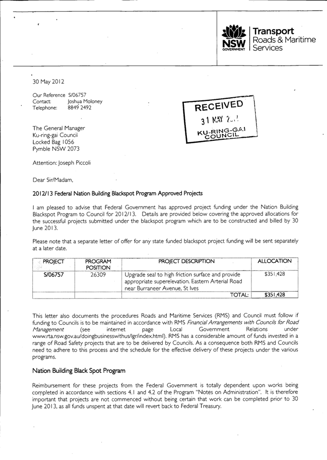
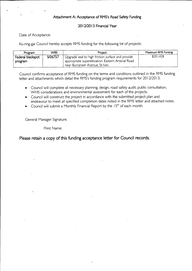
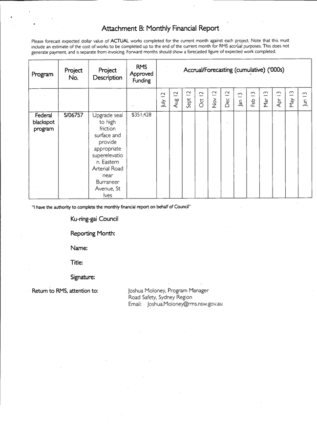
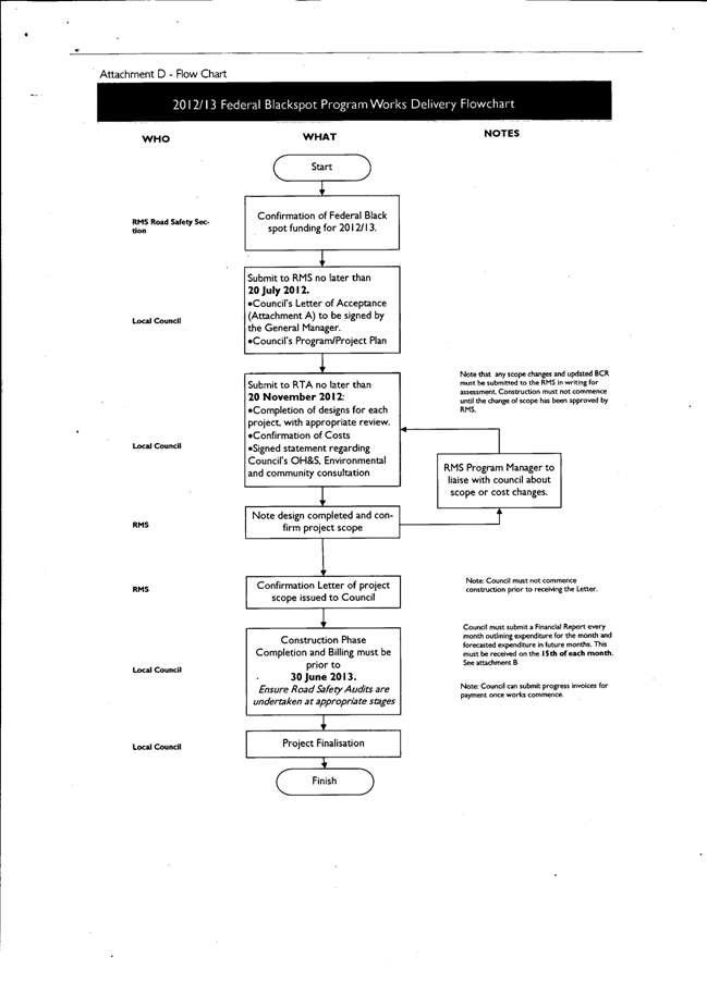
GB.16 Federal Nation Building Black Spot Projects 2012-2013 476
File: S06118/5
To seek acceptance of the 2012/2013 Federal Nation Building Black Spot grant for the upgrade of the road surface and superelevation of Eastern Arterial Road, St Ives near Burraneer Avenue.
Recommendation:
That the Roads and Maritime Services be advised of Council's acceptance of the grant and the terms and conditions associated with the grant.
GB.17 T55/2012 - Design and Construction of Ku-ring-gai Emergency Services Facilities 487
File: S09289/2
For Council to consider the tenders for the design and construction of Ku-ring-gai State Emergency Services and Bush Fire Brigade Emergency Services Facilities within Golden Jubilee Field, North Wahroonga and for Council to accept the tender from the preferred tenderer.
Recommendation:
That Council decline to accept any tender and negotiate with the preferred tenderer, Taylor Construction Group Pty Ltd.
GB.18 Open Space Grass Mowing Services Contract 493
File: S09261/2
For Council to consider the tender received for the mowing of parks, sportsfields, road reserves and laneways and appoint the preferred tenderer.
Recommendation:
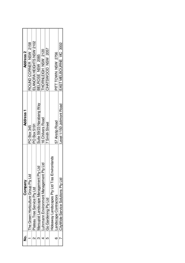
That Council accepts the preferred tender from Hideaway Landscapes Pty Ltd T/as Envirolands Landscape Contractors for the provision of grass mowing services throughout Ku-ring-gai local government area.
Extra Reports Circulated to Meeting
Motions of which due Notice has been given
NM.1 Wearing of formal Councillor Robes 499
File: S03690
Notice of Motion from Councillor Keays dated 18 June 2012
At present I am unable as a Councillor to attend Citizenship as I have done for most of the four years since being elected, because I do not wish to wear a formal Councillor robe. I do not seek via this motion to ban the practice but I wish to seek a formal Council vote on this issue. At present the Mayor, Councillor Anderson has imposed her decision that any Councillor wishing to attend Citizenship must wear a robe and if they do not are therefore banned from attending. I am of the opinion that should a Mayor want to impose this rule they should put the matter to a vote before they can impose such a ban on attendance at Citizenship Ceremonies or other functions.
I recall the removal of the Queen's portrait from Chambers was brought to Council because some where of the view no Mayor of the day had that right to remove the portrait without a vote, I believe this is a similar issue. I enjoyed attending Citizenship and to be banned is quite extraordinary, and since there is no other mechanism available to me I have had to bring about this Notice of Motion.
“I seek a formal vote by Council on the use of formal robes at Council functions including Citizenship."
I move that:
"1. Should a Mayor wish to impose mandatory wearing of Councillor Robes at functions including Citizenship they should bring the matter to Council for voting during their term of office.
2. If the Mayor of the day does not put the matter before Council then each Councillor can choose whether or not to wear the official Councillor robes at any Council function."
BUSINESS WITHOUT NOTICE – SUBJECT TO CLAUSE 241 OF GENERAL REGULATIONS
Questions Without Notice
Inspections Committee – SETTING OF TIME, DATE AND RENDEZVOUS
Confidential Business to be dealt with in Closed Meeting
C.1 Acquisition of Open Space - St Ives 1
File: S09321
In accordance with the Local Government Act 1993 and the Local Government (General) Regulation 2005, in the opinion of the General Manager, the following business is of a kind as referred to in section 10A(2)(c), of the Act, and should be dealt with in a part of the meeting closed to the public.
Section 10A(2)(c) of the Act permits the meeting to be closed to the public in respect of information that would, if disclosed, confer a commercial advantage on a person with whom the Council is conducting (or proposes to conduct) business.
The matter is classified confidential because it deals with the proposed acquisition and/or disposal of property.
It is not in the public interest to release this information as it would prejudice Council’s ability to acquire and/or dispose of the property on appropriate terms and conditions.
Report by Director Strategy & Environment dated 6 July 2012.
John McKee
General Manager
** ** ** ** ** **
|
Present: |
The Mayor, Councillor J Anderson (Chairperson) (Roseville Ward) Councillors S Holland & E Malicki (Comenarra Ward) Councillors E Keays & C Szatow (Gordon Ward) Councillor R Duncombe (Roseville Ward) Councillors T Hall & C Hardwick (St Ives Ward) Councillor D McDonald (Wahroonga Ward) |
|
|
|
|
Staff Present: |
General Manager (John McKee) Acting Director Corporate (Tino Caltabiano) Director Development & Regulation (Michael Miocic) Director Operations (Greg Piconi) Director Strategy & Environment (Andrew Watson) Director Community (Janice Bevan) Manager Records & Governance (Matt Ryan) Minutes Secretary (Sigrid Banzer) |
The Meeting commenced at 7.00pm
The Mayor offered the Prayer
|
163 |
Apologies
File: S02194
Councillor Ian Cross tendered an apology for non-attendance [health matter] and requested leave of absence.
|
|
|
Resolved:
(Moved: Councillors McDonald/Hall)
That the apology by Councillor Ian Cross be accepted and leave of absence granted.
CARRIED UNANIMOUSLY |
DECLARATIONS OF INTEREST
The Mayor adverted to the necessity for Councillors and staff to declare a Pecuniary Interest/Conflict of Interest in any item on the Business Paper.
Councillor Elise Keays declared that as she is a member of the Board of KOPWA and there is a General Business Item 2 which is in regards to the Lease to KOPWA Ltd - "Arrunga" Units - 259 to 261 Pacific Highway, Lindfield, she believes that she can make a fair and balanced judgement on both but understands that there is a perception of conflict as well and based on that she will remove herself from the Chamber during the debate.
|
164 |
CONFIRMATION OF REPORTS TO BE CONSIDERED IN CLOSED MEETING
File: S02499
|
|
|
Resolved:
(Moved: Councillors Keays/Duncombe)
That in accordance with the provisions of Section 10 of the Local Government Act 1993, all officers’ reports be released to the press and public, with the exception of the confidential attachments to the following General Business reports:
GB.2 Lease to KOPWA Ltd - "Arrunga" Units - 259 - 261 Pacific Highway, Lindfield
GB.3 Marian Street Theatre, 2 Marian Street Killara - Management Options
GB.12 Tender T54/2012 - Scheduled Maintenance of Mechanical Services - Various Buildings
GB.15 T44/2011 - North Turramurra Recreation Area - Detailed Engineering Works - Slope C - Semi-Contiguous Pile Wall
CARRIED UNANIMOUSLY
|
DOCUMENTS CIRCULATED TO COUNCILLORS
The Mayor adverted to the documents circulated in the Councillors’ papers and advised that the following matters would be dealt with at the appropriate time during the meeting:
|
Late Items: |
Refer MM.1 - VALE William Henry "Harry" Oliver - Memorandum by the Mayor, Councillor Jennifer Anderson dated 21 June 2012 to Councillors with attached amended Mayoral Minute with the explanation as to why the Mayoral Minute was updated as a result of information having been added and details clarified by the family.
Refer MM.3 - RAF Bomber Command Memorial - Letter of Appreciation
Refer GB.11 - Delivery Program and Operational Plan 2012-2013 - Post Exhibition - Memorandum by Manager Integrated Planning, Property and Assets dated 22 June 2012 with attached late submissions.
Refer GB.15 - T44/2011
- North Turramurra Recreation Area - Detailed Engineering Works - Slope C -
Semi-Contiguous Pile Wall - Memorandum by Manager Strategic
Projects dated
|
|
Memorandums: |
Refer GB.10 - Ku-ring-gai Bicycle Plan - Memorandum by Manager Urban and Heritage Planning dated 25 June 2012 advising of additional information and minor amendments to the draft plan prior to exhibition.
Gordon Golf Club - Correspondence to Council - Memorandum by Director Community dated 26 June 2012 advising Councillors of a proposed increase of the fee relating to the Gordon Golf Club's lease under the 2012/2013 Fees and Charges.
|
|
Councillors Information: |
Lot 1 Water Street, Wahroonga - Fencing - Memorandum by Manager Open Space Services dated 21 June 2012 with an attachment in answer to a Question Without Notice raised by Councillor Duncan McDonald at the Ordinary Meeting of Council held on 12 June 2012. |
|
Confidential Late Agenda Attachment: |
Refer GB.15 - T44/2011 - North Turramurra Recreation Area - Detailed Engineering Works - Slope C - Semi-Contiguous Pile Wall - Confidential Attachments to the report. |
CONFIRMATION OF MINUTEs
|
165 |
Minutes of Ordinary Meeting of Council
File: S02131
|
|
|
Meeting held 12 June 2012 Minutes numbered 143 to 162
|
|
|
Resolved:
(Moved: Councillors McDonald/Szatow)
That Minutes numbered 143 to 162 circulated to Councillors were taken as read and confirmed as an accurate record of the proceedings of the Meeting.
CARRIED UNANIMOUSLY |
minutes from the Mayor
|
166 |
VALE William Henry "Harry" Oliver
File: S04813 Vide: MM.1
|
|
|
On behalf of Ku-ring-gai Council, I would like to pay tribute to the life of former Lindfield resident Harry Oliver, who sadly passed away on the 31st of May at the age of 92.
Harry was a prominent member of our community and was involved in many organisations including St David’s Uniting Church at Lindfield, Hornsby RSL Club, Killara Bowling Club and the Wolseley & Treatts Roads Residents’ Action Group.
Harry, the eldest of seven children, enlisted for World War 11 in 1940 and served in the Citizen Military Forces and the Australian Imperial Force.
He was a member of the 18th and 30th Australian Infantry Battalions, serving in Papua New Guinea. His war service was recognised with medals including the 1939-45 Star, the Pacific Star and the Australian Service Medal.
On returning from the war, Harry was instrumental in founding Hornsby RSL Club and was the oldest surviving founding board member. As a proud war veteran, he never missed an Anzac Day march.
A life-long elder of St David’s Uniting Church, Harry served in several roles including Church Secretary and as a member of the Church Property Committee.
He was also an active member of the Wolseley & Treatts Roads Residents’ Action Group, helping to campaign for the retention of low density development in Lindfield and the protection of built and natural heritage.
Harry worked his entire career with miller and foodstuff firm Clifford Love and Co, makers of the famous Uncle Toby’s Oats.
His role was to source and buy ingredients such as maize, and he became a licensed pilot so he could check crops with less time away from his family than would have been possible with road trips.
He started at the bottom and worked his way up through the company, retiring in 1983.
Harry’s service to agriculture was recognised with a major award putting him in a similar league to iconic Australian agronomist William Farrer. They were both listed on the Honour Roll of Agricultural Icons of the 20th Century.
Harry had three children, Lyn, Gaye and Gary, and two grandchildren, Belinda and Kelton – and was married for 69 years to Noeleen, who passed away last year. He remained in the Lindfield family home until illness necessitated a move to a nursing home in Willoughby.
He remained active in his later years. At the age of 86, he did the Sydney Harbour bridge climb, a symbolic event considering he walked across the bridge as a child when it opened in 1932.
On behalf of Ku-ring-gai Council, I would like to pay tribute to the life of Harry Oliver and express our sincere condolences to his extended family. He was a truly inspiring member of our community who will be sorely missed by many.
|
|
|
Resolved:
A. That the Mayoral Minute be received and noted.
B. That we stand for a minute’s silence to honour the life of Harry Oliver.
C. That the Mayor write to Harry’s family enclosing a copy of the Mayoral Minute.
CARRIED UNANIMOUSLY |
One Minute's Silence was observed
|
167 |
Queen's Birthday Honours 2012
File: S02767 Vide: MM.2
|
|
|
I am pleased to inform you that 10 Ku-ring-gai citizens, through their outstanding achievements and services to the community, have been awarded 2012 Queen’s Birthday Honours.
We are very proud to have these dedicated and talented Australians as members of the Ku-ring-gai community.
I would like to read to you the names of these special Ku-ring-gai citizens and, on behalf of Council, congratulate them on their excellent contributions to Australian society.
Kevin Callinan of St Ives, for service to the Ku-ring-gai community through the Historical Society, the Ku-ring-gai Community Shed and St Ives Progress Association.
Peter Pickles of Killara, for service to the community through the establishment of student leadership training programs, pastoral care for Members of Parliament, contributions to Australia’s international aid programs and philanthropic support for medical research.
Lancelot Lightfoot of Wahroonga, for service to the container shipping industry, to the development and promotion of Australia’s international trade networks and as a supporter of the welfare of merchant mariners, and to the community.
James Millar of Gordon, for service to business and commerce through executive roles with a range of organisations, and to the community through leadership and fundraising support for social welfare, cancer research and education.
Robert Jansen of Killara, for service to medical research and education domestically and overseas as an academic, clinician and author, particularly in the field of human reproductive genetics and in-vitro fertilisation.
Alanna Nobbs of Pymble, for service to education in the fields of ancient history and the classics as an educator, and through leadership roles in professional organisations, in particular, the Society for the Study of Early Christianity.
Richard Nott of West Pymble, for service to the banking and insurance industries, and to the community through the Australia-Britain Society.
Clifford Cowdroy of Lindfield, for service to remote education through the Bush Children’s Education Foundation of NSW.
Margaret Leong of St Ives, for service to youth as the co-founder and inaugural president of the Nova Youth Orchestra.
Eric Palmer of Pymble, for service to people with disabilities, particularly through the scouting movement and volunteer at the Northern Area Recreational Association.
On behalf of Council, I congratulate all these award winners on their outstanding achievements.
Ku-ring-gai should be proud that it has so many citizens being recognised at the highest levels for their selfless dedication, commitment and contribution to local, national and international communities.
|
|
|
Resolved:
A. That Council acknowledge the outstanding contribution made by these recipients of 2012 Queen's Birthday Honours to the Ku-ring-gai community and to the well-being of our society.
B. That the Mayor, on behalf of Council, write to the recipients to congratulate them.
CARRIED UNANIMOUSLY |
|
168 |
RAF Bomber Command Memorial - Letter of Appreciation
File: S02024 Vide: MM.3
|
|
|
At our meeting on 22 May 2012, Councillors resolved to donate $10,000 towards an appeal to help local World War II veterans attend the unveiling of the RAF Bomber Command Memorial in London.
More than 55,000 members of the Bomber Command died in the war. Around 3,500 of these were Australians. To honour this sacrifice, the Queen will unveil a special memorial this coming Thursday, 28 June.
As a result of the financial assistance from Council and other sources, local veterans of the Bomber Command have been able to make the journey to London for this very special ceremony.
They include pilots, navigators and bomb aimers from
Warrawee, Wahroonga and
I have received a kind letter from Ross Pearson OAM, 89, of Lindfield, who was a wireless operator/gunner during the war.
On behalf of the local veterans who have travelled to London, Mr Pearson has thanked Council for the donation.
In his letter, he wrote: “The elected representatives have shown compassion and a generous desire to ensure appropriate representation at the London Memorial recognising the achievements and sacrifice of the boys in Air Force Blue”.
It’s very pleasing to know that our donation has been truly appreciated and has gone towards a very worthwhile cause.
We look forward to hearing of the veterans’ experiences in London when they return.
|
|
|
Resolved:
That the Mayoral Minute, including the letter from Mr Ross Pearson, be received and noted. CARRIED UNANIMOUSLY
|
GENERAL BUSINESS
Council Car Park - Woodford Lane, Lindfield - Reclassification
File: CY00337/2
Vide: GB.9
To have Council consider the reclassification of Council Car Park – Woodford Lane, Lindfield to Operational land.
A Motion moved by
Councillor Hall that a site inspection take place was LOST
For the Motion: Councillor Hall
Against the Motion: The Mayor, Councillor J Anderson, Councillors Duncombe, Hardwick, Holland, Keays, Malicki, McDonald and Szatow
|
169 |
Compliance Audit of Recently Completed Developments
File: CY00133/4 Vide: GB.7
|
|
|
To report on an audit of three recently completed residential flat developments to determine the number and type of non-compliances detected.
|
|
|
Resolved:
(Moved: Councillors Holland/Malicki)
That the report is received and the findings of the sample development compliance audit 2012 be received and noted.
CARRIED UNANIMOUSLY |
|
170 |
Council Submission: Sydney Over the next 20 years - Discussion Paper NSW Department of Planning & Infrastructure
File: CY00349/2 Vide: GB.8
|
|
|
To have Council consider a submission on the Discussion Paper “Sydney Over the next 20 years”.
|
|
|
Resolved:
(Moved: Councillors Holland/Malicki)
That a submission to the NSW Department of Planning & Infrastructure on the Discussion Paper - “Sydney Over the Next 20 Years”, be prepared based on the key points identified in this report.
CARRIED UNANIMOUSLY |
|
171 |
Tender T54/2012 - Scheduled Maintenance of Mechanical Services - Various Buildings
File: S09277/2 Vide: GB.12
|
|
|
For Council to consider the tender received for scheduled maintenance of Mechanical Services Various Buildings and appoint the preferred tenderer.
|
|
|
Resolved:
(Moved: Councillors Holland/Malicki)
A. That Council accept the preferred tender from Norfolk Holdings Pty Ltd (Haden) to carry out scheduled maintenance of mechanical services various buildings for a period of three (3) years with a two (2) year option.
B. That the Mayor and General Manager be delegated authority to execute all tender documents on Council’s behalf in relation to the contract.
C. That the Common Seal of Council be affixed to all necessary documents.
D. That all tenderers be advised of Council’s decision in accordance with Clause 178 of the Local Government Tendering Regulations.
CARRIED UNANIMOUSLY |
|
172 |
60 Westbrook Avenue, Wahroonga - Amendment of Terms of Drainage Easement over Downstream Property
File: PCDC0369/11 Vide: GB.13
|
|
|
To consider a request by the owners of 60 Westbrook Avenue, Wahroonga, to amend the terms of the drainage easements over 62 Westbrook Avenue and 27 Morris Avenue to permit the passage of runoff from 60 Westbrook Avenue, Wahroonga.
|
|
|
Resolved:
(Moved: Councillors Holland/McDonald)
A. That Council grants approval for the amendment of the terms of the drainage easements over Lot 13 DP24317, known as 62 Westbrook Avenue, and Lot 19 DP27768, known as 27 Morris Avenue, to allow the passage of private property runoff.
B. That Council authorise the Mayor and the General Manager to execute all documentation associated with the amendment to the terms of the existing easements.
C. That Council authorise the affixing of the Common Seal of the Council to the amended Section 88B Instruments and if required, for any extinguishment of the existing easement.
D. The applicant will be responsible for all costs to amend the terms of the drainage easements including but not limited to the costs of legal, survey, registration and administration.
CARRIED UNANIMOUSLY |
|
173 |
100 Eton Road, Lindfield - Subdivision to Create 7 Lots for Development envisaged under Part 3A Concept Approval MP06-0130, Construction of Roads, Ancillary Site Works and new Sporting Oval - Voluntary Planning Agreement for Edgelea
File: DA0677/11 Vide: GB.5
|
|||||||||||||||||||||||||||||||||||||||||||||||||||||||||||||||||||||||||||||||||||||||||||||||||||||||||||||||||||||||||||||||||||||||||||||||||||||||||||||||||||||
|
|
Subdivision of land and preparation works for development
envisaged under
|
|||||||||||||||||||||||||||||||||||||||||||||||||||||||||||||||||||||||||||||||||||||||||||||||||||||||||||||||||||||||||||||||||||||||||||||||||||||||||||||||||||||
|
|
Resolved:
(Moved: Councillors Holland/Malicki)
A. That Council resolve to enter into the Planning Agreement with DHA for the Edgelea development, as specified within Annexure E.
B. That the Council grant delegation to the General Manager and Mayor to execute the Planning Agreement, under Common Seal.
C. That Council grant Development Consent to DA0677/11 for the subdivision of 100 Eton Road , Lindfield into 7 lots for development envisaged under Concept Approval MP06_0130, and lots for public facilities and asset protection zones, and for the construction of roads, ancillary site works and new soccer field, subject to the following conditions:
Conditions that identify approved plans:
1. Approved architectural plans and documentation
The development must be carried out in accordance with the following plans and documentation listed below and endorsed with Council’s stamp, except where amended by other conditions of this consent:
Reason: To ensure that the development is in accordance with the determination.
2. Inconsistency between documents
In the event of any inconsistency between conditions of this consent and the drawings/documents referred to above, the conditions of this consent prevail.
Reason: To ensure that the development is in accordance with the determination.
3. No demolition of extra fabric
Demolition of the existing buildings shall be limited to that documented on the approved plans (by way of notation). No approval is given or implied for removal and/or rebuilding of any portion of the existing building network which is shown to be retained.
Reason: To ensure compliance with the development consent.
Conditions to be satisfied prior to the issue of the construction certificate:
4. Amendments to environmental site management plan
Prior to the issue of a Construction Certificate, the Principal Certifying Authority shall be satisfied that the approved plans, listed below and endorsed with Council’s stamp, have been amended in accordance with the requirements of this condition as well as other conditions of this consent:
The following changes are required to the Environmental Site Management Plan:
1. The plan of the site is to be provided at a legible scale. 2. The plan is to refer to all proposed works within the above development application including, road construction and associated landscape works, laying field construction and associated parking and landscape works, and services installation. 3. The environmental site management plan is to be prepared in accordance with Council’s DA Guide including proposed tree protection as per arborist recommendation, location of temporary truck access, site offices, parking, and material handling areas. 4. The approval of this application will enable the requirements of an asset protection zone
Prior to the issue of the Construction Certificate, the Principal Certifying Authority shall be satisfied that the environmental site management plan has been submitted as required by this condition.
Note: A site management plan shall be submitted to the Certifying Authority.
Reason: To ensure that the development is in accordance with the determination.
5. Amendments to approved landscape plans
Prior to the issue of a Construction Certificate, the Principal Certifying Authority shall be satisfied that the approved landscape plans, listed below and endorsed with Council’s stamp, have been amended in accordance with the requirements of this condition as well as other conditions of this consent:
The following changes are required to the Landscape Plan:
1. To preserve existing vegetation as per Tree Management Plan, Section 2c (la2402/a02, DEM, 8/12/11) is to be amended to indicate the top of wall height of the proposed rock cutting or stone wall proposed along the northern side of Road 2, between chainage 200 and 275. The top of wall level is to ensure retention of existing ground levels in the vicinity of existing vegetation that is shown to be retained.
2. Landscape plans are to include proposed concrete headwall stormwater outlets with scour protection to southern end of Road 1(Stormwater and Utilities Coordination Plan, C5.02/1, Northrop, 16/11/11).
Prior to the issue of the Construction Certificate, the Principal Certifying Authority shall be satisfied that the landscape plan has been amended are required by this condition.
Note: An amended plan, prepared by a landscape architect or qualified landscape designer shall be submitted to the Certifying Authority.
Reason: To ensure adequate landscaping of the site
6. Long service levy
In accordance with Section 109F(i) of the Environmental Planning and Assessment Act a Construction Certificate shall not be issued until any long service levy payable under Section 34 of the Building and Construction Industry Long Service Payments Act 1986 (or where such levy is payable by instalments, the first instalment of the levy) has been paid. Council is authorised to accept payment. Where payment has been made elsewhere, proof of payment is to be provided to Council.
Reason: Statutory requirement.
7. Excavation for services
Prior to the issue of the Construction Certificate, the Principal Certifying Authority shall be satisfied that no proposed underground services (i.e.: water, sewerage, drainage, gas or other service) unless previously approved by conditions of consent, are located beneath the canopy of any tree protected under Council’s Tree Preservation Order, located on the subject allotment and adjoining allotments.
Note: A plan detailing the routes of these services and trees protected under the Tree Preservation Order shall be submitted to the Principal Certifying Authority.
Reason: To ensure the protection of trees.
8. Utility provider requirements
Prior to issue of the Construction Certificate, the applicant must make contact with all relevant utility providers whose services will be impacted upon by the development. A written copy of the requirements of each provider, as determined necessary by the Certifying Authority, must be obtained. All utility services or appropriate conduits for the same must be provided by the developer in accordance with the specifications of the utility providers.
Reason: To ensure compliance with the requirements of relevant utility providers.
9. Structural stability
Prior to the issue of a Construction Certificate, a report prepared by a structural engineer in respect of the condition of the supporting structure for the suspended portion of Road 1 (known as the bus turn around bay) shall be provided to Council. Where the structure is identified to not be structurally sound, it shall be upgraded to Council’s satisfaction (with the extent of works to be determined in consultation with Council). Where upgrade / rectification works are necessary, details of these works shall be provided to the Principal Certifying Authority.
Reason: Public interest.
10. Road lighting
The applicant is to provide a road lighting plan for the development with due consideration given to all areas operating characteristics, proposed traffic management devices and intersection including all works within the road reserve and adjoining public spaces. The lighting plan shall be designed in accordance with Australian Standards AS/NZS 1158 - Road Lighting. On completion of the road lighting design plans, the plans and a schedule of annual charges shall be forwarded to Council's for their acceptance of the ongoing maintenance and charges. These plans shall include a statement by the designer certifying that the design meets all requirements of AS/NZS 1158. The Construction Certificate for development shall not be issued prior to Council providing this letter of acceptance, unless otherwise agreed to by Council. This letter of acceptance and approved plan shall then by submitted to Ausgrid for their approval and certification for connection to their public lighting network.
Reason: Public safety.
11. Sporting field surface
The surface of the sporting felid shall be designed to satisfy AS 3541.1-1988 Synthetic sporting surfaces - General principles and FIFA 1-star accreditation. Detailed plans and specifications shall be provided to, and meet the satisfaction of Council’s Sports and Recreation Planner prior to the issue of a Construction Certificate.
Reason: To ensure a high standard of public asset.
12. Easements
Prior to the issue of any Construction Certificate and to the satisfaction of Council, a plan shall be provided detailing the location of easements necessary for any services (including stormwater) which traverse over proposed allotment boundaries. Easements shall be sized in accordance with Council’s DCP No. 47.
Reason: Orderly development of land.
13. Stormwater
The applicant shall submit full hydraulic design documentation for the required interallotment drainage system from the subject property to the approved point of discharge to the public drainage system in Winchester Avenue. Plans are to be prepared by a suitably qualified and experienced consulting civil/hydraulic engineer in accordance with Council’s Water Management DCP 47 (available on Council’s website and at Customer Services) and the Plumbing and Drainage Code (AS3500). New pipes within the downstream easement drainage system must be sized to have adequate capacity to carry design flow rates, or detention system overflows where detention systems are to be provided, from the subject property.
The following details must be included:
· plan view of interallotment system to scale showing dimensions, location and reduced levels of all pits, grates, pipe inverts, flushing facilities and exact point of discharge · the contributing catchment calculations and supporting pipe sizing information · longitudinal section showing existing ground levels and proposed pipe invert levels, grades and flow capacities · surrounding survey detail including all trees within seven (7) metres of the proposed drainage system · means to preserve the root systems of trees within seven (7) metres of the drainage system
Reason: To ensure adequate provision is made for stormwater drainage from the site in a proper manner that protects adjoining properties.
14. Asset Protection Zones
Prior to the issue of a Construction Certificate and to the satisfaction of Council, a plan shall be provided to Council detailing the extent of vegetation clearing within the APZ’s. This plan is to clearly detail what trees are to be retained and what trees are to be removed. The plan is to also include the relevant information as required by the second last dot point of the Bushfire section within the Statement of Commitments, referenced in Condition A2(1)(b) of MP06_0130.
Reason: Requirement of Concept Approval.
15. Bus turn-around bay
Prior to the issue of any Construction Certificate for residential development on lot 5 or the Subdivision Certificate for the further subdivision of Lot 5 the undercroft area of the bus turn around bay associated with Road 1 is to be painted grey, with the extent of painting ensuring that all existing graffiti is not visible. These works are to be at the sole expense of the developer undertaking the works and are to be undertaken to Council’s satisfaction.
Reason: Public benefit.
16. Stormwater system
The outlet pipe draining the soccer oval at the south western corner is to discharge at the bottom of the rock wall that retains the soccer oval. Drainage plans subject of the Construction Certificate shall be amended in this regard, with the final design to be submitted to and approved by the certifying authority.
Reason: To minimise environmental impact.
17. Voluntary planning agreement
Prior to the issue of any Construction Certificate the Voluntary Planning Agreement between Ku-ring-gai Council and Defence Housing Australia titled ‘Voluntary Planning Agreement for Edgelea’ is to be executed and implemented in accordance with the timetable and terms set within the document.
Reason: Statutory requirement.
18. Pavement design
Pavement design for the new roads (and upgraded roads) shall be prepared in accordance with the Austroads publication ‘Guide to Pavement Technology – Part 2 Pavement Structural Design. Where the design relates to a road that is to be dedicated to Council, the design shall be submitted to Council and approved by Council Asset Engineer, prior to the issue of a Construction Certificate.
These plans shall include the removal of Tree No. 914 abutting and overhanging the bus turn-around bay.
Reason: To ensure an appropriate standard of Construction.
Conditions to be satisfied prior to the issue of the construction certificate or prior to demolition, excavation or construction (whichever comes first):
19. Infrastructure restorations fee
To ensure that damage to Council Property as a result of construction activity is rectified in a timely matter:
a) All work or activity taken in furtherance of the development the subject of this approval must be undertaken in a manner to avoid damage to Council Property and must not jeopardise the safety of any person using or occupying the adjacent public areas.
b) The applicant, builder, developer or any person acting in reliance on this approval shall be responsible for making good any damage to Council Property, and for the removal from Council Property of any waste bin, building materials, sediment, silt, or any other material or article.
c) The Infrastructure Restoration Fee must be paid to the Council by the applicant prior to both the issue of the Construction Certificate and the commencement of any earthworks or construction.
d) In consideration of payment of the Infrastructure Restorations Fee, Council will undertake such inspections of Council Property as Council considers necessary and also undertake, on behalf of the applicant, such restoration work to Council Property, if any, that Council considers necessary as a consequence of the development. The provision of such restoration work by the Council does not absolve any person of the responsibilities contained in (a) to (b) above. Restoration work to be undertaken by the Council referred to in this condition is limited to work that can be undertaken by Council at a cost of not more than the Infrastructure Restorations Fee payable pursuant to this condition.
e) In this condition:
“Council Property” includes any road, footway, footpath paving, kerbing, guttering, crossings, street furniture, seats, letter bins, trees, shrubs, lawns, mounds, bushland, and similar structures or features on any road or public road within the meaning of the Local Government Act 1993 (NSW) or any public place; and
“Infrastructure Restoration Fee” means the Infrastructure Restorations Fee calculated in accordance with the Schedule of Fees & Charges adopted by Council as at the date of payment and the cost of any inspections required by the Council of Council Property associated with this condition.
Reason: To maintain public infrastructure.
20. Traffic management
Prior to the issue of any Construction Certificate for this development, the applicant must obtain approval from Council for a Site, Pedestrian and Traffic Management Plan. This Plan must address the measures that will be implemented for the protection of adjoining properties, pedestrian safety and traffic management and other requirements as specified below.
A PRIVATE CERTIFIER CANNOT APPROVE YOUR SITE, PEDESTRIAN & TRAFFIC MANAGEMENT PLAN
This plan shall include details of the following:
a) Proposed ingress and egress points for vehicles to and from the construction site; b) Proposed protection of pedestrians, adjacent to the constructions site; c) Proposed hoardings, scaffolding and/or fencing to secure the construction site; d) Proposed pedestrian management whilst vehicles are entering/exiting the construction site; e) Proposed measures to be implemented for the protection of all public roads and footway areas surrounding the construction site from building activities, crossings by heavy equipment, plant and materials delivery and static load from cranes, concrete pumps and the like; f) Proposed method of loading and unloading excavation machines, building material, construction materials and waste containers during the construction period; g) Proposed traffic control measures such as advanced warning signs, barricades, warning lights, after hours contact numbers etc are required to be displayed and shall be in accordance with Council's and the NSW Roads and Maritime Service requirements and AS1742.3. h) Proposed method of support of any excavation, adjacent to adjoining buildings or the public road. The proposed method of support is to be certified by a Civil Engineer with National Professional Engineering Registration (NPER) in the construction of civil works. i) Proposed measures to be implemented in order to ensure that no soil/excavated material is transported on wheels or tracks of vehicles or plant and deposited on the public road. j) Proposed measures for protection of the environment including procedures to control environmental impacts of work e.g. sediment control, proper removal, disposal or recycling of waste materials, protection of vegetation and control/prevention of pollution i.e. water, air noise, land pollution.
The approved Site, Pedestrian and Traffic Management Plan is to be implemented prior to the commencement of any works on the construction site. The applicant will be required to pay for inspections by Council Officers in accordance with Council's adopted fees and charges.
It is the responsibility of the applicant to contact the RMS to determine whether the works will require a Road Occupancy Licence from the RMS. More information can at http://www.rta.nsw.gov.au/trafficinformation/downloads/road_occupancy_manual.pdf or searching for ‘road occupancy’ on the RMS website or contacting Planned Incident Unit (PIU) Phone: 8396 1513 Fax: 8396 1530.
Conditions to be satisfied prior to demolition, excavation or construction:
21. Road opening permit
The opening of any footway, roadway, road shoulder or any part of the road reserve shall not be carried out without a road opening permit being obtained from Council (upon payment of the required fee) beforehand.
Reason: Statutory requirement (Roads Act 1993 Section 138) and to maintain the integrity of Council’s infrastructure.
22. Notice of commencement
At least 48 hours prior to the commencement of any development (including demolition, excavation, shoring or underpinning works), a notice of commencement of building or subdivision work form and appointment of the principal certifying authority form shall be submitted to Council.
Reason: Statutory requirement.
23. Notification of contractor’s details
Prior to the commencement of any development or excavation works, the Principal Certifying Authority shall be notified in writing of the name and contractor licence number of the contractor intending to carry out the approved works.
Reason: Statutory requirement.
24. Erosion and drainage management
Earthworks and/or demolition of any existing buildings shall not commence until an erosion and sediment control plan is submitted to and approved by the Principal Certifying Authority. The plan shall comply with the guidelines set out in the NSW Department of Housing manual "Managing Urban Stormwater: Soils and Construction" certificate. Erosion and sediment control works shall be implemented in accordance with the erosion and sediment control plan.
Reason: To preserve and enhance the natural environment.
25. Tree protection fencing
To preserve the following tree/s, no work shall commence until the area beneath their canopy is fenced off as per following Tree Management Plans to prevent any activities, storage or the disposal of materials within the fenced area. The fence/s shall be maintained intact until the completion of all demolition/building work on site.
The tree protection fencing shall be constructed of galvanised pipe at 2.4 metre spacing’s and connected by securely attached chain mesh fencing to a minimum height of 1.8 metres in height prior to work commencing.
Reason : To protect existing trees during construction phase.
26. Statement of compliance with Australian Standards
The demolition work shall comply with the provisions of Australian Standard AS2601: 2001 The Demolition of Structures. The work plans required by AS2601: 2001 shall be accompanied by a written statement from a suitably qualified person that the proposal contained in the work plan complies with the safety requirements of the Standard. The work plan and the statement of compliance shall be submitted to the satisfaction of the Principal Certifying Authority prior to the commencement of any works.
Reason: To ensure compliance with the Australian Standards.
27. Site notice
A site notice shall be erected on the site prior to any work commencing and shall be displayed throughout the works period.
The site notice must:
· be prominently displayed at the boundaries of the site for the purposes of informing the public that unauthorised entry to the site is not permitted · display project details including, but not limited to the details of the builder, Principal Certifying Authority and structural engineer · be durable and weatherproof · display the approved hours of work, the name of the site/project manager, the responsible managing company (if any), its address and 24 hour contact phone number for any inquiries, including construction/noise complaint are to be displayed on the site notice · be mounted at eye level on the perimeter hoardings/fencing and is to state that unauthorised entry to the site is not permitted
Reason: To ensure public safety and public information.
28. Tree fencing inspection
Upon installation of the required tree protection measures, an inspection of the site by the Principal Certifying Authority is required to verify that tree protection measures comply with all relevant conditions.
Reason: To protect existing trees during the construction phase.
Conditions to be satisfied during the demolition, excavation and construction phases:
29. Prescribed conditions
The applicant shall comply with any relevant prescribed conditions of development consent under clause 98 of the Environmental Planning and Assessment Regulation. For the purposes of section 80A (11) of the Environmental Planning and Assessment Act, the following conditions are prescribed in relation to a development consent for development that involves any building work:
· The work must be carried out in accordance with the requirements of the Building Code of Australia. · In the case of residential building work for which the Home Building Act 1989 requires there to be a contract of insurance in force in accordance with Part 6 of that Act, that such a contract of insurance is in force before any works commence.
Reason: Statutory requirement.
30. Hours of work
Demolition, excavation, construction work and deliveries of building material and equipment must not take place outside the hours of 7.00am to 5.00pm Monday to Friday and 8.00am to 12 noon Saturday. No work and no deliveries are to take place on Sundays and public holidays.
Excavation or removal of any materials using machinery of any kind, including compressors and jack hammers, must be limited to between 7.30am and 5.00pm Monday to Friday, with a respite break of 45 minutes between 12 noon 1.00pm.
Where it is necessary for works to occur outside of these hours (i.e.) placement of concrete for large floor areas on large residential/commercial developments or where building processes require the use of oversized trucks and/or cranes that are restricted by the RMS from travelling during daylight hours to deliver, erect or remove machinery, tower cranes, pre-cast panels, beams, tanks or service equipment to or from the site, approval for such activities will be subject to the issue of an "outside of hours works permit" from Council as well as notification of the surrounding properties likely to be affected by the proposed works.
Note: Failure to obtain a permit to work outside of the approved hours will result in on the spot fines being issued.
Reason: To ensure reasonable standards of amenity for occupants of neighbouring properties.
31. Temporary irrigation
Temporary irrigation within the Tree Protection Fencing is to be provided. Irrigation volumes are to be determined by the Project Arborist.
Reason: To protect trees to be retained on site.
32. Demolition of existing site structures
To preserve the health and condition of existing trees to be retained, all demolition of existing building and landscape structures including tree removal, are to be undertaken within the access restricted to the existing driveways and building platforms and in accordance with Section 2, Appendix 6 and Appendix 7, Arboricultural Impact Appraisal and Method Statement, Naturally Trees, 12/12/11. Where vehicular access is required across existing soft landscape area, temporary ground protection capable of supporting the vehicles is to be constructed in accordance with Section 4.5.3, AS4970-2009 Protection of trees on development sites.
Reason: To protect trees to be retained on site.
33. Approved plans to be on site
A copy of all approved and certified plans, specifications and documents incorporating conditions of consent and certification (including the Construction Certificate if required for the work) shall be kept on site at all times during the demolition, excavation and construction phases and must be readily available to any officer of Council or the Principal Certifying Authority.
Reason: To ensure that the development is in accordance with the determination.
34. Construction noise
During excavation, demolition and construction phases, noise generated from the site shall be controlled in accordance with the recommendations of the approved noise and vibration management plan.
Reason: To ensure reasonable standards of amenity to neighbouring properties.
35. Dust control
During excavation, demolition and construction, adequate measures shall be taken to prevent dust from affecting the amenity of the neighbourhood. The following measures must be adopted:
· physical barriers shall be erected at right angles to the prevailing wind direction or shall be placed around or over dust sources to prevent wind or activity from generating dust · earthworks and scheduling activities shall be managed to coincide with the next stage of development to minimise the amount of time the site is left cut or exposed · all materials shall be stored or stockpiled at the best locations · the ground surface should be dampened slightly to prevent dust from becoming airborne but should not be wet to the extent that run-off occurs · all vehicles carrying spoil or rubble to or from the site shall at all times be covered to prevent the escape of dust · all equipment wheels shall be washed before exiting the site using manual or automated sprayers and drive-through washing bays · gates shall be closed between vehicle movements and shall be fitted with shade cloth · cleaning of footpaths and roadways shall be carried out daily
Reason: To protect the environment and amenity of surrounding properties.
36. Guarding excavations
All excavation, demolition and construction works shall be properly guarded and protected with hoardings or fencing to prevent them from being dangerous to life and property.
Reason: To ensure public safety.
37. Toilet facilities
During excavation, demolition and construction phases, toilet facilities are to be provided, on the work site, at the rate of one toilet for every 20 persons or part of 20 persons employed at the site.
Reason: Statutory requirement.
38. Protection of public places
If the work involved in the erection, demolition or construction of the development is likely to cause pedestrian or vehicular traffic in a public place to be obstructed or rendered inconvenient, or building involves the enclosure of a public place, a hoarding or fence must be erected between the work site and the public place.
If necessary, a hoarding is to be erected, sufficient to prevent any substance from, or in connection with, the work falling into the public place.
The work site must be kept lit between sunset and sunrise if it is likely to be hazardous to persons in the public place.
Any hoarding, fence or awning is to be removed when the work has been completed.
Reason: To protect public places.
39. Recycling of building material
During demolition and construction, the Principal Certifying Authority shall be satisfied that building materials suitable for recycling have been forwarded to an appropriate registered business dealing in recycling of materials. Materials to be recycled must be kept in good order.
Reason: To facilitate recycling of materials.
40. Construction signage
All construction signs must comply with the following requirements:
· are not to cover any mechanical ventilation inlet or outlet vent · are not illuminated, self-illuminated or flashing at any time · are located wholly within a property where construction is being undertaken · refer only to the business(es) undertaking the construction and/or the site at which the construction is being undertaken · are restricted to one such sign per property · do not exceed 2.5m2 · are removed within 14 days of the completion of all construction works
Reason: To ensure compliance with Council's controls regarding signage.
41. Road reserve safety
All public footways and roadways fronting and adjacent to the site must be maintained in a safe condition at all times during the course of the development works. Construction materials must not be stored in the road reserve. A safe pedestrian circulation route and a pavement/route free of trip hazards must be maintained at all times on or adjacent to any public access ways fronting the construction site. Where public infrastructure is damaged, repair works must be carried out when and as directed by Council officers. Where pedestrian circulation is diverted on to the roadway or verge areas, clear directional signage and protective barricades must be installed in accordance with AS1742-3 (1996) “Traffic Control Devices for Work on Roads”. If pedestrian circulation is not satisfactorily maintained across the site frontage, and action is not taken promptly to rectify the defects, Council may undertake proceedings to stop work.
Reason: To ensure safe public footways and roadways during construction.
42. Services
Where required, the adjustment or inclusion of any new utility service facilities must be carried out by the applicant and in accordance with the requirements of the relevant utility authority. These works shall be at no cost to Council. It is the applicants’ full responsibility to make contact with the relevant utility authorities to ascertain the impacts of the proposal upon utility services (including water, phone, gas and the like). Council accepts no responsibility for any matter arising from its approval to this application involving any influence upon utility services provided by another authority.
Reason: Provision of utility services.
43. Sydney Water Section 73 Compliance Certificate
The applicant must obtain a Section 73 Compliance Certificate under the Sydney Water Act 1994. An application must be made through an authorised Water Servicing CoOrdinator. The applicant is to refer to “Your Business” section of Sydney Water’s web site at www.sydneywater.com.au then the “e-develop” icon or telephone 13 20 92. Following application a “Notice of Requirements” will detail water and sewer extensions to be built and charges to be paid. Please make early contact with the CoOrdinator, since building of water/sewer extensions can be time consuming and may impact on other services and building, driveway or landscape design.
Reason: Statutory requirement.
44. Arborist’s report
The trees to be retained shall be inspected, monitored and treated by a Project Arborist who must be a qualified (AQF) Level 5 arborist in accordance with AS4970-2009 Protection of trees on development sites. Regular inspections and documentation from the Project Arborist to the Principal Certifying Authority are required including at the following times or phases of work. All monitoring shall be recorded and provided to the Principal Certifying Authority prior to completion of the works.
Reason: To ensure protection of existing trees.
45. Stockpiling of top soil
Top soil shall be stripped from areas to be developed and stock-piled within the site. Stock-piled topsoil must be located outside drainage lines and tree canopies and be protected from run-on water by suitably positioned diversion banks. Where the period of storage will exceed fourteen (14) days, stock-piles are to be seeded or sprayed with an appropriate emulsion solution to minimise particle movement.
Reason: To protect the environment.
46. Canopy/root pruning
Canopy and/or root pruning of the following tree(s) which is necessary to accommodate the approved building works shall be undertaken by an experienced AQF level 3 Arborist under the supervision of the Project Arborist and in accordance with the reduction pruning clause of AS4373-2007. All other branches are to be tied back and protected during construction, under the supervision of a qualified arborist.
Reason: To protect the environment.
47. Treatment of tree roots
If tree roots are required to be severed for the purposes of constructing the approved works, they shall be cut cleanly by hand, by an experienced Arborist/Horticulturist with a minimum qualification of Horticulture Certificate or Tree Surgery Certificate. All pruning works shall be undertaken as specified in Australian Standard 4373-2007 – Pruning of Amenity Trees.
Reason: To protect existing trees.
48. Excavation near trees
No mechanical excavation shall be undertaken within the specified radius of the trunk(s) of the following tree(s) until root pruning by hand along the perimeter line of such works is completed:
Reason: To protect existing trees.
49. Hand excavation
All excavation (excluding that associated with road construction) within the specified radius of the trunk(s) of the following tree(s) shall be hand dug under the supervision of the Project Arborist.
Reason: To protect existing trees.
50. No storage of materials beneath trees
No activities, storage or disposal of materials shall take place beneath the canopy of any tree protected under Council's Tree Preservation Order at any time.
Reason: To protect existing trees.
51. Removal of refuse
All builders' refuse, spoil and/or material unsuitable for use in landscape areas shall be removed from the site on completion of the building works.
Reason: To protect the environment.
52. Canopy replenishment trees to be planted
The canopy replenishment trees to be planted shall be maintained in a healthy and vigorous condition until they attain a height of 5.0 metres whereby they will be protected by Council’s Tree Preservation Order. Any of the trees found faulty, damaged, dying or dead shall be replaced with the same species.
Reason: To maintain the treed character of the area.
53. On site retention of waste dockets
All demolition, excavation and construction waste dockets are to be retained on site, or at suitable location, in order to confirm which facility received materials generated from the site for recycling or disposal.
· Each docket is to be an official receipt from a facility authorised to accept the material type, for disposal or processing. · This information is to be made available at the request of an Authorised Officer of Council.
Reason: To protect the environment.
54. DECC requirements
All works subject of this consent is to be undertaken in accordance with the ‘Guidelines for Developments Adjoining Department of Environment and Conservation Land’ by DECC dated August 2006.
Reason: Requirement of Concept Approval.
55. Rural Fire Services conditions – S.100B
Asset Protection Zones
The intent of measures is to provide sufficient space and maintain reduced fuel loads so as to ensure radiant heat levels of buildings are below critical limits and to prevent direct flame contact with a building. To achieve this, the following conditions shall apply:
1. At the issue of the subdivision certificate and in perpetuity, or at any time prior to this, the landowner shall implement the required Asset Protection Zone and landscape management works in accordance with Planning for Bushfire Protection 2006 and the NSW Rural Fire Service’s document Standards for asset protection zones. The asset protection zones shall consist of an Inner Protection Area (IPA) and Outer Protection Area (OPA) in accordance with table A2.7 of ‘Planning for Bushfire Protection 2006’. The IPA requirement shall be excluded from conservation areas.
Water and utilities
The intent of measures is to provide adequate services of water for the protection of buildings during and after the passage of a bushfire, and to locate gas and electricity so as not to contribute to the risk of fire to a building. To achieve this, the following conditions shall apply:
2. Water, electricity and gas are to comply with section 4.1.3 of ‘Planning for Bushfire Protection 2006.
Access
The intent of measures for public roads is to provide safe operational access to structures and water supply for emergency services, while residents are seeking to evacuate from an area. To achieve this, the following conditions shall apply:
3. Public road access shall comply with section 4.1.3(1) of ‘Planning for Bushfire Protection 2006’.
56. Cut and Fill
Cut and fill across the allotments being created should be balanced. Where additional fill is necessary, this fill shall be Virgin Excavated Material (VEM). Documentation supporting this for the importation of any soil to the site shall be provided to the Principal Certifying Authority.
Reason: Requirement of Concept Approval.
57. Survey marks
The applicant must not remove, damage, destroy, displace, obliterate or deface any survey mark unless authorised to do so by the Surveyor-General and is to comply with Section 24(1) of the Surveying Act 2002. Further details are contained in Surveyor General’s Direction No 11. More information can be found at http://www.lpma.nsw.gov.au/__data/assets/pdf_file/0008/25946/section11.pdf or by searching on the Lands Department website through the tags 'Survey & Maps', 'SCIMS Online', 'Survey Mark Status' to get a copy of the document. For the purpose of this clause ‘survey mark’ means a mark that is in a form or style declared by the regulations to be the form or style for a survey mark under the Surveying Act 2002.
Reason: Public interest.
58. Construction Standards
All construction and restoration work shall be carried out in accordance with the approved plans (including any amendments shown in red) and with Council’s General Specification for Construction of Road Works and Drainage Works and to the satisfaction of Council's Development Engineer.
Any inspections carried out by Council do not relieve the applicant or the Applicant’s Engineer/Surveyor of their responsibility to ensure works are carried out in accordance with these approved plans and with Council’s Specification for Road Works and Drainage Work.
Reason: Public benefit.
59. Council assets
Any disturbed or damaged areas adjacent to the public land or roadway shall be restored or landscaped to the satisfaction of Council’s Director Operations. Full cost to be borne by the developer. The total cost of all construction and restoration work shall be borne by the applicant.
That prior to construction of the building, fencing or suitable alternative be installed around the easement perimeter to prevent loading by heavy construction machinery on the area directly above the pipelines at no cost to Council.
Reason: To ensure a high standard of Council asset.
60. Insurances
The applicant or the applicant’s contractor shall ensure that there is adequate Worker’s Compensation policy in force for the staff carrying out the work, and shall supply a copy of such policy to Council prior to the commencement of work.
The applicant must indemnify Council against all loss of or damage to the property of others and injury or death to any persons which may arise out of or in consequence of the carrying out of the work and against all claims, demands, proceedings, costs, charges and expenses whatsoever in respect thereof or in relation thereto. In this regard, the applicant shall take out a public liability policy during the currency of the works in the sum of not less than $20,000,000 and to be endorsed with Ku-ring-gai Council as principal, and keep such policy in force at the applicant’s own expense. A certificate from the applicant’s insurers to this effect is to be lodged with Council before any work is commenced. The amount of Common Law liability shall be unlimited.
Reason: Public interest.
61. Design requirements
This approval does not confer any responsibility upon Council with respect to the accuracy of the design for which responsibility fully rests with the designing engineer.
This approval does not confer any responsibility upon Council with respect to the design meeting requirements of AS1428.
Reason: Disability Discrimination Act requirement.
62. Road safety
Lighting, fencing, traffic flagging and advance warning signs and other measures shall be provided in accordance with the RMS’s “Traffic Control at Work Sites Version 4”, SAA’s “Field Guide for Traffic Control at Works on Roads – Part 1” and AS 1742.3 “Manual of uniform traffic control devices, Part 3, Traffic control devices for works on roads” and the approved Traffic Control Plan for these works. Traffic movement in both directions and vehicular access to private properties is to be maintained at all times.
Reason: Public safety.
63. Necessary Council inspections – engineering
Council’s Development Engineer is to undertake an inspection of the works which will be dedicated to Council or come under Council control at the time of subdivision. The applicant or their engineer is to give Council’s Development Engineer at least 48 hours notice of a need for inspection of the following stages:
a) After excavation and prior to pipe laying commencing. b) Pipes laid and jointed, prior to backfilling. c) Pits formed prior to pouring. d) Road, excavated to sub grade and sub grade compacted. e) Road, base placed and compacted, prior to laying asphalt. f) Prior to any concrete pours. g) All works completed and restoration complete. h) Before commencement and at agreed times during piling works.
Reason: To ensure a high standard of public asset.
64. Construction requirements
Joins to existing asphalt to be at least 300 mm overlap of edge of excavation below asphalt. See Council’s drawing 2004-010.
Reason: To ensure a high standard of public asset.
65. Completion of construction
A Consulting Civil Engineer’s Certificate is to be supplied to Council on completion of all works which is to certify that all works have been carried out in accordance with the approved plans and with Council’s “General Specification for Road Works and Drainage Works”.
Reason: To ensure a high standard of public asset.
66. Inspections by Sports and Recreation Planner
The following inspections during construction shall be undertaken by Council’s Sports and Recreation Planner (or his/her nominated representative) for the soccer field:
· At completion of the sub-grade, to check size, levels, gradients and strength. This is to validate the design of the sub-base (thickness, etc). · At completion of the construction of the drainage system, to ensure that all connections have been made and that the correct falls have been made in pipe work and that the pipe work is free of blockage. · At completion of the base to check that level and thickness requirements have been met and that the materials supplied are as per tender, e.g. crushed rock, concrete, etc. · At completion of the shock pad to check thickness, if this is part of the final design. · At completion of the carpet surface to ensure consistency of infill depth across the pitch. Also to ratify lines, dimensions, etc. · At completion of any natural turf surrounds or associated landscaped areas. · At completion of the chain wire fencing, if installed.
A minimum of 48 hours notice shall be given for necessary inspections. The Subdivision Certificate shall not be issued until Council has provided the developer with written conformation that the completed works are to their satisfaction, in anticipation of hand over and dedication.
Reason: To ensure a high standard of public asset.
67. Works-as-executed drawings
Works-as-Executed drawings of the competed works are to be provided to Council’s Development Engineer immediately upon completion of works. To be prepared by a registered surveyor.
Reason: To ensure works are constructed as designed.
68. Drainage assets
That after the building construction on site and drainage in the road are completed, an inspection of the pipeline by closed circuit TV or suitable alternative be undertaken to verify the structural integrity of pipelines by the applicant at no cost to council. Prior to the issue of any occupation certificate(s), the applicant is to obtain written acceptance from Council of the pipeline and the inspection report.
Reason: To ensure works are constructed as designed.
69. Aboriginal Land Council
All works associated with the subdivision shall be done with the supervision of the Metropolitan Local Aboriginal Land Council. In the event that any archaeological findings are unearthed, works are to stop immediately and they are to be referred to the NSW Heritage Office.
Reason: To ensure compliance with the Concept Approval.
70. Demolition / excavation requirements
Any demolition / removal of Polychlorinated Biphenylis (PCB’s) and asbestos containing material is to be removed in accordance with current NSW EPA waste classification and disposal guidelines, as well as Workcover occupational health and safety procedures. They shall also accord with the applicable Australian Standards.
Reason: To ensure compliance with the Concept Approval.
71. Cut and fill
Any fill required to be brought onto the site is to be certified as Virgin Excavated Material (VEM). Certification of any such fill is to be provided to the PCA.
Reason: To ensure compliance with the Concept Approval.
72. EPBC approval
The development and any associated works are to be undertaken in accordance with Environment Protection and Biodiversity Conservation Act 1999 (cth) approval for a Controlled Action (EPBC 2008/4083).
Reason: To ensure compliance with the Concept Approval.
Conditions to be satisfied prior to the issue of a Subdivision certificate:
73. Completion of landscape works
Prior to the release of the Subdivision Certificate, the Principal Certifying Authority is to be satisfied that all landscape works, including the removal of all noxious and/or environmental weed species, have been undertaken in accordance with the approved plan(s) and conditions of consent.
Reason: To ensure that the landscape works are consistent with the development consent.
74. Completion of tree works
Prior to the release of the Occupation Certificate, the Principal Certifying Authority is to be satisfied that all tree works, including pruning in accordance with AS4373-2007 or remediation works in accordance with AS4370-2009, have been undertaken in accordance with the approved plan(s) and conditions of consent.
Reason: To ensure that the tree works are consistent with the development consent.
75. Sydney Water Section 73 Compliance Certificate
Prior to release of the linen plan/issue of the subdivision certificate, the Section 73 Sydney Water compliance certificate which refers to the subdivision application must be obtained and submitted to the Council.
Reason: Statutory requirement.
76. Requirements of public authorities for connection to services
Prior to the issue of the Subdivision Certificate, the Principal Certifying Authority shall be satisfied that the applicant has complied with the requirements of any public authorities (e.g. Energy Australia, Sydney Water, Telstra Australia, AGL, etc) in regard to the connection, relocation and/or adjustment of the services affected by the proposed subdivision. All costs related to the relocation, adjustment or support of services is the responsibility of the applicant.
Note: Details of compliance with the requirements of any relevant public authorities are to be submitted to the Principal Certifying Authority.
Reason: To ensure that services are available to the allotments of land.
77. Infrastructure repair – subdivision works
Prior to issue of the Subdivision Certificate, any infrastructure within the road reserve along the frontage of the subject site or within close proximity, which has been damaged as a result of subdivision works, must be fully repaired to the satisfaction of Council’s Development Engineer and at no cost to Council.
Reason: To protect public infrastructure.
78. Provision of services
Prior to issue of the Subdivision Certificate, separate underground electricity, gas and phone or appropriate conduits for the same, must be provided to each allotment to the satisfaction of the utility provider. A suitably qualified and experienced engineer or surveyor is to provide certification that all new lots have ready underground access to the services of electricity, gas and phone. Alternatively, a letter from the relevant supply authorities stating the same may be submitted to satisfy this condition.
Reason: Access to public utilities.
79. Issue of Subdivision Certificate
The Subdivision Certificate must not be issued until all conditions of development consent have been satisfied and a Final Certificate of Compliance has been issued by the Principal Certifying Authority. The Subdivision Certificate shall not be issued until the standard of asset to be dedicated to Council as part of the subdivision process is to Council’s satisfaction.
Reason: To ensure that the development is completed prior to transfer of responsibility for the site and development to another person.
80. Submission of 88b instrument
Prior to the issue of the Subdivision Certificate, the applicant must submit an original instrument under Section 88B of the Conveyancing Act with the plan of subdivision, plus six (6) copies to Council. Ku-ring-gai Council must be named as the authority whose consent is required to release, vary or modify the burdens. The instrument is to include the following terms:
In accordance with Condition B9(2) of MP06_0130, the plan of subdivision shall be accompanied by a written instrument burdening each lot being created as part of the subdivision with the Vegetation Management Plan, prepared by ERM, Report No. 0137046_VMP_Final, dated 8 December 2011. This written instrument shall detail the responsibility of each action by the owners of the new lots required by the VMP.
Reason: To create all required easements, rights-of-carriageway, positive covenants, restrictions-on-use or other burdens/benefits as may be required.
81. Submission of plans of subdivision
For endorsement of the subdivision certificate, the applicant shall submit an original plan of subdivision plus 6 copies, suitable for endorsement by Council. The following details must be submitted with the plan of subdivision and its copies:
a) the endorsement fee current at the time of lodgement b) the 88B instrument plus 6 copies c) all surveyor’s and/or consulting engineers’ certification(s) required under this subdivision consent d) The Section 73 (Sydney Water) Compliance Certificate for the subdivision. e) proof that an easement benefiting lot 6 over properties fronting Winchester Avenue has been secured f) relevant Council approvals for the intended dedication’s to Council.
Council will check the consent conditions on the subdivision. Failure to submit the required information will delay endorsement of the linen plan and may require payment of rechecking fees. Plans and copies of subdivision must not be folded. Council will not accept bonds in lieu of completing subdivision works.
Reason: Statutory requirement.
82. General easement/R.O.W. provision and certification
Prior to issue of the Subdivision Certificate, a registered surveyor is to provide details to Council that all physical structures are fully contained within the proposed allotments or will be fully covered by the proposed burdens upon registration of the final plan of subdivision. Alternatively, where the surveyor is of the opinion that creation of burdens and benefits is not required, then proof to this effect must be submitted to the Principal Certifying Authority.
Reason: To ensure that all physical structures are fully contained within the proposed allotments or will be fully covered by the proposed burdens upon registration of the final plan of subdivision.
83. Easement draining Lot 6
Prior to the issue of a Subdivision Certificate, documentary evidence shall be provided to Council that demonstrates than an easement to drain stormwater (benefiting Lot 6) has been obtained over properties facing Winchester Avenue, Lindfield. This easement shall be clearly documented on the plan of subdivision.
Reason: Orderly development of land.
84. Bus stop
Prior to the issue of the Subdivision Certificate, the existing bus stop shall be cleaned, painted (with the existing colours) and made good (with the repair of any visible damage). The Subdivision Certificate shall not be issued until the upgrade to the bus stop is to Council’s satisfaction.
Reason: To ensure a high standard of public asset.
Conditions to be satisfied at all times:
85. Encroachment over burdens
At all times for the life of the approved development, no part of any structure shall encroach over any easement and no loadings shall be imposed to utilities within any easement unless approved by the owner(s) appurtenant to the burden.
This development consent does not set aside or affect in any way the exercise of any rights-at-law which may be conferred upon any parties by the existence and/or terms of the grant of any easements or rights-of-carriageway on or over the subject lot(s). It is the applicant’s full responsibility to ensure that any rights-at-law are investigated and upheld. Council accepts no responsibility whatsoever, at any time, for any claim for any matter or thing arising from its approval to this application involving any encroachment or other influence upon any easement or right-of-carriageway.
The applicant’s attention is directed to the rights of persons benefited by any easement or right-of-carriageway concerning the entry and breaking up of a structure approved by this consent. In the event that such a structure causes damage, blockage or other thing requiring maintenance to infrastructure within the easement or right-of-carriageway, or access is required to carry out maintenance, Council accepts no responsibility in this regard.
Reason: To ensure compliance with the development consent.
CARRIED UNANIMOUSLY
|
|||||||||||||||||||||||||||||||||||||||||||||||||||||||||||||||||||||||||||||||||||||||||||||||||||||||||||||||||||||||||||||||||||||||||||||||||||||||||||||||||||||
|
174 |
7 Chase Avenue, Roseville Chase - Encroachment on Managed Land
File: S08422 Vide: GB.1
|
|
|
To respond to questions raised at the Council site inspection and for Council to consider its position in relation to existing encroachments on Crown Land under the care, control and management of Council adjacent to 7 Chase Avenue, Roseville Chase.
|
|
|
Resolved:
(Moved: Councillors Holland/Duncombe)
That Council write to the Minister of Planning and Infrastructure, as owner of the subject land, seeking written advice of his intention as regards the continued unauthorised use of the land, and advising that if his advice is not received within six weeks, Council will take such further action as may be appropriate in relation to the matter in accordance with Council’s obligations as manager and relevant policies.
CARRIED UNANIMOUSLY
|
|
175 |
T44/2011 - North Turramurra Recreation Area - Detailed Engineering Works - Slope C - Semi-Contiguous Pile Wall
File: S08942/2 Vide: GB.15
|
|
|
To consider the tenders received for T44/2011 Detailed Engineering Works Slope C Semi-Contiguous Pile Wall and seek to negotiate, expedite and undertake landfill drainage and slope stabilisation works as “emergency works” as per s55(3)(k) of the Local Government Act, 1993.
|
|
|
Resolved:
(Moved: Councillors Malicki/McDonald)
A. That Council decline to accept any of the tenders for contract T44/2011 Detailed Engineering Slope C - Semi-Contiguous Pile Wall.
B. That Council enter into negotiations with the tenderers or any suitable contractor, whether or not the contractor was a tenderer, with a view to entering into a contract with a suitable contractor to carry out the works contemplated by the Request for Tenders for such contract with or without modification.
C. That the reason for declining to invite fresh tenders for the Contract is that instability of the access track to the works contemplated by the contract has lately been increased by rain and that it is urgent that the works be undertaken before that track's condition becomes too unstable for necessary equipment to use it for access to the proposed works. The delay in a tender process will increase the risk that the track will become too unstable for the works to be done without major additional cost in stabilising the track.
D. That the proposed contract be entered into by reason of the “emergency” exemption in s.55(3) (k) of the Local Government Act, 1993.
E. That the General Manager be authorised to negotiate the terms of the contract contemplated above.
F. That the Mayor and General Manager be delegated authority to execute all necessary documents on Council’s behalf in relation to the contracts.
G. That the Seal of Council be affixed to all necessary documents.
H. That all tenderers be advised of Council’s decision in accordance with Clause 178 of the Local Government Tendering Regulations.
CARRIED UNANIMOUSLY |
|
176 |
Marian Street Theatre, 2 Marian Street, Killara - Management Options
File: S08766 Vide: GB.3
The following members of the public addressed Council:
D Castle M McCrae D Newman W Blaxland
|
|
|
For Council to consider management options following
negotiations for a licence with Marian Street Theatre for Young People Inc.
(MSTYP) for the premises located at
|
|
|
Resolved:
(Moved: Councillors Malicki/Keays)
A. That Council not accept the EOI and proposed alternative leasing arrangements as offered by Marian Street Theatre for Young People Inc to be the licensed Head User for the Marian Street Theatre.
B. That Council’s Director Community, Economic Development Manager and relevant staff, in conjunction with MSTYP, conduct a review of alternative Management models for the Marian Street Theatre, ensuring the facility is accessible to the wider community and as financially viable as possible for Council.
C. That a report come to Council recommending alternative Management models.
D. That the recommended Management model and business plan support MSTYP at the Marian Street Theatre within a financially sustainable model.
E. That Marian Street Theatre for Young People Inc enters a 12 month temporary licence agreement with Council, to include use of the downstairs area from July 2012 to hire the Marian Street Theatre at a rate of $6,000pa.
CARRIED UNANIMOUSLY
The above Resolution was subject to an Amendment which was LOST. The Lost Amendment was:
(Moved: Councillors Szatow/McDonald
A. That Marian Street Theatre for Young People Inc (MSTYP) enters into a 5 year licence agreement with Council from 1 July 2012 to hire the Marian Street Theatre at the rate of $6,000 pa.
B. That MSTYP have pre-eminent use of and manage, the upstairs theatre subject to maximum external use as arranged by them, with proceeds from external theatre hire going to Council, after expenses.
C. Council to manage the hiring of the downstairs component of the building within the agreed time frames as currently set out in the EOI pages 5 and 6, Council’s Draft Licence Agreement, pages 3 to 6 and paragraph 6 of Attachment 2 (letter to General Manager - 24 May 2012).
D. Council to pay all outgoings except electricity and telephone charges (as at present).
E. Council to divide and secure the premises to permit use of the downstairs area and the upstairs toilets, separately from the upstairs theatre, backstage and administrative areas.
F. The licence agreement containing these terms and conditions to be signed by the parties not later than 1 September 2012.
|
Council Car Park - Woodford Lane, Lindfield - Reclassification
File: CY00337/2
Vide: GB.9
To have Council consider the reclassification of Council Car Park – Woodford Lane, Lindfield to Operational land.
Motion moved by Councillors Malicki and Szatow
for Council to adjourn into Closed Session for
discussion of a Confidential matter regarding
GB.9 - Council Car Park - Woodford Lane, Lindfield - Reclassification
with Press and Public Excluded
Against the Motion: Unanimous
Motion moved by Councillors Keays and Szatow
that the matter be deferred for a confidential discussion later in the evening
after Council deals with two other general business items with speakers
For the Motion: The Mayor, Councillor J Anderson, Councillors Duncombe, Hardwick, Holland, Keays, Malicki, McDonald and Szatow
Against the Motion: Councillor Hall
|
177 |
Delivery Program and Operational Plan 2012-2013 - Post Exhibition
File: FY00382/4 Vide: GB.11
The following member of the public addressed the Council:
G Inglis
|
|
|
For Council to adopt the revised Delivery Program and draft Operational Plan 2012-2013, incorporating the budget, capital works program and fees and charges for 2012/2013.
|
|
|
Resolved:
(Moved: Mayor, Councillor J Anderson/Councillor Malicki)
A. That Council adopt the Delivery Program and draft Operational Plan 2012-2013, incorporating the Budget, Capital Works Program and Fees and Charges for 2012-2013.
B. That an ordinary rate in the dollar of $0.00094362 on the unimproved capital value of all rateable land categorised as residential in the Council area be made for the period of 1 July 2012 to 30 June 2013.
C. That an ordinary rate in the dollar of $0.00621143 on the unimproved capital value of all rateable land categorised as business in the Council area be made for the period of 1 July 2012 to 30 June 2013.
D. That an environmental special rate in the dollar of $0.00010512 on the unimproved capital value of all rateable land categorised as residential or business in the Council area, with a zero base amount, be made for the period of 1 July 2012 to 30 June 2013.
E. That an infrastructure special rate in the dollar of $0.00046881 on the unimproved capital value of all rateable land categorised as residential or business in the Council area, with a $270 base amount for an infrastructure category, be made for the period of 1 July 2012 to 30 June 2013.
F. That a new facilities special rate in the dollar of $0.00006636 on the unimproved capital value of all rateable land categorised as residential or business in the Council area, with a zero base amount, be made for the period of 1 July 2012 to 30 June 2013.
G. That the minimum rate for both residential and business be set at $458.00 for the period 1 July 2012 to 30 June 2013.
H. That the voluntary pensioner rebate be granted to all eligible pensioners as a flat percentage of 11% of total rates and charges in 2012/2013.
I. That the charge for the Domestic Waste Management base service with green waste be set at $350.00 per residential property per annum excluding flats and home units.
J. That the charge for Domestic Waste Management base service without green waste be set at $255.00 per annum.
K. That the charge for Domestic Waste Management service be set at $310.00 per residential property per annum for flats and home units.
L. That the charge for an additional green waste service be set at $120.00 per container, per annum.
M. That the charge for a 240 litre waste bin with green waste be set at $465.00 per annum, excluding flats and home units.
N. That the charge for a 240 litre waste container without green waste be set at $370.00 per annum, excluding flats and home units.
O. That the charge for a 240 litre waste container for flats and home units be set at $455.00 per annum.
P. That the charge for the provision of an additional 120 litre waste bin, per bin, per annum be set at $145.00.
Q. That the charge for Domestic Waste Management on vacant land be charged at $150.00 per annum, per residential property.
R. That the annual waste management charge be set at $220.00 per business service provided or proposed to be provided.
S. That the Stormwater Management Charge be set as follows:
- Strata / Company titled residential home units: $12.50 per unit - Strata / Company titled business units: $12.50 per unit - Other residential property: $25.00 per rateable property - Business rateable property: $25.00 per 350 square metres of Land area (a maximum charge of $1,500 applies to land area greater than 21,000 square metres).
T. That Council acknowledge the formal submissions made on the Delivery Program and draft Operational Plan 2012-2013, and respond to the authors with the outcomes.
U. The General Manager and Director Corporate be delegated to negotiate and establish Council’s new borrowings up to a maximum of $31.368M and the Common Seal be affixed to all required documents.
V. That the Fees and Charges 2012/13 be amended to drop the twilight rate from $13.50 to $13.00 for the Gordon Golf Course.
For the Resolution: The Mayor, Councillor J Anderson, Councillors Duncombe, Holland, Keays, Malicki, McDonald and Szatow
Against the Resolution: Councillors Hardwick and Hall
|
Motions of which due Notice has been given
|
178 |
Proposed Reclassification of Council Land, St Ives
File: S09318 Vide: NM.1
The undermentioned members of the public addressed the Council:
P Moate J Watts C Berlioz
|
|
|
Notice of Motion from Councillor Rakesh Duncombe dated 15 June 2012
The draft Ku-ring-gai Local Environmental Plan (Local Centres) 2012 now has been given a gateway determination by the Department of Planning & Infrastructure and the draft plan is now on formal exhibition until 18 June 2012. It is noted at this stage there are no proposed reclassification of Council-owned land in the Draft Plan.
On 8 May 2012, Council considered the Delivery Program and draft Operational Plan 2012-2013 incorporating the Budget and Capital Works Program. The program includes a special loan proposed for the purchase of a Council new operational building of $23.8M.
Council is a strategic land holder within the St Ives precinct. Reclassification of Council’s land (see map - Proposed Reclassification of Land in St Ives) from community to operational will assist in the first steps of Council both achieving its objectives under both the Delivery Program and draft Operational Plan 2012-2013 and attaining the significant public benefit which could arise from the inclusion of Council’s landholdings within the St Ives precinct within the planning and redevelopment process.
I therefore move:
"A. That Council adopts the following sites for the purpose of reclassification from community to operational land status in an amendment to the Draft Ku-ring-gai Local Environmental Plan (Local Centres) 2012;
1. Council Car Park - known as 176 Mona Vale Road, St Ives being Lot 103 DP627012 & Lot 105 DP629388.
2. St Ives Village Green Parade and St Ives Library, Early Childhood Centre and Neighbourhood Centre St Ives Lot 201 in DP 1164994.
3. Council’s Car Park known as 11-21 Cowan Road, St Ives being:
· Lot 200 in DP 1164994, · Lot A in DP336206, · Lot B in DP336206, · Lot 1 DP504794, · Lot A DP321567,
4. Occasional Child Care Centre - known as 261 Mona Vale Road, St Ives being Lot 31 DP719052."
|
|
|
Motion:
(Moved: Councillor Duncombe/Mayor, Councillor J Anderson)
That the above Notice of Motion as printed be adopted.
For the Resolution: The Mayor, Councillor J Anderson, Councillors Duncombe and Holland
Against the Resolution: Councillors Hardwick, Keays, Malicki, McDonald, Szatow and Hall
No decision was taken in respect of the above matter as the Motion when put to the vote was LOST
|
Council adjourned into Closed Session for
discussion of a Confidential matter regarding
GB.9 - Council Car Park - Woodford Lane, Lindfield - Reclassification
with Press and Public Excluded
after a Motion was moved by Councillors Keays and Szatow
For the Motion: The Mayor, Councillor J Anderson, Councillors Duncombe, Hardwick, Holland, Keays, Malicki, McDonald and Szatow
Against the Motion: Councillor Hall
Council resolved to return to Open Council which was
moved by Councillors McDonald and Szatow
and was CARRIED UNANIMOUSLY
|
179 |
Council Car Park - Woodford Lane, Lindfield - Reclassification
File: CY00337/2 Vide: GB.9
|
|
|
To have Council consider the reclassification of Council Car Park – Woodford Lane, Lindfield to Operational land.
|
|
|
Resolved:
(Moved: Mayor, Councillor J Anderson/Councillor Holland)
A. That a Planning Proposal be prepared, in accordance with section 55 of the Environmental Planning and Assessment Act, 1979, to reclassify Woodford Lane Car Park (1b Beaconsfield Parade & 19 Drovers Way), Lindfield - being Part Lot 1 DP929131 & Lots 1, 2, 3, 4, 5, 6, 7, 8, 9, 10, 11, 12, 13, 14, 15, 16 DP1099330 from Community land to Operational land either via an amendment the Ku-ring-gai Planning Scheme Ordinance (KPSO) or the draft Ku-ring-gai Local Centres LEP (2012)
B. That Council undertake a public hearing under the provisions of the Local Government Act, 1993 for the proposed reclassification of Woodford Lane Car Park (1b Beaconsfield Parade & 19 Drovers Way), Lindfield from Community land to Operational land.
C. That Council formally seek to discharge all interests for Woodford Lane Car Park (1b Beaconsfield Parade & 19 Drovers way), Lindfield - being Part Lot 1 DP929131 & Lots 1, 2, 3, 4, 5, 6, 7, 8, 9, 10, 11, 12, 13, 14, 15, 16 DP1099330.
D. That the Planning Proposal by submitted to the Department of Planning and Infrastructure for a Gateway Determination in accordance with Section 56 of the Environmental Planning and Assessment Act, 1979.
E. That upon receipt of a Gateway Determination, the exhibition and consultation process is carried out in accordance with the requirements of the Environmental Planning and Assessment Act, 1979 and with the Gateway Determination requirements.
F. That a report be brought back to Council at the end of the exhibition and public hearing processes.
G. That a further report be brought back to Council regarding the arrangements with Transport for NSW for the delivery of a commuter car park at Woodford Lane, Lindfield.
For the Resolution: The Mayor, Councillor J Anderson, Councillors Duncombe, Holland, Keays, Malicki, McDonald and Szatow
Against the Resolution: Councillors Hardwick and Hall
The above Resolution was subject to an Original Motion which was LOST. The Lost Motion was:
(Moved: Councillors Hall/McDonald
That Council note the approach made by the Department and that a further report be brought back to Council regarding the arrangements with Transport for NSW for the delivery of a commuter car park at Woodford Lane, Lindfield.
|
Councillor Keays declared a conflict of interest
in respect of the following item -
GB.2 - Lease to KOPWA Ltd - "Arrunga" Units -
259 to 261 Pacific Highway, Lindfield
and withdrew from the Chamber taking no part
in debate and voting on the item
|
180 |
Lease to KOPWA Ltd - "Arrunga" Units - 259 to 261 Pacific Highway, Lindfield
File: S07470 Vide: GB.2
|
|
|
For Council to consider the granting of a lease to KOPWA Ltd (formerly Ku-ring-gai Old People's Welfare Association) for the premises located at 259–261 Pacific Highway, Lindfield, being the 14 Arrunga Aged Care Self Contained Units (the Premises).
|
|
|
Resolved:
(Moved: Mayor, Councillor JAnderson/Councillor Malicki)
A. That a lease be granted to KOPWA Ltd for a period of five years with two options to renew for further five years each giving a total term of 15 years.
B. That the lease be granted on the terms outlined in the report.
C. That this approval is subject to the public notice provisions under section 47 of the Local Government Act 1993 and that Council advertise and publish the said public notice.
D. That the Mayor and the General Manager be authorised to execute and sign all necessary documents.
E. That the Council Seal be affixed to the lease agreements.
CARRIED UNANIMOUSLY by those present
The above Resolution was subject to an Original Motion which was LOST. The Lost Motion was:
(Moved: Councillors Hall/Hardwick
That the renewal of the lease stand deferred for consideration by the incoming Council.
|
Councillor Keays returned
|
181 |
Investment Report as at 31 May 2012
File: S05273 Vide: GB.4
|
|
|
To present to Council investment allocations and returns on investments for May 2012.
|
|
|
Resolved:
(Moved: Councillors Hall/McDonald)
A. That the summary of investments and performance for May 2012 be received and noted.
B. That the Certificate of the Responsible Accounting Officer be noted and the report adopted.
CARRIED UNANIMOUSLY |
Councillor Duncombe withdrew
|
182 |
33 Marian Street, Killara - Torrens Title Subdivision of Heritage Item
File: DA0061/12 Vide: GB.6
|
|
|
To determine Development Application No DA0061/12 for the Torrens title subdivision of 33 Marian Street, Killara.
|
|
|
Resolved:
(Moved: Mayor, Councillor J Anderson/Councillor Malicki)
THAT Council, as the consent authority, refuse development consent to Development Application No. 0061/12 for Torrens title subdivision of an existing lot into two lots on land at 33 Marian Street Killara, for the following reasons:
1. The development is contrary to the aims and objectives for residential zones as outlined in Schedule 9 of the Ku-ring-gai Planning Scheme Ordinance.
Particulars
i. The proposal will not maintain or enhance the amenity and environmental character of the residential area. ii. The proposal will prevent the establishment of screening vegetation on the western side of the heritage item and is incompatible with the landscaped character of the area. iii. The proposed vehicular access arrangement for proposed lot 1 does not maintain or encourage replacement of tree cover to ensure the predominant landscape quality of the Ku-ring-gai Municipality is maintained and enhanced. iv. An insufficient proportion of proposed Lot 2 is available for soft landscaping as evidenced by the failure to comply with the development standard for built-upon area.
3. The development does not comply with the development standard for built-upon area contained within cl.60C(2) of the Ku-ring-gai Planning Scheme Ordinance. A SEPP 1 objection to the development standard for built-upon area was not submitted with the development application.
Particulars
i. The building footprint calculations on drawing No. SK02 fail to include the areas occupied by eaves overhangs and retaining walls. ii. Eaves overhangs are an integral part of a building and must be included as built-upon area. iii. Retaining walls are built structures and must be included as built-upon area. iv. The built-upon area for proposed Lot 2 is 63.77% which does not comply with the maximum built-upon area development standard of 60%.
4. The development does not comply with the development standard for access corridor width contained within cl.58B(3)(b)(iii) of the Ku-ring-gai Planning Scheme Ordinance. The SEPP 1 objection to the development standard for access corridor width is not well founded because it is based on a misunderstanding of the meaning of the term ‘access corridor’.
Particulars
i. The SEPP 1 objection states that the access corridor has a width of 4.14m, in truth, the access corridor has a width of 1m. ii. The wording of cl.58(3)(b)(iii) makes it clear that an access corridor must be part of the battleaxe allotment. An access corridor cannot be part of another allotment. iii. If an access corridor can be part of another allotment, the area of proposed lot 1 is 1,073.43m2, which does not satisfy the minimum battleaxe allotment area standard of 1170m2. A SEPP 1 objection to the development standard for the minimum area of a battleaxe allotment was not submitted with the application.
5. The proposed development is contrary to the requirements of cl. 61D(2) of the Ku-ring-gai Planning Scheme Ordinance.
Particulars
i. The proposed development will have a negative impact of the heritage significance of the heritage item.
6. The proposed development is inconsistent with the requirements of DCP 38 – The Ku-ring-gai Residential Design Manual.
Particulars
i. In contravention of the requirements of part 4.4, the proposed driveway would have an unacceptable impact on the visual and acoustic privacy of Cameron House. ii. In contravention of the requirements of part 4.5.5, the proposed access arrangements for the battleaxe allotment will have an unacceptable impact on the heritage values of Cameron House. iii. In contravention of the requirements of part 4.3.7, the proposal included excavation to a depth of 670mm within 2m of the side boundary. The proposal has an unacceptable impact on the ability of the site to sustain landscaping which maintains or enhances the character of the area.
7. The proposed development is inconsistent with the requirements of DCP 40 – Construction and Demolition Waste Management
Particulars
i. In contravention of the requirements in part 3.2 a waste management plan was not submitted with the application.
8. The proposed development is inconsistent with the requirements of DCP 47 – Water Management
Particulars
i. In contravention of the requirements in part 6.4, a rainwater tank has not been provided for the existing dwelling.
9. The proposed development is inconsistent with the requirements of Draft LEP 218.
Particulars
i. The proposed development will have an adverse impact on the heritage significance of the draft Marian Street Conservation Area.
CARRIED UNANIMOUSLY by those present |
Councillor Duncombe returned
|
183 |
Ku-ring-gai Bicycle Plan
File: S02777 Vide: GB.10
|
|
|
To have Council consider the draft Ku-ring-gai Bicycle Plan for formal public exhibition.
|
|
|
Resolved:
(Moved: Councillors McDonald/Malicki)
That the following amendments be made to the draft Ku-ring-gai Bicycle Plan:
a. Further detailed information be provided on the types of facilities/works that are covered by the range of estimated costs as outlined in section 7.1.
b. Section 2.1.3 (Crash Data Review) to be further reviewed to incorporate more information on accident black spots and road safety considerations.
That the draft Ku-ring-gai Bicycle Plan be placed on formal public exhibition for a minimum of 28 days and then a report be brought back to Council at the conclusion of the exhibition period.
CARRIED UNANIMOUSLY
|
|
184 |
Open Space Reference Committee - Meeting held on 21 May 2012
File: S07618 Vide: GB.14
|
|
|
To advise Council of the notes from the Open Space Reference Committee Meeting held on 21 May 2012.
|
|
|
Resolved:
(Moved: Councillors Keays/Holland)
That the notes of the Open Space Reference Committee held on 21 May 2012 be received and noted.
CARRIED UNANIMOUSLY |
BUSINESS WITHOUT NOTICE - SUBJECT TO CLAUSE 241 OF GENERAL REGULATIONS
The following item was dealt with after a Motion
moved by Councillors Hall and Hardwick
to have the matter dealt with was CARRIED
and the Mayor ruled Urgency
|
185 |
No Hunting in our National Parks
File: S09069 Vide: BN.1
|
|
|
Councillor Tony Hall advised that he had received in the mail, details of a public rally being held at Wahroonga Park in our own area next Sunday - No Hunting in Our Parks, Our Parks and animals are not fair game. Councillor Hall advised that we need to identify ourselves with this rally particularly as we have 3 major National Parks surrounding us and that we should ensure that there is no declaration for hunting in those particular Parks.
|
|
|
Resolved:
(Moved: Councillors Hall/Hardwick)
That this Council:
1. View with concern the amendments to the Game and Feral Animal Control Act 2002 to permit hunting in NSW Parks.
2. Support the Public Rally on Sunday, 1 July 2012 at 11am in Wahroonga Park to condemn hunting in our Parks.
3. Call on the Premier and local member to ensure the responsible Minister makes no declaration of land areas in those Parks and Nature Reserves in and adjoining this Local Government Area permitting hunting in these metropolitan parks.
For the Resolution: The Mayor, Councillor J Anderson, Councillors Duncombe, Hardwick, Keays, Malicki, McDonald, Szatow and Hall
Against the Resolution: Councillor Holland
|
QUESTIONS WITHOUT NOTICE
|
186 |
House With No Steps Special Needs Team - Cowan Creek, St Ives
File: S03325 Vide: QN.1
|
|
|
Question Without Notice from Councillor Duncan McDonald
Could the Director Operations please confirm that the House With No Steps Special Needs Team that have been working for the Council along Cowan Creek, St Ives Bushland Maintenance Program will be cancelled in July 2012?
Will there be another program that Council is considering for the House with No Steps?
Answer by Director Operations
I have actually written to them today indicating that I will give them the 12 months extension to the program and there are conditions associated with that as well.
|
|
187 |
Return on Investments - Sporting Fields in Local Government Area
File: S02182 Vide: QN.2
|
|
|
Question Without Notice from Councillor Cheryl Szatow
What return is Council achieving for its investment dollar into sporting fields in the LGA?
What is the total input, in dollars, of Council into sporting fields in the LGA?
Answer by Director Operations
I will have to take that on notice and get back to Council.
|
The Meeting closed at 11.01pm
The Minutes of the Ordinary Meeting of Council held on 26 June 2012 (Pages 1 - 49) were confirmed as a full and accurate record of proceedings on 17 July 2012
__________________________ __________________________
General Manager Mayor / Chairperson
MINUTES OF Ku-ring-gai Traffic Committee
HELD ON Thursday, 24 May 2012
|
Present: |
Ku-ring-gai Council (Councillor Elise Keays, Chairperson) Director Operations (Mr Greg Piconi) Roads & Maritime Services (Ms Kathryn Hawkins) Representing Police Local Area Command Kuring-gai (Snr Const Debbie Birmingham) Representing Police Local Area Command North Shore (Sgt Glen Marks) Representing Member for Davidson (Mr Robert Forster) |
|
|
|
|
Staff Present: |
Manager Traffic and Transport (Mr George Koolik) Traffic Team Leader (Mr Deva Thevaraja) |
|
|
|
|
Others Present: |
Councillor Tony Hall Resident – David Gentle (Item 2) |
|
|
|
|
Apologies: |
Representing Bicycle NSW (Mr Robert Chambers) |
The Meeting commenced at 9.00am
DECLARATIONS OF INTEREST
No interest was declared.
CONFIRMATION OF MINUTEs
GENERAL BUSINESS
|
KTC02 |
File: TM9/04 Vide: GB.2
|
|
|
To consider a request for traffic calming in Yarrabung Road, between Killeaton Street and Stanley Street, St Ives.
|
|
|
The Committee’s Comments:
Resident, David Gentle, addressed the Committee with a submission which argues for traffic management in Yarrabung Road. He noted that there are seven schools in the area and that there are 4,500 vehicles daily in Yarrabung Road. He expressed concerns with measured vehicles speeds, the fact that Yarrabung Road is used as a connecting road, and the number of pedestrians using the street. He also expressed concern with the future impact of the current development at 132-138 Killeaton Street. He discussed the score under Council’s criteria, and suggested specific treatments and how they might be funded from the nearby development. He suggested a half-road closure in Yarrabung Road at Killeaton Street and signals at Mona Vale Road at Killeaton Street be considered.
Director Operations discussed Council’s criteria and the basis of allocating scores for individual sites. He suggested that traffic conditions in Yarrabung Road be reviewed after the development is completed and occupied.
Councillor Hall reminded the Committee that Yarrabung Road is used by residents east of Mona Vale Road and by school traffic from Masada College and Corpus Christi School.
The Representatives of the Roads & Maritime Services and the Police agreed with the low priority of Yarrabung Road for treatment under Council’s criteria, particularly in view of the relatively low number of recorded collisions.
The Committee noted that a closure of Yarrabung Road as suggested would impact on numerous residents and that closures are not normally supported by Council. It agreed with the Chairperson’s suggestion that a VMS visual display unit might be helpful in making drivers aware of their speeds.
The Representative of Roads & Maritime Services (RMS) informed the Committee that signals on Mona Vale Road at Killeaton Street are unlikely to be approved because of their proximity to existing signals at Link Road and the impact such signals would have on traffic congestion on Mona Vale Road .
The Representative of Member for Davidson informed the Committee that the Member agrees with the recommendation.
|
|
|
A. That resident concerns with traffic conditions, data obtained regarding those conditions and the low ranking of Yarrabung Road under Council’s traffic management criteria, be noted.
B. That in view of the low ranking of Yarrabung Road, between Killeaton Street and Stanley Street, under Council’s priority ranking system, that no traffic management or road closure be undertaken nor supported.
C. That
the ranking of Yarrabung Road be monitored in future reviews of Council’s
D. That the Roads & Maritime Services be requested to consider the residents’ request for improved access onto Mona Vale Road from Killeaton Street.
E. That the two residents who have been in contact with Council regarding their concerns with Yarrabung Road and Masada College, be informed of Council’s decision.
|
general discussion
Mona Vale Road, St Ives
Councillor Hall raised concerns with traffic congestion on Mona Vale Road at Link Road. He noted that there are significant delays on Mona Vale Road in both directions during peak periods. Similarly there are long delays to traffic in Killeaton Street and Link Road. He noted that a review of Clearways is being undertaken by the Minister for Roads. Councillor Hall tabled a communication he had with the State Member for Davidson asking about the status of the Clearway review and on the potential widening of Killeaton Street, north of St Ives, to reduce traffic congestion.
The Meeting closed at 9.50am
|
Ordinary Meeting of Council - 17 July 2012 |
GB.1 / 60 |
|
|
|
|
Item GB.1 |
S02355 |
|
|
3 July 2012 |
Amendment to Council
Meeting Schedule for 2012
EXECUTIVE SUMMARY
Purpose of Report
To propose an amendment to Council’s adopted meeting cycle for 2012 to cancel the proposed Ordinary Meeting of Council scheduled to be held on Tuesday, 11 September 2012.
Background
Council adopted a meeting cycle at the Ordinary Meeting of Council for 2012 on the 8 November 2011. In the meeting cycle it was adopted to hold an Ordinary Meeting of Council on Tuesday, 11 September 2012.
Section 9 of the Local Government Act 1993 requires Council to give notice to the public of the times and places of its meetings. It has been Council’s usual practice in the past to resolve to amend its meeting cycle to take into account any school holidays, public holidays, the Local Government Association Conference and the Christmas recess.
Comments
Due to the Local Government Elections being held on Saturday, 8 September 2012 it is recommended to cancel the Ordinary Meeting of Council previously scheduled to be held on Tuesday, 11 September 2012.
Governance Matters
Section 9 of the Local Government Act 1993 requires Council to give notice to the public of the times and places of its meetings. It has been Council’s usual practice in the past to resolve to amend its meeting cycle to take into account any school holidays, public holidays, the Local Government Association Conference and the Christmas recess.
Risk Management
If the Ordinary Meeting of Council continues to be scheduled on Tuesday, 11 September 2012 there is a distinct possibility that the NSW Electoral Commission will not have declared the results of the election by this date. Furthermore it is Council’s usual business process, and a requirement of Section 367(1) of the Local Government Act, that Councillors must be advised of the time, place and date of a meeting and the business proposed to be transacted at least three (3) days before the meeting. If the meeting continues as is scheduled Council may be found to have breached s. 367(1) of the Act.
Financial Considerations
There are no financial considerations associated with this report.
Social Considerations
There are no social considerations associated with this report.
Environmental Considerations
There are no environmental considerations associated with this report.
Community Consultation
None undertaken or required.
Internal Consultation
None undertaken or required.
Summary
To propose an amendment to Council’s adopted meeting cycle for 2012 to cancel the proposed Ordinary Meeting of Council scheduled to be held on Tuesday, 11 September 2012. Council adopted a meeting cycle for 2012 at the Ordinary Meeting of Council held on the 8 November 2011. Due to the Local Government Elections being held on Saturday, 8 September 2012 it is recommended to cancel the Ordinary Meeting of Council scheduled to be held on Tuesday, 11 September 2012.
The first Ordinary Meeting of Council after the Local Government Elections will be Tuesday, 18 September 2012.
|
That the Ordinary Meeting of Council scheduled to be held on Tuesday, 11 September 2012 be cancelled and that public notice of the cancellation be placed on Council’s website.
|
|
Matt Ryan Manager Records & Governance |
Rocky Naickar Director Corporate |
|
Ordinary Meeting of Council - 17 July 2012 |
GB.2 / 63 |
|
|
|
|
Item GB.2 |
CY00210/4 |
|
|
22 June 2012 |
Call for Motions - Local Government Association Conference
EXECUTIVE SUMMARY
|
purpose of report: |
To consider an invitation from the Local Government and Shires Association (LGSA) to submit motions to the 2012 Local Government Association (LGA) Conference. |
|
|
|
|
background: |
The Local Government and Shires Associations are the
peak industry bodies for Local Government in NSW. The LGA Conference is held
annually. This year, the 2012 LGA conference is being held in Dubbo between
the 28 and |
|
|
|
|
comments: |
The LGSA has advised that motions for the conference are now ready to be received. Motions before the conference shall be classified into two categories by the Executive Committee, prior to the conference as follows: Category 1: motions must seek to establish a new policy or position or amend existing policy and it must be of regional, state or national significance. Category 2: motions are motions which are already covered by existing policy or subject to ongoing lobbying and/or representation. Category 2 motions will be dealt with by the Executive and not by the Conference. |
|
|
|
|
recommendation: |
That Councillors consider whether they propose to submit any motions to the conference and supply those to the General Manager by Tuesday, 31 July 2012 who will then provide a further report to Council on Tuesday, 14 August 2012. |
Purpose of Report
To consider an invitation from the Local Government and Shires Association (LGSA) to submit motions to the 2012 Local Government Association (LGA) Conference.
Background
The Local Government and Shires Association have written to Council to invite the submission of motions to the 2012 LGA Conference (see Attachment A1).
The Local Government and Shires Associations are the peak industry bodies for Local Government in NSW. The LGA Conference is held annually. This year, the 2012 LGA conference is being held in Dubbo between the Sunday 28 and Tuesday 30 October 2012. Over 600 delegates from member councils, as well as representatives of county councils and associate member councils, meet to discuss and set policy for the coming year.
The LGA has called for motions from councils to be considered at the conference. Motions must be submitted by Wednesday, 15 August 2012. Motions submitted after this date will be considered late motions and will therefore not be accepted unless the matter is both urgent and emergent.
Comments
The LGSA has advised that motions for the conference are now ready to be received. Motions before the conference shall be classified into two categories by the Executive Committee, prior to the conference as follows:
Category 1: motions must seek to establish a new policy or position or amend existing policy and it must be of regional, state or national significance.
Category 2: motions are motions which are already covered by existing policy or subject to ongoing lobbying and/or representation. Category 2 motions will be dealt with by the Executive and not by the Conference.
Where Councils submit similar motions on related topics, these motions may be grouped and the strategic issue debated at the Conference to arrive at a ‘Local Government Industry’ position.
The LGA Executive has advised they would prefer to see motions focused on strategic issues and matters of significant policy considered at the Annual Conference. Motions submitted should be written to address strategic Local Government sector issues rather than specific single local issues. 2012 motions will be considered under one (1) of four (4) subject headings:
1. Services: human services, environmental services, library services, cultural programs, recreation programs, health protection and promotion, development approvals, environment regulatory activity, etc.
2. Infrastructure: issues relating to transport, roads, bridges, footpaths, open space, water and sewerage facilities, waste facilities and services, recreation facilities, arts facilities, civic buildings, etc
3. Finance: revenue raising, government funding, cost shifting, emergency services levy, waste levy, carbon tax, economic development, etc
4. General: land use planning, development approvals, environmental regulatory activity, workforce planning and development, industrial issues, etc.
The following should be taken into account when structuring a motion. Each motion;
· Should nominate the Council proposing the motion
· Should identify which of the four (4) subject headings is applicable
· Contain a title heading
· Should commence with the words “That the Local Government Association…” so as to direct the Association to undertake some kind of action, be it lobby/write to/make representation, etc
· Must be accompanied by a “Note from Council” which should explain the reason for the motion.
Governance Matters
The submission of motions to the LGA conference provides an opportunity for Council to have matters considered and discussed at the Annual Conference which is attended by over 600 delegates.
Risk Management
Assuming any motions put forward comply with the requirements of the LGSA which are outlined in this report, there are no major risks associated with the recommendations in this report.
Financial Considerations
Not applicable.
Social Considerations
Not applicable.
Environmental Considerations
Not applicable.
Community Consultation
None undertaken or required.
Internal Consultation
None undertaken or required.
Summary
The Local Government and Shires Associations are the peak industry bodies for Local Government in NSW. The LGA Conference is held annually. This year, the 2012 LGA conference is being held in Dubbo between the Sunday 28 and Tuesday 30 October 2012. Over 600 delegates from member councils, as well as representatives of county councils and associate member councils, meet to discuss and set policy for the coming year.
The LGA has called for motions from councils to be considered at the conference. Motions must be submitted by Wednesday, 15 August 2012. Motions submitted after this date will be considered late motions and will therefore not be accepted unless the matter is both urgent and emergent.
The submission of motions to the LGA conference provides an opportunity for Council to have matters considered and discussed at the Annual Conference.
|
That Councillors consider whether they propose to submit any motions to the conference and supply those to the General Manager by Tuesday, 31 July 2012 who will then provide a further report to Council on Tuesday, 14 August 2012.
|
|
Matt Ryan Manager Records & Governance |
Rocky Naickar Director Corporate |
|
A1View |
Call for Local Government Association conference motions 2012 |
|
2012/153364 |
|
Ordinary Meeting of Council - 17 July 2012 |
GB.3 / 70 |
|
|
|
|
Item GB.3 |
S03662 |
|
|
9 July 2012 |
Setting of Date for the Election of Mayor and Deputy Mayor - 2012/2013
EXECUTIVE SUMMARY
|
purpose of report: |
To give consideration to setting the date for the 2012/2013 election of the Mayor and Deputy Mayor. |
|
|
|
|
background: |
Section 290 of the Local Government Act 1993 provides that the election of the Mayor by the Councillors is to be held within three (3) weeks after the ordinary election. Section 231 of the Act empowers the Council to elect a Deputy Mayor. |
|
|
|
|
comments: |
Traditionally, Council has held the Mayoral election early in September. |
|
|
|
|
recommendation: |
That the 2012/2013 election of Mayor and Deputy Mayor be held at the Ordinary Meeting of Council on Tuesday, 18 September 2012 and that Council consider which Reference and Advisory Committees they wish to hold during the term at the Ordinary Meeting of Council to be held on Tuesday, 9 October 2012 and that the 2012/2013 election of Chairpersons and Deputy Chairpersons of Council’s Reference and Advisory Committees, be held at the Ordinary Meeting of Council to be held on Tuesday, 23 October 2012 and that Council consider the appointment of various Community Committee members/delegates to Council’s Reference and Advisory Committees at the Ordinary Meeting of Council to be held on Tuesday, 23 October 2012. |
Purpose of Report
To give consideration to setting the date for the 2012/2013 election of the Mayor and Deputy Mayor.
Background
Section 290 of the Local Government Act provides that Council shall elect a Mayor and is required to hold a Mayoral Election within three (3) weeks after the ordinary election.
Section 231 of the Act empowers the Council to elect a Deputy Mayor.
Also, Council's Code of Meeting Practice (Clause 3.28 - Annual Elections) states:
That Council determine the meeting in September each year at which the election for Mayor, Deputy Mayor, Committee members and delegates is to be held.
Comments
Traditionally, Council has held the Mayoral Election in early September each year.
The recommended date to hold the Mayoral/Deputy Mayoral elections is Tuesday, 18 September 2012.
In previous years, the election of the Chairpersons/Deputy Chairpersons of Council’s Reference and Advisory Committees has been deferred to the following Council meeting. These elections could then be held in conjunction with the appointment of the various Community Committee members and organisation delegates.
Governance Matters
Section 290 of the Local Government Act 1993 provides that Council shall elect a Mayor and is required to hold a Mayoral Election within three (3) weeks after the ordinary election.
Section 231 of the Act empowers the Council to elect a Deputy Mayor.
Also, Council's Code of Meeting Practice (Clause 3.28 - Annual Elections) states:
That Council determine the meeting in September each year at which the election for Mayor, Deputy Mayor, Committee members and delegates is to be held.
Risk Management
The main risk associated with this report is that if a date for the Mayoral election is not held within three (3) weeks after the ordinary election on 8 September 2012, Council would be in breach of the Local Government Act 1993.
Financial Considerations
There are no financial considerations applicable to this report.
Social Considerations
There are no social considerations applicable to this report.
Environmental Considerations
There are no environmental considerations applicable to this report.
Community Consultation
None undertaken or required.
Internal Consultation
None undertaken or required.
Summary
Section 290 of the Local Government Act 1993 provides that Council shall elect a Mayor and is required to hold a Mayoral Election within three (3) weeks after the ordinary election on the 8 September 2012.
Section 231 of the Act empowers the Council to elect a Deputy Mayor.
Also, Council's Code of Meeting Practice (Clause 3.28 - Annual Elections) states:
That Council determine the meeting in September each year at which the election for Mayor, Deputy Mayor, Committee members and delegates is to be held.
|
A. That the 2012/2013 election of Mayor and Deputy Mayor be held at the Ordinary Meeting of Council on Tuesday, 18 September 2012.
B. That Council consider which Reference and Advisory Committees they wish to hold during the term at the Ordinary Meeting of Council to be held on Tuesday, 9 October 2012.
C. That the 2012/2013 election of Chairpersons and Deputy Chairpersons of Council’s Reference and Advisory Committees, be held at the Ordinary Meeting of Council to be held on Tuesday, 23 October 2012.
D. That Council consider the appointment of various Community Committee members/delegates to Council’s Reference and Advisory Committees at the Ordinary Meeting of Council to be held on Tuesday, 23 October 2012.
|
|
Matt Ryan Manager Records & Governance |
Rocky Naickar Director Corporate |
|
Ordinary Meeting of Council - 17 July 2012 |
GB.4 / 74 |
|
|
|
|
Item GB.4 |
S08820 |
|
|
6 July 2012 |
Use of Council Resources and Electoral Material in 2012 Local Government Elections
EXECUTIVE SUMMARY
|
purpose of report: |
To advise Councillors of a Division of Local Government (DLG) Circular regarding use of Council resources and electoral material in relation to the upcoming 2012 local government elections. |
|
|
|
|
background: |
With the upcoming local government elections in September 2012 the DLG has provided a reminder of the obligations of council officials in relation to the use of council resources and the potential for council publications to be considered ‘electoral material’. |
|
|
|
|
comments: |
To ensure transparency, accountability and community confidence in councils during the local government elections it is important that council officials observe their obligations in relation to the use of council resources. |
|
|
|
|
recommendation: |
That the advice from the Division of Local Government on the use of Council resources and electoral material be received and noted. |
Purpose of Report
To advise Councillors of a Division of Local Government (DLG) Circular regarding use of Council resources and electoral material in relation to the upcoming 2012 local government elections.
Background
With the upcoming local government elections in September 2012 the DLG Circular provides a reminder of the obligations of council officials in relation to the use of council resources and the potential for council publications to be considered ‘electoral material’ (see Attachment A1).
Comments
To ensure transparency, accountability and community confidence in councils during the local government elections it is important that council officials observe their obligations in relation to the use of council resources.
Council’s Code of Conduct deems the interest of a councillor in their re-election to public office to be a personal interest. Therefore councillors should not use council property or facilities for the purpose of assisting their or others election campaign (unless such property or facilities are available for use and property payment is made where appropriate).
Governance Matters
Council official’s responsibilities are outlined in Council’s Model Code of Conduct.
Risk Management
If council officials don’t comply with their obligations in the use of council resources and electoral material this may result in a negative impact to Council’s reputation in regards to transparency, accountability and community confidence. Any council official found to be in breach of the code may be subject to disciplinary action. It may also result in action by the Division of Local Government and other regulatory agencies, such as the Independent Commission Against Corruption and the NSW Ombudsman.
Financial Considerations
There are no financial considerations associated with this report.
Social Considerations
There are no social considerations associated with this report.
Environmental Considerations
There are no environmental considerations associated with this report.
Community Consultation
None undertaken or required.
Internal Consultation
None undertaken or required.
Summary
With the upcoming local government elections in September 2012 the DLG has provided a reminder of the obligations of council officials in relation to the use of council resources and the potential for council publications to be considered ‘electoral material’.
To remind Councillors of their obligations a Division of Local Government (DLG) Circular has been issued regarding the use of Council resources and electoral material in relation to the upcoming 2012 local government elections.
The circular is designed to ensure transparency, accountability and community confidence in councils during the local government elections and it is important that council officials observe their obligations in relation to the use of council resources.
|
That the advice from the Division of Local Government on the use of Council resources and electoral material be received and noted.
|
|
Matt Ryan Manager Records & Governance |
Rocky Naickar Director Corporate |
|
A1View |
Circular to Councils 12 / 20 - September 2012 Local Government Elections - Use of Council Resources and Electoral Material |
|
2012/166698 |
|
APPENDIX No: 1 - Circular to Councils 12 / 20 - September 2012 Local Government Elections - Use of Council Resources and Electoral Material |
|
Item No: GB.4 |
|
Ordinary Meeting of Council - 17 July 2012 |
GB.5 / 79 |
|
|
|
|
Item GB.5 |
S02531 |
|
|
23 March 2012 |
Pymble Playgroup - Lease Renewal for
57 Merrivale Road, Pymble
EXECUTIVE SUMMARY
|
purpose of report: |
For Council to consider granting a ten (10) year lease to Playgroup NSW Incorporated (Pymble Playgroup) for the premises located at 57 Merrivale Road, Pymble (the Premises). |
|
|
|
|
background: |
Pymble Playgroup has been in continuous occupation since 1973 and is keen to renew its lease for another ten (10) years. The current lease has expired and the playgroup is holding over on the provisions of the former lease. |
|
|
|
|
comments: |
Pymble Playgroup would like to formalise its continued usage by entering into a new ten (10) year lease. The information provided to Council by Pymble Playgroup shows their compliance with Council’s requirements to lease. Pymble Playgroup has also shown that it is able to undertake its obligations to Council under the terms of the proposed lease, ensuring the long term provision of this valuable service to the community of Ku-ring-gai Local Government Area. |
|
|
|
|
recommendation: |
That Council grant to Playgroup NSW Incorporated a ten (10) year lease of the premises located at 57 Merrivale Road, Pymble and that the Mayor and General Manager sign the documentation and affix the Common Seal to the lease documents. |
Purpose of Report
For Council to consider granting a ten (10) year lease to Playgroup NSW Incorporated (Pymble Playgroup) for the premises located at 57 Merrivale Road, Pymble (the Premises).
Background
Council is the owner of Lot 2 DP 252197 containing an area of 999 m2 and located at 57 Merrivale Road, Pymble. The land is zoned Residential 2 (c) and classified as community land. The Premises is heritage listed under the Ku-ring-gai Planning Scheme Ordinance vide Ku-ring-gai Heritage Conservation LEP No 1.
Pymble Playgroup is an affiliated body of the Playgroup NSW Incorporated and follows their guidelines and constitution. Playgroup NSW works to provide the voice, the support and the opportunity for children and their carers to come together in a fun, safe and supportive way. Through these processes children aged less than six years and their carers can interact, grow, share experiences and learn through play. Playgroups are not-for-profit and are run by and for the parents who attend once a week for a two hour session.
Pymble Playgroup has continually occupied the Premises since 1973 and is keen to renew its lease for another ten (10) years. The current lease has expired and the playgroup is holding over on the provisions of the former lease.
Detailed negotiations between Council and the Pymble Playgroup have resulted in the signed Offer to Lease and three attachments. An unsigned and undated copy of the Offer to Lease, plus 3 attachments are included in Attachment 1.
Comments
This year Playgroup NSW Incorporated will commemorate its 40th anniversary with, among other things, support for 40 localised anniversary celebration parties across NSW. This is a great opportunity for both past and present families associated with Playgroup NSW Incorporated to celebrate the success of this valuable community service.
Playgroup NSW Incorporated is a well established and trusted organisation that has been part of the NSW community for generations. In NSW there are over 1,700 playgroup sessions with over 50,000 parents and children meeting each week.
There are currently 118 families enrolled and it is estimated that approximately 150 children attend weekly.
Governance Matters
Section 36 of the Local Government Act 1993 requires a specific Plan of Management (POM) for community land. Council’s Children’s Services Plan of Management adopted on 19 March 2002 is consistent with the requirements for a specific POM.
The Children’s Services POM expressly authorises Council to consider, when approving the granting of any lease, that Council takes into consideration Playgroup NSW Incorporated’s ability to meet NSW Department of Community Services (DOCS) regulations. These regulations relate to Playgroup NSW Incorporated through Pymble Playgroup operating a facility that must achieve the regulated standards approved by NSW DOCS.
The Premises are operated by Pymble Playgroup which fully complies with NSW DOCS regulations.
The proposed lease for ten years fully complies with the Children’s Services POM and Council’s Policy for Management of Community and Recreation Land and Facilities.
Risk Management
Pymble Playgroup is to procure its own internal contents and plate glass insurances, together with $20 million Public Liability. Pymble Playgroup is to fully indemnify Council against personal and property damage on the Premises. Evidence of currency is to be supplied annually to Council.
Financial Considerations
Pymble Playgroup currently pays an annual rental amount of $1,949 pa (excl GST) being the net amount after a 90% rebate has been applied.
In accordance with the Policy, Playgroup NSW Incorporated has again been assessed to receive a 90% rebate. It has been determined as within the category of ‘Frontline Community’ being a user group that provides high community benefits and limited funding.
A new independent valuation of the Premises was undertaken on 26 July 2011 by Corporeal Valuations Pty Ltd (the Valuation). Refer to Confidential Attachment A2. The Valuation valued the Premises’ market rental as follows:
Full Lease Fee $35,000
Less 90% Rebate $31,500
Annual Year 1 Lease Fee $ 3,500 (excl GST)
Yearly reviews are calculated by a fixed step of 3% for the term of the lease.
Playgroup NSW Incorporated is responsible for the Premises’ maintenance in accordance with the Maintenance Schedule attached to the Offer to Lease. Refer to Attachment A1.
Pymble Playgroup is also planning to replace existing play surface with new synthetic grass/soft fall and to surface additional areas with this material in places where the grass cannot grow.
In accordance with the Policy and the Offer to Lease, Playgroup NSW Incorporated is also obliged to pay Council’s legal costs, estimated to $1,500 plus GST and the one-off $230 ‘frontline community service’ administration fee to Council, for administrative costs incurred associated with the preparation of the lease.
Given the legal costs of $1,500 plus GST, Playgroup NSW Incorporated has made an application to Council being the concessional hardship provisions for a waiver of the payment of the legal fees for the lease. The reasons for the concessional hardship application are that Pymble Playgroup:
· Is a not for profit organisation and the legal fees payable would impose financial hardship; and
· Has made capital improvements and will make further capital improvements to the value of $28,000 to the premises.
Whilst Council’s Policy for Management of Community and Recreation Land and Facilities requires the lessee to pay legal costs, Council officers gave Pymble Playgroup an undertaking that an application to waive these fees, due to financial hardship, would be included in this report.
Playgroup NSW Incorporated has, during the period of its occupation, met their responsibilities as a lessee and has complied with the conditions of the lease.
Social Considerations
Playgroup is an informal session where mums, dads, grandparents, caregivers, children and babies meet up in a relaxed and friendly environment. The adults stay to interact with other adults and to play with their children.
· Playgroup gives children an opportunity to have fun, make new friends and develop new skills through informal play;
· Playgroup provides parents and carers with an opportunity to meet other parents and carers, make friends and share ideas and experiences;
· Playgroup also allows parents and carers to spend quality time with their children, encouraging, helping or simply playing with their children;
· Playgroup is not-for-profit; and
· Currently around Australia there are 103,000 families regularly participating in Playgroups, meeting in halls, neighbourhood centres, churches, private homes and parks.
Environmental Considerations
Pymble Playgroup is located in a quiet and beautiful leafy setting. This leafy setting includes the critically endangered ecological community (CEEC), the Blue Gum High Forest (BGHF). The NSW Threatened Species Conservation Act 1995 (TSC Act) Schedule 1 lists CEECs that are critically endangered or presumed extinct. Part 2 of Schedule 1A lists the critically endangered ecological communities (CEEC). The lease terms and conditions will include obligations on Playgroup NSW Incorporated to maintain the CEEC.
Under the lease terms and conditions, Pymble Playgroup is to provide Council with evidence of environmental compliance on an annual basis.
Community Consultation
No consultation is required for this process prior to Council resolution. Once Council resolves to grant the proposed lease, public notification of Council’s intention to grant the lease in accordance with s 47 (1) a of the Local Government Act 1993 will occur.
Internal Consultation
Strategy and Environment, and Corporate officers have been consulted in the writing of this report.
Summary
Playgroup NSW Incorporated (Pymble Playgroup) has occupied the Premises since1973. Pymble Playgroup would like to formalise its continued usage by registering a ten (10) year lease. The information provided to Council by Playgroup NSW Incorporated shows their compliance with Council’s requirements to lease.
Pymble Playgroup has also shown that it is able to undertake its obligations to Council under the terms of the proposed lease, ensuring the long term provision of this valuable service to the community of Ku-ring-gai Local Government Area.
|
A. That a lease be granted to Playgroup NSW Incorporated (Pymble Playgroup) for 57 Merrivale Road, Pymble for a period of ten (10) years.
B. That the lease be granted on the terms outlined in this report.
C. That Council grant Playgroup NSW Incorporated a concessional waiver of the payment of the legal fees of $1,500 (plus GST)
D. That the granting of the leases are subject to the public notice provisions under section 47 of the Local Government Act 1993 and that Council advertise and publish the said public notices.
E. That the Mayor and the General Manager be authorised to execute and sign all necessary documents.
F. That the Council Seal be affixed to the lease agreement.
|
|
Guy McDonald Leasing and Contracts Officer |
Mark Taylor Manager Community & Recreation Services |
|
Janice Bevan Director Community |
|
|
A1View |
Offer to Lease and three attachments |
|
2012/074546 |
|
|
|
Corporeal Valuation dated 26 July 2011 |
|
Confidential |
|
Ordinary Meeting of Council - 17 July 2012 |
GB.6 / 95 |
|
|
|
|
Item GB.6 |
S07621 |
|
|
20 June 2012 |
Community Reference Committee -
Minutes of Meeting
EXECUTIVE SUMMARY
|
purpose of report: |
To advise Council of the minutes of the Community Reference Committee meeting held on 2 May 2012. |
|
|
|
|
background: |
The Community Reference Committee was established to provide a forum for interested residents and people with specialist knowledge to play an active role in the formulation of Community Department policies and programs. |
|
|
|
|
comments: |
The main focus of the committee meeting was to obtain feedback from committee members about a number of Community Department initiatives. |
|
|
|
|
recommendation: |
That Council receive and note the Community Reference Committee meeting minutes from 2 May 2012. |
Purpose of Report
To advise Council of the minutes of the Community Reference Committee meeting held on 2 May 2012.
Background
The Community Reference Committee was established to provide a forum for interested residents and people with specialist knowledge to play an active role in the formulation of Community Department policies and programs.
Comments
The agenda for the Committee consisted of a number of presentations by staff and community members. Topics covered in 2 May 2012 meeting included:
1. Aboriginal Heritage Office progress report.
2. Risk Management
3. Youth Services strategy update
4. Capacity Building workshops
5. Northern Sydney Aboriginal Social Plan Evaluation Report
6. Ageing Strategy update
7. Reconciliation Week
8. General Business:
a. Welcome Basket
b. Community Legal Centre
Governance Matters
The Committee is comprised of Councillors, local community representatives and staff, and provides input, advice and feedback on social issues impacting on the Ku-ring-gai community.
Risk Management
There are no risk management matters associated with the writing of this report.
Financial Considerations
There are no financial considerations associated with the writing of this report. Any costs associated with the operation of the Community Reference Committee and associated projects are covered by the existing Community Department budget and grant funding.
Social Considerations
The matters under consideration are consistent with Council’s Delivery Program and Operational Plan, Community Plan, DDA Action Plan and related policies. The Community Reference Committee provides valuable guidance and expertise to assist in the implementation of projects, identify possible partnership opportunities and mobilisation of additional resources. Where possible and appropriate this advice is incorporated into the project design and program delivery. Another key aspect of the Committee is to disseminate information through their organisation and professional networks.
Environmental Considerations
There are no environmental factors associated with the writing of this report.
Community Consultation
The Committee is an important link in Council’s communication strategy with the community and is supported via other community consultation methods. A key facet of all projects considered through the Committee is Council’s communication and community engagement strategy
Internal Consultation
No additional consultation has been undertaken in the writing of this report.
Summary
Minutes of the 2 May 2012 meeting and attachments are appended Attachment A1.
|
That Council receive and note the Community Reference Committee meeting minutes of 2 May 2012.
|
|
Danny Houseas Manager Community |
Janice Bevan Director Community |
|
A1View |
Minutes of Meeting held 2 May 2012 |
|
2012/158069 |
|
|
Item No: GB.6 |
 Community
reference Committee
Community
reference Committee
Ante Room, Level 3, 818 Pacific Highway, Gordon
Wednesday 2 May 3.30pm
![]()
Minutes
|
Present: |
Name |
Position |
|
|
|
|
|
|
Cr Jennifer Anderson |
Chairperson |
|
|
|
|
|
|
Danny Houseas |
Acting Director Community |
|
|
Jason Guest |
Youth Services Coordinator |
|
|
Sue Davies |
Minutes |
|
|
Tim Johnson |
Risk Management Coordinator |
|
|
Anne Barry |
Historical Society |
|
|
Stuart Doyle |
|
|
|
Ivan Cribb |
|
|
|
Joyce Cribb |
|
|
|
Morrison Hammond |
|
|
|
Phil Hunt |
Aboriginal Heritage Officer |
|
|
|
|
|
Apologies: |
Cr Carolyne Hardwick |
Deputy Chairperson |
|
|
Janice Bevan |
Director Community |
|
|
Miguel Andrade |
|
|
|
Don Durie |
|
Clr Jennifer Anderson advised the Committee that at the Council meeting of 20 September Councillors were elected as chairs of committees. Cr Jennifer Anderson remains as Chair and Cr Carolyn Hardwick was elected Deputy Chair of the Community Reference Committee.
1. Apologies for the meeting were acknowledged.
2. Minutes from the meeting of 10 August 2011 were reviewed and accepted. An update of the outcomes from Item 4 of the August minutes will be answered in the Youth Services Update - Item 5.
3. Aboriginal Heritage Office
Jennifer Anderson introduced Phil Hunt who then gave the Committee a progress report on what the AHO offers.
- Training programs are offered to Council staff in Aboriginal Sites Awareness. There is new legislation which now has strict liability and due diligence, so there is continual need for update training for new staff. There are two main training programs for project managers and general staff e.g. bush regenerators which cover specific needs. The AHO also provides assistance to council and residents in efforts to protect Aboriginal sites in the area.
- Karen Smith, Aboriginal Education Officer, has now been with the AHO for a year and is very busy organising walks and talks and giving free presentations to schools informing students about Aboriginal history and heritage of the local area.
The AHO have outgrown their office space at Northbridge and would consider any suitable relocation options in Ku-ring-gai. Council are considering the establishment of a Cultural Centre and the Wildflower Garden would be a suitable venue for the type of uses proposed by the Aboriginal Heritage Office. Council would have to look for grant funding opportunities to assist with constructing such a centre. Council is about to appoint an Economic Development Officer who will be focussing on tourism in Ku-ring-gai including Aboriginal cultural development opportunities. The Committee were enthusiastic for this concept and hoped funding would become available to progress this matter beyond the current discussion.
The Aboriginal Heritage Office Annual Report 2010-2011 is available on Council’s website http://www.kmc.nsw.gov.au/resources/documents/Aboriginal_Heritage_Office_Annual_Report 2011.pdf
Jennifer Anderson thanked Phil for the update and the important work they perform in preserving Aboriginal culture and history in this area.
4. Risk Management
Tim Johnstone, Risk Management Coordinator, presented to the Committee 2 short videos on ‘How to Manage Risk’.
- What does it mean to you?
- What does it mean to me?
- What does it mean to the organisation?
Tim also provided an overview of Council’s Risk Management Policy, Strategy and Procedures and how they relate to the Community Reference Committee. These are consistent with the requirements of the International Risk Management Standard AS/NZS ISO 31000. The Risk Management Coordinator provides technical risk assistance to all of Council on Risk Management matters.
Council has in place a risk assessment process which uses Risk Registers to assist in the identification of significant risks that require further treatment to bring them to acceptable level of risk.
Council staff report on risk to decision makers through the Audit Committee, as part of Council Reports, the Delivery Program and Operational Plan and as part of the development of significant projects.
A number of key areas of risk to be reviewed and improved in the next few years include event management, volunteer management, project and contract management.
5. Youth Services Strategy Update
Jason Guest provided a progress update to the committee relating to the Ku-ring-gai Youth Strategy. Once developed, this strategy will guide the Council's service delivery to young people and their families. The strategy will also inform Council's other planning processes such as the Operational and Delivery Plan 2011-2014.
Consultation Strategy
Jason made reference to the consultation plan that has been initiated for the Strategy. Consultation will form an important foundational principle that will guide the development of the Strategy. Council will consult with a range of stakeholders including:
- Young People: Council will consult with young people in a variety of settings including youth centres, schools, public space and online environments. Consultation methods will include surveys, focus groups and online forums.
- Parents, Carers and the wider community: Council will place the draft Youth Strategy on the exhibition section of the website. Members of the community will be invited to provide feedback on the strategy. Additionally, parents and carers will be consulted at Council's Parent Forums to identify priority youth issues and services.
- PEAK Bodies: State (YAPA) and Federal (AYAC) Youth PEAKS will be consulted during the development of the strategy. Efforts will be made to ensure alignment (where appropriate) with current plans and strategies developed by the PEAKS.
- Organisational Networks: Council will consult with Hornsby Ku-ring-gai Youth Network, Local Government Youth Development Network and other relevant networks. This will provide important perspectives from local youth sector professionals.
- Internal Council Stakeholders: It is hoped that the Youth Strategy will inform the way that Council works with young people across the organisation's five directorates.
- Council Partner Organisations: Council partners with external organisations (corporate and community-based) to deliver services to young people. These partners will be consulted, particularly in relation to the Council projects and their level of involvement
- Primary and High Schools: Council will consult with school principals and relevant staff to ensure that the Strategy is responsive to the identified needs of local young people.
- State and Federal Governments: Where relevant, Council will ensure that the Youth Strategy aligns with youth-focussed plans and policies at the State and Federal level.
- Macquarie University work placement students have been assisting Council to develop a framework for the development of the Ku-ring-gai Youth Strategy.
Priority Topics
Council staff have worked with Macquarie University students to develop a list of priority youth topics that could guide the drafting of the Ku-ring-gai Youth Strategy. Whilst comprehensive, this list still needs to be 'road-tested' with internal / external stakeholders and adjusted where applicable.
10.1 Participation and Engagement
- Youth led initiatives
- Advocacy and lobbying
- Consultation with young people
10.2 Coordination and Planning of Services
- Development of partnerships and collaborations
- Primary and high schools
- Service networks
- Hornsby Ku-ring-gai Youth Network
- Youth Mental Health Working Party
- Lower North Shore Youth Interagency
10.3 Safety
- Road safety
- Bullying
- Online safety
- Child protection
- Building capacity of families/ communities to respond to the needs of young people
- Preventative early intervention focus
- Public Health Model universal supports
- National framework, coordinated approach, integrated response
10.4 Health and Wellbeing
- Mental Health
- Headspace service funding
- Early intervention, promotion, prevention and treatment services
- Risk factors
- Resilience and coping
- Community awareness
- Improving capacity for early identification and referral
- Improving treatment services
- Investing in mental health research
- Physical Health
10.5 Education, Training and Employment
- Vocational Programs
- Public Art
- Services networks
10.6 Sport, Recreation and Entertainment
- Council direct service Delivery
- Service networks
10.7 Technology
- Social networking
- Opportunities for the youth sector to embrace / harness technology
10.8 Youth-friendly spaces
- Youth Centres
- Youth oriented facilities
- Town Centre and other Council spaces
10.9 Transport
- Public Transport
- Bikes and walking
Outcome from Item 4 of August minutes:
- There are plans for an area in the Ku-ring-gai Library to be dedicated to the display of young people’s artworks.
- Financial management training was held in Turramurra and was well attended by local young people. Future financial management training will be held in August and September.
- Skateboard design and canvas artwork programs were held at Turramurra Youth Centre and St Ives Youth Centres were well attended. Art programs continue to be a priority for Youth Services with a public art project planned for July at Allan Small Park in East Killara.
6. Capacity Building Workshops – Danny Houseas
Over the next couple of months Council will be presenting a series of 4 workshops to assist the long term sustainability of local organisations and promote cross sector collaboration. The range of workshops to be presented is listed below:
Developing Successful Grant Submissions
Content covers:
- from concept to project development
- developing a plan for grants
- using and applying a template
- winning/losing, what to do in each case
- acquitting and evaluating
Intensive Community Fundraising
Content covers:
- Strategies to encompass donations, bequests, memberships, friends, partnerships, sponsorships, events and enterprises
- How to raise secure, unattached and predictable income – untied money to use for your group’s own priorities and decisions
- How to run great events – eliminate loss-making, energy-sapping events for good
- Developing a funding plan
- Membership strategies
- Developing community partnerships and sponsorships
Marketing your Organisation
Content covers:
- What does marketing mean in a local community context?
- What marketing options are available?
- Identifying your target markets
- Promoting your organisation for free
- Dealing with the media
- How do you communicate with the community?
- Developing a communications calendar
- Resources available – where to go for help
Secrets of Successful Boards
Content covers:
- How to meet the roles and responsibilities of a board
- The legal obligations and duties of committee members
- Incorporation - What is it and why you need it
- Renewal and succession planning
- Strategies for effective meetings.
The Developing Successful Grant Submissions workshop held in April was attended by 60 community group representatives and achieved a satisfaction rating of over 94%.
7. Northern Sydney Aboriginal Social Plan Evaluation Report
Danny Houseas tabled the Northern Sydney Aboriginal Social Plan Evaluation Report and distributed copies to those present. An electronic copy is also available on Council’s website using the following link http://www.kmc.nsw.gov.au/www/html/1198-aboriginal-heritage.asp
The Northern Sydney Aboriginal Social Plan 2007-2011 (NSASP) was a collaborative approach to planning bringing together eleven local government organisations in Northern Sydney Region including: Willoughby; Manly; Hunters Hill; Ku-ring-gai; Lane Cove; Mosman; North Sydney; Pittwater; Ryde; Warringah; and Hornsby. The evaluation was a process developed to measure the effectiveness of the Social Plan in delivering on its aims.
The Northern Sydney Aboriginal Social Plan 2007-2011 aims outlined at the meeting included:
· Improve outcomes for the Aboriginal community living in Northern Sydney;
· Improve coordination and relationships with government on Aboriginal issues; and
· Increase sharing and cooperation between individuals, groups, and agencies across the Region.
The key recommendations of the report included:
· Develop collaborative models of meeting agreed social needs
· Agree on social impact priority areas identified through this evaluation
· Coordination: increasing the coordination, communication and collaboration across the regional service system;
· Increased awareness of Aboriginal presence, history and culture: finding new ways to celebrate, acknowledge and inform all communities across the region about Aboriginal history, presence and culture; and
· Better access and engagement for Aboriginal people with existing services
· Broaden support, decision making and resourcing of any future strategy
The Evaluation Report together with proposed recommendations is currently in the process of being considered by the various participating Council’s and this will inform future collaborative approaches by local government in northern Sydney.
8. Ageing Strategy Update
Council has received funding to facilitate the development of an Ageing Strategy. The Strategy is expected to be completed by March 2013 in consultation with seniors, community organisations, relevant government departments, Community Reference Committee, Council staff, Councillors etc.
The Strategy is focussing on current and future needs of Ku-ring-gai’s ageing population and capturing the key demographic trends of an ageing community such as:
- Services for ageing in place
- Liveable communities physical involvement
- Discrimination, safety
- Work place
- Built infrastructure
- Building facilities
- Health and wellbeing
- Mental health, nutrition
- Future service delivery
- Increase in services – funding
- Connecting with older people
The brief for the Ageing Strategy has been completed and expressions of interest will be sought in June/July 2012. The aim of this project is to enable Council to be proactive in addressing the needs of an ageing population and lead to the development, innovation, advocacy for a greater range of services to this area.
9. Reconciliation Week
Planning for Children’s Voices for Reconciliation to be held on 31 May at Ravenswood is well advanced. Currently 7 local schools have confirmed their participation and we anticipate that over 340 students will be engaged in this event. Monty (Boori) Pryor, the renowned indigenous author of children’s books, will be the MC and the Mayor will formally open the event. A copy of the program is attached.
10. General Business
· Welcome Basket – Welcome Basket is a personal greeting service for new families and individuals that have recently moved to the Ku-ring-gai area by providing them with gifts and information from Council and the local businesses. Information is on Council’s website http://www.welcomebasket.com.au/
· The Mayor has received an email requesting support for the establishment of a Community Legal Centre to provide legal advice and assistance which is needed by, but not readily accessible to, local residents in the northern area of Sydney. The Mayor advised the Committee that this was a worthy initiative and that Council would be considering supporting this concept.
Morrison Hammond a representative of the Ku-ring-gai Neighbourhood Centre commented that some limited assistance by way of making available the service of a Justice of the Peace and tax return support is available from the Centre. The Committee members supported the establishment of a Community Legal Centre in northern Sydney and the demand of legal advice and assistance particularly among older residents.
Meeting concluded 6.10pm
Next Meeting: To be advised, following Council elections in September
|
Ordinary Meeting of Council - 17 July 2012 |
GB.7 / 105 |
|
|
|
|
Item GB.7 |
FY00275/4 |
|
|
25 June 2012 |
Carols in the Park - Sponsorship Proposal
EXECUTIVE SUMMARY
|
purpose of report: |
To advise Council of a sponsorship request from the Combined Churches to present Carols in the Park. |
|
|
|
|
background: |
Council has supported Carols in the Park, a Christmas event held in Bicentennial Park, for over 20 years. Approximately 3,000 people attended the event last year. |
|
|
|
|
comments: |
The Combined Churches has requested $16,000 for sponsorship for Carols in the Park, on Saturday 8 December 2012 at Bicentennial Park, West Pymble. This is $1,000 more than the sponsorship provided in 2011 and 2010. Prior to this, Council has sponsored the event for $10,000 each year. |
|
|
|
|
recommendation: |
That Council determine whether to sponsor Carols in the Park for 2012, and should Council agree to sponsor Carols in the Park, Council also determine the amount for sponsorship. |
Purpose of Report
To advise Council of a sponsorship request from the Combined Churches to present Carols in the Park.
Background
Council has received a request
from the Combined Churches for sponsorship of $16,000, for the annual Carols in
the Park event, to be held in Bicentennial Park, West Pymble on Saturday,
8 December 2012. (See Attachment A1)
Council has been associated with Carols in the Park for some years, approximately 3,000 people attended the event last year.
Comments
The Combined Churches has requested $16,000 in sponsorship for Carols in the Park on Saturday 8 December 2012 at Bicentennial Park, West Pymble. This is $1,000 more than the sponsorship provided in 2011. The increase in sponsorship is requested to help with increased costs in running the event, mainly associated with hiring the stage, audio and video equipment.
In 2009 Ku-ring-gai Council sponsored the event for $10,000. However in 2010 the Combined Churches lost a major sponsor that provided significantly discounted light, sound and communication equipment for the event. To help cover the increased cost, Council provided additional sponsorship of $5,000 in 2010 and 2011. Council is unaware of any effort by the Combined Churches to secure another major sponsor.
Benefits to Council from sponsorship include the Ku-ring-gai Council logo being featured on all promotional material and an opportunity to include Council information in the event’s program and a mayoral speech.
At the event, a collection is taken for charity during the Carols performance. This year donations will go to the State Emergency Service to assist in operating from their new location in Wahroonga.
Governance Matters
The sponsorship proposal complies with Council’s Sponsorship and Donations Policy.
Risk Management
Cancellation of the event due to wet weather is a reputational risk for the event organisers and sponsors.
If the event is not well organised, the organisers, and Council, as a sponsor, could be associated with a reputational risk. However this is mitigated by the fact that the Combined Churches have experience in running the event for over 20 years.
Financial Considerations
Council has sufficient funds available in the sponsorship budget - currently there is $42,100 in the sponsorship budget for the 2012/13 financial year.
Social Considerations
Ku-ring-gai Council’s sponsorship of Carols in the Park will provide the necessary funds for the Combined Churches to present its annual community event.
The event is attended by 3,000 to 5,000 local residents each year and promotes community spirit.
Environmental Considerations
Council also provides rubbish removal and recycling services at cost to Carols in the Park.
Community Consultation
Attendees of the event in 2011 participated in an exit survey and many requested the concert start earlier so children could stay for the entire event. This year the event will start half an hour earlier in response to the surveys. (See Attachment A1)
Internal Consultation
Not applicable.
Summary
Carols in the Park has requested $16,000 in sponsorship for their major event on 8 December 2012, at Bicentennial Park, West Pymble. Council increased its sponsorship of the event from $10,000 in 2009 to $15,000 in 2010 and 2011 to cover the loss of a major sponsor. Council is not aware of any effort by the Combined Churches to secure another major sponsor. Council has supported Carols in the Park in previous years and receives benefits from the sponsorship including the Council logo on all promotional material. Presented by the Combined Churches, the events have attracted between 3,000 and 5,000 people each year.
|
A. That Council determine whether to sponsor Carols in the Park for 2012
B. That, should Council support Recommendation A, that Council determine the amount for sponsorship for Carols in the Park 2012. Options include:
$10,000 – the same as prior to 2010 $15,000 – the same as 2010 and 2011 $16,000 – the requested amount for 2012
|
|
Tiffiny Kellar Manager Communications |
Janice Bevan Director Community |
|
A1View |
Carols in the Park request for sponsorship |
|
2012/140707 |
|
Ordinary Meeting of Council - 17 July 2012 |
GB.8 / 113 |
|
|
|
|
Item GB.8 |
DA0626/11 |
|
|
19 January 2012 |
development application
Summary Sheet
|
Report title: |
31 - 33 Millewa Avenue & 24 Neringah Avenue North Wahroonga - Demolition of existing structures, consolidation of allotments and construction of a residential flat development for 53 dwellings, including basement car park and landscaping. |
|
ITEM/AGENDA NO: |
GB.8 |
|
Application No: |
DA0626/11 |
|
Property Details: |
31 – 33 Millewa Avenue & 24 Neringah Avenue North Wahroonga Lot & DP No: Lot 1 DP 726100; Lot 80 DP 2666; Lot 90B DP 339613 Site area (m2): 3064m2 Zoning: 2(d3) – KPSO |
|
Ward: |
|
|
Proposal/Purpose: |
Demolition of existing structures, consolidation of allotments and construction of a residential flat development for 53 dwellings, including basement car park and landscaping. |
|
Type of Consent: |
Local |
|
Applicant: |
Mackenzie Architects |
|
Owner: |
John Foster, Michelle Ritchie, Anne Knight, Diana Connelly, Shirley Read, Margaret Davidson |
|
Date Lodged: |
25 November 2011 |
|
Recommendation: |
Approval. |
Purpose of Report
The purpose of this report is to determine DA0626/11. The matter is reported to Council and not the JRPP for determination as the development proposed is for a residential flat development with a capital investment value of less that $20 million.
History
Site
The site has a history of residential use with no other development history.
Pre-DA
A Pre-DA was held between the applicant and Council on 19 October 2012. Major points raised by Council officers as part of the Pre-DA for consultation included:
· reconfiguration of the development into two buildings
· primary orientation of the apartments should be to the east
· reduce the number of single aspect west facing apartments to less than 15% of the total apartments in the development
· provide further information with regards to the site isolation of the adjoining property at 35 Millewa Avenue
· ensure that the window proportions shown on the elevations match those shown on the DA plans
· ensure that adequate shading is provided to the windows on the upper most (5th) floor
· provide covered balconies to Units 47 and 48
· provide windows to the lobbies of the 5th floor instead of the proposed metal grills
· consider the provision of roof level windows to the 5th floor’s single aspect apartments, to take advantage of changes in air pressure to increase air flow
· locate bathrooms on external walls to provide natural light and ventilation to these rooms
· architectural treatment of courtyard fencing to improve the visual quality of the communal open space should be explored
· all critical dimensions should be shown on the floor plans and elevations. All bedrooms are to be dimensioned and wardrobes illustrated.
· manageable and visitable apartments are to be nominated on the plans.
The applicant has responded to the matters raised within the Pre-DA minutes and has amended the proposal to address a number of the issues raised by Council at the Pre-DA meeting. Where the development was not amended, supporting arguments have been provided with the DA submission.
DA History
25 November 2011 Application submitted to Council
1 December 2011 to 9 January 2012 Application notified
20 December 2011 Preliminary assessment letter sent to applicant
1 February 2012 Meeting with applicant
5 April 2012 Railcorp concurrence issued
26 April 2012 Amended application and supporting documentation provided to Council
4 May 2012 Amended plans re-notified
31 May 2012 Amended stormwater information provided to Council
The Site
Site description
The site is located on the western corner of Millewa Avenue and Neringah Avenue North and forms the south-eastern corner of the street block bounded by Woonona Avenue, Woniora Avenue, Neringah Avenue North and Millewa Avenue.
The site has an area of 3064m2 and is generally rectangular in shape.
The three individual allotments (Lot 1 DP 726100, Lot 80 DP 2666 and Lot 90B DP 339613) which comprise the development site each contain a single storey cottage with a detached garage or car port. The sites are landscaped with cottage style gardens and contain several trees, a mixture of exotic and native species. The Millewa Avenue frontage is influenced by the adjoining Northern rail corridor, which is located on the opposite (southern) side of Millewa Avenue.
The below aerial photograph shows the location of the subject site and the surrounding area.
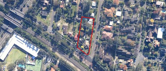
Surrounding development
The street block in which the site is located is zoned 2(d3) pursuant of the Ku-ring-gai Planning Scheme Ordinance (KPSO) and is in the process of undergoing redevelopment consistent with the zoning. To the west of the site on the corner of Millewa and Woonona Avenue, construction is currently underway for a 5 storey residential flat development. Behind this site facing Woniora Avenue, Council has recently had submitted to it a DA for a residential flat building (DA0014/12) effectively completing the block with medium density development.
In addition to these developments, current surrounding developments included newer 5 storey residential flat developments and older, 3 storey ‘walk up’ style medium density developments. Recent developments have transformed this surrounding area into a medium density precinct.
Directly adjoining the development site to the north on the corner of Neringah Avenue North and Woniora Avenue, is a listed heritage item (known as 8 Woniora Avenue). Council has recently approved a detached dual occupancy development at this property.
The Proposal
The proposal, as amended, is for demolition of the existing structures on the three allotments and construction of a residential flat building, containing the following:
· a single, 5 storey building
· 53 residential units (24 x 1 bedroom units, 28 x 2 bedroom units and 1 x 3 bedroom unit)
· Unit sizes range from 50m2 for the 1 bedroom units to 130 m2 for the 3 bedroom unit
· 2 basement levels providing a total of 68 car spaces (being 54 spaces for residents and 14 spaces for visitors), as well as designated bicycle parking, residential storage areas and waste storage provisions
· vehicular access into the basement at the northern end of the building, accessed from Neringah Avenue North
· two pedestrian accessways into the development from the Neringah Avenue North frontage
· communal open space area at the northern (rear) end of the building
Ancillary works include landscaping of the site to enhance its ‘cottage garden’ setting, as well as a new brick and metal palisade front fence to both the Millewa Avenue frontage and Neringah Avenue North frontage.
It is also proposed to remove 20 existing trees, the majority of which are within the proposed building footprint.
Consultation
Community
In accordance with the provisions of DCP 56, the application was advertised and notified for two periods of 30 days (between 9 December 2011 to 9 January 2012 and 4 May 2012 to 4 June 2012. Council received 18 submissions during the two notification periods from the following:
1. J Hart – Secretary Norwood mews 12 Woniora Avenue, Wahroonga
2. M & A Staunton 5/17 Neringah Avenue North, Wahroonga
3. N King 1/25 Millewa Avenue, Wahroonga
4. S Ramage 2/ 25 Millewa Avenue, Wahroonga
5. Owners Corporation 25 Millewa Avenue, Wahroonga
6. D & M Morton 6/17 Neringah Avenue North, Wahroonga
7. K Kozlowska 11/25 Millewa Avenue, Wahroonga
8. M, C & J Adamski No address given
9. H Harper 4/25 Millewa Avenue, Wahroonga
10. A Deamer 7/25 Millewa Avenue, Wahroonga
11. S Scher 11/25 Millewa Avenue, Wahroonga
12. Pikes Lawyers C/o 35 Millewa Avenue, Wahroonga
13. R. King 25-29 Millewa Avenue, Wahroonga
14. J. Briggs PO Box 806, Port Headland WA
15. J. Dowling – Solicitor & Barrister PO Box 2226, Bowral
16. W. Chee Tang & M. Tan 10 Woniora Avenue, Wahroonga
The following matters were raised:
Construction works associated with this application will damage surrounding infrastructure
To address this concern, Conditions 7 & 8 require a detailed dilapidation report to be prepared prior to the commencement of works. In the event of damage, it will be referenced against this report and where verified, the responsibility of the developer to rectify.
Kerb and guttering as well as a footpath should be provided along the Neringah Avenue North frontage as one does not exist at this time
Condition 35 requires the developer to construct these to Council’s satisfaction, prior to occupation of the building.
The number of units on the site is excessive
The number of units within the development is assessed as being satisfactory for the site, considering that the development satisfies the applicable height and FSR controls.
The proposed development is out of character with the residential developments on the opposite side of Neringah Avenue
The medium density residential development on the opposite side of Neringah Avenue North is 3 storeys. The subject site, as well as those to the north and west, is zoned for 5 storey residential development. The three storey development on the opposite (eastern) side of Neringah Avenue North provides a suitable transition to the lower density areas further to the east.
Impacts of traffic noise
The proposed development is not assessed as generating an unacceptable level of traffic noise that would affect the amenity currently enjoyed by surrounding developments. It is further noted that the area is in close proximity to the Northern Rail Corridor and the F3 Freeway.
The surrounding street network will become a series of dangerous traffic hazards
The application has been supported by a parking and traffic impact assessment, prepared by a traffic engineer. This impact assessment (which was also reviewed by Council’s engineers) demonstrates that the proposed development will not have a detrimental impact on the flow of traffic within the surrounding street network.
The development would isolate 35 Millewa Avenue
This matter is considered and addressed within the site isolation assessment further in this report.
The height of the development will result in the loss of views from the properties which face west onto Neringah Avenue North
In accordance with the principals established in the Land & Environment Court, no important or significant views or vistas exist to the west over the development site (with the western view from the buildings on the eastern side of Neringah Avenue North being of the adjacent residential properties and the noise attenuation walls associated with the F3 Freeway). The development is assessed as being satisfactory in this regard.
The proposed development will have a serious impact on the available sunlight to the west facing units on the eastern side of Neringah Avenue North
As detailed within the submitted shadow diagrams, the shadow cast by the proposed development will not extend as far to the buildings on the opposite (eastern) side of Neringah Avenue North.
The proposed development will have an unacceptable impact upon privacy
In the case of units in the development which address a street frontage, these units are sufficiently separated from adjoining properties, ensuring the maintenance of amenity and privacy. To the north, a compliant setback has been provided along with dense landscaping, limiting the extent of impact upon the adjoining properties. To the west, privacy impacts have been managed through landscaping, appropriate positioning of balconies as well as the use of screening to those balconies.
Potential loss of trees along the footways of the development site
The matter of tree impacts has been considered by Council’s Landscape and Tree Assessment Officer, who is satisfied that the proposed development maintains the majority of trees outside of the building envelope and within the footway.
The height of the northern section of the proposed building appears to create a transition from the single storey heritage dwelling on the corner of Neringah and Woniora Avenue to a 5 storey building.
This transition in height is managed through a 9m to 15m setback between the development to the boundary with the heritage item. This provides a sufficient break between the two built elements, with the transition area being heavily landscaped to respect the low scale of the heritage item.
The building will be an unattractive element in a town that prides itself on its beauty, trees and aesthetics.
The proposed development (and) building has been assessed against SEPP 65 urban design principles by Council’s Urban Design consultant. This assessment has concluded that the development is generally acceptable from a built environment and urban design perspective.
Construction noise will affect the amenity of surrounding properties.
The proposed construction hours are consistent with the standard construction hours permitted by Council. In the case of noise, strict conditions have been recommended to ensure that noise levels are within the limits established by the EPA (Condition 18).
When this development is considered with that proposed as part of DA0114/12 currently before Council, it represents what is a gross over development of this area.
DA0114/12 which is currently being assessed by Council is a proposal for a residential flat development of 5 storeys containing 25 units. Both proposals represent developments which are consistent with the density and character envisaged by their zoning under the KPSO.
The substation for the development is too close to 8 Woniora Avenue.
The substation in the amended scheme has been relocated to the Millewa Avenue frontage.
The proposed development has an unacceptable impact upon the privacy and amenity of 8 Woniora Avenue and 35 Millewa Avenue
The development is assessed as having an acceptable impact on both 8 Woniora Ave and 35 Millewa Avenue, given that the design and setting of the development accords with the building envelope controls of the DCP. Privacy impacts have been mitigated through proposed landscaping and the use of sliding privacy screens.
The proposed development will place additional impact on what is already an undersized drainage system and will increase flooding during large storms
The site is identified by Council as being flood affected. The application has been supported by a flood study prepared by the applicant. This flood study concludes that, subject to an upgrade and partial relocation of the existing Council stormwater system that runs through the northern portion of the site, stormwater and overland flow issues within the local area will be improved, particularly for those existing residents down stream. These stormwater works are covered within Condition B of the deferred commencement requirements.
Within Council
Landscaping:
The application was referred to Council’s Landscape Assessment Officer. The following comments were made in respect of the application:
Tree impacts
The arborist has assessed 39 trees, 27 of which are located on the site, 4 on the adjoining property and 8 on the nature strip. Of the 27 trees located on the site, 20 are proposed to be removed. 19 of the trees to be removed are considered to have low to moderate landscape value, whilst 1 tree (Tree 39) has high landscape value.
Tree 39 - Corymbia citriodora (Lemon Scented Gum) is 18 metres high with a 15 metres canopy spread and a trunk diameter of 450mm. It displays a good branching structure with fair to good vigour. There are no arboricultural grounds for the removal of Tree 39, however its central location would unreasonably constrain development of the site. No objection is raised to the removal of Tree 39 and the 19 other trees nominated by the applicant.
No objection is raised to the removal of the following trees;
|
Schedule |
|
|
Tree/Location |
Comments |
|
Tree 8 - Picea pungens (Blue Spruce) / South eastern corner |
8 metres high fair condition |
|
Tree 9 – Juniperus communis (Common Juniper) / South eastern corner |
5 metres high in good condition |
|
Tree 10 – Juniperus communis (Common Juniper) / South eastern corner |
5 metres high in good condition |
|
Tree 11 – Chamaecyparis obtusa 'Crippsii' (Golden Cripps Cypress) / Within the building footprint |
8 metres high in good condition |
|
Tree 12 – Magnolia x soulangiana (Magnolia) / Within the building footprint |
6 metres high in good condition |
|
Tree 13 – Rhododendron sp. (Broad leaf Rhododendron) / Within the building footprint |
7 metres high in good condition |
|
Tree 16 - Juniperus communis (Common Juniper) / Southern boundary |
6 metres high in good condition |
|
Tree 22 - Juniperus communis (Common Juniper) / Within the building footprint |
7 metres high in fair condition |
|
Tree 23 – Dracaena draco (Dragon tree) / Western boundary |
6 metres high in good condition |
|
Tree 27 – Pyrus sp. (Pear Tree) / Western boundary |
9 metres high in good condition |
|
Tree 28 – Chamaecyparis obtusa 'Crippsii' (Golden Cripps Cypress) / Within the building footprint |
12 metres high in good condition |
|
Tree 29 - Picea pungens (Blue Spruce) / Within the building footprint |
8 metres high in good condition |
|
Tree 30 – Chamaecyparis obtusa 'Crippsii' (Golden Cripps Cypress) / Within the building footprint |
9 metres high in fair condition |
|
Tree 31 – Syzygium paniculatum (Brush Cherry) / Within the building footprint |
8 metres high in good condition |
|
Tree 32 – Pittosporum undulatum (Sweet Pittosporum) / Western boundary |
8 metres high in fair condition |
|
Tree 37 – Archontophoenix cunninghamiana (Bangalow Palm) / Within the building footprint |
8 metres high in good condition |
|
Tree 38 – Archontophoenix cunninghamiana (Bangalow Palm) / Within the building footprint |
8 metres high in good condition |
|
Tree 39 – Corymbia citriodora (Lemon Scented Gum) / Within the building footprint |
18 metres high with fair vigour and good structure. |
Landscape plan
The landscape plan is considered acceptable. Ample screen and tree planting has been provided in both the street frontages and the northern and western interfaces. Under clause C-8 Tree replenishment of Development Control Plan 55 a minimum of 10 canopy trees are required. At least 13 locally occurring canopy trees are proposed to be planted together with numerous exotic deciduous tree species.
Communal open space
The communal open space is located on the northern side of the building. Seating has been provided with availability to solar access. The Access Consultant has determined that the accessible common outdoor areas will provide appropriate access for people with disabilities.
BASIX
The BASIX certificate is considered accurate in relation to the calculations for areas of garden and lawn in both common areas and private open space. In accordance with the BASIX certificate no indigenous or low water use planting is required for the proposed development.
Stormwater plan
There are no landscape issues in relation to the proposed stormwater plans.
Conclusion
The application is acceptable on landscaping grounds, subject to conditions.
Heritage:
The application was referred to Council’s Heritage Advisor. The following comments were made in respect of the application:
The subject site adjoins 8 Woniora Avenue, a listed heritage item which comprises a timber cottage and timber studio/garage. The studio/garage is located 3m from the common boundary with the development site and about 2.5m from the street boundary. The other nearby heritage items are separated from the site by a reasonable distance and the specific heritage setback controls do not apply to those other nearby items.
The small timber cottage was originally listed as part of a group of cottages in Woniora Avenue. The other cottages in the group were removed from the heritage schedule at various times and their sites developed. This remaining cottage is historically and socially significant as the former home and studio of the well known artist, Sidney Nolan. The studio is believed to have been relocated to the site by Nolan in the 1950s for use as his studio and, although he only lived at the cottage for a few years, he painted many of his important works on the site. The family retained ownership of the cottage until 2007.
The Wahroonga Railway Station Group is a local and State heritage item. The curtilage of the item includes the railway corridor and extends beyond the platform and buildings and includes the Coonanbarra footbridge. The station platform, station buildings and stairways are a considerable distance from the subject site.
The three heritage items in Warwilla Avenue are located on the other side of the railway line and are not considered to be within the visual catchment of the development site. Similarly “Poole House”, formerly No 26 Woonona Avenue is located on the other side of the railway line and its setting is not dependent upon or related to the development site.
The architect’s design statement states:
“The proposed development respects the aesthetic character of the locality through the use of a language of sandstone cladding around the base of the building to ground into the landscape. The render walls and glass penetrations lighten the higher floors through colour texture and a level of transparency leading to a roof with large overhangs.”
In general, the proposed development is relatively conservative in its architectural expression and would relate to other rezoned sites in the area.
As acknowledged in the HIS, the scale of the development conflicts with the scale of the adjoining heritage item. It states:
“It is however clearly not possible for multi unit housing of the type envisaged by the standards of the LEP to respect the character of the surrounding area where this consists of one or two storey cottages…”.
The corner location of the heritage items does allow it to be appreciated from several view corridors and it will remain as an historic element in the rezoned medium density area.
Conclusion
Demolition of the existing houses on the site is acceptable, provided photographic recording is undertaken to archival standards.
The proposed development has a reasonable level of impact on the adjoining and nearby heritage items and can be supported.
Engineering:
The application was referred to Council’s Development Engineer. The following comments were made in respect of the application:
Water management
The site is subject to a Council drainage easement which runs diagonally from Neringah Avenue North towards Woniora Avenue. The proposed basement excavation is across the easement and pipe.
Because of the need to obtain Council’s approval for the relocation of the drainage easement (by resolution, which cannot be guaranteed), a deferred commencement consent is recommended. A detailed design for the construction of the new pipe and pits will have to be submitted and a report prepared for Council’s consideration.
The applicant has submitted an overland flow assessment which contains design details for works in Neringah Avenue North to contain overland flow to within the road reserve and easement. These works include the construction of kerb and gutter and road shoulder in Neringah Avenue North, a small retaining wall on part of the easement boundary and a special suspended driveway crossing to allow overland flow to pass under and into the relocated easement.
An amended site stormwater management plan has also been submitted, which shows the detention tank located beneath the northern end of the building, with access via pits in the common area. The detention storage is now clear of the overland flow path.
The BASIX water commitments do not include any retention and re-use of roofwater, so the entire site storage requirement must be provided as on site detention. The detention tank shown on the stormwater management layout has a volume of 49 cubic metres. This volume is calculated using 50% of the site area (instead of 60% as required under DCP 47), which is acceptable given the requirement that 50% of the site area be set aside for deep soil planting.
The stormwater management plan shows a 22 000 litres rainwater tank “connected in accordance with the BASIX requirements”. Since there are no BASIX requirements for this tank, this tank is superfluous.
Discharge is to a new grated pit in Neringah Avenue North, over the relocated trunk drainage line. Because the connection is within the road reserve, there is no need for the terms of the easements over the downstream properties to be investigated.
In a submission, the poor condition of the trunk drainage line through the downstream properties was raised. It is considered prudent and in the interests of the applicant that a CCTV report on the section of pipe between the lowest corner of the site and Woniora Avenue be carried out before and after works, so that any existing damage, blockage etc can be recorded.
Parking and vehicular access
The site is further than 400 metres from Wahroonga Station. For the 53 units proposed, 54 resident and 14 visitor parking spaces are required.
The parking spaces have now been dimensioned on the plans. The required number of spaces has been shown and the layout assessed as being acceptable.
Traffic increase
The submitted traffic and parking assessment details that the proposed development will result in an increase of 13.1 vehicle movements per hour during peak periods. This represents a minimal increase and is assessed as not having an unacceptable impact on the local road network capacity.
Waste management
The waste storage and collection area is adequate for the required number of containers. Section CC demonstrates that vehicular access to the basement can be achieved with the minimum 2.6 metres of headroom required for the small waste collection vehicle and with a maximum gradient of 20%.
Construction traffic management
The Environmental Site Management Plan is now satisfactory. A detailed Construction Traffic Management Plan (CTMP) will be required prior to commencement of works on site. The recommended conditions specifically prohibits construction vehicle access via the railway bridge or Wahroonga Shopping Village.
Urban Design:
The application was referred to a Council’s Urban Design Consultant. The following comments were made in respect of the application:
Principle 1: Context: Good design responds and contributes to its context. Context can be defined as the key natural and built features of an area. Responding to context involves identifying the desirable elements of a location’s current character or, in the case of precincts undergoing a transition, the desired future character as stated in planning and design policies. New buildings will thereby contribute to the quality and identity of the area.
The site is zoned 2(d3) and is located on the north-western corner of Millewa Avenue and Neringah Avenue North, Wahroonga. It is composed of three lots, is long and regularly shaped, and has a gentle fall from south to north. It has a southern frontage of 36.625m to Millewa Avenue, an eastern frontage of 95.81m to Neringah Avenue North, a typical width of 33.515m across the site, and a site area of 3,064m2. There is an existing drainage easement running across the site diagonally from the north-west. The site is bordered to the west and north-west by land zoned 2(d3). To the immediate north, 10 Woniora Avenue is not zoned 2(d3), and 8 Woniora Avenue contains a local heritage item, both requiring increased setbacks. To the south, the North Shore train line runs on the opposite side of Millewa Avenue. The site is approximately a 380m walk from Wahroonga station 37-41 Millewa Avenue has a residential flat building approval which has commenced construction. The present proposal occupies 31-33 Millewa Avenue & 24 Neringah Avenue North. As such, 35 Millewa Avenue in between has been omitted for redevelopment.
Above ground, the proposed plans are generally reasonable in layout, however, the car park does not appear to be wide enough to fit the layout proposed. Typically, a 11.8m wide car park is needed, however this width could be reduced is the spaces within the basement are widened. Other than this, there does not appear to be any major impediments to the workability of this design.
Principle 2: Scale: Good design provides an appropriate scale in terms of the bulk and height that suits the scale of the street and the surrounding buildings. Establishing an appropriate scale requires a considered response to the scale of existing development. In precincts undergoing a transition, proposed bulk and height needs to achieve the scale identified for the desired future character of the area.
The length of elevation to Neringah Avenue North scales at 79.6m. This is more than double the maximum 36m required by DCP55 control 4.4 C-3. However, DCP55 control 4.4 C-4 allows buildings to be recessed or articulated so as to present to the street as a separate building when a greater building length is justified. In this instance, the slender proportions of the site and the application of two street setbacks make for a developable footprint of which most is required in order to approach the possible FSR allowable. A two-building proposal and the separation then required between these buildings, would unnecessarily restrict the floor space and make this site less developable. The proposal provides a 6.2m x 5.5m articulation at the centre of the building and the top floor is separated into two volumes. Also, the north and south portions of the building each have their own pedestrian entries. It is considered that these features assist the proposal to read as two volumes. If the central articulation could be bigger it would be better, but it is probably at the limit of what is acceptable to have the desired effect given the constraints in this instance. Whilst the street perspective provided does not demonstrate this perceived separation of buildings, as it is taken from an acute angle, the model photograph is considered to be more convincing in this respect and is satisfactory from an urban design point of view.
Principle 3: Built Form: Good design achieves an appropriate built form for a site and the building’s purpose, in terms of building alignments, proportions, building type and the manipulation of building elements. Appropriate built form defines the public domain, contributes to the character of streetscapes and parks, including views and vistas, and provides internal amenity and outlook.
The site coverage has been amended from that initially lodged and is considered to comply.
The floor area of the penthouse level appears to be more than 60% of the storey immediately below it. SK406 shows that the floor area of the penthouse level is 507.7m2 (59.8%), however the area of the horizontal circulation is excluded from the measurement. The circulation area cannot be considered to be external even if there is no glazing to the opening. It is clearly far more closed than it is open. As evidenced by the applicant, similar arrangements have been previously accepted by Council. In this respect the situation is supportable.
The area of the major wall planes of the western and southern elevations do not appear to comply. Respectively, they are approximately 200m2 and 300m2 in area without articulation. Both will be highly visible from the public domain. This is significantly more than the 81m2 allowed by DCP55 control 4.4 C-1 and C-2. The intention of controls such as these must be to prevent large, flat, boxy elevations. The western façade has been amended to provide a greater extent of articulation than that of the initial scheme and, whilst the development does not strictly comply with the DCP, it now provides for sufficient articulation.
Other than the points above, the proposal has several positive attributes. The two pedestrian entries facing Neringah Avenue North are direct and strong. The driveway location at the lowest point of the site on the quieter street is sensible. Although the lift cores are at the perimeter of the building, they are well integrated with the elevations. In this instance, a third lift core could be considered giving a better ratio of four units per floor, per lift. The floor plans are straightforward and neat. The units are tight and efficient and, with the exception of the single-orientation western apartments to be discussed under PRINCIPLE 7: AMENITY, are generally rational and well proportioned.
Principle 4: Density: Good design has a density appropriate for a site and its context, in terms of floor space yields (or number of units or residents). Appropriate densities are sustainable and consistent with the existing density in an area or, in precincts undergoing a transition, are consistent with the stated desired future density. Sustainable densities respond to the regional context, availability of infrastructure, public transport, community facilities and environmental quality.
The proposal appears to comply with the floor space ratio, even with the omitted penthouse circulation accounted for. The overall scale is appropriate and consistent in the context of the zoning, neighbouring redevelopment and proximity to the station.
Principle 5: Resource, Energy and Water Efficiency: Good design makes efficient use of natural resources, energy and water throughout its full life cycle, including construction. Sustainability is integral to the design process. Aspects include demolition of existing structures, recycling of materials, selection of appropriate and sustainable materials, adaptability and reuse of buildings, layouts and built form, passive solar design principles, efficient appliances and mechanical services, soil zones for vegetation and reuse of water.
The building depth of 17.515m allows for more of the floor space of the building to have direct access to the perimeter wall. This is very positive from an energy use and amenity point of view. In this instance, 19 of 53 (35%) kitchens, 14 of 53 (25%) of bathrooms, and potentially even several laundries, have direct access to a window. With the exception of the single-orientation western apartments to be discussed under PRINCIPLE 7: AMENITY, most apartments have their habitable spaces within acceptable distances from windows and there does not appear to be any internalised spaces such as ‘studies’. All common circulation areas also have a window. Council should take strong note here of the positive influence that building depths of less than 18m have on improving building amenity.
Principle 6: Landscape: Good design recognises that together landscape and buildings operate as an integrated and sustainable system, resulting in greater aesthetic quality and amenity for both occupants and the adjoining public domain. Landscape design builds on the site’s natural and cultural features in responsible and creative ways. It enhances the development’s natural environmental performance by co-ordinating water and soil management, solar access, micro-climate, tree canopy and habitat values. It contributes to the positive image and contextual fit of development through respect for streetscape and neighbourhood character, or desired future character. Landscape design should optimise usability, privacy and social opportunity, equitable access and respect for neighbour’s amenity, and provide for practical establishment and long term management.
Penthouse terraces have now been provided with planter boxes to the west to ameliorate overlooking of 35 Millewa Avenue. The communal open space to the north of the site is considered positive as previously described under Principle 3. Access from the lift cores to the western side setback at ground level is direct.
There appeared to be a conflict between the easement realignment and the planting along the northern boundary, however this has been sufficiently addressed within the amended scheme.
Principle 7: Amenity: Good design provides amenity through the physical, spatial and environmental quality of a development. Optimising amenity requires appropriate room dimensions and shapes, access to sunlight, natural ventilation, visual and acoustic privacy, storage, indoor and outdoor space, efficient layouts and service areas, outlook and ease of access for all age groups and degrees of mobility.
The number of apartments with 3 hours sunlight between 9am and 3pm in midwinter appears to comply. This is achieved by locating many single orientation units on the west side of the building as this elevation receives more sun than the east due to the orientation of the subdivision boundary which is 9° 36’ off north. There is a tension here. Although this decision is logical, as solar access is a primary (and quantifiable) control, this decision causes 38 of 53 (70%) of apartments to have their living room and private open space face directly on to 35 Millewa Avenue. This neighbouring property will only have a 3m setback to its side boundaries if it developed in the future and therefore will only have 9m separation from the subject site. The introduction of sliding screens to the northern half of the western facing units addresses the issue of overlooking and also deal with the impacts of the western sun.
It is considered that these screens should be continued along the length of the façade. Balustrades on the western elevation should be more solid, particularly at the lower levels, anticipating a 9m separation to 35 Millewa. These matters are dealt with by Condition 2.
The number of single orientation western apartments does not comply. 18 of 53 (33%) of single orientation units face west which exceeds the 15% allowed by DCP55 control 4.5.1 C-5. This control must be to limit the heat load from afternoon sun on apartments. Whilst page 7 of DCP55 states that the provisions of DCP55 prevail over the RFDC where there is an inconsistency, it must be said that the RFDC is silent on this issue and does not seek to limit the number of west facing apartments. Therefore, with adequate shading to the windows of this façade (which has been provided), it is considered that this aspect of the single orientation west facing apartments is acceptable.
The 16 single orientation western apartments on levels ground through third (30% of apartments) are 9.7m deep. This does not comply with the RFDC Rule of Thumbs (p69) that ‘Single aspect apartments should be limited in depth to 8m from a window’ and ‘The back of a kitchen should be no more than 8 metres from a window’. The available natural ventilation, and particularly daylight, exists at the perimeter of the building. This unit type seeks to measure the 8m from the perpendicular re-entrant terrace window which is internalised up to 3.3m. This complies ‘numerically’ but is clearly not the intention of the control.
Better Design Practice for Daylight Access (RFDC p84) includes: ‘limit the depth of single aspect apartments.’ This unit type is considered undesirable as too much of the habitable floor space is distant from a window. That said, it should be noted that this unit type is not particular to this site, it has been employed as a standard design response in a number of pending development applications including: 36-40A Culworth Avenue, Killara; 1147-1149 Pacific Highway & 2 Bobbin Head Road, Pymble; 1444B-1454 Pacific Highway, Turramurra; as well as having been approved previously at 728-730 Pacific Highway, Gordon. Elsewhere, these units have been up to 12.72m deep. 35 of 53 (65%) of apartments are cross ventilated. This complies with the RFDC Rule of Thumb (p87) that ‘Sixty percent (60%) of residential units should be naturally cross ventilated.’
With regard to acoustics, the southern most units (9, 10, 21, 22, 33, 34, 45, 46 and 54) are affected by rail noise being within 60m of the centre line of the closest train line. The acoustic report provided appears to deal with this adequately. Whilst DCP55 control C-6 i and ii recommends that noise sensitive uses such as bedrooms should be located away from the noise source, there is competing interest here in achieving solar access to living rooms. Given this is the case, and the acoustic report recommends construction solutions, the layout of these apartments is considered acceptable.
Planning Comment: The issues raised by Council’s Urban Design consultant with respect to the depth of the single aspect units are acknowledged. Support has been given to the design in this instance as 12 of the 16 affected units have a north-westerly aspect through the re-entrant sliding glazed doors associated with the unit’s private open space. This arrangement allows the adjacent living areas to be afforded with natural light through this favourable aspect. Whist not strictly compliant with DCP 55, it is an acceptable design outcome for a narrow building envelope on a north-south orientated site.
Principle 8: Safety & Security: Good design optimises safety and security, both internal to the development and for the public domain. This is achieved by maximising overlooking of public and communal spaces while maintaining internal privacy, avoiding dark and non-visible areas, maximising activity on streets, providing clear, safe access points, providing quality public spaces that cater for desired recreational uses, providing lighting appropriate to the location and desired activities, and clear definition between public and private spaces.
This aspect is considered positive. Good casual surveillance is provided to all spaces and to the street. The building entries are located directly from Neringah Avenue North and provide a clear identity for the development. Multiple entries activate the street edge.
Principle 9: Social Dimensions & Housing Affordability: Good designs respond to the social context and needs of the local community in terms of lifestyles, affordability, and access to social facilities. New developments should optimise the provision of housing to suit the social mix and needs in the neighbourhood or, in the case of precincts undergoing transition, provide for the desired future community. New developments should address housing affordability by optimising the provision of economic housing choices and providing a mix of housing types to cater for different budgets and housing needs.
In general, the units are compact and well planned, with the exception of the single orientation west apartments as discussed under PRINCIPLE 7: AMENITY. Their size is at, or slightly over, the minimum unit sizes required by the RFDC Rule of Thumb (p69). This is acceptable and provides a choice of apartments in a market where apartments are typically being oversized.
Principle 10: Aesthetics: Quality aesthetics require the appropriate composition of building elements, textures, materials and colours and reflect the use, internal design and structure of the development. Aesthetics should respond to the environment and context, particularly to desirable elements of the existing streetscape or, in precincts undergoing transition, contribute to the desired future character of the area.
The building presents well to Neringah Avenue North and is well articulated on this and the northern facade. The western façade has been improved through additional articulation and the use of screens. Likewise the minor adjustment to the north façade is positive.
External Referrals:
The application was referred to the following external agencies:
Ausgrid:
Council, by letter dated 02 December 2011, wrote to Ausgrid advising them of the development and inviting comment. in respect of the proposed development.
To date, no response has been provided.
Sydney Water:
Sydney Water was notified of the development as an adjoining property owner. The following comments were made by Sydney Water in respect of the proposed development:
Water
The 100mm drinking water main fronting the proposed development in Neringah Avenue North does not comply with the Water Supply Code of Australia (Sydney Water Edition - WSA 03-2002) requirement for minimum sized mains for the scope of development. The drinking water main needs to be amplified to a 150mm, as recommended in Water Supply Code of Australia (Sydney Water Edition WSA 03-2002). This will be covered within the Section 73 requirements Condition 65.
Wastewater
The current wastewater system has sufficient capacity to service the proposed development. The wastewater main available for connection is the 225mm main traversing the property. The proposed development conflicts with the location of this 225mm wastewater main traversing the property. A wastewater deviation may be required. Refer to your Water Servicing Coordinator for details of requirements.
Sydney Water Servicing
Sydney Water will further assess the impact of any subsequent development when the developer applies for a Section 73 Certificate. This assessment will enable Sydney Water to specify any works required as a result of future development and to assess if amplification and/or changes to the system are applicable. The developer must fund any adjustments needed to Sydney Water infrastructure as a result of the development.
Railcorp:
The DA was referred to Railcorp as an adjoining land owner and also due to the proximity of the development site to the rail corridor. This referral is discussed in greater detail in the ‘SEPP Infrastructure’ section of this report.
Statutory Provisions
State Environmental Planning Policies:
State Environmental Planning Policy No. 55 - Remediation of Land
The provisions of SEPP 55 require consideration of the potential for a site to be contaminated.
In accordance with SEPP 55 (clause 7), the consent authority must not grant consent on land unless,
(a) it has considered whether the land is contaminated, and
(b) if the land is contaminated, it is satisfied that the land is suitable in its contaminated state (or will be suitable, after remediation) for the purpose for which the development is proposed to be carried out, and
(c) if the land requires remediation to be made suitable for the purpose for which the development is proposed to be carried out, it is satisfied that the land will be remediated before the land is used for that purpose.
The development site is currently occupied by single residential dwellings, with this use occupying the site since the late 1920’s. Given this low density residential occupation, the likelihood of soil contamination low and with regard to the considerations prompted by SEPP 55, the subject site is assessed as being satisfactory with regard to the proposed development.
State Environmental Planning Policy No.65 - Design Quality of Residential Flat Development (RFDC)
SEPP 65 aims to improve the design quality of residential flat buildings across NSW and provides an assessment framework, the Residential Flat Design Code (RFDC), for assessing ‘good design’.
Clause 50(1A) of the EPA Regulation 2000 requires the submission of a design verification statement from the building designer at lodgement of the development application. This documentation has been submitted and is satisfactory.
The SEPP requires the assessment of any development application for residential flat development against 10 principles contained in Clauses 9-18 (which has been undertaken by Council’s Urban Design Consultant) and Council also is required to consider the matters contained in the publication “Residential Flat Design Code”.
As such, the following consideration has been given to the requirements of the SEPP and Design Code.
Residential Flat Design Code Compliance Table
Pursuant to Clause 30(2) of SEPP 65 in determining a development application for a residential flat building the consent authority is to take into consideration the Residential Flat Design Code (RFDC). The following table is an assessment of the proposal against the guidelines provided in the RFDC.
|
|
Guideline |
Consistency with Guideline |
|
PART 02 SITE DESIGN |
||
|
Site Configuration |
|
|
|
Deep Soil Zones |
A minimum of 25 percent of the open space area of a site should be a deep soil zone; more is desirable. Exceptions may be made in urban areas where sites are built out and there is no capacity for water infiltration. In these instances, stormwater treatment measures must be integrated with the design of the residential flat building. |
YES
|
|
Fences + walls |
Define the edges between public and private land to provide privacy and security and contribute positively to the public domain. |
YES
|
|
Open Space |
The area of communal open space required should generally be at least between 25 and 30 percent of the site area. Larger sites and brown field sites may have potential for more than 30 percent. |
YES
|
|
|
The minimum recommended area of private open space for each apartment at ground level or similar space on a structure, such as on a podium or car park, is 25m2 . |
YES
|
|
Optimise solar access, contribute positively to desired streetscape character, support landscape design with consolidated open space areas, protect amenity of existing development and improve thermal efficiency. |
YES
|
|
|
Planting on Structures |
In terms of soil provision there is no minimum standard that can be applied to all situations as the requirements vary with the size of plants and trees at maturity. The following are recommended as minimum standards for a range of plant sizes:
Medium trees (8 metres canopy diameter at maturity) - minimum soil volume 35 cubic metres - minimum soil depth 1 metre - approximate soil area 6 metres x 6 metres or equivalent
|
YES |
|
Stormwater management |
Minimise impact on the health and amenity of natural waterways, preserve existing topographic and natural features and minimise the discharge of sediment and other pollutants to the stormwater drainage system. |
YES
|
|
Safety
|
Carry out a formal crime risk assessment for all residential developments of more than 20 new dwellings. |
YES
|
|
Visual Privacy |
Refer to Building Separation minimum standards
- up to four storeys/12 metres - 12 metres between habitable rooms/balconies - 9 metres between habitable/balconies and non-habitable rooms - 6 metres between non-habitable rooms - five to eight storeys/up to 25 metres - 18 metres between habitable rooms/balconies - 13 metres between habitable rooms/balconies and non-habitable rooms - 9 metres between non-habitable rooms |
YES
|
|
Building Entry |
Create entrances which provide a desirable residential identity, provide clear orientation for visitors and contribute positively to the streetscape and building façade design. |
YES
|
|
Parking |
Provide adequate parking for occupants, visitors and disabled. |
YES
|
|
Pedestrian Access
|
Identify the access requirements from the street or car parking area to the apartment entrance. |
YES
|
|
|
Follow the accessibility standard set out in Australian Standard AS 1428 (parts 1 and 2), as a minimum.
Provide barrier free access to at least 20 percent of dwellings in the development. |
YES
|
|
Vehicle Access
|
Generally limit the width of driveways to a maximum of six metres. |
YES
|
|
|
Locate vehicle entries away from main pedestrian entries and on secondary frontages.
|
YES
|
|
PART 03 BUILDING DESIGN |
||
|
Building Configuration |
|
|
|
Apartment layout |
Single-aspect apartments should be limited in depth to 8 metres from a window. |
NO – see discussion below
|
|
|
The back of a kitchen should be no more than 8 metres from a window. |
NO – see discussion below
|
|
|
The width of cross-over or cross-through apartments over 15 metres deep should be 4 metres or greater to avoid deep narrow apartment layouts. |
N/A
|
|
|
If Council chooses to standardise apartment sizes, a range of sizes that do not exclude affordable housing should be used. As a guide, the Affordable Housing Service suggest the following minimum apartment sizes, which can contribute to housing affordability: (apartment size is only one factor influencing affordability)
- 1 bedroom apartment 50m² - 2 bedroom apartment 70m² - 3 bedroom apartment 95m² |
YES
|
|
Apartment Mix |
Include a mixture of unit types for increased housing choice. |
YES
|
|
Balconies |
Provide primary balconies for all apartments with a minimum depth of 2 metres. Developments which seek to vary from the minimum standards must demonstrate that negative impacts from the context-noise, wind – can be satisfactorily mitigated with design solutions. |
YES
|
|
Ceiling Heights |
The following recommended minimum dimensions are measured from finished floor level (FFL) to finished ceiling level (FCL). - in residential flat buildings or other residential floors in mixed use buildings: - in general, 2.7 metres minimum for all habitable rooms on all floors, 2.4 metres is the preferred minimum for all non-habitable rooms, however 2.25m is permitted. |
YES
|
|
Ground Floor Apartments |
Optimise the number of ground floor apartments with separate entries and consider requiring an appropriate percentage of accessible units. This relates to the desired streetscape and topography of the site. |
YES
|
|
|
Provide ground floor apartments with access to private open space, preferably as a terrace or garden. |
YES
|
|
Internal Circulation |
In general, where units are arranged off a double-loaded corridor, the number of units accessible from a single core/corridor should be limited to eight. |
YES
|
|
Storage |
In addition to kitchen cupboards and bedroom wardrobes, provide accessible storage facilities at the following rates:
- studio apartments 6m³ - one-bedroom apartments 6m³ - two-bedroom apartments 8m³ - three plus bedroom apartments 10m³ |
YES . |
|
Building Amenity |
|
|
|
Acoustic Privacy |
Ensure a high level of amenity by protecting the privacy of residents within apartments and private open space |
YES
|
|
Daylight Access |
Living rooms and private open spaces for at least 70 percent of apartments in a development should receive a minimum of three hours direct sunlight between 9 am and 3 pm in mid winter. |
YES
|
|
|
Limit the number of single-aspect apartments with a southerly aspect (SW-SE) to a maximum of 10% of the total units proposed. |
YES
|
|
Building depths, which support natural ventilation typically, range from 10 to 18 metres.
|
YES
|
|
|
|
Sixty percent (60%) of residential units should be naturally cross ventilated. |
YES
|
|
Building Performance |
|
|
|
Waste Management |
Supply waste management plans as part of the development application submission as per the NSW Waste Board.
|
YES
|
|
Water Conservation |
Rainwater is not to be collected from roofs coated with lead- or bitumen-based paints, or from asbestos- cement roofs. Normal guttering is sufficient for water collections provided that it is kept clear of leaves and debris. |
YES
|
Apartment Layout
As noted in the above table, the proposed development does not comply with the maximum depth controls for single aspect apartments nor does the proposal strictly comply with the specified distance of the back of the kitchen to a window.
A total of 16 of 53 (or 30%) of apartments are single aspect with a depth greater than 8m (up to 9.7m). It is noted that within the RFDC, dispensation for this controls exists where adequate natural light and ventilation is available (per the provisions of the daylight access and natural ventilation controls). The subject single aspect units face north-west, maximising available natural light and ventilation. They are therefore considered acceptable in this regard.
Likewise, in the case of units where the back of a kitchen is more than 8m away from a window, the units face north-west, maximising the available natural light. The additional depth afforded to the units does not comprise the amenity which the RFDC is seeking to ensure.
State Environmental Planning Policy (infrastructure) 2007
The site subject of the proposed development is adjacent to the Northern rail corridor. As a result, the proposed development triggers considerations of Cl. 86 and 87 of the SEPP. In this regard, the following comments are made:
…….Clause 86 Excavation in, above or adjacent to rail corridors
(1) This clause applies to development (other than development to which clause 88 applies) that involves the penetration of ground to a depth of at least 2m below ground level (existing on land):
(a) within or above a rail corridor, or
(b) within 25m (measured horizontally) of a rail corridor, or
(c) within 25m (measured horizontally) of the ground directly above an underground rail corridor.
(2) Before determining a development application for development to which this clause applies, the consent authority must:
(a) within 7 days after the application is made, give written notice of the application to the chief executive officer of the rail authority for the rail corridor, and
(b) take into consideration:
(i) any response to the notice that is received within 21 days after the notice is given, and
(ii) any guidelines issued by the Director-General for the purposes of this clause and published in the Gazette.
(3) Subject to subclause (4), the consent authority must not grant consent to development to which this clause applies without concurrence of the chief executive officer of the rail authority for the rail corridor to which the development application relates, unless the rail authority is the ARTC…….
In accordance with the controls of Clause 86, the application has been referred to Railcorp for consideration and concurrence. In response, concurrence to the development was issued via letter dated 5 April 2012, subject to the following conditions.
Schedule A
A1 The applicant shall prepare and provide to Railcorp for approval/certification the following items:
1. Final geotechnical report that meets Railcorp’s requirements. The geotechnical report must be based on actual borehole testing conducted on the site closest to the rail corridor.
2. Final structural report / drawings that meets the requirements of the final geotechnical report and Railcorp requirements.
3. Final construction methodology with construction details pertaining to structural support during excavation.
4. Final cross sectional drawings showing ground surface, rail tracks, sub soil profile, proposed basement excavation and structural design of sub ground support adjacent to the rail corridor. All measurements are to be verified by a registered surveyor.
5. Detailed survey plan showing the relationship of the proposed development with respect to Railcorp’s land and infrastructure.
6. If required by Railcorp, and FE analysis which assesses the different stages of loading-unloading of the site and its effect on the rock mass surrounding the rail corridor.
Any conditions issued as part of Railcorp’s approval/certification of the above documents with also form part of the consent conditions that the Applicant is required to comply with.
Schedule B
B1 Prior to the commencement of works and prior to the issue of the Occupation Certificate, a joint inspection of the rail infrastructure and property in the vicinity of the project (especially the retaining wall and track formation) is to be carried out by representatives from Railcorp and the Applicant. These dilapidation surveys will establish the extent of any existing damage and enable any deterioration during construction to be observed. The submission of a detailed dilapidation report will be required unless otherwise notified by Railcorp.
B2 Prior to the issue of a Construction Certificate the applicant must submit to Council and Railcorp a revised Acoustic Assessment Report prepared by Acoustic Logic incorporating the following items:
· The distance from the proposed dwellings to the nearest track and Millewa Avenue should be stated in the report.
· Description of three principle measurement parameters used is insufficient. Development Near Rail Corridors and Busy Roads – Interim Guideline (DoP 2008) specifies LAeq, 9hr (night) and LAeq, 15hr (day) as the relevant descriptors for airborne rail noise assessment.
· The Acoustic report should be amended to clearly state the rail noise criteria applicable to the development consistent with the guideline.
· It is noted that the attended noise measurement location was on Neringah Avenue North (as shown on Figure 1) which is not the most rail noise exposed location on the proposed site. The report does not describe the measurement location used to determine measured rail noise at the future southern façade as referred to in Table 3.
· Glazing construction, Section 6.1 on Page 10 – The report must describe the required sound insulation ratings together with the relevant installation requirements. Suppliers’ test data/results should be provided to support the claimed sound insulation rating.
· Ventialtion requirements, Section 6 on Page 11 – where windows must be kept closed to meet the internal noise limits, the report should recommend ventilation methods to meet the requirements of the Building Code of Australia and relevant standards.
The Principal Certifying Authority shall not issue a Construction Certificate until it has verified that the recommendations contained in the revised acoustic report have been incorporated in the construction specifications and drawings.
B3 Prior to the issue of a Construction Certificate the applicant is to engage and Electrolysis Expert to prepare a report on the Electrolysis Risk to the development from stray currents. The applicant must incorporate in the development all the measures recommended in the report to control that risk. A copy of the report is to be provide to the Principal Certifying Authority with the application for a Construction Certificate.
B4 The design, installation and use of lights, signs and reflective materials, whether permanent or temporary, which are (or from which reflected light must be) visible from the rail corridor must limit glare and reflectivity to the satisfaction of Railcorp.
The Principal Certifying Authority is not to issue the Construction Certificate until written conformation has been received from Railcorp confirming that this condition has been satisfied.
B5 Prior to the issue of a Construction Certificate a Risk Assessment/Management plan and detailed Safe Work Method Statement (SWMS) for the proposed works are to be submitted to Railcorp for review and comment on the impacts on rail corridor. The Principal Certifying Authority is not to issue the Construction Certificate until written confirmation has been received from Railcorp confirming that this has been satisfied.
B6 Prior to the issuing of a Construction Certificate the applicant is to submit to Railcorp a plan showing all craneage and other aerial operations for the development and must comply with all Railcorp requirements. The Principal Certifying Authority is not to issue the Construction Certificate until written confirmation has been received from Railcorp confirming that this condition has been satisfied.
B7 If required by Railcorp, a track monitoring plan (including instrumentation and the monitoring regime during excavation and construction phases) is to be submitted to Railcorp for review and endorsement prior to the issuing of a Construction Certificate until written confirmation has been received from Railcorp advising of the need to undertake the track monitoring plan, and if required, that it has been endorsed.
These have been included within as Condition 1 of Schedule A & Condition 43 of Schedule B
……..Clause 87 Impact of rail noise or vibration on non-rail development
(1) This clause applies to development for any of the following purposes that is on land in or adjacent to a rail corridor and that the consent authority considered is likely to be adversely affected by rail noise or vibration:
(a) a building for residential use,
(b) a place of public worship,
(c) a hospital,
(d) an educational establishment or child care centre.
(2) Before determining a development application for development to which this clause applies, the consent authority must take into consideration any guidelines that are issued by the Director-General for the purposes of the clause and published in the Gazette.
(3) If the development is for the purposes of a building for residential use, the consent authority must not grant consent to the development unless it is satisfied that appropriate measures will be taken to ensure that the following LAeq levels are not exceeded:
(a) in any bedroom in the building – 35dB(A) at any time between 10.00pm and 7.00am,
(b) anywhere else in the building (other than a garage, kitchen, bathroom or hallway) – 40dB(A) at any time…….
In response to Clause 87, the applicant has submitted an acoustic report, detailing the necessary level of construction and inclusions to achieve the stipulated noise criteria.
To ensure the noise levels are achieved, acoustic treatment is necessary to the building structure, as well as acoustic treatment and seals to the buildings windows. In addition, it is necessary to mechanically ventilate the proposed dwellings as compliance with the noise criteria is only achieved with the windows closed. This is an acceptable arrangement as the units would otherwise be provided with air-conditioning. This arrangement is also consistent with other residential flat developments that have been approved within the LGA that are in proximity of the rail corridor or the Pacific Highway / Mona Vale Road.
Furthermore, Railcorp’s conditions (Condition 43 in Schedule B) require further investigation with regard to acoustics, which have been incorporated into the recommended conditions of consent.
The development is assessed as being satisfactory with regard to the considerations prompted by Clause 87 of the SEPP.
State Environmental Planning Policy (Building Sustainability Index: BASIX) 2004
A valid BASIX Certificate (404868M) has been submitted.
Ku-ring-gai Planning Scheme Ordinance
The site subject of the proposed development is zoned 2(d3). The proposed development is therefore subject of the controls and objectives of LEP 194 (or Cl. 25). The following assessment is given with regard to those controls:
Development standards – Clause 25
|
Development standard |
Proposed |
Complies |
|
Site area (min): 2300m2 |
3064m2 |
YES |
|
Deep landscaping (min): 50% (site area less than 1,800m2) |
50% site area |
YES |
|
Street frontage (min): 30m (more than 1,800m2) |
>30m to each frontage (minimum 33.7m) |
YES |
|
Number of storeys (max): 5 |
5 storeys |
YES |
|
Site coverage (max): 35% |
34.89% |
YES |
|
Top floor area (max): 60% of level below |
60% |
YES |
|
Storeys and ceiling height (max): 4 storeys and 13.4m |
4 storeys & 13.4m |
YES |
|
Car parking spaces (min): 1 per 4 dwellings (visitors) = 13.4 spaces 1 per dwelling (residents)
|
14 visitors spaces provided 1 car space per dwelling (54) + 4 disabled spaces 68 spaces total |
YES |
|
Zone interface setback (min): 9m |
9m (min) |
|
|
Manegeable housing (min): 10% = 5.4 dwellings |
6 units have been provided as manageable housing |
YES |
|
Lift access: required if greater than three storeys |
Lift access proposed |
YES |
Residential zone objectives and impact on heritage – Clause 25D
Council must not grant consent to any development of land to which this Part applies, unless Council (as the consent authority) has had regard to:
(a) the objectives for residential zones set out in this clause, and
(b) if the application is for consent for a residential flat building in Zone 2(d3), a statement describing the extent, if any, to which carrying out the proposed development would affect the heritage significance of any heritage item in the vicinity of the subject land.
The development has been considered against the objectives of the residential zones and, in this instance, is assessed as being a form of residential development that is consistent with the residential zone.
In the case of heritage considerations prompted by subclause (2), sufficient information has been provided to Council which demonstrates that the proposed development would have an acceptable impact with respect to the heritage significance of the adjoining identified item.
Development in the vicinity of heritage items – Clause 61E
The site subject of the proposed development (at its northern boundary) adjoins a listed heritage item, 8 Woniora Avenue. This necessitates consideration of the development against Cl. 61E of the
KPSO. Cl. 61E states:
…The Council shall not grant consent to an application to carry out development on land in the vicinity of a heritage item unless it has made an assessment of the effect the carrying out of that development will have on the heritage significance of the item and its setting….
The development proposal was considered by Council’s Heritage Advisor and as detailed elsewhere in this report, the context in which the development is proposed, together with its sympathetic design and generous setbacks is assessed as having an acceptable level of impact upon the heritage significance and setting of 8 Woniora Avenue.
Policy Provisions (DCPs,)
Development Control Plan No. 55 – Railway/Pacific Highway Corridor & St Ives Centre
|
Development control |
Proposed |
Complies |
|
Part 4.1 Landscape design: |
||
|
Deep soil landscaping (min) |
|
|
|
150m2 per 1000m2 of site area = 450m2 |
330 m2 |
NO |
|
No. of tall trees required (min): 10 trees required |
10 |
YES |
|
Part 4.2 Density: |
||
|
Building footprint (max): |
|
|
|
35% of total site area |
35% |
YES |
|
Floor space ratio (max): |
|
|
|
1.3:1 |
1.29:1 |
YES |
|
Part 4.3 Setbacks: |
||
|
Street boundary setback (min): |
|
|
|
between 10 and 12 metres (<40% of the zone occupied by building footprint) |
10-12m to both street frontages - <40% occupied by building footprint to Millewa frontage; 53% to Neringah Avenue North frontage |
NO |
|
Rear boundary setback (min): |
|
|
|
12-15m (per Clause 3.5) & Zone Interface Control |
12m – 15m |
YES |
|
Side boundary setback (min): |
|
|
|
6m |
6m |
YES |
|
Setback of ground floor courtyards to street boundary (min): |
|
|
|
8m |
8m (Min) |
YES |
|
total area of front setback occupied by private courtyards (max): |
|
|
|
15% |
<15% |
YES |
|
Part 4.4 Built form and articulation: |
||
|
Façade articulation: |
|
|
|
§ Wall plane depth >600mm |
Min. 600mm proposed |
|
|
§ Wall plane area <81m2 |
138m2 |
NO |
|
Built form: |
|
|
|
§ Building width < 36m, where longer provide break for view corridor |
Building width 70m to Neringah Avenue |
NO |
|
§ Balcony projection < 1.2m |
Balcony projection less than 1.2m |
YES |
|
Part 4.5 Residential amenity |
||
|
Solar access: |
|
|
|
§ >70% of units receive 3+ hours direct sunlight in winter solstice |
78% receive 3+ direct sunlight at winter solstice |
YES |
|
§ >50% of the principle common open space of the development receives 3+ hours direct sunlight in the winter solstice |
> 50% common open space receives 3 hours + at the winter solstice |
YES |
|
§ <15% of the total units are single aspect with a western orientation |
30% single aspect |
NO |
|
Visual privacy: |
|
|
|
Separation b/w windows and balconies of a building and any neighbouring building on site or adjoining site: |
Windows offset or provided with privacy screens |
YES |
|
Internal amenity: |
|
|
|
§ Habitable rooms have a minimum floor to ceiling height of 2.7m |
2.7m |
YES |
|
§ Non-habitable rooms have a minimum floor to ceiling height of 2.4m |
2.4m |
YES |
|
§ 1-2 bedroom units have a minimum plan dimension of 3m in all bedroom |
Minimum dimensions provided |
YES |
|
§ Single corridors: - serve a maximum of 8 units - >1.5m wide - >1.8m wide at lift lobbies |
No more than 6 units per lift shaft 1.5m / 1.8m |
YES |
|
Outdoor living: |
|
|
|
§ ground floor apartments have a terrace or private courtyard greater than 25m2 in area |
Terraces ≥ 25 m2 |
YES |
|
§ primary outdoor space has a minimum dimension of 2.4m |
2.4m (min) provided |
YES |
|
§ balcony sizes: - 10 m2 for each 1 bed unit - 12 m2 for each 2 bed unit
|
≥10m2 for 1 bed units ≥12 m2 for 2 bed units |
YES YES |
|
Part 4.7 Social dimensions: |
||
|
Visitable units (min): |
|
|
|
70% |
100% Visitable |
YES |
|
Part 5 Parking and vehicular access: |
||
|
Car parking (min): |
|
|
|
1 per 4 dwellings (visitors) = 13.4 spaces 1 per dwelling (residents) = 54 spaces spaces (total) |
14 visitors spaces provided 1 car space per dwelling (54) + 4 disabled spaces 68 spaces total |
YES |
|
Space for removalist vehicles |
Yes |
YES |
Clause 3.5 – Development within the vicinity of a heritage item
As mentioned earlier within this report, the development site adjoins 8 Woniora Avenue, which is a listed item of local heritage significance, under the KPSO.
In recognising the need to ensure harmonious and sympathetic medium density development, Clause 3.5 of the DCP establishes a series of controls, relating to setbacks, screening and design controls.
The development is assessed as generally satisfying these controls, noting that the development provides for the required setbacks to the building (being 10m to the first two floors and 15m thereafter between the development and the item). A small encroachment of 300mm into the setback of the balcony at the north-eastern end of the building results, however, given the scope of this non-compliance and the fact that the ‘hard’ built elements of the development complies with the setback, the variation is marginal, has no adverse impact and is considered to be acceptable.
Notwithstanding this variation, the design of the development at the interface is sympathetic and further enhanced through significant landscaping and screen plantings along the northern boundary.
Consistent with the comments made by Council’s Heritage Advisor, the development is assessed as being satisfactory, in respect of heritage considerations.
Clause 4.1 – Landscape design
Clause C-1 of DCP 55 requires that an area of 150m2 per 1000m2 of the site is to be provided as deep soil landscaping, with this area being concentrated towards the middle or rear of the site. For this site, an area of 450 m2 is required. An area of 330 m2 has been provided at the rear (on the northern end of the site). Whilst this area is not strictly in accordance with the DCP, it is assessed as being satisfactory as significant landscaped area is dedicated within the extensive street frontage setbacks.
A notable point with regard to landscape design is the style of the front fence as viewed from Neringah Avenue North. The fence between the two pedestrian entries is masonry, up to a height of 1m. This has been proposed so as to act as a barrier for overland stormwater flow in the event of a 1:100yr rainfall event. As this design of fence responds to the issue of overland flow and is necessary to ensure that the development does not flood, it is appropriate in the context in which it is proposed.
Clause 4.3 – Setbacks
Clause 4.3, control C-1(b) limits 40% of a residential flat development’s footprint within the 10-12m setback zone.
The objective of this control is to restrict built elements with the front setback, ensuring sufficient area for deep soil landscaping and plantings. The control also seeks to limit bulk and scale, through an articulated façade, achieved when the control is complied with.
The development is compliant with this control along the Millewa Street frontage, as the building is set back 12m along the entire building’s façade.
Along the Neringah Avenue North frontage, the building footprint occupies 53% of the setback zone, 13% more than that permitted by the DCP of 40%. The variation is a minor departure in the circumstance of the case as the setback zone is reduced in available area due to the adjoining heritage item (a greater setback to the side boundary is necessary, reducing the available setback zone to the Neringah Avenue North frontage). The development otherwise provides for an articulated façade which extends in some instances beyond the setback zone when viewed from the street. The proposal also complies with the deep soil development standard.
In this respect, whilst the proposal is not compliant with the DCP in respect of the amount of building within the setback zone it is assessed in this instance as satisfying the intent of the control.
Clause 4.4 – Building form & articulation
Clause C-2 of DCP 55 limits the area of a wall plane to a maximum of 81m2. The wall planes within the development in numerous circumstances exceed the maximum area of 81 m2 (up to 138 m2). This matter has been considered by Council’s Urban Design consultant within their review of the development.
Whilst the development is non-compliant with the DCP, Council’s Urban Design consultant is satisfied that the development has been sufficiently articulated to add visual interest and minimise the bulk and scale upon adjoining properties through an articulated facade. Further to the issue of articulation, the building presents a building length greater than 36m, which like the maximum area of wall plane is non compliant with the terms of the DCP (Clause C-3). However, Clause C-4 of the DCP allows Council to consider a longer building length, provided that the building is sufficiently articulated and/or recessed so as to present to the street as two separate buildings, which it achieves, particularly at the top floor.
As the development is within the building envelope established by DCP 55, the building form is assessed as being satisfactory with regard to the controls of Clause 4.4.
Clause 6 – Consideration of isolated sites
Clause 6 of the DCP provides a series of controls relating to developments proposing site amalgamations that will leave isolated undersized sites.
Clause 6 provides the following controls:
C-1 Consolidation or amalgamation of sites are to avoid single detached dwellings on lots in a 2(d3) zone smaller than 1200m2 or with street frontages less than 23m being left underdeveloped as a result of any development proposal.
C-2 Where a development proposal results in an adjoining single allotment or allotments in a 2(d3) zone with an area of less than 1200m2 or a street frontage of less than 23m, the applicant is to demonstrate that the adjoining allotment(s) can be developed in accordance with the provisions of LEP 194 and this DCP, including but not limited to the standards and controls relating to:
i. deep soil landscaping
ii. site coverage
iii. building setback
iv. solar access, and
v. visual privacy
submitted material should include details and diagrams that demonstrate that such development is economically viable and that it will not detract from the character of the neighbourhood and can contribute positively to the streetscape.
This proposed development, would ‘isolate’ 35 Millewa Avenue, as it results in a single dwelling on a single allotment of land less than 1200m2 and with a frontage of less than 23m (1026m2 and 19.075m respectively), being constrained to the side and rear by ‘residential flat buildings’ (noting that the townhouses at the rear of 35 Millewa Avenue satisfy the definition of a residential flat building).
In response to Council’s isolation controls, the applicant has prepared a scheme demonstrating how 35 Millewa Avenue could nevertheless be developed in accordance with the terms of KPSO and DCP 55.
The prescriptive scheme (Annexure A11) provides for a basement car park with three storeys of residential development above, resulting in a yield of 7 units.
In accordance with Control C-2 of Clause 6 in DCP 55, it is necessary for the applicant to demonstrate that the isolated site can be developed in accordance with the provisions of LEP 194 and DCP 55.
The submitted scheme demonstrates that:
(i) Based on a land area of 1026m2 medium density development on 35 Millewa Avenue would require 40% deep soil or 410 m2. The submitted scheme provides for deep soil of 45% complying with the KPSO and DCP.
(ii) The building footprint is shown to be at 34%, which is below the prescribed maximum of 35%.
(iii) Building setbacks of 10m to the street as required by the DCP has been provided, as has a compliant 6m setback to the rear. Minimum setbacks of 3m to the side boundary have been provided in accordance with the DCP. It is noted that the DCP requires a 6m setback to the habitable side windows of a development and the side boundary. The scheme submitted by the applicant does not strictly comply with this requirement however, this has been offset through the use of privacy screens to the affected habitable windows. This is assessed as being an acceptable design solution were it to be proposed in any future DA, as screening has been used extensively on the western side of the residential flat building being considered by the report. Despite this, a 9m separation between a development on 35 Millewa Avenue and this building would still be provided for. The Residential Flat Design Code (RFDC) and control 4.5.2 of DCP55 would require a 12m separation between the habitable rooms in the two buildings (reducing to 6m between non-habitable areas), however the RFDC does acknowledge that building separation can be varied (and reduced) where sites are constrained, as would be the case in this instance.
(iv) The orientation of 35 Millewa Avenue is such that 5 out of 7 units in the development face north. This complies with the DCP and RFDC’s solar access requirements. As north is to the rear of the site, shadow cast a building on this site would be over the site’s front setback area and not onto adjoining buildings.
(v) The development has been designed so that living areas and the corresponding open space areas face the street or rear, thereby reducing the opportunity for overlooking. This design approach is acceptable with regard to the privacy considerations of the DCP.
(vi) The scheme proposes a FSR of 0.687:1 which is less than that maximum of 0.7:1 permitted by the DCP.
(vii) The scheme being 3 storeys complies with the maximum of 3 storey control and is below the maximum perimeter ceiling height control of 10.3m stipulated in the KPSO.
Pursuant to the provisions of Control C-2, as the scheme provided to Council demonstrates that a compliant development with respect to Council’s controls could be undertaken on 35 Millewa Avenue, Council may consider a DA that could have the effect of isolating that allotment.
Within the representations made to Council on behalf of the owners of 35 Millewa Avenue, it is argued that the submitted scheme is insufficient to enable an informed and comprehensive assessment of the development potential of 35 Millewa Avenue and that the plans are misleading.
It is considered that the scheme as submitted is adequate for the purpose of assessing and determining whether a reasonable, compliant development can occur on the potentially isolated site.
Consideration of site isolation extends however, far greater than schematic diagrams on how an isolated allotment maybe developed. Before such a situation could be supported by Council, the circumstance in which the potentially isolated allotment has come about needs to be established and explored.
The Land & Environment Court has dealt with numerous developments involving a potentially isolated allotment being created and as a consequence derived three planning principles that can be used to help determine the acceptability or otherwise of the potentially isolated allotment, and for that matter, the development subject of this assessment. These planning principles are not statutory instruments that must be complied with or satisfied, rather useful guidelines that can be applied to determine the adequacy of a proposal against a tested and accepted case.
The first and most relevant of the planning principles of the Land & Environment Court was established in Melissa Grech V Auburn Council [2004] NSWLEC 40.
In that matter, the Court established 3 principles that should apply to any assessment involving a potentially isolated allotment as follows:
….Firstly, where a property will be isolated by a proposed development and that property cannot satisfy the minimum lot requirements then negotiations between the owners of the properties should commence at an early stage and prior to the lodgement of the development application.
Secondly, and where no satisfactory result is achieved from the negotiations, the development application should include details of the negotiations between the owners of the properties. These details should include offers to the owner of the isolated property. A reasonable offer, for the purposes of determining the development application and addressing the planning implications of an isolated lot, is to be based on at least one recent independent valuation and may include other reasonable expenses likely to be incurred by the owner of the isolated property in the sale of the property.
Thirdly, the level of negotiation and any offers made for the isolated site are matters that can be given weight in the consideration of the development application. The amount of weight will depend on the level of negotiation and whether offers are deemed reasonable or unreasonable, and relevant planning requirements and the provisions of S79C of the Environmental Planning and Assessment Act 1979……
In the case of the subject application:
(i) The applicant has provided evidence that negotiations with the owners of 35 Millewa Avenue to acquire that property commenced in March 2011. This was well in advance of the lodgement date of the DA (24 November 2011). It is noted within the responses provided to Council by both affected parties that these negotiations included revised offers and that in-principle agreement to purchase the site was reached, despite the deal never being executed.
It is considered that with regard to the first planning principle mentioned above that negotiation to acquire 35 Millewa Avenue occurred early on and well before the lodgement of the subject Development Application.
(ii) From the documentation provided to Council, it is evident that a negotiated purchase price was agreed to by the developer and the owners of 35 Millewa Avenue. It is noted that this purchase price was far in excess of the valuation provided in the valuation report lodged with the development application. Further, per the owners’ submission prepared by Pikes Lawyers, dated 31 January 2012, the offer made by the developer to the owners of 35 Millewa Avenue was deemed ‘a reasonable one in the circumstances’.
Given the various valuations, the fact that both parties agreed in principle to an offer price and that the solicitors representing the owners of 35 Millewa Avenue considered that the offer price was reasonable, it is concluded that with regard to the second of the planning principles, a reasonable and acceptable offer has been made to acquire 35 Millewa Avenue.
(iii) It is understood, from documentation provided by both the applicant and the owners of 35 Millewa Avenue that, whilst an in principle offer was agreed to, the mechanisms to execute the deal was not finally agreed to, or achievable within the established time frames. It is understood that it was the view point of both parties that the other was responsible for the costs associated with the execution of the deal, which had an appreciable impact on the bottom line of both parties (e.g. impact on the profit of the owners of 35 Millewa Avenue and the costs to the proprietors of this development). Further, the logistics of signing the contracts was not necessarily a matter for any one party and an issue that would potentially arise in any typical property transaction. These attributes are commercial matters that have no planning relevance in the assessment of the DA.
This situation is relevant in giving consideration and setting of the amount of weight this matter is given in the determination of the development application, particularly with regard to considering the extent to which negotiations have been undertaken and exhausted.
It is apparent that a high level of negotiation has occurred between both parties, despite the inability to execute a deal. This is evident with regard to the time associated with the negotiations as well as the fact that both parties did agree to a purchase price, despite the deal not being executed. Furthermore, this purchase price was informed through a realistic valuation process (as is prompted through the planning principle).
Nothing within the planning principle or Council’s planning controls demands that an agreement as to acquire a potentially isolated allotment be reached. Importantly, such a position would confer a distinct commercial advantage to the owners of 35 Millewa Avenue or for that matter any other land owner that has land which allows for a higher density of development, subject to amalgamation.
The second of the Land & Environment Court cases that established a planning principle concerning isolated allotments was Conerstone Property Group V Warringah Council 2004 NSWLEC 189. That case considered the instance of a potentially isolated allotment and expanded on the principle established in the Grech case. Importantly, that principle established considerations where site isolation would result as a consequence of development and that no planning controls or mechanisms for dealing with potentially isolated sites existed within the relevant consent authority’s planning controls. Both the KPSO and DCP 55 include controls for dealing with potentially isolated allotments as well as undersized allotments for multi-unit housing. In this respect, it is considered that the terms of that principle are not useful in the assessment of this matter.
The third Land & Environment Court case which dealt with the issue of an isolated allotment was Karavellas V Sutherland Shire Council 2004 NSWLEC 251. As is the case with the second planning principle, the circumstances of that case were different to that proposed in this instance, as the subject Council’s applicable planning controls compelled amalgamation, through an amalgamation strategy / plan. Such a strategy does not exist in this instance, other than minimum lot and frontage size for medium density development.
It is acknowledged that in that case the Court considered the matter as to what extent of any the carrying of the development on the development site would compromise the ability of the potentially isolated allotment to be developed in a manner consistent with the otherwise prevailing development controls and standards. This has been considered and demonstrated within the submitted scheme for 35 Millewa Avenue.
With those matters in mind, the owners of 35 Millewa Avenue in addition to representations of Pikes Lawyers have engaged an external planning consultant to review the proposed development and advise on issues that this development presents.
In summary, the planning consultant engaged by the owners of 35 Millewa Avenue made the following conclusions / representations:
- the impacts of the proposed development upon any likely development on 35 Millewa Avenue (and indeed the existing dwelling) are unreasonable and unacceptable, in large, part as a consequence of the undersized nature of 35 Millewa Avenue as well as the constraints of the DA site’s own dimensions and aspirations viz a viz floor space maximations.
- Apart from these impacts on 35 Millewa Avenue, the development application incorporates a number of non-compliances with DCP 55 and RDCP controls/guidelines, with adverse consequences both on its own internal amenity and on its contribution to the streetscapes of Neringah Avenue North and Millewa Avenue.
In my opinion, the planning issues presented above are sufficient to warrant refusal of the development application. Amalgamation of 35 Millewa Avenue with the DA site is obviously the most desirable planning outcome and potentially the only supportable planning outcome.
- The most appropriate planning outcome from a streetscape and amenity perspective, as well as from the viewpoint of achieving appropriate housing outcomes, is that 35 Millewa Avenue be amalgamated with the subject site.
Within the representations made by the owners of 35 Millewa Avenue it has been argued that Council should refuse this application until negotiations between the developers of the site subject of this application and the owners of 35 Millewa Avenue have been exhausted. Were Council to refuse the application on this basis it would confer a distinct advantage to a particular party. Council cannot be seen to be favouring any particular party in commercial terms.
It is noted that throughout the assessment period of this application a ‘for sale’ sign has been erected on 35 Millewa Avenue and that the many representations of the owners of 35 Millewa Avenue are such that …they remain willing and ready sellers…. holds little weight in the assessment as they have not proceeded with continued or further negotiations with the applicant during the assessment period of the DA (which has been in excess of 6 months).
Strong representations have been made by both the developer and owners of 35 Millewa Avenue as to the terms associated with the process of negotiations that ultimately failed. These are not planning considerations, nor are they matters relevant to the assessment. They are commercial, civil matters that Council is not concerned with, nor can Council influence the outcome thereof. Rather, with regard to the planning principle, Council has to be satisfied that they occurred (which they did) and that reasonable and acceptable offers were made, which both parties agree has occurred. As to the reasons concerning the failure of the deal to be executed, these again are not matters for assessment and Council cannot compel the deal to be executed.
In the circumstance of the case, it would be unreasonable to refuse the proposed development on the basis that it would isolate 35 Millewa Avenue as it has been demonstrated that reasonable development of that site can occur within the controls of the KPSO and DCP 55.
DCP 31 - Access
An access report has been submitted which demonstrates access into the development can be provided in accordance with the requirements of DCP 31. It is noted that 100% of the units within the development and the communal open space are accessible. The development is assessed as being satisfactory in accordance with DCP 31.
DCP 40 – Construction and Demolition Waste Management
The proposed development is accompanied by a waste management plan detailing the recycling of construction and demolition waste. The details provided with the application are assessed as being satisfactory, with this being reinforced through conditions of consent.
DCP 47 – Water Management
Section 94 Plan
The development attracts a section 94 contribution of $545,782.85 (Condition 40).
Likely Impacts
The likely impacts of the development have been considered within this report and are deemed to be acceptable, subject to conditions.
Suitability of the Site
The proposal is considered to be a reasonable development which does not result in any unreasonable impacts upon adjoining properties or the streetscape. The site is suitable for the proposed development and this has been demonstrated in the above assessment.
Public Interest
The public interest is best served by the consistent application of the requirements of the relevant Environmental Planning Instruments and by Council ensuring that any adverse effects on the surrounding area and the environment are minimised. The proposal has been assessed against the relevant environmental planning instruments and is deemed to be acceptable. Accordingly, the proposal is recommended for approval.
Conclusion
This application has been assessed under the heads of consideration of Section 79C of the Environmental Planning and Assessment Act 1979 and all relevant instruments, policies and considerations. The proposal is considered to be generally consistent with the relevant statutory and policy controls. Where strict compliance with every control has not been achieved, the proposal has been considered with respect of the control outcomes and is acceptable on merit.
|
A. That the Council, as the consent authority, grant a deferred development consent to DA0626/11, for the demolition of existing structures and construction of a residential flat development for 53 units including basement and ancillary site works, on land at 31 & 33 Millewa Avenue and 24 Neringah Avenue North, Wahroonga, subject to the matters listed in Schedule A being satisfied within 6 months of a date of determination, and subject to conditions in Schedule B for a period of two (2) years from the date of the satisfaction of Schedule A, consistent with the following:
Schedule A: Deferred Commencement - Terms to be satisfied prior to the consent operating.
The following deferred commencement terms must be complied with to the satisfaction of Railcorp and Council within 6 months of the date of this deferred commencement consent, prior to the issue of an operational development consent:
A. Railcorp requirements:
1. The applicant shall prepare and provide to Railcorp for approval/certification the following items:
1. Final geotechnical report that meets Railcorp’s requirements. The geotechnical report must be based on actual borehole testing conducted on the site closest to the rail corridor. 2. Final structural report / drawings that meets the requirements of the final geotechnical report and Railcorp requirements. 3. Final construction methodology with construction details pertaining to structural support during excavation. 4. Final cross sectional drawings showing ground surface, rail tracks, sub soil profile, proposed basement excavation and structural design of sub ground support adjacent to the rail corridor. All measurements are to be verified by a registered surveyor. 5. Detailed survey plan showing the relationship of the proposed development with respect to Railcorp’s land and infrastructure. 6. If required by Railcorp, and FE analysis which assesses the different stages of loading-unloading of the site and its effect on the rock mass surrounding the rail corridor.
Any conditions issued as part of Railcorp’s approval/certification of the above documents with also form part of the consent conditions that the applicant is required to comply with.
B. Approval for relocation of Council pipe and easement
P Prior to the operation of the consent, the Applicant shall obtain a resolution from Ku-ring-gai Council as the asset owner that it will consent to the relocation of the existing Council easements for drainage and underground pipe.
A full hydraulic design for the relocation of the pipe is to be prepared in accordance with the requirements of Chapter 9 of Council’s DCP 47 Water Management and submitted to Council with the application and the relevant fees. The design must be suitable for construction.
Details are to be included to confirm the overland flowpath around the building.
Council’s resolution is required for the relocation of the pipe and easement is to be obtained prior to the operation of the consent. Such approval is not guaranteed and conditions may be imposed including monetary incentives to extinguish and relocate easements.
Reason: To protect the environment and Council's assets.
Schedule B: Conditions of development consent
1. Approved architectural plans and documentation (new development)
The development must be carried out in accordance with the following plans and documentation listed below and endorsed with Council’s stamp, except where amended by other conditions of this consent:
Reason: To ensure that the development is in accordance with the determination.
2. Amendments to approved plans
The development plans shall be amended as follows:
a) Solid balustrades shall be provided to all western facing balconies.
b) The sliding screens as shown on the northern half of the western elevation shall be provided to all balconies along the western elevation.
All plans subject of the Construction Certificate shall be consistent with this requirement.
Reason: To maintain amenity and ensure a high quality development.
3. Inconsistency between documents
In the event of any inconsistency between conditions of this consent and the drawings/documents referred to above, the conditions of this consent prevail.
Reason: To ensure that the development is in accordance with the determination.
4. Approved landscape plans
Landscape works shall be carried out in accordance with the following landscape plan(s), listed below and endorsed with Council’s stamp, except where amended by other conditions of this consent:
Reason: To ensure that the development is in accordance with the determination.
Conditions to be satisfied prior to demolition, excavation or construction:
5. Road opening permit
The opening of any footway, roadway, road shoulder or any part of the road reserve shall not be carried out without a road opening permit being obtained from Council (upon payment of the required fee) beforehand.
Reason: Statutory requirement (Roads Act 1993 Section 138) and to maintain the integrity of Council’s infrastructure.
6. Notification of builder’s details
Prior to the commencement of any development or excavation works, the Principal Certifying Authority shall be notified in writing of the name and contractor licence number of the owner/builder intending to carry out the approved works.
Reason: Statutory requirement.
7. Dilapidation survey and report (public infrastructure)
Prior to the commencement of any development or excavation works on site, the Principal Certifying Authority shall be satisfied that a dilapidation report on the visible and structural condition of all structures of the following public infrastructure, has been completed and submitted to Council:
Public infrastructure
· Full road pavement width, including kerb and gutter, of Millewa Avenue and Neringah Avenue over the site frontage, including the full intersection. · All driveway crossings and laybacks opposite the subject site.
The report must be completed by a consulting structural/civil engineer. Particular attention must be paid to accurately recording (both written and photographic) existing damaged areas on the aforementioned infrastructure so that Council is fully informed when assessing any damage to public infrastructure caused as a result of the development.
The developer may be held liable to any recent damage to public infrastructure in the vicinity of the site, where such damage is not accurately recorded by the requirements of this condition prior to the commencement of works.
Note: A written acknowledgment from Council must be obtained (attesting to this condition being appropriately satisfied) and submitted to the Principal Certifying Authority prior to the commencement of any excavation works.
Reason: To record the structural condition of public infrastructure before works commence.
8. Dilapidation survey and report (private property)
Prior to the commencement of any demolition or excavation works on site, the Principal Certifying Authority shall be satisfied that a dilapidation report on the visible and structural condition of all structures upon the following lands, has been completed and submitted to Council:
The dilapidation report must include a photographic survey of adjoining properties detailing their physical condition, both internally and externally, including such items as walls ceilings, roof and structural members. The report must be completed by a consulting structural/geotechnical engineer as determined necessary by that professional based on the excavations for the proposal and the recommendations of the submitted geotechnical report.
In the event that access for undertaking the dilapidation survey is denied by a property owner, the applicant must demonstrate in writing to the satisfaction of the Principal Certifying Authority that all reasonable steps have been taken to obtain access and advise the affected property owner of the reason for the survey and that these steps have failed.
Note: A copy of the dilapidation report is to be provided to Council prior to any excavation works been undertaken. The dilapidation report is for record keeping purposes only and may be used by an applicant or affected property owner to assist in any civil action required to resolve any dispute over damage to adjoining properties arising from works.
Reason: To record the structural condition of likely affected properties before works commence.
9. Geotechnical report
Prior to the commencement of any bulk excavation works on site, the applicant shall submit to the Principal Certifying Authority, the results of the detailed geotechnical investigation comprising a minimum of three cored boreholes to at least 3 metres below the proposed basement level, with installation of standpipes, as recommended in the report by Douglas Partners dated November 2011. The report is to address such matters as:
· appropriate excavation methods and techniques · vibration management and monitoring · dilapidation survey · support and retention of excavated faces · hydrogeological considerations
The recommendations of the report are to be implemented during the course of the works.
Reason: To ensure the safety and protection of property.
10. Construction and traffic management plan
The applicant must submit to Council a Construction Traffic Management Plan (CTMP), which is to be approved prior to the commencement of any works on site.
The plan is to consist of a report with Traffic Control Plans attached.
The report is to contain commitments which must be followed by the demolition and excavation contractor, builder, owner and subcontractors. The CTMP applies to all persons associated with demolition, excavation and construction of the development.
The report is to contain construction vehicle routes for approach and departure to and from all directions. No construction vehicle access to the site is to be via Wahroonga Shopping Village or the railway bridge.
The report is to contain a site plan showing entry and exit points. Swept paths are to be shown on the site plan showing access and egress for an 11 metre long heavy rigid vehicle.
The Traffic Control Plans are to be prepared by a qualified person (red card holder). One must be provided for each of the following stages of the works:
o Demolition o Excavation o Concrete pour o Construction of vehicular crossing and reinstatement of footpath o Traffic control for vehicles reversing into or out of the site.
Traffic controllers must be in place at the site entry and exit points to control heavy vehicle movements in order to maintain the safety of pedestrians and other road users.
When a satisfactory CTMP is received, a letter of approval will be issued with conditions attached. Traffic management at the site must comply with the approved CTMP as well as any conditions in the letter issued by Council. Council’s Rangers will be patrolling the site regularly and fines may be issued for any non-compliance with this condition.
Reason: To ensure that appropriate measures have been considered during all phases of the construction process in a manner that maintains the environmental amenity and ensures the ongoing safety and protection of people.
11. Work zone
A Works Zone is to be provided in Neringah Avenue North subject to the approval of the Ku-ring-gai Local Traffic Committee.
No loading or unloading must be undertaken from the public road or nature strip unless within a Works Zone which has been approved and paid for.
In the event the work zone is required for a period beyond that initially approved by the Traffic Committee, the applicant shall make a payment to Council for the extended period in accordance with Council’s schedule of fees and charges for work zones prior to the extended period commencing.
Reason: To ensure that appropriate measures have been made for the operation of the site during the construction phase.
12. Sediment controls
Prior to any work commencing on site, sediment and erosion control measures shall be installed along the contour immediately downslope of any future disturbed areas.
The form of the sediment controls to be installed on the site shall be determined by reference to the ‘NSW Department of Housing manual ‘Managing Urban Stormwater: Soils and Construction’. The erosion controls shall be maintained in an operational condition until the development activities have been completed and the site fully stabilised. Sediment shall be removed from the sediment controls following each heavy or prolonged rainfall period.
Reason: To preserve and enhance the natural environment.
13. Erosion and drainage management
Earthworks and/or demolition of any existing buildings shall not commence until an erosion and sediment control plan is submitted to and approved by the Principal Certifying Authority. The plan shall comply with the guidelines set out in the NSW Department of Housing manual "Managing Urban Stormwater: Soils and Construction" certificate. Erosion and sediment control works shall be implemented in accordance with the erosion and sediment control plan.
Reason: To preserve and enhance the natural environment.
14. Tree protection fencing
To preserve the following tree/s, no work shall commence until the area beneath their canopy is fenced off at the specified radius from the trunk/s to prevent any activities, storage or the disposal of materials within the fenced area. The fence/s shall be maintained intact until the completion of all demolition/building work on site.
Reason: To protect existing trees during the construction phase.
15. Tree protective fencing type galvanised mesh
The tree protection fencing shall be constructed of galvanised pipe at 2.4 metre spacing and connected by securely attached chain mesh fencing to a minimum height of 1.8 metres in height prior to work commencing.
Reason: To protect existing trees during construction phase.
16. Tree protection signage
Prior to works commencing, tree protection signage is to be attached to each tree protection zone, displayed in a prominent position and the sign repeated at 10 metres intervals or closer where the fence changes direction. Each sign shall contain in a clearly legible form, the following information:
Tree protection zone.
· This fence has been installed to prevent damage to the trees and their growing environment both above and below ground and access is restricted. · Any encroachment not previously approved within the tree protection zone shall be the subject of an arborist's report. · The arborist's report shall provide proof that no other alternative is available. · The Arborist's report shall be submitted to the Principal Certifying Authority for further consultation with Council. · The name, address, and telephone number of the developer.
Reason: To protect existing trees during the construction phase.
17. Tree fencing inspection
Upon installation of the required tree protection measures, an inspection of the site by the Principal Certifying Authority is required to verify that tree protection measures comply with all relevant conditions.
Reason: To protect existing trees during the construction phase.
18. Noise and vibration management plan
Prior to the commencement of any works, a noise and vibration management plan is to be prepared by a suitably qualified expert addressing the likely noise and vibration from demolition, excavation and construction of the proposed development and provided to the Principal Certifying Authority. The management plan is to identify amelioration measures to achieve the best practice objectives of AS 2436-2010 and NSW Department of Environment and Climate Change Interim Construction Noise Guidelines. The report shall be prepared in consultation with any geotechnical report that itemises equipment to be used for excavation works.
The management plan shall address, but not be limited to, the following matters: · identification of the specific activities that will be carried out and associated noise sources · identification of all potentially affected sensitive receivers, including residences, churches, commercial premises, schools and properties containing noise sensitive equipment · the construction noise objective specified in the conditions of this consent · the construction vibration criteria specified in the conditions of this consent · determination of appropriate noise and vibration objectives for each identified sensitive receiver · noise and vibration monitoring, reporting and response procedures · assessment of potential noise and vibration from the proposed demolition, excavation and construction activities, including noise from construction vehicles and any traffic diversions · description of specific mitigation treatments, management methods and procedures that will be implemented to control noise and vibration during construction · construction timetabling to minimise noise impacts including time and duration restrictions, respite periods and frequency · procedures for notifying residents of construction activities that are likely to affect their amenity through noise and vibration · contingency plans to be implemented in the event of non-compliances and/or noise complaints
Reason: To protect the amenity afforded to surrounding residents during the construction process.
19. CCTV report of existing Council pipe system near works
Prior to the commencement of any works on site, qualified practitioners must undertake a closed circuit television inspection and then report on the existing condition of the Council drainage pipeline between the subject property and Woniora Avenue. The report must be provided to Council’s, Development Engineer and is to include a copy of the video footage of the pipeline. A written acknowledgment from Council’s Development Engineer (attesting to this condition being appropriately satisfied) shall be obtained and submitted to the Principal Certifying Authority prior to the commencement of any works on site.
This is for the protection of the proponent so that existing damage or blockage can be identified before works commence.
Reason: To protect Council’s infrastructure.
Conditions to be satisfied prior to the issue of the construction certificate:
20. Lot consolidation
Prior to issue of the Construction Certificate the Applicant must consolidate the existing Torrens lots which will form the development site. Evidence of lot consolidation, in the form of a plan registered with Land and Property Information, must be submitted for approval of the Certifying Authority prior to issue of the Construction Certificate.
Reason: To ensure continuous structures will not be placed across separate titles.
21. Relocation of bicycle parking spaces
Prior to issue of the Construction Certificate the Principal Certifying Authority is to be satisfied that the shared space adjacent to Adaptable Space 4 in Basement 2 is clear and that the bicycle parking has been reconfigured and/or relocated to achieve this.
Reason: Disabled access and amenity
22. Long service levy
In accordance with Section 109F(i) of the Environmental Planning and Assessment Act a Construction Certificate shall not be issued until any long service levy payable under Section 34 of the Building and Construction Industry Long Service Payments Act 1986 (or where such levy is payable by instalments, the first instalment of the levy) has been paid. Council is authorised to accept payment. Where payment has been made elsewhere, proof of payment is to be provided to Council.
Reason: Statutory requirement.
23. Builder’s indemnity insurance
The applicant, builder, developer or person who does the work on this development, must arrange builder’s indemnity insurance and submit the certificate of insurance in accordance with the requirements of Part 6 of the Home Building Act 1989 to the Certifying Authority for endorsement of the plans accompanying the Construction Certificate.
It is the responsibility of the applicant, builder or developer to arrange the builder's indemnity insurance for residential building work over the value of $20,000. The builder's indemnity insurance does not apply to commercial or industrial building work or to residential work valued at less than $20,000, nor to work undertaken by persons holding an owner/builder's permit issued by the Department of Fair Trading (unless the owner/builder's property is sold within 7 years of the commencement of the work).
Reason: Statutory requirement.
24. Outdoor lighting
Prior to the issue of a Construction Certificate, the Certifying Authority shall be satisfied that all outdoor lighting will comply with AS/NZ1158.3: 1999 Pedestrian Area (Category P) Lighting and AS4282: 1997 Control of the Obtrusive Effects of Outdoor Lighting.
Note: Details demonstrating compliance with these requirements are to be submitted prior to the issue of a Construction Certificate.
Reason: To provide high quality external lighting for security without adverse affects on public amenity from excessive illumination levels.
25. Access for people with disabilities (residential)
Prior to the issue of the Construction Certificate, the Certifying Authority shall be satisfied that access for people with disabilities to and from and between the public domain, residential units and all common open space areas is provided. Consideration must be given to the means of dignified and equitable access.
Compliant access provisions for people with disabilities shall be clearly shown on the plans submitted with the Construction Certificate. All details shall be provided to the Principal Certifying Authority prior to the issue of the Construction Certificate. All details shall be prepared in consideration of the Disability Discrimination Act, and the relevant provisions of AS1428.1, AS1428.2, AS1428.4 and AS 1735.12.
Reason: To ensure the provision of equitable and dignified access for all people in accordance with disability discrimination legislation and relevant Australian Standards.
26. Adaptable units
Prior to the issue of the Construction Certificate, the Certifying Authority shall be satisfied that the nominated adaptable units within the development application, [enter unit nos.], are designed as adaptable housing in accordance with the provisions of Australian Standard AS4299-1995: Adaptable Housing.
Note: Evidence from an appropriately qualified professional demonstrating compliance with this control is to be submitted to and approved by the Certifying Authority prior to the issue of the Construction Certificate.
Reason: Disabled access & amenity.
27. Stormwater management plan
Prior to issue of the Construction Certificate, the applicant must submit, for approval by the Principal Certifying Authority, scale construction plans and specifications in relation to the stormwater management and disposal system for the development. The plan(s) must be based on ALW Design SW11410-S1 and S2 both Issue C, dated 30/05012 and must include the following detail:
· exact location and reduced level of discharge point to the public drainage system · Layout of the property drainage system components, including but not limited to (as required) gutters, downpipes, spreaders, pits, swales, kerbs, cut-off and intercepting drainage structures, subsoil drainage, flushing facilities and all ancillary stormwater plumbing - all designed for a 235mm/hour rainfall intensity for a duration of five (5) minutes (1:50 year storm recurrence) · location(s), dimensions and specifications for the required rainwater storage and reuse tanks and systems and where proprietary products are to be used, manufacturer specifications or equivalent shall be provided · specifications for reticulated pumping facilities (including pump type and manufacturer specifications) and ancillary plumbing to fully utilise rainwater in accordance with Ku-ring-gai Council Development Control Plan 47 and/or BASIX commitments · details of the required on-site detention tanks required by Ku-ring-gai Water Management DCP 47, including dimensions, materials, locations, orifice and discharge control pit details as required (refer Chapter 6 and Appendices 2, 3 and 5 of DCP 47 for volume, PSD and design requirements) · the required basement stormwater pump-out system is to cater for driveway runoff and subsoil drainage (refer appendix 7.1.1 of Development Control Plan 47 for design)
The above construction drawings and specifications are to be prepared by a qualified and experienced civil/hydraulic engineer in accordance with Council’s Water Management Development Control Plan 47, Australian Standards 3500.2 and 3500.3 - Plumbing and Drainage Code and the Building Code of Australia.
Reason: To protect the environment.
28. Excavation for services
Prior to the issue of the Construction Certificate, the Principal Certifying Authority shall be satisfied that no proposed underground services (ie: water, sewerage, drainage, gas or other service) unless previously approved by conditions of consent, are located beneath the canopy of any tree protected under Council’s Tree Preservation Order, located on the subject allotment and adjoining allotments.
Note: A plan detailing the routes of these services and trees protected under the Tree Preservation Order shall be submitted to the Principal Certifying Authority.
Reason: To ensure the protection of trees.
29. Noise from plant in residential zone
Where any form of mechanical ventilation equipment or other noise generating plant is proposed as part of the development, prior to the issue of the Construction Certificate the Certifying Authority, shall be satisfied that the operation of an individual piece of equipment or operation of equipment in combination will not exceed more than 5dB(A) above the background level during the day when measured at the site’s boundaries and shall not exceed the background level at night (10.00pm –6.00 am) when measured at the boundary of the site.
C1. Note: A certificate from an appropriately qualified acoustic engineer is to be submitted with the Construction Certificate, certifying that all mechanical ventilation equipment or other noise generating plant in isolation or in combination with other plant will comply with the above requirements.
Reason: To comply with best practice standards for residential acoustic amenity.
30. Location of plant (residential flat buildings)
Prior to the issue of the Construction Certificate, the Certifying Authority shall be satisfied that all plant and equipment (including but not limited to air conditioning equipment) is located within the basement.
C1. Note: Architectural plans identifying the location of all plant and equipment shall be provided to the Certifying Authority.
Reason: To minimise impact on surrounding properties, improved visual appearance and amenity for locality.
31. Driveway grades – basement carparks
Prior to the issue of the Construction Certificate, longitudinal driveway sections are to be prepared by a qualified civil/traffic engineer and be submitted for to and approved by the Certifying Authority. These profiles are to be at 1:100 scale along both edges of the proposed driveway, starting from the centreline of the frontage street carriageway to the proposed basement floor level. The traffic engineer shall provide specific written certification on the plans that:
· vehicular access can be obtained using grades of 20% (1 in 5) maximum and · all changes in grade (transitions) comply with Australian Standard 2890.1 –“Off-street car parking” (refer clause 2.5.3) to prevent the scraping of the underside of vehicles.
The longitudinal sections must incorporate the driveway crossing levels as shown on the plans prepared for Roads Act approval under another condition of this consent.
Reason: To provide suitable vehicular access without disruption to pedestrian and vehicular traffic.
32. Basement car parking details
Prior to issue of the Construction Certificate, certified parking layout plan(s) to scale showing all aspects of the vehicle access and accommodation arrangements must be submitted to and approved by the Certifying Authority. A qualified civil/traffic engineer must review the proposed vehicle access and accommodation layout and provide written certification on the plans that:
· all parking space dimensions, driveway and aisle widths, driveway grades, transitions, circulation ramps, blind aisle situations and other trafficked areas comply with Australian Standard 2890.1 – 2004 “Off-street car parking” · a clear height clearance of 2.6 metres (required under DCP40 for waste collection trucks) is provided over the designated garbage collection truck manoeuvring areas within the basement · no doors or gates are provided in the access driveways to the basement carpark which would prevent unrestricted access for internal garbage collection at any time from the basement garbage storage and collection area · the vehicle access and accommodation arrangements are to be constructed and marked in accordance with the certified plans
Reason: To ensure that parking spaces are in accordance with the approved development.
33. Car parking allocation
Car parking within the development shall be allocated in the following way:
Each adaptable dwelling must be provided with car parking complying with the dimensional and location requirements of AS2890.1 – parking spaces for people with disabilities.
At least one visitor space shall also comply with the dimensional and location requirements of AS2890.1 – parking spaces for people with disabilities.
Consideration must be given to the means of access from disabled car parking spaces to other areas within the building and to footpath and roads and shall be clearly shown on the plans submitted with the Construction Certificate.
Reason: To ensure equity of access and appropriate facilities are available for people with disabilities in accordance with federal legislation.
34. Number of bicycle spaces
The basement car park shall be adapted to provide 17 bicycle spaces in accordance with DCP 55. The bicycle parking spaces shall be designed in accordance with AS2890.3. Details shall be submitted to the satisfaction of the Certifying Authority prior to the issue of a Construction Certificate.
Reason: To provide alternative modes of transport to and from the site.
35. Design of works in public road (Roads Act approval)
Prior to issue of the Construction Certificate, the Certifying Authority shall be satisfied that engineering plans and specifications prepared by a qualified consulting engineer have been approved by Council’s Development Engineer. The plans to be assessed must be to a detail suitable for construction issue purposes and must detail the following infrastructure works required in Neringah Avenue:
· footpath, kerb and gutter/ grass swale and edge strip and road shoulder as shown on the drawings by ACOR Appleyard · special vehicular crossing as shown on the drawings by ACOR Appleyard – GO120138/OF1 Issue 1 and GO120138/OF2 Issue 1.
Development consent does not give approval to these works in the road reserve. The applicant must obtain a separate approval under sections 138 and 139 of The Roads Act 1993 for the works in the road reserve required as part of the development. The Construction Certificate must not be issued, and these works must not proceed until Council has issued a formal written approval under the Roads Act 1993.
The required plans and specifications are to be designed in accordance with the General Specification for the Construction of Road and Drainage Works in Ku-ring-gai Council, dated November 2004. The drawings must detail existing utility services and trees affected by the works, erosion control requirements and traffic management requirements during the course of works. Survey must be undertaken as required. Traffic management is to be certified on the drawings as being in accordance with the documents SAA HB81.1 – 1996 – Field Guide for Traffic Control at Works on Roads – Part 1 and RTA Traffic Control at Work Sites (1998). Construction of the works must proceed only in accordance with any conditions attached to the Roads Act approval issued by Council.
A minimum of three (3) weeks will be required for Council to assess the Roads Act application. Early submission of the Roads Act application is recommended to avoid delays in obtaining a Construction Certificate. An engineering assessment and inspection fee (set out in Council’s adopted fees and charges) is payable and Council will withhold any consent and approved plans until full payment of the correct fees. Plans and specifications must be marked to the attention of Council’s Development Engineers. In addition, a copy of this condition must be provided, together with a covering letter stating the full address of the property and the accompanying DA number.
Reason: To ensure that the plans are suitable for construction purposes.
36. Ausgrid requirements
Prior to issue of the Construction Certificate, the applicant must contact Ausgrid regarding power supply for the subject development. A written response detailing the full requirements of Ausgrid (including any need for underground cabling, substations or similar within or in the vicinity the development) shall be submitted to the Principal Certifying Authority for approval prior to issue of the Construction Certificate.
Any structures or other requirements of Ausgrid shall be indicated on the plans issued with the Construction Certificate, to the satisfaction of the Principal Certifying Authority and Ausgrid. The requirements of Ausgrid must be met in full prior to issue of the Occupation Certificate.
Reason: To ensure compliance with the requirements of Energy Australia.
37. Utility provider requirements
Prior to issue of the Construction Certificate, the applicant must make contact with all relevant utility providers whose services will be impacted upon by the development. A written copy of the requirements of each provider, as determined necessary by the Certifying Authority, must be obtained. All utility services or appropriate conduits for the same must be provided by the developer in accordance with the specifications of the utility providers.
Reason: To ensure compliance with the requirements of relevant utility providers.
38. Underground services
All electrical services (existing and proposed) shall be undergrounded from the proposed building on the site to the appropriate power pole(s) or other connection point. Undergrounding of services must not disturb the root system of existing trees and shall be undertaken in accordance with the requirements of the relevant service provided. Documentary evidence that the relevant service provider has been consulted and that their requirements have been met are to be provided to the Certifying Authority prior to the issue of the Construction Certificate. All electrical and telephone services to the subject property must be placed underground and any redundant poles are to be removed at the expense of the applicant.
Reason: To provide infrastructure that facilitates the future improvement of the streetscape by relocation of overhead lines below ground.
Conditions to be satisfied prior to the issue of the construction certificate or prior to demolition, excavation or construction (whichever comes first):
39. Infrastructure restorations fee
To ensure that damage to Council Property as a result of construction activity is rectified in a timely matter:
a) All work or activity taken in furtherance of the development the subject of this approval must be undertaken in a manner to avoid damage to Council Property and must not jeopardise the safety of any person using or occupying the adjacent public areas.
b) The applicant, builder, developer or any person acting in reliance on this approval shall be responsible for making good any damage to Council Property, and for the removal from Council Property of any waste bin, building materials, sediment, silt, or any other material or article.
c) The Infrastructure Restoration Fee must be paid to the Council by the applicant prior to both the issue of the Construction Certificate and the commencement of any earthworks or construction.
d) In consideration of payment of the Infrastructure Restorations Fee, Council will undertake such inspections of Council Property as Council considers necessary and also undertake, on behalf of the applicant, such restoration work to Council Property, if any, that Council considers necessary as a consequence of the development. The provision of such restoration work by the Council does not absolve any person of the responsibilities contained in (a) to (b) above. Restoration work to be undertaken by the Council referred to in this condition is limited to work that can be undertaken by Council at a cost of not more than the Infrastructure Restorations Fee payable pursuant to this condition.
e) In this condition:
“Council Property” includes any road, footway, footpath paving, kerbing, guttering, crossings, street furniture, seats, letter bins, trees, shrubs, lawns, mounds, bushland, and similar structures or features on any road or public road within the meaning of the Local Government Act 1993 (NSW) or any public place; and
“Infrastructure Restoration Fee” means the Infrastructure Restorations Fee calculated in accordance with the Schedule of Fees & Charges adopted by Council as at the date of payment and the cost of any inspections required by the Council of Council Property associated with this condition.
Reason: To maintain public infrastructure.
Conditions to be satisfied during the demolition, excavation and construction phases:
41. Prescribed conditions
The applicant shall comply with any relevant prescribed conditions of development consent under clause 98 of the Environmental Planning and Assessment Regulation. For the purposes of section 80A (11) of the Environmental Planning and Assessment Act, the following conditions are prescribed in relation to a development consent for development that involves any building work:
· The work must be carried out in accordance with the requirements of the Building Code of Australia · In the case of residential building work for which the Home Building Act 1989 requires there to be a contract of insurance in force in accordance with Part 6 of that Act, that such a contract of insurance is in force before any works commence.
Reason: Statutory requirement.
42. Hours of work
Demolition, excavation, construction work and deliveries of building material and equipment must not take place outside the hours of 7.00am to 5.00pm Monday to Friday and 8.00am to 12 noon Saturday. No work and no deliveries are to take place on Sundays and public holidays.
Excavation or removal of any materials using machinery of any kind, including compressors and jack hammers, must be limited to between 7.30am and 5.00pm Monday to Friday, with a respite break of 45 minutes between 12 noon 1.00pm.
Where it is necessary for works to occur outside of these hours (ie) placement of concrete for large floor areas on large residential/commercial developments or where building processes require the use of oversized trucks and/or cranes that are restricted by the RTA from travelling during daylight hours to deliver, erect or remove machinery, tower cranes, pre-cast panels, beams, tanks or service equipment to or from the site, approval for such activities will be subject to the issue of an "outside of hours works permit" from Council as well as notification of the surrounding properties likely to be affected by the proposed works.
Note: Failure to obtain a permit to work outside of the approved hours will result in on the spot fines being issued.
Reason: To ensure reasonable standards of amenity for occupants of neighbouring properties.
43. Railcorp conditions:
(a) Prior to the issue of a Construction Certificate the applicant is to engage and Electrolysis Expert to prepare a report on the Electrolysis Risk to the development from stray currents. The applicant must incorporate in the development all the measures recommended in the report to control that risk. A copy of the report is to be provide to the Principal Certifying Authority with the application for a Construction Certificate.
(b) Prior to the issue of a Construction Certificate a Risk Assessment/Management plan and detailed Safe Work Method Statement (SWMS) for the proposed works are to be submitted to Railcorp for review and comment on the impacts on rail corridor. The Principal Certifying Authority is not to issue the Construction Certificate until written confirmation has been received from Railcorp confirming that this has been satisfied.
(c) The design, installation and use of lights, signs and reflective materials, whether permanent or temporary, which are (or from which reflected light must be) visible from the rail corridor must limit glare and reflectivity to the satisfaction of Railcorp.
The Principal Certifying Authority is not to issue the Construction Certificate until written conformation has been received from Railcorp confirming that this condition has been satisfied.
(d) Prior to the issuing of a Construction Certificate the applicant is to submit to Railcorp a plan showing all craneage and other aerial operations for the development and must comply with all Railcorp requirements. The Principal Certifying Authority is not to issue the Construction Certificate until written confirmation has been received from Railcorp confirming that this condition has been satisfied.
(e) Prior to the issue of a Construction Certificate the applicant must submit to Council and Railcorp a revised Acoustic Assessment Report prepared by Acoustic Logic incorporating the following items:
· The distance from the proposed dwellings to the nearest track and Millewa Avenue should be stated in the report. · Description of three principle measurement parameters used is insufficient. Development Near Rail Corridors and Busy Roads – Interim Guideline (DoP 2008) specifies LAeq, 9hr (night) and LAeq, 15hr (day) as the relevant descriptors for airborne rail noise assessment. · The Acoustic report should be amended to clearly state the rail noise criteria applicable to the development consistent with the guideline. · It is noted that the attended noise measurement location was on Neringah Avenue North (as shown on Figure 1) which is not the most rail noise exposed location on the proposed site. The report does not describe the measurement location used to determine measured rail noise at the future southern façade as referred to in Table 3. · Glazing construction, Section 6.1 on Page 10 – The report must describe the required sound insulation ratings together with the relevant installation requirements. Suppliers’ test data/results should be provided to support the claimed sound insulation rating. · Ventialtion requirements, Section 6 on Page 11 – where windows must be kept closed to meet the internal noise limits, the report should recommend ventilation methods to meet the requirements of the Building Code of Australia and relevant standards.
The Principal Certifying Authority shall not issue a Construction Certificate until it has verified that the recommendations contained in the revised acoustic report have been incorporated in the construction specifications and drawings.
(f) Prior to the commencement of works and prior to the issue of the Occupation Certificate, a joint inspection of the rail infrastructure and property in the vicinity of the project (especially the retaining wall and track formation) is to be carried out by representatives from Railcorp and the Applicant. These dilapidation surveys will establish the extent of any existing damage and enable any deterioration during construction to be observed. The submission of a detailed dilapidation report will be required unless otherwise notified by Railcorp.
(g) If required by Railcorp, a track monitoring plan (including instrumentation and the monitoring regime during excavation and construction phases) is to be submitted to Railcorp for review and endorsement prior to the issuing of a Construction Certificate until written confirmation has been received from Railcorp advising of the need to undertake the track monitoring plan, and if required, that it has been endorsed.
44. Approved plans to be on site
A copy of all approved and certified plans, specifications and documents incorporating conditions of consent and certification (including the Construction Certificate if required for the work) shall be kept on site at all times during the demolition, excavation and construction phases and must be readily available to any officer of Council or the Principal Certifying Authority.
Reason: To ensure that the development is in accordance with the determination.
45. Statement of compliance with Australian Standards
The demolition work shall comply with the provisions of Australian Standard AS2601: 2001 The Demolition of Structures. The work plans required by AS2601: 2001 shall be accompanied by a written statement from a suitably qualified person that the proposal contained in the work plan comply with the safety requirements of the Standard. The work plan and the statement of compliance shall be submitted to the satisfaction of the Principal Certifying Authority prior to the commencement of any works.
Reason: To ensure compliance with the Australian Standards.
46. Construction noise
During excavation, demolition and construction phases, noise generated from the site shall be controlled in accordance with the recommendations of the approved noise and vibration management plan.
Reason: To ensure reasonable standards of amenity to neighbouring properties.
47. Site notice
A site notice shall be erected on the site prior to any work commencing and shall be displayed throughout the works period.
The site notice must:
· be prominently displayed at the boundaries of the site for the purposes of informing the public that unauthorised entry to the site is not permitted · display project details including, but not limited to the details of the builder, Principal Certifying Authority and structural engineer · be durable and weatherproof · display the approved hours of work, the name of the site/project manager, the responsible managing company (if any), its address and 24 hour contact phone number for any inquiries, including construction/noise complaint are to be displayed on the site notice · be mounted at eye level on the perimeter hoardings/fencing and is to state that unauthorised entry to the site is not permitted
Reason: To ensure public safety and public information.
48. Dust control
During excavation, demolition and construction, adequate measures shall be taken to prevent dust from affecting the amenity of the neighbourhood. The following measures must be adopted:
· physical barriers shall be erected at right angles to the prevailing wind direction or shall be placed around or over dust sources to prevent wind or activity from generating dust · earthworks and scheduling activities shall be managed to coincide with the next stage of development to minimise the amount of time the site is left cut or exposed · all materials shall be stored or stockpiled at the best locations · the ground surface should be dampened slightly to prevent dust from becoming airborne but should not be wet to the extent that run-off occurs · all vehicles carrying spoil or rubble to or from the site shall at all times be covered to prevent the escape of dust · all equipment wheels shall be washed before exiting the site using manual or automated sprayers and drive-through washing bays · gates shall be closed between vehicle movements and shall be fitted with shade cloth · cleaning of footpaths and roadways shall be carried out daily
Reason: To protect the environment and amenity of surrounding properties.
49. Post-construction dilapidation report
The applicant shall engage a suitably qualified person to prepare a post construction dilapidation report at the completion of the construction works. This report is to ascertain whether the construction works created any structural damage to adjoining buildings, infrastructure and roads. The report is to be submitted to the Principal Certifying Authority. In ascertaining whether adverse structural damage has occurred to adjoining buildings, infrastructure and roads, the Principal Certifying Authority must:
· compare the post-construction dilapidation report with the pre-construction dilapidation report · have written confirmation from the relevant authority that there is no adverse structural damage to their infrastructure and roads.
A copy of this report is to be forwarded to Council at the completion of the construction works.
Reason: Management of records.
50. Further geotechnical input
The geotechnical and hydro-geological works implementation, inspection, testing and monitoring program for the excavation and construction works must be in accordance with the report by Douglas Partners dated November 2011 and the additional report submitted prior to commencement of works. Over the course of the works, a qualified geotechnical/hydro-geological engineer must complete the following:
· further geotechnical investigations and testing recommended in the above report(s) and as determined necessary · further monitoring and inspection at the hold points recommended in the above report(s) and as determined necessary · written report(s) including certification(s) of the geotechnical inspection, testing and monitoring programs
Reason: To ensure the safety and protection of property.
51. Compliance with submitted geotechnical report
A contractor with specialist excavation experience must undertake the excavations for the development and a suitably qualified and consulting geotechnical engineer must oversee excavation.
Geotechnical aspects of the development work, namely:
· appropriate excavation method and vibration control · support and retention of excavated faces · hydro-geological considerations
must be undertaken in accordance with the recommendations of the geotechnical report prepared by Douglas Partners dated November 2011 and the report submitted prior to commencement of works. Approval must be obtained from all affected property owners, including Ku-ring-gai Council, where rock anchors (both temporary and permanent) are proposed below adjoining property(ies).
Reason: To ensure the safety and protection of property.
52. Use of road or footpath
During excavation, demolition and construction phases, no building materials, plant or the like are to be stored on the road or footpath without written approval being obtained from Council beforehand. The pathway shall be kept in a clean, tidy and safe condition during building operations. Council reserves the right, without notice, to rectify any such breach and to charge the cost against the applicant/owner/builder, as the case may be.
Reason: To ensure safety and amenity of the area.
53. Guarding excavations
All excavation, demolition and construction works shall be properly guarded and protected with hoardings or fencing to prevent them from being dangerous to life and property.
Reason: To ensure public safety.
54. Toilet facilities
During excavation, demolition and construction phases, toilet facilities are to be provided, on the work site, at the rate of one toilet for every 20 persons or part of 20 persons employed at the site.
Reason: Statutory requirement.
55. Protection of public places
If the work involved in the erection, demolition or construction of the development is likely to cause pedestrian or vehicular traffic in a public place to be obstructed or rendered inconvenient, or building involves the enclosure of a public place, a hoarding or fence must be erected between the work site and the public place.
If necessary, a hoarding is to be erected, sufficient to prevent any substance from, or in connection with, the work falling into the public place.
The work site must be kept lit between sunset and sunrise if it is likely to be hazardous to persons in the public place.
Any hoarding, fence or awning is to be removed when the work has been completed.
Reason: To protect public places.
56. Recycling of building material (general)
During demolition and construction, the Principal Certifying Authority shall be satisfied that building materials suitable for recycling have been forwarded to an appropriate registered business dealing in recycling of materials. Materials to be recycled must be kept in good order.
Reason: To facilitate recycling of materials.
57. Construction signage
All construction signs must comply with the following requirements:
· are not to cover any mechanical ventilation inlet or outlet vent · are not illuminated, self-illuminated or flashing at any time · are located wholly within a property where construction is being undertaken · refer only to the business(es) undertaking the construction and/or the site at which the construction is being undertaken · are restricted to one such sign per property · do not exceed 2.5m2 · are removed within 14 days of the completion of all construction works
Reason: To ensure compliance with Council's controls regarding signage.
58. Approval for rock anchors
Approval is to be obtained from the property owner for any anchors proposed beneath adjoining private property. If such approval cannot be obtained, then the excavated faces are to be shored or propped in accordance with the recommendations of the geotechnical and structural engineers.
Reason: To ensure the ongoing safety and protection of property.
59. Maintenance period for works in public road
A maintenance period of six (6) months applies to all work in the public road reserve carried out by the applicant - after the works have been completed to the satisfaction of Ku-ring-gai Council. In that maintenance period, the applicant shall be liable for any section of the public infrastructure work which fails to perform in the designed manner, or as would reasonably be expected under the operating conditions. The maintenance period shall commence once the applicant receives a formal letter from Council stating that the works involving public infrastructure have been completed satisfactorily.
Reason: To protect public infrastructure.
60. Road reserve safety
All public footways and roadways fronting and adjacent to the site must be maintained in a safe condition at all times during the course of the development works. Construction materials must not be stored in the road reserve. A safe pedestrian circulation route and a pavement/route free of trip hazards must be maintained at all times on or adjacent to any public access ways fronting the construction site. Where public infrastructure is damaged, repair works must be carried out when and as directed by Council officers. Where pedestrian circulation is diverted on to the roadway or verge areas, clear directional signage and protective barricades must be installed in accordance with AS1742-3 (1996) “Traffic Control Devices for Work on Roads”. If pedestrian circulation is not satisfactorily maintained across the site frontage, and action is not taken promptly to rectify the defects, Council may undertake proceedings to stop work.
Reason: To ensure safe public footways and roadways during construction.
61. Road repairs necessitated by excavation and construction works
It is highly likely that damage will be caused to the roadway at or near the subject site as a result of the construction (or demolition or excavation) works. The applicant, owner and builder (and demolition or excavation contractor as appropriate) will be held responsible for repair of such damage, regardless of the Infrastructure Restorations Fee paid (this fee is to cover wear and tear on Council's wider road network due to heavy vehicle traffic, not actual major damage).
Section 102(1) of the Roads Act states “A person who causes damage to a public road is liable to pay to the appropriate roads authority the cost incurred by that authority in making good the damage.”
Council will notify when road repairs are needed, and if they are not carried out within 48 hours, then Council will proceed with the repairs, and will invoice the applicant, owner and relevant contractor for the balance.
Reason: To protect public infrastructure.
62. Services
Where required, the adjustment or inclusion of any new utility service facilities must be carried out by the applicant and in accordance with the requirements of the relevant utility authority. These works shall be at no cost to Council. It is the applicants’ full responsibility to make contact with the relevant utility authorities to ascertain the impacts of the proposal upon utility services (including water, phone, gas and the like). Council accepts no responsibility for any matter arising from its approval to this application involving any influence upon utility services provided by another authority.
Reason: Provision of utility services.
63. Temporary rock anchors
If the use of temporary rock anchors extending into the road reserve is proposed, then approval must be obtained from Council and/or the Roads and Traffic Authority in accordance with Section 138 of the Roads Act 1993. The Applicant is to submit details of all the work that is to be considered, and the works are not to commence until approval has been granted. The designs are to include details of the following:
· How the temporary rock anchors will be left in a way that they will not harm or interfere with any future excavation in the public road · That the locations of the rock anchors are registered with Dial Before You Dig · That approval of all utility authorities likely to use the public road has been obtained. All temporary rock anchors are located outside the allocations for the various utilities as adopted by the Streets Opening Conference. · That any remaining de-stressed rock anchors are sufficiently isolated from the structure that they cannot damage the structure if pulled during future excavations or work in the public road. · That signs will be placed and maintained on the building stating that de-stressed rock anchors remain in the public road and include a contact number for the building manager. The signs are to be at least 600mm x 450mm with lettering on the signs is to be no less than 75mm high. The signs are to be at not more than 60m spacing. At least one sign must be visible from all locations on the footpath outside the property. The wording on the signs is to be submitted to Council’s Director Technical Services for approval before any signs are installed.
Permanent rock anchors are not to be used where any part of the anchor extends outside the development site into public areas or road reserves.
All works in the public road are to be carried out in accordance with the Conditions of Construction issued with any approval of works granted under Section 138 of the Roads Act 1993.
Reason: To ensure the ongoing safety and protection of property.
64. Drainage to street
Stormwater runoff from all new impervious areas and subsoil drainage systems shall be piped to the street drainage system. New drainage line connections to the street drainage system shall conform and comply with the requirements of Sections 5.3 and 5.4 of Ku-ring-gai Water Management Development Control Plan No. 47.
Reason: To protect the environment.
65. Sydney Water Section 73 Compliance Certificate
The applicant must obtain a Section 73 Compliance Certificate under the Sydney Water Act 1994. An application must be made through an authorised Water Servicing CoOrdinator. The applicant is to refer to “Your Business” section of Sydney Water’s web site at www.sydneywater.com.au then the “e-develop” icon or telephone 13 20 92. Following application a “Notice of Requirements” will detail water and sewer extensions to be built and charges to be paid. Please make early contact with the CoOrdinator, since building of water/sewer extensions can be time consuming and may impact on other services and building, driveway or landscape design.
Reason: Statutory requirement.
66. Arborist’s report
The tree/s to be retained shall be inspected, monitored and treated by a qualified Arborist during and after completion of development works to ensure their long term survival. Regular inspections and documentation from the Arborist to the Principal Certifying Authority are required at the following times or phases of work:
Reason: To ensure protection of existing trees.
67. Canopy/root pruning
Canopy and/or root pruning of the following tree/s which is necessary to accommodate the approved building works shall be undertaken by an experienced Arborist/Horticulturist, with a minimum qualification of the Horticulture Certificate or Tree Surgery Certificate. All pruning works shall be undertaken as specified in Australian Standard 4373-2007 – Pruning of Amenity Trees.
Reason: To protect the environment.
68. Treatment of tree roots
If tree roots are required to be severed for the purposes of constructing the approved works, they shall be cut cleanly by hand, by an experienced Arborist/Horticulturist with a minimum qualification of Horticulture Certificate or Tree Surgery Certificate. All pruning works shall be undertaken as specified in Australian Standard 4373-2007 – Pruning of Amenity Trees.
Reason: To protect existing trees.
69. Approved tree works
Approval is given for the following works to be undertaken to trees on the site:
Removal or pruning of any other tree on the site is not approved, excluding species exempt under Council’s Tree Preservation Order.
Reason: To ensure that the development is in accordance with the determination.
70. No storage of materials beneath trees
No activities, storage or disposal of materials shall take place beneath the canopy of any tree protected under Council's Tree Preservation Order at any time.
Reason: To protect existing trees.
71. Removal of refuse
All builders' refuse, spoil and/or material unsuitable for use in landscape areas shall be removed from the site on completion of the building works.
Reason: To protect the environment.
72. Canopy replenishment trees to be planted
The canopy replenishment trees to be planted shall be maintained in a healthy and vigorous condition until they attain a height of 5.0 metres whereby they will be protected by Council’s Tree Preservation Order. Any of the trees found faulty, damaged, dying or dead shall be replaced with the same species.
Reason: To maintain the treed character of the area.
73. Survey and inspection of waste collection clearance and path of travel
At the stage when formwork for the ground floor slab is in place and prior to concrete being poured, a registered surveyor is to:
· ascertain the reduced level of the underside of the slab at the driveway entry, · certify that the level is not lower than the level shown on the approved DA plans; and · certify that the minimum headroom of 2.6 metres will be available for the full path of travel of the small waste collection vehicle from the street to the collection area. · This certification is to be provided to Council’s Development Engineer prior to any concrete being poured for the ground floor slab. · No work is to proceed until Council has undertaken an inspection to determine clearance and path of travel.
At the stage when formwork for the ground floor slab is in place and prior to concrete being poured, Council’s Development Engineer and Manager Waste Services are to carry out an inspection of the site to confirm the clearance available for the full path of travel of the small waste collection vehicle from the street to the collection area. This inspection may not be carried out by a private certifier because waste management is not a matter listed in Clause 161 of the Environmental Planning and Assessment Regulation 2000.
Reason: To ensure access will be available for Council’s contractors to collect waste from the collection point.
74. On site retention of waste dockets
All demolition, excavation and construction waste dockets are to be retained on site, or at suitable location, in order to confirm which facility received materials generated from the site for recycling or disposal.
· Each docket is to be an official receipt from a facility authorised to accept the material type, for disposal or processing. · This information is to be made available at the request of an Authorised Officer of Council.
Reason: To protect the environment.
Conditions to be satisfied prior to the issue of an Occupation Certificate:
75. Easement for waste collection
Prior to issue of the Occupation Certificate, an easement for waste collection is to be created under Section 88B or 88E of the Conveyancing Act 1919. This is to permit legal access for Council, Council's contractors and their vehicles over the subject property for the purpose of collecting waste from the property. The terms of the easement are to be generally in accordance with Council's draft terms for an easement for waste collection and shall be to the satisfaction of Council's Development Engineer.
Reason: To permit legal access for Council, Council's contractors and their vehicles over the subject site for waste collection.
76. Registration of relocated easement
Prior to issue of the Occupation Certificate, the Principal Certifying Authority must be satisfied that a drainage easement has been registered over the relocated pipe within the subject property.
Reason: To protect Council's assets.
77. Compliance with BASIX Certificate
Prior to the issue of an Occupation Certificate, the Principal Certifying Authority shall be satisfied that all commitments listed in BASIX Certificate No. 404868M_04 have been complied with.
Reason: Statutory requirement.
78. Mechanical ventilation
Following completion, installation and testing of all the mechanical ventilation systems, the Principal Certifying Authority shall be satisfied of the following prior to the issue of any Occupation Certificate:
1. The installation and performance of the mechanical systems complies with:
· The Building Code of Australia · Australian Standard AS1668 · Australian Standard AS3666 where applicable
2. The mechanical ventilation system in isolation and in association with other mechanical ventilation equipment, when in operation will not be audible within a habitable room in any other residential premises before 7am and after 10pm Monday to Friday and before 8am and after 10pm Saturday, Sunday and public holidays. The operation of the unit outside these restricted hours shall emit a noise level of not greater than 5dbA above the background when measured at the nearest adjoining boundary.
Note: Written confirmation from an acoustic engineer that the development achieves the above requirements is to be submitted to the Principal Certifying Authority prior to the issue of the Occupation Certificate.
Reason: To protect the amenity of surrounding properties.
79. Completion of landscape works
Prior to the release of the Occupation Certificate, the Principal Certifying Authority is to be satisfied that all landscape works, including the removal of all noxious and/or environmental weed species, have been undertaken in accordance with the approved plan(s) and conditions of consent.
Reason: To ensure that the landscape works are consistent with the development consent.
80. Accessibility
Prior to the issue of an Occupation Certificate, the Principal Certifying Authority shall be satisfied that:
· the lift design and associated functions are compliant with AS 1735.12 & AS 1428.2 · the level and direction of travel, both in lifts and lift lobbies, is audible and visible · the controls for lifts are accessible to all persons and control buttons and lettering are raised · international symbols have been used with specifications relating to signs, symbols and size of lettering complying with AS 1428.2 · the height of lettering on signage is in accordance with AS 1428.1 – 1993 · the signs and other information indicating access and services incorporate tactile communication methods in addition to the visual methods
Reason: Disabled access & services.
81. Provision of copy of OSD designs if Council is not the PCA
Prior to issue of the Occupation Certificate, the following must be provided to Council’s Development Engineer:
· a copy of the approved Construction Certificate stormwater detention/retention design for the site · A copy of any works-as-executed drawings required by this consent · The Engineer’s certification of the as-built system.
Reason: For Council to maintain its database of as-constructed on-site stormwater detention systems.
82. Creation of a floodway restriction
Prior to issue of the Occupation Certificate, the applicant must create of a restriction-on-use on the title of the subject property. The restriction is to be over the 100 year ARI flood zone identified in the report by ACOR Appleyard and must prevent the placement of any structures, walls, fences, fill or other items which may impede the 100 year ARI flood, within that zone except for those shown on the approved landscape plan. Ku-ring-gai Council is to be named as the Authority whose consent is required to release, vary or modify the restriction.
Reason: To protect the environment.
83. Certification of drainage works (dual occupancies and above)
Prior to issue of the Occupation Certificate, the Principal Certifying Authority is to be satisfied that:
· the stormwater drainage works have been satisfactorily completed in accordance with the approved Construction Certificate drainage plans · the minimum retention and on-site detention storage volume requirements of BASIX and Ku-ring-gai Water Management Development Control Plan No. 47 respectively, have been achieved · retained water is connected and available for use · basement and subsoil areas are able to drain via a pump/sump system installed in accordance with AS3500.3 and Appendix 7.1.1 of Ku-ring-gai Water Management Development Control Plan No. 47 · all grates potentially accessible by children are secured · components of the new drainage system have been installed by a licensed plumbing contractor in accordance with the Plumbing and Drainage Code AS3500.3 2003 and the Building Code of Australia · all enclosed floor areas, including habitable and garage floor levels, are safeguarded from outside stormwater runoff ingress by suitable differences in finished levels, gradings and provision of stormwater collection devices
The rainwater certification sheet contained in Appendix 13 of the Ku-ring-gai Water Management Development Control Plan No. 47, must be completed and attached to the certification. Where an on-site detention system has been constructed, the on-site detention certification sheet contained in Appendix 4 of DCP 47 must also be completed and attached to the certification.
Note: Evidence from a qualified and experienced consulting civil/hydraulic engineer documenting compliance with the above is to be provided to Council prior to the issue of an Occupation Certificate.
Reason: To protect the environment.
84. WAE plans for stormwater management and disposal (dual occupancy and above)
Prior to issue of the Occupation Certificate, a registered surveyor must provide a works as executed survey of the completed stormwater drainage and management systems. The survey must be submitted to and approved by the Principal Certifying Authority prior to issue of the Occupation Certificate. The survey must indicate:
· as built (reduced) surface and invert levels for all drainage pits · gradients of drainage lines, materials and dimensions · as built (reduced) level(s) at the approved point of discharge to the public drainage system · as built location and internal dimensions of all detention and retention structures on the property (in plan view) and horizontal distances to nearest adjacent boundaries and structures on site · the achieved storage volumes of the installed retention and detention storages and derivative calculations · as built locations of all access pits and grates in the detention and retention system(s), including dimensions · the size of the orifice or control fitted to any on-site detention system · dimensions of the discharge control pit and access grates · the maximum depth of storage possible over the outlet control · top water levels of storage areas and indicative RL’s through the overland flow path in the event of blockage of the on-site detention system
The works as executed plan(s) must show the as built details above in comparison to those shown on the drainage plans approved with the Construction Certificate prior to commencement of works. All relevant levels and details indicated must be marked in red on a copy of the Principal Certifying Authority stamped construction certificate stormwater plans.
Reason: To protect the environment.
85. Basement pump-out maintenance
Prior to issue of the Occupation Certificate, the Principal Certifying Authority shall be satisfied that a maintenance regime has been prepared for the basement stormwater pump-out system.
Note: A maintenance regime specifying that the system is to be regularly inspected and checked by qualified practitioners is to be prepared by a suitable qualified professional and provided to the Principal Certifying Authority.
Reason: To protect the environment.
86. OSD positive covenant/restriction
Prior to issue of the Occupation Certificate, the applicant must create a positive covenant and restriction on the use of land under Section 88E of the Conveyancing Act 1919, burdening the owner with the requirement to maintain the on-site stormwater detention facilities on the lot.
The terms of the instruments are to be generally in accordance with the Council's "draft terms of Section 88B instrument for protection of on-site detention facilities" and to the satisfaction of Council (refer to appendices of Ku-ring-gai Council Water Management DCP 47). For existing titles, the positive covenant and the restriction on the use of land is to be created through an application to the Land Titles Office in the form of a request using forms 13PC and 13RPA. The relative location of the on-site detention facility, in relation to the building footprint, must be shown on a scale sketch, attached as an annexure to the request forms.
Registered title documents, showing the covenants and restrictions, must be submitted and approved by the Principal Certifying Authority prior to issue of an Occupation Certificate.
Reason: To protect the environment.
87. CCTV report of pipe after work
Prior to issue of the Occupation Certificate, a closed circuit television inspection and report on the relocated Council drainage pipeline in Neringah Avenue, traversing the site and through the downstream properties as far as Woniora Avenue is to be undertaken by appropriate contractors and provided to Council’s Development Engineer. The report is to include a copy of the footage of the inside of the pipeline. Any damage that has occurred to the section of the pipeline since the commencement of construction on the site must be repaired in full to the satisfaction of Council’s Development Engineer at no cost to Council.
Reason: To protect the environment.
88. Sydney Water Section 73 Compliance Certificate
Prior to issue of an Occupation Certificate the Section 73 Sydney water Compliance Certificate must be obtained and submitted to the Principal Certifying Authority
Reason: Statutory requirement.
89. Certification of as-constructed driveway/carpark – RFB
Prior to issue of an Occupation Certificate, the Principal Certifying Authority is to be satisfied that:
§ the as-constructed car park complies with the approved Construction Certificate plans
§ the completed vehicle access and accommodation arrangements comply with Australian Standard 2890.1 – 2004 “Off-Street car parking" in terms of minimum parking space dimensions
§ finished driveway gradients and transitions will not result in the scraping of the underside of cars
§ no doors, gates, grilles or other structures have been provided in the access driveways to the basement carpark, which would prevent unrestricted access for internal garbage collection from the basement garbage storage and collection area
§ the vehicular headroom requirements of: - Australian Standard 2890.1 – “Off-street car parking”, - 2.6 metres height clearance for waste collection trucks (refer DCP 40) are met from the public street into and within the applicable areas of the basement carpark.
Note: Evidence from a suitably qualified and experienced traffic/civil engineer indicating compliance with the above is to be provided to and approved by the Principal Certifying Authority prior to the issue of an Occupation Certificate.
Reason: To ensure that vehicular access and accommodation areas are compliant with the consent.
90. Reinstatement of redundant crossings and completion of infrastructure works
Prior to issue of the Occupation Certificate and upon completion of all works on site which may cause damage to Council's infrastructure, the Principal Certifying Authority must be satisfied that he or she has received a signed inspection form from Council which states that the following works in the road reserve have been completed:
· new concrete driveway crossing in accordance with levels and specifications issued by Council · removal of all redundant driveway crossings and kerb laybacks (or sections thereof) and reinstatement of these areas to footpath, turfed verge and upright kerb and gutter (reinstatement works to match surrounding adjacent infrastructure with respect to integration of levels and materials) · full repair and resealing of any road surface damaged during construction · full replacement of damaged sections of grass verge to match existing
This inspection may not be carried out by the Private Certifier because restoration of Council property outside the boundary of the site is not a matter listed in Clause 161 of the Environmental Planning and Assessment Regulation 2000.
All works must be completed in accordance with the General Specification for the Construction of Road and Drainage Works in Ku-ring-gai Council, dated November 2004. The Occupation Certificate must not be issued until all damaged public infrastructure caused as a result of construction works on the subject site (including damage caused by, but not limited to, delivery vehicles, waste collection, contractors, sub contractors, concrete vehicles) is fully repaired to the satisfaction of Council. Repair works shall be at no cost to Council.
Reason: To protect the streetscape.
91. Construction of works in public road – approved plans
Prior to issue of the Occupation Certificate, the Principal Certifying Authority must be satisfied that all approved road, footpath and/or drainage works have been completed in the road reserve in accordance with the Council Roads Act approval and accompanying drawings, conditions and specifications.
The works must be supervised by the applicant’s designing engineer and completed and approved to the satisfaction of Ku-ring-gai Council.
The supervising consulting engineer is to provide certification upon completion that the works were constructed in accordance with the Council approved stamped drawings. The works must be subject to inspections by Council at the hold points noted on the Roads Act approval. All conditions attached to the approved drawings for these works must be met prior to the Occupation Certificate being issued.
Reason: To ensure that works undertaken in the road reserve are to the satisfaction of Council.
|
||||||||||||||||||||||||||||||||||||||||||||||||||||||||||||||||||||||||||||||||||||||||||||||||||||||||||||||||||||||||||||||||||||||||||||||||||||||||||||||||||||||||||||||||||||||||||||||||||||||||||||||||||||||||||||||||||||||||||||||||||||||||||||||
|
Adam Richardson Executive Assessment Officer |
Selwyn Segall Team Leader - Development Assessment North |
|
Corrie Swanepoel Manager Development Assessment Services |
Michael Miocic Director Development & Regulation |
|
A1View |
Zoning Map |
|
2012/140713 |
|
|
|
A2View |
Objectors Map |
|
2012/140714 |
|
|
A3View |
Site Plan |
|
2012/140741 |
|
|
A4View |
Basement Level 2 |
|
2012/140732 |
|
|
A5View |
Basement Level 1 |
|
2012/140749 |
|
|
A6View |
Ground Floor Plan |
|
2012/140743 |
|
|
A7View |
Floor Plan Levels 1-5 |
|
2012/140738 |
|
|
A8View |
Section |
|
2012/140745 |
|
|
A9View |
Elevations 1 |
|
2012/140746 |
|
|
A10View |
Landscape Plan |
|
2012/140739 |
|
|
A11View |
Development Scheme 35 Millewa Avenue |
|
2012/140737 |
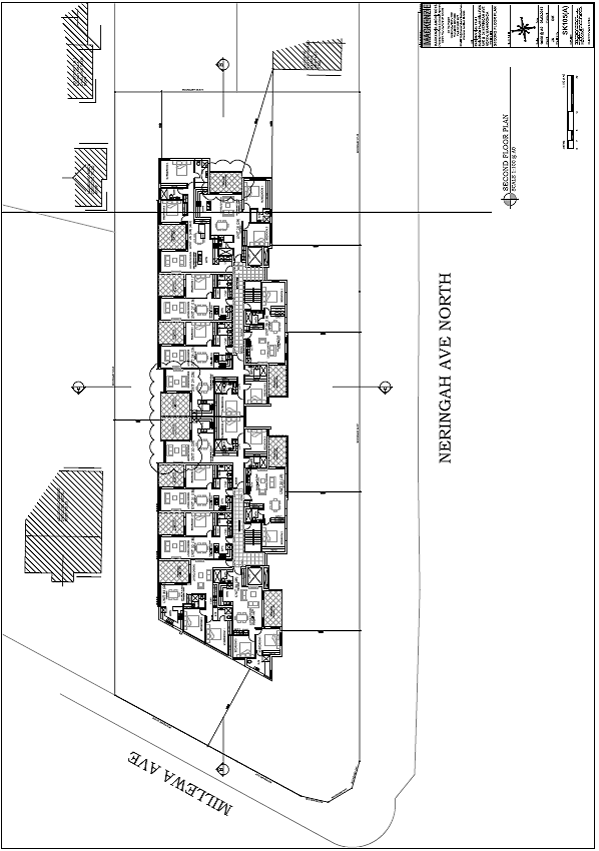

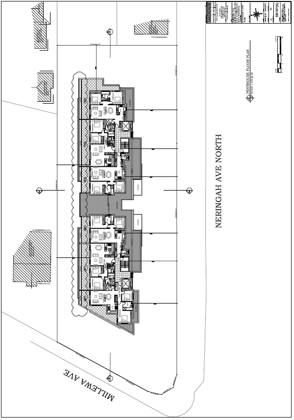
|
Ordinary Meeting of Council - 17 July 2012 |
GB.9 / 196 |
|
|
|
|
Item GB.9 |
DA0047/12 |
|
|
8 June 2012 |
development application
Summary Sheet
|
Report title: |
8A Wattle Street , Killara - Alterations, Additions and a New Pool |
|
ITEM/AGENDA NO: |
GB.9 |
|
Application No: |
0047/12 |
|
Property Details: |
8A Wattle Street, Killara Lot & DP No: Lot B, DP335577 Site area (m2): 1827m2 Zoning: Residential 2(b) |
|
Ward: |
Gordon |
|
Proposal/Purpose: |
Alterations, additions and a new pool. |
|
Type of Consent: |
Local |
|
Applicant: |
Mrs Justine Cottle |
|
Owner: |
Mrs J L Cottle |
|
Date Lodged: |
28 February 2012 |
|
Recommendation: |
Approval. |
Purpose of Report
To determine application No. DA0047/12 proposing alterations, additions and the demolition and reconstruction of a swimming pool.
The application proposes a variation to a development standard exceeding 10% and is required to be determined by full Council.
Council’s attention is directed to the attached Planning Circular PS 11-018, issued 18 August 2011 by the NSW Department of Planning & Infrastructure concerning the determination by Council of Development Applications where a variation to a development standard is sought under the provisions of SEPP No. 1. The circular requires all development applications which involve a variation greater than 10% under the provisions of SEPP No. 1 to be determined by full Council.
Executive Summary
Issues: SEPP 1 – Built-upon area
Submissions: Three
Land & Environmental Court Appeal: No
Recommendation: Approval
History
Site
The site has a history of residential use.
Pre-DA
A pre-DA consultation was held in relation to this application. The meeting took place on 12 July, 2011 .Issues raised were in relation to the built upon area of the site, the location of the swimming pool, the rear setback and the floor area of the first floor relative to the total floor space of the dwelling.
DA History
DA0706/11 sought consent for alterations, additions to existing dwelling, swimming pool and associated landscaping. The application was rejected due to insufficient information on 9 January, 2012.
The Site
Site description
The subject site is located on the northern, high side of Wattle Street, approximately 50 metres west of its intersection with Tasman Crescent.
The site is a battle-axe lot with an access handle approximately 58 metres in length from Wattle Street. The site (excluding the access handle) has a cross fall towards the street of approximately 3 metres from its rear north-west corner to its front south-east corner. Existing improvements include a two storey dwelling, carport, tennis court, swimming pool and associated landscaping.
Surrounding development
The surrounding development mainly consists of large dwellings situated on large, landscaped lots.
The Proposal
The proposal includes the following works:
· ground floor addition to family room and new laundry
· new sunroom at ground floor level, balcony and ensuite addition on the first floor level
· new retractable roof over the existing courtyard
· demolition of the existing pool and construction of a new swimming pool and associated landscaping
· enclosure of the existing carport and walkway
Consultation
COMMUNITY CONSULTATION
In accordance with Development Control Plan No. 56, owners of surrounding properties were given notice of the application. In response, (3) submissions were received from the following:
1. Mr T Kuo and Mrs C T Kuo 11 Northcote Avenue, Killara
2. Fiona Ringrose 1 Maytone Avenue, Killara (owner 12A Wattle Street)
3. Elizabeth Kelly 15 Northcote Avenue, Killara
The submissions raised the following issues:
The pool is set back less than 2 metres from the northern boundary which will result in additional noise to properties 11 and 15 Northcote Avenue and reduced opportunity for screen planting
The proposed swimming pool is to be set back 1260mm from the northern site boundary instead of the required 2 metres. This variation can be supported given that the new pool replaces an existing pool that has no setback from the northern boundary, new screen planting is to be located within the setback proposed which is supported by Council’s Landscape Assessment Officer and the pool adjoins the tennis court of 11 Northcote Avenue and the swimming pool of 15 Northcote Avenue. The pool coping located along the northern length and eastern side of the pool is narrow and non-trafficable which precludes persons standing along those sides of the pool.
The proposal will not provide any greater opportunity for generation of residential noise associated with a pool than the existing pool. Moreover, Conditions 37 and 39 serve to contain any noise generated by the pump associated with the new pool.
There is limited plant screening on the northern boundary which is insufficient to minimise the bulk of the upstairs addition and provide a buffer to the downstairs addition
The first floor addition amounts to no more than a bathroom some 5.5m2 in area. The proposal includes screen planting along the northern and eastern site boundaries to a height of three metres and, together with the existing plant screening located at the north-west corner of the rear garden, will screen the first floor addition and provide an effective buffer to the ground floor addition.
The pool is not set down and is up to 1.5metres above ground
The proposed swimming pool is to be located 30mm below the existing ground level at its western end and up to 1.45 metres above the existing ground at its eastern end instead of the maximum of 900mm above ground level stipulated in DCP 38. Given that the swimming pool is set back 1.88 metres from the eastern site boundary and 1.26 metes from the rear, northern, boundary with an adjoining public pathway 1.8 metres wide located on the eastern and northern sides of the pool, there is provision for adequate planting and separation from adjoining properties so as to minimise any impacts such as noise, glare and visual intrusion. Where the pool is elevated above the ground at its eastern end, the coping is narrow and not trafficable which further assists in preserving the amenity of the neighbours. The additional height is limited to the eastern end of the pool and is acceptable in the circumstances.
The upstairs addition will add more bulk
The first floor addition consists of 5.5m2 of floor space added to the existing bathroom. Given that the floor space of the first floor represents 40% of the total floor space of the building, (compliant with the DCP 38 control) the addition at first floor level will not add any appreciable bulk to the building and is acceptable.
The new upstairs balcony will create a privacy issue, the balcony will have a direct view into 11 Northcote Avenue
The proposed first floor balcony is off the bathroom of Bedroom 1, and Bedrooms 2 and 3. The balcony is set back 8.8 metres from the northern, rear, property boundary. Given the proposed landscape screen planting along the northern boundary, the 8.8m setback, access to the balcony being only from bedrooms which are low use rooms and the fact that the neighbour’s residence at 11 Northcote Avenue is separated from the subject site by a tennis court and a swimming pool, the balcony would not have any adverse impact on the privacy of 11 Northcote Avenue.
Loss of privacy and potential noise from the additional balcony in relation to 12A Wattle Street
As mentioned above, the proposed first floor balcony is located off three bedrooms, moreover it is set back 17 metres from the western side boundary of 12A Wattle Street. Given the low use of the bedrooms and the considerable setback from the neighbour’s western boundary, the balcony will not have a significant impact upon the amenity of the neighbouring property at 12A Wattle Street.
The upstairs addition is likely to result in more noise as the balcony is large
Whilst the first floor balcony has an area of 19.9m2, the bathroom addition effectively splits the balcony into two smaller useable portions with the most likely used western portion measuring only 9.8m2. Consequently, given the limited size of the usable, western area of the balcony off the bedrooms, the use of the balcony is not likely to physically accommodate a large number of people and therefore it would not result in any significant noise impact.
The additional bathroom appears to have glass walls and will be visible to 11 Northcote Avenue
The rear addition to the bathroom has timber framed glazing to the doors and windows. The new bathroom walls will be a minimum distance of 20 metres from adjoining dwellings and, as such, will not have a significant impact upon the neighbours’ in terms of privacy or visual impact.
The external courtyard is being built without a setback and could be enclosed at a later date
The courtyard is existing and it is proposed to have a retractable roof structure over it. Any future enclosure of the courtyard would require the submission of another development application, complying development certificate or exempt development depending on the nature of the enclosure.
The infinity edge on the pool can create more noise in relation to 12A Wattle Street
The proposed pool spillway is located 3.68 metres from the western property boundary of 12A Wattle Street. It is noted that construction of the approved new dwelling at 12A Wattle Street is underway and the approved set back of this dwelling is 3 metres from the western boundary with landscape screen planting included in the setback area. Given the substantial separation of 6.68 metres between the pool spillway and the adjoining dwelling approved at 12A Wattle Street, it is considered that the splashing sound of falling water of the pool spillway will not have a significant impact upon the aural privacy of 12A Wattle Street.
Question as to whether the choice of a Leighton green hedge is the best option
Council’s Landscape Assessment Officer does not support the use of Leighton green screen planting and has recommended the use of either Lilly Pilly and Viburnum species or Murraya or Spartan Juniper. An appropriate condition of consent has been recommended. (Condition 9)
There may be asbestos on the site which should be removed by a licensed contractor
A suitable condition has been recommended requiring the proper disposal of any asbestos that may be located on the site. (Condition 32)
Within Council
Landscaping
Council's Landscape and Tree Assessment Officer commented on the proposal as follows:
Tree impacts
There are no trees that will be impacted by the proposed works. The proposal includes the removal of a Cocos Palm (exempt from Council’s Tree Preservation Order due to species) and a Bangalow Palm (exempt from Council’s Tree Preservation Order due to size).
Landscape plan/tree replenishment
The proposed planting will require an amendment to replace the Leyland Cypress with a more suitable screening species. This has been conditioned.(Refer Council’s Landscape and Tree Information Pack August 2010).
It is noted that, due to the very high BUA, the site does not support the 10 trees that are required (1838m 2) as per Section 4.3.6. DCP 38. The site currently supports 2 Evergreen Alders and the proposed landscaping nominates 3 additional small trees. The existing and proposed trees will not reach the height requirements as per section 4.3.6. DCP 38. Consequently, a condition has been recommended to include one canopy tree that will reach 13 metes in height. (Condition 9)
The proposed pool is elevated (1.45m) at the north eastern end, however there is no potential for overlooking into the adjoining sites as there is no area to stand at that end of the pool and there is a wide laneway adjacent to the northern corner of the site.
There is currently a high fence/wall on the boundary adjacent to the lane.
Other issues
It is noted that the BUA is currently 81.07% and the proposed area is 80.83%. There is some potential for the BUA to be decreased. For example a portion of the eastern side of the front drive (between the fountain and the tennis court) could be returned to soft landscaping. If the current proposal for the new pool is not supported the area at the northern end of the tennis court between the pool and the boundaries could also be returned to soft landscaping.
Comment:
The applicant, in response to preliminary assessment advice has lodged amended plans resulting in the built upon area being reduced to 73.98%. This was achieved by the following modifications;
· the outdoor area adjacent to the proposed sunroom and modified pool will now be turfed instead of paved
· the existing area of driveway and associated paved areas at the front of the existing dwelling have been reduced and replaced with turf
Engineering
Council's Development Engineer has raised no objection to the proposal, subject to the inclusion of relevant standard conditions.
State Environmental Planning Policy No. 55 – Remediation of Land
The provisions of SEPP 55 require Council to consider the potential for a site to be contaminated. The subject site has a history of residential use and as such, it is unlikely to contain any contamination and further investigation is not warranted in this case.
Sydney Regional Environmental Planning Policy (Sydney Harbour Catchment) 2005
Matters for consideration include biodiversity, ecology and environment protection, public access to and scenic qualities of foreshores and waterways, maintenance of views, control of boat facilities and maintenance of a working harbour. The proposal is not in close proximity to or within views of the Middle Harbour waterway, or wetland. Engineering conditions are imposed in accordance with DCP 47, which will minimise the impact on downstream waterways.
The proposed development has been found to satisfy the provisions of the SREP.
State Environmental Planning Policy (Building Sustainability Index: BASIX) 2004
A valid BASIX certificate has been submitted. The certificate demonstrates compliance with the provisions of the SEPP and adequately reflects all amendments to the application.
STATUTORY PROVISIONS
Ku-ring-gai Planning Scheme Ordinance
Permissibility
The subject site is zoned residential 2(b) under the Ku-ring-gai Planning Scheme Ordinance. The proposed works are permissible under this zone with development consent from Council.
Development standards
|
Development standard |
Proposed |
Complies |
|
Site area: 1827m2 |
||
|
Building height 8m (max) |
7.1m |
YES |
|
Built upon area 60%(m2)(max) |
73.98% (existing 80.83%) |
NO (SEPP 1 submitted) |
The non-compliance with the development standard has been addressed through the assessment of the proposed breach against the provisions of SEPP 1 below:
State Environmental Planning Policy No. 1 – Objection to Development Standard (SEPP1)
SEPP 1 provides flexibility to development standards and it enables Council to vary standards where strict compliance with a standard would be unnecessary, unreasonable or tend to hinder the objectives of the Environmental Planning & Assessment Act, 1979.
Where there is a variation to a development standard, the application must be accompanied by a SEPP 1 Objection. When considering a variation it must be demonstrated that the non compliance:
a) is consistent with the objectives of the relevant developments standard;
b) strict compliance would hinder obtainment of the objectives of SEPP 1 or the objects specified in Section 5(a)(i) and (ii) of the Environmental Planning and Assessment Act, 1979; and
c) is unreasonable or unnecessary in the circumstance of the case.
Clause 60C of the Ku-ring-gai Planning Scheme Ordinance (KPSO), a statutory planning instrument, states:
(1) This clause applies to any land on which a dwelling-house is, or is proposed to be erected or extended, or on which development ancillary to the dwelling has been, or is proposed to be, carried out.
(2) The maximum built-upon area of land to which this clause applies is 60%.
(2A) However, if exempt or complying development is carried out on the land, the maximum built-upon area is 50%.
In respect of this Clause, the KPSO provides the following definition:
“Built-upon area" means the area of a site containing any built structure (whether covered or uncovered), any building, carport, terrace, pergola, hard-surface recreation area, swimming pool, tennis court, driveway, parking area or any like structure, but excluding minor landscape features.
In response to Council’s request for additional information, the applicant confirmed that the proposed development will result in a BUA coverage of 73.98% (1354.5m²). The existing BUA coverage is 81.07% (1484.8m²). Therefore, in accordance with the provisions of SEPP1, a formal objection to the development standard prescribed by Clause 60C of the KPSO is required. The ability of the proposal and the submitted objection to satisfy the provisions of SEPP1 and other relevant criteria is assessed through the following five part test.
whether the planning control to be varied is a development standard
Clause 60C of the KPSO restricts the land on which dwelling houses are constructed to a maximum hard surface area of 60%. As the KPSO is a statutory planning instrument, this control is considered to be a development standard as defined under Section 4 of the Environmental Planning & Assessment Act, 1979.
the underlying objective or purpose of the standard
Clause 60C of the KPSO does not have any specific objectives relating to the permissible hard surface coverage of site’s occupied by residential dwellings.
There is no specific underlying objective or purpose identified with respect to clause 60C of the KPSO.
However, it is considered the underlying objectives behind the standard would be:
· to ensure that development provides for sufficient soft landscape area for planting and retention of large canopy trees in scale with proposed development
· to ensure amenity is maintained to surrounding properties and future occupants by limiting the extent of built form on site
· to achieve consistency with the principles of ecologically sustainable development
The proposal is considered to be consistent with the underlying purpose of the control. The proposal reduces the existing built-upon area of site and does not result in an increased breach of the standard. The proposal does not result in any adverse amenity impacts upon adjoining properties.
whether compliance with the development standard is consistent with the aims of the policy and in particular, whether compliance with the development standard hinders the attainment of the objectives specified in Section 5(a)(i) and (ii) of the Environmental Planning and Assessment Act 1979
The aim of SEPP 1 is to:
Provide flexibility in the application of planning controls operating by virtue of development standards in circumstances where strict compliance with those standards would, in any particular case, be unreasonable or unnecessary or tend to hinder the attainment of the objects specified in Section 5(a) (i) and (ii) of the Act.
In this regard, the objective of Section 5(a)(i) and (ii) of the Act are:
(a) To encourage:
1. the proper management, development and conservation of natural and artificial resources, including agricultural land, natural areas, forests, minerals, water, cities, towns and villages for the purpose of promoting the social and economic welfare of the community and a better environment;
2. the promotion and co-ordination of the orderly and economic use and development of land.
The non-compliance with the development standard is considered to be consistent with the aims of SEPP 1 as it is unreasonable and unnecessary in this instance (as discussed in detail below) to comply with the requirement. In this particular circumstance, compliance with the development standard would hinder the attainment of the objectives specific in Section 5(a) (i) and (ii) of the Act.
whether compliance with the development standard is unreasonable or unnecessary in the circumstances of the case
The applicant has put forward the following arguments in support of the variation to the development standard:
The existing development on site currently exceeds the nominated BUA for development in the Ku-ring-gai Local government area. While the proposed development remains non-compliant, it results in a significant improvement in the BUA by introducing an additional 130 m 2 of soft landscaping for development on site. On this basis, the proposed development will not exacerbate the existing non-compliance and will not result in any significant impacts for the site or surrounding properties.
As has been highlighted within the submitted SEPP1 objection and, as mentioned earlier in the report, the proposed development will result in a nett decrease in built upon area from 80.83% to 73.98% or 130.3m2. This reduction has been achieved in part by the following amendments to the original submission:
· the outdoor area located adjacent to the proposed sunroom and modified pool will now be turf instead of paved
· the existing area of driveway and associated paved areas at the front of the existing dwelling have been reduced and replaced with turf
Therefore, in respect of the above, the remaining non-compliance which is an improvement on the existing built upon area by 6.85% or 130.3m2 is better as the development’s performance is improved in terms of achieving the objectives of the control and is deemed to be acceptable in this particular circumstance.
whether the objection is well founded
The arguments advanced in the SEPP 1 objection are considered to be well founded as the proposal will significantly improve the existing situation and will uphold what are considered to be the underlying objectives of the development standard. It is therefore concluded that strict compliance with prescribed development standard would unnecessarily hinder the attainment of the objectives specified by Section 5(a) (i) & (ii) of the EP&A Act, 1979.
Aims and objectives for residential zones:
The development: (i) provides satisfactory levels of solar access and privacy to surrounding properties; (ii) is of a bulk, scale and design, characteristic of the area; (iii) improves levels of soft landscaping; (iv) provides suitable egress/ingress for vehicles; and (v) improves the landscape quality of the municipality. Consequently, the aims and objectives for residential development as outlined by Schedule 9 have been satisfied.
Draft LEP 218 – Draft Biodiversity Land, Draft Riparian Land and Draft Heritage Conservation Areas:
The site is located in a proposed draft Heritage Conservation Area and is identified as a contributory item. Council is required to consider the impact of the development on the draft Conservation Area. Council’s Heritage Advisor advises that the site has little visual street presence due to its battle-axe location and, as such, will maintain the values of significance of the draft Heritage Conservation Area.
POLICY PROVISIONS
Development Control Plan No. 38 - Ku-ring-gai Residential Design Manual
|
Development Control |
Proposed |
Complies |
|
4.1 Streetscape: |
||
|
Building setbacks (s.4.1.3) |
|
|
|
Front setback: 11m (Ave) -75% front elevation 9m (min) – 25% front elevation |
Maintain existing front setback
|
N/A |
|
Side setback (battle-axe property): Ground floor: 5.85m(min)
1st floor: 5.85m (min) |
3.2m west side 15m east side 17.5m east side 1.4m west side (existing) |
NO YES YES NO |
|
Rear setback: 9.65m(min) |
6.9m |
NO |
|
4.2 Building form: |
||
|
FSR (s.4.2.1) 0.31:1 |
0.27:1 |
YES |
|
Height of building (s.4.2.2) |
|
|
|
2 storey (max) and 7m (site <200 slope) |
2 storey & 7.1m |
YES NO |
|
Building height plane (s.4.2.3) 450 from horizontal at any point 3m above boundary |
within envelope |
YES |
|
First floor (s.4.2.4) |
|
|
|
FSR: < 40% total FSR |
40% |
YES |
|
Roof Line (s.4.2.6) |
|
|
|
Roof height (5m – single storey) (3m – two+ storey) |
300mm |
YES |
|
Roof pitch 350 (max) |
5 0 |
YES |
|
Built-upon area (s.4.2.7) 50% (max) |
73.98% |
NO |
|
Unrelieved wall length (s.4.2.8) 12m (max)
|
11m |
YES |
|
Solar access (4.2.11) 4h solar access to adjoining properties between 9am to 3pm |
4h to 3pm |
YES |
|
Cut & fill (s.4.2.14) |
|
|
|
Max cut 900mm |
1.5m for pool |
NO |
|
Max cut & fill across building area of 1800mm and 900mm |
1.5m |
YES |
|
No cut or fill within side setbacks |
1.5m west end of pool |
NO |
|
4.3 Open space & landscaping: |
||
|
Soft landscaping area (4.3.3) 50% (min) |
26.02% |
NO |
|
4.4 Privacy & security: |
||
|
In accordance with the assessment criteria of s.4.4.1 of DCP 38, ‘private open spaces and living rooms of the proposed dwelling and adjacent dwellings should be protected from direct or unreasonable overlooking’.
See comment later in report:
|
||
|
4.5 Access & parking: |
||
|
No. of car parking spaces (s.4.5.1) 2 spaces behind building line |
2 spaces behind building line |
YES |
|
Size of car parking space (s.4.5.2) 5.4m x 5.4m |
8mx5.6m |
YES
YES |
|
Driveway width (s.4.5.6) 3.0m |
3.0m (existing) |
YES |
4.1 Streetscape
The western wall of the addition to the family room located at the rear of the dwelling is set back 3.2 metres from the western site boundary instead of the required 5.85 metres. The existing, significant landscape screen planting located along the western site boundary will remain unaltered, the length of wall in question at 3m is relatively short and is articulated with the existing western wall of the dwelling which stands 1.4 metres from the site boundary. Therefore, the proposed setback of 3.2 metres is considered to be satisfactory in the circumstances.
The sunroom addition, located at the rear of the dwelling, is set back 6.9 metres from the rear site boundary instead of the required 9.65 metres. The sunroom is set back 400mm greater than the setback of the existing kitchen from the rear boundary and additional soft landscaping is provided in the rear setback area, particularly along the eastern side boundary. In light of this and that there are no significant amenity impacts associated with the variation, the proposed setback is considered acceptable in the circumstances.
4.2 Building form and 4.3 Open space and landscaping
The addition to the first floor bathroom results in a ceiling height of 7.1 metres instead of the required 7.0 metres for site slopes less than 20 degrees. The bathroom in question is set back 16.3 metres from the eastern boundary and is located at the rear of the dwelling. There are no significant amenity impacts associated with this minor variation and is considered satisfactory in the circumstances.
The variation to the built upon area and consequently the soft landscaped area has been considered in the discussion of the SEPP 1 objection detailed earlier in the report.
4.3 Privacy and security
The ground floor addition to the family room and the new sunroom addition have their orientation to the rear garden and pool area and will be screened from the neighbouring properties by the existing boundary fencing and the proposed and existing perimeter screen planting. The proposed first floor balcony is off the bathroom of Bedroom 1 and Bedrooms 2 and 3 and is set back 8.8 metres from the northern, rear, property boundary. Due to the proposed landscape screen planting along the northern boundary, the generous setback and the location off the three bedrooms, which are low use rooms, the balcony will not likely give rise to any significant impact upon the privacy or security of any neighbouring property.
The swimming pool at its eastern end where it is up to 1.45 metres above the existing ground level is designed with a narrow coping edge which is not trafficable. Consequently, the use of the pool together with the proposed plant screening and the existing 3.5 metres high boundary fence will ensure that the privacy of neighbouring properties is maintained.
LIKELY IMPACTS
There are not likely to be any unreasonable impacts on the adjoining properties, the streetscape or on the landscape as a result of this proposal for the reasons discussed in the body of this report.
SUITABILITY OF THE SITE
The site is considered to be suitable for the proposed development, particularly as the existing improvements on the site include a significant dwelling, tennis court, swimming pool, carport and associated landscaping.
ANY SUBMISSIONS
The submissions received have been considered in the assessment of this application.
PUBLIC INTEREST
The approval of the application is considered to be in the public interest as the proposal improves the performance of the development in terms of achieving the objectives of the planning controls.
CONCLUSION
Having regard to the provisions of section 79C of the Environmental Planning and Assessment Act 1979, the proposed development is considered to be satisfactory. Therefore, it is recommended that the application be approved.
|
PURSUANT TO SECTION 80(1) OF THE ENVIRONMENTAL PLANNING AND ASSESSMENT ACT, 1979
That pursuant to Section 80(1) of the Environmental Planning and Assessment Act 1979, Council, as the consent authority, is of the opinion that the objection under State Environmental Planning Policy No. 1 – Development Standards to Clause 60(C) Built-upon Area of the Ku-ring-gai Planning Scheme Ordinance is well founded. Council is also of the opinion that strict compliance with the development standard is unreasonable and unnecessary in the circumstances of this case.
AND
THAT Council, as the consent
authority, grant development consent to DA0047/12 for
alterations and additions to the existing dwelling and construction of a new
swimming pool on land at
Conditions that identify approved plans:
1. Approved architectural plans and documentation (new development)
The development must be carried out in accordance with work shown in colour on the following plans and documentation listed below and endorsed with Council’s stamp, except where amended by other conditions of this consent.
Reason: To ensure that the development is in accordance with the determination.
2. Inconsistency between documents
In the event of any inconsistency between conditions of this consent and the drawings/documents referred to above, the conditions of this consent prevail.
Reason: To ensure that the development is in accordance with the determination.
3. Approved landscape plans
Landscape works shall be carried out in accordance with the following landscape plan(s), listed below and endorsed with Council’s stamp, except where amended by other conditions of this consent:
Reason: To ensure that the development is in accordance with the determination.
Conditions to be satisfied prior to demolition, excavation or construction:
4. Road opening permit
The opening of any footway, roadway, road shoulder or any part of the road reserve shall not be carried out without a road opening permit being obtained from Council (upon payment of the required fee) beforehand.
Reason: Statutory requirement (Roads Act 1993 Section 138) and to maintain the integrity of Council’s infrastructure.
5. Notice of commencement
At least 48 hours prior to the commencement of any development (including demolition, excavation, shoring or underpinning works), a notice of commencement of building or subdivision work form and appointment of the principal certifying authority form shall be submitted to Council.
Reason: Statutory requirement.
6. Notification of builder’s details
Prior to the commencement of any development or excavation works, the Principal Certifying Authority shall be notified in writing of the name and contractor licence number of the owner/builder intending to carry out the approved works.
Reason: Statutory requirement.
7. Sediment controls
Prior to any work commencing on site, sediment and erosion control measures shall be installed along the contour immediately downslope of any future disturbed areas.
The form of the sediment controls to be installed on the site shall be determined by reference to the ‘NSW Department of Housing manual ‘Managing Urban Stormwater: Soils and Construction’. The erosion controls shall be maintained in an operational condition until the development activities have been completed and the site fully stabilised. Sediment shall be removed from the sediment controls following each heavy or prolonged rainfall period.
Reason: To preserve and enhance the natural environment.
8. Erosion and drainage management
Earthworks and/or demolition of any existing buildings shall not commence until an erosion and sediment control plan is submitted to and approved by the Principal Certifying Authority. The plan shall comply with the guidelines set out in the NSW Department of Housing manual "Managing Urban Stormwater: Soils and Construction" certificate. Erosion and sediment control works shall be implemented in accordance with the erosion and sediment control plan.
Reason: To preserve and enhance the natural environment.
Conditions to be satisfied prior to the issue of the construction certificate:
9. Amendments to approved landscape plan
Prior to the issue of a Construction Certificate, the Principal Certifying Authority shall be satisfied that the approved landscape plans, listed below and endorsed with Council’s stamp, have been amended in accordance with the requirements of this condition as well as other conditions of this consent:
The above landscape plan(s) shall be amended in the following ways:
(a) The x Cupressocyparis leylandii (Leyland Cypress) are to be replaced with more suitable species, such as, Lilly Pilly or Viburnum, Murraya or Spartan Juniper.
(b) In order to ensure the provision of a canopy tree, the Brachychiton acerifolius (Flame tree) shall be replaced with a canopy tree from the Blue Gum High or Sydney Turpentine Ironbark Forest. The tree shall be a species that will attain 13.0 metres in height on the site and shall be planted a minimum distance of 3.5 metres from the dwelling.
Prior to the issue of the Construction Certificate, the Principal Certifying Authority shall be satisfied that the landscape plan has been amended are required by this condition.
Note: An amended plan, prepared by a landscape architect or qualified landscape designer shall be submitted to the Certifying Authority.
Reason: To ensure adequate landscaping of the site
10. Long service levy
In accordance with Section 109F(i) of the Environmental Planning and Assessment Act a Construction Certificate shall not be issued until any long service levy payable under Section 34 of the Building and Construction Industry Long Service Payments Act 1986 (or where such levy is payable by instalments, the first instalment of the levy) has been paid. Council is authorised to accept payment. Where payment has been made elsewhere, proof of payment is to be provided to Council.
Reason: Statutory requirement.
11. Builder’s indemnity insurance
The applicant, builder, developer or person who does the work on this development, must arrange builder’s indemnity insurance and submit the certificate of insurance in accordance with the requirements of Part 6 of the Home Building Act 1989 to the Certifying Authority for endorsement of the plans accompanying the Construction Certificate.
It is the responsibility of the applicant, builder or developer to arrange the builder's indemnity insurance for residential building work over the value of $20,000. The builder's indemnity insurance does not apply to commercial or industrial building work or to residential work valued at less than $20,000, nor to work undertaken by persons holding an owner/builder's permit issued by the Department of Fair Trading (unless the owner/builder's property is sold within 7 years of the commencement of the work).
Reason: Statutory requirement.
Conditions to be satisfied prior to the issue of the construction certificate or prior to demolition, excavation or construction (whichever comes first):
12. Infrastructure restorations fee
To ensure that damage to Council Property as a result of construction activity is rectified in a timely matter:
a) All work or activity taken in furtherance of the development the subject of this approval must be undertaken in a manner to avoid damage to Council Property and must not jeopardise the safety of any person using or occupying the adjacent public areas.
b) The applicant, builder, developer or any person acting in reliance on this approval shall be responsible for making good any damage to Council Property, and for the removal from Council Property of any waste bin, building materials, sediment, silt, or any other material or article.
c) The Infrastructure Restoration Fee must be paid to the Council by the applicant prior to both the issue of the Construction Certificate and the commencement of any earthworks or construction.
d) In consideration of payment of the Infrastructure Restorations Fee, Council will undertake such inspections of Council Property as Council considers necessary and also undertake, on behalf of the applicant, such restoration work to Council Property, if any, that Council considers necessary as a consequence of the development. The provision of such restoration work by the Council does not absolve any person of the responsibilities contained in (a) to (b) above. Restoration work to be undertaken by the Council referred to in this condition is limited to work that can be undertaken by Council at a cost of not more than the Infrastructure Restorations Fee payable pursuant to this condition.
e) In this condition:
“Council Property” includes any road, footway, footpath paving, kerbing, guttering, crossings, street furniture, seats, letter bins, trees, shrubs, lawns, mounds, bushland, and similar structures or features on any road or public road within the meaning of the Local Government Act 1993 (NSW) or any public place; and
“Infrastructure Restoration Fee” means the Infrastructure Restorations Fee calculated in accordance with the Schedule of Fees & Charges adopted by Council as at the date of payment and the cost of any inspections required by the Council of Council Property associated with this condition.
Reason: To maintain public infrastructure.
Conditions to be satisfied during the demolition, excavation and construction phases:
13. Prescribed conditions
The applicant shall comply with any relevant prescribed conditions of development consent under clause 98 of the Environmental Planning and Assessment Regulation. For the purposes of section 80A (11) of the Environmental Planning and Assessment Act, the following conditions are prescribed in relation to a development consent for development that involves any building work:
· The work must be carried out in accordance with the requirements of the Building Code of Australia · In the case of residential building work for which the Home Building Act 1989 requires there to be a contract of insurance in force in accordance with Part 6 of that Act, that such a contract of insurance is in force before any works commence.
Reason: Statutory requirement.
14. Hours of work
Demolition, excavation, construction work and deliveries of building material and equipment must not take place outside the hours of 7.00am to 5.00pm Monday to Friday and 8.00am to 12 noon Saturday. No work and no deliveries are to take place on Sundays and public holidays.
Excavation or removal of any materials using machinery of any kind, including compressors and jack hammers, must be limited to between 7.30am and 5.00pm Monday to Friday, with a respite break of 45 minutes between 12 noon 1.00pm.
Where it is necessary for works to occur outside of these hours (ie) placement of concrete for large floor areas on large residential/commercial developments or where building processes require the use of oversized trucks and/or cranes that are restricted by the RTA from travelling during daylight hours to deliver, erect or remove machinery, tower cranes, pre-cast panels, beams, tanks or service equipment to or from the site, approval for such activities will be subject to the issue of an "outside of hours works permit" from Council as well as notification of the surrounding properties likely to be affected by the proposed works.
Note: Failure to obtain a permit to work outside of the approved hours will result in on the spot fines being issued.
Reason: To ensure reasonable standards of amenity for occupants of neighbouring properties.
15. Approved plans to be on site
A copy of all approved and certified plans, specifications and documents incorporating conditions of consent and certification (including the Construction Certificate if required for the work) shall be kept on site at all times during the demolition, excavation and construction phases and must be readily available to any officer of Council or the Principal Certifying Authority.
Reason: To ensure that the development is in accordance with the determination.
16. Statement of compliance with Australian Standards
The demolition work shall comply with the provisions of Australian Standard AS2601: 2001 The Demolition of Structures. The work plans required by AS2601: 2001 shall be accompanied by a written statement from a suitably qualified person that the proposal contained in the work plan comply with the safety requirements of the Standard. The work plan and the statement of compliance shall be submitted to the satisfaction of the Principal Certifying Authority prior to the commencement of any works.
Reason: To ensure compliance with the Australian Standards.
17. Site notice
A site notice shall be erected on the site prior to any work commencing and shall be displayed throughout the works period.
The site notice must:
· be prominently displayed at the boundaries of the site for the purposes of informing the public that unauthorised entry to the site is not permitted · display project details including, but not limited to the details of the builder, Principal Certifying Authority and structural engineer · be durable and weatherproof · display the approved hours of work, the name of the site/project manager, the responsible managing company (if any), its address and 24 hour contact phone number for any inquiries, including construction/noise complaint are to be displayed on the site notice · be mounted at eye level on the perimeter hoardings/fencing and is to state that unauthorised entry to the site is not permitted
Reason: To ensure public safety and public information.
18. Dust control
During excavation, demolition and construction, adequate measures shall be taken to prevent dust from affecting the amenity of the neighbourhood. The following measures must be adopted:
· physical barriers shall be erected at right angles to the prevailing wind direction or shall be placed around or over dust sources to prevent wind or activity from generating dust · earthworks and scheduling activities shall be managed to coincide with the next stage of development to minimise the amount of time the site is left cut or exposed · all materials shall be stored or stockpiled at the best locations · the ground surface should be dampened slightly to prevent dust from becoming airborne but should not be wet to the extent that run-off occurs · all vehicles carrying spoil or rubble to or from the site shall at all times be covered to prevent the escape of dust · all equipment wheels shall be washed before exiting the site using manual or automated sprayers and drive-through washing bays · gates shall be closed between vehicle movements and shall be fitted with shade cloth · cleaning of footpaths and roadways shall be carried out daily
Reason: To protect the environment and amenity of surrounding properties.
19. Use of road or footpath
During excavation, demolition and construction phases, no building materials, plant or the like are to be stored on the road or footpath without written approval being obtained from Council beforehand. The pathway shall be kept in a clean, tidy and safe condition during building operations. Council reserves the right, without notice, to rectify any such breach and to charge the cost against the applicant/owner/builder, as the case may be.
Reason: To ensure safety and amenity of the area.
20. Guarding excavations
All excavation, demolition and construction works shall be properly guarded and protected with hoardings or fencing to prevent them from being dangerous to life and property.
Reason: To ensure public safety.
21. Toilet facilities
During excavation, demolition and construction phases, toilet facilities are to be provided, on the work site, at the rate of one toilet for every 20 persons or part of 20 persons employed at the site.
Reason: Statutory requirement.
22. Protection of public places
If the work involved in the erection, demolition or construction of the development is likely to cause pedestrian or vehicular traffic in a public place to be obstructed or rendered inconvenient, or building involves the enclosure of a public place, a hoarding or fence must be erected between the work site and the public place.
If necessary, a hoarding is to be erected, sufficient to prevent any substance from, or in connection with, the work falling into the public place.
The work site must be kept lit between sunset and sunrise if it is likely to be hazardous to persons in the public place.
Any hoarding, fence or awning is to be removed when the work has been completed.
Reason: To protect public places.
23. Recycling of building material (general)
During demolition and construction, the Principal Certifying Authority shall be satisfied that building materials suitable for recycling have been forwarded to an appropriate registered business dealing in recycling of materials. Materials to be recycled must be kept in good order.
Reason: To facilitate recycling of materials.
24. Road reserve safety
All public footways and roadways fronting and adjacent to the site must be maintained in a safe condition at all times during the course of the development works. Construction materials must not be stored in the road reserve. A safe pedestrian circulation route and a pavement/route free of trip hazards must be maintained at all times on or adjacent to any public access ways fronting the construction site. Where public infrastructure is damaged, repair works must be carried out when and as directed by Council officers. Where pedestrian circulation is diverted on to the roadway or verge areas, clear directional signage and protective barricades must be installed in accordance with AS1742-3 (1996) “Traffic Control Devices for Work on Roads”. If pedestrian circulation is not satisfactorily maintained across the site frontage, and action is not taken promptly to rectify the defects, Council may undertake proceedings to stop work.
Reason: To ensure safe public footways and roadways during construction.
25. Services
Where required, the adjustment or inclusion of any new utility service facilities must be carried out by the applicant and in accordance with the requirements of the relevant utility authority. These works shall be at no cost to Council. It is the applicants’ full responsibility to make contact with the relevant utility authorities to ascertain the impacts of the proposal upon utility services (including water, phone, gas and the like). Council accepts no responsibility for any matter arising from its approval to this application involving any influence upon utility services provided by another authority.
Reason: Provision of utility services.
26. Erosion control
Temporary sediment and erosion control and measures are to be installed prior to the commencement of any works on the site. These measures must be maintained in working order during construction works up to completion. All sediment traps must be cleared on a regular basis and after each major storm and/or as directed by the Principal Certifying Authority and Council officers.
Reason: To protect the environment from erosion and sedimentation.
27. Drainage to existing system
Stormwater runoff from all new impervious areas and subsoil drainage systems shall be piped to the existing site drainage system. The installation of new drainage components must be completed by a licensed contractor in accordance with AS3500.3 (Plumbing Code) and the BCA. No stormwater runoff is to be placed into the Sydney Water sewer system. If an illegal sewer connection is found during construction, the drainage system must be rectified to the satisfaction of Council and Sydney Water.
Reason: To protect the environment.
28. No storage of materials beneath trees
No activities, storage or disposal of materials shall take place beneath the canopy of any tree protected under Council's Tree Preservation Order at any time.
Reason: To protect existing trees.
29. Removal of refuse
All builders' refuse, spoil and/or material unsuitable for use in landscape areas shall be removed from the site on completion of the building works.
Reason: To protect the environment.
30. Canopy replenishment trees to be planted
The canopy replenishment trees to be planted shall be maintained in a healthy and vigorous condition until they attain a height of 5.0 metres whereby they will be protected by Council’s Tree Preservation Order. Any of the trees found faulty, damaged, dying or dead shall be replaced with the same species.
Reason: To maintain the treed character of the area.
31. On site retention of waste dockets
All demolition, excavation and construction waste dockets are to be retained on site, or at suitable location, in order to confirm which facility received materials generated from the site for recycling or disposal.
· Each docket is to be an official receipt from a facility authorised to accept the material type, for disposal or processing. · This information is to be made available at the request of an Authorised Officer of Council.
Reason: To protect the environment.
32. Asbestos removal
A person taking down or demolishing or causing to be taken down or demolished any building or part thereof shall, upon identifying or suspecting that asbestos is present in the building, immediately notify the Workcover Authority. The Authority is the controlling body for the safe removal, handling and disposal of asbestos. The Authority supervises and monitors contractors engaged in asbestos removal.
The requirements and standards imposed by the Authority, its consultants or contractors shall be complied with.
Reason: To ensure asbestos is removed in a safe manner.
Conditions to be satisfied prior to the issue of an Occupation Certificate:
33. Compliance with BASIX Certificate
Prior to the issue of an Occupation Certificate, the Principal Certifying Authority shall be satisfied that all commitments listed in BASIX Certificate No.A128936-02 have been complied with.
Reason: Statutory requirement.
34. Completion of landscape works
Prior to the release of the Occupation Certificate, the Principal Certifying Authority is to be satisfied that all landscape works have been undertaken in accordance with the approved plan(s) and conditions of consent.
Reason: To ensure that the landscape works are consistent with the development consent.
35. Certification of drainage works (alterations/additions)
Prior to issue of the Occupation Certificate, the Principal Certifying Authority is to be satisfied that:
· the components of the new drainage system have been installed by a licensed contractor in accordance with the National Plumbing and Drainage Code AS3500.3 (2003) and the Building Code of Australia · the stormwater drainage works have been completed in accordance with the approved Construction Certificate drainage plans, the nominated BASIX commitments and Ku-ring-gai Water Management DCP 47
Note: Evidence from the plumbing contractor or a qualified civil/hydraulic engineer confirming compliance with this control is to be provided to Council prior to the issue of an Occupation Certificate.
Reason: To protect the environment.
36. Infrastructure repair
Prior to issue of the Occupation Certificate, the Principal Certifying Authority must be satisfied that any damaged public infrastructure caused as a result of construction works (including damage caused by, but not limited to, delivery vehicles, waste collection, contractors, sub contractors, concrete vehicles) is fully repaired to the satisfaction of Council Development Engineer and at no cost to Council.
Reason: To protect public infrastructure.
37. Swimming pool (part 1)
Prior to the issue of the Occupation Certificate, the Principal Certifying Authority shall be satisfied that:
C1 1. Access to the pool/spa shall be restricted by a child resistant barrier in accordance with the regulations prescribed in the Swimming Pools Act, 1992:
(a) The pool shall not be filled with water or be allowed to collect stormwater until the child resistant barrier is installed; and (b) The barrier is to conform to the requirements of AS 1926-1 2007 Fences and Gates for Private Swimming Pools.
Reason: To ensure the safety of children.
2. Any mechanical equipment associated with the swimming pool and/or spa pool shall be located in a sound-attenuating enclosure and positioned so that it is setback a minimum of 2m from the boundary of any adjoining premises. The Principal Certifying Authority shall be satisfied that the sound levels associated with the swimming pool/spa filtration system and associated mechanical equipment do not exceed 5dB(A) above the background noise level at the boundaries of the site.
Reason: To protect the amenity of surrounding properties.
38. Pool overflow to sewer
Prior to issue of the Occupation Certificate a high level overflow pipe is to be provided from the back of the skimmer box to the filter backwash line discharging to the sewer. This line must not directly vent the receiving Sydney Water sewer. This requirement is to collect stormwater overflow from the swimming pool surface only. A certificate from the installer, indicating compliance with this condition, must be submitted to the Principal Certifying Authority prior to issue of the Occupation Certificate.
Reason: To provide satisfactory drainage.
Conditions to be satisfied at all times:
39. Swimming pool (part 2)
At all times:
1. Access to the swimming pool must be restricted by fencing or other measures as required by the Swimming Pools Act 1992. 2. Noise levels associated with spa/pool pumping units shall not exceed 5dB(A) at the boundaries of the site. 3. Devices or structures used for heating swimming pool water must not be placed where they are visible from a public place. 4. For the purpose of health and amenity, the disposal of backwash and/or the emptying of a swimming pool into a reserve, watercourse, easement or storm water drainage system is prohibited. These waters are to discharge via a permanent drainage line into Sydney Water's sewer in accordance with Australian Standard AS3500.2 section 10.9. Permission is to be obtained from Sydney Water prior to the emptying of any pool to the sewer. 5. Lighting from the swimming pool and other communal facilities shall not detrimentally impact the amenity of other premises and adjacent dwellings.
Reason: Health and amenity. |
|
Graham Bolton Executive Assessment Officer |
Shaun Garland Team Leader Development Assessment South |
|
Corrie Swanepoel Manager Development Assessment Services |
Michael Miocic Director Development & Regulation |
|
A1View |
Location sketch and zoning extract |
|
2012/161040 |
|
|
|
A2View |
Landscape plan |
|
2012/098126 |
|
|
A3View |
Architectural plans |
|
2012/161208 |
|
|
A4View |
Department of Planning Circular PS08-014 |
|
2012/138064 |
|
|
A5View |
SEPP1 objection |
|
2012/098128 |
|
Ordinary Meeting of Council - 17 July 2012 |
GB.10 / 233 |
|
|
|
|
Item GB.10 |
DA0063/12 |
|
|
25 May 2012 |
development application
Summary Sheet
|
Report title: |
7 Smith Street Lindfield - alterations and additions, new garage and associated works |
|
ITEM/AGENDA NO: |
GB.10 |
|
Application No: |
DA0063/12 |
|
Property Details: |
7 Smith Street, Lindfield Lot & DP No: Lot 2 & DP 594690 Site area: 1520m² Zoning: Residential 2(b) |
|
Ward: |
Roseville |
|
Proposal/Purpose: |
Alterations and additions, new garage and associated works. |
|
Type of Consent: |
Local |
|
Applicant: |
Mr Craig Robert Morris |
|
Owner: |
Mrs Caroline Louise Morris, Mr Craig Robert Morris |
|
Date Lodged: |
7 March 2012 |
|
Recommendation: |
Approval. |
Purpose of Report
To determine Development Application DA0063/12 proposing alterations and additions, a new garage and associated works.
The application must be determined by full Council in accordance with the requirement of the Department of Planning & Infrastructure where there is a variation to a development standard of 10% or greater.
Council’s attention is directed to the attached Planning Circular PS 11-018 (Attachment A7), issued 18 August 2011 from the NSW Department of Planning & Infrastructure concerning the determination by Council of Development Applications where a variation to a development standard is sought under the provisions of SEPP No. 1. The circular requires all development applications which involve a variation greater than 10% under the provisions of SEPP No. 1 to be determined by full Council.
Executive Summary
|
Issues:
|
SEPP 1 – Built-upon area
|
|
Submissions:
|
None |
|
Land & Environmental Court Appeal:
|
No |
|
Recommendation: |
Approval |
History
Site
The site has previously been used for residential purposes only.
Pre-DA
There was no pre-DA consultation in relation to this application.
DA history
• BA 82/01771, proposing a swimming pool, was approved on 9 November 1982.
• BA 86/01343, proposing additions, was approved on 25 August 1986.
The Site
Site description
The site is legally described as Lot 2 in DP 594690 and is known as No. 7 Smith Street, Lindfield. The site is located on the southern side of Smith Street and is a battle-axe allotment. The site has a width of 5m at the access handle and 34.14m for the remainder of the site. The depth of the site excluding the access handle is 39.93m (70.41m including the access handle). The area of the site is 1520m².
The site accommodates a single storey dwelling-house with a lower ground floor pool store room located at the rear south-eastern corner of the existing dwelling. Vehicular access is from Smith Street, adjacent to the eastern side boundary. The site currently accommodates a double carport adjoining the northern (front) elevation of the dwelling, with an in-ground swimming pool, surrounding paving and a tennis court at the rear of the site.
There is a private drainage easement that runs from the rear of No. 5 Smith Street, almost perpendicular underneath the southern-most area of the access handle of the subject site and continues along the entire length of the eastern, side, boundary.
The only part of the site that is visible from Smith Street is the access handle due to dense vegetation along the northern property boundary shared with No. 5 Smith Street.
Surrounding development
The site and surrounding area is located in a Residential 2(b) zone. The surrounding development is low density residential in nature.
The site shares its property boundaries with six other properties. In general, properties to the north, east and south of the site are zoned Residential 2(b) which encourages a low density residential environment. Properties to the west are zoned Residential 2(c2) which also encourages a low density residential development while permitting some forms of increased residential density.
The Smith Street streetscape comprises a mix of old and new, single and two storey dwellings on rectangular shaped allotments. The exception is the subject site, being a hatched-shaped allotment.
The Proposal
The application proposes alterations and additions, new garage and associated works, including:
· demolition of existing carport
· conversion of existing billiard room into a double garage
· conversion of existing pool storage area beneath the billiard room in to a games room, with WC facility and internal access to the existing dwelling
· garage roof raised to accommodate headroom in the proposed games room
· reconfigured front entry
· various internal alterations
· existing driveway raised by 900mm (excludes access handle)
· new retaining wall along eastern side boundary adjacent to the driveway
Amended plans received 11 April 2012
The amended plans included a revised location of the new retaining wall along the eastern side boundary.
The amended plans were not required to be notified in accordance with Clause 4.1 of Notification Development Control Plan No. 56 since the environmental impact of the amended proposal would be less than the original proposal.
Consultation
Community
In accordance with Development Control Plan No. 56, owners of surrounding properties were given notice of the application. No submissions were received.
Within Council
Engineering
Council's Development Engineer commented on the proposal as follows:
"The site is affected by a stormwater drainage easement along the eastern boundary. It appears that the existing retaining wall located within the drainage easement will be replaced with a new retaining wall which supports the new raised driveway. As the new retaining wall is longer than the existing wall and includes a foundation, additional work within the drainage easement would be required. According to Section 7.6 d) of Council’s DCP 47 Water Management, where any structure is to be located within a drainage easement, written agreement shall be obtained from all beneficiaries of the easement.”
Having regard to the above comments, a preliminary assessment letter was sent to the applicant requesting the written agreement of the owners of Lot 1 DP 594690 (5 Smith Street) to the proposed works within the drainage easement. The applicant amended the submitted plans by relocating the proposed new retaining wall outside of the drainage easement. The written agreement from the owners of No. 5 Smith Street is therefore no longer required.
Council's Development Engineer commented on the amended plans as follows:
"Amended architectural plans have been submitted indicating that the new retaining wall which supports the new raised driveway is located outside the drainage easement.
The proposed planter box and suspended driveway will allow some access to the easement in the event that works are required.
From an engineering perspective there are no objections to the proposal as amended."
Landscaping
Council's Landscape Assessment Officer commented on the amended proposal as follows:
Tree impacts
The amendments, indicating the relocation of the retaining wall 1 metre from the eastern side boundary, are considered acceptable. Conditions will be recommended to protect the Grevillea robusta (Silky Oak) located on the adjoining property.
Landscape plan
A condition will be recommended to provide screen planting between the new retaining wall and the eastern side boundary. An automatic irrigation system is to be installed to allow for optimum plant growth.
Conclusion
The Landscape Assessment Officer finds the proposal acceptable in relation to landscape issues, subject to conditions."
Outside Council
The application did not require any external referrals.
Statutory Provisions
State Environmental Planning Policies
State Environmental Planning Policy No. 1 – Development Standards
Clause 60C of the KPSO states that the maximum built-upon area (BUA) of land on which a dwelling house is proposed to be erected or extended is 60%. The existing BUA of the site is 1279.9m2 or 84.2% of the total site area. The applicant proposes to reduce the BUA to 83.9%.
Accordingly, as the development remains non-compliant, a SEPP No. 1 objection has been lodged which is considered further below.
State Environmental Planning Policy No. 55 – Remediation of Land
The provisions of SEPP 55 require Council to consider the potential for a site to be contaminated. The subject site has a history of residential use and as such, it is unlikely to contain any contamination and further investigation is not warranted in this case.
Sydney Regional Environmental Planning Policy (Sydney Harbour Catchment) 2005
Matters for consideration under SREP 2005 include biodiversity, ecology and environmental protection, public access to and scenic qualities of foreshores and waterways, maintenance of views, control of boat facilities and maintenance of a working harbour. The proposal is not in close proximity to, or within view, of a waterway or wetland and is considered satisfactory.
State Environmental Planning Policy (Building Sustainability Index: BASIX) 2004
A valid BASIX certificate has been submitted with the application (Certificate No. A131447, dated 5 March 2012). The certificate demonstrates compliance with the provisions of the SEPP and adequately reflects all amendments to the application. BASIX requirements are reflected on the plans submitted with the application.
Ku-ring-gai Planning Scheme Ordinance
Permissibility
The site is zoned Residential 2(b). The proposed works, being alterations and additions, new garage and associated works, are permissible with development consent pursuant to Clause 23(b) of the KPSO.
Part A: Development standards
|
Development standard |
Proposed |
Complies |
|
Site area: 1170m² (excludes access handle) |
1363.2m2 (excludes access handle) (includes access handle = 1520m2) |
YES |
|
Building height 8m (max) |
<8m |
YES |
|
Built upon area 60%(912m2)(max) |
83.9% (1275.78m2) (Existing = 84.2%) |
NO |
Built-upon area
Clause 60C of the KPSO states that the maximum built upon area (BUA) is 60% of the site area. The proposed BUA for the site is 83.9% (1275.3m2) which exceeds the maximum built-upon area permitted. Contributing substantially to the non-compliance are an existing tennis court and swimming pool located to the rear of the site. Accordingly, a SEPP 1 objection is required (Attachment A6). The following is an assessment of the SEPP 1 objection:
whether the planning control is a development standard
The limit on BUA for land zoned Residential is 60% prescribed under Clause 60C of the KPSO. As the KPSO is a statutory planning instrument, this control is a development standard as defined under Section 4 of Environmental Planning & Assessment Act, 1979.
the underlying objective or purpose behind the standard
There is no specific underlying objective or purpose identified with respect of clause 60C of the KPSO.
However, it is considered the underlying objectives behind the standard, based on the assessment criteria of BUA in Ku-ring-gai Residential Design Manual Development Control Plan No. 38, would be:
· to maintain a reasonable proportion of the site as soft landscaping to ensure of the site as soft landscaping to ensure that predominate landscape character of the locality is maintained or enhanced
· to encourage a reduction in the BUA of the site where stormwater cannot be directed to the street or a drainage easement
· to achieve consistency with the principles of ecologically sustainable development
The proposed development results in a small reduction of existing BUA which would still produce a BUA level that is well above the maximum permitted by the development standard. While the proposed reduction is small, the proposed development does not seek to further increase the existing BUA of the site which could lead to a further erosion of the landscape character of the locality. The proposed alterations and additions include a minor extension to the rear of the dwelling of approximately 4.5m². The roof surface area over this extension will drain to the existing stormwater system. In conclusion, the development proposal is consistent with what are considered to be the underlying objectives behind the standard.
whether compliance with the development standard is consistent with the aims of the policy and, in particular, whether compliance with the development standard hinders the attainment of the objectives specified under Section 5(A)(i), (ii), (iii) and (iv) of the Environmental Planning and Assessment Act 1979
The aim of SEPP 1 is to:
Provide flexibility in the application of planning controls operating by virtue of development standards in circumstances where strict compliance with those standards would, in any particular case, be unreasonable or unnecessary or tend to hinder the attainment of the objects specified in Section 5(a) (i) and (ii) of the Act.
In this regard, the objectives of Section 5(a)(i) and (ii) of the Act are:
(a) To encourage:
1. the proper management, development and conservation of natural and artificial resources, including agricultural land, natural areas, forests, minerals, water, cities, towns and villages for the purpose of promoting the social and economic welfare of the community and a better environment;
2. the promotion and co-ordination of the orderly and economic use and development of land.
The non-compliance with the development standard is considered to be consistent with the aims of SEPP 1 as it is unreasonable and unnecessary in this instance (as discussed in detail below) to comply with the requirement. In this particular circumstance compliance with the development standard would hinder the attainment of the objectives specified in Section 5(a) (i) and (ii) of the Act.
whether compliance with the development standard is unreasonable or unnecessary in the circumstances of the case
The applicant submits that strict compliance with the maximum built-upon area control is both unreasonable and unnecessary for the following reasons:
· The achievement of full compliance would be unreasonable to the property owner because it would entail the removal of existing property improvements, namely the existing tennis court and swimming pool;
· In reference to the above point, the scope of the works proposed is not sufficient to justify the property owners having to remove existing property improvements such as the swimming pool and tennis court. The proposed works are designed to improve the amenity of the existing dwelling by altering the internal layout of its floor plan. The applicant does not seek to increase the amount of BUA for the site.
· The proposed removal of hard surface area at the northern end of the site will provide some additional soft landscaping where it is needed most – within an area where soft landscaping will enhance privacy of the proposed patio adjacent to the northern boundary of the subject site while softening the appearance of a timber lattice privacy screen along the same boundary for the subject site’s residents.
· The proposed removal of hard surface area on the eastern boundary of the site between the proposed new retaining wall and the side boundary is sufficiently wide enough to incorporate vegetation capable of attaining a height of 2.5m. The applicant has designated this area for landscaping. In accordance with the recommendations made by Council’s Landscape Assessment Officer, a condition of consent can be imposed requiring the applicant to submit a screen planting plan prior to the issue of a Construction Certificate detailing the types of species that would suitably adapt to the conditions of the area and attain a height of at least 2.5m. The screen planting would reduce the visual bulk of the proposed retaining wall to the neighbouring property as well as enhance the landscaped amenity of the locality.
· There are no reasonable opportunities for a further reduction in soft landscaping should this application be approved by Council.
· In the circumstances of the case, the extent of the proposed reduction in built upon area and the extent of improvements to the provision of soft landscaping within the site are more than commensurate with the impacts of the proposed development.
Having regard to the above, it is considered unreasonable or unnecessary in this instance to comply with the development standard. The development proposal does not result in an increase in the existing amount of BUA, rather a reduction. This is a net improvement over the existing circumstances given that the site is constrained by the presence of a swimming pool and tennis court. A more substantial reduction to the existing amount of BUA is therefore unlikely to be achieved without imposing an unreasonable burden on the property owner.
The proposed alterations primarily relate to improving amenity within the existing dwelling by raising the ceiling height of a part of the ground and first floors to comply with the Building Code of Australia (BCA). The proposed ceiling height of the dwelling remains less than 8m above existing ground level which complies with the height of buildings development standard in the KPSO. Accordingly, this translates into an acceptable bulk and scale for the dwelling which improves internal access to natural light while achieving BCA compliance. The existing building footprint of the dwelling remains unchanged except for a 4.5m² increase to the rear of the dwelling which is the product of incorporating a reconfiguration of the existing load-bearing wall to the southern elevation of the proposed garage and games room. This minor increase will not be visible from the street and will not have a detrimental impact on adjoining properties in terms of overshadowing, privacy, bulk and scale.
whether the objection is well founded
The SEPP 1 objection is considered to be well founded and the development will achieve the underlying objectives of the standard. It is also concluded that strict compliance with the prescribed development standard would unnecessarily hinder the attainment of the objectives specified by Section 5(a) (i) & (ii) of the EP&A Act, 1979.
Part B: Aims and objectives for residential zones
Schedule 9 of the KPSO outlines the aims and objectives for residential zones that the development proposal must comply with. The proposal is consistent with the aims and objectives for residential zones in the following manner:
· The proposal will maintain the existing amenity and environmental character of the residential zone as most of the proposed changes are internal and others will remain concealed from the street due to the changes taking place on a battle-axe allotment.
· The proposal involves some minor external changes such as raising the existing ground level of the driveway and ceiling height of a part of the dwelling which is sympathetic to the design of the subject dwelling and to development on adjoining properties. A recommended condition of consent will ensure that sufficient screen planting will conceal the new retaining wall from view from No. 9 Smith Street (Condition 10).
· The revised location of the proposed retaining wall will ensure the structural footings of the wall will not adversely impact on the health of a Silky Oak tree located in the rear of 9 Smith Street. No trees are proposed to be removed which ensures the predominant landscape quality of the municipality is maintained.
· Satisfactory levels of solar access to surrounding properties will be maintained. The increase in ceiling height is minor which results in some additional overshadowing but not enough to prevent four hours of solar access to neighbouring properties during the winter solstice.
· The proposed new windows on the eastern elevation of the dwelling will not adversely affect the privacy of any adjoining property, including No. 9 Smith Street. The windows on the ground floor games room will have a sill height of 1.8m while half of the length of the windows on the first floor will have the same sill height and are to a garage which is a low usage room.
It is considered that the aims and objectives for residential development as outlined by Schedule 9 are satisfied.
Part C: Development in the vicinity of heritage items
Clause 61(E) of the KPSO states that consent must not be granted to an application to carry out development on land in the vicinity of a heritage item unless an assessment of the effect the carrying out of that development will have on the heritage significance of the item and its setting has been made.
The subject site is in the vicinity of several heritage items which are:
· 15 Nelson Road, Lindfield
· 6, 8, 12, 14 and 19 Lightcliff Avenue, Lindfield
The above heritage items are located in a different street and the subject site is largely invisible from these items. Council’s Heritage Advisor is satisfied that the proposed development, which is almost entirely concealed from view in Smith Street, will not result in any impacts on the heritage significance of the above heritage items.
Amendments to the Ku-ring-gai Planning Scheme Ordinance to incorporate provisions for biodiversity and riparian land and heritage conservation areas
Council publicly exhibited a planning proposal on 29 January 2012 seeking to amend the Ku-ring-gai Planning Scheme Ordinance (KPSO) as follows:
i. include a clause and associated map relating to biodiversity protection;
ii. include a clause and associated map relating to riparian lands and waterways
iii. delete existing heritage clauses and replacing them with the standard instrument LEP heritage conservation clause;
iv. include a heritage conservation areas map
v. add additional definitions and amend existing definitions to support the new clauses.
The site is located within a draft Heritage Conservation Area (HCA) called “Crown Blocks Conservation Area” (C22) and Council is required to consider the impact of the development proposal on the cultural significance of the draft HCA under section 79C of the Environmental Planning and Assessment Act.
The planning proposal outlines the heritage significance of Crown Blocks Conservation Area as follows:
“Crown Blocks which sold in the1890s whose boundaries are evident through the following streets: Tryon Road, Nelson Road and the boundary of original large lots. The area has historic significance for the further subdivision of Crown Blocks as Mackenzie Estate in 1907, Lightcliff Avenue and Slade Avenue in 1916 and Belhelvie Estate in 1919. The area has aesthetic significance for the intact Federation and Inter-war houses. Nelson Road consists mainly of Federation period houses with consistent siting, massing and architecture. Lightcliff Avenue represents a significant example of cohesive subdivision and development with housing styles including Inter-war Mediterranean and Old English. The Seven Little Australians Park and Killara Oval are important inclusions to the HCA, providing large landscape elements of high visual amenity.”
The dwelling is located on a battle-axe allotment which is not representative of the crown blocks that were sold in the 1890s and in the early 1900s. The dwelling is not an example of an intact Federation period, Inter-war Mediterranean or Old English home. Furthermore, the dwelling on the subject site is largely concealed from view in the Smith Street streetscape due to its location on a battle-axe allotment. As a result, Council’s Heritage Advisor is satisfied that the proposed alterations to the front elevation of the dwelling are unlikely to result in an adverse impact on the existing character of the streetscape, thereby maintaining the values of the heritage significance of the draft HCA.
Policy Provisions
Development Control Plan 38 – Ku-ring-gai Residential Design Manual
|
Development Control |
Proposed |
Complies |
|
4.1 Streetscape: |
||
|
Battle-axe blocks (s.4.1.4) |
|
|
|
Front setback: 9.98m (min) – 25% average site depth |
35.8m front setback |
YES
|
|
Side setback: Ground floor: 5.12m (min)
|
1.35m (existing)
|
Existing
|
|
Rear setback: 29.9m (min)
|
24.6m (existing) |
Existing |
|
4.2 Building form: |
||
|
FSR (s.4.2.1) 0.31:1 (474m2) (max) |
0.29:1 (445m2)
|
YES |
|
Height of building (s.4.2.2) |
|
|
|
2 storey (max) and 8m (site >200 slope) or 7m (site <200 slope)
|
2 storeys & <7m |
YES YES |
|
Building height plane (s.4.2.3) 450 from horizontal at any point 3m above boundary
|
2.85m (additional 1.15m from existing encroachment eastern elevation)
existing non-compliance western elevation
|
NO
Existing |
|
Roof Line (s.4.2.6) |
|
|
|
Roof height (3m – two storey) |
<3m |
YES
|
|
Roof pitch 350 (max) |
70 |
YES
|
|
Built-upon area (s.4.2.7) 50% (760m2) (max)
|
83.9% (1275.3m2) |
NO |
|
Unrelieved wall length (s.4.2.8) 12m (max) where wall <4m high 8m (max) where wall >4m high
|
<12m 8.2m (eastern elevation)
|
YES NO |
|
Solar access (4.2.11) 4h solar access to adjoining properties between 9am to 3pm
|
>4 hours to 9 Smith Street Overshadowing to other adjoining properties remain unchanged.
|
YES |
|
Cut & fill (s.4.2.14) |
|
|
|
Max cut 900mm |
Games room 1.4m (max)
|
NO |
|
Max cut & fill across building area of 1800mm and 900mm |
Fill Driveway - 900mm |
YES
|
|
No cut or fill within side setbacks
|
900mm (east boundary) |
NO |
|
4.3 Open space & landscaping: |
||
|
Soft landscaping area (4.3.3) 50% (720m2) (min)
|
16.1% (244.7m2) |
NO |
|
Useable open space (s.4.3.8) Min depth 5m and min area 50m2
|
Depth >5m (existing) Area >50m2 (existing)
|
YES YES |
|
4.4 Privacy & security: |
||
|
Refer discussion below.
|
||
|
4.5 Access & parking: |
||
|
No. of car parking spaces (s.4.5.1) 2 spaces behind building line |
2 spaces behind building line |
YES
|
|
Size of car parking space (s.4.5.2) 3.1m x 5.4m |
7.7m x 5.4m
|
YES |
|
Carport/garage <6m in width or <40% site width whichever is the lesser
|
5.94 |
YES |
|
Driveway width (s.4.5.6) 3.5m
|
Existing |
Existing |
|
4.6 Ancillary facilities: |
||
|
Swimming pools (s.4.6.1) |
Existing |
Existing |
|
Tennis courts (s.4.6.2) |
Existing |
Existing |
Building height plane
DCP 38 seeks to avoid development creating an overbearing effect upon adjoining development by maintaining the relative scale relationship between buildings, maintaining access to adequate levels of direct sunlight to habitable rooms and private open spaces in adjacent properties and to encourage an increased setback commensurate with an increase in height of a dwelling.
The proposed alterations include increasing the overall roof height by 1.15m. This translates to a 4m variation along the eastern elevation. It is noted that the existing dwelling currently has a non-compliance of 2.85m along this elevation. The increased non-compliance can be supported for the following reasons:
· The non-compliant eastern elevation will maintain the existing building line of the dwelling.
· The proposal maintains adequate solar access to neighbouring properties, particularly to No. 9 Smith Street
· The garage windows proposed on the eastern elevation are of obscure glazing which will limit overlooking of habitable rooms and private open spaces of No. 9 Smith Street. In addition, 50% of the length of the windows will have a sill height greater than 2m.
· The area of non-compliance will not be visible from the street and will have no impact on the streetscape.
· The proposed development meets the underlying objectives of this control.
Built-upon area
Part 4.2.7 of DCP 38 aims to ensure that development maintains a reasonable proportion of the site as soft landscaping to guarantee the predominant landscape character of the locality is protected or enhanced. The built-upon area (BUA) should be reduced where stormwater cannot be directed to the street or to a drainage easement. The maximum BUA for the site is 50% and the existing BUA is 84.2%. The proposed BUA at 83.9% although a reduction, does not achieve compliance.
To require a further reduction of the BUA is considered unreasonable due to existence of an in-ground swimming pool and tennis court. The proposal will not result in any adverse environmental impacts as stormwater run-off is will drain to an existing system.
As discussed in greater detail earlier in this report, the non-compliance with the BUA is pre-existing and while the application does not achieve compliance all reasonable measures have been taken to improve on the current situation.
Unrelieved wall
DCP 38 requires walls in excess of 8m to be relieved where a wall exceeds 4m in height. This development control is designed to incorporate architectured relief and modulation of the wall façade to avoid a bulky appearance.
The existing billiard room and pool store are proposed to be extended. The eastern elevation relating to this extension results in a breach of the abovementioned development control by 200mm.
It is considered that the proposed non-compliance is a very minor departure from the development control and will not result in a wall with a bulky appearance.
In light of the above, the proposed non-compliance with the unrelieved wall control can be supported.
Cut and fill
The proposed fill can be supported for the following reasons:
· The fill is required to provide vehicular access to a lock-up garage. The raised driveway is to an existing hard surface area and will not encroach on the area underneath the canopy spread of nearby trees, particularly Grevillea robusta (Silky Oak).
· The fill serves to improve the amenity of the existing dwelling by accommodating most of the alterations to the dwelling internally. The internal alterations results in a cut of the natural slope of up to 1.4m. The proposed cut will occur beneath the existing dwelling, concealed from public view and therefore will not adversely affect the appearance of the natural landscape in the surrounding area. The internal layout changes and abovementioned cut ensures that the bulk or scale of the dwelling remains harmonious with development on adjacent properties.
Soft landscaping area
With an existing BUA of 84.2%, the ability of the site to accommodate more soft landscaping area is constrained by the presence of an in-ground swimming pool, tennis court and the existing dwelling. The areas which are not built-upon do provide soft landscaping in the form of lawn and vegetation so as to optimise open space on the site and avoid hard surface drainage and run-off issues. The application proposes a minor increase in the area of soft landscaping area for the site.
Privacy
A timber lattice privacy screen will conceal the proposed northern elevation window to Bedroom 3 from direct overlooking of 5 Smith Street. The proposed window on the eastern elevation of the proposed games room will have a sill height of 1.8m above the finished floor level which reduces the opportunity for direct overlooking of habitable rooms and private open spaces of neighbouring properties. Furthermore, the window is separated by approximately 20m from the dwelling at 9 Smith Street which would not result in any undue privacy impacts.
The proposed eastern elevation windows to the proposed garage (a low usage area) are also well set back from the dwelling at No. 9 Smith Street. More than 50% of the sill height is greater than 2m above the finished floor level which reduces any opportunity for privacy impacts.
Development Control Plan 40 – Construction and Demolition Waste Management
The key objectives of DCP 40 is to encourage building design and construction techniques which will minimise waste generation, implement the principles of the waste hierarchy of avoiding, re-using and recycling building and construction materials, household-generated waste and industrial/commercial waste. Minimise the environmental impacts of waste and promote the principles of ecologically sustainable development.
Conditions have been recommended to ensure that the proposed works comply with the objectives of DCP 40.
Development Control Plan 47 – Water Management
To minimise impacts on adjoining land, stormwater must generally be directed to a public drainage system comprising gutters, streets, pipes, box culverts, trench systems and channels owned and operated by the Council. Conditions have been recommended to ensure compliance with the objectives of DCP 47.
Likely Impacts
The above assessment demonstrates that the proposal will not have any adverse impacts on adjoining properties or the environment in general.
Suitability of the Site
The site is suitable for the proposed development.
Public Interest
The proposal has been assessed against the reluctant environmental planning instruments and is deemed to be acceptable and in the public interest.
Conclusion
Having regard to the provisions of section 79C of the Environmental Planning and Assessment Act 1979, the proposed development is considered to be satisfactory. Therefore, it is recommended that the application be approved.
|
A. THAT the Council, as the consent authority, is of the opinion that the objection under State Environmental Planning Policy No. 1 – Development Standards to the built upon area standard in Clause 46 of the Ku-ring-gai Planning Scheme Ordinance is well founded. The Council is also of the opinion that strict compliance with the development standard is unreasonable and unnecessary in the circumstances of this case.
B. THAT the Council, as the consent authority, being satisfied that the objection under SEPP No. 1 is well founded and also being of the opinion that the granting of consent to DA0063/12 is consistent with the aims of the Policy, grant development consent to DA0063/12 for two storey addition to rear of existing dwelling and extension of front porch on land at 7 Smith Street, Lindfield for a period of two (2) years from the date of the Notice of Determination, subject to the following conditions:
CONDITIONS THAT IDENTIFY APPROVED PLANS:
1. Approved architectural plans and documentation (alterations and additions)
The development must be carried out in accordance with work shown in colour on the following plans and documentation listed below and endorsed with Council’s stamp, except where amended by other conditions of this consent:
Reason: To ensure that the development is in accordance with the determination.
2. Inconsistency between documents
In the event of any inconsistency between conditions of this consent and the drawings/documents referred to above, the conditions of this consent prevail.
Reason: To ensure that the development is in accordance with the determination.
3. No demolition of extra fabric
Alterations to, and demolition of the existing building shall be limited to that documented on the approved plans (by way of notation). No approval is given or implied for removal and/or rebuilding of any portion of the existing building which is shown to be retained.
Reason: To ensure compliance with the development consent
CONDITIONS TO BE SATISFIED PRIOR TO DEMOLITION, EXCAVATION OR CONSTRUCTION:
4. Road opening permit
The opening of any footway, roadway, road shoulder or any part of the road reserve shall not be carried out without a road opening permit being obtained from Council (upon payment of the required fee) beforehand.
Reason: Statutory requirement (Roads Act 1993 Section 138) and to maintain the integrity of Council’s infrastructure.
5. Notice of commencement
At least 48 hours prior to the commencement of any development (including demolition, excavation, shoring or underpinning works), a notice of commencement of building or subdivision work form and appointment of the principal certifying authority form shall be submitted to Council.
Reason: Statutory requirement.
6. Notification of builder’s details
Prior to the commencement of any development or excavation works, the Principal Certifying Authority shall be notified in writing of the name and contractor licence number of the owner/builder intending to carry out the approved works.
Reason: Statutory requirement.
CONDITIONS TO BE SATISFIED PRIOR TO THE ISSUE OF THE CONSTRUCTION CERTIFICATE:
7. Long service levy
In accordance with Section 109F(i) of the Environmental Planning and Assessment Act a Construction Certificate shall not be issued until any long service levy payable under Section 34 of the Building and Construction Industry Long Service Payments Act 1986 (or where such levy is payable by instalments, the first instalment of the levy) has been paid. Council is authorised to accept payment. Where payment has been made elsewhere, proof of payment is to be provided to Council.
Reason: Statutory requirement.
8. Builder’s indemnity insurance
The applicant, builder, developer or person who does the work on this development, must arrange builder’s indemnity insurance and submit the certificate of insurance in accordance with the requirements of Part 6 of the Home Building Act 1989 to the Certifying Authority for endorsement of the plans accompanying the Construction Certificate.
It is the responsibility of the applicant, builder or developer to arrange the builder's indemnity insurance for residential building work over the value of $12,000. The builder's indemnity insurance does not apply to commercial or industrial building work or to residential work valued at less than $12,000, nor to work undertaken by persons holding an owner/builder's permit issued by the Department of Fair Trading (unless the owner/builder's property is sold within 7 years of the commencement of the work). Reason: Statutory requirement.
9. Excavation for services
Prior to the issue of the Construction Certificate, the Principal Certifying Authority shall be satisfied that no proposed underground services (ie: water, sewerage, drainage, gas or other service) unless previously approved by conditions of consent, are located beneath the canopy of any tree protected under Council’s Tree Preservation Order, located on the subject allotment and adjoining allotments.
Note: A plan detailing the routes of these services and trees protected under the Tree Preservation Order shall be submitted to the Principal Certifying Authority.
Reason: To ensure the protection of trees.
10. Screen planting plan
A plan detailing screen planting between the new retaining wall and the eastern side boundary shall be submitted to the Principal Certifying Authority and approved by a Landscape Architect or qualified Landscape Designer prior to release of the Construction Certificate.
The plan shall incorporate species suitable for the site conditions and capable of attaining a height of 2.5 metres at maturity.
The plan shall note that an automatic drip irrigation system shall be installed in the garden bed to provide ongoing optimum plant growth.
Reason: To ensure the visual bulk and scale of the retaining wall is minimised.
CONDITIONS TO BE SATISFIED PRIOR TO THE ISSUE OF THE CONSTRUCTION CERTIFICATE OR PRIOR TO DEMOLITION, EXCAVATION OR CONSTRUCTION (whichever comes first):
11. Infrastructure restorations fee
To ensure that damage to Council Property as a result of construction activity is rectified in a timely matter:
a) All work or activity taken in furtherance of the development the subject of this approval must be undertaken in a manner to avoid damage to Council Property and must not jeopardise the safety of any person using or occupying the adjacent public areas.
b) The applicant, builder, developer or any person acting in reliance on this approval shall be responsible for making good any damage to Council Property, and for the removal from Council Property of any waste bin, building materials, sediment, silt, or any other material or article.
c) The Infrastructure Restoration Fee must be paid to the Council by the applicant prior to both the issue of the Construction Certificate and the commencement of any earthworks or construction.
d) In consideration of payment of the Infrastructure Restorations Fee, Council will undertake such inspections of Council Property as Council considers necessary and also undertake, on behalf of the applicant, such restoration work to Council Property, if any, that Council considers necessary as a consequence of the development. The provision of such restoration work by the Council does not absolve any person of the responsibilities contained in (a) to (b) above. Restoration work to be undertaken by the Council referred to in this condition is limited to work that can be undertaken by Council at a cost of not more than the Infrastructure Restorations Fee payable pursuant to this condition.
e) In this condition:
“Council Property” includes any road, footway, footpath paving, kerbing, guttering, crossings, street furniture, seats, letter bins, trees, shrubs, lawns, mounds, bushland, and similar structures or features on any road or public road within the meaning of the Local Government Act 1993 (NSW) or any public place; and
“Infrastructure Restoration Fee” means the Infrastructure Restorations Fee calculated in accordance with the Schedule of Fees & Charges adopted by Council as at the date of payment and the cost of any inspections required by the Council of Council Property associated with this condition.
Reason: To maintain public infrastructure.
CONDITIONS TO BE SATISFIED DURING THE DEMOLITION, EXCAVATION AND CONSTRUCTION PHASES:
12. Prescribed conditions
The applicant shall comply with any relevant prescribed conditions of development consent under clause 98 of the Environmental Planning and Assessment Regulation. For the purposes of section 80A (11) of the Environmental Planning and Assessment Act, the following conditions are prescribed in relation to a development consent for development that involves any building work:
· The work must be carried out in accordance with the requirements of the Building Code of Australia
· In the case of residential building work for which the Home Building Act 1989 requires there to be a contract of insurance in force in accordance with Part 6 of that Act, that such a contract of insurance is in force before any works commence.
Reason: Statutory requirement.
13. Hours of work
Demolition, excavation, construction work and deliveries of building material and equipment must not take place outside the hours of 7.00am to 5.00pm Monday to Friday and 8.00am to 12 noon Saturday. No work and no deliveries are to take place on Sundays and public holidays.
Excavation or removal of any materials using machinery of any kind, including compressors and jack hammers, must be limited to between 7.30am and 5.00pm Monday to Friday, with a respite break of 45 minutes between 12 noon 1.00pm.
Where it is necessary for works to occur outside of these hours (ie) placement of concrete for large floor areas on large residential/commercial developments or where building processes require the use of oversized trucks and/or cranes that are restricted by the RTA from travelling during daylight hours to deliver, erect or remove machinery, tower cranes, pre-cast panels, beams, tanks or service equipment to or from the site, approval for such activities will be subject to the issue of an "outside of hours works permit" from Council as well as notification of the surrounding properties likely to be affected by the proposed works.
Note: Failure to obtain a permit to work outside of the approved hours will result in on the spot fines being issued.
Reason: To ensure reasonable standards of amenity for occupants of neighbouring properties.
14. Approved plans to be on site
A copy of all approved and certified plans, specifications and documents incorporating conditions of consent and certification (including the Construction Certificate if required for the work) shall be kept on site at all times during the demolition, excavation and construction phases and must be readily available to any officer of Council or the Principal Certifying Authority.
Reason: To ensure that the development is in accordance with the determination.
15. Site notice
A site notice shall be erected on the site prior to any work commencing and shall be displayed throughout the works period.
The site notice must:
· be prominently displayed at the boundaries of the site for the purposes of informing the public that unauthorised entry to the site is not permitted.
· display project details including, but not limited to the details of the builder, Principal Certifying Authority and structural engineer.
· be durable and weatherproof.
· display the approved hours of work, the name of the site/project manager, the responsible managing company (if any), its address and 24 hour contact phone number for any inquiries, including construction/noise complaint are to be displayed on the site notice.
· be mounted at eye level on the perimeter hoardings/fencing and is to state that unauthorised entry to the site is not permitted
Reason: To ensure public safety and public information.
16. Use of road or footpath
During excavation, demolition and construction phases, no building materials, plant or the like are to be stored on the road or footpath without written approval being obtained from Council beforehand. The pathway shall be kept in a clean, tidy and safe condition during building operations. Council reserves the right, without notice, to rectify any such breach and to charge the cost against the applicant/owner/builder, as the case may be.
Reason: To ensure safety and amenity of the area.
17. Recycling of building material (general)
During demolition and construction, the Principal Certifying Authority shall be satisfied that building materials suitable for recycling have been forwarded to an appropriate registered business dealing in recycling of materials. Materials to be recycled must be kept in good order.
Reason: To facilitate recycling of materials.
18. Construction signage
All construction signs must comply with the following requirements:
· are not to cover any mechanical ventilation inlet or outlet vent · are not illuminated, self-illuminated or flashing at any time · are located wholly within a property where construction is being undertaken · refer only to the business(es) undertaking the construction and/or the site at which the construction is being undertaken · are restricted to one such sign per property · do not exceed 2.5m2 · are removed within 14 days of the completion of all construction works
Reason: To ensure compliance with Council's controls regarding signage.
19. Road reserve safety
All public footways and roadways fronting and adjacent to the site must be maintained in a safe condition at all times during the course of the development works. Construction materials must not be stored in the road reserve. A safe pedestrian circulation route and a pavement/route free of trip hazards must be maintained at all times on or adjacent to any public access ways fronting the construction site. Where public infrastructure is damaged, repair works must be carried out when and as directed by Council officers. Where pedestrian circulation is diverted on to the roadway or verge areas, clear directional signage and protective barricades must be installed in accordance with AS1742-3 (1996) “Traffic Control Devices for Work on Roads”. If pedestrian circulation is not satisfactorily maintained across the site frontage, and action is not taken promptly to rectify the defects, Council may undertake proceedings to stop work.
Reason: To ensure safe public footways and roadways during construction.
20. Services
Where required, the adjustment or inclusion of any new utility service facilities must be carried out by the applicant and in accordance with the requirements of the relevant utility authority. These works shall be at no cost to Council. It is the applicants’ full responsibility to make contact with the relevant utility authorities to ascertain the impacts of the proposal upon utility services (including water, phone, gas and the like). Council accepts no responsibility for any matter arising from its approval to this application involving any influence upon utility services provided by another authority.
Reason: Provision of utility services.
21. Erosion control
Temporary sediment and erosion control and measures are to be installed prior to the commencement of any works on the site. These measures must be maintained in working order during construction works up to completion. All sediment traps must be cleared on a regular basis and after each major storm and/or as directed by the Principal Certifying Authority and Council officers.
Reason: To protect the environment from erosion and sedimentation.
22. Drainage to existing system
Stormwater runoff from all new impervious areas and subsoil drainage systems shall be piped to the existing site drainage system. The installation of new drainage components must be completed by a licensed contractor in accordance with AS3500.3 (Plumbing Code) and the BCA. No stormwater runoff is to be placed into the Sydney Water sewer system. If an illegal sewer connection is found during construction, the drainage system must be rectified to the satisfaction of Council and Sydney Water.
Reason: To protect the environment.
23. Arborist’s report
The tree/s to be retained shall be inspected, monitored and treated by a qualified Arborist during and after completion of development works to ensure their long term survival. Regular inspections and documentation from the Arborist to the Principal Certifying Authority are required at the following times or phases of work:
Reason: To ensure protection of existing trees.
24. Treatment of tree roots
If tree roots are required to be severed for the purposes of constructing the approved works, they shall be cut cleanly by hand, by an experienced Arborist/Horticulturist with a minimum qualification of Horticulture Certificate or Tree Surgery Certificate. All pruning works shall be undertaken as specified in Australian Standard 4373-2007 – Pruning of Amenity Trees.
Reason: To protect existing trees.
25. Cutting of tree roots No tree roots of 30mm or greater in diameter located within the specified radius of the trunk/s of the following tree/s shall be severed or injured in the process of any works during the construction period. All pruning works shall be undertaken as specified in Australian Standard 4373-2007 – Pruning of Amenity Trees:
Reason: To protect existing trees.
26. Hand excavation All excavation within the specified radius of the trunk/s of the following tree/s shall be hand dug:
Reason: To protect existing trees.
27. No storage of materials beneath trees
No activities, storage or disposal of materials shall take place beneath the canopy of any tree protected under Council's Tree Preservation Order at any time.
Reason: To protect existing trees.
28. Removal of refuse
All builders' refuse, spoil and/or material unsuitable for use in landscape areas shall be removed from the site on completion of the building works.
Reason: To protect the environment.
29. On site retention of waste dockets
All demolition, excavation and construction waste dockets are to be retained on site, or at suitable location, in order to confirm which facility received materials generated from the site for recycling or disposal.
· Each docket is to be an official receipt from a facility authorised to accept the material type, for disposal or processing.
· This information is to be made available at the request of an Authorised Officer of Council.
Reason: To protect the environment.
CONDITIONS TO BE SATISFIED PRIOR TO THE ISSUE OF AN OCCUPATION CERTIFICATE:
30. Compliance with BASIX Certificate
Prior to the issue of an Occupation Certificate, the Principal Certifying Authority shall be satisfied that all commitments listed in BASIX Certificate No. A60885 have been complied with.
Reason: Statutory requirement.
31. Infrastructure repair
Prior to issue of the Occupation Certificate, the Principal Certifying Authority must be satisfied that any damaged public infrastructure caused as a result of construction works (including damage caused by, but not limited to, delivery vehicles, waste collection, contractors, sub contractors, concrete vehicles) is fully repaired to the satisfaction of Council Development Engineer and at no cost to Council.
Reason: To protect public infrastructure.
CONDITIONS TO BE SATISFIED AT ALL TIMES:
32. Encroachment over burdens
At all times for the life of the approved development, no part of any structure shall encroach over any easement and no loadings shall be imposed to utilities within any easement unless approved by the owner(s) appurtenant to the burden.
This development consent does not set aside or affect in any way the exercise of any rights-at-law which may be conferred upon any parties by the existence and/or terms of the grant of any easements or rights-of-carriageway on or over the subject lot(s). It is the applicant’s full responsibility to ensure that any rights-at-law are investigated and upheld. Council accepts no responsibility whatsoever, at any time, for any claim for any matter or thing arising from its approval to this application involving any encroachment or other influence upon any easement or right-of-carriageway.
The applicant’s attention is directed to the rights of persons benefited by any easement or right-of-carriageway concerning the entry and breaking up of a structure approved by this consent. In the event that such a structure causes damage, blockage or other thing requiring maintenance to infrastructure within the easement or right-of-carriageway, or access is required to carry out maintenance, Council accepts no responsibility in this regard.
Reason: To ensure compliance with the development consent.
33. Loading and unloading
At all times, all loading and unloading of service vehicles in connection with the use of the premises shall be carried out wholly within the site.
Reason: To ensure safe traffic movement.
|
|||||||||||||||||||||||||||||||
|
Stuart Wilson Development Assessment & Duty Officer |
Shaun Garland Team Leader Development Assessment South |
|
Corrie Swanepoel Manager Development Assessment Services |
Michael Miocic Director Development & Regulation |
|
A1View |
Zoning extract |
|
2012/150327 |
|
|
|
A2View |
Floor plans, elevations and sections |
|
2012/090754 |
|
|
A3View |
Survey |
|
2012/059951 |
|
|
A4View |
Built-upon area plan |
|
2012/090759 |
|
|
A5View |
SEPP No. 1 objection - Built-upon area |
|
2012/090752 |
|
|
A6View |
Location sketch |
|
2012/150324 |
|
|
A7View |
Planning Circular PS 11-018 |
|
2012/162757 |
|
Ordinary Meeting of Council - 17 July 2012 |
GB.11 / 266 |
|
|
|
|
Item GB.11 |
DA0041/12 |
|
|
21 June 2012 |
development application
Summary Sheet
|
Report title: |
12 Victoria Street, Roseville - Alterations and Additions to Front Fence and Stormwater Management to Tennis Court |
|
ITEM/AGENDA NO: |
GB.11 |
|
Application No: |
0041/12 |
|
Property Details: |
12 Victoria Street, Roseville Lot & DP No: Lot B DP 398603 Site area (m2): 1960m2 Zoning: 2(d) |
|
Ward: |
Roseville |
|
Proposal/Purpose: |
Alterations and additions to front fence and stormwater management to tennis court. |
|
Type of Consent: |
Local |
|
Applicant: |
Alex Hunyor and Alison Peters |
|
Owner: |
Alex Hunyor and Alison Peters |
|
Date Lodged: |
23 February 2012 |
|
Recommendation: |
Approval. |
Purpose of Report
To determine application No. DA0041/12 proposing alterations and additions to a front fence and stormwater management to an existing tennis court.
The application is to be determined by full Council in accordance with the requirement of the Department of Planning & Infrastructure where there is a variation to a development standard of 10% or greater.
Council’s attention is directed to the attached Planning Circular PS 11-018, issued 18 August 2011, by the NSW Department of Planning & Infrastructure concerning the determination by Council of Development Applications where a variation to a development standard is sought under the provisions of SEPP No. 1. The Circular requires all development applications which involve a variation greater than 10% under the provisions of SEPP No. 1 to be determined by full Council.
Executive Summary
History
Issues: SEPP 1 – Built upon area
Submissions: Nil
Land & Environmental Court Appeal: No
Recommendation: Approval
Site
The site has previously been used for residential purposes only.
Pre-DA
A Pre-DA consultation was not undertaken in relation to this application.
DA History
Application received 23 February 2012
Preliminary assessment letter sent 17 May 2012
Additional information received 31 May 2012
The Site
Site description
The site is located on the northern side of Victoria Street, approximately 100 metres east of its intersection with Hill Street. The existing improvements on the site include a two storey brick dwelling, attached garage/ carport, driveway pavement, and a swimming pool and tennis court at the rear. The site has a slight slope of approximately 240 mm from Victoria Street to the rear of the site.
Surrounding development
The surrounding development mainly consists of large dwellings situated on large landscaped lots.
The Proposal
The proposal seeks consent for changes to an existing front fence and modifications to the existing tennis court.
The modifications to the front fence include;
· infilling the existing pedestrian gate to match the existing fence
· installation of a new front entry gate - metal palisade style and masonry pier to height of 1150mm and the provision of a new driveway gate and stone wall.
The modifications to the tennis court include;
· raising the level of the tennis court from 310mm at its western corner to 150mm at its north-western corner to enable collected surface water to drain to Victoria Street
· new synthetic grass surface on concrete slab and stormwater drainage in accordance with engineer’s plans
· new 5,000 litres retention tank under the driveway to enable controlled discharge to the street
· new black mesh tennis court fence 3600mm in height (existing fence average height 3800mm) and black mesh court gate
· minor landscaping works
Consultation
Community
In accordance with Development Control Plan No. 56, owners of surrounding properties were given notice of the application. No submissions were received.
Within Council
Landscaping
Council's Landscape and Tree Assessment Officer commented on the proposal as follows:
Landscape plan/tree replenishment
The proposed Angophora costata (Sydney Red Gum) adjacent to the site’s north-eastern side boundary should be relocated away from directly over the proposed stormwater line.
The front fence is now supported, subject to the new (returning) masonry retaining wall to the right of the driveway being the same height as the existing front fence.
Engineering
Council's Development Engineer commented on the proposal as follows:
The applicant advises that a request for a drainage easement through the downstream property has been declined. The proposal includes raising the level of the tennis court by up to 0.4m and the stormwater from the tennis court is directed by gravity to Victoria Street.
Council requires that on site detention be provided on the tennis court surface by means of a 200mm wall around the perimeter of tennis court and a 65mm diameter orifice plate within the discharge control pit which has been conditioned. This is envisaged in the Stormwater Management Report by Greg Timewell & Associates.
BASIX water commitments are not applicable for this type of development. The applicant proposes to install a 5000L below ground rainwater tank located under the driveway area. The stormwater runoff from the roof area shall be directed to rainwater tank. The overflow from the rainwater tank shall be directed by gravity to the street drainage system.
The Stormwater Plan, Drawing No: SW0408, dated May 2011 is prepared by Greg Timewell & Associates. The design is considered a satisfactory system for this type of development and should be stamped with the DA stamp and listed in Condition 1.
From an engineering perspective there are no objections to this application.
Statutory Provisions
State Environmental Planning Policy No. 55 – Remediation of Land
The provisions of SEPP 55 require Council to consider the potential for a site to be contaminated. The subject site has a history of residential use and as such, it is unlikely to contain any contamination and further investigation is not warranted in this case
Sydney Regional Environmental Planning Policy (Sydney Harbour Catchment) 2005
Matters for consideration under SREP 2005 include biodiversity, ecology and environmental protection, public access to and scenic qualities of foreshores and waterways, maintenance of views, control of boat facilities and maintenance of a working harbour. The proposed development is considered to achieve the relevant aims under this policy on the basis of the appropriate design of the stormwater disposal system, and suitable conditions to protect against soil erosion and the like to ensure proper site management during works.
State Environmental Planning Policy (Building Sustainability Index: BASIX) 2004
A valid BASIX certificate has been submitted. The certificate demonstrates compliance with the provisions of the SEPP and adequately reflects all amendments to the application.
Ku-ring-gai Planning Scheme Ordinance
Part A: Development standards
|
Development standard |
Proposed |
Complies |
|
Site area: 1960m2 |
||
|
Building height 8m (max) |
4.8m (tennis court fence) |
YES |
|
Built upon areas 60%(1176m2)(max) |
75.57% (1481.17m2) Existing 76.3% (1495.4 m2) |
NO |
Built-upon areas:
The existing built-upon area of the site is 76.3% and the proposal seeks to decrease the built-upon area to 75.57%. The existing built upon area of the site is high due to the existence of a tennis court and pool at the rear of the dwelling. The proposal results in a small reduction of the built-upon area of 0.73% or 14.31m2. A SEPP 1 objection to the development standard for built-upon area was submitted with the application.
The non-compliance with the development standard has been addressed through the assessment of the proposed breach against the provisions of SEPP 1 as detailed below:
State Environmental Planning Policy No. 1 – Objection to Development Standard (SEPP 1)
Clause 60C of the KPSO states that the maximum built-upon area (BUA) is 60% of the site area. The existing built-upon area of the site is 76.3% of the total site area. The applicant seeks to decrease the built-upon area to 75.57%. The development maintains the non-compliance and consequently a SEPP No. 1 objection is required.
In respect of this Clause, the KPSO provides the following definition:
“Built-upon area" means the area of a site containing any built structure (whether covered or uncovered), any building, carport, terrace, pergola, hard-surface recreation area, swimming pool, tennis court, driveway, parking area or any like structure, but excluding minor landscape features.
whether the planning control to be varied is a development standard
Clause 60C of the KPSO restricts the land on which dwelling houses are constructed to a maximum built-upon area of 60%. As the KPSO is a statutory planning instrument, this control is considered to be a development standard as defined under Section 4 of the Environmental Planning & Assessment Act, 1979.
the underlying objective or purpose of the standard
Clause 60C of the KPSO does not have any specific objectives relating to the permissible hard surface coverage of site’s occupied by residential dwellings.
However, it is considered that the underlying objectives behind the standard would be:
· to ensure that development provides for sufficient soft landscape area for planting and retention of large canopy trees in scale with proposed development
· to ensure amenity is maintained to surrounding properties and future occupants by limiting the extent of built form on site
· to achieve consistency with the principles of ecologically sustainable development
The proposal is considered to be consistent with the underlying purpose of the standard. The proposal reduces the existing built-upon area of site and does not result in an increased breach of the standard. The proposal does not result in any adverse amenity impacts upon adjoining properties.
whether compliance with the development standard is consistent with the aims of the policy and in particular, whether compliance with the development standard hinders the attainment of the objectives specified in Section 5(a)(i) and (ii) of the Environmental Planning and Assessment Act 1979
The aim of SEPP 1 is to:
Provide flexibility in the application of planning controls operating by virtue of development standards in circumstances where strict compliance with those standards would, in any particular case, be unreasonable or unnecessary or tend to hinder the attainment of the objects specified in Section 5(a) (i) and (ii) of the Act.
In this regard, the objective of Section 5(a)(i) and (ii) of the Act are:
(a) To encourage:
1. the proper management, development and conservation of natural and artificial resources, including agricultural land, natural areas, forests, minerals, water, cities, towns and villages for the purpose of promoting the social and economic welfare of the community and a better environment;
2. the promotion and co-ordination of the orderly and economic use and development of land.
The non-compliance with the development standard is considered to be consistent with the aims of SEPP 1 as it is unreasonable and unnecessary in this instance (as discussed in detail below) to comply with the requirement. In this particular circumstance, compliance with the development standard would hinder the attainment of the objectives specific in Section 5(a) (i) and (ii) of the Act.
whether compliance with the development standard is unreasonable or unnecessary in the circumstances of the case
The applicant submits that strict compliance with the maximum built-upon area control is both unreasonable and unnecessary for the following reasons:
· there is no fundamental change to the existing built-upon area of the site
· the changes as a consequence of the proposed tennis court refurbishment will be beneficial to the subject site and downstream property
· whilst the existing non-compliance is substantial, it is proposed to increase the soft landscape areas by about 14.3m 2
· the fence modification has no impact with respect to landscape area
· the proposal includes the planting of three (3) additional trees
Having regard to the above, it is considered unreasonable or unnecessary in this instance to comply with the development standard. The development proposal does not result in an increase in the existing amount of BUA, rather a reduction. This is a nett improvement over the existing situation given that the site is constrained by the presence of a swimming pool and tennis court. A more substantial reduction to the existing amount of BUA is therefore unlikely to be achieved without imposing an unreasonable burden on the owner.
Whether the objection is well founded
The SEPP 1 objection submitted with the application is considered to be well founded as the proposal will achieve compliance with what are considered to be the underlying objectives of the standard. It is also concluded that strict compliance with the development standard would unnecessarily hinder the attainment of the objectives specified by Section 5(a) (i) & (ii) of the EP&A Act, 1979.
Aims and objectives for residential zones:
The development: (i) provides satisfactory levels of solar access and privacy to surrounding properties; (ii) is of a bulk, scale and design, characteristic of the area; (iii) improves levels of soft landscaping; (iv) provides suitable egress/ingress for vehicles; and (v) improves the landscape quality of the municipality. Consequently, the aims and objectives for residential development as outlined by Schedule 9 have been satisfied.
Draft Ku-ring-gai LEP Local Centres 2012
Part 4: Development standards
|
Development standard |
Proposed |
Complies |
|
Site area: 1960m2 |
||
|
4.3 Building height sites 1800m 2 – 2400m 2 ; 14.5m (max) |
4.8m (court fence) |
YES |
|
4.4 Floor space ratio sites 1800m2 – 2400m 2 ; 1.0:1 |
<0.5:1
|
YES, although no change |
The site is affected by the Draft Ku-ring-gai LEP Local Centres 2012, however it is not in an Draft Heritage Conservation Area, Draft Riparian Land or Draft Biodiversity Land.
The proposal satisfies the particular aims of the Draft Plan because there is no fundamental change to the existing built-upon area of the site and the changes as a consequence of the proposed tennis court refurbishment will benefit the subject site and the downstream property.
POLICY PROVISIONS
Development Control Plan No. 38 - Ku-ring-gai Residential Design Manual
|
Development Control |
Proposed |
Complies |
|
4.1 Streetscape: |
||
|
Building setbacks (s.4.1.3) |
|
|
|
Front fences (s.4.1.5) |
|
|
|
Height: High solid in excess of 1.2m setback 1m with low maintenance screen planting in setback area:
|
1.6m |
YES |
|
4.2 Building form: |
||
|
Height of building (s.4.2.2) |
|
|
|
2 storey (max) and 8m (site >200 slope) or 7m (site <200 slope)
|
1 storey & 4.8m (court fence) |
YES YES |
|
Building height plane (s.4.2.3) 450 from horizontal at any point 3m above boundary
|
|
NO |
|
Solar access (4.2.11) 4h solar access to adjoining properties between 9am to 3pm
|
More than 4 hours to adjoining properties |
YES |
|
4.3 Open space & landscaping: |
||
|
Soft landscaping area (4.3.3) 50% (980m2) (min)
|
24.43% (479m2) |
NO |
|
4.6 Ancillary facilities: |
||
|
Tennis courts (s.4.6.2) |
|
|
|
Setback from boundary: 3m |
Existing Nil setback (adjacent to boundary) |
NO (existing) |
4.2 Building form
The new court fence located along the rear northern site boundary will be partially outside the building envelope, ranging from 2m at the north-eastern corner of the court to 800mm at the north-western corner of the court. The new court fence is replacing the existing court fence at a slightly lesser height and is open mesh in design. Consequently, the relative scale relationship between buildings will remain largely the same and solar access to the adjoining northern property will not be affected. The non-compliance with the building envelope is acceptable in the circumstances.
4.3 Soft landscaping area
Whilst the existing non-compliance is substantial, it is proposed to increase the soft landscaped area by about 14.3m2 and three additional trees will also be planted. Consequently, the existing amount of soft landscaping will be increased rather than reduced. This is a nett improvement over the existing situation given the constraints posed by the existing pool and tennis court.
Development Control Plan 40 – Construction and Demolition Waste Management
An acceptable waste management plan has been submitted with the application indicating suitable off-site re-use, recycling and disposal of building materials. Conditions will be imposed to ensure appropriate practices are undertaken with regard to site management, pollution control, resource/waste management, tree protection and noise control as applicable.
Development Control Plan No. 43 – Car Parking
DCP 43 has been considered in the assessment of the proposal against the relevant provisions of DCP 38 that relate to car parking and vehicular access and by Council’s Development Engineer.
Development Control Plan 47 – Water Management
The proposal has been found to be compliant with DCP 47 by Council’s Development Engineer, subject to conditions.
Tennis Court Policy
The proposal generally complies with the considerations of the Tennis Court Policy except that the existing court is not set back 3 metres from the property boundaries. Given that the location of the tennis court is not being altered (only having its fences renewed and the water management of the court is being upgraded) the improvements to the court are considered to be satisfactory in the circumstances.
LIKELY IMPACTS
The likely impacts of the development have been considered throughout the report, and it is concluded that there will not be any unreasonable impacts upon the neighbouring properties or the streetscape.
SUITABILITY OF THE SITE
The site is considered to be suitable for the proposed development as the built upon area will be reduced. In addition, a presently unacceptable stormwater management issue in relation to the existing tennis court will be resolved.
ANY SUBMISSIONS
No submissions have been received in relation to this application.
PUBLIC INTEREST
The approval of the application is considered to be in the public interest due to the improved environmental outcome on the site.
CONCLUSION
Having regard to the provisions of section 79C of the Environmental Planning and Assessment Act 1979, the proposed development is considered to be satisfactory. Therefore, it is recommended that the application be approved.
|
PURSUANT TO SECTION 80(1) OF THE ENVIRONMENTAL PLANNING AND ASSESSMENT ACT, 1979
THAT Council, as the consent authority, is of the opinion that the objection under State Environmental Planning Policy No. 1 – Development Standards to the built upon area standard in Clause 60C of the Ku-ring-gai Planning Scheme Ordinance is well founded. The Council is also of the opinion that strict compliance with the development standard is unreasonable and unnecessary in the circumstances of this case.
AND
THAT the Council, as the consent authority, being satisfied that the objection under SEPP No. 1 is well founded and also being of the opinion that the granting of consent to DA0041/12 is consistent with the aims of the Policy, grant development consent to DA0041/12 for alterations and additions to the front fence and stormwater management to the tennis court on land at 12 Victoria Street, Roseville, for a period of two (2) years from the date of the Notice of Determination, subject to the following conditions:
CONDITIONS THAT IDENTIFY APPROVED PLANS:
1. Approved architectural plans and documentation (new development)
The development must be carried out in accordance with work shown in colour on the following plans and documentation listed below and endorsed with Council’s stamp, except where amended by other conditions of this consent.
Reason: To ensure that the development is in accordance with the determination.
2. Inconsistency between documents
In the event of any inconsistency between conditions of this consent and the drawings/documents referred to above, the conditions of this consent prevail.
Reason: To ensure that the development is in accordance with the determination.
CONDITIONS TO BE SATISFIED PRIOR TO DEMOLITION, EXCAVATION OR CONSTRUCTION:
3. Road opening permit
The opening of any footway, roadway, road shoulder or any part of the road reserve shall not be carried out without a road opening permit being obtained from Council (upon payment of the required fee) beforehand.
Reason: Statutory requirement (Roads Act 1993 Section 138) and to maintain the integrity of Council’s infrastructure.
4. Notice of commencement
At least 48 hours prior to the commencement of any development (including demolition, excavation, shoring or underpinning works), a notice of commencement of building or subdivision work form and appointment of the principal certifying authority form shall be submitted to Council.
Reason: Statutory requirement.
5. Notification of builder’s details
Prior to the commencement of any development or excavation works, the Principal Certifying Authority shall be notified in writing of the name and contractor licence number of the owner/builder intending to carry out the approved works.
Reason: Statutory requirement.
6. Sediment controls
Prior to any work commencing on site, sediment and erosion control measures shall be installed along the contour immediately downslope of any future disturbed areas.
The form of the sediment controls to be installed on the site shall be determined by reference to the ‘NSW Department of Housing manual ‘Managing Urban Stormwater: Soils and Construction’. The erosion controls shall be maintained in an operational condition until the development activities have been completed and the site fully stabilised. Sediment shall be removed from the sediment controls following each heavy or prolonged rainfall period.
Reason: To preserve and enhance the natural environment.
7. Erosion and drainage management
Earthworks and/or demolition of any existing buildings shall not commence until an erosion and sediment control plan is submitted to and approved by the Principal Certifying Authority. The plan shall comply with the guidelines set out in the NSW Department of Housing manual "Managing Urban Stormwater: Soils and Construction" certificate. Erosion and sediment control works shall be implemented in accordance with the erosion and sediment control plan.
Reason: To preserve and enhance the natural environment.
CONDITIONS TO BE SATISFIED PRIOR TO THE ISSUE OF THE CONSTRUCTION CERTIFICATE:
8. Amendments to approved landscape plan
Prior to the issue of a Construction Certificate, the Principal Certifying Authority shall be satisfied that the approved landscape plans, listed below and endorsed with Council’s stamp, have been amended in accordance with the requirements of this condition as well as other conditions of this consent:
The above landscape plan(s) shall be amended in the following ways:
· The proposed Angophora costata (Sydney Red Gum) adjacent to the site’s north-eastern side boundary shall be relocated a minimum of 5 metres from the stormwater line.
Prior to the issue of the Construction Certificate, the Principal Certifying Authority shall be satisfied that the landscape plan has been amended are required by this condition.
Note: An amended plan, prepared by a landscape architect or qualified landscape designer shall be submitted to the Certifying Authority.
Reason: To ensure adequate landscaping of the site.
9. Long service levy
In accordance with Section 109F(i) of the Environmental Planning and Assessment Act a Construction Certificate shall not be issued until any long service levy payable under Section 34 of the Building and Construction Industry Long Service Payments Act 1986 (or where such levy is payable by instalments, the first instalment of the levy) has been paid. Council is authorised to accept payment. Where payment has been made elsewhere, proof of payment is to be provided to Council.
Reason: Statutory requirement.
10. Builder’s indemnity insurance
The applicant, builder, developer or person who does the work on this development, must arrange builder’s indemnity insurance and submit the certificate of insurance in accordance with the requirements of Part 6 of the Home Building Act 1989 to the Certifying Authority for endorsement of the plans accompanying the Construction Certificate.
It is the responsibility of the applicant, builder or developer to arrange the builder's indemnity insurance for residential building work over the value of $20,000. The builder's indemnity insurance does not apply to commercial or industrial building work or to residential work valued at less than $20,000, nor to work undertaken by persons holding an owner/builder's permit issued by the Department of Fair Trading (unless the owner/builder's property is sold within 7 years of the commencement of the work).
Reason: Statutory requirement.
11. Stormwater management plan
Prior to issue of the Construction Certificate, the applicant must submit, for approval by the Principal Certifying Authority, scaled construction plans and specifications in relation to the stormwater management and disposal system for the development. The plan(s) must be based on The Stormwater Plan, Drawing No: SW0408, dated May 2011 prepared by Greg Timewell & Associates and must include the following detail:
· exact location and reduced level of discharge point to the public drainage system · layout of the property drainage system components, including but not limited to (as required) gutters, downpipes, pits, grated drains, swales, kerbs, flushing facilities, subsoil drainage and all ancillary plumbing - all designed for a 235mm/hour rainfall intensity for a duration of five (5) minutes (1:50 year storm recurrence)
Details of any required on-site detention tanks required by Ku-ring-gai Water Management Development Control Plan No. 47 including dimensions, materials, location, orifice and discharge control pit details as required (refer Chapter 6 and Appendices 2, 3 and 5 for volume, PSD and design requirements).
The above construction drawings and specifications are to be prepared by a suitably qualified and experienced civil/hydraulic engineer in accordance with Council’s Water Management Development Control Plan 47, Australian Standards 3500.2 and 3500.3 - Plumbing and Drainage Code and the BCA.
Reason: To protect the environment.
12. Excavation for services
Prior to the issue of the Construction Certificate, the Principal Certifying Authority shall be satisfied that no proposed underground services (ie: water, sewerage, drainage, gas or other service) unless previously approved by conditions of consent, are located beneath the canopy of any tree protected under Council’s Tree Preservation Order, located on the subject allotment and adjoining allotments.
Note: A plan detailing the routes of these services and trees protected under the Tree Preservation Order shall be submitted to the Principal Certifying Authority.
Reason: To ensure the protection of trees.
13. Tennis court detention system
The proposed tennis court shall be constructed as a stormwater detention system by the provision of the following measures:
· a standard discharge control pit in accordance with Council’s drawing No 83-082 · a minimum 200mm high water-retaining kerb around the perimeter of the court · a 65mm diameter orifice plate within the discharge control pit
Details are to be provided to and approved by the Certifying Authority prior to the issue of the Construction Certificate.
Reason: To protect the environment.
Conditions to be satisfied prior to the issue of the construction certificate or prior to demolition, excavation or construction (whichever comes first):
14. Infrastructure restorations fee
To ensure that damage to Council Property as a result of construction activity is rectified in a timely matter:
a) All work or activity taken in furtherance of the development the subject of this approval must be undertaken in a manner to avoid damage to Council Property and must not jeopardise the safety of any person using or occupying the adjacent public areas.
b) The applicant, builder, developer or any person acting in reliance on this approval shall be responsible for making good any damage to Council Property, and for the removal from Council Property of any waste bin, building materials, sediment, silt, or any other material or article.
c) The Infrastructure Restoration Fee must be paid to the Council by the applicant prior to both the issue of the Construction Certificate and the commencement of any earthworks or construction.
d) In consideration of payment of the Infrastructure Restorations Fee, Council will undertake such inspections of Council Property as Council considers necessary and also undertake, on behalf of the applicant, such restoration work to Council Property, if any, that Council considers necessary as a consequence of the development. The provision of such restoration work by the Council does not absolve any person of the responsibilities contained in (a) to (b) above. Restoration work to be undertaken by the Council referred to in this condition is limited to work that can be undertaken by Council at a cost of not more than the Infrastructure Restorations Fee payable pursuant to this condition.
e) In this condition:
“Council Property” includes any road, footway, footpath paving, kerbing, guttering, crossings, street furniture, seats, letter bins, trees, shrubs, lawns, mounds, bushland, and similar structures or features on any road or public road within the meaning of the Local Government Act 1993 (NSW) or any public place; and
“Infrastructure Restoration Fee” means the Infrastructure Restorations Fee calculated in accordance with the Schedule of Fees & Charges adopted by Council as at the date of payment and the cost of any inspections required by the Council of Council Property associated with this condition.
Reason: To maintain public infrastructure.
15. Tree protection bond
Prior to the commencement of any development or excavation works or prior to the issue of the Construction Certificate (whichever comes first) the applicant must lodge a $3,000.00 tree protection bond with Council. This bond is to provide security that the following trees are maintained in a healthy condition as found prior to commencement of work upon the site:
The bond shall be lodged in the form of a deposit or bank guarantee. The bond will be returned following issue of the Occupation Certificate, provided the trees are undamaged and are in a healthy condition.
In the event that any specified trees are found damaged, dying or dead as a result of any negligence by the applicant or its agent or as a result of the construction works at any time during the construction period, Council will have the option to demand the whole or part therefore of the bond.
Reason: To ensure that the trees are maintained in the same condition as found prior to commencement of work.
CONDITIONS TO BE SATISFIED DURING THE DEMOLITION, EXCAVATION AND CONSTRUCTION PHASES:
16. Prescribed conditions
The applicant shall comply with any relevant prescribed conditions of development consent under clause 98 of the Environmental Planning and Assessment Regulation. For the purposes of section 80A (11) of the Environmental Planning and Assessment Act, the following conditions are prescribed in relation to a development consent for development that involves any building work:
· The work must be carried out in accordance with the requirements of the Building Code of Australia · In the case of residential building work for which the Home Building Act 1989 requires there to be a contract of insurance in force in accordance with Part 6 of that Act, that such a contract of insurance is in force before any works commence.
Reason: Statutory requirement.
17. Hours of work
Demolition,
excavation, construction work and deliveries of building material and
equipment must not take place outside the hours of 7.00am to 5.00pm Monday to
Friday and 8.00am to
Excavation or removal of any materials using machinery of any kind, including compressors and jack hammers, must be limited to between 7.30am and 5.00pm Monday to Friday, with a respite break of 45 minutes between 12 noon 1.00pm.
Where it is necessary for works to occur outside of these hours (ie) placement of concrete for large floor areas on large residential/commercial developments or where building processes require the use of oversized trucks and/or cranes that are restricted by the RTA from travelling during daylight hours to deliver, erect or remove machinery, tower cranes, pre-cast panels, beams, tanks or service equipment to or from the site, approval for such activities will be subject to the issue of an "outside of hours works permit" from Council as well as notification of the surrounding properties likely to be affected by the proposed works.
Note: Failure to obtain a permit to work outside of the approved hours will result in on the spot fines being issued.
Reason: To ensure reasonable standards of amenity for occupants of neighbouring properties.
18. Approved plans to be on site
A copy of all approved and certified plans, specifications and documents incorporating conditions of consent and certification (including the Construction Certificate if required for the work) shall be kept on site at all times during the demolition, excavation and construction phases and must be readily available to any officer of Council or the Principal Certifying Authority.
Reason: To ensure that the development is in accordance with the determination.
19. Site notice
A site notice shall be erected on the site prior to any work commencing and shall be displayed throughout the works period.
The site notice must:
· be prominently displayed at the boundaries of the site for the purposes of informing the public that unauthorised entry to the site is not permitted · display project details including, but not limited to the details of the builder, Principal Certifying Authority and structural engineer · be durable and weatherproof · display the approved hours of work, the name of the site/project manager, the responsible managing company (if any), its address and 24 hour contact phone number for any inquiries, including construction/noise complaint are to be displayed on the site notice · be mounted at eye level on the perimeter hoardings/fencing and is to state that unauthorised entry to the site is not permitted
Reason: To ensure public safety and public information.
20. Dust control
During excavation, demolition and construction, adequate measures shall be taken to prevent dust from affecting the amenity of the neighbourhood. The following measures must be adopted:
· physical barriers shall be erected at right angles to the prevailing wind direction or shall be placed around or over dust sources to prevent wind or activity from generating dust · earthworks and scheduling activities shall be managed to coincide with the next stage of development to minimise the amount of time the site is left cut or exposed · all materials shall be stored or stockpiled at the best locations · the ground surface should be dampened slightly to prevent dust from becoming airborne but should not be wet to the extent that run-off occurs · all vehicles carrying spoil or rubble to or from the site shall at all times be covered to prevent the escape of dust · all equipment wheels shall be washed before exiting the site using manual or automated sprayers and drive-through washing bays · gates shall be closed between vehicle movements and shall be fitted with shade cloth · cleaning of footpaths and roadways shall be carried out daily
Reason: To protect the environment and amenity of surrounding properties.
21. Use of road or footpath
During excavation, demolition and construction phases, no building materials, plant or the like are to be stored on the road or footpath without written approval being obtained from Council beforehand. The pathway shall be kept in a clean, tidy and safe condition during building operations. Council reserves the right, without notice, to rectify any such breach and to charge the cost against the applicant/owner/builder, as the case may be.
Reason: To ensure safety and amenity of the area.
22. Guarding excavations
All excavation, demolition and construction works shall be properly guarded and protected with hoardings or fencing to prevent them from being dangerous to life and property.
Reason: To ensure public safety.
23. Toilet facilities
During excavation, demolition and construction phases, toilet facilities are to be provided, on the work site, at the rate of one toilet for every 20 persons or part of 20 persons employed at the site.
Reason: Statutory requirement.
24. Protection of public places
If the work involved in the erection, demolition or construction of the development is likely to cause pedestrian or vehicular traffic in a public place to be obstructed or rendered inconvenient, or building involves the enclosure of a public place, a hoarding or fence must be erected between the work site and the public place.
If necessary, a hoarding is to be erected, sufficient to prevent any substance from, or in connection with, the work falling into the public place.
The work site must be kept lit between sunset and sunrise if it is likely to be hazardous to persons in the public place.
Any hoarding, fence or awning is to be removed when the work has been completed.
Reason: To protect public places.
25. Recycling of building material (general)
During demolition and construction, the Principal Certifying Authority shall be satisfied that building materials suitable for recycling have been forwarded to an appropriate registered business dealing in recycling of materials. Materials to be recycled must be kept in good order.
Reason: To facilitate recycling of materials.
26. Road reserve safety
All public footways and roadways fronting and adjacent to the site must be maintained in a safe condition at all times during the course of the development works. Construction materials must not be stored in the road reserve. A safe pedestrian circulation route and a pavement/route free of trip hazards must be maintained at all times on or adjacent to any public access ways fronting the construction site. Where public infrastructure is damaged, repair works must be carried out when and as directed by Council officers. Where pedestrian circulation is diverted on to the roadway or verge areas, clear directional signage and protective barricades must be installed in accordance with AS1742-3 (1996) “Traffic Control Devices for Work on Roads”. If pedestrian circulation is not satisfactorily maintained across the site frontage, and action is not taken promptly to rectify the defects, Council may undertake proceedings to stop work.
Reason: To ensure safe public footways and roadways during construction.
27. Services
Where required, the adjustment or inclusion of any new utility service facilities must be carried out by the applicant and in accordance with the requirements of the relevant utility authority. These works shall be at no cost to Council. It is the applicants’ full responsibility to make contact with the relevant utility authorities to ascertain the impacts of the proposal upon utility services (including water, phone, gas and the like). Council accepts no responsibility for any matter arising from its approval to this application involving any influence upon utility services provided by another authority.
Reason: Provision of utility services.
28. Erosion control
Temporary sediment and erosion control and measures are to be installed prior to the commencement of any works on the site. These measures must be maintained in working order during construction works up to completion. All sediment traps must be cleared on a regular basis and after each major storm and/or as directed by the Principal Certifying Authority and Council officers.
Reason: To protect the environment from erosion and sedimentation.
29. Drainage to street
Stormwater runoff from all new impervious areas and subsoil drainage systems shall be piped to the street drainage system. New drainage line connections to the street drainage system shall conform and comply with the requirements of Sections 5.3 and 5.4 of Ku-ring-gai Water Management Development Control Plan No. 47.
Reason: To protect the environment.
30. Treatment of tree roots
If tree roots are required to be severed for the purposes of constructing the approved works, they shall be cut cleanly by hand, by an experienced Arborist/Horticulturist with a minimum qualification of Horticulture Certificate or Tree Surgery Certificate. All pruning works shall be undertaken as specified in Australian Standard 4373-2007 – Pruning of Amenity Trees.
Reason: To protect existing trees.
31. Approved tree works
Approval is given for the following works to be undertaken to trees on the site:
Removal or pruning of any other tree on the site is not approved, excluding species exempt under Council’s Tree Preservation Order.
Reason: To ensure that the development is in accordance with the determination.
32. Thrust boring
Excavation for the installation of any services within the specified radius of the trunk/s of the following tree/s shall utilise the thrust boring method. Thrust boring shall be carried out at least 600mm beneath natural ground level to minimise damage to tree/s root system:
Reason: To protect existing trees.
33. No storage of materials beneath trees
No activities, storage or disposal of materials shall take place beneath the canopy of any tree protected under Council's Tree Preservation Order at any time.
Reason: To protect existing trees.
34. Removal of refuse
All builders' refuse, spoil and/or material unsuitable for use in landscape areas shall be removed from the site on completion of the building works.
Reason: To protect the environment.
35. Canopy replenishment trees to be planted
The 3 canopy replenishment trees to be planted shall be maintained in a healthy and vigorous condition until they attain a height of 5.0 metres whereby they will be protected by Council’s Tree Preservation Order. Any of the trees found faulty, damaged, dying or dead shall be replaced with the same species.
Reason: To maintain the treed character of the area.
36. Removal of noxious plants & weeds
The following noxious and/or environmental weed species shall be removed from the property prior to completion of building works:
Reason: To protect the environment.
37. On site retention of waste dockets
All demolition, excavation and construction waste dockets are to be retained on site, or at suitable location, in order to confirm which facility received materials generated from the site for recycling or disposal.
· Each docket is to be an official receipt from a facility authorised to accept the material type, for disposal or processing. · This information is to be made available at the request of an Authorised Officer of Council.
Reason: To protect the environment.
CONDITIONS TO BE SATISFIED PRIOR TO THE ISSUE OF AN OCCUPATION CERTIFICATE:
38. Completion of landscape works
Prior to the release of the Occupation Certificate, the Principal Certifying Authority is to be satisfied that all landscape works, including the removal of all noxious and/or environmental weed species, have been undertaken in accordance with the approved plan(s) and conditions of consent.
Reason: To ensure that the landscape works are consistent with the development consent.
39. Certification of drainage works
Prior to issue of the Occupation Certificate, the Principal Certifying Authority is to be satisfied that:
· the stormwater drainage works have been satisfactorily completed in accordance with the approved Construction Certificate drainage plans · the minimum retention and on-site detention volume storage requirements of BASIX and Ku-ring-gai Water Management Development Control Plan No. 47, respectively, have been achieved in full · all enclosed floor areas, including habitable and garage floor levels, are safeguarded from outside stormwater runoff ingress by suitable differences in finished levels, gradings and provision of stormwater collection devices
The rainwater certification sheet contained in Appendix 13 of Ku-ring-gai Water Management Development Control Plan No. 47, must be completed and attached to the certification. Where an on-site detention system has been constructed, the on-site detention certification sheet contained at appendix 4 of DCP 47 must also be completed and attached to the certification.
Note: Evidence from a qualified and experienced consulting civil/hydraulic engineer documenting compliance with the above is to be provided to Council prior to the issue of an Occupation Certificate.
Reason: To protect the environment.
40. Infrastructure repair
Prior to issue of the Occupation Certificate, the Principal Certifying Authority must be satisfied that any damaged public infrastructure caused as a result of construction works (including damage caused by, but not limited to, delivery vehicles, waste collection, contractors, sub contractors, concrete vehicles) is fully repaired to the satisfaction of Council Development Engineer and at no cost to Council.
Reason: To protect public infrastructure.
|
||||||||||||||||||||||||||||||||||||
|
Graham Bolton Executive Assessment Officer |
Shaun Garland Team Leader Development Assessment South |
|
Corrie Swanepoel Manager Development Assessment Services |
Michael Miocic Director Development & Regulation |
|
A1View |
Site location and zoning extract |
|
2012/161034 |
|
|
|
A2View |
Amended landscape plans |
|
2012/161324 |
|
|
A3View |
SEPP 1 objection |
|
2012/162802 |
|
|
A4View |
Department of Planning Circular PS11-018 |
|
2012/138064 |
|
Ordinary Meeting of Council - 17 July 2012 |
GB.12 / 297 |
|
|
|
|
Item GB.12 |
S09007 |
|
|
22 May 2012 |
Planning Proposal- Pymble Business Park- Assessment of Submissions
EXECUTIVE SUMMARY
|
purpose of report: |
To have Council consider the submissions on the Planning Proposal Pymble Business Park. |
|
|
|
|
background: |
On 13 December 2012 Council resolved to prepare a Planning Proposal to rezone Pymble Business Park to B7 Business Park consistent with the provision contained in the former Ku-ring-gai Local Environmental Plan (Town Centres) 2010. The Planning Proposal and supporting material was placed on exhibition in accordance with the requirements of the gateway determination from 23 April 2012 to 7 May 2012. |
|
|
|
|
comments: |
As a result of the public exhibition period, a total of 24 submissions were received. In response to issues raised in submissions, it is recommended that a number of changes be made to the proposed planning provisions to apply to Pymble Business Park. |
|
|
|
|
recommendation: |
That Council vary the Planning Proposal as outlined in the report and forward the revised Planning Proposal to the Minister for Planning and Infrastructure. |
Purpose of Report
To have Council consider the submissions on the Planning Proposal Pymble Business Park.
Background
On 13 December 2012, Council considered a report on a Planning Proposal that had been lodged on behalf of Titanium Holdings Pty Ltd to rezone land at 1 Suakin Street, Pymble (known as Lot 22, DP 1053372) to permit the site to be developed for mixed use purposes. The site is currently zoned 5(a) Special Uses “A” (Commonwealth Purposes) under the Ku-ring-gai Planning Scheme Ordinance (KPSO). The long term occupant of the site, the Commonwealth Government National Measurement Institute has vacated the site making the current zoning and purpose built building redundant.
Following consideration of the report it was resolved that, rather than proceeding with the Titanium Holdings Pty Ltd Planning Proposal, Council prepare a Planning Proposal to rezone the whole of the Pymble Business Park to B7 Business Park consistent with the provision for the precinct contained in former Ku-ring-gai Local Environmental Plan (Town Centres) 2010, including the commercial zoned land to the west of West Street and on Ryde Road not previously included in the town centres plans LEP, but physically forming part of the business park.
Council’s resolution stated:
A. That a Planning Proposal be prepared, in accordance with section 55 of the Environmental Planning and Assessment Act, 1979, to amend the Ku-ring-gai Planning Scheme Ordinance 1971 to zone the Pymble Business Park to B7 Business Park consistent with the provision for the precinct contained in former Ku-ring-gai Local Environmental Plan (Town Centres) 2010 (KLEP 2010). The Planning Proposal is also to include land to the west of West Street and Ryde Road currently zoned 3(b)-(B1) and not previously included in KLEP 2010 as shown in Attachment A3 to the report.
B. That the Planning Proposal by submitted to the Department of Planning and Infrastructure for a gateway determination in accordance with section 56 of the Environmental Planning and Assessment Act, 1979.
C. That upon receipt of a Gateway Determination, the exhibition and consultation process is carried out in accordance with the requirements of the Environmental Planning and Assessment Act, 1979 and with the Gateway Determination requirements.
D. That a report be brought back to Council at the conclusion of the exhibition period.
A Planning Proposal consistent with Council’s resolution was prepared by BBC Consulting Planners and submitted to the Department of Planning and Infrastructure for a gateway determination on 19 January 2012. A copy of the planning proposal, as submitted is included as Attachment A1.
A Gateway Determination to proceed to exhibition was issued by the Department of Planning and Infrastructure (DP&I) on 20 February 2012 (Attachment A2). The conditions on the gateway determination included:
· a community consultation period of 14 days;
· requirements for State Agency consultation, including specific consultation with the NSW Rural Fire Service; and
· inclusion of additional information to better explain the intent and proposed provisions to be incorporated into the Ku-ring-gai Planning Scheme Ordinance (KPSO). As a result an addendum to the planning proposal was prepared and included in the formal exhibition (Attachment A3).
The Planning Proposal and supporting material was placed on exhibition in accordance with the requirements of the gateway determination from Monday 23 April 2012 to Monday 7 May 2012.
Comments
The present zoning of the land in the Pymble Business Park is restrictive and inconsistent with sound planning and the objects of the Environmental Planning and Assessment Act, 1979 (EP&A Act). It is appropriate that the zoning be changed to enable the site to be developed or used in an orderly and economic manner as determined by Council’s strategic planning investigations. The main objective of the Planning Proposal is to enable the redevelopment of Pymble Business Park for higher-density commercial development that will better contribute to sub-regional commercial space targets by facilitating the redevelopment and expansion of the existing business park. The identified zoning and increased development potential for the land under the Planning Proposal are based on a strategic assessment of employment land uses to meet anticipated demand and the role and function of Pymble as a centre of commercial employment.
As a result of the public exhibition of the Planning Proposal, a total of 24 Submissions were received. Issues raised in the submissions covered the following:
· character and amenity/ overdevelopment;
· economic impacts/ oversupply of office space;
· traffic;
· impact on biodiversity and other environmental issues;
· heritage; and
· proposed LEP provisions.
A summary of the submissions and associated responses is included as Attachment A4. Complete copies of all submissions have been circulated separately to Councillors. A discussion on the major issues raised is outlined below.
Character and amenity/ overdevelopment
Issue
A number of submissions raised objections to the proposed building height of 10 storeys as they would be out of character with existing commercial buildings. It was also recommended in a submission that the building heights in the precinct should be restricted to 2 to 3 Storeys.
Response
The planning proposal seeks to implement a building height of 32.5 metres for the majority of the precinct and 17.5 metres for the land between the Pacific Highway and the railway line.
Under the planning proposal, building height is defined as:
the vertical distance between ground level (existing) and the highest point of the building, including plant and lift overruns, but excluding communication devices, antennae, satellite dishes, masts, flagpoles, chimneys, flues and the like.
In commercial buildings each storey is approximately 3.6m in height, often higher on the ground or entrance level. Under the definition lift overruns and other plant and equipment also needs to be accommodated in the overall building height.
When planning for the Pymble Business Park, consideration also needs to be given to the sloping nature of most of the sites. Office and commercial buildings require much larger floor plates than residential building and as such are less able to step down a site. This results in typical buildings in the Pymble Business Park having a 3 storey height difference across its floor plate.
As such these building heights will result in commercial buildings of 6 to 9 storeys in the Bridge Street precinct and up to 4 storeys for the land between the Pacific Highway and the railway line.
To put this in context, the existing Pymble Corporate Centre, between Bridge Street and Ryde Road, has a height of approximately 28 metres (not including plant and lift overruns, which are also included in the calculation of building height) and ranges from 5 storeys to 8 storeys at it highest point. Buildings on the steeply sloping parts of the precinct are typically 3 to 6 storeys in height. The largest building in the Pacific Highway/ railway precinct is the Bayer building at 3 to 4 storeys. The most recent building developed in the precinct at 23 Ryde Road is 5 storeys and has a height of 20 metres (not including plant and lift overruns).
Given this existing context, the proposed building height under the Planning Proposal is not considered excessive or out of character for the precinct. The suggested maximum building height limit of 2 and 3 storeys is illogical as most existing buildings in the precinct exceed this height.
Building heights are also driven by the proposed FSR for the precinct. The proposed height is necessary to accommodate appropriate building and urban design outcomes including setbacks, adequate building separation and provision of landscaping. Such design details are to be incorporated in the DCP controls for the precinct. It is also proposed that, like the previous Town Centres DCP, all new office buildings in the precinct will be required to meet 5 star Green Star building sustainability standards.
The proposed height also provides the flexibility for design as the large floor plates of the commercial buildings to be accommodated on the steeply sloping land in the precinct.
Issue
Several submissions raised the issue of the impact of the Planning Proposal on surrounding residential area and the potential to have unacceptable impacts on adjoining residential and heritage conservation areas, eg: on amenity, on treed/bushland character.
Response
The area covered by the Planning Proposal generally has substantial buffers (typically 40 metres to 100 metres) providing physical and visual separation to surrounding residential areas in the form of vegetated Council reserve and bushland. Other buffers are Ryde Road, the Pacific Highway or the railway line. In addition, lower density residential areas are predominantly to the north of the precinct, therefore possible overshadowing would not be an issue.
The Planning Proposal seeks to only introduce broad development standards for height and FSR. How a building is designed and developed under these standards and how it relates to, and impacts on, surrounding land uses is largely governed by the detailed design controls within a supporting Development Control Plan (DCP). The proposed DCP is discussed in further detail below.
The closest residential land to the precinct is the area to the north along the Pacific Highway and in Bloomsbury Avenue and the area to the south along Ryde Road.
It is considered that there is little scope for any potential future development to impact in this area due to the barriers created by Council’s new depot site and the State heritage listed Pymble Substation.
In regard to the residential zoned land to the south along Ryde Road, where any buffer is down to 20 metres at its narrowest, it is acknowledged that future commercial development of up to 9 storeys is much more likely to have potential impacts. The properties in this part of the Business Park include: the existing commercial properties at 25 and 35-37 Ryde Road, which are relatively modern buildings of 3 to 6 storeys; 33 Ryde Road being strata titled and containing 15 commercial units; and, the newly completed (and still unoccupied) building 23 Ryde Road.
Given the nature of these buildings and the current market situation, it is unlikely that there will be demand or viable incentives for redevelopment in the medium term. This is unlike the sites in the Suakin/West Street precinct, where sites relatively underdeveloped or contain lower grade commercial stock and are more likely to be viable for redevelopment should market conditions change. The sites in the Suakin/West Street precinct also enjoy a greater buffer from adjoining residential lands.
In response to the issues raised in submissions, it is recommended that the Planning Proposal for the PLEP be amended so that the sites at 23, 25, 33 and 35-37 Ryde Road retain their existing development standards under the KPSO being a maximum height of 12 metres (it is noted that the existing buildings on these sites exceed this 12 metre height limit) and an FSR of 1:1. These sites should still be included in the B7 Business zone to ensure a consistency in land use application across the business park.
Economic impacts / oversupply of office space
Issue
A number of submissions raised the issue of there is no recognised market demand for the additional floor space proposed. The business park currently has high vacancy rates and suffers from low rental yields due to properties in the precinct and average rentals being overvalued. The PP does not appear to present any justification to introduce uplift in the FSR for the Pymble Business Park, which already has sufficient floor space to support forecast office demand for the next 10 years.
There have been a number of studies and reports commissioned to examine the potential development feasibility market conditions for the Pymble Business Park. These include an assessment of development feasibility prepared by Sphere Property Corporation 2008 as part of the preparation of the KLEP 2010 and SGS Ku-ring-gai Centres Market Update prepared by SGS Economics and Planning in 2011. In addition to these studies, Jones Lang LaSalle has been engaged to review submissions to this planning proposal regarding economic feasibility and market demand issues (Attachment A5).
The studies acknowledge that Pymble Business Park has experienced high office vacancy rates with a number of larger tenants relocating to the competing centres of Macquarie Park and Chatswood. Also given the fact that the suburban office market is experiencing soft market conditions and that there is significant potential supply from competing markets, it is acknowledged that the addition of FSR does not necessarily mean that new development will become immediately feasible or that existing values will increase.
The SGS Ku-ring-gai Market Update (2011) identified that in the short to medium term the allocation of demand for office space between centres and between submarkets will be demand-led. That is, tenants seeking office space will locate where floor space is available or can be built on demand.
This is also supported by the advise provided by Jones Lang LaSalle (June 2012), which concludes that in the current market the proposed planning changes will likely not result in any short term broad-brushed development up lift. However it is important to keep employment zones within the local government area and have regard to future demand and market cycles. To this end, the planning controls should be flexible enough to encourage development that re-activates the precinct as a vibrant destination with a range of employment based uses. This also helps to minimise the impact of economic cycles on a precinct as different sectors can be at different points in the economic cycle.
By increasing the development capacity in the precinct it would ensure that, should there be demand for floor space then, there would be opportunities in the precinct to respond to such demand. Leaving the planning provisions as they are would greatly limit the precinct’s ability to cater for such demand, ensuring the area remains degraded and uncompetitive.
The future viability of the Pymble Business Park lies in its ability to respond to changes in the economic cycles. The Planning Proposal is a proactive approach to planning for future employment needs by putting in place planning parameters to cater for future upturns in the economic cycle. To wait for market upturns to make planning changes could result in missed opportunities due to the time consuming plan making process.
While their may be sufficient floor space to cater for existing demand, it is also noted that the quality of the existing office space is poor and unattractive to potential tenants. SGS have identified that vacancy rates in Gordon and Pymble are increasing due to tenants relocating to more attractive areas and more premium office space. Tenants can now upgrade from B and C-grade buildings in Ku-ring-gai to A-grade Buildings and floor space in Chatswood and Macquarie Park without incurring significant additional costs. The increased development standards contained in the planning proposal will help facilitate the redevelopment of the degraded lower quality existing office buildings.
The area covered by the Planning Proposal also includes the redundant Commonwealth site at 1 Suakin Street, Pymble was included in the KLEP 2010. When the KLEP 2010 was declared invalid by the NSW Land & Environment Court, the planning controls for the site have reverted back to the provisions of the KPSO. The restrictive special uses zoning of the site represents a poor planning outcome and is inconsistent with the objects of the EP&A Act which includes “the promotion and co-ordination of the orderly and economic use and development of land”.
Issue
The increase in FSR across the majority of the Pymble Business Park is likely to push up property prices artificially and vacancy rates will increase.
Response
In relation to the proposition put forward that property values will increase and vacancy rates will increase is unfounded, Jones Lang LaSalle (June 2012) makes the following points:
· the statement contradicts itself as it is not economically possible for values (price) to increase at the same time as vacancy (supply) increases;
· increased FSR does not necessarily result in increased values. In the current market the costs and risk of redevelopment outweigh the returns that can be generated from a new development. Therefore in many cases the returns generated from existing buildings will be greater than the return that can be generated from a new development;
· speculative development is unlikely to occur in the current market not only because of the market factors mentioned but in addition construction finance cannot be obtained for developments that do not have significant tenant pre-commitment; and
· for values to increase and development to take place, existing developed stock in competing regions would need to be absorbed and demand would need to increase to a point that there was sustained upward pressure on rents and therefore improved investor returns.
On the basis of the comments by Jones Lang LaSalle the proposition the Planning Proposal will artificially increase land values is not supported. Land values are driven by market demand and the increase in permissible FSR in itself will not increase values.
Issue
The additional jobs created in Pymble Business Park will have little positive economic flow on effect to retailers in Gordon. Limiting retail uses is expected to drive workers to Gordon retail- they would drive, further exacerbating traffic issues.
Response
The economic benefits to Gordon by limiting retail uses in Pymble Business Park are not derived through forcing the additional workers to travel to Gordon to shop, but rather to prevent the precinct competing with Gordon in the broader retail market.
One of the proposed objectives of the B7 zone is to “enable other land uses that provide facilities or services to meet the day to day needs of workers in the area”. The types of retail uses permissible in the precinct have been limited to those that will support the day to day needs of workers in the area such as food and drink premises and neighbourhood shops. They will significantly reduce the need for workers to drive of walk to Gordon.
Traffic
Issue
A number of submissions raised concern with the existing traffic problem with the precinct, which would only be exacerbated by the additional development capacity under the Planning Proposal.
Response
The traffic study supporting the Planning Proposal “Pymble Business Park Assessment of Access improvements “prepared by GTA Consultants uses traffic forecasts models based on TCLEP 2010 and expected development take up as per Employment Lands Study. The study identifies that the existing traffic network in the precinct is operating at or near capacity in the AM and PM peaks and that the proposed expansion in development would result in the network exceeding capacity.
Traffic studies have recommended intersection improvements, particularly to improve egress during the peak periods. These include a new signalised intersection at West Street/ Ryde Road and upgrades to the Bridge Street/Pacific Highway intersection. Traffic signals at West Street would improve access and safety particularly during the pm peak. Northbound traffic would be required to stop to allow egress from West Street.
While the proposed network upgrades and modelling are subject to further discussions with Roads and Maritime Services, if implemented they will adequately address the traffic network issues associated with greater development capacity in the precinct. Council will continue discussions with Roads and Maritime Services on traffic signal upgrade proposals.
Issue
There was a concern raised with the modelling in the traffic study which indicates that there will only be minor increase in traffic and delays. The modelling is too general and should be redone to take into account following specific local issues and times.
Response
Modelling in the traffic study has considered the peak hour in AM and PM period which was derived from on-site traffic counts, and the modelling was undertaken using network analysis software.
The transport study has recommended selected intersection improvements, particularly to improve egress during the PM peak. These are the subject of ongoing discussions with Roads and Maritime Services.
Pacific Highway and Mona Vale Road/ Ryde Road are arterial roads under the responsibility of the NSW Government, which is undertaking a Long Term Transport Master plan to address key transport challenges over the next 20 years.
Issue
There was also concern that the location of Pymble Business Park on the major intersection of Ryde Road and the Pacific Highway provides limited infrastructure to support additional floor space. The precinct is approximately 900 metres from Pymble train station – limiting potential for employees in PBP to commute by public transport
Response
Public transport and arterial roads are the responsibility of the NSW Government, which is undertaking a Long Term Transport Masterplan to address key transport challenges over the next 20 years.
Although Pymble railway station is 10-15 minutes walk from Pymble Business Park, Council will also be investigating opportunities to introduce high frequency St Ives – Pymble – Gordon shuttle bus service, as well as bicycle access improvements through the review of the Bicycle Plan. Improved bus services and bus stop locations would encourage more public transport use.
Council will continue to lobby Transport for NSW for improvements to arterial roads and public transport as recommended in its adopted Integrated Transport Strategy.
Issue
Specific concern was raised about the Council Depot construction that was considered to have major impacts on traffic and parking given the limited area and restricted access into/ out of the area.
Response
This is not considered to be a problem as the construction of Council’s depot will be completed well before any new potential development under the Planning Proposal. Once in operation, Council Depot's peak periods do not conflict with the background morning and evening peaks, and is expected to have minimal impact on traffic conditions during those peaks.
Impact on biodiversity and other environmental issues
Issue
A number of submission raised concerns that the ‘environment’ has not been considered. In particular, there will be unwanted environmental impacts on the adjacent E2 zoning and Category 2 Riparian land, including overshadowing, on flora and fauna in Bullock Park/Hammond Reserve adjacent critically endangered communities, Blue Gum Forest, Sydney Turpentine Ironbark Forest and riparian lands. The canopy on and north of Ryde Rd must remain.
Response
Biodiversity and riparian issues have been subject to extensive studies and are currently being considered in considered in a separate LEP. Draft LEP 218, which introduces biodiversity and riparian overlays along with associated provisions into the KPSO, also applies to the Pymble Business Park precinct and will become matters for consideration in future development of the site. Further, SEPP 19 – Urban Bushland requires development adjoining bushland reserves, such as Bullock Park, to consider the impact on the bushland.
The vegetation canopy north of Ryde Road includes species from threatened ecological community as well as non-indigenous species. Any application for development is required to consider the impact on the environment and on surrounding areas. The ecological, aesthetic and amenity significance of the trees and their health will be considered in any application that seeks to remove them.
While there will be potential for some impact on the peacefulness and seclusion of areas such as Hammond Reserve during construction phases, over the longer term business parks generally are not in themselves very noisy places.
Issue
A Bushfire Assessment Report, a Flora and Fauna Assessment Report and a Water Management Strategy should be undertaken as part of the Planning Proposal to ascertain and mitigate the impact of proposed permissible development on endangered ecological communities, endangered populations, threatened species, the E2 zoned land and the riparian lands.
Response
As part of agency consultation, the NSW RFS has stated that it has no concerns about the Planning Proposal for the business park. It is noted that any application for development on bushfire prone lands is required to be consistent with Planning for Bushfire Protection 2006.
The Ku-ring-gai Biodiversity and Riparian Lands Study considered the key values and threats to the natural values of Ku-ring-gai and provides a strategic assessment of the significance of the vegetation and role of riparian lands within the LGA. Draft LEP 218 incorporates the results of this study introducing biodiversity and riparian overlays along with associated provisions into the KPSO. This also applies to the Pymble Business Park precinct and will become matters for consideration in future development of the site.
Issue
There was concern that there will be unacceptable impact on riparian corridor and catchment management. Future development will result in more flooding, from disturbance for deep excavation for the tall buildings.
Response
Draft LEP 218, which introduces riparian overlays along with associated provisions into the KPSO, also applies to the Pymble Business Park precinct and will become matters for consideration in future development of the site. DCP 47 – Water Management will also apply to the site, which includes controls in relation to flooding. Impacts on creeks, riparian lands and flooding will need to be considered in any application for development that has the potential to affect these.
Issue
The Planning Proposal incorrectly states that no critical habitats or threatened species will be adversely affected as a result of the Planning Proposal.
Response
The Planning Proposal states that it is unlikely that any critical habitats or threatened species exist on any of the sites. There is no currently identified critical habitat within or directly adjoining the Ku-ring-gai LGA. In addition draft LEP 218, which introduces biodiversity and riparian overlays along with associated provisions into the KPSO, also applies to the Pymble Business Park precinct and will become matters for consideration in future development of the site. Further investigation is required at the DA stage in relation to threatened species.
Heritage
Issue
Submissions identified the following potential heritage sites in the Pymble Business Park that should be investigated for heritage listing:
1. 966 Pacific Highway (Pymble Fire Station);
2. 982-984 Pacific Highway (Electricity Sub-station);
3. 859 Pacific Highway (Former Traveller’s Rest Hotel)
4. 950 Pacific Highway (3M Building)
Response
The Electricity Sub-station is a State heritage item and will be listed as such in the KPSO under the Planning Proposal.
The Pymble Fire Station is listed under s.170 of the Heritage Act being the NSW State agency heritage register.
Recent heritage reviews of the Ku-ring-gai Town Centres and the northern heritage conservation area review did not identify the other two (2) places as potential items. The Ku-ring-gai Heritage Study did identify the Traveller’s Rest Hotel but noted that it was altered and unsympathetically extended. Consequently, it was not recommended for inclusion on the heritage schedule.
Proposed LEP provisions
1) Permissible land uses
A substantial submission was lodged by Urbis on behalf of Masters Home Improvements, a joint venture between Woolworths and Lowe’s companies Inc to develop major home improvement centres across NSW and Australia. Masters have identified the site at 950 Pacific Highway (former 3M site) as a site that is suitable for a Masters store.
Issue
The Planning Proposal states that Council seeks to rezone the land within the Pymble Business Park to be consistent with the provision for the precinct contained in the former KLEP 2010 yet there are prohibited uses introduced for the B7 zone which were previously permissible under the former KLEP 2010.
Response
KLEP 2010 was made prior to the amendment of the Standard Instrument introduced the terms ‘Commercial premises” and the definition for ‘hardware and building supplies’.
While not prohibiting retail premises as a group of uses, KLEP 2010 had ‘shops’ as a prohibited use along with a number of other retail uses. This demonstrated a clear intent to significantly restrict extensive retail uses so as not to undermine the primacy of Gordon as a key retail hub.
Under the KLEP 2010, Timber and Building Supplies was defined as "a building or place used for the display, sale (whether by retail or wholesale) or hire of goods or materials that are used in the construction and maintenance of buildings". Such uses could be classified as retail and/or industrial.
The Standard Instrument (Local Environmental Plans) Amendment Order 2011 (made and published on 25 February 2011) introduced the land use definition ‘Hardware and Building Supplies’ to replace the term ‘timber and building supplies’ . Under the new definition hardware and building supplies means “a building or place the principal purpose of which is the sale or hire of goods or materials, such as household fixtures, timber, tools, paint, wallpaper, plumbing supplies and the like, that are used in the construction and maintenance of buildings and adjacent outdoor areas”. This new definition more clearly establishes the use as a type of retail premise then the previous definition and better describes such outlets proposed by Masters. However, the KLEP 2010 was not subject to this new Hardware and Building Supplies definition as it was not a standard LEP and therefore not subject to the Standard Instrument Order.
Under the definitions contained in KLEP 2010, a number of activities that major outlets such as Masters offer would have fallen within a "prohibited category", including lines of offer such as "landscaping or garden supplies" and “Bulky goods premises”. As such, the land uses for the B7 zone contained in the Planning Proposal are not considered to be inconsistent with the intent of the land uses contained in KLEP 2010.
Issue
The Planning Proposal is inconsistent with the Draft Centres Policy 2009 and Draft Activity Centres Policy 2010, which encourages B7 Business Park zones to be flexible to allow for the centres of this nature to respond to market demand. The development of a Masters store has the potential to activate the precinct and attract further investment which would achieve the objectives of the B7 Business Park zone. The Planning Proposal provides no discussion or planning justification for the more restrictive B7 Business Park zone proposed. There is no restriction in the Standard Instrument (Local Environmental Plan) Order 2006, which mandates the prohibition of “retail premises” in the B7 Business Park zone.
Response
The Planning Proposal identifies that the principal strategic planning study informing the use of the B7 Business Park Zone for the Pymble Business Park is the 'Hornsby & Ku-ring-gai Subregional Employment Study (2008) This study was included with the exhibition of the Planning Proposal. The study identified the need to protect the core employment function of the area by the application of a specific employment zoning that prohibits residential development and limits retail land uses. The B7 Business Park zoning was considered most appropriate as it suggests a more ‘traditional’ employment focus with support retail only.
The study concludes that: "The area accounts for one third of the LGA’s Office and Business Park floor space. Considering future demand and potential supply, there is a shortfall of 19,412 sqm in this area. This is driven by increasing office based employment. We recommend increasing FSRs to accommodate this shortfall. Zone B7 – Business park is recommended with retail restricted to neighbourhood shops".
The study also identified that strict limits on retail activity within Pymble Business Park will assist in promotion of economic growth in Gordon town centre.
The application of the B7 Business Park zone and associated land use table in the Planning Proposal is consistent with its intended application by the Department of Planning and Infrastructure. The Department's LEP practice note ‘PN 06–002 - Preparing LEPs using the standard instrument: standard zones’ states the following on intended purpose of the B7 Business park zone:
This zone is generally intended for land that primarily accommodates office and light industrial uses, including high technology industries. The zone also permits a range of facilities and services to support the day-to-day needs of workers, such as child care centres and neighbourhood shops.
It is acknowledged that enabling a wider range of land uses within the precinct will enhance the opportunities to generate greater commercial activity and employment generation within the precinct. The greater diversity in uses in the precinct is supported by Jones Lang LaSalle who state that:
“The planning controls should be flexible enough to encourage development that re-activates the precinct as a vibrant destination with a range of employment based uses. This also helps to minimise the impact of economic cycles on a precinct as different sectors can be at different points in the economic cycle;”
However, when considering additional land uses, it is important that those land uses do not distract from the core objective of the zone which is to provide for a range of office and light industrial uses and generate employment opportunities. Also expanded land uses should not detract from the economic growth of Gordon as a key retail centre.
To this end it is considered that the inclusion of “hardware and building supplies” as additional permitted uses in the precinct would not be incompatible with the zone objectives. It is also a use that would not be developed in a traditional retail centre under the modern market format proposed. In addition, as such uses have peak weekend traffic movements, traffic generation of the precinct will be spread more across off peak times such as weekend’s and less likely to adversely affect the network capacity issues currently being experienced.
2) Zoning and development standards for 855 to 915 Pacific Highway properties
Issue
Submissions were received from the owners of properties on the eastern side of the Pacific Highway, claiming that there was no reason why FSR and height for their properties should be different to the area west of Pacific Hwy. In addition it was noted that the pure commercial zoning of eastern side is inappropriate and other examples of combined commercial/residential developments along Pacific Hwy. A Precedent has been set with residential land between Pacific Hwy and Pymble Hotel
Response
The area in question has site depths of between minimum 0 metres and maximum 40 metres with an average depth of about 20 metres. The site is located between the Pacific Highway and the north shore rail line. The rail line is either at grade or above the sites in question. Given the narrowness of the sites, the potential noise and vibration impacts, and the lack of amenity, these sites are not considered suitable for residential uses.
Comparing this area to the triangular area of land noted in the submission located north of the Pymble hotel. The site depths here range between about 30 metres and 65 metres. At the same location the rail line is in a deep cutting and located many metres below the existing dwellings. Overall this area is not comparable with the area in question as the noise impacts from the railway are less, the area has good residential amenity provided by the views to the west over Sydney and the site depths are greater.
In terms of FSR the submissions make a valid point. Given the sites are small and highly efficient the exhibited FSR of 2.5:1 is too low to accommodate a suitable built form within a 17.5 metres (4/5 storey) envelope. It is therefore recommended the FSR be increased to 3.5:1 with the height to remain at 17.5 metres.
Consultation with Public Authorities
Formal consultation was conducted with relevant public authorities under section 56(2)(d) of the EP&A Act and the Gateway Determination. Formal responses were received from the following agencies:
· NSW Rural Fire Service;
· NSW Police Force – Ku-ring-gai Local Area Command;
· Office of Environment and Heritage;
· Hornsby Council; and
· Department of Defence.
Copies of the agencies submissions are included as Attachment A6. A summary of these submissions is as follows:
· NSW Rural Fire Service
The RFS raised no objection to the proposed rezoning or maximum FSR or heights proposed for Pymble Business Park.
· NSW Police Force – Ku-ring-gai Local Area Command
Were unable to comment or provide a suitable review as it contains no plans and gives no details to employ the CPTED principals. It should be noted that the NSW Police force usually comment on CPTED (Crime Prevention through Environmental Design) matters associated with development applications rather than on planning proposals.
· Office of Environment and Heritage
OEH notes that the there appears to be Endangered Ecological Communities (EECs) present at the site and in the adjacent riparian corridor. It request the proposal incorporate a split E2/ B7 zoning or alternatively incorporate Council’s existing LEP dealing with biodiversity significance and riparian lands.
Draft LEP 218, which introduces biodiversity and riparian overlays along with associated provisions into the KPSO, also applies to the Pymble Business Park precinct and will become matters for consideration in future development of the site. This addresses the requirements of OEH.
· Hornsby Council
Hornsby Council noted that the planning proposal was consistent with the Ku-ring-gai and Hornsby Subregional Employment Study to increase office development in the Pymble Business Park. Otherwise there was no comment concerning the Planning Proposal
· Department of Defence
A submission was received from the Department of Defence as a landowner adjoining the land covered by the Planning Proposal at 3 Suakin Street. The Department of Defence identified that it was keen to ensure inappropriate land uses and developments in the vicinity of the defence estate lands do not jeopardise the ability to carry out its operations and was of the view that the proposal will not impact on Defence activities.
Overview of Proposed Variations to the Planning Proposal
As a result of the consideration of submissions it’s recommended that the Planning Proposal be varied in the following manner:
1. That the development standards applying to the properties at 23, 25, 33 and 35-37 Ryde Road to be consistent with the existing development standards under the KPSO, being a maximum height of 12 metres and a FSR of 1:1.
2. That “hardware and building supplies” be added to Land use table for the Zone B7 Business Park under Part 3 – permitted with consent.
3. That the FSR applying to the sites at 855, 859, 875 – 893, 895, 897, 907 – 909, 909A, 909B, 911 and 915 Pacific Highway be increased to 3.5:1 with the maximum height to remain at a 17.5 metres.
Provision for varying a Planning Proposal following exhibition is provided for by Section 58 of the EP&A Act. Under s.58(1), Council “may, at any time, vary its proposals as a consequence of its consideration of any submission or report during community consultation or for any other reason”. If Council does resolve to vary the planning proposal then it is to forward a revised planning proposal to the Minister (s.58(2)). It should also be noted that under s.58(3) if Council seeks to amend the planning proposal, further community consultation under s.57 is not required unless the Minister so directs in a revised gateway determination under s.56.
The area covered by the Pymble Business Park Planning Proposal is also included in Council’s Principal LEP. Council adopted a Planning Proposal for the Principal LEP on 6 March 2012. The planning provisions applying to the business park precinct under Council’ preliminary draft Principal LEP are the same as those contained in the exhibited Planning Proposal for Pymble Business Park. Council could resolve to vary the Principal LEP planning proposal as it applies to Pymble Business Park variations recommended by this report.
DCP Controls for Pymble Business Park
The Planning Proposal seeks to only introduce broad development standards for height and FSR. How a building developed under these standards relates to and impact on surrounding land uses is largely governed by the detailed design controls within a supporting Development Control Plan (DCP).
It is proposed that a DCP be put in place to guide the design of future development within Pymble Business Park. The DCP will not only address building design in the context of the business park, it will also address developments relationship to the surrounding bushland and other adjoining development. The DCP would cover detailed design elements including (but not limited to):
· building setbacks and separation;
· building forms and facades;
· landscaping;
· solar access;
· visual and acoustic privacy;
· materials and finishes;
· car parking and access;
· water management;
· waste management; and
· heritage items and development in the vicinity of heritage items.
The DCP would also incorporate riparian and biodiversity controls to support the riparian and biodiversity provisions and overlays that would apply to the precinct under draft LEP 218. It is also proposed that, like the previous Town Centres DCP, all new office buildings in the precinct will be required to meet 5 star Green Star building sustainability standards.
Should Council resolve to proceed with the Planning Proposal, it would be preferable for any DCP applying to Pymble Business Park to come onto effect at the same time as or as soon as possible after the making of the LEP. To do this, Council would be required to adopt a draft DCP for public exhibition, exhibit the Draft DCP for a period of 28 days and consider a report on submission received from the exhibition period.
To ensure that there was undue delay in its implementation, the DCP making process would need to commence as soon as practical after any resolution to adopt the final planning proposal. To this end it is recommended that a further report be brought back to Council on a draft DCP for Pymble Business Park as soon as practical.
Governance Matters
The area covered by the planning proposal, including the redundant site at 1 Suakin Street, Pymble was included in the Ku-ring-gai Local Environmental Plan (Town Centres) 2010 (KLEP 2010). When the KLEP 2010 was declared invalid by the NSW Land & Environment Court on July 28 2011, the planning controls for the site have reverted back to the provisions of the Ku-ring-gai Planning Scheme Ordinance, 1971.
It is now within Ku-ring-gai Council’s remit to provide new updated and relevant planning controls for the subject site as well as other land in the Ku-ring-gai local centre areas.
The process for the preparation and implementation of planning proposals is governed by the provisions of the Environmental Planning and Assessment Act, 1979 and the Local Government Act, 1993 (where relevant).
The NSW Department of Premier and Cabinet – Division of Local Government issued circular No. 12-9 on 25 June 2012 providing details of the September 2012 local government elections caretaker provisions. The circular identifies that Clause 393 of the Local Government Act 1993 requires that the Council, General Manager or any other delegate of the Council not exercise certain functions during the four weeks preceding the local government elections (caretaker period). The caretaker period for the September 2012 local government elections commences on Friday 10 August 2012 and ends on Saturday 8 September 2012.
Given the timing of this report, there are no provisions Clause 393 of the Local Government Act 1993, the Local Government (General) Regulation 2005 or advice within the Division of Local Government Circular that prevents Council from making a decision on the planning proposal for Pymble Business Park.
Risk Management
Not proceeding with the planning proposal for the whole of Pymble Business Park will put at risk further investment in the precinct, further eroding the employment base in the Gordon/Pymble area. It could also reinforce the relative competitive disadvantage currently experienced by the precinct with commercial precincts in adjoining local government areas.
Council risks damage to its reputation if it does not undertake strategic land use planning in an effective and timely manner.
Financial Considerations
The initial Planning Proposal submitted by Titanium Holdings was subject to the relevant application fee under Council’s Schedule of Fees and Charges 2011-12. The cost of the review and preparation of the revised Planning Proposal was covered by the application fee. All other costs were covered by the Strategy and Environment Department’s operational budget.
Social Considerations
Social considerations for the planning proposal relate to the implementation of strategic planning policies and directions that call for the rezoning and increase in density in the Pymble Business Park to generate a viable employment base. This is consistent with the findings of the Hornsby/ Ku-ring-gai Employment Lands Study.
Environmental Considerations
Council has recently exhibited a Planning Proposal to introduce biodiversity and riparian overlays along with associated provisions into the KPSO. These provisions will also apply to the Pymble Business Park precinct and will become matters for consideration in future development of the site.
The site is partly affected by a riparian corridor that runs along the rear of the land affected by the Planning Proposal. In addition, part of the site is also bushfire prone on Council’s mapping system. These issues would need to be addressed during the assessment of any development application/s on the land.
Community Consultation
Consultation on the planning proposal was carried out in accordance with the Department of Planning and Infrastructure’s gateway determination requirements. This involved appropriate notification and receipt of submissions on the draft plan.
All persons who made a submission were notified of this report going before Council.
Internal Consultation
Other Council departments have been consulted on the planning proposal where relevant in the preparation of this report.
Summary
On 13 December 2012 Council resolved to prepare a Planning Proposal to rezone Pymble Business Park to B7 Business Park consistent with the provision contained in the former Ku-ring-gai Local Environmental Plan (Town Centres) 2010.
The present zoning of the land in the Pymble Business Park is restrictive and inconsistent with sound planning and the objects of the EP&A Act. The main objective of the Planning Proposal is to enable the redevelopment of Pymble Business Park for higher-density commercial development that will better contribute to sub-regional commercial space targets by facilitating the redevelopment and expansion of an existing business park. The identified zoning and increased development potential for the land under the Planning Proposal are based on a strategic assessment of employment land uses to meet anticipated demand and the role and function of Pymble as a centre of commercial employment.
The Planning Proposal and supporting material was placed on exhibition in accordance with the requirements of the gateway determination from 23 April 2012 to 7 May 2012.
As a result of the public exhibition period, a total of 24 submissions were received. In response to issues raised in submissions, it is recommended that a number of variations be made to the Planning Proposal for the Pymble Business Park.
|
A. That Council resolve to vary the Planning Proposal to amend the Ku-ring-gai Planning Scheme Ordinance, 1971 to zone the Pymble Business Park to B7 Business Park as follows:
i) That the development standards applying to the properties at 23, 25, 33 and 35-37 Ryde Road to be consistent with the existing development standards under the KPSO, being a maximum height of 12 metres and a FSR of 1:1.
ii) That “hardware and building supplies” be added to Land use table for the Zone B7 Business Park under Part 3 – permitted with consent.
iii) That the FSR applying to the sites at 855, 859, 875 – 893, 895, 897, 907 – 909, 909A, 909B and 915 Pacific Highway be increased to 3.5:1 with the maximum height to remain at a 17.5 metres.
B. That the revised Planning Proposal be submitted to the Minister in accordance with section 58(2) of the Environmental Planning & Assessment Act, 1979.
C. That all persons who made submissions be notified of Council's decision.
|
|
Craige Wyse Team Leader Urban Planning |
Antony Fabbro Manager Urban & Heritage Planning |
|
Andrew Watson Director Strategy & Environment |
|
|
A1View |
Pymble Business Park Planning Proposal - Final |
|
2012/056980 |
|
|
|
A2View |
Gateway Determination issued by the Department of Planning and Infrastructure |
|
2012/045287 |
|
|
A3View |
Addendum to Pymble Business Park Planning Proposal |
|
2012/095719 |
|
|
A4View |
Summary of submissions and responses |
|
2012/143196 |
|
|
A5View |
Comments from Jones Lang LaSalle on economic feasibility and market demand issues |
|
2012/162226 |
|
|
A6View |
Public agency submissions |
|
2012/163892 |
|
APPENDIX No: 2 - Gateway Determination issued by the Department of Planning and Infrastructure |
|
Item No: GB.12 |
|
APPENDIX No: 3 - Addendum to Pymble Business Park Planning Proposal |
|
Item No: GB.12 |
Addendum to Planning proposal to Rezone Pymble Business Park – Additional Information
The gateway determination for the planning proposal to rezone land in Pymble Business Park included conditions requiring additional information to be included prior to the commencement of the public exhibition. The requested information is provided below.
Condition
1. Council is to consult with the commissioner of the NSW Rural Fire Service prior to undertaking community consultation and take into account any comments made as per requirements of S117 Direction 4.4 Planning for Bushfire Protection.
Response
The NSW Rural Fire Service (RFS) were notified on 5th March 2012 and invited to comment on the proposal, or to indicate that you will require additional time to comment on the proposal by Monday 26th March 2012. At the time of commencing this exhibition of the planning proposal, no comments have been received nor have the RFS indicated that they require more time to respond.
Should a response be received from the RFS, any matter raised will be addressed prior to Council finalising the planning proposal
Condition
2. Council is to amend the planning proposal to include consideration of the requirements of S117 Direction 6.3 Site Specific Provisions prior to the commencement of public exhibition.
Response
The table below sets out a consideration of the planning proposal against the requirements of S117 Direction 6.3 Site Specific Provisions.
|
Section 117 Direction |
Consistency of Planning Proposal |
|
6.3 Site Specific Provisions (1) The objective of this direction is to discourage unnecessarily restrictive site specific planning controls. Where this direction applies (2) This direction applies to all relevant planning authorities. When this direction applies (3) This direction applies when a relevant planning authority prepares a planning proposal that will allow a particular development to be carried out. What a relevant planning authority must do if this direction applies (4) A planning proposal that will amend another environmental planning instrument in order to allow a particular development proposal to be carried out must either: (a) allow that land use to be carried out in the zone the land is situated on, or (b) rezone the site to an existing zone already applying in the environmental planning instrument that allows that land use without imposing any development standards or requirements in addition to those already contained in that zone, or (c) allow that land use on the relevant land without imposing any development standards or requirements in addition to those already contained in the principal environmental planning instrument being amended. (5) A planning proposal must not contain or refer to drawings that show details of the development proposal. Consistency A planning proposal may be inconsistent with the terms of this direction only if the relevant planning authority can satisfy the Director-General of the Department of Planning (or an officer of the Department nominated by the Director-General) that the provisions of the planning proposal that are inconsistent are of minor significance. |
This planning proposal seeks to included provisions that prescribe a maximum floor space ratio (FSR) on the land in the Pymble Business Park ranging from 2.5:1 to 3.5:1. The maximum building height limit range is from 17.5 meters to 32.5 metres.
Land covered by the planning proposal is currently zoned under the KPSO as either · 3(b) – (B1) Business - Commercial Services; · 5(a) Special Uses “A” (Commonwealth Purposes); and · 5(a) Special Uses “A” (Council Purposes).
Land within the 3(b) – (B1) Business - Commercial Services zone currently has a maximum FSR of 1:1 and a maximum height of 12 metres, at the highest internal point of the ceiling of its topmost storey.
For land within 5(a) Special Uses “A” zones there is no specified maximum standards for FSR or height under the KPSO.
The planning proposal seeks to increase existing floor space and height controls on the current commercially zoned land and introduce controls for FSR and height to the Special Uses land.
The Department’s LEP practice note PN08-001 requires FSR and height controls to be contained in Local Environmental Plans rather than Development Control Plans.
As such, it is considered that the inconsistency is justifiable on the grounds that it is of minor significance and that the approach being proposed is consistent with the Department’s policy. |
Condition
3. Council is to review Part 2 – Explanation of Provisions of the planning proposal to ensure the proposed changes to the Ku-ring-gai Planning Scheme Ordinance 1971 are clearly explained.
Response
The planning proposal seeks to zone all land covered by the planning proposal to B7 Business Park. This requires the introduction of a new zone into the Ku-ring-gai Planning Scheme Ordinance and the inclusion of 3 new maps, namely:
· Land zoning Map
· Floor Space Ratio Map
· Height of Buildings Map
These proposed new maps identify the land to which the new B7 Business Park zone will apply, the maximum floor space ratio controls for specific land and the maximum building height controls to apply to specific land.
It is proposed that the B7 Business Park zone be based on the B7 Business Park zone used in the Standard Instrument—Principal Local Environmental Plan. The new zone and associated provisions will be incorporated into the KPSO via the insertion of a new Part. It is proposed that the new part will follow the existing Part IV of the KPSO which contains the provisions for the other business zones.
The new provisions will include zone objectives and details of permitted and prohibited development within the new zone. There will also be objectives and provisions to support the application of the proposed Height of Buildings and Floor Space Ratio Maps.
As the proposed new provisions contain terms contained in the Standard Instrument—Principal Local Environmental Plan, it is proposed that the definitions conditioned in the Standard instrument also be adopted for the new section.
In addition, the planning proposal seeks to include the Energy Australia substation at 982 – 984 Pacific Highway Pymble in Schedule 7 of the KPSO as a heritage item of state significance. The property is already included on the State Heritage Register but is not currently listed in Schedule 7. The planning proposal seeks to rectify this current error.
The proposed wording of a draft planning instrument to achieve these outcomes is included as Appendix 2 to the planning proposal and is reproduced again below. The draft Zoning, Floor Space Ratio and Height of Buildings Maps are also attached.
Amendments to the KPSO to facilitate the incorporation of the B7 Business Park Zone
[1] Insert, at the end of PART IV, a new PART IVA as follows:
“PART IV – Pymble Business Park Provisions
XX Land to which this Part applies
(1) This Part applies to the land shown edged heavy black on sheet 1 of the map marked "Ku-ring-gai Local Environmental Plan No. XXX (Pymble Business Park)" deposited in the office of Ku-ring-gai Council.
XX Interpretation
(1) For the purpose of this Part only, a word or expression used in this Part has the same meaning as it has in the Standard Instrument—Principal Local Environmental Plan.
XX Zoning of land to which Plan applies
(1) For the purposes of this Ordinance, land to which this Part applies is within the zones shown on the map marked Ku-ring-gai Local Environmental Plan No. XXX (Pymble Business Park) - Land Zoning Map".
XX Zone objectives and Land Use Table
(1) The Land Use Table under this clause specifies for each zone:
(a) the objectives for development, and
(b) development that may be carried out without development consent, and
(c) development that may be carried out only with development consent, and
(d) development that is prohibited.
(2) The consent authority must have regard to the objectives for development in a zone when determining a development application in respect of land within the zone.
(3) In the Land Use Table under this clause:
(a) a reference to a type of building or other thing is a reference to development for the purposes of that type of building or other thing, and
(b) a reference to a type of building or other thing does not include (despite any definition in this Part) a reference to a type of building or other thing referred to separately in the Land Use Table in relation to the same zone.
(4) This clause is subject to the other provisions of this of the Ordinance.
Land Use Table
Zone B7 Business Park
1 Objectives of zone
· To provide a range of office and light industrial uses.
· To encourage employment opportunities.
· To enable other land uses that provide facilities or services to meet the day to day needs of workers in the area.
2 Permitted without consent
Nil
3 Permitted with consent
Business premises; Child care centres; Food and drink premises; Light industries; General industries; Hotel or motel accommodation; Neighbourhood shops; Office premises; Passenger transport facilities; Respite day care centres; Warehouse or distribution centres; Water reticulation systems; Any other development not specified in item 2 or 4
4 Prohibited
Agriculture; Air transport facilities; Airstrip; Amusement centres; Animal boarding or training establishments; Boat launching ramps; Boat building and repair facilities; Boat sheds; Camping grounds; Caravan parks; Cemeteries; Charter and tourism boating facilities; Commercial premises; Correctional centres; Crematoria; Eco-tourist facilities; Exhibition homes; Exhibition villages; Extractive industries; Farm buildings; Forestry; Heavy industrial storage establishments; Helipad; Highway service centres; Home-based child care; Home business; Home industry; Home occupations; Home occupation (sex services); Industries; Jetties; Marinas; Mooring pens; Moorings; Mortuaries; Open cut mining; Port facilities; Recreation facilities (major); Recreation facilities (outdoor); Research stations; Residential accommodation; Restricted premises; Retail premises; Rural industries; Sewerage systems; Tourist and visitor accommodation; Waste or resource management facilities; Water recreation structures; Water supply systems; Wharf or boating facilities; Wholesale supplies
XX Height of buildings
(1) The objectives of this clause are as follows:
(a) to ensure that height of development is appropriate for the scale of the different centres within the hierarchy of Ku-ring-gai town centres,
(b) to establish an interface between the centres and the adjoining lower density residential and open space zones,
(c) to enable development with a built form that is compatible with the size of the land to be developed.
(2) The height of a building on any land is not to exceed the maximum height shown for the land on the Ku-ring-gai Local Environmental Plan No. XXX (Pymble Business Park)- Height of Buildings Map.
XX Floor space ratio
(1) The objectives of this clause are as follows:
(a) to ensure that development density is appropriate for the scale of the different centres within the hierarchy of Ku-ring-gai town centres,
(b) to enable development with a built form that is compatible with the size of the land to be developed,
(c) to provide an appropriate correlation between the extent of any residential development and the environmental constraints of a site,
(d) to ensure that development density provides a balanced mix of uses in buildings in the business zones.
(2) The maximum floor space ratio for a building on any land is not to exceed the floor space ratio shown for the land on the Ku-ring-gai Local Environmental Plan No. XXX (Pymble Business Park) - Floor Space Ratio Map.
[2] Schedule 7 Heritage items
Insert in Part 2 “982 – 984 (Substation)” after “818 (Council Chambers)” in the matter relating to Pacific Highway.
|
|
Item No: GB.12 |
|
THEME |
ISSUE/ CONCERN |
COMMENT |
RECOMMENDATION |
|
|
Character & Amenity
|
A 10 storey height limit is excessive and indiscriminate. Scale is out of context and future demand is limited. Building heights should be limited to 2-3 storeys.
Scale is excessive and will overwhelm neighbouring areas and there is no precedent for 10 storey buildings in the LGA
Proposed 10 storey building height is out of character with surrounding residential and commercial uses.
Heights fronting Pacific Highway and Ryde Rd totally out of character with Ku-ring-gai and inconsistent with Minister Hazzard’s statement that change in the centres ‘must have regard to the character of the area’
Heights should be kept below the canopy line
5 storey height between highway and railway line is excessive due to narrowness of site and poor pedestrian and road access
Sites fronting E2 zone, and Pacific Highway, and 35-37 Ryde Road should only have 2-storey buildings. The remainder of sites should be to a maximum of 3-storey. In addition the Beaurepairs site should remain 1-storey and partially be acquired for public recreation.
|
Given the definition of building height and the topography of the precinct, the proposed building heights contained in the planning proposal will result in commercial buildings of 6 to 9 storeys in the Bridge/Suakin /West Streets precinct and 4 to 5 storeys for the land between the Pacific Highway and the railway line.
These proposed building heights are consistent with the existing Pymble Corporate Centre, at 20 Bridge Street and the largest building in the Pacific Highway / railway precinct being the Bayer building at 875 – 93 Pacific Highway.
Given this existing context, the proposed building height under the Planning Proposal is not considered excessive or out of character for the precinct.
The suggested maximum building height limit of 2 and 3 storeys is illogical as most existing buildings in the precinct exceed this height.
The issue of building height is discussed in more detail in the body of the Council report.
|
No changes to height controls recommended other than those to 23, 25, 33 and 35-37 Ryde Road. (See below) |
|
|
|
Heights are greater than Macquarie Business Park which has wider streets to offset heights.
Not to ‘human scale’ – not a people place. |
The permissible building heights in Macquarie Park typically range from 22 metres to 44.5 metres.
The matter of how future development relates to streets and public areas will be addressed in the detailed design controls within a supporting Development Control Plan (DCP). |
No change recommended. |
|
|
|
Additional office space would be out of character with current building size and intrude in residential properties. Residential amenity in surrounding area will be reduced.
|
The area covered by the Planning Proposal generally has substantial buffers to surrounding residential areas in the form of vegetated Council reserve and bushland, Ryde Road, the Pacific Highway or the railway line. These provide significant physical and visual separation. In addition, lower density residential areas are predominantly to the north of the precinct, therefore possible overshadowing would not be an issue.
It is acknowledged that future commercial development of up to 9 storeys on land to the south along Ryde Road, where the buffer to residential zoned is down to 20m, is much more likely to have potential adverse impacts. As such it is recommended that the Planning Proposal be amended so that the sites at 23, 25, 33 and 35-37 Ryde Road retain their existing development standards under the KPSO.
This issue is discussed in more detail in the body of the Council report.
|
That the development standards applying to the properties at 23, 25, 33 and 35-37 Ryde Road to be consistent with the existing development standards under the KPSO, being a maximum height of 12m and an FSR of 1:1 |
|
|
Residential and heritage conservation areas |
Plan will have unacceptable impacts on adjoining residential and heritage conservation areas, eg: on amenity, on treed/bushland character. |
The land covered by the planning proposal does not adjoin any identified heritage conservation areas.
The Planning Proposal seeks to only introduce broad development standards for height and FSR. How a building is designed and developed under these standards and how it relates to, and impacts on, surrounding land uses is largely governed by the detailed design controls within a supporting Development Control Plan (DCP). The proposed DCP is discussed in further detail in the body of the report.
|
That the Pymble Business Park DCP contains controls on how future development relates to surrounding areas. |
|
|
|
Lighting from offices and building advertising would carry across Ryde Rd into homes on Ryde Rd and Holford Cr. |
The issue of light spill and advertising signage is a DCP matter. A DCP to apply to development in the Pymble Business Park is proposed and would address the issues of signage and light spill. |
That the Pymble Business Park DCP includes appropriate controls on signage and light spill. |
|
|
|
Don’t box us in single dwellings in Ridge St with high rise (only 50% occupied), which will impact on our privacy, health and wellbeing. |
The planning proposal only applies to land on the northern side of Ryde Road and as such will have little or no impact on the existing single dwellings in Ridge Street, Gordon.
|
No change recommended. |
|
|
|
Although Council prefers noise generating waste collection to be done during the day, it accepts that it is difficult and unsafe. Will increased development require servicing at night? |
The issue of waste management is a DCP matter. A DCP to apply to development in the Pymble Business is proposed and will address the issues associated with waste management. |
That the Pymble Business Park DCP includes appropriate controls on waste management. |
|
|
Heritage Potential heritage sites |
Potential heritage sites that should be investigated in the Pymble Business park are: 1. 966 Pacific Highway (Pymble Fire Station); 2. 982-984 Pacific Highway (Electricity Sub-station); 3. 859 Pacific Highway (Former Traveller’s Rest Hotel) 4. cnr Bridge Street and Pacific Highway (3M Building) |
The Electricity Sub-station is identified as a State heritage item under the Pymble Business Park Planning Proposal.
The Pymble Fire Station is listed under s.170 of the Heritage Act being the NSW State agency heritage register.
Recent heritage reviews of the Ku-ring-gai Town Centres and the northern heritage conservation area review did not identify the other places as potential items. The Ku-ring-gai Heritage Study did identify the Traveller’s Rest Hotel but noted that it was altered and unsympathetically extended. Consequently, it was not recommended for inclusion on the heritage schedule.
Rather than pursuing ad hoc listings, heritage assessment of future items should be included in the strategic review of Ku-ring-gai’s heritage and the potential for a community based thematic heritage study of the entire LGA should be investigated |
No changes recommended to the to the Heritage listings contained in the Planning Proposal. |
|
|
Potential heritage places and archaeological sites |
The remnants of Hammond’s Abattoir in the Bullock Park reserve should be protected. Adverse impact on potential heritage item – Hammond’s paddock – referenced in the KHS Historian.
|
The reserve is located adjoining the land covered by the planning proposal. The appropriate mechanism for listing would be through Council’s Principal LEP. Council does have a Conservation Management Plan (CMP) in place governing the reserve. Any future development adjoining the reserve would need to be cognisant of the CMP. |
No change recommended. |
|
|
|
If the proposed unhealthy high rise goes ahead, how long before bulldozers will be at the heritage cottage Heythorp’ at 65 Ridge St, which has been expensive to keep up. |
The property at 65 Ridge Street, Gordon is not under threat from this planning proposal as it is well removed from the area and will not be directly impacted from any development they may result from the proposed rezoning in Pymble Business Park. |
No change recommended. |
|
|
|
Excessive height and scale likely to effect items of heritage significance |
The only heritage item in the area covered by the Planning Proposal is the Electricity Substation at 982 Pacific Highway which is a State listed item. Any development in the vicinity of this item would by subject to the heritage provisions in the KPSO or other relevant environmental planning instrument and would also need to be referred to the Heritage Council of NSW. The DCP for Pymble Business Park should also incorporate relevant controls for development in the vicinity of heritage items. |
That appropriate Heritage provisions be incorporated into Pymble Business Park DCP. |
|
|
Overdevelopment Issues
|
The increase in FSR (3.5:1) across the majority of the PBP is likely to push up property prices artificially.
|
In relation to the proposition put forward that property values will increase and vacancy rates will increase is unfounded. Land values are driven by market demand and the increase in permissible FSR in itself will not increase values.
This matter is discussed further in the body of the report.
|
No change recommended. |
|
|
|
The Draft Ku-ring-gai Town Centres Assessment 2011 indicated that the Business Park currently has high vacancy rates and suffers from low rental yields due to properties in the precinct and average rentals being overvalued.
The Planning Proposal does not appear to present any justification to introduce uplift in the FSR for the PBP, which already has sufficient floor space to support forecast office demand for the next 10 years.
There is no recognised market demand for the additional floorspace proposed.
10 storey buildings will result in oversupply and worsening of the already high vacancy rates (as stated in SGS Economic Assessment July 2011, which found office vacancies in Pymble 14% and Gordon 17%; businesses preferred to be located elsewhere where access is easy)
No need for additional commercial property in Pymble & Gordon, when there are high numbers of existing vacancies. Should consider ways of attracting business to fill vacant premises.
Proposal does not identify any independently corroborated demand for additional floor space by commercial sector.
No need for expansion as area is currently underutilised and under-occupied
Occupancy is low for this type of development therefore there is no need for such overdevelopment.
There is current excess office space – so presumably the “strategy” is to provide more office space –a high risk strategy
|
The existing high vacancy rates and current soft market for office floor space in the Pymble Business Park is acknowledged in the most recent market advice provided by Jones Lang LaSalle (June 2012). It is also acknowledged that in the current market the proposed planning changes are unlikely to result in any short term broad-brushed development up lift.
Regardless of current market conditions, Ku-ring-gai has long term responsibilities under the Sydney Metropolitan Plan to zone sufficient land to cater for sub-regional employment targets.
It is important to keep employment zones within the local government area and have regard to future demand and market cycles. The planning controls should be flexible enough to encourage development that re-activates the precinct as a vibrant destination with a range of employment based uses. This also helps to minimise the impact of economic cycles on a precinct as different sectors can be at different points in the economic cycle. The future viability of the Pymble Business Park lies in its ability to respond to changes in the economic cycles. The planning proposal is a proactive approach to planning for future employment needs by putting in place planning parameters to cater for future upturns in the economic cycle. To wait for market upturns to make planning changes could result in missed opportunities due to the time consuming plan making process.
These matters are discussed further in the body of the report. |
No change recommended. |
|
|
|
Proposal is for overdevelopment – beyond current and future commercial/business needs.
Large Business Park in Pymble not needed Plenty of business parks in surrounding areas, and there are already high numbers of existing vacancies. |
Under the Sydney Metropolitan Plan, Ku-ring-gai Council is required to zone sufficient land to cater for sub-regional employment targets. The identified zoning and increased development potential for the land under the Planning Proposal are based on a strategic assessment of employment land uses to meet anticipated demand and the role and function of Pymble as a centre of commercial employment. |
No change recommended. |
|
|
|
Scale will impact on Ku-ring-gai’s struggling outlying commercial centres. SGS also notes threat to Gordon centre, and competition from Macquarie Park, growing home based business. May be ‘white elephant’. Opportunity for a distinct low rise niche for upmarket fashion and food precinct should be investigated. |
The proposed zoning and land uses for the Pymble Business Park is intended to reinforce the precincts role as an employment precinct that does not compete Ku-ring-gai’s other commercial centres.
This is consistent with the recommendations of the 'Hornsby & Ku-ring-gai Subregional Employment Study (2008) and achieved through mechanisms such as the use B7 Business Park and the prohibition of residential development and limits on retail land uses. The zoning is considered most appropriate as it suggests a more ‘traditional’ employment focus with support retail only.
The suggestion to investigate opportunities for a distinct low rise niche for upmarket fashion and food precinct are not supported as this would lead to competition with Gordon and other commercial centres and contrary to Council’s centres strategy.
|
No change recommended. |
|
|
|
Proposed scale and development is for economic gain to detriment of area.
This development will set a precedent for future development |
The development standards for height and FSR contained in the Planning Proposal will apply to the Pymble Business Park only. They do not create precedents for other centres.
Planning controls fro other areas of Ku-ring-gai will be determined on merit and specific planning issues and challenges faced in specific areas or centres.
|
No change recommended. |
|
|
|
Economic impact poorly considered. Report says a few jobs will be created, but that this positive effect will flow on to retailers in Gordon. Report does not say what economic impact is expected? Limiting retail uses is expected to drive workers to Gordon retail- they would drive, further exacerbating traffic issues. |
The economic benefits to Gordon by limiting retail uses in Pymble Business Park are not derived through forcing the additional workers to travel to Gordon to shop, but rather to prevent the precinct competing with Gordon in the broader retail market.
The types of retail uses permissible in the precinct have been limited to those that will support the day to day needs of workers in the area such as food and drink premises and neighbourhood shops. The will significantly reduce the need for workers to drive of walk to Gordon.
|
No change recommended. |
|
|
Property values |
Property values around the business park will fall due to loss of amenity- overlooking, overshadowing. The report fails to identify the extent of fall in property values. |
It is not considered that the Planning proposal will have an adverse impact on surrounding residential areas (see discussion above and in the main body of the report) or on property values. |
No change recommended. |
|
|
Impact on areas of biodiversity significance |
Creek area has many significant trees along Council and Commonwealth lands, which should be protected and removed from the proposal.
|
The planning proposal does not apply to the Council owned bushland.
Any development of the adjoining sites will need to consider the impact on the riparian areas and bushland.
Draft LEP 218, which introduces biodiversity and riparian overlays along with associated provisions into the KPSO, also applies to the Pymble Business Park precinct and will become matters for consideration in future development of the site. Further, SEPP 19 – Urban Bushland requires development adjoining bushland reserves, such as Bullock Park , to consider the impact on the bushland.
The canopy on and north of Ryde Road includes species from threatened ecological community as well as non-indigenous species. The ecological, aesthetic and amenity significance of the trees and their health will be considered in any application that seeks to remove them. |
No change recommended That the DCP for the Pymble Business Park include provisions for biodiversity and riparian protection. |
|
|
Land of Biodiversity significance should have no development in it.
Concerned that ‘environment’ has not been considered
|
|
|||
|
Will degrade areas outside the Business Park. Council has done a commendable job merging and enhancing Hammond Reserve/Bullock Park. There will be unwanted environmental impacts, including overshadowing, on flora and fauna in Bullock Park/Hammond Reserve adjacent critically endangered communities, Blue Gum Forest, Sydney Turpentine Ironbark Forest and riparian lands.
Canopy on and north of Ryde Rd must remain. |
|
|||
|
|
The permissible development and zoning is incongruous with the adjacent E2 zoning and Category 2 Riparian land, and the stated objectives for E2 zones and the desired riparian buffers. |
Draft LEP 218, which introduces biodiversity and riparian overlays along with associated provisions into the KPSO, also applies to the Pymble Business Park precinct and will become matters for consideration in future development of the site. SEPP 19 – Urban Bushland will also need to be considered in relation to the E2 zone.
Further investigation is required at the DA stage in relation to threatened species. |
No change recommended. |
|
|
|
A Bushfire Assessment Report, a Flora and Fauna Assessment Report and a Water Management Strategy should be undertaken as part of the Planning Proposal to ascertain and mitigate the impact of proposed permissible development on endangered ecological communities, endangered populations, threatened species, the E2 zoned land and the riparian lands.
|
As part of agency consultation, the NSW RFS has stated that it has no concerns about the Planning Proposal for the business park. It is noted that any application for development on bushfire prone lands is required to be consistent with Planning for Bushfire Protection 2006.
The Ku-ring-gai Biodiversity and Riparian Lands Study considered the key values and threats to the natural values of Ku-ring-gai and provides a strategic assessment of the significance of the vegetation and role of riparian lands within the LGA. Draft LEP 218 incorporates the results of this study introducing biodiversity and riparian overlays along with associated provisions into the KPSO. This also applies to the Pymble Business Park precinct and will become matters for consideration in future development of the site.
Consideration of the proposed E2 lands (Hammond Reserve) have been discussed above.
Further investigation is required at the DA stage in relation to any potential habitat for threatened species or populations.
|
That the DCP for the Pymble Business Park include detailed provisions for riparian and biodiversity protection. |
|
|
|
The Planning Proposal incorrectly states that no critical habitats or threatened species will be adversely affected as a result of the Planning Proposal. |
The planning proposal states that it is unlikely that any critical habitats or threatened species exist on any of the sites. There is no currently identified critical habitat within or directly adjoining the Ku-ring-gai LGA. In addition draft LEP 218, which introduces biodiversity and riparian overlays along with associated provisions into the KPSO, also applies to the Pymble Business Park precinct and will become matters for consideration in future development of the site. Further investigation is required at the DA stage in relation to threatened species. |
No change recommended. |
|
|
|
Development will damage fragile environment, flora, fauna, and destroy peaceful secluded healthy areas sacrificing long term issues for this short term gain. |
Any application for development is required to consider the impact on the environment and on surrounding areas.
While there will be potential for some impact on the peacefulness and seclusion of areas such as Hammond Reserve during construction phases, over the longer term business parks are not in themselves very noisy places.
|
No change recommended. |
|
|
|
Development and overshadowing will threaten flora and fauna
|
Any impact on significant flora and fauna will need to be considered in any application for development within the Park.
Biodiversity and riparian issues have been considered in a separate LEP and the recommendations from that will be incorporated into the DCP controls for such affected sites.
|
That the DCP for the site include provisions for riparian and biodiversity areas. |
|
|
|
Loss of trees unacceptable: trees should be retained as they convert CO2 into life giving oxygen. |
The ecological, aesthetic and amenity significance of the trees and their health will be considered in any application that seeks to remove them.
|
That the DCP include requirements for the protection of significant vegetation and setbacks to allow for tree retention and planting. |
|
|
|
Unacceptable impact on riparian corridor and catchment management
Will result in more flooding, from disturbance for deep excavation for the tall buildings. |
Draft LEP 218, which introduces riparian overlays along with associated provisions into the KPSO, also applies to the Pymble Business Park precinct and will become matters for consideration in future development of the site. DCP 47 – Water Management will also apply to the site, which includes controls in relation to flooding. Impacts on creeks, riparian lands and flooding will need to be considered in any application for development that has the potential to affect these. |
That the DCP include detailed controls in relation to riparian lands. |
|
|
Traffic and Transport Traffic access and parking difficult |
Exacerbation of existing traffic problem. Traffic in Ryde Rd banked back to Mona Vale Rd almost every morning, caused by Macquarie Park. Additional traffic due to 10 storey development means traffic will increase thereby putting more pressure on already impeded traffic flow. |
Traffic forecasts are based on expected development take up as per Employment Lands Study. Traffic studies have recommended intersection improvements, particularly to improve egress during the pm peak.
New developments would be required to provide for their own parking needs on site |
Continue discussions with Roads and Maritime Services on traffic signal upgrade proposals.
Continue to lobby Transport for NSW for improvements to arterial roads and public transport |
|
|
Proposed traffic signals at West St and Ryde Rd |
The proposed traffic signals at West St and Ryde Rd will not significantly ease congestion, and its is unclear how they would benefit traffic on the Ryde Rd off-ramp. |
Traffic signals at West St would improve access and safety during the pm peak.
Northbound traffic would be required to stop to allow egress from West St. These delays have been considered in the modelling and are subject to further discussions with Roads and Maritime Services.
|
Continue discussions with Roads and Maritime Services on traffic signal upgrade proposals |
|
|
Traffic issue on Ryde Rd not addressed in GTA report. |
Vehicles travelling south on Ryde Rd to an address between 23 to 37 Ryde Rd will make a U-turn at Ryde Rd or in Cross St, which is dangerous. Traffic modelling needs to consider access to these sites. |
Traffic forecasts are based on expected development take up as per Employment Lands Study. This was considered to be in the area around Bridge St, Suakin St and West St, which would be most likely to redevelop and would not impact further on sites from 23 to 37 Ryde Rd.
An extended length of raised median has been installed in Cross St at Ryde Rd, to prevent U-turns in the intersection area. U-turns at Ryde Rd are also banned through No U-Turn signs. |
No change recommended. |
|
|
Emergency access |
Concern evacuation during peak hours would be difficult if additional development occurs |
In emergencies, access during peak hours would be managed by emergency services through traffic control. |
No changes recommended. |
|
|
Council Depot |
Council Depot construction will have major impacts on traffic and parking given the limited area and restricted access into/out of the area. |
The new Council Depot's peak periods do not conflict with the background morning and evening peaks, and is expected to have minimal impact on traffic conditions during those peaks. |
No changes recommended. |
|
|
Traffic on surrounding roads |
Traffic generated would have impacts on surrounding residential streets used as routes to PBP
|
Traffic forecasts are based on expected development take up as per Employment Lands Study. This was considered to be in the area around Bridge St, Suakin St and West St, which would be most likely to redevelop and would not impact further on sites from 23 to 37 Ryde Rd. |
No changes recommended. |
|
|
Inadequate public transport and infrastructure |
The location of PBP on the major intersection of Ryde Road and the Pacific Highway provides limited infrastructure to support additional floorspace.. Approximately 900 metres from Pymble train station – limiting potential for employees in PBP to commute by public transport
Major interchange is not pedestrian friendly and plan would be unsafe. Therefore will not support walking, cycling or access to public transport.
Planning Proposal notes public transport inadequacies, and the suggested increase in a bus service would not address this.
|
Public transport and arterial roads are the responsibility of the NSW Government, which is undertaking a Long Term Transport Master plan to address key transport challenges over the next 20 years.
Improved bus services and bus stop locations would encourage more public transport use.
Traffic studies have recommended intersection improvements, particularly to improve egress during the pm peak.
Although Pymble railway station is 10-15 minutes walk from PBP, Council will also be investigating opportunities to introduce high frequency St Ives – Pymble – Gordon shuttle bus service, as well as bicycle access improvements through the review of the Bicycle Plan. |
Continue to lobby Transport for NSW for improvements to arterial roads and public transport |
|
|
Pacific Highway, Ryde Rd/Mona Vale Rd |
Modelling indicates that there will only be minor increase in traffic and delays. Modelling is too general and should be redone to take into account following specific local issues and times: Pacific Highway- · Heavy congestion 7.45-8.30am weekdays heading north, · Exacerbated on Thursdays with trucks and semis, backing traffic up to McIntyre. Can take 10 minutes from there to intersection Livingstone Ave intersection’ · Cumulative impact with narrowing to bridge at Pymble, where cars turn to go to PLC, · Left turn into Bridge St will have little impact when a couple of semis turn onto highway. Ryde Rd- · Even worse congestion from Ryde Rd turning left on highway between 3.15 and 7pm, · Queues sometimes to Cross St. · Drivers heading north as well as drivers needing to get into business park will need to use this lane. Other congestion at peak times not addressed include: · morning traffic turning right onto Ryde road blocking left and middle highway lanes · afternoons from Mona Vale Rd on ramp to highway traffic extends to Carlotta Ave.
|
Modelling in the transport study has considered the peak hour in am and pm period which was derived from on-site traffic counts, and the modelling was undertaken using network analysis software.
The transport study has recommended selected intersection improvements, particularly to improve egress during the pm peak. These are the subject of ongoing discussions with Roads and Maritime Services.
Pacific Hwy and Mona Vale Rd/Ryde Rd are arterial roads under the responsibility of the NSW Government, which is undertaking a Long Term Transport Masterplan to address key transport challenges over the next 20 years.
|
Continue to lobby Transport for NSW for improvements to arterial roads and public transport. |
|
|
Ridge St, Vale St, Merriwa St, McIntyre St, St John’s Ave |
Plan would increase traffic on these roads as they are used as a bypass. |
Some additional local access traffic is forecast on these roads due to the draft Local Centres LEP, however additional traffic in these roads due to the PBP proposal is unlikely. |
No change recommended. |
|
|
Clauses of the Draft LEP
Permitted land use |
The Planning Proposal states that Council seeks to rezone the land within the Pymble Business Park to be consistent with the provision for the precinct contained in the former TCLEP 2010. However, new prohibited uses are introduced for the B7 zone for the precinct which were previously permissible under the TCLEP 2010.
The PP does not provide any planning or commercial justification for the change of approach to land uses proposed for the B7 zone.
· The Planning Proposal provides no discussion or planning justification for the more restrictive B7 Business Park zone proposed. The inclusion of a number of retail land uses as permissible in the B7 Business Park zone under the KLEP 2010 indicates there was strategic merit..
· There is no restriction in the Standard Instrument (Local Environmental Plan) Order 2006, which mandates the prohibition of “retail premises” in the B7 Business Park zone
|
KLEP 2010 was made prior to the amendment of the Standard Instrument introduced the terms ‘Commercial premises” and the definition for ‘hardware and building supplies’
While not prohibiting retail premises as a group of uses, KLEP 2010 had ‘shops’ as a prohibited use along with a number of other retail uses. This demonstrated a clear intent to significantly restrict extensive retail uses so as not to undermine the primacy of Gordon as a key retail hub.
Under the KLEP 2010, Timber and Building Supplies was defined as " a building or place used for the display, sale (whether by retail or wholesale) or hire of goods or materials that are used in the construction and maintenance of buildings". Such uses could be classified as retail and/or industrial.
The Standard Instrument (Local Environmental Plans) Amendment Order 2011 introduced the land use definition ‘Hardware and Building Supplies’ to replace the term ‘timber and building supplies’ . This new definition more clearly establishes the use as a type of retail premise then the previous definition and better describes such outlets proposed by Masters. However, KLEP 2010 was not subject to this new Hardware and Building Supplies definition as it was not a standard LEP and therefore not subject to the Standard Instrument Order.
Under the definitions contained in KLEP 2010, a number of activities that major outlets such as Masters offer would have fallen within a "prohibited category", including lines of offer such as "landscaping or garden supplies" and ‘Bulky goods premises”. As such, the land uses for the B7 zone contained in the Planning Proposal are not considered to be inconsistent with the intent of the land uses contained in KLEP 2010.
|
That “hardware and building supplies” be added to Land use table for the Zone B7 Business Park under Part 3 – permitted with consent. (see below)
|
|
|
Land use |
There is investor interest in this precinct for a Masters development, which has the potential to activate the precinct and attract further investment which would achieve the objectives of the B7 Business Park zone.
There is no hardware or home improvement precinct within the Ku-ring-gai LGA, and this commercial offer is under-presented in the Main Trade area of the Pymble Business Park.
By supporting a wider range of land uses within the precinct, traffic generation of the precinct will be spread across a greater time frame. Some land uses, such as ‘hardware and building supplies’ have peak traffic movements on weekends, which would alleviate traffic demands on the surrounding road network which is already operating at or near capacity.
|
It is acknowledged that enabling a wider range of land uses within the precinct will enhance the opportunities to generate greater commercial activity and employment generation within the precinct.
However, when considering additional land uses, it is important that those land uses do not distract from the core objective of the zone which is to provide for a range of office and light industrial uses and generate employment opportunities. Also expanded land uses should not detract from the economic growth of Gordon as a key retail centre.
To this end it is considered that the inclusion of “hardware and building supplies” as additional permitted uses in the precinct would not be incompatible with the zone objectives. It is also a use that would not be developed in a traditional retail centre under the modern market format proposed. In addition, as such uses have peak weekend traffic movements, traffic generation of the precinct will be spread more across off peak times such as weekend’s and less likely to adversely affect the network capacity issues currently being experienced.
|
That “hardware and building supplies” be added to Land use table for the Zone B7 Business Park under Part 3 – permitted with consent.
|
|
|
Land use |
The Planning Proposal is inconsistent with the Draft Centres Policy 2009 and Draft Activity Centres Policy 2010, which encourages B7 Business Park zones to be flexible to allow for the centres of this nature to respond to market demand.
|
The principal strategic planning study informing the use of the B7 Business Park Zone for the Pymble Business Park is the 'Hornsby & Ku-ring-gai Subregional Employment Study (2008). The study identified the need to protect the core employment function of the area by the application of a specific employment zoning that prohibits residential development and limits retail land uses. The B7 Business Park zoning was considered most appropriate as it suggests a more ‘traditional’ employment focus with support retail only.
The study also identified that strict limits on retail activity within Pymble Business Park will assist in promotion of economic growth in Gordon town centre.
The application of the B7 Business Park zone and associated land use table in the in the LEP is consistent with its intended application by the Department of Planning. The Department's LEP practice note PN 06–002 - Preparing LEPs using the standard instrument: standard zones states the following on purpose of the B7 Business Park zone: This zone is generally intended for land that primarily accommodates office and light industrial uses, including high technology industries. The zone also permits a range of facilities and services to support the day-to-day needs of workers, such as child care centres and neighbourhood shop |
No changes recommended. |
|
|
Zoning, FSR and height restrictions should be the same on both sides of Pacific Hwy |
Owners of 859 and 915 Pacific Hwy – no reason why FSR and height should be different to the area west of Pacific Hwy.
Pure commercial zoning of eastern side inappropriate and other examples of combined commercial/residential developments along Pacific Hwy. Precedent set with residential land between Pacific Hwy and Pymble Hotel. |
The area in question has site depths of between minimum 0 metres and maximum 40 metres with an average depth of about 20 metres. The site is located between the Pacific Highway and the north shore rail line. The rail line is either at grade or above the sites in question. Given the narrowness of the sites, the potential noise impacts, and the lack of amenity, these sites are not considered suitable for residential uses.
Comparing this area to the triangular area of land noted in the submission located north of the Pymble hotel. The site depths here range between about 30 metres and 65 metres. At the same location the rail line is in a deep cutting and located many metres below the existing dwellings. Overall this area is not comparable with the area in question as the noise impacts from the railway are less, the area has good residential amenity provided by the views to the west over Sydney and the site depths are greater.
In terms of FSR the submissions make a valid point. Given the sites are small and highly efficient the exhibited FSR of 2.5:1 is too low to accommodate a suitable built form within a 5 storey envelope. It is therefore recommended the FSR be increased to between 3.5:1. |
That the FSR applying to the sites at 855 to 915 Pacific Highway be increased to 3.5:1 with the maximum height to remain at a 17.5m.
|
|
|
General and Process Related Issues
Misleading nature of planning proposal documentation |
The Planning Proposal makes no reference in s1.5 ‘Proposed Planning Controls’ to Appendix 2, or elsewhere in the PP to Appendix 2 (except from s117 Direction Compliance Table).
The Planning Proposal does not clearly outline what effect the Addendum documentation is, and the effect is detached and hidden from the principle PP documentation.
|
The table of contents for the planning proposal clearly identifies that Appendix 2 contains “Proposed format of Pymble Business Park LEP”
The purpose of the addendum was to provide additional information to be included with the public exhibition the planning proposal as required by the conditions of the. This was clearly stated on the addendum.
|
No changes recommended. |
|
|
|
The exhibition period from 20/4 to 6/5 is insufficient time for interested people to comment considering the significance of the area.
|
The gateway determination for the planning proposal issued by the Director General of the Department of Planning and Infrastructure required a 14 day exhibition period. The exhibition complied with these statutory requirements.
|
No changes recommended. |
|
|
|
The LEP and timeline are being pushed by major landowner. The Pymble Business Park LEP is driven by end of lease on “Titanium Holdings” site.
|
On 13 December 2012, Council considered a report on a Planning Proposal that had been lodged on behalf of Titanium Holdings Pty Ltd to rezone land at 1 Suakin Street, Pymble to permit the now redundant site zoned 5(a) Special Uses “A” (Commonwealth Purposes) to be developed for mixed use purposes.
Following consideration of the report it was resolved that, rather that than proceeding with the Titanium Holdings Planning proposal, Council prepare a Planning Proposal to rezone the whole of the Pymble Business Park to B7 Business Park consistent with the provision for the precinct contained in former KLEP2010.
Council’s strategic planning studies have identified that the present zoning of the land in the Pymble Business Park is restrictive and inconsistent with sound planning and the objects of the EP&A Act. The main objective of the Planning Proposal is to enable the redevelopment of Pymble Business Park for higher-density commercial development that will better contribute to sub-regional commercial space targets by facilitating the redevelopment and expansion of an existing business park. |
No changes recommended. |
|
|
Miscellaneous Support
|
Support for rezoning by owner of Lot 2, Suakin St (Titanium Holdings) |
When the KLEP 2010 was declared invalid by the NSW Land & Environment Court, the planning controls for 1 Suakin Street reverted back to the provisions of the KPSO. The restrictive special uses zoning of the site represents a poor planning outcome and is inconsistent with the objects of the EP&A Act. Support for the Planning proposal is noted. |
No changes recommended. |
|
|
|
Area has declined due to restrictions, this zoning will enable revitalisation |
Support for the Planning proposal is noted. |
No changes recommended. |
|
|
Evolution of Planning Proposal |
Planning Proposal started as a single site, but resulted in consideration of whole Business Park.
No objection to rezoning of Commonwealth site in Suakin St (only) consistent with surrounding commercial neighbours. |
Council considered a report on a Planning Proposal that had been lodged on behalf of Titanium Holdings Pty Ltd to rezone land at 1 Suakin Street, Pymble to permit the now to be developed for mixed use purposes.
Council has resolved that, rather that than proceeding with the Titanium Holdings Planning proposal to only rezone redundant site zoned 5(a) Special Uses “A” (Commonwealth Purposes) at 1 Suakin street, it would take a more strategic approach and rezone the whole of the Pymble Business Park to B7 Business Park consistent with the provision for the precinct contained in former KLEP2010.
Council’s strategic planning studies have identified that the present zoning of the land in the Pymble Business Park is restrictive and inconsistent with sound planning and the objects of the EP&A Act. The main objective of the Planning Proposal is to enable the redevelopment of Pymble Business Park for higher-density commercial development that will better contribute to sub-regional commercial space targets by facilitating the redevelopment and expansion of an existing business park.
|
No changes recommended. |
|
|
Bushfire Risk |
Potential bushfire issues due to Hammond Reserve. Larger workforce in area adds to risk management.
Plan should not proceed till an assessment has been received from the experts, including NSW RFS. Otherwise it may be that the difficulty of access to the area will make it unsafe in the event of a bushfire. |
The planning proposal has been reviewed by the NSW Rural Service who has raised no objections. |
No changes recommended. |
|
|
APPENDIX No: 5 - Comments from Jones Lang LaSalle on economic feasibility and market demand issues |
|
Item No: GB.12 |
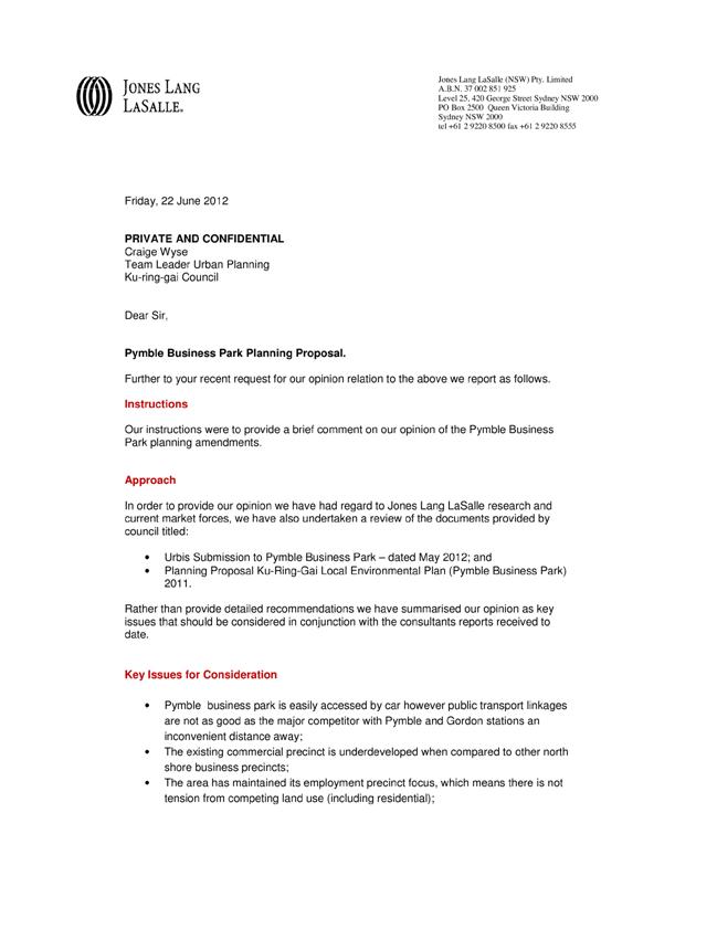
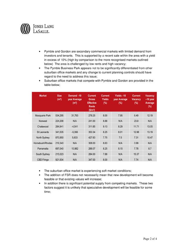
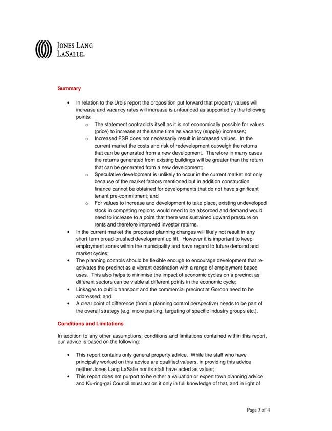
|
Ordinary Meeting of Council - 17 July 2012 |
GB.13 / 460 |
|
|
|
|
Item GB.13 |
S07252 |
|
|
19 June 2012 |
205 Mona Vale Road, St Ives - Lease Renewal
EXECUTIVE SUMMARY
|
purpose of report: |
For Council to consider the lease renewal of 205 Mona Vale, St Ives, to the current tenants for a five (5) year term. |
|
|
|
|
background: |
The restaurant has been under lease from Council since 1994. The current tenants have operated a business from the premises since that time. |
|
|
|
|
comments: |
Given that the lease area resides upon community classified land and the commercial use of the premises, a five (5) year term is the maximum term permissible under the Local Government Act, 1993, without the need to undertake an Expression of Interest (EoI) or a tendering process as stated in S46A of Local Government Act, 1993 . |
|
|
|
|
recommendation: |
That Council enter into a lease agreement for a further five (5) years with Lasamart Pty Ltd, in the terms and conditions contained within the report. |
Purpose of Report
For Council to consider the lease renewal of 205 Mona Vale, St Ives, to the current tenants for a five (5) year term
Background
The Old School Trattoria restaurant is one of a number of buildings located on the site of the former St Ives Public School. The land is classified as community land and zoned Special Uses 5(a) “Municipal Purposes” under the Ku-ring-gai Planning Scheme ordinance [KPSO] and zoned B2 Local Centre under the draft Ku-ring-gai Local Environment Plan (Local Centres) 2012.
The land is covered by the “Community Groups Centre and Car Park, St Ives” Plan of Management (PoM), and the original approval for use was granted pursuant to the planning provisions relating to conservation incentives for heritage items.
The restaurant has been under lease from Council since 1994. The current tenants have operated a business from the premises since that time.
Comments
The lease is due to expire on 14 December 2012, and the current tenants are seeking a further five (5) year lease term (Attachment A1). Given that the lease area resides upon community classified land and the commercial use of the premises, a five (5) year term is the maximum term permissible under the Local Government Act, 1993, without the need to undertake an Expression of Interest (EoI) or a tendering process as stated in S46A of Local Government Act, 1993.
During their eighteen (18) years of occupancy the lessees have proven themselves capable and reliable tenants.
The lessees are proposing to replace the existing air conditioning system at the premises and have requested Council to consider contributing 50% of the cost towards the replacement system. They have also raised the ongoing problem with the pavement directly in front of the entrance to the building which pools with water and soil runoff during extended wet periods and becomes extremely slippery. This request is not unreasonable and will enhance Council’s asset. As part of the request is structural, of which Council is responsible for as landlord. It is proposed that any structural improvements will be developed as part of Council’s annual Building Maintenance Program or through rental abatement to offset the relevant cost.
Should Council approve a further term to the tenants a rental valuation will be undertaken by a registered Valuer to determine the new market rental.
Governance Matters
The PoM expressly authorises the proposed lease, and public notification of the lease is required in accordance with S47A of the Local Government Act, 1993 and would commence subject to approval by Council.
Council’s solicitor Matthews Folbigg Pty Ltd, would prepare the draft lease documentation and Disclosure Statement in accordance with the Retail Leases Act, 1994.
Risk Management
A rental determination will be undertaken by a registered valuer to determine the market rental. Subject to the valuation staff will negotiate essential lease terms and any potential request for a rent abatement.
The tenants have demonstrated they are responsible and financially capable to pay rent and take on a further lease term.
In accordance with the provisions of the Retail Leases Act, 1994 each party is responsible for their legal costs.
Financial Considerations
Should Council approve a further term to the tenants a rental valuation will be undertaken by a registered Valuer to determine the new market rental.
It is likely that Council will contribute towards improvement costs associated with any upgrade. However, this will be developed as part of Council’s annual Building Maintenance Program or through a rental abatement.
Social Considerations
The communities adopted vision identified in the Community Strategic Plan 2009, states that Ku-ring-gai is a place with strong and stable local economy and that Council is financially sustainable.
The continuing occupancy of the premises contributes towards this community vision.
Environmental Considerations
Nil.
Community Consultation
As the lease area is upon community classified land and given the commercial use of the premises, a five (5) year term is the maximum term permissible under the Local Government Act, 1993, without the need to undertake an Expression of Interest (EoI).
Due to the community classification of the land, public notification of the proposed lease is required to be undertaken in accordance with S47A Local Government Act, 1993.
Internal Consultation
Not required.
Summary
The lease over the premises is due to expire on 14 December 2012. The current tenants are seeking a further five (5) year lease term. The current tenants have occupied the premises since 1994, and have demonstrated during this time that they are responsible and financially capable to pay rent, and take on a further lease term.
The lessees are proposing to replace the air conditioning system at the premises and have requested that Council contribute towards 50% of the costs. This is not unreasonable and will enhance Council’s asset. Furthermore, Council’s Building Assets team would provide input into the selection and installation on an appropriate system to ensure compliance with current standards and the heritage aspect of the building. Structural improvements at the premises of which Council is responsible for as landlord will be developed as part of Council’s annual Building Maintenance Program or through a rental abatement.
Should Council approve a further lease term a rental determination will be undertaken by a registered Valuer to establish the new market rental, and staff will negotiate the terms and conditions of the new lease, along with proposed upgrades and potential rental abatement inline with commercial practices.
As the lease area is upon community classified land and given the commercial use of the premises, a five (5) year term is the maximum term permissible under the Local Government Act, 1993, without the need to undertake an Expression of Interest (EoI). Due to the community classification of the land, public notification of the proposed lease is required to be undertaken in accordance with S47A Local Government Act, 1993.
|
A. That Council enter into a lease agreement for a further five (5) years with Lasamart Pty Ltd.
B. That the Mayor and General Manager are delegated authority to execute all documentation associated with the lease.
C. That the General Manager or his delegate are authorised to negotiate the commercial terms of the new lease as discussed within the report.
D. That Council affix the Common Seal to any necessary documents.
E. That public notification of the proposed lease be undertaken in accordance with Section 47A of the Local Government Act, 1993.
|
|
Deborah Silva Manager Integrated Planning, Property & Assets |
Andrew Watson Director Strategy & Environment |
|
A1View |
Renewal of lease - The Old School Trattoria - 205 Mona Vale Road St Ives |
|
2012/161268 |
|
APPENDIX No: 1 - Renewal of lease - The Old School Trattoria - 205 Mona Vale Road St Ives |
|
Item No: GB.13 |
|
Ordinary Meeting of Council - 17 July 2012 |
GB.14 / 465 |
|
|
|
|
Item GB.14 |
S02696 |
|
|
29 June 2012 |
Bicycle Reference Committee - Notes of Meeting held 4 April 2012
EXECUTIVE SUMMARY
|
purpose of report: |
To bring to the attention of Council the proceedings of the Bicycle Reference Committee meeting held on Wednesday, 4 April 2012. |
|
|
|
|
background: |
In 2009, Ku-ring-gai Council appointed four (4) community reference committees under section 260 of the Local Government (General) Regulation, 2005, and in October 2011 resolved to form a Bicycle Reference Committee. |
|
|
|
|
comments: |
Notes of the Bicycle Reference Committee meeting of 4 April 2012 are included as Attachment A1 to this report. |
|
|
|
|
recommendation: |
That the notes of the Bicycle Reference Committee meeting of 4 April 2012 be received and noted. |
Purpose of Report
To bring to the attention of Council the proceedings of the Bicycle Reference Committee meeting held on Wednesday, 4 April 2012.
Background
In 2009, Ku-ring-gai Council appointed four (4) community reference committees under section 260 of the Local Government (General) Regulation, 2005. In October 2011 Council further resolved to form a Bicycle Reference Committee. The role of this committee is to advise Council on issues relating to cycling. The committee currently consists of twelve (12) representatives. The Chairperson is Councillor Holland and Deputy Chair is Councillor Malicki.
Comments
Notes of the Bicycle Committee meeting of 4 April 2012 are included as Attachment A1 to this report. In summary the committee discussed the following items:
Item 1 Code of Conduct
The Internal Ombudsman gave a brief introduction as to his purpose and role, and described how the code of conduct applies to the committee.
Item 2 Bicycle Plan update
There was discussion from the committee members about all aspects of the draft Bicycle Plan report, which could be summarised into the following key themes:
· Prioritisation of routes;
· Lack of north-south route west of Pacific Highway;
· Cost estimates;
· Route configuration;
· Funding sources;
· Regional routes map/context; and
· Schools.
Item 3 Cycling Map update
The representative of pedestrians’ interests was thanked for his input into the trails component of the map, and the committee was advised that consultation with NSW National Parks is now underway, for consistency of routes in National Parks.
Governance Matters
The Bicycle Reference Committee was formed by Council under charter and terms of reference as adopted in May 2009. As noted in the background section in this report the Committee is constituted under section 260 of the Local Government (General) Regulation, 2005.
Risk Management
There are no significant risk management issues arising from this report or its recommendations.
Financial Considerations
There are no financial considerations associated with this report.
Social Considerations
The Bicycle Reference Committee is an advisory committee of Council comprising 12 community members. Information and issues discussed by the Committee are in turn shared with other peak groups across the local government area whose members have been appointed to the committee.
Environmental Considerations
Through the actions of the committee, the role of cycling within Ku-ring-gai as a sustainable option for transportation and as a healthy physical activity would be elevated. By encouraging and promoting cycling, there is the potential to make significant changes to transport patterns by shifting the high number of short trips (that are currently undertaken by car) to cycling.
Community Consultation
The Committee is a community forum and no further consultation is required. Details of the committee, presentation material, notes and reports can be obtained from Council’s website.
Internal Consultation
This report was prepared by the Strategy and Environment Department.
Summary
The Bicycle Reference Committee discussed three (3) items at its meeting on 4 April 2012. These included:
1. The Code of Conduct;
2. An update on the review of the Bicycle Plan; and
3. The Cycling Map.
|
That the notes of the Bicycle Reference Committee meeting held on Wednesday, 4 April 2012 be received and noted.
|
|
Joseph Piccoli Strategic Traffic Engineer |
Antony Fabbro Manager Urban & Heritage Planning |
|
Andrew Watson Director Strategy & Environment |
|
|
A1View |
Bicycle Reference Committee - Meeting of 04/04/2012 - Notes of meeting |
|
2012/089001 |
|
APPENDIX No: 1 - Bicycle Reference Committee - Meeting of 04/04/2012 - Notes of meeting |
|
Item No: GB.14 |
 Bicycle Reference Committee
Wednesday 4 April, 2012 - 6.00 to 7.30pm
Ante Room - Council Chambers, Level 3, 818 Pacific Highway, Gordon.
NOTES OF MEETING
Attendance
|
Councillors |
Cr Steven Holland (Chair) |
|
Council Staff |
Joseph Piccoli – Strategic Transport Engineer Michael Langereis (Internal Ombudsman, Ku-ring-gai Council) |
|
State Agencies |
Greg Kevill – Roads and Maritime Services Kathryn Hawkins – Roads and Maritime Services |
|
Community |
Mick Watts Rowan Bouttel Penn Hsiang Lyness Beavis John Martyn Ian Jackson Richard Measures Peter Tuft – Bike North Tony Arnold – Bike North |
|
Apologies |
Cr Elaine Malicki (Deputy Chairperson) Jon Leighton – Bicycle NSW |
Councillor Holland opened the meeting at 6.05pm
Declarations of Interest
None
Confirmation of Previous Notes
There was no objection to the previous notes as circulated.
Item 1: Code of Conduct
Michael Langereis gave a brief introduction as to the purpose and role of the Internal Ombudsman. He also described how the code of conduct applies to the committee, particularly in relation to conflicts of interest (perceived or otherwise), and gave examples of other aspects where the code applies, such as gifts and benefits, and privacy.
Item 2: Bicycle Plan Update
Joseph Piccoli introduced the interim draft Bicycle Plan report (which was circulated to the members prior to the meeting in confidence), and noted that there are key sections such as the behaviour change component that were not yet completed in time for the meeting. There was discussion from the committee members about all aspects of the draft report, which could be summarised into the following key themes:
· Prioritisation of routes
The committee members noted that there were very few high priority routes and a larger number of medium and low priority routes. There was uncertainty as to how the high/medium/low categories were established, so it was suggested that the high/medium/low labels be removed completely and that projects be prioritised with the numerical total score only.
It was also suggested that the route hierarchy criteria of the weighting system (currently 5%) be increased, to reflect the importance of route continuity.
· Lack of north-south route west of Pacific Highway
It was noted that there is little connectivity in the north/south direction on the western side of Pacific Highway and that The Comenarra Parkway/Yanko Road/Lady Game Drive route could be considered to provide this connectivity. Also, it was suggested that the “Roseville 3” route should connect to Fullers Road/Millwood Avenue via Lady Game Drive, as Fullers Road is a formal route in the Willoughby Bike Plan.
· Cost estimates
There was some concern that the costings for the routes do not reflect existing conditions on the road, and that unit rates were applied over the whole length of a project. For example, there is a high cost for shoulder widening on Bobbin Head Road but it was felt it would not be necessary for the full length. It was suggested that costings be reported separately so as not to raised expectations. Some committee members thought it was unclear what the rationale for the costings were.
It was also suggested that more detailed costings and designs be undertaken for the 3 high priority routes, so that they could be submitted to the next round of funding programs.
· Route configuration
Some committee members would like more clarity on what type of cycling facilities were being proposed on the routes. The Roads and Maritime Services representative advised that the bike plan indentifies the route and priority, and configuration of the route is typically determined following detailed investigation, design and consultation.
The Bike North member suggested the separation treatments were more appropriate for greenfields sites, and the bike plan should recognise this. Also, he suggested there should be more mention of the non-separation treatments i.e. painted logos and signposting, which would be more relevant for a number of routes in Ku-ring-gai.
· Funding sources
The range of funding sources available for cycling projects was considered to be limited, with some committee members aware of various state and federal funding programs that could fund cycleways.
· Regional routes map/context needs to be strengthened
It was suggested that the NSW Bike Plan’s regional cycling map be shown in the bike plan, to highlight the importance of the strategic routes.
· Schools
The committee considered that schools need to have more focus in the bike plan, to encourage cycling at an early age.
Joseph Piccoli advised that there would be a further opportunity to comment on the bike plan, when it is placed on public exhibition.
Item 3: Cycling Map update
Joseph Piccoli thanked John Martyn for his input into the trails component of the map. Joseph also advised the committee that consultation with NSW National Parks is now underway, for consistency of routes in National Parks.
It was suggested that the map indicate where cycling maps from adjoining areas are available.
Meeting closed: 8.00pm
|
Items for next meeting
1. Bike Plan review
2. Cycling Map update
|
Ordinary Meeting of Council - 17 July 2012 |
GB.15 / 471 |
|
|
|
|
Item GB.15 |
S09260 |
|
|
13 April 2012 |
EOI 12/2012 - Road and Footpath Sweeping Contract
EXECUTIVE SUMMARY
|
purpose of report: |
To consider Expressions of Interest (EoI) for Council’s road and footpath sweeping service. |
|
|
|
|
background: |
A further review of Council’s roads and footpath cleaning was recently undertaken. Council previously reviewed this service in 2003 and adopted levels of service for the various activities. As part of the recent review, an Expression of Interest was called to assess the viability and opportunity for improvements in Council delivering these services by Contract. |
|
|
|
|
comments: |
Assessment of the Expression of Interest identifies opportunities are available to improve the services at lower costs to existing services. Any decision to move to delivering these services, under Contract, would not result in staff redundancies due to current vacancies. To proceed with the review, it is proposed to call selective tenders to more accurately determine the associated costs with each service. |
|
|
|
|
recommendation: |
That Council proceed with a Selective Tender for its Roads and Footpath Sweeping Contract and that the four (4) Expressions of Interest respondents be invited to tender for these services. |
Purpose of Report
To consider Expressions of Interest (EoI) for Council’s road and footpath sweeping service.
Background
A further review of Council’s roads and footpath cleaning was recently undertaken. Council previously reviewed this service in 2003 and adopted levels of service for the various activities.
As part of the recent review, an Expression of Interest was called to assess the viability and opportunity for improvements in Council delivering these services by Contract.
This is considered timely due to a number of staff vacancies due to employees retiring and leaving Council. Also, the escalating costs of plant replacement and maintenance costs with the sweeper fleet and other plant associated with unmade gutters cleaning and footpath cleaning could be better managed by contract to take advantage of the economies of scale if handled by a contractor.
The option to consider enhancements to the cleaning of footpaths on main roads has been included to determine if opportunities will result with these services being conducted outside of business hours and by special plant to clean the footpath surfaces.
Council’s day labour staff would continue to provide litter control and footpath cleaning to the neighbourhood centres.
Comments
An Expression of Interest was called for the road and footpath cleaning service currently performed by Council. Council has four (4) mechanical sweepers in the operational fleet and the vehicles cost approximately $300,000 each to purchase and after six (6) to seven (7) years Council only receives approximately $30,000 for the disposal of the plant. The ongoing repairs to these vehicles takes up a lot of time for the workshop mechanics and the plant could be out of service for up to a week waiting on repairs and replacement parts. This impacts on the other servicing of the operational and small plant due to the urgent nature to get this vehicle back in service.
Four (4) companies responded to the Expression of Interest.
1. Specialised Road Services Pty Ltd (SRS)
2. Economy Sweep Pty Ltd
3. Assetlink Services T/as AssetLink
4. All Sweeper Hire Pty Ltd
Indicative costs are as follows for 2012/2013:
|
STREET SWEEPING |
|||||
|
|
|||||
|
Expenses |
Council |
SRS |
Economy Sweep |
Assetlink |
All Sweep |
|
Budget |
$ 445,022 |
$ 750,000 |
$ 530,000 |
$ 762,000 |
$ 496,860 |
|
Disposal |
$ 258,500 |
$ 258,500 |
$ 258,500 |
$ 258,500 |
$ 258,500 |
|
Depot Cleaning |
|
|
|
|
|
|
Plant replacement |
$ 100,000 |
|
|
|
|
|
Maintenance |
$ 249,575 |
|
|
|
|
|
Sub Total |
$1,053,097 |
$ 1,008,500 |
$ 788,500 |
$ 1,020,500 |
$ 755,360 |
|
|
|
|
|
|
|
|
UNMADE GUTTERS |
|||||
|
|
|
|
|
|
|
|
Expenses |
Council |
SRS |
Economy Sweep |
Assetlink |
All Sweep |
|
Budget |
$ 116,447 |
$ 59,700 |
$ 86,000 |
$ 276,000 |
included in above |
|
Disposal |
$ 20,100 |
$ 20,100 |
$ 20,100 |
$ 20,100 |
$ 20,100 |
|
Sub Total |
$ 136,547 |
$ 79,800 |
$ 106,100 |
$ 296,100 |
$ 20,100 |
|
|
|
|
|
|
|
|
Sub Total |
$ 1,189,644 |
$ 1,088,300 |
$ 894,600 |
$ 1,316,600 |
$ 775,460 |
|
|
|
|
|
|
|
|
FOOTPATH CLEANING (optional) |
|||||
|
|
|
|
|
|
|
|
Expenses |
Council |
SRS |
Economy Sweep |
Assetlink |
All Sweep |
|
|
Subject to selective tender & savings |
$ 205,800 |
$ 125,000 |
$ 162,000 |
$ 149,060 |
|
Total All Services |
|
$ 1,294,100 |
$ 1,019,600 |
$ 1,478,600 |
$ 924,520 |
Evaluation of the Expression of Interest indicates these services have the potential to be delivered at better cost to that provided by Council’s day labour. Further advantages are evident with potential savings associated with the plant replacement and maintenance budgets, together with a contractor providing greater flexibility for the application of plant that best suits the service needs. There is potential for improvements to reporting such as using GPS tracking and electronic reporting and service delivery outside of day labour hours which is not currently available under existing services.
It should be noted however, the cost indications provided are estimates only and are not binding to the contractor and this will only be determined by tender.
To progress the review process further it is considered appropriate to call for a Selective Tender with the companies that replied to the Expression of Interest. This will need to be carried out to allow the contractors an opportunity to fully consider their proposals and cost their services relative to a term contract. To allow for the amortisation of plant and to account for plant rotation in a cost effective manner, a seven (7) year contract with a three (3) year option would be proposed. This is similar to the timeframe associated with Council’s Waste collection service for the same reason.
The service will require the selected companies to submit their proposals based on a street cleaning schedule for all kerbed roads being completed each month, unmade gutters cleaned every second month and footpaths on main roads cleaned weekly.
It is recommended that all four (4) companies that responded to the Expression of Interest be invited to tender for the delivery of these services.
Governance Matters
Calling of Expressions of Interest and Tenders is covered under Section 55 of the Local Government Act and the associated Regulations.
Risk Management
Risk management matters will be further assessed as part of the Selective Tender process including the various companies’ financial capacities.
Financial Considerations
Costs associated with services will be assessed in detail with the Selective Tender submissions but it appears that savings can be made by contracting out this service which could be reallocated to increased services for this important Council activity.
Social Considerations
The review, including the tender process, is designed to consider improvements to services to benefit the community and possibly increase the service levels.
Environmental Considerations
Enhanced cleansing services are likely to contribute to positive environmental outcomes.
Community Consultation
The review process is in response to community expectations for cleansing services and continual breakdowns result in adverse comments for the public about the services not being performed.
Internal Consultation
This was considered as part of the internal review carried out by external consultants and endorsed in their recommendations.
Summary
A further review of Council’s roads and footpath cleaning was recently undertaken. Council previously reviewed this service in 2003 and adopted levels of service for the various activities.
As part of the recent review, an Expression of Interest was called to assess the viability and opportunity for improvements in Council delivering these services by Contract.
This is considered timely due to a number of staff vacancies due to employees retiring and leaving Council. Also, the escalating costs of plant replacement and maintenance costs with the sweeper fleet and other plant associated with unmade gutters cleaning and footpath cleaning could be better managed by contract to take advantage of the economies of scale if handled by a contractor.
It is recommended that Council proceed with the calling of a Selective Tender from the four (4) respondents to the Expressions of Interest for a seven (7) year contract term with a three (3) year extension option.
|
A. That Council proceed with calling a Selective Tender for its Roads and Footpath Sweeping Contract.
B. That all four (4) respondents to the Expression of Interest be invited to Tender under a selective tender process for the street sweeping of roads and footpath cleaning services for a seven (7) contract term with a three (3) year extension option.
|
|
Colin Wright Manager Waste, Drainage & Cleansing |
Greg Piconi Director Operations |
|
Ordinary Meeting of Council - 17 July 2012 |
GB.16 / 476 |
|
|
|
|
Item GB.16 |
S06118/5 |
|
|
27 June 2012 |
Federal Nation Building Black Spot Projects 2012-2013
EXECUTIVE SUMMARY
|
purpose of report: |
To seek acceptance of the 2012/2013 Federal Nation Building Black Spot grant for the upgrade of the road surface and superelevation of Eastern Arterial Road, St Ives near Burraneer Avenue. |
|
|
|
|
background: |
Council has applied for a grant for the upgrade to the road surface and superelevation (crossfall) under the 2012/2013 Federal Nation Building Black Spot Program. The Roads and Maritime Services has now advised that Council was successful in obtaining a grant of $351,428 to upgrade the seal to high friction surface, and provide appropriate superelevation. |
|
|
|
|
comments: |
The upgrade of the section of Eastern Arterial Road is considered essential to overcome accidents, the majority of which occur in wet weather. The Roads and Maritime Services has advised Council of the grant under the Federal Nation Building Black Spot Program and the conditions associated with the grant |
|
|
|
|
recommendation: |
That the Roads and Maritime Services be advised of Council's acceptance of the grant and the terms and conditions associated with the grant. |
Purpose of Report
To seek acceptance of the 2012/2013 Federal Nation Building Black Spot grant for the upgrade of the road surface and superelevation of Eastern Arterial Road, St Ives near Burraneer Avenue.
Background
Council at its meeting of 11 August 2009 considered the minutes of the Traffic Committee relating to the nominations for the 2012/13 Black spot funding.
Council resolved to submit a number of projects for funding assistance including the upgrade of the road surface and superelevation of Eastern Arterial Road, St Ives near Burraneer Avenue. Conditions at this site were considered by the Ku-ring-gai Traffic Committee/Council in September/October 2010.
Analysis of reported accidents and anecdotal evidence from a resident have confirmed that there is a problem, particularly in wet weather, with vehicles running off the road or colliding head-on on the steep downhill section of Eastern Arterial Road between the crest at Barra Brui Crescent and Nicholson Avenue. A reduction in the speed limit, enhancement of the line marking, painting of a section of kerb and additional signposting were interim measures adopted to address the problem.
The proposed treatment involving adjustments to superelevation and application of a skid-resistant pavement is considered to be a long term solution, particularly as crashes mostly occur in wet weather.
The Roads and Maritime Services has now advised that Council was successful in obtaining a grant of $351,428 for the upgrade to the road surface and superelevation (crossfall).
Comments
Attached is a copy of the letter from the Roads and Maritime Services advising of the grant and the conditions associated with the acceptance of the grant.
Council is normally required to advise the Roads and Maritime Services of the acceptance of the grant by 20 July 2012.
If approved by Council the project will be included in the 2012/13 Capital Works program.
Governance Matters
Through Council’s adopted Traffic and Transport Policy and the Federal Black Spot Program’s BCR nomination process, a clear and transparent method of allocating funds to projects is set out.
Risk Management
Council’s Traffic and Transport Policy calls for prioritisation of traffic management works based on set criteria which includes accident history/costs. This helps to identify and prioritise sites requiring treatment to address accident histories and other factors.
The Federal Black Spot program provides funding assistance to councils by prioritising nominations through its BCR analysis.
Treating high priority sites reduces accident risks on council controlled roads.
Financial Considerations
The Black Spot grant is fully funded by the program and as such Council is not required to contribute to the funding. If approved by Council, the project will be included in the 2012/13 Capital Works program under the Traffic Facilities program.
Social Considerations
The non-financial cost of accidents to the community can be high, and treatments to minimise accidents or reduce their severity provides benefits not only to Ku-ring-gai residents but to the wider community.
Environmental Considerations
Projects involving pavement rehabilitation have the opportunity to consider utilising recycled materials where appropriate.
Community Consultation
No direct consultation has taken place with the residents of the area but following acceptance of the grant, local residents will be advising of the proposed work. Temporary notices will need to be installed only for the period of construction advising of the Federal Government’s Black Spot funding.
Internal Consultation
Consultation has taken place with staff from Strategy and Environment and Corporate Departments with regard to the program and funding.
Summary
Council has requested assistance with the funding for the upgrade Eastern Arterial Road St Ives, near Burraneer Avenue, which was considered to be a black spot under the criteria for black spot funding.
The upgrade of the section of Eastern Arterial Road is considered essential to overcome accidents, the majority of which occur in wet weather.
The Roads and Maritime Services has advised Council of the grant under the Federal Nation Building Black Spots Program and the conditions associated with the grant. Council staff will undertake the design for the work and arrange for installation before June 2013.
|
That the Roads and Maritime Services be advised of Council's acceptance of the grant of $351,428 for the upgrade of the road surface and superelevation of Eastern Arterial Road St Ives, near Burraneer Avenue.
|
|
Joseph Piccoli Strategic Traffic Engineer |
Greg Piconi Director Operations |
|
A1View |
Letter from Roads & Maritime Services |
|
2012/135796 |
|
Ordinary Meeting of Council - 17 July 2012 |
GB.17 / 487 |
|
|
|
|
Item GB.17 |
S09289/2 |
|
|
13 April 2012 |
T55/2012 - Design and Construction of
Ku-ring-gai Emergency Services Facilities
EXECUTIVE SUMMARY
|
purpose of report: |
For Council to consider the tenders for the design and construction of Ku-ring-gai State Emergency Services and Bush Fire Brigade Emergency Services Facilities within Golden Jubilee Field, North Wahroonga and for Council to accept the tender from the preferred tenderer. |
|
|
|
|
background: |
On 13 December 2011, an approved Development Application was obtained. A formal Expression of Interest (EoI) process was held to qualify suitable tenderers for the construction of facilities. This closed on 13 December 2011. Results of the EoI were reported to and approved by Council on 7 February 2012. |
|
|
|
|
comments: |
Following architectural recommendations, consultants have prepared contract documentation for the purpose of obtaining a Construction Certificate. Tenders were called from approved selected companies following the EoI process. A tender was called in May 2012 and closed on 5 June 2012. A Construction Certificate will be obtained through a Private Certifying Authority. |
|
|
|
|
recommendation: |
That Council decline to accept any tender and negotiate with the preferred tenderer, Taylor Construction Group Pty Ltd. |
Purpose of Report
For Council to consider the tenders for the design and construction of Ku-ring-gai State Emergency Services and Bush Fire Brigade Emergency Services Facilities within Golden Jubilee Field, North Wahroonga and for Council to accept the tender from the preferred tenderer.
Background
On 13 December 2011, an approved Development Application was obtained for the demolition of existing structures and the construction of new facilities for the Ku-ring-gai State Emergency Services and Bush Fire Brigade.
A formal Expression of Interest (EoI) process was held to qualify suitable tenderers for the construction of facilities. The EoI closed on 13 December 2011. Results were reported to Council on 7 February 2012, who approved the calling of select tenders and that a further report be brought back to Council following the evaluation of select tenders submitted.
A Selective Tender was called in May 2012 from approved selected companies and closed on 5 June 2012.
Architectural advice was provided recommending a design team prepare 80% full construction documentation (comprising of tender drawings and specifications), allowing the remaining 20% for value engineering. This would enable a proper design and construction process with a fixed lump sum for the administration of the tender.
Consultants have prepared detailed documentation to accompany the application for the Construction Certificate
The Construction Certificate is being obtained through a Private Certifying Authority.
Comments
Council resolved to call tenders from seven (7) companies. Brisland Pty Ltd was part of the Kell & Rigby Group which had ceased building on 9 February 2012. It was placed in [voluntary] administration thereafter. Tenders were not sought from Brisland Pty Ltd.
Tenders were called through Tenderlink and five (5) tenders were received from:
§ Kane Constructions (NSW) Pty Ltd
§ Denham Constructions Pty Ltd
§ Gartner Rose Pty Ltd
§ Taylor Construction Group Pty Ltd
§ Time Cost and Quality Pty Ltd
A Tender Evaluation Panel was formed comprising staff from Operations and Strategy and Environment as well as Council’s Architect. This was to ensure independent expert advice was applied.
A Tender Evaluation Assessment Scorecard was prepared based on the weighted criteria in the tender documents. The report prepared from the evaluation by the Tender Evaluation Panel is attached.
Clarifications and additional information were requested as some submissions were unclear. Worthwhile cost savings were offered in the submissions. Consequently, before signing of the contract, Council would need to negotiate with the preferred tenderer for clarification of any unclear information and possible indicative cost savings, in order to protect Council’s interest.
Governance Matters
Tenders were called in accordance with Section 55 of the Local Government Act, 1993 and associated tendering regulations. Tender documents were developed in accordance with Council’s Tendering Procedure and sign-off by the internal Tender Review Committee.
The attachments are considered to be confidential in accordance with section 10A (2) (d) (iii) of the Local Government Act, 1993 as they are considered to contain commercial in confidence information.
Risk Management
Preparation of approximately 80% of full construction documentation was provided for quality control and scope and to avoid costing risks. The Development Application drawings did not cover the full scope of work nor detail required
Costing risk is associated with areas requiring specific design development and must be adequately costed. Such areas relate to the bush fire report and the Building Code of Australia specifications.
Inherent with construction, there will be risks associated with variations and latent conditions. A contingency amount has been included in the funding for the project in the event of these risks.
Project risk arising from wet weather and latent conditions from previous landfill activities are possible concerns. Contractors make allowance for wet weather in their timetable. It will be necessary to negotiate wet weather contingencies with the preferred tenderer, prior to the release of the contract, in order to minimise the risk to Council.
Council engaged Geotechnical Engineers to undertake extensive soil investigation and analysis to minimise the risk of contamination issues arising from excavation and piling works. The positioning of the new buildings is not located on the former landfill area but predominantly on natural land. Piling will be to natural bedrock material.
Hazards, predominately from bushfire threat, have been considered in the design. The project site is located with a BAL-FZ (Bushfire Attack Level – Flame Zone). Therefore, the building design has been done to comply with AS3959-2009 ‘Construction of Buildings in Bushfire Prone Areas’ BAL-FZ construction provisions.
Financial Considerations
Council has provided sufficient funding in the Capital Works Program 2012/2013 for the construction of the Emergency Services Facilities, including a contingency amount available for any potential variations and assumptions made by the preferred tenderer.
Social Considerations
This work forms part of Council’s on-going commitment to upgrade essential building infrastructure that support combat agencies responding to hazards throughout the Council area. The facilities will provide training and operational rooms essential for emergency planning, preparedness, response and recovery.
Environmental Considerations
All tenderers were required to submit an Environmental Management Plan comprising details of systems, polices, audits and monitoring programs. The effectiveness of the Environmental Management Plan was considered during the tender assessment.
Prior to commencement of the development, an erosion and sediment control plan is required to be submitted and approved by the Private Certifying Authority.
Community Consultation
The community has been notified of the proposed works in accordance with the Development Control Plan No56 – Notification.
The Ku-ring-gai State Emergency Services and Bush Fire Brigade have been extensively engaged and consulted in the design and documentation for this development.
Internal Consultation
Staff from the Operations Department, Strategy and Environment Department and Development and Regulatory Department has been consulted.
Summary
Tenders were called in May 2012 through Tenderlink from six (6) approved selected companies. Five (5) tenders were received from:
§ Kane Constructions (NSW) Pty Ltd
§ Denham Constructions Pty Ltd
§ Gartner Rose Pty Ltd
§ Taylor Construction Group Pty Ltd
§ Time Cost and Quality Pty Ltd
A Tender Evaluation Panel was formed comprising of staff from Operations Department and Strategy and Environment Department as well as Council’s architect, in order to ensure independent expert advice was applied.
An evaluation was undertaken of all five (5) submissions in accordance with the price and non-priced criteria. The report prepared from the evaluation by the Tender Evaluation Panel is attached.
Prices submitted by Gartner Rose Pty Ltd and Time Cost and Quality were substantially higher than the prices submitted by Taylor Construction Group Pty Ltd, Kane Construction (NSW) Pty Ltd and Denham Constructions Pty Ltd.
The following three (3) companies were short listed for further detailed evaluation.
§ Taylor Construction Group Pty Ltd
§ Kane Constructions Pty Ltd
§ Denham Constructions Pty Ltd
The detailed evaluation comprised:
§ Further requests for clarifications and additional information and
§ Post tender interviews held with each tenderer in which to gain their understanding of the project, as well as explain assumptions or qualifications.
To ensure Council would not be exposed to financial risk and that the three (3) companies are trading in a sound and profitable manner, all companies were referred to Corporate Scorecard for an independent Financial and Performance Assessment. Detailed Financial Assessments for each company are attached as confidential attachments.
Following the evaluation of all tenderers received, the Tender Evaluation Panel recommended Taylor Construction Group Pty Ltd as the preferred tenderer to undertake the construction of the Emergency Service Facilities.
As there were assumptions and qualifications in all tenders received, it is appropriate for Council to not accept any of the tenders and negotiate with the preferred tenderer for the purpose of entering into a contract for the construction of the new Emergency Services Facilities.
None of the assumptions and qualifications listed in the tender are likely to cause any major issues for Council and these matters will be resolved during negotiations and contract development.
|
A. That
Council decline to accept any tender and negotiate with the preferred
tenderer, Taylor Construction Group Pty Ltd, for the construction of the
Emergency Services Facilities at
B. That Council note the reasons for declining to accept any tender is because of assumptions and offers of savings associated with all the tenders received and hence they were determined to be non conforming tenders.
C. That the contract agreements be referred to Council’s solicitor for preparing the contract documents to protect Council’s interest.
D. That the Mayor and General Manager be delegated authority to execute all tender documentation on Council’s behalf in relation to the contract.
E. That the seal of Council be affixed to the contract documents.
F. That all tenderers be advised of Council’s decision in accordance with Clause 178 of the Local Government Tendering Regulations and that advice of the accepted tender and amount be placed on Council’s noticeboard and web site once the final price has been determined following negotiations.
|
|
Ian Taylor Manager Engineering Services |
Greg Piconi Director Operations |
|
Submitted Prices for Tender |
|
Confidential |
||
|
|
Tender Evaluation Panel Report |
|
Confidential |
|
|
|
Detailed Financial Assessment Taylor Construction Group |
|
Confidential |
|
|
|
Detailed Financial Assessment for Kane Construction |
|
Confidential |
|
|
|
Detailed Financial Assessment for Denham Construction |
|
Confidential |
|
Ordinary Meeting of Council - 17 July 2012 |
GB.18 / 493 |
|
|
|
|
Item GB.18 |
S09261/2 |
|
|
13 April 2012 |
Open Space Grass Mowing Services Contract
EXECUTIVE SUMMARY
|
purpose of report: |
For Council to consider the tender received for the mowing of parks, sportsfields, road reserves and laneways and appoint the preferred tenderer. |
|
|
|
|
background: |
In conjunction with Operational staff Council engages contractors to undertake the mowing of Open Space Areas as part of its overall maintenance program. Funding will come from existing recurrent budgets. |
|
|
|
|
comments: |
Public tenders were called on 19 May 2012 and closed on 12 June 2012. Council has proposed a contract term initially of three (3) years, with an option for an extension of two (2) years. Tender documents were produced with seven (7) submissions received. The submissions were assessed using agreed criteria which identified the tender submission providing the best value to Council |
|
|
|
|
recommendation: |
That Council accepts the preferred tender from Hideaway Landscapes Pty Ltd T/as Envirolands Landscape Contractors for the provision of grass mowing services throughout Ku-ring-gai local government area. |
Purpose of Report
For Council to consider the tender received for the mowing of parks, sportsfields, road reserves and laneways and appoint the preferred tenderer.
Background
In conjunction with Operational staff, Council engages contractors to undertake the mowing of open space areas as part of its overall maintenance program. Funding will come from existing recurrent budgets.
Comments
Seven (7) tenders were received and recorded in accordance with Council’s tendering policy.
Tenders were received from the following companies:
1. The Green Horticultural Group Pty Ltd
2. Plateau Tree Services Pty Ltd
3. Marsupial Landscape Management Pty Ltd
4. Luhrmann Environmental Management Pty Ltd
5. Go Gardening Pty Ltd
6. Hideaway Landscapes Pty Ltd T/as Envirolands Landscape Contractors
7. CityWide Services Solutions Pty Ltd
A Tender Evaluation Committee (TEC) was formed consisting of staff from Open Space Services and Finance. The evaluation considered the total contract quoted cost, the ability to provide the full range of service, staff experience and resources.
Ability to provide a full range of service
1. References
2. Uniforms
3. Use of sub-contractors
4. Environmental Management
5. Workers Health and Safety
Staff experience
1. Does staff have the specific experience?
2. Length of service.
3. White card.
Resources
1. Vehicles
2. Plant
3. Access to extra staff during peak periods
From the information provided Hideaway Landscapes Pty Ltd T/as Envirolands Landscape Contractors and Marsupial Landscape Management Pty Ltd were identified as providing the best value to Council.
To ensure Council is not exposed to financial risk and that Hideaway Landscapes Pty Ltd T/as Envirolands Landscape Contractors and Marsupial Landscape Management Pty Ltd are trading in a sound and profitable manner, both companies were referred to Corporate Scorecard for an independent Financial and Performance Assessment.
The results from Corporate Scorecard revealed that Hideaway Landscapes Pty Ltd T/as Envirolands Landscape Contractors was rated with a marginal score of 3.74. Marsupial Landscape Management Pty Ltd was rated satisfactory with a score of 4.45.
To be consistent with Council’s Tendering Policy, and the risks associated with entering into contracts with an organisation that receives a “marginal” assessment, further measures needed to be considered to mitigate any risks to Council.
A meeting was held with the Manager of Finance to discuss the results of the assessments and to seek support for the TEC first recommendation. After the Managers’ review of the documentation, he agreed that risk for Council was low as it was a maintenance contract and payments were only made for works completed.
It was also discussed with the Manager Finance that the company Hideaway Landscapes Pty Ltd T/as Envirolands Landscape Contractors has been working with Council for the last six (6) years and their performance had been excellent.
A second and final meeting was held with the TEC to review the Corporate Scorecard results and to discuss any other options. It was agreed with all members of the committee that their preference was to stay with the initial recommendation of Hideaway Landscapes Pty Ltd T/as Envirolands Landscape Contractors.
The following attachments report the results of the evaluation process:
· List of tenders received. (Attachment 1)
· Tender Evaluation Spreadsheet (Attachment 2)
· Tender Evaluation Panel’s Meeting Minutes (Attachment 3)
· Detailed Financial Assessment as provided by Corporate Scorecard Pty Ltd.
(Attachment 4)
· Financial Assessment for Year Ending 2011. (Attachment 5)
Governance Matters
The attachments are considered to be confidential in accordance with Section 10A (2)(d)(iii) of the Local Government Act 1993 as they are considered to contain commercial in confidence information.
Risk Management
Three (3) key areas of risk were identified in relation to the proposed work:
§ Work needed to be carried out by a suitably qualified company with experience of grass mowing maintenance.
§ Have access to enough resource to complete cycles on time.
§ That Council should not be exposed to financial risk.
Maintenance Risk was addressed by ensuring works be undertaken by suitably qualified companies by demonstration of:
§ Good understanding of the requirements of the work required.
§ Sound previous experience of carrying out work of a similar nature.
§ High quality results in relation to previous work of a similar nature.
To ensure Council would not be exposed to financial risk, an independent Financial and Performance assessment was carried out by Corporate Scorecard Pty Ltd.
Given the assessment score, a further consultation with the organisation has been undertaken to ensure Council considers the relevant matters prior to entering into a Maintenance Contract with the preferred tenderer.
Four (4) items were considered:
· Length of contract being three (3) years with a two (2) year option is a relatively short term for a maintenance contract. The contract will be reviewed at the conclusion of the three (3) year term or before any extension is offered.
· On advice given from the Manager of Finance, the Grass Mowing Contract is considered a low financial risk for Council as new contractors could be engaged relatively quickly’
· Hideaway Landscapes Pty Ltd T/as Envirolands Landscape Contractors offer good value for money.
· Hideaway Landscapes Pty Ltd T/as Envirolands Landscape Contractors are an existing service provider with Council and have a proven track record.
Financial Considerations
Council has sufficient funds in its annual recurrent budget to maintain the open space areas to the required specifications.
Social Considerations
This work forms part of Council’s ongoing commitment to maintain the open space areas to a satisfactory standard.
Environmental Considerations
All companies had an Environmental Management System in place as required in the returnable schedule documentation.
Community Consultation
No community consultation was undertaken as this is an operational matter.
Internal Consultation
Staff from the Operations Department and the Corporate Department were consulted in the preparation, review and recommendation of the preferred contractor.
Summary
Tender T56/2012 was called on 19th May 2012 with a closing date of 12th June 2012. A Tender Evaluation Panel was formed consisting of representatives from Open Space Services and the Finance Department.
All tenderers demonstrated an understanding of the work required. Following the evaluation and independent performance and financial checks, it is recommended that Hideaway Landscapes Pty Ltd T/as Envirolands Landscape Contractors be appointed on the basis of providing the best value to Council and as an existing contractor to Council, their dealings with Council have been nothing but professional.
|
A. That Council accept the preferred tender submission from Hideaway Landscapes Pty Ltd T/as Envirolands Landscape Contractors to provide the grass mowing service for a period of three (3) years with a two (2) year option.
B. That the Mayor and General Manager be delegated authority to execute all tender documents on Council’s behalf in relation to the contract.
C. That the Seal of Council be affixed to all necessary documents.
D. That all tenderers be advised of Council’s decision in accordance with Clause 178 of the Local Government Tendering Regulations.
|
|
Matthew Drago Manager Open Space Services |
Greg Piconi Director Operations |
|
A1View |
List of Tenders Received |
|
2012/164822 |
|
|
|
Tender Evaluation Spreadsheet |
|
Confidential |
|
|
|
Tender Evaluation Panel's Meeting Minutes |
|
Confidential |
|
|
|
Detailed Financial Assessment |
|
Confidential |
|
|
|
Financial Statement for Year ending 2011 |
|
Confidential |
|
Ordinary Meeting of Council - 17 July 2012 |
NM.1 / 499 |
|
|
|
|
Item NM.1 |
S03690 |
|
|
18 June 2012 |
Notice of Motion
Wearing of formal Councillor Robes
Notice of Motion from Councillor Keays dated 18 June 2012
At present I am unable as a Councillor to attend Citizenship as I have done for most of the four years since being elected, because I do not wish to wear a formal Councillor robe. I do not seek via this motion to ban the practice but I wish to seek a formal Council vote on this issue. At present the Mayor, Councillor Anderson has imposed her decision that any Councillor wishing to attend Citizenship must wear a robe and if they do not are therefore banned from attending. I am of the opinion that should a Mayor want to impose this rule they should put the matter to a vote before they can impose such a ban on attendance at Citizenship Ceremonies or other functions.
I recall the removal of the Queen's portrait from Chambers was brought to Council because some where of the view no Mayor of the day had that right to remove the portrait without a vote, I believe this is a similar issue. I enjoyed attending Citizenship and to be banned is quite extraordinary, and since there is no other mechanism available to me I have had to bring about this Notice of Motion.
“I seek a formal vote by Council on the use of formal robes at Council functions including Citizenship."
I move that:
"1. Should a Mayor wish to impose mandatory wearing of Councillor Robes at functions including Citizenship they should bring the matter to Council for voting during their term of office.
2. If the Mayor of the day does not put the matter before Council then each Councillor can choose whether or not to wear the official Councillor robes at any Council function."
|
That the above Notice of Motion as printed be adopted.
|
|
Councillor Elise Keays Councillor for Gordon Ward |
|