Ordinary
Meeting of Council
TO BE HELD
ON Tuesday, 13 November 2012
AT 7.00pm
Level 3
Council Chambers
Agenda
** ** ** ** ** **
NOTE:
For Full Details, See Council’s Website –
www.kmc.nsw.gov.au under the link to business papers
APOLOGIEs
DECLARATIONS OF INTEREST
Confirmation of Reports to be Considered in
Closed Meeting
PRESENTATION OF ROUND 14 ENVIRONMENTAL LEVY SMALL GRANT SCHEME AWARDS
Address the Council
NOTE: Persons
who address the Council should be aware that their address will be tape
recorded.
Documents Circulated to Councillors
CONFIRMATION OF MINUTEs
Minutes of Ordinary Meeting of
Council 6
File: S02131
Meeting held 23
October 2012
Minutes
numbered 297 to 311
minutes from the Mayor
Petitions
Recommendations from Committee
RC.1 Minutes of Ku-ring-gai Traffic Committee 27
File: CY00022/4
Meeting held 25
October 2012
Minutes
numbered KTC.10 to KTC.12.
GENERAL BUSINESS
i.
The Mayor to invite Councillors to
nominate any item(s) on the Agenda that they wish to have a site inspection.
ii.
The Mayor to invite Councillors to
nominate any item(s) on the Agenda that they wish to adopt in accordance with
the officer’s recommendation allowing for minor changes without debate.
GB.1 Disclosure of Interest
Returns 33
File: S02167
The Division of Local Government
has written a Circular to Councils as a reminder to Councillors of their
obligations under the Local Government Act 1993 in relation to the
lodgement of the ‘Disclosures by Councillors and Designated Persons Return’.
Recommendation:
That Council receive and note the
report.
GB.2 Update on One Association 38
File: S02046
To provide Councillors
information relating to the forming of One Association to represent Local
Government in NSW.
Recommendation:
That Council receive and note the
report.
GB.3 Gordon Interchange
Upgrade and New Commuter Car Parking- Site inspection feedback 44
File: S06940
Following a site inspection and
briefing held on 22 October 2012, the approval of Council is sought to enter
into a Project Delivery Agreement with Transport for NSW for the Gordon
Interchange Upgrade and Commuter Car Parking Project.
Recommendation:
That Council authorise the
General Manager and/or his delegate to negotiate the development of a Heads of
Agreement for the Gordon Interchange Upgrade and Commuter Car Parking Project
and that Council authorise the General Manager to execute the legal document,
to affix the Council Seal and to execute all necessary documentation, resulting
from the development of the final Heads of Agreement.
GB.4 Review of Submissions on
Draft LEP 218 for Biodiversity, Riparian Land and Heritage Conservation Areas 51
File: S09053
To report to Council on the
outcomes of the public exhibition of the Planning Proposal to incorporate
provision for biodiversity, riparian lands and Heritage Conservation Areas into
the Ku‑ring‑gai Planning Scheme Ordinance.
Recommendation:
That Council vary the Planning
Proposal as outlined in the report and forward the revised Planning Proposal to the Minister for Planning and
Infrastructure.
GB.5 Planning Proposal to
Rezone Land at 35 Water Street, Wahroonga from Special Uses 5(a) to Residential
under the KPSO 188
File: S09400
To inform Council of the
independent consultant’s review on a Planning Proposal to rezone 35 Water
Street, Wahroonga from 5(a) Special Uses - Hospital to Residential
under the
Ku-ring-gai Planning Scheme Ordinance 1971 (KPSO).
Recommendation:
That the current proposed E4
Environmental Living zone and the NSW standard LEP Conservation Incentives
clause be supported in principle, and that the applicant be advised to amend
their Planning Proposal as per the Consultant’s review and Council’s report and
that the amended Planning Proposal be prepared to the
satisfaction of the General Manager prior to being forwarded for a Gateway
Determination.
GB.6 Planning Proposal to Rezone Land at 39, 41, 43 and 51 Lindfield Avenue, Lindfield 300
File: S07023
For Council
to consider a Planning Proposal to amend the draft KLEP (Local Centres) 2012
and to rezone land at 39, 41, 43 and 51 Lindfield Avenue, Lindfield to permit
mixed use and high density residential development.
Recommendation:
That Council
agree in principle to the submission of a Planning Proposal for a Gateway
Determination to amend the draft KLEP (Local
Centres) 2012 to zone the land at 39, 41, 43, 51 and 55 Lindfield Avenue
consistent with the provisions for the subject properties contained in the
exhibited version of the KLEP (Local Centres) 2012.
That the applicant be advised to
amend their Planning Proposal to adequately address all relevant requirements
of A Guide to Preparing Planning Proposals.
That the amended Planning Proposal be prepared to the
satisfaction of the General Manager prior to being forwarded for a Gateway
Determination.
GB.7 Request for Interim
Heritage Order - 78A Springdale Road, East Killara 350
File: S06413
For Council to consider
requesting from the Minister for Environment and Heritage an interim heritage
order for 78A Springdale Road, East Killara.
Recommendation:
That Council request the Minister
for Environment and Heritage to place an Interim Heritage Order on
“Wharncliffe” at 78A Springdale Road, East Killara (Lot 103 DP 859921) as a
place of local heritage significance and potential state significance.
GB.8 Request to Extinguish an Easement
for Tennis Court over 15 Hastings Road, Warrawee 358
File:
PCDC0391/11
To consider a request to
extinguish an easement for tennis court over 15 Hastings Road, Warrawee, which
benefits Council for drainage purposes.
Recommendation:
That Council grant approval for
the extinguishment of the easement for a tennis court over 15 Hastings Road,
Warrawee (Lot 13 DP16650).
GB.9 Tender T61/2012 - Sports
Courts Refurbishment 364
File: S09430/2
To consider the tenders received
for the refurbishment and upgrade of sports courts at Turramurra Memorial Park, Gordon Recreation Ground, Killara Park and Elizabeth Reserve and appoint the
preferred tenderer.
Recommendation:
That Council accepts the tender
from Recreational Surfacing Pty Ltd for the refurbishment and upgrade of sports
courts at Turramurra Memorial Park, Gordon Recreation Ground, Killara Park and Elizabeth Reserve.
GB.10 Tender No. T63/2012 -
Schedule of Rates Tree Works 369
File: S09426/2
To consider the tenders received
for contract tree works and have a list of preferred contractors for tree
works.
Recommendation:
Acceptance of tenders and the
inclusion of tenderers to a list of contractors for a period of three (3)
years.
GB.11 Open Space Reference
Committee - Meeting held on 20 August 2012 374
File: S07618
To advise Council of the notes
from the Open Space Reference Committee meeting held on 20 August 2012.
Recommendation:
That the notes from the Open Space
Reference Committee meeting of 20 August 2012 be received and noted.
Extra Reports Circulated to Meeting
BUSINESS WITHOUT NOTICE – SUBJECT TO CLAUSE 241 OF
GENERAL REGULATIONS
Questions Without Notice
Inspections Committee – SETTING OF TIME, DATE AND
RENDEZVOUS
** ** ** ** ** **
MINUTES OF Ordinary Meeting of
Council
HELD ON Tuesday, 23 October 2012
|
Present:
|
The Mayor, Councillor E Malicki (Chairperson) (Comenarra
Ward)
Councillor J Pettett (Comenarra Ward)
Councillors D Citer & C Szatow (Gordon Ward)
Councillors C Berlioz & D Ossip (St Ives Ward)
Councillors J Anderson & D Armstrong (Roseville Ward)
Councillors C Fornari-Orsmond & D McDonald (Wahroonga
Ward)
|
|
|
|
|
Staff Present:
|
General Manager (John McKee)
Director Corporate (Rocky Naickar)
Director Development & Regulation (Michael Miocic)
Director Operations (Greg Piconi)
Director Strategy & Environment (Andrew Watson)
Director Community (Janice Bevan)
Manager Records & Governance (Matt Ryan)
Governance Officer (Christie Spry)
|
The Meeting
commenced at 7.00pm
The Mayor offered
the Prayer
DECLARATIONS
OF INTEREST
The Mayor
adverted to the necessity for Councillors and staff to declare a Pecuniary
Interest/Conflict of Interest in any item on the Business Paper.
Councillor
David Citer declared a pecuniary interest in Item GB.1 - 2012 Ku-ring-gai
Community Grants (advised that he is the Manager of Ku-ring-gai Youth
Development Service [KYDS]) and that he will leave the Chamber during the
debate and voting of the item.
Councillor David
Citer also declared a conflict of interest in part of Item GB.3 -
Representation on Community Committees/Organisations (advised that he is the
Manager of Ku-ring-gai Youth Development Service [KYDS]) and that he will leave
the Chamber for voting of Council's representative and/or alternate for the
Ku-ring-gai Youth Development Service Inc Management Committee.
Councillor
Chantelle Fornari-Orsmond declared a non-significant pecuniary interest in Item
GB.1 - 2012 Ku-ring-gai Community Grants (advised that she was a Rotary member and associate of a person on the Committee and also was part of the election
campaign) but there is no need for her to leave during debate and voting on the
item.
|
297
|
CONFIRMATION
OF REPORTS TO BE CONSIDERED IN CLOSED MEETING
File: S02499
|
|
|
Resolved:
(Moved: Councillors Szatow/McDonald)
That in accordance with the provisions of Section 10 of
the Local Government Act 1993, all officers’ reports be released to the press
and public, with the exception of confidential attachments to the following
General Business reports:
GB.9 Tender T62/2012 - Two
Turners Reserve Playground Construction and associated Landscape Works
Attachment 1: List of Tenderers
Attachment 2: Evaluation Sheet
Attachment 3: Financial and Performance Assessment
GB.10 Tender T60/2012 - Acron
Oval Car Park and Ancillary Works
Attachment 1: List of Tenderers
Attachment 2: Evaluation Sheet
Attachment 3: Financial & Performance
Assessment - Civil Constructions Pty Ltd
Attachment 4: Financial & Performance
Assessment - Cockerill Contracting Pty Ltd
CARRIED UNANIMOUSLY
|
DOCUMENTS
CIRCULATED TO COUNCILLORS
The Mayor adverted to the
documents circulated in the Councillors’ papers and advised that the following
matters would be dealt with at the appropriate time during the meeting:
|
Late Items:
|
PT.2 -
Objection to Reclassification and Rezoning of 90 Babbage Road, Roseville Chase - (One Hundred and Four [104] Signatures)
PT.3 -
4 Binalong Street, West Pymble - Objection to Reclassification and Rezoning
of Property - (Three Hundred and Sixty-Four [364] Signatures)
|
|
Memorandums:
|
Refer
GB.10 - Tender T60/2012 - Acron Oval Car Park and Ancillary Works - Memorandum
from Director Operations dated 17 October 2012 advising Councillors that in
reference to the financial considerations in the report relating to the
tender for the Acron Oval works indicates that funds are available under
PJ101372. However, the balance of funds in this account is $62,677.00. There
is also funding from PJ101839 for Acron Oval works in an amount of $90,886.00
and it is proposed to fund the balance of the funds required to complete the
works from Section 94 reserves, 2004/09 - Local Parks and Sporting Facilities
Reserve. Also advised that the recommendation in the report is not effected by
the changes to the funding source.
|
CONFIRMATION
OF MINUTEs
|
298
|
Minutes
of Ordinary Meeting of Council
File: S02131
|
|
|
Meeting held 9 October 2012
Minutes numbered 274 to 296
|
|
|
Resolved:
(Moved: Councillors McDonald/Szatow)
That Minutes numbered 274 to 296 circulated to Councillors
were taken as read and confirmed as an accurate record of the proceedings of
the Meeting.
CARRIED
UNANIMOUSLY
|
PETITIONS
|
299
|
Objection
to Reclassification and Rezoning of 21 Calga Street, Roseville Chase - (Three
Hundred and Three [303] Signatures)
File: S09190
Vide: PT.1
|
|
|
"We, the undersigned, strongly oppose Ku-ring-gal
Council's proposal to reclassify and rezone 21 Calga Street from Community
Land to Operational Land, 2(a) Residential, for the following reasons:
1. Loss
of open space.
2. Increasing
demand for open space due to increasing number of households with young
children in Roseville Chase.
3. Roseville-Roseville
Chase has the highest population density of Ku-ring-gai municipality.
4. No
equivalent space in the local community.
5. No
offsetting benefit to local community.
6. Community
land is a limited resource."
|
|
|
Resolved:
(Moved: Councillors Anderson/Armstrong)
That the petition be received and referred to the
appropriate Officer of Council for attention.
CARRIED UNANIMOUSLY
|
|
300
|
Objection
to Reclassification and Rezoning of 90 Babbage Road, Roseville Chase - (One
Hundred and Four [104] Signatures)
File: S09190
Vide: PT.2
|
|
|
"We, the undersigned, object to the Council's
proposal to reclassify and rezone
90 Babbage Road, Roseville Chase from Community Land to Operational Land
2(a) Residential."
|
|
|
Resolved:
(Moved: Councillors Anderson/Armstrong)
That the petition be received and referred to the
appropriate Officer of Council for attention.
CARRIED
UNANIMOUSLY
|
|
301
|
4
Binalong Street, West Pymble - Objection to Reclassification and Rezoning of
Property - (Three Hundred and Sixty-Four [364] Signatures)
File: S09190
Vide: PT.3
|
|
|
"We, the undersigned, being either residents of West
Pymble or elsewhere in the
Ku-ring-gai area, and/or owners of commercial property in West Pymble and/or
business operators in West Pymble and elsewhere in the Ku-ring-gai area
hereby petition the Council to leave the current zoning of the land - 4
Binalong Street, West Pymble, subject of a recent Council notice, untouched
for at least three years in order for West Pymble Chamber of Commerce
Incorporated, and others who may care, to explore, and submit to Council
community uses to which the land can potentially be put, including retaining
its present use, with a view to permanently retaining the present
zoning."
|
|
|
Resolved:
(Moved: Councillors Pettett/McDonald)
That the petition be received and referred to the
appropriate Officer of Council for attention.
CARRIED
UNANIMOUSLY
|
GENERAL BUSINESS
|
302
|
Environmental
Levy Small Grants Scheme - Round Fourteen
File: S04553
Vide: GB.6
|
|
|
To seek Council’s endorsement to fund Round Fourteen of
the Community Small Grants Scheme funded by the Environmental Levy.
|
|
|
Resolved:
(Moved: Councillors McDonald/Ossip)
That Council supports the recommendation of the small
grants assessment panel to fund
fifteen (15) projects under Round Fourteen of the Environmental Levy
Community Small Grants Scheme, totalling $43,357.
CARRIED
UNANIMOUSLY
|
|
303
|
Tender
T62/2012 - Two Turners Reserve Playground Construction and Associated
Landscape Works
File: S09364
Vide: GB.9
|
|
|
To consider the tenders received for the Two Turners
Reserve playground construction and associated landscape works at Gladstone
Parade, Lindfield and appoint the preferred tenderer.
|
|
|
Resolved:
(Moved: Councillors McDonald/Anderson)
A. That
Council accept the tender from Urban Landscape Projects Pty Ltd to carry out
the work of playground construction and associated landscape works at Two
Turners Reserve, Lindfield.
B. That
the Mayor and General Manager be delegated authority to execute all tender
documents on Council’s behalf in relation to the contract.
C. That
the Seal of Council be affixed to all necessary documents.
D. That
all tenderers be advised of Council’s decision in accordance with Clause 178
of the Local Government Tendering Regulations.
CARRIED
UNANIMOUSLY
|
|
304
|
Tender
T60/2012 - Acron Oval Car Park and Ancillary Works
File: S09431/3
Vide: GB.10
|
|
|
To consider the tenders received for the upgrade of the
car park and ancillary works at Acron Oval, St Ives and appoint the preferred
tenderer.
|
|
|
Resolved:
(Moved: Councillors McDonald/Berlioz)
A. That
Council accepts the tender from Civil Constructions Pty Ltd to carry out the
construction of Acron Oval Car Park and Ancillary Works.
B. That
the Mayor and General Manager be delegated authority to execute all tender
documents on Council’s behalf in relation to the contract.
C. That
the Seal of Council be affixed to all necessary documents.
D. That
all tenderers be advised of Council’s decision in accordance with Clause 178
of the Local Government Tendering Regulations.
CARRIED
UNANIMOUSLY
|
Councillor Citer declared a
pecuniary Interest
in respect of the following item -
2012 Ku-ring-gai Community Grants
and withdrew from the Chamber taking
no part
in discussion and voting on the item
|
305
|
2012
Ku-ring-gai Community Grants
File: FY00430/4
Vide: GB.1
|
|
|
The
following member of the public addressed Council:
G
Simmons
|
|
|
To advise Council of applications received from community
groups for financial assistance in 2012 and to recommend subsequent funding
allocations.
|
|
|
Resolved:
(Moved: Councillors McDonald/Szatow)
A. That
the community and cultural groups, as listed under each category, receive the recommended amount of financial assistance from Council in 2012.
1. Category: Small Equipment
|
Name of Organisation
|
Amount Recommended
$
|
|
East Lindfield Community Preschool
|
1,465
|
|
1st East Roseville Group Scouts
|
2,000
|
|
English At Gordon (Gordon Baptist Church Cross Cultural
Friendship Centre)
|
1,200
|
|
Girl Guides Assoc (NSW) South Turramurra District
|
1,860
|
|
Killara Public School
P & C Association
|
1,535
|
|
KU South Turramurra Preschool
|
977
|
|
KU The Chase Preschool
|
2,000
|
|
KU Wahroonga Preschool
|
2,000
|
|
Ku-ring-gai Community Workshop "The Shed" Inc
|
2,000
|
|
Ku-ring-gai Meals on Wheels
|
800
|
|
Ku-ring-gai Neighbourhood Centre Inc
|
2,000
|
|
Lifeline Harbour to Hawkesbury
|
1,539
|
|
2nd 3rd Lindfield Scout Group
|
2,000
|
|
North Turramurra Netball Club
|
2,000
|
|
Probus Club of Barra Brui Inc
|
1,814
|
|
Probus Club of East Lindfield Inc
|
1,299
|
|
St Edmund's School - Edmund Rice Special Educations
Services NSW
|
1,881
|
|
St Ives Girl Guides - Brui District
|
1,800
|
|
St Ives Toastmasters Club
|
2,000
|
|
West Pymble Scouts
|
2,000
|
2. Category: Community Development
|
Name of Organisation
|
Amount Recommended
$
|
|
Active Opportunities Inc.
(Conditional
on quote for t-shirt printing & purchase).
|
5,000
|
|
Constant Companion Service
|
1,350
|
|
Easy Care Gardening Inc
|
1,000
|
|
English At Gordon (Gordon Baptist Church Cross Cultural
Friendship Centre)
|
1,200
|
|
Hills Schools Industry Partnership
|
3,323
|
|
Hornsby Ku-ring-gai & Hills Multiple Births
Association
|
620
|
|
Killara Public School
P & C Association
(Release
of funds conditional on the availability of funds from the NSW Department of Sport and Recreation and /or the project progressing through funds raised
by the Killara Public School
P & C Association).
|
5,000
|
|
Ku-ring-gai Community Workshop "The Shed" Inc
|
4,606
|
|
Ku-ring-gai Historical Society Inc
|
4,700
|
|
Ku-ring-gai Neighbourhood Centre Inc
|
2,240
|
|
Ku-ring-gai Youth Development Service (KYDS)
|
5,000
|
|
Lifeline Harbour to Hawkesbury
|
5,000
|
|
1st Lindfield Scouts: The Scout Association of Australia NSW
|
4,800
|
|
Parkinson's NSW Hornsby Ku-ring-gai Support Group
|
2,150
|
|
Rotary Club of Turramurra
|
3,000
|
3. Category: Arts/Cultural
|
Name of Organisation
|
Amount Recommended
$
|
|
Boonah
Creative Arts Centre, Centacare Broken Bay
|
3,000
|
|
Chabad
House of the North Shore
|
5,000
|
|
The Eryldene
Trust
|
5,000
|
|
Jewish
Arts Incorporated
|
1,980
|
|
Ku-ring-gai
Historical Society Inc
|
4,715
|
|
Ku-ring-gai
Youth Orchestra
|
3,500
|
|
The
Mirrabooka Singers
|
1,475
|
|
Zonta
Club of Hornsby Ku-ring-gai Inc
|
2,063
|
B. That
$15,000 be allocated under the Major Sponsorship category, to the Ku-ring-gai
Chase Fun Run to be held on 13 March 2013.
C. That
all groups recommended for financial assistance and sponsorship from Council
receive cheques from the Mayor at the 2012 Ku-ring-gai Community Grants
Presentation Evening.
D. That
the balance of funds be included in the 2013 Ku-ring-gai Community Grants
Program to commence in March 2013.
CARRIED
UNANIMOUSLY by those present
|
Councillor Citer returned
Standing Orders
were suspended to deal with items where
there are speakers
first which was moved by
Councillors Szatow
and McDonald
and was CARRIED
UNANIMOUSLY
|
306
|
8 - 10
Bent Street Lindfield - Demolition of Two Dwellings and Construction of a
Residential Flat Building comprising 12 Units with Basement Parking and
Landscaping Works
File: DA0303/12
Vide: GB.5
Ward: Roseville
Applicant: Mainstring
Owners: Mr Mao Hsiung Wang, Ms Linda Chiu Lee Wang
|
|
|
The following members
of the public addressed Council:
Y Wang
C Pillay
|
|
|
To determine Development Application DA0303/12 for
demolition of two dwellings and construction of a residential flat building
comprising 12 units with basement parking and landscaping works.
|
|
|
Resolved:
(Moved: Councillors Szatow/Berlioz)
That Council, as the consent authority pursuant to Section
80 of the Environmental Planning and Assessment Act 1979, refuse to grant
consent to Development Application DA0303/12 for demolition of two dwellings
and construction of a residential flat building comprising 12 units, basement
parking and landscaping works on land at 8 – 10 Bent Street, Lindfield for
the following reasons:
1. DEEP SOIL LANDSCAPE AREA
The development does not demonstrate compliance with the development
standard of Clause 25I(2) of the KPSO. An objection pursuant to State
Environmental Planning Policy No.1 (Development Standards) has not been
submitted.
Particulars:
(a) The
applicant nominates a deep soil landscape area of 614m² or 40%.
(b) The
definition of 25I(2)(a) states deep soil landscaping within a minimum width
of
2 metres is to be provided on the site.
(c) The
following areas do not satisfy the definition for deep soil landscape area:
· The existing rear
boundary wall (considered a structure).
· The basement fire
egress stairs (considered part of structure).
· Overhanging balconies
for Units 8 & 10 (considered part of structure).
· Front fence (considered
a structure)
· The basement where it
projects further than the building footprint (considered part of structure).
· The access ramp and
pedestrian path adjacent to the western site boundary (>1.0m wide).
(d) The
development breaches the development standard with a deep soil landscape area
of approximately 38.5%. No objection has been made pursuant to SEPP 1. The
development therefore cannot be approved.
2. SITE COVERAGE
The development does not comply with the development standard in
Clause 25I(6) of the KPSO. No objection pursuant to State Environmental
Planning Policy No.1 (Development Standards) has been submitted.
Particulars:
(a) The proposal is for a residential flat building
where the maximum permitted site coverage is 35%. The applicant nominates a
site coverage of 36.2%.
(b) Building footprint is defined as the total maximum
extent of the two dimensional area of the plan view of a building including
all levels, but excluding any part of the building below ground and minor
ancillary structures such as barbeques, letterboxes and pergolas.
(c) Council has calculated the site coverage to be
40.67% in accordance with the definition above.
(d) No objection has been made pursuant to SEPP 1. The
development therefore cannot be approved.
3. STATE ENVIRONMENTAL PLANNING POLICY BASIX (2006)
The BASIX Certificate submitted with the development application and
the nominated commitments are inconsistent with the submitted architectural
plans.
Particulars:
(a) BASIX Certificate 177525M_02 dated 29/07/2012 has
been submitted with the application.
(b) The Certificate makes numerous landscape area
commitments for both private and common landscape areas. The available deep
soil landscape area for the site, which is totally within communal ownership,
is identified as 614m². The Certificate nominates the communal area of garden
and lawn as 390m².
(c) The common area of garden at 80m² is inconsistent
with the landscape plan which proposes a significantly larger area of planted
gardens.
(d) A planter box is proposed between the terraces of
Units 1 and 2. The planter box is elevated and accessible only from the units
and due to its location in front of Unit 2 it should be included as private
garden area for Unit 2.
(e) The proposal is subject to the provisions of State
Environmental Planning Policy BASIX (2006) and as a valid BASIX Certificate
has not been provided the proposal cannot be approved.
4. DENSITY
The proposal seeks a
variation to the allowable building footprint from 35% to 40.67% and results
in an unacceptable density contrary to Principle 4 Density of State Environmental Planning Policy No 65 – Design
of Residential Flat Development.
Particulars:
(a) The
maximum permitted building footprint is 35%. The applicant indicates a
building footprint of 36.2% is proposed.
(b) DCP
55 Control C-2 states building footprint calculations shall include all
elements within the external plane of a building, including the external
plane of any balcony. Control C-3 states any areas of ground floor terraces
or courtyards that extend beyond the external plane of the above floors may
not be included in the building footprint calculations.
(c) Council
calculates the building footprint to be 40.67%. The applicant has excluded
all the external terraces from the calculation.
(d) The
building footprint is considered excessive and is non compliant with the
development standard Clause 25I(6) of the KPSO. Variation to the development
standard is not considered reasonable or necessary in this circumstance.
(e) The
permitted FSR is 0.7:1 by control 4.5.1 of DCP 55. The applicant indicates
the proposal results in a FSR of 0.705:1 but according to Council’s
calculations the proposal has a FSR of 0.9:1. This represents a significant
breach of the control.
(f) The
proposed floor space is considered excessive and is facilitated by an
excessive building footprint and short fall in deep soil landscape area.
5. RESIDENTIAL AMENITY
The proposal exhibits poor internal amenity and functionality as a
result of poor planning and design. The proposal is contrary to Principle 7
Amenity of State Environmental Planning Policy No 65 – Design of Residential
Flat Development.
Particulars:
(a) The following inconsistencies relating to
residential amenity are identified:
· The stair flights are
shown incorrectly. The plans do not show any breaks or indication of
direction of flights. Access to Unit 8 from the stair landing does not appear
to work with the RLs provided.
· The plans do not show
the location of sliding doors. The access to balconies and terraces is
possible but not demonstrated on documents.
· There is an excessive
number of bathrooms for the size units being proposed particularly where
space is compromised in the majority of units eg Units 5,6 and 7 with contain
ensuites to each bedroom.
· The excessive number
of service rooms results in likely unworkable rooms for either using the
laundry appliances and/or using toilets and/or opening doors, and/or general
circulation space eg both bathrooms Unit 5; Units 1 & 8 laundry/WC;
ensuite for Units 4, 12. Generally, it is accepted practice that an area of
900x1500mm provides adequate space to use a WC and allow door clearances.
Laundries need to provide sufficient space to open a front loading machine,
move around to load and unload washing and reach up to an overhead dryer. The
proposal does not demonstrate these areas are accessible and can be used for
the intended purpose.
· The size of most
laundries/WCs as proposed does not appear to provide adequate clearance for
door opening and using the WC eg Unit 6.
· The view of WC from
living room in Unit 6 is unacceptable.
· There is an excessive
number of sinks and tubs where laundries accommodate a second WC eg Units 8
and 9
· No linen cupboards
provided to Units 1, 4, 5, 7, 8, 9 , 10, 11 or 12 or 75% of the units and is
unacceptable.
· RLs are not provided
to all balconies.
· The functionality of
the terrace at Level 2 to Unit 12 is unacceptable. The single access point
from living area is to the small terrace which requires three steps up to
access the rear terrace. The terrace is not directly accessible from any
internal room and requires external access via the small terrace.
(b) The lift location is internalised and accessed is
via a dog-legged internal corridor at ground level. At Levels 1 and 2 it is
fully internalised. This is contrary to (p79) of the RFDC which encourages
corridors to be naturally lit and is non-compliant with DCP55 control 4.5.1
C-3. The internal lift lobby should have direct access to a window for
natural light, ventilation and a welcoming entry. As a development of only
three storeys, the inclusion of generously sized skylights at Level 2 roof
over the lobby and over the stair could help address this as well as a window
on the landing between Levels 1 and 2.
(c) The proposal offers some units a secondary
terrace or balcony area with the potential for multiple access points that is
supported and encouraged in principle. However, it is noted that the primary
open space terrace off the living room in the adaptable Unit 3 is smaller
than the secondary balcony off the bedroom. Generally, the primary terrace
should be the larger to provide maximum amenity to living rooms. This is
contrary to (p71) of the RFDC which requires balconies to be used to extend
the living area and to promote indoor/outdoor living.
(d) Entry to Units 5 and 7 is at the end of long
corridor at the rear of the building. The entrance to the Units is at a
distance of 22 metres from the main entry and via a dog-legged corridor and
is not supported. They are also immediately adjacent to the rear fire exit
door and appear awkwardly configured. This is contrary to (p79) of the RFDC
which requires appropriate levels of lighting and minimising corridor lengths
to improve amenity and safety in circulation spaces.
(e) Compliance with solar access controls has not
been demonstrated. No solar impact report has been provided to demonstrate
compliance is achieved. The proposal is only provided with roof shadow
diagrams in plan. These plans are insufficient to determine whether
compliance is achieved. It would appear from these plans, that only five (5)
apartments are in sunlight at 9am and 12 noon, with eight (8) receiving
sunlight at 3pm. A Solar Impact Report is required which provides comments on
the performance of each unit. It is unclear whether the shadow diagrams have
been calculated from true north.
(f) Units 6, 8 and 10 are not provided with outdoor
living spaces which comply with the minimum area requirements of 10m² for
unit 10 and 12m² for units 6 and 8 by Control 4.5.5 C-2 of DCP 55.
6. VISUAL PRIVACY
The development provides inadequate spatial separation which results
in visual privacy impacts on occupants of the development and of surrounding
properties. This is contrary to the building separation requirements of the
RFDC (page 29) and 4.5.2 Visual Privacy of DCP 55 which requires a separation
between 6 – 12 metres.
Particulars:
(a) The following separation distances between
buildings are required under the RFDC for buildings up to four storeys:
· 12 metres between
habitable rooms/balconies
· 9 metres between
habitable/balconies and non-habitable rooms
· 6 metres are provided between
non-habitable rooms.
(b) The objectives of the minimum separation distance
controls are to provide visual and acoustic privacy for existing and new
residents, control overshadowing and ensure that new development is scaled to
support the desired area character with appropriate massing and spaces
between buildings, to allow for the provision of open space and to provide
deep soil zones.
· the proposal provides
the following separation distances which are non compliant with the control
requirement:
· the northern terrace
associated with Unit 3 is located 5.5 metres from the openings of 6 Bent Street
· the eastern terrace
associated with Unit 3 is located 7.2 metres from the openings of 6 Bent Street
· the northern terrace
associated with Unit 1 is located 4.1 metres from the openings of 12 Bent Street
· the western elevation
openings of Unit 1 is located 4.1 metres from the opening of 12 Bent Street
· the northern balcony
associated with Unit 10 is located 4.4 metres from the openings of 6 Bent Street
· the study opening
associated with Unit 10 is located 7.2 metres from the openings of 6 Bent Street
· the balcony of Unit 8 is
located 3.1 metres from the opening of 12 Bent Street
· the terrace associated
with Unit 12 is located 4.9 metres from the rear building of 12 Bent Street
· the terrace associated
with Unit 11 is located 5.4 metres from the openings of
6 Bent Street
(c) The Control 4.3 control C-1(b) of DCP 55 requires
a side setback of 3 metres. The proposal provides a setback of 2.007 metres
from the eastern boundary. The balcony associated with Unit 10 is considered
to adversely affect the amenity of 6 Bent Street.
(d) The proposal results in a significant shortfall
from the required separation distances for privacy between properties. The
proposal is considered to have an unacceptable impact upon 6 and 12 Bent Street as a result of the reduced separation distances and location of balconies and
terraces.
(e) The development is contrary to the aim of Part
IIIA set out in Clause 25C(2)(g) of the KPSO which requires development to
achieve a high level of residential amenity in building design for the
occupants of the building through solar access, acoustic control, privacy
protection, natural ventilation, passive security design, outdoor living,
landscape design, indoor amenity and storage provision.
7. DRAFT KU-RING-GAI LOCAL ENVIRONMENTAL PLAN (LOCAL CENTRES) 2012
The proposal development is contrary to the provisions and zoning of
the site under the Draft Ku-ring-gai Local Environmental Plan (Local Centres)
2012.
Particulars
(a) Pursuant to Section 79C(1)(a)(ii) the provisions
of the Draft Ku-ring-gai Local Environmental Plan (Local Centres) 2012 are a
relevant consideration for assessment of this development application.
(b) The Ku-ring-gai Local Environmental Plan (Local
Centres) 2012 was exhibited from 21 May 2012 to 18 June 2012. The Draft LEP
has adopted by Ku-ring-gai Council and the Minister for Planning and
Infrastructure has been requested to make the plan.
(c) The Draft LEP is considered to be certain and
imminent. The site’s zoning has not been altered post exhibition and
therefore it is unlikely the final form of the Draft LEP will change in
relation to the subject site from that exhibited and endorsed by Council.
(d) The site is proposed to be zoned RE1 Public
Recreation pursuant to Ku-ring-gai Local Environmental Plan (Local Centres)
2012. A residential flat building is not a permissible form of development
within this zone.
(e) The proposed development is contrary to the Aims
of the LEP 2012 and objectives for the RE1 Public Recreation zone.
8. STORMWATER MANAGEMENT
The proposal is non-compliant
with Ku-ring-gai Council Water Management Development Control Plan No.47.
Particulars
(a) Insufficient information was submitted of the
entire stormwater drainage system including fully detailed design drawings,
cross sections and calculations of the on-site stormwater detention and
retention systems.
(b) No information was submitted to show how ground
floor units will not be subject to inundation if the pits in the car park are
blocked.
(c) The 300mm pipe that traverses the north eastern
side boundary of No.6 Bent Street appears from inspection to cut across to a
lintel located in front of No.8 Bent Street. No information has been
submitted from a registered surveyor to provide an accurate assessment
showing exact location of Council’s pipeline.
(d) All pipelines are to have a minimum longitudinal
grade of 1% where pipe diameters are up to and including 150mm. The 0.5%
grade as shown will require possibly a 225mm pipe diameter.
(e) The access opening has not been installed directly
over the overflow outlet and is not readily accessible from a point external
to the site building.
(f) Water quality measures have not been addressed
using MUSIC Modelling as required in Chapter 8 of Council’s Water Management
DCP No.47. All stormwater flows are to be treated prior to discharge to the
stormwater drainage system. The pollutant load standards set out in Section
8.3.1 of the DCP have not been satisfied.
9. CAR PARKING AND TRAFFIC MANAGEMENT
The proposal is non-compliant with Australian Standard 2890.1 (2004) “Off-Street car parking”, and
Ku-ring-gai Council ‘Car Parking’ Development Control Plan No.43.
Particulars
(a) A computer
modelling software Auto-Track or equivalent has not been submitted to clarify
that the manoeuvring areas for parking space 1 and visitor space 1 can safely
manoeuvre out in a forward direction with a maximum 3-point turn. An
electronic version of the model should have been submitted.
(b) The car
parking layout does not indicate a carwash / service bay space. Temporary
space for service loading bay and removalist vehicles can be provided as a
visitor space provided it has a minimum dimension of 3.5m x 6m and a minimum
manoeuvring area of 7m wide. Furthermore, no swept paths have been submitted
to show that a removalist vehicle can depart in a forward direction using the
AS2890.1:2004 B99 design template.
(c) The
longitudinal section through the driveway and into the basement carpark does
not clearly demonstrates that there will be 2.6 metres clear headroom along
the whole of the travel path required for the small waste collection vehicle.
The section does not include realistic slab/beam depths, stormwater pipelines
and other overhead services, which will need to be endorsed by a structural
engineer.
(d) No
Construction and Traffic Management Plan (CTMP), prepared by a suitable
qualified traffic engineer, has been submitted with this application.
10. INADEQUATE INFORMATION
Particulars:
(a) The SEE states that no front fence is proposed yet
drawing 07.20/DA06 has a front fence elevation. Clarification is sought as to
what is being proposed. It is noted that existing ground levels require a
retaining wall (as is existing) along the site frontage to maintain existing
levels.
(b) The SEE states that the terraces on the ground and
third floor provide planter boxes and a large extent of landscaping. No
planter boxes or landscape area have been proposed on the ground or third
floor plans.
(c) The SEE statements within the ‘SEPP65 Landscape
Principle’ are inconsistent with the landscape plan. No landscape planter
boxes are proposed and no direct access from the terraces to the landscape
areas is proposed. The statements made are therefore incorrect and misleading
and misrepresents compliance with the SEPP65 landscape principle.
(d) No arborist report was submitted with the
application. To enable assessment of potential tree impacts it is required
that a tree impact assessment report be undertaken by an AQF5 arborist for
all existing trees located on site, neighbouring properties and nature strip
where development works are proposed within the tree protection zones. The
report should specifically address the following:
· Jacaranda
mimosifolia (Jacaranda) located adjacent to the site frontage. The
proposed driveway and associated excavation is located within the tree’s
identified tree protection zone and may result in the severance of structural
roots.
· The proposed driveway
location will require the removal of a mature Fraxinus americana
(American Ash) which is part of an avenue planting across the site frontage.
No justification has been provided for the tree’s removal. It is preferred to
retain the tree which would require a design change to the driveway entry.
Subject to arboricultural assessment it is recommended the driveway be
relocated between the two existing vehicle crossovers.
· Chamaecyparis obtusa
‘Crippsii’ (False Hinoki Cypress) located within the site frontage. The
submitted plans are inconsistent regarding the retention/removal of the tree.
No justification has been provided for the tree’s removal. Clarification is
sought as to what is proposed for the tree and if it is to be removed
justification is required.
· Jacaranda mimosifolia
(Jacaranda) located adjacent to the eastern site boundary within the
neighbouring property. Excavation for the proposed basement is located within
a 2.0m setback from the tree within its tree protection zone and at the outer
edge of the structural root zone. This excavation is likely to require
severance of structural roots and may adversely impact upon the tree’s
ongoing health, viability and possibly its stability. No assessment of the
impacts of the proposed development to the tree has been undertaken.
· There is a grouping of
mature Eucalypts located at the rear of the site within the commuter car
park. The landscape plan indicates significant regrading and excavation of
the rear setback within the tree protection zone of these Eucalypts. No
arboricultural impact assessment has been undertaken of the impact of the
development works to the ongoing health and viability of these trees.
(e) The landscape plan is inadequate for the
following reasons:
· The landscape plan is a
concept plan only with an indicative plant schedule. To enable assessment it
is required that the plan be a detailed plan with a full plant schedule
including pot size at planting and quantities. The plan is to detail the
location and species of proposed planting.
· The plan is inconsistent
with the BASIX certificate and architectural plans. The landscape plan
proposes planter boxes associated for Units 11 and 12 which have not been
included on the architectural plans or within the BASIX certificate. No
objection is raised regarding having the planter boxes, however all plans and
documentation need to be consistent.
· The plan does not
sufficiently resolve existing and proposed levels across the site and how
level changes are to be retained/resolved. For example the rear setback is
proposed to be excavated by approximately 1.0m with no retaining walls.
Further detail is required.
· The landscape plan
fails to connect the proposed building with its landscape surrounds. It is
recommended that the ground floor terraces/courtyards connect with the
perimeter landscape area, particularly at the rear where there is an opportunity
for the landscape setting to connect with the terraces and encourage use of
the outdoor space.
· Clarification is sought
regarding the front fence/retaining wall. The existing wall supports raised
soil levels and the mature Jacaranda located within the site frontage and
therefore the wall is required. The wall has not been shown on the plans and
has not been excluded from the deep soil landscape area calculations.
· Further detail is
required regarding the proposed access ramp connected to Unit 1. The unit
floor level is approximately 1.4m above ground level with no retaining wall
or balustrade indicated. The southwest elevation is inconsistent with other
architectural plans and the landscape plan. Clarification is sought to enable
assessment.
· The landscape plan is
inconsistent with the architectural plans regarding pedestrian access/fire
egress to the rear of the site. Clarification is sought as to what is
proposed to enable assessment.
· The landscape plan does
not propose any tree plantings in scale with the development within the side
setbacks. As per LEP194 objectives it is required that tree planting be
proposed within side setbacks for resident, neighbour and landscape amenity.
· Canopy tree planting
proposed is inconsistent with the desired landscape character for the area.
It is required as per LEP194 objectives that tree species be endemic to Ku
ring gai.
· Tree locations are
immediately adjacent to the rear site boundary immediately adjacent to the
existing masonry wall that will restrict root growth. It is required that
proposed tree locations be appropriate to ensure ongoing health and viability
and avoid future conflicts with the built form. It is recommended/required
that the trees be relocated with an increased setback from the masonry wall.
· The landscape design
proposes a single row planting of screening shrubs adjacent to the rear site
boundary. This is inadequate to screen and soften the visual impact of the
development works. It is required that the proposed planting be significantly
increased to include understorey trees, screening shrubs, feature plantings,
low shrubs, grasses and groundcovers to provide a layered landscape setting.
The same can be said for the proposed landscape works within the site
frontage.
CARRIED
UNANIMOUSLY
|
|
307
|
Establishment
of a Council Committee Structure
File: S02080
Vide: GB.2
|
|
|
To provide options and recommendations on the committee
structure and Councillor representations for Council’s committees.
|
|
|
During debate,
Council resolved itself into Committee of the Whole
with the Press
and Public included for discussion
moved by the
Mayor, Councillor E Malicki and Councillor McDonald
and was CARRIED
UNANIMOUSLY
Council resolved
to return to Open Council
prior to vote
after a Motion
moved by
Councillors Szatow and Armstrong
was CARRIED
UNANIMOUSLY
Resolved:
(Moved:
Mayor, Councillor E Malicki/Councillor McDonald)
A. That
Council elect the Council representatives for the Audit Committee (noting
that the Committee is chaired by an independent community member, Mr. John
Gordon - Audit Committee). That Councillors Duncan McDonald, Jeff Pettett
and Jennifer Anderson are all accepted as members of the Committee and
further that other Councillors are invited to attend as observers as
previously has occurred.
B. That
Council elect Councillor Christiane Berlioz as Chairperson and Councillor
Chantelle Fornari-Orsmond as the Alternate for the Ku-ring-gai Traffic
Committee.
C. That
Council elect Councillor David Armstrong as Chairperson and Councillor Cheryl
Szatow as Deputy for the Flood Risk Management Reference Committee.
D. That
determination of a committee structure be deferred until after Council has
considered the organisational structure as required by the Local Government
Act 1993.
E. That
one session at the Councillor workshop be devoted to a high level discussion
of organisational and committee structures.
CARRIED
UNANIMOUSLY
The above Resolution was
subject to a Motion. The Motion was:
(Moved: Councillors
Ossip/McDonald)
A. That
Council elect the Council representatives for the Audit Committee (noting
that the Committee is chaired by an independent community member, Mr. John
Gordon - Audit Committee). That Councillors Duncan McDonald, Jeff Pettett
and Jennifer Anderson are all accepted as members of the Committee and
further that other Councillors are invited to attend as observers as
previously occurred.
B. That
Council elect Councillor Christiane Berlioz as Chairperson and Councillor
Chantelle Fornari-Orsmond as the Alternate for the Ku-ring-gai Traffic
Committee.
C. That
Council elect the Councillor David Armstrong as Chairperson and Councillor
Cheryl Szatow as Deputy for the Flood Risk Management Reference Committee.
D. That
Council also gives further consideration at the Councillor Workshop, being
held on Wednesday, 31st October through to Friday, 2 November 2012, to what
other Committees could be established.
E. That
the General Manager includes in the aforementioned Councillor Workshop agenda
a report for Council to consider its current organisational structure, and
other possible alternative structures.
|
|
308
|
Representation
on Community Committees / Organisations
File: S02342
Vide: GB.3
|
|
|
For Council to make appointments to Community Committees /
Organisations for the 2012/2013 term.
|
|
|
Resolved:
(Moved: Councillors Berlioz/McDonald)
A. That
Council make appointments to Community Committees/ Organisations and nominate
the following representatives:
The Ku-ring-gai Police and Community Safety
Committee
Representative: Councillor
Chantelle Fornari-Orsmond
Ku-ring-gai Meals on Wheels Inc
Representative: Councillor
Duncan McDonald
Alternate: Councillor
Christiane Berlioz
Eryldene Trust
Representative: Councillor
Jennifer Anderson
Hornsby/Ku-ring-gai Bushfire
Management Committee
Representative: Councillor
Chantelle Fornari-Orsmond
Alternate: Councillor
Christiane Berlioz
Metropolitan Public Libraries
Association
Representative: Councillor
Jennifer Anderson
Rural Fire Service District
Liaison Committee
Representative: Councillor
David Citer
Alternate: Councillor
Duncan McDonald
Hawkesbury/Nepean Local Government
Advisory Group
No
Nominees
Northern Sydney Regional
Organisation of Councils (NSROC)
Mayor,
Councillor E Malicki (automatic appointment)
That Councillor Jennifer Anderson be elected as second delegate and that Councillor Christiane Berlioz as
alternate.
Councillor Citer declared a
conflict of Interest
in respect of the nomination and
voting on the following
item and withdrew from the Chamber
taking no part
in the discussion and voting on
the item
Ku-ring-gai Youth Development Service Inc
Management Committee (KYDS)
Standing Orders
were suspended
to allow
nominees to address Council
moved by the
Mayor, Councillor E Malicki and Councillor Anderson
and was CARRIED
UNANIMOUSLY by those present
Nominations for the position
of representative to the Ku-ring-gai Youth Development Service Inc Management
Committee (KYDS) were received from Councillor Cheryl Szatow and Councillor
David Ossip and as such a ballot was conducted resulting as follows:
For
Councillor Cheryl Szatow: 6 votes
For
Councillor David Ossip: 3 votes
Councillor Cheryl Szatow was
duly elected as representative of the Ku-ring-gai Youth Development Service
Inc Management Committee (KYDS) and Councillor David Ossip for a possible
alternate.
Councillor Citer returned to the
meeting
KOPWA (Ku-ring-gai Old Peoples Welfare Association)
Representative: Councillor
Cheryl Szatow
B. That
the Community Committees / Organisations be informed of Council’s nominated
representatives.
CARRIED
UNANIMOUSLY
|
|
309
|
Investment
Report as at 30 September 2012
File: S05273
Vide: GB.4
|
|
|
To present to Council investments portfolio performance
for September 2012.
|
|
|
Resolved:
(Moved: Councillors Anderson/McDonald)
A. That
the summary of investments and performance for September 2012 be received and
noted.
B. That
the Certificate of the Responsible Accounting Officer be noted and the report
adopted.
CARRIED
UNANIMOUSLY
|
Councillor Armstrong withdrew
|
310
|
Draft
NSW Long Term Transport Master Plan
File: S02705
Vide: GB.7
|
|
|
To provide Council with an overview of the Draft NSW Long
Term Transport Master Plan, and formally refer the Council’s comments to the
NSW State Government.
|
|
|
Resolved:
(Moved: Councillors Anderson/Szatow)
That comments be submitted to Transport for NSW based on
the contents of the report sand that additional comments be included dealing
with congestion points along the Pacific Highway.
CARRIED
UNANIMOUSLY by those present
|
Councillor Armstrong returned
|
311
|
Divestment
of Surplus Land - Pymble
File: S08130
Vide: GB.8
|
|
|
To seek Council approval to divest the property at 12A Park Crescent, Pymble, which is no longer required for a future road.
|
|
|
Resolved:
(Moved: Councillors Anderson/McDonald)
A. Council approve the divestment of 12A Park Crescent, Pymble.
B. Council authorise the
General Manager and/or his delegate to set
the reserve price established by an independent valuation report prior to the
auction date.
C. In the event the
property does not reach the reserve price set at public auction that Council
authorise the General Manager and/or his delegate to negotiate within a variance of 10% of the reserve.
D. Council authorise the General Manager to execute all
documentation and affix the Council Seal if required, to all documents
associated with the sale of 12A Park Crescent, Pymble.
CARRIED
UNANIMOUSLY
|
The Meeting closed
at 8.45pm
The Minutes of the
Ordinary Meeting of Council held on 23 October 2012 (Pages 1 - 27) were
confirmed as a full and accurate record of proceedings on 13 November 2012
__________________________ __________________________
General Manager Mayor
/ Chairperson
Minute Ku-ring-gai Council Page
MINUTES OF Ku-ring-gai Traffic Committee
HELD ON Thursday, 25 October 2012
|
Present:
|
Ku-ring-gai Council (Councillor Christiane Berlioz,
Chairperson)
Ku-ring-gai Council (Councillor Chantelle Fornari-Orsmond)
Director Operations (Mr Greg Piconi)
Roads & Maritime Services (Ms Kathryn Hawkins)
Representing Member for Davidson (Mr Robert Forster)
|
|
|
|
|
Staff Present:
|
Manager Traffic and Transport (Mr George Koolik)
Traffic Team Leader (Mr Deva Thevaraja)
Strategic Traffic Engineer (Mr Joseph Piccoli)
|
|
|
|
|
Others Present:
|
Representing Bicycle NSW (Mr Robert Chambers)
Representing Shorelink Bus Company (Mr Paul Kelly)
|
|
|
|
|
Apologies:
|
Representing Fire & Rescue NSW (Supt Kel McNamara)
|
The Meeting
commenced at 9.00am
DECLARATIONS
OF INTEREST
No interest was declared.
CONFIRMATION
OF MINUTEs
|
|
Minutes of Ku-ring-gai Traffic
Committee
File: CY00022/4
|
|
|
Meeting held 19 July 2012
Minutes numbered KTC3 to KTC9
|
|
|
The Committee Recommends:
That Minutes numbered KTC3 to KTC9 were received and
confirmed as an accurate record of the proceedings of the meeting.
|
GENERAL
BUSINESS
|
KTC10
|
General Matter Items Under
Delegated Authority
File: S02738
Vide: GB.1
|
|
|
Advice on matters considered under Delegated Authority.
|
|
|
The Committee Recommends:
That the information regarding traffic facilities approved
July to September 2012 be noted.
|
|
KTC11
|
General Matter - Wahroonga Village Fair
File: S02454
Vide: GB.2
|
|
|
To consider a proposal to conduct the annual Wahroonga
Village Fair on Sunday,
2 December 2012.
|
|
|
The
Committee’s Comments:
The Committee noted that there were no safety related
incidents reported at the 2011 Fair and that the Fair is a longstanding
event.
|
|
|
The Committee Recommends:
That Council approve the
Wahroonga Village Fair 2012 and not object to the temporary closures of Railway
Avenue, part of Redleaf Lane, Station Lane between Railway Avenue and
Coonanbarra Road, and the use of the north and south-western portions of
Council car park (CP 26), except spaces 20 and 21, on Sunday, 2 December 2012
between 5am and 8pm, subject to:
A. The Roads & Maritime Services approving the Traffic
Management Plan prepared by Council on behalf of the Wahroonga Chamber of
Commerce.
B. The Wahroonga Chamber of Commerce fully implementing the
Roads & Maritime Services-approved Traffic Management Plan to alleviate
traffic congestion during the event and to address the traffic impacts that
may result from the proposed road closures.
C. Council receive no
substantial objections to the proposal which cannot be addressed, being
received by the closing date of the advertising and the Wahroonga Chamber of
Commerce paying Council’s fee of $1,555 for advertising and processing the
road closure application.
D. The Applicant
providing and maintaining all necessary signs, barricades and all other
safety equipment at its expense to properly effect the changed traffic
conditions.
E. The Applicant
confirming in writing to Council that it has liaised with the local emergency
services regarding occupation of Railway Avenue and other locations, and that
such occupation be approved by the emergency services, and that an emergency
access corridor be left available during the Fair, in case of an emergency.
F. The Applicant
providing Council with details of liaison with the Police Local Area
Commander Kuring-gai and the State Emergency Service in regard to providing
an adequate number of suitable identifiable personnel to control all approved
road closures and changed traffic conditions and that these personnel be
responsible for monitoring the closures and providing vehicular access to
emergency vehicles and residents if such access is required.
G. Provision of
details and locations of any proposed advertising banners to Council for
prior approval.
H. Signs being
installed on Pacific Highway indicating "Railway Avenue will be closed
between Coonanbarra Road and Redleaf Avenue on Sunday,
2 December 2012 for the Wahroonga Village Fair". These signs are to be
erected two weeks before the Fair at locations approved by the Roads &
Maritime Services and on the day of the Fair the words "will be" on
the signs are to be covered or removed.
I. Banners may be used in Railway Avenue (but not
on Pacific Highway) instead of signposting, to advise motorists of the
proposed closure of Railway Avenue, subject to that part of the banners
having 150mm black lettering on yellow background reading "Railway
Avenue closed to traffic on Sunday, 2 December 2012 for the Wahroonga Village
Fair".
J. Banners or signs
being installed a minimum of two weeks prior to the closure, and that they be
properly maintained during the period leading up to the Fair.
K. Any activity
associated with the Fair, including stalls, not occupying Railway Avenue
beyond the respective building alignments at Coonanbarra Road and Redleaf Avenue and not obstructing pedestrian crossings in any way.
L. That 'No Parking'
restrictions be imposed on the south-western side of Woodville Avenue for the
length of the existing weekday restrictions, between Redleaf Avenue and No. 18 Woodville Avenue on Sunday, 2 December 2012 with the Wahroonga Chamber of Commerce
obtaining, installing and maintaining appropriate "Clip-on" signs
to advise motorists of this alteration.
M. That the
Wahroonga Chamber of Commerce be permitted to occupy the north and
south-western portions of Council's car park (CP 26) off Coonanbarra Road in
conjunction with the Fair, excepting spaces 20 and 21, and that only the
south-eastern portion of the car park be allowed for parking on the Fair
day. Access to this portion to be obtained from the eastern end of Redleaf Lane, off Redleaf Avenue.
N. Council’s Regulatory Officer visiting the site
throughout the day to ensure Council's conditions of approval are being
observed.
O. Council's Regulatory Services provide a written
report to the Director Operations within 30 days of the Fair on the impact of
the Fair on traffic, access, parking and pedestrian movements in the vicinity
of the event.
P. The concurrence
of the Local Area Commander Kuring-gai for Roads & Maritime Services
approved marshals to be on duty on the Coonanbarra Road and Redleaf Avenue
pedestrian crossings at all times during the Fair and at any other locations
in the closure area to supervise pedestrians and to ensure that Fair
activities are kept clear of the crossings.
Q. The Wahroonga Chamber of Commerce supply 20 million
dollars public liability insurance cover, naming Ku-ring-gai Council as
principal. A certificate of currency is to be sighted by Council's Director
Operations or his delegate before the event will be approved.
R. The Wahroonga Chamber of Commerce responds in writing to
Council by
16 November 2012, regarding the acceptance of Council's conditions for
conducting the Wahroonga Village Fair.
|
|
KTC12
|
Fox Valley Road, Wahroonga
File: TM11/04
Vide: GB.3
|
|
|
To consider modifications to on-street parking in Fox
Valley Road as a result of the proposed upgrade to the traffic signals at the
intersection of The Comenarra Parkway and Fox Valley Road.
|
|
|
The
Committee’s Comments:
The Director Operations discussed the background to the
intersection design which assists both traffic flow and pedestrian movements,
but to maximise the efficiency of the intersection would impact on two car
parking spaces.
Strategic Traffic Engineer informed the Committee that he
has received positive feedback from local businesses to the changes made to
parking at the shops, as well as concerns from a resident, Mr Matthew
Peacock, regarding traffic delays. Mr Peacock refers to congestion at the Fox Valley Road and The Comenarra Parkway signals and suggests changes to signal
operations. His letter was tabled for review by the Roads & Maritime
Services (RMS).
The Representative of RMS informed the Committee that RMS
is aware of congestion issues at the intersection and is operating the
signals to minimise overall queuing lengths.
|
|
|
The Committee Recommends:
A. That
approval in principle be given to the revised traffic signal plan for the
intersection of Fox Valley Road and The Comenarra Parkway as shown in Plan
No. Fox Valley/KTC/10/12.
B. That
the developer consult with the businesses that occupy the car park to seek
their comments on the proposal.
C. That
Council contact the developer to encourage increased on-site parking of
construction employees vehicles.
D. That
Council’s Rangers be requested to provide increased enforcement of parking
restrictions around the site, including at Fox Valley shops.
|
general discussion
1.
Fox Valley Road Shops
The Manager Traffic and Transport
raised the leasing of car parking spaces in the Council owned car park at the
rear of the Fox Valley Road shops, by individual shopkeepers, as recommended by
this Committee at its meeting of 19 July 2012. As recommended advice has been
obtained from appropriate Council staff about this possibility. That advice is
that the car park is classified as Community Land under the Local Government
Act 1993, and its use is therefore governed by a Plan of Management (POM). Any
potential leasing of the car park must be expressly authorised within the POM. Council’s Car Parks Generic POM does not permit leasing of car parking spaces except
where a lease was in place at the time of adopting the POM in 2001. Therefore
Council cannot lease car parking spaces in the car park without revising the POM and amending it to permit the commercial use of car parks.
2.
Park Avenue at Werona Avenue, Gordon
The Manager Traffic and Transport
referred to an accident on the pedestrian crossing in Park Avenue, near Werona Avenue, involving Mrs Virginia Neighbour, on 24 July 2012. The driver appears to
have been distracted while turning left from Park Avenue. The collision has
been reported to Police. The incident is referred to the Committee because of
a request by the Member for Davidson, Mr Jonathan O’Dea MP, for the incident to
be placed on the Agenda of this meeting. The Member has been advised of
changes recently made to the intersection and that the existing signs and
linemarking have been checked and considered appropriate. He was advised that
the accident will be referred to in General Discussion at this meeting.
3.
Changes to NSW Road Rules, Effective 1 November 2012
The Representative of RMS
informed the Committee that changes are being made to the Road Rules, effective
1 November 2012, involving use of mobile phones, giving way to pedestrians when
turning at an intersection, signalling at a roundabout keeping left of a
dividing line (no ‘U’ turns) and passing or overtaking a vehicle displaying a
‘do not overtake turning vehicle’ sign.
4.
Draft NSW Long Term Transport Master Plan
The Strategic Traffic Engineer
informed the Committee that a submission is being finalised by Council to
Transport for NSW, regarding the Draft NSW Long Term Transport Master Plan, as
resolved by Council. As well, input is being given to NSROC for NSROC’S submission.
Council’s submissions are consistent with Council’s Integrated Transport
Strategy.
5.
Archbold Road at Tryon Road, Lindfield
The Representative of RMS
informed the Committee that changes have been made to the signals at the
intersection Archbold Road at Tryon Road to address the number of collisions at
this intersection. Improvements include the provision of a right-turn phase in
Archbold Road (southbound). The green time required for the right-turn phase
will result in a reduction in overall green time for other movements.
The Meeting closed
at 9.30am
|
Ordinary
Meeting of Council - 13 November 2012
|
GB.1 / 33
|
|
|
|
|
Item GB.1
|
S02167
|
|
|
19 October 2012
|
Disclosure of Interest Returns
EXECUTIVE
SUMMARY
|
purpose of report:
|
The Division of Local
Government has written a Circular to Councils as a reminder to Councillors of
their obligations under the Local Government Act 1993 in relation to
the lodgement of the ‘Disclosures by Councillors and Designated Persons
Return’.
|
|
|
|
|
background:
|
Section 449 of the Local Government Act 1993
requires the lodgement of returns disclosing interests of Councillors and
Designated Persons each year.
|
|
|
|
|
comments:
|
Councils are requested to have procedures in place to
record the lodgement of returns, to ensure returns are tabled in accordance
with the Act and to ensure that all Councillors are provided with a copy of
the circular.
|
|
|
|
|
recommendation:
|
That Council
receive and note the report.
|
Purpose of Report
The Division of Local Government has written a Circular to
Councils as a reminder to Councillors of their obligations under the Local
Government Act 1993 in relation to the lodgement of the ‘Disclosures by
Councillors and Designated Persons Return’.
Background
Section 449 of the Local Government Act 1993 requires
the lodgement of returns disclosing interests of Councillors and Designated
Persons each year.
Comments
Section 449(3) of the Local Government Act 1993 requires
Councillors (and designated persons) who hold that position on 30 June in each
year to lodge a ‘Disclosures by Councillors and Designated Persons Return’. All
current Councillors who held office at 30 June and have been re-elected, and
designated officers, should have lodged such a return with their General
Manager by 30 September 2012. These returns were then tabled at the Ordinary
Meeting of Council held on Tuesday, 9 October 2012 in accordance with the Act.
Newly elected Councillors (i.e. excluding those persons who
are current Councillors who have been re-elected) are required to lodge a
return within the three-month period after becoming a Councillor as required by
section 449(1) of the Act. These returns will be tabled at the Ordinary Meeting
of Council to be held on Tuesday, 13 November 2012 in accordance with the Act.
While individuals are responsible for lodging their returns
by the due date, the Division has encouraged General Managers to remind current
Councillors and designated officers of their obligation to lodge a return each
year.
Governance Matters
Section 449(3) of the Local Government Act 1993 requires
Councillors (and designated persons) who hold that position on 30 June in each
year to lodge a ‘Disclosures by Councillors and Designated Persons Return’
Newly elected Councillors (i.e. excluding those persons who
are current Councillors who have been re-elected) are required to lodge a
return within the three-month period after becoming a Councillor as required by
section 449(1) of the Act.
Risk Management
There is a moderate risk for the Councillors and staff who
are deemed designated persons if they fail to submit a return, or complete the
return inaccurately, it may expose the designated person to action against them
at some time in the future.
Financial Considerations
There are no financial considerations associated with the
recommendation in this report.
Social Considerations
There are no social considerations associated with the
recommendation in this report.
Environmental Considerations
There are no environmental considerations associated with
the recommendation in this report.
Community Consultation
None undertaken or required.
Internal Consultation
None undertaken or required.
Summary
The Division of Local Government has written a Circular to
Councils as a reminder to Councillors of their obligations under the Local
Government Act 1993 in relation to the lodgement of the ‘Disclosures by Councillors
and Designated Persons Return’.
These returns were tabled at the Ordinary Meeting of Council
held on Tuesday, 9 October 2012 in accordance with the Act.
Newly elected Councillors (i.e. excluding those persons who
are current Councillors who have been re-elected) are required to lodge a
return within the three-month period after becoming a Councillor as required by
section 449(1) of the Act.
These returns will be tabled at
the Ordinary Meeting of Council to be held on Tuesday, 13 November 2012 in
accordance with the Act.
|
Recommendation:
That Council receive and note the report.
|
|
Matt Ryan
Manager Records & Governance
|
Rocky Naickar
Director Corporate
|
|
Attachments:
|
A1View
|
Circular
to Councils 12-38 - Disclosure of Interests Returns
|
|
2012/255931
|
|
Ordinary
Meeting of Council - 13 November 2012
|
GB.2 / 36
|
|
|
|
|
Item GB.2
|
S02046
|
|
|
22 October 2012
|
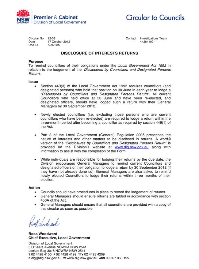
Update on One Association
EXECUTIVE
SUMMARY
|
purpose of report:
|
To provide Councillors information relating to the
forming of One Association to represent Local Government in NSW.
|
|
|
|
|
background:
|
The Local Government and Shires Association of NSW
have advised that members of the two Associations have now voted in favour of
their amalgamation. The amalgamation is expected to take place in March 2013.
To fully complete the amalgamation process, an
amalgamation of the State registered associations also needs to occur. The
executives of both Associations have resolved to seek an exemption from the
NSW Industrial Registrar from the requirement to hold a ballot for the
amalgamation given the very recent and strong vote in favour of the amalgamation.
|
|
|
|
|
comments:
|
Continued updates on the One Association will be
provided to Council as appropriate.
|
|
|
|
|
recommendation:
|
That Council receive and note the report.
|
Purpose of Report
To provide Councillors information relating to the forming
of One Association to represent Local Government in NSW.
Background
The Local Government and Shires Association of NSW have
previously advised that members of the two Associations have now voted in
favour of their amalgamation. A ballot was run between 12 July and 7 August
2012 resulting in the Shires Association of NSW voting 59-13 in favour and the
Local Government Association of NSW voting 161-53 in favour.
The Association has written to Councils to outline further
updates of the amalgamation process. The amalgamation is expected to take place
in March 2013. To fully complete the amalgamation process, an amalgamation of
the State registered associations also needs to occur. The executives of both
Associations have resolved to seek an exemption from the NSW Industrial
Registrar from the requirement to hold a ballot for the amalgamation given the
very recent and strong vote in favour of the amalgamation.
A copy of the exemption is attached (see attachment A1).
Comments
Continued updates on the One Association amalgamation will
be provided to Council as appropriate.
Governance Matters
There is no governance considerations associated with the
recommendations in this report.
Risk Management
There are no risk management considerations associated with
the recommendations in this report.
Financial Considerations
There are no financial considerations associated with the
recommendations in this report.
Social Considerations
There are no social considerations associated with the
recommendations in this report.
Environmental Considerations
There are no environmental considerations associated with
the recommendations in this report.
Community Consultation
None undertaken or required.
Internal Consultation
None undertaken or required.
Summary
The Local Government and Shires Association of NSW have
previously advised that members of the two Associations have now voted in
favour of their amalgamation. A ballot was run between 12 July and 7 August
2012 resulting in the Shires Association of NSW voting 59-13 in favour and the
Local Government Association of NSW voting 161-53 in favour.
The Association has written to Councils to outline further
updates of the amalgamation process. The amalgamation is expected to take place
in March 2013. To fully complete the amalgamation process, an amalgamation of
the State registered associations also needs to occur. The executives of both
Associations have resolved to seek an exemption from the NSW Industrial
Registrar from the requirement to hold a ballot for the amalgamation given the
very recent and strong vote in favour of the amalgamation.
A copy of the exemption is attached (see Attachment A1).
Continued updates on the One Association amalgamation will
be provided to Council as appropriate.
|
Recommendation:
That Council receive and note the report.
|
|
Matt Ryan
Manager Records & Governance
|
Rocky Naickar
Director Corporate
|
|
Attachments:
|
A1View
|
Update on
progress of One Association - exemption from requirements for a ballot of
members for amalgamation of State registered organisations
|
|
2012/256500
|
|
APPENDIX No: 1 - Update on
progress of One Association - exemption from requirements for a ballot of
members for amalgamation of State registered organisations
|
|
Item No: GB.2
|
|
Ordinary
Meeting of Council - 13 November 2012
|
GB.3 / 44
|
|
|
|
|
Item GB.3
|
S06940
|
|
|
19 October 2012
|
Gordon Interchange Upgrade and New Commuter Car Parking- Site
inspection feedback
EXECUTIVE
SUMMARY
|
purpose of report:
|
Following a site inspection and
briefing held on 22 October 2012, the approval of Council is sought to enter
into a Project Delivery Agreement with Transport for NSW for the Gordon
Interchange Upgrade and Commuter Car Parking Project.
|
|
|
|
|
background:
|
On 29 May 2012, the NSW
Government announced it will build nine new commuter car parks, providing
more than 1,200 additional car spaces at train stations across the CityRail
network.
The announcement outlined the
proposal for Gordon which will include more than 160 additional car spaces at
two locations, upgrade of the bus interchange, and a new kiss-and-ride zone.
The works are estimated to cost $44 million.
Council at its meeting on 9
October 2012 considered the Officers’ Report and resolved to defer the matter
for a briefing with Transport NSW.
|
|
|
|
|
comments:
|
On 22 October 2012 Councillors,
Council staff and representatives from Transport for NSW (TfNSW) held an
on-site inspection, followed by a presentation on the proposal.
Previously, Council staff met
with representatives of TfNSW from the Transport Projects Division on 6 June
2012. At the meeting, Council staff were briefed by TfNSW on the scope and
nature of the project. Following this meeting, on 15 June 2012, TfNSW issued
a Gordon Interchange Upgrade and Commuter Car Parking -Discussion Draft
Heads of Agreement which set out the proposed parameters and agreements
for the project.
|
|
|
|
|
recommendation:
|
That Council authorise the
General Manager and/or his delegate to negotiate the development of a Heads
of Agreement for the Gordon Interchange Upgrade and Commuter Car Parking
Project and that Council authorise the General Manager to execute the legal
document, to affix the Council Seal and to execute all necessary
documentation, resulting from the development of the final Heads of Agreement.
|
Purpose of Report
Following a site inspection and briefing held on 22 October
2012, the approval of Council is sought to enter into a Project Delivery
Agreement with Transport for NSW for the Gordon Interchange Upgrade and
Commuter Car Parking Project.
Background
On 29 May 2012 the NSW Government announced it will build
nine new commuter car parks at train stations across the CityRail network,
providing more than 1,200 additional car spaces.
The nine new commuter car parks - some with new interchanges
- will be built at Granville, Canley Vale, Gordon, Sutherland, Lindfield,
Kiama, Moss Vale, Oak Flats and Padstow.
The announcement outlined the proposal for Gordon which will
include more than 160 additional car spaces at two locations, upgrade of the
bus interchange, and a new kiss-and-ride zone. The works are estimated to cost
$44 million.
TfNSW has now started work on
the design and planning approval process for each of these projects. TfNSW
noted that the level of investment required, and the size of the project, may
change as detailed work is undertaken.
Council at its meeting on 9 October 2012 considered the
Officers’ Report and resolved to defer this matter for a site inspection.
Comments
On Monday evening 22 October 2012, the Councillors, Council
staff and representatives from TfNSW held a site inspection for the proposed
interchange upgrade and the new commuter car parking. This was followed by a
briefing on the proposal at chambers by TfNSW.
A wide range of issues were discussed at the briefing
including the:
· traffic and access in/around the
proposed interchange/car park for buses, taxis and passenger vehicles
movements;
· design features including bus
shelters, awnings, signage, bicycle facilities;
· heritage – Gordon Station and
settings and views;
· landscape and vegetation-
retention/removal;
· duplication of North Shore line and proposed location of commuter parking ;
· pedestrian safety- lighting and
design safety issues;
· road safety audit of designs;
· location of access/egress points for
commuter parking;
· parking layouts and design on the
east side;
· community consultation;
· timing and staging of the works;
· Gordon public domain works; and
· demand forecasting for commuter
parking/rail patronage.
Previously, Council staff had met with representatives of TfNSW
from the Transport Projects Division on 6 June 2012. At the meeting Council
staff were briefed by TfNSW on the scope and nature of the project.
Following this meeting, on 15 June 2012, TfNSW issued the Gordon
Interchange Upgrade & Commuter Car Parking - Discussion Draft Heads of
Agreement (Draft HoA) which sets out the proposed parameters and general
agreements for the project.
TfNSW has requested Council
commence negotiations to prepare a legally binding agreement that will see the
project through to fruition. The appropriate document for this is a Project
Delivery Agreement (PDA).
The precursor to the PDA is a
Heads of Agreement (HoA). Whilst the HoA itself is not legally binding, it
sets out the agreed key terms of the primary documents to be entered into to
ensure that the parties have a common understanding before formally documenting
the project. A copy of the HoA is attached to this report in full as CONFIDENTIAL
Attachment A1.
The HoA will form the basis of a
PDA which becomes the legally binding contract between Council and TfNSW. The
contents of the HoA are:
1. A
statement of the parties to be involved in the project.
2. Statements
regarding the location of the project and the scope of works.
3. Commentary
on specific agreements between the parties such as land tenure and construction
processes.
4. General
agreements regarding responsibilities of the parties for design, construction,
management and maintenance of the project.
Governance Matters
The relevant Council policies and plans in relation to this
matter are the Ku-ring-gai Integrated Transport Strategy (ITS), Town Centres
Public Domain Plan 2010 (TCPDP) and the Gordon Local Centre Traffic Improvement
Concept Plan (TICP).
The Ku-ring-gai ITS acknowledges
that infrastructure actions towards improving the public transport system
itself in Ku-ring-gai are largely out of Council’s control. Infrastructure such
as bus/rail interchanges are a critical component of Sydney’s public transport
network but Ku‑ring‑gai travel data suggests that relatively few
bus-train or train-bus trips occur in Ku‑ring‑gai. One contributing
factor is the poor quality of the interchanges.
A specific action in the ITS
recommends that Council should work with TfNSW
to construct better bus/rail interchanges at several locations, including
Gordon.
The TCPDP is an adopted policy document of Council which
provides a concept plan for a new bus interchange in Gordon. The plan foresaw
redevelopment of the interchange based on prior discussions with representatives
from the former Ministry of Transport.
To ensure consistency with Council’s policy it is
recommended that the Draft HoA be amended to include an additional statement as
follows:
- That
the concept proposals developed by TfNSW be consistent with the objectives,
principles, strategies and proposals of the Ku-ring-gai Town Centres Public
Domain Plan 2010.
The TICP proposes a number of
changes to the traffic network in the area around Wade Lane, St Johns
Avenue and Henry Street, Gordon. This plan also received general concurrence
from the Roads and Maritime Services during consultation for the draft
Ku-ring-gai Local Centres LEP. Other relevant actions from the ITS include
implementation of road network improvements from Ku‑ring-gai
Contributions Plan (2010), of which the TICP forms part of.
To ensure consistency with Council’s planning documents it
is recommended that the Draft HoA be amended to include an additional statement
as follows:
- That
the traffic network developed by TfNSW be consistent with Ku-ring-gai Council’s
Gordon Local Centre Traffic Improvement Concept Plan.
From a governance point of view the Draft HoA, with further
development and the proposed amendments noted above, is considered an
acceptable basis on which to move forward.
Risk Management
The risk to Council of adopting the Draft HoA for the
purposes of drafting a formal development agreement is minimal as it will not
be legally binding document.
Overall the provision of a new bus interchange and
additional commuter car parking will be seen as a positive development for
Gordon. Community consultation during preparation of the Town Centres/Local
Centres LEPs showed that commuter car parking and the quality of the existing
bus interchange is a significant issue for residents. Therefore there is a
potential risk to Council’s reputation if Council were not to proceed in a
timely manner with this project.
From a risk management point of view the Draft HoA, with
further development and review, is considered an acceptable basis on which to
move forward.
Financial Considerations
NSW State Government funding
The project design and construction is proposed to be
funded, in its entirety, by TfNSW, as stated in the Draft HoA.
Ongoing Council management
The Draft HoA implies there may be some ongoing financial
obligations to Council once the project is constructed. These include management
of any roads created in the proposed car park/interchange upgrade and any
tenure for permanent occupation of commuter car parking spaces.
In relation to roads, Council requires more detail around
the design and construction of the proposed car park/interchange upgrade to
understand the extent of the ongoing maintenance obligations resultant from the
dedication of any new public roads. It is recommended that further information
is sought from TfNSW to enable discussion and negotiation around this issue.
In relation to land tenure this also requires further
information from TfNSW. At present Council staff have limited understanding of
the ownership of the land proposed for occupation for construction and future
permanent occupation as a commuter car park. Based on the limited information
provided to Council the preceding matters are not currently acceptable.
There is also some ambiguity in the Draft HoA in regard to
ownership of assets once construction is complete. Further discussions with
representatives from TfNSW is required to clarify the intent of the statements
in this regard.
Relationship to Ku-ring-gai Contributions Plan 2010
The final financial consideration is in relation to the Ku-ring-gai
Contributions Plan 2010. This adopted and in effect document proposes to
fund various public domain, pedestrian and transport related upgrade works to
the Gordon local centre including construction of a bus interchange in Henry Street. At the time of drafting Ku-ring-gai Contributions Plan 2010, there
were no State Government funds allocated to the project.
The work in the contributions plan would have been of a
significantly lesser scale involving surface treatments to the bus area only
without the underground car parking or kiss-and-ride zone as a total of just
$929,875 (plus contingencies) was allocated to this work. A much smaller scale
work is also proposed for the bus stop on the Werona Avenue side of the station
valued at $121,500 (plus contingencies).
In terms of financial considerations the Draft HoA, with
further development and the proposed amendments noted above, is considered an
acceptable basis on which to move forward.
Social Considerations
The main social considerations are:
- the
social and historical significance of Annie Forsyth Wyatt Garden;
- the
heritage significance of Gordon rail station (State listed item);
- inconvenience
to users of the rail station and interchange during construction; and
- the
benefits of a new interchange to the community.
The Draft HoA does not specifically mention the first two
points and it is recommended the following wording be incorporated:
- That
the proposed development protects and enhances the social and historical
significance of Annie Forsyth Wyatt Garden.
- That
the proposed development conserves and enhances the cultural significance and
setting of the State heritage listed Gordon Railway Station Group, (including
primary view lines to the station).
In relation to the third point the Draft HoA specifically
acknowledges the issue of inconvenience to users.
In terms of social considerations the Draft HoA, with
further development and the proposed amendments noted above, is considered an acceptable
basis on which to move forward.
Environmental Considerations
The main environmental consideration for the proposed
development is the Lemon Scented Gum (Eucalyptus citriodora) and the
Blue Gum in the Annie Forsyth Wyatt Garden immediately to the east of the new
development.
The Draft HoA does not specifically mention this tree and it
is recommended the following wording be incorporated in the Draft HoA to ensure
the tree is protected:
- That
the proposed development protect the existing Lemon Scented Gum (Eucalyptus
citriodora) and the Blue Gum (planted in 2005 for National Trust 60th
Anniversary) in the Annie Forsyth Wyatt Garden.
From an Environmental point of view the Draft HoA, with
further development and the proposed amendments noted above, is considered an
acceptable basis on which to move forward.
Community Consultation
Community consultation for this project will be the
responsibility of TfNSW, in liaison with Council.
Internal Consultation
At this stage consultation has occurred within the Strategy
Department, the officers involved include the Manager Integrated Planning,
Property & Assets; Strategic Traffic Engineer, Heritage Planner Specialist
and Infrastructure Co-ordinator.
Summary
TfNSW are proposing a major redevelopment of the bus
interchange area in Henry Street, Gordon which will include more than 160
additional car spaces, upgrade of the bus interchange, and a new kiss-and-ride
zone. The works are estimated to cost $44 million.
TfNSW have issued the Gordon Interchange Upgrade &
Commuter Car Parking -Discussion Draft Heads of Agreement (Draft HoA) which
sets out the proposed parameters and general agreements for the project. TfNSW
have asked that the Draft HoA be put to Council for their concurrence so that a
formal development agreement may be prepared by TfNSW and Council.
A site inspection was held with Councillors, Council staff
and TfNSW representatives on 22 October 2012 to brief Councillors on the
proposal.
This report has reviewed the Draft HoA and found that it is
generally considered to be acceptable from a Council Officer’s point of view,
however, the report recommends a number of additions and clarifications to the
Draft HoA.
In summary, the Draft HoA, with further review and
development; inclusion of the amendments noted in this report; and legal review
and advice to protect Council’s interest, is considered an acceptable basis on
which to move forward with the preparation of a formal development agreement.
|
Recommendation:
A. That
Council authorise the General Manager and/or his delegate to negotiate the
development of a Heads of Agreement for the Gordon Interchange Upgrade and
Commuter Car Parking Project and to incorporate the following additional
matters into a formal development agreement to protect Council’s legal
interest:
i. That
the concept proposals developed by TfNSW be consistent with the objectives,
principles, strategies and proposals of the Ku-ring-gai Town Centres Public
Domain Plan 2010;
ii. That
the traffic network developed by TfNSW be consistent with Ku-ring-gai
Council’s Gordon Local Centre Traffic Improvement Concept Plan;
iii. That
the proposed development protect the existing Lemon Scented Gum (Eucalyptus
citriodora) and the Blue Gum (planted in 2005 National Trust 60th
Anniversary) in the Annie Forsyth Wyatt Garden;
iv. That
the proposed development protect and enhance the social and historical
significance of Annie Forsyth Wyatt Garden;
v. That
the proposed development conserve and enhance the cultural significance and
setting of the State heritage listed Gordon Railway Station Group, (including
primary view lines to the station).
B. That
Council authorise the Mayor and the General Manager to execute the legal
document, to affix the Council Seal and to execute all necessary documentation,
resultant from the development of the final Gordon Interchange Upgrade and
Commuter Car Parking - Heads of Agreement.
|
|
Bill Royal
Team Leader Urban Design
|
Joseph Piccoli
Strategic Traffic Engineer
|
|
Andrew Watson
Director Strategy & Environment
|
Antony Fabbro
Manager Urban & Heritage Planning
|
|
Attachments:
|
A1
|
Draft
Heads of Agreement
|
|
Confidential
|
|
Ordinary
Meeting of Council - 13 November 2012
|
GB.4 / 51
|
|
|
|
|
Item GB.4
|
S09053
|
|
|
12 October 2012
|
Review of Submissions on Draft LEP 218 for Biodiversity, Riparian
Land and Heritage Conservation Areas
EXECUTIVE
SUMMARY
|
purpose of report:
|
To report to Council on the outcomes of the public
exhibition of the Planning Proposal to incorporate provision for
biodiversity, riparian lands and Heritage Conservation Areas into the Ku‑ring‑gai
Planning Scheme Ordinance.
|
|
|
|
|
background:
|
On 8 November 2011 Council resolved to prepare a
planning proposal to implement an LEP to amend the KPSO to incorporate
biodiversity and riparian lands provisions and Heritage Conservation Areas
(HCAs). The draft LEP was placed on public exhibition from 30 January to 27
February 2012.
|
|
|
|
|
comments:
|
As a result of the exhibition there were 127
submissions received. Consideration of the submissions has resulted in a
number of minor changes to the Biodiversity and Riparian Lands maps. It is also proposed to reduce the extent of two draft HCAs. Other changes,
including extensions to HCAs and listing of additional heritage items should
be pursued through the draft Ku-ring-gai Principal Local Environmental Plan.
|
|
|
|
|
recommendation:
|
That Council vary the Planning Proposal as outlined in
the report and forward the revised Planning
Proposal to the Minister for Planning and Infrastructure.
|
Purpose of Report
To report to Council on the outcomes of the public
exhibition of the Planning Proposal to incorporate provision for biodiversity,
riparian lands and Heritage Conservation Areas into the Ku‑ring‑gai
Planning Scheme Ordinance.
Background
On 8 November 2011 Council
resolved to prepare a Planning Proposal to implement a Local Environmental Plan
(LEP) to amend the Ku-ring-gai Planning Scheme Ordinance (KPSO) to incorporate
biodiversity and riparian lands provisions and Heritage Conservation Areas. The
Planning Proposal (known as Draft LEP 218) was initiated as an interim
planning measure to provide a level of protection for areas identified as
having valuable heritage and environmental values and to form a basis for
future residential, retail and commercial planning in the Principal LEP and the
Local Centres LEP.
The matter of the development of
an interim LEP (dealing with biodiversity and heritage issues) was agreed to by
the Minister and the Department of Planning and Infrastructure on the basis
that its development did not divert Council resources from development of a
fresh town centres LEP or lengthen the overall timeframe for a new centres LEP
and Council’s Principal LEP.
The planning proposal seeks to
amend the Ku-ring-gai Planning Scheme Ordinance (KPSO) to:
i) include a clause and associated map relating to biodiversity
protection;
ii) include a clause and associated map relating to riparian
lands and waterways;
iii) delete existing heritage clauses and replacing them with the
standard instrument LEP heritage conservation clause;
iv) include a heritage conservation areas map; and
v) to add additional definitions and amend existing definitions
to support the new clauses.
The biodiversity and riparian
provisions contained in Draft LEP 218 have been based on the Biodiversity
and Riparian Lands Study, Ku-ring-gai Principal LEP Draft Background Study
(Ku‑ring-gai Council, 2011) which was previously exhibited (in a
non-statutory form) as part of the development of the Principal LEP, including
the biodiversity and riparian lands identified in the Ku‑ring-gai Town
Centres LEP.
The identified Heritage
Conservation Areas (HCAs) are a result of numerous studies conducted in
Ku-ring-gai Council over many years to ascertain the cultural significance of
heritage conservation areas. The most recent studies undertaken being:
· Paul Davies Pty Ltd
(2008) Ku-ring-gai Town Centres Heritage Conservation Area Review;
· Paul Davies Pty Ltd
(2010) Northern Heritage Conservation Area Review; and
· Architectural Projects
(2010) Southern Heritage Conservation Area Review.
Each study reviewed areas
previously identified in other studies as potential heritage conservation
areas, in particular the Urban Conservation Areas Studies undertaken by Godden
Mackay Logan from 2001-2005. The objective of the most recent studies was to
assess the degree of change that had occurred in the last 6-10 years and
determine the intactness of the potential heritage conservation areas.
A Gateway Determination for the
Planning Proposal was issued by the Department of Planning and Infrastructure
on 13 December 2011 (refer to Attachment A1).
A copy of the Planning Proposal
(refer to Attachment A2) and supporting material for Draft LEP 218 were
placed on public exhibition in accordance with the gateway determination from
30 January to 27 February 2012. The biodiversity, riparian and heritage
conservation area maps and provisions contained in Draft LEP 218 were also
carried forward into the preliminary draft Principal LEP adopted by Council on
6 March 2012.
The assessment and reporting on
submissions on Draft LEP 218 has been delayed due to the resourcing
requirements of the new Local Centres LEP. However, submissions specific to
the areas covered by the local centres were considered at the Ordinary Meeting
of Council on 3 April 2012 and adopted prior to the exhibition of the draft
Local Centres LEP 2012. The final Local Centre’s LEP adopted by Council on 31
July 2012 incorporates the relevant biodiversity, riparian lands and heritage
conservation area provisions from draft LEP 218.
While Draft LEP 218 applies to
the whole Ku-ring-gai LGA, the application of Draft LEP 218 within the Local
Centres LEP areas has been resolved and finalised by Council as part of the
Local Centres LEP process. Consequently this report will focus on the issues
raised in relation to Draft LEP 218 relating to areas outside the Local Centres
LEP, i.e. areas covered by the draft Principal LEP, which will be reported to
Council in the near future.
Comments
Consideration of public submissions
Draft LEP 218 was exhibited from 30 January 2012 to Monday
27 February 2012. As a result of the exhibition there were 127 submissions
received. These submissions related to both sites within the boundaries of the
Local Centres LEP and sites that will be covered by the Principal LEP.
Approximately 100 submissions related to areas outside the areas covered by the
Local Centres LEP; however, there was some overlap within submissions.
Public submissions received for sites within the boundaries
of the Draft Local Centres LEP were discussed in the reports on that LEP on 3
April 2012 and 31 July 2012 and incorporated in the final draft Local Centres
LEP. Public submissions on draft LEP 218 received for sites covered by the
Draft Principal LEP are discussed below.
Public submissions on biodiversity and riparian lands
40 public submissions on Draft LEP 218 related to
biodiversity and riparian lands within the area covered. Issues raised in
submissions included:
· support for the objectives, mapping
and provisions of the Draft LEP;
· concerns that the Draft LEP should
include additional detail or maps and that it does not go far enough in
protecting ecological values;
· concern that individual property
owners’ rights will be affected;
· objection that the Draft LEP was not
notified in accordance with legislative requirements resulting in issues of
procedural fairness; and
· site specific concerns related to
the identification or categorisation of riparian lands or areas of biodiversity
significance.
Attachment A3 provides a summary of these submissions
and a response and recommendations resulting from their consideration.
Submissions on the following specific areas were made:
· objection to the categorisation of
riparian lands along the creek to Middle Harbour bounded by Babbage Road,
Allard Avenue and Normac Street Roseville Chase as Category 1 – seeking
category 2;
· objection to the inclusion of
riparian lands through Little Digger Park (end of Amarna Parade and Roseville Avenue);
· support for riparian category
(Category 3) for ‘Coleman’s Creek’ through 14, 16, 18, 20A, 21 and 22
Beaconsfield Parade and 1- 3 Averil Place, Lindfield;
· objection to inclusion of riparian
lands along the boundary, and the north-eastern, north-western and
south-western biodiversity areas at 59 Miowera Road North Turramurra;
· objection to the categorisation of
the riparian lands at the boundary of 59 Miowera Road North Turramurra as
category 3 – seeking category 2;
· objection of the inclusion of
riparian lands through 41, 43 and 47 Griffith Avenue, Roseville;
· objection to the inclusion of
biodiversity areas in the mapping for 414-420 Bobbin Head Road North
Turramurra;
· objection to the categorisation of
the riparian lands through 52 Finlay Road, Turramurra as category 2 – seeking
category 3. Consideration of this submission has led to a recommendation for
amendments to the riparian lands map for a number of other sites;
· objection to riparian land (category
3) at 6 Luxor Parade Roseville;
· objection to the categorisation of
riparian lands along Moores Creek bounded by Amarna Parade and Luxor Parade
Roseville as Category 1- seeking category 2.
These issues are discussed in detail in Attachment A3.
The issue which generated the highest number of public
objections related to the categorisation of riparian lands between Amarna
Parade and Luxor Parade. A further brief discussion of these issues is
therefore included here. Seven submissions were received for this stretch of
the riparian land along Moores Creek. Key
concerns include:
· location of roads within the
riparian land;
· previous clay fill and building
rubble used for the road and dumped within the riparian land compromises the
potential for restoration;
· the reserve is struggling as the
bushcare group does not have adequate resources;
· does not provide link between
significant bushland reserves or endangered ecological communities;
· effect of ‘riparian zoning’ on
private properties:
- Uncertainty
about development potential;
- Impact
on property values;
- Requirement
for revegetation resulting in:
§ bushfire risk;
§ overshadowing;
§ loss of front gardens; and
§ reducing connection to the rest of the
zone, potentially impacting on heritage value of the heritage conservation
area.
As stated in Biodiversity and Riparian Lands Study,
Ku-ring-gai Principal LEP Draft Background Study (Ku‑ring-gai
Council, 2011):
“When assigning categories,
priority is given to the degree to which a riparian corridor meets or has
potential to meet the environmental objectives of that category, with the
current core riparian zone (CRZ) width noted as a secondary consideration. In
this way, a corridor in good ecological condition that provides significant
terrestrial and aquatic habitat, yet is only 15 m wide, will be classed as
category 2 not category 3”. (p.33)
This principle was applied to this reach as the existing
core riparian land along this reach of Moores Creek between Amarna and Luxor
Parades is between 20m – 30m in width from the top of each bank along the
majority of the reach and it is an important bushland pocket within the already
heavily urbanised area, despite past land use practices. The reach:
· is connected to larger reserves
through Roseville Golf Course and is the most significant corridor remaining
within the Moores Creek Catchment;
· includes an important bushcare site
which has received considerable investment and support from Council; and
· is an important asset to the
community.
The riparian classification will also support Council’s
operational section in ensuring that the management of the road adjacent to the
creek considers the impact on the riparian land.
While the road separates that main area of the creek from
the residences, the residents themselves have noted the presence of riparian
fauna such as Eastern Water Dragons in their yards, so there is clearly habitat
across these roadways.
The riparian mapping does not represent a separate land use
zoning for riparian areas within the Draft LEP. Rather, it will trigger
relevant considerations for development applications. Each application will be
assessed on its merits. Merit consideration will need to take into account in
an integrated way matters related to bushfire protection, riparian enhancement,
heritage protection, amenity, character etc. as well as the location of
existing development and the scale of the proposal. In many cases the only
requirement may be the retention and/or planting of some riparian vegetation,
consistent with any bushfire or heritage requirements.
The riparian mapping extends from public land to private
land across many sites within the LGA. The mapping procedure should be
consistent across the LGA. Incorporating this information as part of a natural
resource overlay map has been done to ensure this environmental value can be
considered without imposing excessive restrictions on property titles or
amending all affected land use zones.
The attached draft Riparian Lands and Biodiversity Maps (Attachments
A5 and A6) show the resulting recommended amendments for the following
areas:
· reduction from Category 2 to
Category 3 Riparian Lands, with consequent changes to the Biodiversity Map near
the following:
- 52 Finlay Road Turramurra;
- Lucinda/Mahratta Avenue, Wahroonga;
- Campbell Drive, Wahroonga;
- Comenarra Parkway/Kiogle Street,
Wahroonga;
- Ada Avenue South, Warrawee;
- Blytheswood Avenue, Wahroonga;
- Challis Avenue and Katina Street, Turramurra;
- End of Cudgee Street, Turramurra;
- Alice Street, Turramurra;
- Linigen Place, St Ives;
- Melaleuca Drive, St Ives;
- North-western section of Avondale
Golf Course;
· adjustment to the boundary between
Category 1 and 2 Riparian Lands at Godfrey Avenue/Catalpa Crescent Turramurra
to be perpendicular to the identified watercourse;
· reduction in extent of Category 1
Riparian Lands near Normac Avenue/Babbage Road, at the confluence of Middle Harbour with resulting changes to the Biodiversity Map;
· very minor changes to extent or
category under a road (4 sites);
· reduction in the area of
biodiversity on the biodiversity map to match the Category 3 riparian lands at
41, 43 and 47 Griffith Avenue, and the rear of 7-9 Allard Avenue Roseville
Chase; and
· a reduction in the Category 1
biodiversity area at the north-west corner of 59 Miowera Road North Turramurra
to the canopy of the trees rooted in 24 Milton Road with the 8 metre buffer
around this.
Recommendations
It is recommended that the
amended Biodiversity and Riparian Lands Maps be adopted as shown at Attachments
A5 and A6. (Note: Due to the size of the maps
they have been circulated to Councillors separately or can be viewed on
Council’s website at http://www.kmc.nsw.gov.au/www/html/101-agendas-reports-and-minutes.asp)
It is recommended that the following terms be defined in the
supporting DCP:
· riparian land;
· regionally significant species, if
the term is used in the final written LEP instrument or the DCP; and
· threatened species, population or
ecological community.
It is recommended that the
priorities of the Australian Biodiversity Conservation Strategy 2010- 2030 also
be considered in Council’s revised Biodiversity Strategy.
Public submissions on heritage conservation areas
There have been 60 submissions received from the exhibition
of Draft LEP 218 that pertained to heritage conservations areas, in the area
covered by the proposed Principal LEP. Attachment A4 provides a summary
of these submissions organised by suburb or specific issue. Responses and
recommendations resulting from consideration of the submissions are included in
the table.
The main issues raised and responses to those issues are as
follows:
· Support for the areas included as
draft heritage conservation areas. Many submissions were received, in
particular for HCAs in the Roseville area, in support of the HCAs proceeding.
· Requests to increase the number of
heritage conservation areas or the size of heritage conservation areas.
- Several submissions requested that
additional HCAs be made, in particular, in Turramurra and Pymble. The
submissions stated the work of previous reviews such as the National Trust’s Housing
in NSW between the Wars and the Godden Mackay Logan Ku-ring-gai Urban
Conservation Area studies. The decision to undertake a further review, for
which Paul Davies Pty Ltd and Architectural Projects were engaged, was the
result of significant change to housing that occurred following the
introduction of the Exempt and Complying Codes SEPP. The SEPP permitted
development to occur, without the need to apply to Council for development
approval. The result has been the introduction of new development which is
unsympathetic to the housing character of Ku-ring-gai. These most recent
heritage conservation area reviews used the previous studies as a based and
then assessed the impact of change and the degree of intactness of the proposed
conservation areas. As a result, some areas which were formally Urban
Conservation Areas did not meet the threshold of intactness for inclusion as
heritage conservation areas.
- Several of the areas which were
requested for inclusion are the subject of the Heritage Conservation Area peer
review being conducted by Sue Jackson-Stepowski. Further discussion on the peer
review is contained below.
· Concern over additional costs for
development applications and house maintenance.
- As a result of the listing, certain
developments which may have been exempt will now require development approval.
This is necessary to retain the character and the cultural significance of
conservation areas. The period of time in which these houses were developed
without development approval resulted in the erosion of the heritage fabric and
the introduction of detracting housing types, such as two storey rendered
houses with diminished side setbacks in streets where the character was
previously single storey bungalows, with facebrick facades surrounded by
generous established gardens compromised of mixed shrubbery and selective
native and introduced feature trees. The loss of the garden setting and significant
trees has been as damaging to the character of these areas as the loss of the
Federation and Inter-war houses.
- Other types of development which may
have been complying development will now require Council development approval.
These developments would still have incurred a cost as they required complying
development certificate from a private certifier. Additional cost may be
incurred if a heritage impact statement is required. It is recommended that
council review its processes and requirements for development that would have
otherwise been exempt or complying to minimise the burden on the owners of
heritage properties.
- All houses require ongoing
maintenance and places within heritage conservation areas are no different.
However, places within conservation areas require a “like for like”
replacement. For example, a slate roof could not be replaced with corrugated
steel. The inability to use cheaper substitutes represents a loss of potential
savings that could have been made on materials. The replacement of “like for
like” is necessary to retain the recognised character of these conservation
areas.
· Concern over the lack of public
consultation.
- The consultation for the draft LEP
was consistent with the Council resolution and the requirements of the Gateway
Determination.
· Against a blanket approach to
listing.
- The designation of heritage places
at the local government level in NSW takes two forms:
1. heritage
items and
2. heritage
conservation areas.
- Heritage conservation areas
acknowledge that places, not just single buildings, can have a special
character that is worth conserving. Ku-ring-gai is blessed with many
aesthetically significant housing types from the Victorian period through to
the present. Those places considered to be of heritage significance having
stood the test of time, and despite fads and fashions have been retained. These
places are not just buildings but include the florally diverse, established
garden settings, which epitomise the philosophy behind the garden suburb ideal.
This being to provide healthy living environs, through the segregation of
land-use, the provision of more parks, more street tree planting, and
harmonious housing design within generous garden settings. As such, the
inclusion of conservation areas in Schedule 5 of the LEP is not just to
conserve houses but also to conserve the gardens, parks, street planting,
recreation facilities, schools, and other community facilities which contribute
to the aesthetic and an understanding of the history and social setting which
led to the creation of these valuable places.
· Loss of development potential and
inability to modernise their house.
- The inclusion of a
property in a heritage conservation area does not preclude future new
development, such as additions and sympathetic infill. Instead, change in these
areas will be managed to allow the modernisation and expansion of homes while
conserving the valued character and cultural significance of the conservation
area. Subdivision and infill development is still permitted within a heritage
conservation area provided this development is successfully supported by a
heritage impact statement which can demonstrate that the significance of the
conservation will not be detrimentally impacted by the proposed development.
As a result of consideration of submissions, it is recommended
that amendments to the HCA maps be considered. This includes both amendments of
HCA boundaries to remove certain areas and the inclusion of additional
properties within HCA boundaries.
The proposed amendments to HCAs to remove certain areas are
identified on the maps in Attachment A7. This includes the following:
· Recommended to amend draft HCA C30
Lindfield West Conservation Area, to create two HCAs:
1. C30 – Frances Street Conservation Area and
2. C30A –
Lindfield West Conservation Area;
· Amend C34 - Archbold Farms Conservation Area to remove 1A-39 and 14-38 Park Avenue, Roseville.
The revised draft heritage map can be found in Attachment
A8. (Note: Due to the size of the maps they have
been circulated to Councillors separately or can be viewed on Council’s website
at http://www.kmc.nsw.gov.au/www/html/101-agendas-reports-and-minutes.asp)
The proposed heritage amendments being considered that
involve the listing of additional heritage items or the extension of HCA
include the following:
· Amend Schedule 5 and the heritage
map to include:
- 1-5
Railway Avenue Wahroonga and
- 9A-17
Railway Avenue Wahroonga;
· Amend the heritage map and include
15 and 19 Karuah Road, Turramurra in HCA C6 Ku‑ring-gai Avenue;
· Amend Schedule 5 and the heritage
map to include 39 Victoria Street and 26 Lord Street Roseville in draft HCA C32
– Clanville Conservation Area.
As these additional listings were included as part of the
exhibited planning proposal, it is not recommended that draft LEP 218 be
amended to include them. The more appropriate process would be to have the
additional listings subject to community consultation by including them within
the draft Principal LEP.
Agency Consultation
Comments received from state agencies on Draft LEP 218 were
addressed in the report to Council on the Principal LEP on 6 March 2012 and for
the Local Centres LEP on 3 April 2012. The comments are summarised below. The
detailed comments from the agencies are included at Attachment A9.
City of Ryde Council
No
comment concerning the Planning Proposal.
Response
Noted.
Hornsby Shire Council
No
comment concerning the Planning Proposal.
Response
Noted.
Office of Environment and Heritage (OEH)
Status
of Coastal Shale Sandstone Forest (CSSF) should be classified as ‘considered
eligible for listing as an endangered ecological community’. However, OEH
supports the classification in these documents of CSSF as ‘regionally
significant’ as it may take some time before the NSW Scientific Committee
considers this community for listing.
OEH
notes that the number of significance categories has been reduced from the
early 2011 documents, and that category 5 patches will not be included in the
LEP Biodiversity overlay, rather that they will be managed through general
biodiversity provisions in the DCP and through other Council policies. This
position is supported.
Response
Support
noted. On 24 May 2011, Council resolved to further discuss the inclusions
within the lowest biodiversity category with relevant agencies. OEH support for
the current inclusions in the LEP finalises these discussions.
Sydney Metropolitan Catchment Management Authority
The intent and objectives
outlined in the Planning Proposal and the Proposed LEP provisions appear to be
consistent with the Sydney Metropolitan CMA’s Catchment Action Plan, and
respective NSW legislation. There is
good correlation between the Natural Resources Biodiversity mapping and the
CMA’s draft mapping of corridors, between the riparian lands mapping and
categorisation and CMA mapping priorities, and between Council’s biodiversity
mapping and the identified significance of the riparian lands map.
The LEP provisions for
Biodiversity Protection would benefit from the inclusion of some additional
definitions to clear up any ambiguity. Definitions, such as those contained in
Draft Biodiversity and Riparian Lands Study should be included for “regionally
significant species” and for “threatened species, population or ecological
community”.
Make an explicit inclusion in
the current definition of “Riparian Land” to the biological factors that form
the basis of ecosystem services in the proposed clause and its respective map.
The Lovett and Price (1999) definition of riparian land is recommended:
“Riparian land is any land which adjoins, directly influences, or is influenced
by a body of water”. The explicit inclusion of biological factors unique to
riparian land demonstrates their importance to the biodiversity of terrestrial
and aquatic species, and therefore links to the biodiversity map.
To ensure consistency with the
Objects of the Environmental Planning and Assessment Act 1979 (5 (a)(vii))
and Water Management Act 2000 (3(b)), within the planning proposal, insert the
term “protect” in Section 1. Objectives or intended outcomes (page 3), second
bullet point on waterways and riparian lands.
Include trees located within
golf courses in the biodiversity mapping as they have potential to provide
habitat and conservation function.
Response
Support for the intent,
objectives and correlation with mapping and relevant legislation is noted.
Regarding definitions sought, the Department of Planning and Infrastructure
does not generally support the addition of definitions to the LEP dictionary
and discourages definitions in local provisions. Where possible, the Department
seeks consistency through the adoption of model clauses, though variations are
permitted where there is sufficient justification. The term ‘regionally
significant species’ has been previously used in gazetted LEPs without a
definition. The phrase ‘threatened species, population or ecological community’
refers to the common term ‘threatened’ used to refer to ‘threatened species
legislation’, and it is unlikely this would result in any confusion. Whether a
community is listed as critically endangered, or endangered it is still
‘threatened’. However, Council could define the terms in the DCP.
Council acknowledges that a more
holistic definition of riparian land would include the influence of the land
and water on each other. However, the definition used in the background study
has been developed to provide clear planning direction where these important
areas are involved, rather than leaving it open to discussion on what
"influenced by a body of water" means in a practical sense. The
definition used is not for scientific purposes, but rather to set a clear
planning direction to protect the natural and aesthetic values of waterways and
adjoining lands. The mapping and assessment process was designed with the
geophysical processes of the natural system as well as the practical
limitations of the urban area in mind. It is however recommended, that
‘riparian land’ be defined in the DCP as it is in the background study, where
Council has more freedom to set definitions.
The objects of these Acts referenced
above are to:
· encourage
ecologically sustainable development; and
· protect, enhance and
restore water sources, their associated ecosystems, ecological processes and
biological diversity and their water quality.
It is recommended that the term
‘protect’ be inserted in the relevant section of the planning proposal prior to
public exhibition, as requested by the Catchment Management Authority.
The issue of trees in golf
courses was discussed in detail in the report to Council of 6 March 2012. Council
resolved to include an additional area at the south-eastern end of Avondale
Golf Course on the biodiversity map in the draft Principal LEP prior to
exhibition. The matter will be addressed at the draft Principal LEP stage.
Aboriginal Heritage Office (AHO)
No specific concerns with the
proposed amendments as they appear to comply with current standards. AHO supports Council in not mapping
Aboriginal sites or ‘objects’ in accordance with the revised NSW standard LEP
provisions, as:
· it maintains the
confidentiality of sensitive sites; and
· Council won’t be in
breach if its licence agreement which prohibits the providing site data to
third parties.
Due to the inadequacy of the
Standard LEP instrument and changes that put the onus on proponents to ensure
due diligence in reviewing and assessing potential harm to Aboriginal heritage,
it is recommended that Council continues to utilise the site and potential area
mapping, supporting information, and training made available by the AHO.
Response
The AHO support for not mapping
known sites is noted. This view is important given the recommendations of the
Hawkesbury-Nepean Catchment Management Authority, as discussed below.
Council continues to utilise the
mapping, supporting information and trained staff in its development assessment
and operational work.
Hawkesbury-Nepean Catchment Management Authority
Notes that the Hawkesbury Nepean
Catchment Action Plan environmental targets and objectives are considered and
that riparian areas are appropriately mapped and categorised in the proposed
provisions.
As riparian areas often overlap
with areas of Aboriginal cultural significance, attention is drawn to s.117
Direction No.9 on Conservation and Management of Environmental and Indigenous
Heritage and the importance of mapping any identified areas of cultural
significance.
Response
It is acknowledged that riparian
areas do sometimes overlap with areas of Aboriginal cultural significance. Note
that the Section 117 Directions have been amended. The directions under the
previous no.9 are now included under Direction 2.3 Heritage Conservation. Part
4) of the direction requires a planning proposal to contain provisions that
facilitate the conservation of:
b) Aboriginal objects or Aboriginal places that are protected
under the National Parks and Wildlife Act 1974, and
c) Aboriginal areas, Aboriginal objects, Aboriginal places or
landscapes identified by an Aboriginal heritage survey prepared by or on behalf
of an Aboriginal Land Council, Aboriginal body or public authority and provided
to the relevant planning authority, which identifies the area, object, place or
landscape as being of heritage significance to Aboriginal culture and people.
The Principal LEP is proposed to
include provisions to facilitate the conservation of sites, objects and places
identified in b) and c) above.
A note included at the end of
the Direction refers to the requirement to identify items, areas objects of
places of indigenous heritage significance when using the standard LEP template.
However, the Standard LEP Instrument has been amended since the drafting of
this direction, to require the identification of such items, only where the
relevant Aboriginal community has agreed to this.
Council has consulted with the
relevant Aboriginal authority. The AHO has provided Council with information
and mapping which identify sites or ‘objects’ of significance. As discussed
above, the AHO does not support the mapping of these items or sites in the LEP.
Heritage Council of New South Wales
The Heritage Council of New South Wales supports the
resolution of Council to adopt the new HCAs. It also Advises Council to ensure
that the existing Development Control Plan (DCP) and any future DCPs include
development controls that are specific to the proposed HCAs to guide
development both within and adjoining the HCAs.
Response
The support of the Heritage Council of New South Wales and
the acknowledgement of the comprehensive heritage reviews to identify
Ku-ring-gai’s heritage conservation areas are noted.
Any new DCP drafted to support any gazetted HCAs will
include development controls and management objectives and recommendations
specific to the HCA to guide new development both within and in the vicinity of
the HCA.
NSW Rural Fire Service
(RFS)
The RFS raises no concerns about
the incorporation of natural resource and heritage conservation area overlays
and provisions.
Council should consider the
following which may be influenced by bushfire:
· The extension of
vegetation closer to an asset may result in a hazard complaint and the need to
remove the vegetation;
· Bushfire should be
considered when assessing biodiversity and riparian lands, eg where existing
development does not comply proposed controls a compromise should be sought;
· It may be useful to
include the aims and objectives of Planning for Bushfire Protection 2006
into the assessment where bush fire risk may be increased;
· Improvement of
biodiversity corridors and riparian lands should address obligations to protect
life, property and assets as well as obligations to maintain and protect
natural and cultural heritage, as per the NSW Biodiversity Strategy
Guidelines for Ecologically Sustainable Fire Management July 2004;
· Heritage conservation
areas within bushfire prone lands will conflict with landscaping restrictions
for development on bushfire prone land;
· For low risk areas the
requirements of Appendix 5 of Planning for Bushfire Protection 2006 may
suffice (ie vegetation management, property maintenance principles);
· However, for bushfire
attack level (BAL) 40 and BAL FZ, requirements for no exposed timbers and extra
protection for glazed elements, may conflict with existing heritage items or
development in HCAs;
· Lots with BAL 40 or BAL
FZ should have reduced heritage restrictions.
Response
· In the categorisation of
biodiversity areas the Draft Ku-ring-gai Biodiversity and Riparian Lands
Study reduced the category of many areas of private land where dwellings
were close to bushfire prone vegetation, in recognition that these areas may
require management to protect life and property. However, it is recognised that
conflicts will remain between the protection and enhancement of biodiversity,
riparian and heritage values and the minimisation of bushfire risk.
· Any proposal must consider
all of the values in an integrated way, so that a proper merit assessment can
be carried out. Accordingly it will be important that the DCP include controls
relating to the integration of these values at the earliest stage in the design
process. In some cases a compromise may need to be reached to balance the
conflicting values.
· All development
proposals on bushfire prone lands need to consider the NSW Rural Fires Act
1997 and Planning for Bushfire Protection 2006. The aims and
objectives of the latter will be considered in any assessment of such proposals
and do not require duplication in the LEP.
Department of Primary
Industries: NSW Office of Water (NOW)
Reference is made to previous
submission (16 May 2011)
Background Study Comments:
· Seeks additional aim of
study: to identify waterways and riparian lands that need to be enhanced,
rehabilitated and protected to improve aquatic and riparian linkages.
· Seeks amendment to the
glossary to include reference to ‘riparian buffer’.
· Study could note
benefits of establishing a vegetated riparian buffer.
· Recommended amendment for
section 2.2 – clarify documented basis of riparian mapping (should be as per
previous draft)
· Previous comments
regarding section 1.1 (amendments to aims and objectives), 3.4.2 (corridor
width), and management of biodiversity connectivity within regional fauna
habitat and biodiversity corridors comments are re-iterated.
Comments relating to
amendment of the planning scheme ordinance:
· Supports inclusion of
riparian lands and waterways clause
· Supports inclusion of
rehabilitating existing piped or channelised waterways
· Recommends the
amendments to subclause 1, to 4 to simplify and clarify
· Supports the inclusion
of the stream classification map but recommends that the legend is amended to
include the category width measurements.
Response
Background Study Comments:
Prior to exhibition of the draft
Principal LEP, the Draft Background Study will be updated to be consistent with
the draft PLEP and taking into account the comments from the Office of Water.
Comments relating to
amendment of the KPSO:
· Support for the riparian
clause and the inclusion of rehabilitation of piped or channelised waterways is
noted.
· Amendments to clarify
the purpose of, broaden and simplify this clause were made to the riparian
clause outlined in the Planning Proposal for the Principal LEP as sent to the
agencies for consultation. It is recommended that the Riparian and Waterways
clause in Draft LEP 218 be amended in line with the Planning Proposal for the
draft Principal LEP.
· Ku-ring-gai’s riparian
land and waterways are already highly urbanised, it should be recognised that
there is existing development within these areas that needs to be considered.
This clause does not only protect riparian lands and waterways from new
development but must act to guide future changes to existing developments.
· The associated map
clearly shows the boundaries of the riparian lands. While the measured
distances will be included in the DCP, identifying the extent of the riparian
lands on the LEP map, rather than by a distance from “the top of the bank”
creates greater certainty for landholders about the presence or extent of
riparian land on their site. Again, this is an urban area, and in most cases
any additional distance resulting from measuring from the top of the bank would
be minor relative to the overall buffer.
Recommendations
As a result of the consideration
of agency submissions, the following is recommended:
· That Council continue to
utilise the Aboriginal heritage site and potential area mapping, supporting
information, and training made available by the AHO.
· That the Riparian and
Waterways clause in Draft LEP 218 be amended in line with the Planning Proposal
for the draft Principal LEP as included in Attachment 10.
· That the following terms
be defined in the DCP: ‘riparian land’; ‘regionally significant species”,
‘threatened species, population or ecological community’.
· That the DCP include
provisions relating to the integration of biodiversity, riparian and heritage
values.
Aligned Projects
Ku-ring-gai Local Centres LEP
The Ku-ring-gai Local Centres LEP is currently with the
Minister of Planning for gazettal. It includes heritage conservation areas, biodiversity
and riparian areas, which took into account submissions received by Council on
Draft LEP 218 for those areas covered by the six centres. These areas have
therefore been omitted from the final draft of LEP 218.
Ku-ring-gai Principal LEP
Council has prepared a draft Principal LEP for the area of
the LGA outside the boundaries of the Local Centres LEP. The draft is expected
to be considered by Council for adoption in the near future. The provisions and
maps in Draft LEP 218 are to be incorporated within the Principal LEP. However,
as the Principal LEP covers all LEP related matters for most of the LGA, it is
expected that this making of this LEP will take some time. It is therefore
critical for the protection of heritage conservation areas and natural
resources in Ku-ring-gai, that the provisions and mapping of Draft LEP not wait
for the finalisation of the Principal LEP.
HCA Peer review
At the Ordinary Meeting on 13
December 2011, Council adopted a resolution to engage an independent consultant
to undertake a peer review of several conservation areas in Turramurra and
Pymble. At the Ordinary Meeting on 22 May 2012, Council adopted a further
resolution to also peer review Fox Valley Road, Wahroonga.
Part D of Council resolution
from 6 March 2012 required that any changes recommended to the heritage
conservation areas as a result of the peer review be included within the
Principal LEP prior to the public exhibition.
In March 2012 Council engaged an
independent consultant to undertake the peer review. Much of the field work was
undertaken and completed in April and May 2012. Unfortunately, due to
consultant issues beyond Council’s control, a delay has arisen. A date is yet
to be determined for the consultant’s recommendations of to be reported to Council.
Governance Matters
The process for the preparation
and implementation of planning proposals is governed by the provisions of the Environmental Planning and Assessment Act, 1979 (EP&A Act) and
the Local Government Act, 1993 (where
relevant). A Gateway Determination for the Planning Proposal was issued by the
Department of Planning and Infrastructure under section 56 of the EP & A
Act on 13 December 2011 (Refer to Attachment A1).
A copy of the Planning Proposal
and supporting material for Draft LEP 218 were placed on public exhibition in
accordance with the Gateway Determination from 30 January to 27 February 2012.
Section 451 of the Local Government Act 1993 requires that
Councillors or members of Council committees must declare a pecuniary interest
in any matter being considered by the Council or committee.
451 Disclosure
and presence in meetings
(1) A
councillor or a member of a council committee who has a pecuniary interest in
any matter with which the council is concerned and who is present at a meeting
of the council or committee at which the matter is being considered must
disclose the nature of the interest to the meeting as soon as practicable.
(2) The
councillor or member must not be present at, or in sight of, the meeting of the
council or committee:
(a) at any
time during which the matter is being considered or discussed by the council or
committee, or
(b) at any
time during which the council or committee is voting on any question in
relation to the matter.
(3) For the
removal of doubt, a councillor or a member of a council committee is not
prevented by this section from being present at and taking part in a meeting at
which a matter is being considered, or from voting on the matter, merely
because the councillor or member has an interest in the matter of a kind
referred to in section 448.
(4) Subsections
(1) and (2) do not apply to a councillor who has a pecuniary interest in a
matter that is being considered at a meeting, if:
(a) the
matter is a proposal relating to:
(i) the making
of a principal environmental planning instrument applying to the whole or a
significant part of the Council’s area, or
(ii) the
amendment, alteration or repeal of an environmental planning instrument where
the amendment, alteration or repeal applies to the whole or a significant part
of the Council’s area, and
(b) the
councillor made a special disclosure under this section in relation to the
interest before the commencement of the meeting.
(5) The
special disclosure of the pecuniary interest must, as soon as practicable after
the disclosure is made, be laid on the table at a meeting of the Council and
must:
(a) be in
the form prescribed by the regulations, and
(b) contain
the information required by the regulations.
Note: The
code of conduct adopted by a Council for the purposes of section 440 may also
impose obligations on Councillors, members of staff of Councils and delegates
of Councils.
Risk Management
Draft LEP 218 was prepared to ensure that areas of
biodiversity and riparian significance, and heritage conservation areas that
have been identified through publicly available studies and through the former
Ku-ring-gai LEP (Local Centres) 2010, are protected for the future. Further
delay in making this LEP will reduce its statutory weight, and would likely
result in works that will adversely impact on these areas, such as demolition
of buildings that contribute to the heritage conservation areas or loss of
significant trees.
Financial Considerations
The cost of the preparation of
the Planning Proposal and review were covered by the Strategy and Environment
Department’s operational budget.
Social Considerations
The proposed biodiversity and riparian clauses will protect
and enhance the natural environment. In seeking to improve biodiversity, waterways
and their buffers, there are the social and economic benefits for the whole
community of living in a healthy natural environment. The character of the LGA
is formed to a large extent through the retention of vegetation within the
urban setting.
The proposed provisions may mean that individual development
proposals are restricted in some way or have additional economic costs
associated with vegetation or riparian management or offsets in order to
develop. However, the use of an overlay with the biodiversity and riparian
clauses means that the underlying zoning will continue to permit development in
accordance with the zone. The proposed riparian and biodiversity LEP provisions
provide for instances where adverse impacts are unavoidable, in which circumstances
the proposed development must be designed and sited to have a minimum adverse
impact and include mitigation measures.
On balance the overall the social and economic benefits of a
strategic and consistent approach to biodiversity management outweighs possible
additional costs and/or loss of perceived development potential.
There are social and economic costs and benefits to the
introduction of heritage conservation areas, both to the individual and to the
community. Protecting a conservation area has the benefit of conserving for
current and future generations the aesthetic and social qualities which give
the area its cultural value and make it an appealing place to live. Other
benefits include certainty as to the types of and form of development that
occur in a conservation area to ensure the character of the area retained.
It is also acknowledged that some restrictions and
additional development costs may result from inclusion in a heritage
conservation area. These include additional development controls and more
rigorous scrutiny certain types of development such as demolition for new
builds of contributory sites and lot subdivision or amalgamations. Heritage
items or places within heritage conservation areas that are deemed as meeting
the criteria for being heritage restricted under section 14G of the Valuation
of Land Act, 1916 may be eligible for a heritage restricted valuation for the
purposes of land tax.
On balance the overall the social and economic benefits from
the conservation of Ku-ring-gai’s heritage areas including the buildings,
gardens and streetscapes provides outweighs possible additional costs and/or
loss of perceived development potential of properties in heritage conservation
areas.
Environmental Considerations
The planning proposal will have a positive effect on the
protection of threatened species, populations and ecological communities, and
their habitats, through the application of two maps identifying environmentally
important areas; the ‘Natural resource – biodiversity protection map’ and
the ‘Natural resource-Riparian land and waterways map’ and provisions to
protect and enhance the natural values of these lands.
Community Consultation
The Planning Proposal for Draft LEP 218 has be exhibited in
accordance with the requirements of the publication “A guide to preparing
local environmental plans” released by the Department of Planning and the
requirement of the Gateway process under section 56 of the EP&A Act.
The Planning Proposal and supporting material was exhibited
from Monday 30 January 2012 to Monday 27 February 2012 at Ku-ring-gai Council
chambers and also made available on Council’s website. The exhibition was also
notified in the North Shore Times.
There were 127 submissions received as a result of the public
exhibition of Draft LEP 218. Of these, around 100 related to areas outside the
areas covered by the Local Centres LEP. However, there was some overlap within
submissions. There were 60 submissions related to the Heritage Conservation
Areas matters outside of the Local centres, while 40 submissions related to
biodiversity or riparian matters outside of the Local Centres.
There have also been a number of written representations
made to Council since the close of the exhibition period. This information has
been circulated to Councillors for their considerations.
All persons who made a submission have been notified of this
matter being reported back to Council.
Internal Consultation
Draft LEP 218 was prepared in consultation with Council’s
Department of Development and Regulation. A briefing for Councillors was also
held in early November 2012.
Summary
Draft LEP 218 was exhibited from 30 January 2012 to Monday
27 February 2012. As a result of the exhibition there were 127 submissions
received. These submissions related to both sites within the boundaries of the
Local Centres LEP and sites that will be covered by the Principal LEP.
Public submissions received for sites within the boundaries
of the Draft Local Centres LEP were discussed in the reports on that LEP on 3
April 2012 and 31 July 2012 and incorporated in the final draft Local Centres
LEP. This report focuses on the issues raised in submissions to Draft LEP 218
relating to areas outside of the Local Centres LEP.
As the issues within the Local Centres Areas have previously
been resolved by Council, it is recommended that draft LEP 218 be amended to
exclude the areas covered by Draft Ku-ring-gai Local Environmental Plan
(Local Centres) 2012.
Biodiversity and Riparian
As a result of public submissions and comments from state
agencies, amendments to the riparian and biodiversity maps are recommended for
the following:
· The area of biodiversity on the
biodiversity map at 41, 43 and 47 Griffith Ave, and the rear of 7-9 Allard Ave Roseville Chase.
· The biodiversity area at the
north-west corner of 59 Miowera Rd North Turramurra
· A change from Category 2 to Category
3 Riparian Lands, with consequent changes to the Biodiversity Map where
required to be consistent with the methodology for the following:
- 52 Finlay Road, Turramurra
- Lucinda/Mahratta Avenues, Wahroonga
- Campbell Drive, Wahroonga
- Comenarra Parkway/Kiogle Street,
Wahroonga
- Ada Avenue, South Warrawee
- Blytheswood Avenue, Wahroonga
- Challis Avenue & Katina Street, Turramurra
- End of Cudgee Street, Turramurra
- Alice Street, Turramurra
- Godfrey Avenue/Catalpa Crescent, Turramurra
- Linigen Place, St Ives
- Melaleuca Drive, St Ives
- Avondale Golf Course behind St
Andrew’s Drive
· The boundary between Category 1 and
2 Riparian lands at Godfrey Avenue/Catalpa Crescent Turramurra.
· Category 1 Riparian Lands near Normac Avenue/Babbage Road, at the confluence of Middle Harbour with consequent minor
changes to biodiversity mapping.
· Very minor changes to the extent or
category of riparian land (4 sites).
An amendment
to the Riparian and Waterways clause in Draft LEP 218 is recommended as a
result of agency comments. The revised clause is included at Attachment A10.
Heritage
Conservation Areas
As a result of public submissions
and comments from state agencies, the following amendments are recommended to
the Draft LEP 218 Heritage Conservation Area maps:
· Amend draft HCA C30 Lindfield West
Conservation Area, to create two HCAs:
- C30 – Frances Street Conservation Area and
- C30A –
Lindfield West Conservation Area;
· Amend draft HCA C34 - Archbold Farms
Conservation Area to remove 1A-39 and 14-38 Park Avenue, Roseville.
It is also recommended that the following additional
heritage items and extension of HCAs be considered as part of the draft
Principal LEP:
· Amend Schedule 5 and the heritage
map to include:
- 1-5
Railway Avenue Wahroonga and
- 9A-17
Railway Avenue Wahroonga;
· Amend the heritage map and include
15 and 19 Karuah Road, Turramurra in HCA C6 Ku‑ring-gai Avenue;
· Amend Schedule 5 and the heritage
map to include 39 Victoria Street and 26 Lord Street Roseville in draft HCA C32
– Clanville Conservation Area.
The
revised maps for riparian, biodiversity and heritage conservation areas are
included as Attachments A5, A6 and A7
respectively. Due to the size of the maps they have been circulated to
Councillors separately or can be viewed on Council’s website at (http://www.kmc.nsw.gov.au/www/html/101-agendas-reports-and-minutes.asp)
|
Recommendation:
A. That Council resolve to vary the Planning
Proposal to amend the Ku-ring-gai
Planning Scheme Ordinance, 1971 to incorporate provision for biodiversity,
riparian lands and Heritage Conservation Areas as follows:
i. Exclude
the areas covered by Draft Ku-ring-gai Local Environmental Plan (Local
Centres) 2012.
ii. Amend
the Riparian Lands Map in accordance with the revised map at Attachment A5.
iii. Amend
the Biodiversity Map in accordance with the revised map at Attachment A6.
iv. Amend the Heritage Conservation Area Map in
accordance with the revised map at Attachment A8.
v. Amend
the Riparian and Waterways clause in accordance with the revised clause
included at Attachment A10.
A. That the revised Planning Proposal be submitted to the
Minister in accordance with section 58(2) of the Environmental Planning
& Assessment Act, 1979.
B. That
Council requests that the Minister determine:
i. whether further community consultation under Section 57 of the
EP&A Act is required, pursuant to section 58(3) of the EP&A Act; and
ii. whether the inclusion of a particular matters in the proposed
local environmental plan be deferred, pursuant to Section 59(3) of the
EP&A Act.
C. That
delegation be granted to the General Manager to make all necessary corrections
and amendments to the Planning Proposal for drafting inconsistencies, or
minor amendments as necessary to ensure consistency with Department of Planning
and Infrastructure policy.
D. The
following additional heritage items and extension of HCAs be considered as
part of the draft Principal LEP:
i. Amend
Schedule 5 and the heritage map to include:
- 1-5
Railway Avenue Wahroonga and
- 9A-17
Railway Avenue Wahroonga;
ii. Amend
the heritage map and include 15 and 19 Karuah Road, Turramurra in HCA C6 Ku‑ring-gai
Avenue;
iii. Amend
Schedule 5 and the heritage map to include 39 Victoria Street and 26 Lord Street Roseville in draft HCA C32 – Clanville Conservation Area.
E. That all persons who made submissions be notified of
Council's decision.
|
|
Terri Southwell
Senior Urban Planner
|
Andreana Kennedy
Strategy - Heritage Planner Specialist
|
|
Craige Wyse
Team Leader Urban Planning
|
Antony Fabbro
Manager Urban & Heritage Planning
|
|
Attachments:
|
A1View
|
Gateway
Determination
|
|
2011/285503
|
|
|
A2View
|
Planning
Proposal - Amendments to the Ku-ring-gai Planning Scheme Ordinance to
incorporate provisions for Biodiversity and Riparian land and Heritage
Conservation Areas - Public Exhibition Version
|
|
2012/019562
|
|
|
A3View
|
Summary
of submissions - Biodiversity - Riparian - Draft LEP 218
|
|
2012/238439
|
|
|
A4View
|
Summary
of submissions on heritage conservation areas - Draft LEP 218
|
|
2012/237599
|
|
|
A5View
|
Draft LEP
218 Riparian Lands Map
|
|
2012/250669
|
|
|
A6View
|
Draft LEP
218 Biodiversity Map
|
|
2012/265170
|
|
|
A7View
|
Amendments
to the Heritage Map
|
|
2012/264748
|
|
|
A8View
|
Draft LEP
218 Heritage Conservation Area Map
|
|
2012/265174
|
|
|
A9View
|
Public
Agency Submissions under Section 56 of the EP&A Act
|
|
2012/250044
|
|
|
A10View
|
Revised
Riparian and Waterways Clause - Draft LEP 218
|
|
2012/261955
|
|
APPENDIX No: 1 - Gateway
Determination
|
|
Item No: GB.4
|
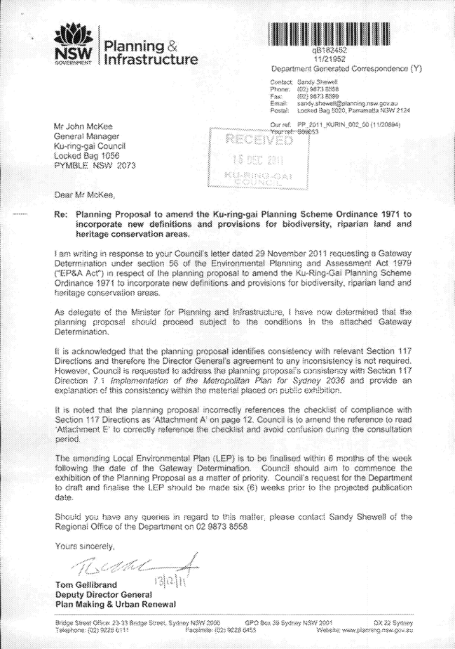
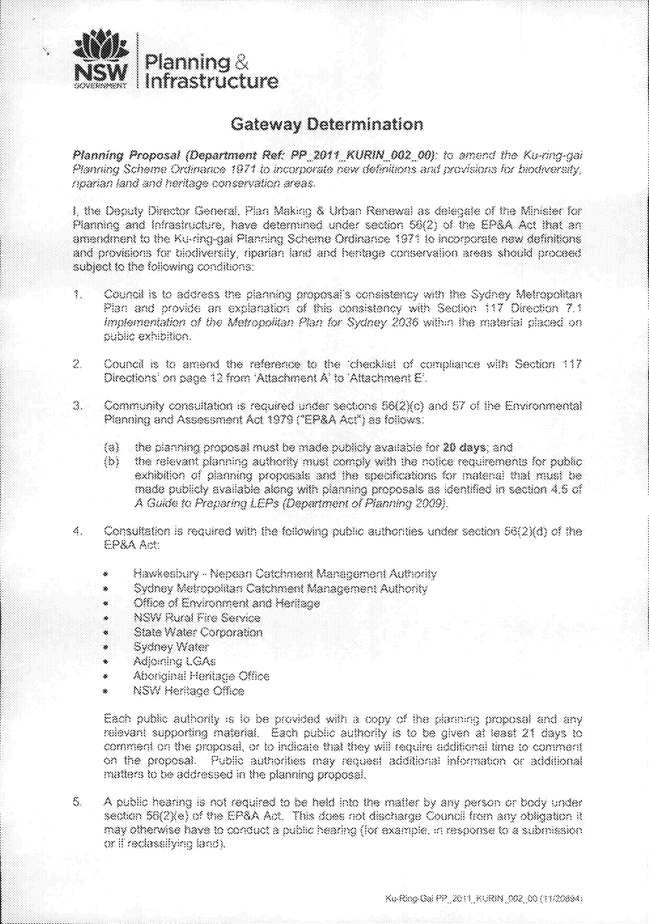
|
APPENDIX No: 2 - Planning
Proposal - Amendments to the Ku-ring-gai Planning Scheme Ordinance to
incorporate provisions for Biodiversity and Riparian land and Heritage
Conservation Areas - Public Exhibition Version
|
|
Item No: GB.4
|

Planning Proposal
Amendments to the Ku-ring-gai Planning Scheme Ordinance to
incorporate provisions for Biodiversity and Riparian land and Heritage
Conservation Areas
January
2012
PUBLIC
EXHIBITION VERSION
Contents
Background. 2
1. Objectives or intended outcomes. 3
2. Explanation of the provisions. 3
3. Justification.. 6
A. Need for the planning proposal. 6
B. Relationship to strategic planning
framework. 9
C. Environmental, social and economic
impact. 16
D. State and Commonwealth interests. 17
4. Details of the community
consultation.. 17
ATTACHMENT
A - Letter from Minister for Planning and Infrastructure
ATTACHMENT
B1 - Proposed Biodiversity and Riparian Land LEP provisions
ATTACHMENT
C1 - Proposed Heritage Conservation LEP Provisions
ATTACHMENT
D - Heritage conservation area statements of significance
ATTACHMENT
E - Assessment of Planning Proposal Consistency with Section 117
Direction and State Environmental Planning Policies
|
APPENDIX No: 2 - Planning
Proposal - Amendments to the Ku-ring-gai Planning Scheme Ordinance to
incorporate provisions for Biodiversity and Riparian land and Heritage
Conservation Areas - Public Exhibition Version
|
|
Item No: GB.4
|
Background
The
NSW Land & Environment Court declared the Ku-ring-gai Local
Environmental Plan (Town Centres) 2010 invalid on 28 July 2011 creating
much planning uncertainty in Ku-ring-gai. Since that time Council has been in
discussions with the Minister for Planning & Infrastructure and the
Department and has now agreed on a proposal for the best way forward to resolve
the strategic planning issues in Ku-ring-gai.
As
part of its overall strategic planning, Council is seeking the preparation of
an Interim Biodiversity and Heritage LEP. The matter of the development of an
interim LEP (dealing with biodiversity and heritage issues) has been also
discussed with the Minister and the Department. It has been agreed that the LEP
should be prepared on the basis that development of the interim LEP did not
divert Council resources from development of a fresh town centres LEP or
lengthen the overall timeframe for a new Town centres LEP and Council’s
Principal LEP.
The
Minister has written to Council expressing his support for the prospered time
lines for the Ku-ring-gai LEPs. A copy of the Minister’s letter and the
endorsed timeline for the preparation of the interim Biodiversity and Heritage
LEP is included as Attachment A.
It
is essential that Council initiate a draft Biodiversity and Heritage LEP in
order to protect the specific character of Ku-ring-gai, its heritage and
natural landscapes and to form a basis for future residential, retail and commercial
planning in our LGA.
The
proposed Biodiversity and Heritage LEP is to be based solely on work already
undertaken by the Council. The biodiversity and riparian provisions will be
based on the draft natural resource strategies on bushfire, biodiversity and
riparian lands previously exhibited (in non-statutory form) as part of the
Principal LEP, including the biodiversity and riparian lands indentified in the
Ku-ring-gai Town Centres LEP. The identified Heritage Conservation Areas
(HCAs) are a result of previously exhibited (in non-statutory form) studies as
part of the Comprehensive LEP and the 14 HCAs of the former (gazetted) Ku-ring-gai
Local Environmental Plan (Town Centres) 2010 and take into consideration
public submissions received during the exhibitions.
|
APPENDIX No: 2 - Planning
Proposal - Amendments to the Ku-ring-gai Planning Scheme Ordinance to
incorporate provisions for Biodiversity and Riparian land and Heritage
Conservation Areas - Public Exhibition Version
|
|
Item No: GB.4
|
1. Objectives or intended
outcomes
The
intended outcome of the planning proposal is to implement an LEP to amend the
Ku-ring-gai Planning Scheme Ordinance to incorporate biodiversity and riparian
lands provisions and Heritage Conservation Areas to:
· protect,
maintain and improve biodiversity
· maintain
or improve waterways and riparian lands
· protect
the specific character of Ku-ring-gai: its heritage and natural landscapes, and
· form the
basis for future residential, retail and commercial planning in our LGA.
2. Explanation of the provisions to be included in the proposed local
environmental plan.
This
planning proposal seeks to amend the Ku-ring-gai Planning Scheme Ordinance
(KPSO) to:
i. include a clause and associated map relating to
biodiversity protection;
ii. include a clause and associated map relating
to riparian lands and waterways
iii. delete existing heritage clauses and replacing
them with the standard instrument LEP heritage conservation clause;
iv. include a heritage conservation areas map
v. add additional definitions and amend existing
definitions to support the new clauses.
Details
of the proposed provisions are as follows:
Biodiversity
Protection
The
proposed biodiversity provisions seek to protect, maintain and enhance biodiversity
in the LGA and beyond. The objectives of the proposed clause relate to the
protection and recovery of native flora and fauna, (including species and
ecological communities listed as threatened in state or federal legislation),
their habitat and linkages between habitat areas.
The
clause relates to a map which identifies areas of strategic biodiversity
significance, based on a conservation significance assessment. The focus is on
the consideration of strategic landscape scale biodiversity processes. For
example, the map includes areas that do not include vegetation, but that are
important to link habitat areas. It also excludes some areas where isolated
small stands of a threatened ecological community occur, as these will still be
covered under threatened species legislation.
The
provisions outline considerations for the consent authority and matters about
which the consent authority must be satisfied. These relate to:
· the
vegetation or habitat significance;
· the
function of the vegetation, habitat or site within the landscape;
· the
potential impacts of the development on the above;
· measures
proposed to mitigate unavoidable impacts;
· opportunities
for restoration, considering ‘no net loss’ as a guide.
The
proposed clause has been previously approved by Parliamentary Counsel and
was included within former gazetted Ku-ring-gai LEP (Town Centres) 2010
(See Attachment B1). The proposed Natural Resource Biodiversity Map is
included as Attachment B2.
Riparian
land and waterways
The
proposed riparian provisions seek to protect or enhance waterways and riparian
land in the LGA and downstream catchments. The objectives of the proposed
clause relate to the protection and enhancement of water quality, aquatic and
riparian habitats, (including for species and communities listed as threatened
in state or federal legislation), bed and bank stability and the processes
which support these. Scenic and cultural values are also sought to be
protected.
The
clause relates to a map which identifies riparian lands (including the
waterways) in four categories, based on a conservation significance assessment.
The
provision outlines considerations for the consent authority and matters about
which the consent authority must be satisfied. These relate to:
· the
natural values of the waterway and riparian land;
· the
hydrological and ecological processes that support the above;
· the
potential impact of the location and design of development;
· integration
of riparian, stormwater and flooding measures;
· measures
proposed to mitigate unavoidable impacts;
· opportunities
for restoration.
The
proposed clause has been previously approved by Parliamentary Counsel and
was included within former gazetted Ku-ring-gai LEP (Town Centres) 2010
(See Attachment B1). The proposed Natural Recourse Riparian Map is
included as Attachment B3
Heritage Conservation Areas
The
proposed heritage conservation area provisions seeks to protect heritage in
Ku-ring-gai through amending the KPSO to introduce 38 new heritage conservation
areas and include the standard heritage clause (Cl 5.10) from the standard
instrument LEP template.
Specifically, the proposed LEP is seeking to amend
the KPSO as follows:
1. Amend clause 4.(1)
Interpretation to include definitions consistent with the standard instrument LEP template.
New definitions to be added:
· Aboriginal object
· Aboriginal place of heritage significance
· archaeological site
· curtilage
· demolish
· excavation
· heritage conservation area
· heritage conservation management plan
· heritage impact statement
· heritage management document
· maintenance
· nominated State heritage item
Definitions to be omitted and a new
definition added:
· heritage item
· heritage significance
· relic
2. To omit the clauses 61D, 61E, 61F, 61G and 61H pertaining to:
· Development of heritage items;
· Development in the vicinity of heritage items;
· Conservation areas; and
· Conservation incentives relating to heritage items.
And insert from the standard instrument
LEP template new clauses being clause 5.10 (1) - (10) Heritage conservation.
3. Amend Schedule 7 Heritage Items to
include Part 3 - Heritage conservation areas and list the following 38
heritage conservation areas:
1. Wahroonga Conservation Area
2. Heydon Avenue, Warrawee/Woodville Avenue, Wahroonga Conservation Area
3. Warrawee Conservation Area
4. Mahratta Conservation Area
5. Laurel Avenue/King Street Conservation Area
6. Ku-ring-gai Avenue Conservation Area
7. Park Estate Conservation Area
8. Pymble Heights Conservation Area
9. Fernwalk Conservation Area
10. Orinoco Street
Conservation Area
11. Pymble Avenue
Conservation Area
12. Gordondale Estate Conservation Area
13. Roberts Grant Conservation Area
14. Love Estate/Thorne/Oatley Grant Conservation Area
15. Gordon Park Estate McIntosh/Ansell Grant
Conservation Area
16. St Johns Avenue
Conservation Area
17. Gordon Park Conservation Area
18. Yarabah Avenue
Conservation Area
19. Smith Grant Conservation Area
20. Greengate Estate Conservation Area
21. Springdale Grant Conservation area
22. Crown Blocks Conservation Area
23. Lynwood Avenue
Conservation Area
24. Marian Street
Conservation Area
25. Stanhope Road
Conservation Area
26. Oliver Grant Conservation Area
27. Blenheim Road
Conservation Area
28. Wolseley Road
Conservation Area
29. Balfour Street/ Highfield Road Conservation Area
30. Lindfield West Conservation Area
31. Trafalgar Avenue
Conservation Area
32. Clanville Conservation Area
33. Earl of Carnarvon Conservation Area
34. Archbold Farms Conservation Area
35. The Grove Conservation Area
36. Lord Street/Bancroft Avenue Conservation Area
37. Garden of Roseville Estate Conservation Area
38. Shirley Road
Conservation Area
4. Incorporate a new map titled ‘Heritage
Conservation Area Map’ that identifies the new heritage conservation areas
as listed in the Schedule 7 amendment above.
The
proposed clauses for Heritage Conservation may be found in Attachment C1.
The proposed Heritage Conservation Area Map is included as Attachment
C2.
3. Justification for those objectives, outcomes and provisions and
the process for their implementation.
A. Need for the planning proposal.
A1. Is the planning proposal a result of any
strategic study or report?
Yes, the planning proposal results from extensive
studies undertaken by Ku-ring-gai Council for biodiversity, riparian and
heritage matters. The details of these studies are outlined below.
Biodiversity and Riparian studies
A number of previous studies have identified the need
for land use planning to address the pressures on biodiversity and riparian
lands resulting from urbanisation in Ku-ring-gai.
The Ku-ring-gai Residential Development Strategy:
Environmental Baseline Study, for Ku-ring-gai Municipal Council (Conacher
Travers Pty Ltd, 2000) identified a number of key natural environmental values
within the LGA. These include:
· the
three surrounding National Parks,
· remnant
pockets of native vegetation within the urban environment providing refuges for
many flora and fauna species as well as critical last vestiges for threatened
ecological communities
· waterways
and riparian lands
· linkages
between the major reserves of the local area
· the
range of topographical representations, elevations, aspects and soils which
have resulted in a diversity of habitats, supporting a range of threatened
flora and fauna.
Conacher
Travers (2000) identified the key pressures from urbanisation, including
clearing and fragmentation, stormwater runoff, increased nutrients, bushfire
and bushfire management and introduced species. The study identified a range
of environmentally sensitive areas that need consideration in land use plans,
including broad ‘bio-links’ containing existing tree canopy, riparian lands and
lands adjacent to open space or bushland.
In
2004, Council, in conjunction with Macquarie University and the NSW Department
of Infrastructure, Planning and Natural Resources (DIPNR), undertook a mapping
(desktop) and categorisation of riparian lands in the LGA. The categories were
based on the approach developed in 2004 by DIPNR in Riparian Corridor
Management Study: Covering all of the Wollongong Local Government Area and
Calderwood Valley in the Shellharbour Local Government Area, which defines
the core functions as well as the current and predicted environmental
significance. This was used to develop Council’s Riparian Policy.
Ku-ring-gai
Council’s Lands of High and Special Ecological Value, Draft Methodology
(2008) built on the Conacher Travers study and riparian study outlined above
and incorporated a conservation significance assessment of vegetation and
riparian mapping for the 6 centres covered in the former Ku-ring-gai LEP
(Town Centres) 2010. This was undertaken in conjunction with extensive
field validation of riparian lands and vegetation mapping of the LGA, starting
with the Town Centre areas. The study was designed to integrate with broader
regional mapping and inform the protection of important natural resources under
the LEP. The conservation significance assessment led to the development of map
overlays and accompanying LEP provisions for the protection of biodiversity
significance and riparian lands, similar to that proposed in the current
planning proposal. This was incorporated within the LEP at that time. The land
use recommendations also included the use of environmental zones within the
centres covered by the LEP, resulting in the application of E2 Environmental
Protection and E4 Environmental Living to a number of sites within the former
LEP.
The
Biodiversity and Riparian Lands Study, Ku-ring-gai Principal LEP Draft
Background Study (Ku-ring-gai Council, 2011) used the detailed vegetation
and riparian mapping as for the previous study, but for the rest of the LGA.
It refined the conservation significance methodology to take into account the
broader vegetation and riparian mapping and an analysis of the outcomes of the
previous conservation significance assessment methodology, as applied at the
LGA scale. Areas of strategic ecological significance are mapped and
categorised. The study recommends a map overlay and local provisions for the
Principal LEP, with a more detailed breakdown of categories and controls within
the accompanying DCP. This approach is in line with the planning proposal.
As
in the previous study, the land use recommendations also include the use of
environmental zones. All four environment zones under the Standard LEP
Instruments are recommended for inclusion in the Principal and Town Centres
LEPs. This work is continuing.
Subsequent
to the exhibition of the Draft Biodiversity and Riparian Lands Study
further minor refinements of the methodology and mapping have been undertaken
and incorporated within the Biodiversity and Heritage LEP proposed by the
Planning Proposal.
Heritage studies
Numerous
studies have been conducted in Ku-ring-gai Council over many years to ascertain
the cultural significance of heritage conservation areas. The most recent
studies undertaken being:
· Paul
Davies Pty Ltd (2008) Ku-ring-gai Town Centres Heritage Conservation Area
Review;
· Paul
Davies Pty Ltd (2010) Northern Heritage Conservation Area Review; and
· Architectural
Projects (2010) Southern Heritage Conservation Area Review.
Each
study reviewed areas previously identified in other studies as potential
heritage conservation areas, in particular the Urban Conservation Areas Studies
undertaken by Godden Mackay Logan from 2001-2005. The objective of the most
recent studies was to assess the degree of change that had occurred in the last
6-10 years and determine the intactness of the potential heritage conservation
areas.
Heritage
conservation areas were assessed in accordance with the ‘Burra Charter’ and the
associated ‘Guidelines’ and the NSW Heritage Office ‘Heritage Manual’. The
reports and associated inventory sheets were publicly exhibited. Some
amendments were made to the proposed HCAs based upon consideration of community
submissions and the results of further assessment. The Ku-ring-gai Town Centres Heritage Conservation Area Review was presented to the (former) Ku-ring-gai
Planning Panel who adopted the recommendations for the proposed heritage
conservation areas within the Ku-ring-gai Town Centres. The Northern and
Southern Heritage Conservation Area Reviews were presented to Ku-ring-gai
Council who adopted the recommendations for the proposed heritage conservation
areas in Ku-ring-gai outside of the Town Centres.
Attachment
D includes a Statement of
Significance for each of the HCAs adopted by the (former) Ku-ring-gai Planning
Panel and Ku-ring-gai Council and are now recommended for inclusion in the
Ku-ring-gai Planning Scheme Ordinance.
A2. Is the planning proposal the best means of
achieving the objectives or intended outcomes, or is there a better way?
Biodiversity and Riparian
If
the biodiversity and riparian areas were required to wait for the Principal and
Town Centre LEPs, this would leave the identified areas unnecessarily
unprotected for a continued extended timeframe. This could be detrimental as
these areas were already identified through the former Ku-ring-gai LEP (Town
Centres) 2010 (exhibited as a draft in 2008) and Council’s Draft Biodiversity
and Riparian Background Study exhibited early in 2011.
Another
method may be relying on state and federal legislation and Council’s existing
policies; in particular, the Environmental Protection and Biodiversity
Conservation Act 1999, the NSW Threatened Species Conservation Act 1995,
the Ku-ring-gai Riparian Policy 2004 and DCP 47 - Water Management.
However,
the lack of a strategic framework means that decisions are made only on a
reactive basis, while the complexity and intertwining of the natural and urban
environments in Ku-ring-gai has also contributed to fairly ad hoc
decision-making in respect to the protection of biodiversity and riparian
lands.
Another
method may be the use of land use zones to restrict uses in environmentally
sensitive areas. This method will be used in the future Principal and Town
Centres LEPs, however, it is intended to limit their use to ensure that
environmental zones are only applied to an entire site or area where there are
severe or a range of constraints, relying on the biodiversity and riparian
mapping (supplemented by DCP provisions) across other lands. Reliance on
environmental zones alone would either unnecessarily limit development
opportunities at one end of the scale, or provide inadequate biodiversity and
riparian protection across the LGA at the other end.
It
should be noted that more detailed provisions will be included in a development
control plan (DCP).
The
planning proposal offers a strategic framework to trigger the consideration of
biodiversity and riparian values regardless of the zone, especially in the
period prior to the gazettal of the Principal and Town Centre LEPs. As such,
the most appropriate means to protect biodiversity and riparian lands, at this
time, is to identify areas of strategic biodiversity and riparian significance
on a map, with accompanying provisions within the LEP.
Heritage
The
existing statutory mechanism for the protection of local heritage in New South
Wales is inclusion on the heritage schedule and heritage map of a given local
government area’s local environmental plan. The amendment of the KPSO to
include the recommended heritage conservation areas will enable Council to
conserve these culturally significant areas and protect them from further
erosion though demolition and unsympathetic development.
At this stage, Ku-ring-gai has no gazetted heritage
conservation areas. If the heritage conservation areas were required to wait
for the gazettal of the Town centres and Principal LEPs, this would leave the
identified areas unnecessarily unprotected and susceptible to demolition.
A3. Is there a net community benefit?
This
Planning Proposal does not involve a rezoning and therefore the ‘Net Community
Benefit Test’ is not applicable. However, this Planning Proposal will provide
a community benefit via the opportunity to update our planning controls, retain
the values of Ku-ring-gai’s built and natural heritage whilst also providing a
basis for the future implementation of plans to respond to the Metropolitan Strategy
and sub-regional planning.
Biodiversity and Riparian
The
proposed biodiversity and riparian clauses will protect and enhance the natural
environment. These clauses are aimed at improving biodiversity, waterways and
their buffers, which benefits the whole community by sustaining a healthy
natural environment to live in. There is also an overall community benefit
through the implementation of a strategic and consistent approach to
biodiversity management.
Heritage
Protecting a conservation area has the benefit of
conserving for current and future generations the aesthetic and social
qualities which give the area its cultural value and make it an appealing place
to live. Other benefits include certainty as to the types of and form of
development that occurs in a conservation area, ensuring the character of an
area is retained.
It is acknowledged that some restrictions and
additional development costs may result from inclusion in a heritage
conservation area. However, on balance the community benefit from the
conservation of Ku-ring-gai’s heritage areas including the buildings, gardens
and streetscapes provides a net community benefit.
B. Relationship to strategic planning framework.
B1. Is the planning proposal consistent with the
objectives and actions contained within the applicable regional or sub-regional
strategy?
Yes,
the Planning Proposal is consistent with the objectives and actions contained
in the Metropolitan Plan for Sydney 2036 and the draft North Subregional
Strategy.
The
relevant strategic directions and associated actions in the Metropolitan Plan
are:
· Tackling
Climate Change and Protecting the Environment
o Action G3.1 Integrate environmental targets into
infrastructure and land use planning. This action outlines measures, such as using the most up to date information such as biodiversity
mapping to ensure environmental targets can be achieved and monitored
regularly, and establishing consistent and measurable metrics to allow
comparative assessment. These measures contribute to natural resource
management targets while balancing economic and social factors.
o Action G4.2 Guide Councils in mapping significant
riparian corridors. This action recognises that
quality, up-to-date mapping informs decision making on the protection of
aquatic and terrestrial biodiversity values and on meeting objectives and
targets, and the essential role of riparian corridors in protecting a
waterway’s aquatic and terrestrial biodiversity values and the stability of its
bed and banks.
o Action G6.1 Implement the NSW Biodiversity Strategy to protect identified priority conservation
areas and guide land use planning. The Draft NSW Biodiversity Strategy 2010-2015 includes the following:
§ Target 4: By 2015, regional land-use planning processes are
informed by landscape scale biodiversity assessment and contain provisions that
contribute to the protection of biodiversity.
§ Objective 6: Use strategic mechanisms to assess, conserve and
improve biodiversity values in land-use planning
§ Objective 9: Protect and restore aquatic ecosystems.
· Achieving
Equity, Liveability and Social Inclusion
o Action H1.1 Incorporate equity, liveability and
social inclusion as a strategic direction in Subregional Strategies to ensure
they can be implemented at the local level and in council LEPs. This action
includes a requirement for subregional planning including LEPs, to encourage
and strengthen heritage, to integrate local identity and integrate new communities
with existing local communities.
The
proposed instrument will include specific provisions for riparian and
biodiversity protection. These will relate to up-to-date riparian and
biodiversity mapping layers based on a strategic approach and a consistent
methodology.
The
proposed heritage conservation areas and associated clauses will ensure that
heritage is strengthened and can be integrated within future planning for the
centres and the LGA as a whole.
These
measures will not compromise the potential to achieve the other aims of the
Metropolitan Plan, but will ensure that they can be considered as an integral
part of future planning decisions.
The
most applicable objectives and actions in the draft North Subregional Strategy
are those related to Environment, Heritage and Resources.
The
biodiversity and riparian clauses will support the following aims of the Draft
North Subregion: Draft Subregional Strategy:
· the
protection of Sydney’s unique plants and animals;
· improvement
of the health of waterways;
· improvement
in the sustainable use of resources;
· addressing
and responding to climate change.
The
proposed instrument will include specific provisions and mapping layers which
address biodiversity and riparian issues. It will not compromise the potential
to achieve the other aims of the Draft Strategy.
An aim of the Draft North Subregional Strategy is to
protect the environment and a key action to conserve Sydney’s cultural
heritage. The conservation of culturally significant heritage conservation
areas in Ku-ring-gai is consistent with this objective.
B2. Is the planning proposal consistent with the
local council’s Community Strategic Plan, or other local strategic plan?
Yes,
Council adopted the Community Strategic Plan 2030 on 13 October 2009. This
Strategic Plan is based around the following principal activity areas:
· community
development
· urban
environment
· natural
environment
· planning
and development
· civic
leadership and corporate services
· financial
sustainability
The
planning proposal is not inconsistent with this Strategic Plan, specifically
the following objectives:
· Comprehensive
Integrated Principal LEP and Development Control Plan (DCP) completed for the
local government area (LGA) that addresses the Metropolitan Strategy and North
Subregion objectives
· Protect,
enhance and where appropriate increase local biodiversity and terrestrial,
habitats and connectivity between reserves
· Council
planning systems apply the principles of sustainability, best practice urban design
and place making to meet the needs of the community
B3. Is the planning proposal consistent with
applicable state environmental planning policies?
The
following table identifies the key applicable SEPPs and outlines the planning
proposal’s consistency with those SEPPs. A checklist of compliance with all
applicable SEPPs is contained at Attachment E.
|
SEPP
|
Comment
on Consistency
|
|
SEPP No.
19 Bushland in Urban Areas
|
When
preparing draft local environmental plans for any land to which SEPP 19
applies, other than rural land, the council shall have regard to the general
and specific aims of the Policy, and give priority to retaining bushland,
unless it is satisfied that significant environmental, economic or social
benefits will arise which outweigh the value of the bushland.
Compliance
with SEPP 19 is one of the considerations addressed through the biodiversity
mapping and the Biodiversity and Riparian Lands, Draft Background Study
(Ku-ring-gai Council, 2011). These have guided the implementation of planning
provisions for SEPP 19 bushland.
|
|
SEPP
No.44 - Koala Habitat Protection
|
In order
to give effect to the aims of this Policy, a council should survey the land
within its area so as to identify areas of potential koala habitat and core
koala habitat, and make or amend a local environmental plan to include land
identified as a core koala habitat within an environmental protection zone,
or to identify land that is a core koala habitat and apply special provisions
to control the development of that land.
Feed
trees identified within SEPP 44 are found in Ku-ring-gai. Any potential
habitat is likely to be within the areas identified as Regional Fauna Habitat
in the Biodiversity and Riparian Lands Draft Background Study
(Ku-ring-gai Council, 2011) proposed for inclusion in the Natural
Resource – Biodiversity Protection Map, with its associated provisions.
However, no core koala habitat has been identified in the LGA in the land to
which this SEPP applies, and the most recent koala sighting within the LGA of
which Council is aware was over 40 years ago.
|
|
State
Environmental Planning Policy (Exempt and Complying Development Codes) 2008
|
The Codes
SEPP aims to provide streamlined assessment processes for development certain
types of development that are of minimal environmental impact and identifying
types of complying development that may be carried out in accordance with
complying development codes.
The
biodiversity provisions contained in the planning proposal will not affect
the application of the SEPP as it does not identify land as an “environmentally
sensitive area” as defined by the Codes SEPP.
The
planning proposal does include the implementation of “heritage
conservation area(s)” as defined by the Codes SEPP. This will limit the
application of the codes under the SEPP on the land identified as heritage
conservation areas in this planning proposal.
|
|
SREP
No.20 Hawkesbury-Nepean River
|
The
deemed SEPP requires consideration be given to the impact of future land use
in Hawkesbury-Nepean River catchment in a regional context. It also requires
an environmental planning instrument to have regard to general and specific
considerations, policies and strategies related to total catchment
management, water quality and quantity, environmentally sensitive areas, flora
and fauna, riverine scenic quality, agriculture, aquaculture and fishing,
urban and rural residential development, recreation and tourism and the
Metropolitan Strategy.
Considerations
under the SEPP have been taken into account when developing provisions under
the planning proposal. The proposal particularly addresses water quality and
quantity, environmentally sensitive areas and flora and fauna within the Hawkesbury-Nepean River catchment.
|
|
SREP (Sydney Harbour Catchment) 2005
|
The
deemed SEPP aims to establish a balance between maintaining and restoring the
natural, heritage and scenic values of the Sydney Harbour catchment,
promoting recreational access to the foreshore and waterways and promoting a
prosperous working harbour. It establishes planning principles and controls
for the catchment as a whole that are to be considered and, where possible,
achieved in the preparation of environmental planning instruments.
The
planning proposal is consistent with the SEPP as it aims to protect and enhance
identified environmentally sensitive lands and waterways and implement
appropriate planning provisions. No changes in heritage status are proposed
for sites identified within the Sydney Harbour Catchment.
|
B4. Is the planning proposal consistent with
applicable Ministerial Directions (s.117 directions)?
The
following table identifies applicable Section 117 Directions and outlines the
planning proposal’s consistency with those directions. A checklist of
compliance with all Section 117 Directions is contained at Attachment E.
|
Directions under S117
|
Objectives
|
Consistency
|
|
1.1 Business and Industrial
Zones
|
The
objectives of this direction are to:
(a) Encourage employment
growth in suitable locations,
(b) protect employment land in
business and industrial zones, and
(c) support the viability of
identified strategic centres.
|
Consistent.
The
planning proposal does not reduce the area or the floor space potential of
existing business zones.
|
|
2.1 Environment Protection
Zones
|
The
objective of this direction is to protect and conserve environmentally
sensitive areas.
|
Consistent.
While no
changes are proposed to zoning, it is proposed that the LEP include
provisions that facilitate the protection and conservation of environmentally
sensitive areas.
The
planning proposal proposes to identify land for environment protection
purposes in the LEP and introduce provisions with improved environmental
protection standards applying to the land.
|
|
2.3 Heritage Conservation
|
The objective of this direction is to conserve items,
areas, objects and places of environmental Heritage significance and
indigenous heritage significance.
|
Consistent.
The LEP
will include the provisions to conserve items, areas, objects and places of
environmental heritage significance. This will take the form of the standard
instrument heritage conservation clause and will also include the
introduction of heritage conservation areas.
|
|
2.4 Recreation Vehicle Areas
|
The objective of this direction is to protect sensitive
land or land with significant conservation values from adverse impacts from
recreation vehicles.
|
Consistent.
The
planning proposal does not propose to enable land to be developed for the
purpose of a recreation vehicle area.
|
|
3.1 Residential Zones
|
The objectives of this direction are:
(a) to encourage a variety
and choice of housing types to provide for existing and future housing needs,
(b) to make efficient use of
existing infrastructure and services and ensure that new housing has
appropriate access to infrastructure and services, and
(c) to minimise the impact of
residential development on the environment and resource lands.
|
Consistent.
The
planning proposal does not contain any provisions that will reduce the area
of land zoned for housing or reduce permissible residential density of land.
It does propose to minimise the impact of residential development on the
environment.
|
|
3.2 Caravan Parks and Manufactured Home Estates
|
The objectives of this direction are:
(a) to provide for a variety
of housing types, and
(b) to provide opportunities
for caravan parks and manufactured home estates.
|
Consistent.
The
planning proposal does not propose any rezoning or changes in provisions
relating to caravan parks.
|
|
3.3 Home Occupations
|
The objective of this direction is to encourage the
carrying out of low-impact small businesses in dwelling houses
|
Consistent.
The
planning proposal does not propose any changes to the provisions relating to
home occupation
|
|
3.4 Integrating Land Use and
Transport.
|
The
objective of this direction is to ensure that urban structures, building
forms, land use locations, development designs, subdivision and street
layouts achieve the following planning objectives:
(a) improving access to
housing, jobs and services by walking, cycling and public transport, and
(b) increasing the choice of
available transport and reducing dependence on cars, and
(c) reducing travel demand
including the number of trips generated by development and the distances
travelled, especially by car, and
(d) supporting the efficient
and viable operation of public transport services, and
(e) providing for the
efficient movement of freight.
|
Consistent.
The
planning proposal does not propose any changes to zoning or land use.
The
natural resource and heritage provisions will not prevent the achievement
under the future Town Centres and Principal LEPs of zoning and land uses
consistent with the aims, objectives and principles of Improving Transport
Choice – Guidelines for planning and development and The Right Place
for Business and Services – Planning Policy.
|
|
4.1 Acid Sulfate Soils
|
The
objective of this direction is to avoid significant adverse environmental
impacts from the use of land that has a probability of containing acid
sulfate soils.
|
Consistent.
There are
small areas in Ku-ring-gai with a probability of containing acid sulfate
soils. These areas are identified for their natural values within the
proposed environmentally sensitive lands maps, affording them greater
protection. The planning proposal does not propose an intensification of
land uses on this land.
|
|
4.4 Planning for Bushfire
Protection
|
The
objectives of this direction are:
(a) to protect life, property
and the environment from bush fire hazards, by discouraging the establishment
of incompatible land uses in bush fire prone areas, and
(b) to encourage sound
management of bush fire prone areas.
|
Consistent.
The
planning proposal does not propose any alterations to zoning or land use, and
nothing in the proposed instrument would prohibit the carrying out of
bushfire hazard reduction works in asset protection zones.
Significant
portions of the areas identified as environmentally sensitive are bushfire
prone lands.
The
identification of the core environmentally sensitive lands, which are the
backbone of the biodiversity map, was reduced in many areas as a result of
the consideration of the need for bushfire protection measures.
Consultation
with the NSW Rural Fire Service is proposed as outlined in D2.
|
|
6.1 Approval and Referral
Requirements
|
The objective of this direction is to ensure that LEP
provisions encourage the efficient and appropriate assessment of development.
|
Consistent.
The
planning proposal does not seek to incorporate additional provisions that
require the concurrence, consultation or referral of development applications
to a Minister or public authority, or identify development as designated
development.
|
|
6.2 Reserving Land for Public
Purposes
|
The
objectives of this direction are:
(c) to facilitate the provision of public services
and facilities by reserving land for public purposes, and
(d) to facilitate the removal of reservations of land
for public purposes where the land is no longer required for acquisition
|
Consistent.
The
planning proposal does not create, alter or reduce existing zonings or
reservations of land for public purposes. However, by identifying areas of
natural resource and heritage significance, it will support future
considerations in relation to the reservation of land for public purposes.
|
|
7.1 Implementation of the
Metropolitan Plan for Sydney 2036
|
The objective of this
direction is to give legal effect to the vision, transport and land use
strategy, policies, outcomes and actions contained in the Metropolitan Plan
for Sydney 2036.
|
Consistent.
The
planning proposal is consistent with the NSW Government’s Metropolitan Plan
for Sydney 2036
Details
are contained under Section 3- B1 above.
|
C. Environmental, social and economic impact.
C1. Is there any likelihood that critical habitat or
threatened species, populations or ecological communities, or their habitats,
will be adversely affected as a result of the proposal?
There
is no identified critical habitat within or directly adjoining the LGA at this
time.
The
planning proposal will actually have a positive affect on the protection of
threatened species, populations and ecological communities, and their habitats,
through the application of two maps identifying environmentally important
areas; the ‘Natural resource – biodiversity protection map’ and the ‘Natural
resource-Riparian land and waterways map ’ and provisions to protect and
enhance the natural values of these lands.
C2. Are there any other likely environmental effects
as a result of the planning proposal and how are they proposed to be managed?
There
will be positive environmental effects through the protection of the existing
natural and built environment.
C3. How has the planning proposal adequately
addressed any social and economic effects?
Due
to the nature of this planning proposal, it is not possible to undertake a
definitive study on its social and economic effects. However, it is considered
that the proposed clauses adequately address any social and economic effects.
Biodiversity and Riparian
The
proposed biodiversity and riparian clauses will protect and enhance the natural
environment. In seeking to improve biodiversity, waterways and their buffers,
there are the social and economic benefits for the whole community of living in
a healthy natural environment. The character of the LGA is formed to a large
extent through the retention of vegetation within the urban setting.
The
proposed provisions may mean that individual development proposals are
restricted in some way or have additional economic costs associated with
vegetation or riparian management or offsets in order to develop. However, the
use of an overlay with the biodiversity and riparian clauses means that the
underlying zoning will continue to permit development in accordance with the zone.
The proposed riparian and biodiversity LEP provisions provide for instances
where adverse impacts are unavoidable, in which circumstances the proposed
development must be designed and sited to have a minimum adverse impact and
include mitigation measures.
On
balance the overall the social and economic benefits of a strategic and
consistent approach to biodiversity management outweighs possible additional
costs and/or loss of perceived development potential.
Heritage
There are social and economic costs and benefits to
the introduction of heritage conservation areas, both to the individual and to
the community. Protecting a conservation area has the benefit of conserving for
current and future generations the aesthetic and social qualities which give the
area its cultural value and make it an appealing place to live. Other benefits
include certainty as to the types of and form of development that occur in a
conservation area to ensure the character of the area retained.
It is also acknowledged that some restrictions and
additional development costs may result from inclusion in a heritage
conservation area. These include additional development controls and more
rigorous scrutiny certain types of development such as demolition for new
builds of contributory sites and lot subdivision or amalgamations. Heritage
items or places within heritage conservation areas that are deemed as meeting
the criteria for being heritage restricted under section 14G of the Valuation
of Land Act, 1916 may be eligible for a heritage restricted valuation for the
purposes of land tax.
On
balance the overall the social and economic benefits from the conservation of
Ku-ring-gai’s heritage areas including the buildings, gardens and streetscapes
provides outweighs possible additional costs and/or loss of perceived
development potential of properties in heritage conservation areas.
D. State and Commonwealth interests.
D1. Is there adequate public infrastructure for the
planning proposal?
As
the planning proposal will not result in any increases in residential density
or intensity of land uses and as such will not place additional demands or
pressures on existing infrastructure.
D2. What are the views of State and Commonwealth
Public Authorities consulted in accordance with the gateway determination, and
have they resulted in any variations to the planning proposal?
The views of State and Commonwealth Public
Authorities will not be known until after the initial gateway determination. It
is proposed that the following State and Commonwealth Public Authorities will
be consulted:
· NSW Office of Environment and Heritage
· Land and Property Management Authority
· NSW Office of Water
· NSW Rural Fire Service
· National Parks & Wildlife Service
· NSW Heritage Office
· Aboriginal Heritage Office
· Hornsby Shire Council
· Ryde City Council
· Warringah Council
· Willoughby City
Council
· Hawkesbury Nepean Catchment Management Authority
· Sydney Metropolitan Catchment Management Authority
Comments received to date from public authorities are
included at Attachment F.
4. Details of the
community consultation that is to be undertaken on the planning proposal.
Community
consultation will be conducted in accordance with the publication “A guide to
preparing local environmental plans” released by the Department of Planning.
The planning proposal will
also be exhibited in accordance with the requirements of section 57 of the
EP&A Act and/ or any other requirements as determined by the Gateway
process under section 56 of the EP&A Act.
Amendments and
clarifications to the Planning Proposal for the purposes of community
consultation are included at Attachment G.
ATTACHMENT A – Letter from Minister for Planning and Infrastructure
ATTACHMENT B1 – Proposed
Biodiversity and Riparian Land LEP provisions
Biodiversity
Protection
(1) The objective of this clause is to
protect, maintain and improve the diversity and condition of native vegetation
and habitat, including:
(a) protecting biological diversity of
native flora and fauna, and
(b) protecting the ecological processes
necessary for their continued existence, and
(c) encouraging the recovery of threatened
species, communities, populations and their habitats, and
(d) protecting, restoring and enhancing
biodiversity corridors.
(2) This clause applies to development on
land that is identified as “Areas of Biodiversity Significance” on the Natural Resources - Biodiversity
Map.
(3) Before granting development consent for
development on land to which this clause applies, the consent authority must
consider:
(a) the impact of the proposed
development on the following:
(i) any native vegetation community,
(ii) the habitat of any threatened
species, population or ecological community,
(iii) any regionally significant species
of plant, animal or habitat,
(iv) any biodiversity corridor,
(v) any wetland,
(vi) the biodiversity values within any
reserve,
(vii) the stability of the land, and
(b) any proposed measure to be
undertaken to ameliorate any potential adverse environmental impact, and
(c) any opportunity to restore or
enhance remnant vegetation, habitat and biodiversity corridors.
(4) Development consent must not be granted
for development on land to which this clause applies unless the consent
authority is satisfied that the development:
(a) is consistent with the objectives
of this clause, and
(b) is designed, and will be sited and
managed, to avoid any potential adverse environmental impact or, if a potential
adverse environmental impact cannot be avoided:
(i) the development minimises
disturbance and adverse impacts on remnant vegetation communities, habitat and
threatened species and populations, and
(ii) measures have been considered to maintain
native vegetation and habitat in parcels of a size, condition and configuration
that will facilitate biodiversity protection and native flora and fauna
movement through biodiversity corridors, and
(iii) the development avoids clearing
steep slopes and facilitates the stability of the land, and
(iv) measures have been considered to
achieve no net loss of significant vegetation or habitat.
(5) In this clause:
biodiversity
corridor means an area to
facilitate the connection and maintenance of native flora and fauna habitats.
Within the urban landscape, biodiversity corridors may be broken by roads and
other urban elements and may include remnant trees and associated native and
exotic vegetation.
Riparian
land and waterways
(1) The objectives of this clause are:
(a) to protect or improve:
(i) water quality in waterways, and
(ii) stability of the bed and banks of
waterways, and
(iii) aquatic and riparian habitats, and
(iv) ecological processes in waterways
and riparian areas, and
(v) threatened aquatic species,
communities, populations and their habitats, and
(vi) scenic and cultural heritage values
of waterways and riparian areas, and
(b) where practicable, to provide for
the rehabilitation of existing piped or channelised waterways to a near natural
state.
(2) This clause applies to development on
land that is identified on the Natural Resources - Riparian
Lands Map as:
(a) Category 1, or
(b) Category 2, or
(c) Category 3, or
(d) Category 3a.
(3) Before granting development consent for
development on land to which this clause applies, the consent authority must
consider the impact of the proposed development on the following:
(a) water quality in the waterway, and
the natural hydrological regime,
(b) aquatic and riparian habitats and
ecosystems,
(c) stability of the bed, shore and
banks of the waterway,
(d) the movement of aquatic and
terrestrial native species,
(e) habitat of any threatened species,
population or ecological community,
(f) public access to, and use of, any
public waterway and its foreshores,
(g) any opportunities for maintenance,
rehabilitation or re-creation of watercourses, aquatic and riparian vegetation
and habitat.
(4) Development consent must not be granted
for development on land to which this clause applies unless the consent
authority is satisfied that the development:
(a) is consistent with the objectives
of this clause, and
(b) is designed, and will be sited and
managed, to avoid any potential adverse environmental impact or, if a potential
adverse environmental impact cannot be avoided, the development:
(i) is designed and sited so as to
have minimum adverse impacts, and
(ii) incorporates effective measures so
as to have minimal adverse environmental impact, and
(iii) mitigates any adverse
environmental impact through the rehabilitation or remediation of any existing
disturbed or artificially modified riparian area on the site.
ATTACHMENT C1 – Proposed Heritage Conservation LEP Provisions
Proposed amendments to
the Ku-ring-gai Planning Scheme Ordinance
Make amendments to clause
4.(1) Interpretation to be consistent with the standard LEP template:
Aboriginal object means any deposit, object or
other material evidence (not being a handicraft made for sale) relating to the
Aboriginal habitation of an area of New South Wales, being habitation before or
concurrent with (or both) the occupation of that area by persons of
non-Aboriginal extraction, and includes Aboriginal remains.
Aboriginal place of heritage significance means an area of land, the general
location of which is identified in an Aboriginal heritage study adopted by the
Council after public exhibition and that may be shown on the Heritage Map, that
is:
(a) the site
of one or more Aboriginal objects or a place that has the physical remains of
pre-European occupation by, or is of contemporary significance to, the
Aboriginal people. It may (but need not) include items and remnants of the
occupation of the land by Aboriginal people, such as burial places, engraving
sites, rock art, midden deposits, scarred and sacred trees and sharpening
grooves, or
(b) a natural Aboriginal
sacred site or other sacred feature. It includes natural features such as
creeks or mountains of long-standing cultural significance, as well as
initiation, ceremonial or story places or areas of more contemporary cultural
significance.
Note. The term may
include (but is not limited to) places that are declared under section 84 of
the National Parks and Wildlife Act 1974 to be Aboriginal places for the
purposes of that Act.
archaeological site means a place that contains
one or more relics.
curtilage, in relation to a heritage item or conservation
area, means the area of land (including land covered by water) surrounding a
heritage item, a heritage conservation area, or building, work or place within
a heritage conservation area, that contributes to its heritage significance.
demolish, in relation to a heritage
item or an Aboriginal object, or a building, work, relic or tree within a
heritage conservation area, means wholly or partly destroy, dismantle or deface
the heritage item, Aboriginal object or building, work, relic or tree.
excavation means the removal of soil or
rock, whether moved to another part of the same site or to another site, but
does not include garden landscaping that does not significantly alter the
shape, natural form or drainage of the land.
heritage conservation area means an area of land of
heritage significance:
(a) shown on
the Heritage Map as a heritage conservation area, and
(b) the location and
nature of which is described in Schedule 5,
and includes any
heritage items situated on or within that area.
heritage conservation management plan means a document prepared in accordance
with guidelines prepared by the Division of the Government Service responsible
to the Minister administering the Heritage Act 1977 that documents the
heritage significance of an item, place or heritage conservation area and
identifies conservation policies and management mechanisms that are appropriate
to enable that significance to be retained.
heritage impact statement means a document consisting of:
(a) a statement
demonstrating the heritage significance of a heritage item or heritage
conservation area, and
(b) an assessment of the impact that
proposed development will have on that significance, and
(c) proposals for measures to minimise
that impact.
heritage item means a building, work,
place, relic, tree, object or archaeological site the location and nature of
which is described in Schedule 7.
Note. An inventory
of heritage items is also available at the office of the Council.
heritage management document means:
(a) a heritage conservation
management plan, or
(b) a heritage impact statement, or
(c) any other document that provides
guidelines for the ongoing management and conservation of a heritage item,
Aboriginal object, Aboriginal place of heritage significance or heritage conservation
area.
heritage significance means historical, scientific, cultural,
social, archaeological, architectural, natural or aesthetic value.
maintenance, in relation to a heritage item,
Aboriginal object or Aboriginal place of heritage significance, or a building,
work, archaeological site, tree or place within a heritage conservation area,
means ongoing protective care, but does not include the removal or disturbance
of existing fabric, alterations (such as carrying out extensions or additions)
or the introduction of new materials or technology.
nominated State heritage item means a heritage item that:
(a) has been identified
as an item of State significance in a publicly exhibited heritage study adopted
by the Council, and
(b) the Council has, by notice in
writing to the Heritage Council, nominated as an item of potential State
significance.
relic has the same meaning as in the Heritage Act 1977.
To omit the clauses 61D,
61E, 61F, 61G and 61H and insert from the standard LEP template new clauses
being clause 5.10 (1) - (10) Heritage conservation:
Heritage
conservation
Note.
Heritage items (if any) are listed and described in Schedule 7. Heritage
conservation areas (if any) are shown on the Heritage Conservation Area Map as
well as being described in Schedule 7.
61D
(1) Objectives
The objectives of this clause are as
follows:
(a) to
conserve the environmental heritage
of Ku-ring-gai Council,
(b) to conserve the
heritage significance of heritage items and heritage conservation areas,
including associated fabric, settings and views,
(c) to conserve
archaeological sites,
(d) to conserve
Aboriginal objects and Aboriginal places of heritage significance.
(2) Requirement
for consent
Development consent is required for any
of the following:
(a).... demolishing
or moving any of the following or altering the exterior of any of the following
(including, in the case of a building, making changes to its detail, fabric,
finish or appearance):
(i) a
heritage item,
(ii) an
Aboriginal object,
(iii) a
building, work, relic or tree
within a heritage conservation area,
(b) altering
a heritage item that is a building by making structural changes to its interior
or by making changes to anything inside the item that is specified in Schedule 7 in
relation to the item,
(c) disturbing or
excavating an archaeological site while knowing, or having reasonable cause to
suspect, that the disturbance or excavation will or is likely to result in a
relic being discovered, exposed, moved, damaged or destroyed,
(d) disturbing or
excavating an Aboriginal place of heritage significance,
(e) erecting a building
on land:
(i) on
which a heritage item is located or that is within a heritage conservation
area, or
(ii) on which an
Aboriginal object is located or that is within an Aboriginal place of heritage
significance,
(f) subdividing
land:
(i) on
which a heritage item is located or that is within a heritage conservation
area, or
(ii) on which an
Aboriginal object is located or that is within an Aboriginal place of heritage
significance.
(3) When consent
not required
However, development consent under this
clause is not required if:
(a).... the applicant has
notified the consent authority of the proposed development and the consent
authority has advised the applicant in writing before any work is carried out
that it is satisfied that the proposed development:
(i)..... is of a minor nature
or is for the maintenance of the heritage item, Aboriginal object, Aboriginal
place of heritage significance or archaeological site or a building, work,
relic, tree or place within the heritage conservation area, and
(ii).... would not adversely affect the
heritage significance of the heritage item, Aboriginal object, Aboriginal
place, archaeological site or heritage conservation area, or
(b).... the development is in
a cemetery or burial ground and the proposed development:
(i) is the creation of a
new grave or monument, or excavation or disturbance of land for the purpose of
conserving or repairing monuments or grave markers, and
(ii) would not cause disturbance to
human remains, relics, Aboriginal objects in the form of grave goods, or to an
Aboriginal place of heritage significance, or
(c) the development is
limited to the removal of a tree or other vegetation that the Council is
satisfied is a risk to human life or property, or
(d) the development is exempt
development.
(4) Effect
of proposed development on heritage significance
The consent authority must, before
granting consent under this clause in respect of a heritage item or heritage
conservation area, consider the effect of the proposed development on the
heritage significance of the item or area concerned. This subclause applies
regardless of whether a heritage management document is prepared under
subclause (5) or a heritage conservation management plan is submitted under subclause
(6).
(5) Heritage
assessment
The consent authority may, before
granting consent to any development:
(a) on land on which a
heritage item is located, or
(b) on land that is within a heritage
conservation area, or
(c) on land that is within the vicinity
of land referred to in paragraph (a) or (b),
require a heritage management document to
be prepared that assesses the extent to which the carrying out of the proposed
development would affect the heritage significance of the heritage item or
heritage conservation area concerned.
(6) Heritage
conservation management plans
The consent authority may require, after
considering the heritage significance of a heritage item and the extent of
change proposed to it, the submission of a heritage conservation management
plan before granting consent under this clause.
(7) Archaeological
sites
The consent authority must, before
granting consent under this clause to the carrying out of development on an
archaeological site (other than land listed on the State Heritage Register or
to which an interim heritage order under the Heritage Act 1977 applies):
(a) notify
the Heritage Council of its intention to grant consent, and
(b) take into
consideration any response received from the Heritage Council within 28 days
after the notice is sent.
(8) Aboriginal
places of heritage significance
The consent authority must, before
granting consent under this clause to the carrying out of development in an
Aboriginal place of heritage significance:
(a) consider
the effect of the proposed development on the heritage significance of the
place and any Aboriginal object known or reasonably likely to be located at the
place by means of an adequate investigation and assessment (which may involve
consideration of a heritage impact statement), and
(b) notify the local
Aboriginal communities, in writing or in such other manner as may be
appropriate, about the application and take into consideration any response
received within 28 days after the notice is sent.
(9) Demolition
of nominated State heritage items
The consent authority must, before
granting consent under this clause for the demolition of a nominated State
heritage item:
(a) notify the Heritage
Council about the application, and
(b) take into consideration any
response received from the Heritage Council within 28 days after the notice is
sent.
(10) Conservation
incentives
The consent authority may grant consent
to development for any purpose of a building that is a heritage item or of the
land on which such a building is erected, or for any purpose on an Aboriginal
place of heritage significance, even though development for that purpose would
otherwise not be allowed by this Plan, if the consent authority is satisfied
that:
(a) the conservation of
the heritage item or Aboriginal place of heritage significance is facilitated
by the granting of consent, and
(b) the proposed development is in
accordance with a heritage management document that has been approved by the
consent authority, and
(c) the consent to the proposed
development would require that all necessary conservation work identified in
the heritage management document is carried out, and
(d) the proposed development would not
adversely affect the heritage significance of the heritage item, including its
setting, or the heritage significance of the Aboriginal place of heritage
significance, and
(e) the proposed development would not
have any significant adverse effect on the amenity of the surrounding area.
To include in Schedule 7 Heritage
Items, Part 3 - Heritage conservation areas an additional 38
heritage conservation areas being:
Part
3 - Heritage Conservation Areas
|
Description
|
Identification
on Heritage Map
|
Significance
|
|
Wahroonga
Conservation Area
|
Shown by red hatching and labelled
“C1”
|
Local
|
|
Heydon
Avenue, Warrawee/Woodville Avenue, Wahroonga Conservation Area
|
Shown by red hatching and labelled
“C2”
|
Local
|
|
Warrawee
Conservation Area
|
Shown by red hatching and labelled
“C3”
|
Local
|
|
Mahratta
Conservation Area
|
Shown by red hatching and labelled
“C4”
|
Local
|
|
Laurel
Avenue/King Street
Conservation Area
|
Shown by red hatching and labelled
“C5”
|
Local
|
|
Ku-ring-gai
Avenue Conservation Area
|
Shown by red hatching and labelled
“C6”
|
Local
|
|
Park
Estate Conservation Area
|
Shown by red hatching and labelled
“C7”
|
Local
|
|
Pymble Heights Conservation Area
|
Shown by red hatching and labelled
“C8”
|
Local
|
|
Fernwalk
Conservation Area
|
Shown by red hatching and labelled
“C9”
|
Local
|
|
Orinoco
Street Conservation
Area
|
Shown by red hatching and labelled
“C10”
|
Local
|
|
Pymble
Avenue Conservation
Area
|
Shown by red hatching and labelled
“C11”
|
Local
|
|
Gordondale
Estate Conservation Area
|
Shown by red hatching and labelled
“C12”
|
Local
|
|
Roberts
Grant Conservation Area
|
Shown by red hatching and labelled
“C13”
|
Local
|
|
Love
Estate/Thorne/Oatley Grant Conservation Area
|
Shown by red hatching and labelled
“C14”
|
Local
|
|
Gordon Park Estate McIntosh/Ansell Grant
Conservation Area
|
Shown by red hatching and labelled
“C15”
|
Local
|
|
St Johns
Avenue Conservation
Area
|
Shown by red hatching and labelled
“C16”
|
Local
|
|
Gordon Park Conservation Area
|
Shown by red hatching and labelled
“C17”
|
Local
|
|
Yarabah
Avenue Conservation
Area
|
Shown by red hatching and labelled
“C18”
|
Local
|
|
Smith
Grant Conservation Area
|
Shown by red hatching and labelled
“C19”
|
Local
|
|
Greengate
Estate Conservation Area
|
Shown by red hatching and labelled
“C20”
|
Local
|
|
Springdale
Grant Conservation area
|
Shown by red hatching and labelled
“C21”
|
Local
|
|
Crown
Blocks Conservation Area
|
Shown by red hatching and labelled
“C22”
|
Local
|
|
Lynwood
Avenue Conservation
Area
|
Shown by red hatching and labelled
“C23”
|
Local
|
|
Marian
Street Conservation
Area
|
Shown by red hatching and labelled
“C24”
|
Local
|
|
Stanhope
Road Conservation Area
|
Shown by red hatching and labelled
“C25”
|
Local
|
|
Oliver
Grant Conservation Area
|
Shown by red hatching and labelled
“C26”
|
Local
|
|
Blenheim
Road Conservation
Area
|
Shown by red hatching and labelled
“C27”
|
Local
|
|
Wolseley
Road Conservation
Area
|
Shown by red hatching and labelled
“C28”
|
Local
|
|
Balfour
Street/ Highfield Road Conservation Area
|
Shown by red hatching and labelled
“C29”
|
Local
|
|
Lindfield Park Estate Conservation Area
|
Shown by red hatching and labelled
“C30”
|
Local
|
ATTACHMENT D - Heritage
conservation area statements of significance
1. Wahroonga Conservation Area
Wahroonga Heritage Conservation Area is of heritage
significance for its distinctive residential streetscapes which evidence the
transformation of early subdivisions of the 1890s into the later rectilinear
grid lot street and lot pattern of later subdivisions including the Wahroonga
Heights Estate. The area contains a significant collection of grand residences
from the Federation and Inter-war periods, built following the opening of the
North Shore railway line in 1890, many of these the residences of prominent
families of this period, and often designed by prominent architects, for
example the 1894 Ewan House (formerly Innisfail) designed by architect Herbert
Wardell for John Thomas Toohey, and eleven houses designed by the architect
Howard Joseland. The western end of Burns Road and western side of Coonanbarra Road are representative streetscapes of intact more modest Federation period
houses.
The through-block pathways and formal avenues of
street trees within the area (in Burns Road, Water Street and Coonanbarra Road)
along with the formal landscaping of Wahroonga Park, and its distinctive John
Sulman-designed shops in Coonanbarra Road facing the Park, are a tribute to the
work of the Wahroonga Progress Association in the early 20th century (which
included Sulman as a member), and have resulted in a high-quality and
distinctive residential landscape.
2. Heydon Avenue, Warrawee/Woodville Avenue, Wahroonga Conservation Area
The Heydon Avenue Warrawee/Woodville Avenue Wahroonga
Heritage Conservation Area is a distinctive residential area of historical and
aesthetic significance for its fine Federation and Interwar period
streetscapes, including Yosefa Avenue, which contains houses designed by
architect Augustus Aley. The area contains a number of heritage items by
notable architects including Redleaf and Inglewood, both designed
by Howard Joseland. Significantly, the area retains its oldest house, Reaycroft
at 17 Heydon Avenue, built in the Federation Queen Anne style in 1895 to a
design by architects Castleton and Lake for Judge Heydon, after whom Heydon Avenue is named.
3. Warrawee Conservation Area
Warrawee Heritage Conservation Area is of aesthetic
significance for its remarkable concentration of architecturally distinguished
houses set within fine landscaped garden settings on large sites, many of the
houses designed by notable architects including Eleanor Cullis-Hill, John
Horbury Hunt, H. Joseland, Joseland & Gillings, Maurice B. Halligan, John
Sulman, Hugh Venables Vernon, Waterhouse & Lake, and Wilson, Neave &
Berry. Fine gardens blend with regenerated native trees and the undulating
topography to create an aesthetically fine residential landscape. Warrawee
Heritage Conservation Area is of historical significance as an exclusively
residential area, which retains evidence of its early settlement, subdivision and
continuing development, in its main road pattern created in the 1890s, and
evidence of later subdivision of earlier estates such as the Pibrac Estate
subdivision of 1920, which created Pibrac Avenue. A notable feature of the
area’s layout, which is of historical significance, is the early creation of
battleaxe allotments from the 1917 subdivision of the Warrawee Garden Estate.
The area is also of historical significance for its
collection of early houses associated with prominent historical figures including
Pibrac, the home of Frederick Eccleston Du Faur (1832 -1915); Roseburn
and Kooyong designed for two of the Gillespie brothers, proprietors
of Anchor Flour Mills and prominent benefactors of Knox Grammar School, and Audley,
designed for Preston L. Gowing of Gowings department stores.
4. Mahratta Conservation Area
The Mahratta Heritage Conservation Area is of
historical and aesthetic significance for its largely intact fabric (houses,
gardens, street layout) dating from the 1890s through to the inter war period
into the 1940s. The area is of aesthetic significance as: it encompasses the
State Heritage Listed Mahratta built 1941 on the corner of the Pacific Highway
and Fox Valley Road with its substantial gardens designed by Paul Sorenson; the
1924 subdivision of Myall Avenue as a rare early cul-de-sac design, distinctive
for its Inter war period housing and circular planting bed; the 1912
subdivision of the eastern end of Gilda Avenue, with its collection of
Federation period to inter-war period housing.
The area is of historical significance as one of the
earliest areas of housing development on the western side of the Pacific
Highway at Wahroonga, encompassing the 1912 Warrawee View Estate (eastern end
of Gilda Avenue) and the Myall Avenue (a subdivision of part of Toohey’s
Estate). The 1943 aerial photo of the area shows the eastern end of Gilda
Avenue with unified formal street tree plantings (likely brush box), indicating
the influence of the Wahroonga Progress Association in the early 20th century.
5. Laurel Avenue/King Street Conservation Area
The Laurel Avenue/King Street Heritage Conservation
Area is a small distinct area which contains a collection of Federation and
Inter-war period buildings of high aesthetic and historical significance. These
buildings illustrate the complex subdivision history of the area following the
opening of the railway in 1890 and the intensification of suburban development
in the Inter-war period. Laurel Avenue contains a collection of Inter-war
Georgian Revival style housing, including two houses designed by the architect
Leith McCredie. St. James Anglican Church at 5 King Street is considered to be
of social, historical and aesthetic significance.
6. Ku-ring-gai Avenue Conservation Area
The Ku-ring-gai Avenue Heritage Conservation Area is
of historic, aesthetic, social and technological significance as one of the
most socially prestigious Federation period streets in Sydney and potentially New South Wales. Ku-ring-gai Avenue derives its fine aesthetic qualities from its
collection of grand Federation period residences set in generous and
well-proportioned garden settings which blend into the mature brush box avenue
street tree planting. Many of these residences were designed by prominent
Sydney architects, including Thomas Frame Cosh (of Slatyer & Cosh, Spain
& Cosh), Arthur Stanton Cook, G.M. Pitt junior, Robertson & Marks and
Sir John Sulman.
The Avenue is also of historical and social
significance for its association with the important artist Grace Cossington
Smith, whose works were inspired by her home and its setting; and for its
association with prestigious and influential early residents including the
Penfold family (stationers) and many of Sydney’s most prominent early twentieth
century architects, including Charles Slatyer, Thomas Frame Cosh, John Spencer
Stansfield, Sir John Sulman and Arthur Stanton Cook.
7. Park Estate Conservation Area
The Park Estate Heritage Conservation Area is
historically and aesthetically significant as an intact portion of the Park
Estate subdivision associated with Robert Pymble and his descendants, for
Robert Pymble Park, and as an area of fine substantial houses of the Federation
and the Inter-war period, in a variety of architectural styles, many of which
are listed heritage items and exemplars of their various architectural styles.
8. Pymble Heights Conservation Area
A largely intact portion of the 1892 Pymble Heights
Estate subdivision encompassing a large number of heritage items, particularly
intact Victorian, Federation and Inter-war period housing. The area is of
aesthetic significance for its fine groups of Victorian, Federation period and
Inter war period houses, outstanding groups including the group of heritage
items at Nos. 35-45 Grandview Street and 2 Wellesley Road (Corner Grandview
Street) which illustrate the transition from Victorian to Federation period
architectural styles; and the group of heritage items at 19-33 Church Street,
an impressive group of high quality houses built from the 1890s on a ridge top
affording district views: these Church Street houses were particularly
prominent in historic photos c. 1900 taken from Grandview or King Edward
Streets looking north. The Pymble Heights heritage conservation area is of
historical significance as it represents the high quality housing development
for wealthy families which followed closely on the opening of Pymble railway
station on 1 January 1890. Both Hoffbank at 33 Church Street and Kiewa
at 29 Church Street, were constructed for the wealthy woolbroker Duncan
Carson.
9. Fern Walk Conservation Area
The Fern Walk Heritage Conservation Area is of
historical significance as an area developed from later subdivision of land
once part of McKeown’s land in the 19th century. The area encompasses a largely
intact mix of Federation, Inter-war and 1940s period housing, with some later
housing. The area is of historical significance for its pattern of subdivision,
re-subdivision and development from November 1892 through to the 1940s.
The area is of aesthetic significance for its fine
groups of Federation period, Inter war period and 1940s houses, illustrating a
variety of architectural styles of those periods including Federation Queen
Anne, Federation Arts & Crafts, Inter War California Bungalow, Inter War
Mediterranean, Inter War Spanish Mission, and Inter War Georgian Revival.
Housing within the area includes modest c. 1900 cottages (18 and 20 Mona Vale
Road), larger heritage-listed Federation period houses, and, in Fern Street, groups of Inter war California Bungalows and later 1940s houses.
10. Orinoco Street Conservation Area
Orinoco Street is
significant historically and aesthetically as an highly intact portion of the
1894 Hamilton Estate subdivision developed from the early 20th century, and for
its collection of Peddle Thorp designed bungalows. The Heritage Conservation
Area boundary also encompasses 16 Livingstone Avenue, a house designed 1956-57
by architects Morrow & Gordon for Grace Irene Gordon, wife of Percy J.
Gordon architect, principal of the firm at the time, as his family residence.
The area is considered rare for its concentration of housing designed by a
single architectural firm (Peddle Thorp later Peddle Thorp & Walker)
between 1913 and 1930, and for its collection of fine inter war period housing at
the southern end of Orinoco Street, wrapping around into Livingstone Avenue.
11. Pymble Avenue Conservation Area
Pymble Avenue Heritage Conservation Area is
historically significant as a portion of Richard’s Wall’s 1824 land grant which
became the Pymble Station Estate subdivision of 47 one-acre residential
lots on either side of Pymble Avenue, advertised for sale between 1893 and
1910, developed in the Federation to inter-war period, with substantial one and
two storey houses, often architect-designed. The area is of aesthetic
significance for its group of fine, Federation to inter-war period houses in
generous garden settings within a spectacular mature blue gum high forest
streetscape. The area contains a representative collection of fine houses including:
· Grey House 59 Pymble Avenue constructed c. 1916 to the design of architect
Hedley Vicars Graham for Jane and Oscar Curtis, exporter, built on Lot 41 of the Pymble Station Estate (heritage listed). In 1918 Jane Curtis sold the
property to the Presbyterian Church, which used it as a residence for the
Principal of its Ladies College (PLC). Dr. Marden, Miss Everett and Miss Nancy
Jobson, all lived there. This property is historically associated with PLC
school.
· Elderslie 41 Pymble Avenue, designed by architects Peddle Thorp & Walker in
1939 with innovative design features (heritage listed)
· 37 Pymble Avenue, constructed
1940 to the design of architect J. Aubrey Kerr for Jean and Colin Milne
· Grenier aka Brambledene,
61 Pymble Avenue, constructed c. 1918 for Millicent and Edward Bryant, reputed
to have been designed by architects Waterhouse & Lake, built on Lot 40 of
the Pymble Station Estate. Millicent Bryant became the first Australian
woman to gain a pilot’s license on 28 March 1927.
· Boongala, 56 Pymble Avenue,
built 1939 for Geoffrey Phillip Stuckey, a fellow of St. Paul’s College, Sydney University, admitted to the NSW Bar in 1924, and joint editor for the 2nd
edition of Parker’s Equity Practice in NSW 1949.
· Orana, 60 Pymble Avenue,
designed 1937 by architects Peddle Thorp & Walker for Claude Robinson
Cornwell, company manager. The house was the subject of an article in the Sydney
Morning Herald Women’s Supplement on 16 January 1939.
12. Gordondale Estate Conservation Area
Gordondale
Estate Conservation Area is historically significant as part of the late
nineteenth century subdivision of Gordondale Estate. The subdivision reflects
anticipated improved transport connections due to the construction of the North
Shore Rail line. The area is aesthetically significant with fine examples of
substantial Federation and Inter-war style houses on large blocks with well
established garden settings.
13. Roberts Grant Conservation Area
Roberts Grant Conservation Area is historically
significant as an intact portion of the Roberts’ 1856 25 acre land grant whose
boundaries are evident through the following streets; Nelson, Melkin End, and
Rosedale Road. The Conservation Area has aesthetic significance for the large
number of intact Federation and Inter-war houses. The setting of the houses is
complemented by the substantial gardens, and significant native and introduced
trees.
14. Love Estate/Thorne/Oatley Grant Conservation Area
The conservation area Love
Estate/Thorne/Oatley Grant Conservation Area has historic significance as part
of the Thorne 1856 100 acre land grant and the 1882 19 Choice Farms
subdivision. The area has high aesthetic significance as a highly intact and
consistent Interwar development and for the high proportion of quality houses
including Stonyhurst at 4 Matang Street. The streets in the area derived their
names from the owners at the time of the subdivision the Love family.
15. Gordon Park Estate McIntosh/Ansell Grant
Conservation Area
The Gordon Park Estate McIntosh/Ansell Grant Conservation
Area Conservation Area has historic significance as the part of the 1823 Ansell
40 acre land grant purchased by McIntosh and the late nineteenth century
subdivision of Gordon Park Estate evident in McIntosh Street. The area is
aesthetically significant for its intact Inter-war houses representing a mix of
styles from the Inter-war period.
16. St Johns Avenue Conservation Area
St. Johns Avenue Conservation Area is of heritage
significance for its intact Federation and Inter-war period housing, its
dramatic streetscape derived from the narrow paved carriageway, wide grassed
verges and mature brush box avenue planting, as the first paved road in
Ku-ring-gai, and for its association with and the heritage significance of St.
Johns Church, manse and cemetery, which encompass significant historical and
social values for Ku-ring-gai. The Pacific Highway section of the proposed HCA
is of aesthetic and historical significance for its collection of fine
Federation and Inter-war period housing.
17. Gordon Park Conservation Area
The Gordon Park Heritage Conservation Area is of
historical and aesthetic significance as an intact portion of the Gordon Park and Brown’s Estates developed from 1895, illustrative of the 1890s post railway
development in Gordon, with a predominant Federation to Interwar period
character. The area features key heritage items Eryldene 17 McIntosh Street
(listed on the State Heritage Register) and 49 and 51 Werona Avenue Gordon.
18. Yarabah Avenue Conservation Area
Yarabah Avenue is
significant as part of a 1920s subdivision which retains its inter-war
character of single storey Inter-war California Bungalows, including the
remarkable heritage-listed bungalow Nebraska designed by architect Alexander S
Jolly at 17 Yarabah Avenue.
19. Smith Grant Conservation Area
The Smith Grant Conservation Area has historic
significance as an intact portion of the Joseph Smith 40 acre land grant whose
boundaries are evident through Essex Street and the Pacific Highway. The area
evidences an overlay of Inter-war subdivision after an earlier land release,
including the Open View Estate 1921, and the Fairmont Estate 1928. The area has
aesthetic significance as a reasonably intact and consistent early Twentieth
Century subdivision and for the high proportion of quality houses.
20. Greengate Estate Conservation Area
The Greengate Estate
Conservation Area has historic significance as a portion of the Foster 70 acre
land grant. The area has aesthetic significance as a highly intact early
Twentieth Century subdivision with buildings from the Federation and Inter-war
period. In particular, the Arts and Craft and Bungalow styles are well
represented.
21. Springdale Grant Conservation Area
The Springdale Grant Conservation Area has historic
significance as part of the Jane Bradley’s 1839 160 acre land grant whose
boundaries are evident through the following streets: Karanga Avenue, Locksley Street, Roseberry Road and Stanhope Rd. The area has aesthetic value for the high
number of intact Federation and Inter-war buildings. The area is characterised
by medium to large lots with well established gardens. The houses are almost
exclusively detached residences, with only few exceptions. The area has
groupings of Federation and Interwar housing. Architectural styles present
include Federation Queen Anne, Arts and Crafts and Bungalow, and Inter-war Old
English, Spanish Mission, Mediterranean and Californian Bungalow. Many houses
retain period landscape features including sweeping drives, borders of mixed
shrubberies and planted out beds.
22. Crown Blocks Conservation Area
The Crown Blocks Conservation Area has historic
significance as Crown Blocks which sold in the1890s whose boundaries are
evident through the following streets: Tryon Road, Nelson Road and the boundary
of original large lots. The area has historic significance for the further
subdivision of Crown Blocks as Mackenzie Estate in 1907, Lightcliff Avenue and Slade Avenue in 1916 and Belhelvie Estate in 1919. The area has aesthetic significance for
the intact Federation and Inter-war houses. Nelson Road consists mainly of
Federation period houses with consistent siting, massing and architecture. Lightcliff Avenue represents a significant example of cohesive subdivision and development
with housing styles including Inter-war Mediterranean and Old English. The
Seven Little Australians Park and Killara Oval are important inclusions to the
HCA, providing large landscape elements of high visual amenity.
23. Lynwood Avenue Conservation Area
The Lynwood Avenue Conservation Area has historic
significance as part of the Edwin Booker 80 acre land grant purchased by
Captain Pockley who established his home Lorne and an orchard here. The
boundary of the land grant is evident through Karranga Avenue and Locksley Street. The area has aesthetic significance for the highly intact and cohesive late
Nineteenth Century and early Twentieth Century development. The area includes a
large number of heritage items. It is characterised by mostly intact Federation
and Inter-war development. Housing types present represent the varied
architectural styles of the periods, including Old English, Spanish Mission, Mediterranean and Californian Bungalows, many of the homes architecturally designed. Mature
native and introduced trees, on private property and as street trees, add to
the high visual quality of the area.
24. Marian Street Conservation Area
The Marian
Street Heritage Conservation Area is of high local historic and aesthetic
significance as a good and largely intact residential precinct characterised by
streetscapes of good, high quality examples of single detached houses from the
Federation, Inter-war and Post-war periods. The built context is enhanced by
large garden settings, wide street proportions, street plantings and remnant
and planted native trees; elements which are synonymous with the Ku-ring-gai
area. The early grant boundaries, estates and subdivision pattern significantly
remain visible in the current layout and pattern of development and late 19th
and early to mid 20th century building stock retains a high level of integrity.
The early development is also overlayed by later land subdivisions and some
consolidation and later development which reflect changes in the wider rail and
road networks and ongoing evolution of the local and wider area. Despite these
changes the area significantly retains part of the original vision for the area
with emphasis on residential, recreational and cultural development.
25. Stanhope Road Conservation Area
The Stanhope Road
Conservation Area has historic significance as part of the Jane Bradley’s Springdale 1839 160 acre land grant whose boundaries are evident through Stanhope Rd and the Pacific Highway. The area has aesthetic significance a good and largely intact residential precinct characterised
by streetscapes of good, high quality examples of single detached houses from
the Federation, Inter-war and Post-war periods. The built context is enhanced
by large garden settings, wide street proportions, street plantings and remnant
and planted native trees; elements which are synonymous with the Ku-ring-gai
area. The early grant boundaries, estates and subdivision pattern significantly
remain visible in the current layout and pattern of development and late 19th
and early to mid 20th century building stock retains a high level of integrity.
The early development is also overlayed by later land subdivisions and some
consolidation and later development which reflect changes in the wider rail and
road networks and ongoing evolution of the local and wider area. Despite these
changes the area significantly retains part of the original vision for the area
with emphasis on residential, recreational and cultural development.
26. Oliver Grant Conservation Area
The Oliver Grant Conservation Area has historic
significance as part of the Henry Oliver 45 acre land grant which was later
divided into 3 farms. The grant boundaries are evident through Stanhope Road and the Pacific Highway. The area has aesthetic significance for the high
quality intact buildings from the Federation and Inter-war periods.
27. Blenheim Road Conservation Area
Blenheim Road Heritage Conservation Area has
historical and aesthetic significance as an intact area of Federation Queen
Anne and Inter-war California Bungalow style housing with mature street tree
planting, including three listed heritage items, which represents an intact
portion of the 1911 Heart of Lindfield subdivision.
28. Wolseley Road Conservation Area
Wolseley Road is of
aesthetic and historical significance for its collection of Federation and
Inter-war period housing, built following subdivision as part of the 1911 Heart
of Lindfield Estate, and for its magnificent avenue of mature brush box trees.
29. Balfour Street/ Highfield Road Conservation Area
The area is of aesthetic and historical significance
as an intact area of Federation Queen Anne style housing, including a
presbytery (10 Highfield Road), representative of the development of the 1884
Gordon Park Estate subdivision. The area also includes the c. 1940s Holy Family
Catholic church and school at 2-4 Highfield Road (corner Pacific Highway),
which is a property which includes 7 Balfour Street, one of the intact group of
Balfour Street Federation Queen Anne style houses.
30. Lindfield West Conservation Area
The Lindfield West Conservation Area has historic
significance as part of the late nineteenth century subdivision Gordon Park
Estate (1884) evident in the following streets: Beaconsfield Parade, Norwood Avenue and Gladstone Avenue lots and some houses. The area has aesthetic
significance as a mostly intact and consistent late nineteenth century
development consolidated in the Inter-war period and several quality houses
from the Federation and Inter-war periods. Frances Street has a large number of
heritage items and the street consisting of predominantly single storey
Inter-war Bungalows is of high aesthetic significance.
31. Trafalgar Avenue Conservation Area
The Trafalgar Avenue area is of aesthetic and
historical significance as it encompasses intact portions of the Clanville,
Seldon and Runnymede Estate subdivisions, containing Federation and Inter-war
housing.
32. Clanville Conservation Area
The Clanville Conservation Area has historic
significance as the part of the David Dering Mathew 400 acre land grant
“Clanville”. The area has further historic significance for the successive
subdivision of “Clanville” in the late nineteenth century subdivisions of
Roseville Park Estate (1893) and Roseville Station Estate (1896), and the early
twentieth century subdivisions of Clanville Estate (1903); Clanville Heights
Estate (AKA Lindfield Heights Estate of 1906) (1905); Terry’s Hill Estate
(1908); Clermiston Estate (1912); Taraville Estate (1914); The First Estate
(1918); The Garden Estate (1920); Horden’s Roseville Estate (1922) and Archbold
Hill Estate (1923). The area has aesthetic significance for the highly intact
and quality Federation and inter-war houses. Architectural styles present from
the Federation period include Federation and transitional Bungalows, Queen
Anne, and Arts and Crafts, and present from the Inter-war period mostly
Californian Bungalows but also Old English, Art Deco and Spanish Mission.
33. Earl of Carnarvon Conservation Area
The Earl of Carnarvon Conservation Area has historic
significance as the John Jamieson 49 acre land grant, whose boundaries are
evident through the following streets: Carnarvon Road, Earl Street and Archbold Road. The area has high historic significance as 1922-3 Earl of Carnarvon
subdivisions evident in the following streets: Merlin Street, Roseville Avenue,
Luxor and Amarna Parade. The subdivisions were developed by Arthur Rickard as
the ‘ideal Bungalow Estate’. The area was fully developed by 1943. The naming
of the Estate and streets reflects the discovery of Tutankhamen’s tomb in 1922.
The area has high significance as a highly intact and consistent Inter-war
development.
34. Archbold Farms Conservation Area
The Archbold Farms Conservation Area has historic
significance as the James Archbold 33 acre land grant whose boundaries are
evident through Archbold Road and Earl Street and divided into four farms in
the 1880s. The area has historic significance for its early twentieth century
subdivision of the 1880s farms as the Winifred Estate (1903), the Roseville
Heights Estate (1906) and the Upper Clanville Estate (1911), evident in the
following streets: Duntroon Avenue, Addison Avenue and Park Avenue lots and
houses. The conservation area has aesthetic significance for the intact and
consistent Inter-war development throughout the conservation area and the high
quality Federation transitional period architecture in Duntroon Avenue. The
houses are aesthetically enhanced by established garden settings and
streetscapes with significant street trees.
35. The Grove Conservation Area
The Grove Heritage Conservation Area is of historical
and aesthetic significance as it encompasses intact streetscapes of Federation
to Inter-war period housing, largely single storey, with mature street tree
planting (predominantly brush box) characteristic of the same period. The area
reflects its historical development following both the 1903 Clanville Estate
subdivision and re-subdivision in 1922 as part of Hordern’s Roseville Estate.
36. Lord Street/Bancroft Avenue Conservation Area
The Lord Street/Bancroft Avenue Heritage Conservation
Area is of historical and aesthetic significance as an area of Federation Queen
Anne style housing which represents an intact portion of the 1903 Clanville
Estate subdivision.
37. Garden of Roseville Estate Conservation Area
The
Garden of Roseville Estate Conservation Area has historic significance as
part of the William Henry land grant . The area has historic significance as an
early twentieth century subdivision of the Garden of Roseville Estate (1914),
evident in street layouts, lots and some houses. The conservation area has high
aesthetic significance as a highly intact and consistent early twentieth
century development, whose Inter-war streetscapes are enhanced by the
consistent architectural style, mostly Inter-war Californian, and Arts and
Crafts Bungalows.
38. Shirley Road Conservation Area
The Shirley Road
Conservation Area has historic significance as part of the Henry Fitzgerald and
Jenkins land grants. The conservation area has historic significance as a
collection of early twentieth century of subdivisions including the Shirley
Road Estate (1909), Jenkins Estate (Glenearn) (1909), Jenkins Estate 1st
Subdivision (1912), Lynwood Estate (1915), and a collection of Inter-war
subdivisions including Recreation Park Estate (1925), Toongarah Estate (1931),
Millwood Estate (DP 17798) (1936) evident in the lots and some houses. The
conservation area has aesthetic significance as it is highly intact Federation
and Inter-war development. Federation residences on Shirley Road have fine
architectural detailing and are set in generously landscapes gardens. The type
of buildings on Shirley Road range from large and notable residences, to
smaller examples of both the Federation and the Inter-war periods.
ATTACHMENT E - Assessment of
Planning Proposal Consistency with Section 117 Direction and State
Environmental Planning Policies
|
PART
A: STATE ENVIRONMENTAL PLANNING POLICIES
|
Not
relevant
|
Consistent
|
|
SEPP1 Development
Standards
|
ü
|
|
|
SEPP4 Development
Without Consent
|
ü
|
|
|
SEPP6 Number
of Storeys in a Building
|
ü
|
|
|
SEPP19 Bushland
in Urban Areas
|
|
ü
|
|
SEPP21 Caravan
Parks
|
ü
|
|
|
SEPP22 Shops
and Commercial Premises
|
ü
|
|
|
SEPP30 Intensive
Agriculture
|
ü
|
|
|
SEPP32 Urban
Consolidation (Redevelopment of Urban Land)
|
ü
|
|
|
SEPP33 Hazardous
and Offensive Development
|
ü
|
|
|
SEPP44 Koala
Habitat Protection
|
|
ü
|
|
SEPP55 Remediation
of Land
|
ü
|
|
|
SEPP60 Exempt
and Complying Development
|
ü
|
|
|
SEPP62 Sustainable
Aquaculture
|
ü
|
|
|
SEPP64 Advertising
and Signage
|
ü
|
|
|
SEPP65 Design
Quality of Residential Flat Development
|
ü
|
|
|
SEPP70 Affordable
Housing (Revised Schemes)
|
ü
|
|
|
SEPP
(Affordable Rental Housing) 2009
|
ü
|
|
|
SEPP (Housing
for Seniors or People with a Disability) – 2004
|
ü
|
|
|
SEPP Building
Sustainability Index : Basix 2004
|
ü
|
|
|
SEPP Major
Development 2005
|
ü
|
|
|
SEPP Mining,
Petroleum Production and Extractive Industries 2007
|
ü
|
|
|
SEPP Temporary
Structures 2007
|
ü
|
|
|
SEPP Infrastructure
2007
|
ü
|
|
|
SEPP
Affordable Rental Housing 2009
|
ü
|
|
|
SEPP
Exempt and Complying Development Codes 2008
|
|
ü
|
|
SEPP
(State and Regional Development) 2011
|
ü
|
|
|
PART
B: REGIONAL ENVIRONMENTAL PLANS
|
Not
relevant
|
Consistent
|
|
SYDNEY
REP20 Hawkesbury-Nepean River
|
|
ü
|
|
SYDNEY
REP (Sydney Harbour Catchment) 2005
|
|
ü
|
PART
C: DIRECTIONS UNDER S117(2)
|
Not
relevant
|
Consistent
|
|
PART
1 – GENERAL DIRECTIONS
|
|
1. Employment and Resources
|
|
1.1 Business and
Industrial Zones
|
|
ü
|
|
1.2 Rural Zones
|
ü
|
|
|
1.3 Mining,
Petroleum production and Extractive Industries
|
ü
|
|
|
1.4 Oyster
Aquaculture
|
ü
|
|
|
1.5 Rural
Lands
|
ü
|
|
|
2. Environment and Heritage
|
|
2.1 Environment
Protection Zones
|
|
ü
|
|
2.2 Coastal
Protection
|
ü
|
|
|
2.3 Heritage
Conservation
|
|
ü
|
|
2.4 Recreation
Vehicle Areas
|
|
ü
|
|
3. Housing,
Infrastructure and Urban Development
|
|
|
|
3.1 Residential
Zones
|
|
ü
|
|
3.2 Caravan Parks and Manufactured Home Estates
|
|
ü
|
|
3.3 Home
Occupations
|
|
ü
|
|
3.4 Integrating
Land Use and Transport
|
|
ü
|
|
3.5 Development
Near Licensed Aerodromes
|
ü
|
|
|
4. Hazard and Risk
|
|
4.1 Acid
Sulfate Soils
|
|
ü
|
|
4.2 Mine
Subsidence and Unstable Land
|
ü
|
|
|
4.3 Flood
Prone Land
|
ü
|
|
|
4.4 Planning
for Bushfire Protection
|
|
ü
|
|
5. Regional
Planning
|
|
5.1 Implementation
of Regional Strategies
|
ü
|
|
|
5.2 Sydney Drinking Water Catchments
|
ü
|
|
|
5.3 Farmland
of State and Regional Significance on the NSW Far North Coast
|
ü
|
|
|
5.4 Commercial
and Retail Development along the Pacific Highway, North Coast
|
ü
|
|
|
5.5 Development
in the vicinity of Ellalong, Paxton and Millfield (Cessnock LGA)
|
ü
|
|
|
5.6 Sydney to Canberra Corridor (Revoked 10 July 2008. See amended Direction 5.1)
|
ü
|
|
|
5.7 Central Coast (Revoked 10 July 2008. See amended Direction 5.1)
|
ü
|
|
|
5.8 Second Sydney Airport: Badgerys Creek
|
ü
|
|
|
6. Local
Plan Making
|
|
|
|
6.1 Approval
and Referral Requirements
|
|
ü
|
|
6.2 Reserving
Land for Public Purposes
|
|
ü
|
|
6.3 Site
Specific Provisions
|
ü
|
|
|
7. Metropolitan Planning
|
|
|
|
7.1 Implementation of the Metropolitan Plan for Sydney 2036
|
|
ü
|
|
APPENDIX No: 3 - Summary of
submissions - Biodiversity - Riparian - Draft LEP 218
|
|
Item No: GB.4
|
|
Issue
|
Response
|
Recommendation
|
|
General
Riparian and Biodiversity
|
|
It is recommended
that the objectives of the Ordinance in respect of biodiversity, waterways
and riparian lands be commended to the respective federal and state
authorities to form the basis of nationally uniform planning requirements for
future development in Australia.
|
The
objectives will be considered by the NSW state government Department of
Planning and Infrastructure prior to gazettal of the LEP.
|
No change
recommended.
|
|
The work
that Council staff has achieved in documenting the natural heritage of
Ku-ring-gai is impressive and vital to the planning process.
|
Noted and
appreciated.
|
No change
recommended.
|
|
‘Yes’ to
Biodiversity ‘No’ to over-development.
|
Noted.
|
No change
recommended.
|
|
The LGA
is formally un-acknowledged for its ecological significance. All legally
binding protections must be contained in the Biodiversity LEP as a
stand-alone, scientific and secure land-use planning document. It should be
the basis for a model planning instrument, contributing to the Local, State
and National effort to protect Australia’s biodiversity reserve.
Too much
reliance is placed on non-statutory documents (DCPs, Council reports,
Studies) and on aerial mapping. I suggest the comments, Tables and detail in
the Environmental Baseline Study of 2000 be included in a stand alone
Biodiversity LEP.
The
proposed clause is strong, but it must mention the critically endangered
classification of key ecological communities and it must include soils, soil
maps, the geology and the topography of Ku-ring-gai as these are the basis
for the habitat and ecosystems which are to be scientifically protected).
The
definition of Natural Areas in the Biodiversity LEP needs to be made clear,
and expanded definition and clarification in the Glossary of the Biodiversity
Study is needed on page 7 and page 58. Also, should the LEP clearly state
that: Category 1 vegetation which is CEEC needs to be zoned E2 in this LGA?
Zoning
for development in environmentally sensitive areas has created many problems
for planning staff at all levels. Juggling categories of vegetation, coping
with Greenweb mapping limitations and delegating protection to the DCP and
the Biodiversity Strategy are largely difficult and artificial protection
measures.
These are
not legal instruments for preventing significant reductions in biodiversity.
Private
ownership must be dealt with in a sensitive manner by referencing the
national interest – the concept of Urban Forest is vital for public
understanding.
|
The role
of the LEP as a plan is set by the Environmental Planning and Assessment Act
1979 (EP&A Act). It is a land use planning instrument. The instrument is
based on studies done, but cannot include the details of those studies.
Further, the Department of Planning and Infrastructure, through the Standard
LEP Instrument, its Planning Circulars and Practice notes, determines what
can and cannot be included in an LEP.
The
EP&A Act also provides for a DCP, which is able to provide more detail,
such as design related provisions, than the LEP. Council cannot work outside
this legislative framework.
The work
undertaken for the assessment of biodiversity for draft LEP 218 has built on,
but been much more extensive than that undertaken for the study of 2000, and
included a high degree of ground-truthing rather than exclusively relying on
aerial mapping.
The
identification of specific endangered communities is inappropriate, and could
in fact lead to inadequate consideration of other threatened ecological
communities, now or in the future.
It must
be recognised that planning inherently involves the consideration of
conflicting objectives, complicated by past decisions which have ongoing
implications, socially, ecologically and economically. Land use plans can
only address some of these conflicts, but in many cases, they will need to be
resolved at a more detailed scale.
|
No change
recommended.
|
|
The
non-recognition of cumulative impact – one of many system problems affecting
Ku-ring-gai due to incrementing removal of seed-bank and soils – is of
special significance because no Local Environment Study (LES) was done before
gazettal of Ku-ring-gai LEP 194.
The
biodiversity clause should specifically include references to the soil seed
bank.
The
definition of Natural Areas in the Biodiversity LEP needs to be made clear,
and expanded definition and clarification in the Glossary of the Biodiversity
Study is needed on page 7 and page 58. Also, should the LEP clearly state
that: Category 1 vegetation which is CEEC needs to be zoned E2 in this LGA?
|
The
background study was specifically undertaken to address the need for a
strategic approach in order to address the issue of cumulative impact. The
biodiversity mapping results directly from the outcomes of the study.
It is not necessary to specifically refer to the soil
stored seedbank in the LEP as consideration of the soil seedbank is implicit
in the consideration of ‘vegetation community’ during development assessment.
Clause 6.5 (3) identifies seven environmental variables
that Council must consider when considering the impact of a development
during the development assessment process on land to which the clause
applies. The soil stored seed bank is considered as part of the community in
the first point (i) any native vegetation community.
It is
envisaged that the upcoming Principal LEP will further help to avoid
cumulative impacts through the use of environment zones.
The
definition of Natural Areas in the Background Study is “All Council
managed land classified as community land and zoned ‘Natural Areas’ under the
Local Government Act 1993 and crown land under the Crown Lands Act 1989
(under the care control and management of Ku-ring-gai Council as zoned
natural area).” The use of the term “zoned” may be confusing and will be
reviewed in the next version of the Background Study. However, this is not
relevant to Draft LEP 218.
|
No
further change recommended.
|
|
The
Biodiversity LEP has not sought any solid input from the Department of
Environment and Climate Change.
|
Agency
consultation, including with the Office of Environment and Heritage has been
undertaken for both draft LEP 218. The responses to Draft LEP 218 were
included in the report on the Local Centres LEP (3 April 2012) and the
Principal LEP (6 March 2012), and the more recent responses are included in
the body of this report.
|
No change
recommended.
|
|
General
Support for LEP 218 for the protection of biodiversity and riparian areas in
Ku-ring-gai.
Concerns
are raised over traffic planning to address areas of increased population and
adequate drainage corridors. Especially the drainage corridors and drainage
structures associated with Moores Creek, Gordon Creek and other waterways of
Ku-ring-gai which feed Middle Harbour and Lane Cove River.
|
Support
noted.
Draft LEP
218 does not propose additional population.
Control
of drainage from areas identified for more intense development will be
addressed through the DCP which will include controls relating to on-site
detention and retention of stormwater. The improvement of the existing
drainage corridors and structures is addressed through council’s strategic
integrated catchment plans and operationally through the drainage works
program.
|
No change
recommended.
|
|
The
objectives in LEP 218 in respect to biodiversity, waterways and riparian
lands should be brought to the attention of the respective state and federal
authorities. This will then form the basis of future development in Australia. This would address the issues which do not seem to be adequately addressed when
allowing coal seam gas work, for example.
|
Support
for the objectives is noted. The state government will ultimately determine
whether to include these objectives in any gazetted plan. The suggestion is
beyond the scope of the LEP.
|
No change
recommended.
|
|
The
submission supports the objectives of the Planning Proposal. However, the
following concerns are noted:
·· The plan however should mention
the critically endangered ecological communities (CEECs), Blue Gum High Forest and Sydney Turpentine Ironbark Forest.
·· The mapping on which the plan is
based should consider the defining topography and geology of Ku-ring-gai, as
was done in the 2000 Environmental Baseline Study to ensure correct
identification and protection of CEECs.
·· Seeks the use of the E2 zone for
Council lands, categorised as Natural Areas with CEECs.
|
The
inclusion of specific ecological communities is not supported, as this could
potentially reduce the protection for endangered ecological communities that
are not specified. This applies to other endangered ecological communities
currently listed under threatened species legislation that occur in
Ku-ring-gai, as well as any communities that may be listed in the future.
Topography
and geology were factors considered in the vegetation mapping on which the
background study, and therefore the draft LEP mapping were based. The
background study built on the work undertaken for the 2000 Baseline study.
Draft LEP
218 does not include any zoning.
This
matter will be addressed at the Principal LEP stage.
|
No change
recommended.
|
|
Riparian
– General
|
|
|
|
Objectives
of Riparian Land and Waterways 1(b) should be amended to "where
practicable and reasonable to provide for the rehabilitation of existing
piped or channelised waterways to a near natural state" to protect
existing residential amenity, ensuring owners’ land use rights are properly
considered.
|
The addition
of the term “or reasonable” would not add any clarity. The term “practicable”
includes the concept of reasonableness. It is noted that the DCP will
identify matters that need to be considered in assessing what is
‘practicable’ to ensure a consistent and reasonable approach to the
application of Category 3a riparian zones.
|
No change
recommended.
|
|
Support of the following concerns and recommendations in
CMAs report dated 20 January 2012:
§§ “Planning Proposal – Section 1.
Objectives or intended outcomes (page 3) the CMA feels the term “protect”
should be inserted at the commencement of the second bullet point on
waterways and riparian lands. This will ensure consistency with Objects of
the EPAA (5(a) (vii)) and WMA (3(b)).
§§ “the current definition of
“Riparian Land” in the “Draft Ku-ring-gai Biodiversity and Riparian Lands
Study – Agency consultation” (Glossary p8 and Section 2 Assessment of
riparian lands p.29) is insufficient, as it references the physical
appearance/features of riparian land but ignores the biological factors that
form the basis of the ecosystem services critically provided by watercourses
and their riparian land. This is critically important as the explicit
definition of Riparian Land does not appear in the proposed clause and its
respective map as discussed in the “Planning Proposal – Amendments to the
Ku-ring-gai Planning Scheme Ordinance to incorporate provisions for
Biodiversity and Riparian Land and Heritage Conservation Areas”. Further the
explicit exclusion, in a definition, of the biological factors unique to
riparian land demonstrates their significance and importance to biodiversity
of terrestrial and aquatic species (both flora and fauna). In turn this
demonstrates the link to the Natural Resource Biodiversity Map. The SMCMA
recommends that Ku-ring-gai Council systematically uses the Lovett and Price
(1999) definition of riparian land: “Riparian land is any land which adjoins,
directly influences or is influenced by a body of water””.
|
The objects of these Acts referenced above are to:
o encourage ecologically sustainable development; and
o protect, enhance and restore water sources, their
associated ecosystems, ecological processes and biological diversity and
their water quality.
Note that the background studies have considered
objectives
of regional and subregional plans, such as:-
·· the protection of Sydney’s unique plants and animals;
·· improvement of the health of waterways;
and
§§ ...the ‘Natural resource-Riparian
land and waterways map ’ and provisions to protect and enhance the natural
values of these lands natural resource maps and associated local provisions
Accordingly the matter is adequately addressed in the
planning proposal.
Council acknowledges that a more holistic definition of
riparian land would include the influence of the land and water on each
other. However, the
definition used in the background study has been developed
to provide clear
planning direction where these important areas are
involved, rather than leaving it open to discussion on what "influenced
by a body of water" means in a practical sense. The definition used is
not for scientific purposes, but rather to set a clear planning direction to
protect the natural and aesthetic values of waterways and adjoining lands.
The mapping and assessment process was designed with the geophysical
processes of the natural system as well as the practical limitations of the
urban area in mind.
It is
however recommended, that ‘riparian land’ be defined in the DCP as it is in
the background study, where Council has more freedom to set definitions.
|
It is
recommended that ‘riparian land’ be defined in the DCP.
|
|
Site
|
Issue
|
Response
|
Recommendation
|
|
Riparian
– Site Specific
|
|
Riparian
Zone known locally as Coleman’s Creek
14, 16,
18, 20A, 21, 22 Beaconsfield Pde, Lindfield
1, 3 Averil Place
|
Support
of adding the Category 3 Riparian Zone to the KPSO and the new Riparian and
Biodiversity LEP.
Council
is urged to continue to protect the Riparian Zone and biodiversity in
Lindfield as was previously exhibited in the last Town Centres plan 2008.
In 2006
and 2008 the category 3 Riparian System was to have a buffer 10m either side,
not 8m as proposed in this LEP. Council should review this change and return
to the more adequate 10 metre buffer.
|
Support
noted.
There
have been minor changes to the biodiversity significance assessment
methodology which result in some minor changes in this locality. This is a
result of adapting the methodology to apply to the available mapping for the
whole LGA and further discussions with OEH.
Category
3 riparian zones have a buffer of 10m either side of the centreline of the
watercourse, not 8m.
|
No change
recommended.
|
|
52 Finlay
Rd, Turramurra
|
Please
review site for downgrade from Category 2 to Category 3 because:
§§ The watercourse is <1m wide and
only carries water for a short period after medium to heavy rain
§§ Areas of the same watercourse
upstream and downstream are classified as zone 3
§§ Development of surrounding
properties was done before riparian classification and may not necessarily
have followed the current buffer recommendations, which in some instances
does not seem to disturb water flow or native habitat
§§ The current classification was
done 8 years ago and may not be fully applicable today.
|
Additional
investigation of the isolated Category 2 reaches through private property in
this area was undertaken.
This
category 2 area is a very small stretch, bounded on either side by Category 3
riparian areas. Although there are some restricted areas between properties
or undeveloped lots where a full 20m buffer may be possible, at present there
is a significant amount of subdivision and existing development in the area
which would largely restrict application of the category 2 distance
requirements on either side of the water course.
Further
desktop assessment shows there are only 3 lots (one of which is the
submitters) identified in the area (yellow stripes) where the objectives of
the category 2 riparian zone could be applied consistently across the site on
least one side of the creek. These lots are typically thin and are isolated
from more connected areas and are not dominated by vegetation from key
vegetation communities - reducing the potential for category 2 objectives to
be achieved.
All the
lots indicated with a blue outline have existing development within the core
riparian lands, or the nature of the subdivision has resulted in any
development to be undertaken would be within the core riparian zone.
In the
circumstances, re-categorising these areas as Category 3 is supported.
Other
sites in similar circumstances
Following
on from this, and to ensure consistency in mapping across Ku-ring-gai,
investigation has been undertaken across the whole LGA to determine areas
where existing development would already cause significant restriction to
both sides of the watercourse or where the tributary is very tiny and part of
a first order stream. These reaches do not warrant the higher category.
Please
note that in undertaking this assessment isolated pockets of higher category
zoning identified in respect to council bushland, parkland or technical
services (such as drainage reserves) will be retained noting that the
riparian mapping is also used to inform council operations and adjacent
properties will be assessed on a merit basis. Reaches where there is a
consistent riparian buffer along one side of the watercourse have been
maintained - with properties on the thinner buffer side to remain on the
merit assessment basis. In addition some isolated pockets where the larger
buffer is currently present have been maintained where they are part of a
larger corridor.
In
addition, it is noted that some of the recommended riparian changes will
result in changes to the map identifying areas of biodiversity significance,
in line with the methodology adopted in the background study. Not all
riparian changes will result in such changes however due to the presence of
key vegetation communities or identified corridors through these lands.
|
It is
recommended that the Planning Proposal for the Draft LEP 218 be amended prior
to exhibition to change category 2 riparian lands at the following locations
to category 3, as identified in the attached draft LEP Riparian Lands map:
·· 52 Finlay Road Turramurra
·· Lucinda/Mahratta Ave, Wahroonga
·· Campbell Dr Wahroonga
·· Comenarra Pkwy/Kiogle St Wahroonga
·· Ada Ave South Warrawee
·· Blytheswood Ave Wahroonga
·· Challis Ave &Katina St Turramurra
·· End of Cudgee St Turramurra
·· Alice St Turramurra
·· Godfrey Ave/Catalpa Cres Turramurra
·· Linigen Pl St Ives
·· Melaleuca Dr. St Ives
·· Avondale golf course behind St
Andrew’s Drive
It is
recommended that the boundary between Category 1 and 2 at Godfrey Ave/Catalpa
Cres Turramurra be adjusted to be perpendicular to the identified watercourse
as identified on the Draft LEP 218 Riparian Lands map.
It is
recommended that consequent changes to the Biodiversity Map be made as shown
on the attached draft LEP 218 Biodiversity Map, to ensure consistency
with the methodology.
|
|
41,43,47 Griffith Ave, Roseville
|
Inclusion
of these sites as riparian lands is not justified-even for category 3 - due
to the history of the development of this area, which included dumping, creek
diversions and piping to enable the residential subdivisions.
Objection
to inclusion of 43 Griffith as riparian land because of:
§§ Extension of riparian zone into
very limited residential open space areas available on the site
§§ Land conditions (deep excavated
rock channel dropping into deep stormwater pit would result in erosion)
§§ The inclusion of riparian zones in
areas where the subdivision pattern relied on the relocation of urban
stormwater channels to property boundaries would significantly disadvantage
affected properties and would not be in the public interest
§§ The difficult and dangerous access
to/within the site
§§ Pipe should not be removed and
opened up as it is 70m long before it opens up to the channel
§§ The isolated nature of the site –
little environmental benefit
|
As outlined
in the background study we have mapped reaches where they currently exist
and/or where pipes and easements are present rather than relying solely on
topography as per the 2004 Map of Riparian lands. The current map should
reflect current positions better and there is no suggestion to move reaches
to different and/or more natural parts of the landscape.
The
category 3 riparian zone was developed for these urbanised and altered creek
systems. The mapping is based on where the creek (whether modified or not) is
present now. This is to ensure that current subdivision patterns and
development are considered in considering riparian lands.
Previous
disturbance to watercourses so that that they are now considered artificially
modified does not warrant removal from the mapping. The riparian controls do
not require any drainage lines to be re-directed to a previous or more
natural drainage line. It is important to note that these buffers are
significantly smaller than the 40m from a watercourse previously used as a
trigger for considering riparian issues in developments. This recognises the
urbanised nature of the area.
The
riparian controls cannot override other water management and DCP controls
that are designed to prevent flooding and erosion issues.
The
riparian area includes the existing ‘excavated rock channel’. The inclusion
of this area would protect the natural values that remain, including its
value as a habitat refuge, and its long term planning potential to re-connect
this 70m stretch. Note: this is not a long reach in comparison to other piped
areas in the LGA.
|
No change
recommended.
|
|
6 Luxor Pde Roseville
|
Remove
Category 3 zoning on 6 Luxor Pde because it:
§§ Virtually renders land useless
even for re-building
§§ Encompasses a vegetable garden
developed over time
§§ Is not shown on the Riparian map
as having any biodiversity sensitivity or linkage to other communities.
|
This site
has been mapped as category 3 due to the presence of an open waterway. This
was previously identified as category 2 based on tree canopy along the reach.
However it was revised to category 3 following initial feedback and site
investigation following initial exhibition of the background study and report
in March 2011.
Riparian
land mapping is not a zoning and as such cannot override the primary land use
zoning for residential purposes. The riparian provision are not a prohibition
on development, rather, they are matters of consideration for any proposed
development.
Land uses
that already occur within riparian land will be considered in more detail in
the DCP.
Waterways
and riparian zones themselves provide important habitats and are sensitive
environments – as outlined in the background study.
|
No change
recommended.
|
|
Moore’s Creek Reserve Area bound by
Amarna Pde and Luxor Pde;
Moore’s Creek Reserve Area btw
Roseville Golf Course and Roseville Ave;
Moore’s Creek Reserve
|
The creek
should be graded as Category 2 rather than Category 1 for the following
reasons:
§§ The area has become a degraded
stormwater channel including sewerage overflows and manholes
§§ The riparian land is bound on
three sides by urban roads and a golf course at the other end
§§ The riparian land extends over
roads and into homes and properties – devaluing (often) the owners’ main
asset
§§ Encroaches on properties that are
in a Bushfire Buffer Zone – increased fire risk from native vegetation, of a
density to comply with the Category 1 zoning
§§ Crowds out and degrades front
gardens as a result of Riparian encroachments, and potential overshadowing by
large trees
§§ Is divorced from main area of the
zoning by intervening streets and which could also have a negative effect of
the continuance of the Heritage designation of the area (including garden settings
as one element in the approval process)
§§ The LEP support study (p.31)
endorses the proposition: “…Infrastructure such as roads, drainage,
stormwater structures, services, etc. should not be located within a CRZ”
as well as “Where there are significant changes in land use along the
length of identified riparian land, such as a road or a change from bushland
to residential areas, a merit assessment would be required to assess any
proposal for these areas”.
|
As stated
in the background study report:
“When
assigning categories, priority is given to the degree to which a riparian
corridor meets or has potential to meet the environmental objectives of that
category, with the current core riparian zone (CRZ) width noted as a
secondary consideration. In this way, a corridor in good ecological condition
that provides significant terrestrial and aquatic habitat, yet is only 15 m
wide, will be classed as category 2 not category 3”. (p.33)
This
principle was applied to this reach as the existing core riparian land along
this reach of Moores creek between Armarna and Luxor Parades is between 20m –
30m in width from the top of each bank along the majority of the reach and it
is an important bushland pocket within the already heavily urbanised area.
This reach
was identified as category 1 for the 2004 mapping and policy and was
considered appropriate to maintain as:
• the
area is connected to larger reserves through Roseville Golf Course,
• the
site is an important bushcare site which has received considerable
investment; and
• it is
considered an important asset to the community.
Matters
related to bushfire protection, eg for the front yards, will need to be
considered in an integrated way through a merit assessment at the DA stage,
together with matters such as riparian enhancement, heritage protection,
character etc.
The
riparian mapping does not represent a separate land use zoning for riparian
areas within the draft PLEP. Rather, it will trigger relevant considerations
for development applications – as stated in the quoted study (p. 31).
Each
application is assessed on its merits. The DCP will provide more detailed
guidance on how the location and scale of existing development may affect the
requirements on site. The requirements would be reduced where existing
development is located in the riparian land and the scale of the development
is small.
|
No change
recommended.
|
|
|
Request
to change the designation of the Moores Creek reserve area from Category 1 to
Category 2 Riparian Zone. The frontages of Luxor, Armana parades, Roseville Avenue and Merlin street are affected by this Riparian zoning and Bushfire
protection buffer zone. The submission states that residents do not want an
increased fire risk from native vegetation. The Category 1 zoning will have a
negative affect on the continuation of the heritage designation of the area,
as “green scapes” are included in the considerations of an approval process.
The
reserve is struggling and the Bushcare group does not have the resources to
maintain the area and Council seems distant and disinterested in helping.
By
changing the zoning and restricting the boundaries of the Riparian zoning to
the reserve itself, isolated lot encroachments would be minimised and would
not minimise the conservation integrity of the site.
|
The
majority of the riparian lands shown on these properties represent the
‘buffer’ section of the lands mapping which specifically allows for asset
protection zones to be established. Even for those properties where the core
area does extend onto their land the riparian lands provisions cannot
override the provisions of Planning for Bushfire Protection 2006.
Council support the bushcare group and the site is
advertised as being part of Two Creeks track, a popular bushwalking track to Middle Harbour. Last year an E-Levy small grant funded the access crossing over Moores
Creek almost directly opposite 31 Amarna Parade. Volunteers are welcome to
help the bushcare program and residents are asked to reduce the impacts of
urbanisation on fragmented bushland.
The
riparian lands mapping does not represent a different land zoning.
It is
important to note that the Riparian policy applies to Council’s operational
works, and therefore ensures that Council’s management of the road adjacent
to the creek considers the impact on the riparian land. Reducing the buffer
to category 2 will minimise and in some areas remove the requirements on
council’s operational activities to consider the riparian land and may
increase negative impacts within the reserve.
|
No change
recommended.
|
|
Moores
Creek bounded by Armana Pde and Luxor Pde; and
The creek
to Middle Harbour bounded by Babbage Rd, Allard Av and Normac St Roseville
Chase.
|
These
creeklines should be graded as category 2 rather than category 1 for reasons
including:
§§ They were subject to extensive
clay fill and building rubble during the inter-War and early post-War
development era in Roseville
§§ This materially and irreversibly
damaged the original sandstone vegetation and soil. Its ecological worth is
unlikely to recover and thus why would council want to protect it?
§§ They are relatively narrow with
typical widths around 60m
§§ Bounded on both sides by urban
road which were built on clay fill and building rubble over original
sandstone soil
§§ Neither portion of these creeks
provides linkages between significant bushland reserves or endangered
ecological communities.
§§ The riparian and buffer zones
extend into private property causing uncertainty about the development
potential and financial value of the sites.
|
Moores
Creek bounded by Armarna Pde and Luxor Pde:
This site
has been identified as category 1 riparian land despite past land use
practices and the impacts of development, as it is the most significant
corridor remaining within the Moores Creek Catchment. The area is connected
to larger reserves along Middle Harbour through Roseville Golf Course, and
consequently it provides the primary service of category 1 riparian lands to
provide an environmental corridor.
Similarly,
the creek to Middle Harbour bounded by Babbage Rd, Allard Av and Normac St Roseville Chase is located in a bushland reserve
adjoining Middle Harbour, and is important as it is part of the connection
for the “Roseville Bridge” wildlife corridor. Consequently it provides the
primary service of category 1 riparian lands to provide an environmental
corridor. However, it was noted that Category 1 Riparian zone extends beyond
the confluence with Middle Harbour (category 2). It is recommended the
category 1 corridor is moved up to the foreshore edge, recognising existing
residential and parkland development on the foreshore frontage.
The
riparian mapping extends from public land to private land across many sites
within the LGA – the mapping procedure should be consistent across the LGA
and incorporating this information as part of a natural resource overlay map
has been done to ensure this environmental value can be considered without
imposing excessive restrictions on property titles or amending all affected
land use zones.
|
No change
recommended.
That the
extent of the Category 1 riparian lands at the confluence of Middle Harbour
(near Normac St/Babbage Rd) be amended so it does not extend beyond the
creek’s confluence with Middle Harbour, as shown in the attached draft LEP
218 – Riparian Lands Map.
|
|
Little Digger Park (end of Amarna Pde and Roseville Ave)
|
This site
should not be included in any Riparian Land because:
§§ it is the only park on this side
of Archbold Rd within walking distance for children to play;
§§ It should be preserved as is, with
its beautiful trees and small area of open grass.
|
The site
is mapped as Category 2 Riparian land. The draft LEP includes a provision
requiring any development of the site to consider a number of matters
relating to the riparian values of these lands. This is a trigger for
consideration, not a prohibition on development or a requirement to restore
the area to its original state.
Any
assessment of works proposed will, as always, need to integrate the social,
economic and ecological values. The proposed Riparian land does not prevent
its use for recreational purposes.
|
No change
recommended.
|
|
Lot 31, Miowera Rd, North Turramurra
(previously owned by Guides NSW)
|
Mapped
Category 3 with the lower piped sectioned mapped Category 3A.
This
creek was previously mapped Category 1 on the 2004 Council Riparian Policy
map.
The open
creek through the lower bush land, Open Space zoned section of Lot 31 as Category 1.
The upper
open reach of creek should have been mapped Category 2 as it is significant
‘Terrestrial and Aquatic Habitat’ which is the definition of Category 2. It
meets several of the criteria (p.32 of the study):
§§ It provides connectivity between
riparian vegetation and a formal bush reserve that adjoins Ku-ring-gai National Park
§§ It has high habitat value
§§ It has potential for
re-instatement of a riparian corridor, as the piped section of creek could
easily be re-opened and restored to its original form to provide continuity
of the natural creek
§§ It contains on the upper reach the
original wide, sandstone rocks which create small natural waterfalls which
are also present at the other end of the piped section into the bush reserve
§§ Residents intend to remove the
bamboo present and restore the native vegetation on the council verge
§§ The core riparian corridor on one
side contains mature native trees which provide habitat for a range of native
birds
§§ The fact that a developer has
purchased the site does not justify reducing the category of the creek and
does not justify dismissing the opportunity to re-open the piped section
|
The
identified category 3 riparian land is based on a small very disturbed upper
reach of the creek which connects through a piped section to the larger creek
to the east that runs through the bushland to the east.
This
upper section of creek is a first order headwater stream and was identified
as category 3 due to the extensive re-alignment and existing development
within the riparian zone including the road and Guide’s buildings. The only
remnant vegetation in this section exists immediately along the banks of the
creek and there is very little remnant vegetation beyond this. Nor are there
any threatened or endangered ecological communities, species or populations
within this stretch of land.
The
identification of the piped section as category 3a specifically identifies
its potential for re-establishment in the future.
|
No change
recommended.
|
|
59
Miowera Rd North
Turramurra
|
Questions
are raised over the definition of ‘riparian’ and the broad terminology used.
The definition includes elements which are not covered by the term ‘river’ in
the Water Management Act. While it is noted that the Sydney Metropolitan CMA
seeks an even broader definition of ‘riparian’, it is submitted that the term
should include only those areas covered by the definition of ‘river’ in the
Water Management Act, and therefore exclude artificially created channels,
that are not ‘natural channels artificially improved’.
Consultant
reports are attached, showing that the water course along the south-west
boundary was a “consequence of the formalising and the forming of Miowera Road” and is not located in the path of a natural watercourse. Accordingly the area
does not warrant its respective riparian zonings (Category 3 and 3a).
The
vegetation along this section has been classified as Category 2 biodiversity
significance only due to the mapping of this area as riparian land. As the
channel should not be mapped as riparian, and the area supports only exotic
and planted natives along the channel, this area on the biodiversity map
should be removed. This is further supported by the consultant Worley Parsons
(report attached) who states ‘the channel and surrounding vegetation is
not considered to be critical riparian habitat or to have any significant
environmental value...non- native vegetation was found along the channel (eg
bamboo). Further, no significant native vegetation was found and there has
been no visible attempt to vegetate the channel with native species.’
Issues of
procedural fairness have been raised by the submission concerning non
compliance with section 4.5 of the Department of Planning and Infrastructure’s
“A Guide to preparing Local Environmental Plans” and clause 3(b) of the
Gateway Determination as follows:
·· The landowner did not receive
written notice, advising them of the exhibition of the planning proposal.
·· Having found out by chance an
extension of only 11 days was given- but this was not given to others in the
community.
·· Council has received and acknowledged
a variety of correspondence seeking advice on when PPs would be advanced, but
Council has not provided feedback.
·· A weblink is provided at p35 of
the background study which does not provide a working link to the CMA
mapping.
These
issues have “deprived the community including those persons most directly
affected” from having any participation in the planning process, contrary to
the objects of the EP&A Act.
The
planning proposal is misleading in that it states that ‘no changes are
proposed to zoning. However the background study recommends that lands zoned
County Open Space be considered for inclusion in the E2 Environmental
Conservation Zone.
The
submission requests that the planning proposal be deferred until these
problems are addressed satisfactorily.
Council’s
mapping is materially wrong, and as a direct result the planning proposal
will adversely affect the site and will impact viability and future
development potential. Amendments are required to address these issues.
Accordingly
a public hearing under s.57 of the Act is requested to further investigate
and deliberate these matters relating to the site in an open and public way.
|
All areas
within the LGA have been mapped according to the methods in the background
study to ensure consistency.
It is
important to note that this tributary to Cowan creek, although extensively
modified, is included within part (b) of the definition of a ‘River’ from the
NSW Water Management Act (2000) which includes:
“(a)
any watercourse, whether perennial or intermittent and whether comprising a
natural channel or a natural channel artificially improved, and
(b) any
tributary, branch or other watercourse into or from which a watercourse
referred to in paragraph (a) flows, and
(c)
anything declared by the regulations to be a river, whether or not it also
forms part of a lake or estuary, but does not include anything declared by
the regulations not to be a river.”
This site
has also been subject to submissions requesting category 2 classification for
the open section of channel (see submission for Lot 31, Miowera Rd, North
Turramurra (previously owned by Guides NSW)).
Investigation
into this site considering historical aerial photographs and anecdotal
evidence from a long term resident suggest that was an existing watercourse,
however it has been artificially modified and moved over time to be located
in its current position. As such the reach is not on its natural location in
the landscape, however it is considered to be a natural watercourse
artificially modified. Identification of the riparian zone in the current
location follows the methods outlined in the background study (pp. 32-34).
The
interface between water and land provides an important habitat for plants and
animals. The mapped riparian area supports native and exotic species. Both
native and exotic species provide habitat for native fauna. During a short
site visit in response to this submission a Brush Turkey and Swamp Wallaby
were observed in the mapped riparian zones. The mapped areas have
environmental values including being habitat for native fauna.
The
gateway determination required the planning proposal to be publicly available
for 20 days, and to comply with the requirements for exhibition listed in
section 4.5 of A Guide to Preparing LEPs (Department of Planning 2009).
The Planning Proposal was exhibited from Monday 30 January 2012 to Monday 27
February 2012 a period of more than 20 days.
A Guide to Preparing LEPs states the following in relation
to community consultation:
Community consultation is
commenced by giving notice of the public exhibition of the planning proposal:
·· in a newspaper that circulates in the area affected by the
planning proposal;
·· on the web-site of the RPA; and
·· in writing to adjoining landowners, unless the planning authority is
of the opinion that the number of landowners makes it impractical to notify
them.
Notice of the exhibition was given in the local newspaper
and on Council’s website. Further the planning proposal was also available on
the website. Individual landholders were not given written notice, as Council
determined that it was impractical to notify them, especially given that the
clause and maps were intended to be incorporated in the near future in the
Local Centres LEP and the Principal LEP and that Council intended to write to
adjoining landowners for both of these LEPs.
The Guide
also specifies the materials to be available. These materials were available
to the public at Council offices during the exhibition period.
Re the
weblink, the background study explains that the CMA mapping is in draft form,
currently being undertaken, with ongoing consultation. It states only that
the link provides access to more information, not the mapping itself.
Re the
zoning issue raised, the background study was not itself on exhibition at
that time. The Planning Proposal itself was on exhibition, for Draft LEP 218
which included only heritage conservation areas and overlays with related
provisions for biodiversity and riparian lands – no zoning.
Note that
the relevant mapping from draft LEP 218 is also being incorporated within the
Principal LEP and that therefore the community has another opportunity to
comment on the maps and associated provisions.
Section
57(5) of the Act states:
If:
(a) a person making a submission so requests,
and
(b) the relevant planning authority considers
that the issues raised in a submission are of such significance that they
should be the subject of a hearing,
the relevant planning authority is to arrange a public hearing
on the issues raised in the submission.
The
natural resource maps do not prohibit development of this site. Rather, they
seek to ensure that future development considers the ecological values of the
site.
This
issue is not considered to be of such significance that it should be the
subject of a public hearing.
|
No change
recommended.
|
|
Issue
|
Response
|
Recommendation
|
|
Biodiversity
– General
|
|
Support of the following concerns and recommendations in
CMAs report dated 20 January 2012:
§§ Include additional definitions in
the draft LEP for “regionally significant species” and “threatened
species, population or ecological community” and suggest the definitions
contained within the “Draft Biodiversity and Riparian Lands Study” December
2011 could be used
§§ Concern that “only the
perimeter areas of golf courses within the LGA have been included in the
biodiversity mapping. The CMA says “the value of trees within the golf
courses themselves appears to have been overlooked, yet street trees and
patches of trees less than 0.1ha in size have been included elsewhere The CMA
says “there has been research that has shown the value of golf courses for
biodiversity…particularly when located in an urbanised environment.
Therefore, golf courses have the potential to provide habitat and
conservation function in Sydney and in the Ku-ring-gai LGA, particularly when
adjacent to a bushland patch where they can act as a buffer from more
intensive land uses such as housing. Other potential benefits of golf courses
include: aesthetics and amenity, provision of pervious surfaces within the catchment
and recreation/health.”
|
Regarding
definitions sought, the Department of Planning and Infrastructure does not
generally support the addition of definitions to the LEP dictionary and
discourages definitions in local provisions. Where possible, the Department
seeks consistency through the adoption of model clauses, though variations
are permitted where there is sufficient justification. The term ‘regionally significant species’ has been previously used in gazetted LEPs without
a definition. The phrase ‘threatened species, population or ecological
community’ refers to the common term ‘threatened’ used to refer to
‘threatened species legislation’, and it is unlikely this would result in
any confusion. Whether a community is listed as critically endangered, or
endangered it is still ‘threatened’. However, Council could define the terms
in the DCP.
At its
meeting of 6 March 2012, Council adopted changes to the biodiversity mapping
of Avondale Golf course as a result of the comments in the agency submission.
No further change is required.
|
It is
recommended that Council define in the DCP:
·· regionally significant species, if
the term is used in the Written LEP instrument or the DCP, and
·· threatened species, population or
ecological community.
|
|
No
mention of the Critically Endangered Ecological Communities (CEECs) i.e. Blue Gum High Forest (BGHF) and Sydney Turpentine Ironbark Forest (STIF).
BGHF and Sydney Turpentine Ironbark Forest should be specifically mentioned in Attachment B1, either
in Cl 1(ac) or (c) and Cl 3(a)(ii)
Include
the following in the background study and the LEP:
"Ku-ring-gai
has two critically endangered ecological communities: BGHF (listed CEEC under
both the Threatened Species Act 1995 NSW and the EPBC Act 1999) and STIF
listed as a critically endangered ecological community (CEEC) under the
Environmental Protection and Biodiversity Conservation Act and the Threatened
Species Conservation Act.”
|
The
background study identifies all the threatened ecological communities which
occur in Ku-ring-gai – eg pages 21, 22, including BGHF and STIF and their
status under threatened species legislation. Both of these communities are
identified as key vegetation communities for the purposes of the conservation
significance assessment which produced the biodiversity mapping in the
Planning Proposal for the LEP.
The
sentence as proposed is not appropriate to an LEP. However, it is noted that
the proposed LEP Biodiversity Protection clause (in Attachment B1) includes
reference to threatened ecological communities in the objectives at (1) c)
and in subclause (3)(a)(ii). This would automatically include BGHF and STIF
as well as other threatened ecological communities that occur within the LGA,
(eg Coastal Flats Swamp Mahogany Forest) or that may be identified in the
future. Limiting the reference to only 2 communities would reduce the
protection of biodiversity under the LEP.
|
No change
recommended.
|
|
The LEP
should include environmental zones, not just overlays for ecological
protection.
|
Draft LEP
218 was only intended to be an interim LEP to identify and protect areas of
significance, while the preparation of the draft Local Centres LEP and
Principal LEPs was continuing. The Local Centres LEP and the upcoming
Principal LEP include environmental zones.
|
No change
recommended.
|
|
Topology,
geology and soils, especially those associated with identification of and
protection of the CEECs of BGHF and STIF are not mentioned and must be
articulated in the LEP.
Soils/seedbank,
topography and geology are critical and intricately linked to CEEC
identification and survival.
§§ Seed-bank has been afforded
protection by the NSW Threatened Species Scientific Committee and therefore
the soils associated with CEECs and EECs must be recorded in this LEP in
order to protect them.
Soil
studies and maps are absent from the LEP and supporting study. It is
recommended that soil maps such as those included in the Environmental
Baseline Study of 2000 in Table 2.3 be included in the LEP.
Aerial
mapping is inadequate in this regard.
|
Aerial
mapping was only part of the methodology used in the vegetation mapping. For
instance, soil mapping and extensive ground-truthing were also used. While
field mapping was generally limited to areas with canopy, where key
vegetation communities were regenerating adjoining these areas they were
included. Field verification was also required in many instances in regard to
soil mapping, as the available mapping is not at a fine enough scale to
determine boundaries between communities. It is acknowledged that the
Scientific Determination, for BGHF for instance, notes that ‘..above ground individuals of some species may be absent,
but the species may be represented below ground…”
However,
the presence of canopy identifies the threatened community:
‘The distribution comprises a series of small remnant patches,
the largest of which is less than 20ha. Highly modified relics of the
community also persist as small clumps of trees without a native
understorey.’
The
government’s standard instrument order provides for a standard LEP
instrument. While local provisions may be included with the agreement of DPI,
the inclusion of a soil map does not meet the requirements for local
provisions.
|
No change
recommended.
|
|
Concepts
of Urban Forest and cumulative impact should be referred to, as these will
become accepted norms.
|
The
planning proposal for Draft LEP 218 are built on a range of studies,
including studies on biodiversity and riparian values. The approach of these
studies and the drafting of the LEPs was to establish a landscape scale
approach to the protection of ecological values to guide ecological
protection and enhancement as well as development from a broader strategic
viewpoint, rather than focussing only on specific threatened species or
communities. This approach provides a much better tool for the assessment of
cumulative impacts. This will be further supported by breaking down the
biodiversity layer into categories, which outline the functions and rationale
for the inclusion of these lands. While the term ‘urban forest’ may not be
specifically used, it is obvious that the planning proposal includes many
areas of urban forest within the biodiversity overlay. Indeed, the historical
difficulties associated with the assessment of the significance of particular
areas of urban forest was a key reason for the undertaking of the study and
the inclusion of the biodiversity overlay in these LEPs.
|
No change
recommended.
|
|
The LEP
should inform the planning process by referencing NRMMC and other Federal
Agencies (http://www.mincos.gov.au/__data/assets/pdf_file/0010/1890379/nrmmc16res.pdf)
to protect biodiversity by stating that loopholes allowing environmental
damage (e.g. by LEP 194) should be closed by zoning for environmental
conservation. LEP 194 needs to be repealed in view of the levels of
construction take-up already achieved. Advice needs to be sought to protect
the LGA by the repeal of LEP 194.
If
protection for Biodiversity mapped from LEP 194 is sincerely intended – then
down-zoning of such areas should be indicated in the LEP Planning Proposal.
|
The National Resource Management Ministerial Council
(NRMMC) in this document considers the review of strategies, such as the National
Biodiversity Strategy. A key focus is the identified need to shift
conservation efforts towards integration at the landscape [and seascape]
scale and to support the building of ecological resilience to address risks
from climate change. The planning proposal for the draft LEP 218 and have
used this approach. The Council’s Memorandum of Understanding with the
Minister specifically stated that LEP 194 would not be repealed. The
biodiversity overlay approach means that, even where a site is zoned for a
number of reasons for higher density development, the ecological values
across the landscape will still need to be considered.
|
No change
recommended.
|
|
The LEP
needs to include Recovery Plans and Action Plans to protect local
biodiversity, e.g. for BGHF and STIF; the Recovery Plan or Priority Action
Statement relating to biodiversity conservation of CEECs should be flagged,
stated, indicated or mentioned in the LEP.
The
Recovery Plan being completed by the NSW National Parks and Wildlife Service
for the Cumberland Plain will include CEECs such as BGHF and even though not
completed, must be identified in the LEP.
Management,
monitoring and community-awareness practices such as those found in the
brochure of Best Practice Guidelines for BGHF in 2008 should be
included within the LEP, and if this requires further studies then these
should be completed and included in the LEP.
|
Recovery
and Priority Action Statements and Best Practice Guidelines for particular
ecological communities are made by the Office of Environment and Heritage,
not by Council. Such plans cannot be included in the LEP under the state
government’s standard LEP template. Further the inclusion of such plans in an
LEP, would not allow for future plans and statements as they are finalised.
|
No change
recommended.
|
|
Recommendation
to include the list of threatened species in Ku-ring-gai as found in the Biodiversity
Strategy 2006 (or as updated) to provide a more complete picture of the
threatened species which require protection. If we do not highlight species
that require special management and consideration, they will likely not be
considered in future planning.
In the
supporting Biodiversity study, there are comprehensive descriptions of
habitat in which threatened species are known to live. Just as HCAs are
listed in a table under the Heritage provisions, it is requested that these
areas be listed in a table under the LEP.
Details
such as three tables summarizing biodiversity and listing the critically
endangered ecological communities, the endangered, threatened and vulnerable
species embraced by this LGA, is seen as essential for attachment in the
Biodiversity LEP. These are found in the Council’s Biodiversity Strategy
Appendix 6 Biodiversity Data.
|
The
appropriate location for the list of threatened species are the various NSW
and Commonwealth threatened species Acts, namely the NSW Threatened
Species Conservation Act 1995, the NSW Fisheries Management Act 1994 and
the Commonwealth Environment Protection and Biodiversity Conservation Act
1999. These Acts are updated as soon as the Scientific Committee makes
its determinations, whereas an LEP is only updated periodically. Inclusion in
the LEP, even were it permitted by DPI, would therefore likely result in
newer listings having less protection.
|
No change
recommended.
|
|
Biodiversity
mapping in the Biodiversity supporting study should be included within the
LEP Planning Proposal for future reference by planners and ecologists.
It is
recommended that the following maps from the Ku-ring-gai Biodiversity and
Riparian Lands Study: Public Exhibition Draft be included in the LEP:
§§ Fig 1: Ku-ring-gai Local
Government Area
§§ Fig 2: Formal Reserves and
Fauna Habitat
§§ Fig 3: Local and Regional Fauna
Habitat
§§ Fig 4: Patch size of Formal
Reserves within and surrounding Ku-ring-gai
§§ Fig 5: Biodiversity Corridors
|
Maps
included in the LEP are those permitted by DPI under the standard instrument
template.
The maps
reference were used (among other matters) to identify areas of biodiversity
significance in the Planning Proposal for Draft LEP 218.
These
maps will be broken down into categories within the DCP, in line with the
recommendations of the background study. These mapped areas will be
identified within these categories.
|
No change
recommended.
|
|
The
wording of the proposed clause in page 3 and Attachment B1 should ensure that
goals of the Australian Biodiversity Conservation Strategy are met in full in
Ku-ring-gai
(http://www.environment.gov.au/biodiversity/conservation/index.html#framework)
|
The
vision of the Australian Biodiversity Conservation Strategy 2010- 2030 is ‘that
Australia's biodiversity is healthy and resilient to threats, and valued both
in its own right and for its essential contribution to our existence.’
A
single planning proposal cannot ensure that this vision is met. However, the
provisions and zones in the planning proposals for LEP 218 go some way to
providing for this vision where development is proposed within the LGA. Many
other areas of Council operations also affect biodiversity conservation, from
community programs through to council’s own on ground projects. The
Biodiversity Strategy provides a link across all of these areas. The
Ku-ring-gai Biodiversity strategy is being updated to deliver national and
state targets on a local basis where applicable.
|
That
the revised Biodiversity Strategy consider the priorities of the Australian Biodiversity
Conservation Strategy 2010- 2030.
|
|
The
Biodiversity LEP section of the Planning Proposal is less in size and depth
than the Heritage section of the Planning Proposal. Greater detail needs to
be included for genuine biodiversity protection. Most usefully Attachments
should be included.
|
The size
of the provisions in the LEP does not dictate their depth or strength. The
standard LEP template provides limited opportunity for local provisions, and
this opportunity has been used to the fullest extent permissible as provided
for in the Standard LEP Order, Instrument and associated Planning Circulars,
Practice Notes and model clauses.
The
standard template provides for a limited number of Schedules (or attachments)
which do not include a schedule for biodiversity protection.
|
No change
recommended.
|
|
The
Biodiversity LEP and biodiversity and riparian lands need to be developed,
reviewed and managed by a reference committee to form a model document
covering all interdependent factors governing biodiversity conservation
strategies in LGAs, to form guidelines for State capability adherence to the
Australia-wide management of its national biodiversity conservation strategy.
|
This is
beyond the scope of an LEP.
|
No change
recommended.
|
|
The LEP
should state that E2 zoning should cover CEECs.
It should
be clear that all Natural Areas containing CEECs are to be zoned E2.
The
definition of ‘Natural Areas’ in the supporting Biodiversity Study is not
detailed enough. It should clarify that CEECs occur in Natural Areas and
Category 1 Key Vegetation Communities, protected by the NSW Threatened
Species Act 1995.
The same
detailed definition must also be stated in the LEP as advised by the
Environmental Defender’s Office.
|
The
planning proposal for Draft LEP 218 is limited to heritage conservation
areas, and areas of biodiversity or riparian significance in the form of
overlays. The draft Local Centres LEP and the Planning Proposal for the
Principal LEP address zoning issues.
There is
no reference to council’s natural areas in the draft LEP, and therefore no
definition is required here.
|
No change
recommended.
|
|
Flora and
fauna lists should be included in the main Study for the purpose of raising
awareness of the significance of the issues.
|
It is
preferable to include flora and fauna lists in documents that are
consistently updated over time, such as the Biodiversity Strategy.
|
No change
recommended.
|
|
Clarification
on the distinction between (a) Zoning for Open Space and Recreation and (b)
protecting Ku-ring-gai for the future needs of critically endangered
biodiversity is required.
Will the
vegetation be accorded critically endangered recognition if these areas are
targeted for Open Space and Recreation? This does not appear to be in the
Planning Proposal.
If land
zoned Natural Areas is put up for public “use”/”amenity”/”recreation”/”Open
Space” – will the CEECs contained within be reclassified?
|
The
biodiversity and riparian overlays identify those areas considered at a
landscape scale to warrant protection. This includes many areas with
critically endangered ecological communities.
The
overlay applies regardless of the zoning, so may apply both to open space
zones and environmental zones (as well as private lands).
Council
does not apply ‘critically endangered recognition’. This is applied through
the relevant threatened species legislation at state and federal levels.
In
undertaking the background study a number of areas were identified where the
categorisation under the Local Government Act 1993 was inappropriate. Council
has over the past 18 months, adopted a number of changes to boundaries of
these categories, eg from ‘sportsfield’ to ‘natural area’ or vice versa.
This has then been considered in determining the biodiversity overlay and the
appropriate zoning. It is noted that zoning is a relatively blunt instrument
from the point of view of determining detailed boundaries, and is therefore
supported by the more detailed biodiversity and riparian overlays.
|
No change
recommended.
|
|
Site
|
Issue
|
Response
|
Recommendation
|
|
Biodiversity
–Site specific
|
|
41, 43
and 47 Griffith Ave, Roseville
|
The width
of the zone on this site still reflects earlier Cat. 2 riparian zoning, but
should not because:
§§ Very little canopy is original
native vegetation, many weedy species
§§ Site contains no endangered
ecological communities or species
§§ Difficult access for maintenance
(24m drop over site)
§§ Any existing original native
vegetation is highly susceptible to weed invasion due to higher soil fertility
from past fill and urban stormwater
Categorising
such a large site for biodiversity would be counter-productive, unreasonable,
unsustainable and in the long term against the public interest.
|
The
biodiversity map may still be based on the previous categorisation of the
riparian lands as Category 2. The vegetation is sandstone based and not a key
vegetation community. The methodology in these circumstances only includes
the vegetated area within the identified riparian lands as Category 2
vegetation, but also includes a buffer of 8m as Category 4. The resulting
biodiversity area will therefore still be wider than the Category 3 riparian
lands.
Note: The
Category 3 riparian zone does not depend on native vegetation – while
appropriate native vegetation is the most suitable in riparian lands, any
vegetation can still provide habitat, corridor, stability and water quality
benefits.
|
It is
recommended that the Planning Proposal for LEP 218 be amended as follows:
·· Reduce the area of biodiversity on
the biodiversity map to match the Category 3 riparian lands at 41,43 and 47 Griffith Ave, and the rear of 7-9 Allard Ave Roseville Chase (see attached Biodiversity
Map).
|
|
59
Miowera Rd North
Turramurra
|
Object to the inclusion of the north-western area (corner of
Milton and Miowera) on the biodiversity map as Category 1 (as shown in the
Background study). This area is separated by a road from bushland and
contains no significant vegetation. An attached report by Conacher Travers
verifies that development of this area would have ‘no significant effect
on threatened species, populations, ecological communities or their
habitats’.
Also object to the eastern biodiversity affectation (Category 1
Regional fauna habitat in the Background study). This area should be limited
to the area currently zoned ‘County Open Space’ which is located between
Cowan Creek and the cliff line. The area above the cliff line has no
biodiversity significance. An attached report by Conacher Travers verifies
that development of this area would have ‘no significant effect on
threatened species, populations, ecological communities or their habitats’. In
fact Conacher notes that the ‘proposed development is likely to
provide an opportunity to manage the invasion of native vegetation.’ The area
above the cliff is zoned residential and the biodiversity mapping should be
consistent with the zoning.
Object to
the figure at p55 of the background study including this site within regional
fauna habitat.
|
Agreed.
The trees at the north west corner of 59 Miowera Rd are exotic and do not
meet the definition of Category 1. The mapped area should be reduce to the
canopy of the trees rooted in 24 Milton Rd. An 8m buffer will apply.
The biodiversity mapping at the east of the site applies to the
vegetation to the cliff top plus a 10m buffer. The biodiversity mapping is
compatible with residential zoning. The biodiversity significance mapping
highlights areas for consideration of environmental constraints during the
development application phase. During a short site visit in response to this
submission a Swamp Wallaby was observed in this area supporting its
categorisation as regional fauna habitat.
A
significant portion of this site, as acknowledged by the submitter, is
regional fauna habitat. The figure at p55 is a broad map showing the
biodiversity corridors and their broad context. The more detailed and refined
mapping has been used for the draft LEP.
|
It is
recommended that the Category 1 area at the north western corner of 59 Miowera Rd North Turramurra be reduced to the canopy of the trees rooted in 24 Milton Rd, and the 8m Category 4 buffer applied around this, consistent with the
methodology as shown at the attached draft LEP 218 Biodiversity Map.
No change
recommended.
|
|
414-420
Bobbin Head Road North Turramurra
|
Identification
of vegetation as category 3 in the Background study is wrong, so these areas
should not be included in the draft LEP. Consultant’s report is provided.
The
vegetation must not be significant as Ku-ring-gai Council approved housing on
allotments within the area. Any requirement to preserve the vegetation along
the Murrua Road frontage would inhibit the construction of the already
approved site at stage 5 of the development.
Identification
of vegetation in the middle of the site as category 5 is wrong as it has no
regard to the condition of the tree.
The
submission quotes the consultant report from Wildsearch: “For the Draft study
to provide a valid guide to the ecological value of the treed areas it must
take into consideration the condition of the vegetation at the outset of
mapping to ensure that only vegetation with ecological value is mapped.
Further, the characteristics of vegetation that provide ecological functions
that aid biodiversity must be defined so that guidance can be provided as to
what kind of modifications can occur in existing urban areas without
significantly affecting biodiversity”.
Objects
to consideration of vegetation as a KVC where it does not meet the condition
requirements of the endangered ecological community (EEC) under the Threatened
Species Conservation Act, 1995.
Issues of
procedural fairness have been raised by the submission concerning non
compliance with section 4.5 of the Department of Planning and
Infrastructure’s “A Guide to preparing Local Environmental Plans” and clause
3(b) of the Gateway Determination as follows:
·· The landowner did not receive
written notice, advising them of the exhibition of the planning proposal.
·· Having found out by chance an
extension of only 11 days was given- but this was not given to others in the
community.
·· Council has received and
acknowledged a variety of correspondence seeking advice on when PPs would be
advanced, but Council has not provided feedback.
·· A weblink is provided at p35 of
the background study which does not provide a working link to the CMA
mapping.
These
issues have “deprived the community including those persons most directly
affected” from having any participation in the planning process, contrary to
the objects of the EP&A Act.
The
submission claims LEP 218 will significantly affect the site by reducing the
reasonable future development potential. The mapping is incorrect and thus
must be amended. The submission requests a public hearing under section 57 of
the EP& A Act. The Minister and Council should seek and consider further
submissions from the public on the matter. Given the seriousness of the error
in Council’s mapping, if it remains as is the owner will be forced to
challenge the validity of LEP 218.
Written
acknowledgement of the submission is requested as well as a meeting with the
applicant.
|
Category
3 applies to Key Vegetation Community (KVC) patches that are ≥ 0.1ha in
size, or, contain KVC vegetation in good, moderate condition (Ku-ring-gai
Council 2011Ku-ring-gai Biodiversity and Riparian Lands Study (KBRLS);
p.58). The category 3 areas mapped for 414 – 420 Bobbin Head Rd North Turramurra
meet these criteria as the vegetation along Murrua Rd and in the north
eastern corner of the site are part of a key vegetation community (KVC)
≥ 0.1ha in size. KVCs in Ku-ring-gai Council area include communities
identified as CEECs, EECs and regionally significant vegetation communities
identified by Council, regardless of condition.
The
inclusion of an area within the biodiversity mapping in the draft LEP is a
trigger for consideration of biodiversity issues in accordance with the
biodiversity clause. It does not prohibit development. Rather it seeks to
assist in the protection, enhancement and monitoring of biodiversity (KBRLS
p: 58). At the DA stage decisions will be made based on mapping refinements
at the site scale, condition and function (including the biodiversity
category as identified in the associated DCP) of the vegetation and habitat,
assessment of the cumulative impacts on regional resources, the most recent
national and state legislation, and any mitigation measures proposed in the
DA.
Category
5 is applied to KVC patches that are <0.1ha in size and do not contain KVC
vegetation in good, moderate condition. (KBRLS; p.58). This patch meets these
criteria.
The
ecological principles underlying the identification of biodiversity corridors
and supporting regional connectivity include: avoiding local extinction,
reproduction and genetic mixing, pollination and seed dispersal, response to
change, regeneration and increasing habitat
(KBRLS;
p: 49). In order for remnant vegetation to provide ecosystem services such
as: maintenance of Threatened Ecological Communities across a range of
topographies, biodiversity reservoirs, stepping stones for fauna and seed
bank / pollination resources, habitat for birds and invertebrates, nesting,
feeding and hollow sites for birds and habitat for pollinators, the first and
most important factor is that the plants exist.
The
extent of modification permitted will change with the cumulative impacts of
development and in response to the legal status of endangered species,
populations and ecological communities as identified under national and state
legislation. However, further more detailed provisions for each category will
be provided in the DCP.
The
inclusion of vegetated areas as key vegetation communities has been based
upon vegetation community not condition. As such KVCs may include areas
outside the scope of conditions required to meet the determination. The
background study notes that this allows for future variations in
determinations for endangered ecological communities. It is also critical to
note that the the objectives of the study are broader than just the
protection of species, populations and ecological communities listed under
threatened species legislation. The aim of the study, and of Draft LEP 218 is
to provide a landscape scale strategic approach to biodiversity conservation.
This approach enables the consideration of the value of vegetation and
habitat that would not necessarily meet the listing under legislation, but is
nevertheless important for the protection of biodiversity at the landscape
scale. The urbanised nature of the LGA and therefore the highly fragmented
landscape means that even relatively degraded patches become important for
the survival of a community.
The
gateway determination required the planning proposal to be publicly available
for 20 days, and to comply with the requirements for exhibition listed in
section 4.5 of A Guide to Preparing LEPs (Department of Planning 2009).
The Planning Proposal was exhibited from Monday 30 January 2012 to Monday 27
February 2012 a period of more than 20 days.
A Guide to Preparing LEPs states the following in relation
to community consultation:
Community consultation is
commenced by giving notice of the public exhibition of the planning proposal:
·· in a newspaper that circulates in the area affected by the
planning proposal;
·· on the web-site of the RPA; and
·· in writing to adjoining landowners, unless the planning authority is
of the opinion that the number of landowners makes it impractical to notify
them.
Notice of the exhibition was given in the local newspaper
and on Council’s website. Further the planning proposal was also available on
the website. Individual landholders were not given written notice, as Council
determined that it was impractical to notify them, especially given that the
clause and maps were intended to also be incorporated in the near future in
the Local Centres LEP and the Principal LEP and that Council intended to
write to adjoining landowners for both of these LEPs.
The Guide
also specifies the materials to be available. These materials were available
to the public at Council offices during the exhibition period.
Re the
weblink, the background study explains that the CMA mapping is in draft form,
currently being undertaken, with ongoing consultation. It states only that
the link provides access to more information, not the mapping itself.
Section
57(5) of the Act states:
If:
(a) a person making a submission so requests,
and
(b) the relevant planning authority considers
that the issues raised in a submission are of such significance that they
should be the subject of a hearing,
the relevant planning authority is to arrange a public hearing
on the issues raised in the submission.
This
issue is not considered to be of such significance that it should be the
subject of a public hearing.
Written
acknowledgement of the submission was sent.
|
No change
recommended.
|
|
APPENDIX No: 4 - Summary of
submissions on heritage conservation areas - Draft LEP 218
|
|
Item No: GB.4
|
Summary of issues raised
in public submissions to Draft LEP 218
General issues
|
Theme
|
Issue/Concern
|
Comment
|
Recommendation
|
|
Overall support for the
LEP, however, would like the number of HCAs expanded.
|
Express strong support for
HCAs.
Support for HCAs as a way
of preventing inappropriate development.
HCAs will maintain the
valued character and residential amenity of the area, while managing change
that is sympathetic to the house and the streetscape.
In addition to the proposed
HCAs, the following HCAs should be included:
· Any areas the residents submit they want
· Recommendations by Jane McMillan - the 28 national Trust Urban Conservation Areas
should be identified on maps and given statutory protection with the
provision that residential height limits are not to exceed 2 storeys
|
Support for HCAs is noted.
HCAs are not the mechanism
for preventing inappropriate development. Their intent is to conserve areas
identified by the community as a place worth conserving and assessed by a
heritage professional as being culturally significant.
It is agreed that those
valued areas, assessed as being significant, should be conserved and future
sympathetic and contextual development guided by the LEP and DCP.
The inclusion of HCAs
should be the result of a formal assessment process against the recognised
criteria for significance as outlined by the Heritage Branch in their
publication “Assessing Heritage Significance”. Community requests for HCAs
can be a starting point but community want does not always equate with
heritage significance.
|
No action recommended.
|
|
Effect on house prices.
|
Concerned about HCA impact
on value of their house.
|
Numerous studies in Australia and overseas have concluded that the effect of designation on house prices is
negligible and in fact greater effects are derived from locational factors
such as proximity to schools and public transport, and desired attributes,
like the number of bathrooms.
Being within a HCA does not
prohibit new development and change it just requires that this development
occurs in a way that does not degrade the conservation area.
|
No action recommended.
|
|
Additional costs.
|
Concerned over the
potential financial burden of additional administrative and planning costs if
included in a conservation area.
|
Following
the gazettal of the
Principal
LEP, options for improving the DA process for heritage items and places
within HCAs should be reviewed. This could include reviewing the notification
requirements, reviewing the generic need for Heritage Impact Statements,
providing pre DA advice and drafting a clear list of exempt development
|
Review administrative
processes and costs for heritage places.
|
|
Lack of consultation
|
Alarmed at the lack of
consultation and the fact places were listed without so much as a letter from
Council.
|
The
consultation for the exhibition of Draft LEP 218 was consistent with the
Council resolution of 8 November 2011 being:
That the Planning Proposal be exhibited in accordance with any
gateway determination and the requirements of Section 57 of the Environmental
Planning and Assessment Act.
Prior
to the statutory exhibition, extensive non-statutory consultation was
undertaken which included six community information sessions and a mail-out
to all affected properties.
The
proposed exhibition of the Draft Principal LEP will provide another
opportunity for the community to comment on the draft heritage conservation
areas. All affected property owners will receive a letter informing them of
the exhibition, where the documents may be viewed and how they can make a
submission.
|
No action recommended.
|
|
Blanket listing
|
Against a blanket approach
to listing that includes individual places regardless of the lack of heritage
significance.
|
The
designation of a heritage conservation area is intended to conserve the
collective attributes of an area which contribute to the cultural
significance of the place. These attributes are not in isolation or specific
to an individual property but are recognized throughout the area. In
Ku-ring-gai these attributes are often the fine examples of Federation to
Inter-war architecture, and occasionally Post-war architecture, the
established gardens, street trees and native canopy. Designation of a
conservation area is intended to protect these attributes which may not be
counted in an individual listing or compromised by edge effects where the
listings are interspersed with non-listed properties.
|
No action recommended.
|
|
Loss of development
potential
|
Concerns that with the
planning constraints placed upon a place in a heritage conservation area they
will be unable to build a modern family home
|
Alterations
and additions are possible with development consent within a HCA. Substantial
development with consent may be possible at the rear of existing buildings,
consistent with the trend for large open space living/family areas opening
onto the private open space.
|
Develop
design guidelines and highlight positive examples of sympathetic modern
development in heritage conservation areas.
|
Wahroonga
|
Theme
|
Issue/Concern
|
Comment
|
Recommendation
|
|
Support for Mahratta HCA
|
Supportive of HCA C4
(Mahratta). Resident in this HCA.
|
Support noted.
|
No action recommended.
|
|
Support for Mahratta HCA
|
Supportive of HCA C4
(Mahratta).
Would like the HCA to
include all of Gilda Avenue.
|
The boundary of the HCA on Gilda Avenue reflects the historical subdivision pattern and the layers of development in
the street. The exclusion of the western end is reflective of the reduced
heritage value of a more recent development period. The western end is still
zoned R2 and new development is restricted to a maximum potential of two
storey residential dwellings. The effect of this type of development on the
HCA is not considered to be potentially detracting or detrimental. It is not
considered necessary to expand the HCA to protect the setting.
|
No action recommended.
|
|
HCA C4 is not of heritage
significance and should be removed.
|
Does not support the
inclusion of
of HCA C4 (Myall Avenue).
Objects to the process,
that saw the smaller HCA, once part of the larger proposed HCA 26, included
after the consultants recommended that HCA 26 failed to reach the threshold
of significance for inclusion.
States the inclusion
occurred without public consultation.
Rejects Myall Avenue as
contributory to the HCA and requests own house be excluded from HCA and
strongly objects to 3 Myall Avenue as a contributory building.
|
The house at 3 Myall Avenue Wahroonga is located within the boundary of draft HCA C4 (Mahratta). This HCA
was reviewed on the basis of submissions received in the non statutory exhibition
of proposed heritage conservation areas in 2011 and was recommended for
inclusion by Paul Davies in 2011.
The wider HCA 26 was
rejected due to the large number of non-contributory buildings, which
indicated the level of intactness of the wider HCA had been compromised.
The reviewed and smaller
HCA has a higher percentage of contributory buildings and is considered to be
significantly intact. The key development periods for the HCA are from the
Federation period to the 1940s.
The house at 3 Myall Avenue is an Inter-war bungalow. It is considered contributory as its building
period, form, setback, materials and massing conform to the characteristics
of buildings from a key development period of the HCA.
Many of the HCAs in
Ku-ring-gai are not typified by rows of identical houses. This is
particularly true of parts of Wahroonga where larger lots were later
subdivided for Inter-war infill development.
|
No action recommended.
|
|
Wahroonga Village
should be in a HCA
|
General support for the
LEP.
Requests that Wahroonga Village and the state listed Wahroonga Station should be peer reviewed for
inclusion in a HCA. Asks what happened about the 20 May 2011 Council
resolution to peer review Wahroonga Village.
The Wahroonga Group which
includes:
· the State listed Wahroonga Station Group
· the Wahroonga shopping village and
· Wahroonga Park (with associated heritage streetscape and buildings)
Is the largely intact
remainder of the earliest village development in Ku-ring-gai. It is a unique
historical precinct requiring its own discreet recognition and management
recommendation.
|
Wahroonga Station is
already within a HCA.
Wahroonga Village was
reviewed by Paul Davies Pty Ltd as part of the northern heritage conservation
area review (2010). The consultants found the area did not meet the threshold
for inclusion as a HCA, however, as mentioned in your own submission another
alternative was put forward – with the recommendation by Paul Davies for a
site specific DCP to guide future development and maintain the character of
the precinct.
Wahroonga Park and the
Wahroonga Station Group are both already included in draft HCA 1 – Wahroonga
Conservation Area. The boundary of this HCA reflects the National Trust UCA
boundary.
The peer review of Wahroonga Village also found the area did not meet the threshold of significance to be
included as a HCA.
Based on the recommendation
of Paul Davies Pty Ltd, Council undertook a heritage assessment of the
following properties:
· 1-5 Railway avenue Wahroonga and
· 9A-17 Railway Avenue Wahroonga
These were found to be
significant and have been included in the draft heritage list (Schedule 5) of
the draft Principal LEP.
|
Amend the Principal LEP to
include in Schedule 5 and on the heritage map:
· 1-5 Railway Avenue Wahroonga and
· 9A-17 Railway Avenue Wahroonga.
|
|
The proposed HCA 26 should
be instated as a draft HCA
|
Requests the area of HCA 26
that includes Woonona Avenue, Neringah Avenue and the Wahroonga Village be included.
|
The submission from
Robertson and Hindmarsh supporting the inclusion of Woonona Avenue and Neringah Avenue was made regarding the non-statutory exhibition of the Northern Heritage
Conservation Area Review completed in 2010. Changes to these streets since
2010 include development approval for the demolition of 5 buildings to make
way for the new buildings at Neringah hospital.
The submission also assumed
that the listing of a lot as a heritage item meant the lot is contributory.
Unfortunately, due to subdivision and recent development, in the map
inclusion within the polygon that represents a heritage place does not mean
the buildings/grounds on that lot have heritage significance or are
contributory. Where possible, these inconsistencies are being addressed in the
Principal LEP.
It is important when
determining what reaches the threshold of significance to not just look at
coloured blocks on a map or numbers in a spreadsheet. Walking the street and
getting an overall sense of the visual intactness and the presentation of the
street as a “place worth conserving” is also highly critical. This was done
by Paul Davies Pty Ltd. Analysis of the maps was not the sole determining
factor.
|
No action recommended.
|
|
Request additional HCAs
|
In addition to the proposed
HCAs, the following HCAs should be included:
· HCA recommendations by Jennifer Harvey – Wahroonga Village (village shops, railway precinct and Wahroonga Park); expand HCA 26;
|
The park and the Wahroonga
Station Group are included in the Wahroonga Conservation Area. Wahroonga
Station was assessed by Paul Davies Pty Ltd and in a peer review by John
Oultram. Both concluded the area to not be intact enough to include within a
HCA. Several places were recommended as potential items. 1-5 Railway Avenue
and 9A-17 Railway Avenue have been included as draft heritage items.
|
Include 1-5 Railway Avenue
and 9A-17 Railway Avenue Wahroonga as draft heritage items in Schedule 5 of
the Principal LEP.
|
|
Support for a Fox Valley Road HCA
|
Requests Fox Valley
precinct between Pacific Highway and Ada Avenue be peer reviewed given the
high density of heritage items and contributory buildings.
|
On 22 May 2012 Council
adopted a resolution to review Fox Valley Road from Pacific Highway to Lucinda Avenue. Any resolutions from Council to include additional HCAs will be addressed in
a planning proposal to amend the Principal LEP.
|
Await the findings of the
peer review to determine whether to proceed with a planning proposal.
|
|
Support for HCA C4 –
Mahratta Conservation Area.
|
Supports HCA C4 (Mahratta).
Would like whole of Gilda Avenue to be included in HCA C4.
|
Gilda Avenue represents two distinct periods of development.
This is clearly identifiable in the 1943 aerial which shows the Pacific
Highway end of the street development with houses and the Ada Avenue end of
the street mostly undeveloped and still heavily treed. The Ada avenue end of the HCA is not considered represent a significant development period and is
not included in the HCA.
|
No action recommended.
|
|
Opposes HCA C4
|
Opposed to LEP.
Specifically mentions Pacific Highway and loss of amenity.
Concerned re financial
impact and the lack of notification.
|
HCA C4 was adopted as a
result of submissions to the non-statutory exhibition of the Northern HCA
Review. The area included was assessed as being in the majority intact and
representative of the key development periods being Federation and Inter-war.
The exhibition of the
Principal LEP will be notified to affected residents via letter notification
and residents will have the opportunity to comment through this process.
|
No action recommended.
|
|
Opposes HCA C4
|
Opposed to LEP,
specifically mentions C4.
Objects to inclusion in a
HCA on the grounds of own house (2a Gilda Avenue) being built post study
period (1960s).
|
This area was reviewed by
Paul Davies after submissions received in the non-statutory exhibition. 2a Myall Avenue was built after the study period and consequently was given a rating of
“neutral” by the consultants reviewing the area. However, the majority of
houses in Myall Street were identified as ‘contributory’ and coupled with the
street being identified as a ‘rare early cul-de-sac design (1924),
distinctive for its Inter war period housing and circular planting bed” the
area was assessed as having significant character worthy of conservation as a
heritage conservation area.
This area was reviewed by
Paul Davies after submissions received in the non-statutory exhibition.
|
No action recommended.
|
Warrawee
|
Theme
|
Issue/Concern
|
Comment
|
Recommendation
|
|
Request additional HCAs
|
In addition to the proposed
HCAs, the following HCAs should be included:
· Warrawee Station;
|
Warrawee Station – agreed
to include this in the Warrawee Conservation Area. The Warrawee Station Group
is identified on the State rail s.170 register and is considered to be
significant and contributory to the HCA.
|
Amend the heritage map to
include the Warrawee Station Group in C3 – Warrawee Conservation Area.
|
Turramurra
|
Theme
|
Issue/Concern
|
Comment
|
Recommendation
|
|
Request additional HCAs
|
In addition to the proposed
HCAs, the following HCAs should be included:
· Turramurra Precinct
· HCA recommendations by Jennifer Harvey –reassess UCA
22 Bobbin Head Road (many potential items on Warrangi Street); extend C6 Ku-ring-gai Avenue to include 15 Karuah Road
|
Several areas in Turramurra
are the subject of the peer review. This includes Gilroy Road and Eastern Road. Hillview is already included as a draft HCA.
While there are several
items and potential items on Warrangi Street for the most part these places
are not closely clustered, with the exception of the few around Berrillee Lane. Warrangi Street is not considered to be mostly intact or aesthetically
significant.
The property at 15 Karuah Road is considered to be significant andf contributory to the HCA. It is
recommended to extend C6 - Ku-ring-gai Avenue Conservation Area to include 15 Karuah Road, Turramurra. This extension would also take in 19 Karuah Road, and the
battleaxe drive of 17 Karuah Road which is considered neutral.
|
Investigate extending C6 Ku-ring-gai Avenue to include 15 and 19 Karuah Road, Turramurra.
|
Pymble
|
Theme
|
Issue/Concern
|
Comment
|
Recommendation
|
|
Support for HCAs.
|
Supports LEP.
Specifically, Telegraph
Road, Pymble (partially included in HCA C7) – would like the HCA to be
extended to include entire Road.
|
It was Council’s
recommendation at the Meeting of 13 December 2011 that an independent peer
review of this area (Telegraph Road) as a potential HCA be undertaken, and
this work is currently underway.
|
No action recommended.
|
|
Request additional HCAs
|
In addition to the proposed
HCAs, the following HCAs should be included:
· HCAs in Pymble should be larger to reflect the high
numbers of heritage items;
· Telegraph Road
and Mona Vale Road (due to the historical significance and large number of
heritage items).
|
On 13 December 2011 Council
adopted a resolution to review:
· Pymble Avenue both
sides from the top down to house # 69 ( just over the hill which climbs up
from the Rand intersection).
· Orinoco Street both
sides.
· Livingstone Avenue both
sides from junction with top of Orinoco down to house numbers 77A and 80 ( just
past junction with Penrhyn).
· Area bounded by Avon Road, Linden Avenue, Beechworth
Road and Railway (includes Avon Road, Avon Close, Lonsdale Avenue, Barclay
Close, Arilla Road, Mayfield Avenue, Allawah Road, Arden Road, Linden Close
and Beechworth Road [in all cases both sides of the street including Avon
Road (even though one side is currently PLC School]).
· Church St - Continuation to Mona Vale Road (both
sides), including the Bird Sanctuary and Orana/Kwyong Ave loop
· Wellesley Road -
Continuation to Church Street (both sides)
· King Edward Street
(between Station & Church Street) - Include opposite side
· Mocatta Avenue -
Include opposite side
· Station Street (between
Grandview Street and Church Street) - Both sides
· Mona Vale Road - Both
sides, between Mona Vale Road & Dalrymple-Hay Forest
· Telegraph Road - Both
sides, between Pacific Highway and Mona Vale Road.
Any resolutions from
Council, that result from this review, to include additional HCAs will be
addressed in a planning proposal to amend the Principal LEP.
|
Await the findings of the
peer review to determine whether to proceed with a planning proposal.
|
|
Does not support the
proposed Pymble Heights HCA – C8
|
States that less than half
the buildings within the HCA are listed as heritage items and there is no
consistent heritage theme in the HCA.
Listing will impose
additional restrictions on owners to maintain, alter and update their homes
for houses that do not individually have heritage value
States that the Paul Davies
2010 report identified that part of the HCA lacks a consistent streetscape
and doesn’t have representative value or is not contributory to a streetscape
worth conserving and therefore the entire HCA should be excluded.
|
The statement of
significance for HCA C8 – Pymble height Conservation Area states:
“A
largely intact portion of the 1892 Pymble Heights Estate subdivision
encompassing a large
number
of heritage items, particularly intact Victorian, Federation and Inter-war
period
housing.
The area is of aesthetic significance for its fine groups of Victorian,
Federation period
and Inter war period
houses…”
The theme of development of
high quality houses from the Victorian period through to the end of the
Inter-war period is the dominant aesthetic and historic theme for the Pymble
Heights Conservation Area.
Places in heritage
conservation areas do have additional development requirements. These include
the need to conserve the heritage significance of the area. Development is
still permissible with consent and can include modern and innovative design;
however, new development should not detract from the heritage value of the
area. The requirements for developing places in conservation areas are
different to those of heritage items and in some instances development can
still occur on a house in an HCA without requiring a DA under the Exempt and
Complying SEPP.
The proposed boundary for
HCA C8 represents that part of the larger former UCA 17 that the consultant
concluded was still intact and of heritage significance. The exclusion of
other streets assessed as not intact is not reason for the exclusion of
streets that are intact.
|
No action recommended.
|
Gordon
|
Theme
|
Issue/Concern
|
Comment
|
Recommendation
|
|
Request additional HCAs
|
In addition to the proposed
HCAs, the following HCAs should be included:
· All of Gordon east of the railway as per National
Trust)
|
The Gordon HCAs east of the
rail line have been extended to include the Khartoum Avenue/Robert Road HCA
and an expansion of the Gordondale Estate HCA to include 6-16 Park Avenue
under the draft Local Centres LEP.
Those areas in the former
UCA which are not included have been assessed as not being intact.
|
No action recommended.
|
Lindfield
|
Theme
|
Issue/Concern
|
Comment
|
Recommendation
|
|
Support for HCA C30
(Lindfield West Conservation Area)
|
Support protection of C30,
the canopy of Ku-ring-gai and the creek.
Support proposals to stop
redevelopment of Beaconsfield Parade
|
Noted.
|
No action recommended.
|
|
|
Supports LEP.
Specifically mentions HCA
C30 (Lindfield West Conservation Area).
Submission on behalf of the
Friends of Beaconsfield Parade and Drovers Way Inc (FOB).
Ask that submission be
noted as having the support of GML and over 30 families in or adjoining C30.
Particularly concerned
about the upzoning of properties on the eastern interface of the HCA and the
impact this would have on 12, 14 and 16 Beaconsfield Parade, and the threat
to the heritage value of 14 and 16 Beaconsfield Parade.
|
This HCA (C30 – Lindfield
West Conservation Area) was added to the proposed list of HCAs in 2011 by
Ku-ring-gai Councillors at an ordinary meeting of a Council and is now slated
to proceed.
The removal of 16
Beaconsfield Parade from the HCA would not degrade the visual setting as seen
from the street, as number 16 is not visible unless one walks up the handle
of this recessed battleaxe lot. The intended zoning is R3 which would allow
town house like development to a maximum building height of 11.5 m and an FSR
of 0.8:1.
Council
at its Ordinary meeting of 3 April 2012 resolved to remove12 and 16 Beaconsfield Parade Lindfield from the
proposed draft HCA in the Principal LEP – Planning Proposal, for the purposes
of creating an R3 interface zone between the R4 zone and approved development
on Drovers Way and the R2 zone on Beaconsfield Parade.
|
No action recommended.
|
|
|
Opposes the proposed
eastern boundary of the West Lindfield HCA (HCA C30)
Notes that there is no
difference in the heritage value of the buildings in the Local Centres
between the eastern boundary of HCA 30 and the Pacific Highway, and those
proposed in C30. The buildings at the interface between the HCA and the Local
Centres are compromised by the upzoning the heritage overlay.
Specific mention of 9B, 11,
15, 17, 12 & 18 Beaconsfield Parade.
-Suggest two options for
re-alignment of boundary for HCA C30 – either include the buildings in the
Local Centres in the in the draft HCA or exclude interface affected
properties from the draft boundary of HCA C30 with a potential upzoning.
|
The
impact on these properties is recognised and Council acknowledged this by
adopting the resolution at the 3 April 2012 Ordinary meeting to remove the
HCA overlay and upzone to R3 12 and 16 Beaconsfield Parade, Lindfield and 9B,
11, 15 and 17 Gladstone Parade, Lindfield.
|
No action recommended.
|
|
|
Supports LEP and
specifically mentions HCA C30 – West Lindfield conservation Area.
Does not support the zoning
under LEP 194.
Not supportive of the
potential up-zoning for 12 & 16 Beaconsfield Parade – adverse impact on
14 Beaconsfield Parade (heritage item) and the loss of the significant
building at 16.
|
The areas referred to as
zoned under LEP 194, now have an approved development application.
The Council resolved to
address the interface issues created by the approved future apartments by
upzoning the interface to R3.
This decision was based
upon numerous planning considerations which included but was not limited to
amenity, built form, environmental considerations and the heritage
significance of the places to be upzoned and the heritage item at 14
Beaconsfield Parade.
|
No action recommended.
|
|
|
Supports LEP.
Specifically HCA C30 –
Lindfield West Conservation Area.
Does not support any
upzoning.
Suggests a potential
heritage item:
10A – apparently built in
1954 designed by Sydney Anchor (garden with signatures of Jorn Utzon (opera
house) in a concrete slab.
Submission asks it to be
noted as having the support of Godden Mackay Logan and over 30 other families
in or adjoining the proposed HCA C30.
|
This HCA was added to the
proposed list of HCAs in 2011 by Ku-ring-gai Councillors at an ordinary
meeting of a Council and is included as a draft HCA.
10A Beaconsfield Parade is
included within an approved development application and is not recommended to
be included as a potential heritage item.
|
No action recommended.
|
|
Supports C28 - Wolseley Road Conservation Area
|
Support the LEP,
specifically mentions C28 (Wolseley Road Conservation Area) and the
significance of Treatts Road.
|
Support noted.
|
No action recommended.
|
|
Opposes to HCA over Frances Street Lindfield
|
Opposed to LEP,
specifically mentions C30 – Lindfield West Conservation Area.
Concerned regarding loss of
development potential – asks for houses in Frances Street not currently
affected by a heritage order to be removed from the HCA.
|
Frances Street was identified as contributory from the initial
review in 2010/2011. First split between two recommended HCAs, Council’s
report in 2011 supported the recommendation for Frances Street to be included
as one whole HCA. In 2011 this area was expanded to include Beaconsfield
Parade – resulting from submissions received as part of the non-statutory
exhibition process.
Houses in HCAs can still be
developed, however, new development must conserve the recognised values of
the HCAs and not impact on the heritage significance.
|
No action recommended.
|
|
Opposes inclusion Norwood Avenue in HCA C30.
|
Opposed to LEP and
specifically HCA C30 (Lindfield West Conservation Area – Norwood Avenue).
|
This draft HCA was included
in 2011 as the result of an amendment to the resolutions by Councillors at
the Ordinary meeting of 28 June 2011. It is agreed that significant portions
of the HCA do not reach the threshold for inclusion as a conservation area.
In particular the south eastern side of Beaconsfield Parade from numbers
12-32. These houses, with the exception of the heritage item at 14
Beaconsfield Parade, represent a mix of houses, clearly built post the key
development periods, of low aesthetic significance and not contributory to
the HCA. Beaconsfield Parade is wide, the grassed verges are also wider than
most in the area and there is a lack of visual connection between the houses
on the north west side and the houses on the south east side. Other parts of
the HCA that are represented by a majority of neutral properties includes
11-23 and 8-22 Norwood Avenue, and 11-23 and 8-24 Gladstone Parade. This
areas should also be excised from the HCA.
|
Recommended to amend the
HCA to create two HCAs which reflect the contributory buildings and remove
those portions which are clearly not culturally significant.
Recommended to amend draft
HCA C30 Lindfield West Conservation Area, to create two HCAs
· C30 – Frances Street Conservation Area and
· C30A – Lindfield West Conservation Area;
|
|
-
|
Requests the removal of 16 Beaconsfield Parade from HCA C30 (Lindfield West Conservation Area).
House has interface issues
with existing new development.
Asks that 16 Beaconsfield parade be excluded from the draft HCA C30.
|
The house at 16 Beaconsfield Parade Lindfield was excluded from HCA C30 as the result of a Council
resolution at the Ordinary meeting of 3 April 2012.
It is acknowledged that 16 Beaconsfield Parade has significant interface issues with the approved development on the
adjoining property. As a battleaxe site and with a proposed zoning of R3 and
a height of 11.5 m, the changes do not represent a threat or impact to the
aesthetic value of the HCA.
The Councillors decision to
remove the property from the HCA was based on sound planning considerations
which will result in a good transition between the higher density development
and the HCA.
|
No action recommended.
|
|
Support for C29 and C30
|
Supportive of LEP.
Specific mention of HCAs
C29 (Balfour Street/Highfield Road Conservation Area) C30 (Lindfield West
Conservation Area).
|
Support noted.
|
No action recommended.
|
|
Rejects the inclusion of
C30 – Lindfield West Conservation Area
|
The submission refers to
the Council decision to include C30 against the recommendations of the
Council officer’s report of 28 June 2011.
Submission states that the
inclusion of the HCA was based on the request of only a few residents and
does not reflect an objective heritage assessment. Lindfield West should be
removed as a HCA with the exception of Frances Street.
Requests a public hearing
pursuant to s. 57(5) of the EP&A Act to review the planning processes
that led to the inclusion of C30 in LEP 218.
|
The Council as the relevant
planning authority does not consider the
issues raised in a submission to be of such significance as to warrant a
public hearing. The issues can be dealt with by this report. There is some
merit to the inclusion of parts of C30 in a HCA, however, it is agreed that
some streets should not be included.
Beaconsfield Parade is the
street from which most the contention has arisen. The properties on Drovers Way that were zoned 2D3 have successfully obtained development approval. The
properties directly downhill from this site are proposed to be zoned R3 (see
above).
An assessment of the
contribution mapping and further ground truthing has been undertaken to
assist in assessing the request by several residents in the HCA to be
removed. The request to include the south side of Beaconsfield Parade seems
more about preventing development than recognising the value of a heritage
conservation area. 14 Beaconsfield Parade is a heritage item and an important
place that should be conserved. It doesn’t mean that the majority of houses
around it which are not contributory should be preserved in a HCA. The houses
on the northern side of Beaconsfield Parade are of some merit, and along with
the houses in Frances Street can appropriately be included in a HCA.
|
C30 to be amended as
described above.
|
|
Theme
|
Issue/Concern
|
Comment
|
Recommendation
|
|
Support for Roseville HCAs
|
Supports the LEP and the
objective to protect the character of Ku-ring-gai.
Specific mention of C32,
C35, and C36.
Submission “encourages”
expansion of Roseville HCAs to include all of Clanville Road, Lord Street, Marjorie Street and Roseville Avenue.
|
The HCAs in Roseville have been expanded where the level of significance and intactness warranted
inclusion of additional areas.
That part of Lord Street within the Principal LEP boundary that is not included includes 26 Lord Street. It agreed the HCA should include 26 Lord Street as it is a corner property
and the adjoining properties and the house opposite the primary frontage are
all within a HCA. Its exclusion is nonsensical in terms of the ongoing
management of the HCA, as it is a contributory item and potentially could
gain development approval under the Exempt and Complying SEPP, which does not
guarantee that appropriate consideration would be given to the context of the
HCA.
|
Investigate amending
Schedule 5 and the heritage map to include 26 Lord Street Roseville in draft
HCA 32 – Clanville Conservation Area.
|
|
|
Supports LEP.
Specifically mentions C36 (Bancroft Avenue).
Commends Council’s
requirement for “emphasising compatible streetscape”.
|
Support noted.
|
No action recommended.
|
|
Opposes HCAs in Roseville.
|
Opposed to LEP.
Specifically mentions C32,
C35, C36 – Roseville.
Confused by
notification/communication – from community groups (i.e. Archbold Estate)
masquerading as Council.
|
HCAs C32, C35, C36 are all
included as HCAs.
The property at 34 Marjorie Street Roseville is contributory to the HCA. It is located within the Clanville
Conservation area which covers a large swathe of the eastern side of Roseville. The area is considered to have heritage significance for the highly intact and
quality Federation and Inter-war house.
The actions of community
groups are not within the purview of responsibility of Council.
|
No action recommended.
|
|
Supports HCAs in Roseville.
|
Supports LEP.
Specific mention of HCAs
C32, C35, C36.
Seek amalgamation of HCAs
C35/36 to create one large HCA from Hill Street to Archbold Road inclusive.
|
The Principal LEP does not
include those areas covered by the Local Centres LEP.
It is agreed that those places assessed as contributory in the most recent
studies should be included in a draft HCA. As such it is recommended to
include 39 Victoria Street Roseville in C32 – Clanville Conservation area.
The house was assessed as contributory and neighbouring properties and the
houses opposite are included in the draft HCA.
|
Investigate amending
Schedule 5 and the heritage map to include 39 Victoria Street Roseville in draft HCA 32 – Clanville Conservation Area.
|
|
Supports the Roseville HCAs
|
Overall support for the
HCAs but does not believe they go far enough.
Against multi-storey
development adjacent to single-storey.
|
Support is noted. The work
to assess and include places of heritage significance has not stopped and the
Local Centres and Principal LEPs are not end points.
The interface between the
boundaries of the Local Centres and Principal LEP areas has been considered
when determining zoning. Where possible transition zones have been created to
protect the heritage value of conservation areas.
|
No action recommended.
|
|
Supports the Roseville HCAs:
C32 (Clanville Estate
Conservation Area);
C35 (The Grove Conservation
Area);
C36 (Lord Street /Bancroft Avenue Conservation Area).
Would like some areas
expanded.
|
The boundary to be extended
to include the following:
· north of Clanville Road;
· Boundary St
between Spearman Street & Archbold Road.
· 39 Victoria Street and 26 Lord Street
The submission includes an
expert’s (Architectural Projects) report which emphasises the significance of
the Archbold Estate as ‘a highly intact area of exceptional quality’ and
recommends reflecting the historic boundaries i.e. bound by Boundary Street
to the south, Archbold Road to the east, the railway to the west and
Chelmsford Avenue to the north.
Boundary Street should be
included to reinforce and support the Willoughby HCA, to create a
historically meaningful boundary to the HCA and to protect the heritage items
on this street that reflect the earliest settlement of the area.
|
The north of Clanville Road was excluded because of the lack of contributory buildings. The street has
been zoned R2, permitting single residential dwellings with a maximum height
of 2 storeys. This should retain an appropriate residential and garden
setting for the HCA on the southern side of Clanville Road between McLeod Avenue and Trafalgar Avenue.
The Heritage Branch in its
draft publication “Guidelines for the identification and management of change
in heritage conservation areas” states that a boundary definition requires
making practical decisions. An important consideration is how the
significance is reflected in the historical records and on the ground. Being
a boundary to a historical subdivision is not enough for inclusion. What is
on the ground needs to reflect the significance. An area recognised for its
aesthetic value and in particular as a garden suburb, should be legible as
such. The houses on Boundary Street have been compromised by the high volume
of traffic. The houses on the Willoughby side of the road have lost a large
portion of their front setback with massive implications on amenity. Their
inclusion in a HCA has restricted their ability to reasonably respond to this
loss of amenity i.e. high masonry front fences on the front boundary.
The connection between the Willoughby and Ku-ring-gai HCAs was lost when the road was widened, the front setbacks on
the Willoughby side reduced and six lanes of busy traffic separated the two
sides of the street.
Many of the houses on the
Ku-ring-gai side of Boundary Street have responded to the issues resulting
from the high traffic volume. This includes paving their front gardens to
create a large turning area so they can safely exit their properties and
enter the busy road, as well as high fences for noise abatement. The loss of
front fences and the visual connection with the houses has diminished their
significance and it is not reasonable to expect that in the long term these
owners will return their paved yards into gardens and lower the noise
abatement fence so the community can see the house and garden. On the balance
of planning considerations other than heritage, the houses on Boundary Street should not be included in the HCA, and it is not recommended to amend the
boundary. The heritage items will remain as items. Under a DA, development in
the vicinity of a heritage item or a HCA requires consideration be given to
retaining and not diminishing the significance of the heritage item or the
HCA. The zoning of the area remains at R2. Development is therefore limited
to single residential dwelling with a maximum height of 2 storeys.
It is agreed that 39 Victoria Street and 26 Lord Street should be included in a HCA and this is discussed
above.
|
Investigate amending
Schedule 5 and the heritage map to include 39 Victoria Street and 26 Lord Street Roseville in draft HCA 32 – Clanville Conservation Area.
|
|
Amend C34 – Archbold Farms
HCA
|
Request from several
residents to remove Park Avenue from the HCA. Request based on the degree of
change that has occurred in the street, including new 2 storey houses, which
has rendered the street no longer of heritage significance.
|
A review of the street did
find that substantial change has occurred. Since the field work had been
undertaken in 2010 and prior to the exhibition of draft LEP 218, 4 complying
development certificates were issued for the street. Other houses had
existing development approvals and work was commenced which substantially
changed the appearance of buildings. The street has been significantly
impacted by the changes, especially the change from the original single
storey character to the new two storey dwellings. The new houses have a
detracting impact on the remaining contributory houses. The contributory
houses are also clustered, so while the majority of buildings are
contributory, the detracting effect is compounded by the clusters of new
buildings which are in greater concentration at the western end of the
street. It is agreed that the recent changes have degraded the aesthetic
significance of Park Avenue. It is recommended to amend C34 and remove the
houses on Park avenue from the HCA.
|
Amend the heritage map to
remove 1A-39 and 14-38 Park Avenue, Roseville from C34 – Archbold Farms Conservation Area.
|
|
APPENDIX No: 5 - Draft LEP 218
Riparian Lands Map
|
|
Item No: GB.4
|
|
APPENDIX No: 6 - Draft LEP 218
Biodiversity Map
|
|
Item No: GB.4
|
|
APPENDIX No: 7 - Amendments to
the Heritage Map
|
|
Item No: GB.4
|
|
APPENDIX No: 8 - Draft LEP 218
Heritage Conservation Area Map
|
|
Item No: GB.4
|
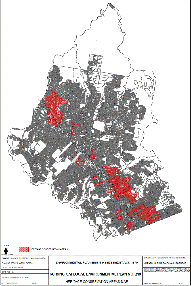
|
APPENDIX No: 9 - Public Agency
Submissions under Section 56 of the EP&A Act
|
|
Item No: GB.4
|
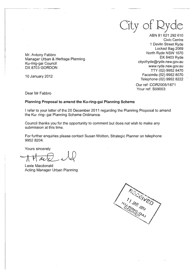
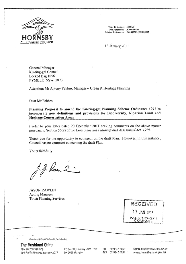
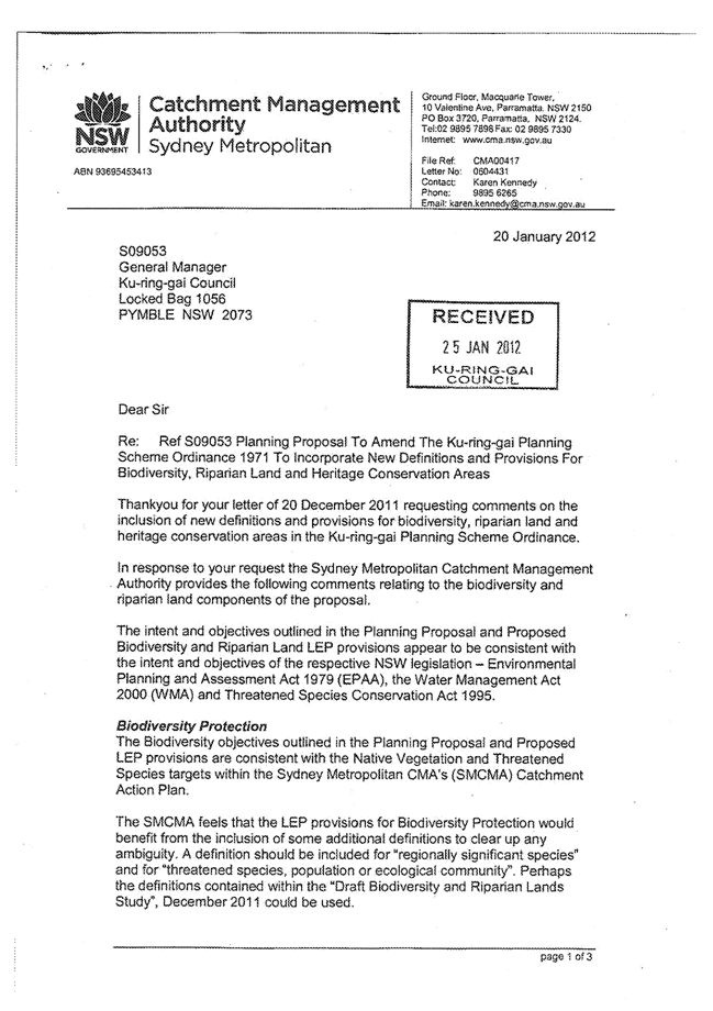
|
APPENDIX No: 10 - Revised
Riparian and Waterways Clause - Draft LEP 218
|
|
Item No: GB.4
|
Attachment –
Revision of clause
6.7 Riparian land and waterways
(1)
The objectives of this clause are:
(a) to
protect or improve:
(i) water
quality within waterways,
(ii) stability
of the bed and banks of waterways,
(iii) aquatic
and riparian species, communities, populations and habitats,
(iv) ecological
processes within waterways and riparian lands,
(v) scenic
and cultural heritage values of waterways and riparian lands, and
(b) where
practicable, to provide for the rehabilitation of existing piped or channelised
waterways to a near natural state.
(2) This
clause applies to development on land that is identified as “Riparian land” on
the Natural Resource Riparian Lands Map.
Note: Some development types within 40m of these waterways
will still require referral to the Office of Water as ‘integrated development’.
(3) Before
determining a development application for development on land to which this
clause applies, the consent authority must consider:
(a) whether
the development is likely to have any adverse impact on the following:
(i) water
quality in the waterway,
(ii) the
natural flow regime, including groundwater flows to a waterway,
(iii) aquatic
and riparian species, populations, communities, habitats and ecosystems,
(iv) stability
of the bed, shore and banks of the waterway,
(v) the
free passage of native aquatic and terrestrial organisms within or along the
waterway and riparian land,
(vi) public
access to, and use of, any public waterway and its foreshores,
(b)
any opportunities for rehabilitation or re-creation of the watercourse and its
riparian areas,
(c)
any appropriate measures proposed to avoid, minimise or mitigate the impacts of
the development.
(4)
Development consent must not be granted for development on land to which
this clause applies unless the consent authority is satisfied that the
development:
(a)
integrates riparian, stormwater and flooding measures,
(b) is
sited, designed and managed to avoid potential adverse environmental impacts,
and
(c) if
a potential adverse environmental impact cannot be avoided by adopting feasible
alternatives, the development minimises or mitigates any adverse environmental
impact, to a satisfactory extent.
|
Ordinary
Meeting of Council - 13 November 2012
|
GB.5 / 188
|
|
|
|
|
Item GB.5
|
S09400
|
|
|
24 September 2012
|
Planning Proposal to Rezone Land at
35 Water Street, Wahroonga from Special Uses 5(a) to Residential under the
KPSO
EXECUTIVE
SUMMARY
|
purpose of report:
|
To inform Council of the independent consultant’s review
on a Planning Proposal to rezone 35 Water Street, Wahroonga from 5(a)
Special Uses - Hospital to Residential under the Ku-ring-gai
Planning Scheme Ordinance 1971 (KPSO).
|
|
|
|
|
background:
|
The Planning Proposal, lodged on 10 July 2012, seeks
rezoning of the site to enable residential subdivision and restoration of
Rippon Grange. A consultant team engaged by Council assessed the Planning
Proposal and its suitability to be forwarded to the Department of Planning
and Infrastructure for a Gateway Determination.
On 29 October 2012 Council received a further letter from
the applicant requesting that an E4 Environmental Living zone and the
Conservation Incentives clause, both under the Standard Instrument, be
applied to the site under the Planning Proposal.
|
|
|
|
|
comments:
|
Council’s independent review puts forward changes needed
for the Planning Proposal to meet the statutory requirements, prior to
submission for a Gateway Determination. Council staff had some concerns
regarding biodiversity issues on the site. These have now been addressed by
the applicant’s recent letter and inclusion of the E4 Environmental Living
zone across the site.
|
|
|
|
|
recommendation:
|
That the current proposed E4 Environmental Living zone and
the NSW standard LEP Conservation Incentives clause be supported in principle,
and that the applicant be advised to amend their Planning Proposal as per the
Consultant’s review and Council’s report and that
the amended Planning Proposal be prepared to the satisfaction of the General
Manager prior to being forwarded for a Gateway Determination.
|
Purpose of Report
To inform Council of the independent consultant’s review on
a Planning Proposal to rezone
35 Water Street, Wahroonga from 5(a) Special Uses - Hospital to Residential under the Ku-ring-gai Planning Scheme
Ordinance 1971 (KPSO).
Background
The property at 35 Water Street, Wahroonga, known as Rippon
Grange, was constructed in 1898 as a grand residence and subdivided to its
current site structure in the 1920s. The site was converted in 1951 by the NSW
State Government to hospital use. This ceased in 2004.
A 2006 development application to construct medium density
seniors development (78 units in 8 buildings) on the land was refused by
Council and the refusal was subsequently upheld in the Land and Environment Court (L&E Court). The two key drivers for the L&E Court ruling were the
protection of the Blue Gum High Forest on the site, and the preservation of the
site’s heritage significance.
In 2010 consent was granted by the Department of Planning
and Infrastructure under Part 3A of the Environmental Planning and
Assessment Act, 1979 to develop the site as a private hospital. This
approval has not been acted on and expires in 2015.
The property at 35 Water Street is significant for two primary reasons as
confirmed by the above L&E Court ruling:
1. Heritage value
The site is listed as a heritage item of local significance
under the Ku-ring-gai Planning Scheme Ordinance 1971 (KPSO). This
includes the heritage house Rippon Grange, its gardens, ancillary buildings and
structures, mostly located to the north of the site on cleared land.
The significance of the heritage aspect of the site was
addressed in the mapping of Council’s recently exhibited Draft LEP 218 -
Biodiversity and Riparian Land and Heritage Conservation Areas which
includes the site within a draft Heritage Conservation Area. The Draft LEP also
proposes to amend the KPSO to incorporate the Standard Instrument LEP
heritage provisions, including the Conservation Incentives clause.
The
draft Heritage Conservation Area that covers this site has also been included
in the Council’s planning proposal for the new Principal LEP which is to
replace the KPSO. A gateway determination has been issued for the Principal
LEP Planning Proposal and is due for Council consideration for exhibition
in the near future.
2. Ecological value
The south and east of the site contains areas of Blue Gum
High Forest (BGHF), a critically endangered ecological community under the NSW
Threatened Species Conservation Act 1995 and the Commonwealth
Environment Protection and Biodiversity Conservation Act 1999. The court
ruling referred to above delineated a line showing the extent of the ecological
community that was to be protected on this site.
The biodiversity on this site was addressed in the mapping
of Council’s exhibited Draft LEP 218 - Biodiversity and Riparian Land and
Heritage Conservation Areas which mapped an Area of Biodiversity
Significance within this site.
Based on
this mapping, the Principal LEP Planning Proposal put forward a zoning on the
subject land of part R2 (Low Density Residential) to the predominantly cleared
parts of the site, and part E4 (Environmental Living) under the Standard LEP
Instrument, with a minimum lot size for the E4 zone of 1500sqm, to that part of
the site with significant ecological value.
Given the level of vegetation on
the site, Council has expressed concern regarding the possible threat to life
by bushfire. In light of this, Council has lodged an amendment to the Bushfire
Prone Lands Map to include the Blue Gum High Forest area of the site and
surrounding area. The amendment was supported by the local Rural Fires Service,
but is still awaiting the decision on certification by the Commissioner.
Comments
Ku-ring-gai Council received a
Planning Proposal on 10 July 2012 from Ingham
Planning Pty Ltd, on behalf of Mr Peter Borbilas, to rezone land at 35 Water Street, Wahroonga. The site is currently zoned 5(a) Special Uses - Hospital under
the Ku-ring-gai Planning Scheme Ordinance 1971 (KPSO). The site (Lot 1
D.P. 375262) is listed as Heritage Item under Schedule 7 of the KPSO.
The Planning Proposal as
originally lodged sought a 2(c) Residential zoning under the Ku-ring-gai KPSO
to enable the subdivision of the land for dwellings and enable the restoration
of the heritage item for use as a residence. The full planning proposal,
including appendices, has been provided for Councillors information in the
Councillors’ room. See Attachment A1 for applicant’s planning proposal
without appendices.
Town planning consultant Sue
Haertsch Planning, with specialist assistance from John Oultram Heritage &
Design (heritage) and Eco Logical Australia (ELA )(biodiversity and bushfire),
was commissioned by Council to provide an independent review of the Planning
Proposal. The purpose of the independent review was to make recommendations to
Ku-ring-gai Council on the suitability of the Planning Proposal to be referred
to the Department of Planning and Infrastructure (DoPI) for a formal gateway
determination and to advise on the integration of this application with
Council’s Principal LEP Planning Proposal which has received a gateway
determination from DoPI.
The Consultant team have based
their review on the legislative and technical requirements for planning
proposals. Their analysis has included specialist assessment of the two key
elements of this site, its heritage value and its biodiversity value. See Attachment
A2 for the full Consultant’s review report.
On 29 October 2012, Council received a further letter from
the applicant, Ingham Planning Consultants, requesting an E4 Environmental
Living zone and the Conservation Incentives clause, both under the Standard
Instrument, be included in the assessment of their Planning Proposal. Since the
consultant’s review was completed prior to the receipt of this letter, this
matter has been considered in this report. See Attachment
A3 for Applicant’s letter.
What is the Planning Proposal seeking to do?
The Planning Proposal, as originally lodged, proposed a
rezoning of the land at 35 Water Street from 5(a) Special Uses – Hospital to
2(c) Residential under the Ku-ring-gai Planning Scheme Ordinance (KPSO). The
purpose of the rezoning is to enable residential subdivision of the land and
facilitate restoration of the existing building, Rippon Grange, which is
identified as a heritage item.
The Planning Proposal is based on a preliminary subdivision
layout that proposes five lots. Rippon Grange would be retained on a 1.5
hectare lot and returned to use as a single dwelling. The other lots vary in
size from 937m2 (Lot 3) to 2,422m2 (Lot 2).
The applicant has indicated that the consent for a private
hospital development on this site would be surrendered if the rezoning
proceeds. This would require a legal agreement between the applicant and
Council.
Heritage considerations
John
Oultram Heritage & Design’s review confirms that Rippon Grange is a
place of high heritage significance and that the rezoning to a residential zone
is an appropriate change for the site provided that it leads to outcomes listed
below with further assessments:
· conservation of Rippon
Grange, its immediate gardens and significant built and landscape elements
(significant items assessment would be required);
· retention of an
appropriate curtilage for the house (curtilage assessment would be required);
· appropriate treatment of
any archaeological remains (archaeological assessment would be required);
· low key development of
the site for residential use (plans of the proposed works to Rippon Grange and
the garden elements associated with its lot together with a detailed schedule
of conservation works to the house and grounds prepared by a suitably qualified
heritage consultant would be required); and
· retention of the Blue
Gum High Forest as an important garden backdrop to this property. (Fencing and
new buildings designed to ensure the backdrop to the heritage house is in
keeping with its character).
John
Oultram’s assessment expressed a preference for a community title
subdivision rather than a formal subdivision of the land. This would allow
Rippon Grange to continue to read as a single site with new and old buildings
dotted into the landscape, and maintaining the visual connections with
significant items in the grounds which would otherwise be cut off from the
house by subdivision fencing.
Although John Oultram’s
Heritage Report suggests an approximate curtilage, curtilage is not part of the
consideration for this Planning Proposal. It should be noted, however, that
Council’s Heritage Advisors are not in agreement with the suggested curtilage
which separates the stables from Rippon Grange. In addition, the existing
Conservation Management Plan for the site also delineates a different curtilage
extent. Therefore a more detailed curtilage study would need to be conducted to
formulate a fixed curtilage line, justifying the inclusion and exclusion of
significant items. This matter will be dealt with as part of a subsequent
development application.
The applicant’s recent letter requests inclusion of the
Standard Instrument Conservation Incentives clause (cl 5.10(10)). This clause
has been included in Council’s Draft LEP 218 and would enable
development to a heritage item which is otherwise not permitted within the
zoning. A typical example would be the strata subdivision of a large heritage
house into a number of apartments which have communal use of the heritage
gardens. The Planning Proposal would need to stipulate how the KPSO would be
amended to include the Incentives Clause in a similar manner to that in the
planning proposal prepared for the Draft LEP 218.
The Conservation Incentives
clause requires assessment against a ‘heritage management document that has
been approved by the consent authority’. The applicant will need to prepare
this in the form of a Conservation Management Plan (CMP) that sets out what is
significant on the site, what policies are appropriate to enable that
significance to be retained in its future use and development, and the
provision of a guide to future care and use of the site, including new
development. The CMP would need to be submitted and reported to Council for
approval prior to the use of the Incentives Clause.
Biodiversity considerations
The Ecological consultant ELA
validates the mapping of BGHF endorsed in the court proceedings and used in the
Planning Proposal’s UBM report; however, their primary concern is the
subdivision of land within the BGHF mapped area.
ELA’s assessment disagrees with the Planning Proposal in
that the assessment has not considered indirect impacts/edge effects in each of
the relevant factors of the Assessment of Significance for the BGHF on the
site. For example, it underestimates the removal and direct impact from the
indicative subdivision layout because it does not appear to have taken into
consideration construction areas for the access road and building works. In
addition, ELA question how utilities (water, telecommunications and
electricity) will supply the proposed lots and the impact of such works on the
vegetation, and that the indirect impacts associated with edge effects such as
changes to hydrology and ongoing activity associated with an occupied dwelling
do not appear to have been included.
Although the indicative
subdivision layout locates the building footprints predominantly outside the
BGHF area, the review notes that it is impractical to attempt to control
activities within private gardens in a residential setting through a vegetation
management plan. As such, ELA concludes that there is a potential significant
impact on BGHF as a result of the indicative subdivision layout that would result
from the Residential 2(c) zoning being sought.
The
ELA review concludes that a 2(c) or R2 Low Density zone would be incompatible
with that part of the site that contains BGHF because of concerns about direct
and indirect impacts on the sensitive habitat. The 930sqm minimum lot size
would facilitate development at a density that would result in potentially
significant impacts on a critically endangered ecological community.
ELA’s
assessment considers the larger lot sizes associated with an E4 zone would
enable future development without compromising the long‐term
viability of the BGHF vegetation, provided rigorous and effective development
conditions are imposed to protect and restore the vegetation. An
effective, well-resourced restoration program for the BGHF habitat is required alongside
a future Vegetation Management Plan
ELA
advises that the proposed 2(c)/R2 zone is considered appropriate across the
remainder of the site to the north, provided a setback or buffer of 10m is
achieved from the mapped BGHF area. The consultant recommends the buffer area
be revegetated with BGHF species.
The applicant’s recent letter requests their Planning
Proposal zoning be changed from Residential 2(c) to
E4 Environment Living under the Standard instrument. The E4 zone enables
residential development within ecologically significant areas. The Planning
Proposal would need to stipulate how the KPSO would be amended to include the
E4 Environment Living zone as indicated in the Principal
LEP Planning Proposal.
Bushfire considerations
ELA concluded that the remnant
area of BGHF on the site is not considered to be a bushfire hazard significant
enough to require an assessment of asset protection zones or building
construction standards under PBP or AS 3959-2009
Construction of buildings in bushfire prone areas because of the size and
shape of the BGHF on the site and the site’s separation from Turiban Reserve or
the bushland within the Wahroonga School grounds to the north. The bushland
within the school grounds is classified as low hazard as it is remnant area
that is less than 1 hectare and forms a corridor less than 50m in width
parallel to the site.
ELA consider that the Bushfire
Risk Assessment does not recognise the implications of the Wahroonga School grounds as a low hazard area. Similarly, the report does not consider the
potential threat of the BGHF on the site. This has implications to potential
future development on the site but does not materially affect the outcomes or
recommendations for the Planning Proposal.
ELA recommend that the bushland
within the school grounds be mapped as Bush Fire Prone Vegetation Category 2
but not the BGHF on the site. The site would still be considered bush fire
prone land and property as it would be within 30m of the Category 2 vegetation
on the Wahroonga School grounds. Future development on the site would need to
consider bushfire hazards within the grounds of the Wahroonga Primary School as this is the only hazard within 100m of the site.
Legislative and technical considerations
The consultant review found that the Planning Proposal does
not satisfy the legislative and technical requirements of Section 55 of the EPA
Act or the requirements of the Department of Planning’s Guide to Preparing
Planning Proposals; and that in its current form it is not suitable to be
referred to the DoPI for a formal gateway determination.
The primary reasons for the
Consultant’s conclusion are outlined below, with all details provided in the
attached Consultant’s report.
1. Compliance with Ministerial Directions
(s.117 Directions)
The Planning
Proposal has not demonstrated consistency with all relevant Ministerial Directions.
Whilst it has considered five relevant Directions, it has omitted consideration
of two key Directions:
i. Direction 2.1 (Environment Protection Zones) is relevant
given that it is accepted that the site has biodiversity value. This is
reinforced by the previous Court decision and the mapping accompanying Draft
LEP 218. The Direction requires planning proposals to include provisions
that facilitate the protection and conservation of environmentally sensitive
areas and not reduce the environmental protection standards that apply to the
land. The Planning Proposal needs to address the suitability of the proposed
2(c) zone in relation to the environment protection measures proposed by Draft
LEP 218 and the interrelationship between the two instruments.
The
applicant’s latest request to change their zoning application from 2(c) to E4
will support their response to this requirement.
ii. Direction 6.3 (Site Specific Provisions) does not allow
planning proposals to refer to drawings of particular developments. As a
result, the Planning Proposal cannot directly link the preliminary subdivision
plan to potential outcomes of the new zone.
The structure
of the Planning Proposal is not considered suitable as it does not adequately
separate the indicative subdivision layout and potential future development
from the change of zoning. The proposal needs to justify the new zone on its
merits without reference to the indicative subdivision layout. The primary
address of the planning proposal should be the suitability of the proposed zone
and consistency of the proposed change to the strategic context. The Planning
Proposal needs to be revised to remove references to the design of the proposed
future development from the technical component of the report.
2. Compliance with State Environmental Planning Policies
(SEPPs)
The Planning Proposal identifies SEPP 55 – Remediation of
Land and notes a potential asbestos hazard arising from demolition of existing
structures, however it states that there is “no evidence of any contamination
hazard that would preclude rezoning the land for residential purposes” and that
“Council can require submission of detailed contamination assessment with the
future development application for subdivision”.
Given that the site was used as a hospital from 1952 until
2004, there is a high potential for contamination on the site, including
asbestos. The Planning Proposal needs to be revised to include an updated
statement in relation to the likely contamination issues present at the site to
satisfy the provisions of SEPP 55 Clause 6. The statement should
identify buildings and structures that are intended to be demolished and
provide a strategy for managing potential risks.
3. Consideration of strategic context
The Planning
Proposal is potentially inconsistent with the environmental objectives and
actions of the North Subregion Strategy and needs to be updated to
include a response. Action E2.2 to protect Sydney’s unique diversity of
plants and animals requires LEPs to be informed by regional biodiversity
matters. The action acknowledges the importance of the challenge to ensure that
development retains bushland in sustainable configurations, including the
remaining Blue Gum High Forest areas.
In addition,
the Planning Proposal states that “Ku‐ring‐gai Council does not have a Strategic
Plan relating to land use planning and development” and therefore only responds
to the KPSO. This aspect of the Planning Proposal is not acceptable as it does
not acknowledge or fully consider the strategic context, including the draft
Heritage and Biodiversity LEP (218) and the Ku-ring-gai Principal LEP
Planning Proposal. As a result, the report does not provide adequate
justification for how the proposed zone will adequately protect the
biodiversity values of the site or why the rezoning should proceed in advance
of the Principal LEP.
The Planning Proposal needs to be
revised to consider the implications of the above strategic documents.
The applicant’s latest request to
change their zoning application from 2(c) to E4 will support their response to
this requirement.
4. Spot rezoning and creation of
precedent
The Planning
Proposal includes an assessment against the Department of Planning’s LEP
Pro-forma Evaluation Criteria for Spot Rezonings. A key issue arising from
the spot rezoning criteria is whether the resulting LEP for this site is likely
to create a precedent, or create or change the expectations of the landowner or
other landowners.
Although the
Planning Proposal indicates that the proposed change will not create a
precedent on the grounds that the circumstances of the site are unique, the
response does not consider implications of the proposal’s potential
inconsistency with Draft LEP 218 and the approach proposed by the Principal
LEP Planning Proposal. Both issues are relevant and potentially
create precedents about the appropriate zoning approach for residential
development within environmentally sensitive land. The
Planning Proposal needs to demonstrate why it would not create a precedent in
terms of the potential inconsistency with Draft LEP 218 and the Planning
Proposal for the Ku‐ring‐gai Principal LEP for environmentally sensitive land.
The
applicant’s latest request to change their zoning application from 2(c) to E4
addresses these issues; nevertheless, the Planning Proposal needs to be amended
to remove this now redundant section within the document.
Discussion
Whilst the consultant’s review suggests that residential
development would suit this site and its context, it is the degree of
residential development and its impact on the site’s acknowledged asset of
biodiversity and heritage that is being questioned. The concern has been
twofold: That the permitted lot sizes under Residential 2(c) are not conducive
to the integrity of the BGHF area and that the Planning Proposal cannot bind a
subdivision plan to it and therefore the location and number and size of future
lots on this site is able to change.
The applicant’s recent letter changing the zoning from 2(c)
to E4 across the entire site will address this issue through the provision of
larger residential lot sizes on the site, allowing the integrity of the BGHF to
be retained.
The value of the E4 Environmental Living zone on this
site
Environmental Living (E4) is a means of enabling residential
development to occur within ecologically significant areas. It is a middle
ground between an area being zoned Environmental Conservation (E2) where no
residential development is permitted, and Residential (R2) permitting single
dwellings on lots with little to no significant site features. The main
advantage of the E4 Environmental Living zone is illustrated in the table
below:
|
|
R2 Low Density Residential
|
E4 Environmental Living
|
|
Objective
of zoning type
|
Encourage the provision of facilities or services that
meet the day‐to‐day needs of residents.
|
Land with special environmental or scenic values where
residential development can be accommodated.
|
|
Biodiversity
value
|
Compromised due to forced encroachment and close proximity
of buildings and garden structures within lot sizes too small to protect
significant proportions of biodiversity areas.
|
Less encroachment by buildings and garden structures due
to larger lot sizes allowing residential activity to occur without changing
the ecology of the entire area within the lot boundary.
|
|
Heritage
value
|
Reinstated with residential development adjacent to its
curtilage.
|
Reinstated with lower density residential development
adjacent to its curtilage.
|
|
Subdivision
lot size permitted
|
Minimum lot size of 930sqm.
|
Minimum lot size of 1500sqm.
|
|
Residential
single dwelling type
|
Permitted under this zoning.
|
Permitted under this zoning.
|
|
Hospital
Development type
|
Permitted under this zoning.
|
Not permitted under this zoning.
|
Governance Matters
A planning proposal was lodged by
the applicant on 10 July 2012. An amendment to the planning proposal was made
by letter dated 26 October 2012. An independent review was commissioned by
Council and forms part of this report. If Council adopts the planning proposal
to be formally submitted to the Department of Planning & Infrastructure
requesting a gateway determination, then there will be a series of further
consultations and final report back to Council.
Risk Management
Council now is in a position to
make a formal determination on whether the planning proposal should be formally
submitted to the Department of Planning & Infrastructure requesting a
gateway determination. If a timely decision is not made on this matter, is it
understood the applicant may have recourse to a further review under the
proposed amendments to the Local Plan making process under the EP&A Act and
EP&A Regulations recently announced by the NSW Minister for Planning and
Infrastructure.
Financial Considerations
In submitting their application for this Planning Proposal,
the Applicant paid the required fee rezoning fees. To date these funds have
been allocated towards the engagement of Council’s independent consultant, to a
further staff review of the Planning Proposal and will cover the next stages in
the process if it progressed through the formal gateway process.
Social Considerations
In the past the site has catered
for specialist health services provided to the community. The site current has
a limited 5(a) Special use zoning applying to the site under the KPSO. The site has remained vacant and redundant for several
years. A new contemporary zoning should provide for future additional uses
including residential, the adaptive reuse of the heritage buildings on the
site, whilst recognising the environmental significance of the site. This
should result in better use of the site and its current infrastructure.
Environmental Considerations
Due to the significant biodiversity and presence of
critically endangered BGHF on the site, a specialist ecological and bushfire
consultant was engaged to review the Planning Proposal. Their reports are
attached and findings are discussed above.
Community Consultation
A number of letters have been received in support of placing
residential development on this site as a means of preventing a hospital
development. Should the Planning Proposal be progressed, notification and
exhibition would occur in line with the requirements of the gateway determination.
This would give the community and interested groups complete information
regarding the site, including the heritage and biodiversity significance, and
the opportunity to then formally comment on the proposal.
Internal Consultation
Council’s biodiversity, bushfire and heritage advisors were
consulted in the preparation of this report.
Summary
Whilst it is agreed that both the site and the local context
would benefit from a residential development on the site reinstating the
heritage value of the site, it is evident that the biodiversity value of the
site will be compromised by a Residential 2(c) zoning. This concern has now
been addressed by the applicant’s recent amendment which seeks an E4
Environmental Living zone across the site which will allow a form of
residential development that is able to protect the valuable site ecology as
well as the heritage asset.
The review finds that the
current Water Street Planning Proposal, for some aspects is not in a suitable
form to be referred to the Department of Planning and Infrastructure for a
formal gateway determination. For it to be acceptable, the Planning Proposal
would need to be revised in accordance with the findings of the Consultant’s
Review and the requirements of Council’s Report. In addition, the applicant
would need to enter into a legal agreement with Council to provide certainty
that the Part 3A hospital consent would be surrendered and Rippon Grange would
be restored.
|
Recommendation:
A. That the Planning Proposal to amend the Ku-ring-gai
Planning Scheme Ordinance to rezone the property at 35 Water Street,
Wahroonga from Special Uses 5(a) to zone E4 Environmental Living and to
incorporate the NSW Standard Instrument LEP Conservation Incentives clause be
supported in principle .
B. That the applicant be advised to amend their
Planning Proposal as per the Consultant’s Review and this report as follows:
i) Amend the planning proposal so as to
seek an E4 Environmental Living zone across the site.
ii) Stipulate how the KPSO would be amended to
include the E4 (Environmental Living) zone and Conservation Incentives clause
to align with Council’s Draft LEP 218 and the Planning Proposal for the Ku‐ring‐gai Principal LEP.
iii) Review and
confirm the objectives or intended outcomes for the planning proposal
particularly in relation to permissibility of future health/hospital uses.
iv) Revise the
justification of the planning proposal to:
a) Justify the proposed new zone on its merits
without reference to the indicative subdivision layout.
b) Include
consideration of Draft LEP 218 and the planning proposal for the
Ku-ring-gai Principal LEP.
v) Include
consideration of environmental objectives and actions of the Metropolitan
Plan and North Subregion Strategy.
vi) Provide updated
advice or information about contamination issues affecting the site in
response to Clause 6 of SEPP 55.
vii) Provide an
updated review of relevant Ministerial Directions including consideration of
Direction 2.1 (Environment Protection Zones) and Direction 6.3 (Site Specific
Provisions) and a checklist of all Ministerial Directions.
viii) Amend the section referring to assessment
against the Department of Planning’s LEP Pro-forma Evaluation Criteria for
Spot Rezonings to demonstrate why the planning
proposal would not create a precedent in terms of the potential inconsistency
with Draft LEP 218 and the planning proposal for the Ku-ring-gai Principal
LEP for environmentally sensitive land.
C. That the amended Planning Proposal be prepared to
the satisfaction of the General Manager and then be forwarded to the DoPI for
a Gateway Determination in accordance with the provisions of the EP&A Act
and Regulations.
D. That
upon receipt of a Gateway Determination, the exhibition and consultation
process is carried out in accordance with the requirements of the
Environmental Planning and Assessment Act, 1979 and with the Gateway
Determination requirements.
E. That
a report be brought back to Council at the conclusion of the exhibition
period.
|
|
Rthna Rana
Urban Planner
|
Antony Fabbro
Manager Urban & Heritage Planning
|
|
Andrew Watson
Director Strategy & Environment
|
|
|
Attachments:
|
A1View
|
Planning
Proposal - Ingham Planning (without appendices)
|
|
2012/268962
|
|
|
A2View
|
Consultant
Review - Sue Haertsch Planning
|
|
2012/259855
|
|
|
A3View
|
Letter -
Planning Proposal Amendment - Ingham Planning
|
|
2012/262593
|
|
APPENDIX No: 1 - Planning
Proposal - Ingham Planning (without appendices)
|
|
Item No: GB.5
|

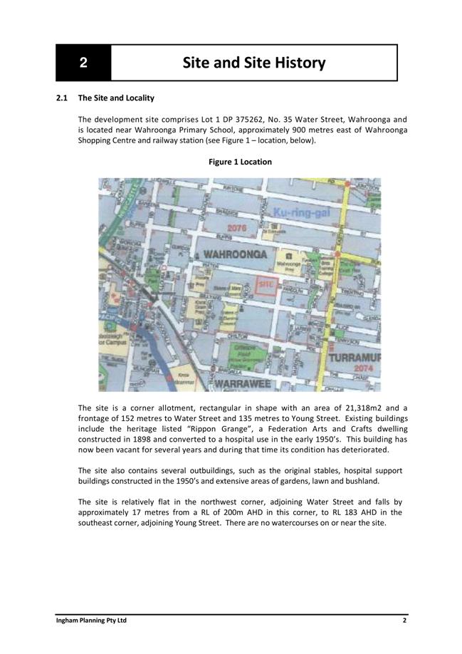
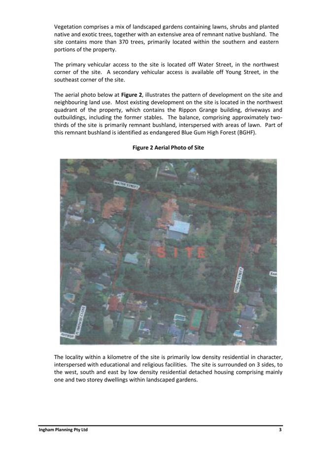
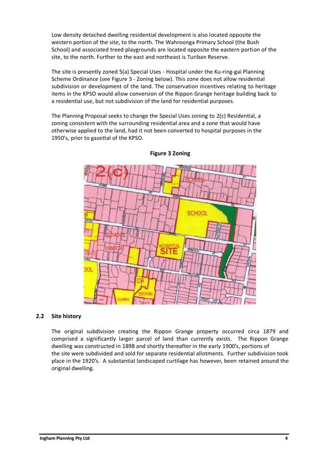
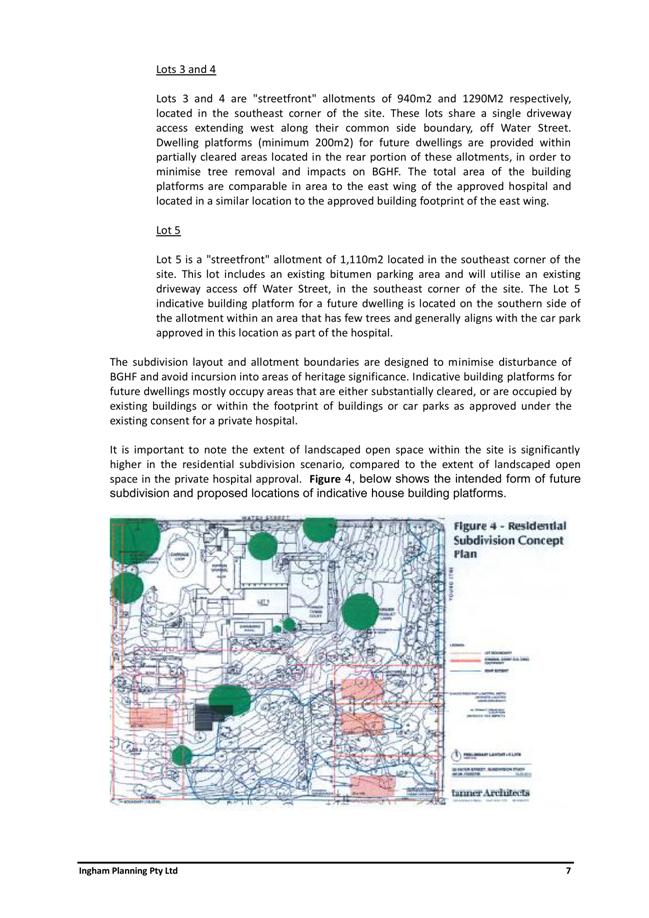
|
APPENDIX No: 2 - Consultant
Review - Sue Haertsch Planning
|
|
Item No: GB.5
|
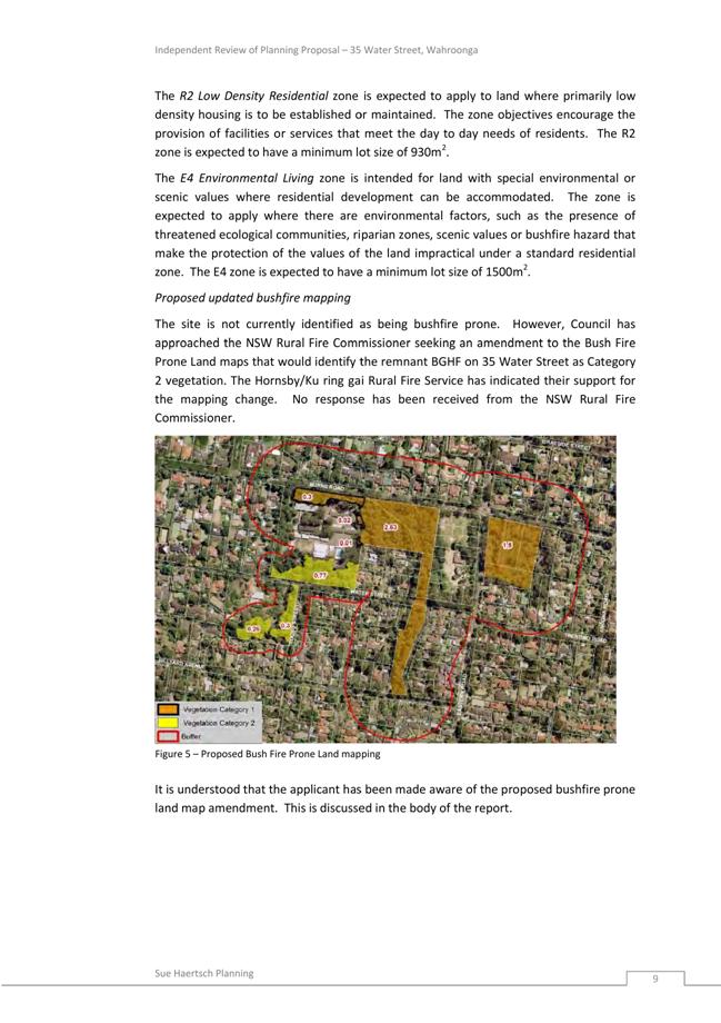
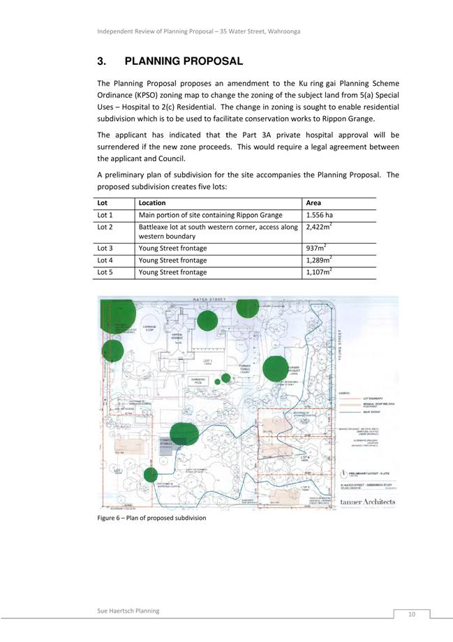
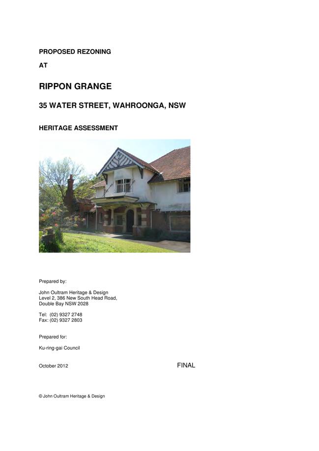
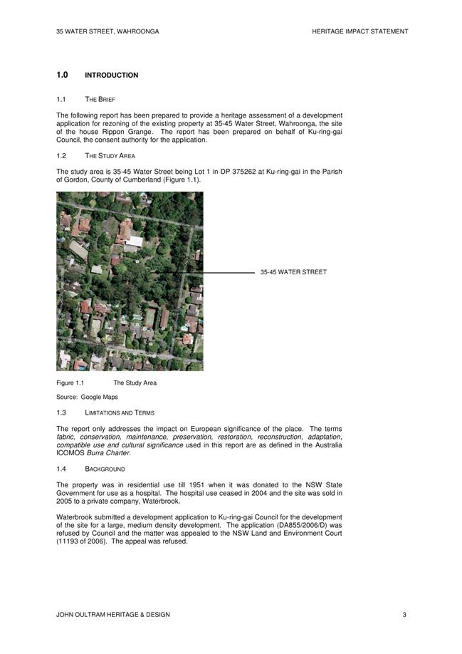
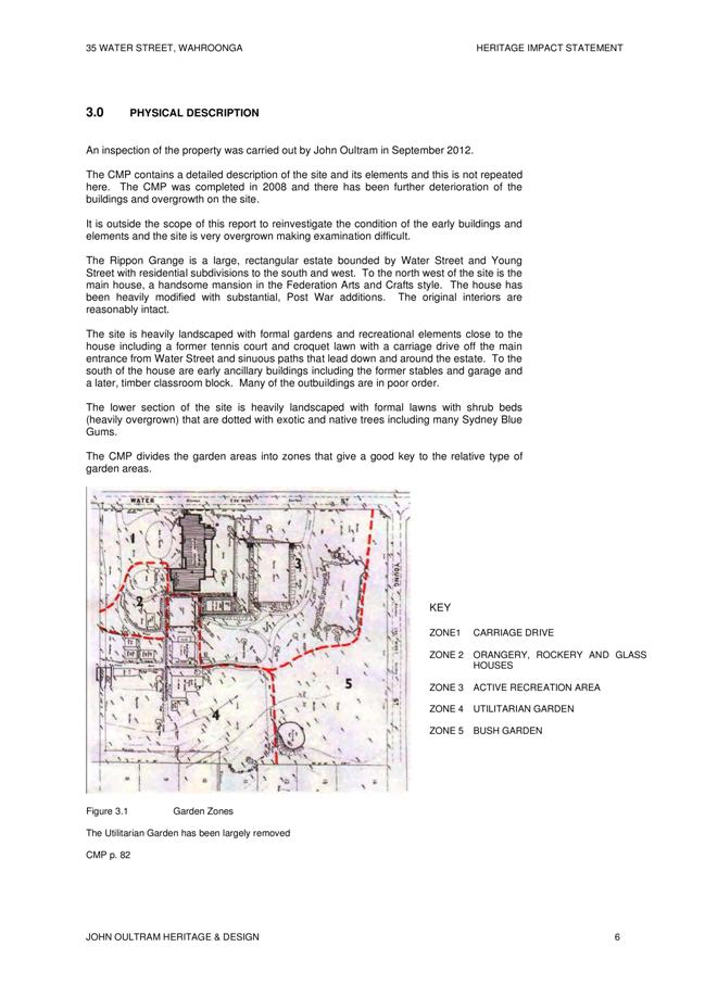
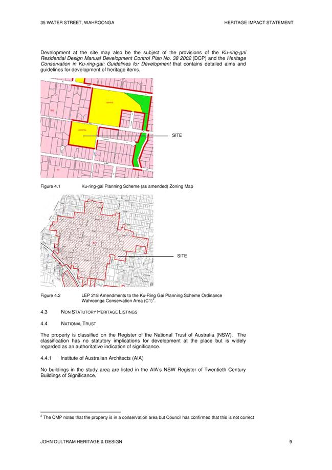
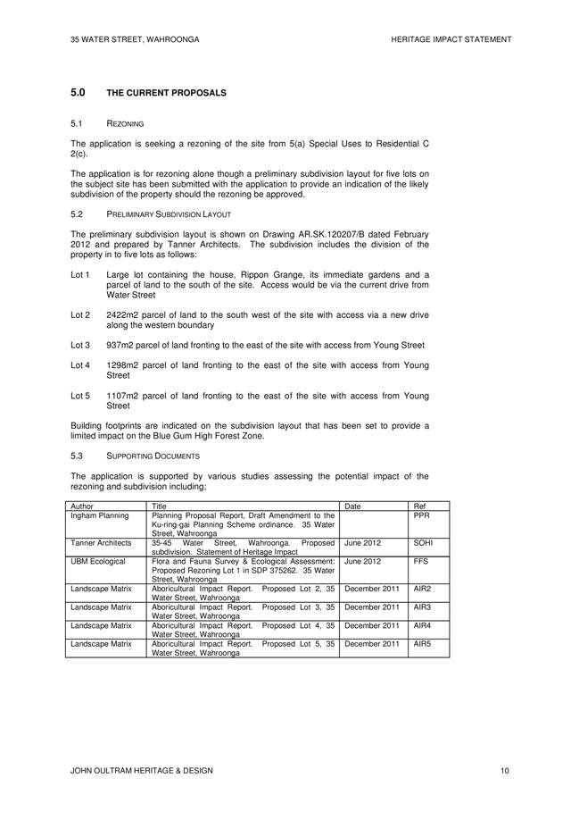
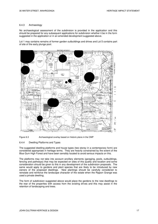
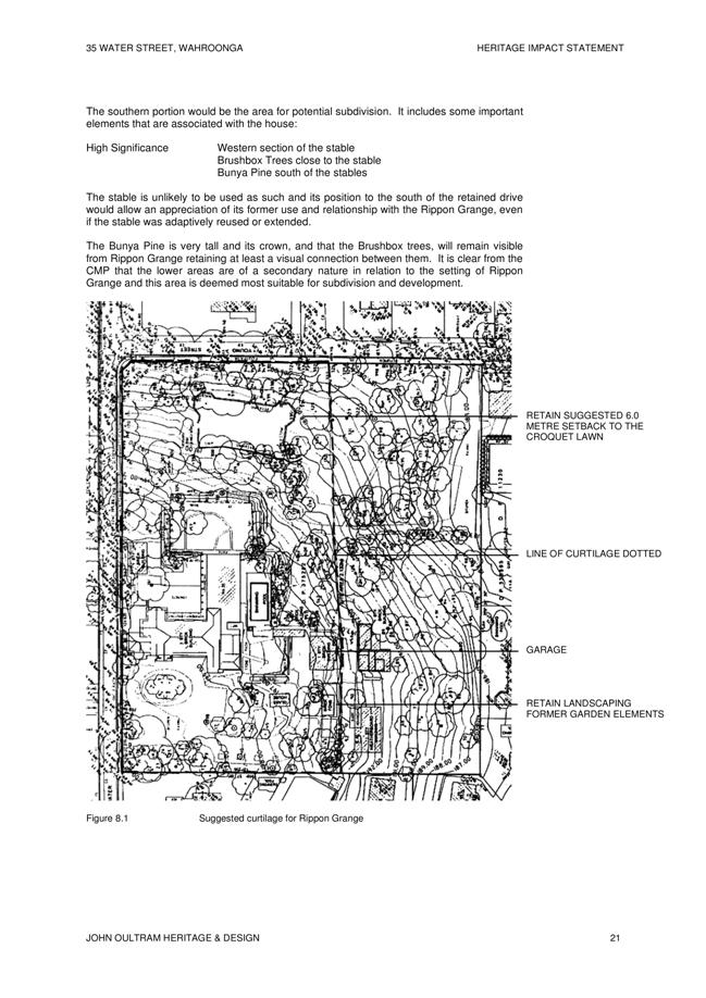
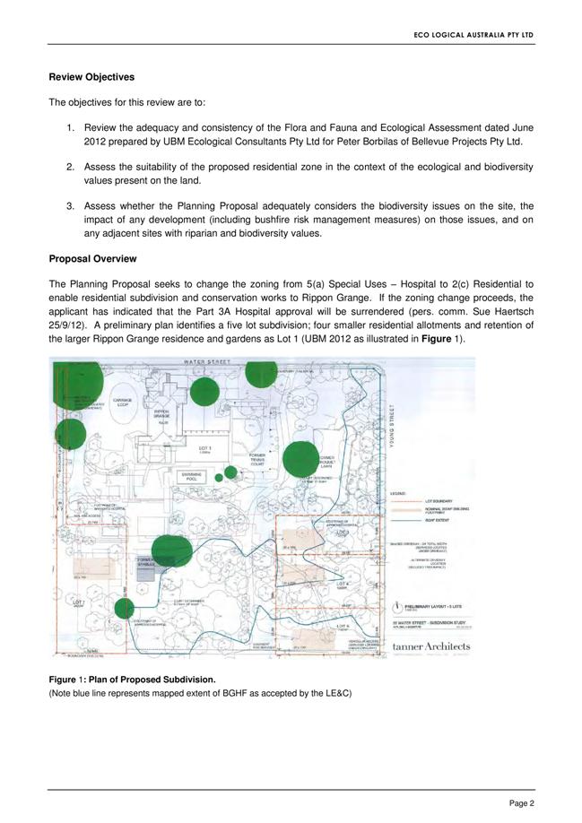
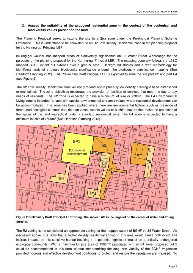
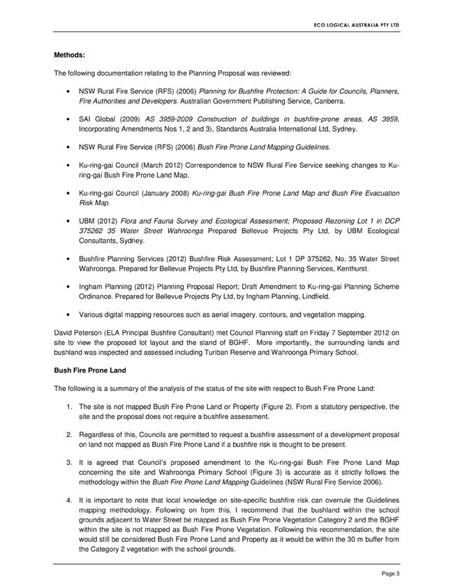
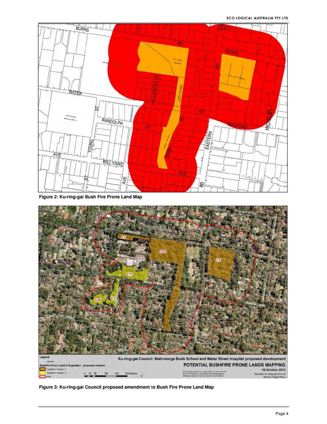
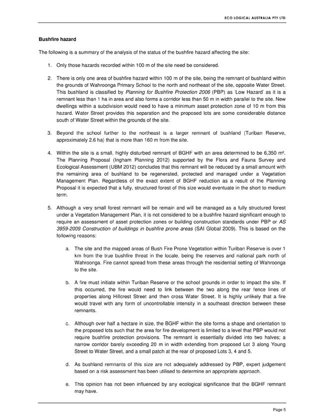
|
APPENDIX No: 3 - Letter -
Planning Proposal Amendment - Ingham Planning
|
|
Item No: GB.5
|
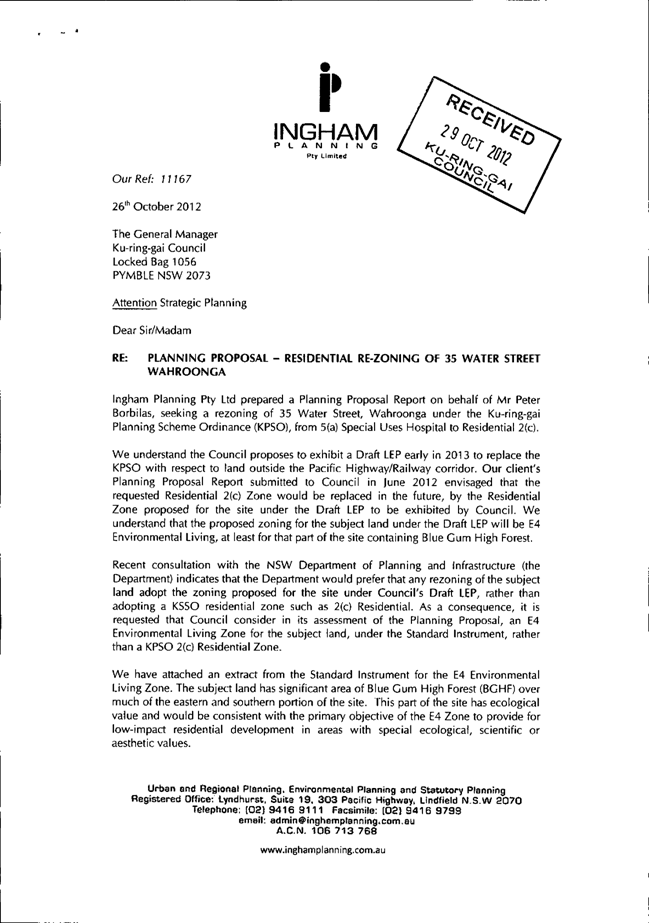
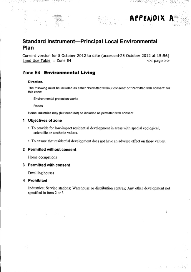
|
Ordinary
Meeting of Council - 13 November 2012
|
GB.6 / 300
|
|
|
|
|
Item GB.6
|
S07023
|
|
|
23 October 2012
|
Planning Proposal to rezone land at
39, 41, 43 and 51 Lindfield Avenue, Lindfield
EXECUTIVE
SUMMARY
|
purpose of report:
|
For Council to consider a
Planning Proposal to amend the draft KLEP (Local Centres) 2012 and to rezone
land at 39, 41, 43 and 51 Lindfield Avenue, Lindfield to permit mixed use and
high density residential development.
|
|
|
|
|
background:
|
Council has received a Planning Proposal on behalf of WZRM
Pty Ltd to rezone land at 39, 41, 43 and 51 Lindfield Avenue from 3(a)-(A2)
Business and Residential 2(d) to a combination of B2 – Local Centre and R4 –
High Density Residential. The Planning Proposal is consistent with the
provisions for the subject properties contained in the exhibited version of
the KLEP (Local Centres) 2012.
|
|
|
|
|
comments:
|
The Planning Proposal has been
assessed by Council staff against the requirements of Section 55 of the
Environmental Planning and Assessment Act 1979 (the Act), including A
Guide to Preparing Planning Proposals. While this study has identified a
justifiable planning need to rezone the subject properties, the planning
proposal, as submitted, is not considered to be in an appropriate form to be
referred to the State Government’s LEP Panel for a Gateway Determination.
|
|
|
|
|
recommendation:
|
That Council agree in
principle to the submission of a Planning Proposal for a Gateway
Determination to amend the draft KLEP (Local
Centres) 2012 to zone the land at 39, 41, 43, 51 and 55 Lindfield
Avenue consistent with the provisions for the subject properties contained in
the exhibited version of the KLEP (Local Centres) 2012.
That the applicant be advised to amend their Planning
Proposal to adequately address all relevant requirements of A Guide to
Preparing Planning Proposals.
That
the amended Planning Proposal be prepared to the satisfaction of the General
Manager prior to being forwarded for a Gateway Determination.
|
Purpose of Report
For Council to consider a Planning Proposal to amend the
draft KLEP (Local Centres) 2012 and to rezone land at 39, 41, 43 and 51
Lindfield Avenue, Lindfield to permit mixed use and high density residential
development.
Background
Council has received a Planning Proposal on behalf of WZRM
Pty Ltd to rezone land at 39, 41, 43 and 51 Lindfield Avenue from 3(a)-(A2)
Business and Residential 2(d) to a combination of B2 – Local Centre and R4 –
High Density Residential to permit the site to be developed for mixed use and
high density residential purposes. The Applicant’s report is included as Attachment
A1
There has been a long planning background for this site, the
key stages are set out below:
· On 15 January 2009 the subject
properties, along with adjoining lands, were declared to be a site to which
Part 3A of the EP&A Act applied as it was identified in Clause 15 in
Schedule 2 of State Environmental Planning Policy (Major Development) 2005
(Major Development SEPP), entitled “Housing in Ku-ring-gai”.
· The Director General’s Environmental
Assessment Requirements (DGRs) for the Project Application were issued on 19
February 2009.
· The site (including the properties
which are the subject of this report) were also previously identified
development for the purpose of multi-unit housing on sites within the
Ku-ring-gai area listed in Schedule 4 of State Environmental Planning Policy
53 Metropolitan Residential Development (SEPP 53) as a Major Development to
be assessed under Part 3A of the EPA Act.
· The Ku-ring-gai Local
Environmental Plan (Town Centres) 2010 (Town Centres LEP) was made on 25
May 2010 and included zoning and development standards for the site that
reflected the development potential for the site that previously applied under
SEPP 53. The Town Centres LEP also repealed SEPP 53 from applying to the land.
SEPP 53 was subsequently amended on 25 June 2010 to reflect the provisions of
the Town Centres LEP.
· On 28 July 2011 the Land and
Environment Court declared that the Town Centres LEP had been made contrary to
the provisions of the Environmental Planning and Assessment Act 1979
(the Act). The Town Centres LEP was declared void and therefore of no legal
force or effect. This meant that the subject site reverted back to their
previous zoning, pursuant to the Ku-ring-gai Planning Scheme Ordinance 1971
(KPSO).
· A project application was approved
for a mixed use residential and retail development at 23‑37 Lindfield Avenue and 11 Havilah Lane (not including 2 Kochia Lane) by the Planning
Assessment Commission (PAC), as a delegate of the Minister for Planning and Infrastructure,
on 27 January 2012. The approval is for a 6-8 storey development comprising
over 100 apartments, a small supermarket and retail shops as well as associated
basement car parking.
· In December 2011 Council resolved to
commence the preparation of a new Local Centres LEP. Council undertook a
preliminary (non-statutory) consultation process during December 2011 through
to March 2012.
· On 7 May 2012 Council was Granted
Gateway approval to place the draft KLEP 2012 on exhibition. The Plan was exhibited
from 21 May 2012 to 18 June 2012. The exhibited plan, in relation to the
subject sites, was consistent with both the Town Centres LEP and SEPP 53 in
terms of development standards.
· On 31 July 2012 Council adopted the
draft KLEP 2012. The adopted version of the LEP was different to that which was
exhibited, for the subject properties, and was not consistent with the
recommendations of Council staff. The development standards were significantly
reduced at the Council meeting, without debate or specific reference to any
formal planning justification or supporting documentation.
· The adopted draft KLEP 2012 is
currently with the Minister for Planning for his consideration and potential
gazettal.
The relevant documents are:
· Ku-ring-gai Planning Scheme
Ordinance 1971 (KPSO).
· Gateway Determination – Ku-ring-gai
LEP (Local Centres) 2012 and dated 7 May 2012.
· Council report – Ku-ring-gai Local
Centres Planning Proposal – post exhibition prepared for OMC 31 July 2012.
· Draft Ku-ring-gai Local
Environmental Plan (Local Centres) 2012 as adopted by Council on 31 July
2012.
· Planning Proposal – Ku-ring-gai
Local Centres Local Environmental Plan prepared by Ku‑ring-gai Council
and dated April 2012.
Comments
The Planning Proposal has been reviewed by Council staff.
This review has assessed the Planning Proposal against the requirements of
Section 55 of the Environmental Planning and Assessment Act 1979 (the
Act) and the relevant Department of Planning Guidelines including A Guide to
Preparing Planning Proposals issued under section 55(3) of the Act.
The Planning Proposal, as submitted by the applicant,
addresses the broad requirements under section 55(2) of the Act. In doing so,
it seeks to rely on, by general reference rather than detailed analysis, the
Planning Proposal prepared by Council for the Ku-ring-gai Local Centres LEP. The
applicant’s planning proposal does not address all requirements in A Guide
to Preparing Planning Proposals, particularly the questions that need
considering when demonstrating justification under 2.3(a) of the Guidelines.
Reliance on the Planning Proposal prepared by Council is not
considered appropriate going forward. Council’s Planning Proposal was for a
comprehensive LEP covering six centres whereas the applicant’s planning
proposal is for a spot rezoning. To proceed, the applicant’s planning proposal
needs to be a standalone proposal that justifies the strategic merit of the
rezoning in the context of Council’s adopted draft Local Centres LEP and the
specific issues relating to the subject site.
It is also noted that the version of Council’s Planning
Proposal attached to the application is that which was submitted to the
Department of Planning and Infrastructure for a Gateway Determination. It was
not the final revised version which accompanied Council’s final adopted Draft
LEP.
A report from Council staff on
the review and assessment of the Planning Proposal is included as Attachment
A2. While this study has identified a justifiable planning need to rezone
the subject properties, the Planning Proposal, as submitted, is not considered
to be in an appropriate form to be referred to the State Government’s LEP Panel
for a Gateway Determination. The applicant should be requested to modify the
planning proposal to address all relevant requirements of A Guide to
Preparing Planning Proposals, particularly those under section 2.3(a) in
order to present the necessary information to demonstrate the strategic merit
of the proposal.
It is also noted that should the Planning Proposal proceed,
the property at No. 55 Lindfield Avenue would be left with the provisions under
draft KLEP 2012, as submitted to the Department of Planning and Infrastructure.
This property would be left isolated by the planning proposal if it were to
proceed without its inclusion which is an unsatisfactory planning outcome. The
properties at Nos 51, 55 and 55A Lindfield Avenue should be viewed as having
potential to be amalgamated into one development site for high density
residential. As such, No. 55 Lindfield Avenue should be incorporated into the
Planning Proposal with the same zoning and provisions as No. 51 Lindfield
Avenue.
Governance Matters
The subject properties at 39, 41, 43 and 51 Lindfield Avenue,
Lindfield were included in the Ku‑ring-gai Local Environmental Plan
(Town Centres) 2010 (KLEP 2010). When the KLEP 2010 was declared invalid by
the NSW Land & Environment Court on 28 July 2011, the planning controls for
the site reverted back to the provisions of the Ku-ring-gai Planning Scheme
Ordinance 1971.
The KPSO zoning, building height and FSR provisions for the
sites represent a poor planning outcome and are inconsistent with the
objectives of the EP&A Act.
Ku-ring-gai Council has provided new and updated planning
controls for the subject site as well as other land in the Ku-ring-gai town
centre areas. On 31 July 2012 Council adopted the draft KLEP (Local Centres)
2012. This study has found however that the planning provisions for the subject
sites still represent a poor planning outcome and is inconsistent with the
objects of the EP&A Act. The adopted version of the LEP was different to
that which was exhibited, for the subject properties, and was not consistent
with the recommendations of Council staff. The development standards were
significantly reduced at the Council meeting, without debate or specific
reference to any formal planning justification or supporting documentation.
The adopted draft KLEP 2012 is currently with the Minister
for Planning for his consideration and potential gazettal. It is now in
Ku-ring-gai Council’s domain to further consider a revised set of planning
provisions for the subject sites.
The planning process will be governed by the provisions of
the Environmental Planning and Assessment Act 1979 and the Local
Government Act 1993 (where relevant).
On 29 October 2012 Council was
advised by the NSW Department of Planning about new delegations and independent
reviews related to plan-making under Part 3 of the Environmental Planning
and Assessment Act 1979. This new administrative review processes consist
of:
Pre-gateway reviews –
which may be requested by a proponent before a planning proposal has been
submitted to the department for a gateway determination. These reviews are
informed by advice from joint regional planning panels (regional panels) or the
Planning Assessment Commission (PAC). The proponent may ask for a pre-gateway
review if:
a) the council has notified the proponent that the request to
prepare a planning proposal is not supported, or
b) the council has failed to indicate its support 90 days after the
proponent submitted a request, accompanied by the required information.
And
Gateway reviews – which
may be requested by a council or proponent following a gateway determination,
but before community consultation on the planning proposal has commenced. These
reviews are informed by advice from the PAC.
Risk Management
Not proceeding with the planning
proposal for these sites will put at risk further investment in the precinct.
Council risks damage to its
reputation if it does not undertake strategic land use planning in an effective
and timely manner. The proponent may have recourse to the new independent plan
making review system (see governance section of this report).
Financial Considerations
The Planning Proposal submitted
by WZRM Pty Ltd was subject to the relevant application fee under Council’s
Schedule of Fees and Charges 2011-12. The cost of the review and assessment of
the Planning Proposal was covered by the application fee.
Social Considerations
The Planning Proposal submitted
by WZRM Pty Ltd did not include information relating to the social and economic
effects for the rezoning of the subject sites.
Generally, the rezoning and
future redevelopment in the centres can have a positive economic and social
impact through local employment growth, centre revitalisation, community
infrastructure and improved local housing choice.
Negative social impacts may
relate to the proposed increase in building heights on Lindfield Avenue and the
potential for increased urban densities and congestion.
Environmental Considerations
The site is affected by some biodiversity constraints. The
properties 51 and 55 Lindfield Avenue support a small patch of Sydney Turpentine Ironbark Forest identified in the KLEP 2012 Natural Resources -
Biodiversity Map
55A Lindfield Avenue, which Council
has proposed as an R4 zone with building heights of 6 storeys, also supports a
small patch of Sydney Turpentine Ironbark Forest identified in the KLEP 2012
Natural Resources - Biodiversity Map
No.43 Lindfield Avenue is a service station and is identified
as a contaminated site.
Environmental considerations would need to be addressed
during the assessment of any Development Application on the site.
Community Consultation
Should the Planning Proposal
receive a favourable Gateway Determination, it will be exhibited in accordance
with the Department’s Gateway Determination requirements. This will involve
appropriate notification and receipt of submissions on the draft plan from the
relevant State agencies and the general community.
Internal Consultation
Councillors were invited to
attend an on-site meeting attended by representatives from WRZM Pty Ltd and
their planning consultant. Two Councillors attended along with urban planning
staff.
Other relevant departments of
Council will be consulted in the preparation of the planning proposal and on
submissions received should it proceed to public exhibition.
Summary
Council has received a Planning Proposal on behalf of WZRM
Pty Ltd to rezone land at 39, 41, 43 and 51 Lindfield Avenue from 3(a)-(A2)
Business and Residential 2(d) to a combination of B2 – Local Centre and R4 –
High Density Residential to permit the site to be developed for mixed use and
high density residential purposes. The report is included in Attachment A1
Recent planning history for the site has been complex as the
site has been the subject of State Government planning policy including SEPP 53
and Part 3A. Since about 2005 there has been an expectation for the subject
sites and adjoining lands that mixed use and high density residential development
was permissible up to heights of between 6 and 7 levels. This changed when KLEP
(Town Centres) 2010 was declared invalid by the NSW Land & Environment
Court on 28 July 2011. At that time the planning controls for the site reverted
back to the provisions of the Ku-ring-gai Planning Scheme Ordinance 1971.
On 27 January 2012 a project application was approved for a
mixed use residential and retail development at 23-37 Lindfield Avenue and 11
Havilah Lane, immediately adjoining the subject properties (also a former Part
3a site), by the Planning Assessment Commission (PAC), as a delegate of the
Minister for Planning and Infrastructure. The approval is for a 6-8 storey
development comprising over 100 apartments, a small supermarket and retail
shops as well as associated basement car parking.
On 31 July 2012 Council adopted the draft KLEP (Local
Centres) 2012. The development standards were significantly reduced for the
subject sites (when compared to the prior controls under Part 3a, and to those
that were publicly exhibited) on the night of the Council meeting. The adopted
draft KLEP (Local Centres) 2012 is currently with the Minister for Planning for
his consideration and potential gazettal.
A report from Council staff on
the review and assessment of the Planning Proposal is included as Attachment
A2. While this study has identified a justifiable planning need to rezone
the subject properties, the Planning Proposal, as submitted, is not considered
to be in an appropriate form to be referred to the State Government’s LEP Panel
for a Gateway Determination. The applicant should be requested to modify the
planning proposal to address all relevant requirements of A Guide to
Preparing Planning Proposals, particularly those under section 2.3(a) in
order to present the necessary information to demonstrate the strategic merit
of the proposal.
It is also noted that should the Planning Proposal proceed,
the property at No. 55 Lindfield Avenue would be left with the provisions under
draft KLEP 2012, as submitted to the Department of Planning and Infrastructure.
This property would be left isolated by the planning proposal if it were to
proceed without its inclusion which is an unsatisfactory planning outcome. The
properties at Nos 51, 55 and 55A Lindfield Avenue should be viewed as having
potential to be amalgamated into one development site for high density
residential. As such, No. 55 Lindfield Avenue should be incorporated into the
Planning Proposal with the same zoning and provisions as No. 51 Lindfield Avenue.
|
Recommendation:
A. That
Council give in principle support to the planning proposal for a planning
instrument amending the draft KLEP 2012 as follows:
i. 39
and 41 Lindfield Avenue (retail shops) as B2 – Local Centre zone, maximum
building height 26.5 metres, FSR 3.0:1
ii 43
Lindfield Avenue (service station) as B2 – Local Centre zone, maximum
building height 26.5 metres, FSR 3.0:1
Iii. 51
and 55 Lindfield Avenue as R4 – high density residential zone, maximum
building height 20.5 metres (6 storeys), FSR 1.6:1
B. That the applicant be advised to amend their
Planning Proposal so as to:
i. include the property at 55 Lindfield Avenue as R4 – high density residential zone, maximum building height 20.5
metres (6 storeys), FSR 1.6:1; and,
ii. adequately address all relevant requirements
of A Guide to Preparing Planning Proposals, particularly the questions
under section 2.3(a).
C. That the amended Planning Proposal be prepared
to the satisfaction of the General Manager and then be forwarded to the DoPI
for a Gateway Determination in accordance with the provisions of the EP&A
Act and Regulations.
D. That
upon receipt of a Gateway Determination, the exhibition and consultation
process is carried out in accordance with the requirements of the Environmental
Planning and Assessment Act, 1979 and with the Gateway Determination
requirements.
E. That
a report be brought back to Council at the conclusion of the exhibition
period.
|
|
Craige Wyse
Team Leader Urban Planning
|
Bill Royal
Team Leader Urban Design
|
|
Antony Fabbro
Manager Urban & Heritage Planning
|
|
|
Attachments:
|
A1View
|
Planning
Proposal - Lindfield Avenue - prepared by Glendinning Minto and Associates
|
|
2012/268237
|
|
|
A2View
|
Planning
Proposal - Lindfield Avenue - Council Assessment Report
|
|
2012/268321
|
|
APPENDIX No: 1 - Planning
Proposal - Lindfield Avenue - prepared by Glendinning Minto and Associates
|
|
Item No: GB.6
|
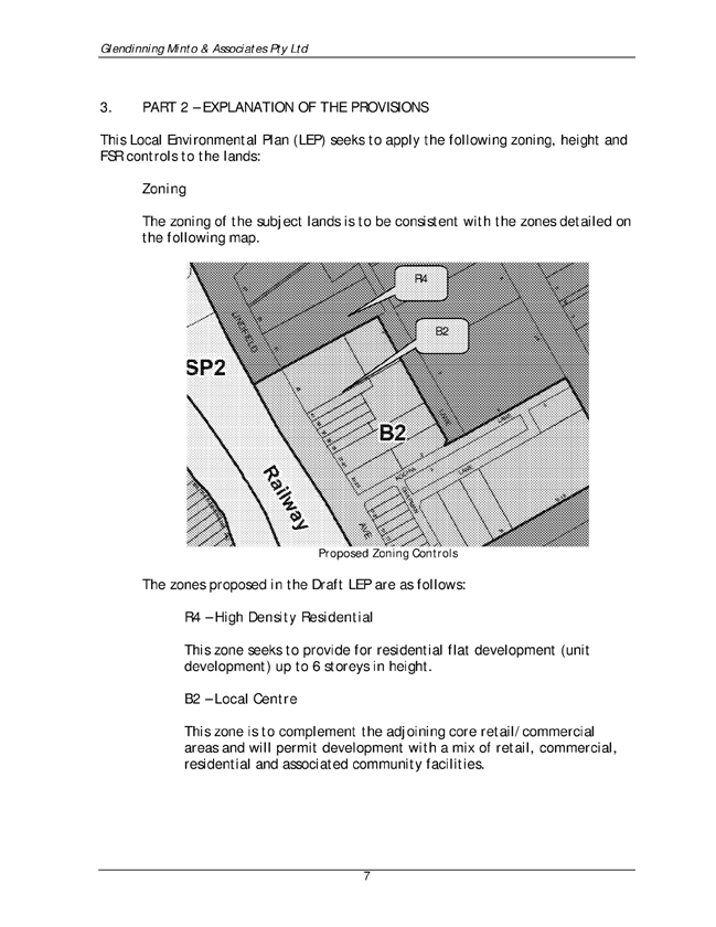

|
APPENDIX No: 2 - Planning
Proposal - Lindfield Avenue - Council Assessment Report
|
|
Item No: GB.6
|

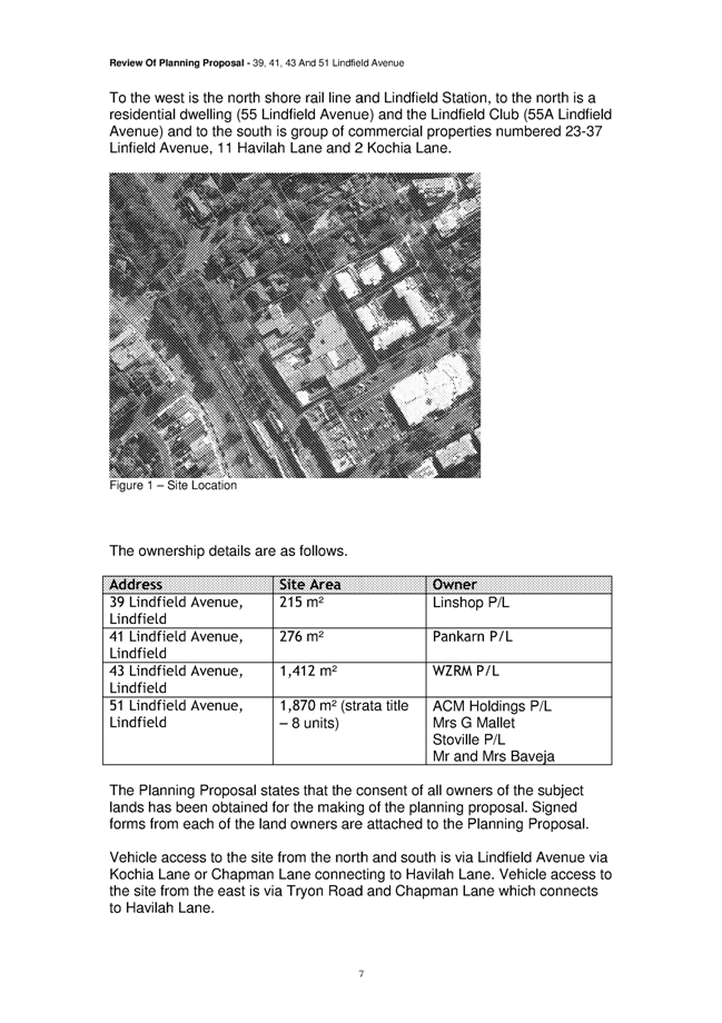
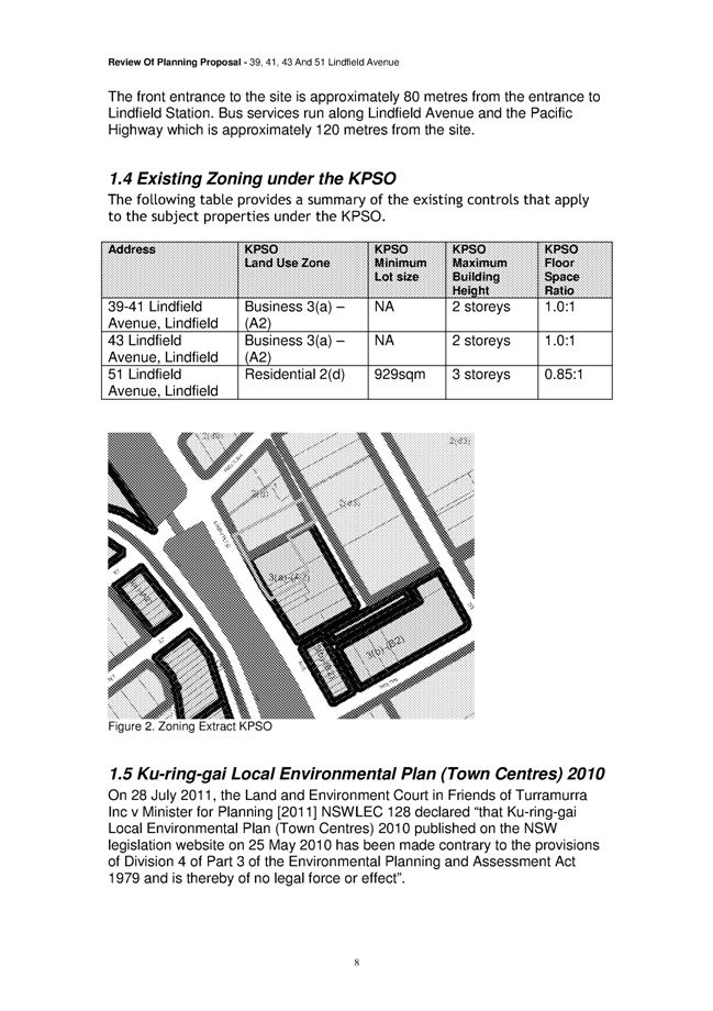
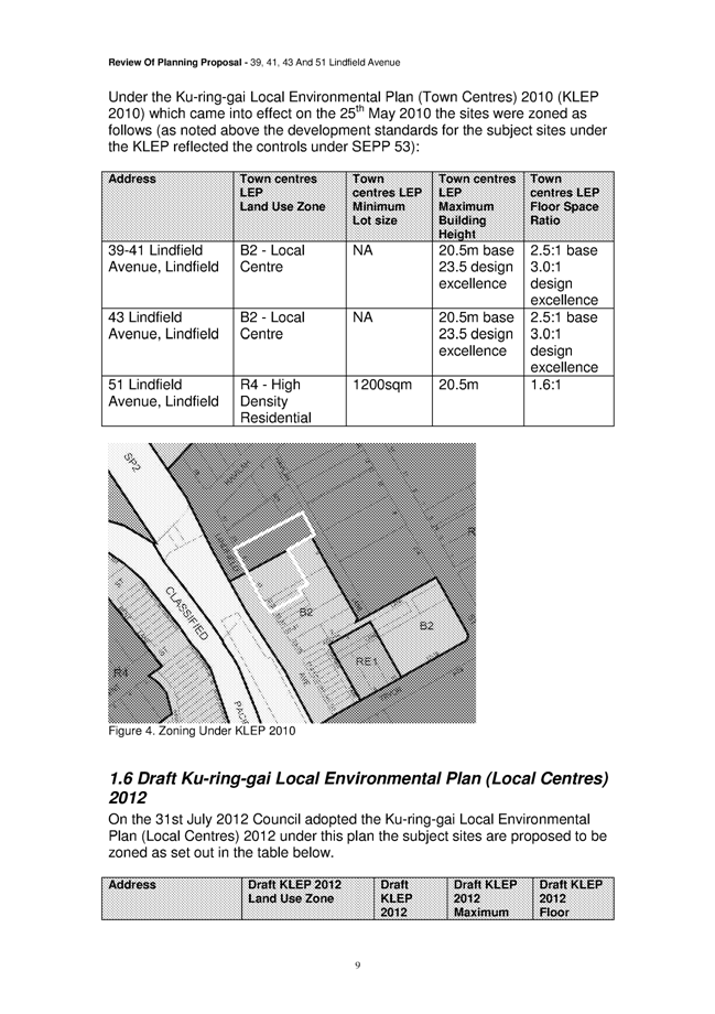
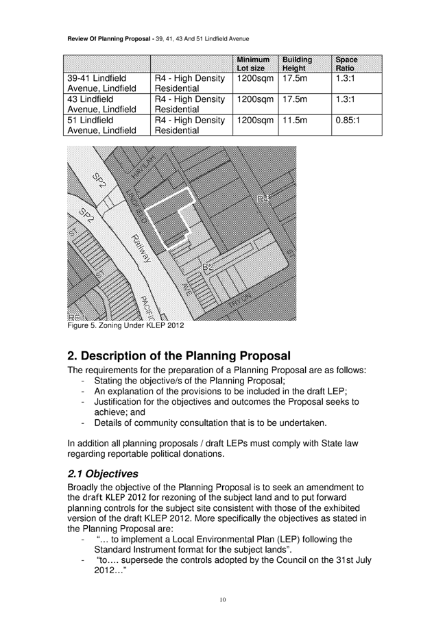
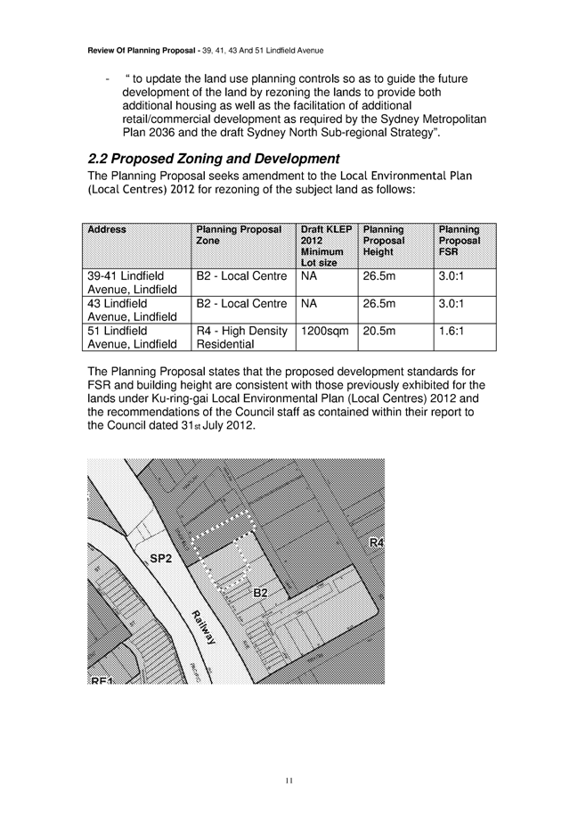
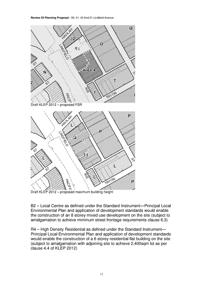
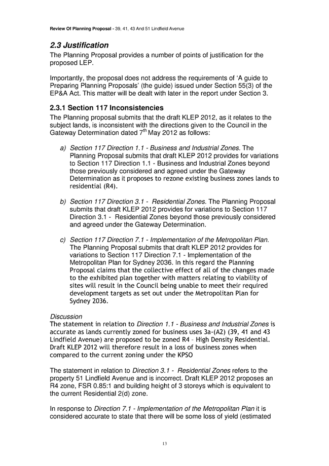
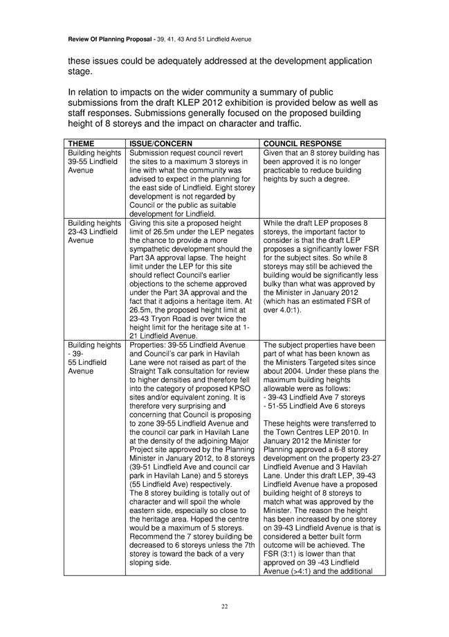
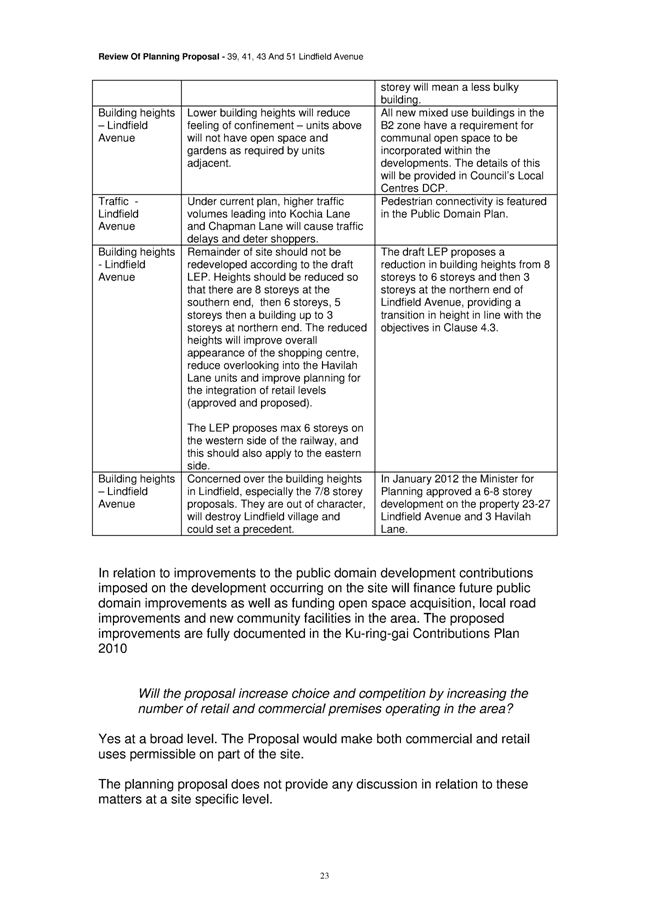
|
Ordinary
Meeting of Council - 13 November 2012
|
GB.7 / 350
|
|
|
|
|
Item GB.7
|
S06413
|
|
|
5 November 2012
|
Request for Interim Heritage Order -
78A Springdale Road, East Killara
EXECUTIVE
SUMMARY
|
purpose of report:
|
For Council to consider requesting from the Minister
for Environment and Heritage an interim heritage order for 78A Springdale Road, East Killara.
|
|
|
|
|
background:
|
The property at 78A Springdale Road, East Killara is
at risk of redevelopment and the heritage values of this property require
further assessment.
|
|
|
|
|
comments:
|
If the Minister for Environment and Heritage makes an
interim heritage order, appropriate time will be allowed to undertake the
assessment of the heritage values of the site.
|
|
|
|
|
recommendation:
|
That Council request the Minister for Environment and
Heritage to place an Interim Heritage Order on “Wharncliffe” at 78A Springdale Road, East Killara (Lot 103 DP 859921) as a place of local heritage significance
and potential state significance.
|
Purpose of Report
For Council to consider requesting from the Minister for
Environment and Heritage an interim heritage order for 78A Springdale Road,
East Killara.
Background
A Development Application has
been lodged on 25 October 2012, for 78A Springdale Road East Killara (Lot 103
DP 859921). The application includes extensive renovations which involve
demolishing and removing much of the original fabric, altering the built form
of the main building and alterations to the form of the original garden and
driveway.
Comments
“Wharncliffe” at 78A Springdale Road, East Killara is a substantial two storey sandstone dwelling built in the
Georgian style during the Inter-war period circa1938. It is an extremely fine
house, designed by the architect Garnet Finlay, and remains mostly intact on
large, original grounds including carriage loop and drive. Substantial
additions have been made, including a large wing on the north-western side of
the building. Historic and recent aerial photographs of the site can be found
in Attachment A1.
The house is situated on a
battleaxe block, down a long battleaxe handle drive. The house is not visible
from the street and as such was not identified in previous heritage studies.
The house represents one of the
earliest developments in East Killara. A brief history of the house drafted by
the Ku-ring-gai Historical Society can be found in Attachment A2.
The house is currently under
threat from extensive renovations which include demolishing and removing much
of the original fabric, altering the built form of the main building, paving
the gravel drive and altering the form of the carriage loop.
To understand the impact of the
proposed development on the heritage significance of this site, it is necessary
to undertake a thorough independent heritage assessment. It is recommended that
pursuant to section 24 of the Heritage Act,
Council request the Minister grant an interim heritage order over 78A Springdale Road, East Killara to allow a heritage assessment to be completed, to ascertain
the potential local or state significance of the property.
Governance Matters
Previously in December 2011 Council sought the delegation
from the Minister for Heritage to make interim heritage orders for properties
in Ku-ring-gai under threat of harm under certain conditions. It is understood
that the Minster was also considering granting delegation for interim heritage
orders to several council across the Sydney Region, but to date a decision has
not been made.
If Council proceeds with the request
for the interim heritage order the request will then be forwarded for further
consideration by the Minister for Heritage and the NSW Heritage Council, under
the provision of the NSW Heritage Act 1977.
Risk Management
An interim heritage order, if made,
is a temporary form of protection over an item or land that may be made while
further investigation of the heritage value of the item is carried out. The
effect of an interim heritage order is that a person cannot damage, destroy,
alter or move the item, building or land without approval from the NSW Heritage
Council.
It is understood the house and its
landscape setting are under threat of inappropriate development and/or
potential demolition. If Council does not proceed with the request for the
interim heritage order this may lead to a further loss of a potential heritage
site in Ku-ring-gai. Accordingly, this could result in a risk to Council’s
reputation through inaction.
Financial Considerations
The costs associated with this
request for an interim heritage order are covered by the Strategy and
Environment Department - Urban Planning and Heritage budget. Additional costs
may be incurred in further heritage assessment of the site.
Social Considerations
Ku-ring-gai Council is responsible for the identification
and management of Ku-ring-gai’s Local Cultural Heritage. Consideration of this
request for an interim heritage order will assist Council in investigating the
cultural heritage significance of the site to determine if it is suitable for a
formal heritage listing.
Environmental Considerations
Ku-ring-gai Council is responsible for the identification
and management of Ku-ring-gai’s Local Cultural Heritage. Consideration of this
request for an interim heritage order will assist Council in investigating the
cultural heritage significance of the site to determine if it is suitable for a
formal heritage listing.
Community Consultation
At this stage consultation is not
formally required. If Council decides to request an interim heritage
order for the site, any consultation would be via the
Ministers Office as required under the relevant legislation.
Internal Consultation
Where relevant, consultation with
other Departments has occurred in the preparation of the report.
Summary
Council has received a Development application which will
result in the loss of a building of potential local and/or state heritage
significance. It is suggested that the Council request the Minister for
Environment and Heritage to set in place an interim heritage order on 78A Springdale Road, East Killara. The interim heritage order will give Council the time
necessary to obtain a heritage assessment to ascertain whether or not the
property is of heritage significance.
|
Recommendation:
A. That
Council request the Minister for Environment and Heritage to place an Interim
Heritage Order on “Wharncliffe” at 78A Springdale Road, East Killara (Lot 103
DP 859921) as a place of local heritage significance and potential state
significance.
B. That
Council prepare a detailed heritage assessment and inventory sheet to
investigate the potential local and/or state heritage significance of
“Wharncliffe” at 78A Springdale Road,, East Killara (Lot 103 DP 859921).
C. That
the findings of the heritage assessment be reported back to Council.
D. That Council include “Wharncliffe” at 78A Springdale Road, East Killara (Lot 103 DP 859921) as draft item of heritage significance in
the Ku-ring-gai Principal Local Environmental Plan.
|
|
Andreana Kennedy
Strategy - Heritage Planner Specialist
|
Antony Fabbro
Manager Urban & Heritage Planning
|
|
Andrew Watson
Director Strategy & Environment
|
|
|
Attachments:
|
A1View
|
Historic
and recent aerial photographs of 78a Springdale Road East Killara
|
|
2012/268714
|
|
|
A2View
|
History
of 78a Springdale Road East Killara
|
|
2012/268851
|
|
APPENDIX No: 1 - Historic and
recent aerial photographs of 78a Springdale Road East Killara
|
|
Item No: GB.7
|
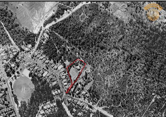
1943
Aerial – can clearly see the majority of East Killara is still bush and not
developed. 78a Springdale Road can be seen as the most substantial development
in East Killara at this time.
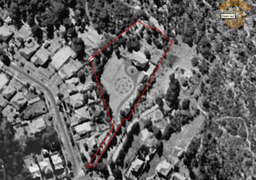
Close
up of 78a Springdale Road. Features present include the main building, a
secondary building on the drive at the south east corner of the main house, the
tennis court, gravel carriage loop and drive, feature tree plating in the
carriage loop lawn and parterre garden.
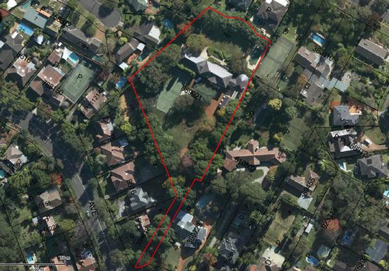
Aerial
photograph from 2011. Still visible are the main building, the secondary
building on the drive, the tennis court, the parterre garden, the carriage loop
and drive
|
APPENDIX No: 2 - History of 78a Springdale Road East Killara
|
|
Item No: GB.7
|
History prepared by the Ku-ring-gai
Historical Society
Wharncliffe No 78 A Springdale Road, Killara
No 78A Springdale Road was owned by Lorna May and William George Wright (metal merchant) who
commissioned architect Clifford H Finch to design their residence. The builder
was Garnet Finlay. The building application was approved by Ku-ring-gai Council
on 3 May 1938.
A large
article with an illustration of the property appeared in the SMH on 5
March 1940 page 3. The property sold in 1997 for a record $3 million and in
2011 for $7.8 million. (NST 4 March 2011) The 7528sq m garden was
landscaped by Annie-Wilkes.
Parkside
Estate.
No 78A is
located in the Parkside Estate; a subdivision of Portions 237, 239 and
242. DP 8616. These portions were Crown Land grants that were auctioned in the
1890s. Portion 242 contained over 2 acres and became the majority of the
curtilage of No 78A. Portion 242 was divided into three lots being:
Lot 31
containing 2 roods 32½ perches,
Lot 32
containing 2 roods 31¼ perches and
Lot 33
containing 3 roods 5¼ perches
The frontage
for these three lots was to Churchill Road. A 33’5” wide right-of-way was taken
from Lot 16 DP 8616 to give access to Springdale Road. Lot 16 had a frontage to
Birdwood Avenue and was part of Parkside Estate that was surveyed in
September 1916.
Aerial
Photographs
We know that
No 78A was constructed before 1943 when ‘From the Skies’ aerial photographs
were taken. The property was shown to contain well laid out gardens etc.
1940
Valuations (under Churchill Road)
Valuation
mentions Birdwood Avenue and Springdale Road.
The owner
was May Lorna Wright of a property containing 2 acres 1 rood 2¾ perches that
was described as containing a:
Mansion
Tennis Court
Garage
Pavilion
The UV was
£800 the IV £6,500 the AAV £325.
Title Deeds
- Volume 3888-102 DP 8616
1955
Valuations (under Springdale Road)
The owner
was still Lorna May Wright of Lots 31-33 and part Lot 16A. The property
contained 2 acres 1 rood 2¾ perches and had a 118’5” frontage to Churchill Road and a 35’5” curved frontage to Springdale Road.
The UV was
£4,000 the IV was £20,000 and the AAV was £1,000.
The property
was described as having a:
Residence
Tennis Court
Garage
Pavilion
Title Deeds
- Volume 3888-102 DP 8616
Building
Application No 1938/264
The owner
was WG Wright of 5 Kylie Avenue, Killara and the builder was Garnet Finlay of
Finlay Avenue, Roseville.
The
residence was being built in Churchill Street, however the building application
was under Birdwood Avenue.
The plan was
lodged on 20 April 1938, and approved on the 3 May 1938. The application was
for a two-storey dwelling of nine rooms and a garage that was estimated to cost
£1,700. The plans for the garage were amended.
(NOTE the
estimated cost appears low)
SMH 5 March 1940
BUILDING and CONSTRUCTION.
MODERN HOME.
Lasting Materials Used
THREE ACRES OF GARDEN.
Commodious accommodation and
lasting qualities of materials used in construction are the outstanding
features of the home illustrated, which has been completed at the corner of Springdale Road and Birdwood Avenue, Killara.
The home is pleasantly
situated on the site surrounded by over three acres of gardens, and is
approached through imposing iron gates from Springdale Road. The illustration
shows the front facade. There is a second facade facing in the opposite
direction, with a stone colonnaded terrace for practically the whole length.
The outside walls of the
whole building are faced with rich-grained Waverley sandstone and all
dressings, such as columns, window heads, and cornices, are of clean chiselled Sydney sandstone. In the process of time the sandstone will mellow down to a charming
colour. Roofs are of purple Bangor slates and all gutters and downpipes are of
copper. Windows throughout are of box-framed type constructed wholly in bronze
with novel metal sash cords. Copper has been used extensively in all the
plumbing services.
Most of the walls are
internally finished in cement and coloured. Woodwork on the ground floor is
mostly of cedar. On the ground floor is the entrance hall, stair hall, lounge,
library, dining-room, sun-room, kitchen, pantry, servery and cloakroom. On the
first floor there are six bedrooms, two bathrooms, lavatories, service stair
and sun balcony
The stair hall l8 feet by 17
feet has a circular stair with wrought iron balustrade with polished cedar
handrail. Off this hall is the library with cedar panelling and built in
bookcases. A square entrance hall connects the lounge and dining rooms by means
of sliding doors surmounted by carved scrolled heads. The walls of these rooms
are panelled out with plaster the kitchen tiled in cream has double moniel
metal sinks. A servery connects the kitchen with the dining room
Bedrooms have
built-in-wardrobes and walls coloured cream. Three of the rooms open out on to
the balcony. A feature has been made of the electric light fittings. In the
main hall there is a wrought iron candelabra with brackets to match; the
library has a brass candelabra whilst the lounge and dining rooms are
illuminated through cut-glass chandeliers of chaste design.
A separate stone building
shown in illustration, houses the garages and laundry with provision overhead
to house servants living quarters
The building was elected by
Mr Garnet Finlay to plans and under the supervision of Mr Clifford H Finch
architect Sydney
Killara's Finest
Landmark property Wharncliffe at 78a
Springdale Rd, Killara sold through Andrew Burns from Ray White Burns &
Burns for $7.8 million recently. Mr Burns said the magnificent sandstone
residence on a 7528sq m Annie-Wilkes-landscaped estate previously traded at a
Killara record of $3 million in 1997. The property enjoys secluded privacy via
a long battle-axe driveway and offers extensive stately formal living and
extensive informal living plus its own ballroom flowing out to north-facing
grounds overlooking a Romanesque pool and full-size tennis court.
Burns
& Burns Real Estate - Pymble
|
Ordinary
Meeting of Council - 13 November 2012
|
GB.8 / 358
|
|
|
|
|
Item GB.8
|
PCDC0391/11
|
|
|
18 September 2012
|
Request to extinguish
an easement for tennis court over
15 Hastings Road, Warrawee
EXECUTIVE
SUMMARY
|
purpose of report:
|
To consider a request to extinguish an easement for
tennis court over 15 Hastings Road, Warrawee, which benefits Council for
drainage purposes.
|
|
|
|
|
background:
|
The site is subject to an easement for a tennis court
created in 1986. The terms allow Council access to its stormwater pipe within
the subject property. An easement for drainage exists over the Council
stormwater pipe.
Council, at its meeting of 24 May 2011, resolved to
advise the owner it had no objection to the extinguishment of the easement
subject to an alternative on site detention system being incorporated in a
Development Application for the subject property.
|
|
|
|
|
comments:
|
The tennis court has been demolished and a residence
constructed under a Complying Development Certificate (PCDC0391/11). An
alternative on site detention system has been provided in conjunction with
the construction of the new dwelling.
|
|
|
|
|
recommendation:
|
That Council grant approval for the extinguishment of the
easement for a tennis court over 15 Hastings Road, Warrawee (Lot 13 DP16650).
|
Purpose of Report
To consider a request to extinguish an easement for tennis
court over 15 Hastings Road, Warrawee, which benefits Council for drainage
purposes.
Background
Building Application 85/1133 for a tennis court over a
Council stormwater pipe at 15 Hastings Road, Warrawee was approved subject to
the registration of an easement for tennis court. The easement for a tennis
court was created in 1986, by Deposited Plan 638512 (see Attachment A1).
The terms allow Council access to the stormwater drainage pipe within the site.
It also requires the owner to restore any damage caused as a consequence of the
construction of the tennis court, and to pay Council’s costs associated with
any future access to the pipe for maintenance or repair.
Additionally, the site is subject to a drainage easement 10
feet (3.048 metres) wide which was created by Instrument B968340, which
benefits Council. The terms allow Council access to its pipe and require the
owner to restore any damage which may be caused to the pipe. A survey sketch
of the property showing the easements is at Attachment A2.
Comments
The tennis court has been demolished on Development
Application - DA0235/11. The dwelling was demolished on Complying Development
- CDC0011/11 and a new residence has been constructed on Private Certifier Development
Certificate - PCDC0391/11. In conjunction with the construction of the new
residence, an on site detention system has been provided, to replace the
surface detention system on the tennis court. The design drawing is at Attachment
A3.
Risk Management
The terms of the easement for a tennis court allow Council
access for maintenance of its underground drainage system. Now the tennis
court has been demolished, the easement for tennis court is no longer
required. A replacement on site detention system has been provided, to ensure
the stormwater discharge, from the site, is not increased.
The Positive Covenant and Restriction on the Use of Land are
to burden the property with the requirement to maintain the on-site stormwater
detention facilities on site. The terms of the instruments are to be in
accordance with the Council’s Section 88B instruments for the protection of
on-site detention facilities.
Financial Considerations
The tennis court has been demolished, the easement for
tennis court is no longer required therefore no compensation will be requested
from the owner. Council will retain access to its drainage pipes under
existing easement plan in dealing B968340.
The owner of the property has agreed to meet all Council’s
costs associated with the extinguishment of the tennis court easement.
Community Consultation
Consultation has been held between Council, the owners of
the property and consulting engineer.
Internal Consultation
Consultation has been held with Council’s Operations
Department, Development and Regulation Department and Integrated Planning,
Property and Assets.
Summary
An easement for a tennis court was created over Lot 13
DP16650 in 1986. The terms allow Council access to maintain its stormwater
pipe. The tennis court has been demolished and the easement is no longer
required.
Council is the beneficiary of the easement and has the
authority to agree to its extinguishment.
Council’s drainage system is still protected by another
easement that runs across the property, created by B968340. To remove the
tennis court easement will not have any major impact on Council’s drainage
system. The tennis court surface on site detention system has been replaced
with an alternative system which will continue to restrict the stormwater
runoff from the site.
|
Recommendation:
A. That
Council grant approval for the extinguishment of the easement for a tennis
court over
15 Hastings Road, Warrawee (Lot 13 DP16650).
B. That
authority is given to the General Manager and the Mayor to affix the Common
Seal of the Council to the Instrument for the release of the easement and any
other relevant documents.
C. That
the owner of the property be responsible for all costs associated with the
extinguishment of the tennis court easement.
D. That, prior to the endorsement of the easement
documents, the owner provide Council with evidence that documents for the
creation of a Positive Covenant and Restriction on the Use of Land under Section 88E of the Conveyancing Act 1919 have
been lodged with the Department of Lands.
|
|
Dirk Nagel
Strategic Property Advisor
|
Kathy Hawken
Team Leader Development Engineers
|
|
Attachments:
|
A1View
|
Deposited
plan 638512
|
|
2012/235599
|
|
|
A2View
|
Survey
sketch
|
|
2012/235597
|
|
|
A3View
|
Design of
new on site detention system
|
|
2012/235585
|
|
APPENDIX No: 1 - Deposited plan
638512
|
|
Item No: GB.8
|
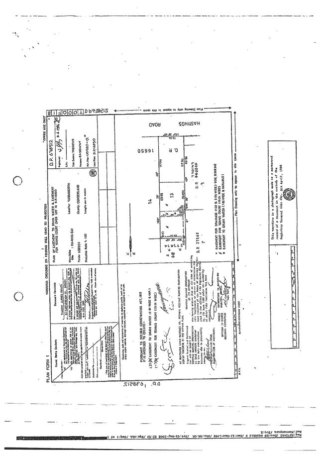
|
APPENDIX No: 2 - Survey sketch
|
|
Item No: GB.8
|
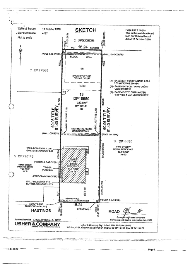
|
APPENDIX No: 3 - Design of new
on site detention system
|
|
Item No: GB.8
|
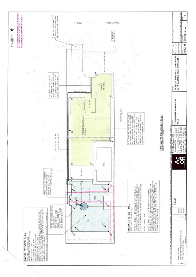
|
Ordinary
Meeting of Council - 13 November 2012
|
GB.9 / 364
|
|
|
|
|
Item GB.9
|
S09430/2
|
|
|
25 September 2012
|
Tender T61/2012 -
Sports Courts Refurbishment
EXECUTIVE
SUMMARY
|
purpose of report:
|
To consider the tenders received for the refurbishment
and upgrade of sports courts at Turramurra Memorial Park, Gordon Recreation
Ground, Killara Park and Elizabeth Reserve and appoint the preferred
tenderer.
|
|
|
|
|
background:
|
Council, as part of the Open Space Capital Works
Program, approved funding for the refurbishment and upgrade of sports courts
at four (4) sites.
|
|
|
|
|
comments:
|
Tender documents were produced with five (5)
submissions received. The submissions were assessed using agreed criteria
which identified the tender submission providing the best value for money for
Council.
|
|
|
|
|
recommendation:
|
That Council accepts the tender from Recreational
Surfacing Pty Ltd for the refurbishment and upgrade of sports courts at Turramurra Memorial Park, Gordon Recreation Ground, Killara Park and Elizabeth Reserve.
|
Purpose of Report
To consider the tenders received for the refurbishment and
upgrade of sports courts at Turramurra Memorial Park, Gordon Recreation Ground,
Killara Park and Elizabeth Reserve and appoint the preferred tenderer.
Background
Council, as part of the Open
Space Capital Works Program 2012/2013, approved funding for the refurbishment
and upgrade of the following sports courts:
· Turramurra Memorial Park
· Gordon Recreation
Reserve
· Killara Park
· Queen Elizabeth Reserve
The proposed amount for the
refurbishment is over $150,000. Tenders were called using Tenderlink in accordance
with the tender requirements of the Local Government Act and Regulations.
Comments
In accordance with Council’s
Tendering Policy, five (5) tenders were received and recorded.
Tenders were received from the
following companies:
· Recreational Surfacing
Pty Ltd
· All Grass Sports
Surfaces Pty Ltd ( Sports Contractors Association)
· North Shore Paving Pty
Ltd
· Court Craft (Aust) Pty
Ltd
· Active Areas Pty Ltd
A Tender Evaluation Panel
consisting of staff from the Operations Department was formed to assess the
five (5) tenders received. The evaluation took into account:
· the lump sum fee,
· provisional rates,
· company and staff experience,
· the ability to provide the full range of
services required,
· work program,
· previous performance in relation to similar
type work, and
· the company’s financial capacity.
The confidential attachments to
this report include a list of companies who provided a tender
(Attachment 1), the
Tender Evaluation Panel’s assessment (Attachment 2), and a copy of the
independent Performance and
Financial Assessments which was carried out by Corporate
Scorecard Pty Ltd (Attachments
3 and 4).
From the five (5) submissions
received and the available information taken into account during the scoring
from each element of the assessment, Recreational Surfacing Pty Ltd was
identified as providing the best value to Council. In order to ensure Council
is not exposed to financial risk and Recreational Surfacing Pty Ltd is trading
in a ‘sound and profitable manner’, an independent Performance and Financial
Assessment was carried out by Corporate Scorecard. Recreational Surfacing Pty
Ltd was identified as providing the ‘Best Value’ to Council.
Governance Matters
At the close of tender, five (5)
tenders were received and recorded in accordance with Council’s tendering
policy. A Tender Evaluation Panel consisting of staff from the Operations
Department was formed to assess the five (5) tenders received. The attachments
are considered to be confidential in accordance with Section 10A (2)(d)(iii) of
The Local Government Act 1993 as they are considered to contain
commercial in confidence information.
Risk Management
Two (2) key areas of risk were
identified in relation to the proposed work:
1. That work needed to be carried out by a suitably qualified
company with experience of refurbishing sports courts to a high standard,
2. That Council should not
be exposed to financial risk.
The evaluation process
considered the lump sum price and provisional rates as well as their ability to
provide service through their experience and documented evidence of previous
work of a similar nature.
Four (4) of the five (5)
tenderers demonstrated:
· A reasonable
understanding of the requirements of the work required.
· Previous experience of
carrying out work of a similar nature.
· Quality results in
relation to previous work of a similar nature.
All Grass Sports Surfaces Pty
Ltd (Sports Contractors Association) submitted non compliant documentation.
Therefore, their submission was not assessed.
Following the initial
evaluation, the company assessed as providing the best value for money and work
quality was Recreational Surfacing Pty Ltd. In order to ensure that Council not
be exposed to financial risk, an independent Performance and Financial Assessment
was carried out on Recreational Surfacing Pty Ltd.
As part of this assessment the
following areas were examined:
· that Recreational
Surfacing Pty Ltd had the financial capacity to undertake the proposed value of
work;
· that Recreational
Surfacing Pty Ltd has been trading in a profitable and responsible manner
during the last three (3) years;
· that Recreational Surfacing
Pty Ltd has sufficient assets / reserves to cover all possible debts during the
period of work.
The financial aspect of the
assessment shows that Recreational Surfacing Pty Ltd is able to satisfy all
requirements and is unlikely to expose Council to any financial risk if awarded
the work of refurbishing the sports courts as detailed within Council’s tender
documents. As an additional risk reduction measure Recreational Surfacing Pty
Ltd will provide a Bank Guarantee.
Financial Considerations
Council’s adopted Open Space
Capital Works Program 2012/2013 allocated funding for the refurbishment of all
four (4) sports courts sites. The proposed work will be funded from the funding
resources as listed below.
|
Project No
|
Description
|
Available
Funds at October 2012
|
|
103186
|
Gordon Recreational Ground -
Fencing
|
$62,300
|
|
103187
|
Turramurra Park - Upgrade 2 acrylic courts and fencing.
|
$62,500
|
|
103188
|
Gordon Recreation Ground –
Upgrade 2 synthetic grass courts
|
$62,300
|
|
103189
|
Killara Park – Upgrade 2
synthetic grass courts
|
$62,300
|
|
103190
|
Queen Elizabeth Reserve –
Upgrade 4 acrylic courts
|
$62,300
|
|
|
TOTAL
|
$311,700
|
Social Considerations
All four (4) sports courts sites
are extensively utilized by the local community. Families, individuals and
schools use the courts for both social and competition sports. The current
facilities are in need of general repair and improvement to meet future
community demands.
The proposed improvement works
are in accordance with Council’s adopted Open Space Capital Works Program 2012/2013.
The proposed works will enhance the recreational value, improve general access
and safety and create greater opportunities for social interaction as well as
providing health and wellbeing. Public access and use of the sports courts will
not be possible during the refurbishment period. In order to minimise the
impact to users, the work will be scheduled with no more than two (2) sites
closed at any one time.
Environmental Considerations
The refurbishment is being
carried out to existing facilities and will not impact on surrounding areas.
The proposed works aim to upgrade the sports courts and extend their usable
life. As part of standard refurbishment practice, suitable environmental
management controls will be required to be implemented by the appointed
contractor.
Community Consultation
No specific community
consultation was undertaken as the works involve the refurbishment of existing
facilities. This will ensure the services available will be in a safe usable
condition.
Prior to commencement,
notification of the proposed works including the dates of closure will be sent
to all regular uses. Additional signs will be displayed at the sports courts to
advise casual users of the closure.
Internal Consultation
Consultation was undertaken by
officers from the Operations Department, Strategy & Environment Department
and Community Department.
Summary
Council, as part of the Open
Space Capital Works Program 2012/2013, approved funding for the refurbishment
of four (4) sports court sites:
· Turramurra Memorial Park,
· Gordon Recreation
Reserve,
· Killara Park, and
· Queen Elizabeth Reserve.
Tenders were called in August
2012 with a closing date of 11 September 2012. A Tender Evaluation Panel was
formed consisting of representatives from the Operations Department.
Four (4) of the five (5)
tenderers submitted demonstrated an understanding of the work required.
Following the evaluation and independent performance and financial checks, it
is recommended Recreational Surfacing Pty Ltd be appointed on the basis of
providing the best value to Council.
|
Recommendation:
A. That
Council accepts the tender from Recreational Surfacing Pty Ltd to carry out
refurbishment of all four (4) sports court sites at Turramurra Memorial Park, Gordon Recreation Reserve, Killara Park, and Queen Elizabeth Reserve.
B. That
the Mayor and General Manager be delegated authority to execute all tender
documents on Council’s behalf in relation to the contract.
C. That
the seal of Council be affixed to all necessary documents.
D. That
all tenderers be advised of Council’s decision in accordance with Clause 178
of the Local Government Tendering Regulations.
|
|
David Morris
Manager Open Space Projects
|
Greg Piconi
Director Operations
|
|
Attachments:
|
A1
|
Tender
Submissions
|
|
Confidential
|
|
|
A2
|
Evaluation
Sheet
|
|
Confidential
|
|
|
A3
|
Performance
and Financial Assessment
|
|
Confidential
|
|
|
A4
|
Performance
and Financial Assessment
|
|
Confidential
|
|
Ordinary
Meeting of Council - 13 November 2012
|
GB.10 / 369
|
|
|
|
|
Item GB.10
|
S09426/2
|
|
|
9 October 2012
|
Tender No. T63/2012 -
Schedule of Rates Tree Works
EXECUTIVE
SUMMARY
|
purpose of report:
|
To consider the tenders received for contract tree
works and have a list of preferred contractors for tree works.
|
|
|
|
|
background:
|
In conjunction with Operational staff, contractors are
engaged to undertake tree works as part of its overall maintenance program.
Funding for this work will come from existing recurrent budgets
|
|
|
|
|
comments:
|
Public tenders were called on 8th September
2012 and closed on 2nd October 2012. Council has proposed a term
of three (3) years. Tender documents were produced with nine (9) submissions
received. The submissions were assessed using agreed criteria which
identified the tender submission providing the best value to Council
|
|
|
|
|
recommendation:
|
Acceptance of tenders and the inclusion of tenderers
to a list of contractors for a period of three (3) years.
|
Purpose of Report
To consider the tenders received for contract tree works and
have a list of preferred contractors for tree works.
Background
In conjunction with Operational staff, contractors are
engaged to undertake tree works throughout the LGA as part of its overall tree
maintenance program. Funding will come from existing recurrent budgets.
Comments
All tenders were received via the
Tenderlink online portal or placed in the tender box.
Council received nine (9) submissions from the following
companies:
1. Hornsby
Tree Services Pty Ltd
2. Plateau
Tree Service Pty Ltd
3. Sydney
Metro Tree Service Pty Ltd
4. AHK
Enterprises Pty Ltd - T/as Priority Tree Service
5. CJ
Murphy Tree Recycling Services Pty Ltd
6. Active
Tree Services Pty Ltd
7. Arbor
Pride Pty Ltd
8. UAM Pty
Ltd
9. Macquarie
Vegetation Management Pty Ltd
A Tender Evaluation Committee (TEC) was formed consisting of
staff from Open Space Services.
The TEC assessed all nine (9) submissions to ensure they
conformed by completing all 13 parts of the Returnable Schedules. Only eight
(8) of the nine (9) conformed.
The evaluation considered:
· Submitted prices valued
at 40%
· Contractor ability to provide full range
of service valued at 25%
· Contractor expertise and experience valued
at 20%
· Resources valued
at 10%
· Response times valued
at 5%
Totalling 100%
Four (4) companies have previously worked for Ku-ring-gai
Council and six (6) of the eight (8) have worked for other Councils and State
Government.
The evaluation sheet listing the
tenderers and their submitted prices for the various tasks as itemised in the
Returnable Schedules is attached. (Attachment 1)
Price was considered the most
important item to value. Submitted prices were valued from one (1) to eight
(8), with eight (8) being the best value for money. The score was then divided
by the % value and multiplied by 100 to give the final percentage score.
The assessment of the tenderers
ability to provide the full range of service, experience and expertise,
resource and response times was scored from ten (10) to one (1) with 10 being
the highest score.
All submissions were evaluated to
meet each of the criteria.
Therefore, the TEC agreed it would
be beneficial to Council to establish a preferred contractor list consisting of
conforming tenders due to each of the contractor’s ability to provide a number
of different services which are used by Council on various occasions.
Governance Matters
The attachments are considered to be confidential in
accordance with Section 10A (2)(d)(iii) of the Local Government Act 1993
as they are considered to contain commercial in confidence information.
Risk Management
Four (4) key areas of risk were identified in relation to
the provision of tree works:
· Contractor’s ability to provide a full
range of service;
· Contractor expertise and experience;
· Resource; and
· Response times.
Independent Financial and Performance Assessments were not
undertaken as the works need to be completed prior to payment.
Financial Considerations
Council has sufficient funds in its annual recurrent budget
to maintain the open space areas to the required specifications.
Social Considerations
This work forms part of Council’s ongoing commitment to
maintain Ku-ring-gai’s tree canopy to a satisfactory standard.
Environmental Considerations
All companies have an Environmental Management System in
place as required in the Returnable Schedule documentation.
Community Consultation
No community consultation was undertaken as this is an
operational matter.
Internal Consultation
Staff from the Operations Department was consulted in the
preparation, review and recommendation of the preferred contractors.
Summary
Tender T63/2012 was called on 8th September 2012
with a closing date of 2nd October 2012. A Tender Evaluation Panel
was formed consisting of representatives from Open Space Services.
All conforming
tenderers demonstrated an understanding of the work required. It is recommended
a preferred contractor list be established
consisting of the submitted tenders based on the Schedule of Rates provided.
|
Recommendation:
A. That
Council accept the Schedule of Rates for Tree Works submitted by the
following tenderers and these tenderers make up the list of Contractors to be
engaged as needed for the general maintenance of Council’s tree resource for
a period of three (3) years:
1. Hornsby
Tree Services Pty Ltd
2. Plateau
Tree Service Pty Ltd
3. Sydney
Metro Tree Service Pty Ltd
4. AHK
Enterprises Pty Ltd - T/as Priority Tree Service
5. CJ
Murphy Tree Recycling Services Pty Ltd
6. Active
Tree Services Pty Ltd
7. Arbor
Pride Pty Ltd
8. UAM
Pty Ltd
B. That
the Mayor and General Manager be delegated authority to execute all tender
documents on Council’s behalf in relation to the contracts.
C. That
the Seal of Council be affixed to all necessary documents.
D. That
the all tenderers be advised of Council’s decision in accordance with Clause
178 of the Local Government Tendering Regulations.
|
|
Scott Hannell
Tree Preservation and Contracts Co-ordinator
|
Matthew Drago
Manager Open Space Services
|
|
Greg Piconi
Director Operations
|
|
|
Attachments:
|
A1
|
Evaluation
- Schedule of Rates - Tree Works
|
|
Confidential
|
|
Ordinary
Meeting of Council - 13 November 2012
|
GB.11 / 374
|
|
|
|
|
Item GB.11
|
S07618
|
|
|
29 October 2012
|
Open Space Reference Committee -
Meeting held on 20 August 2012
EXECUTIVE
SUMMARY
|
PURPOSE of report:
|
To advise Council of the notes from the Open Space
Reference Committee meeting held on 20 August 2012.
|
|
|
|
|
background:
|
The Committee is working with Council on its forward
planning and providing valuable feedback on Council’s current programs for
sportsfields, bushland activities and policies.
|
|
|
|
|
comments:
|
The meeting provided the Committee with follow up
actions from the previous meeting and presented further matters for feedback
on a number of initiatives currently in progress.
|
|
|
|
|
recommendation:
|
That the notes from the Open Space Reference Committee
meeting of 20 August 2012 be received and noted.
|
Purpose of Report
To advise Council of the notes from the Open Space Reference
Committee meeting held on 20 August 2012.
Background
In 2009, Council appointed four
(4) community reference committees under Section 355(b) of the Local
Government Act, 1993. One of the committees appointed was the Open Space
Reference Committee. The Committee consists of twenty (20) community
representatives. The Chair of the Committee is Councillor Keays and the Deputy
Chair is Councillor Hardwick.
The Committee is working with Council on its forward
planning and providing valuable feedback on Council’s current programs for
sportsfields, bushland activities and policies.
Comments
The Committee is concentrating on assisting Council with
input into policies and procedures and providing valuable feedback on Council’s
future programs.
Notes from the meeting held on 20 August 2012 are attached.
Governance Matters
The Open Space Reference Committee is established under
Section 355(b) of the Local Government Act, 1993. It is not a decision
making committee but provides Council with valuable information on the items
presented to the Committee and to assist Council with its decision making.
Risk Management
Not applicable.
Financial Considerations
The Committee is not empowered to
make decisions and therefore there are no financial decisions made by the
Committee.
Social Considerations
Matters raised at the Open Space Reference Committee take
into consideration the social considerations associated with the various
programs and projects.
Environmental Considerations
This is a major function of the Committee and most of the
projects and programs go through a due diligence program relating to
environmental considerations.
Community Consultation
The Committee is a community
forum. The various programs and plans presented to the Committee undergo
community consultation. Details of the Committee, presentation material, notes
and reports can be obtained from Council’s website or in reports at Council.
Internal Consultation
Presentations and servicing of the
Committee is undertaken by Strategy and Environment, Operations and Community
Departments and relevant staff were involved in the presentations and support
for the Open Space Reference Committee.
Summary
The meeting held on 20 August 2012
provided the Committee with follow up action from the previous meeting and presented
further matters to the Committee seeking feedback on a number of initiatives
currently in progress.
|
Recommendation:
That the notes of the Open Space Reference Committee held
on 20 August 2012 be received and noted.
|
|
Matthew Drago
Manager Open Space Services
|
Greg Piconi
Director Operations
|
|
Attachments:
|
A1View
|
Open
Space Reference Committee Notes 20 August 2012
|
|
2012/263359
|
|
APPENDIX No: 1 - Open Space
Reference Committee Notes 20 August 2012
|
|
Item No: GB.11
|
Open Space Reference Committee
Notes of 20 August 2012
Training Rooms – Level 1
Council Depot – 5 Suakin Street
Pymble
Meeting
Commenced 6.00pm
Attendance:
Councillors:
Councillor
Hardwick (Chair)
Mayor,
Councillor Anderson
Committee
members:
Philip
Youdale Margaret Booth Dr Harley Wright
Alan
Fredericks Sandra Fry John
McFadden
Margery
Street Dr Andrew Little Nancy Pallin
Guests:
Greg Hay
(for John Ceccato)
Apologies:
Councillor
Keays Miguel Andrade Grant Corderoy
Sandra Van De Water John Ceccato Andrew Watson
Mary-lou Lewis Christiane Berlioz Andrew Falk David
Howard Ian Dreghorn
Staff:
Greg Piconi
Matt Drago Roger Faulkner
Mark Taylor Marnie Kikken
1. Confirmation of
meeting notes from 21 April 2012:
The Chair
tabled the notes from the last meeting.
The notes
were considered and accepted as a true record of the meeting.
2. Apologies:
Apologies were noted by the Chair.
3. Business arising from
previous meeting.
Dr
Andrew Little
requested an update on item 7 from the notes from the previous meeting
regarding the St Ives Showground and Precincts Plan of Management. Roger Faulkner advised that there had been no further developments since the last
meeting.
Matt
Drago updated the
committee on item 11 from the notes of the previous meeting regarding Haloragodendron
at Barra Brui. Matt advised that he was in the process of organising a
meeting with the relevant staff from National Parks and would update the
interested committee members in the near future.
Sportsfields
and Parks
4. Update on Bookings
System
Mark
Taylor presented the committee with the
progress on the new bookings system.
A copy of
the presentation can be found at the following link:
http://www.kmc.nsw.gov.au/resources/documents/2012_262681_Facilities_and_Events_Bookings_System_Presentation.pdf
Sportsfields
and Parks General Business
4.1 The Glade and Bannockburn Oval
Alan
Fredericks and John McFadden requested whether funding allocated to The Glade Oval would
now be re-allocated to Bannockburn Oval for an athletics facility.
Roger
Faulkner responded that any funds allocated
to the Glade had been expended however, there was an item in the current
Delivery Program (OSP4.4.4) relating to the investigation of a masterplan for
an athletics facility. The location to masterplan would be a decision of
Council.
Bushland
and Natural Areas
5. Prioritisation Matrix and Regeneration Works
for Levy 2 and recurrent funds
Marnie
Kikken and Matt
Drago, presented
the committee with a breakdown of the prioritisation process and results for
the allocation of funding in this area.
Committee
members were provided with a copy of the information which can be found at the
following links:
http://www.kmc.nsw.gov.au/resources/documents/2012_262666_2012_262666_Regeneration_Prioritisation_Matrix.pdf
http://www.kmc.nsw.gov.au/resources/documents/2012_262671__Bushland_Matrix_-_Assessment_Criteria.pdf
http://www.kmc.nsw.gov.au/resources/documents/2012_262672_Bushland_Matrix_final_rankings.pdf
Committee
members questioned the absence of some sites and it was agreed that some of the
sites would be included in future prioritisation processes.
5.1
General Business Bushland and Natural Areas
Nancy
Pallin complemented
Council staff on the results they had achieved in the regeneration of bushland
surrounding Hassall Park St Ives
6. General Business
6.1 Discussion
and recommendation for future committee structure
Greg
Piconi, gave some
background of the requirements of the Local Government Act in relation to the
formation of committees and the two main types of committees, either a 355 or a
260.
Greg acknowledged
the committee members general concerns regarding the existing committee
structure and outlined the importance of community input into decision making.
Some
committee members expressed feeling more empowered under a 355 structure as had
been the structure for previous committees. Some committee members felt that
the current 260 committee structure was more suitable.
It was
generally agreed that the information that had been presented to the committee
by Council staff over the previous four years was of a high standard and
informative. It was also agreed that any information should be made available
to committee members a lot earlier in advance of the meeting regardless of the
future structure.
Committee
members also agreed that there could be two sub committees formed under one
main committee.
It was
agreed that these thoughts, along with the notes of the previous committee
meeting be recorded for reference of the new Council.
6.2
Original Purchase of land at 5 Suakin Street Pymble
Alan Fredericks did a short
presentation on his involvement as a committee member with the original
purchase of the land at 5 Suakin Street Pymble, the site of Council’s new
Depot, which was originally purchased as a site for an indoor aquatic
facility.
6.3
Thanks to Committee Members
Greg
Piconi thanked all
of the committee members for their support and input for the previous four
years.
Meeting
closed at 8.30pm
* * * *