Minute Ku-ring-gai Council Page
Ordinary Meeting of Council
TO BE HELD ON Tuesday, 26 November 2013 AT 7.00pm
Level 3 Council Chambers
BOOK 2
Agenda and Late ITEMS
** ** ** ** ** **
NOTE: For Full Details, See Council’s Website –
www.kmc.nsw.gov.au under the link to business papers
LATE ITEM
Minutes of Extraordinary Meeting of Council 4
File: S02131
Meeting held 20 November 2013
Minutes numbered EMC.1 to EMC.2
Petitions
LATE ITEM
PT.2 Petition regarding Saving Killara Station Car Park for our Local Community - (Six Hundred and Forty-nine [649] Signatures) 8
File: S09768
The following Petition was presented by Councillor Cheryl Szatow
“We, the undersigned, petition Ku-ring-gai Council that since 1981, every time Ku-ring-gai Council has a need for money, it tries to rezone and sell the Culworth Avenue Car Park at Killara Station.
Five times, since 1981, the voice of the local residents has defeated this proposition. Now Council seeks to reclassify the land, such that it will be sold to developers who will replace a vital community facility with another five storey apartment block with more traffic on our already congested and inadequate local streets.
We residents need once more to send a clear message to those elected to represent us that our wish is to retain that land for the benefit of the community forever. By signing up to this petition, and attending the public meeting at Council Chambers on October 24 at 5:00pm , we are sending a clear message to the Council that we want this land kept for our benefit and not reclassified and sold."
GENERAL BUSINESS
i. The Mayor to invite Councillors to nominate any item(s) on the Agenda that they wish to have a site inspection.
ii. The Mayor to invite Councillors to nominate any item(s) on the Agenda that they wish to adopt in accordance with the officer’s recommendation allowing for minor changes without debate.
BUSINESS PAPER BOOK 2
GB.14 Draft Principal Local Environmental Plan - Consideration of Submissions 9
File: S06413/5
To have Council consider the public submissions on the draft Ku-ring-gai Principal Local Environmental Plan 2013.
Recommendation:
That Council adopts the draft Ku-ring-gai Principal Local Environmental Plan 2013 and recommend to the Minister for Planning & Infrastructure that the plan be made.
LATE ITEMS
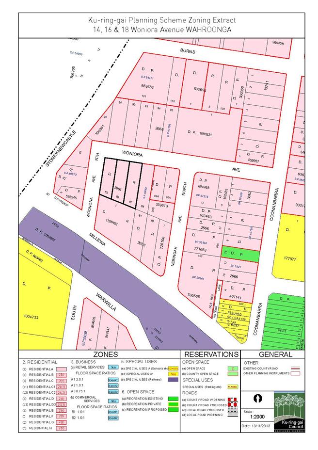
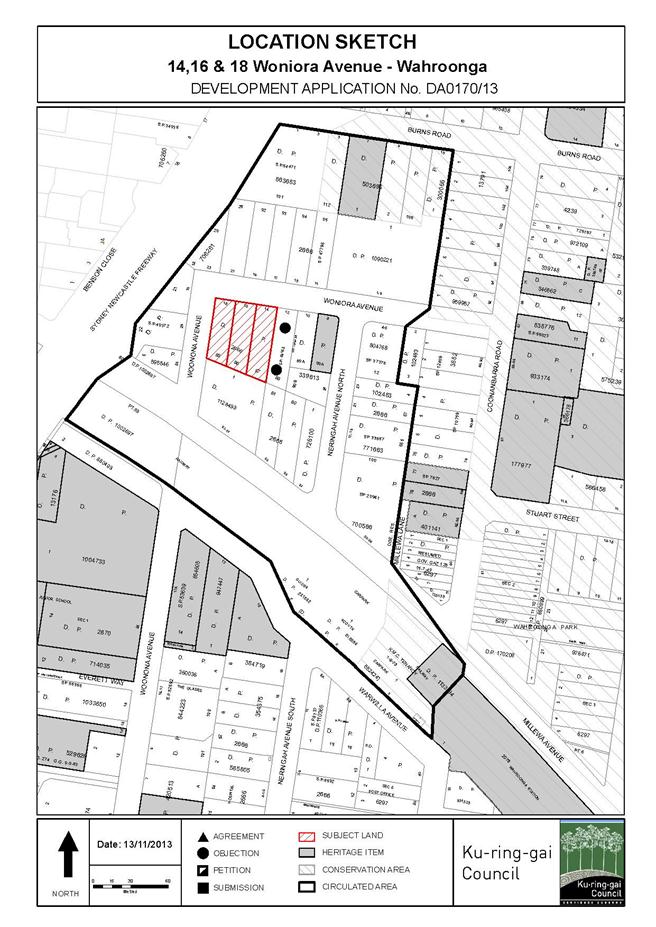
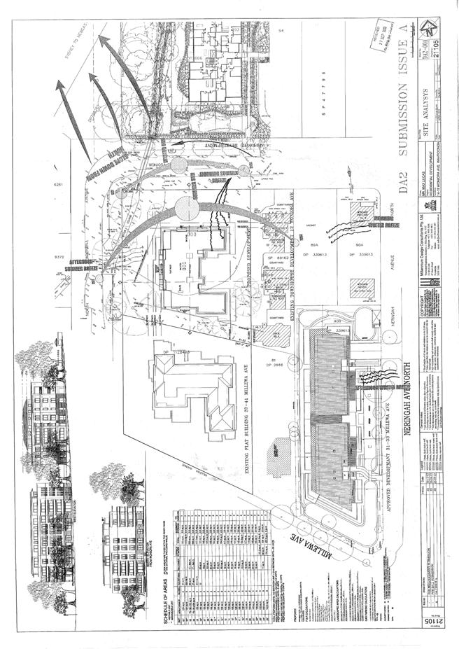
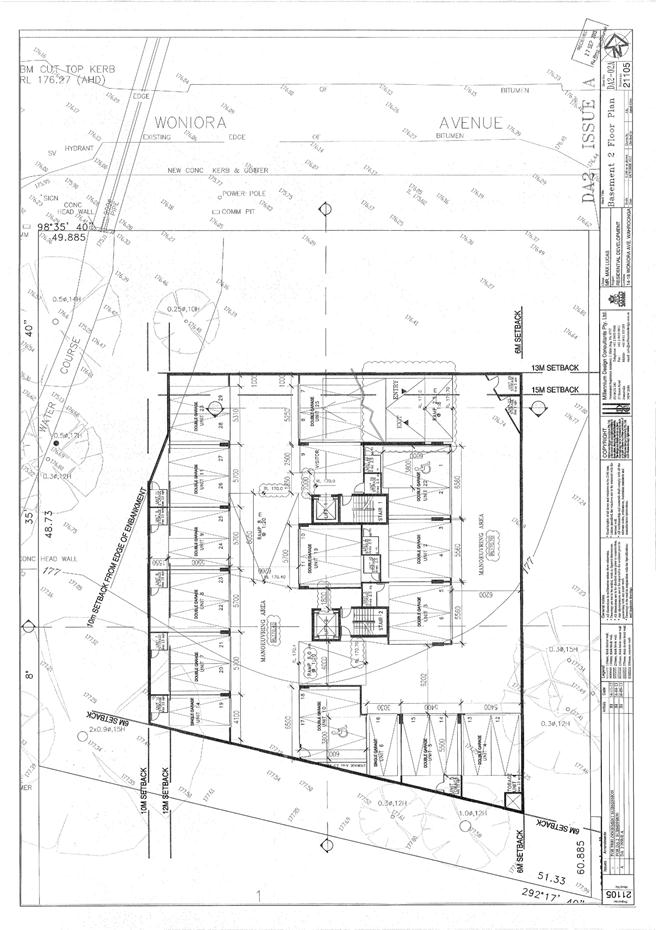
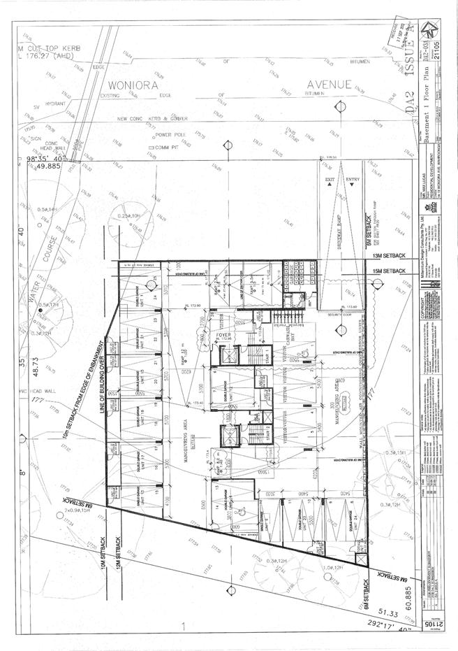
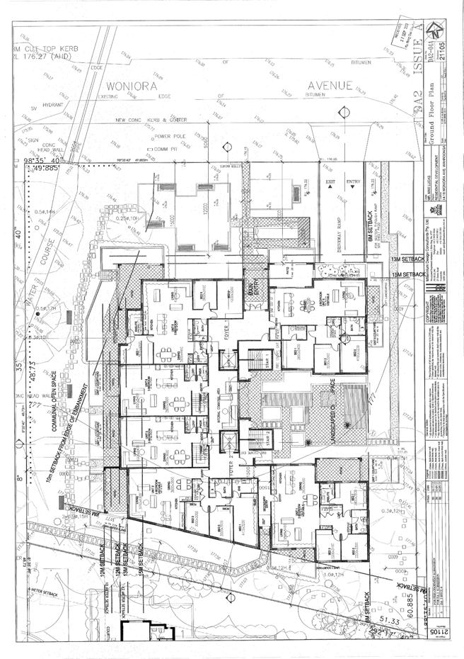
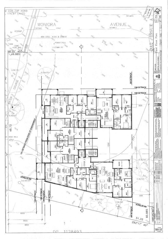
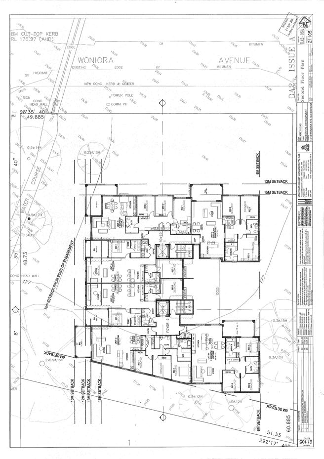
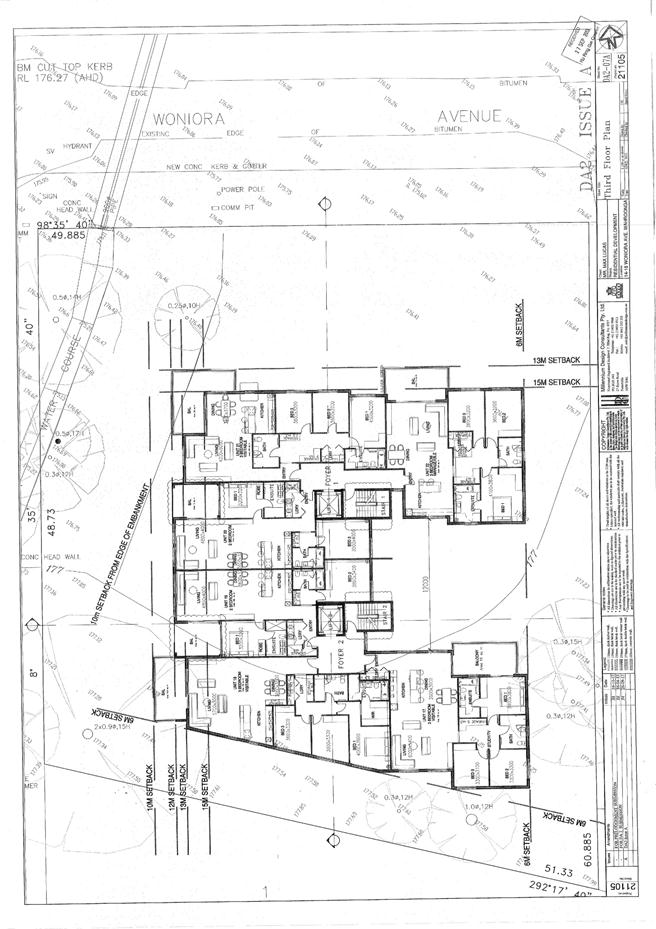
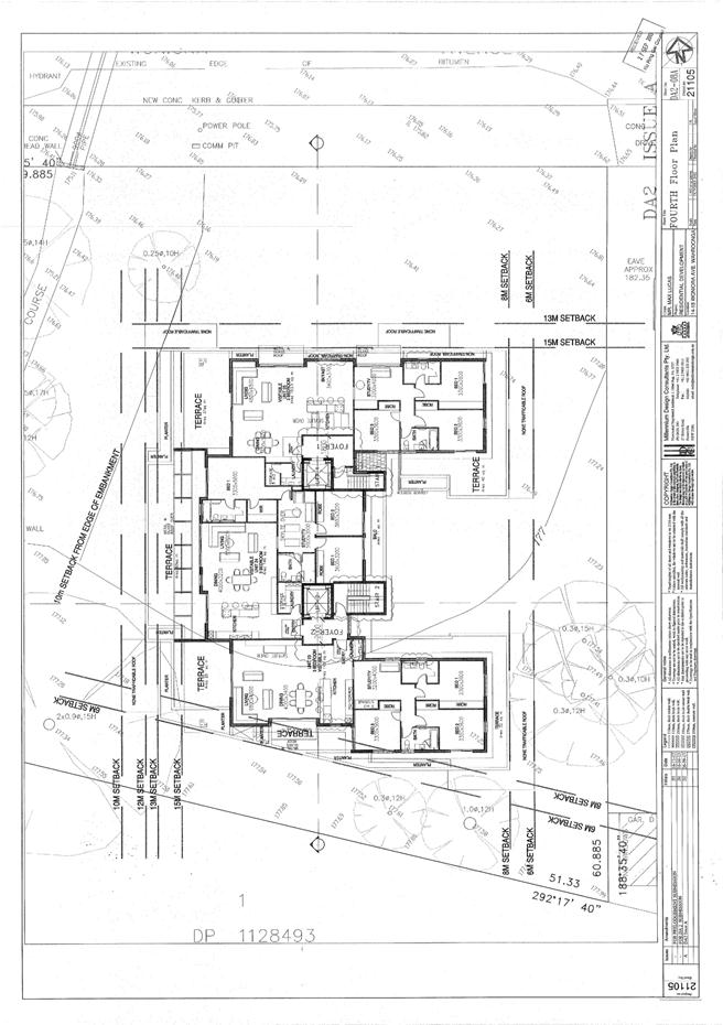
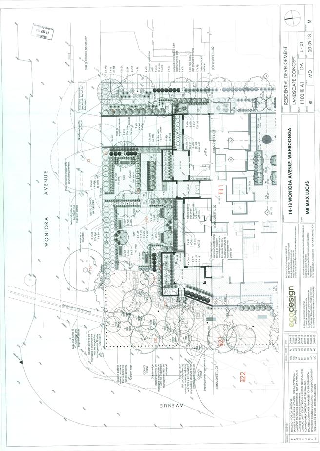
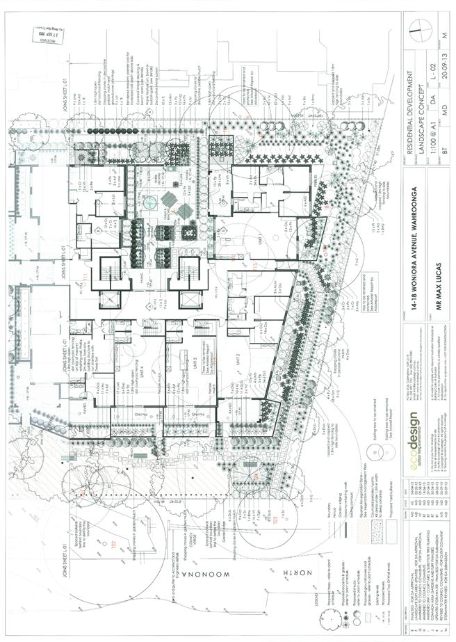
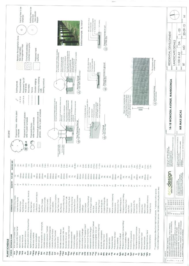
GB.15 14-18 Woniora Avenue, Wahroonga - Demolition of Existing Dwellings and Construction of a Residential Flat Building comprising 25 Apartments, Basement Car Parking and Associated Landscaping 490
File: DA0170/13
Ward: Wahroonga
Applicant: Max Lucas
Owner: Sheer Developments Pty Ltd, Krikis Nominees Pty Ltd, Duhart Holdings Pty Ltd
Demolition of existing dwellings and construction of residential flat building comprising 25 apartments, basement car parking and associated landscaping
Recommendation:
Approval
GB.16 Demolition of Four Houses in Gilroy Road, Turramurra 582
File: S08976
The purpose of this report is to advise Council on a way forward with regard planning for community facilities in Turramurra.
Recommendation:
That Council allow staff to advise the demolition contractor to recommence and complete demolition of the houses 2, 4, 6 and 8 Gilroy Road, Turramurra and that Council prepare a community facilities strategy for Turramurra local centre.
** ** ** ** ** **
Minute Ku-ring-gai Council Page
|
Ordinary Meeting of Council - 26 November 2013 |
PT.2 / 8 |
|
|
|
|
Item PT.2 |
S09768 |
|
|
27 November 2013 |
Petition
Petition
regarding Saving Killara Station Car Park for our Local Community -
(Six Hundred and Forty-nine [649] Signatures)
The following Petition was presented by Councillor Cheryl Szatow
“We, the undersigned, petition Ku-ring-gai Council that since 1981, every time Ku-ring-gai Council has a need for money, it tries to rezone and sell the Culworth Avenue Car Park at Killara Station.
Five times, since 1981, the voice of the local residents has defeated this proposition. Now Council seeks to reclassify the land, such that it will be sold to developers who will replace a vital community facility with another five storey apartment block with more traffic on our already congested and inadequate local streets.
We residents need once more to send a clear message to those elected to represent us that our wish is to retain that land for the benefit of the community forever. By signing up to this petition, and attending the public meeting at Council Chambers on October 24 at 5:00pm , we are sending a clear message to the Council that we want this land kept for our benefit and not reclassified and sold."
|
That the petition be received and referred to the appropriate Officer of Council for attention.
|
|
Ordinary Meeting of Council - 26 November 2013 |
GB.14 / 10 |
|
|
|
|
Item GB.14 |
S06413/5 |
|
|
18 November 2013 |
Draft Principal Local Environmental Plan - Consideration of Submissions
EXECUTIVE SUMMARY
Purpose of Report
To have Council consider the public submissions on the draft Ku-ring-gai Principal Local Environmental Plan 2013.
The structure of this report is set out below.
Part 1 Introduction
Overview of background to date and the key planning processes followed to date.
Part 2 Submissions on Land Use and Infrastructure
This part outlines the general key themes and issues arising from the exhibition and a summary response on how the draft environmental plan KLEP 2013 addresses the submissions and where proposed amendments are recommended. The key themes in this part are as follows:
- Land Uses & Zones
- Height, FSR, Lot size
- Traffic
- Infrastructure
Part 3 Submissions on Site Specific Issues
This part provides a summary analysis of specific sites and an outline of the planning recommendations and proposed amendments to draft KLEP. The key themes in this part are as follows:
- Zoning
- Interface
- Reclassification of Community Land
- Dual Occupancy
- Schools, Hospitals, Seniors Living
- Other Large Sites
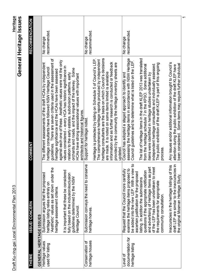
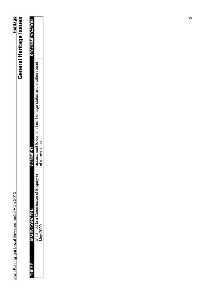
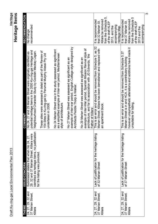
Part 4 Submissions on Heritage Issues
This part summarises general issues raised regarding the heritage conservation areas (HCA) and heritage items (HI) and considers specific items and areas with recommendations and proposed amendments to draft KLEP. The key themes in this part are as follows:
- General Heritage Issues
- Heritage Items
- Heritage Conservation Areas
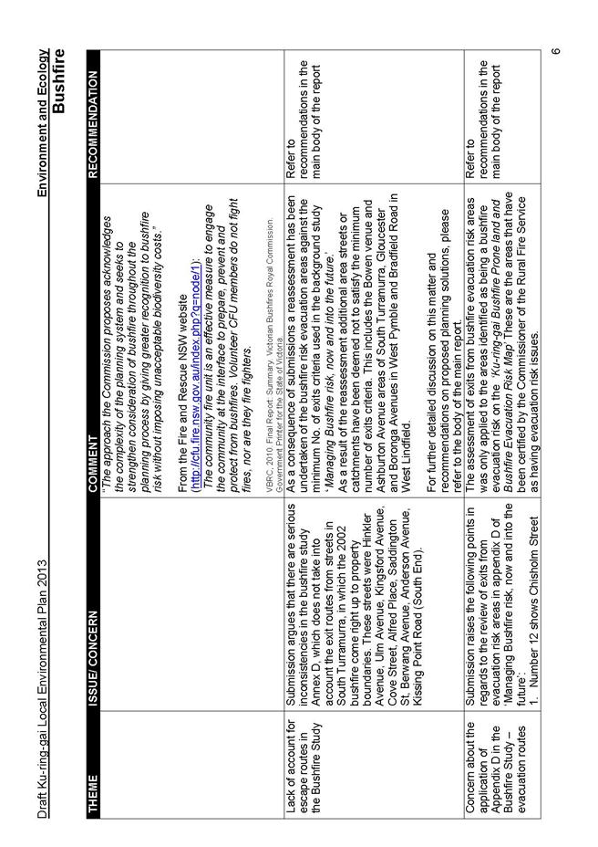
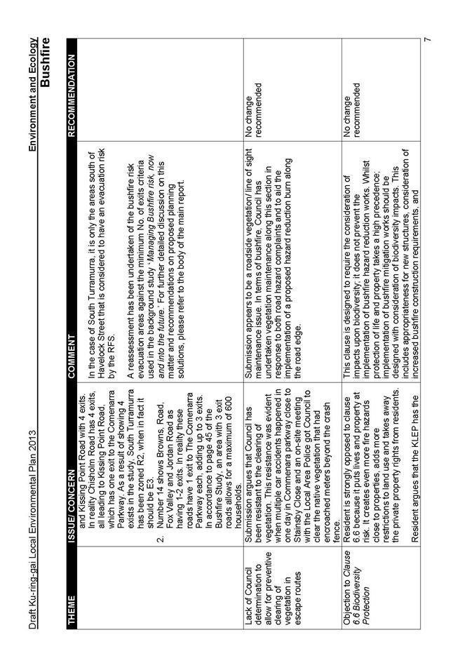
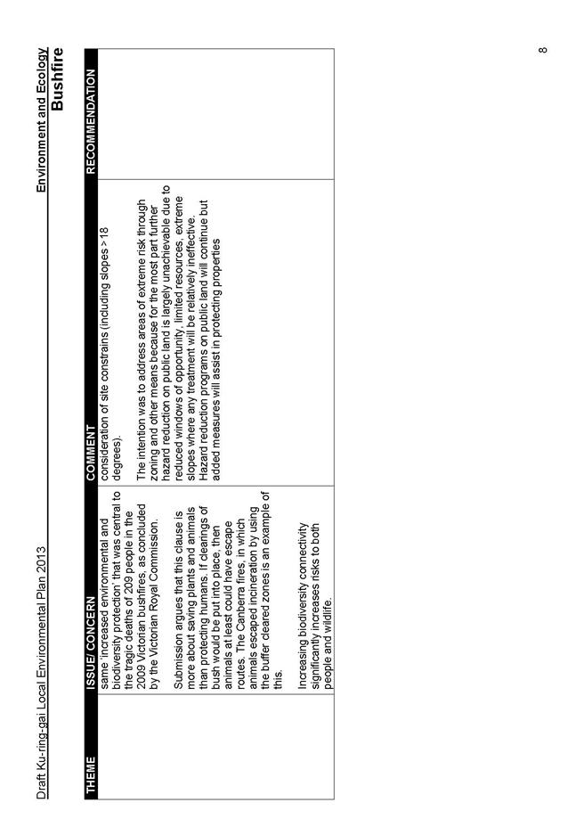
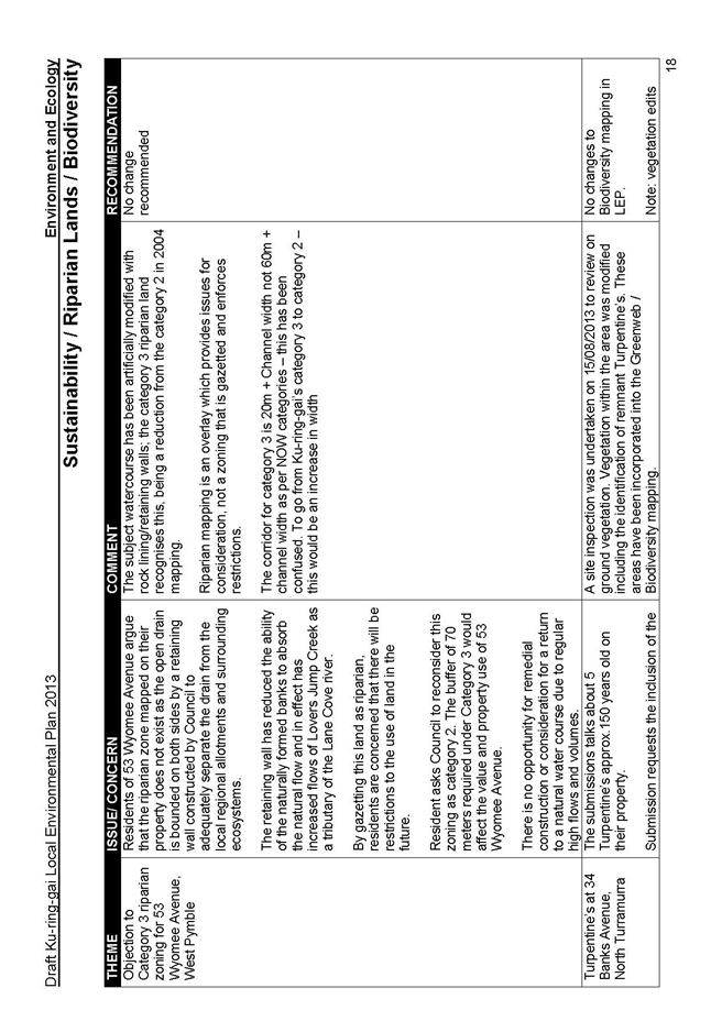
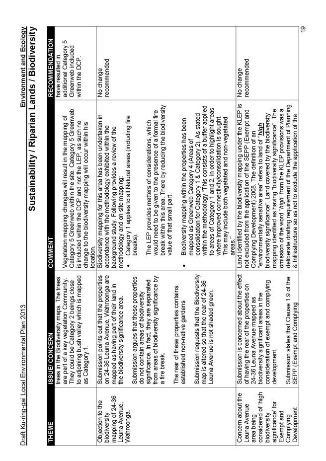
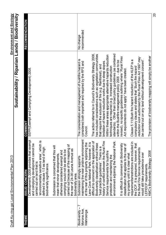
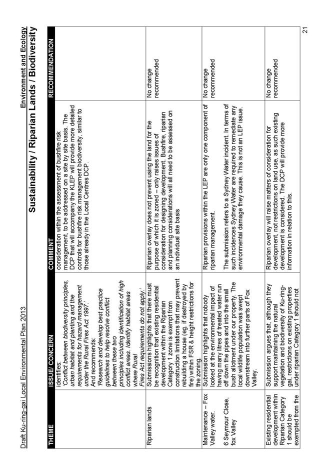
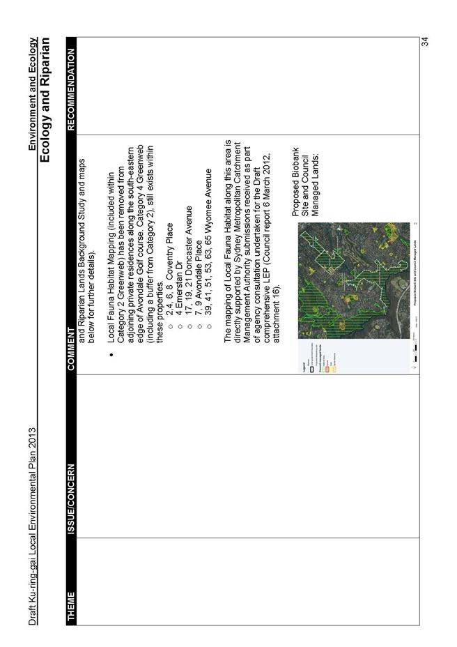
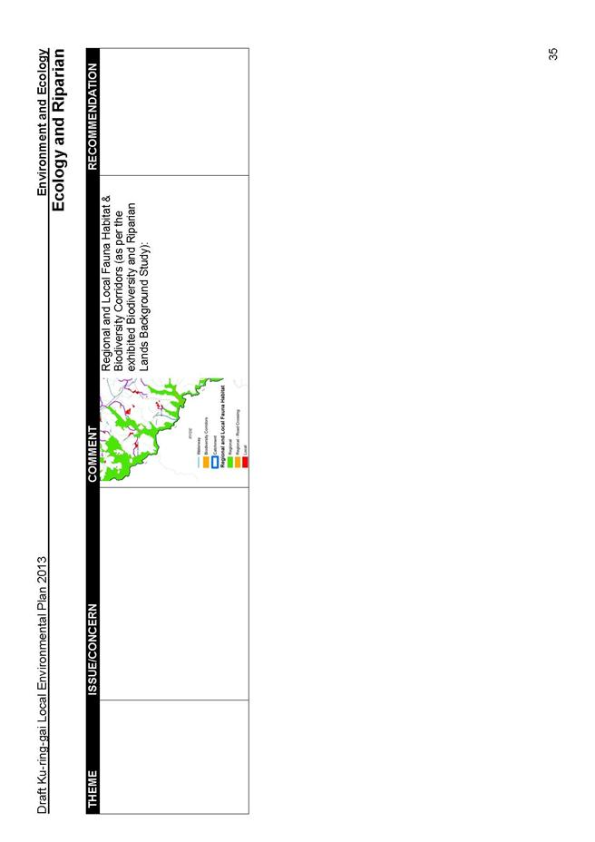
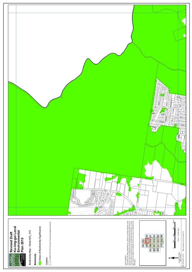
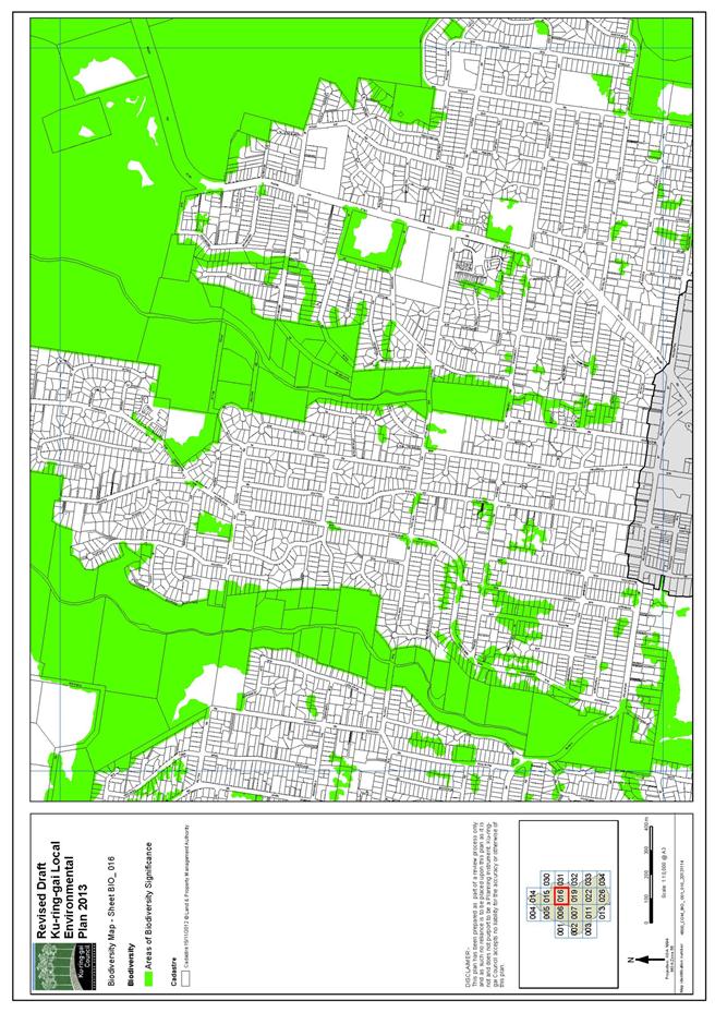
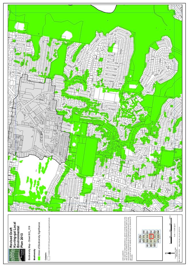
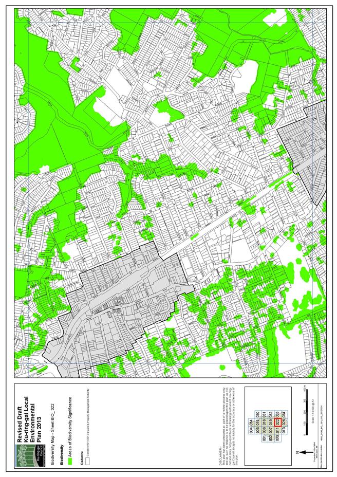
Part 5 Submissions on Environmental and Ecological Issues
This part reviews all environmental issues raised and considers individual sites with recommendations and proposed amendments to draft KLEP. The key themes in this part are as follows:
- Bushfire
- Biodiversity
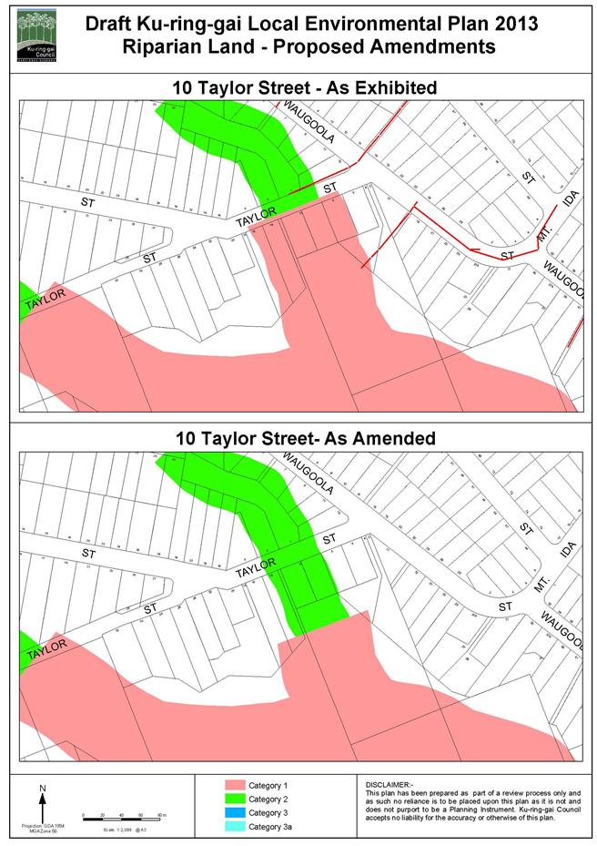
- Riparian Lands
Part 6 Submissions on Environmental Zoning Issues
This part considers submissions made regarding the environmental zones with recommendations and proposed amendments to draft KLEP. The key themes in this part are as follows:
- Environmental Zones
- E3 Zone
- E4 Zone
Part 7 Submissions on Policy Issues and the Written Instrument (draft KLEP)
This part provides a summary analysis of submissions on policy matters and the written instrument draft KLEP. The key themes in this part are as follows:
- General & Process Related Issues
- Clauses to the Draft LEP
- Mapping
- Areas inside the Local Centre Boundaries
- Miscellaneous issues
Part 8 Other Statutory Considerations
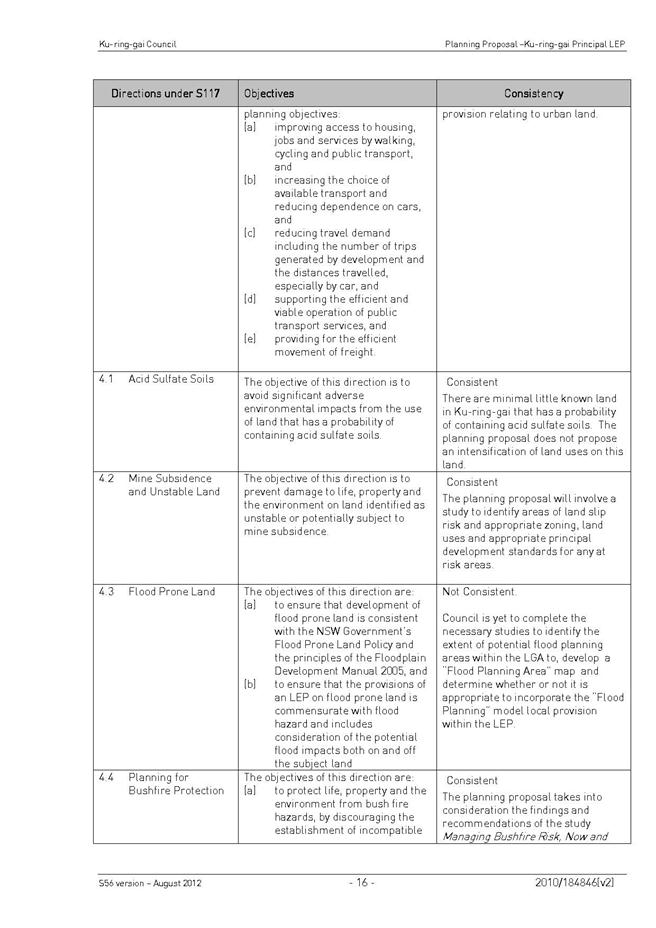
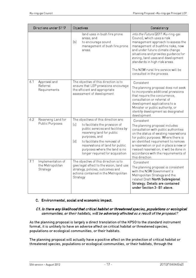
This part responds to the submissions in response to the variations to the Department of Planning & Infrastructure (DP&I) cover letter, Gateway Determination, Ministerial section 117, directions, and consultation with relevant State Agencies and authorities.
Part 9 Internal Consultation
This part summarises and gives recommendations in response to internal Council consultation- e.g. signage.
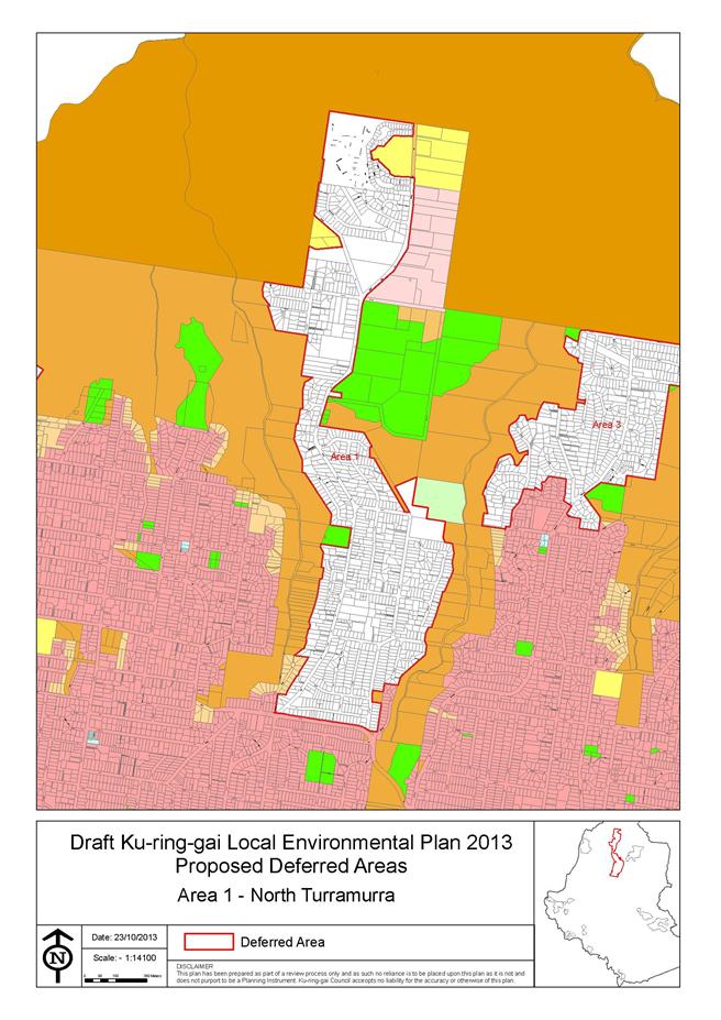
Part 10 Reclassifications being considered as matters of this KLEP
This part puts forward the process undertaken for reclassification of two sites within this KLEP and gives recommendations in light of that process.
Part 11 Aligned Projects and Supporting Infrastructure
This part provides a brief overview of other projects that are aligned, but not included within, the draft KLEP including the proposed Principal Development Control Plan, Development Contributions Planning and alignment with Council’s Local Centres LEP.
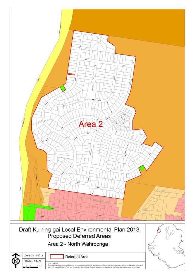
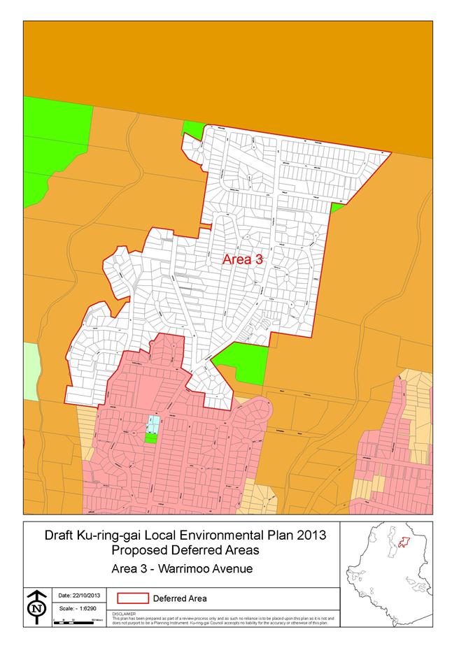
This report concludes with an overall summary and recommendations. It is recommended that Council adopts the draft Ku-ring-gai Principal Local Environmental Plan 2013, subject to amendment and recommend to the Minister for Planning & Infrastructure that the plan be made. It is also recommended that certain lands be deferred from the plan and certain elements of the draft plan be subject to a new planning proposal and exhibition.
Background
PART 1 - INTRODUCTION
Overview of background to date and the key planning processes followed to date.
On 20 November 2012 Council considered a revised draft PLEP that incorporated several amendments including feedback from the state agency consultation phase. Refer to the Planning Proposal at Attachment A1.
Council resolved:
A. That Council endorses the draft Planning Proposal Principal LEP at Attachments A2 to A12 and incorporating the summary of recommendations outlined in this report for public exhibition, subject to the following amendments:
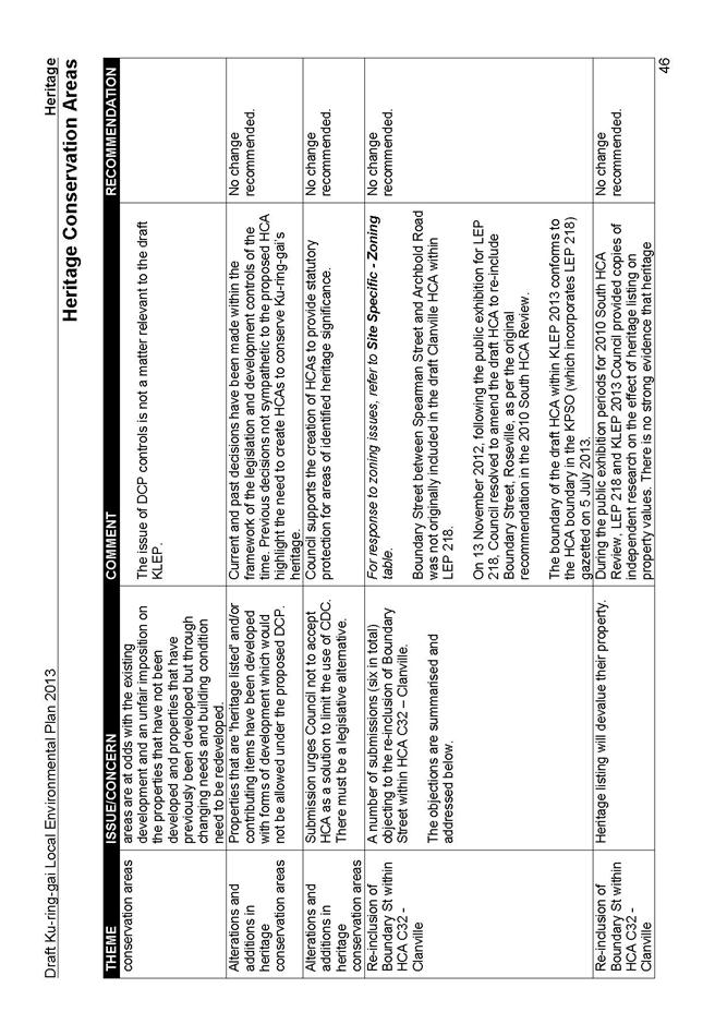
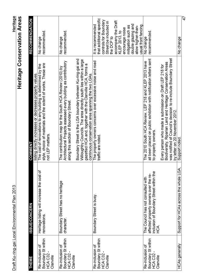
i) Heritage conservation area C32 be extended to incorporate the properties in Boundary Street, Roseville consistent with Council's adopted draft LEP 218.
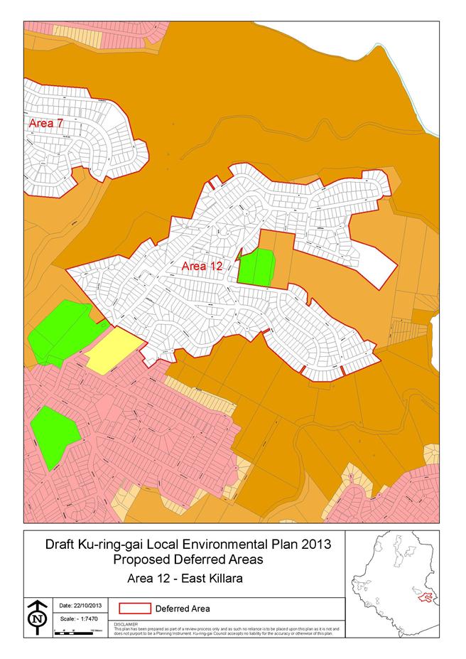
Ii) The property at 78A Springdale Road, East Killara (Lot 103 DP 859921) be listed in schedule 5 and identified on the Heritage map as a heritage item of local significance.
B. That the revised Planning Proposal be adopted and submitted to the Department of Planning and Infrastructure for a revised Gateway Determination in accordance with section 56 of the Environmental Planning and Assessment Act, 1979.
C. That delegation be granted to the General Manager to make all necessary corrections and amendments to the draft Principal LEP and Planning Proposal for drafting inconsistencies, or minor amendments as necessary to ensure consistency with NSW Standard Instrument LEP Order and Department of Planning & Infrastructure policy.
D. That upon receipt of a revised Gateway Determination, the exhibition and consultation process is carried out in accordance with the requirements of the Gateway Determination requirements and the Community Engagement strategy at Attachment A23.
E. That during the public exhibition Council undertakes an assessment, with subsequent report back to Council, in relation to land which contains a listed item of State heritage significance, or that is located within the vicinity of a State heritage item, to ensure that the land zoning, maximum building height, minimum lot sizes and floor space ratio is appropriate for retaining and enhancing the embodied heritage significance of the State heritage item. Specifically, ensure an appropriate buffer is retained to protect views to and from heritage items; ensure that there is an appropriate transition in the scale and height of development to ensure new development does not visually dominate State significant items and ensure that the land zoning will both allow and restrict certain land uses that will compliment the character of the heritage item.
F. That a report be brought back to Council for consideration of submissions at the conclusion of the exhibition period.
On 26 February 2103 Council received the revised Gateway Determination from the Department of Planning & Infrastructure to permit the exhibition of the draft plan. See Gateway Determination at Attachment A2
The draft Ku-ring-gai Principal Local Environmental Plan 2013 was exhibited from 25 March to 6 May 2013.
A public hearing was held on 12 June 2013 for the 2 sites to be reclassified from community land to operational land status.
The exhibition period has ended and all submissions, (including late submissions, where possible) have been assessed, summarised and presented in this report alongside recommendations for amendments to the draft KLEP.
Submissions on the exhibition have been assessed and review by staff in consultation with other departments of Council and external advice sought (e.g. State agencies and consultants) where relevant.
Copies of all submissions received in respect to the exhibition and subsequently, have been provided to Councillors. Where possible, staff have assessed submissions made post exhibition. Others received in recent weeks have been circulated under memo.
The draft Ku-ring-gai Principal Local Environmental Plan 2013 seeks to implement an LEP following the Standard Instrument format to apply to the Ku-ring-gai local government area (except for land subject to the Ku-ring-gai Local Environmental Plan (Town Centres) 2010).
The draft Ku-ring-gai Principal Local Environmental Plan 2013 is largely a translation of the general effect of the existing Ku-ring-gai Planning Scheme Ordinance 1971 (KPSO) applying to the land, except where it is intended to:
· rezone unzoned land to same as adjoining zoning;
· rezone land covered by Interim Development Orders to standard instrument equivalent;
· rezone certain interface sites to provide a solution to those low density housing areas adjoining land zoned for five storey apartment buildings or other higher zonings within the town centres;
· rezone certain existing residential and open space sites to an appropriate environmental zone having given consideration to the biodiversity, riparian and other natural resource assessment and mapping processes;
· include heritage conservation areas and add or delete heritage items;
· include ‘natural resource sensitivity’ provisions and mapping layers to address biodiversity and riparian lands issues, consistent with Town Centres LEP;
rezone certain sites currently zoned Special uses in accordance with Department of Planning Practice Note PN 08–002 – Zoning Infrastructure;
· correct existing zoning anomalies, e.g. where existing open space is currently zoned residential;
· remove redundant road and open space reservations following consultation with relevant public authority; and
· include new road and open space reservations where necessary following consultation with the relevant public authorities.
Investigation was also undertaken to consider the potential application of additional local provisions for flood planning areas and landslide risk.
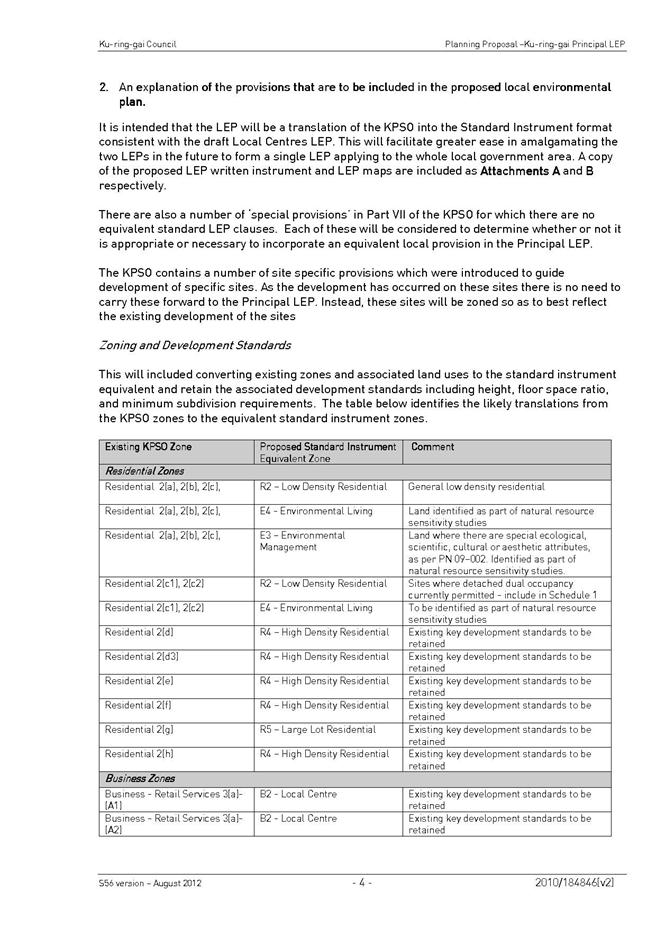
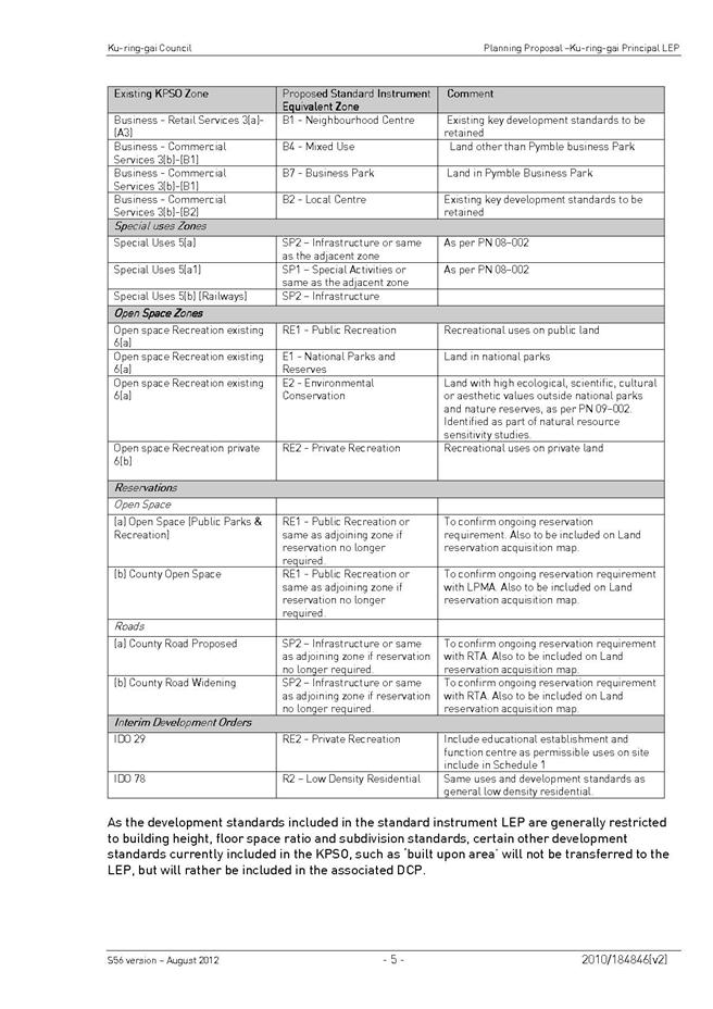
General Description of Land Use Zones contained in the Draft KLEP 2013
The 'Land Zoning Map' identifies the land to which each zone applies. The zones used under the draft KLEP 2013 are as follows:
R1 – General Residential: applies to land where a broad variety of residential density and housing types is sought. It is only applied to the Wahroonga Estate and the former UTS campus site, consistent with approvals by the State Government for the redevelopment of these sites.
R2 – Low Density Residential: - applies to land where primarily low density housing is to be established or maintained. The zone objectives also encourage the provision of facilities or services that meet the day-to-day needs of residents.
R3 – Medium Density Residential: - to provide for medium density housing generally in the form of townhouse development of 2 - 3 storeys. The zone provides for increased housing choice and is generally used as a transition area between low and high density areas.
R4 – High Density Residential: - to provide for unit development. These areas are typically located along the Pacific Highway/railway corridor.
R5 – Large Lot Residential: - to cater for development within a rural setting adjacent to metropolitan areas. Lot sizes can be varied within the zone depending on the servicing availability and other factors such as topography, native vegetation characteristics and surrounding agricultural land uses. This zone is only used in North Turramurra and is strongly supported by the Draft Background Study, Managing Bushfire Risk, Now and Into the Future.
B1 – Neighbourhood Centre: - to enable the development of small-scale convenience retail premises including neighbourhood shops, business premises, medical centres and community uses within easy walking distance for residents. The zone also allows for shop top housing and other appropriate mixed use development.
B2 – Local Centre: - to apply to the core retail commercial areas. This zone, at the core of each centre, will permit developments with a mix of retail, commercial, residential and associated community facilities.
B4 – Mixed Use: for land where a wide variety of land uses are encouraged, generally including commercial, community and residential uses. In the draft KLEP 2013 it is applied only on the former UTS campus, consistent with state government approval for the redevelopment of this site.
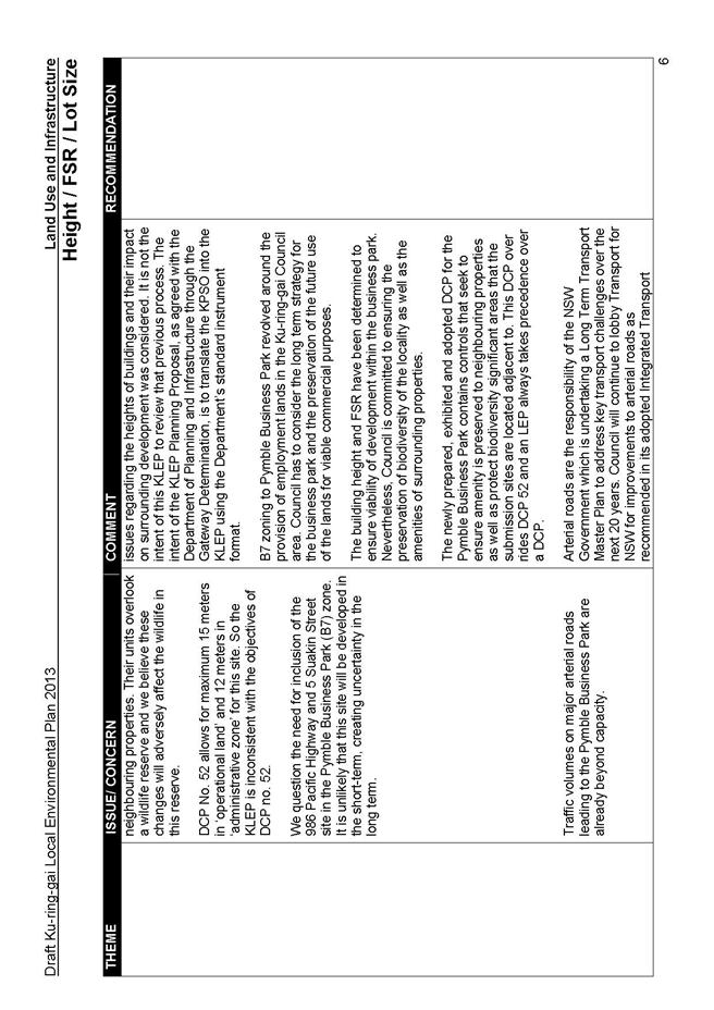
B7 – Business Park: - for land that primarily accommodates office and light industrial uses, including high technology industries. The zone also permits a range of facilities and services to support the day-to-day needs of workers, such as child care centres and neighbourhood shops. This only applies to the Pymble Business Park. The draft KLEP 2013 brings the zoning and provisions of the recently gazetted LEP 219 - Pymble Business Park from the KPSO into the new LEP.
SP1 – Special Activities: - for special land uses or sites with special characteristics that cannot be accommodated in other zones.
SP2 – Infrastructure: - accommodates a wide range of human and physical infrastructure uses. The principal application of this zone is for schools, main roads and the railways as well as for proposed future local roads.
RE1 – Public Recreation: - to provide for a wide range of public recreation areas and activities, including local open space. A range of land uses compatible with recreation uses of the land will be permitted.
RE2 – Private Recreation: - to cover a wide range of recreation areas and facilities on land that is privately owned or managed. The use of facilities developed on this land may be open to the general public or restricted e.g. to registered members only. Private recreation may include, golf clubs, bowling clubs, tennis complexes and other sporting or recreational facilities.
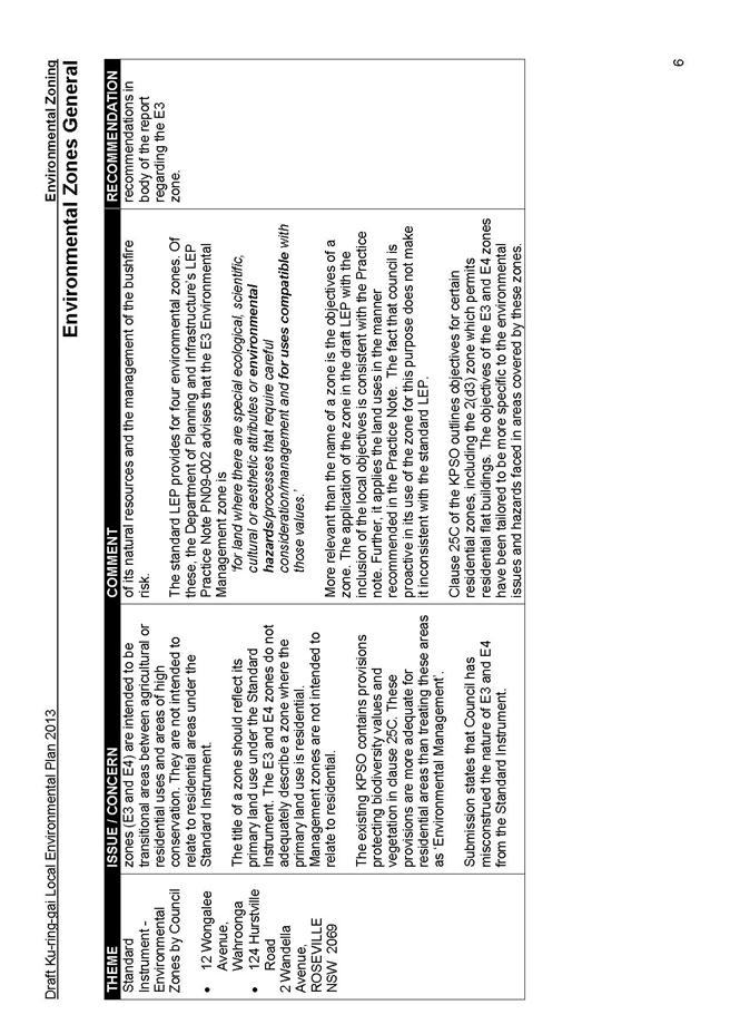
E1 – National Parks and Reserves: - protects areas of environmental significance. This zone is comprised of existing national parks and nature reserves. Permissible uses under this zone are determined by the National Parks and Wildlife Act 1974.
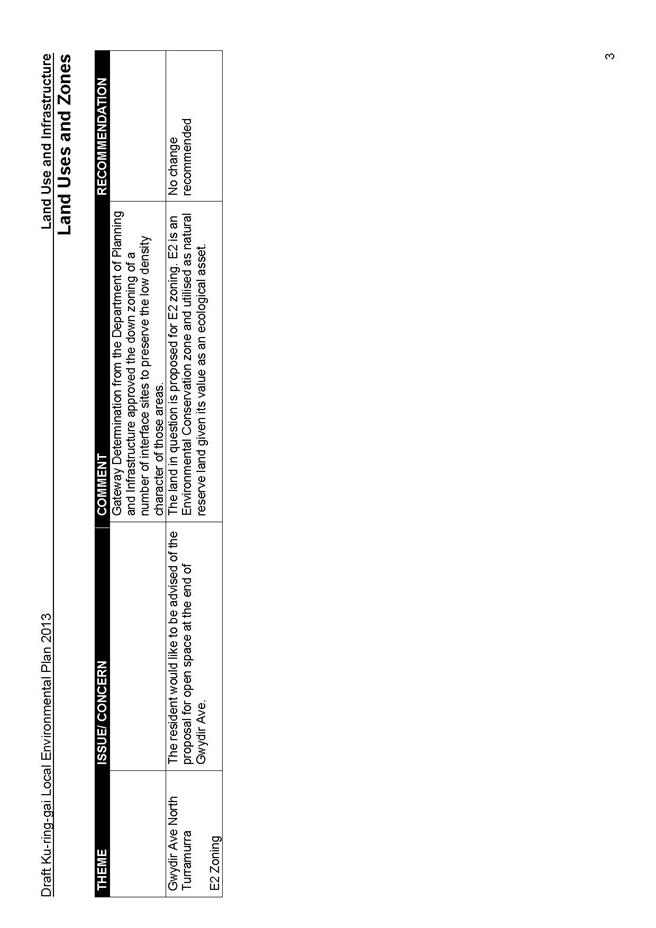
E2 – Environmental Conservation: - to protect land that has high conservation value. A number of land uses considered to be inappropriate for this zone, including dwelling houses will be prohibited. The zone is mostly applied to public lands.
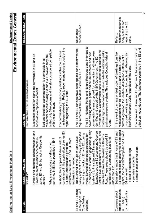
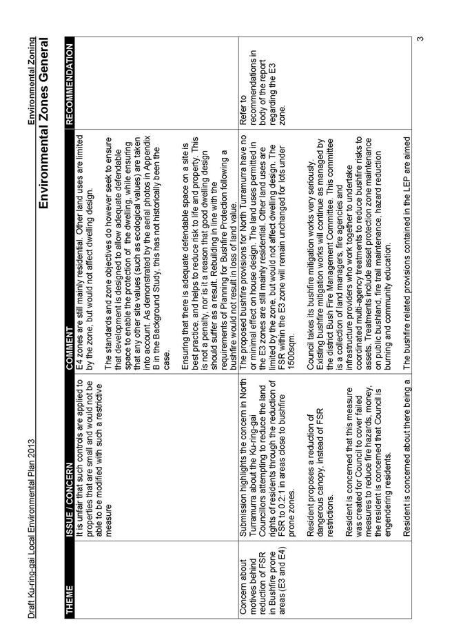
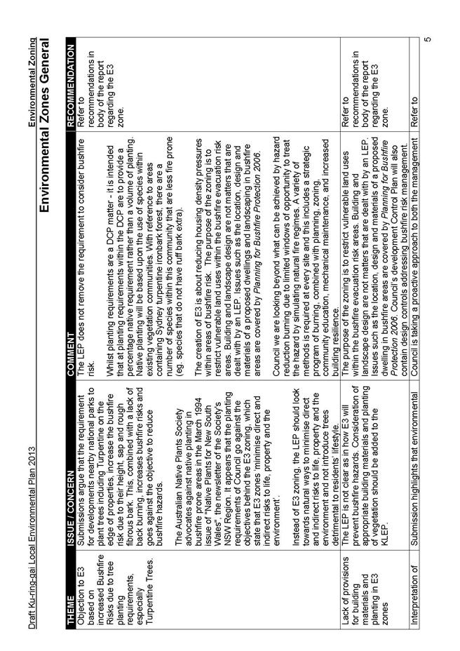
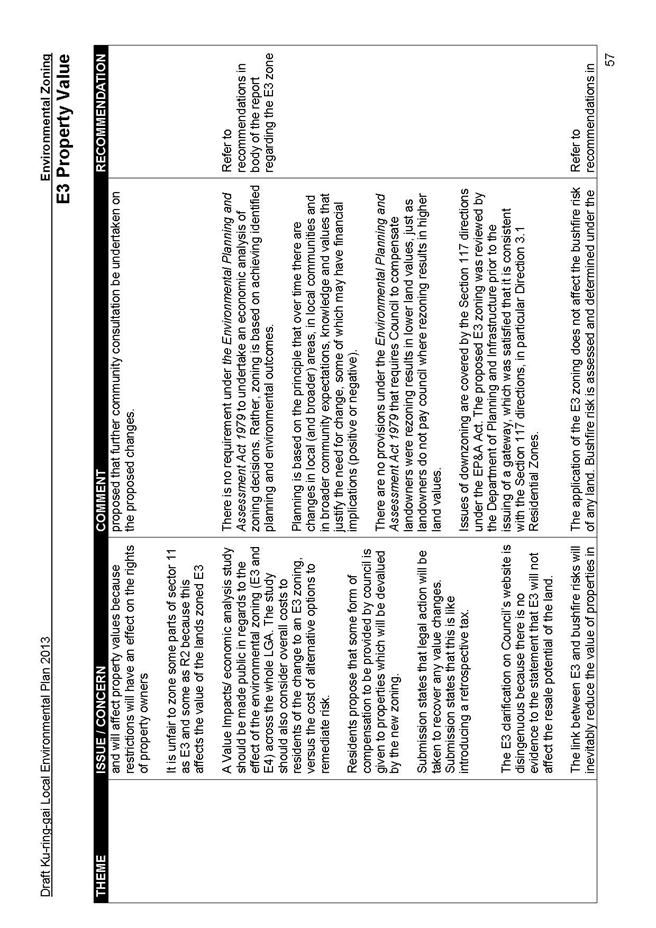
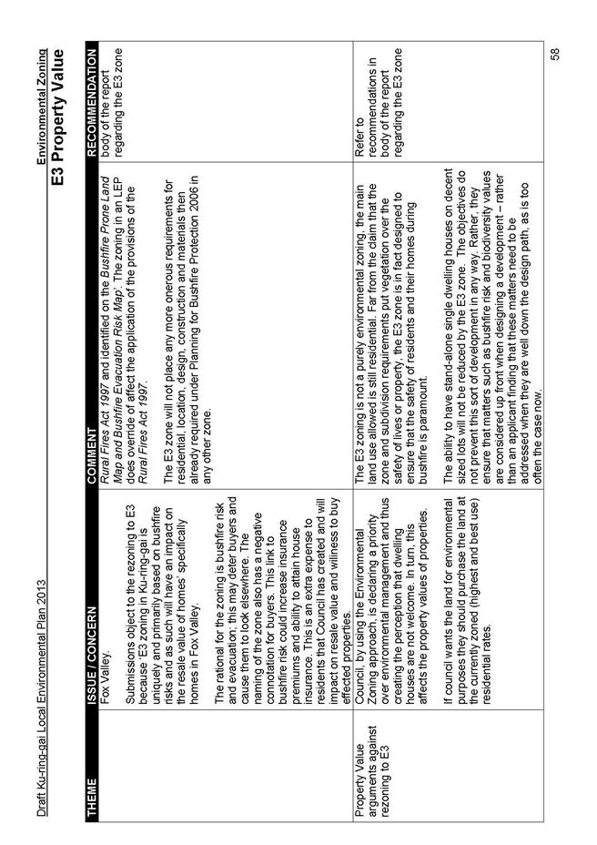
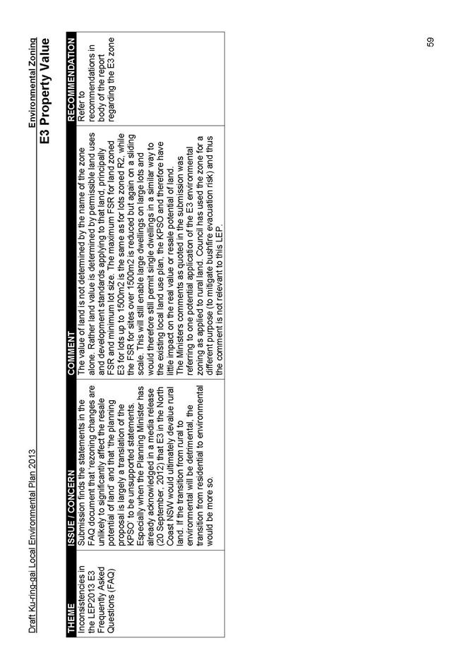
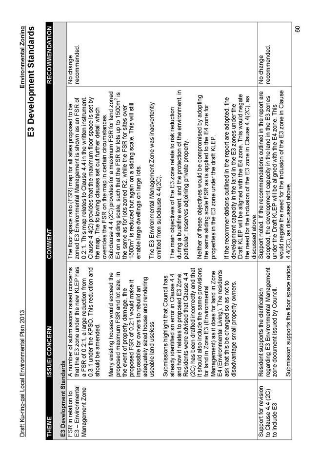
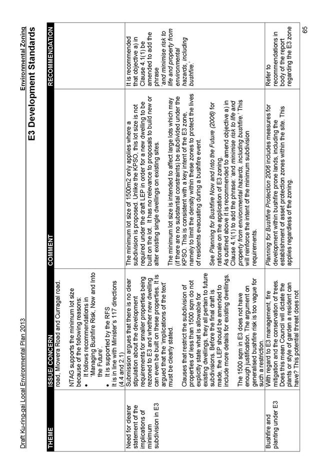
E3 – Environmental Management: - protects land that has special ecological, scientific, cultural or aesthetic attributes, or land highly constrained by hazards such as bushfire. A limited range of development including ‘dwelling houses’ are permitted in the zone. The zone also supports a transition between areas of high conservation value, particularly National Parks, and other land uses.
E4 – Environmental Living: - for land with special environmental or scenic values where residential development can be accommodated. The zone has been applied where there are environmental factors, such as the presence of threatened ecological communities, riparian zones, scenic values or bushfire hazard that make the protection of the values of the land impractical under a standard residential zone. Some limited additional uses are proposed in the E4 zone, namely secondary dwellings and home businesses.
W1 - Natural Waterways: - for natural waterways that are to be protected for their ecological and scenic values. A limited number of low impact uses that do not have an adverse effect on the natural value of the waterway will be permitted in this zone, such as environmental facilities.
The draft Ku-ring-gai Principal Local Environmental Plan 2013 has prepared in accordance with the Standard Instrument (Local Environmental Plan) Order 2006 (Standard Instrument LEP) under Section 33A of the Environmental Planning and Assessment Act, 1979 (EP& A Act). The Standard Instrument LEP mandates provisions that are to be included in all future LEPs across NSW and substantially governs the content and operation of the Principal LEP.
PART 2 - SUBMISSIONS ON LAND USE AND INFRASTRUCTURE
The following parts present the key issues raised in the submissions and a brief discussion around the reasons for the recommendations made in this Report. For a detailed summary of all submissions, please refer to Attachment A3 at the end of this document.
Land Uses
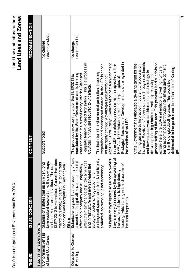
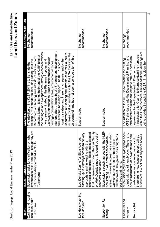
Whilst some submissions supported the residential land uses and rezoning proposed under the draft KLEP, others raised the following concerns:
- failure of land use zoning to provide housing choice through enabling townhouses, dual occupancy and villa style development and opportunities for aging in place through housing that can be adapted and subdivided; and
- the high density R4 zoning is detrimental to the Ku-ring-gai character and to local infrastructure, open space, wildlife and ecology.
Discussion:
The submissions indicate a misunderstanding of the principles of the draft KLEP and assume there has been an increase in R4 zoning in the LGA. Explanation has been provided in the submission summary tables reiterating that the R4 zoning has been a direct translation of the existing 2(d3) sites under the KPSO, and changes to zoning have only occurred for strategic reasons and as approved through the Gateway Determination. By the same token, in response to submissions questioning why more provision for town houses, dual occupancy, and villa type development has not been made in the draft KLEP, it is pointed out that there has been no direction from State Government for dwelling number to increase through the draft KLEP process, hence this instrument is primarily a translation of the KPSO.
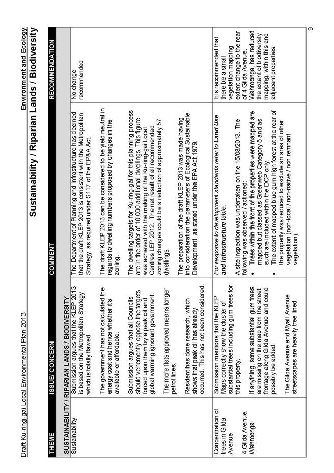
With regards to concerns regarding the conflict between building development and environmental protection, Council is obliged, under the EPA Act 1979, to ensure ecologically sustainable development and as such has conducted background studies, such as the ‘Ku-ring-gai Biodiversity and Riparian Lands Study’ which have informed the draft KLEP.
Recommendation:
No changes recommended
Height
Submissions requested the following:
- height decrease with concerns raised over the methodology for determining maximum building heights and the impacts of the perceived increase to heights; and
- increase in height allowances as the current allocations are seen as restrictive. These submissions were from property owners wishing to increase the potential of their land.
Discussion:
Height limits are set by the Department’s standard template and are measured in a consistent manner from existing ground level, as explained in the summary table. Since the development standards of the draft KLEP are a translation of the existing KPSO standards, decrease in heights on the specific sites nominated in the submissions are not justified. Similarly, the applications for height increase are not supported as the draft KLEP makes a direct translation of the KPSO standards and it does not have the scope to increase development potential except where there are justifiable planning grounds. Such consideration has been given to1 Bundarra Ave South, 1685 & 1687 Pacific Hwy.
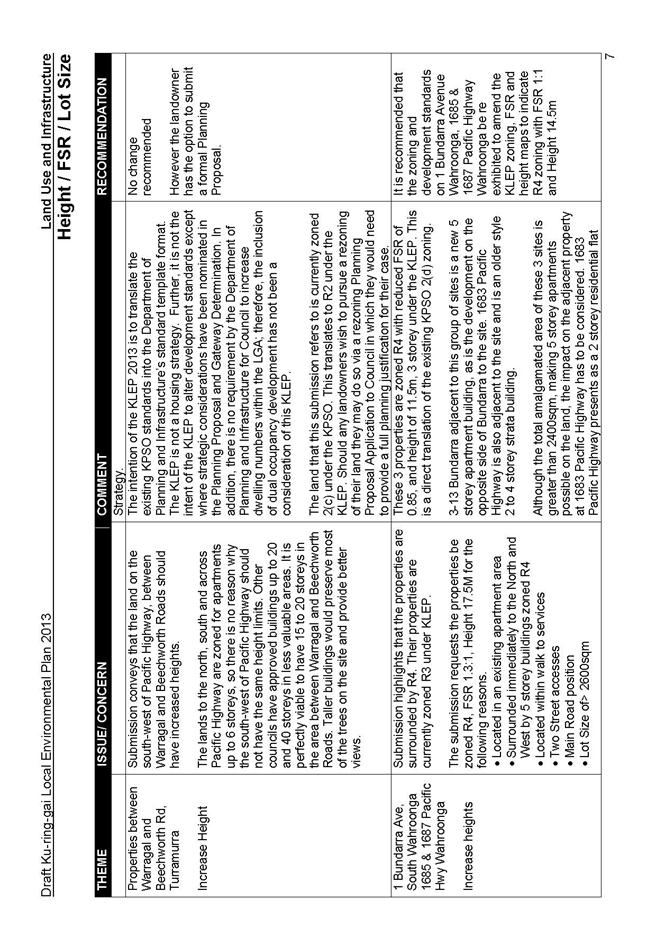
1 Bundarra Ave South, 1685 & 1687 Pacific Hwy, Wahroonga:
The submission argued for a height of 17.5m, 5 storey, and 1.3:1 FSR. The 3 properties are currently proposed for R4 zoning with reduced height of 11.5m, 3 storey, and FSR of 0.85:1 under the draft KLEP. This is a direct translation of the existing KPSO 2(d) zoning on the properties. This group of sites has 5 storey apartment buildings opposite and also adjacent to them at 3-13 Bundarra. Their other neighbour at1683 Pacific Highway is an older style 2 to 4 storey strata building.
Although the total amalgamated area of these 3 sites is greater than 2400sqm, making 5 storey apartments theoretically possible on the land, the impact on the adjacent property at 1683 Pacific Highway has to be considered. 1683 Pacific Highway presents as a 2 storey residential flat building to Pacific Highway. The land slopes away from the Highway and the building stands as a 4 storey building with garages at ground level at the rear of the site. The building has a 5m approximate setback to the side boundary shared with these sites, with bedroom and utility area windows facing the common boundary. The impact of a 5 storey development on this 2 to 4 storey building would result in a significant reduction of amenity to 1683 Pacific Highway. Since the building presents as a 2 storey building along the greater part of the common boundary, and 3 storey for a shorter extent of the common boundary, there would be both overlooking and overshadowing issues.
It is acknowledged that these 3 sites are on a very busy road and at a corner with adjacent 5-storey buildings, and a similar 5 storey development on the site would create a continuous scale and density; however, the impact on the adjacent 2 to 4 storey building must be considered. In assessing all the issues, there are planning reasons to consider this site for some increase to its development potential, namely the corner location which requires two street frontages, and the necessity for any development on these sites to step down to the adjacent 2 storey strata building Therefore, an R4 zoning with reduced heights of 14.5m, 4 storey, and a reduced FSR of 1.0:1 is considered feasible as it would allow both an increase in the amalgamated potential of the 3 sites as well as have the means to preserve the privacy and amenity of the adjacent building residents. The reduced FSR would enable a generous landscaped setback (similar to that of the adjacent 5 storey 3-13 Bundarra Street which also has a boundary with the 2 storey building at 1683 Pacific Highway).
Recommendation:
It is recommended that the zoning and development standards on 1 Bundarra Avenue Wahroonga, 1685 & 1687 Pacific Highway Wahroonga be re exhibited to amend the KLEP zoning, FSR and height maps to indicate R4 zoning with FSR 1:1 and Height 14.5m.
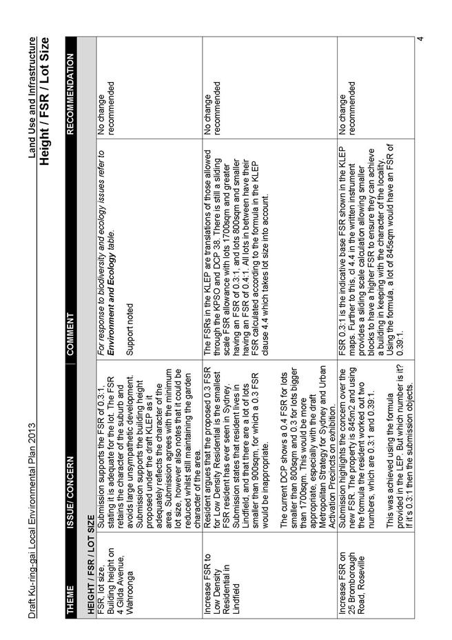
Floor Space Ratio
Submissions primarily raised concerns regarding the following:
- draft KLEP will result in reduction in FSR to residents’ properties; and
- there is a lack of housing choice being delivered through R4 densities, consequently R4 FSR should be reduced to enable more R3 and town house development.
Discussion:
Objections around FSR stem from a misunderstanding of the relationship between the FSR shown on the KLEP maps and clause 4.4 in the Written Instrument. Most submissions appeared unaware of the Written Instrument clause and others were unclear about which took precedent. The Summary Tables explain how the FSR map and the KLEP clause work together, and that FSR is calculated to give a sliding scale provision according to land size in much the same way as currently exists under the KPSO and DCP 38.
The request for more R3 townhouse type development to provide diversity of housing is understood, however the draft KLEP is not a housing strategy and whilst R3 may provide housing choice, the KLEP has to deliver on the agreed principles of translating existing zones into the Department’s standard template format. R3 has only been allocated to those sites assessed as interface sites to provide a good planning outcome to properties compromised by adjacent high density development.
Recommendation:
No changes recommended
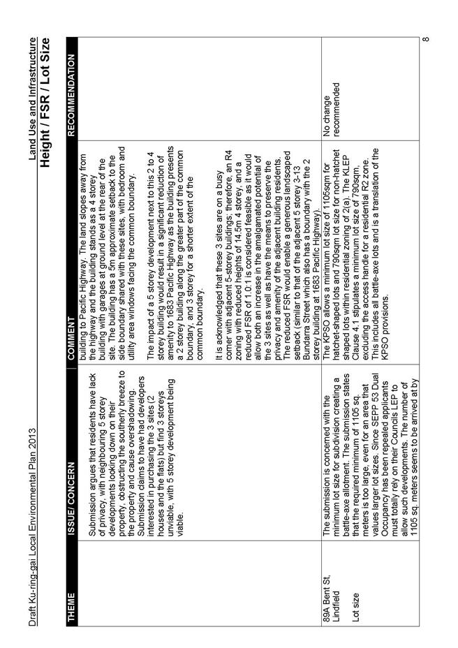
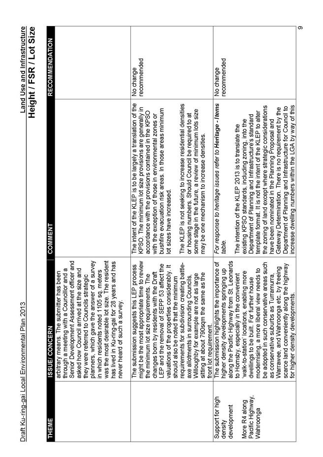
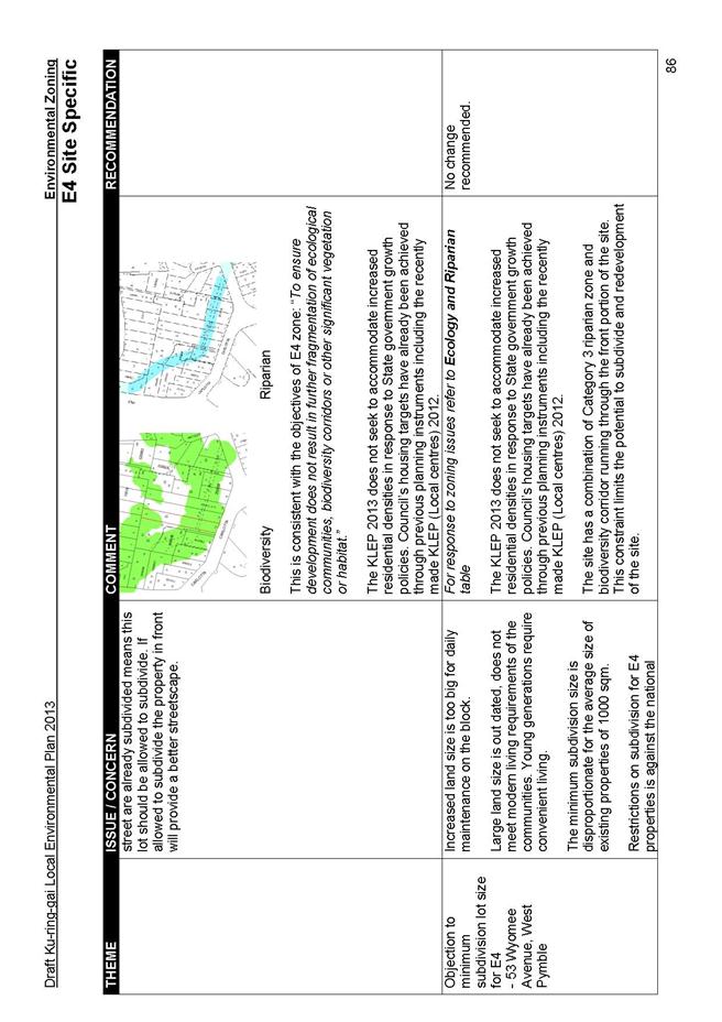
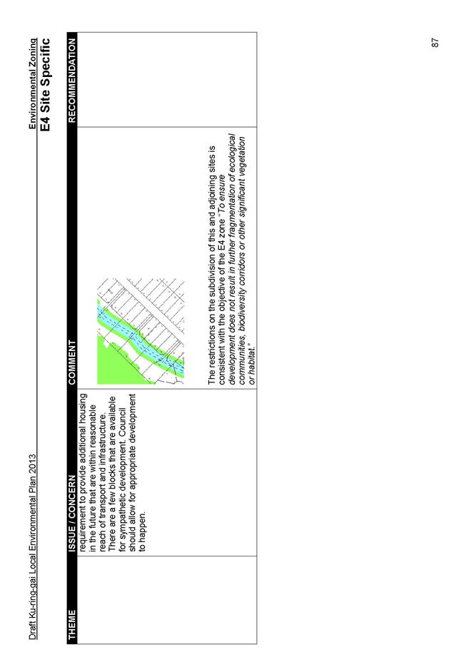
Lot size
Concerns were raised regarding the following:
- most land parcels are already smaller than the 1500sqm minimum lot size proposed for the E3 and E4 zones and the 1500sqm lot size prevents subdivision that they consider possible under the KPSO; and
- battleaxe block size requirements are being increased in the KLEP.
Discussion:
The reasoning for the large lot size in the E3 and E4 zones revolves around the preservation of the ecological value of those lands through limited subdivision patterns. The properties nominated in the submissions on the whole do not have sufficient lot size to allow subdivision under the KPSO, therefore their status under the draft KLEP remains the same.
The size requirement of a battleaxe block is generally the same within the R2 zone as in the KPSO, with a minimum 790sqm requirement excluding the access handle.
Recommendation:
No changes recommended.
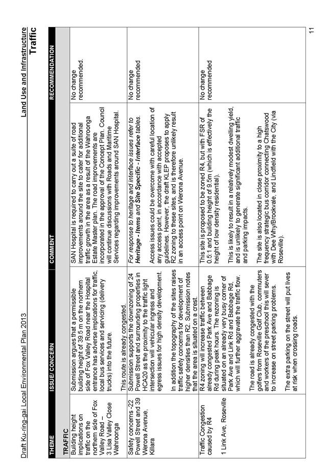
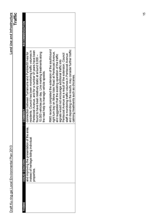
Traffic
The key issues raised are as follows:
- numerous submissions were received relating to the proposed R4 zone in the vicinity of Link Avenue Roseville, and the potential traffic and parking issues that would result; and
- there were also several submissions relating to the proposed rezoning of the Culworth Avenue car park, and that it should be retained for commuter parking.
Discussion:
The Link Avenue Roseville site is proposed to be zoned R4, but with FSR of 0.5:1 and building height of 9.5m (which is effectively the height of low density residential).This is likely to result in a relatively modest dwelling yield, and is unlikely to generate significant additional traffic and parking impacts. The site is also located in close proximity to a high frequency strategic bus corridor.
Surveys show that at its peak utilisation, the Culworth Avenue car park is typically 1/3 empty. At the commuter peak time (9am) surveys indicate the car park is typically 70% empty. This suggests commuters have a preference for parking on-street first before occupying the car park. In a report to Council on 30 April 2013, it was noted that this site has a constraint/condition that up to 100 underground spaces are to be provided depending on feasibility and demand. Therefore, retention of public car parking is subject to further investigation. Conversely, it has never been said that no parking would be provided.
Recommendation:
No changes recommended
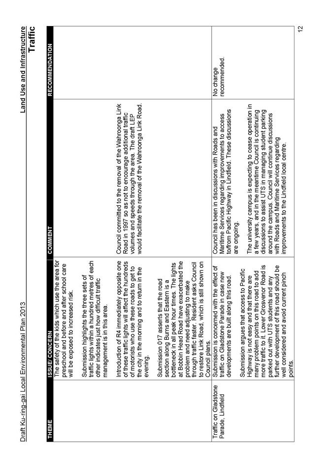
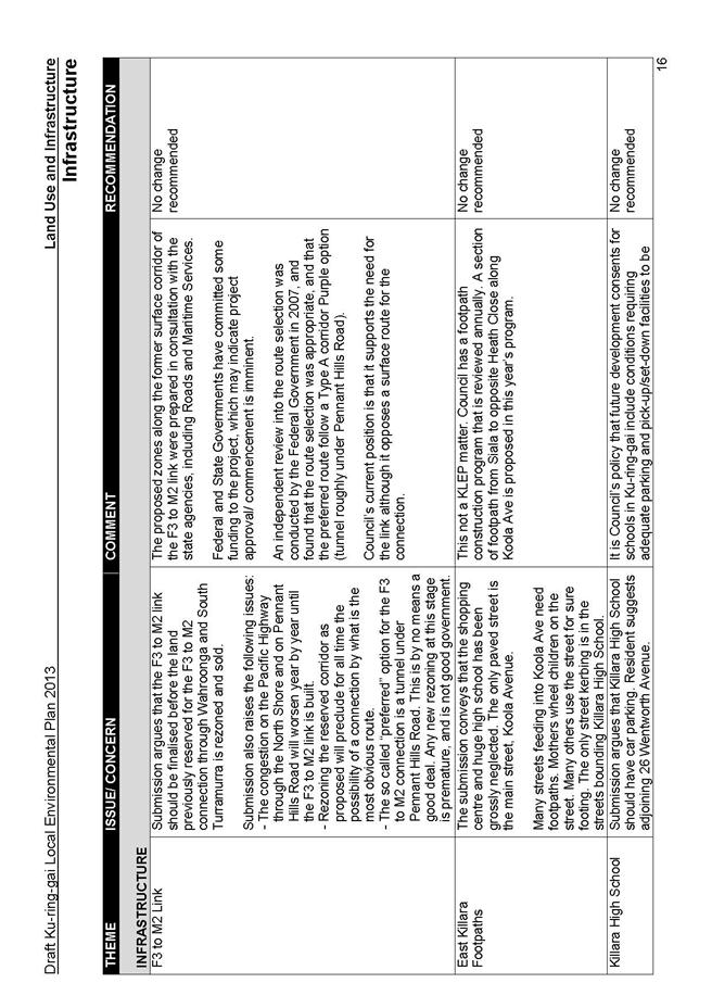
Infrastructure
The main issues raised are as follows:
- a number of submissions related to facilities in the East Killara area (footpaths, Koola Park and Killara High School); and
- one submission suggested that the F3 to M2 link should be finalised before the land previously reserved for the F3 to M2 connection through Wahroonga and South Turramurra is rezoned and sold.
Discussion:
The submissions related to facilities in the East Killara area are not KLEP matters. They are operational issues to be dealt with by Council.
The proposed zones along the former surface corridor of the F3 to M2 link were prepared in consultation with the State agencies, including Roads and Maritime Services. An independent review into the route selection was conducted by the Federal Government in 2007, and found that the route selection was appropriate, and that the preferred route follow a Type A corridor Purple option (tunnel roughly under Pennant Hills Road). Council’s current position is that it supports the need for the link although it opposes a surface route for the connection.
Recommendation:
No changes recommended
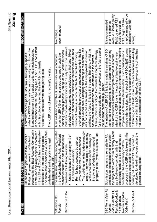
PART 3 - SUBMISSIONS ON SITE SPECIFIC ISSUES
The following parts present the key issues raised in the submissions and a brief discussion around the reasons for the recommendations made in this Report. For a detailed summary of all submissions, please refer to Attachment A4 at the end of this document.
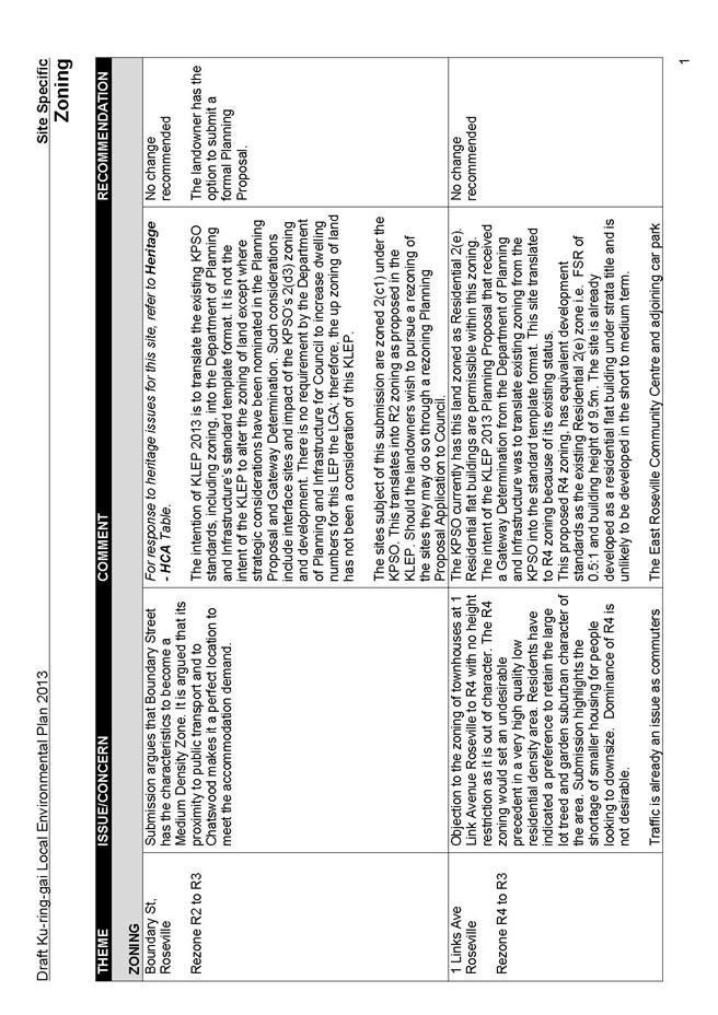
Zoning
The key issues raised regarding the proposed zoning are as follows:
- individual and group submissions request upzoning from R2 to R3 and also from R2 to R4;
- interface sites should be upzoned to R4 to match adjacent development;
- error to zoning in draft KLEP indicating Kirby Park, Gordon as R2 instead of open space;
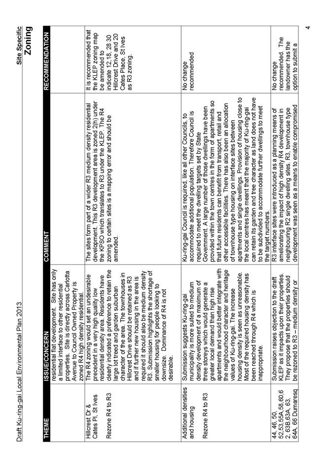
- error to zoning in draft KLEP that is not a translation of the KPSO at Cates Place/Hillcrest Drive, St Ives; and
- zoning of all land within HCAs should be R2, especially sites within Culworth Avenue and Marian Street, despite existing landuse as is the case for 18 Marian Street, Killara (a high density development on a site that has R2 zoning).
Discussion:
The R3 interface zone was introduced as a planning solution to ameliorate the impacts of the KPSO 2(d3) high density sites on adjacent single dwelling sites. The R3 zone was not introduced as a means to increase densities as this was not one of the principles of the Planning Proposal guiding the draft KLEP. R3 townhouse type development was seen as a means to reduce the impact of high density R4 development on neighbouring R2 single dwelling sites, and enable R2 sites to be redeveloped and designed around the compromised amenity as well as create a stepping down of building form between the apartment building and the single dwelling. The number of sites allocated R3 zoning was based on ensuring sites could amalgamate and provide a successful interface development.
There is no requirement through this plan making process to increase dwellings in the LGA by upzoning. Ku-ring-gai Council has delivered its dwelling targets predominantly within the town centres, and there has been no direction from the Department of Planning and Infrastructure to create further increased density sites within the draft KLEP through extensions of the interface areas or nominations of new sites for R3 or R4 development. The intent of the KLEP Planning Proposal that received a Gateway Determination from the DPI, was to translate existing zoning from the KPSO into the Standard Template format. Changes to density have only been included where sites were considered to have interface issues.
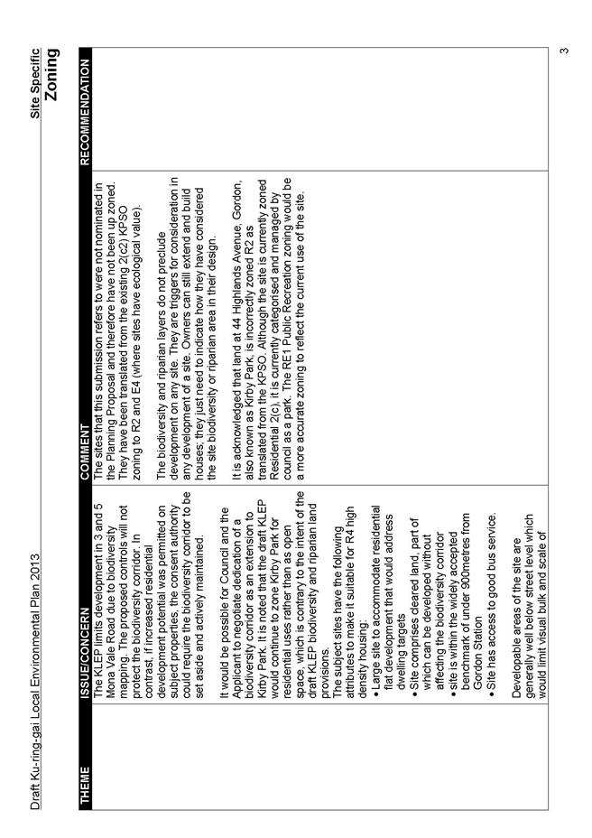
It is acknowledged that land at 44 Highlands Avenue, Gordon, also known as Kirby Park, is incorrectly zoned R2 as translated from the KPSO. RE1 zoning would be a more accurate zoning to reflect the current use of the site. Similarly, the R4 zoning to the sites at Hillcrest Drive and Cates Place, St Ives is a mapping error as these sites form part of a wider R3 development. This R3 Development area is zoned 2(h) under the KPSO which translates to R3 under the KLEP.
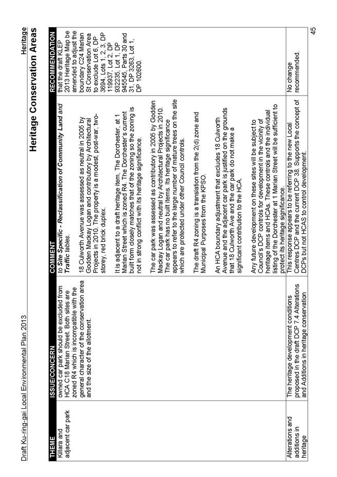
One submission argued for the downzoning of all development within HCA C24 to R2, arguing that medium and high density sites can be downzoned in much the same way as 18 Marian Street, Killara, a high density development with an R2 zoning. The HCA C24 area fronting Culworth Avenue and Marian Street is currently zoned 2(d3), Municipal Purposes and 3(a)-(A3) and therefore translates to R4 and B1, or has previously been approved by Council to be zoned R4 and B1. Further, as indicated in the Heritage section of this report, where the HCA issue is discussed, the 2(d3) and 3(a)-(A3) properties fronting Culworth Avenue are to be removed from the HCA as the zoning both as existing and as proposed is not consistent with HCA principles.
18 Marian St, Killara is zoned 2(b) under the KPSO which translates to the proposed R2 zoning. This site consists of a 3 storey residential flat building and is an anomaly in the KPSO. The proposed R2 zoning to the site is inappropriate as it does not reflect the current status of the property. A more fitting zoning would be R4 with a reduced 11.5m height and 0.85:1 FSR to reflect the current 3 storey development. LEP zoning is required to reflect development or development potential of the land it applies to.
Recommendation:
It is recommended that that the KLEP zoning map be amended to indicate zoning to 44 Highlands Avenue, Gordon (Kirby Park) as RE1; and zoning to 12,18, 28 30 Hillcrest Drive, 20 Cates Place, St Ives as R3; and zoning to 18 Marian St, Killara as R4 with a reduced 11.5m height and 0.85:1 FSR.
Interface
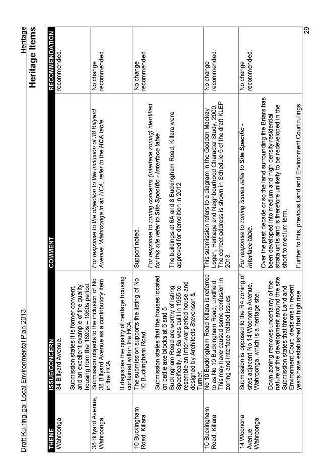
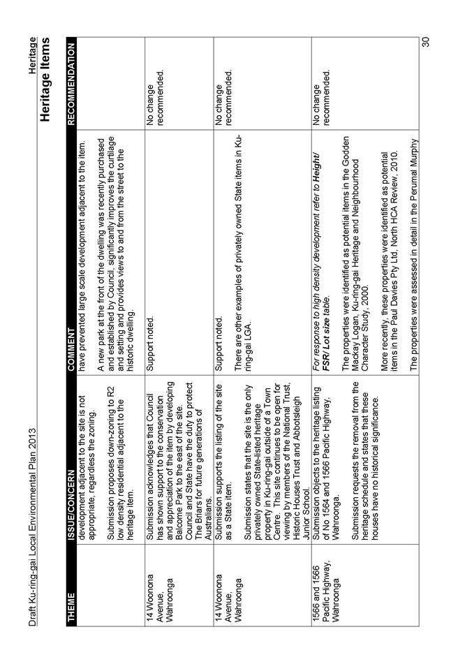
A number of submissions were made regarding the interface sites, the key issues are as follows:
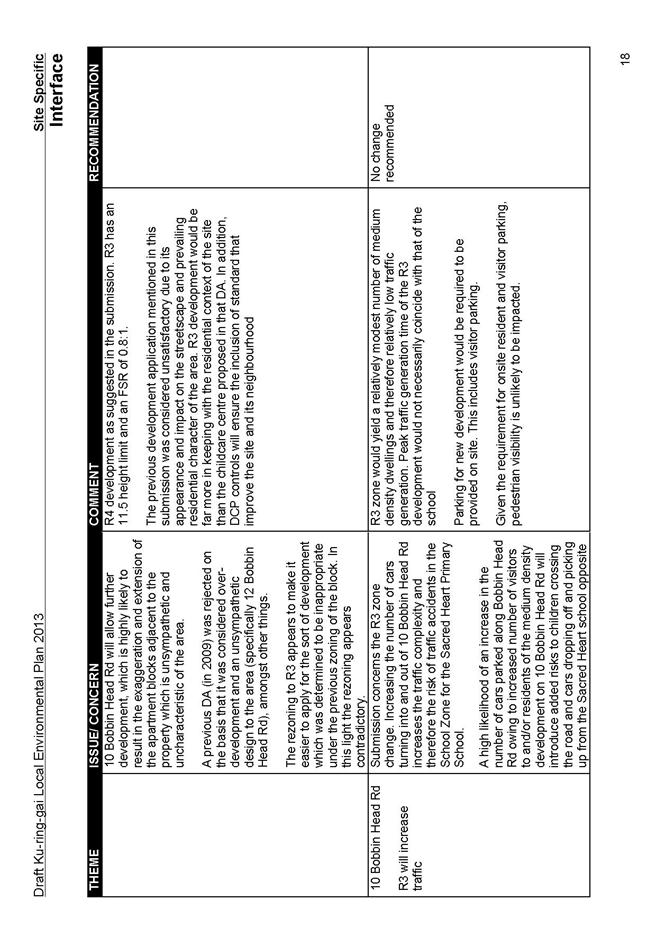
- one submission disputed the R3 interface allocation of its neighbour at 10 Bobbin Head Rd and the impacts of the R3 on their R2 potential heritage item property at 12 Bobbin Head Rd;
- individual and group submissions were made requesting extensions to the interface sites to allow R3 development on their R2 properties; and
- sites where no interface has been provided:
o Werona Avenue:
Whilst a number of submissions supported the KLEP downzoning of 2(d3) sites along Werona Avenue as it would enable the preservation of the low density character of the area and reinforce the HCA qualities, others disputed the downzoning and requested the reinstatement of the R4 status of their properties.
o Caithness Street; and Buckingham Road; and The Briars
Submissions argued for the downzoning of R4 lands to R2 on these sites due to the lack of provision of interface between R4 and R2 properties resulting in impacted R2 sites.
Discussion:
The R3 zone was introduced as a planning solution to ameliorate the impacts of the KPSO 2(d3) high density sites on adjacent single dwelling sites. Site visits confirm that 10 Bobbin Head Road is a highly compromised site and requires a means to deal with the impact of the adjacent high density development. Further to this, it was observed that any R3 development would have minimal impacts on the amenity of the neighbouring R2 property as there is at least a 5m separation from the 12 Bobbin Head Road house itself to the side boundary shared with the R3 site, allowing screening vegetation; and further, should the house be heritage listed there would be more stringent controls on the adjacent development to preserve the setting of the item.
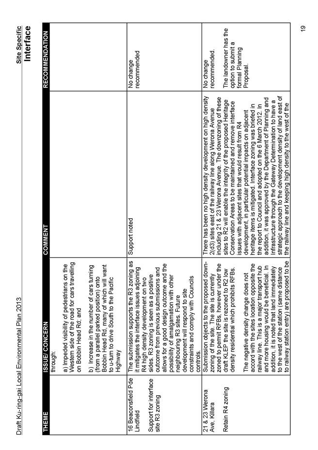
Werona Avenue
There has been no high density development on high density 2(d3) sites east of the railway line along Werona Avenue including 21 & 23 Werona Avenue. The downzoning of these sites to R2 will enable the integrity of the proposed Heritage Conservation Areas to be maintained, and remove interface issues with adjacent sites that would result from R4 development if they were to go ahead, in particular potential impacts on adjacent heritage items is mitigated. Interface zoning was briefed in the report to Council and adopted on the 6 March 2012. In addition, it was approved by the Department of Planning and Infrastructure through the Gateway Determination to have a strategic approach to the development density of land east of the railway line and keeping high density to the west of the railway line. Should the landowners wish to pursue this matter they have the option to submit a formal Planning Proposal to Council with planning justifications for the changes they seek. This will enable a fair and transparent process to occur through consultation and exhibition of the proposed modification that has not been possible through the draft KLEP process.
Caithness Street; and Buckingham Road; and The Briars
The reason for the absence of R3 interface sites in these locations was due to individual site constraints such as location of heritage items, or existing development, or topography that would not support medium density R3 development.
2,4,6 Caithness Street, Killara
The three sites are located along a narrow street with a heritage item directly opposite them at 1 Caithness St. Further, the street is a cul de sac with a small landscaped island at its centre with a narrow walkway, Caithness Walk, linking the street with the Pacific Highway. The other properties on the street are all R2 dwellings and were proposed to be downzoned from R4 to R2 in the Planning Proposal due to their questionable ability to be developed given their shape. They were also maintained as R2 to help preserve the unique quality of this cul de sac narrow street as a setting for the heritage item.
Given the narrowness of the street and the minimal frontage of the heritage item at 1 Caithness Street to the road, the concerns raised in the submission are valid. The impact of the 5 storey R4 zoning of the three sites on the setting of that heritage item and the general character of the street itself will be substantial. This is illustrated by the recently completed 5 storey development at the corner of Caithness and Marian Streets which dominates that part of Caithness Street due to its bulk, scale and character.
At the same time, it is acknowledged that should the three sites be zoned R2 as suggested by the submission, they will form interface sites themselves as they are impacted by the adjacent 5 storey R4 development which significantly reduces their privacy and amenity. Therefore, whilst it is acknowledged that the R4 status of the sites will result in substantial negative impact on the heritage setting of Caithness Street which comprises solely of R2 development, there is a need for these three sites to ameliorate impact from adjoining R4 development on themselves should they be downzoned. For this reason a townhouse style R3 development is recommended for the three sites so that they can be redeveloped to mitigate the impact on them as interface sites whilst developing in a manner that is fitting with the heritage item and the street character. Site visits show that 2 and 4 Caithness St are highly compromised by the R4 development to their side and rear. Due to the lot configuration, the R4 development to the rear of 6 Caithness St has approximately 15m setback to the common boundary and significant trees and vegetation which give a high level of screening to the site, resulting in a site that is able to maintain its privacy despite the high density development to its rear.
It is also noted that the submission put forward one of the three sites, 6 Caithness St, as having significant heritage value, and the other two having some value. Preliminary investigations indicate that 6 Caithness St may have some value, however the other two do not appear to be unique examples of early architecture. For this reason, further detailed investigation is being recommended for 6 Caithness St.
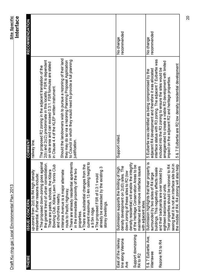
6A and 8 Buckingham Road, Killara
6a and 8 Buckingham Road are zoned 2(d3) under the KPSO and translate to R4 under the KLEP. It is acknowledged that there is no R3 interface site between the R2 and R4 zonings. When the interface study was conducted, 8A, 10 and 11 Buckingham Road were considered for R3 zoning; however, since 10 and 11 are heritage items, R2 was maintained on them to preserve their heritage value. Although impacted, 8A on its own would be unable to successfully develop as R3 due to topography and traffic issues along the access handle to the battle-axe site, and therefore it retained its R2 status.
The submission requests the downzoning of the R4 sites at 6a and 8 Buckingham Rd to create better separation to the R2 sites. This is not possible since the sites have a current DA approved on 25/10/12 for 43 units.
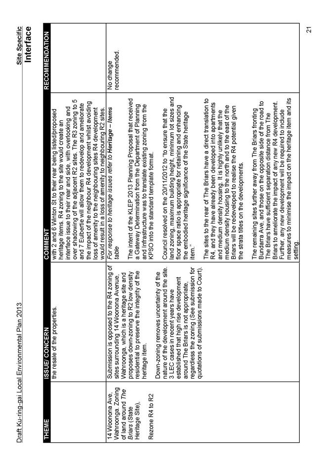
The Briars, Bundarra Ave, Wahroonga
The Briars is a State listed item and has a number of R4 sites adjacent to it. The sites to the rear of The Briars are a direct translation to R4 from the KPSO, and they have already been developed into apartments and medium density housing. It is highly unlikely that the medium density housing to the north and to the east of The Briars will be redeveloped to realise the R4 potential given their existing strata title nature.
The remaining sites further away from The Briars fronting Bundarra Ave, and those on the opposite side of the road to The Briars have sufficient separation distance from The Briars to ameliorate the impact of any new R4 development. Further, any new development will be required to include measures to minimise the impact on the heritage item and its setting. Three Land and Environment court cases illustrate that should inappropriate R4 development be proposed around The Briars, it is highly unlikely that it will be approved. This is considered to be sufficient protection of the item from neighbouring development.
Recommendation:
Generally there is no change recommended however it is recommended that the zoning on 2, 4 & 6 Caithness Street, Killara be re exhibited to amend the KLEP zoning, FSR and height maps to indicate R3 zoning. It is recommended that 6 Caithness Street, Killara be investigated as a potential Heritage Item, and if found to be a potential item, to be re-exhibited as such and to show R2 zoning with according FSR, height and lot size standards.
Landowners at 21 and 23 Werona Avenue wishing to pursue this matter have the option to submit a formal Planning Proposal to Council with planning justifications for the changes they seek. This will enable a fair and transparent process to occur through consultation and exhibition of the proposed modification that has not been possible through the draft KLEP process.
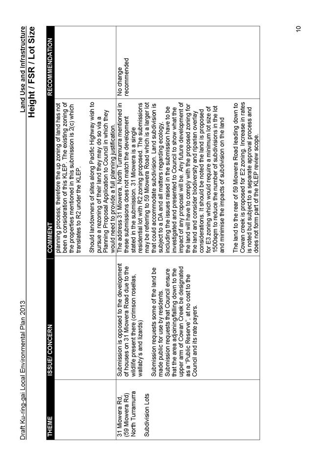
Reclassification of Community Land
Submissions were received opposing the reclassification of various sites.
Discussion:
With the exception of the two sites discussed in Part 10 of this Report, reclassification of land is not dealt with under the KLEP. Where sites are being considered for reclassification, Council has or will engage in the process of preparing a separate Planning Proposal regarding the reclassification of each site or groups of sites. That process will involve detailed investigations and a public hearing, and include opportunities for community and State agency submissions to be made on the proposed reclassification.
The KLEP does address the rezoning aspect of certain reclassification sites raised in submissions. This is addressed below:
90 Babbage Road, Roseville Chase:
The rezoning and reclassification of 90 Babbage Road was the subject of a Planning Proposal adopted by Council on 16 July 2013. Thorough investigations were conducted to assess issues raised, including a Public Hearing. Apart from a call to rezone the land as E2, the concerns presented in the submissions to the KLEP are identical to those submitted to the Planning Proposal and have been addressed in detail in the 16 July 2013 Council Report and its attachments.
The Planning Proposal sought to rezone the site to Residential 2(a) under the KPSO. This draft KLEP indicates the zoning for the site as E4 in recognition of its value as a local biodiversity habitat. There is no justification for the E2 zoning requested in the submission, none of the studies conducted during the consideration of 90 Babbage Road revealed this as a significant site to warrant E2 zoning.
Car park area Culworth Avenue, Killara
The site is currently zoned a mixture of Municipal Purposes, 2(d) and 3(a)-(A3). The original intention for the site was for medium to high density office development. Since the KLEP is a translation of zoning and site potential from the KPSO to the standard instrument format KLEP, this site could translate to a business zone or to a high density residential zone. Given the context of the surrounding R4 zoning and residential development and the proximity to the railway station the development standards of this site should be consistent with the surrounding sites. As such it is proposed that the FSR for the site be increase from 1:1 to 1.3:1 and the maximum building height from 14.5m to 17.5m.
Any development on the site will be subject to controls to do with setbacks and impacts on the heritage conservation area as well as on any adjacent heritage items including the station and will have to show how it mitigates impact on adjacent properties in terms of amenity, overshadowing and visual context. These issues will be addressed through the DCP controls at development application stage. For discussion regarding the relationship of the Culworth car park and its relationship to the HCA, refer to the heritage section of this Report at Part 4. With regards to the loss of public parking adjacent to Killara Station, in addition to the discussion in Part 2 of this report on traffic issues, the proposal to provide public parking within any development on the site, subject to viability, would require an addition to Schedule 1 of the draft KLEP to allow car parking use on the R4 zoning of this site.
Recommendation:
It is recommended that the LEP as it applies to 20-28 Culworth Ave, Killara (Lots 1, 2 and 3 DP119937; Lot 6 DP3694; lot 2 DP932235) be amended to a FSR of 1.3:1 and a maximum height of buildings to 17.5m. It is also proposed to amend Schedule 1- Additional permitted uses to permit ‘Car parking’ as a use on the car park at 20-28 Culworth Ave and17 Marian Street, Killara.
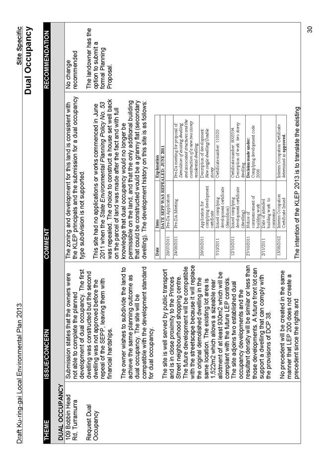
Dual Occupancy
Submissions requested the ability to develop dual occupancies on their land, expressing the intention of their land purchase was to develop dual occupancy, and that the SEPP being repealed truncated that wish. One submission requested the removal dual occupancy status on a neighbouring site at 33 Grandview St, Pymble.
Discussion:
The intention of the KLEP is to translate the existing KPSO standards into the Department of Planning and Infrastructure’s standard template format. It is not the intent of the KLEP to alter development standards except where strategic considerations have been nominated in the Planning Proposal and Gateway Determination. There is no requirement by the Department of Planning and Infrastructure for Council to increase dwelling numbers through this plan making process, therefore, the inclusion of dual occupancy development has not been a consideration of this KLEP.
In analysing submissions requesting dual occupancy on parcels of land, research has been conducted to check if any dual occupancy application was existing at the time SEPP 53 was repealed (June 2011). In all cases, there was no such evidence. All documentation and all works have clearly been commenced after the date of the repeal.
The submissions express the intention of their land purchase was to develop dual occupancy, and that the SEPP being repealed truncated that wish. The submissions do not provide sufficient planning grounds to operate against the KLEP provisions. Restricting dual occupancy to those sites with existing use rights or with applications lodged prior to the SEPP repeal will avoid creating conflict with the intention of the KLEP and the Gateway Determination.
Should landowners wish to pursue this matter they have the option to submit a formal Planning Proposal to Council with planning justifications for the changes they seek. This will enable a fair and transparent process to occur through consultation and exhibition of the proposed modification that has not been possible through the draft KLEP process.
33 Grandview St, Pymble
KLEP does not have provisions for dual occupancy; however should dual occupancy be permitted under the KPSO, then that planning provision has been translated into the KLEP. Dual occupancy is permitted on this site under the KPSO and hence is retained under Schedule 1 of the KLEP. The site is a corner block of size suitable for the already permitted dual occupancy subdivision. The right of way access that the submission is concerned about is owned by Council and will not change its status in the event of any development; therefore access to the rear subdivided properties will not be altered.
It is acknowledged that the site has been nominated as a potential heritage item and that further investigations are proposed to verify its significance. Should the heritage status be confirmed for this site, the dual occupancy status would be removed due to the location of the heritage item in the centre of the site and the negative impact subdivision would have on the curtilage of the heritage item. Should heritage status be confirmed this site would be subject to a re-exhibition posing the heritage status and removing the dual occupancy status.
Recommendation:
Generally there are no changes recommended, however it is recommended that further investigations be conducted to verify the heritage value of 33 Grandview Street, Pymble. Should it be found worthy of heritage listing, the dual occupancy status would be removed. The proposed changes would be the subject of re exhibition to amend the KLEP.
With regards to dual occupancy subdivisions, should the landowners wish to pursue this matter they have the option to submit a formal Planning Proposal to Council with planning justifications for the changes they seek. This will enable a fair and transparent process to occur through consultation and exhibition of the proposed modification that has not been possible through the draft KLEP process.
Schools
Private schools in the LGA raised a number of common and individual issues. The common concerns are as follows:
- main concern of the schools, listed individually by site below, were around the permissibility of uses under the KLEP and the perceived uncertainty around the status of the SEPPs that enable development on their land;
- concerns are raised by most of schools around the expansion of the facility into neighbouring properties and the ability to develop within those zonings; and
- a number of schools requested the words Educational Establishment in addition to SP2 on the zoning map to be consistent with other school labelling across the LGA.
Discussion:
The Infrastructure SEPP is key in the delivery of all manner of infrastructure, including hospitals and schools. Council has been given direction by the Department of Planning and Infrastructure to ensure the KLEP does not overlap with the Infrastructure SEPP so that those developments can occur under that instrument in a consistent manner across the State. It is therefore highly unlikely the SEPPs will be repealed as suggested in the submissions. The new Planning Bill recently introduced into Parliament provides for all existing SEPP provisions to be retained in Local Plans, thereby ensuring a continued certainty around their delivery. Therefore sites that are within a residential zone can continue to be developed for hospital, schools and seniors living purposes under the current SEPPs and their future iterations.
Further to this, Council is required to draft the KLEP under the existing legislation, the EPA Act. Council is not in a position to assume what the status of future legislation will be and draft the KLEP on those assumptions. Should State Government alter the standing of the SEPPs from that expressed in its White Paper, all Councils across the State will be given a direction on accommodating that change and the time. Under the recent Planning Bill 2013 introduced into the parliament, SEPPs under the former Act, will continue in force as part of the relevant provisions of a local plan (s12.6(1)). In the event it is amended to fit in with the new planning reforms, it will retain its weight and direction as stated in the Planning Bill to ensure a continuing certainty around infrastructure delivery.
The Department of Planning and Infrastructure’s standard template places a residential zoning across all school sites and utilises the SEPP Infrastructure to enable school development within those residential zones. Ku-ring-gai Council sought and received a special dispensation from the Department to zone school sites SP2. The justification for this was that educational establishments form a core portion of Ku-ring-gai’s employment sector, and this zoning would give Council and the school establishment’s certainty regarding the preservation of existing school uses on their land well into the future.
It is recognised that schools may acquire adjoining lands for the purposes of expansion. These sites remain in the zoning of the surrounding properties as school uses are permitted on them under the Infrastructure SEPP. This ensures the type of development on those sites is in keeping with, and has little impact on, the neighbouring residential amenity. Should schools acquire substantial parcels of land where there is clear separation, and hence impact on the neighbouring residential development, schools have the option to apply for an SP2 rezoning by submitting a formal Planning Proposal to Council with planning justifications for the changes they seek. This will enable a fair and transparent process to occur through consultation and exhibition of the proposed modification that has not been possible through the draft KLEP process.
The KLEP does not indicate school uses in the R2, R3, R4, E4 zones. It should be noted that Council was directed by the Parliamentary Counsel Office through the Department of Planning and Infrastructure to remove reference to schools in zones where they are permitted under the Infrastructure SEPP.
Given the status of the Infrastructure SEPP and other SEPPs in the new Planning Bill recently introduced into Parliament, it is expected that R2 sites that are in the ownership of various schools can continue to be developed for school purposes. Many of the sites acquired by schools that remain R2 form part of a strong residential context and in many cases there are a number of heritage and contributory items that contribute to the character of the local residential area. These adjoining residential areas themselves require some certainty that their amenity will not be compromised by future school development. The residential zoning ensures that any new development will integrate into the residential built fabric.
It is acknowledged that the SP2 zoning to the majority of the school site makes no reference to its use as a school. Therefore the words ‘educational establishment’ should be included in the title of the land so it is clear that the land is preserved for school uses.
Recommendation:
For all school sites, it is recommended that the zoning map be amended to read SP2 Educational Establishment across all school sites.
Individual schools additional issues:
Sacred Heart School, Our Lady of Perpetual Succour School and Church at 2-4 Richard Porter Way
Following are issues raised in the submission:
- seeks a number of additional permitted uses in the draft KLEP to reflect the current and potential future range of programs and services provided by the parish; and
- questions the R4 zoning to 4 Richard Porter Way.
Discussion
The request in the submissions to allow uses that are not directly linked with the school use but are more linked with community provision (such as seniors housing, childcare centre, counselling and youth centres, community worship) is in direct conflict with the ordinary application of the SP2 zoning for educational purposes. Whilst the request for a holistic approach to the site and its mixture of school and community uses is understood, Council is obliged to affect the same principles across all SP2 school sites, and to ensure all uses on those sites are linked to the primary school use. For this reason it is not possible to make special circumstances for one school over another and allow non-school uses within the SP2 zone on the sites at Bobbin Head Road and 64 Kendall Street, West Pymble.
During a pre-DA with Council to place a 0-5 childcare centre on the school site it was pointed out to the applicant that whilst childcare associated with the school use, for staff, or after school care, or a pre-school run as part of the school may be permissible, the type of childcare sought would not be permitted on the school grounds because it was not ancillary to the school use, but would be an independent facility from the school.
The submission questions the R4 zoning to 4 Richard Porter Way. This is a direct translation from the KPSO in which the site is currently zoned 2(d3). However, since 4 Richard Porter Way is contiguous with the current SP2 area, there is merit in its inclusion into the adjacent SP2 zone.
Under the KLEP, Seniors Living is permitted in R1 and R3 and not in R2, R4, E4. The reason for this is that the SEPP Seniors Living permits this development type in R2, R4, E4 and the KLEP is required to avoid covering development permitted under the SEPP. Further, since the SEPP permits seniors living development on land adjacent to residential land, a development application for this type of development could be made under that instrument; therefore there is no requirement to make this an allowable use under the KLEP.
Should the landowners wish to pursue the inclusion of non-school uses on the land, they have the option to submit a formal Planning Proposal to Council with planning justifications for the changes they seek to zoning all or part of the school site to a residential zone permitting school and non-school uses on the site. This will enable a fair and transparent process to occur through consultation and exhibition of the proposed modification that has not been possible through the draft KLEP process.
Recommendation:
It is recommended that 4 Richard Porter Way, Pymble be included within the SP2 zoning boundary line of Sacred Heart School.
St Lucy’s School
The school submission requested the inclusion of 6 & 8 Billyard Avenue, Wahroonga in the SP2 zone which covers the school area.
Discussion:
The school site has a number of lots that are zoned SP2. 6 Billyard Ave shares a common boundary with the SP2 site. Since 6 & 8 are contiguous with the current SP2 area, there is merit in its inclusion into the adjacent SP2 zone. In the interest of consistency with other school sites, the words SP2 Educational Establishment should also be indicated on the zoning map.
Recommendation
It is recommended that 6 and 8 Billyard Avenue, Wahroonga be included within the SP2 zoning boundary line of St Lucy’s School.
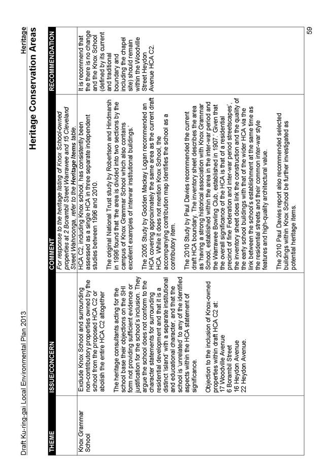
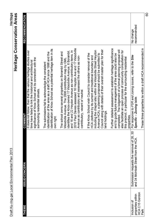
Knox Grammar School
The issues raised in the Knox School submission are addressed below.
It should be noted that prior to LEP 218 being gazetted, the Minister (upon representations from the Knox School) amended draft LEP 218 to remove this entire HCA. This was on the basis the HCA was identified in Draft KLEP 2013 and would also provide time to facilitate further discussions and review between the Knox School and Council.
Council staff met with Knox to hear the school’s issues regarding the draft KLEP including the HCA area that included the school. This meeting was arranged by Knox with Council and held on 6 August 2013. The meeting occurred after the exhibition of the draft KLEP to which Knox made a submission stating their concerns. At that meeting Council officers were again briefed on the school’s issues and questioned about decisions Council would make to support the School.
The school representatives were informed that in the interest of fairness and transparency to all sectors of the Ku-ring-gai community, Council was not in a position to reveal its decisions on the draft KLEP until Council’s report was made public, staff reiterated their position not to agree any special conditions for one school over any other school in the LGA, or favour one sector of the community over another. It was also clarified that staff would present a considered response to the Knox submission in their report to Council.
Following this meeting, Council received a letter where Knox again tabled their issues over the exhibited draft KLEP pointing out that no decisions had been forthcoming in the meeting. Once again, Council officers were not in a position to address the issues in the letter as this would remove the fairness and transparency of the exhibition and reporting to Council process that operates under the EPA Act, and which is fairly and equally afforded to all sectors of the community and all submissions made on the draft KLEP. The issues have accordingly been addressed in this report with recommendations that reflect the value of the school to the area, and which are fair and without bias towards Knox school or any other sector of the Ku-ring-gai community.
The key issues raised in the school submission are as follows:
- inclusion of the Chapel site and 17 Woodville Ave, Wahroonga in SP2 zone;
- inclusion of Borambil Street in SP2 zoning instead of the residential area zoning;
- increase FSR, lot sizes, heights to those parts of the main school site that are zoned R2;
- questions E3 zoning to Curagul Fields used as playing fields in Nth Turramurra as E3 does not permit school uses in the KLEP;
- suggests inconsistency with draft Sydney Metropolitan Strategy as no R4 zoning is indicated around Warrawee Station;
- questions the heritage relevance of 15 Cleveland Street, Wahroonga which is a relatively new school building and forms part of the school site;
- removal of the school from the HCA as it is seen as a burden to future development.
- School sites zoned R2 should be rezoned SP2; and
- HCA and R2 zoning is a hindrance to school’s expansion.
Discussion:
For detailed discussion regarding the HCA area and the Knox submission for removal from that HCA, refer to Part 4 of this Report.
Inclusion of 17 Woodville Ave in the SP2 zoning is supported as it is owned by the school, is contiguous with the SP2 site, and now legally forms part of the adjacent school SP2 lot 875542. It is acknowledged that a mapping error did not translate the KPSO existing zoning of the Chapel into the KLEP 2013 zoning maps. As such this site should be included in the SP2 zoning as per the adjacent land.
The request to zone Borambil Street as SP2 is not supported. The standard template requires all roads to take on the highest order of zoning of the adjacent land uses. In this case R2 is the highest order zoning as it permits a wider range of development including school uses (under the Infrastructure SEPP).
FSR, lot sizes, heights are related to the zoning of the land. There is no direction from the Department to increase densities of the area within the KLEP, it is primarily a translation of the KPSO. Most of the sites acquired by the school, that remain in the R2 zoning, form part of a strong residential context where in many cases there are a number of heritage and contributory items that lend to the quality of the local HCA. In addition, they adjoin existing residential areas that in themselves require some certainty that their amenity will not be compromised by future adjacent school building development. The residential zoning ensures that any new development will integrate into the residential built fabric therefore changes to the development standards are not supported.
It is acknowledged that the KLEP 2013 and Infrastructure SEPP do not permit school uses within the E3 zoning. The E3 zoning covers the majority of the North Turramurra locality due to growing concerns from the RFS regarding the safe evacuation of population in the event of a serious bushfire hazard. The zone limits the density of population occupying the land so that evacuation through the limited exit routes can be conducted in a timely manner. Whilst E3 might restrict uses the reasoning behind its allocation is sound. The approach being taken to the E3 sites applies to this site. Refer to Part 6 of this report for the discussion and recommendations regarding the use of the E3 zone
Contrary to the submissions claim of inconsistency, the draft KLEP 2013 is consistent with the draft Sydney Metropolitan Strategy. Council has delivered its dwelling targets predominantly within the town centres where there is a transport node and other supporting facilities such as retail and recreational premises. The request in the submission to zone areas around Warrawee station as R4 to enable high density development in that area is not supported as it would significantly alter the character of this locality. In a similar vein, the request to remove the HCA in this area to enable R4 development is not supported. The HCA is established on the existing character of the area not on the future development potential of that area. This locality has been found to have a quality heritage standing that is worthy of retention for future generations. The school itself, given its significant heritage architecture, forms part of that heritage value. Further, there has been no direction from the Department of Planning and Infrastructure to create other high density sites within the current plan making process. The intent of the KLEP 2013 Planning Proposal that received a Gateway Determination was to translate existing zoning from the KPSO into the Standard Template format. Changes to density have only been included where sites were considered to have interface issues. In addition to this, Warrawee station has no retail or commercial uses associated with it and is of a different character and scale to the town centres where R4 zoning has been approved by the Department.
The request to remove the school site from the draft HCA is not supported. The draft KLEP has been exhibited showing the extent of the draft HCA in this location. The removal of the school site constitutes a major and significant change for which no justification or study has been provided in the Knox submission. Heritage studies conducted over several years have repeatedly stated the heritage significance of Knox school given its historical standing in the area, and the significant heritage buildings that form a part of the school itself. Refer to Part 4 of this report for specific studies conducted addressing the heritage significance of Knox school and the surrounding neighbourhood. No study has disputed this fact, nor indicated otherwise.
The Knox submission, various letters, and meeting with Council officers have not provided any evidence to give Council reason to alter its delineation of the draft HCA in this locality. Council is obliged to use the same process and have equal regard for all sectors of the community when making significant changes to the exhibited draft KLEP. Should Knox wish to pursue this matter, they have the option to submit a formal Planning Proposal to Council with planning justifications for the changes they seek to the HCA boundary. This will enable a fair and transparent process to occur through consultation and exhibition of the proposed modification that has not been possible through the draft KLEP process.
The concerns regarding aspects of the KLEP seen as a hindrance to the school expansion, namely the R2 zoning and the HCA status, are not considered obstructions to the school’s expansion in the future since school development is permitted within both R2 and HCAs. No evidence or future expansion plans illustrating the perceived hindrance were provided in the submission to the draft KLEP to justify this claim. There is no reason why KLEP and the Infrastructure SEPP will not continue to support the future growth of Knox school in the same manner all other schools and institutions in the LGA.
The planning basis underpinning the draft KLEP ensures transparency and fairness across all sectors of the Ku-ring-gai community and gives due consideration to any changes impacting on local neighbourhoods. Should the school wish to submit a Planning Proposal for changes to the draft KLEP, Council would be given clarity on the direction the school wishes to take and consider that submission on its planning merits. Importantly, Council would be able to conduct the required community and State agency consultation on the proposal as required by the EPA Act, and make recommendations in a fair and transparent manner with full support of the relevant community and State sectors.
Recommendation
It is recommended that the main school Chapel site; 17 Woodville Ave; 15 Cleveland Street Wahroonga be included in the SP2. Refer to Part 4 of this Report for recommendations regarding heritage issues. No other change is recommended.
Hospitals and Seniors Living
The main concern of the hospitals and seniors living facilities, listed individually by site below, is around the permissibility of uses under the draft KLEP. In particular, the perceived uncertainty around the status of the SEPPs that enable their development, particularly with regards to the expansion into neighbouring residential properties and the ability to develop within those zonings
Discussion:
Whilst residential zones under the KLEP do not permit Seniors Living use in the R2, R4, E4 zones, and Hospitals under R3 and R4 zones, it should be noted that this development type is permissible in those residential zones under the SEPP Seniors Living and SEPP Infrastructure. This means Council’s KLEP is consistent with the Department’s requirement that the KLEP should not provide development standards on uses covered by the SEPP.
The Infrastructure SEPP is key in the delivery of all manner of infrastructure, including hospitals and schools; and, the seniors living SEPP is key in the delivery of all seniors living across the State. Council has been given direction by the Department of Planning and Infrastructure to ensure the KLEP does not overlap with the SEPPs so that such developments can occur under that instrument in a consistent manner across the State. The only exception to this has been the existing large school sites in the LGA being zoned SP2, for which Council received a dispensation.
It is therefore highly unlikely the SEPPs will be repealed as suggested in the submissions. The new Planning Bill recently introduced into Parliament provides for all existing SEPP provisions to be retained in Local Plans to ensure a continuing certainty around their delivery. Therefore sites that are within a residential zone can continue to be developed for hospital, schools and seniors living purposes under the current SEPPs and their future iteration. Further to this, under the recent Planning Bill 2013 introduced into the parliament, SEPPs under the former Act, will continue in force as part of the relevant provisions of a local plan (s12.6(1)). In the event it is amended to fit in with the new planning reforms, it will retain its weight and direction as stated in the Planning Bill to ensure a continuing certainty around infrastructure delivery.
Further to this, Council is required to draft the KLEP under the existing legislation, the EPA Act. Council is not in a position to assume what the status of future legislation will be and draft the KLEP on those assumptions.
Recommendation:
No change recommended.
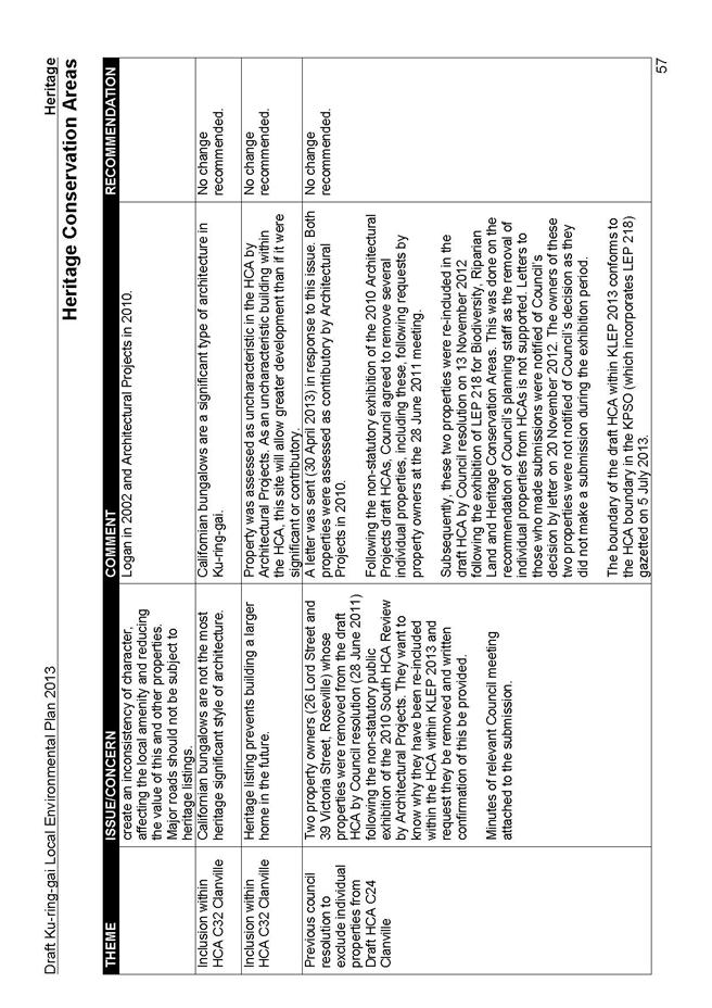
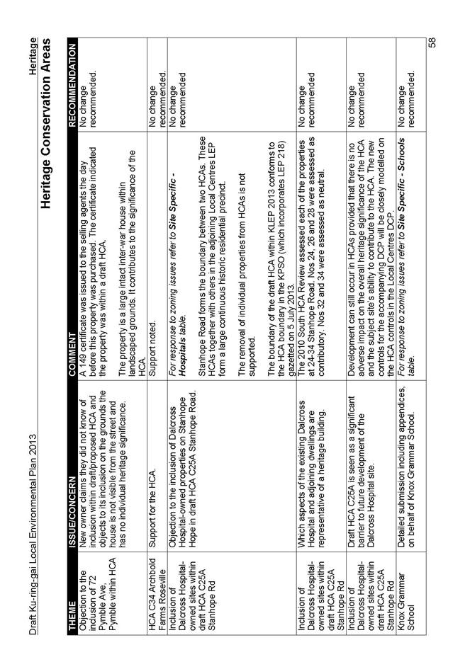
Dalcross Hospital28 Stanhope Rd, Killara
The hospital seeks an R3 zoning with increased FSR.
Discussion:
Dalcross Hospital, 24-34 Stanhope Road is located within a low density residential area with no other high density or commercial development in the vicinity. In addition, the locality has a number of heritage items and is within a HCA. Given the context, it is important that any development on this site remain of a scale suitable to the residential context. Further to this, there has been no high density development on the high density 2(d3) sites east of the railway line along Werona Ave. The downzoning of 2(d3) sites to R2 will enable the integrity of the HCA to be maintained and remove interface issues with adjacent residential sites that would result from R4 development. Interface zoning was briefed in the report to Council and adopted on the 6 March 2012, and was approved by the Department of Planning and Infrastructure through the Gateway process.
The request to zone the Dalcross hospital sites R3 is not supported as this is a quality low density residential areas as well as a proposed HCA, of which the hospital site is a part. Hospital uses are permitted with consent within R2 zones under the KLEP. Removal of the FSR controls to individual sites is not supported as it gives unfair development advantage and does not enable Council to adopt a fair and even approach across the LGA . FSR in existing 2(c2) zones under the KPSO is covered by DCP 38 clause 4.2.1 which stipulates the FSR control within this area. This standard has been translated into the KLEP R2 zone. Despite the current relative over development of Dalcross, the streetscape remains intact and consistent with the low density residential neighbourhood.
The hospital’s request for hospital-owned properties to be removed from the HCA is not supported. The removal of individual properties from HCAs is contrary to the principles of the HCA being homogenous in character. The 2010 South HCA Review assessed each of the properties at 24-34 Stanhope Road. Nos 24, 26 and 28 were assessed as contributory to the HCA. Nos 32 and 34 were assessed as neutral. The boundary of the HCA within KLEP 2013 conforms to the HCA boundary in the KPSO (which incorporates LEP 218) gazetted on 5 July 2013. Stanhope Road forms the boundary between two HCAs. These HCAs together with others in the adjoining Local Centres LEP form a large continuous historic residential precinct.
Development can still occur in HCAs provided that there is no adverse impact on the overall heritage significance of the HCA and the subject site’s ability to contribute to the HCA. Any future development on the hospital site would need to continue to maintain a scale and streetscape address that is homogenous with and contribute to the existing residential fabric of this locality. Should the landowners wish to pursue this matter they have the option to submit a formal Planning Proposal to Council with planning justifications for the changes they seek. This will enable a fair and transparent process to occur through consultation and exhibition of the proposed modification that has not been possible through the draft KLEP process.
Recommendation:
No change is recommended.
Neringah Hospital2-12 Neringah Ave, 3-9 Woonona Ave, Wahroonga
The submission from the hospital requested the following:
- insertion of clauses into schedule 1 to allow Hospital and Seniors Living on the site;
- removal of heritage listing on the entire property; and
- objection to listing of ‘Hardie House’ 4-6 Neringah Ave South, and the 1950s hospital block, and other buildings on the site as this would impede future development
Discussion:
Hospital and Seniors Living are permissible in residential zonings either under the KLEP or the SEPPs as explained above, so there is no reason to make a change to Schedule 1.
Objection raised in the submission to listing of ‘Hardie House’ 4-6 Neringah Ave South on the grounds of asbestos content and contradictions to healthcare; lack of justification for the listing of the main 1950s hospital block, and other buildings on the site that do not have heritage value are not supported by any accompanying studies to validate the claims.
Neringah Hospital was identified as a potential item in the Godden Mackay Logan, Heritage and Neighbourhood Character Study, 2000. More recently, the site was identified as a potential item in the Paul Davies Pty Ltd, North HCA Review, 2010.
There is documentary and physical evidence that confirms that 4–6 Neringah Avenue is a Federation period residence, donated to the Red Cross for use as a convalescent home after World War II, later incorporated into the hospital as an administration building. The hospital itself is a branch of the ‘Home of Peace for the Dying’ established in Wahroonga in 1958. It is acknowledged that the ongoing use of the site as a hospital is a crucial aspect of significance.
Council has adopted a staged approach to identify and assess the heritage items within the LGA. The public exhibition is part of this process; therefore, further detailed heritage assessment of this property should be undertaken in line with that approach.
Recommendation:
No change recommended regarding the permissibility of hospital or seniors living uses within the residential zones. It is recommended that the Neringah Hospital Site at 2 - 12 Neringah Avenue South, Wahroonga be removed from Schedule 5, of the draft KLEP 2013 and accompanying Heritage Map and be deferred for further investigation and re-exhibition.
Lourdes Retirement Village, Killara
Apart from the concern that Seniors Housing is not permitted in KLEP, the submission expressed that there is confusion on which instrument will determine heights as there is a difference in the development standards between the KLEP and SEPP.
Discussion:
Seniors Living is permissible in residential zonings either under the KLEP or the SEPPs as explained above. When a DA is prepared for any development on the site, it will have to adhere to the development standards of the statutory instrument under which it is proposing the development. Each development application is assessed under the applicable instrument. If the DA operates under the KLEP then those standards need to be met, if the development complied with operates under a SEPP, then those standards need to be met. Further, a detailed DCP will be prepared to clarify and control development standards within the KLEP area to ensure the new development remains in keeping with the context of the area.
Recommendation:
No change recommended
Lady Gowrie Nursing Home, 6-10 Edward St and Melkin End, Gordon
The issues raised in this submission are as follows:
- loss of the KPSO Hospital special uses zone means Seniors Housing and Residential Care Facilities will no longer be permitted on the site under the KLEP;
- request for the site to be zoned R1 or include special provisions in Schedule 1 allowing Seniors Housing and Residential Care Facilities;
- the E4 zoning to part of the site will prevent seniors housing development due to the biodiversity value categorising the land as environmentally sensitive;
- questions the KLEP (and other Councils’) methodology around permitted and prohibited uses within zones and consistency with the Department’s Practice Notes;
- inability to comply with access to transport and services as stated in cl 26 of SEPP Seniors Housing should this become the instrument under which future development on the site is carried out; and
- concerns regarding the reduced FSR across the whole site.
Discussion:
Sites that are within a residential zone can continue to be developed for seniors living purposes under the current and any future iteration of SEPP Seniors Housing.
Ku-ring-gai Council continues to support the provision of facilities for aged persons within the current legislative framework. Council is consistent with the direction from the Department of Planning and Infrastructure to rezone this land from a Special Uses Hospital zone under the KPSO, to a residential zone, R2 and E4, under the KLEP. This results in the Department’s desired outcome for all infrastructure development, previously given Special Uses zoning, to be carried out under the appropriate SEPP. LEP Practice Note ‘Zoning for Infrastructure in LEPs’ states guidelines that Council has been required to follow. Therefore the development of the site for senior’s housing is in no way altered, nor is there any downzoning of the site as the uses are still permitted on the land.
Given the Department’s preferred use of the SEPP for the development of special uses, SP2 zoning in Ku-ring-gai is now limited to school sites (as they form a core portion of Ku-ring-gai’s employment sector) and those sites that have regional status in terms of their scale and infrastructure, and which were assigned the zoning by the Department under the Major Projects SEPP (such as the SAN hospital). By a similar token, Council has not assigned R1 zoning to any area within the LGA due to the conglomerate of development types permitted within that zone and the complexity in preserving a certain character (the one exception is the Screen Australia site where R1 is assigned to create a homogenous zone with existing adjacent R1 properties). R1 zoning within the LGA has previously been assigned to certain sites including the mentioned Mt Pleasant Avenue, Normanhurst, by the Department under the Major Projects SEPP which amended the KPSO. This R1 zoning has been directly translated into the KLEP. R1 zoning is not supported to the Lady Gowrie site as it would enable high density R4 type development which is inappropriate to the locality.
E4 areas have been zoned as such in recognition of their biodiversity and riparian features. The definition of biodiversity, or biological diversity, under the KLEP is separate and different to the definition of Environmentally Sensitive Land under the SEPP Seniors Housing which does not include biodiversity areas in its definition; therefore, the submission’s claim that E4 zoning will hinder the development of the site for senior’s housing is incorrect.
The structure of the KLEP has been endorsed by the Department of Planning and Infrastructure. The approach that has been used, and agreed through the Gateway process, is an ‘open zone’ approach for all commercial areas, giving them a level of development flexibility; and a ‘closed zone’ approach for all residential zones as land uses are more sensitive in residential areas. This approach gives certainty to the residents of Ku-ring-gai regarding land uses in close proximity to their homes and which will impact their amenity. Ku-ring-gai Council can only advise the due diligence of this Council in its decision making processes and the endorsements by the Department of Planning and Infrastructure. The criticism in the submission of other Metropolitan Councils is not within the scope of this KLEP and those matters should be pursued with those Councils to understand their rational.
In any redevelopment, the potential exists for a pedestrian connection from the Melkin End part of the site to bus stops on Rosedale Road Gordon as this would meet the 400m distance and gradient requirements of the SEPP. If future access from this part of the site is not possible, there is also the possibility of introducing new bus stops on Rosedale Road in the vicinity of Edward Street (subject to concurrence from the bus operator Transdev/Shorelink/Transport for NSW, and Ku-ring-gai Council). Preliminary investigations show that on-street grades and distances along the travel paths to these stops would comply with the requirements of Clause 26 of SEPP (HSPD) 2004 from the Edward Street site frontage. Rosedale Road (in the vicinity of the site) is serviced by the Transdev/Shorelink 582 service linking Gordon railway station (Werona Avenue) with St Ives Shops (Memorial Avenue), and could provide direct connection to services and facilities in the St Ives and Gordon local centres, and further connections to services and facilities in Chatswood and Hornsby (via North Shore railway line).
It is acknowledged that a lower FSR has been given to the entire site to be in keeping with the E4 zoning requirements. It is agreed that since part of the site is zoned R2, the FSR to that part of the site should be in keeping with that zoning. Therefore it would be appropriate to align the FSR map with the zoning map to show A3 FSR to the R2 portion of the site
Recommendation:
It is recommended that the FSR Map be amended to show A3 to that part of the site zoned R2, and A1 to that part of the site zoned E4 for the site; and the Lot Size map be amended to show correct sizes for the R2 and E4 areas at Lady Gowrie Nursing Home, 6-10 Edward St and Melkin End, Gordon.
Other Large Sites
Pymble Business Park
Two main issues were raised in submissions are:
- opposition was raised to the increased height and B7 zoning for 986 Pacific Highway and 5 Suakin Street claiming that the heights will have negative impacts on residents of neighbouring properties and on the wildlife in the adjacent reserve; and
- concern about the traffic implications with the increased development that will occur within the business park.
Discussion:
The building height and FSR have been determined to ensure viability of development within the business park; nevertheless, Council is committed to ensuring the preservation of biodiversity of the locality as well as the amenities of surrounding properties. The newly prepared, exhibited and adopted DCP for the Pymble Business Park contains controls that seek to ensure amenity is preserved to neighbouring properties as well as protect biodiversity significant areas that the submission sites are located adjacent to.
A full exhibition on Pymble Business Park was conducted through a comprehensive planning process when LEP 219 for that area was prepared. Zoning for the Pymble Business Park was considered by Council on 17 July 2012. At that time, all issues regarding the heights of buildings and their impact on surrounding development was considered. It is not the intent of this KLEP to review that previous process. The intent of the KLEP Planning Proposal, as reflected in the Gateway Determination, is to translate the KPSO into the KLEP using the Department of Planning and Infrastructure’s standard instrument format. The B7 zoning to Pymble Business Park underpins the provision of employment lands in the Ku-ring-gai LGA. Council has to consider the long term strategy for the business park and the preservation of the future use of the lands for commercial purposes.
Explanation has been provided in the Summary Tables that arterial roads are the responsibility of the NSW Government which is undertaking a Long Term Transport Master Plan to address key transport challenges over the next 20 years. Council will continue to lobby Transport for NSW for improvements to arterial roads as recommended in its adopted Integrated Transport Strategy.
Recommendation:
No changes are recommended.
DHA site - 100 Eton Road, Lindfield and Screen Australia – 101 Eton Road Lindfield
The submission on this site has been made by the neighbouring major landholder currently developing their own land (DHA) and local residents concerned about traffic in the area:
- DHA requests a change of zoning on the Screen Australia site from R4 to R1 to be consistent with zoning on the adjacent DHA site;
- request for changes affecting the DHA development sites adjacent to the Screen Australia site:
o addition of Exhibition Homes and Building Identification Signage permitting them in the R1 zone;
o requests that clause 6.11 be amended to remove the word ‘Edgelea’ and replace it with the term ‘Crimson Hill’;
o requests zone boundary match the approved cadastral boundary between Lot 5 and part Lot 1 in the north east of the site; and
- problems of traffic and parking with restricted vision, difficulty exiting driveways, reduced access for emergency services and dislocation of garbage collection and street sweeping.
Discussion:
The zoning on the Screen Australia site allows a mix of R2 single dwelling development, and R4 residential flat development with reduced height and FSR to result in 4-storey buildings with limited footprint. Whilst the R4 with reduced development standards was considered the best option for a site with existing significant trees as it would not rise above the mature tree canopy and would limit the footprint and ground works, and allow other large species to be planted in the open areas, there is merit in providing consistency with the adjacent R1 zoning on the DHA sites. The R1 zoning would allow a flexibility of development types across the land and include the proposed R4 type development. Any overshadowing from any future development will be a consideration at DA stage where preservation of the amenity of adjacent sites will have to be demonstrated.
In terms of the DHA site, since R2, R3, R4 all permit Exhibition Homes and Building Identification Signage with consent, it would be consistent to include them in the R1 zone. There is no objection to the change of wording to reflect the new name of the DHA development, nor to the mapping adjustment to the zone boundary to match the cadastral line.
The access and parking issues around the UTS campus have resulted from the early removal of a portion of the student parking on the UTS site, resulting in students seeking parking in neighbouring streets. This is unlikely to happen if the Screen Australia site redevelops. Residential parking is to be provided as part of the proposal in accordance with Council’s adopted DCPs. This includes visitor parking. New internal access roads and footpaths are to be provided as part of the proposal to ensure good site access. Road quality is subject to Council’s road resurfacing program. Council staff regularly undertake traffic volume and speed monitoring of key local roads in Ku-ring-gai. Eton Road is one of those roads. This is currently occurring as a result of the parking issues around the campus, although the need is likely to diminish once the university ceases operation. Construction vehicle parking would be considered as part of the Construction Traffic Management Plan which would be submitted to Council before construction commences. The installation of traffic devices in any area is subject to Council’s adopted criteria for traffic management works. Rate payer funded services continue as normal throughout any construction project
Recommendation:
It is recommended that the Screen Australia site at 101 Eton Road replace the R4 zoning with R1 and a site specific DCP be prepared to ensure the site is developed in a way that preserves its value and preserves the amenity of adjacent sites. It is also recommended that the word Edgelea be replaced with the words Crimson Hill in the title and wording of cl 6.11 and that Exhibition Homes and Building Identification Signage be included in cl 2.8 Zone R1 (3) permitted with consent of the KLEP written instrument. Further, it is recommended that the zone boundary be aligned with the approved cadastral boundary between Lot 5 and part Lot 1 in the north east of the site.
It should also be noted that there a proposed amendments to the biodiversity mapping and E3 Environmental Management zone applying to the DHA site at 100 Eton Road. Details of these changes are contained in Parts 5 and 6 of this report.
PART 4 - SUBMISSIONS ON HERITAGE ISSUES
The following parts present the key issues raised in the heritage submissions on both items and heritage conservation areas and a brief discussion around the reasons for the recommendations made in this Report. For a detailed summary of all submissions, please refer to Attachment A5 at the end of this document.
Heritage Items
The following list of properties the owners have made detailed submissions on the proposed individual heritage listings, supported by detailed heritage submissions and/or heritage consultant assessments, the following properties are not located within a draft heritage conservation area, so are not covered by the general HCA provisions.
Detailed submissions were received for the following properties;
· 60 - 62 Pentecost Ave, Pymble;
· 66 Pentecost Avenue, Pymble;
· 6 Munderah Street, Wahroonga;
· 10 Munderah Street, Wahroonga;
· 51 Warrangi Street, Turramurra;
· 59 Warrangi Street, , Turramurra;
· Neringah Hospital Site– 2-12 Neringah Avenue South, Wahroonga;
· 12 Bobbin Head Road, Pymble;
· 88 Fox Valley Road, Wahroonga; and
· 33 Grandview Street, Pymble.
Discussion:
The heritage process recognises that the sites might change or might have additional values associated with them over time or alternatively there may be changes that reduce or alter the heritage value of an item e.g. changes in the context or setting through surround development.
In the absence of a formal heritage listing on these properties over the past years, there may have been alterations and additions approved that have impacted their level of heritage significance.
The historical significance of some these properties are well supported by evidence, however additional assessments are required through detailed site visits to review the:
· extent of alterations and additions; and
· changes to context and setting.
In some cases a comparative analysis of the dwelling types is required to establish if the properties under review, are the most representative of their style and in terms of their condition and locational setting.
It is also acknowledged in some cases, Council has not undertaken any further review of proposed listings due to a lack of resources and/ or a focus on other heritage priorities (e.g. identification and listing of new HCAs).
Recommendation:
It is recommenced that further detailed heritage assessment of these properties be undertaken to determine if the properties should be listed on Council’s LEP. This will also allow for further consultation and feedback from the owners and the community prior to making a further recommendation on its listing and re inclusion in a formal planning proposal for Council’s consideration.
Heritage Items- list of items requiring further detailed research and noted errors
Discussion:
A further internal review of the proposed heritage items within Schedule 5 of draft KLEP 2013 has also identified a list of heritage items that have only limited heritage research. An error was originally made in generating the heritage data base map, which inadvertently included potential heritage items identified by previous heritage reviews.
These are listed in Attachment A9 Part A and are located outside of the proposed Heritage Conservation Areas. These properties were originally identified in previous heritage consultants reviews (e.g. Paul Davies Pty Ltd ), architectural/ heritage organisations e.g. Royal Australian Institute of Architects, internal heritage staff, or by Council’s former Heritage Reference Committee.
Some of these potential items may have sufficient heritage value to warrant a formal listing, while others have been subject to change over the past years including demolition, significant alterations/additions and/or a change to their setting (adjoining development or development in the vicinity) and therefore require additional heritage assessment.
There are other properties known as errors and/or have been subject to previous Council resolutions to be removed from the heritage list. These sites do not warrant further research. These sites are listed in Attachment A9 Part B. It is recommended these be properties removed from draft KLEP 2013 Schedule 5- Heritage items.
Recommendation
The list of properties identified in Attachment A9 Part A be removed from draft KLEP 2013 Schedule 5- Heritage items and be subject to further heritage assessment and review, prior to being reported back to Council for inclusion in a new planning proposal. The sites listed in Attachment A9Part B are to be deleted from Draft KLEP 2013 Schedule 5 Heritage Items.
Heritage Conservation Areas
There are 29 HCAs in the draft KLEP. Their boundaries are largely based on the recommendations of the most recent heritage studies conducted in 2010 and represent some of the best heritage streetscapes within Ku-ring-gai. During the public exhibition of KLEP, many submissions on HCAs were received. The individual submissions are addressed in detail in the Heritage Submission Summary Tables at Attachment A5. Key issues and recommendations from the submissions are discussed below.
Impact of draft HCAs on property values and cost of development
Several submissions were received objecting to the creation of HCAs on financial and/or economic grounds. Inclusion within an HCA would result in:
- a decline in property values;
- prices for houses within HCAs being lower than those outside HCAs; and
- increased cost of development.
Discussion:
To address in advance fears over property values being affected by heritage listing, Council included independent research on the effect of heritage listing on real estate prices in the public exhibition supporting material.
The majority of studies found that listing had marginal impact on house prices and in several instances the effect was positive. Armitage and Irons (2005), for example, attributed the positive effects on house prices in heritage precincts to the increased consistency and greater certainty of character in an area.
The concern expressed over increased cost of development was related to a perception that HCAs require higher-quality, therefore more expensive, works and the extra costs related to Council approval and consent. While inclusion in an HCA does result in different controls applying to development, it does not follow that development will be more expensive. These matters are at the discretion of the applicant. In some cases, sensitive additions and alterations to existing properties will be less expensive than demolishing and rebuilding.
Recommendation:
No change recommended.
Impact of draft HCAs on owners’ ability to make changes to their property
This was the subject of many submissions. Concerns were expressed that inclusion within an HCA would:
- limit owners’ ability to make changes to their property;
- create additional planning controls; and
- result in a loss of development potential.
Discussion:
While inclusion within an HCA does not preclude future new development, it does result in additional controls and restrictions. For example:
· additions located at rear and not visible, or at the least not visually dominant, from the street;
· demolition of contributory sites for new builds generally not supported;
· additional storeys on single storey buildings generally not supported;
· lot subdivision or amalgamation may not be supported;
· rendering and painting of original face brick and previously unpainted surfaces is strongly discouraged;
· it may be possible to demolish a neutral or non-contributory building within an HCA provided the significance of the HCA is not adversely affected; and
· new dwellings and demolitions are not complying development under the Housing and Demolition Codes, thereby requiring development consent.
Development is still permitted provided the applicant is able to demonstrate that the significance of the HCA will not be detrimentally affected and the application is supported by a heritage impact statement. While this will result in property owners requiring development consent for major works, this additional requirement needs to be weighed up against the benefits of inclusion within an HCA in terms of overall higher quality and sympathetic development promoted by the HCA and associated DCP controls.
Recommendation:
No change recommended.
Unable to demolish and rebuild on a site within an HCA
This was a major concern for owners who bought property before the creation of the draft HCAs with the intention of demolishing an existing house and building a new one.
Discussion:
It should be noted that the creation of HCAs does not preclude future development as discussed above.
It is also possible (and preferable) that sensitive alterations and additions to existing houses will provide the desired increased amenity together with the benefits that accrue from inclusion within an HCA such as the conservation of historic fabric, architectural quality and streetscape consistency.
Recommendation:
No change recommended.
Uncertainty over future development controls
Several submissions expressed concern that the creation of HCAs created uncertainty as to the what property owners could do to their properties in the future.
Discussion:
This uncertainty was possibly due to HCAs being a new planning control in Ku-ring-gai with many long-term residents having no experience of HCAs.
Development controls for the proposed heritage conservation areas will be very similar to those in the current Local Centres DCP and the main objectives of these controls are:
· to ensure new development retains the historic and aesthetic character of the HCA;
· to ensure new development minimises the visual impact upon the HCA and its streetscapes through appropriate design and siting; and
· to ensure that original building elements are retained and where new elements occur that the design is clearly related to the proportions, placement and scale of patterns of the existing HCA.
Recommendation:
No change recommended.
Some HCAs do not have heritage significance and many streetscapes lack cohesion and architectural integrity
Several submissions challenged the basis of the draft HCAs due to a perception that they lack architectural cohesion and integrity due to later alterations and additions.
Discussion:
Development in Ku-ring-gai has occurred in several waves. Early development includes large homes with the large garden estates, a few from the Victorian period, many from the Federation and Inter-war periods. In the mid-late 20th century these lots were subdivided and new housing introduced. The result is several historical layers and buildings of different styles and ages readily occur within the one streetscape.
This explains the perception that streetscapes lack significance and cohesion.
This aspect of Ku-ring-gai’s built character is acknowledged in the various heritage studies. The statements of significance for the draft HCAs reflect the variety of built forms and the different phases of development. All the draft HCAs have been mapped to identify significant, contributory, neutral and non-contributory sites and several have been subject to built-era mapping as well.
Given the degree of concurrence between the different heritage studies and the number of statutory and non-statutory public exhibitions, Council can feel confident that the current draft HCAs can withstand scrutiny as areas with identified heritage significance.
Later alterations and additions have been approved according to the planning controls in place at the time.
Council supports the creation of HCAsto provide statutory protection for areas of identified heritage significance. This will ensure that future alterations and additions will contribute to the HACs, not detract from them.
Recommendation:
No change recommended.
Recent vendors/purchasers unaware of draft HCA at time of sale/purchase
A small number of submissions were received where new owners were not aware of the draft listing of their properties.
Discussion:
This issue arises when HCAs became draft after the sale/purchase of a property has been initiated. As a result, the s149 certificates does not accurately reflect the heritage status of the area or the property at the time the sale is completed.
The process of making a new LEP takes place over a period of time. S149 certificates are only current on the day they are issued. It is the responsibility of purchasers to ensure they are current at the time of purchase.
Recommendation:
No change recommended.
Support for HCAs
Many submissions were received in support of the draft HCAs. Particular support was received for the Treatts Road (HCA C25A Stanhope Road and HCA C26 Oliver Grant), Mahratta (HCA C4) and Archbold Farms (HCA C34).
Discussion:
For many, the inclusion of HCAs in the LEP is the culmination of years of volunteer work and community consultation. For these community members, the conservation of their local communities has been long awaited and is welcomed.
Recommendation:
No change recommended.
Request for the inclusion within an HCA of the area around Middle Harbour Road not included in any draft HCA
One submission queried the exclusion of a number of streets, including Middle Harbour Road from any HCA and argued the area includes fine examples of Federation era homes and Californian Bungalows.
Discussion:
Investigation into previous advice regarding this area revealed an oversight.
The Post-Exhibition Report on the Draft South HCA Review was considered by Council on 28 June 2011. Council’s planning staff recommended the exclusion of the streets above Chelmsford Avenue within the proposed HCA 3A/6A Clanville Conservation Area due to their not being within the original National Trust HCA or the amended Godden Mackay Logan HCA boundaries and having experienced considerable recent change. However, on revision, the area between the current draft HCAs C22 (Crown Blocks) and C32 (Clanville Estate) was mistakenly identified as excluded in earlier recommended HCAs.
This area was included within the HCA 6 (Lindfield) in the 1996 Robertson and Hindmarsh/NT conservation areas. It was also included in the Lindfield conservation area recommended by Godden Mackay Logan in 2001. It was included in the 2010 South HCA Review within the Clanville Estate (HCA3A-6A).
Godden Mackay Logan’s 2001 description and assessment of the Lindfield HCA makes mention of the ‘large number of high-quality intact significant houses of the Federation and Inter-war period’ in Middle Harbour Road amongst others. The report also refers to the high visual amenity and landscape qualities within the proposed HCA.
The 2010 South HCA Review describes Middle Harbour Road as one of a number of streets of high quality due to the combination of street trees and intact housing.
Recommendation:
It is recommended that Council consider a review of the previously excluded area around Middle Harbour Road to determine its significance and the extent of recent change with the view to its re-inclusion as an HCA or to identify and assess potential new heritage items.
Request for the inclusion within HCAs of areas of Pymble based on the 1996 National Trust HCAs 17 and 18
A number of detailed submissions were received from Pymble residents expressing concern over the heritage management of the former National Trust HCAs 17 and 18 (east and west Pymble). Their concerns can be summarised as:
- historical subdivision layouts as the preferred basis for HCAs;
- definitions of “contributory” when assessing potential HCAs;
- use of streets as the boundaries of HCAs;
- larger HCAS to allow remediation of areas with later intrusive development;
- the more modest scale of West Pymble has not been sufficiently recognised for its heritage values; and
- specific requests for the inclusion of potential items.
The submissions are accompanied by recently commissioned reviews of HCAs 17 and 18 by Architectural Projects (April 2013).
Discussion:
Overall, the submissions express a strong desire to a return to the HCAs 17 and 18 in the 2008 HCA boundaries in the 2001 Godden Mackay Logan Heritage Study.
The concerns of residents regarding the differing approaches have been brought to the attention of Council many times.
These community concerns have been addressed with subsequent additional reviews of North HCAs by independent consultants. All consultants have used and referred to the proposed 1996-1998 National Trust conservation areas and HCA assessment by Godden Mackay Logan in 2000.
Most recently, Council resolved on 2 December 2011 to commission of an additional peer review of the north HCAs. This HCA review was completed in April 2013 by Sue Jackson-Stepowski and Carste Studios and the results are reported elsewhere in these Council papers. An additional peer review of Gilroy Road, Turramurra was added following a Council Resolution on 22 May 2012.
The HCA peer review largely addresses the concerns raised in these submissions and requests for additional HCAs in the Pymble area. The requested individual items are either already included in Schedule 5 of the Local Centres LEP or are on the draft KLEP Schedule 5.
The exception is 5 Avon Road Pymble which has been removed from Schedule 5 due to fire damage.
Recommendation:
Refer to the separate Council Report on the 2013 Sue Jackson-Stepowski and CARSTE Studio North HCA Peer Review where it is recommended that the 2013 Peer Review of Potential Heritage Conservation Areas (HCAs) – North Sector, including Gilroy Road be placed on non-statutory exhibition.
Requests for individual properties to be excluded from HCAs
A number of requests were received for individual properties to be excluded from an HCA:
- 18 Culworth Avenue, Killara from HCA C24 Marian Street;
- 23 Boomerang Street, Turramurra from HCA CA Ku-ring-gai Avenue;
- 29 Burns Road, Wahroonga (remove as a contributory building from HCA C1 Wahroonga contribution map;
- 5-9 Cecil Street, Gordon (within Local Centres LEP) and 22-26 Cecil Street, Gordon from HCA C19 Smith Grant;
- 1564 and 1566 Pacific Highway, Wahroonga from HCA C4 Mahratta;
- 26 Lord Street, Roseville and 39 Victoria Street, Roseville from HCA C24 Clanville;
- 24-34 Stanhope Rd, Killara owned by Dalcross Hospital within HCA25C Stanhope Road;
- 26, 30 and 34 McIntosh Street, Gordon from HCA C15 Gordon;
- 34 Marjorie Street, Roseville within HCA C32 Clanville;
- 44 Archbold Road, Roseville within HCA C32 Clanville; and
- 38 Billyard Avenue, Wahroonga within HCA C4 Mahratta
Discussion:
Generally speaking, the removal of individual properties from HCAs is not supported.
The individual circumstances of the above properties within HCAs are addressed in the submissions table. In assessing the submissions, staff visited the properties and their immediate streetscape. Staff also consulted the 2010 North and South HCA Reviews to determine how the properties had been ranked in the contributions maps and assessed the properties in relation to the inventory sheets prepared for each HCA.
In most cases, if an individual property within HCA was:
1. ranked as contributory;
2. located within a precinct of intact contributory housing;
3. located on the boundary of an adjoining HCA; and
4. specifically noted in the 2010 North and South HCA Reviews or its streetscape was noted.
The recommendation was made to retain the property within the HCA.
It should be noted that sites within HCAs ranked as neutral or uncharacteristic will allow greater levels of development than those ranked as contributory.
Recommendations:
In the following two cases, it is recommended to remove these properties from the HCA:
· 18 Culworth Avenue, Killara from HCA C24 Marian Street – see discussion following.
· 38 Billyard Avenue, Wahroonga within HCA C4 Mahratta – a recently constructed house on the boundary of the HCA.
Request for Bromborough Road within HCA C37 Garden of Roseville to be removed from the HCA.
Several submissions, including a petition claiming to represent 81% of residents, objected to the inclusion of Bromborough Road within the draft HCA C37 Garden of Roseville due to additional restrictions and that the option to knock-down a poorly designed and very poorly maintained home will be more difficult.
Discussion:
Bromborough Road lies within HCA C37 Garden of Roseville and was recommended as an HCA in the 2010 South HCA Review by Architectural Projects. The 2010 contribution map assessed the majority of Bromborough Road as contributory.
The 2010 South HCA Review concluded that the HCA has “high aesthetic significance as a highly intact and consistent early twentieth century development. The HCA has high aesthetic significance for the high proportion of quality houses including Bayswater Road and Bromborough Road.”
The current boundary of the draft HCA within KLEP 2013 conforms to the HCA boundary in the KPSO (which incorporates LEP 218) gazetted on 5 July 2013. Bromborough Road is a major component of the HCA and its removal would compromise its viability.
While the petition represents many residents, several names on the petition are co-owners of the same property and seven signatures own houses rated as neutral or uncharacteristic.
The residents’ concerns are possibly due to the fact that HCAs are a new planning control in Ku-ring-gai and long-term residents have little experience of their operation. Concerns over development restrictions need to be weighed up against the benefits of inclusion within an HCA in terms of overall higher quality and sympathetic development promoted by the HCA and associated DCP controls. In addition, neutral or uncharacteristic sites will allow greater development than those assessed as significant or contributory. Without HCA listing and corresponding DCP controls there is no guarantee that rebuilt buildings will respect the historic character.
Recommendation:
No change recommended to the KLEP. It is recommended that Bromborough Road be retained within the HCA because of its high degree of intactness. One house currently under construction was approved before the draft HCA was created and represents the kind of undesirable development within an historic residential streetscape that HCAs are designed to control and limit.
Request for Tryon Road within HCA C22 Crown Blocks to be removed from the HCA
A large number of submissions from Tryon Road residents were received objecting to the inclusion of 30-48 Tryon Rd Lindfield within HCA C22 Crown Blocks.
The main objections raised were the lack of a consistent style or period of construction in Tryon Road, and that all the buildings in Tryon Road have had alterations and additions and lacked integrity. It was also argued that inclusion within the HCA was a restriction on future development.
Discussion:
The area covered by the Crown Blocks Estate (including Tryon Road) has been reviewed in four separate heritage studies, all of which found in favour of retaining Tryon Road within an HCA:
· National Trust conservation areas in 1996;
· Godden Mackay Logan proposed HCAs in 2002;
· Architectural Projects South Review HCAs in 2010; and
· peer review of the Crown Blocks HCA by Perumal Murphy Alessi in early 2013.
The 2013 Perumal Murphy Alessi review was sought to address residents’ concerns over the inclusion of Tryon Road within the draft HCA following the public exhibition of LEP 218 for Biodiversity, Riparian Land and Heritage Conservation Areas.
On 13 November 2012 Council resolved to commission a further review of the HCA applying to Tryon Road, Lindfield.
The three most recent heritage reviews(2002, 2010 and 2013) included contribution maps and each review ranked the majority of buildings in Tryon Road as contributory.
The 2013 Perumal Murphy Alessi review found additional neutral properties in Tyron Road which reflect recent developments in the street. However, no buildings were assessed as detracting and the majority were considered contributory. The review makes the following observation:
“Many of the identified contributory items within this study are aged between 80 and 100 years old. Buildings of this age are rarely completely intact in their original form, fabric and style. It is recognised that modifications and additions are often necessary to allow the continued use of the building in a modern age. Consideration has been given to this requirement for change and the contributory items have been assessed with the consideration of the degree of change and its impact on the historical and visual character of the item and its contribution to the area when viewed from a public place.”
Council’s Heritage officer visited Tryon Road in June 2013 and concurs with the most recent assessment that the streetscape includes properties that have undergone change but are substantially intact. These contribute to the streetscape and warrant the retention of Tryon Road within the HCA.
Contrary to the arguments that Tryon Road lacks a consistent style or period of construction, the Council’s Heritage Officer found that the majority of the contributory properties are single-storey, detached inter-war bungalows. Some have been rendered and painted but are substantially intact retaining their original built forms, roofs and materials. Several properties are original and highly intact. Tryon Road conforms to the assessment of the Crown Blocks HCA as:
‘of local historic and aesthetic significance as a good and largely intact residential precinct characterised by streetscapes of good, high quality examples of single detached houses from the Federation, Inter-war and Post-war periods.’
Recommendation:
It is recommended that Tryon Road be retained within the Crown Blocks HCA.
Re-inclusion of Boundary Street, Roseville within HCA C32 Clanville
A number of submissions (six in total) objected to the re-inclusion of Boundary Street, Roseville within HCA C32 – Clanville.
Discussion:
Boundary Street between Spearman Street and Archbold Road was not originally included in the draft Clanville HCA within LEP 218. On 13 November 2012, following the public exhibition for LEP 218, Council resolved to amend the draft HCA to re-include Boundary Street, Roseville, as per the original recommendation in the 2010 South HCA Review.
The contribution map for the South HCA Review (2010) by Architectural Projects assessed every building as contributory along this section of Boundary Street.
Concerns over a perceived decline in property values and increased costs of renovations are probably due to a lack of familiarity with HCAs within Ku-ring-gai. During several recent public exhibitions, Council provided copies of independent research on the effect of heritage listing on property values. There is no strong evidence that heritage listing directly increases or decreases property values.
Council’s Heritage Officer visited Boundary Street in May 2013 and concurs with the South HCA Review (2010) that the street warrants inclusion within the HCA and that most, if not all the buildings are contributory with several intact and high-quality examples of Federation and inter-war housing.
In addition, Boundary Street is the LGA boundary between Ku-ring-gai and Willoughby Councils. The area directly south lies within a large gazetted HCA and, together with the Clanville HCA, forms a continuous conservation area spanning the two LGAs.
Recommendation:
It is recommended that Boundary Street be retained within the Clanville HCA.
The property owners concerns over excessive noise and road traffic are noted. It is recommended that additional specific controls for Boundary Street be included within the accompanying DCP to encourage noise mitigation such as double glazing.
18 Culworth Ave Killara and adjacent car park
One submission was received in relation to 18 Culworth Avenue and adjacent council-owned car park. The submission suggested these sites should be excluded from HCA C24 Marian Street. Both sites are zoned R4 which is incompatible with the general character of the conservation area and the size of the allotment.
Discussion:
18 Culworth Avenue was assessed as neutral in 2005 by Godden Mackay Logan and contributory by Architectural Projects in 2010. The property is a modest, post-war, two-storey, red brick duplex.
It is adjacent to a draft heritage item, The Dorchester, at 1 Marian Street which is zoned R4. The Dorchester’s current built form closely matches that of the zoning so the zoning is not in strong conflict with its heritage significance.
The car park was assessed as contributory in 2005 by Godden Mackay Logan and neutral by Architectural Projects in 2010. The car park has no built items. Its heritage significance appears to refer to the mature trees on the site which are protected under other Council controls.
The draft R4 zoning will provide for future development on the site similar to the 2(d) zone zoning from the KPSO.
An HCA boundary adjustment that excludes 18 Culworth Avenue and the adjacent car park is justified on the grounds that 18 Culworth Ave and the car park do not make a significant contribution to the HCA in its current state.
It should be noted that clause 5.10(5) of the draft KLEP ensures protection of heritage items, and further to this any future development on these sites will be subject to Council’s DCP controls for development in the vicinity of heritage items and HCAs. These controls and the individual listing of the Dorchester at 1 Marian Street will be sufficient to protect their heritage significance.
Recommendation:
It is recommended that the C24 Marian Street HCA boundary be adjusted to exclude the area currently covered by the draft R4 zones.
Knox Grammar School within HCA C2 Heydon Avenue, Warrawee/Woodville Avenue, Wahroonga
A detailed submission including appendices, was prepared on behalf of Knox Grammar School requesting that the school and other school-owned properties be removed from the proposed HCA C2 or that HCA C2 be abolished altogether. A further letter from Knox reiterating these points was also received.
The heritage consultants acting for the school base their objections on the SHI form not providing sufficient evidence or justification for the school’s inclusion. They argue the school does not conform to the character statements for surrounding residential development and that it is a distinct ‘island’ with a separate institutional and educational character, and that the school is ‘unrelated’ to any of the identified aspects within the HCA statement of significance.
The submissions also query the whole HCA and argue that there is insufficient justification for the HCA due to an inadequqte number of heritage items. The submissions describe the area as having ‘very ordinary (if any) significance in terms of Ku-ring-gai’s cultural heritage’.
Discussion:
HCA C2, including Knox school, has consistently been assessed as a single HCA in three separate independent studies between 1996 and 2010:
· the 1996 National Trust study by Robertson and Hindmarsh found that ‘the area is divided into two sections by the campus of Knox Grammar School which also contains excellent examples of interwar institutional buildings.;
· the 2005 study by Godden Mackay Logan recommended an HCA covering approximately the same area as the current draft HCA: ‘the area between the Pacific Highway and the railway line is a potential conservation area, comprising inter-war housing set within an established landscape, part of which is Knox Grammar School.’ The accompanying contribution map identifies the school as a contributory item; and
· the 2010 study by Paul Davies recommended a conservation area slightly larger than the current draft HCA boundary. The inventory sheet describes the area as ‘having a strong historical association with Knox Grammar School, established within the area in the inter-war period and the Warrawee Bowling Club, established in 1907.’ Given that the overall significance of the HCA is that of a residential precinct of fine Federation and inter-war period streetscapes’, the inventory sheet does link the construction and the quality of the early school buildings with that of the wider HCA via the link between the school’s establishment at the same time as the residential streets and their common inter-war style features and high-quality architectural value.
The 2010 Paul Davies report recommended selected buildings within Knox School be further investigated as potential heritage items.
The 2010 Paul Davies study provided individual contribution maps for all recommended HCAs. In the case of HCA C2, the contribution map considered every building in the HCA and identified listed items, contributory, neutral and uncharacteristic items and vacant sites. The contribution map reveals an absolute majority of buildings in the HCA are listed items and contributory sites, including Knox Grammar and the Warrawee Bowling Club. No uncharacteristic sites were identified. This high concentration of identified sites and lack of non-contributory sites makes HCA C2 unique in the area and in relation to other nearby and adjacent HCAs. In addition, two sites at 1421 Pacific Highway and A2 Heydon Avenue are not identified and are mapping errors as the sites are occupied by pre-WWI villas. Other sites not identified include Warrawee Park at the end of Borambil Street and 22 Heydon Avenue which is a battle axe allotment which the consultants did not view.
It does not follow, then that the various heritage studies over time have failed to link the historical and architectural significance of Knox School and its connection with the surrounding residential streets. The submissions on behalf of Knox Grammar fail to acknowledge the consistent identification of the area as a draft HCA since 1996, the identification of Knox School as a potential heritage item in its own right, and the high number of listed and identified contributory items.
In addition, the number of listed items is not a valid measure for the creation of an HCA. HCAs are determined by a range of characteristics: architectural styles and quality, street plantings, subdivision pattern, remnant vegetation, private gardens, public domain features, topography, views and overall historical and aesthetic consistency and cohesion. HCAs are broader in concept than individual heritage listings and, while they generally include a number of listed heritage items, this is not a requirement for their creation.
The submissions on behalf of Knox Grammar describe the area as having ‘very ordinary (if any) significance in terms of Ku-ring-gai’s cultural heritage’.
HCA C2 is anything but an ordinary. It is a small enclave of high-quality Federation and Inter-War buildings which display high-level historic and aesthetic significance and this assessment has been confirmed by three independent heritage studies since 1996.
In response to the comment in the Knox School submission that the 2010 Paul Davies HCA SHI form does not provide sufficient evidence and justification for the schools inclusion, Council has undertaken further research and assessment of the HCA and expanded and amended the SHI form see Heydon Ave, Warrawee & Woodville Ave Wahroonga Heritage conservation Area (HCA C2 – 2013) Attachment A10.
During the recent public exhibition no objections were received by other property owners in the streets surrounding Knox Grammar to the creation of the HCA.
Recommendation:
No change to the boundary of HCA C2 is recommended; however should Knox wish to pursue this matter they have the option to submit a formal Planning Proposal to Council with planning justifications evidence that supports their request to remove the school site from HCA C2. This will enable a fair and transparent process to occur through consultation and exhibition of the proposed modification that has not been possible through the draft KLEP process. It is also recommended that Council’s heritage inventory sheet for HCA C2 be amended to include evidence of, and support for, the historical and architectural significance of Knox School, including its institutional and educational character which make significant and unique contribution to HCA C2.
PART 5 - SUBMISSIONS ON ENVIRONMENTAL AND ECOLOGICAL ISSUES
The following parts present the key issues raised in the submissions and a brief discussion around the reasons for the recommendations made in this Report. For a detailed summary of all submissions, please refer to Attachment A6 at the end of this document.
Biodiversity
A number of submissions were received highlighting resident issues with sections of the biodiversity lands mapping. The primary issues raised within the submission were:
· perceived restrictions on use created by biodiversity mapping;
· questions relating to the process used to produce biodiversity map ;
· request to include additional remnant vegetation within the biodiversity mapping;
· concern regarding whether threatened ecological communities exist on their lands. This related primarily to where communities were degraded and consisted of scattered canopy above cleared, or non-local / non-native vegetation. Council has reviewed these sites and are of the opinion that they meet the requirements to be listed as Threatened Ecological Communities under the NSW Threatened Species Conservation Act 1995; and
· questions and concerns regarding use of Biodiversity mapping and values to determine E2 and E4 zoning (as elaborated on within Part 6 of this report).
Discussion:
In addition to submissions responses made within summary tables, further information regarding:
· permitted use within biodiversity mapping (or Greenweb lands) are addressed in detail contained in Draft DCP controls (for examples of what these are likely to look like see Ku-ring-gai Local Centres Development Control Plan; and
· the method used to produce the biodiversity lands and Greenweb map is provided within the Ku-ring-gai Biodiversity and Riparian Lands Background Study (as exhibited).
Conservation significance mapping within the LGA was created for incorporation into the KLEP and DCP, to highlight areas of biodiversity importance and provide triggers for consideration of biodiversity provisions. This mapping contains 5 categories of biodiversity significance and was adopted as Greenweb mapping within the Ku-ring-gai Local Centres DCP. Biodiversity mapping within the KLEP, combines Greenweb Categories 1 – 4, to create a single overlay.
Following the public exhibition and submission review, the biodiversity overlay was rerun using refined data. The revised mapping is provided within Attachment A11.
Variation between the exhibited draft and the proposed final biodiversity overlay consist of addition and contractions to the external extent as well as changes to DCP level categories. These variations are provided within Attachment A12.
These variations have resulted from changes to the following:
· riparian overlay mapping (as outlined within Riparian section below);
· vegetation mapping refinements directed by Council staff feedback, opportunistic desktop updates andLEP submissions. Submission related changes were made at:
o 4 Gilda Avenue, Wahroonga;
o 34 Banks Avenue, North Turramurra;
o 28A Duff Street, Turramurra;
o 121 Mona Vale Road, St Ives;
o 7 Korangi Road, Pymble;
o 47 Highfield Rd, Lindfield;
Vegetation mapping refinements were undertaken through both field validation and aerial photograph interpretation (primarily using 2010 aerials). This affects numerous sites, includes 4 Binalong Street West Pymble (where vegetation edits resulted in removal of non-native / non local vegetation and exclusion of remnant areas from the biodiversity overlay, now mapped in Category 5 Greenweb mapping).
· contractions to Regional Fauna Habitat Mapping, at the following locations:
o 20 to 30 Craiglands Avenue, Gordon;
o 100 Eton Road, Lindfield - DHA and adjacent UTS site;
· contractions to Local Fauna Habitat Mapping, along properties adjoining the south-eastern edge of Avondale Golf course (2,4, 6, 8 Coventry Place, 4 Emerstan Dr, 17, 19, 21 Doncaster Avenue, 7, 9 Avondale Place, 39, 41, 51, 53, 63, 65 Wyomee Avenue);
· removal of Natural area mapping in accordance with approved methodology at 1A Bell St Killara. Resulting in a contraction of the Biodiversity mapping within this area;
· incorporation of reclassification to remove natural areas at 90 Babbage Road, changing Greenweb mapping from Category 1 (due to natural area status) to Category 2 (due to mapping as local fauna habitat) and
· correction of Greenweb mapping error at corner of Eastern and Burn road Wahroonga, to include exhibited riparian mapping.
Recommendation:
It is recommended that Biodiversity mapping in Attachment A11 be adopted.
Riparian
A number of submissions were received highlighting resident issues with sections of the riparian lands mapping. The primary issues raised within the submission were:
· perceived restrictions on use created by riparian lands mapping;
· questions relating to the process used to produce the riparian lands map ;
· the size of riparian buffers, particularly at the interface between residential and natural areas; and
· the alignment of some mapped riparian lands.
Many of these submissions, particularly those related to the permitted use within riparian lands and the method used to produce the riparian lands map are addressed by detail contained in the DCP controls or the Biodiversity and Riparian Lands Background Study, as outlined in the submission tables.
Discussion:
All sites highlighting issues with the buffer extent or alignment of the riparian lands map were investigated through desktop analysis. In some cases site visits were undertaken to confirm issues raised which were unclear following the initial investigation.
As a result of this additional investigation and site inspection some minor changes to the Riparian Lands overlay are recommended. Sites recommended for minor changes include:
· 59 Campbell Drive, Wahroonga – change section of riparian lands through No. 59 from category 1 to category 2, reflecting the connectivity through the residential area;
· 43 Griffith Ave, Roseville – amend mapping to reflect separate waterways present on site;
· 4 Gilda Ave, Wahroonga – change mapping to include piped section as category 3a;
· 203-207 Fox Valley Road, Wahroonga – change mapping on these properties from category 1 to category 2 accounting for the developed nature of this section;
· 15 Morona Ave, Wahroonga – change riparian mapping in reserve next to No.15 from category 1 to category 2 to reflect the shape of the reserve; and
· 10 Taylor Street, Gordon – change riparian mapping in reserve at No.10 Taylor Street from category 1 to category 2, extending to the stormwater outlet from Waugoola Street.
The minor changes recommended above are shown in Attachment A13.
In addition to the submissions received from the community in response to the exhibition there are some additional sites that have been highlighted by staff where sections of waterways have been missed on the riparian lands mapping. As each of these sites have identified an addition to the riparian lands map these are considered major amendments. As such they are not proposed to be added at this stage, rather they will be part of a future planning proposal to amend the KLEP.These sites are located at:
· corner of Woniora Ave to Woonona Ave Nth, Wahroonga;
· Ortona Road to Westbourne Road, Lindfield; and
· 90/92 Babbage Road, Roseville
Recommendation:
It is recommended that changes to Riparian Mapping be adopted as per Attachment A13
Major changes including the three additional reaches are to be included in a future planning proposal to amend the KLEP.
Bushfire
Key Issues Raised:
· Questions and concerns regarding E3 zoning (as elaborated on within Part 6 of this report).
· House size restrictions of properties in Bushfire-prone areas (as elaborated on within Part 6 of this report).
· Queries regarding Bushfire Prone Lands mapping and advice for construction standards on private properties.
· That current controls adequately deal with Bushfire concerns.
· Concern about the application of evacuation routes (Bushfire Study – Appendix D) (as addressed within Part 6 of this report).
· Lack of Council action and increase restrictions in regards to clearing of vegetation in escape routes and private properties.
· Lack of detailed provisions for building materials and planting in E3 zones
Discussion:
A number of the submissions raise concerns regarding bushfire risk management or provision of details proposed to be included within the Ku-ring-gai Development Control Plan, rather than KLEP related issues. Whilst these have been addressed within submissions (Attachment A6), it should also be noted that management recommendations beyond those applying to the KLEP are provided within the KLEP background study ‘Managing Bushfire risk, now and into the future’ (as exhibited).
Ku-ring-gai Council maintains a Bush Fire Prone Land (BFPL) map that is owned by the NSW Rural Fire Service. Under the Rural Fires Act 1997 and Environmental Planning and Assessment Act 1979, councils are required to map bush fire prone land to identify areas/properties most at risk from bushfire and act as a trigger to guide appropriate development. This development is also guided by documents such as Planning for Bushfire Protection and AS3959-2009 Construction of buildings in bushfire-prone areas. The BFPL mapping is updated every 5 years or by special consent from the NSW Rural Fire Service Commissioner. Created in accordance with the Bush Fire Prone Land Mapping Guideline (NSW Rural Fire Service, 2006) and includes consideration of vegetation size, management and structure. The proposed KLEP E3 zoning will not influence future revisions of the Ku-ring-gai Bushfire Prone Lands Map. Nor will it affect bushfire risk management requirements including asset protection zone or constriction standards relating to subdivision, or construction / alteration of buildings in bushfire-prone areas.
Ku-ring-gai Council is part of the Hornsby Ku-ring-gai Bush Fire Management Committee, with a representation from emergency services, land managers, environmental organisations, infrastructure and service providers. Each Committee is required to prepare a Bush Fire Risk Management Plan (BFRMP) to guide the strategic management of bush fire risk across the region. The risk plans detail strategies to minimise the risk of adverse impact of bush fires on life, property and the environment.
In addition to active bushfire mitigation and community education works, undertaken in accordance with the BFRMP (street meetings, fire trails, fuel load reduction and asset protection zones), council seek to manage bushfire risk through appropriate planning and building approvals.
The need for such an approach is supported by both the Ku-ring-gai’s adaptation modelling (Climate Change Adaptation Strategy 2010) and Victorian Bushfires Royal Commission (2010) findings (see submission for further details).
Recommendation:
Council continue to implement appropriate bushfire mitigation works and community bushfire education as directed by the BRFMP. That recommended zoning provisions be adopted as outlined within Part 6 of this report.
PART 6 - SUBMISSIONS ON ENVIRONMENTAL ZONING ISSUES
The following parts present the key issues raised in the submissions and a brief discussion around the reasons for the recommendations made in this Report. For a detailed summary of all submissions, please refer to Attachment A7 at the end of this document.
Zone E3 Environmental Management and bushfire risk
There were a significant number of submissions in relation to the application of the Zone E3 Environmental management. The main issues raised in submissions were as follows:
· incorrect interpretation and application of Standard Instrument - Environmental Zones by Council. Inconsistencies with the LEP Practice Note PN09-002 and PN11-002 and the Planning White Paper. A lack of special ecological, scientific, cultural or aesthetic attributes to justify use of E3 zoning;
· inconsistent application of the of the evacuation risk assessment criteria. This included site specific objections to E3 or request for additional E3 areas based on interpretation of the E3 zonings assessment methodology;
· impact on property value through:
o identification as extreme bushfire risk;
o restrictions on secondary dwellings, child care and aged facilities;
o reduction of Floor Space Ratio in Bushfire prone areas;
o change in minimum subdivision to 1500spm;
· Council should pay compensation for property value impacts of E3 and E4 zoning;
· properties in E3 and E4 zone not be able to access to SEPP (Exempt and Complying Development) 2008. This will make it mandatory for most minor land uses to go through the DA process;
· objection to E3 on the grounds that the zoning will not reduce or mitigate the bushfire risk that already exist and have existed since development began in this area. Climate change has not increased fire danger;
· concern regarding a perceived focus by council on planning controls (eg. E3 zones) rather than on ground bushfire mitigation and better management of roads;
· objection to E3 based on ineffectiveness of using zoning measures to prevent bushfire risk;
· support for the E3 zoning of;
o Lot 31, 59 Miowera Road, North Turramurra; and
o the whole of North Turramurra.
Discussion:
Incorrect application of E3 Environmental management zoning
The Department of Planning and Infrastructure’s LEP Practice Note PN09-002 advises that the E3 Environmental Management zone is ‘for land where there are special ecological, scientific, cultural or aesthetic attributes or environmental hazards/processes that require careful consideration/management and for uses compatible with those values.’
The proposed use of the E3 zone in the draft KLEP is a proactive approach to both the management of natural resources and the management of the environmental hazards caused by bushfire risk. These risks result from the historical development patterns in Ku-ring-gai which has seen fingers of bushland into residential areas protected from development and large residential sites which support an extensive tree canopy and areas of remnant bushland.
The application of the zone in the draft LEP, with the inclusion of the local objectives, is considered to be consistent with the practice note. Further, it also applies the land uses in the manner recommended in the practice note. PN 09–002 states that Councils should choose uses that do not have an adverse effect on the special values of the land. Dwelling houses are a mandatory permissible use. The practice note also identifies additional uses that may be suitable (as permitted with consent) depending on location, Of this list the E3 zone in the DKLEP has included:
· bed and breakfast accommodation;
· building/identification signs and business identification signs (as exempt development);
· community facilities;
· environmental facilities;
· home business, home industry and home based child care; and
· recreation area.
The uses included in the E3 zone are considered to be consistent with the zone objective and maintain the integrity of the zone as required by the practice note.
In addition to the consultation with the RFS, the application of the E3 zoning was also subject to the scrutiny of the Department of Planning and Infrastructure (DP&I) and the Local Environmental Planning Panel who determine whether an LEP is satisfactory to proceed to public exhibition, and who have supported the use of the zoning. If the DP&I and/or the LEP Panel were of the view that the E3 had been applied in an inappropriate manner, a Gateway determination would not have been issued for exhibition of the LEP.
In regard to the claims that the use of the E3 zone is inconsistent with the planning changes flagged in the Planning White Paper, it is noted that the white paper relates to a proposed new planning system and has no statutory application. The KLEP is an environmental planning instrument being prepared under the existing Environmental Planning and Assessment Act 1979 (EP&A Act). As such it needs to be prepared in accordance with the requirements of this legislation, including s117 Directions and the practice notes issued by the DP&I. The zoning has been justified against the relevant requirements to the satisfaction of DP&I. It would be inappropriate and unlawful to draft an instrument in accordance with possible changes alluded to in the White Paper.
It is noted that the new Planning Bill that was recently introduced into Parliament retains all existing zones from the Standard Instrument LEP under the EP&A Act. This is contrary to discussion in the white paper that zones would be rationalised, reflecting subsequent community. The new planning legislation, once made, will include transitional arrangements for how planning instrument prepared under the EP& Act are translated to the new planning system.
Inconsistent application and assessment of bushfire evacuation risk criteria.
The background study, Managing Bushfire Risk Now and Into the Future, provides details of the methodology for identifying areas to apply the E3 zone, namely:
· located within areas at extreme bushfire risk using the Bushfire Risk Management Plan (BFRMP) 2010 (HKBFMC, 2010. Bush Fire Risk Management Plan, Hornsby / Ku-ring-gai Bush Fire Management Committee and Bush Fire Coordinating Committee) as a guide; and
· within the 10 evacuation risk zones identified by the RFS ‘Bushfire Prone Land Map and Bushfire Evacuation Risk Map’ that do not meet the exit criteria identified by research by Cova, T,2005, Public safety in the urban-wildland interface: Should fire prone communities have a maximum occupancy ?, Natural Hazards Review, vol. 6, No.3. pp. 99-108.
As a result of the application of the methodology, not all properties within the identified bushfire evacuation risk areas are included in the E3 zone due to the fact they do not meet one or neither of these criteria.
In response to submissions challenging the application of the bushfire evacuation criteria, additional consultation undertaken with NSW Rural Fire Service (RFS) and NSW Police on evacuation and land zoning issues in the high evacuation risk areas in Ku-ring-gai. The key conclusions from this consolation were the following:
· Land use planning with regard to evacuation risk was a fluid problem and it would be difficult to define a cut-off. The area evacuated would depend on the incident, the fire, conditions and resources. In a worst case scenario (i.e. Catastrophic conditions) emergency services would be looking at evacuating more than those properties proposed as E3 in the draft KLEP. Properties in the R2 zone would also be at risk and need to be evacuated. The amount and location of formal evacuations will depend on the conditions, available resources and the most risk (on advice from the RFS).
· In terms of roads, Highway Patrol would be on primary feeder roads assisting in keeping these main exit roads flowing. Choke points in exit roads are critical and should be considered. There is a need to include other considerations in the methodology such as the chance of being isolated. E.g. the Commenarra Parkway at Howson Avenue as a single exit as the bushland to the north leaves the only feasible evacuation option to the south.
· It was identified that some areas are already complicated by the number of Special Fire Protection Purpose (SFPP) developments containing vulnerable people, including retirement villages, schools, hospitals and nursing homes (e.g. North Turramurra).
· The methodology should consider the inclusion of properties based on number of properties to exits including areas near the threshold, chance of isolation in an event and number of existing vulnerable facilities.
· Secondary dwellings (granny flats) do not pose as great an evacuation risk as SFPP developments. Even if properties weren’t zoned E3 they may be restricted through Planning for Bushfire Protection 2006, especially for SFPP developments.
As a consequence of submissions received to the exhibition of the draft KLEP, and the further consultation undertaken with the RFS and NSW Police, a reassessment has been undertaken of the bushfire risk evacuation areas against the minimum No. of exits criteria used in the background study ‘Managing Bushfire risk, now and into the future. As a result of the reassessment additional streets or catchments have been deemed not to satisfy the minimum number of exits criteria and therefore should be subject to the limited land uses and development standards of the environmental zoning. However, there have also been areas identified that do satisfy the minimum number of criteria and therefore should not be subject to the environmental zoning. These 13 areas are identified on the maps at Attachment A14.
Based on the advice from the emergencies service agencies responsible for evacuation, the following changes are also proposed to the zoning applying in these high risk areas:
· Apply the environmental zoning to all land in the evacuation risk zones identified by the RFS ‘Bushfire Prone Land Map and Bushfire Evacuation Risk Map’ that do not meet the exit criteria, not just those sites deemed to be extreme bushfire risk under the BFRMP. This will include areas proposed for R2 in the Draft KLEP.
· Permit secondary dwellings within these zones but no SFPP developments. This would allow granny flats (population restricted by size, eg. 1-2 people) but not hospitals, childcare etc. Any additional structures such as a secondary dwelling would still need to comply with Planning for Bushfire Protection 2006 and Australian Standard Construction levels.
Secondary dwellings can currently permissible in Ku-ring-gai under State Environmental Planning Policy (Affordable Rental Housing) 2009. Based on recent development approvals, there is not expected to be a significant take up of secondary dwellings. Although the number of complying development certificate being issued for secondary developments is unknown, only two such developments being approved by Council in Ku-ring-gai in 2012/2013. Also given the requirement that the combined floor space of a secondary dwelling and principal dwelling on a site cannot exceed the specified FSR for that site, it is not expected to result in any significant increase in populations in the bushfire evacuation risk areas.
By permitting secondary dwellings, it would align the land uses permitted in this area with the E4 Environmental Living zone. This would then facilitate the merging of the E3 zone with the E4 zone through transferring the additional local objectives relating to bushfire evacuation risk to the E4 zone. The development standards contained in the draft KLEP applying to these areas are to be retained. This includes the standards for minimum lot size and lot depth, floor space ratio and building height.
Given the extent of the changes to the methodology and zoning in these 13 areas, it is proposed that Council requests that the Minister defers the inclusion of these areas in the KLEP under S59(4) of the EP&A Act. This will allow Council to undertake further community consultation and re-exhibit the proposed changes prior to making a final decision. If deferred, it would mean that these 13 areas would remain under the Ku-ring-gai Planning Scheme Ordinance (KPSO) until the deferred matted was finalised.
The areas that are subject to the reassessment of evacuation risk and proposed zoning changes are identified on the maps at Attachment A14. The proposed zoning changes in the deferred areas are as follows:
Area 1: North Wahroonga
All land to be zoned E4 Environmental living except:
o Land zone E2 Environmental Conservation in the draft KLEP to retain exhibited zoning.
Area 2: North Turramurra:
All areas to be zoned E4 Environmental living except:
o Land zoned B1 Neighbourhood Business, SP2 Educational establishment and RE1 Public Recreation in the draft KLEP to retain exhibited zoning.
o The zoning applying to Lot 323 DP752031 (part of Glengarry) be amended so that the whole lot is zoned RE2 – Private recreation (refer to discussion below).
Area3: Warrimoo Avenue
All land to be zoned E4 Environmental living except:
o No.s 2, 4, 6, 8, 10, 12, 14, 16 and 18 Waipori Avenue, 149A,151 and 153 Warrimoo Avenue and properties in Ovens Place to be zoned R2 Low Density Residential
Area 4 - Browns Rd - Fox Valley Rd - Jordon Avenue
All land to be zoned E4 Environmental living except:
o 198, 200, 206, 208 and 208A The Comenarra Parkway to be zoned R2 Low Density Residential
o Land zone E2 Environmental Conservation and RE1 Public Recreation in the draft KLEP to retain exhibited zoning
Area 5 - Campbell Drive
All Areas to be zonedR2 Low Density Residential except:
o No.s 1, 3, 5, 7, 9 and 11 Cooper Crescent and 112 Campbell Drive to be zoned E4 Environmental Living
Area 6 - Howson Avenue
All land to be zoned E4 Environmental living.
Area 7 - Bowen Avenue
All land to be zoned E4 Environmental living
Area 8 - Ashburton Avenue
All land to be zoned E4 Environmental living
Area 9 - Parker Avenue - Evans Street
All land to be zoned E4 Environmental living
Area 10 - Boronga Avenue - Gloucester Avenue
All land to be zoned E4 Environmental living except:
o Land zone RE1 Public Recreation in the draft KLEP to retain exhibited zoning
Area 11 - Eastern Arterial Road
All land to be zoned E4 Environmental living except:
o A11, A9, A15, A17 and A19 Hunter Avenue to be zoned R2 Low Density Residential
Area 12 - East Killara
All areas to be zoned E4 Environmental living except:
o Land zoned B1 Neighbourhood Business, SP2 infrastructure and RE1 Public Recreation in the draft KLEP to retain exhibited zoning.
o No. 23 Wentworth Avenue an No.s 18 and 20 Fairburn Avenue to be zoned R2 Low Density Residential
o Lot 32 DP28795 in Redfield Road zoned E2 Environmental Conservation in the draft KLEP to retain exhibited zoning.
NB. It is proposed to amend the zoning of the site at 20 Kanowar Avenue, East Killara from E2 Environmental Conservation to E4 Environmental living. Refer to the discussion elsewhere in this report regarding this matter.
Area 13 - Bradfield Road
All land to be zoned E4 Environmental living.
Placing environmental protection over safety of lives and property.
The main use of the E3 zone is for sites that contain bushfire prone vegetation and are located within a high bushfire risk evacuation zone as outlined in the background study: Managing Bushfire Risk Now and in the Future. In some locations there are also reasons related to the protection of biodiversity in these areas – especially where sites are adjacent to conservation reserves. The zone objectives reflect both of these aims.
The inclusion of a site in the E3 zone will mean that the design of development, (e.g. dwelling houses), will need to consider how the various objectives can be met in an integrated way. It does not prohibit development. Rather it encourages applicants to look at all the site constraints in a holistic way.
Applicants have in the past, frequently addressed bushfire risk without consideration of the effects on the vegetation, or proposed to retain or plant vegetation that is not compatible with the bushfire risk. This wastes valuable time and resources for both Council and the applicant. Note that the DCP will provide more guidance in how to integrate both environmental management and bushfire risk. Volume B of the Local Centres DCP provides examples of such guidance,- e.g. maintaining low fuel loads in asset protection zones through the design and location of landscaping with trees shrubs and groundcovers, or the management of remnant areas to minimise the risk.
Far from the claim that the zone and subdivision requirements put vegetation over the safety of lives or property, the E3 zone is in fact designed to ensure that the safety of residents and their homes during bushfire is paramount.
This is addressed in the land use table through prohibiting uses that are incompatible with the evacuation risk during bushfire events, such as child care centres, seniors living and hospitals. In other words, developments that provide for people who are particularly vulnerable during a bushfire event, and developments that are likely to result in more cars trying to leave the particular area during a severe or catastrophic bushfire.
The reduction in the subdivision potential of some sites is also designed to minimise the increase in the number of cars trying to leave the area during a major bushfire. All E3 areas are within the highest risk bushfire risk evacuation areas – areas where the number of road exits from the bushfire risk area is inadequate in the event of a bushfire of a magnitude where most residents choose to evacuate. The Background Study considered each of these risk areas.
Note that the larger minimum subdivision size applies to all lots, regardless of zoning, within these evacuation risk areas. The minimum lot depth requirement is designed to ensure that where subdivision takes place, an adequate space for asset protection (a ‘defendable space’) can be provided between the dwelling and the hazard without destroying important habitat.
It has been suggested that Clause 4.1 (minimum subdivision lot size) should include an objective that relates to its use in bushfire prone areas. It is agreed that the objective to Clause 4.1 could include a reference to protection from hazards. This could be achieved by amending objective a) in Clause 4.1(1) to add the phrase: ‘and minimise risk to life and property from environmental hazards, including bushfire’.
Impact on property value through due to development restriction:
Planning is based on the principle that over time there are changes in local (and broader) areas, in local communities and in broader community expectations, knowledge and values that justify the need for change, some of which may have financial implications (positive or negative).
There are no provisions under the Environmental Planning and Assessment Act 1979 that requires Council to compensate landowners where rezoning results in lower land values, just as landowners do not pay council where rezoning results in higher land values.
While there are some changes in permitted land uses and stricter subdivision controls, the development potential of the vast majority of properties (i.e. properties under 1500sqm) will not be affected. As such there is unlikely to be any significantly affect the value or resale potential of the land. The main permitted land use in both the KPSO low density residential zones and the draft KLEP E3 Environmental Management zone is dwelling houses. In both cases, community facilities, demolition, home occupations, recreation areas, subdivision and ‘exempt development’ are permitted.
It is acknowledged that some larger sites may no longer be able to be subdivided due to increased lot size or lot depth which may result in a reduction of their current value. However, this is not due to the zoning itself, this is due to a change in development standards for minimum lot size to 1500sqm. This standard applies to land in range of zonings including E3, E4 and R2.
If the recommendations outlined in the report are adopted, the development capacity in the land in the E3 zones under the draft KLEP will be aligned with the E4 zone. As such, the maximum FSR for land zoned E3 for lots up to 1500m2 is the same as for lots zoned R2, while the FSR for sites over 1500m2 is reduced but again on a sliding scale. This will still enable large dwellings on large lots and would therefore still permit single dwellings in a similar way to the existing local land use plan, the KPSO.
It should also be noted that the minimum lot size of 1500m2 only applies where a subdivision is proposed. Unlike the KPSO, this lot size is not required under the draft LEP in order for a new dwelling to be built on the lot. It has no relevance to proposals to build new or alter existing single dwellings on existing sites
Not able to rely on SEPP (Exempt and Complying Development) 2008
State Environmental Planning Policy (Exempt and Complying Development) 2008 (the Codes SEPP) includes the Housing Code, Demolition Code and the Housing Alterations Code (among others) which identify certain development as complying development. Under the provisions of this SEPP, these types of development are not permitted as complying in the E3 Environmental Management and E4 Environmental Living zones.
It is not unreasonable to allow complying development in these zones, in a similar way as such development is permitted in the R2 Low Density Residential zone, as the main land use for both of these zones is dwelling houses. Appropriate standards would need to be included to ensure that the objectives of the zones could still be met. For instance, development within areas to be protected, such as riparian and biodiversity significant areas should be excluded, as such development requires merit assessment. The standards could be based in part on the SEPP, to be consistent with complying development permitted in the R2 zone, with certain clauses deleted and replaced with the equivalent of the relevant provisions from the LEP and the Local Centres DCP.
It is noted that complying development under the SEPP does not permit the removal of trees (other than those permitted as exempt under the Tree and Vegetation Protection provisions of the DCP, when made).
In addition, the SEPP incorporates standards for development in bushfire prone areas that refer to Planning for Bushfire Protection 2006.
It is recommended that Schedule 3 Part 1 of the draft KLEP be amended by including complying development provisions for dwelling houses in the E4 zone. The proposed provisions are included as Attachment A15.
E3 zoning will not reduce or mitigate the bushfire risk
E3 is not proposed to reduce the risk of bushfire but to ensure that the risk during an evacuation because of bushfire is not increased. The application of the E3 zoning does not affect the bushfire risk rating of any land. Bushfire risk is assessed and determined under the Rural Fires Act 1997 and identified on the Bushfire Prone Land Map and Bushfire Evacuation Risk Map’. The zoning in an LEP does not override or affect the application of the provisions of the Rural Fires Act 1997.
Request for a public hearing on the application of the E3 Environmental Management Zone
It is not considered that the issues raised in the submissions warrant the requirement for a public hearing under s57(5) of the EP&A Act. It is considered that all issues are adequately addressed in the report and resolved through the proposed amendments to the LEP and application of the E3 zone. Also it is recommended that additional consultation be undertaken regarding the changes to the environmental zones.
Recommendations:
It is recommended that Council requests the Minister, under S59(4) of the EP&A Act, defer the inclusion of the 13 areas identified on the maps at Attachment A14, and that Council re-exhibit these areas with the proposed zoning outlined in the body of this report.
It is recommended that the objectives for the E4 zone contained in the land use table under Part 2 of the KLEP be amended to include the following additional objectives:
· To minimise direct and indirect risks to life, property and the environment from bushfire events and bushfire management.
· To ensure that development in this zone on land that adjoins land zoned E1 National Parks and Nature Reserves or E2 Environment Conservation is compatible with the objectives for those zones.
· To enable other land uses that provide facilities or services to meet the day to day needs of residents.
It is recommended that Schedule 3 Part 1 of the KLEP be amended by including complying development provisions for dwelling houses in the E4 zone in accordance with the provisions included as Attachment A15.
It is recommended that objective a) in Clause 4.1(1) be amended to add the phrase ‘and minimise risk to life and property from environmental hazards, including bushfire.’
Other Environmental Zoning Issues
Addition of ‘Environmental Protection Works’ to be permitted without consent in the E3 zone at 100 Eton Road, Lindfield
The submission prepared by Defence Housing Australia (DHA) questions why ‘Environmental Protection Works’ is not a land use permitted without consent in the E3 zone, with particular reference to the site 100 Eton Road, Lindfield. This site was rezoned under the Major Development SEPP, submission requests that status quo be retained. If Council does not want to apply this arrangement, it is suggested that ‘environmental protection works’ is added as a site-specific permissible use without consent in Schedule 1.
It is acknowledged that the inclusion of ‘environmental protection works’ as permissible with consent in the E3 zone under the KLEP is inconsistent with the E3 zone applying to the former UTS Campus Lindfield site under Part IIID of the KPSO and original Major Development SEPP. This inconsistency should be amended.
It is also noted that if the recommendations of this report are regard the application of the E3 Environmental Management zone are adopted then the only area it will be apply will be the DHA site in Lindfield. In that case, it would then be consistent with the intent of the KLEP to translate the E3 land use table in the form it appears under Part IIID of the KPSO. This would in turn address the issue of ‘environmental protection works’ being permissible without consent.
Recommendation:
It is recommended to amend the land use table for the E3 Environment Management zone is amended to be consistent with Part IIID of the KPSO.
Request by Guides NSW/ACT to rezone the Glengarry property
The land owned by the Girl Guide Association at Glengarry consists of 4 lots:
• Lot 864, DP 704563; Lot 322 DP752031; Lot 324 DP752031 which are proposed to be zoned E2 – Environmental Conservation; and
• Lot 323 DP752031 which is proposed part E3 Environmental management and Part RE2 private recreation.
The submission in behalf of Girl Guides NSW/ACT seeks the inclusion of the whole of lot 323 to be zoned RE2. The lot is currently it is zoned part RE2 and part E3. Dwelling houses are permitted under E3, but not recreation facilities. This is inconsistent with the current land use, and should be amended. The submission also seeks to be able to have high ropes courses and environmental education in lot 324, which is zoned E2 and requests an amendment to E2 zoning on lot 324 to allow environmental education.
In regard to lot 323, it is currently zoned part Residential 2(c) and part Recreation 6(a) KPSO. The proposed zoning split in the draft KLEP reflects the zoning split under the KPSO. It is acknowledged that the E3 zone would prevent any future expansion of recreational uses on the site. The RE2 zoning would better facilitate the ongoing use of the site for its current purposes and is therefore supported.
The support for the E2 zoning is noted. ‘Environmental facilities’ are a use permissible with consent in the E2 Environmental Management zone. An “environmental facility” is defined as ‘a building or place that provides for the recreational use or scientific study of natural systems, and includes walking tracks, seating, shelters, board walks, observation decks, bird hides or the like, and associated display structures.’
The recreation and educational uses described in the submission that the Girl Guide Association wish to undertake in the E2 zoned portion of the site would satisfy the definition of environmental facility and therefore would be permissible.
There was also objection to the RE2 – Private recreation zoning of the Glengarry site claiming that it should be zoned E2 which is consistent with surrounding land to protect the high biodiversity value of the site and surrounding lands.
Only one of the 4 lots (Lot 323 DP752031 - 8.1ha) that make up the Girl Guides NSW site Glengarry is proposed to be zoned RE2 Private Recreation. The remaining three lots (23.1ha) are to be zoned E2 Environmental Conservation. The RE2 zone applying to lot 323 recognises the ongoing recreational uses on the site and private ownership. The permissible uses are consistent with existing recreation 6(a) zone. The biodiversity overlay and associated provisions will continue to apply to the site, regardless of the zoning and future development on the site will need to consider areas of biodiversity significance on the site.
The application of the E2 Environmental conservation zone to Lot 323 will overly restrict uses on this privately owned site and such may invoke the Land Acquisition (Just Terms Compensation) Act 1991, forcing Council to acquire the land. It is also acknowledged that Girl Guides NSW accept and support the E2 zoning applying to the remainder of their land at Glengarry.
Recommendation
It is recommended that the zoning applying to Lot 323 DP752031 (Glengarry) be amended so that the whole lot is zoned RE2 – Private Recreation.
Application of E4 Environmental Living Zone
The main issues raised in submissions in relation to the E4 Environmental Living zone included:
• insufficient justification of the E4 zone;
• opposition to the E4 zoning changes that E4 zone due to the impact it would have relation to:
• resale value of property;
• ability to conduct property maintenance;
• bushfire zone rating and safety of residents; and
• restrictions in any preventive measures in relation to bushfire and ability to maintain fire insurance without increases of premiums or potential for insurance companies to elect not to insure properties.
• Objection to the application of the zoning on specific sites, including:
· 3 Blytheswood Ave, Warrawee;
· 44 Blytheswood Ave, Warrawee;
· 88 and 88A Merrivale Rd, Pymble;
· 65 Griffith Avenue, Roseville;
· 121 Mona Vale Road, St Ives;
· 26 – 30 Craiglands Avenue, Gordon;
· 7 Korangi Road, Pymble;
· 14 and 16 Taylor St, Gordon;
· 12 Carlotta Avenue, Gordon; and
· 53 Wyomee Avenue, West Pymble.
Discussion:
The following factors were considered within the determination of E4 zones - potential risks to residents and the environment, as well as the existence and site configuration of ecological values including riparian and biodiversity value (threatened species, vegetation, proximity to protected lands (natural areas, nature reserves and national parks), visual amenity, lot size. All available data including riparian and biodiversity (greenweb) mapping were used to review these factors. The existence of biodiversity or riparian mapping within a private property was not considered sufficient terms for E4 zoning on its own.
It is acknowledged that the E4 Environmental Living zone will result in some changes in permitted land uses and stricter subdivision controls when compared to the existing residential zones under the KPSO or the R2 Low density residential zone in the KLEP. However, the development potential of the vast majority of properties (i.e properties under 1500sqm) will not be affected. As such there is unlikely to be any significantly affect the value or resale potential of the land. The main permitted land use in both the KPSO low density residential zones and the draft KLEP E4 Environmental Living zone is dwelling houses. In both cases, community facilities, demolition, home occupations, recreation areas, subdivision and ‘exempt development’ are permitted.
The application of the E4 Environmental Living zoning does not affect the bushfire risk of any land. Bushfire risk is assessed and determined under the Rural Fires Act 1997 and identified on the Ku-ring-gai Bushfire Prone Land Map and Bushfire Evacuation Risk Map’. The zoning in an LEP does override of affect the application of the provisions of the Rural Fires Act 1997
In relation to specific sites, consideration of the submissions resulted in amendments to the biodiversity mapping as it applied to a number of properties (further details are included in part 5 of this report). IN terms of zonings and development standards, it is proposed to make the following amendments. The justifications for these amendments are detailed in the table at Attachment A7.
· 44 Blythewood Street, Warrawee: Proposed to retain the E4 zoning, but decrease the minimum lot size to 930sqm, consistent with and R2 Low density residential zoning. For consistency it is also proposed to make the same amendment to the adjoining properties that are zone E4. It is noted that this will have no effect on the ability of the adjoining properties to subdivide due to the existing size.
· 88,88A, 88B, 88C Merrivale Road, Pymble: Proposed that the E4 zone should be replaced with R2 Low density residential zone. The biodiversity and riparian overlays and constraints will still apply to these properties.
· 65 Griffith Avenue, Roseville: Proposed that Lot 1 (DP651933) and lot 31 (DP13450) be zoned R2 to ensure consistency of zoning of the combined property.
· 26 – 30 Craiglands Avenue, Gordon Proposed to amend zoning to R2 low density residential as a biodiversity mapping change has resulted in a contraction of the biodiversity overlay within these properties, including a reduction of category one Greenweb. Future development, however would still need to consider biodiversity constraints of the site
Recommendation:
It is recommended to amend the Lot Size Map so that a minimum lot size of 930sqm applies to 36,42, 44, 46 Blytheswood Ave and 39, 41, 43, 45, 51 Finlay Road.
It is recommended to amend the zoning applying to 88,88A, 88B, 88C Merrivale Road, Pymble to R2 Low density residential.
It is recommended that both lots comprising 65 Griffith Avenue, being Lot 1 (DP651933) and lot 31 (DP13450), be rezoned to R2 Low Density Residential.
It is recommended to amend the zoning of 26 – 30 Craiglands Avenue to R2 Low Density Residential
Application of E2 Environmental Conservation Zone
Submissions regarding the application of the E2 Environmental Conservation zoning are covered in both the environment and ecology and Environmental zoning summary tables included as Attachments A6 and A7. The main issues raised are as follows:
· zoning of park land containing areas of threatened ecological communities and natural areas RE1 rather than E2;
· zoning of drainage access handles containing biodiversity value E2 rather than R2 or E4; and
· zoning of parts of Avondale Golf Course E2
Discussion:
Adjustment to E2 Environmental Conservation zone boundaries on Council land
As a result of submissions, further reviews of the application of the E2 Environmental Conservation zone on Council land have been undertaken. As a result of these reviews, the following amendments are proposed:
· Rosedale Rd – Sage St, St Ives: The practice in drafting the KLEP has been to align the E2 boundary with the Council’s natural area land management units. It is noted the unused part of the road reserve in this location forms part of Council’s identified land management unit. As such the extent of the E2 should be amended to align with the LMU.
· 59 Campbell Drive, Wahroonga. (Lot 59 DP 222034): The categorisation of natural area and connectivity provided by the drainage reserve, support the recommendation E2 zoning of this site.
· The drainage reserve linking Rosedale Rd and Taylor Street, Gordon. (Lot 2 DP 115175, Lot 1 DP115175 and Lot 6 DP 242900): Whilst this area is small and ecologically degraded, it is agreed that this area provides an important biodiversity link between core areas. As such the rezoning of this site to E2 is supported.
Zoning of parts of Avondale Golf Course E2
A submission on behalf of Avondale Golf Club raises concern that the part of the Club site is zoned E2 (Environmental Conservation Zone) which will prohibit and unfairly restrict future plans to use this part of the property for golf course and recreational purposes.
Upon further review of the site it is proposed that the exhibited E2 zone located within the northern corner of the site to be rezoned RE2. However, the biodiversity mapping within this location has not been altered and ecological constraints are required to be considered as part of development applications or applications to remove trees or vegetation under cl5.9 (Preservation of trees and vegetation) of the KPLEP.
It is proposed that the E2 zone along western edge of property be retained. This area provides a key biodiversity connection between Rofe Park, Sheldon Forest and Comenarra Creek Reserve. The importance of this area is reflected through council endorsement of a 119 hectare Biobank site at Rofe Park, Sheldon Forest and Comenarra Creek Reserves (Council meeting 10 September 2013, GB5). The biobanking site will provide conservation in perpetuity and will be established through the ‘Linking Landscapes through Local Action’ project (a grant program being managed by the Office of Environment & Heritage and funded through the NSW Environmental Trust). The Rapid Fauna Habitat Assessment of the Sydney Metropolitan Catchment Management Authority Area, recognised the western E2 area within the golf course land as regional fauna habitat with a “very high” rating (NSW Department of Environment and Climate Change, 2008).
Recommendation:
It is recommended to amend the extent of the E2 zoning at Rosedale Rd/Sage St, St Ives to align with the natural areas LMU in that location.
It is recommended that E2 zoning be applied to 59 Campbell Drive, Wahroonga. Lot 59 DP 222034.
It is recommended that E2 zoning be applied to the drainage reserve linking Rosedale Rd and Taylor Street, Gordon. Lot 2 DP 115175, Lot 1 DP115175 and Lot 6 DP 242900.
It is recommended that the northern corner of the Avondale Golf Course be zoned RE2 Private Recreation.
PART 7 - SUBMISSIONS ON POLICY ISSUES AND THE WRITTEN INSTRUMENT (DRAFT KLEP)
The following parts present the key issues raised in the submissions and a brief discussion around the reasons for the recommendations made in this Report. For a detailed summary of all submissions, please refer to Attachment A8 at the end of this document.
General & Process Related Issues
Key Issues raised in submission in relation to the exhibition material and consultation process included:
· Complexity of the LEP and supporting material;
· poor quality of exhibition material;
· not having exhibition material available at libraries; and
· poor communication with residents.
Discussion:
It is acknowledged that the suite of planning documents that make up the draft KLEP are complex. All local environmental plans are required to be consistent with guidelines in the Standard Instrument (Local Environmental Plans) Order 2006. The Standard Instrument was created by the NSW State Government. Council has adhered to the guidelines of the Standard Instrument for the creation of the draft KLEP.
A LEP User Guide was created to assist the public to understand the functioning and components of the instrument. In addition “frequently asked questions and answers form” was also made available to the customer service centre staff and the public.
Council has conducted all public notification in accordance with the EP&A Act 1979. Notification letters were sent to all addressed affect by the KLEP 2013 and advertisements were placed in the North Shore Times. The draft LEP was on exhibition on the Council’s website and at central location at the Council Chambers. The exhibition material included explanatory notes, frequently asked questions and LEP user guide and exhibition posters on key features for each aspect of the exhibition. All documentation was available to the public at Council chambers and on Council’s website. Council’s Planning staff were available at the customer services centres or accessible by phone throughout the exhibition period to assist the public with any enquiries on the draft plan.
Previously Council has provided local plan exhibition materials at the local Libraries- but there have been issues where materials or sections of the materials have purportedly gone missing. This was one basis of a previous NSW Land & Environment Court challenge to the validity of draft Ku-ring-gai Plan. Also library staff are unable to answer complex or detailed planning enquiries. Ku-ring-gai Council website is also accessible at all of Council’s libraries.
Council went beyond its statutory obligations
Recommendation:
No change recommended
Clauses to the Draft LEP
Key Issues Raised in relation to specific clauses in the KLEP include:
· objections to the inclusion of Clause 1.9A - Suspension of covenants;
· requests to include additional objectives; and
· request to align land-use tables with Willoughby LEP.
Discussion:
Clause 1.9A - Suspension of covenants
When Council adopted the draft KLEP to be submitted for a Gateway it resolved to not include clause 1.9A. Suspension of covenants. However, the Gateway Determination issued by the Department of Planning and Infrastructure included the condition, that clause 1.9A must be included.
The letter accompanying the gateway, signed by the Director General, stated that it is the Department’s policy that the clause be included in all Standard Instrument Local Environmental Plans. It was also stated in the Director General’s letter that if, following exhibition, there are particular sites which Council believes have a strong reason to be exempt from the clause, Council may make a submission to seek to exempt them from the application of the clause.
Under the KPSO, all residential zones 2(a), 2(b), 2(c), 2(d), 2(e), 2(f), 2(g) or 2(h) are excluded from the application of suspension of covenants clause (cl68). The continued exemption from the suspension of covenants clause for low density zones, including the R2, E4 and R5 zones, could be justified on the basis that it is consistent with the intent of the LEP to largely translate the existing provisions of the KPSO and that it would not prevent the achievements of the objectives of these zones.
However, an exemption to the application of the suspension of covenants in the R1, R3 and R4 cannot be supported as existing covenants may be inconsistent with the objectives of these zones, which is to provide an increase in the choice and number of dwellings. If development in these zones is unreasonably restricted, it may lead to the need to up zone further land to achieve Ku-ring-gai’s housing targets. It also should be noted that the suspension of covenants only applies to any agreement, covenant or other similar instrument that restricts the carrying out of permissible development. Covenants etc. that do not restrict permissible development will continue to apply. This last point is not widely understood
Requests to include additional aims and objectives for land use zones
In a Standard instrument LEP, the aims should not repeat the objects of the EP&A Act, nor should they refer to other documents. Instead, they should be high level and reflect the local strategic planning underpinning the LEP. The aims contained in draft KLEP 2013 address all important strategic planning issues facing Ku-ring-gai and seek to balance the management of environmental, social, economic, heritage and cultural resources. They are also supported by detailed objectives contained in local provisions covering Ku-ring-gai specific planning issues such as biodiversity, riparian lands and heritage
The purpose of zoning is to manage land use types. The proposed additional objectives to the R2 and R3 zone contained in the submission relate to development design issues. The appropriate place for such issues to be addressed is within the development control plan or within specific LEP provisions dealing with such as heritage.
Align land-use tables with Willoughby LEP
The submission provides no justifications for the deletion of the other land uses from the respective zones other than to bring the LEP in line with the Willoughby LEP. Individual Councils are free to determine land uses to be permissible within the various zones. The land uses contained in the KLEP are considered to be compatible uses that are consistent with the respective zone objectives and the overall aims of the plan.
Recommendation:
It is recommended to amend clause 1.9A(2) (Suspension of covenants) to insert the following:
This clause does not apply to:
(i) Zone E4 Environmental Living Zone
(ii) Zone R2 Low Density Residential,
(iii) Zone R5 Large Lot Residential
Mapping
The main issue raised regarding the mapping of the draft KLEP was regarding the subdivisions and cadastre lines which indicated unformed roads and properties in bushland.
Discussion:
The KLEP maps show the cadastral base which includes all registered land parcels and road boundaries. The base contains both improved and unimproved property boundaries as well as formed and unformed Public and Crown roads and all subdivisions are correct and in accordance with the latest registered subdivision maps with the land titles office.
Recommendation:
No changes recommended.
Areas inside the Local Centre Boundaries
Submissions disputed issues to do with height, zoning, reclassification and character within the Local Centres.
Discussion:
These sites are outside the area covered by the KLEP and therefore those submissions have been directed to the gazetted LEP (Local Centres) 2012 and its corresponding Local Centres DCP.
Recommendation:
No changes recommended
PART 8 - OTHER STATUTORY CONSIDERATIONS
This part responds to the submissions in response to the variations to the Department of Planning & Infrastructure (DP&I) cover letter, Gateway Determination, Ministerial section 117, directions, and consultation with relevant State agencies and authorities.
State Agency Submissions
Two State Agency submissions with comment on the draft KLEP were received.
1. AUSGRID
The submission raised concern that land being used for electricity distribution purposes be represented as such in the zoning maps so that there is clarity around the existing and ongoing use of the site and the difference in land use type from residential with it bears no relation. The submission discusses issues around three AUSGRID sites and their zoning under the KLEP. These are as follows:
Key Issues Raised:
a. Transmission Substation at 17 Lamock Avenue (Kulgoa Road), Pymble (Lots 1& 4 DP 444697; Lot 8 DP 30011; Lot 1 DP 445384.)
- The submission requests the proposed draft KLEP residential R2 zoning to this site be changed to SP2 Infrastructure (Electricity Transmission and Distribution) to reflect the use of the land for ongoing electricity distribution purposes and be consistent with the zoning approach taken in the KLEP 2012 (Local Centres).
b. Lindfield Switching Station at 2d CarlyleRoad (Tyron Road), East Lindfield (Lot I DP 621476)
- The submission considers the current 6(a) Recreation zoning of the site under the KPSO and the draft KLEP’s RE1 Public Recreation zoning to be incorrect. It requests the site be zoned SP2 Infrastructure (Electricity Transmission and Distribution).
c. Pymble Depot and Pymble Zone Substation at 982- 984 Pacific Highway, Pymble (Lot 1 DP 441760; Lot 1 DP 119476)
- The submission supports the B7 zoning to the site as the land uses within the B7 zone are not dissimilar in urban scale to this site.
Discussion:
It is acknowledged that 2d Carlyle Road, East Lindfield is not a site for recreational use. Given that 2d Carlyle Road, East Lindfield (5,875m2) and 17 Lamock Avenue(27,096m2) are substantial sites with a strategic use, it is appropriate to adopt the approach in the KLEP 2012 (Local Centres) zoning key sites as SP2 Infrastructure (Electricity Transmission and Distribution). The terminology of the zoning is consistent with the SEPP Infrastructure as required in Practice Note Zoning for Infrastructure in LEPs. Further to this, the SP2 zoning will give a clear indication of an infrastructure use that is potentially high hazard and dissimilar to the surrounding residential neighbourhood. Support for the zoning allocated to Pymble Depot and Pymble Zone Substation is noted.
Recommendation:
It is recommended that the Zoning Map be amended to indicate 17 Lamock Avenue (Kulgoa Road), Pymble (Lots I & 4 DP 444697; Lot 8 DP 30011; Lot 1 DP 445384) as SP2 Infrastructure (Electricity Transmission and Distribution), with the same wording appearing on the Map.
It is recommended that the Zoning Map be amended to indicate 2d Carlyle Road (Tyron Road), East Lindfield (Lot I DP 621476) as SP2 Infrastructure (Electricity Transmission and Distribution), with the same wording appearing on the Map.
2. Office of Strategic Lands
The submission points out that the Minister owns or has acquired considerable areas of land within the Ku-ring-gai LGA. These are predominantly environmentally valuable lands adjacent to and within Lane Cove National Park and Ku-ring-gai Chase National Park. The Minister is also an acquisition agency listed within the draft KLEP to acquire land predominantly for regional open space. In the main the Office of Strategic Lands (OSL) is supportive of the zonings attached to the Minister's landholdings, and supportive of the acquisitions listed in the draft KLEP land reservation maps; however, they raise three issues as outlined below.
Key Issues Raised:
1. Corner of Exeter Road and Eastboume Avenue (Lot 23 DP 16374)
This land is being rezoned after the abandonment of the B2/B3 road corridor and has a proposed zoning E2 - Environmental Conservation. OSL request this lot be rezoned E4 – Environmental Living in keeping with the approach to other vacant lots on the eastern side of Exeter Road which have been zoned E4, as it will allow a continuity of residential use built frontage to Exeter Road.
2. 14 Carcoola Road at St Ives (Lot 24 DP14488)
The Minister recently sold two lots to Council for public open space and only one of these lots has been zoned RE1 - Public Recreation. Lot 24 has incorrectly been zoned R2 and should be changed to RE1 to be consistent with the agreed terms of the sale of the land to Council in 2012.
3. Lot 6 DP12001, Lots 8 and 9 DP17798, End of Glen Road, adjacent to Gum Creek, Roseville
These three lots have mistakenly been shown as Regional Open Space acquisitions in draft KLEP 2013. Council’s previous land reservation acquisition map shows these lots as Local Open Space acquisitions. Since no agreement has been made for these lots to become regional open space acquisitions, the submission requests the draft KLEP maps be corrected to show them as local acquisitions.
Discussion:
The request for E4 zoning to lot 23 on the corner of Exeter Road and Eastboume Avenue is not supported. The site contains critically endangered Blue Gum High Forest and along with lot 24 to its rear, at the corner of Eastbourne Avenue and Seaton Avenue, forms a continuous bushland frontage to Eastbourne Avenue. Lot 23 and 24 together create a biodiversity corridor and visual connection with the lands on the opposite side of Eastbourne Avenue, also containing Blue Gum High Forest.
It is acknowledged that a mapping error has occurred on 14 Carcoola Road at St Ives Lot 24 DP14488 which should be corrected to indicate an RE1 zoning; and a wording error has occurred with regards to the local status of the open space at Lot 6 DP12001, Lots 8 and 9 DP17798, end of Glen Road, adjacent to Gum Creek, Roseville.
Recommendation:
It is recommended that the Zoning map be amended to show Lot 24 in DP14488 Carcoola Road at St Ives as RE1 zoning.
It is recommended that the Land Reservation Acquisition Map be amended to remove the words ‘Regional Open Space’ and insert the words ‘Local Open Space’ on the three lots at Lot 6 DP12001, Lots 8 and 9 DP17798, end of Glen Road, adjacent to Gum Creek,Roseville
PART 9 - INTERNAL CONSULTATION-
Internal consultation has been undertaken across Council’s departments in the preparation of the Draft plan. In addition Councillors have been provided with a series of information workshops and briefings throughout the key stages in the development and exhibition of the draft plan.
A copy of all submissions made in response to the draft plan have been provided to Councillors.
Additional consultation and review of the plan by internal staff has taken place since the exhibition. This part summarises and gives recommendations in response to this additional internal Council consultation.
Signage
Concerns have been raised by Council’s Development Assessment and Regulation team regarding the ongoing issue and continuing complaints about the parking of trailers and vehicles at locations with no parking restrictions. These vehicles are generally covered in advertising material and are parked with the sole purpose of promoting businesses and services to passing traffic.
Under the current KPSO regulations there are no grounds to enforce against the use of trailers and vehicles as advertising structures. Repeated complaints have been received by Council regarding the placement of trailers and parked vehicles on roads and verges for the purposes of advertising. Currently Council has no way to enforce against vehicles parked on roads where there is no breach of parking restrictions.
Clauses have been added to the draft KLEP Exempt Development – Signage to give Ku-ring-gai Council the ability to enforce against trailers and vehicles parked for advertising purposes. Other changes are to ensure that the requirements in the DCPs are not more onerous than those under Exempt Development.
Recommendation:
It is recommended that Council adopt the amendments to Schedule 2 Exempt Development Signage clauses as per Attachment A16.
Special Events
A number of issues were raised by Council’s Community Services and Communications section regarding standard events held by Council and other parties which could be allowed under Exempt Development. By enabling community events through the ease of the Exempt Development process, it is more likely that community engagement will occur, whereas the process, costs and timing required of DAs for simple functions would act as a deterrent to the arrangement.
The discussions led to minor changes in the Exempt Development - Special Events section. These include clauses that enable Council to conduct events that are in line with the “Special Events Guidelines” under Exempt Development; the inclusion of Wahroonga Park as a recognised venue; the use of fireworks with notice to Council; the safety of temporary structures and amusement devices. The clauses may be viewed at Attachment A17.
Recommendation:
It is recommended that Council adopt the amendments to Schedule 2 Exempt Development Special Events clauses as per Attachment A17.
Edith Street, between 74 and 76 Bannockburn Road, Pymble - unformed road reserve (public road)
The site is currently zoned RE1 under the draft KLEP. Since the exhibition of the draft KLEP, Council has resolved 30 April 2013 to reclassify and rezone a number of sites, including 74A Edith Street, for divestment. A Gateway Determination has now been received to progress that reclassification. To facilitate that reclassification and divestment process, it is prudent to zone this site R2 in keeping with its original KPSO 2c zoning.
Recommendation
It is recommended that the Zoning Map be re-exhibited the with amendment to show R2 on this site.
Bruce Avenue Park, Killara
The land at 27, 29 and 31 Bruce Avenue Killara is proposed to zoned R4 Residential High density under the Draft KLEP. The 3 sites have been purchased by Council for the purpose of a park, the construction of which is nearing completion. On acquisition of the site Council resolved to dedicate the site as a Public Reserve under Part 2 Division 3 (s49) of the Local Government Act, 1993.
Given Council’s clear intent of the use of this site, the R4 zoning contained in the draft LEP is considered to be an error and should be amended to be RE1 Public recreation.
Recommendation
It is recommended that the zoning map be amended to zoning for 27, 29 and 31 Bruce Avenue, Killara to RE1 Public Recreation, and to amend the FSR, Height and Lot Size maps to be consistent with RE1 zoning.
35 Water Street
The site is zoned E4 Environmental Living, however the FSR Map does not reflect this. This mapping error requires correction to ensure the KLEP is consistent with the soon to be gazettedE4 zone Planning Proposal for the site.
Recommendation
It is recommended that the FSR Map be amended to change from A3 to A1 to reflect E4 zoning for whole site.
Aboriginal Land at 20 Kanowar Avenue, East Killara
The site at 20 Kanowar Avenue (lot100 DP117602) is a 2.8ha site comprising of bushland. It is currently zoned 2(b) Residential under the KPSO. At the time of drafting of the LEP the site was Crown land and as such was proposed to be zone E2 Environmental Management in the draft KLEP. However, the site has subsequently been subject to a successful native title claim and is now owned by the Metropolitan Local Aboriginal Lands Council.
The application of the E2 Environmental zone to the site will represent a significant downzoning of from the existing Residential 2(b) zone. As this will greatly restrict uses on this now privately owned site, it may invoke the Land Acquisition (Just Terms Compensation) Act 1991, forcing Council to acquire the land. Council has not previously identified this land for acquisition, nor has funds identified for its acquisition. As such, it is proposed to include this site in the deferred Area 12 (refer to comments in Part 6 of this report) and re-exhibited with the E4 Environmental living zone applying. This is the same zoning as the adjoining residential land.
Recommendation
It is recommended that the site at 20 Kanowar Avenue, East Killara be zoned E4 Environmental Living and included in deferred Area 12 for re-exhibition.
81 Boundary St, Roseville
The road widening shown to this property is irregularly shaped and dissimilar to adjacent properties. Correspondence with RMS confirms this is incorrect; further, the mapping is inconsistent with the Land Reservation and Acquisition Map.
Recommendation
It is recommended that the Zoning Map be amended at 81 Boundary Street, Roseville to realign the SP2/R2 line to be consistent with the Land Reservation and Acquisition Map.
Biodiversity and Riparian Mapping
In addition to issues raised in submissions further review of the biodiversity and riparian mapping by staff has resulted in some minor modifications. Details of these changes are outlined in Part 5 of this report.
PART 10- RECLASSIFICATIONS BEING CONSIDERED AS MATTERS OF THIS KLEP
The draft KLEP proposes the reclassification of 2 sites. These are:
· 53 Bradfield Road Lindfield being Lot 1 in DP749201 which forms part only of the Bradfield Park (KU) Childcare Centre; and
· 47 Warrane Road Roseville Chase being Lots 33 and 34 DP3285, Lot 3 DP 26343, Lot B DP 403780 and known as East Roseville Bowling Club
53 Bradfield Road Lindfield
Council owns the property at 53 Bradfield Road Lindfield. The adjoining property at 51 Bradfield Road Lindfield is owned by the CSIRO. A childcare centre currently operated by the Kindergarten Union operates in a building constructed mostly on #53 but with encroachments on to #51. The playground for the centre is located mostly on #51 and the car park straddles both lots with its entry from #51. Neither property can operate as a stand-alone childcare centre due to operational requirements. The CSIRO wishes to divest itself of 51 Bradfield Road Lindfield.
This matter has been the subject of previous reports to Council on 13 December 2011 which outlines the matter in more detail.
A Public Hearing into the proposed reclassification of this property was held on Wednesday 12 June 2013 and the report from the Chairperson is Attachment A18. Five people addressed the Public Hearing and the matter was the subject of considerable public interest including many written submissions.
The Public Hearing Report provides the following summary:
1. The key issue raised at the hearing was that all efforts be made to retain Bradfield Childcare facility at the current site and at the current performance standards. From the community members and operators point of view this would involve KU in continued operation.
2. The status quo is unsustainable in that the CSIRO is in a position to sell its portion of the site, which would make the existing operation untenable.
3. From the writers viewpoint, it is not seen that reclassification of 53 Bradfield Road to operational land would reduce the potential for continuation of the Centre at the existing site. Given our understanding of the status of negotiations, it may assist in this occurring, this by facilitating consolidation of the parcels and a sale or long term lease of the site for such purposes.
4. KU seems to have superb levels of goodwill attributed to it in this facility and is in a strong position to continue its operations from the site under such conditions.
The matter of the future of the operation of a childcare facility on this combined site has been the subject of previous reports to Council.
The public hearing report Recommends:
Council recognise the unique community value of the Bradfield Park Childcare Centre and continue its efforts to retain the current site and at the current performance standards.
1. The reclassification of 53 Bradfield (Lot 1 DP749201) to operational land is supported conditional on the above.
Recommendation:
It is recommended that Council resolve to reclassify the site at 53 Bradfield Road, Lindfield from community land to operational land.
East Roseville Bowling Club
Council owns the site 47 Warrane Road Roseville Chase being Lots 33-34 DP 3285; Lot 3 DP 26434 & Lot B DP 403780 also known as ‘East Roseville Bowling Club’. Council leases the site to the club which includes bowling greens, clubhouse, a car park, and a single dwelling house and its curtilage. The whole site is currently zoned 6(a) Open Space and is proposed to be zoned RE1 Public Recreation under Draft Ku-ring-gai Local Environment Plan 2013.
The Chairperson’s Report from the Public Hearing into the proposed reclassification of this property is Attachment A18.
The current zoning of the property does not permit residential uses on the site unless it is ancillary to the bowling club use. There is evidence to suggest that a tenancy of this residential dwelling has not been in accordance with Council or legal requirements. The proposed reclassification of this site is to allow Council to permit the subdivision of the site so as to have the cottage and its curtilage situated on its own individual lot with separate title. Once subdivided, that will allow the new allotment on which the residence and its curtilage are situated to be rezoned R2 Low Density Residential which will allow the future lawful residential use of the site. The remainder of the site is intended to retain its public recreation zoning for its ongoing use for recreational purposes. That zoning is proposed to change under this Draft Ku-ring-gai Local Environment Plan 2013 toRE1 Public Recreation from the present 6(a) Open Space under the KPSO (which is an effective translation of the existing zoning).
Recommendation:
It is recommended that Council resolve to reclassify the site at 47 Warrane Road Roseville Chase. Following the subdivision of the property, the remainder of the property that is occupied by the Bowling Club as distinct from the cottage and its curtilage can be reclassified back to community.
PART 11- ALIGNED PROJECTS AND SUPPORTING INFRASTRUCTURE
This part provides a brief overview of other projects that are aligned, but not included within, the draft KLEP including the proposed Principal Development Control Plan, Development Contributions Planning and alignment with Council’s Local Centres .
Planning Proposals initiated by Ku-ring-gai Council
There are a number of sites that Council has resolved to reclassify/rezone and which have been, under separate Planning Proposals currently in the final stages. These include:
· 4 Binalong Street, West Pymble; and
· 90 Babbage Road, Roseville Chase.
Subject to conditions, Council resolved to reclassify and rezone 4 Binalong Street West Pymble and 90 Babbage Road Roseville Chase at the OMC of 19 July 2013. Since the Planning Proposal proposed zoning under the KPSO, and the future zoning of the property will actually fall under this KLEP rather than the KPSO, an amendment to those Planning Proposals will be required to enable them to amend this LEP rather than the KPSO. The zoning amendment for4 Binalong Street, West Pymble would be from KPSO 2(c) zoning to KLEP R2 zoning; and for 90 Babbage Road Roseville Chase, would be amended fromKPSO 2(a) zoning to KLEP E4 zoning. Further to this, investigations on 90-92 Babbage Road have identified and located the riparian area and this area has been included in the Riparian Mapping under this draft KLEP
In addition Council has resolved to commence rezoning’s and reclassifications as per the Council resolution of 30 April 2013 some of these sites are in the KLEP 2013. The proposed changes under these planning proposals will run separately, until a final gazettal is made whereby they will be eventually incorporated into the KLEP 2013.
That a Planning Proposal be prepared, in accordance with section 55 of the Environmental Planning and Assessment Act, 1979, to reclassify and/or rezone the sites in the table below from Community land to Operational land either via an amendment the Ku-ring-gai Planning Scheme Ordinance (KPSO), draft Ku-ring-gai Principal Local Environmental Plan 2013 (if gazetted in the interim) or the Ku-ring-gai Local Centres LEP (2012) as appropriate:
|
Site |
Property Address |
Relevant Plan |
Planning Action |
|
1. |
818 Pacific Highway, Gordon |
KLEP (Local Centres) 2012 |
Initiate Planning Proposal to reclassify from Community land to Operational land |
|
2. |
2-4 Moree Street, Gordon |
KLEP (Local centres) 2012 |
Initiate Planning Proposal to reclassify from Community land to Operational land |
|
3. |
Culworth Avenue Car Park, Killara |
KPSO |
Initiate Planning Proposal to reclassify from Community land to Operational land |
|
4. |
2A Park Avenue, Gordon |
KLEP (Local Centres) 2012 |
Initiate Planning Proposal to reclassify from Community land to Operational land |
|
5. |
4 Park Avenue, Gordon |
KLEP (Local Centres) 2012 |
Initiate Planning Proposal to reclassify from Community land to Operational land |
|
6. |
19 Hughes Place, East Lindfield |
KPSO |
Initiate Planning Proposal to reclassify from Community land to Operational land |
|
7. |
62 Pacific Highway, Roseville |
KLEP (Local Centres) 2012 |
Initiate Planning Proposal to reclassify from Community land to Operational land |
|
8. |
27 Garrick Road, St Ives |
KPSO |
Initiate Planning Proposal to reclassify from Community land to Operational land and Rezone R2 Low Density Residential |
|
9. |
9 Eric Street, Wahroonga |
KPSO |
Initiate Planning Proposal to reclassify from Community land to Operational land and subdivide for sale as two lots |
|
10. |
56-58 Koola Avenue, East Killara |
KPSO |
Initiate Planning Proposal for reclassification and rezoning to R2 Low Density Residential |
|
11. |
97 Babbage Road, Roseville |
KPSO |
Initiate Planning Proposal to reclassify from Community land to Operational land and rezone to R2 Low Density Residential |
|
12. |
136A Morris Avenue/Junction Lane, Wahroonga |
KPSO |
Initiate Planning Proposal to reclassify from Community land to Operational land and rezone to R2 Low Density Residential |
|
13. |
Edith Street, Pymble (Between 74/76 Bannockburn Road) |
KPSO |
Initiate Planning Proposal to reclassify from Community land to Operational land |
|
14. |
57 Merrivale Road, Pymble |
KPSO |
Initiate Planning Proposal to reclassify from Community land to Operational land |
|
15. |
6A Peace Avenue, Pymble |
KPSO |
Initiate Planning Proposal to reclassify from Community land to Operational land |
|
16. |
77A Bradfield Road, West Lindfield |
KPSO |
Initiate Planning Proposal to reclassify from Community land to Operational land |
|
17. |
17 Marian Street, Killara |
KPSO |
Initiate Planning Proposal to reclassify from Community land to Operational land |
|
18. |
1186 Pacific Highway, Pymble |
KLEP (Local Centres) 2012 |
Initiate Planning Proposal to reclassify from Community land to Operational land |
|
19. |
1186 Pacific Highway, Pymble |
KLEP (Local Centres) 2012 |
Initiate Planning Proposal to reclassify from Community land to Operational land |
Other Planning Proposals
There are other separate planning proposals that have been lodged with Council including:
· 35 Water Street, Wahroonga (KPSO Amendment- finals stage prior to gazettal); and
· Pymble Business Park, Pymble (Bunnings 3M Site/ KSPO amendment- pre gateway)
The proposed changes under these planning proposals will run separately, until a final determination is made whereby any changes will be eventually incorporated into the KLEP 2013.
Local Centres LEP and DCP
The Local Centres LEP was gazetted on 25 January 2013 and the corresponding DCP came into effect on 7 June 2013. The draft KLEP 2013 is consistent with the Local Centres LEP as the intention is that the two documents will operate in a seamless manner once this draft KLEP is gazetted.
Pymble Business Park LEP and DCP
The Pymble Business Park LEP was gazetted on 25 January 2013 and the corresponding DCP, based on the Local Centres DCP,came into effect on 5 August 2013. The LEP was made under the KPSO and incorporated into that document. All development standards regarding Pymble Business Park are translated from the KPSO into this draft KLEP.
LEP 218
LEP 218 stipulating Biodiversity Areas and Heritage Conservation Areas was gazetted on 5 July 2013. The LEP was made under the KPSO and assimilated into that document. All development standards regarding Biodiversity Areas and Heritage Conservation Areas as delineated and described in LEP 218, are translated from the KPSO into this draft KLEP.
2013 Peer Reviews of Potential Heritage Conservation Areas (HCAs) in Eastern Road, Turramurra and Fox Valley Road, Wahroonga
On 22 May 2012 Council resolved to engage an independent consultant to peer review the following precincts:
· Gilroy Road, Turramurra excluding 2, 4, 6 and 8;
· Eastern Road, Turramurra (eastern side numbers 9-17 and 23-43);
· Fox Valley Road, Wahroonga (from Pacific Highway to Lucinda Avenue),
with the findings reported back to Council and incorporated into the Principal LEP.
The peer reviews of Eastern Road, Turramurra and Fox Valley Road, Wahroonga were undertaken by John Oultram Heritage and Design and completed in July-August 2013.
The peer review of Gilroy Road, Turramurra was undertaken by Sue Jackson-Stepowski/CARSTE Studios in conjunction with the 2013 Peer Review of Potential Heritage Conservation Areas (HCAs) – North Sector and completed in April 2013.
The Council reports for these reviews appear elsewhere on this agenda. It is recommended that Council resolves to exhibit (non-statutory) the 2013 HCA Peer Reviews of Eastern Road, Turramurra and Fox Valley Road, Wahroonga by John Oultram Heritage and Design for 28 days and that Council consider a further report, following the period of public exhibition.
2013 Peer Review of Potential Heritage Conservation Areas (HCAs) – North Sector, including Gilroy Road, Turramurra
On 2 December 2011 Council resolved to engage an independent consultant to peer review the recently completed 2010 HCA North Review by Paul Davies with the findings reported back to Council and incorporated into the Principal LEP.
Sue Jackson-Stepowski and Stephen Booker of Carste Studios were selected to undertake the review. Work began in early 2012 and the completed review was submitted in April 2013. An additional peer review of Gilroy Road, Turramurra was added following a Council Resolution on 22 May 2012 and completed in April 2013.
The Council reports for these reviews appear elsewhere on this agenda. It is recommended that Council resolves to exhibit (non-statutory) the 2013 Peer Review of Potential Heritage Conservation Areas (HCAs) – North Sector, including Gilroy Road, by Sue Jackson-Stepowski and Carste Studio for 28 days and that Council consider a further report, following the period of public exhibition.
Governance Matters
All councils are required to prepare a Principal Local Environmental Plan. On 20 November 2012, Council endorsed the Draft PLEP, seeking a revised Gateway Determination from the Department of Planning and Infrastructure. The NSW Minister for Planning & Infrastructure advised Council on 26 February 2013 that the draft plan could be exhibited in accordance with the revised Gateway conditions. The letter also noted “the date to finalise the Planning Proposal, as specified in the Gateway Determination dated 16 June 2012, is extended by 9 months. The Planning Proposal is now to be finalised by 16 December 2013.”
The adopted Delivery Program and Operational Plan (Places, Spaces and Infrastructure) sets out Council’s 4 year Term Achievement for the Principal LEP.
· Land use strategies, plans and processes are in place to effectively manage the impact of new development. Develop plans and strategies that respond to the impacts of urban development.
The Operational Plan for 2013/2014 also identifies the following series of actions to achieve the Term Achievement;
· Complete Principal LEP and supporting DCP.
Section 451 of the Local Government Act 1993
Section 451 of the Local Government Act 1993 requires that Councillors or members of Council committees must declare a pecuniary interest in any matter being considered by the Council or committee.
451 Disclosure and presence in meetings
(1) A councillor or a member of a council committee who has a pecuniary interest in any matter with which the council is concerned and who is present at a meeting of the council or committee at which the matter is being considered must disclose the nature of the interest to the meeting as soon as practicable.
(2) The councillor or member must not be present at, or in sight of, the meeting of the council or committee:
(a) at any time during which the matter is being considered or discussed by the council or committee, or
(b) at any time during which the council or committee is voting on any question in relation to the matter.
(3) For the removal of doubt, a councillor or a member of a council committee is not prevented by this section from being present at and taking part in a meeting at which a matter is being considered, or from voting on the matter, merely because the councillor or member has an interest in the matter of a kind referred to in section 448.
(4) Subsections (1) and (2) do not apply to a councillor who has a pecuniary interest in a matter that is being considered at a meeting, if:
(a) the matter is a proposal relating to:
(i) the making of a principal environmental planning instrument applying to the whole or a significant part of the Council’s area, or
(ii) the amendment, alteration or repeal of an environmental planning instrument where the amendment, alteration or repeal applies to the whole or a significant part of the Council’s area, and
(b) the councillor made a special disclosure under this section in relation to the interest before the commencement of the meeting.
(5) The special disclosure of the pecuniary interest must, as soon as practicable after the disclosure is made, be laid on the table at a meeting of the Council and must:
(a) be in the form prescribed by the regulations, and
(b) contain the information required by the regulations.
Note: The code of conduct adopted by a Council for the purposes of section 440 may also impose obligations on Councillors, members of staff of Councils and delegates of Councils.
Risk Management
The Ku-ring-gai Planning Scheme Ordinance (1971) that currently applies to most land within the LGA, contains over 219 amendments. The KPSO is out-dated in terms of its approach to zoning and land use controls. As a planning document it is difficult to interpret.
There is a risk that if Council does not progress in updating its planning document and controls, there could be ongoing uncertainty, duplication and inefficient use of Councils resources for both staff and the general public. There could be increased legal costs to Council interpreting and defending a complex and out dated planning instrument.
Council is part of the NSROC Region. By continuing to reply on out dated planning controls, Council may find itself limited in its opportunities to seek funding from other levels of Government and may also find itself inhibited from effectively participating in future regional planning processes.
The Principal LEP will further enable Council to build on a wide range of contemporary planning approaches to identify, protect and monitor a range of environmental factors including the management of bushfire risk, natural resources and cultural heritage.
In regard to bushfire risk management the PLEP uses the results of a risk based study to minimise threats to life, property and environment during bushfire events. The approach allows for the continuing use of existing developments while limiting the potential for increased risk from future development. The plan also provides for an adaptation to bushfire risk under climate change.
Financial Considerations
The cost of the preparation of the PLEP is covered by the Strategy and Environment Department’s operational budget. Any future private Planning Proposals will be subject to Council’s adopted fees and changes policy and these funds contribute towards the costs of review, assessment and consultation.
Social Considerations
The PLEP will replace the KPSO, a 1971 planning instrument that lays the foundation of an unnecessarily complex and out-of-date planning regime. The PLEP is a more ordered planning instrument which better addresses contemporary concerns.
There will be some variations in development potential that will affect a number of landholders in areas containing measures to reduce risk during bushfire events or to protect natural values. Heritage protection and interface planning are also addressed in the plan. The proposed approach retains current uses while minimising future damage or risk, providing an appropriate balance between landholder expectations and the protection of the community, its heritage and the environment.
Environmental Considerations
The new Principal LEP includes a range of mechanisms to protect the natural environment, including four environmental zones, a waterway zone, map overlays and provisions. The inclusions are based on studies undertaken to guide future planning for Ku-ring-gai. In addition the Draft Plan incorporates the recently gazetted Biodiversity, Riparian and Heritage conservation area planning controls under LEP 218.
Community Consultation
Exhibition of Draft Ku-ring-gai Local Environmental Plan 2013
The Draft LEP was formally exhibited from Monday 25 March 2013 to Monday 6 May 2013 inclusive.
· Advertisements were placed in the local press and details of the exhibition provided on Council’s website.
· Letters and an explanatory brochure on the new Draft LEP were sent to all households and property owners affected by the draft plan.
· The Draft LEP exhibition materials were placed at Council’s customer service centre.
· Information posters also placed in Councils’ libraries advising of the exhibition.
· Exhibition materials, explanatory information (FAQs, & LEP user Guide) , posters, and studies also placed on Council’s website.
· Council’s Urban Planning team were available to answer customer enquires in person or by the phone throughout the exhibition period.
· All persons who made a submission were included on a data base and notified of this report coming back to Council.
Reclassification of 53 Bradfield Road Lindfield and 47 Warrane Road Roseville Chase – Public Hearing
In accordance with s57 of the Environmental Planning and Assessment Act, a public hearing was held into the proposed reclassification of these two properties. Notification of adjoining owners and people who made reference to this specific issue for these specific properties was made by letter/email dated 17 May 2013 and a notice was placed in the North Shore Times of Friday 17 May 2013 providing in excess of the required 21 day notice for the Public Hearing. The Public Hearing for both properties was held on Wednesday 12 June 2013 concurrent with the Public Hearing into the reclassification of properties at Woodford Lane, Beaconsfield Parade and Drovers Way (the Woodford Lane Car Park) which has been separately reported.
SUMMARY
Following the exhibition of the draft KLEP as per Council’s resolution, all submissions from all sectors including State Agencies have been duly considered and recommendations put forward for changes to the exhibited draft KLEP. The exhibited draft KLEP documents may be viewed on Council’s website at:
In response to the submissions received and consultations undertaken, the next steps following Council’s resolution to adopt the recommendations of this report would be as follows:
· adopt the draft KLEP Maps and Written Instrument subject to minor amendments;
· deferthe13 high bushfire evacuation risk areas and prepare and re-exhibit a separate planning proposal containing an alternate zoning proposal of those areas;
· prepare and re-exhibit a separate planning proposal to amend the KLEP with zoning related changes for individual sites; and
· further investigate and prepare and re-exhibit a separate planning proposal for potential Heritage Items
The changes to the draft KLEP are stated in the Recommendations below with supporting Attachments.
Next Steps
Following Council’s Resolution on this matter the amended revised the Ku-ring-gai Local Environmental Plan 2013 Planning Proposal will be forwarded to the Department of Planning and Infrastructure in accordance with Section 58 of the EPA Act.
The additional a planning proposal to recommended for the deferred areas and to amend the Ku-ring-gai Local Environmental Plan 2013 will be prepared in accordance with section 55 of the EP&A Act and then be forwarded to the DoPI for a Gateway Determination. Once a gateway is issued, these planning proposals can then be exhibited for further public consultation.
It is also recommended that a draft DCP be prepared to accompany the LEP. When prepared, this will be reported to Council prior to going on public exhibition.
|
A. That Council adopt the Planning Proposal for draft Ku-ring-gai Local Environmental Plan 2013 as exhibited and subject to the following amendments:
i. The Written Instrument be amended as follows:
a. Amend clause 1.9A (2) Suspension of covenants, agreements and instruments by inserting the following additional wording: ‘This clause does not apply to: (i) Zone E4 Environmental Living Zone (ii) Zone R2 Low Density Residential, (iii) Zone R5 Large Lot Residential’
b. Amend the Land Use Table for Zone R1 General Residential to include Exhibition Homes and Building Identification Signage as permitted with consent.
c. Amend Land Use Table for Zone E3 Environmental Management to include ‘environmental protection works’ as permissible without consent.
d. Amend clause 4.1(1) (a) Minimum subdivision lot size to add the following phrase to the objective ‘and minimise risk to life and property from environmental hazards, including bushfire.’
e. Amend Clause 6.7 Riparian land and waterways to insert the following additional words under subclause (4) “(a) is consistent with the objectives of this clause”
f. Amend clause 6.11 Edgelea Residential Development to replace the word ‘Edgelea’ with the words ‘Crimson Hill’ in the title and wording of the clause.
g. Amend Schedule 1 Additional permitted uses to Add ‘car parking’ as permitted on Culworth Car Park, 20-28 Culworth Ave, 17 Marian St, Killara Lots 1, 2 and 3 DP119937; Lot 6 DP3694; lot 2 DP932235.
h. Amend Schedule 2 Exempt Development – Signage as identified in Attachment A16
i. Amend Schedule 2 Exempt Development – Special Events as identified in Attachment A17.
ii. The LEP Maps be amended as follows:
a. Amend the zoning map at make the following sites Zone RE1 Public Recreation and make the associated adjustments to the FSR/Height/Lot Size Maps
· 44 Highlands Avenue, Gordon · 14 Carcoola Road, St Ives (Lot 24 in DP14488) · 27, 29 and 31 Bruce Avenue, Killara
b. Amend the zoning map at make the following sites E2 Environmental Conservation and make the associated adjustments to the FSR/Height/Lot Size Maps
· 59 Campbell Drive, Wahroonga (Lot 59 DP 222034) · Drainage Reserve linking Rosedale Rd and Taylor Street, Gordon (Lot 2 DP 115175, Lot 1 DP115175 and Lot 6 DP 242900) · Land in the vicinity of Rosedale Rd/Sage St, St Ives to align with the natural areas LMU in that location.
c. Amend the zoning map to add the words ‘Educational Establishment’ to all school sites zoned SP2
d. Amend the zoning map at make the following sites zone SP2 Educational Establishment and make the associated adjustments to the FSR/Height/Lot Size Maps
· Knox Grammar School Chapel Site, Wahroonga (Lot 2 DP 204768). · 17 Woodville Ave, Wahroonga (Lot 1 DP 1186815) - Knox Grammar School · 15 Cleveland Street, Wahroonga (Lot 271 DP 608835) - Knox Grammar School · 6&8 Billyard Avenue, Wahroonga (Lot 1 & 2 DP105255) - St Lucy’s School · 2 Richard Porter Way, Pymble (Lot 16 DP 658538) - Sacred Heart School, Our Lady of Perpetual Succour School
e. Amend the zoning map at make the following sites zone SP2 Infrastructure (Electricity Transmission and Distribution), and make the associated adjustments to the FSR/Height/Lot Size Maps
· 2d Carlyle Road (Tyron Road), East Lindfield (Lot I DP 621476) · 17 Lamock Avenue (Kulgoa Road), Pymble (Lots I & 4 DP 444697; Lot 8 DP 30011; Lot 1 DP 445384)
f. Amend the zoning map at make the following sites Zone Map: R2 Low Density Residential, the FSR Map: A3(0.3:1) and the Lot Size Map: T (930sqm);
· 88, 88A, 88B, 88C Merrivale Road, Pymble · 65 Griffith Avenue (Lot 1 DP651933 and lot 31 DP13450) · 26 – 30 Craiglands Avenue, Gordon
g. Amend the zoning map at 12, 18, 28 30 Hillcrest Drive and 20 Cates Place, St Ives to Zone R3 Medium Density Residential. Development standards to remain unchanged.
h. Amend the zoning map at 101 Eton Road, Lindfield (Screen Australia) to Zone R1 General Residential for that part of the site shown as zone R4 High Density Residential in the exhibited draft KLEP 2013. The FSR/Height/Lot size maps are to remain unchanged.
i. Amend the zoning map at 100 Eton Road, Lindfield so that the R1 General Residential to E4 Environmental Management zone boundary at the Kimo Street /North Eastern end of the site be aligned with the approved cadastral boundary between Lot 5 and part Lot 1.
j. Amend the zoning map at 81 Boundary Street, Roseville to realign the realign the boundary between the SP2 zone and the zone R2 Low Density Residential to be consistent with the Land Reservation and Acquisition Map.
k. Amend the Lot Size Map at 36,42, 44, 46 Blytheswood Ave and 39, 41, 43, 45, 51 Finlay Road, Warrawee to ‘T’ (930sqm).
l. At Lady Gowrie Nursing Home 6-10 Edward Street and Melkin End, Gordon, amend:
· the FSR Map to A3(0.3:1) to that part of the site currently zoned R2 Low Density Residential , and A1(90.2:1) to that part of the site currently zoned E4 Environmental Living, and · the Lot size map T (930sqm) to that part of the site currently zoned R2 Low Density Residential, and U2 (1500sqm) to that part of the site currently zoned E4 Environmental Living.
m. Amend the Land Reservation Acquisition Map on 11,23,25 Glen Road, Roseville (Lot 6 DP12001, Lots 8 and 9 DP17798, end of Glen Road, adjacent to Gum Creek, Roseville) to remove the words ‘Regional Open Space’ and insert the words ‘Local Open Space’
n. Amend the Biodiversity Map in accordance with the revised map included as Attachment A11 to this Report.
o. Amend the Riparian Lands Map in accordance with the maps included at Attachment A13 to this report.
p. Amend the Heritage Map and Schedule 5 to delete the following properties:
· 32 Marian St, Killara · 37 Marian St, Killara · 15 Cleveland Street, Wahroonga (Knox School) · 859 Pacific Highway, Pymble · 2A Heydon Ave, Warrawee · 105 Coonanbarra Rd, Wahroonga · 130 Coonanbarra Rd, Wahroonga · 38 Billyard Avenue, Wahroonga · 47A Highfield Road, Lindfield
q. Amend the Heritage Map and Schedule 5 to remove the properties listed in Part A of Attachment A9 and defer them for further heritage investigation.
r. Amend the Heritage Map and Schedule 5 to remove the properties, listed in Part B of Attachment A9 to this Report.
s. Amend the Heritage Map and Schedule 5 to include the correct description of UTS Ku-ring-gai Campus and the level of heritage significance.
t. Amend the Heritage Map and Schedule 5 as follows to correct identified errors:
· Item No. I1012: delete ‘dwelling house’ from item name and replace with ‘Poole House’; delete reference to Lot 14, DP 2870 from the property description and the Heritage Map.
· Item no. I0156: Include 34 Heydon Avenue, Warrawee on the Heritage Map.
· Item No. I834: include 59 Boundary Road, Wahroonga on the Heritage Map.
· Item No I1034: Amend the property description and Heritage map to include all lots comprising 51 Finlay Road, Warrawee: Lot C, DP 415439, Lot X, DP 412570, Lot 8, DP 663529, Lot 2, DP 526913.
u. Amend the Heritage Map to be consistent with the heritage curtilage as mapped on Ku-ring-gai Heritage LEP 1 on the following sites: · Avondale Golf Course, 40 Avon Rd, Pymble · Killara Golf Course, 556 Pacific Hwy, Killara
v. Amend the Heritage Map and Schedule 5 to remove the following potential Heritage Items and they be deferred for further investigation and re-exhibition:
· 59 Warrangi Street, Turramurra · 51 Warrangi, Street Wahroonga · 6 Munderah Street, Wahroonga · 10 Munderah Street, Wahroonga · 2 - 12 Neringah Avenue South, Wahroonga · 88 Fox Valley Road, Wahroonga · 66 Pentecost Ave, Pymble · 60 - 62 Pentecost Ave, Pymble · 12 Bobbin Head Road, Pymble · 33 Grandview Street, Pymble
B. That Council request the Minister, under S59(4) of the EP&A Act, defer the inclusion of the 13 areas identified on the maps at Attachment A14 and that Council resolve to prepare a planning proposal in accordance with section 55 of the EP&A Act to re-exhibit these areas with the proposed zoning outlined in the body of this report. This planning proposal then be forwarded to the DoPI for a Gateway Determination in accordance with the provisions of the EP&A Act and Regulations.
C. That Council resolve to prepare a planning proposal in accordance with section 55 of the EP&A Act to amend the Ku-ring-gai Local Environmental Plan 2013 as follows , and that the planning proposal then be forwarded to the DoPI for a Gateway Determination in accordance with the provisions of the EP&A Act and Regulations:
1. To amend the Zoning Map for Edith Street, between 74 and 76 Bannockburn Road, Pymble (unformed road reserve) to zone R2 Low Density Residential, the FSR Map: A3(0.3:1) and the Lot Size Map: T (930sqm)
2. To amend the Zoning Map for No. 1 Bundarra Avenue Wahroonga, 1685 & 1687 Pacific Highway Wahroonga to zone R4 – High Density residential, the FSR Map: ‘N’ (1:1), Height Map ‘N’ (14.5m), Lot Size Map ‘U1’ (1200sqm).
3. To amend the Zoning Map for 2, 4, 6 Caithness Street, Killara to zone R3 Medium density Residential, the FSR Map ‘J’ (0.8:1), the Height Map ‘L’ (11.5m), Lot Size Map ‘U1’ (1200sqm).
4. To amend the Zoning Map for 18 Marian St, Killara to zone R4 High Density Residential, the FSR Map ‘K’ (0.85:1), the Height Map ‘L’ (11.5m), Lot Size Map ‘U1’ (1200sqm).
5. To amend the Floor Space Ratio Map for 20-28 Culworth Ave, Killara (Lots 1, 2 and 3 DP119937; Lot 6 DP3694; lot 2 DP932235) to ‘Q’ (1.3:1) and the Height of buildings Map ‘P’ (17.5m).
6. To amend the Zoning Map for Avondale Golf Club, 40 Avon Road Pymble to Zone RE2 Private Recreation to the northern corner of the site.
7. To amend the Riparian Lands Map as it applies to the following sites: · Corner of Woniora Avenue and Woonona Avenue North, Wahroonga · Ortona Road to Westbourne Road, Lindfield · 90 and 92 Babbage Road, Roseville Chase
8. To amend the Land Use table for Zone E3 Environmental Management to be consistent with Part IIID of the Ku-ring-gai Planning Scheme Ordinance.
9. To amend the Land Use Table for Zone E4 Environmental Conservation to include the following additional objectives:
· To minimise direct and indirect risks to life, property and the environment from bushfire events and bushfire management. · To ensure that development in this zone on land that adjoins land zoned E1 National Parks and Nature Reserves or E2 Environment Conservation is compatible with the objectives for those zones. · To enable other land uses that provide facilities or services to meet the day to day needs of residents
10. To amend Schedule 3 Part 1 (Complying Development) to include complying development provisions for dwelling houses in the E4 zone in accordance with the provisions included as Attachment A15.
D. That Council resolve to prepare a planning proposal in accordance with section 55 of the EP&A Act to amend the Ku-ring-gai Local Environmental Plan 2013 for the following Heritage related matters and that the planning proposal be forwarded to the DoPI for a Gateway Determination in accordance with the provisions of the EP&A Act and Regulations:
i. To amend the Heritage Map and Schedule 5 to alter the boundaries of the following HCAs:
a. C24 Marian St Conservation Area to exclude Lot 6, DP 3694, Lots 1, 2, 3, DP 119937, Lot 2, DP 932235, Lot 1, DP 945545, Parts 30 and 31, DP 3263, Lot 1, DP 102600.
b. C1 Wahroonga Conservation Area to exclude 38 Billyard Avenue, Wahroonga.
ii. To review the area around Middle Harbour Road, Lindfield (Archbold/Tryon/Middle Harbour and Trafalgar) as shown in the 2010 South HCA review within the Clanville Estate (HCA3A-6A), with the view to its re-inclusion as a potential HCA or to identify and assess potential new Heritage Items within the area.
iii. Further investigation be conducted on 6 Caithness Street, Killara as a new potential Heritage Item.
E. That a public hearing under section 57(5) of the EP&A Act not be held on the now deferred E3 zone.
F. That Council resolve to reclassify the land at 53 Bradfield Road Lindfield from Community to Operational land.
G. That Council resolve to reclassify the land at 47 Warrane Road Roseville Chase from Community to Operational land.
H. That Council, in accordance with Section 58 of the EPA Act, forward a copy of the revised Planning Proposal for the Ku-ring-gai Local Environmental Plan 2013 to the Department of Planning and Infrastructure.
I. That delegation be granted to the General Manager to make all necessary corrections and amendments to the draft Ku-ring-gai Local Environmental Plan 2013 for drafting inconsistencies, or minor amendments as necessary to ensure consistency with NSW Standard Order Template and Department of Planning & Infrastructure policy.
J. That a DCP to accompany the KLEP 2013 be prepared, and include the DCP matters identified in this Report
K. That all persons that made a submission be notified of Council’s decision.
|
|
Rthna Rana Urban Planner |
Craige Wyse Team Leader Urban Planning |
|
Antony Fabbro Manager Urban & Heritage Planning |
Andrew Watson Director Strategy & Environment |
|
A1View |
Planning Proposal |
|
2013/274747 |
|
|
|
A2View |
Gateway Determination |
|
2012/228492 |
|
|
A3View |
Summary Table - Land Use and Infrastructure |
|
2013/293405 |
|
|
A4View |
Summary Table - Site Specific |
|
2013/293404 |
|
|
A5View |
Summary Table - Heritage |
|
2013/293403 |
|
|
A6View |
Summary Table - Environment and Ecology |
|
2013/293402 |
|
|
A7View |
Summary Table - Environmental Zoning |
|
2013/293401 |
|
|
A8View |
Summary Table - Policy and Written Instrument |
|
2013/293399 |
|
|
A9View |
Heritage Items for investigation or removal |
|
2013/290204 |
|
|
A10View |
Heydon Ave, Warrawee & Woodville Ave, Wahroonga Heritage Conservation Area (HCA C2-2013) Heritage Data Form |
|
2013/290637 |
|
|
A11View |
Amended KLEP Biodiversity Maps |
|
2013/293361 |
|
|
A12View |
Map showing changes to Biodiversity Mapping |
|
2013/293348 |
|
|
A13View |
Riparian Land - Proposed Amendments |
|
2013/274262 |
|
|
A14View |
Maps of E3 proposed deferred areas |
|
2013/272222 |
|
|
A15View |
Complying Development Provisions for Dwelling houses in E4 zones |
|
2013/291836 |
|
|
A16View |
Amendments to Signage Provisions in Draft KLEP |
|
2013/275571 |
|
|
A17View |
Amendment to Special Events clause in Draft KLEP |
|
2013/275579 |
|
|
A18View |
Public Hearing Report; Bradfield Park Childcare Centre, Lindfield (in Part) East Roseville Bowling Club, Roseville Chase P Walsh June 2013 (already added in August to the report by KP) |
|
2013/172844 |
|
APPENDIX No: 9 - Heritage Items for investigation or removal |
|
Item No: GB.14 |
PART A - Potential Heritage Items for additional research
It is recommended that the following potential Heritage Items be removed from the Heritage Map and Schedule 5 of the KLEP, and be deferred for further investigation:
1. 19 Ada Avenue, Wahroonga
2. 18 Ada Avenue, Wahroonga
3. 57 Avon Road, Pymble
4. 67 Avon Road, Pymble
5. 31 Bannockburn Road, Pymble
6. 27 Beechworth Road, Pymble
7. 3 Berrillee Lane, Turramurra
8. 10 Berrillee Street, Turramurra
9. 72 Bobbin Head Road, Turramurra
10. 33 Bobbin Head Road, Pymble
11. 31 Bobbin Head Road, Pymble
12. 27 Bobbin Head Road, Pymble
13. 25 Bobbin Head Road, Pymble
14. 21 Bobbin Head Road, Pymble
15. 19 Bobbin Head Road, Pymble
16. 17 Bobbin Head Road, Pymble
17. 65 Braeside Street, Wahroonga
18. 73 Braeside Street, Wahroonga
19. 86 Braeside Street, Wahroonga
20. 82 Braeside Street, Wahroonga
21. 49 Fox Valley Road, Wahroonga
22. 51 Fox Valley Road, Wahroonga
23. 93 Fox Valley Road, Wahroonga
24. 145 Fox Valley Road, Wahroonga
25. 14 Fox Valley Road, Wahroonga
26. 10 Fox Valley Road, Wahroonga
27. 7 Kimbarra Road, Pymble
28. 9 Kimbarra Road, Pymble
29. 12 Kimbarra Road, Pymble
30. 17 Kintore Street, Wahroonga
31. 16 Kintore Street, Wahroonga
32. 51 Kissing Point Road, Turramurra
33. 53 Kissing Point Road, Turramurra
34. 69 Kissing Point Road, Turramurra
35. 54 Kissing Point Road, Turramurra
36. 28 Kissing Point Road, Turramurra
37. 20 Kissing Point Road, Turramurra
38. 5 Kywong Avenue, Pymble
39. 56 Livingstone Avenue, Pymble
40. 11A Lucinda Avenue, Wahroonga
41. 37A Lucinda Avenue, Wahroonga
42. 41 Lucinda Aven ue, Wahroonga
43. 24 Lucinda Avenue, Wahroonga
44. 55A Mona Vale Road, Pymble
45. 59 Mona Vale Road, Pymble
46. 105 Mona Vale Road, Pymble
47. 102 Mona Vale Road, Pymble
48. 1282 Pacific Highway, Turramurra
49. 77B Pymble Avenue, Pymble
50. 49 Telegraph Road, Pymble
51. 66 Telegraph Road, Pymble
52. 52 Telegraph Road, Pymble
53. 42 Telegraph Road, Pymble
54. 2 Telegraph Road, Pymble
55. 11 The Glade, Wahroonga
56. 9 Wahroonga Avenue, Wahroonga
57. 5 Warrangi Street, Turramurra
58. 37 Warrangi Street, Turramurra
59. 29 Bobbin Head Road, Pymble
60. 22 Bungalow Avenue, Pymble
61. 12 Anatol Place, Pymble
62. 26 Bent Street, Lindfield
63. 32 Bent Street, Lindfield
64. 30 Bent Street, Lindfield
65. 73 Braeside Street, Wahroonga
66. 158 Burns Road, Turramurra
67. 48 Bushlands Avenue, Gordon
68. 34 Carlotta Avenue, Gordon
69. 32 Chilton Parade, Warrawee
70. 19 Douglas Street, St Ives
71. 2 Merrivale Road, Pymble
72. 4 Merrivale Road, Pymble
73. 3 Millewa Avenue, Warrawee
74. 2 Oroya Parade, Roseville
75. 29 Pleasant Avenue, East Lindfield
76. 21 Station Street, Pymble
77. 29 Station Street, Pymble
78. 33 Station Street, Pymble
79. 37 Station Street, Pymble
80. 41 Station Street, Pymble
81. 28A Station Street, Pymble
82. 135 Springdale Road, East Killara
83. 35 Vale Street, Gordon
84. 20 Warrangi Street, Turramurra
85. 48 Warrimoo Avenue, St Ives
86. 33 Warrangi Street, Turramurra
87. 29 Ada Avenue, Wahroonga
88. 68 Ridge Street, Gordon
89. 57A Lucinda Avenue, Wahroonga
90. 45 Warrangi Street, Turramurra
91. 67 Clissold Road, Wahroonga
92. 146 Fox Valley Road, Wahroonga
PART B - Properties to be removed due to error
It is recommended that the following properties be removed from the Heritage Map and Schedule 5 of the KLEP:
1. 57 Boundary Road, Wahroonga
2. 72 Pentecost Avenue, Pymble
3. 87 Pentecost Avenue, Pymble
4. 43 Pentecost Avenue, Pymble
5. 10 Culworth Avenue, Killara
6. 12 Culworth Avenue, Killara
7. 39 Selwyn Street, Pymble
8. 3 Warwick Street, Killara
9. 21A Lynwood Avenue, Killara
10. 21 Grandview Street, Pymble
11. 9 Pibrac Avenue, Warrawee
12. 4 Burns Road, Wahroonga
13. 16 Burns Road, Wahroonga
14. 21 Lorne Avenue, Killara
15. 33 Illoura Avenue, Wahroonga
16. 31 Elva Street, Killara
17. 2 Smith Street, Lindfield
|
APPENDIX No: 10 - Heydon Ave, Warrawee & Woodville Ave, Wahroonga Heritage Conservation Area (HCA C2-2013) Heritage Data Form |
|
Item No: GB.14 |
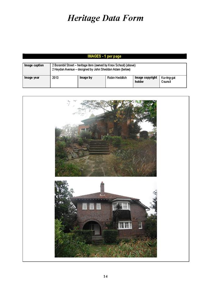
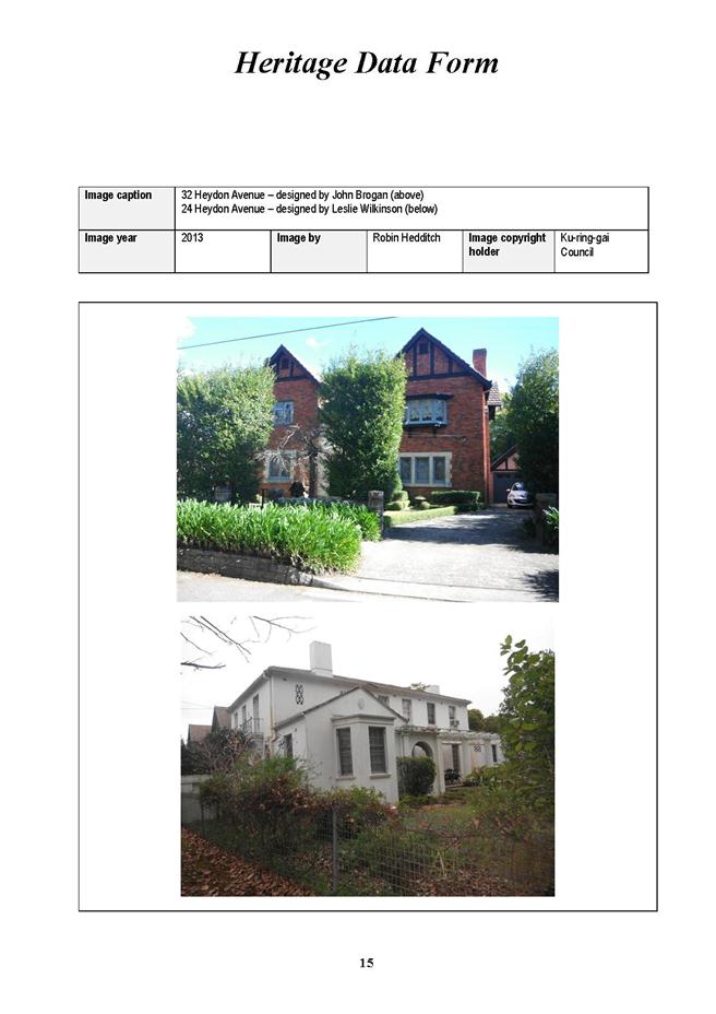
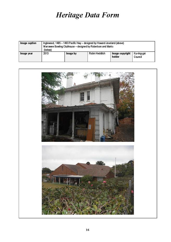
|
APPENDIX No: 15 - Complying Development Provisions for Dwelling houses in E4 zones |
|
Item No: GB.14 |
ATTACHMENT
Proposed Complying Development Provisions for Dwelling Houses in E4 Environmental Living Zone
It is recommended that Schedule 3 Part 1 of the draft LEP be amended by including the following as complying development:
Dwelling houses
In E4 Environmental Living zones;
1. in accordance with Part 3 Housing Code in State Environmental Planning Policy (Exempt and Complying Development) 2008, but excluding Clauses 3.9, 3.10, 3.11 and 3.24;
2. the development must not be located within land identified by clauses 6.6 or 6.7 of this LEP, or on Class 1-4 lands identified in Clause 6.8;
3. the development must meet the following development standards:
Landscaped Area
i) On sites on the low side of the street which drain to bushland, the landscaped area of the dwelling house and all ancillary development draining to a dispersal trench system, infiltration trench system or rain garden must be a minimum of 65%.
ii) The landscaped area of the dwelling house and all ancillary development on any other site must be in accordance with the following table:
Table
|
Site Area (m2) |
Minimum Landscaped Area % |
|
Less than 850m2 |
SA x 0.5 |
|
850m2 or greater |
SA x [0.5 +(SA-850)/6,500] |
Note: Where SA is the Site Area (m2)
Example: The built upon area for a 1100m2 lot is as follows:
1100 x [0.5 + (1100 - 850)/6500]
= 1100 x [0.5 + (250)/6500]
= 1100 x [0.5 + 0.038]
= 1100 x 0.538
= 592 m2
iii) For alterations and additions on sites where the existing landscaped area is less than that listed above, the minimum landscaped area is the existing landscaped area.
iv) Plans must include built elements, such as pathways, normally associated with a residential property.
v) The front setback for any development for a dwelling house must have a minimum landscaped area of 70%.
Floor space ratio
i) The maximum floor space ratio for the dwelling house and all ancillary development on the site is not to exceed the relevant floor space ratio determined in accordance with the following table:
Table
|
Site area (m2) |
Maximum FSR |
|
> 1,500 m2 |
((250 + (0.15 × site area)) / site area):1 |
|
> 1,000 ≤ 1,500 m2 |
((170 + (0.20 × site area)) / site area):1 |
|
> 800 ≤ 1,000 m2 |
((120 + (0.25 × site area)) / site area):1 |
|
≤ 800 m2 |
0.4:1 |
Maximum floor area for outbuildings
i) The floor area of an outbuilding on a site must not be more than the following:
a) 36m2, if the lot has an area of less than 300m2,
b) 45m2, if the lot has an area of at least 300m2 but less than 600m2,
c) 60m2, if the lot has an area of at least 600m2.
Dwelling House Alterations
In E4 Environmental Living zones;
1. In accordance with Part 4 Housing Alterations Code in State Environmental Planning Policy (Exempt and Complying Development) 2008.
Demolition
In E4 Environmental Living zones;
1. In accordance with Part 7 Demolition Code in State Environmental Planning Policy (Exempt and Complying Development) 2008.
|
APPENDIX No: 16 - Amendments to Signage Provisions in Draft KLEP |
|
Item No: GB.14 |
SCHEDULE
2 – Exempt development
Signage – General requirements
(1) All signage must relate to the land on which the signage is located or to premises on the land and specify one or more of the following particulars:
(a) the purpose for which the land or premises is or are used,
(b) the identification of a person residing or carrying on an occupation or business on the land or premises,
(c) a description of an occupation or business referred to in paragraph (b),
(d) particulars of the goods or services dealt with or provided on the land or premises.
(2) Must not be placed on vehicles unless the vehicle is being used for the conveyance of passengers or goods (or both) to and from points of destination.
(3) Must not be located on stationary vehicles parked on roads, including trailers principally for the purpose of advertising and must not be parked on roads:
(a) other than directly in front of the business premises,
(b) other than directly in front of the residential premises of the business owner.
(4) Must not be located on land that comprises, or on which there is, a heritage item.
(5) Must be non-moving, non-flashing and non-inflatable.
(6) Must be attached to front fence or within the boundary of the land to which it applies unless in a business or an industrial zone.
(7) Must not be illuminated except where stated otherwise in this schedule.
(8) Must be at least 600mm from any public road.
(9) If located above a public footpath, the underside of the sign must be at least 2.6m above the footpath.
(10) Must relate to the lawful use of the building (except for temporary signs).
(11) Must reflect the character and style of the building on which the sign is located.
(12) Must not be an A-frame sign.
(13) Must have the consent of the owner of the property or building on which the sign is located.
(14) The use of banner signs must not be for commercial purposes.
(15) Must not advertise a third party, activity or trade other than that associated with the building to which the sign is attached.
(16) Must not be hoarding signs, painted bulletins or advertisements in the nature of posters (except newsagents headlines) or stickers affixed to the exterior of the building.
(17) Must not be above awning level, except for building identification signs.
(18) Must not be affixed to or attached to telephone booths, trees, poles, signs, shelters, sheds, bins and the like.
Signage - building identification signs generally
(1) Must meet the general requirements for signage.
(2) Must be attached to gateways, fences or building facades only.
(3) Must measure not more than 2.5m2 except where otherwise stated in this schedule.
(4) Must not be located more than 3m above ground level (existing).
(5) Only 1 sign per building street frontage.
Signage- business identification signs for businesses other than sex services premises in business zones
(1) Must meet the general requirements for signage.
(2) Under awning sign
Sign must be attached to the underside of an awning other than a fascia or return end, and
(a) must meet the general requirements for advertisements,
(b) only 1 sign per ground floor premises with street frontage,
(c) maximum length of 2.5m,
(d) maximum height of 0.3m,
(e) must be erected in a horizontal location at right angles to the building façade,
(f) must have a minimum clearance of 2.6m underside of the sign, measured from the ground / pavement level,
(g) must be separated by at least 3m from other under awning signs,
(h) must not project beyond the awning fascia,
(i) must be set back at least 600mm from the face of the kerb,
(j) may be either illuminated and non-illuminated,
(k) if illuminated:
(i) must be connected to an automatic timer,
(ii) must be illuminated only between the hours of 6 am and 10.30 pm,
(iii) illumination must be concealed in, or integral to, the sign,
(iv) cabling to signs musts be concealed,
(v) must use LED diode technology or a lighting source of equivalent efficiency,
(vi) must not use red, amber and green if within 60m of a signalised intersection.
(3) Flush wall sign
Sign must be attached to the wall of a building (other than the transom of a doorway or display window) and not projecting more than 50mm, and
(a) must meet the general requirements for advertisements,
(b) maximum area of 2.5m2,
(c) only 1 sign per building street frontage,
(d) must not be located more than 3m above ground level (existing).
Note: For the purpose of this section, flush wall sign means a sign other than a hoarding that is attached to the wall of a building which does not project horizontally more than 50mm from the wall.
(4) Top hamper sign
Sign must be attached to the transom of a doorway or of a display window of a building, and
(a) must meet the general requirements for advertisement,
(b) only 1 sign per premises street frontage,
(c) must not extend below the level of the head of the doorway or window above which it is attached,
(d) must have a maximum length of 4m,
(e) must not exceed 400mm in height,
(f) must not project more than 150mm from the building façade.
(5) Fascia signs
Sign must be attached to the fascia or return of the awning, and
(a) must meet the general requirements for advertisements,
(b) 1 sign per premises or 1 per street frontage,
(c) must not project above, below or beyond the fascia or return end of the awning to which it is attached.
Signage - business identification signs in residential and environmental living zones
(1) Must meet the general requirements for signage.
(2) Only 1 sign per premises.
(3) Maximum area of 0.24m2.
(4) If a pole or pylon sign, maximum height of 2m.
(5) Must not be located more than 3m above ground level (existing).
(6) Must not be illuminated.
(7) Must be located wholly within the property boundaries of the land to which the sign relates.
Signage - changes to wording or content of approved signs
(1) Must meet the general requirements for signage.
(2) The existing sign must have been lawfully erected.
(3) Must not result in any additional signage or increase in signage area, unless permitted otherwise in this Schedule.
Signage - construction signs (temporary)
(1) Must meet the general requirements for signage.
(2) Must not be illuminated or flashing at any time.
(3) Must be located wholly within property boundaries of the land to which the sign relates, or be flush mounted and attached to the front fence or front wall.
(4) Only 1 sign per property.
(5) Must not exceed 2.5m2.
(6) Must not be located more than 3m above ground level (existing).
(7) Must include all information required in the relevant condition of development consent or the complying development certificate.
(8) Must be removed within 14 days of the completion of all construction work.
Signage- real estate and property promotion signs (advertising premises or land for sale or lease)
(1) Must meet the general requirements for signage.
(2) Must be within the boundary of the property to be sold or leased or currently under construction, unless located on either the awning of the building or attached to the front fence or wall of the building.
(3) Only 1 sign per premises, except:
(a) on inspection day, when directional signs not more than 0.8m2 in area may be erected within the property during the advertised hours of inspection,
(b) on the day of sale by auction, when bunting may be erected fully within the property, provided that it is removed promptly after the auction.
(4) Must be removed within 14 days of the completion of the sale or granting of the lease, or 1 year after erection, whichever is the sooner.
(5) Direction signs not more than 0.8m2 in area may be erected on inspection day in front of the property during the advertised hours of inspection.
(6) All signage is to be erected within the confines of the property to which it refers. Bunting and sandwich boards may be used on the day of sale by auction provided that they are within the property and promptly removed after the sale.
(7) The erection of signs on telegraph poles, street trees, sign posts, road traffic facilities or the like, is prohibited.
(8) The maximum size of signboards is as follows:
(a) Where single dwellings, dual occupancy development or single units within multi-unit housing are being advertised for sale the maximum signboard size is 1.15m2,
(b) Where commercial or industrial premises are being advertised the maximum signboard size is 4.5m2,
(c) Where premises other than those listed in i) and ii) above are being advertised for sale the maximum signboard size is 2.5m2.
Signage – internal shopfront window sign in business zones (other than sex services premises)
(1) Must meet the general requirements for signage.
(2) Maximum area of 2.5m2.
(3) Must not occupy more than 20% of the area of the window.
Signage - temporary signs for religious, cultural, social or recreational events
(1) Must meet the general requirements for signage.
(2) Only 1 per street frontage.
(3) Must be located entirely within the property at which the event is taking place, unless the sign is a banner located at a Council-approved banner location.
(4) If the sign is a banner as described in item (3):
(a) maximum size of 2.8m × 1.0m,
(b) must be securely attached to poles.
(5) If the sign is not a banner as described in item (3):
(a) maximum area of 1.5m2,
(b) maximum location of 3m above ground level (existing).
(6) Must not include commercial advertising apart from name of the event sponsor/s.
(7) Must not be displayed earlier than 14 days before, or later than 2 days after, the event.
|
APPENDIX No: 17 - Amendment to Special Events clause in Draft KLEP |
|
Item No: GB.14 |
SCHEDULE 2 – Exempt development
Special events (including markets)
(1) Held by or on behalf of Council, and conducted in accordance with Council’s “Special Events Guidelines”.
(2) Must be social, family, corporate, religious, or community functions, markets or events.
(3) If located on Council owned or managed land:
(a) must not occur outside the standard hours of operation for that land;
(b) must be formally booked with Council;
(c) all relevant fees are paid to Council prior to the event.
(4) Must not contravene any specific condition of development consent that applies to the land on which they will be held;
(a) must not occur outside the standard hours of operation for the land;
(b) must have a duration of not more than 7 days over any 3 month period.
(5) If located on private land, must be located on land supporting:
(a) a place of public worship;
(b) educational establishment;
(c) hospital;
(d) community facility;
(e) residential care facility; or
(f) child care centre.
(6) Not more than 2000 people attend the event at any one time, or if the event is held at St Ives Showground, Bicentennial Park or the SAN Hospital, not more than 5000 people must attend the event at any one time; or, if the event is held at Wahroonga Park, not more than 3500 people must attend the event at any one time.
(7) All lighting must be directed away from the residential properties.
(8) Must not involve laser shows or bonfires.
(9) Must notify Council if any fireworks are to be used.
(10) Must ensure any temporary structures and amusement devices are structurally sound, and erected and used in accordance with the manufacturer’s instructions.
(11) If the event will disrupt normal traffic and transport systems:
(a) a detailed Local Traffic Management Plan must be submitted to Council in accordance with Council’s requirements and approved prior to the event.
(b) the local police must be informed at least 7 days in advance and relevant requirements of NSW Police are to be met.
(c) not less than 7 days prior to the event, written notice of the special event must be given to any residential properties within a 200m radius of the land at which the event is to be held to advise the time, date and type of event.
(12) Arrangements must be made for the collection and disposal of waste and recyclable materials by an authorised trade waste contractor.
(13) Adequate provision of sanitary facilities must be made for all anticipated staff and patrons.
(14) Temporary food premises, stalls and mobile vendors must comply with Council’s Food Premises Code and/or Food Vending Vehicles Code, as applicable.
Notes1. Small events and gatherings that do not involve erection of temporary structures, erection of amusement devices or disruption to normal traffic and pedestrian flows and are events for which the land has been designed are not considered to be special events and will not require any form of development consent. Such activities include family picnics, regular sports training or games, casual exercise, and passive enjoyment of a park.
2. Provisions of the Local Government Act 1993 may also apply, including Plans of Management and Alcohol Free Zones.
3. Council’s Open Space Booking Policy also applies.
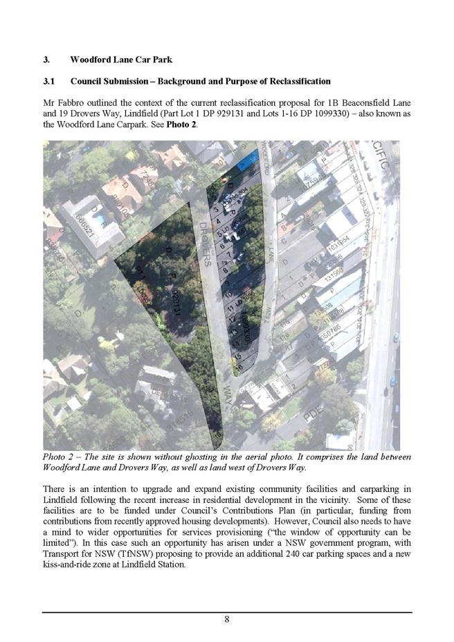
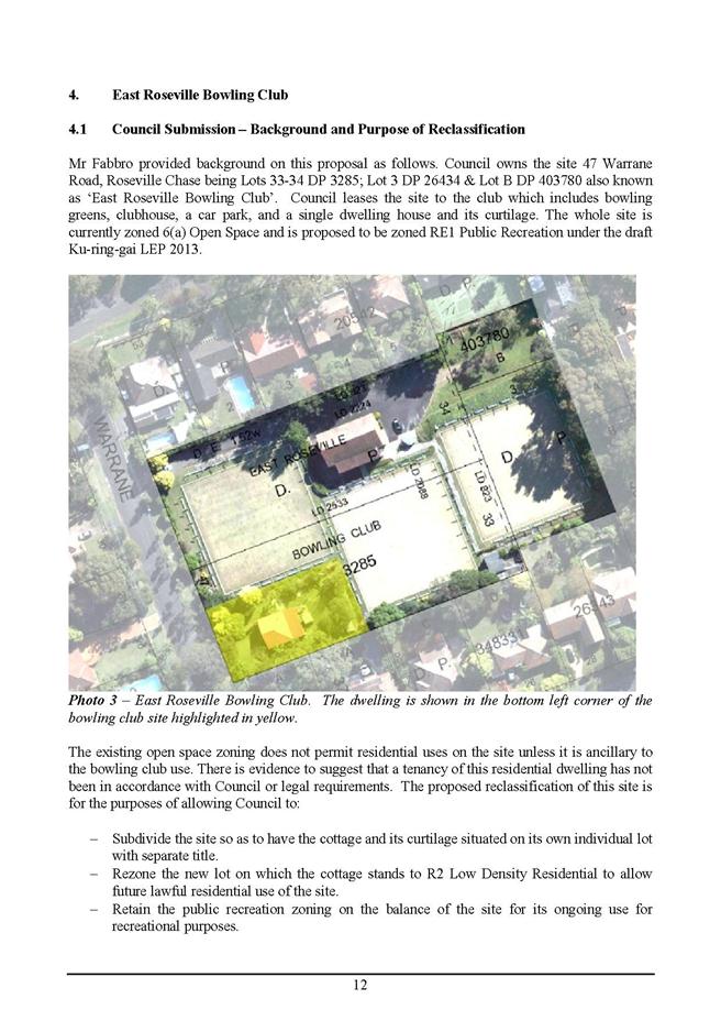
|
Ordinary Meeting of Council - 26 November 2013 |
GB.15 / 491 |
|
|
|
|
Item GB.15 |
DA0170/13 |
|
|
18 November 2013 |
development application
Summary Sheet
|
Report title: |
14-18 Woniora Avenue, Wahroonga - Demolition of Existing Dwellings and Construction of a Residential Flat Building comprising 25 Apartments, Basement Car Parking and Associated Landscaping |
|
ITEM/AGENDA NO: |
GB.15 |
|
Application No: |
DA0170/13 |
|
Property Details: |
14, 16, 18 Woniora Avenue, Wahroonga Lot & DP No: 85, 86, 87 of 2666 Site area (2733m2): Zoning: Residential 2(d3) |
|
Ward: |
|
|
Proposal/Purpose: |
Demolition of existing dwellings and construction of residential flat building comprising 25 apartments, basement car parking and associated landscaping. |
|
Type of Consent: |
Integrated |
|
Applicant: |
Max Lucas |
|
Owner: |
Sheer Developments Pty Ltd, Krikis Nominees Pty Ltd, Duhart Holdings Pty Ltd |
|
Date Lodged: |
27 May 2013 |
|
Recommendation: |
Approval. |
Purpose of Report
To determine development application No.170/13 for demolition of existing dwellings and construction of residential flat building comprising 25 apartments, basement car parking and associated landscaping at 14-18 Woniora Avenue, Wahroonga.
Executive Summary
|
Property |
14-18 Woniora Avenue Wahroonga NSW 2076 |
|
Lot & DP |
Lot 85 DP 2666 |
|
Proposal |
Demolition of existing dwellings and construction of residential flat building comprising 25 apartments, basement car parking and associated landscaping |
|
Development application no. |
DA0170/13 |
|
Ward |
Wahroonga |
|
Applicant |
Max Lucas |
|
Owner |
Sheer Developments Pty Ltd, Krikis Nominees Pty Ltd, Duhart Holdings Pty Ltd |
|
Date lodged |
27 May 2013 |
|
Submissions |
Yes (2) |
|
Land & Environment Court |
N/A |
|
Recommendation |
Approval |
|
Assessment Officer |
Grant Walsh |
|
|
|
|
LEGISLATIVE REQUIREMENTS: |
|
|
|
|
|
Zoning |
Residential 2(d3) |
|
Permissible under |
KPSO |
|
Relevant legislation
|
SEPP 55 SEPP (BASIX) 2004 SEPP65 SEPP Infrastructure 2007 SREP 20 – Hawskbury Nepean River KPSO Draft Ku-ring-gai Local Environmental Plan 2013 DCP 31 - Access DCP 40 – Waste Management DCP 43 – Car Parking DCP 47 – Water Management DCP 55 – Multi-unit housing DCP 56 – Notification Council’s Riparian Policy Section 94 – Development Contribution Plan |
|
Integrated Development
|
YES (NSW Office of Water)
|
HISTORY
Site history
The site has historically been used for residential purposes.
Rezoning history
The site was previously zoned ‘Residential 2(c)’ under the KPSO.
On 28 May 2004, Local Environmental Plan 194 was gazetted, rezoning the site to Residential 2(d3) which permits five storey residential flat development.
Previous development application history
DA0114/12
On 27 September 2012, DA0114/12 for demolition of existing dwellings and construction of a residential flat building comprising 25 apartments, basement car parking and associated landscaping was refused under delegated authority. The reasons for refusal related to the following issues:
1. Urban design issues, failure to satisfy SEPP65/RFDC
2. The application fails to demonstrate that the development would comply with DCP 47 Water management
3. The application fails to demonstrate that the development would comply with DCP 40 (Waste Management)
4. Failure to satisfy SEPP (BASIX)
5. Deep Soil non compliance
6. Mechanical plant and
7. Residential amenity (DCP 55)
Current application history
11 February 2013 pre-DA meeting with applicant
27 May 2013 development application lodged
30 May 2013 Council requested correct owner’s consent be submitted
7 June 2013 application notified for 30 days
11 July 2013 NSW Department of Water’s comments forwarded to applicant
12 August 2013 correspondence sent to applicant raising issues with proposal
20 August 2013 meeting held with applicant to discuss Council’s concerns
1 October 2013 amended plans received
21 October 2013 revised driveway section details received
23 October 2013 final amended landscape plan received
THE SITE AND SURROUNDING AREA
Site description
|
Visual character study category: |
1920 – 1945 |
|
Easements/rights of way: |
No |
|
Heritage Item: |
No |
|
Heritage conservation area: |
No |
|
In the vicinity of a heritage item: |
Yes, No. 8 Woniora Avenue and No. 7 Burns Road, Wahroonga. |
|
Bush fire prone land: |
No |
|
Endangered species: |
Yes (mixture of STIF and BGHF) |
|
Urban bushland: |
No |
|
Contaminated land: |
No |
The development proposal encompasses three (3) allotments which are located on the corner of Woniora Avenue and Woonoona Avenue North, Wahroonga. The site is located in close proximity to the Sydney-Newcastle M1 freeway to the east and the north shore rail line to the south of the site. The site details are as follows:
· 14 Woniora Avenue, Wahroonga, Lot 87 in DP 2666.
· 16 Woniora Avenue, Wahroonga, Lot 86 in DP 2666.
· 18 Woniora Avenue, Wahroonga, Lot 87 in DP 2666.
The site is a corner allotment and is slightly irregular in shape with an angled rear boundary, a frontage of 49.885 metres to Woniora Avenue and 48.73 metres to Woonona Avenue North, and a total site area of 2733sqm. A natural watercourse traverses the site at the front north-western corner. The site falls from the rear south-eastern corner (RL177.99) to the front north-west corner (RL176.36) at an average gradient of approximately 2%.
Existing development on the site includes three detached dwelling houses.
Existing vegetation on site is characterised by an established landscape setting with mature trees and shrubs within garden beds and grassed areas. There are numerous dead trees across the site. All trees on site have been planted with no remnant endemic tree specimens or remnant bushland. The most visually dominant tree is a mature Camphor laurel (Cinnamomum camphora) located adjacent to the south-western site corner.
Surrounding development
The surrounding area exhibits a transition from low density residential houses, (zoned 2d3) to higher density multi-unit developments (constructed or undergoing construction). A two storey town house development is located to the east of the site at 12 Woniora Avenue, Wahroonga.
THE PROPOSAL
The proposal is for the demolition of the existing three dwellings and associated structures and construction of a five storey residential flat building containing 25 dwellings with the following unit mix:
· 21 x 3 bedroom dwellings
· 4 x 2 bedroom dwellings
There are two (2) levels of basement carparking containing a total of 53 parking spaces comprised of 7 visitor parking spaces (including 1 disabled and combined visitor/carwash bay) and 46 residential spaces (including 3 disabled residential spaces). Vehicular access to the basement is from the north-eastern corner of the site (Woniora Avenue).
The building includes two lift cores with the primary pedestrian entrance being from the Woniora Avenue frontage. A secondary rear (southern) entrance is located at the south-west corner of the site (Woonona Avenue) and adjacent to the southern side boundary.
Landscaping is configured to include a communal landscaped open space area to the eastern centre of the development and within the frontage of the development.
The proposal also includes stormwater drainage works.
COMMUNITY CONSULTATION
In accordance with Development Control Plan No. 56, owners of surrounding properties were given notice of the application. In response, submissions from the following were received:
1. David and Joan Hart, 2/12 Woniora Avenue, Wahroonga
2. Masako Grime, 1/12 Woniora Avenue, Wahroonga
The submissions raised the following issues:
Loss of privacy to the townhouses located at 12 Woniora Avenue, Wahroonga, including request for shutters to be located on the western elevation of the proposed building
The proposal complies with Council’s setback provisions and building separation requirements. It is further noted that ground floor courtyards have 1.8 metres high slatted fences which will assist in interrupting lines of sight between properties. The upper level rooms of the building that are orientated toward 12 Woniora Avenue are all bedrooms and bathrooms which are generally considered to have less impacts than that of a living room or kitchen due to their much lower intensity of use. There are upper level terraces which are orientated toward 12 Woniora, however given their building separation compliance, the proposed landscaping scheme and the driveway location at 12 Woniora Avenue, the likely privacy impacts of the proposal are considered acceptable.
Proposed courtyards are located within the 6 metres setback adjoining the eastern boundary.
Development Control Plan 55 allows private courtyards to extend into the side setback area. The proposal complies with Council’s requirements in this respect. It is further noted that sufficient landscaping and courtyard fencing is proposed to provide for amenity between the two developments.
Loss of sunlight to the townhouses at 12 Woniora Avenue
Shadow diagrams have been submitted with the development application and verified by the assessing officer as to their accuracy. The proposal is located almost due west of the existing townhouses (3 in total) at 12 Woniora Avenue. The diagrams indicate that the proposal would not impact the townhouse closest to Woniora Avenue and would not impact the remaining 2 townhouses between 9 am and 12 pm on the winter solstice. The proposal would overshadow the 2 rear townhouses from approximately 2 pm, however, the proposal meets Council’s requirements in providing at least 3 hours of solar access to the adjoining developments.
Concerns regarding vibration and noise levels during construction
Specific conditions are recommended (Conditions 23 and 50) which require the monitoring of vibration levels during construction. Noise and disturbance from construction is further regulated via a condition relating to the approved hours in which works can be undertaken at the site (Condition 47).It is inevitable that some noise and amenity impacts will occur throughout the construction phase, however, these are ephemeral and are regulated in accordance with accepted industry standards.
Concern that the existing dwellings to be demolished could contain asbestos and request that removal is undertaken in accordance with approved standards
Condition 5 ensures that should asbestos be found on the development site, its removal must be undertaken in accordance with the established workcover requirements which includes notification to adjoining residents.
Request that Council supervises placement of footings to ensure building is located outside of the 6 metres setback requirement
Construction work must be carried out in accordance with the approved plans and development consent. A Principal Certifying Authority (which could either be Council of a Private Certifier) must be nominated and is required to ensure the development is constructed in accordance with the development consent.
Request that truck movements during construction are via Woonona Avenue and not Woniora Avenue due to existing congestion
It is likely that truck movement will have to use Woniora Avenue. Council’s Development Engineers have conditioned the requirement for a Construction Traffic Management Plan (Condition 12) which must be submitted to Council for approval prior to any works commencing on site.
Overbearing size of the proposal and its visual impact on the townhouses at 12 Woniora Avenue
The proposal complies with Council’s height, Floor Space Ratio (FSR), number of storeys, deep soil area and setback requirements. The proposal is consistent with the zoning and development controls applicable to the site.
The proposal does not fit the desired style of the street given its size
Council’s Urban Design Consultant supports the proposal as it generally complies with the planning controls governing streetscape and built form and is acceptable in terms of the urban design criteria of SEPP65.
The upper floors of the development should be set further back from the lower levels of the building to reduce bulk and scale
The top floor of the building complies with the DCP 55 provision that limits it to a maximum 60% of floor area of that of the floor immediately below it.
The proposal will result in a loss of vegetation on site
Council’s Senior Landscape Assessment Officer has determined that the proposal would result in an acceptable outcome in terms of tree loss and replenishment. Refer to Council’s Landscape Officer’s comments below.
Impacts of increased traffic on the local road network
Council’s Development Engineer has reviewed the proposal and the submitted traffic and parking assessment and has concluded that the proposal is satisfactory subject, to conditions. Refer to comments below from Council’s Development Engineer.
Impacts of construction traffic on the local road network
Condition 12 requires a construction traffic management plan which must be submitted to Council for approval prior to any works commencing on site.
Amended plans dated 26 September 2013
Amended plans were received on 1 October and 21 October in response to Council’s correspondence of 12 August 2013. The following amendments were made:
i. The balcony area for Units 13, 14, 19 and 20 was increased to meet the 12m² requirement;
ii. The ground floor corridor adjacent to the lifts and at the secondary exit was increased in width to meet the 1.5 metres requirements of DCP 55, similarly the clearance in front of the lift on the basement levels and on the topmost floor was increased in width to meet the 1.8 metres requirement.
iii. Letterbox location was added to the ground floor plan
iv. Stormwater grates that were located on the front entry path have been relocated
v. Stairs were provided down from the lift from the upper levels of the split level carpark so that pedestrians are not forced to walk down vehicular ramps
vi. The sliding doors from the ground floor lobby to the courtyard have been replaced with self-closing swing doors for security as requested.
vii. The bedroom wardrobes in Unit 9 were relocated so as to achieve minimum bedroom dimensions
viii. Windows were added to the kitchens of Units 9, 15, 21 and 23 and to the ensuites of Units 23 and 25
ix. The levels in the basement have been revised and the 14:8 ramps have been replaced with 1:20 and 1:40 ramps to provide the required access between the accessible parking spaces and the lifts as requested.
x. Amended BASIX certificate was submitted to ensure consistency with plans
Given the minor nature of the amendments, the amended plans did not result in greater environmental impacts than the original proposal and therefore did not require notification pursuant to DCP 56.
INTERNAL REFERRALS
Urban design
Council's Urban Design Consultant reviewed the application against the provisions of SEPP 65 and provided the following comments:
PRINCIPLE 1: CONTEXT
Good design responds and contributes to its context. Context can be defined as the key natural and built features of an area. Responding to context involves identifying the desirable elements of a location’s current character or, in the case of precincts undergoing a transition, the desired future character as stated in planning and design policies. New buildings will thereby contribute to the quality and identity of the area.
The site is on the south-eastern corner of Woniora Avenue and Woonona Avenue, Wahroonga and is approximately 520m walk from the entrance of Wahroonga Station via Woonona Avenue.
The site is zoned 2(d3) under KLEP194. The site is bounded to the east and south by properties that are also zoned 2(d3). Located to the immediate east is a townhouse development at 12 Woniora Avenue. Further to the east is 8-10 Woniora Avenue zoned 2(c2).
Whilst 12 Woniora Avenue appears to be isolated as per KDCP55 6 C-1, with a frontage of approximately 17m and an area of approximately 1,060m2, there are several factors which make this situation acceptable. The townhouses appear to have been built and sold relatively recently, circa 2002, making the development therefore only about ten years old. Based on its age, land value, and the fact that it is strata-ed, redevelopment becomes more unlikely. The presence of the townhouses is actually in some ways desirable from an urban design point of view, as they create a more gradual transition in scale from the proposal to the heritage item at 8 Woniora Avenue along the streetscape. Notwithstanding this, if redevelopment of 12 Woniora Avenue became desirable, the DA process for 31-33 Millewa Avenue & 24 Neringah Avenue (DA0626/11), encountering a similar situation with 35 Millewa Avenue (which is a similarly sized and shaped property), demonstrated schematically that 35 Millewa Avenue was in fact re-developable within the controls. 12 Woniora Avenue and 35 Millewa Avenue may even be able to amalgamate in that circumstance. The isolation of 12 Woniora Avenue is not considered to be an issue in these circumstances.
PRINCIPLE 2: SCALE
Good design provides an appropriate scale in terms of the bulk and height that suits the scale of the street and the surrounding buildings. Establishing an appropriate scale requires a considered response to the scale of existing development. In precincts undergoing a transition, proposed bulk and height needs to achieve the scale identified for the desired future character of the area.
The scale of the proposal is considered generally acceptable, with the exception of the following items to be addressed.
The southern setback of the topmost floor and habitable windows to Unit 23, scale at less than 9m from the boundary. This is less than an equitable half (either side of the boundary) of the required 18m separation required by KDCP55 4.5.2 C-2 and RFDC p28 (via p59) and is non-compliant. However, it appears from drawing DA2-00 'Site analysis', if it is correct, that the uppermost floor of 37-41 Millewa Avenue is set back further than 9m, so potentially adequate separation may be achieved. This aspect should be verified.
The separation distance across the courtyard between Unit 23 and Unit 25 on the topmost floor scales at 17m. The 'study/tv' room of Unit 23 is considered to be a habitable room, therefore the separation of it from Bed 3 of Unit 25 is non-compliant. This aspect should be adjusted.
Planner’s comments
The approved development at 37-41 Millewa has a setback of greater than 9 metres and the proposal therefore complies with Building separation requirements in this respect. It is agreed that the proposal does not comply with building separation between units within the “U” shaped area of the design with a 17 metres separation instead of the required 18 metres. Given the minor non-compliance, and that the building exceeds amenity requirements in terms of natural ventilation and daylight access the proposal is nevertheless considered acceptable in this respect.
PRINCIPLE 3: BUILT FORM
Good design achieves an appropriate built form for a site and the building’s purpose, in terms of building alignments, proportions, building type and the manipulation of building elements. Appropriate built form defines the public domain, contributes to the character of streetscapes and parks, including views and vistas, and provides internal amenity and outlook.
Site coverage is stated as being 34.9%. This figure is compliant with KLEP194 25I (6).
The setback to Woonona Avenue is less than the 13-15m required by KDCP55 4.3 C-2 and is non-compliant. However, although KDCP 4.3 C-5 applies, the argument for a lesser setback to this street frontage is considered to be well made (SEPP65 Design Statement p3) from an urban design point of view. KDCP55 4.3 O-4 requires that 'a consistent urban form providing definition to the street edge' be achieved. The lesser 10-12m setback achieves this better than a 13-15m setback would by aligning with the western wall of the proposed 37-41 Millewa Avenue development, as seen in DA2-01 'Site plan.' However, in terms of the impact of the proposal along this setback on the open water course, please see PRINCIPLE 6: LANDSCAPE.
KDCP55 4.3 C-3 states that 'The setback extends both above and below ground and applies to all built elements of the development including car parking.' Combined with the 40% control at KDCP55 4.3 C-1 (b2), it is unclear whether the extent of car park located within the setback zone is compliant or not. This aspect should be verified. For reference, the same issue was encountered at 11-21 Woniora Avenue (DA0951/10). This aspect also goes towards the impact of the proposal on the open water course (please see PRINCIPLE 6: LANDSCAPE).
The balcony area for Units 13, 14, 19 and 20 scales at under 12m2. These should be amended.
The ground floor corridor adjacent to the lifts, and at the secondary exit scales, at less than the 1.5m required by KDCP55 4.5.4 C-5 and is non-compliant. Similarly, the clearance in front of the lift on the basement levels and on the topmost floor, scales at less than 1.8m. These aspects should be amended.
There does not appear to be manoeuvring area and a space for temporary parking of service and removalist vehicles within the basement as required by KDCP55 5.1 C-4.
Planner’s comments
The plans have been amended to ensure that the balcony areas of Units 13, 14, 19 and 20 achieve the minimum 12m² area requirement. The plans were further amended to ensure the required corridor widths and the required widths adjacent to the lifts are achieved. Council’s Development Engineer has confirmed that the basement is compliant with vehicle manoeuvring requirements. The basement does not comply with the setback requirements of DCP 55 to Woonona Avenue North but is consistent with the adjoining site and is considered acceptable. For a detailed discussion refer to the DCP 55 assessment in this report.
PRINCIPLE 4: DENSITY
Good design has a density appropriate for a site and its context, in terms of floor space yields (or number of units or residents). Appropriate densities are sustainable and consistent with the existing density in an area or, in precincts undergoing a transition, are consistent with the stated desired future density. Sustainable densities respond to the regional context, availability of infrastructure, public transport, community facilities and environmental quality.
FSR appears to comply
PRINCIPLE 5: RESOURCE, ENERGY AND WATER EFFICIENCY
Good design makes efficient use of natural resources, energy and water throughout its full life cycle, including construction. Sustainability is integral to the design process. Aspects include demolition of existing structures, recycling of materials, selection of appropriate and sustainable materials, adaptability and reuse of buildings, layouts and built form, passive solar design principles, efficient appliances and mechanical services, soil zones for vegetation and reuse of water.
The environmental performance of the proposal is generally considered good with adequate solar access and exceptional cross ventilation, however an exception are the several units that are greater than 8m to the rear of the kitchen or dining room (see PRINCIPLE 7: AMENITY). The depth of these apartments will lead to unnecessary energy consumption and cost, as artificial lighting and mechanical ventilation will be encouraged, and should be addressed.
Planner’s comments
It is agreed that unit’s depths which are greater than 8 metres and therefore non-compliant with the Residential Flat Design Code are proposed. The RFDC indicates that this may occur where it is demonstrated that adequate natural ventilation and daylight access has been achieved. The proposal substantially exceeds the daylight access and natural ventilation requirements of the RFDC and is therefore considered acceptable.
PRINCIPLE 6: LANDSCAPE
Good design recognises that together landscape and buildings operate as an integrated and sustainable system, resulting in greater aesthetic quality and amenity for both occupants and the adjoining public domain. Landscape design builds on the site’s natural and cultural features in responsible and creative ways. It enhances the development’s natural environmental performance by co-ordinating water and soil management, solar access, micro-climate, tree canopy and habitat values. It contributes to the positive image and contextual fit of development through respect for streetscape and neighbourhood character, or desired future character. Landscape design should optimise usability, privacy and social opportunity, equitable access and respect for neighbour’s amenity, and provide for practical establishment and long term management.
The proposal encroaches into the 10m setback required from the edge of the embankment of an open water course. This issue has come about through the proposal of a non-compliant set back to Woonona Avenue, and potentially a non-compliant occupation of the setback zone by the basement car park (as discussed above in PRINCIPLE 3: BUILT FORM). Notwithstanding the advice from NSW Office of Water, from a design point of view, it is considered that further action could be taken to reduce this encroachment. On the basement levels for instance, it would be possible to remove the north-western most car space on both levels as they are in excess of minimum requirements. Car park storage in this location could be moved also. On the ground floor, the encroaching area of Unit 5 patio could be redistributed to a less sensitive area. However, if Council's landscape and engineering advice finds the level of encroachment acceptable, then it is considered that this urban design advice should defer to their opinion.
Deep soil is stated as being 50.4%. This is compliant with KLEP194 25I (2)(c).
No letterbox location has been shown on the architectural or landscape documentation. These should be provided as per KDCP55 2.1.1 E-10.
Stormwater grates shown in the front entry pathway should be relocated.
Planner’s comments
The front setback and basement location is considered to be acceptable. For a detailed discussion refer to the DCP 55 assessment of the front setback in this report. The plans have been amended to identify the letterbox location and remove the stormwater grates from of the front entry path.
PRINCIPLE 7: AMENITY
Good design provides amenity through the physical, spatial and environmental quality of a development. Optimising amenity requires appropriate room dimensions and shapes, access to sunlight, natural ventilation, visual and acoustic privacy, storage, indoor and outdoor space, efficient layouts and service areas, outlook and ease of access for all age groups and degrees of mobility.
Solar access complies with 18 of 25 (72%) of apartments achieving 3 hours. The use of skylights as the only source to achieve direct solar access to units is not ideal and is not generally supported. Generous clerestory windows in the vertical plane are a superior solution.
DA2-14 'Shadow diagrams' shows that the proposal will have an overshadowing impact on the northern elevation of the development at 37-41 Millewa Avenue. It is likely that the northernmost, central units on the lower floors at Millewa Avenue will experience a significant loss of solar access between 9am and 1pm. However, the proposal is generally compliant with setbacks and height, and there does not appear to be a control that prevents this occurrence
.
Cross ventilation complies with 25 of 25 (100%) of apartments being cross ventilated. This is a very commendable aspect of the proposal, as is the provision of naturally lit and ventilated corridors throughout.
More than 56% of kitchens are naturally ventilated which far exceeds the 25% RFDC Rule of Thumb (p87). It is considered however that an additional four kitchens can and should be provided with a window (9, 15, 21 and 23). Similarly, windows to en suites to Units 23 and 25 are a missed opportunity.
Units 3, 4 and 5 have dining rooms that are greater than 8m from a window. This exceeds the RFDC Rule of Thumb (p69) that 'the back of a kitchen should be no more than 8 metres from a window.' While technically compliant, as it is a dining room, and not a kitchen, it is against the intention of the control which assumes that the kitchen will always be in the rearmost location of an open plan living area. It is considered that these three units should be adjusted so that all habitable spaces are within 8m of a window. A similar issue occurs with Units 13, 14, 19 and 20 which overcome the above Rule of Thumb through reliance on measuring to a re-entrant window to the balcony, which is itself up to 4m removed from the outside face of the building where the daylight and air are available. This unit design is compliant but is not considered best practice. Unit 24 has an internalised 'study/tv' room which is greater than 8m from a window. This space should be adjusted to show built in storage rather than a habitable room.
Both lift cores are typically adjacent to bedrooms. Acoustic measures to address this proximity should be conditioned.
The bedroom wardrobe positions in Unit 9 cause a non-compliance in bedroom dimension. The robes should be moved to the hallway wall.
Planner’s comments
The wardrobe in Unit 9 was amended to ensure compliance with minimum room dimensions and windows have been added, as per the Urban Design Consultant’s recommendation, to the kitchens of Units 9, 15, 21 and 23 and the ensuites to Units 23 and 25. As discussed previously, the RFDC allows for rooms greater than 8 metres where adequate daylight access and natural ventilation has been achieved.
PRINCIPLE 8: SAFETY AND SECURITY
Good design optimises safety and security, both internal to the development and for the public domain. This is achieved by maximising overlooking of public and communal spaces while maintaining internal privacy, avoiding dark and non-visible areas, maximising activity on streets, providing clear, safe access points, providing quality public spaces that cater for desired recreational uses, providing lighting appropriate to the location and desired activities, and clear definition between public and private spaces.
Safety and security is considered generally acceptable.
Stairs down to the lift from the upper levels of the split level car park should be provided so that pedestrians are not forced to walk on driveways and vehicular ramps to access the building.
Sliding doors from the ground floor lobby to the courtyard should be replaced with self-closing swing doors for security.
An additional riser per stair well is required for the proposed floor to floor height of 3.1m to meet BCA standards.
Planner’s comments
The plans were amended to provide the sliding doors, an additional riser per stairwell and pedestrian access within the basement thus overcoming the need to use the vehicle ramp.
PRINCIPLE 9: SOCIAL DIMENSIONS AND HOUSING AFFORDABILITY
Good designs respond to the social context and needs of the local community in terms of lifestyles, affordability, and access to social facilities. New developments should optimise the provision of housing to suit the social mix and needs in the neighbourhood or, in the case of precincts undergoing transition, provide for the desired future community. New developments should address housing affordability by optimising the provision of economic housing choices and providing a mix of housing types to cater for different budgets and housing needs.
The proposed mix of predominantly three bedroom and some two bedroom units is considered to be acceptable. It is understood that the majority of recent residential flat building development applications in Ku-ring-gai have sought predominantly smaller one and two bedroom units, therefore, the provision of mainly larger units on this site is a reasonable in this light.
Three units of typical design are nominated as adaptable. Whilst the adaptability is not fully demonstrated through the documentation, it appears likely that the units will comply given the apartment design.
Disabled access does not appear to have been provided to the primary open space in the north-western corner of the site or to the garbage room. These should be addressed. Similarly, no accessible path of travel has been provided from the disabled visitor car space to the passenger lifts. The current route involves negotiating a 1:8 vehicular ramp which is not compliant with the required 1:14 or 1:20 gradients.
Planner’s comments
The plans were amended to provide compliant disabled access throughout the development.
PRINCIPLE 10: AESTHETICS
Quality aesthetics require the appropriate composition of building elements, textures, materials and colours and reflect the use, internal design and structure of the development. Aesthetics should respond to the environment and context, particularly to desirable elements of the existing streetscape or, in precincts undergoing transition, contribute to the desired future character of the area.
Several major wall planes are greater than 81m2 in area as limited by KDCP55 4.4 C-2 and are non-compliant. The greatest of these is the southern wall which scales at over 200m2, however a large tree to be retained in the south-western corner of the site will reduce the visual impact of this expanse. Other larger walls to the west, north and east are in the order of 150m2 but these are not offensive. Their articulation through tall fenestration openings and material changes are considered to be well managed and effective, even if conservative in appearance. It is considered that the introduction of additional articulation to break down the building will likely be more detrimental than helpful to its appearance. Instead, the introduction of sun shading hoods, particularly to the northern and western facades, is recommended in order to both shade and protect exposed window openings as well as cast some shadow over the larger wall expanses.
All balconies project from the facade more than the 1.2m required by KDCP55 4.4 C-6 and are non-compliant. However, the balconies are also still partially recessed and are made of heavy masonry. These attributes assist them to appear integral to the building, avoiding the appearance of being 'stuck on.' For this reason, the balcony protrusions are considered acceptable in this circumstance.
The materials palette selection is neutral and considered acceptable. In terms of durability, it is considered that less area of render and more face brick would be superior.
CONCLUSION/RECOMMENDATIONS
Generally, the proposal is considered to be consistent with the relevant controls, and certain aspects, such as the 100% cross ventilation, are to be commended. However, there are several issues that it is considered should be resolved before approval is granted. All issues are considered to be able to be resolved with minor design change or verification.
Major issues include: habitable room depths of greater than 8m deep should be adjusted; and provision of disabled access to the primary communal open space, to the garbage room, and from the disabled visitors car space.
Minor issues and non-compliances include: top floor separation across courtyard; balcony areas; corridor widths; service vehicle space and manoeuvring area; providing a letterbox location; removing stormwater grates in the entry path; additional kitchen and en suite windows; adjusting the internalised 'tv/study' room in Unit 24; acoustic issues with bedrooms adjacent to the lift core; moving the wardrobes in Unit 9; providing stairs between split levels of the car park; replacing the sliding doors to the courtyard with a self-closing swing door; additional stair risers; provision of sun shading hoods to the northern and western facades; reducing the amount of rendered wall.
Planner’s comments
As noted within the background section of this report, an issues letter was sent to the applicant on 12 August 2013 raising the above concerns (and other landscaping concerns). A further meeting was held on 20 August during which the issues were discussed which resulted in the submission of amended plans. The Urban Design issues were easily resolved and amendments were made to largely address these minor concerns. Remaining issues associated with the proposal are discussed in detail below.
Landscaping
Council's Landscape and Tree Assessment Officer commented on the proposal as follows:
Tree impacts
The proposed development will result in the removal of numerous trees across the site. No objection is raised to the nominated tree removal as the trees are either exempt species under Council’s Tree Preservation Order, identified as noxious/weed species, in poor health and condition, or not considered significant within the broader landscape setting. The most prominent trees to be removed are mature Cinnamomum camphora (Camphor laurel) which are identified as Class 4 noxious weeds. Tree replenishment planting across the site and within the riparian zone will replenish removed tree canopy in the medium term.
Landscape plan/tree replenishment
The amended landscape design and plans are acceptable.
Riparian planting – refer to ecological assessment
Tree replenishment planting requirements are satisfied with a mix of endemic and exotic tree species proposed throughout the site with the majority of endemic tree species proposed within the riparian corridor.
Stormwater plan
The proposed stormwater drainage works are acceptable on landscape grounds.
BASIX
Numerous landscape areas have been included within the submitted BASIX certificate, for areas of garden and lawn for both communal and private areas. The application appears to be consistent with landscape areas.
Deep soil
By the applicant’s calculations, the proposed development will result in a deep soil landscape area of 1368.4sqm or 50% of the site area. The assessing Landscape Officer is in agreement with the areas included within the deep soil calculable area.
Riparian
An open watercourse traverses the north-western site corner. The watercourse is not specifically identified within Council’s policies or riparian mapping. As the watercourse is piped at each end of the site to traverse beneath Woniora Avenue, it is considered the watercourse would be a Category 3 watercourse (if identified). From a landscape viewpoint the setbacks from the watercourse would satisfy a Category 3 watercourse riparian objective. Refer to Council’s Ecologist assessment report for further detail regarding the VMP and proposed planting within the riparian corridor.
Other issues and comments
Fourth floor/penthouse planters- previous concerns have been satisfactorily resolved in the amended plans.
Engineering
Council's Development Engineer commented on the proposal as follows:
Water management
The site is traversed across its north- western corner by a watercourse, Spring Gully Creek. The NSW Office of Water has advised that the development is not integrated and that no controlled activity approval is required for the works. However, there is a requirement in the letter for a fully tanked basement. See comments below regarding the geotechnical aspects of this work.
The flood report gives recommendations for driveway and ground floor levels, which have been followed in the preparation of the plans.
The BASIX water score of 40% has been achieved with water saving fixtures only and no rainwater retention and re-use. The Stormwater Quality Report refers to a 15 000 litres rainwater tank but it does not seem to be part of the MUSIC model, so appears not to be required.
On site detention is to be provided in a tank between the Ground Floor and Basement 1. The design is satisfactory and the sections provided indicate that adequate headroom will be available under the tank. Stormfilter cartridges are proposed to achieve Council’s water quality targets, as well as enviropods on the surface pits. This is satisfactory.
A pump well is provided for driveway runoff. Please note the requirement of NSW Office of Water for a tanked basement – this will need to be first clarified with the applicant and then incorporated into conditions of consent. The stormwater plans show subsoil drainage around the basement – if NSW Office of Water insists on a tanked basement, a condition could be recommended to delete these in the preparation of the Construction Certificate plans.
Traffic and parking
The site is further than 400 metres from Wahroonga Station, so 46 resident and 7 visitor spaces are required. The basement carpark contains 55 spaces in total, which is compliant. Units 13 and 14 have been provided with single garages, however Units 19 and 20 are the 2 bedroom units, which only require one space. This anomaly could be conditioned if necessary.
The manageable units are 10, 16 and 22, and a parking space suitable for persons with a disability has been provided in the garage for each of these units.
A longitudinal section is provided through the entry driveway. The gradients of the section inside the property boundary have been set by providing a vertical curve instead of straight transitions. This is satisfactory. The traffic report recommends a stop sign at the boundary, however the driver’s eye height will be above the flood training walls and the stop sign is not considered necessary. This could be conditioned.
Waste management
Internal waste collection is required and the waste storage and collection area is located adjacent to the entry drive. The traffic report contains turning paths for the small waste collection vehicle at the first bend. This implies that the truck would stand outside the waste storage area whilst loading. This is not ideal and it would be better if the truck could stand in the visitor/carwash bay. This would be possible, even if the truck then had to proceed further inside to turn. The waste storage and collection arrangements are acceptable.
Construction traffic management
The Construction Management Plan is a fairly general document. It contains the statement that no works zone is proposed. A works zone will be required. The recommended conditions will include a condition that loading or unloading from the street only be undertaken within a works zone. The timing for the works zone can be included in the CTMP to be submitted prior to commencement of works.
Heavy vehicle routes are not indicated. Construction vehicles will not be permitted to use the railway bridge in Wahroonga Village. This would be conditioned.
Council infrastructure
New kerb and gutter and footpath will be required along the site frontage, except directly over the watercourse. A detailed design for these works can be submitted for Council’s approval; prior to the issue of the Construction Certificate.
The condition of the surrounding roads has been raised in submissions. There has been a number of developments approved and constructed in the near vicinity of the site. Each development is required to contribute to Council for repair of damage caused by heavy vehicles on the road network, and works will be carried out using these funds at a suitable time when the bulk of development is complete.
Geotechnical investigation
The same report has been submitted as for DA0114/12. There is no objection to this, as subsurface conditions are not expected to have changed. The recommendations for further investigation, vibration monitoring and dilapidation survey of adjoining structures would be incorporated into conditions of consent.
However, the NSW Office of Water has now required that a fully tanked basement be used (this would seem consistent with the presence of the watercourse within the site, to avoid dewatering), whereas the geotechnical report contains recommendations for short and long term pumping of groundwater seepage. The applicant may wish to provide further hydrogeological advice before conditions are imposed (in the event that the application is to be recommended for approval) which would require a fully tanked basement, as this is a costly form of construction.
The applicant has submitted amended documentation including:
· BASIX Certificate 480035M_02 dated 24 September 2013;
· Millennium Design Consultants letter dated 26/09/13;
· Australian Consulting Engineers Drawing D04 Issue I.
There were no engineering issues raised previously. The basement floor levels on the stormwater plans are now different to those on the architectural plans, but not significantly. The levels can be amended on the Construction Certificate stormwater plans.
The recommended conditions include the requirement of the NSW Office of Water for a fully tanked basement structure.
Ecology
Council's Ecological Assessment Officer commented on the proposal as follows:
This ecological review of the study area was based on the results of a desktop assessment, review of reports and a site inspection by John Whyte, Ecological Assessment Officer of Ku-ring-gai Council on 8 May 2012 and again on 11 July 2013.
Vegetation
The vegetation within the site is highly modified and comprises a mixture of non-endemic native canopy trees e.g. Eucalyptus grandis (Flooded Gum) which have been misidentified as Sydney Blue Gum (Eucalyptus saligna) by the arborist. Numerous exotic Large-leaved Privets, Grevillea robusta (Silky Oak) & Jacarandas were also recorded within the subject property. One native sub-canopy tree identified as a Pittosporum undulatum (Sweet Pittosporum) (Tree 1) occurs within the north-western corner of the subject property. Tree 1 is proposed to be retained.
The understorey vegetation is highly modified and is dominated by exotic grasses and herbaceous weeds. No native shrubs were identified. The vegetation prior to pre-european disturbance would have been a mixture of Blue Gum High Forest (BGHF) & Sydney Turpentine Ironbark Forest (STIF) vegetation.
The proposal seeks to remove a number of planted Flooded Gums, Silky Oaks, Jacaranda and Cypress Pines. The removal of these trees are unlikely to affect foraging habitat for threatened fauna species e.g. the Grey-headed Flying-Fox, as such there removal is supported from an ecological perspective.
Threatened species/habitats
During the site inspection a number of dead Flooded Gums & Silky Oaks were identified across the subject property. Some of the dead trees contained small fissure/hollows which may provide a suitable roosting site for threatened microbat species e.g. Greater Broad-nosed Bat. Conditioned below is the installation of nest boxes to compensate the loss of potential mircobat habitat. The vegetation within the site is unlikely to support threatened flora species due to the degraded nature of vegetation and is not consistent with any endangered vegetation known from the locality.
Riparian
A category 3 watercourse occurs along the western side of the subject property. In accordance with Council’s Riparian Policy a 10m vegetated buffer of full structure vegetation is to be provided along the eastern top of bank (TOB) of the watercourse. The watercourse at present is vegetated, however dominated by exotic shrubs e.g. privets and exotic canopy trees and ground cover vegetation.
A Vegetation Management Plan (VMP) which outlines the criteria for the establishment, management and rehabilitation of the category 3 watercourse has been provided. Implementation of the VMP will enhance, protect and ensure the long-term viability of the watercourse and enhance riparian vegetation within the subject property. The VMP details a suitable selection of appropriate species that are representative of BGHF community that favour riparian vegetation. Soft (Non-sclerophyllic) species have been favoured over sclerophyllic species as they have a lower combustion and would naturally occur within riparian areas.
The VMP describes each task necessary for the implementation of the plan, the duration and priority. Maps, diagrams and plant species lists. The VMP describes the existing vegetation and natural features which are to be retained, proposed vegetation, sediment and erosion control and stabilisation works. The following points below have been addressed within the Vegetation Management Plan.
Vegetation management
|
· Vegetation management objectives · Weed removal methods · Revegetation methods · Habitat creation and
management |
|
Protective measures |
· Protection of existing vegetation · Soil and stormwater management · Erosion and sediment control · Disposal of vegetation and materials on site |
Conclusion
The vegetation management plan is adequate to ensure the protection and enhancement of vegetation within the site. On this basis, the development application is deemed satisfactory and is unlikely to compromise the existing vegetation within the site. The application is supported with conditions.
Heritage
Council's Heritage Advisor commented on the proposal as follows:
Heritage status
The site is not within an Urban Conservation Area.
The site is within the vicinity of several local heritage items being:
· No 7 Burns Road
· No 8 Woniora Avenue
The heritage item at 7 Burns Road is located at the rear of a development site on the opposite side of the road. It is listed for its architectural values as a good example of a Georgian Revival style house designed by the well-known architect, Hardy Wilson. It also has historic/social significance as the house was built for the well-known artist, Lionel Lindsay in 1911.
The house at No 8 Woniora Avenue was originally listed as part of a group of timber houses in Woniora Avenue, which included Nos 8, 10, 11, 12, 14, 15 & 16. The listings to the other properties, including the subject site were removed in following years and some of the land developed. The timber house at No 8 remains largely intact and is considered to be a reasonable example of a timber cottage. It has a high level of historic and some social significance as it was owned by the Nolan family for about a 60 years period and was the home and studio of Sidney Nolan from about 1947 to 1953. The Nolan family retained the cottage until recently. It is known that several major works were painted at the cottage and he won a major art prize while living there.
Background
An application for a residential flat building on the site was submitted in 2012 (DA0114/12). It was refused on several grounds, including urban design SEPP 65 issues and engineering issues. Heritage was not a reason for refusal.
Heritage impact statement
The applicant submitted a HIS, prepared by an experienced heritage consultant. It includes a history of the site, information in the nearby heritage items a discussion of the impacts of the proposed development on the nearby items and concludes that the proposed development:
“will have negligible impacts in the vicinity and is supportable in terms of both its potential heritage and conservation impacts.”
It also finds that:
“The proposed development is 2 doors removed from the subject item and is of a nature and scale that approximates an existing development opposite, though arguably more sympathetic and compatible with the dwelling houses in the area through a mix of face brick and painted render walls. The external materials and colours are recessive/neutral and there are ample grounds for the establishment of substantial mature trees to modulate what impacts the proposal may have.”
Assessment against Controls in DCP 55 for Development Within the Vicinity of a Heritage Item.
Design Controls
C – 1 Setbacks.
Minimum setback is 10 m from the heritage item for the ground and first floor increasing to 15m for the second and third floors. For the purpose of defining the setback, the setback is taken from the closest part of the building.
The control does not apply to the site as it is physically separated from the nearby items.
C- 2 – Screen plantings on the side boundaries of the site should achieve visual screening from the adjoining item with a height of at least 4m.
Landscaping along the boundaries of the site should achieve screening of at least 4m in height. Due to the physical separation of the development site from the nearby items, this control is not critical. However, substantial new planting is proposed.
C – 3 – Respect aesthetic character of nearby heritage item and not dominate
The proposed development is of a contemporary architectural character and not related to the simple vernacular timber heritage item or the Georgina Revival style of the item in Burns Road.
C – 4 – Colours should be complimentary to heritage items
The proposed colours and material are commonly found in the area and the colour range is neutral.
C – 5-The solid component of front and side fences is to be no higher than the fence of the adjoining item and any additional height must be visually transparent.
This control does not directly apply to this site as it does not adjoin a heritage item. However, the Neringah Avenue portion of the site is within a riparian corridor and no fencing is proposed apart from bollards to define the boundary. In the Woniora Avenue frontage outside the riparian zone the application proposes a “garden edge” and plantings to define the boundary. Lapped and capped dividing fences are proposed to the eastern and southern boundaries.
C – 6 – Heritage impact statement to discuss impacts on the item including its garden and setting.
A HIS was submitted with the application
Demolition
The existing buildings on the site, Nos 14, 16 & 18 Woniora Avenue, Wahroonga are not considered to have heritage significance and demolition is acceptable. To be consistent with Council’s policy requiring archival recording of buildings to be demolished for medium density residential development so that in the future there will be records of places before change occurs, a condition of approval will be to undertake an archival standard photographic recording (black & white photography or digital to the NSW Heritage Office guidelines) before works commence on the site (Condition 45). Materials that can be salvaged and easily reused on the site such as sandstone should be retained and reused on the site (Condition 82).
Comments
No 1 to 9 Woniora Avenue has recently been developed for medium density development comprising three separate blocks linked via a basement and walkways at ground level. An application was recently approved to extend the development to include 15 to 21 Woniora as two separate buildings linked by covered walkways. The adjoining site to the south at 37-41 Millewa Avenue has recently been constructed and is similar in scale, materials and design character to this proposed development.
This site is relatively isolated from the nearby heritage items and would result in minimal heritage impacts due to the physical separation. There is a clear scale difference between this development and the timber cottage at No 8 Woniora Avenue. This scale difference is mitigated by the vacant site at No 10 and the existing town house development at No 12. The location of the item on a street corner provides additional setting to the item and does not alter its understanding as a distinct and separate component in the streetscape.
The external finishes, colours and materials of the proposed development are generally light to neutral, similar to the development opposite at 1-9 Woniora Avenue and help to reduce any perceived visual conflicts with the item which is a timber cottage with light painted surfaces and a metal roof.
Conclusions and recommendations
The proposed development has minimal and acceptable impacts on the nearby heritage items and no heritage objections are raised to the proposed works.
Building Services
Council's Building Services Officer commented on the proposal as follows:
Class 2 (Residential unit) & Class 7a (Basement carpark)
The proposed building design in general complies with the BCA requirements. Window openings are located within the 6m path of travel from the fire isolated stairs. The non- compliance with the BCA clause D1.7(c) deemed to satisfy provisions will be addressed at the CC stage by the PCA. A fire engineer will be able to provide an alternative solution.
The following building conditions apply:
Condition 46
Compliance with the Building Code of Australia. Construction of external fire walls along the path of travel from the fire isolated stairway should not be an option as part of any alternative solution
Condition 98
Prior to the issue of the Occupation Certificate, the Principal Certifying Authority shall be satisfied that a Fire Safety Certificate for all the essential fire or other safety measures forming part of this consent has been completed and provided to Council.
EXTERNAL REFERRALS
NSW Office of Water (NOW)
Under the provisions of section 91 of the Environmental Planning and Assessment Act 1979, DA0114/12 is Integrated Development on the basis that it requires development consent from Ku-ring-gai Council as well as a Part 3A permit from NSW Office of Water (NOW, branch of the Department of Environment, Climate Change and Water NSW) under the Water Management Act 2000, due to the development involving excavation within 40 metres of a water course.
Accordingly, the application was referred to NOW for comment. Their response was as follows:
The Office of Water has reviewed documents for the above development application and considers that, for the purposes of the Water Management Act 2000 (WM Act), a controlled activity approval is not required and no further assessment by this agency is necessary for one of the following reasons.
The proposed activity is not occurring on waterfront land (which includes (i) the bed of any river together with any land within 40 metres inland of the highest bank of the river, or (ii) the bed of any lake, together with any land within 40 metres of the shore of the lake, or (iii) the bed of any estuary, together with any land within 40 metres inland of the mean high water mark of the estuary).
The project might require groundwater to be extracted to dewater subsurface strata and allow construction to proceed. On the basis of the current information as provided by Council, the NSW Office of Water does not consider that an authorisation for the extraction of groundwater is warranted at this time. Therefore no general terms of approval specific to groundwater dewatering are suggested to Council for inclusion as consent conditions. However it is noted that there are recommendations for pumping seepage water.
Please note that the proposal must not incorporate provision for the permanent or semipermanent pumping of groundwater seepage from below-ground areas. A fully tanked structure must be used.
Should additional geological and hydrogeological investigations encounter significant quantities of groundwater, then the NSW Office of Water may require an authorisation to be obtained to permit dewatering as part of the development.
Should the proposed development be varied in any way that results in development extending onto land that is waterfront land, or encompassing works that are defined as controlled activities, then the Office of Water should be notified.
The NSW Office of Water has therefore determined that the watercourse which traverses the north-western corner of the site does not constitute “waterfront land” and a controlled activity approval is not required. Recommended conditions from the NSW Officer of Water have been incorporated into the conditions of consent (Condition 101).
Statutory Provisions
State Environmental Planning Policy No. 55 – Remediation of Land
The provisions of SEPP 55 require Council to consider the potential for a site to be contaminated. The subject site has a history of residential use and as such, it is unlikely to contain any contamination and further investigation is not warranted in this case
State Environmental Planning Policy (Infrastructure) 2007
The proposed development is subject to the provisions of State Environmental Planning Policy (Infrastructure) 2007, as the development is within the vicinity of a rail corridor/road corridor.
Clause 87 of the SEPP states:
87 Impact of rail noise or vibration on non-rail development
(1) This clause applies to development for any of the following purposes that is on land in or adjacent to a rail corridor and that the consent authority considers is likely to be adversely affected by rail noise or vibration:
(a) a building for residential use,
(b) a place of public worship,
(c) a hospital,
(d) an educational establishment or child care centre.
(2) Before determining a development application for development to which this clause applies, the consent authority must take into consideration any guidelines that are issued by the Director-General for the purposes of this clause and published in the Gazette.
(3) If the development is for the purposes of a building for residential use, the consent authority must not grant consent to the development unless it is satisfied that appropriate measures will be taken to ensure that the following LAeq levels are not exceeded:
(a) in any bedroom in the building—35 dB(A) at any time between 10.00 pm and 7.00 am,
(b) anywhere else in the building (other than a garage, kitchen, bathroom or hallway)—40 dB(A) at any time.
Clause 102 of the SEPP states:
102 Impact of road noise or vibration on non-road development
(1) This clause applies to development for any of the following purposes that is on land in or adjacent to the road corridor for a freeway, a tollway or a transitway or any other road with an annual average daily traffic volume of more than 40,000 vehicles (based on the traffic volume data published on the website of the RTA) and that the consent authority considers is likely to be adversely affected by road noise or vibration:
(a) a building for residential use,
(b) a place of public worship,
(c) a hospital,
(d) an educational establishment or child care centre.
(2) Before determining a development application for development to which this clause applies, the consent authority must take into consideration any guidelines that are issued by the Director-General for the purposes of this clause and published in the Gazette.
(3) If the development is for the purposes of a building for residential use, the consent authority must not grant consent to the development unless it is satisfied that appropriate measures will be taken to ensure that the following LAeq levels are not exceeded:
(a) in any bedroom in the building—35 dB(A) at any time between 10 pm and 7 am,
(b) anywhere else in the building (other than a garage, kitchen, bathroom or hallway)—40 dB(A) at any time.
(4) In this clause, freeway, tollway and transitway have the same meanings as they have in the Roads Act 1993.
To address the above requirements, the applicant submitted an acoustic assessment prepared by SLR Consulting Australia. The report includes recommended construction techniques and states that the proposal will achieve the above mentioned noise guideline requirements, subject to those construction techniques. The proposal is therefore considered to be satisfactory in this respect, subject to a condition requiring the recommended construction techniques to be undertaken. (Condition 33)
State Environmental Planning Policy No. 65 - Design quality of residential flat development and the Residential Flat Design Code (RFDC)
SEPP 65 aims to improve the design quality of residential flat buildings across NSW and provides an assessment framework, the Residential Flat Design Code (RFDC), for assessing ‘good design’.
Clause 50(1A) of the EPA Regulation 2000 requires the submission of a design verification statement from the building designer at lodgement of the development application. This documentation has been submitted and is satisfactory.
The SEPP requires the assessment of any development application for residential flat development against 10 principles contained in Clauses 9-18 of the SEPP which has been undertaken by Council’s Urban Design Consultant. The SEPP also requires consideration of the matters contained in the publication “Residential Flat Design Code”.
As such, the following consideration has been given to the requirements of the SEPP and Design Code.
Residential Flat Design Code Compliance Table
Pursuant to Clause 30(2) of SEPP 65 in determining a development application for a residential flat building the consent authority is to take into consideration the Residential Flat Design Code (RFDC). The following table is an assessment of the proposal against the guidelines provided in the RFDC.
COMPLIANCE TABLE
|
|
Guideline |
Compliance |
|
PART 02 SITE DESIGN |
||
|
Site Configuration |
|
|
|
Deep Soil Zones |
A minimum of 25 percent of the open space area of a site should be a deep soil zone (m²); more is desirable. Exceptions may be made in urban areas where sites are built out and there is no capacity for water infiltration. In these instances, stormwater treatment measures must be integrated with the design of the residential flat building. |
YES - 50% |
|
Open Space |
The area of communal open space required should generally be at least between 25 and 30 percent of the site area. Larger sites and brown field sites may have potential for more than 30 percent. (819.9m²) |
YES – 52.8% |
|
Planting on Structures |
In terms of soil provision there is no minimum standard that can be applied to all situations as the requirements vary with the size of plants and trees at maturity. The following are recommended as minimum standards for a range of plant sizes:
Medium trees (8 metres canopy diameter at maturity) - minimum soil volume 35 cubic metres - minimum soil depth 1 metre - approximate soil area 6 metres x 6 metres or equivalent
|
YES
|
|
Safety
|
Carry out a formal crime risk assessment for all residential developments of more than 20 new dwellings.
Reinforce the development boundary to strengthen the distinction between public and private space
Optimise the visibility, functionality and safety of building entrances
Improve the opportunities for casual surveillance.
Minimise opportunities for concealment
Control access to the development.
|
YES |
|
Visual Privacy |
Refer to Building Separation minimum standards
|
NO |
|
Pedestrian Access
|
Identify the access requirements from the street or car parking area to the apartment entrance.
|
YES |
|
|
Follow the accessibility standard set out in Australian Standard AS 1428 (parts 1 and 2), as a minimum.
Provide barrier free access to at least 20 percent of dwellings in the development. |
YES |
|
Vehicle Access
|
Generally limit the width of driveways to a maximum of six (6) metres.
|
YES |
|
|
Locate vehicle entries away from main pedestrian entries and on secondary frontages.
|
YES |
|
PART 03 BUILDING DESIGN |
||
|
Building Configuration |
|
|
|
Apartment layout |
Single-aspect apartments should be limited in depth to 8 metres from a window. |
YES |
|
|
The back of a kitchen should be no more than 8 metres from a window. |
NO |
|
|
The width of cross-over or cross-through apartments over 15 metres deep should be 4 metres or greater to avoid deep narrow apartment layouts. |
YES |
|
|
|
|
|
Apartment Mix |
Provide a diversity of apartment types, which cater for different household requirements now and in the future |
YES |
|
Balconies |
Provide primary balconies for all apartments with a minimum depth of 2 metres. Developments which seek to vary from the minimum standards must demonstrate that negative impacts from the context-noise, wind – can be satisfactorily mitigated with design solutions. |
YES |
|
Ceiling Heights |
The following recommended dimensions are measured from finished floor level (FFL) to finished ceiling level (FCL). These are minimums only and do not preclude higher ceilings, if desired. in residential flat buildings or other residential floors in mixed use buildings: in general, 2.7 metres minimum for all habitable rooms on all floors, 2.4 metres is the preferred minimum for all non-habitable rooms, however 2.25 metres is permitted. for two storey units, 2.4 metres minimum for second storey if 50 percent or more of the apartment has 2.7 metres minimum ceiling heights
|
YES |
|
Ground Floor Apartments |
Optimise the number of ground floor apartments with separate entries and consider requiring an appropriate percentage of accessible units. This relates to the desired streetscape and topography of the site.
|
YES |
|
|
Provide ground floor apartments with access to private open space, preferably as a terrace or garden.
|
YES |
|
Internal Circulation |
In general, where units are arranged off a double-loaded corridor, the number of units accessible from a single core/corridor should be limited to eight. Exceptions may be allowed:
for adaptive reuse buildings where developments can demonstrate the achievement of the desired streetscape character and entry response where developments can demonstrate a high level of amenity for common lobbies, corridors and units, (cross over, dual aspect apartments).
|
YES |
|
Storage |
In addition to kitchen cupboards and bedroom wardrobes, provide accessible storage facilities at the following rates:
- studio apartments 6m³ - one-bedroom apartments 6m³ - two-bedroom apartments 8m³ - three plus bedroom apartments 10m³
|
YES |
|
Building Amenity |
|
|
|
Daylight Access |
Living rooms and private open spaces for at least 70 percent of apartments in a development should receive a minimum of three hours direct sunlight between 9 am and 3 pm in mid winter. In dense urban areas a minimum of two hours may be acceptable. |
YES |
|
|
Limit the number of single-aspect apartments with a southerly aspect (SW-SE) to a maximum of 10% of the total units proposed. Developments which seek to vary from the minimum standards must demonstrate how site constraints and orientation prohibit the achievement of these standards and how energy efficiency is addressed (see Orientation and Energy Efficiency). |
YES |
|
Natural Ventilation |
Building depths, which support natural ventilation typically range from 10 to 18 metres.
|
YES |
|
|
Sixty percent (60%) of residential units should be naturally cross ventilated.
Twenty five percent (25%) of Kitchens within a development should have access to natural ventilation |
YES 100%
YES 72% |
|
Building Performance |
|
|
|
Waste Management |
Supply waste management plans as part of the development application submission as per the NSW Waste Board.
|
YES |
|
Water Conservation |
Rainwater is not to be collected from roofs coated with lead- or bitumen-based paints, or from asbestos- cement roofs. Normal guttering is sufficient for water collections provided that it is kept clear of leaves and debris.
|
YES |
Visual privacy
The proposal does not comply with building separation requirements in the “U” section of the proposal. Building separation to adjoining developments complies. Generally, mitigation devises such as screens and window treatment have been utilised to assist in protecting internal visual privacy between the units. Refer to building separation within this report for further discussion.
Apartment layout
Council’s Urban Design consultant raised concern that some apartments are greater than 8 metres in depth from a window and that the back of the kitchen is located at a distance of greater than 8 metres from a window. The units of concern are numbers: 13, 14, 19, 20. The units’ rear kitchen wall is located 10.03 metres from an appropriate window. This issue was discussed with the applicant who has argued that each of the mentioned units achieved cross ventilation and compliant solar access. Whilst it is agreed that the issue raised by Council’s Urban Design consultant is valid, the units in question are not single aspect units to which the control relates and it is technically therefore not applicable. On merit, given this concern relates to four units in the context of the overall development and its high performance in terms of amenity which exceed the controls relating to cross ventilation, solar access and minimum room sizes, the proposal is acceptable. It is further noted that the RFDC indicates that variation may be considered to this control (noting it is technically not applicable) where adequate natural ventilation and daylight access is obtained.
Sydney Regional Environmental Plan No. 20 – Hawkesbury-Nepean River
SREP 20 applies to land within the catchment of the Hawkesbury Nepean River. The general aim of the plan is to ensure that development and future land uses within the catchment are considered in a regional context. The Plan includes strategies for the assessment of development in relation to water quality and quantity, scenic quality, aquaculture, recreation and tourism. The proposed development is considered to achieve the relevant aims under this policy.
State Environmental Planning Policy (Building Sustainability Index: BASIX) 2004
A BASIX certificate has been submitted with the amended application. However Council’s Landscape Officer has raised inconsistencies with the BASIX Certificate landscape areas.
Ku-ring-gai Planning Scheme Ordinance
Under Clause 25B (definitions) of KPSO – LEP 194, a residential flat building is defined as ‘a building containing three or more dwellings’. The residential flat building proposed on the site satisfies this definition and is permissible with consent. The development is considered to satisfy the zone aims and objectives under clause 25C and 25D of the KPSO.
Part A: Development
COMPLIANCE TABLE
|
Development standard |
Proposed |
Complies |
|
Site area (min): 1200m2 |
2733m2 |
YES |
|
Deep landscaping (min): 50% |
50.0% |
YES
|
|
Street frontage (min): 30m |
49.885m to Woniora Ave 48.73m to Wonoona Avenue North |
YES |
|
Number of storeys (max): 5 |
5 |
YES |
|
Site coverage (max): 35% |
34.9% |
YES |
|
Top floor area (max): 60% of level below |
59.8% |
YES |
|
Storeys and ceiling height (max): 4 and 13.4m |
4 & 13.2m |
YES |
|
Car parking spaces (min): 6.25 (7) (visitors) 46 (residents) 53 (total) |
7 visitor spaces (including one disabled) 46 residential spaces (including 3 disabled) Total: 53 |
YES YES YES |
|
Manageable housing (min): 10% (3) Unit 10, 16 and 22 |
10% |
YES |
|
Lift access: required if greater than three storeys |
Lift access proposed |
YES |
Part B: Residential zone objectives:
The development is considered to satisfy the objectives for residential zones as prescribed in clause 25C and 25D.
.
Clause 61E – Development in the vicinity of heritage items
As noted previously, the proposal is within proximity of heritage items located at 8 Woniora Avenue and 7 Burns Road Wahroonga. The application has been considered by Council’s Heritage Advisor who has raised no concerns regarding the proposed development and impact upon these heritage items. The proposal is therefore considered satisfactory in this respect.
Draft Ku-ring-gai Local Environmental Plan 2013
In accordance with Section 79C (1) (ii) of the Environmental Planning and Assessment Act 1979, the consent authority is to take into consideration any relevant matter under the above mentioned draft LEP as it was publically exhibited between Monday 25 March 2013 to Monday 6 May 2013. The particular aims of the draft LEP are to guide the future development of land and the management of environmental, social, economic, heritage and cultural resources within Ku-ring-gai. The subject site is located within an area identified on the statutory maps and as such the draft LEP forms a consideration for the assessment of this application.
As a result of the plan, the subject site will be zoned R4 High Density Residential and the development is permissible within this zoning. The objectives of the zone are as follows:
· To provide for the housing needs of the community within a high density
residential environment.
· To provide a variety of housing types within a high density residential
environment.
· To enable other land uses that provide facilities or services to meet the day to day needs of residents.
· To provide for high density residential housing close to public transport,
services and employment opportunities.
The proposal is considered to meet the above aims of the Draft EPI. A review of the Draft development standards has indicated that the proposal would comply with the minimum lot size requirement of 1200m², minimum frontage requirements of 30m, maximum building height requirements of 17.5 metres, and maximum FSR requirement of 1.3:1. The proposal is considered satisfactory in this respect.
POLICY PROVISIONS
Development Control Plan No. 55 – Railway/Pacific Highway Corridor & St Ives Centre
|
Development control |
Proposed |
Complies |
|
Part 3 Local context: |
||
|
Part 4.1 Landscape design: |
||
|
Deep soil landscaping (min) 50% or 1366.5m² |
1366.5m² or 50% |
YES |
|
150m2 per 1000m2 of site area = 410m2 |
>410m2 |
YES |
|
No. of tall trees required (min): 9 trees |
20 trees |
YES |
|
Part 4.2 Density: |
||
|
Building footprint (max): |
|
|
|
35% of total site area |
34.9% |
YES |
|
Floor space ratio (max): |
|
|
|
1.3:1 |
1.29:1 |
YES |
|
Part 4.3 Setbacks: |
||
|
Street boundary setback (min): |
|
|
|
13-15 metres (<40% of the zone occupied by building footprint) |
13-15 Woniora 10-12m Woonona |
YES NO |
|
Side/Rear boundary setback (min): |
|
|
|
6m |
6m |
YES |
|
Setback of ground floor courtyards to street boundary (min): 11 |
Woonona Avenue: 8m Woniora Avenue: 11m
|
NO YES |
|
% of total area of front setback occupied by private courtyards (max): |
|
|
|
15% |
13% |
YES |
|
Part 4.4 Built form and articulation: |
||
|
Façade articulation: |
|
|
|
§ Wall plane depth >600mm |
>600mm |
YES |
|
§ Wall plane area <81m2 |
Up to 200m2 |
NO |
|
Built form: |
|
|
|
§ Building width < 36m |
29m |
YES |
|
§ Balcony projection < 1.2m |
3.0m (max) |
NO |
|
Part 4.5 Residential amenity |
||
|
Solar access: |
|
|
|
§ >70% of units receive 3+ hours direct sunlight in winter solstice |
88% |
YES |
|
§ >50% of the principle common open space of the development receives 3+ hours direct sunlight in the winter solstice |
>50% |
YES |
|
§ <15% of the total units are single aspect with a western orientation
|
<15% |
YES |
|
Visual privacy: |
|
|
|
Separation b/w windows and balconies of a building and any neighbouring building on site or adjoining site: |
|
|
|
Storeys 1 to 4 § 12m b/w habitable rooms/balconies § 9m b/w habitable and non-habitable rooms § 6m b/w non-habitable rooms |
10.6m >9m >6m |
NO YES YES |
|
5th Storey § 18m b/w habitable rooms § 13m b/w habitable and non-habitable rooms § 9m b/w non-habitable rooms |
17m 16.6m >9m |
NO YES YES |
|
Internal amenity: |
|
|
|
§ Habitable rooms have a minimum floor to ceiling height of 2.7m |
2.7m |
YES |
|
§ 1-2 bedroom units have a minimum plan dimension of 3m in all bedroom |
>3m |
YES |
|
§ 3+ bedroom units have a minimum plan dimension of 3m in at least two bedrooms |
>3m |
YES |
|
§ Single corridors: - serve a maximum of 8 units - >1.5m wide - >1.8m wide at lift lobbies |
3 units
1.5m >1.8m |
YES
YES YES
|
|
Outdoor living: |
|
|
|
§ ground floor apartments have a terrace or private courtyard greater than 25m2 in area |
25m2 |
YES |
|
§ Balcony sizes: - 10m2 – 1 bedroom unit - 12m2 – 2 bedroom unit - 15m2 – 3 bedroom unit NB. At least one space >10m2 |
NA 12m2 15m2 |
NA YES YES |
|
§ primary outdoor space has a minimum dimension of 2.4m
|
>2.4m |
YES |
|
Part 4.7 Social dimensions: |
||
|
Visitable units (min): |
|
|
|
70% |
72% |
YES |
|
Housing mix: |
|
|
|
Mix of sizes and types |
4 x 2 bedroom units 21 x 3 bedroom units |
NO |
|
Part 5 Parking and vehicular access: |
||
|
Car parking (min): |
|
|
|
46 resident spaces 6.25 (7) visitor spaces 53 total spaces |
46 spaces 7 spaces 53 spaces |
YES YES YES |
Part 4.3 Setbacks:
Front setback – Woonona Avenue
The frontages to Woonona Avenue and Woniora Avenue North are 48.73 metres and 49.885 metres, respectively. Accordingly, the width and depth of the site results in the front setback provisions applicable for the site being 13 – 15 metres (on both frontages) including no more than 40% of this zone being occupied by building footprint.
The Woniora Avenue frontage complies with the 13-15 metres requirement, however the Woonona Avenue North frontage does not, proposing a minimum a 10-12 metres front setback.
Under appeal 10712/ of 2008 (DA0556/08), 37-41 Millewa Avenue, Wahroonga (adjoining development south of the site), Senior Commissioner Roseth was of the view that the setback to North Woonona Avenue could suffer (it was too much to expect there to be compliance with the DCP on both street frontages) and that the Millewa Street frontage setback was considered the primary frontage and more important.
The design of the proposed building incorporates a principal address to Woniora Avenue (with a 13-15 metres setback) including the main entrance of the building facing this street. The Woonona Street elevation includes no entrance incorporated to this elevation and proposes a 10-12 metres front setback, generally consistent with the Court Approval at 37-41 Millewa Avenue which is located immediately to the south of the proposed development.
Application of a 13-15 metres setback to the Woonona Avenue frontage would not result in the loss of significant vegetation, nor compromise other standards contained within the DCP. The site is a relatively unconstrained site.
However, given that the NSW Office of Water have raised no objection to the development and impacts on the watercourse (subject to conditions) and the circumstances of the court approval at 37-41 Millewa Avenue, on merit, a variation to the Woonona Avenue North frontage is accepted in this circumstance. The variation does not offend the Woonona Avenue North streetscape and is in-keeping with the adjoining development.
Ground floor private courtyards
Ground floor private terraces/courtyards must be set back 8 metres from the street boundary or 11m where the setback is 13-15 metres to allow for deep soil planting within in the common area.
The proposal does not comply in relation to the Woonona Avenue frontage as a result of the front setback to the building variation (10-12 metres). The setback to the private courtyards within the Woonona Avenue frontage is at minimum 8 metres and in spirit with the intention of this control (for 10-12 metres building setbacks).
No more than 15% of the total area of the front setback is to be occupied by private terraces/courtyards. The proposal complies with this requirement as only 13% of the front setback is taken up by courtyards.
The compliance diagram details a 10-12 metres front setback to Woonona Avenue and a 13-15 metres front setback to Woniora Avenue, with a calculation that the courtyard area within the front setback is 13%. The proposal is considered acceptable in this respect.
Part 4.4 Built form and articulation:
Wall plane area
The wall plane area of the southern elevation exceeds the DCP requirements of 81m² (200m²). Council’s Urban Design Consultant has discussed this issue and determined that additional articulation to break down the building would be detrimental rather than assisting in meeting the goal of the control relating to bulk. It was suggested by Council’s Urban Design consultant to add sun shading hoods to the southern façade to create “shadow” on the façade however the applicant, in their response, indicated that this would have a detrimental effect on the buildings solar access performance. The proposal is considered acceptable.
Balcony projection
The proposal is technically non-compliant with the DCP in that balconies extend greater than 1.2 metres from the outer facade of the building (3.0 metres at worst). Council’s Urban Design consultant has reviewed this aspect of the design and considered it to be acceptable as the design and materials achieve the objectives of the control.
Part 4.5 Residential amenity:
Visual privacy
The development fails to comply with the minimum 12m separation controls (storeys 1 – 4) under the RFDC (habitable rooms/balconies), within the “U” area of the development. The proposal complies in terms of its external separation from adjoining development. The applicant has utilised mitigation techniques such as highlight windows and privacy screens to assist in providing greater amenity. The non-compliance is considered to be minor and as the proposal exceeds all other amenity provision, insisting on full compliance would result in negligible improved amenity for the development. The proposal is therefore considered acceptable.
Part 4.7 Social dimensions:
The proposed mix of units includes 4 x 2 bedroom units 21 x 3 bedroom units. Therefore 0% x 1 bedroom, 16% x 2 bedroom and 84% x 3 bedroom. This development in isolation, does not satisfy the provisions under C-5 requiring residential flat developments to include a range of unit sizes and types, particularly noting there are no 1 bedroom units proposed and there is a significant proportion of 3 bedroom apartments.
Surrounding approvals include:
(i) 37-41 Millewa Avenue including 22 x 3 bedroom units.
(ii) On 20 July 2012, DA0626/11 was approved for a residential flat development at 31-33 Millewa Avenue and 24 Neringah Avenue, North Wahroonga including 53 residential units (24 x 1 bedroom units, 28 x 2 bedroom units and 1 x 3 bedroom units).
(iii) DA0951/10 for demolition of existing dwelling houses and construction of two (2) residential flat buildings comprising 50 units, basement car parking, landscaping and associated works (4 x 1 bedroom, 15 x 2 bedroom, 31 x 3 bedroom units) at 1 – 21 Woniora Avenue, Wahroonga.
Based on the analysis above, there is sufficient range of unit types and sizes within the locality and in this circumstance, the proposed unit mix is acceptable.
Part 6 Isolated sites:
C -1 states:
“Consolidation or amalgamation of sites are to avoid single detached dwellings on lots in a 2(d3) zone smaller than 1200sqm or with street frontages less than 23m being left underdeveloped as a result of any development proposal.”
No.12 Woniora Avenue, is a townhouse development with a frontage of less than 23 metres and site area of 1060sqm and exists as a single allotment containing a two storey town house development (strata subdivided). The site is zoned Residential 2(d3) and is defined as a multi-unit housing (means three or more dwellings on one allotment, whether attached or not) under LEP194.
The adjoining site is therefore not classified as an underdeveloped isolated site.
Development Control Plan 31 – Access
An access report has been submitted with application and it is considered that the proposal meets the requirements of the DCP.
Development Control Plan 40 – Construction and Demolition Waste Management
The plans and documentation demonstrate compliance with DCP40 (refer comments by Council’s Development Engineer).
Development Control Plan No. 43 – Car Parking
The traffic and parking arrangements for the development are acceptable.
Development Control Plan 47 – Water Management
The plans and documentation are satisfactory in relation to DCP47 (refer comments by Council’s Development Engineer).
Section 94 Plan
Ku-ring-gai Contributions Plan 2010 came into force on 19 December 2010 and applies to all Development Applications determined after that date. This Contributions Plan applies to all development in Ku-ring-gai that gives rise to a net additional demand for infrastructure identified in the Contributions Plan. This includes all forms of residential development.
The S94 contributions applicable to this development are included in Condition 44 of the recommendation.
LIKELY IMPACTS
The proposal will not result in any unacceptable urban design or amenity impacts
SUITABILITY OF THE SITE
The site is zoned for 5 storey residential development and the proposal is considered suitable for the site.
SUBMISSIONS
All submissions received have been considered in the assessment of this application.
PUBLIC INTEREST
The public interest is best served by the consistent application if the requirements of the relevant Environmental Planning Instruments and by ensuring that any adverse impacts on the surrounding area are minimised. The proposal has been assessed against the relevant Environmental Planning Instruments and policy provisions and is deemed satisfactory in its amended form.
This application has been assessed under the heads of consideration of Section 79C of the Environmental Planning and Assessment Act 1979 and all relevant instruments and policies.
The proposal is considered satisfactory in terms of height, front and side setbacks, FSR, deep soil and car-parking/traffic requirements. Non-compliances associated with buildings separation/privacy are apparent, however, these issues are not considered to result in an unsatisfactory outcome given the proposed design and how it relates to the site.
CONCLUSION
Having regard to the provisions of section 79C of the Environmental Planning and Assessment Act 1979, the proposed development is considered to be satisfactory. Therefore, it is recommended that the application be granted development consent.
|
PURSUANT TO SECTION 80(1) OF THE ENVIRONMENTAL PLANNING AND ASSESSMENT ACT, 1979
THAT Council, as the consent authority, grant development consent to Development Application No 170/13 for demolition of existing dwellings and construction of residential flat building comprising 25 apartments, basement carparking and associated landscaping, on land at 14, 16 and 18 Woniora Avenue, Wahroonga, for a period of two years from the date of the Notice of Determination, subject to the following conditions:
1. Approved architectural plans and documentation (new development)
The development must be carried out in accordance with the following plans and documentation listed below and endorsed with Council’s stamp, except where amended by other conditions of this consent:
Reason: To ensure that the development is in accordance with the determination.
2. Inconsistency between documents
In the event of any inconsistency between conditions of this consent and the drawings/documents referred to above, the conditions of this consent prevail.
Reason: To ensure that the development is in accordance with the determination.
3. Approved landscape plans
Landscape works shall be carried out in accordance with the following landscape plan(s), listed below and endorsed with Council’s stamp, except where amended by other conditions of this consent:
Reason: To ensure that the development is in accordance with the determination.
Conditions to be satisfied prior to demolition, excavation or construction:
4. Road opening permit
The opening of any footway, roadway, road shoulder or any part of the road reserve shall not be carried out without a road opening permit being obtained from Council (upon payment of the required fee) beforehand.
Reason: Statutory requirement (Roads Act 1993 Section 138) and to maintain the integrity of Council’s infrastructure.
5. Asbestos works
All work involving asbestos products and materials, including asbestos-cement-sheeting (ie. Fibro), must be carried out in accordance with the guidelines for asbestos work published by WorkCover Authority of NSW.
Reason: To ensure public safety
6. Notice of commencement
At least 48 hours prior to the commencement of any development (including demolition, excavation, shoring or underpinning works), a notice of commencement of building or subdivision work form and appointment of the principal certifying authority form shall be submitted to Council.
Reason: Statutory requirement.
7. Notification of builder’s details
Prior to the commencement of any development or excavation works, the Principal Certifying Authority shall be notified in writing of the name and contractor licence number of the owner/builder intending to carry out the approved works.
Reason: Statutory requirement.
8. Dilapidation survey and report (public infrastructure)
Prior to the commencement of any development or excavation works on site, the Principal Certifying Authority shall be satisfied that a dilapidation report on the visible and structural condition of all structures of the following public infrastructure, has been completed and submitted to Council: Public infrastructure
· Full road pavement width, including kerb and gutter, of Woniora Avenue and Woonona Avenue over the site frontage, including the full intersection. · All driveway crossings and laybacks opposite the subject site.
The report must be completed by a consulting structural/civil engineer. Particular attention must be paid to accurately recording (both written and photographic) existing damaged areas on the aforementioned infrastructure so that Council is fully informed when assessing any damage to public infrastructure caused as a result of the development.
The developer may be held liable to any recent damage to public infrastructure in the vicinity of the site, where such damage is not accurately recorded by the requirements of this condition prior to the commencement of works.
Note: A written acknowledgment from Council must be obtained (attesting to this condition being appropriately satisfied) and submitted to the Principal Certifying Authority prior to the commencement of any excavation works.
Reason: To record the structural condition of public infrastructure before works commence.
9. Dilapidation photos (public infrastructure)
Prior to the commencement of any works on site the applicant must submit to Ku-ring-gai Council and the Principal Certifying Authority a photographic record on the visible condition of the existing public infrastructure over the full site frontage (in colour - preferably saved to cd-rom in ‘jpg’ format). The photos must include detail of: · The existing footpath · The existing kerb and gutter · The existing full road surface between kerbs · The existing verge area · The existing driveway and layback where to be retained · Any existing drainage infrastructure including pits, lintels, grates. Particular attention must be paid to accurately recording any pre-developed damaged areas on the aforementioned infrastructure so that Council is fully informed when assessing damage to public infrastructure caused as a result of the development (which is not to be repaired by the Applicant as part of the development). The developer may be held liable to all damage to public infrastructure in the vicinity of the site, where such damage is not accurately recorded and demonstrated under the requirements of this condition prior to the commencement of any works.
Reason: To protect public infrastructure.
10. Dilapidation survey and report (private property)
Prior to the commencement of any demolition or excavation works on site, the Principal Certifying Authority shall be satisfied that a dilapidation report on the visible and structural condition of all structures upon the following lands, has been completed and submitted to Council:
The dilapidation report must include a photographic survey of adjoining properties detailing their physical condition, both internally and externally, including such items as walls ceilings, roof and structural members. The report must be completed by a consulting structural/geotechnical engineer as determined necessary by that professional based on the excavations for the proposal and the recommendations of the submitted geotechnical report.
In the event that access for undertaking the dilapidation survey is denied by a property owner, the applicant must demonstrate in writing to the satisfaction of the Principal Certifying Authority that all reasonable steps have been taken to obtain access and advise the affected property owner of the reason for the survey and that these steps have failed.
Note: A copy of the dilapidation report is to be provided to Council prior to any excavation works been undertaken. The dilapidation report is for record keeping purposes only and may be used by an applicant or affected property owner to assist in any civil action required to resolve any dispute over damage to adjoining properties arising from works.
Reason: To record the structural condition of likely affected properties before works commence.
11. Geotechnical report
Prior to the commencement of any bulk excavation works on site, the applicant shall submit to the Principal Certifying Authority, the results of the detailed geotechnical investigation comprising a minimum of two cored boreholes to at least 3 metres below the proposed basement level, as recommended in the report by Douglas Partners dated December 2011. The report is to address such matters as:
· appropriate excavation methods and techniques · vibration management and monitoring · dilapidation survey · support and retention of excavated faces
The recommendations of the report are to be implemented during the course of the works.
Reason: To ensure the safety and protection of property.
12. Construction and traffic management plan
The applicant must submit to Council a Construction Traffic Management Plan (CTMP), which is to be approved prior to the commencement of any works on site.
The plan is to consist of a report with Traffic Control Plans attached.
The report is to contain commitments which must be followed by the demolition and excavation contractor, builder, owner and subcontractors. The CTMP applies to all persons associated with demolition, excavation and construction of the development.
The report is to contain construction vehicle routes for approach and departure to and from all directions.
The report is to contain a site plan showing entry and exit points. Swept paths are to be shown on the site plan showing access and egress for an 11 metre long heavy rigid vehicle.
The Traffic Control Plans are to be prepared by a qualified person (red card holder). One must be provided for each of the following stages of the works:
· Demolition · Excavation · Concrete pour · Construction of vehicular crossing and reinstatement of footpath · Traffic control for vehicles reversing into or out of the site.
Traffic controllers must be in place at the site entry and exit points to control heavy vehicle movements in order to maintain the safety of pedestrians and other road users.
When a satisfactory CTMP is received, a letter of approval will be issued with conditions attached. Traffic management at the site must comply with the approved CTMP as well as any conditions in the letter issued by Council. Council’s Rangers will be patrolling the site regularly and fines may be issued for any non-compliance with this condition.
Reason: To ensure that appropriate measures have been considered during all phases of the construction process in a manner that maintains the environmental amenity and ensures the ongoing safety and protection of people.
13. Work zone
A Works Zone is to be provided in Woniora Avenue subject to the approval of the Ku-ring-gai Local Traffic Committee.
No loading or unloading must be undertaken from the public road or nature strip unless within a Works Zone which has been approved and paid for.
In the event the work zone is required for a period beyond that initially approved by the Traffic Committee, the applicant shall make a payment to Council for the extended period in accordance with Council’s schedule of fees and charges for work zones prior to the extended period commencing.
Reason: To ensure that appropriate measures have been made for the operation of the site during the construction phase.
14. Temporary construction exit
A temporary construction exit, together with necessary associated temporary fencing, shall be provided prior to commencement of any work on the site and shall be maintained throughout the duration and progress of construction.
Reason: To reduce or eliminate the transport of sediment from the construction site onto public roads.
15. Sediment controls
Prior to any work commencing on site, sediment and erosion control measures shall be installed along the contour immediately downslope of any future disturbed areas.
The form of the sediment controls to be installed on the site shall be determined by reference to the ‘NSW Department of Housing manual ‘Managing Urban Stormwater: Soils and Construction’. The erosion controls shall be maintained in an operational condition until the development activities have been completed and the site fully stabilised. Sediment shall be removed from the sediment controls following each heavy or prolonged rainfall period.
Reason: To preserve and enhance the natural environment.
16. Erosion and drainage management
Earthworks and/or demolition of any existing buildings shall not commence until an erosion and sediment control plan is submitted to and approved by the Principal Certifying Authority. The plan shall comply with the guidelines set out in the NSW Department of Housing manual "Managing Urban Stormwater: Soils and Construction" certificate. Erosion and sediment control works shall be implemented in accordance with the erosion and sediment control plan.
Reason: To preserve and enhance the natural environment.
17. Tree protection fencing
To preserve the following tree/s, no work shall commence until the area beneath their canopy is fenced off at the specified radius from the trunk/s to prevent any activities, storage or the disposal of materials within the fenced area. The fence/s shall be maintained intact until the completion of all demolition/building work on site.
Reason: To protect existing trees during the construction phase.
18. Tree protective fencing type galvanised mesh
The tree protection fencing shall be constructed of galvanised pipe at 2.4 metre spacing and connected by securely attached chain mesh fencing to a minimum height of 1.8 metres in height prior to work commencing.
Reason: To protect existing trees during construction phase.
19. Tree protection signage
Prior to works commencing, tree protection signage is to be attached to each tree protection zone, displayed in a prominent position and the sign repeated at 10 metres intervals or closer where the fence changes direction. Each sign shall contain in a clearly legible form, the following information:
Tree protection zone.
· This fence has been installed to prevent damage to the trees and their growing environment both above and below ground and access is restricted. · Any encroachment not previously approved within the tree protection zone shall be the subject of an arborist's report. · The arborist's report shall provide proof that no other alternative is available. · The Arborist's report shall be submitted to the Principal Certifying Authority for further consultation with Council. · The name, address, and telephone number of the developer.
Reason: To protect existing trees during the construction phase.
20. Tree protection mulching
Prior to works commencing and throughout construction, the area of the tree protection zone is to be mulched to a depth of 100mm with composted organic material being 75% Eucalyptus leaf litter and 25% wood.
Reason: To protect existing trees during the construction phase.
21. Tree fencing inspection
Upon installation of the required tree protection measures, an inspection of the site by the Principal Certifying Authority is required to verify that tree protection measures comply with all relevant conditions.
Reason: To protect existing trees during the construction phase.
22. Construction waste management plan
Prior to the commencement of any works, the Principal Certifying Authority shall be satisfied that a waste management plan, prepared by a suitably qualified person, has been prepared in accordance with Council’s DCP 40 - Construction and Demolition Waste Management.
The plan shall address all issues identified in DCP 40, including but not limited to: the estimated volume of waste and method for disposal for the construction and operation phases of the development.
Note: The plan shall be provided to the Certifying Authority.
Reason: To ensure appropriate management of construction waste.
23. Noise and vibration management plan
Prior to the commencement of any works, a noise and vibration management plan is to be prepared by a suitably qualified expert addressing the likely noise and vibration from demolition, excavation and construction of the proposed development and provided to the Principal Certifying Authority. The management plan is to identify amelioration measures to achieve the best practice objectives of AS 2436-2010 and NSW Department of Environment and Climate Change Interim Construction Noise Guidelines. The report shall be prepared in consultation with any geotechnical report that itemises equipment to be used for excavation works.
The management plan shall address, but not be limited to, the following matters:
· identification of the specific activities that will be carried out and associated noise sources · identification of all potentially affected sensitive receivers, including residences, churches, commercial premises, schools and properties containing noise sensitive equipment · the construction noise objective specified in the conditions of this consent · the construction vibration criteria specified in the conditions of this consent · determination of appropriate noise and vibration objectives for each identified sensitive receiver · noise and vibration monitoring, reporting and response procedures · assessment of potential noise and vibration from the proposed demolition, excavation and construction activities, including noise from construction vehicles and any traffic diversions · description of specific mitigation treatments, management methods and procedures that will be implemented to control noise and vibration during construction · construction timetabling to minimise noise impacts including time and duration restrictions, respite periods and frequency · procedures for notifying residents of construction activities that are likely to affect their amenity through noise and vibration · contingency plans to be implemented in the event of non-compliances and/or noise complaints
Reason: To protect the amenity afforded to surrounding residents during the construction process.
24. Support for Council roads, footpaths, drainage reserves
Council property adjoining the construction site must be fully supported at all times during all excavation and construction works. Details of shoring, propping and anchoring of works adjoining Council property, prepared by a qualified structural engineer or geotechnical engineer, must be submitted to and approved by the Principal Certifying Authority (PCA), before the commencement of the works. A copy of these details must be forwarded to Council. Backfilling of excavations adjoining Council property or any void remaining at completion of construction between the building and Council property must be fully compacted prior to the completion of works.
Reason: To protect Council’s infrastructure.
Conditions to be satisfied prior to the issue of the construction certificate:
25. Tanked basement design
Prior to the issue of the Construction Certificate, the Principal Certifying Authority must be satisfied that the structural drawings for the basement incorporate a fully tanked design.
Reason: To comply with the requirements of NSW Office of Water.
26. Amendments to approved engineering plans
Prior to the issue of a Construction Certificate, the Certifying Authority shall be satisfied that the approved engineering plan(s), listed below and endorsed with Council’s stamp, have been amended in accordance with the requirements of this condition as well as other conditions of this consent:
The above engineering plan(s) shall be amended as follows:
1. The basement floor levels are to be consistent with the approved architectural plans. 2. The subsoil drains are to be deleted, due to the requirement of NSW Office of Water for a fully tanked basement structure.
Note: An amended engineering plan, prepared by a qualified engineer shall be submitted to the Certifying Authority.
Reason: To ensure that the development is in accordance with the determination.
27. Long service levy
In accordance with Section 109F(i) of the Environmental Planning and Assessment Act a Construction Certificate shall not be issued until any long service levy payable under Section 34 of the Building and Construction Industry Long Service Payments Act 1986 (or where such levy is payable by instalments, the first instalment of the levy) has been paid. Council is authorised to accept payment. Where payment has been made elsewhere, proof of payment is to be provided to Council.
Reason: Statutory requirement.
28. Outdoor lighting
Prior to the issue of a Construction Certificate, the Certifying Authority shall be satisfied that all outdoor lighting will comply with AS/NZ1158.3: 1999 Pedestrian Area (Category P) Lighting and AS4282: 1997 Control of the Obtrusive Effects of Outdoor Lighting.
Note: Details demonstrating compliance with these requirements are to be submitted prior to the issue of a Construction Certificate.
Reason: To provide high quality external lighting for security without adverse affects on public amenity from excessive illumination levels.
29. External service pipes and the like prohibited
Proposed water pipes, waste pipes, stack work, duct work, mechanical ventilation plant and the like must be located within the building. Details confirming compliance with this condition must be shown on construction certificate plans and detailed with construction certificate specifications. Required external vents or vent pipes on the roof or above the eaves must be shown on construction certificate plans and detailed with construction certificate specifications. External vents or roof vent pipes must not be visible from any place unless detailed upon development consent plans. Where there is any proposal to fit external service pipes or the like this must be detailed in an amended development (S96) application and submitted to Council for determination.
Vent pipes required by Sydney Water must not be placed on the front elevation of the building or front roof elevation. The applicant, owner and builder must protect the appearance of the building from the public place and the appearance of the streetscape by elimination of all external services excluding vent pipes required by Sydney Water and those detailed upon development consent plans.
Reason: To protect the streetscape and the integrity of the approved development.
30. Access for people with disabilities (residential)
Prior to the issue of the Construction Certificate, the Certifying Authority shall be satisfied that access for people with disabilities to and from and between the public domain, residential units and all common open space areas is provided. Consideration must be given to the means of dignified and equitable access.
Compliant access provisions for people with disabilities shall be clearly shown on the plans submitted with the Construction Certificate. All details shall be provided to the Principal Certifying Authority prior to the issue of the Construction Certificate. All details shall be prepared in consideration of the Disability Discrimination Act, and the relevant provisions of AS1428.1, AS1428.2, AS1428.4 and AS 1735.12.
Reason: To ensure the provision of equitable and dignified access for all people in accordance with disability discrimination legislation and relevant Australian Standards.
31. Adaptable units
Prior to the issue of the Construction Certificate, the Certifying Authority shall be satisfied that the nominated adaptable units within the development application, [10, 16, 13.], are designed as adaptable housing in accordance with the provisions of Australian Standard AS4299-1995: Adaptable Housing.
Note: Evidence from an appropriately qualified professional demonstrating compliance with this control is to be submitted to and approved by the Certifying Authority prior to the issue of the Construction Certificate.
Reason: Disabled access & amenity.
32. Recycling and waste management
Prior to the issue of the Construction Certificate, the Certifying Authority shall be satisfied that the development provides a common garbage collection/separation area sufficient in size to store all wheelie garbage bins and recycling bins provided by Council for the number of units in the development in accordance with DCP 40. The garbage collection point is to be accessible by Council’s Waste Collection Services.
The responsibility for:
· the cleaning of waste rooms and waste service compartments; and · the transfer of bins within the property, and to the collection point once the development is in use;
shall be determined when designing the system and clearly stated in the Waste Management Plan.
Note: The architectural plans are to be amended and provided to the Certifying Authority.
Reason: Environmental protection.
33. Noise from road and rail (residential only)
Prior to the issue of the Construction Certificate, the Certifying Authority shall submit evidence to Council demonstrating that the development will be acoustically designed and constructed to ensure that the following LAeq levels are not exceeded:
(a) in any bedroom in the building-35 dB(A) at any time between 10 pm and 7 am, (b) anywhere else in the building (other than a garage, kitchen, bathroom or hallway)-40 dB(A) at any time.
Plans and specifications of the required acoustic design shall be prepared by a practicing acoustic engineer and shall be submitted to the Principal Certifying Authority.
Reason: To minimise the impact of noise from the adjoining road or rail corridor on the occupants of the development.
34. Noise from plant in residential zone
Where any form of mechanical ventilation equipment or other noise generating plant is proposed as part of the development, prior to the issue of the Construction Certificate the Certifying Authority, shall be satisfied that the operation of an individual piece of equipment or operation of equipment in combination will not exceed more than 5dB(A) above the background level during the day when measured at the site’s boundaries and shall not exceed the background level at night (10.00pm -6.00 am) when measured at the boundary of the site.
C1. Note: A certificate from an appropriately qualified acoustic engineer is to be submitted with the Construction Certificate, certifying that all mechanical ventilation equipment or other noise generating plant in isolation or in combination with other plant will comply with the above requirements.
Reason: To comply with best practice standards for residential acoustic amenity.
35. Location of plant (residential flat buildings)
Prior to the issue of the Construction Certificate, the Certifying Authority shall be satisfied that all plant and equipment (including but not limited to air conditioning equipment) is located within the basement.
C1. Note: Architectural plans identifying the location of all plant and equipment shall be provided to the Certifying Authority.
Reason: To minimise impact on surrounding properties, improved visual appearance and amenity for locality.
36. Driveway grades - basement carparks
Prior to the issue of the Construction Certificate, longitudinal driveway sections are to be prepared by a qualified civil/traffic engineer and be submitted for to and approved by the Certifying Authority. These profiles are to be at 1:100 scale along both edges of the proposed driveway, starting from the centreline of the frontage street carriageway to the proposed basement floor level. The traffic engineer shall provide specific written certification on the plans that:
· vehicular access can be obtained using grades of 20% (1 in 5) maximum and · all changes in grade (transitions) comply with Australian Standard 2890.1 -“Off-street car parking” (refer clause 2.5.3) to prevent the scraping of the underside of vehicles.
Reason: To provide suitable vehicular access without disruption to pedestrian and vehicular traffic.
37. Basement car parking details
Prior to issue of the Construction Certificate, certified parking layout plan(s) to scale showing all aspects of the vehicle access and accommodation arrangements must be submitted to and approved by the Certifying Authority. A qualified civil/traffic engineer must review the proposed vehicle access and accommodation layout and provide written certification on the plans that:
· all parking space dimensions, driveway and aisle widths, driveway grades, transitions, circulation ramps, blind aisle situations and other trafficked areas comply with Australian Standard 2890.1 - 2004 “Off-street car parking”. A departure from the requirement for 6 metres at 5% inside the boundary is approved, with a radius transition instead, as shown on Millennium Design Consultants Drawing DA2-20A. · a clear height clearance of 2.6 metres (required under DCP40 for waste collection trucks) is provided over the designated garbage collection truck manoeuvring areas within the basement · no doors or gates are provided in the access driveways to the basement carpark which would prevent unrestricted access for internal garbage collection at any time from the basement garbage storage and collection area · the vehicle access and accommodation arrangements are to be constructed and marked in accordance with the certified plans
Reason: To ensure that parking spaces are in accordance with the approved development.
38. Number of bicycle spaces
The basement car park shall be adapted to provide 7 bicycle spaces in accordance with DCP 55. The bicycle parking spaces shall be designed in accordance with AS2890.3. Details shall be submitted to the satisfaction of the Certifying Authority prior to the issue of a Construction Certificate.
Reason: To provide alternative modes of transport to and from the site.
39. Design of works in public road (Roads Act approval)
Prior to issue of the Construction Certificate, the Certifying Authority shall be satisfied that engineering plans and specifications prepared by a qualified consulting engineer have been approved by Council’s Development Engineer. The plans to be assessed must be to a detail suitable for construction issue purposes and must detail the following infrastructure works required in Woonona Avenue and Woniora Avenue:
· Kerb and gutter and road shoulder around the site frontage, except for directly over the watercourse. Footpath in Woniora Avenue. · New vehicular crossing incorporating the level at teh boundary shown on the architectural plans.
Development consent does not give approval to these works in the road reserve. The applicant must obtain a separate approval under sections 138 and 139 of The Roads Act 1993 for the works in the road reserve required as part of the development. The Construction Certificate must not be issued, and these works must not proceed until Council has issued a formal written approval under the Roads Act 1993.
The required plans and specifications are to be designed in accordance with the General Specification for the Construction of Road and Drainage Works in Ku-ring-gai Council, dated November 2004. The drawings must detail existing utility services and trees affected by the works, erosion control requirements and traffic management requirements during the course of works. Survey must be undertaken as required. Traffic management is to be certified on the drawings as being in accordance with the documents SAA HB81.1 - 1996 - Field Guide for Traffic Control at Works on Roads - Part 1 and RTA Traffic Control at Work Sites (1998). Construction of the works must proceed only in accordance with any conditions attached to the Roads Act approval issued by Council.
A minimum of three (3) weeks will be required for Council to assess the Roads Act application. Early submission of the Roads Act application is recommended to avoid delays in obtaining a Construction Certificate. An engineering assessment and inspection fee (set out in Council’s adopted fees and charges) is payable and Council will withhold any consent and approved plans until full payment of the correct fees. Plans and specifications must be marked to the attention of Council’s Development Engineers. In addition, a copy of this condition must be provided, together with a covering letter stating the full address of the property and the accompanying DA number.
Reason: To ensure that the plans are suitable for construction purposes.
40. Energy Australia requirements
Prior to issue of the Construction Certificate, the applicant must contact Energy Australia regarding power supply for the subject development. A written response detailing the full requirements of Energy Australia (including any need for underground cabling, substations or similar within or in the vicinity the development) shall be submitted to the Principal Certifying Authority for approval prior to issue of the Construction Certificate.
Any structures or other requirements of Energy Australia shall be indicated on the plans issued with the Construction Certificate, to the satisfaction of the Principal Certifying Authority and Energy Australia. The requirements of Energy Australia must be met in full prior to issue of the Occupation Certificate.
Reason: To ensure compliance with the requirements of Energy Australia.
41. Utility provider requirements
Prior to issue of the Construction Certificate, the applicant must make contact with all relevant utility providers whose services will be impacted upon by the development. A written copy of the requirements of each provider, as determined necessary by the Certifying Authority, must be obtained. All utility services or appropriate conduits for the same must be provided by the developer in accordance with the specifications of the utility providers.
Reason: To ensure compliance with the requirements of relevant utility providers.
42. Underground services
All electrical services (existing and proposed) shall be undergrounded from the proposed building on the site to the appropriate power pole(s) or other connection point. Undergrounding of services must not disturb the root system of existing trees and shall be undertaken in accordance with the requirements of the relevant service provided. Documentary evidence that the relevant service provider has been consulted and that their requirements have been met are to be provided to the Certifying Authority prior to the issue of the Construction Certificate. All electrical and telephone services to the subject property must be placed underground and any redundant poles are to be removed at the expense of the applicant.
Reason: To provide infrastructure that facilitates the future improvement of the streetscape by relocation of overhead lines below ground.
Conditions to be satisfied prior to the issue of the construction certificate or prior to demolition, excavation or construction (whichever comes first):
43. Infrastructure restorations fee
To ensure that damage to Council Property as a result of construction activity is rectified in a timely matter:
a) All work or activity taken in furtherance of the development the subject of this approval must be undertaken in a manner to avoid damage to Council Property and must not jeopardise the safety of any person using or occupying the adjacent public areas.
b) The applicant, builder, developer or any person acting in reliance on this approval shall be responsible for making good any damage to Council Property, and for the removal from Council Property of any waste bin, building materials, sediment, silt, or any other material or article.
c) The Infrastructure Restoration Fee must be paid to the Council by the applicant prior to both the issue of the Construction Certificate and the commencement of any earthworks or construction.
d) In consideration of payment of the Infrastructure Restorations Fee, Council will undertake such inspections of Council Property as Council considers necessary and also undertake, on behalf of the applicant, such restoration work to Council Property, if any, that Council considers necessary as a consequence of the development. The provision of such restoration work by the Council does not absolve any person of the responsibilities contained in (a) to (b) above. Restoration work to be undertaken by the Council referred to in this condition is limited to work that can be undertaken by Council at a cost of not more than the Infrastructure Restorations Fee payable pursuant to this condition.
e) In this condition:
“Council Property” includes any road, footway, footpath paving, kerbing, guttering, crossings, street furniture, seats, letter bins, trees, shrubs, lawns, mounds, bushland, and similar structures or features on any road or public road within the meaning of the Local Government Act 1993 (NSW) or any public place; and
“Infrastructure Restoration Fee” means the Infrastructure Restorations Fee calculated in accordance with the Schedule of Fees & Charges adopted by Council as at the date of payment and the cost of any inspections required by the Council of Council Property associated with this condition.
Reason: To maintain public infrastructure.
44. Section 94 Contributions - Centres. (For DAs determined on or after 19 December 2010)
This development is subject to a development contribution calculated in accordance with Ku-ring-gai Contributions Plan 2010, being a s94 Contributions Plan in effect under the Environmental Planning and Assessment Act, as follows:
The contribution shall be paid to Council prior to the issue of any Construction Certificate, Linen Plan, Certificate of Subdivision or Occupation Certificate whichever comes first in accordance with Ku-ring-gai Contributions Plan 2010.
The contributions specified above are subject to indexation and will continue to be indexed to reflect changes in the consumer price index and housing price index until they are paid in accordance with Ku-ring-gai Contributions Plan 2010 to reflect changes in the consumer price index and housing price index. Prior to payment, please contact Council directly to verify the current payable contributions.
Copies of Council’s Contribution Plans can be viewed at Council Chambers, 818 Pacific Hwy Gordon or on Council’s website at www.kmc.nsw.gov.au.
Reason: To ensure the provision, extension or augmentation of the Key Community Infrastructure identified in Ku-ring-gai Contributions Plan 2010 that will, or is likely to be, required as a consequence of the development.
45. Archival recording of buildings
Prior to the commencement of any development or excavation works on site, the Principal Certifying Authority shall be satisfied that an archival report has been submitted to Council’s Heritage Advisor.
The report must consist of an archival standard photographic record of the building (internally and externally), its garden and views of it from the street illustrating its relationship to neighbouring properties and the streetscape. Recording shall be undertaken in accordance with the guidelines for “Photographic Recording of Heritage Items Using Film or Digital Capture (2006)” prepared by the New South Wales Heritage Office. Information shall be bound in an A4 report format. It shall include copies of photographs, referenced to plans of the site. Two (2) copies (one (1) copy to include negatives or CD of images shall be submitted to Council's Heritage Advisor. The recording document will be held in the local studies collection of Ku-ring-gai Library, the local historical society and Council’s files.
Note: A written acknowledgment from Council must be obtained (attesting to this condition being appropriately satisfied) and submitted to the Principal Certifying Authority prior to the commencement of any works.
Reason: To ensure the proper management of historical artefacts and to ensure their preservation.
Conditions to be satisfied during the demolition, excavation and construction phases:
46. Prescribed conditions
The applicant shall comply with any relevant prescribed conditions of development consent under clause 98 of the Environmental Planning and Assessment Regulation. For the purposes of section 80A (11) of the Environmental Planning and Assessment Act, the following conditions are prescribed in relation to a development consent for development that involves any building work:
· The work must be carried out in accordance with the requirements of the Building Code of Australia. Construction of external fire walls along the path of travel from the fire isolated stairway should not be an option as part of any alternative solution · In the case of residential building work for which the Home Building Act 1989 requires there to be a contract of insurance in force in accordance with Part 6 of that Act, that such a contract of insurance is in force before any works commence.
Reason: Statutory requirement.
47. Hours of work
Demolition, excavation, construction work and deliveries of building material and equipment must not take place outside the hours of 7.00am to 5.00pm Monday to Friday and 8.00am to 12 noon Saturday. No work and no deliveries are to take place on Sundays and public holidays.
Excavation or removal of any materials using machinery of any kind, including compressors and jack hammers, must be limited to between 7.30am and 5.00pm Monday to Friday, with a respite break of 45 minutes between 12 noon 1.00pm.
Where it is necessary for works to occur outside of these hours (ie) placement of concrete for large floor areas on large residential/commercial developments or where building processes require the use of oversized trucks and/or cranes that are restricted by the RTA from travelling during daylight hours to deliver, erect or remove machinery, tower cranes, pre-cast panels, beams, tanks or service equipment to or from the site, approval for such activities will be subject to the issue of an "outside of hours works permit" from Council as well as notification of the surrounding properties likely to be affected by the proposed works.
Note: Failure to obtain a permit to work outside of the approved hours will result in on the spot fines being issued.
Reason: To ensure reasonable standards of amenity for occupants of neighbouring properties.
48. Approved plans to be on site
A copy of all approved and certified plans, specifications and documents incorporating conditions of consent and certification (including the Construction Certificate if required for the work) shall be kept on site at all times during the demolition, excavation and construction phases and must be readily available to any officer of Council or the Principal Certifying Authority.
Reason: To ensure that the development is in accordance with the determination.
49. Statement of compliance with Australian Standards
The demolition work shall comply with the provisions of Australian Standard AS2601: 2001 The Demolition of Structures. The work plans required by AS2601: 2001 shall be accompanied by a written statement from a suitably qualified person that the proposal contained in the work plan comply with the safety requirements of the Standard. The work plan and the statement of compliance shall be submitted to the satisfaction of the Principal Certifying Authority prior to the commencement of any works.
Reason: To ensure compliance with the Australian Standards.
50. Construction noise
During excavation, demolition and construction phases, noise generated from the site shall be controlled in accordance with the recommendations of the approved noise and vibration management plan.
Reason: To ensure reasonable standards of amenity to neighbouring properties.
51. Site notice
A site notice shall be erected on the site prior to any work commencing and shall be displayed throughout the works period.
The site notice must:
· be prominently displayed at the boundaries of the site for the purposes of informing the public that unauthorised entry to the site is not permitted · display project details including, but not limited to the details of the builder, Principal Certifying Authority and structural engineer · be durable and weatherproof · display the approved hours of work, the name of the site/project manager, the responsible managing company (if any), its address and 24 hour contact phone number for any inquiries, including construction/noise complaint are to be displayed on the site notice · be mounted at eye level on the perimeter hoardings/fencing and is to state that unauthorised entry to the site is not permitted
Reason: To ensure public safety and public information.
52. Dust control
During excavation, demolition and construction, adequate measures shall be taken to prevent dust from affecting the amenity of the neighbourhood. The following measures must be adopted:
· physical barriers shall be erected at right angles to the prevailing wind direction or shall be placed around or over dust sources to prevent wind or activity from generating dust · earthworks and scheduling activities shall be managed to coincide with the next stage of development to minimise the amount of time the site is left cut or exposed · all materials shall be stored or stockpiled at the best locations · the ground surface should be dampened slightly to prevent dust from becoming airborne but should not be wet to the extent that run-off occurs · all vehicles carrying spoil or rubble to or from the site shall at all times be covered to prevent the escape of dust · all equipment wheels shall be washed before exiting the site using manual or automated sprayers and drive-through washing bays · gates shall be closed between vehicle movements and shall be fitted with shade cloth · cleaning of footpaths and roadways shall be carried out daily
Reason: To protect the environment and amenity of surrounding properties.
53. Further geotechnical input
The geotechnical works implementation, inspection, testing and monitoring program for the excavation and construction works must be in accordance with the report by Douglas Partners dated December 2011 and the report submitted prior to excavation. Over the course of the works, a qualified geotechnical/hydro-geological engineer must complete the following:
· further geotechnical investigations and testing recommended in the above report(s) and as determined necessary · further monitoring and inspection at the hold points recommended in the above report(s) and as determined necessary · written report(s) including certification(s) of the geotechnical inspection, testing and monitoring programs
Reason: To ensure the safety and protection of property.
54. Compliance with submitted geotechnical report
A contractor with specialist excavation experience must undertake the excavations for the development and a suitably qualified and consulting geotechnical engineer must oversee excavation.
Geotechnical aspects of the development work, namely:
· appropriate excavation method and vibration control · support and retention of excavated faces · hydro-geological considerations
must be undertaken in accordance with the recommendations of the geotechnical report prepared by Douglas Partners dated December 2011 and the report submitted prior to commencement of excavation. Approval must be obtained from all affected property owners, including Ku-ring-gai Council, where rock anchors (both temporary and permanent) are proposed below adjoining property(ies).
Reason: To ensure the safety and protection of property.
55. Use of road or footpath
During excavation, demolition and construction phases, no building materials, plant or the like are to be stored on the road or footpath without written approval being obtained from Council beforehand. The pathway shall be kept in a clean, tidy and safe condition during building operations. Council reserves the right, without notice, to rectify any such breach and to charge the cost against the applicant/owner/builder, as the case may be.
Reason: To ensure safety and amenity of the area.
56. Guarding excavations
All excavation, demolition and construction works shall be properly guarded and protected with hoardings or fencing to prevent them from being dangerous to life and property.
Reason: To ensure public safety.
57. Toilet facilities
During excavation, demolition and construction phases, toilet facilities are to be provided, on the work site, at the rate of one toilet for every 20 persons or part of 20 persons employed at the site.
Reason: Statutory requirement.
58. Protection of public places
If the work involved in the erection, demolition or construction of the development is likely to cause pedestrian or vehicular traffic in a public place to be obstructed or rendered inconvenient, or building involves the enclosure of a public place, a hoarding or fence must be erected between the work site and the public place.
If necessary, a hoarding is to be erected, sufficient to prevent any substance from, or in connection with, the work falling into the public place.
The work site must be kept lit between sunset and sunrise if it is likely to be hazardous to persons in the public place.
Any hoarding, fence or awning is to be removed when the work has been completed.
Reason: To protect public places.
59. Recycling of building material (general)
During demolition and construction, the Principal Certifying Authority shall be satisfied that building materials suitable for recycling have been forwarded to an appropriate registered business dealing in recycling of materials. Materials to be recycled must be kept in good order.
Reason: To facilitate recycling of materials.
60. Construction signage
All construction signs must comply with the following requirements:
· are not to cover any mechanical ventilation inlet or outlet vent · are not illuminated, self-illuminated or flashing at any time · are located wholly within a property where construction is being undertaken · refer only to the business(es) undertaking the construction and/or the site at which the construction is being undertaken · are restricted to one such sign per property · do not exceed 2.5m2 · are removed within 14 days of the completion of all construction works
Reason: To ensure compliance with Council's controls regarding signage.
61. Approval for rock anchors
Approval is to be obtained from the property owner for any anchors proposed beneath adjoining private property. If such approval cannot be obtained, then the excavated faces are to be shored or propped in accordance with the recommendations of the geotechnical and structural engineers.
Reason: To ensure the ongoing safety and protection of property.
62. Maintenance period for works in public road
A maintenance period of six (6) months applies to all work in the public road reserve carried out by the applicant - after the works have been completed to the satisfaction of Ku-ring-gai Council. In that maintenance period, the applicant shall be liable for any section of the public infrastructure work which fails to perform in the designed manner, or as would reasonably be expected under the operating conditions. The maintenance period shall commence once the applicant receives a formal letter from Council stating that the works involving public infrastructure have been completed satisfactorily.
Reason: To protect public infrastructure.
63. Road reserve safety
All public footways and roadways fronting and adjacent to the site must be maintained in a safe condition at all times during the course of the development works. Construction materials must not be stored in the road reserve. A safe pedestrian circulation route and a pavement/route free of trip hazards must be maintained at all times on or adjacent to any public access ways fronting the construction site. Where public infrastructure is damaged, repair works must be carried out when and as directed by Council officers. Where pedestrian circulation is diverted on to the roadway or verge areas, clear directional signage and protective barricades must be installed in accordance with AS1742-3 (1996) “Traffic Control Devices for Work on Roads”. If pedestrian circulation is not satisfactorily maintained across the site frontage, and action is not taken promptly to rectify the defects, Council may undertake proceedings to stop work.
Reason: To ensure safe public footways and roadways during construction.
64. Road repairs necessitated by excavation and construction works
It is highly likely that damage will be caused to the roadway at or near the subject site as a result of the construction (or demolition or excavation) works. The applicant, owner and builder (and demolition or excavation contractor as appropriate) will be held responsible for repair of such damage, regardless of the Infrastructure Restorations Fee paid (this fee is to cover wear and tear on Council's wider road network due to heavy vehicle traffic, not actual major damage).
Section 102(1) of the Roads Act states “A person who causes damage to a public road is liable to pay to the appropriate roads authority the cost incurred by that authority in making good the damage.”
Council will notify when road repairs are needed, and if they are not carried out within 48 hours, then Council will proceed with the repairs, and will invoice the applicant, owner and relevant contractor for the balance.
Reason: To protect public infrastructure.
65. Services
Where required, the adjustment or inclusion of any new utility service facilities must be carried out by the applicant and in accordance with the requirements of the relevant utility authority. These works shall be at no cost to Council. It is the applicants’ full responsibility to make contact with the relevant utility authorities to ascertain the impacts of the proposal upon utility services (including water, phone, gas and the like). Council accepts no responsibility for any matter arising from its approval to this application involving any influence upon utility services provided by another authority.
Reason: Provision of utility services.
66. Temporary rock anchors
If the use of temporary rock anchors extending into the road reserve is proposed, then approval must be obtained from Council and/or the Roads and Traffic Authority in accordance with Section 138 of the Roads Act 1993. The Applicant is to submit details of all the work that is to be considered, and the works are not to commence until approval has been granted. The designs are to include details of the following:
· How the temporary rock anchors will be left in a way that they will not harm or interfere with any future excavation in the public road · That the locations of the rock anchors are registered with Dial Before You Dig · That approval of all utility authorities likely to use the public road has been obtained. All temporary rock anchors are located outside the allocations for the various utilities as adopted by the Streets Opening Conference. · That any remaining de-stressed rock anchors are sufficiently isolated from the structure that they cannot damage the structure if pulled during future excavations or work in the public road. · That signs will be placed and maintained on the building stating that de-stressed rock anchors remain in the public road and include a contact number for the building manager. The signs are to be at least 600mm x 450mm with lettering on the signs is to be no less than 75mm high. The signs are to be at not more than 60m spacing. At least one sign must be visible from all locations on the footpath outside the property. The wording on the signs is to be submitted to Council’s Director Technical Services for approval before any signs are installed. · Permanent rock anchors are not to be used where any part of the anchor extends outside the development site into public areas or road reserves.
All works in the public road are to be carried out in accordance with the Conditions of Construction issued with any approval of works granted under Section 138 of the Roads Act 1993.
Reason: To ensure the ongoing safety and protection of property.
67. Temporary disposal of stormwater runoff
During construction, stormwater runoff must be disposed of in a controlled manner that is compatible with the erosion and sediment controls on the site. Immediately upon completion of any impervious areas on the site (including roofs, driveways, paving) and where the final drainage system is incomplete, the necessary temporary drainage systems must be installed to manage and control runoff as far as the approved point of stormwater discharge. Such measures shall be to the satisfaction of the Principal Certifying Authority.
Reason: To preserve and enhance the natural environment.
68. Erosion control
Temporary sediment and erosion control and measures are to be installed prior to the commencement of any works on the site. These measures must be maintained in working order during construction works up to completion. All sediment traps must be cleared on a regular basis and after each major storm and/or as directed by the Principal Certifying Authority and Council officers. Reason: To protect the environment from erosion and sedimentation.
69. Sydney Water Section 73 Compliance Certificate
The applicant must obtain a Section 73 Compliance Certificate under the Sydney Water Act 1994. An application must be made through an authorised Water Servicing CoOrdinator. The applicant is to refer to “Your Business” section of Sydney Water’s web site at www.sydneywater.com.au <http://www.sydneywater.com.au> then the “e-develop” icon or telephone 13 20 92. Following application a “Notice of Requirements” will detail water and sewer extensions to be built and charges to be paid. Please make early contact with the CoOrdinator, since building of water/sewer extensions can be time consuming and may impact on other services and building, driveway or landscape design.
Reason: Statutory requirement.
70. Arborist’s report
The tree/s to be retained shall be inspected, monitored and treated by a qualified Arborist during and after completion of development works to ensure their long term survival. Regular inspections and documentation from the Arborist to the Principal Certifying Authority are required at the following times or phases of work:
Reason: To ensure protection of existing trees.
71. Treatment of tree roots
If tree roots are severed for the purposes of constructing the approved works, they shall be cut cleanly by hand, by an experienced AQF3 Arborist/Horticulturist. All pruning works shall be undertaken as specified in Australian Standard 4373-2007 - Pruning of Amenity Trees.
Reason: To protect existing trees.
72. Cutting of tree roots
No tree roots of 30mm or greater in diameter located within the specified radius of the trunk/s of the following tree/s shall be severed or injured in the process of any works during the construction period. All pruning works shall be undertaken as specified in Australian Standard 4373-2007 - Pruning of Amenity Trees:
Reason: To protect existing trees.
73. Approved tree works
Approval is given for the following works to be undertaken to trees on the site:
Removal or pruning of any other tree on the site is not approved, excluding species exempt under Council’s Tree Preservation Order. All trees shall be clearly tagged/identified consistent with the Arboricultural Impact Assessment Report by Arboreport dated 19/09/2013 prior to ANY tree removal.
Reason: To ensure that the development is in accordance with the determination.
74. Hand excavation
All excavation within the specified radius of the trunk/s of the following tree/s shall be hand dug:
Reason: To protect existing trees.
75. No storage of materials beneath trees
No activities, storage or disposal of materials shall take place beneath the canopy of any tree protected under Council's Tree Preservation Order at any time.
Reason: To protect existing trees.
76. Tree planting on nature strip
The
following tree species shall be planted, at no cost to Council, in the nature
strip fronting the property along Woniora Avenue. The tree/s used shall be a
minimum
Reason: To provide appropriate landscaping within the streetscape.
77. Tree removal on nature strip
Following removal of T3 Callistemon salignus (Willow Bottlebrush) from Council's nature strip, the nature strip shall be rehabilitated to the satisfaction of Council’s Landscape Assessment Officer at no cost to Council.
Reason: To protect the streetscape.
78. Removal of refuse
All builders' refuse, spoil and/or material unsuitable for use in landscape areas shall be removed from the site on completion of the building works.
Reason: To protect the environment.
79. Canopy replenishment trees to be planted
The canopy replenishment trees to be planted shall be maintained in a healthy and vigorous condition until they attain a height of 5.0 metres whereby they will be protected by Council’s Tree Preservation Order. Any of the trees found faulty, damaged, dying or dead shall be replaced with the same species.
Reason: To maintain the treed character of the area.
80. Survey and inspection of waste collection clearance and path of travel
At the stage when formwork for the ground floor slab is in place and prior to concrete being poured, a registered surveyor is to: · ascertain the reduced level of the underside of the slab at the driveway entry, · certify that the level is not lower than the level shown on the approved DA plans; and · certify that the minimum headroom of 2.6 metres will be available for the full path of travel of the small waste collection vehicle from the street to the collection area. · This certification is to be provided to Council’s Development Engineer prior to any concrete being poured for the ground floor slab. · No work is to proceed until Council has undertaken an inspection to determine clearance and path of travel.
At the stage when formwork for the ground floor slab is in place and prior to concrete being poured, Council’s Development Engineer and Manager Waste Services are to carry out an inspection of the site to confirm the clearance available for the full path of travel of the small waste collection vehicle from the street to the collection area. This inspection may not be carried out by a private certifier because waste management is not a matter listed in Clause 161 of the Environmental Planning and Assessment Regulation 2000.
Reason: To ensure access will be available for Council’s contractors to collect waste from the collection point.
81. On site retention of waste dockets
All demolition, excavation and construction waste dockets are to be retained on site, or at suitable location, in order to confirm which facility received materials generated from the site for recycling or disposal.
· Each docket is to be an official receipt from a facility authorised to accept the material type, for disposal or processing. · This information is to be made available at the request of an Authorised Officer of Council.
Reason: To protect the environment.
82. Recycling of building material (specific)
During demolition and construction, the Principal Certifying Authority shall be satisfied that, in addition to building materials generally suitable for recycling, the following materials have been forwarded to an appropriate registered business dealing in recycling of materials. All materials to be recycled must be kept in good order:
(Any sandstone salvaged from the demolition works shall be retained and re-used on the site in landscaping works)
Reason: To facilitate recycling of materials.
Conditions to be satisfied prior to the issue of an Occupation Certificate:
83. Easement for waste collection
Prior to issue of the Occupation Certificate, an easement for waste collection is to be created under Section 88B of the Conveyancing Act 1919. This is to permit legal access for Council, Council’s contractors and their vehicles over the subject property for the purpose of collecting waste from the property. The terms of the easement are to be generally in accordance with Council’s draft terms for an easement for waste collection and shall be to the satisfaction of Council’s Development Engineer.
Reason: To permit legal access for Council, Council’s contractors and their vehicles over the subject site for waste collection.
84. Compliance with BASIX Certificate
Prior to the issue of an Occupation Certificate, the Principal Certifying Authority shall be satisfied that all commitments listed in BASIX Certificate No. 480035M_02 have been complied with.
Reason: Statutory requirement.
85. Clotheslines and clothes dryers
Prior to the issue of the Occupation Certificate, the Principal Certifying Authority shall be satisfied that the units either have access to an external clothes line located in common open space or have a mechanical clothes dryer installed.
Reason: To provide access to clothes drying facilities.
86. Mechanical ventilation
Following completion, installation and testing of all the mechanical ventilation systems, the Principal Certifying Authority shall be satisfied of the following prior to the issue of any Occupation Certificate:
1. The installation and performance of the mechanical systems complies with:
· The Building Code of Australia · Australian Standard AS1668 · Australian Standard AS3666 where applicable
2. The mechanical ventilation system in isolation and in association with other mechanical ventilation equipment, when in operation will not be audible within a habitable room in any other residential premises before 7am and after 10pm Monday to Friday and before 8am and after 10pm Saturday, Sunday and public holidays. The operation of the unit outside these restricted hours shall emit a noise level of not greater than 5dbA above the background when measured at the nearest adjoining boundary.
Note: Written confirmation from an acoustic engineer that the development achieves the above requirements is to be submitted to the Principal Certifying Authority prior to the issue of the Occupation Certificate.
Reason: To protect the amenity of surrounding properties.
87. Completion of landscape works
Prior to the release of the Occupation Certificate, the Principal Certifying Authority is to be satisfied that all landscape works, including the removal of all noxious and/or environmental weed species, have been undertaken in accordance with the approved plan(s) and conditions of consent.
Reason: To ensure that the landscape works are consistent with the development consent.
88. Accessibility
Prior to the issue of an Occupation Certificate, the Principal Certifying Authority shall be satisfied that:
· the lift design and associated functions are compliant with AS 1735.12 & AS 1428.2 · the level and direction of travel, both in lifts and lift lobbies, is audible and visible · the controls for lifts are accessible to all persons and control buttons and lettering are raised · international symbols have been used with specifications relating to signs, symbols and size of lettering complying with AS 1428.2 · the height of lettering on signage is in accordance with AS 1428.1 - 1993 · the signs and other information indicating access and services incorporate tactile communication methods in addition to the visual methods
Reason: Disabled access & services.
89. Provision of copy of OSD designs if Council is not the PCA
Prior to issue of the Occupation Certificate, the following must be provided to Council’s Development Engineer:
· a copy of the approved Construction Certificate stormwater detention/retention design for the site · A copy of any works-as-executed drawings required by this consent · The Engineer’s certification of the as-built system.
Reason: For Council to maintain its database of as-constructed on-site stormwater detention systems.
90. Certification of drainage works (dual occupancies and above)
Prior to issue of the Occupation Certificate, the Principal Certifying Authority is to be satisfied that:
· the stormwater drainage works have been satisfactorily completed in accordance with the approved Construction Certificate drainage plans · the minimum retention and on-site detention storage volume requirements of BASIX and Ku-ring-gai Water Management Development Control Plan No. 47 respectively, have been achieved · retained water is connected and available for use · all grates potentially accessible by children are secured · components of the new drainage system have been installed by a licensed plumbing contractor in accordance with the Plumbing and Drainage Code AS3500.3 2003 and the Building Code of Australia · all enclosed floor areas, including habitable and garage floor levels, are safeguarded from outside stormwater runoff ingress by suitable differences in finished levels, gradings and provision of stormwater collection devices
The rainwater certification sheet contained in Appendix 13 of the Ku-ring-gai Water Management Development Control Plan No. 47, must be completed and attached to the certification. Where an on-site detention system has been constructed, the on-site detention certification sheet contained in Appendix 4 of DCP 47 must also be completed and attached to the certification.
Note: Evidence from a qualified and experienced consulting civil/hydraulic engineer documenting compliance with the above is to be provided to Council prior to the issue of an Occupation Certificate.
Reason: To protect the environment.
91. WAE plans for stormwater management and disposal (dual occupancy and above)
Prior to issue of the Occupation Certificate, a registered surveyor must provide a works as executed survey of the completed stormwater drainage and management systems. The survey must be submitted to and approved by the Principal Certifying Authority prior to issue of the Occupation Certificate. The survey must indicate:
· as built (reduced) surface and invert levels for all drainage pits · gradients of drainage lines, materials and dimensions · as built (reduced) level(s) at the approved point of discharge to the public drainage system · as built location and internal dimensions of all detention and retention structures on the property (in plan view) and horizontal distances to nearest adjacent boundaries and structures on site · the achieved storage volumes of the installed retention and detention storages and derivative calculations · as built locations of all access pits and grates in the detention and retention system(s), including dimensions · the size of the orifice or control fitted to any on-site detention system · dimensions of the discharge control pit and access grates · the maximum depth of storage possible over the outlet control · top water levels of storage areas and indicative RL’s through the overland flow path in the event of blockage of the on-site detention system
The works as executed plan(s) must show the as built details above in comparison to those shown on the drainage plans approved with the Construction Certificate prior to commencement of works. All relevant levels and details indicated must be marked in red on a copy of the Principal Certifying Authority stamped construction certificate stormwater plans.
Reason: To protect the environment.
92. OSD positive covenant/restriction
Prior to issue of the Occupation Certificate, the applicant must create a positive covenant and restriction on the use of land under Section 88B or 88E of the Conveyancing Act 1919, burdening the owner with the requirement to maintain the on-site stormwater detention facilities on the lot.
The terms of the instruments are to be generally in accordance with the Council's "draft terms of Section 88B instrument for protection of on-site detention facilities" and to the satisfaction of Council (refer to appendices of Ku-ring-gai Council Water Management DCP 47). For existing titles, the positive covenant and the restriction on the use of land is to be created through an application to the Land Titles Office in the form of a request using forms 13PC and 13RPA. The relative location of the on-site detention facility, in relation to the building footprint, must be shown on a scale sketch, attached as an annexure to the request forms.
Registered title documents, showing the covenants and restrictions, must be submitted and approved by the Principal Certifying Authority prior to issue of an Occupation Certificate.
Reason: To protect the environment.
93. Sydney Water Section 73 Compliance Certificate
Prior to issue of an Occupation Certificate the Section 73 Sydney Water Compliance Certificate must be obtained and submitted to the Principal Certifying Authority
Reason: Statutory requirement.
94. Certification of as-constructed driveway/carpark - RFB
Prior to issue of an Occupation Certificate, the Principal Certifying Authority is to be satisfied that:
§ the as-constructed car park complies with the approved Construction Certificate plans
§ the completed vehicle access and accommodation arrangements comply with Australian Standard 2890.1 - 2004 “Off-Street car parking" in terms of minimum parking space dimensions
§ finished driveway gradients and transitions will not result in the scraping of the underside of cars
§ no doors, gates, grilles or other structures have been provided in the access driveways to the basement carpark, which would prevent unrestricted access for internal garbage collection from the basement garbage storage and collection area
§ the vehicular headroom requirements of:
- Australian Standard 2890.1 - “Off-street car parking”, - 2.6 metres height clearance for waste collection trucks (refer DCP 40) are met from the public street into and within the applicable areas of the basement carpark.
Note: Evidence from a suitably qualified and experienced traffic/civil engineer indicating compliance with the above is to be provided to and approved by the Principal Certifying Authority prior to the issue of an Occupation Certificate.
Reason: To ensure that vehicular access and accommodation areas are compliant with the consent.
95. Reinstatement of redundant crossings and completion of infrastructure works
Prior to issue of the Occupation Certificate, and upon completion of all works likely to cause damage to Council's infrastructure, the Principal Certifying Authority must be satisfied that he or she has received a signed inspection form from Council which states that the following works in the road reserve have been completed:
· new concrete driveway crossing in accordance with levels and specifications issued by Council · removal of all redundant driveway crossings and kerb laybacks (or sections thereof) and reinstatement of these areas to footpath, turfed verge and upright kerb and gutter (reinstatement works to match surrounding adjacent infrastructure with respect to integration of levels and materials) · full repair and resealing of any road surface damaged during construction · full replacement of damaged sections of grass verge to match existing
This inspection may not be carried out by the Private Certifier because restoration of Council property outside the boundary of the site is not a matter listed in Clause 161 of the Environmental Planning and Assessment Regulation 2000.
All works must be completed in accordance with the General Specification for the Construction of Road and Drainage Works in Ku-ring-gai Council, dated November 2004. The Occupation Certificate must not be issued until all damaged public infrastructure caused as a result of construction works on the subject site (including damage caused by, but not limited to, delivery vehicles, waste collection, contractors, sub contractors, concrete vehicles) is fully repaired to the satisfaction of Council. Repair works shall be at no cost to Council.
Reason: To protect the streetscape.
96. Construction of works in public road - approved plans
Prior to issue of the Occupation Certificate, the Principal Certifying Authority must be satisfied that all approved road, footpath and/or drainage works have been completed in the road reserve in accordance with the Council Roads Act approval and accompanying drawings, conditions and specifications.
The works must be supervised by the applicant’s designing engineer and completed and approved to the satisfaction of Ku-ring-gai Council.
The supervising consulting engineer is to provide certification upon completion that the works were constructed in accordance with the Council approved stamped drawings. The works must be subject to inspections by Council at the hold points noted on the Roads Act approval. All conditions attached to the approved drawings for these works must be met prior to the Occupation Certificate being issued.
Reason: To ensure that works undertaken in the road reserve are to the satisfaction of Council.
97. Mechanical ventilation
Prior to the issue of the Occupation Certificate, the Principal Certifying Authority shall be satisfied that all mechanical ventilation systems are installed in accordance with Part F4.5 of the Building Code of Australia and comply with Australian Standards AS1668.2 and AS3666 Microbial Control of Air Handling and Water Systems of Building.
Reason: To ensure adequate levels of health and amenity to the occupants of the building.
98. Fire safety certificate
Prior to the issue of the Occupation Certificate, the Principal Certifying Authority shall be satisfied that a Fire Safety Certificate for all the essential fire or other safety measures forming part of this consent has been completed and provided to Council.
Note: A copy of the Fire Safety Certificate must be submitted to Council.
Reason: To ensure suitable fire safety measures are in place.
Conditions to be satisfied at all times:
99. Outdoor lighting
At all times for the life of the approved development, all outdoor lighting shall not detrimentally impact upon the amenity of other premises and adjacent dwellings and shall comply with, where relevant, AS/NZ1158.3: 1999 Pedestrian Area (Category P) Lighting and AS4282: 1997 Control of the Obtrusive Effects of Outdoor Lighting.
Reason: To protect the amenity of surrounding properties.
100. Noise control - plant and machinery
All noise generating equipment associated with any proposed mechanical ventilation system/s shall be located and/or soundproofed so the equipment is not audible within a habitable room in any other residential premises before 7am and after 10pm Monday to Friday and before 8am and after 10pm Saturday, Sunday and public holidays. The operation of the unit outside these restricted hours shall emit a noise level of not greater than 5dbA above the background when measured at the nearest boundary.
Reason: To protect the amenity of surrounding residents.
101. Integrated Development - NSW Office of Water
The proposal must not incorporate provision for the permanent or semi-permanent pumping of groundwater seepage from below-ground areas. A fully tanked structure must be used.
Should additional geological and hydrogeological investigations encounter significant quantities of groundwater, then the NSW Office of Water may require an authorisation to be obtained to permit dewatering as part of the development.
Reason: The meet the requirements of the NSW Office of Water
|
|
Grant Walsh Executive Assessment Officer |
Richard Kinninmont Team Leader- Development Assessment - Central |
|
Corrie Swanepoel Manager Development Assessment Services |
Michael Miocic Director Development & Regulation |
|
A1View |
Zoning Extract |
|
2013/293909 |
|
|
|
A2View |
Locality Sketch |
|
2013/293911 |
|
|
A3View |
Site Analysis Plan |
|
2013/252497 |
|
|
A4View |
Basement 2 Plan |
|
2013/252501 |
|
|
A5View |
Basement 1 Plan |
|
2013/252504 |
|
|
A6View |
Ground Floor Plan |
|
2013/252505 |
|
|
A7View |
First Floor Plan |
|
2013/252508 |
|
|
A8View |
Second Floor Plan |
|
2013/252512 |
|
|
A9View |
Third Floor Plan |
|
2013/252515 |
|
|
A10View |
Fourth Floor Plan |
|
2013/252519 |
|
|
A11View |
Roof Plan |
|
2013/252520 |
|
|
A12View |
Sections |
|
2013/252523 |
|
|
A13View |
Elevations - West & East |
|
2013/252526 |
|
|
A14View |
Elevations - North & South |
|
2013/252527 |
|
|
A15View |
Landscape Plan 01 |
|
2013/252466 |
|
|
A16View |
Landscape Plan 02 |
|
2013/252469 |
|
|
A17View |
Landscape Details |
|
2013/252473 |
|
Ordinary Meeting of Council - 26 November 2013 |
GB.16 / 577 |
|
|
|
|
Item GB.16 |
S08976 |
|
|
21 November 2013 |
Demolition of Four Houses in Gilroy Road, Turramurra
EXECUTIVE SUMMARY
|
purpose of report: |
The purpose of this report is to advise Council on a way forward with regard planning for community facilities in Turramurra. |
|
|
|
|
background: |
At an Extraordinary Council meeting held on 20 November 2013 Council resolved that demolition of 2, 4, 6 and 8 Gilroy Road, Turramurra ceases with the exception of no. 4 Gilroy Road, Turramurra until Council’s meeting on 26 November 2013 for consideration of a report on possible uses of one of the houses or other options to create a community facility which adjoins Cameron Park, Turramurra. |
|
|
|
|
comments: |
Planning for community facilities in Turramurra has had a long history. In 2010 Council adopted the Ku-ring-gai Contributions Plan which identifies a new branch library and a new community centre with a target site in Ray and William Streets, Turramurra.
In 2012 Council adopted the Local Centres DCP which identifies a new branch library in the Ray and William Street area and a new community centre on Council land on Gilroy Lane.
At its meeting of 3 May 2013 Council resolved that Councillors and staff continue to assess potential options for the provision of community facilities on the site encompassing 1-7 Gilroy Road and 2-8 Turramurra Avenue, Turramurra. |
|
|
|
|
recommendation: |
That Council allow staff to advise the demolition contractor to recommence and complete demolition of the houses 2, 4, 6 and 8 Gilroy Road, Turramurra and that Council prepare a community facilities strategy for Turramurra local centre. |
Purpose of Report
The purpose of this report is to advise Council on a way forward with regard planning for community facilities in Turramurra.
Background
Council has owned the properties nos. 2, 4, 6 and 8 Gilroy Road, Turramurra for several years since resolving to acquire them as open space at its meeting of 12 September 2011. On 20 March 2012 Council resolved to dedicate the land as a Public Reserve under Part 2 of the LG Act, 1993. During 2012 Council undertook a lengthy concept planning and community consultation process.
During the first half of 2013 the design process for the park was delayed while council considered an unsolicited joint venture (JV) proposal (considered as a confidential matter at OMC of 28 May 2013) involving Council owned lands adjoining the park. Council resolved not to proceed with JV and recommenced the concept plan approval process.
At its meeting of 25 June 2013 (minute number 192), Council resolved to endorse the final concept design plan for the extension of Cameron Park, Turramurra. The resolution, which was carried unanimously, reads in part as follows:
A. That Council endorse the final design concept plan for the extension to Cameron Park in Gilroy Road, Turramurra as the basis on which staff commence design development and prepare construction documentation including plans, details, sections and specifications for tender.
On the basis of this resolution quotations for demolition of 2, 4, 6 and 8 Gilroy Road were sought and awarded while final documentation of the park was prepared for tender. Demolition became imperative when it was found squatters had occupied some of the buildings. Demolition commenced on 5 November 2013.
At an Extraordinary Council meeting on 20 November 2013 Council resolved:
A. That demolition of the site ceases with the exception of no. 4 Gilroy Road until Council’s next meeting on 26 November 2013 for consideration of a report on possible uses of one of the houses or other options to create a community facility that adjoins Cameron Park, Turramurra.
B. That a site inspection of the Council owned properties at Gilroy Road, Turramurra take place on Friday 22 November 2013.
C. That following the site inspection the General Manager be given authority to instruct the contractors in accordance with the councillors’ direction at the subject site inspection.
Since being instructed by the General Manager, the contractor has not carried out any works at the site since the afternoon of Tuesday, 19 November 2013.
In response to part B of the resolution, a site inspection was carried out at 10.30am on Friday, 22 November 2013. In attendance were a number of staff and Directors; the General Manager and the Mayor; and Councillors Fornari-Orsmond, McDonald and Berlioz. Video footage was taken of the four partly demolished houses and subsequently sent to all Councillors.
Based on the limited attendance by Councillors at the site inspection, the General Manager subsequently determined not to exercise delegation to allow the contractors to continue demolition in accordance with part C of the resolution.
This report is prepared in satisfaction of part A of the resolution and to resolve part C of the resolution.
Comments
Planning for community facilities in Turramurra has had a long history. In 2010 Council adopted the Ku-ring-gai Contributions Plan which identifies a new branch library of 1,500sqm with a target site in Ray and William Streets; and a new community centre of 2,000sqm also with a target site in Ray and William Streets, Turramurra.
In 2012 Council adopted the Local Centres DCP which identifies a new branch library in the Ray and William Street area and a new community centre on council land on Gilroy Lane.
At its meeting of 3 May 2013 Council, on consideration of a confidential report entitled “Turramurra - Potential Public Private Partnership”. Council resolved (in part):
That Councillors and staff continue to assess potential options for the provision of community facilities on the site encompassing 1-7 Gilroy Road and 2-8 Turramurra Avenue.
It is noted that this resolution, or any previous council policy, has not contemplated community facilities on the expanded Cameron Park, including 2, 4, 6 and 8 Gilroy Road.
Part A of the resolution of the Extraordinary Council meeting on 20 November 2013 requires consideration of (a) possible uses of one of the houses or (b) other options to create a community facility that adjoins Cameron Park, Turramurra.
(a) Consideration of possible uses of one of the houses within Cameron Park
There are a number of basic principles which have been consistently applied to the planning for community facilities in Turramurra and the other local centres. The principles are:
- the existing facilities are well used and supported however, the current premises are undersized, ageing and in need of significant renovation or replacement;
- new community buildings should be purpose-built in new buildings designed with capacity to provide services for a growing population over the next 30 years; and
- where possible the facilities should be co-located with other facilities to reduce costs and build on synergies between functions.
The proposal for a new community facility in one of the houses in Cameron Park does not meet these criteria and is therefore not recommended.
(b) Consideration of other options to create a community facility which adjoins Cameron Park
There are clearly some inconsistencies between key Council policy documents and Council resolutions that must be addressed so that Council has a clear vision moving forward for the provision of community facilities in Turramurra.
Ad hoc planning for these facilities is unlikely to result in a satisfactory solution; what is required is a community facilities strategy for Turramurra. The key issues that require resolution are:
- What community facilities does Council need to provide?
- How much space does Council need to provide?
- Where are these facilities best located?
- What is the likely cost of the new facilities?
Council is currently undertaking a similar study for Lindfield local centre, the early results of this study will be reported to Council on 10 December 2013. It is recommended that the Turramurra study, build on earlier work done by Council, and be modelled on the Lindfield study.
Governance Matters
Council’s charter, as outlined in the Local Government Act 1993, provides that Council is responsible for effectively managing services and facilities on behalf of the community. Council is also required to exercise community leadership and to properly manage, develop, protect, restore, enhance and conserve the environment of the area for which it is responsible. However, Council must also be mindful of the long term effects of its decisions.
Councillors, as members of the governing body, have statutory powers and responsibilities. The most important function is to determine Council policies and objectives consistent with Council’s broader vision for meeting its obligations in serving the needs and aspirations of the whole community. In addition, Councillors allocate Council resources and monitor the Council’s performance to ensure these objectives are met.
As a result the DLG is likely to be concerned about a number of matters if Council proceeds:
· varying Council policy without giving due consideration to Council’s strategic planning and allocation of resources;
· the impacts of an unfunded decision on Council’s overall sustainability;
· the decision to make a significant change to concept plan for a new park without consultation with the community;
· the use of an ageing building may not meet the reasonable expectations of the community regarding the effective long term management of Council resources; and
· the potentially inappropriate use of development contribution funds.
Matters similar to these were raised by the DLG, in a letter to Council received on 13 January 2010, following the acquisition of land by Council in front of the Briars in Woonona Road, Wahroonga.
Risk Management
If Council were to decide to retain one of the houses for a community facility the most significant risk would be to Council’s reputation for failing to deliver on a proposal for a new park which has been through a comprehensive process with over 1,800 people contacted during consultation.
Financial Considerations
If Council were to decide to retain one of the houses for a community facility this would be an unfunded and unbudgeted decision with significant financial impacts for Council:
· Council would be required to repay S94 reserves for the land take of the building and associated car parking and ancillary uses. It is estimated this amount would exceed $2 million.
· Council would be required to fund the repair/making good of the selected building. Given that all four buildings were in relatively poor states of repair prior to demolition, and since demolition has commenced their condition has worsened, it is likely this cost would exceed $300,000.
· Council will in all likelihood be required to compensate the contractor for the delay to the work as per Council’s contract. The cost of this cannot easily be estimated.
· Cost of fitting out for a specific community use would be an additional cost likely to exceed $100,000
Social Considerations
Council has undertaken considerable research and planning for community facilities in Turramurra and the other local centres. In 2009 Elton Consulting P/L undertook a Community Facilities Strategy which reviewed the existing facilities and services and recommended future needs and directions. The information from this report was the basis community floor space proposed in the Ku-ring-gai Contributions Plan, 2010.
The Ku-ring-gai Contributions Plan, 2010 Works Programmes: Local recreational and cultural facilities and local social facilities allocate funding for:
· A new multi-purpose community building in Turramurra with a total floor space of 2,000sqm. The funds include site clearance and preparation, construction, full internal fit-out, security, lighting, landscaping and additional associated car parking. The plan identifies total capital cost of $6,949,600 (in 2010 dollars).
· A new Turramurra branch library with a total floor area of 1,200sqm. These funds include site clearance, full internal fit-out, security and lighting. The plan identifies a total capital cost of $6,978,600 (in 2010 dollars).
· In addition the KCP allocates $2.49 million for the design and construction of 50 basement car park spaces required for library and community facilities.
Due to apportionment, about 33% of the cost of community buildings would be funded by development contributions the remainder would be required to be funded by Council from general revenue. The total funding shortfall for these facilities is approximately $12 million.
Environmental Considerations
There are no significant environmental considerations arising.
Community Consultation
During the preparation of the final concept design plan for the extension of Cameron Park a series of community information and consultation activities were undertaken that involved engagement with residents living in close proximity to the proposed new park.
1. Press release
On 1 December 2011 Council issued a press release announcing that Council had purchased the land for a new park. On Wednesday 7 December 2011, the North Shore Times published a front page article on the park.
2. Resident postal survey
On 26 May 2012 Council mailed 1,859 postcards to households within about 1km of the new park, notifying residents of an on-line survey.
3. On-line exhibition – draft concept plan
On 19 December 2012 Council again sent out over 1,800 postcards to residents notifying them of the exhibition of the draft concept plan for the park and seeking feedback.
No consultation has occurred in relation to the subject matter of this report.
Internal Consultation
There has been no internal consultation in relation to the subject matter of this report.
Summary
Part A of the resolution of the Extraordinary Council meeting on 20 November 2013 requires consideration of (a) possible uses of one of the houses or (b) other options to create a community facility which adjoins Cameron Park, Turramurra.
a) Consideration of possible uses of one of the houses within Cameron Park
There are a number of basic principles which have been consistently applied to the planning for community facilities in Turramurra and the other local centres. The principles are:
- the existing facilities are well-used and supported however, the current premises are undersized, ageing and in need of significant renovation or replacement;
- new community buildings should be purpose-built in new buildings designed with capacity to provide services for a growing population over the next 30 years; and
- where possible the facilities should be co-located with other facilities to reduce costs and build on synergies between functions.
The proposal for a new community facility in one of the houses in Cameron Park does not meet these criteria and is therefore not recommended.
b) Consideration of other options to create a community facility which adjoins Cameron Park
There are clearly some inconsistencies between key Council policy documents and Council resolutions that must be addressed so that Council has a clear vision moving forward for the provision of community facilities in Turramurra.
Ad hoc planning for these facilities is unlikely to result in a satisfactory solution; what is required is a community facilities strategy for Turramurra. The key issues that require resolution are:
· What facilities does Council need to provide?
· How much space does Council need to provide?
· Where should these facilities be located?
· How are these facilities to be funded?
Council is currently undertaking a similar study for Lindfield local centre, the early results of this study will be reported to council on 10 December 2013. It is recommended that a similar community facilities study be undertaken for Turramurra local centre.
|
A. That Council allow staff to advise the demolition contractor to recommence and complete demolition of the houses 2, 4, 6 and 8 Gilroy Road.
B. That Council prepare a community facilities strategy for Turramurra to determine the following:
- What community facilities does Council need to provide? - How much space does Council need to provide? - Where are these facilities best located? - What is the likely cost of the new facilities?
C. That Council allocate seed funding of $50,000 for the Turramurra community facilities strategy from section 94 reserves.
|
|
Bill Royal Team Leader Urban Design |
Andrew Watson Director Strategy & Environment |