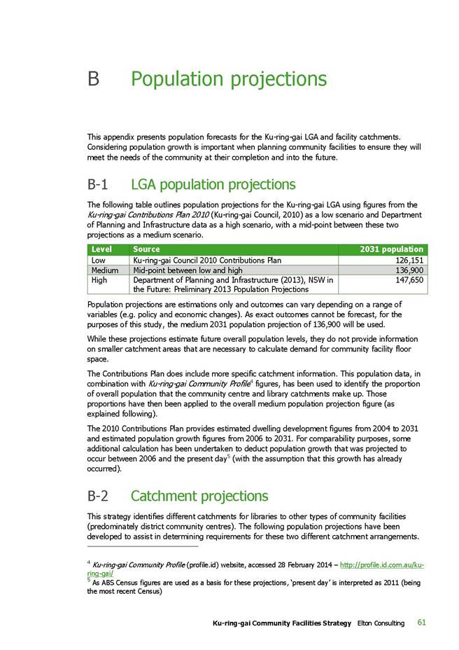
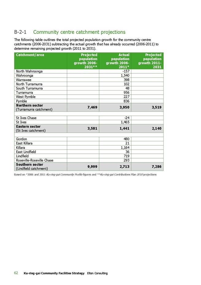
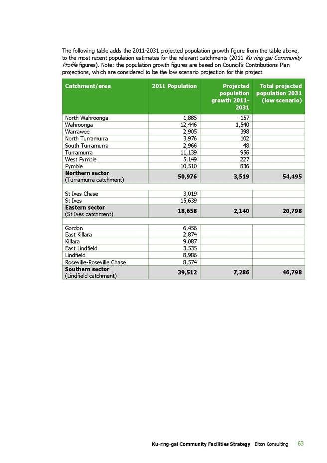
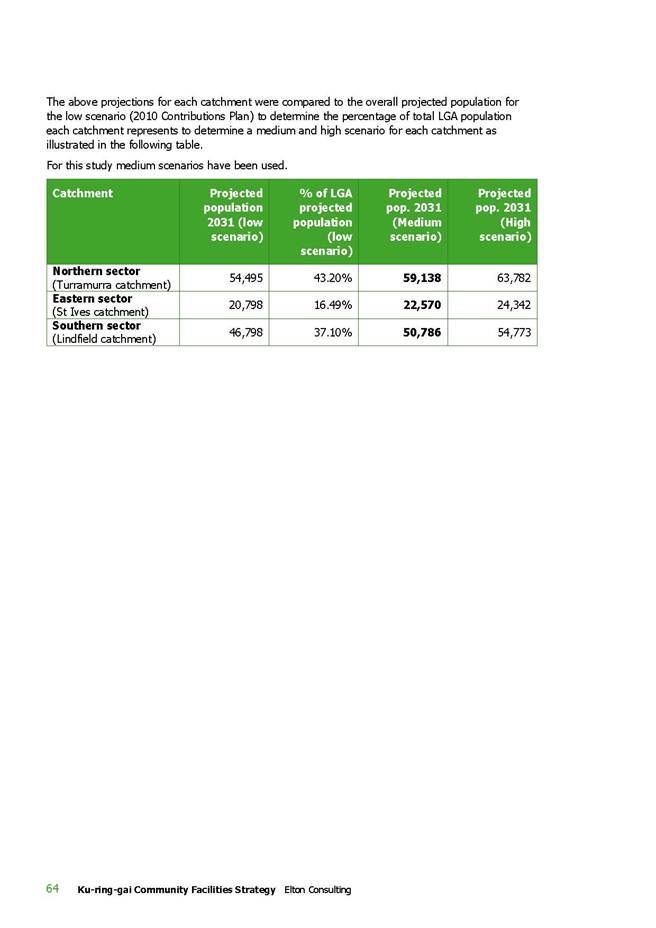
|
|
Item No: GB.17 |
Ordinary Meeting of Council
TO BE HELD ON Tuesday, 9 December 2014 AT 7.00pm
Level 3 Council Chambers
Agenda
** ** ** ** ** **
BOOK 2
NOTE: For Full Details, See Council’s Website –
www.kmc.nsw.gov.au under the link to business papers
GENERAL BUSINESS
i. The Mayor to invite Councillors to nominate any item(s) on the Agenda that they wish to have a site inspection.
ii. The Mayor to invite Councillors to nominate any item(s) on the Agenda that they wish to adopt in accordance with the officer’s recommendation allowing for minor changes without debate.
GB.17 807-813 Pacific Highway Gordon - Partial Demolition of Existing Structures and Construction of Motel, Cafe and Car Wash 3
File: DA0529/13
Ward: Gordon
Applicant: P Ahadizadeh Pty Limited
Owner: P Ahadizadeh Pty Limited
Partial demolition of existing structures and construction of motel, café and car wash.
Recommendation:
Approval.
GB.18 2-4 Newhaven Place St Ives- Demolition of Existing Structures and Construction of a Residential Flat Building containing 27 units 383
File: DA0131/14
Ward: St Ives
Applicant: Mr Stefano Macri
Owners: Mr David & Mrs Jacqueline Lee Stock (2 Newhaven Place) and
Mr Maxwell Bruce Morison & Mrs Diana Marie Morison (4 Newhaven Place).
Demolition of existing structures and construction of a Residential Flat Building containing 27 units.
Recommendation:
Approval.
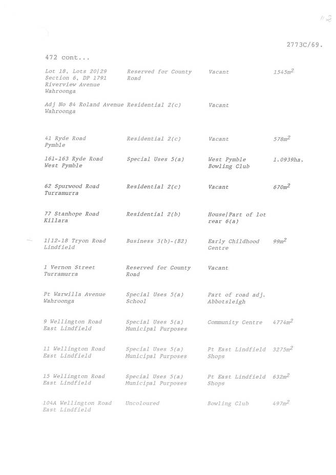
GB.19 Report following the Public Hearing into the Proposed Reclassification of Four Sites in Pymble, Gordon (two sites) and Roseville 506
File: S09771
To have Council consider the feedback following the exhibition and public hearing for the Planning Proposal to reclassify four sites within Gordon, Roseville, and Pymble from community to operational land status.
Recommendation:
That Council considers each property on its individual merits and adopts proposed reclassification of certain Council owned lands.
GB.20 Amendments to Sports Facilities Plan of Management for Adoption - Post Exhibition Report 727
File: S10342
To rectify an anomaly in the Sports Facilities Plan of Management to bring the permitted hours of clubhouse use in line with longstanding lease and licence arrangements, as well as the permitted hours of sportsground use, so that future lease and licence renewals and new agreements with sporting clubs can be negotiated in accordance with the Plan of Management. Also to permit earlier tennis court hiring times at appropriate locations.
Recommendation:
That Council adopts an amendment to the SFPOM to permit the use of clubhouses and amenities until 10pm on Fridays and Saturdays, and 12.00 midnight for club functions. That clubs give surrounding residents at least seven days’ notice in writing of any club function that is going to finish after 10pm. That tennis court bookings be permitted from 7.00am instead of 8.00am, at all Council courts other than Hamilton Park courts and Turramurra Memorial Park courts seven days, and other than Killara Park on Sundays.
** ** ** ** ** **
|
Ordinary Meeting of Council - 9 December 2014 |
GB.17 / 3 |
|
|
|
|
Item GB.17 |
DA0529/13 |
|
|
29 September 2014 |
development application
Summary Sheet
|
Report title: |
807-813 Pacific Highway Gordon - Partial Demolition of Existing Structures and Construction of Motel, Cafe and Car Wash |
|
ITEM/AGENDA NO: |
GB.17 |
Purpose of Report
To determine Development Application No. 529/13 for partial demolition of existing structures and construction of a motel, café and car wash.
integrated planning and reporting
Places, Spaces & Infrastructure
|
Community Strategic Plan Long Term Objective |
Delivery Program Term Achievement |
Operational Plan Task |
|
P2.1 A robust planning framework is in place to deliver quality design outcomes and maintain the identity and character of Ku-ring-gai
|
Applications are assessed in accordance with State and local plans
|
Assessments are of a high quality, accurate and consider all relevant legislative requirements
|
Executive Summary
|
Issues: |
Urban design, height, vehicle access |
|
Submissions: |
Three objections received |
|
|
|
|
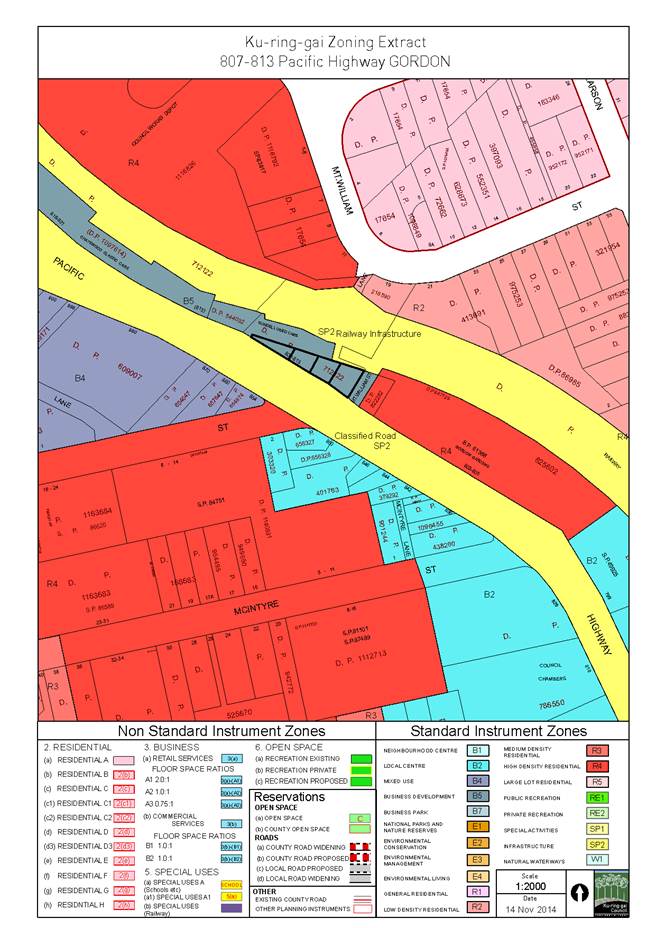
Zoning: |
B5 Business Development |
|
Land and Environment Court: |
N/A |
|
Recommendation: |
Approval |
History
Site
The site has a history of business use. The former use of the site was for the purposes of a motor vehicle dealership.
Pre-DA
The below table provides a summary of pre-Development Application meetings pertaining to the site.
|
Date |
Application ID |
Proposal |
Key Issues |
|
11/08/11 |
Pre-0122/11 |
4 storey mixed commercial / residential development with basement car park
|
· permissibility (residential development prohibited) · development composition · compliance with development standards (maximum height and FSR)
|
|
24/07/13 |
Pre-0079/13 |
Demolition of the existing building, re-use of the existing basement and construction of a motel and carwash |
· non-compliance with maximum building height control of LEP · activation of street frontages · impacts on significant vegetation
|
DA History
|
26 November 2013 |
The development application was lodged. |
|
|
|
|
16 January 2014 |
Council sent a letter to the applicant requesting the following: · report demonstrating structural integrity of existing structures to be retained · owner’s consent for removal of trees on Railcorp land and Council land · landscape plan and arborist report, further information and amendments for consistency · impact statement under Part 5A of the Environmental Planning & Assessment Act 1979 to address impacts on the endangered ecological community, Blue Gum High Forest, resulting from the proposed development |
|
|
|
|
17 January 2014 |
The application was notified to neighbouring property owners for the extended Christmas/New Year period until 17 February 2014. |
|
|
|
|
24 January 2014 |
Additional information was lodged in response to Council’s letter. |
|
|
|
|
10 February 2014 |
A letter was received from the RMS raising safety concerns regarding the proposed exit driveway opposite Merriwa Street and requesting further information. |
|
|
|
|
14 February 2014 |
A letter was received from RailCorp providing conditions for the proposed development. |
|
|
|
|
27 March 2014 |
Council sent a memorandum to the applicant requesting the following: · additional information requested by RMS · owner’s consent required from RailCorp · traffic and parking information · works on Council property to be shown on plans · geotechnical investigation · details of tree removal · planning and urban design amendments, relating to setbacks, aesthetics, amenity, ESD Report and Statement of Commitments · BCA and accessibility information (preliminary comments) |
|
|
|
|
4 April 2014 |
RailCorp owner’s consent to lodgement of the Development Application, subject to conditions, was provided. |
|
|
|
|
16 May 2014 |
Council sent a further letter to the applicant requesting the above outstanding information. |
|
|
|
|
6 June 2014 |
Amended plans and additional information was lodged in response to Council’s correspondence. |
|
|
|
|
11 July 2014 |
A letter was received from RMS providing concurrence to the proposed development, subject to conditions. |
|
|
|
|
14 July 2014 |
Council sent a memorandum to the applicant providing clarification on outstanding information and amendments required. |
|
|
|
|
22 July 2014 |
Amended plans and additional information was lodged in response to Council’s correspondence. |
|
|
|
|
22 August 2014 |
Additional information was lodged by the applicant in relation to RailCorp correspondence. |
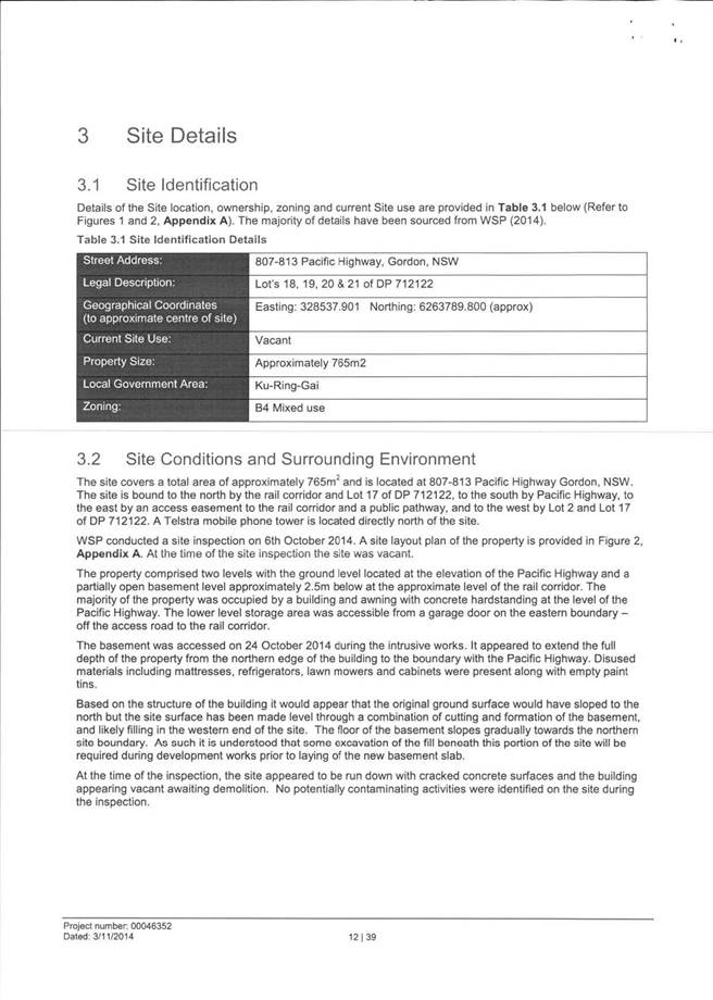
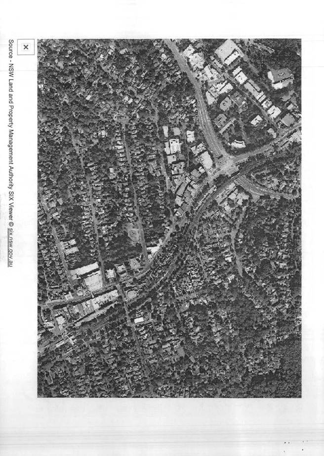
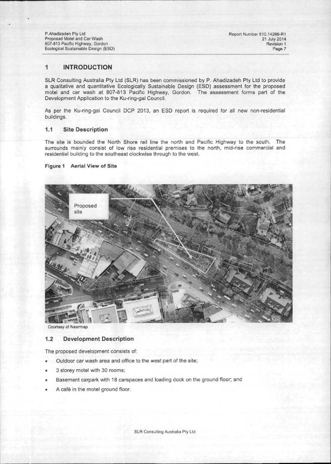
The Site
Site description
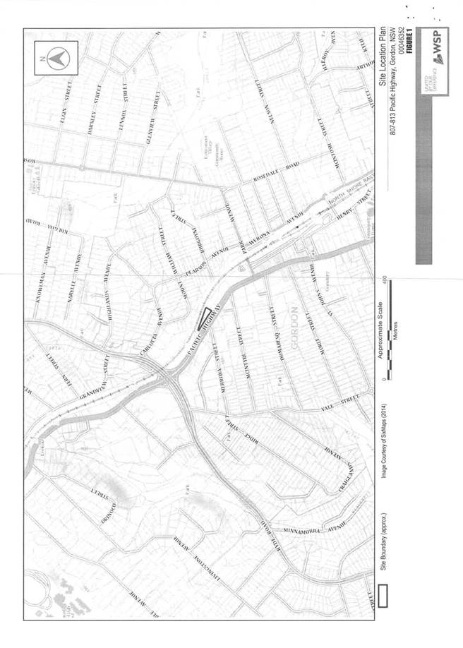
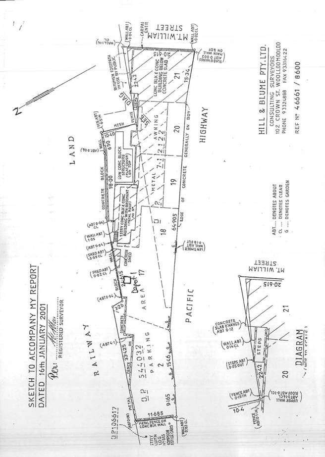
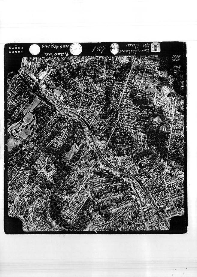
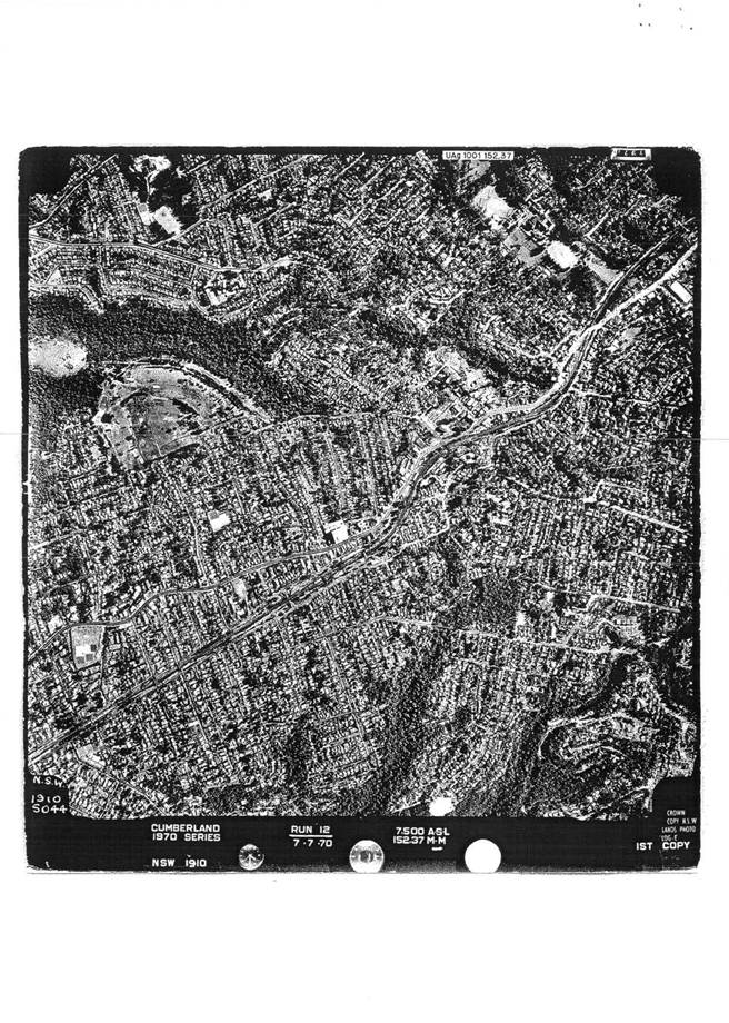
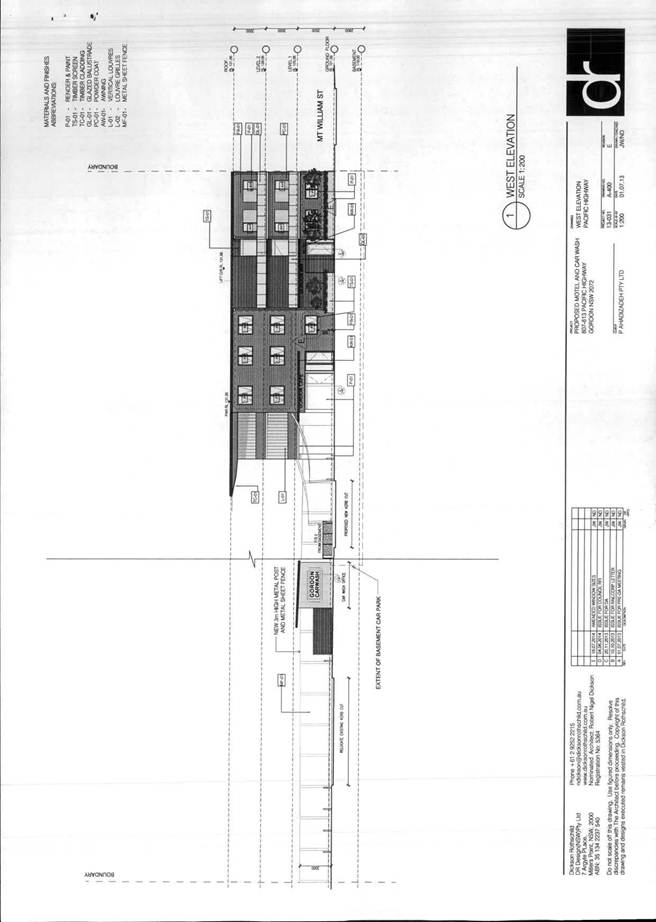
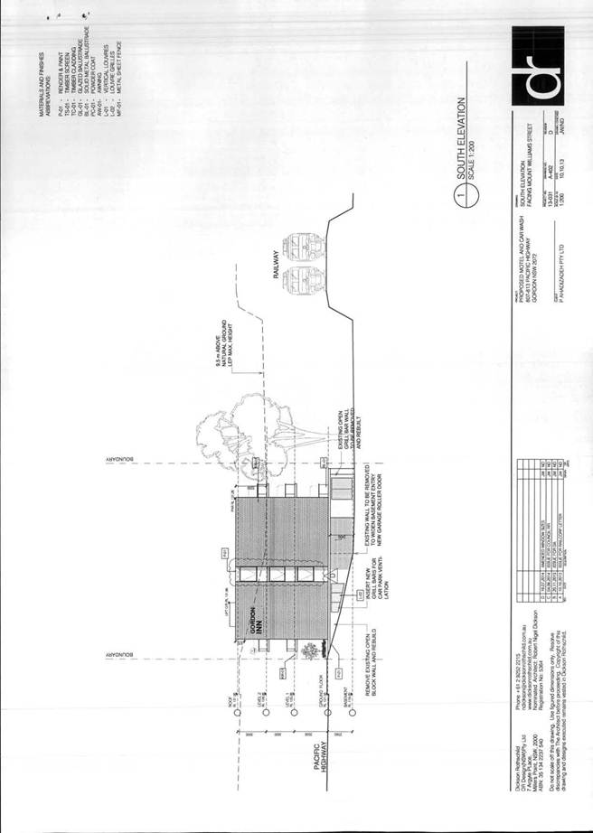
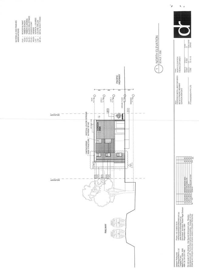
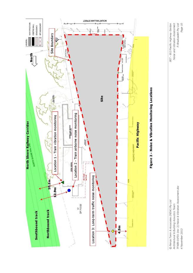
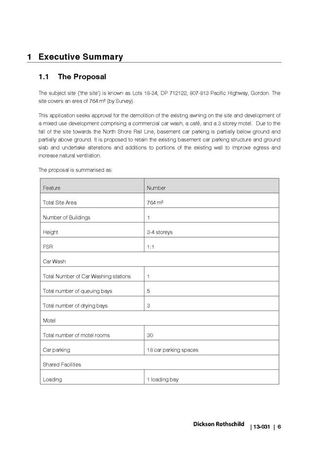
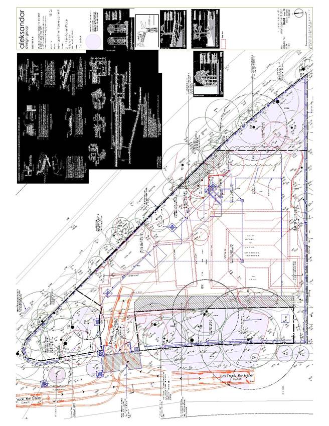
The site is a narrow, triangular-shaped amalgamation of Lots 18, 19, 20 and 21 within DP 712122, known collectively as 807-813 Pacific Highway, Gordon.
The site comprises a total area of 764m2. The site has a primary frontage to the Pacific Highway of 73.9 metres and secondary frontage to Mount William Street of 20.6 metres. The rear boundary of the site adjoins the North Shore Railway Corridor for a length of 75.6 metres.
The site is located on the north-eastern side of the Pacific Highway at the northern gateway to Gordon Town Centre, approximately 250 metres south of the intersection with Mona Vale Road and 600 metres north of Gordon Railway Station.
A level surface is provided to the majority of the site as viewed from the Pacific Highway, however, a fall of approximately 3 metres is evident along the Mount William Street frontage to the north-eastern corner (rear) of the site.
Existing development on the site consists of structures associated with the former use of the site as a motor vehicle dealership, including a portion of a showroom awning and associated supporting structures and basement parking area. It is noted that the showroom and associated office building itself are located on the adjoining RailCorp-owned property to the rear. The site has not been used for several years and is in a dilapidated state.
As a result of previous uses, the site is identified as potentially containing contaminated land.
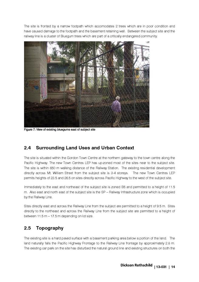
The site consists of hard-surface area (concrete) in its entirety and does not feature any vegetation, although one tree exists on the roadside verge adjacent to the south-eastern site boundary, on the corner of Mount William Street. Notwithstanding, a small portion of the site along this boundary is identified by Council’s mapping as a critically endangered ecological community, Blue Gum High Forest.
The site does not contain a heritage item and is not located within a heritage conservation area. The site is within the vicinity of a heritage item at 21 Mount William Street, however this property is located on the opposite side of the railway corridor to the rear (north-east) and is not within the visual catchment of the subject site.
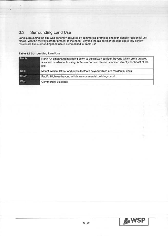
Surrounding development
Surrounding development consists of commercial/retail uses along the Pacific Highway towards the Gordon Town Centre, residential uses including a three-storey flat building located on the opposite side of Mount William Street with a frontage to the Pacific Highway and mixed-use development on the south-western side of the Pacific Highway, between its intersection with Mona Vale Road and Merriwa Street.
The adjoining site to the north-west was also formerly used as a motor vehicle dealership, however is to be used as a miniature golf course, associated landscaping and car parking, which is currently under construction pursuant to a review of a development application (Rev 0001/13) approved by Council in June 2013.
The critically endangered ecological community, Blue Gum High Forest (BGHF), mapped along the south-eastern site boundary to Mount William Street forms part of an isolated patch, which encompasses the railway corridor to the rear and the site on the opposite side of Mount William Street, which features a residential flat building. It is noted that two Sydney Blue Gum trees within this area on RailCorp land were removed by RailCorp prior to the lodgement of the subject application. Council’s Ecological Assessment Officer has advised that the removed trees would have comprised part of the BGHF community on the adjoining site, however, no endangered ecological communities, threatened flora or endangered populations were identified on the subject site.
A pedestrian access path exists adjacent to the site’s rear boundary that runs beneath the railway line and connects to Mount William Street on both sides of the railway corridor.
The Proposal
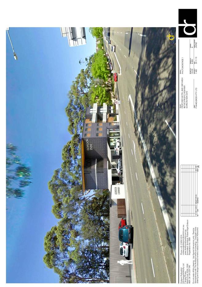
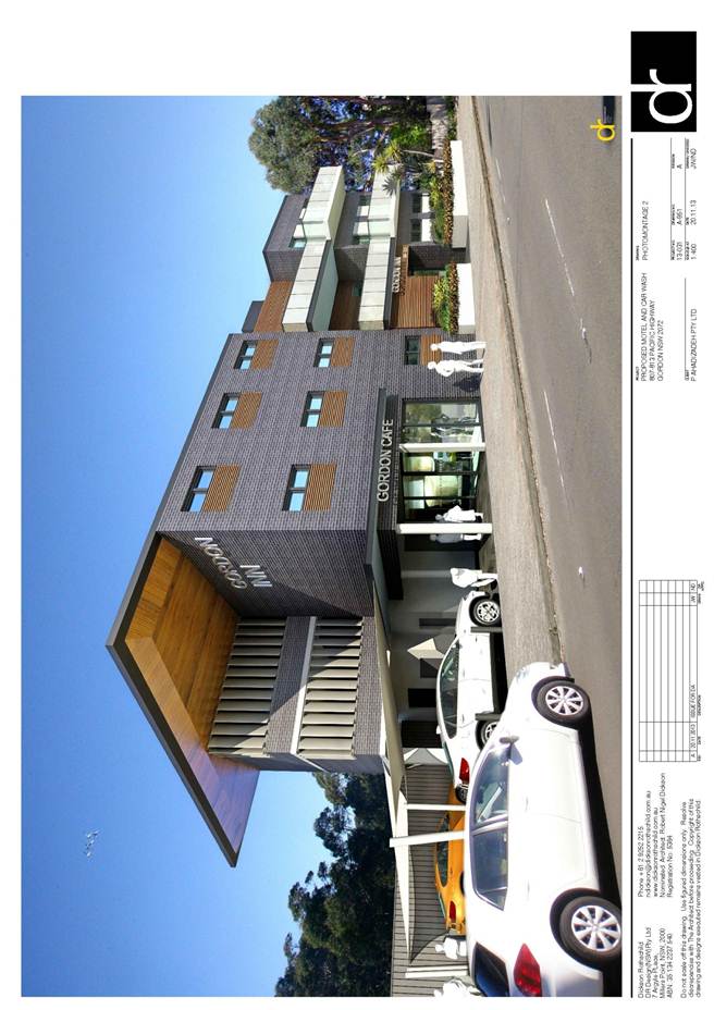
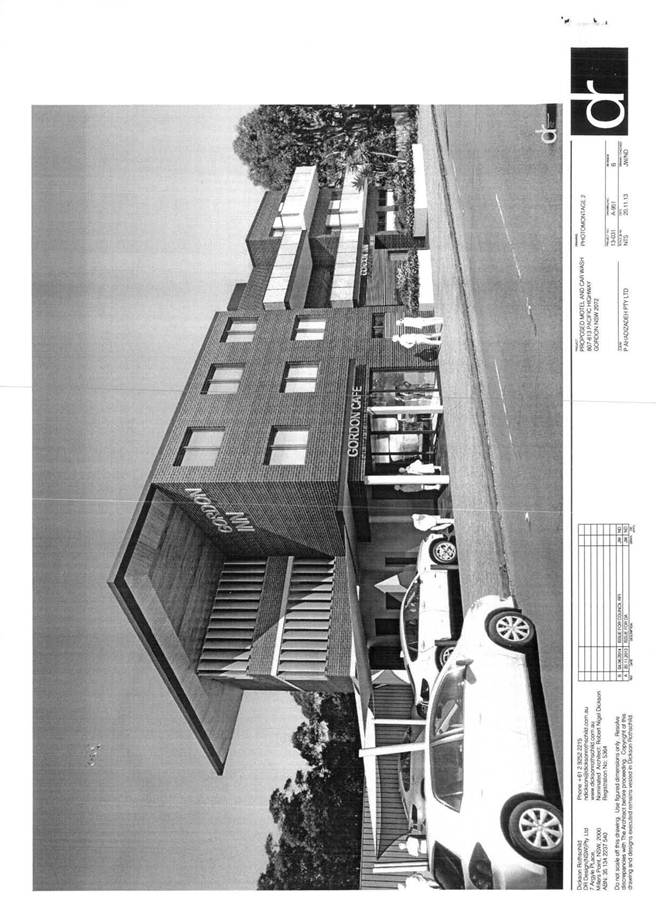
The proposed development involves partial demolition of existing structures and construction of a motel, café and car wash.
Amended plans detailed changes in response to issues identified in Council’s correspondence (refer to DA history above), including traffic and parking, planning and urban design, landscaping, BCA compliance and accessibility. The amended plans form the basis of the subject assessment report.
The proposed development is as follows:
Demolition
· The existing awning on site will be demolished. Structures on the adjoining RailCorp land will be retained.
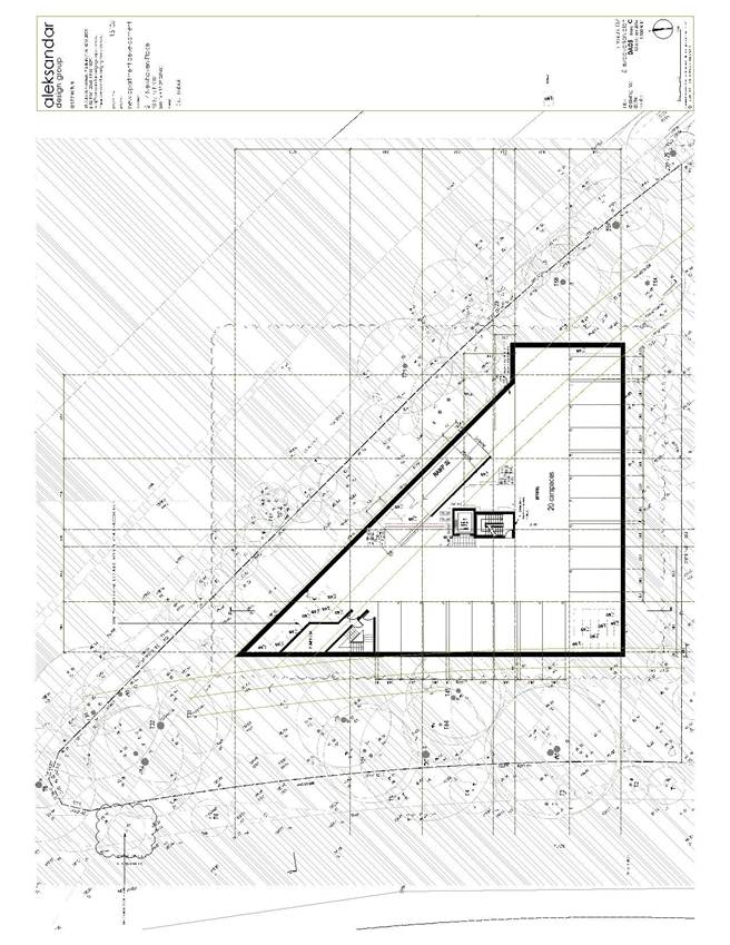
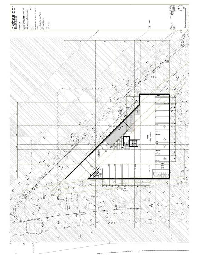
Motel
· Three-storey motel at the eastern end of the site, comprising 30 rooms (26 x 1 bedroom, 4 x 2 bedroom) with individual bathrooms, lift, lobby and reception desk on the ground floor.
· Existing basement car park to be modified to accommodate 18 car spaces, 2 motorbike spaces, 10 bicycle spaces and storage area.
· Office hours will be from 8am to 7pm, daily. Additionally, facilities will be operated by a 24/7 check-in system, enabling after-hours access for guests to check-in and check-out.
· Staffing will consist of one administrator/receptionist, and one cleaner.
Car wash
· Car-wash facility at the north-western (narrow) end of the site, which comprises 1 hand-washing bay, 5 queuing bays, 3 drying bays, 1 loading bay, office, garbage area and a rainwater tank.
· Hours of operation will be from 8am to 7pm, daily.
· Two staff members will operate the facility.
Café
· Café and associated terrace area, ancillary to the car wash.
· No cooking facilities are proposed.
· Hours of operation will be from 8am to 7pm, daily.
· Staffing will be a combined role with the motel administrator.
The proposal provides two WCs, including one accessible WC adjacent to the café, and one adjacent to the motel lobby.
The proposal involves non-illuminated business identification signage. Details of the signage are provided in the assessment against the Ku-ring-gai Local Centres DCP below.
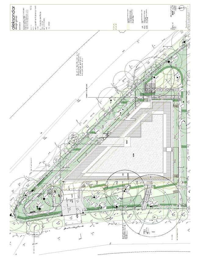
A new landscaped area is proposed at the western corner of the site.
Consultation
Community
In accordance with the Ku-ring-gai Local Centres DCP, owners of surrounding properties were given notice of the application. In response, submissions from the following were received:
1. M. Humphries, C14/803-805 Pacific Highway, Gordon (supportive of proposal)
2. D.A. & M.K. Graham, B11/ 803-805 Pacific Highway, Gordon (objection)
3. C. Darby, C12/803-805 Pacific Highway, Gordon (objection)
4. J.A. & B.J. Golder, 1B/803-805 Pacific Highway, Gordon (objection)
The three objections raised the following issues in relation to impacts to residents in the neighbouring residential flat building at 803-805 Pacific Highway, Gordon:
Traffic safety issues, including:
· increased vehicles accessing proposed basement car park and parking in Mount William Street, conflicting with access to 803-805 Pacific Highway
· illegal parking/stopping along Pacific Highway frontage of site, obstructing visibility for vehicles entering or exiting Mount William Street
The basement car park off Mount William Street is an existing feature of the site. Council’s Development Engineer has advised that there are clear sightlines for motorists exiting the motel car park to see vehicles from the property at 803-805 Pacific Highway and vice versa. Both the motel and the units would have a relatively low traffic generation rate and conflicts are unlikely to occur.
Roads and Maritime Services has not raised any concerns with regard to parking on the Pacific Highway. Illegal parking would be addressed by Council’s Rangers and/ or the Police in the usual manner and this is not a matter for consideration in the assessment of the application.
Parking concerns including:
· insufficient number of car parking spaces for motel
· automatic secure parking should be provided to prevent illicit parking
· potential for unauthorised parking in visitor designated spaces at 803-805 Pacific Highway
Council’s Development Engineer is satisfied that the proposed parking provision will be adequate having regard to results of parking surveys of similar motels carried out by the applicant’s traffic engineer. The plans indicate a roller door at the garage entrance to provide adequate secure parking.
The visitor spaces at 803-805 Pacific Highway are on private property and any parking by users of the proposed development site would be unauthorised. In any case, the parking provision for the proposed development has been found to be adequate by Council’s Development Engineer.
Stormwater management issues on surrounding land including impacts to drainage pit in Mount William Street
The development will have on site detention system provided to manage stormwater and will not increase peak flows in the street drainage system. The basement car park entrance will be clear of the kerb inlet pit and grate, and vehicles entering and leaving the car park will not access over or near the grate.
Increased pedestrian traffic along the Pacific Highway and existing trip hazard posed by sunken services/infrastructure on roadway
Any increase in pedestrian movements that may arise from the development would not generate adverse impacts and would be considered to improve street activation in accordance with local planning provisions. A recommended condition of consent (Condition 26) includes a requirement for upgrading of the Pacific Highway frontage by the applicant in accordance with Council’s Public Domain Plan and the Ku-ring-gai Bicycle Plan. This is expected to eliminate any existing trip hazards.
Likely economic failure of development due to inaccessibility by north travelling traffic
Speculation regarding the economic viability of the development is not a matter for consideration under Section 79C of the Act.
Concerns over the quality of the development
Council’s Urban Design Consultant is satisfied with the development having regard to relevant design quality considerations including context, scale, built form and aesthetics (refer to urban design comments below). Overall, the development is considered satisfactory having regard to likely impacts under Section 79C of the Act.
Concerns over staffing and operation of café, including whether an alcohol licence would be permitted
The proposed café is ancillary to the car wash and both will have the same hours of operation, 8am to 7pm, daily. Staffing will be in a combined role with the motel administrator and no cooking facilities are proposed. Additionally, no alcohol licence has been proposed. The café is considered to enhance street activation in the area without compromising the amenity of any neighbouring properties.
Concerns over illuminated, flashing signs
No illuminated or flashing signs are proposed as part of the development. The proposed signage consists of business identification signs only and is acceptable as discussed below in relation to the relevant provisions of SEPP 64 and the Ku-ring-gai Local Centres DCP.
Concerns over upkeep of the establishment and vulnerability to vandalism (as existing)
The redevelopment of the site is expected to increase activity and vitality to the existing derelict site which has been subject to vandalism. In this regard, and with suitable management, the site is considered less likely to attract future vandalism. Anti-graffiti measures are also recommended to be undertaken via a condition of consent (Condition 17).
Concerns over suitability of the site
The site is suitable for the development having regard to the proposed use, the contamination investigation undertaken and the likely impacts as assessed against Section 79C of the Act.
Amended plans
In accordance with the Ku-ring-gai Local Centres DCP, the amended plans were not notified to owners of surrounding properties as the proposed amendments do not result in a greater environmental impact than the original proposal.
Within Council
Engineering
Council’s Development Engineer commented on the proposal as follows:
“The applicant has submitted amended architectural plans and a BASIX Certificate.
Roads and Maritime Services has now granted concurrence and Railcorp has given owner’s consent to the proposed development.
The application is supported, subject to conditions.
Demolition
Railcorp has not expressed concern about the extent of demolition proposed. The letter states “…this consent does not give the applicant the right to commence construction on Railcorp land without obtaining further approval (Condition 32)”.
It is likely that additional construction-stage detail will be required by Railcorp at that stage. A condition requiring the structure to be made safe following the partial demolition would satisfy Council’s responsibilities in this matter (Condition 38).
Water management
The BASIX water commitments include the re-use of rainwater from the 16 000 litres tank for toilet flushing in Rooms 1 to 9. This is satisfactory. The water management plans do not require amendment at this stage and may be stamped and listed in Condition 1.
Parking and traffic
The proposal includes 30 motel units, with a total of 18 basement parking spaces for motel clients.
The applicant’s traffic engineer considers the proposed parking provision and states that the rate given in the Local Centres DCP of 1 space per unit (which is derived from the RMS Guide to Traffic Generating Developments 2002) applies to motels statewide, that is, including motels in rural and regional areas, which may not be serviced by public transport. However, the subject site is relatively close to public transport, being located within 500 metres of Gordon railway station.
The traffic engineer’s report contains the results of surveys taken of 5 other budget motels in the Sydney area, at similar locations with regard to public transport (e.g. Thornleigh and Artarmon). The report concludes that these motels operate at peaks below their capacity and overall the average peak parking demand was 60%.
At a parking rate of 60% for the 30 rooms, the report states that the proposed 18 car parking spaces would be satisfactory. It is also noted that 2 motorcycle and 10 bicycle parking spaces are provided in addition to the car parking spaces, which would encourage the use of alternative modes of transport for motel users. Accordingly, the departure from the parking rate specified by the DCP is justified in the circumstances.
Driveway access and grades are acceptable, including the ground levels for the carwash and the motel in relation to the footpath level.
Geotechnical report
RMS has recommended its standard condition in relation to support of the Pacific Highway (Condition 13). This requires that applicant to submit details to RMS for approval prior to commencement of works. This is considered satisfactory for DA stage in this instance.”
Landscaping
Council’s Landscape Assessment Officer commented on the proposal as follows:
“Landscape plan/tree replenishment
The removal of the Robinia street tree and restoration of the Council road reserve consistent with the Public Domain Policy is to be conditioned by the Development Engineer (Condition 26).
There are no other landscaping issues other than a minor amendment to the landscape plan to change the proposed species Eucalyptus saligna which is too large for the proposed garden area to a smaller growing species, consistent with Council’s Town Centres Public Domain Strategy for Gordon , 2D.3, “Main Road/ Residential-Native”.
The application is acceptable, subject to conditions.”
Ecology
Council’s Ecological Assessment Officer commented on the proposal as follows:
“Threatened species
No endangered ecological communities, threatened flora or endangered populations were identified on the subject property during the site inspection.
At the time of the site inspection, it was noted that two large Eucalyptus saligna (Sydney Blue Gum) trees had been removed adjacent to the rear of the property (RailCorp land). These trees would have comprised part of Blue Gum High Forest a Critically Endangered Ecological community listed under the Threatened Species Conservation Act 1995.
The two remnant Sydney Blue Gum trees which have been removed were mapped as an area of “biodiversity significance” under the KLEP 218 (2013) and as a category 5 “Canopy Remnants” under the KLEP 2013 DCP.
No further consideration of the Threatened Species legislation or the biodiversity controls under the KLEP 2013 is warranted.
The application is acceptable on ecological grounds.”
Environmental health
Council’s Environmental Health Officer raised no objection to the proposed development, subject to conditions (Conditions 27, 59, 60, 72, 74, 78).
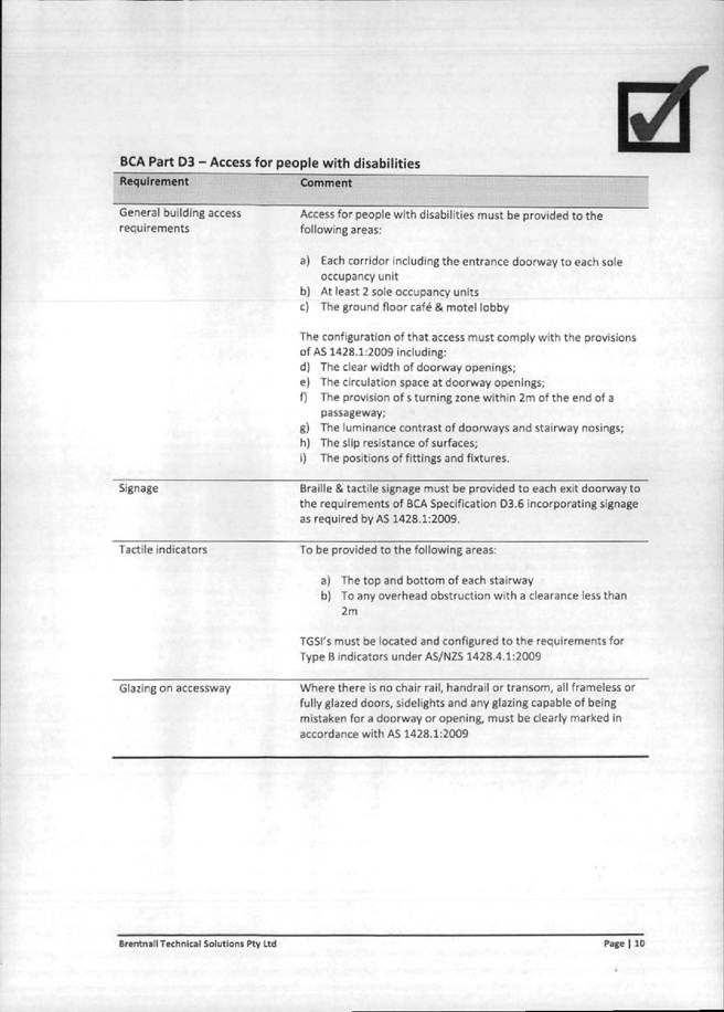
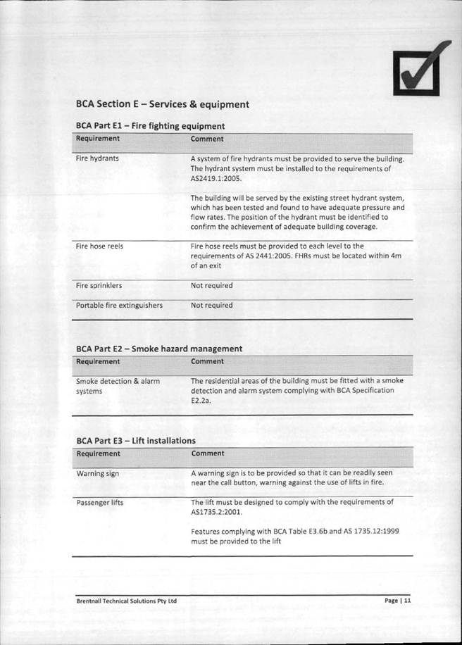
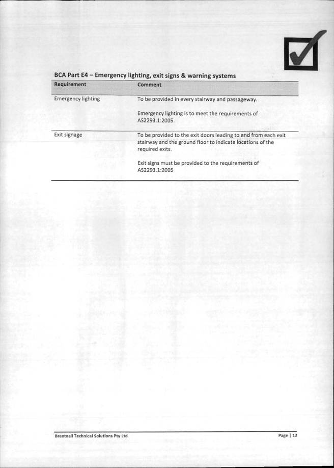
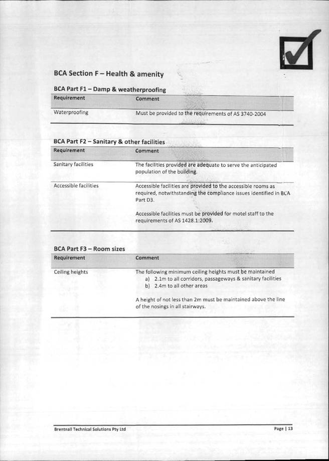
Building
Council’s Building Surveyor is satisfied that the proposed development will be compliant with the Building Code of Australia and provided the following recommendations:
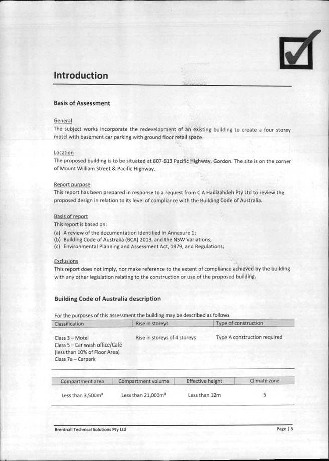
1. The BCA report prepared by Brentnall Technical Solutions, dated 11/12/2013, be included in the referenced documents (Condition 1).
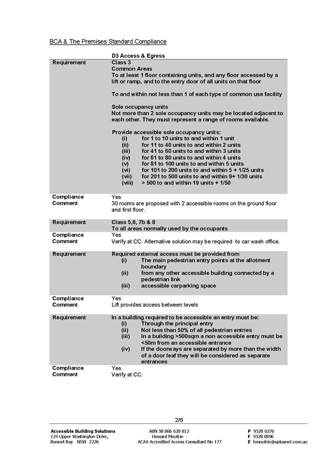
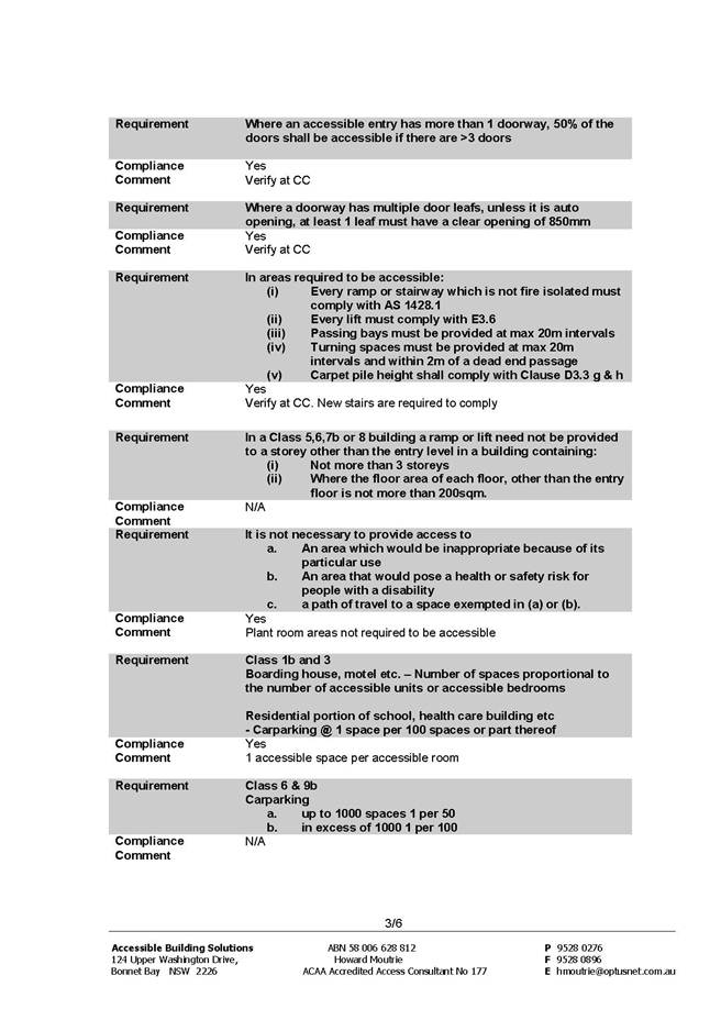
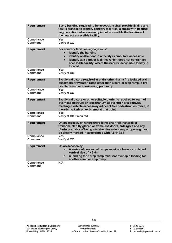
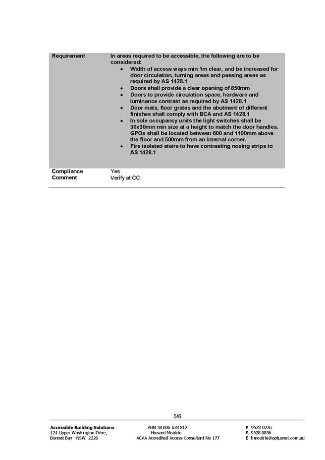
2. The Access report prepared by Accessible Building Solutions, dated 20/11/2013/issue A, be included in the referenced documents (Condition 1).
3. If approval is to be granted then the following conditions are to be included (Conditions 48, 71).
Operations
Council’s Tree Management Coordinator (Operations Department) raised no objections to the proposal and provided the following comments:
Two trees were highlighted for removal by Council on the plans, X1 Eucalyptus dunnii and x1 Robinia pseudoacacia “Frisia”.
The large Eucalyptus dunnii (Dunn’s White Gum) was removed by Council late December 2013 due to a potential insurance claim and subsequent structural engineers report.
The second tree Robinia is still in situ and is considered to be in average condition. There have been some minor branch failures, evidence decay and altered wood.
Given that the proposed development would have an impact on the tree and the overall condition of the specimen, Council would not object to the tree’s removal. It is recommended that the developer remove the tree at their expense and assume any liability should damage to occur to infrastructure or services (Condition 26).
Outside Council
Urban design
Council’s Urban Design Consultant commented on the amended proposal as follows:
“Principle 1: Context
Good design responds and contributes to its context. Context can be defined as the key natural and built features of an area. Responding to context involves identifying the desirable elements of a location’s current character or, in the case of precincts undergoing a transition, the desired future character as stated in planning and design policies. New buildings will thereby contribute to the quality and identity of the area.
Contextual aspects have been described previously.
(Previous referral comments summary: the site is located on the northern side of the Pacific Highway, Gordon. The site is 763m2 in area, triangular in shape with its narrowest point to the west, a long southern frontage of 73.865m to the Pacific Highway, and a short eastern frontage of 20.615m to a stub of Mount William Street. The maximum site fall from north to south is approximately 2.7m. Adjoining the site to the north and west is land zoned B5 with a height of 11.5m and an FSR of 1.0:1; to the north-east is the railway corridor, zoned SP2; and to the west are existing three to four storey residential flat buildings. The site is approximately 565m walk to Gordon train station and there is a bus stop to the immediate south of the site on the Pacific Highway. A pedestrian tunnel connects the stub of Mount William Street to the northern side of the rail line via a path along part of the northern boundary of the site. It would be desirable if the proposal could address the visual treatment of the existing basement wall proposed to be retained in this location).
The KLEPLC2012 classification of the proposal as a ‘light industrial’ use for the car wash component and a ‘hotel and motel accommodation’ use for the motel component in relation to KLEPLC2012 6.6(3) has been discussed previously. The relationship of the motel to the public domain is considered to be a reasonable one.
The proposal is generally considered to meet the ambition of KLCDCP2013 Volume B Part 1D.
Principle 2: Scale
Good design provides an appropriate scale in terms of the bulk and height that suits the scale of the street and the surrounding buildings. Establishing an appropriate scale requires a considered response to the scale of existing development. In precincts undergoing a transition, proposed bulk and height needs to achieve the scale identified for the desired future character of the area.
The proposal exceeds the height limit by 3260mm (240mm less than in prior documentation) and is non-compliant with KLEPLC2012 4.3(2). However, the reasoning of the Clause 4.6 Variation is supported as described previously (for the reasons set out in the submitted Variation and that the Variation satisfies the objectives of Clause 4.6 itself), and given that the height non-compliance does not appear to create any appreciable environmental impacts, the proposed height is considered acceptable from an urban design perspective.
Principle 3: Built form
Good design achieves an appropriate built form for a site and the building’s purpose, in terms of building alignments, proportions, building type and the manipulation of building elements. Appropriate built form defines the public domain, contributes to the character of streetscapes and parks, including views and vistas, and provides internal amenity and outlook.
The size, shape and position of the proposed built form is generally considered acceptable. The issue of the setback of the motel from the northern boundary has been addressed by decreasing the size of the motel room balconies.
The issue of servicing and waste bin provision has been partially addressed. Four additional bins have been shown on Levels 1 and 2 of the motel. This addresses the issue of safety and convenience for motel staff, and may be sufficient to address the volume of waste produced (this has subsequently been verified by Council’s Development Engineer).
The issue of WC provision for motel staff has been resolved by including an additional WC on the ground floor of the motel.
The issue of the cafe layout has been resolved through additional documentation to demonstrate its workability.
The issue of the car park exhaust expelling directly into a working area appears to have been resolved by removing the exhaust stack and having the car park exhaust vertically through the ceiling plane along the length of the northern boundary in a less concentrated manner.
Principle 4: Density
Good design has a density appropriate for a site and its context, in terms of floor space yields. Appropriate densities are sustainable and consistent with the existing density in an area or, in precincts undergoing a transition, are consistent with the stated desired future density. Sustainable densities respond to the regional context, availability of infrastructure, public transport, community facilities and environmental quality.
The issue of FSR compliance appears to be acceptable but should be verified. It is noted that, even though the basement floor plan should not strictly be considered a ‘basement’ as per the KLEPLC2012 definition, there does not appear to be any items to be counted as GFA (as per the KLEPLC2012 definition of ‘gross floor area’) on this level.
Principle 5: Resource, energy and water efficiency
Good design makes efficient use of natural resources, energy and water throughout its full life cycle, including construction. Sustainability is integral to the design process. Aspects include demolition of existing structures, recycling of materials, selection of appropriate and sustainable materials, adaptability and reuse of buildings, layouts and built form, passive solar design principles, efficient appliances and mechanical services, soil zones for vegetation and reuse of water.
An Ecologically Sustainable Design (ESD) report has been provided. Conditions should be attached to any consent to the effect that all of the initiatives recommended/proposed are included in the development, and where relevant, notated on the drawings (Condition 16).
Principle 6: Landscape
Good design recognises that together landscape and buildings operate as an integrated and sustainable system, resulting in greater aesthetic quality and amenity for both occupants and the adjoining public domain. Landscape design builds on the site’s natural and cultural features in responsible and creative ways. It enhances the development’s natural environmental performance by co-ordinating water and soil management, solar access, micro-climate, tree canopy and habitat values. It contributes to the positive image and contextual fit of development through respect for streetscape and neighbourhood character, or desired future character. Landscape design should optimise usability, privacy and social opportunity, equitable access and respect for neighbour’s amenity, and provide for practical establishment and long term management.
The revised documentation for the proposal shows that the existing basement level cannot be retained to the same extent as previously proposed due to structural engineering reasons. This change is considered acceptable from an urban design point of view as the proposed development remains for all intents and purposes the same size, shape and impact as previously put forward.
Principle 7: Amenity
Good design provides amenity through the physical, spatial and environmental quality of a development. Optimising amenity requires appropriate room dimensions and shapes, access to sunlight, natural ventilation, visual and acoustic privacy, storage, indoor and outdoor space, efficient layouts and service areas, outlook and ease of access for all age groups and degrees of mobility.
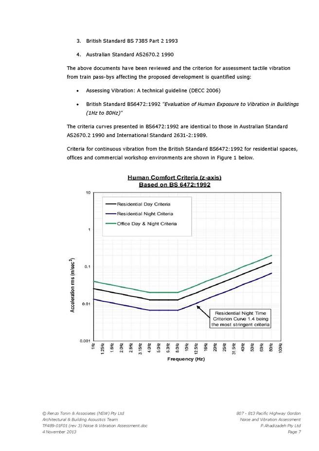
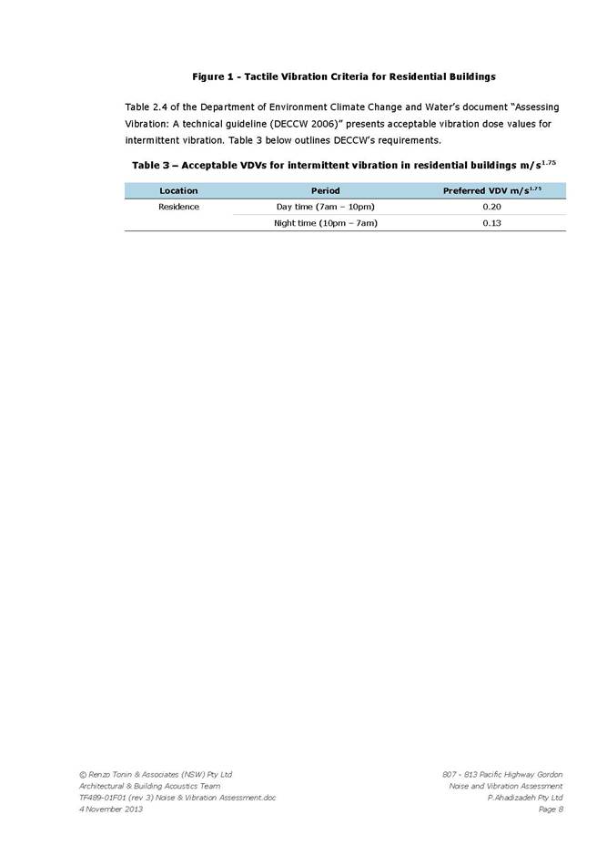
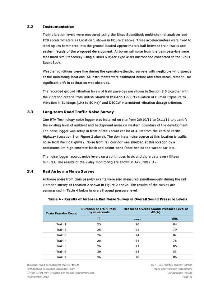
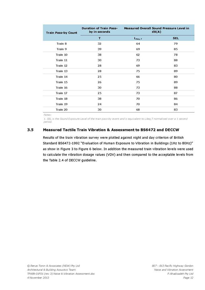
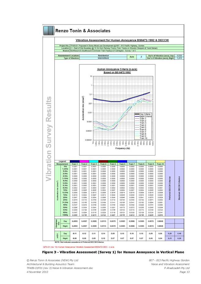
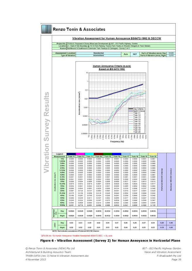
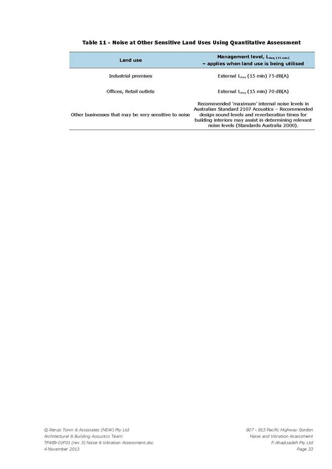
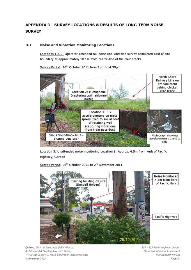
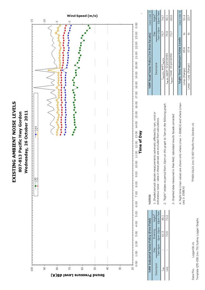
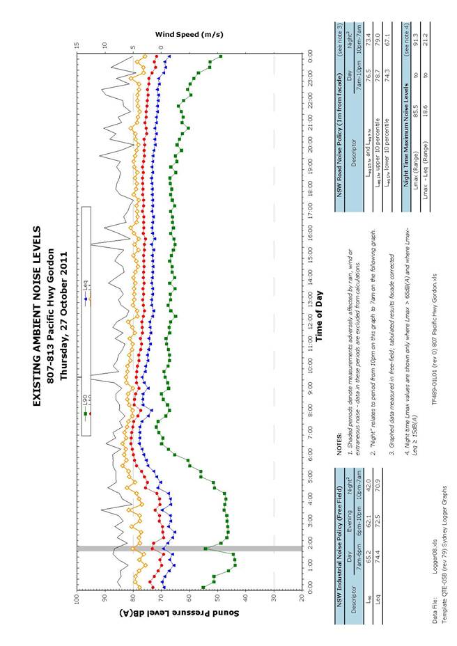
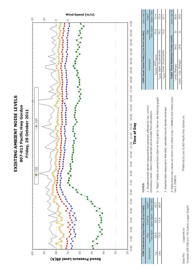
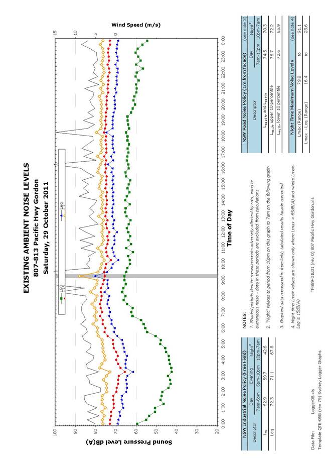
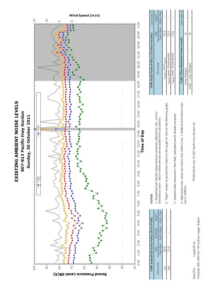
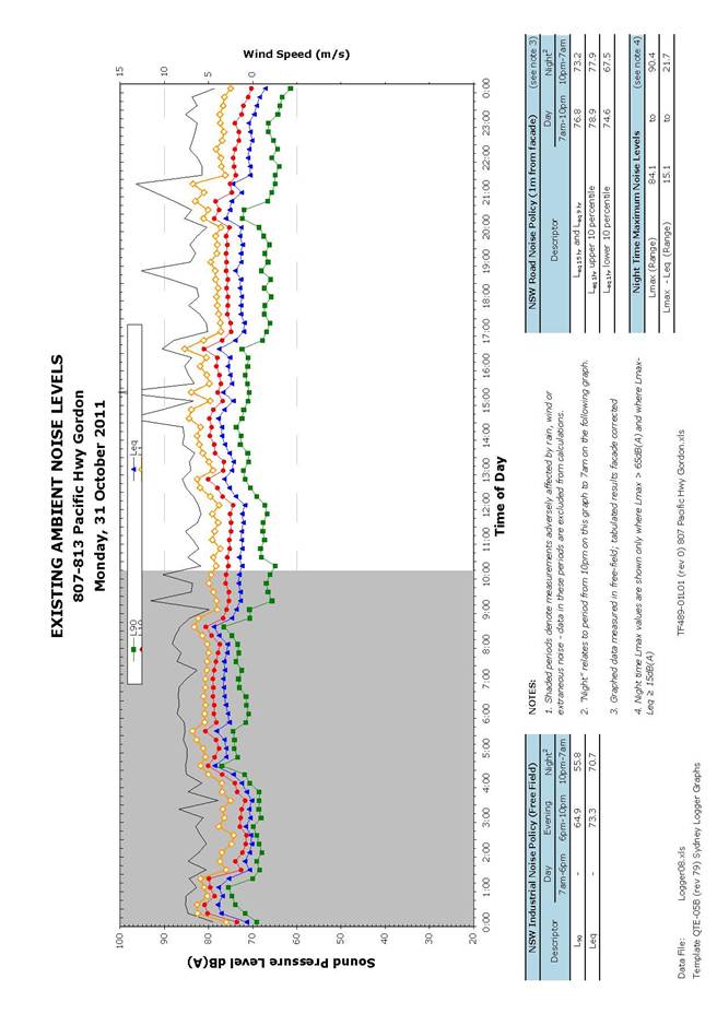
The satisfaction of noise and vibration documentation in compliance with 'Development Near Rail Corridors and Busy Roads - Interim Guidelines', SEPP Infrastructure, AS 3671-1989 and AS2107-2000 has been described previously: the proposal documentation appears to address noise and vibration, however satisfaction of electrolysis should be verified) (Condition 14 and Condition 29).
Principle 8: Safety and security
Good design optimises safety and security, both internal to the development and for the public domain. This is achieved by maximising overlooking of public and communal spaces while maintaining internal privacy, avoiding dark and non-visible areas, maximising activity on streets, providing clear, safe access points, providing quality public spaces that cater for desired recreational uses, providing lighting appropriate to the location and desired activities, and clear definition between public and private spaces.
The issue of employee safety with regards to the operation of the motel have now been satisfactorily addressed.
Principle 9: Social dimensions and housing affordability
Good designs respond to the social context and needs of the local community in terms of lifestyles, affordability, and access to social facilities. New developments should optimise the provision of housing to suit the social mix and needs in the neighbourhood or, in the case of precincts undergoing transition, provide for the desired future community. New developments should address housing affordability by optimising the provision of economic housing choices and providing a mix of housing types to cater for different budgets and housing needs.
The provision of accessible motel rooms has been described previously (two accessible sole occupancy units are provided which appears to comply with BCA Part D3 provisions). The issue of turning zones at the end of the Levels 1 and 2 motel corridors has now been satisfactorily addressed by widening the western end of the respective corridors.
Principle 10: Aesthetics
Quality aesthetics require the appropriate composition of building elements, textures, materials and colours and reflect the use, internal design and structure of the development. Aesthetics should respond to the environment and context, particularly to desirable elements of the existing streetscape or, in precincts undergoing transition, contribute to the desired future character of the area.
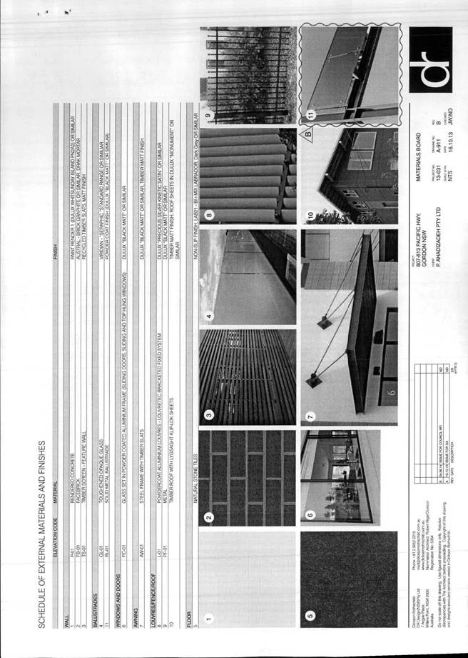
The materials and colours for the project are generally considered to be acceptable. The issue of glazed balustrades to the northern elevation has been addressed by substituting these for a ‘solid metal balustrade’ (Drawing A-911). This aspect is now considered acceptable.
It is noted that the suggestion to alter the larger balcony adjacent to the lift to become a ‘communal balcony’ has been taken on board. Also, that the suggestion to recess the corridor windows on the northern facade has been incorporated. These are considered positive amendments.
The treatment of the new car park wall on Mount William Street and the pedestrian link along the northern boundary appears to be painted rendered concrete. It is considered that the treatment of this wall should incorporate anti-graffiti measures (Condition 17).
This proposal could be approved, subject to several items being addressed.
Planning comment:
Subsequent correspondence with Council’s urban design consultant has resolved any substantive issues. The above items identified have been sufficiently addressed as required through verification of compliance and conditions as applicable. In particular, FSR compliance has been achieved. Notwithstanding the projection of the basement above the ground level at the rear of the site due to the existing slope, FSR compliance is accepted given the basement is excluded from gross floor area as defined by the LEP. Overall aspects of built form are considered acceptable, including scale and height as discussed above, and having regard to streetscape and neighbouring amenity. Recommended conditions of consent are incorporated to address issues of noise and vibration, rail electrolysis, ESD requirements and anti-graffiti considerations (Conditions 14, 29, 16 and 17).
Roads and Maritime Services (RMS)
Under the provisions of section 91 of the Environmental Planning and Assessment Act 1979, the proposal is Integrated Development on the basis that the applicant requires consent under section 138 of the Roads Act.
Accordingly, the development has been referred to the Roads and Traffic Authority, who commented as follows:
“I refer to Council's letter dated 16 June 2014 regarding the amended driveways plans for the
abovementioned development application (DA0529/13) forwarded to the Roads and Maritime
Services (Roads and Maritime) for concurrence under Section 138 of the Roads Act 1993.
Roads and Maritime has reviewed the submitted amended plans and would provide concurrence to the proposed driveways on Pacific Highway, subject to the following conditions being included in any consent issued by Council (Conditions 5, 6, 10, 13, 14, 15, 26, 68, 69)”.
RailCorp
The proposal was referred to RailCorp on the basis that it involves works adjacent to a rail corridor, in accordance with Clause 86 of SEPP (Infrastructure) 2007.
RailCorp commented on the proposal as follows:
“I refer to Council’s letter received 21 January 2014 regarding the proposed development.
Rail Corporation New South Wales (RailCorp) has reviewed the proposal and asks that the following issues be addressed in the conditions for this proposed development (Conditions 28 - 32)”.
Statutory Provisions
State Environmental Planning Policies
Sydney Regional Environmental Planning Policy (Sydney Harbour Catchment) 2005
SREP 2005 applies to the site as it is located in the Sydney Harbour Catchment. The Planning Principles in Part 2 of the SREP must be considered in the preparation of environmental planning instruments, development control plans, environmental studies and master plans. The proposal is not affected by the development assessment provisions of the SREP as the site is not located in the Foreshores and Waterways Area as defined by the Foreshores and Waterways Area Map.
State Environmental Planning Policy No. 55 - Remediation of Land
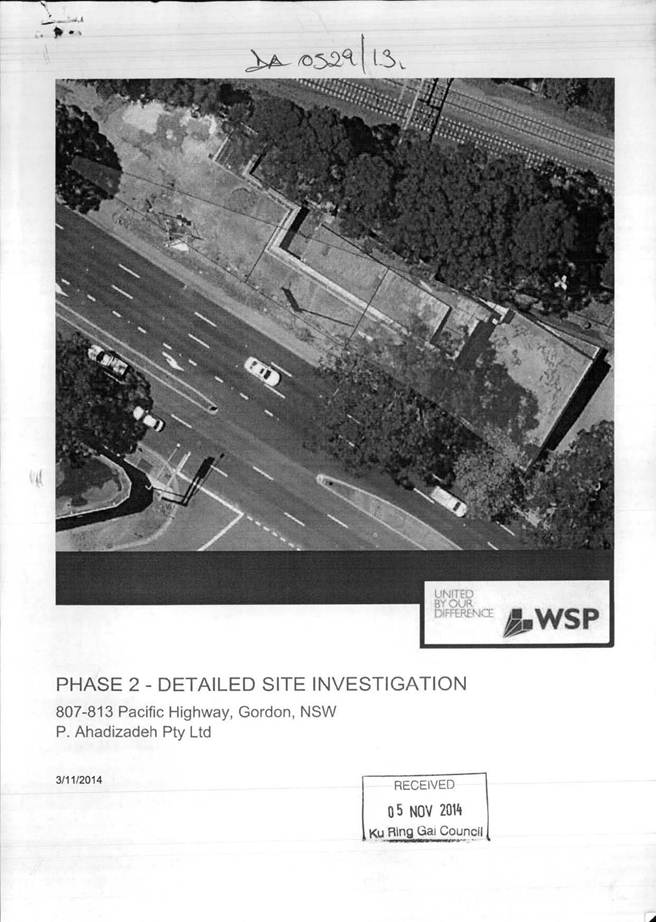
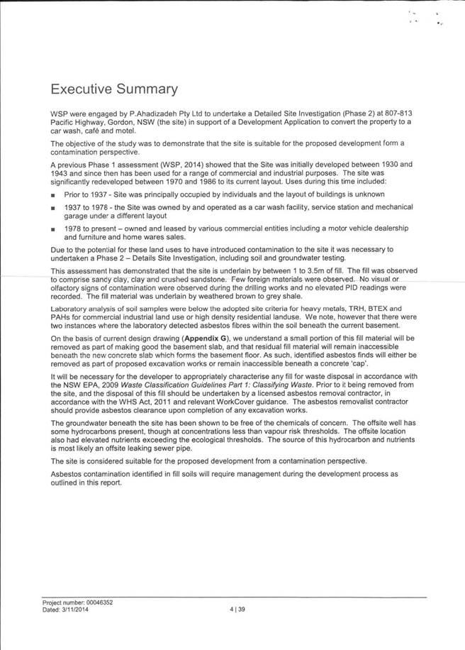
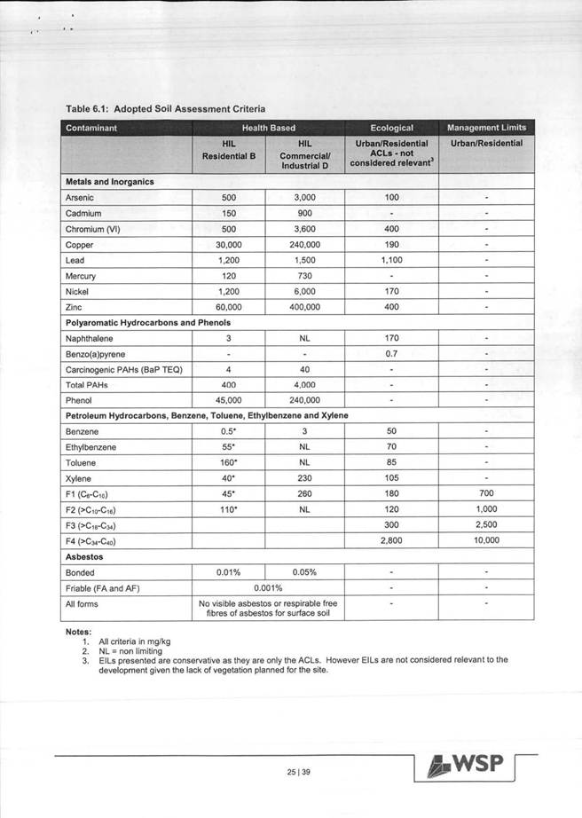
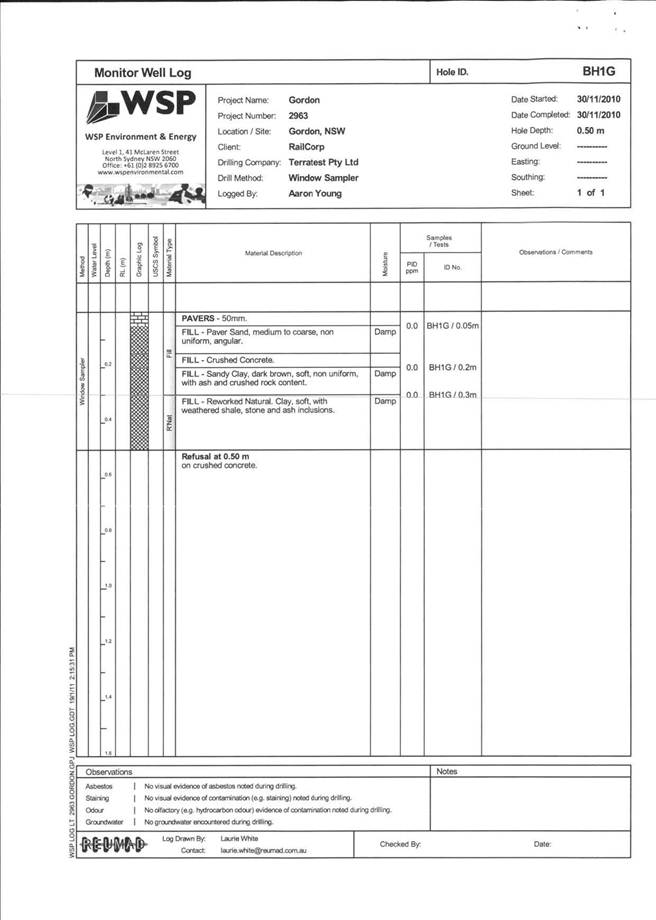
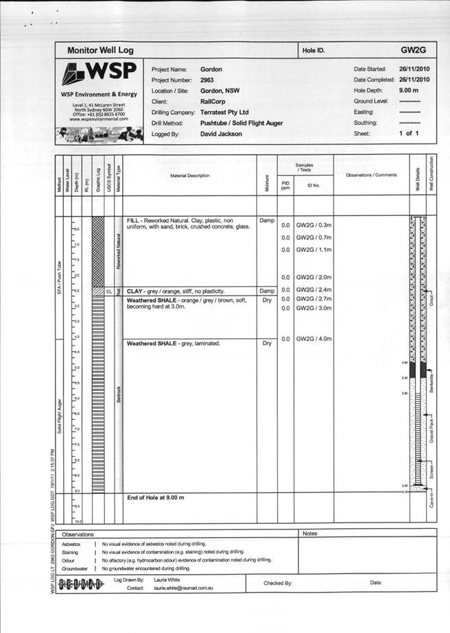
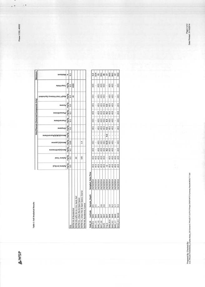
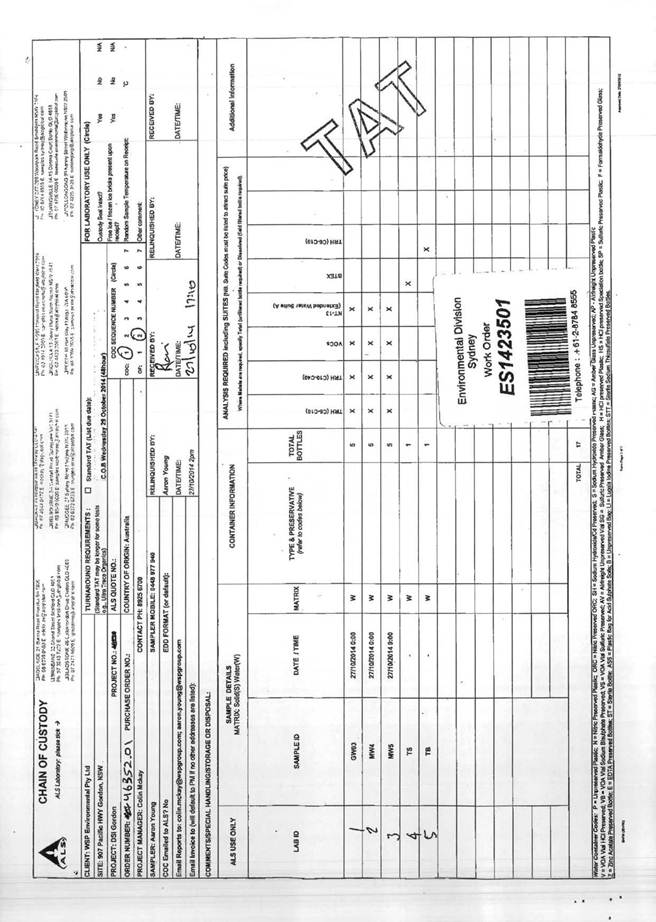
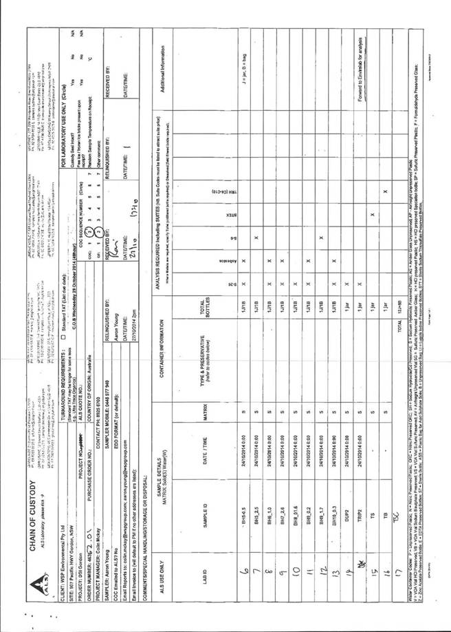
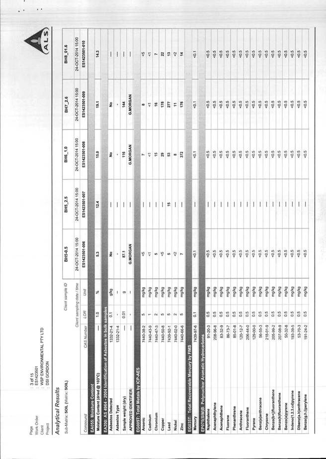
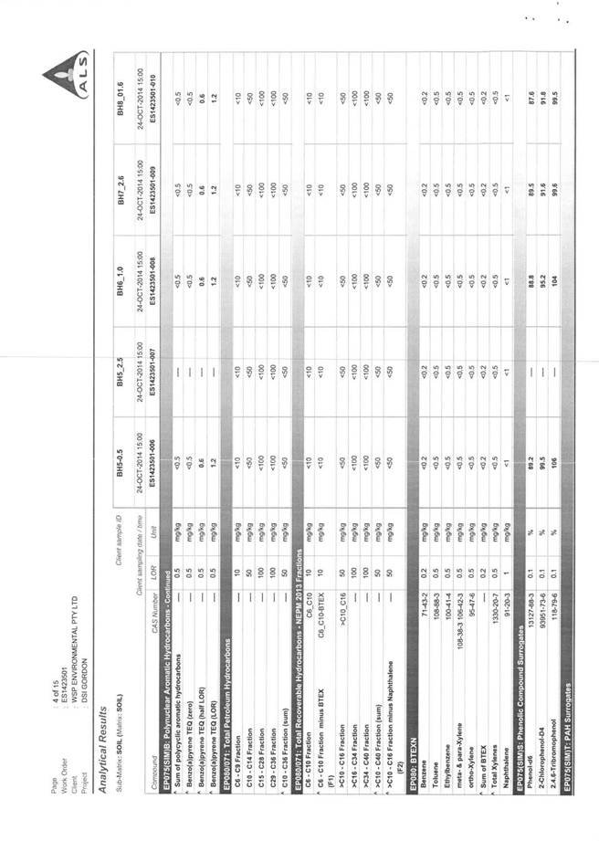
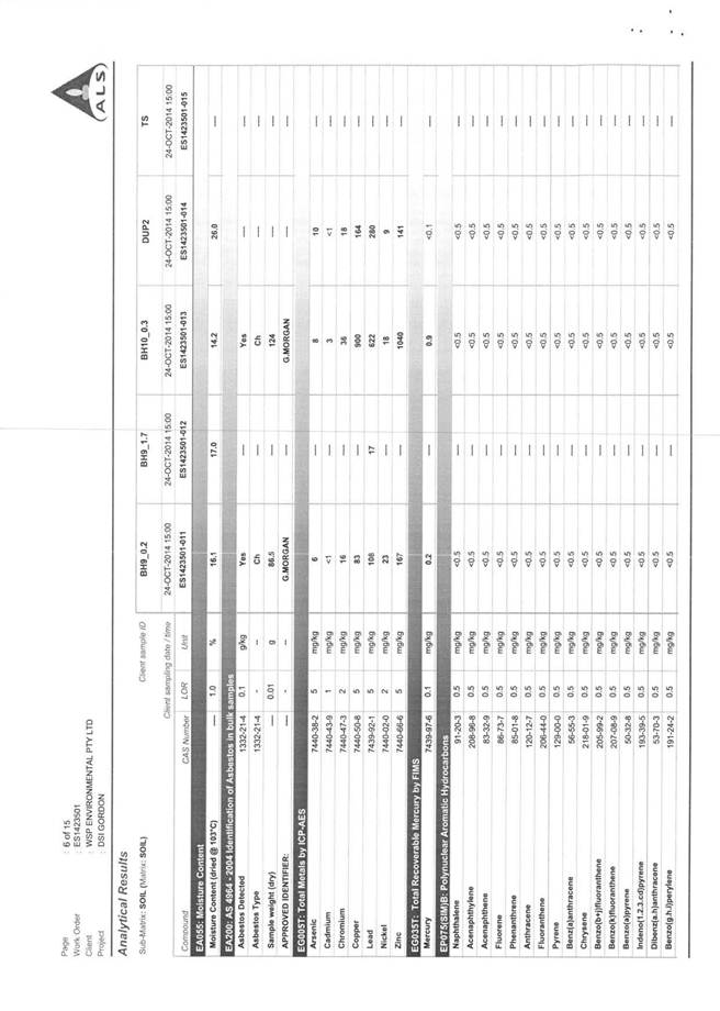
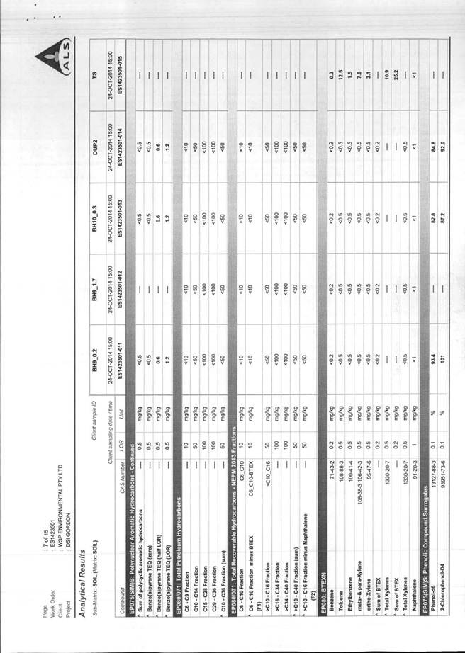
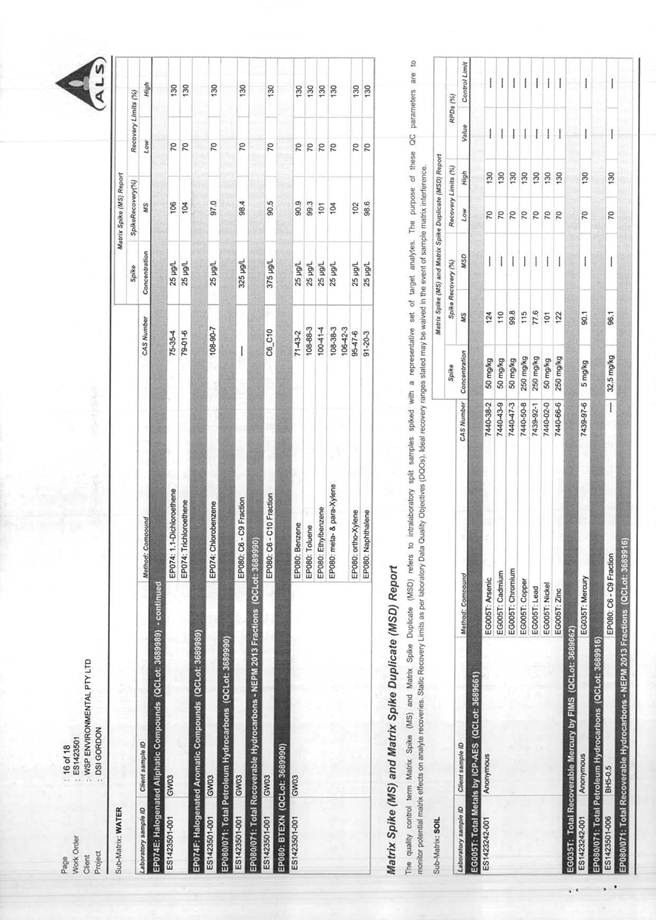
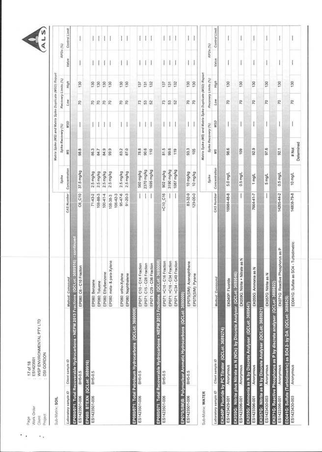
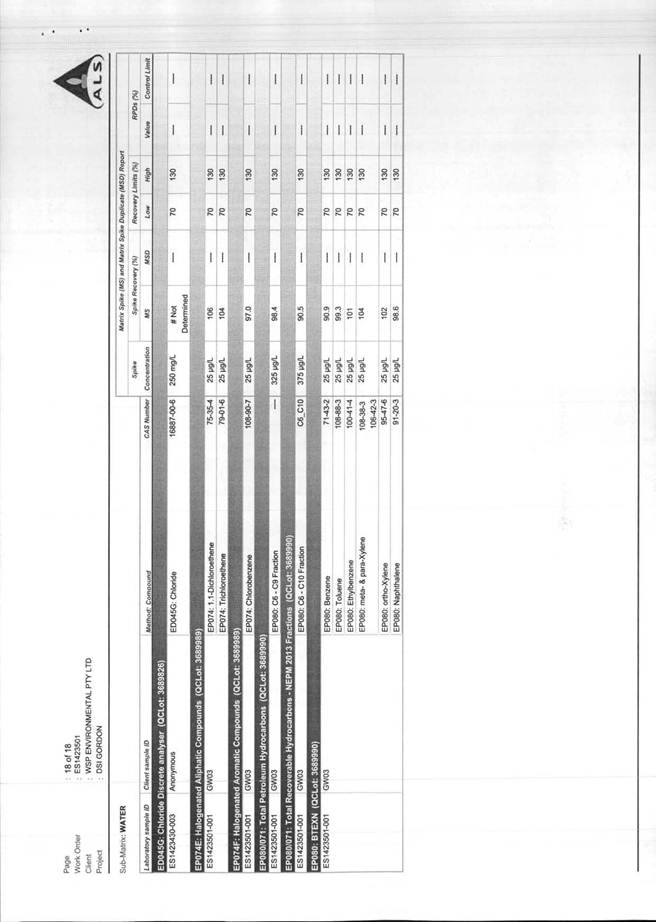
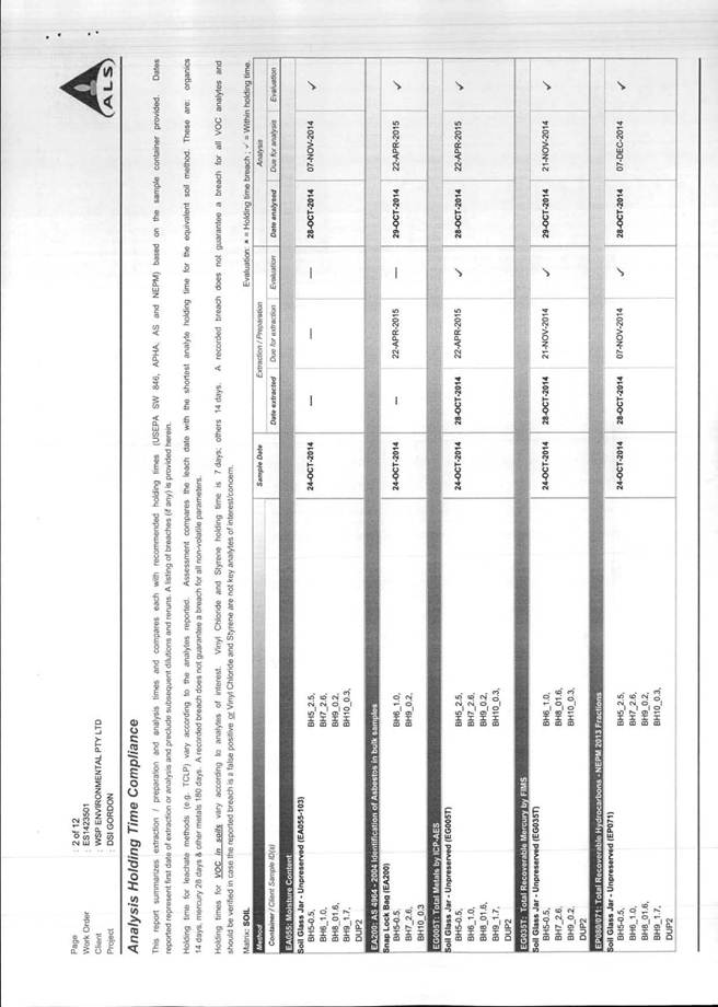
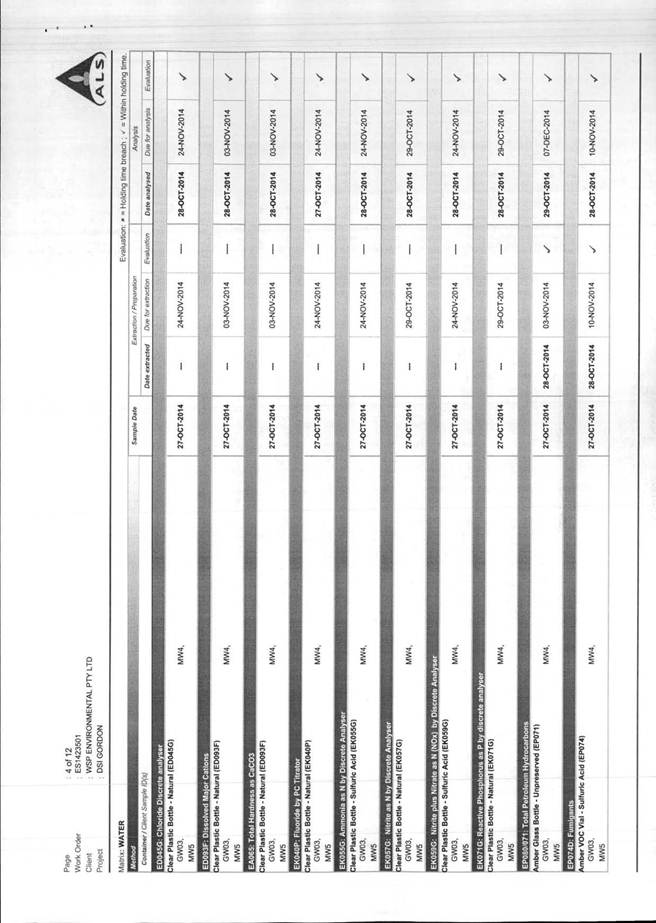
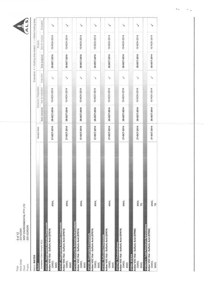
The provisions of SEPP 55 require consideration of the potential for a site to be contaminated. Council records indicate the site may be affected by contaminated land. A Phase 1 Preliminary Site Investigation report (WSP, 2014) was submitted with the application which indicated previous uses of the site as follows:
· prior to 1937 – the site was principally occupied by individuals and the layout of buildings is unknown
· 1937 to 1978 – the site was owned by and operated as a car wash facility, service station and mechanical garage under a different layout
· 1978 to present – the site was owned and leased by various commercial entities including a motor vehicle dealership and furniture and home-wares sales.
The Phase 1 report findings concluded that, based on a review of the historical land uses and available documentation, there is a potential for historical soil and/or groundwater contamination to be present at the site.
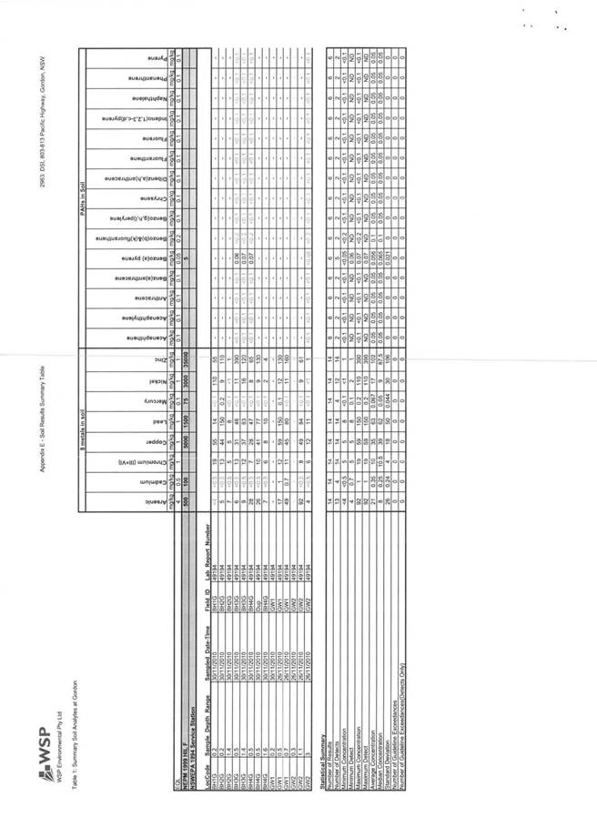
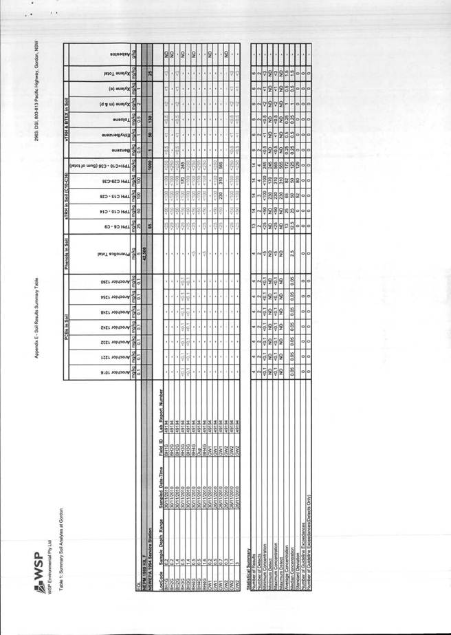
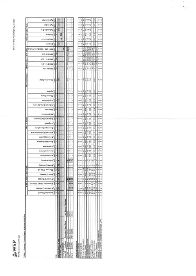
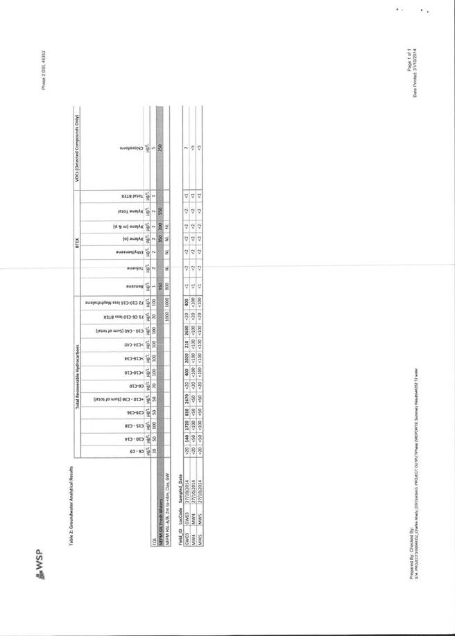
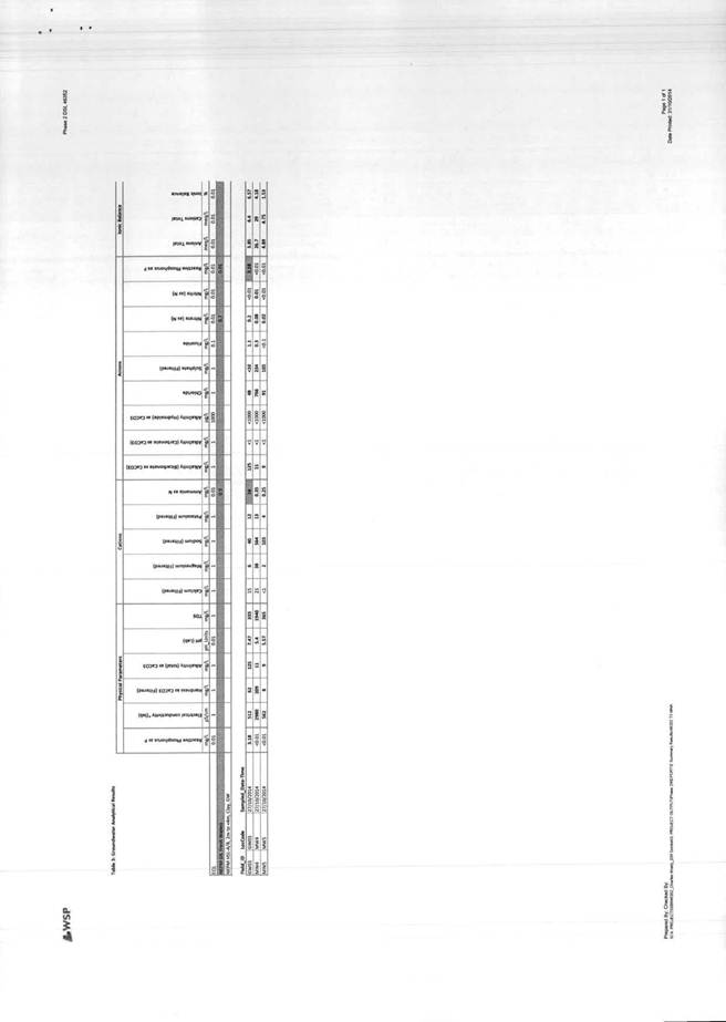
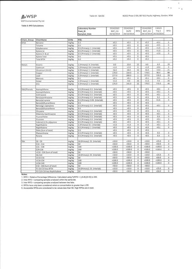
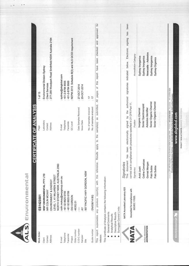
Accordingly, a Phase 2 Detailed Site Investigation (WSP, 2014) was carried out for the site. The report concluded the following:
Based on this detailed site investigation, the site is underlain by between 1 to 3.5 metres of fill. The fill was observed to comprise sandy clay, clay and crushed sandstone. Few foreign materials were observed. No visual or olfactory signs of contamination were observed during the drilling works and no elevated PID readings were recorded. The fill material was underlain by weathered brown to grey shale.
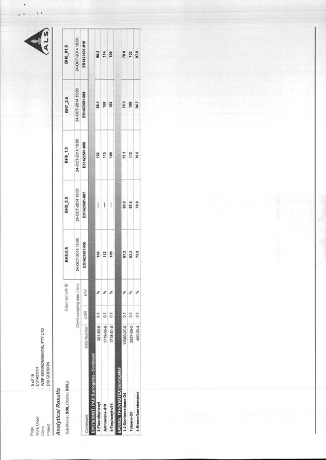
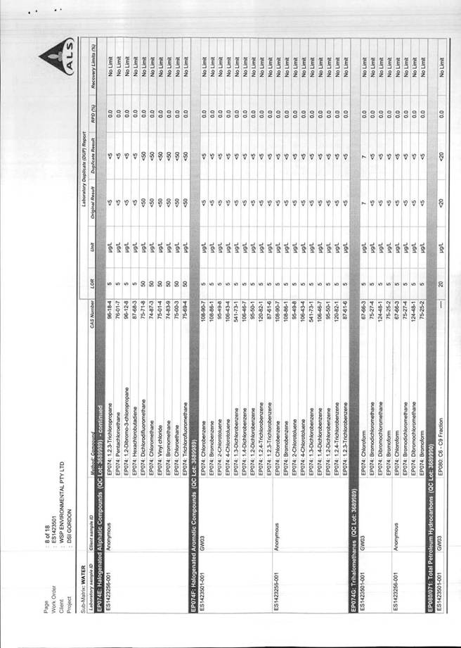
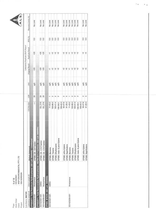
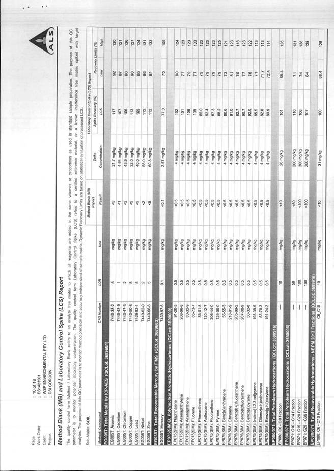
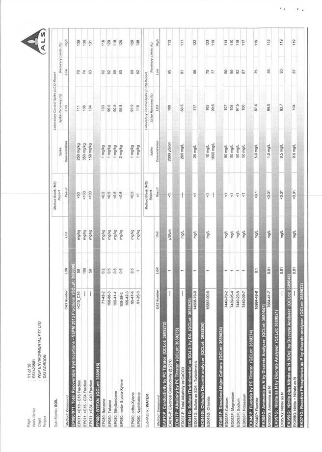
Laboratory analysis of soil samples were below the adopted site criteria for heavy metals, TRH, BTEX and PAHs for commercial industrial land use or high density residential land use. We note, however that there were two instances where the laboratory detected asbestos fibres within the soil beneath the current basement.
On the basis of current design drawing, we understand a small portion of this fill material will be removed as part of making good the basement slab, and that residual fill material will remain inaccessible beneath the new concrete slab which forms the basement floor. As such, identified asbestos finds will either be removed as part of proposed excavation works or remain inaccessible beneath a concrete 'cap'.
It will be necessary for the developer to appropriately characterise any fill for waste disposal in accordance with the NSW EPA, 2009 Waste Classification Guidelines Part 1: Classifying Waste. Prior to it being removed from the site, and the disposal of this fill should be undertaken by a licensed asbestos removal contractor, in accordance with the WHS Act, 2011 and relevant WorkCover guidance. The asbestos removalist contractor should provide asbestos clearance upon completion of the excavation works.
The groundwater beneath the site has been shown to be free of the chemicals of concern. The offsite well has some hydrocarbons present, though at concentrations less than vapour risk thresholds. The offsite location also had elevated nutrients exceeding the ecological thresholds. The source of this hydrocarbon and nutrients is most likely an offsite leaking sewer pipe.
The site is considered suitable for the proposed development from a contamination perspective.
Asbestos contamination identified in fill soils will require management during the development process as outlined in this report.
Accordingly, the site is considered suitable for the proposed development having regard to the provisions of SEPP 55, subject to conditions in accordance with the above recommendations (Condition 18).
State Environmental Planning Policy (Infrastructure) 2007
The proposal is subject to the provisions of State Environmental Planning Policy (Infrastructure) 2007 on the basis that it involves:
(a) development with frontage to a classified road (Pacific Highway) and
(b) development immediately adjacent to a rail corridor.
The relevant clauses of the SEPP are provided below.
85 Development immediately adjacent to rail corridors
(1) This clause applies to development on land that is in or immediately adjacent to a rail corridor, if the development:
(a) is likely to have an adverse effect on rail safety, or
(b) involves the placing of a metal finish on a structure and the rail corridor concerned is used by electric trains, or
(c) involves the use of a crane in air space above any rail corridor.
(2) Before determining a development application for development to which this clause applies, the consent authority must:
(a) within 7 days after the application is made, give written notice of the application to the chief executive officer of the rail authority for the rail corridor, and
(b) take into consideration:
(i) any response to the notice that is received within 21 days after the notice is given, and
(ii) any guidelines that are issued by the Director-General for the purposes of this clause and published in the Gazette.
101 Development with frontage to classified road
(1) The objectives of this clause are:
(a) to ensure that new development does not compromise the effective and ongoing operation and function of classified roads, and
(b) to prevent or reduce the potential impact of traffic noise and vehicle emission on development adjacent to classified roads.
(2) The consent authority must not grant consent to development on land that has a frontage to a classified road unless it is satisfied that:
(a) where practicable, vehicular access to the land is provided by a road other than the classified road, and
(b) the safety, efficiency and ongoing operation of the classified road will not be adversely affected by the development as a result of:
(i) the design of the vehicular access to the land, or
(ii) the emission of smoke or dust from the development, or
(iii) the nature, volume or frequency of vehicles using the classified road to gain access to the land, and
(c) the development is of a type that is not sensitive to traffic noise or vehicle emissions, or is appropriately located and designed, or includes measures, to ameliorate potential traffic noise or vehicle emissions within the site of the development arising from the adjacent classified road.
The proposal was referred to Roads and Maritime Services (RMS) and RailCorp in the above respects. Comments received in response are provided above and conditions recommended (Conditions 5, 6, 10, 13, 14, 15, 26, 28-32, 68, 69).
The relevant provisions of the SEPP have been taken into consideration in the assessment of the application and the proposed development is satisfactory.
State Environmental Planning Policy No. 64 - Advertising and Signage
The objectives of SEPP 64 as set out in clause 3 (1) (a) are as follows:
(1) This Policy aims:
(a) to ensure that signage (including advertising):
(i) is compatible with the desired amenity and visual character of an area, and
(ii) provides effective communication in suitable locations, and
(iii) is of high quality design and finish
The proposal involves the display of business identification signage for the motel, café and car wash and is consistent with the above objectives of SEPP 64. The signage is compatible with the desired amenity and visual character of the area, consisting of a mix of predominantly commercial/retail uses with a variety of signage fronting the Pacific Highway. The proposed signage will effectively communicate the proposed business uses in suitable locations, particularly to southbound traffic along the Pacific Highway towards Gordon town centre. Additionally, the signage is of a high quality design and finish, consisting of pin fixed stainless steel lettering and will be non-illuminated. All proposed signs have a maximum size less of than 6m2 and maximum wall projection of 300mm.
The proposed signage satisfies the assessment criteria specified in Schedule 1 of the SEPP. In particular, the signage:
· is appropriate for the character of the area
· would not detract from the amenity or visual quality of any environmentally sensitive areas, heritage areas, natural or other conservations areas and the like
· would not have any significant impacts on views or vistas, including the viewing rights of other advertisers
· is appropriate for the streetscape, site and building, having regard to scale, proportion and such building form characteristics
· is non-illuminated and would not impact safety having regard to the adjacent roads, pedestrians, bicyclists and the respective sightlines
In summary, the proposed development provides a co-ordinated presentation of signs for the multiple uses on the site. The signage is integrated with the host building in each case and responds to the respective scale, proportions and architecture of the development and would not result in any significant impacts.
Signage details are discussed further in relation to the relevant provisions (Volume A, Part 12) of the Ku-ring-gai Local Centres DCP.
State Environmental Planning Policy (BASIX): 2004 (N/A)
The provisions of SEPP (BASIX): 2004 are not applicable given the proposed development is not for residential purposes.
Local content
Ku-ring-gai Local Environmental Plan (Local Centres) 2012
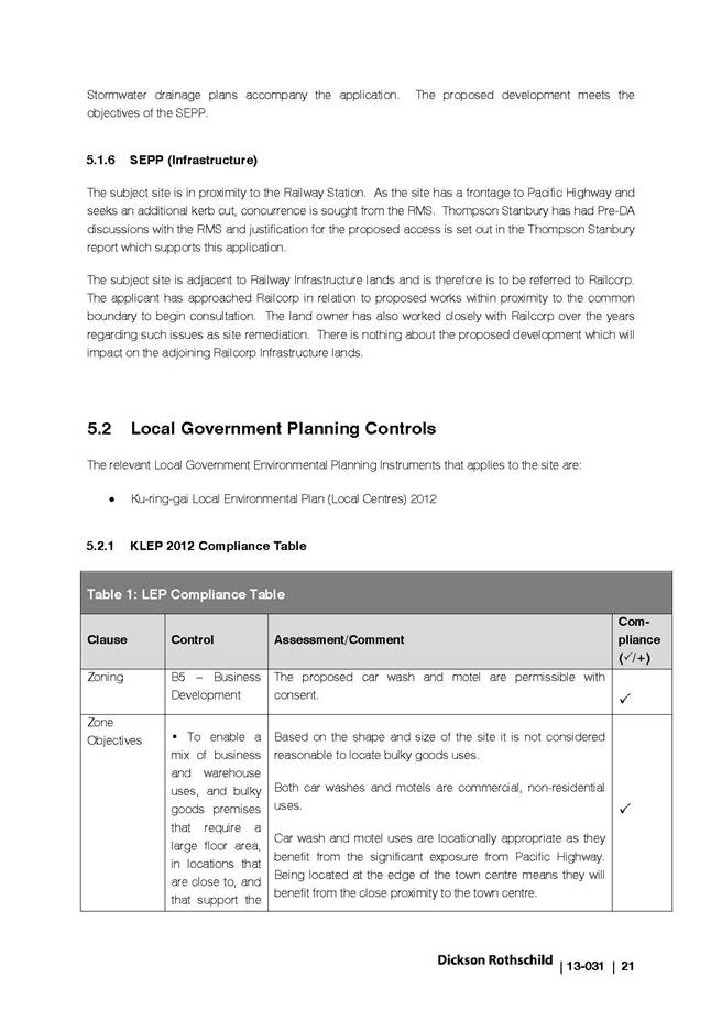
The site falls within the B5 Business Development zone under the LEP (Local Centres) 2012.
The proposed uses, consisting of a motel, café and car wash, are permissible with consent and are also consistent with the objectives of the zone as follows:
Objectives of zone
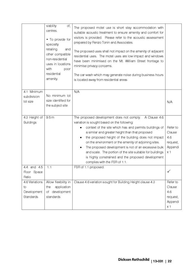
• To enable a mix of business and warehouse uses, and bulky goods premises that require a large floor area, in locations that are close to, and that support the viability of, centres.
• To provide for specialty retailing and other compatible non-residential uses in locations with poor residential amenity.
The proposed development comprises a mix of permissible uses, being a motel, carwash and café, which, in conjunction require a large floor area and that are considered to support the viability of the nearby Gordon local centre.
The proposed uses are compatible non-residential uses in the location which benefits from significant exposure to users of the Pacific Highway, and in particular south-bound traffic.
Development standards:
|
Development standard |
Proposed |
Complies |
|
Building height: 9.5m (Area J) |
12.8m |
NO (Cl. 4.6 variation) |
|
Floor space ratio: 1.0:1 |
1.0:1 |
YES |
|
Minimum lot size: No lot size restrictions |
764m2 |
N/A |
|
Ground floor development in business zones: a) No residential accommodation or ancillary car parking, and b) Provision of uses and building design to encourage interaction between building and external public areas (except where building faces a service lane or is used for a lobby, fire services access or vehicular access) |
a) No residential accommodation or ancillary car parking, and b) Uses encourage interaction/street activation, except to Mount William Street frontage (vehicular access). This is achieved by the café and associated terrace area at the primary interface to the public domain (north-western corner) and appropriate selection of materials, including shade sails, sliding doors and timber screens with suitable finishes. Consequently, the objective of encouraging the presence and movement of people is met. |
YES
YES |
|
Minimum street frontage in business zones: 20m (primary street frontage)
|
73.9m (Pacific Highway) |
YES |
Clause 4.3 – Height of buildings
The proposed development has a height of up to 12.8 metres which exceeds the maximum height standard of 9.5 metres. The extent of the proposed variation is up to 3.3 metres (34.7%). The applicant has made a submission pursuant of Clause 4.6 “Exceptions to development standards” of the LEP requesting a variation to the standard. Refer to discussion under Clause 4.6 below.
Clause 4.6 Exceptions to development standards
The proposed development breaches the building height development standard of the LEP. The applicant has made a submission pursuant to Clause 4.6 to vary this development standard. Clause 4.6 provides flexibility in applying certain development standards on the following grounds:
(1) The objectives of this clause are as follows:
(a) to provide an appropriate degree of flexibility in applying certain development standards to particular development,
(b) to achieve better outcomes for and from development by allowing flexibility in particular circumstances.
(2) Development consent may, subject to this clause, be granted for development even though the development would contravene a development standard imposed by this or any other environmental planning instrument. However, this clause does not apply to a development standard that is expressly excluded from the operation of this clause.
(3) Development consent must not be granted for development that contravenes a development standard unless the consent authority has considered a written request from the applicant that seeks to justify the contravention by demonstrating:
(a) that compliance with the development standard is unreasonable or unnecessary in the circumstances of the case, and
(b) that there are sufficient environmental planning grounds to justify contravening the development standard.
(4) Development consent must not be granted for development that contravenes a development standard unless:
(a) the consent authority is satisfied that:
(i) the applicant’s written request has adequately addressed the matters required to be demonstrated by subclause (3), and
(ii) the proposed development will be in the public interest because it is consistent with the objectives of the particular standard and the objectives for development within the zone in which the development is proposed to be carried out, and
(b) the concurrence of the Director-General has been obtained.
Whether compliance with the standard is unreasonable and unnecessary in the circumstances of the case
The applicant has provided justification that strict compliance with height development standard is unnecessary and unreasonable for the following reasons:
· The proposed development is consistent with the objectives of the zone and the development standard.
· The scale of the proposed development is compatible with the desired character of surrounding areas.
· There is no environmental impact of the additional height.
· There is no amenity impact from the additional height
· The proposed development achieves the desired 3 storey presence along Pacific Highway.
· The proposed development complies with the FSR of the site and thus the height non-compliance is not sought in order to achieve additional floor space.
· The concentration of built form at the south west corner of the site allows for a better planning outcome than spreading lower built form across the entire site due to its unique location between the Pacific Highway and Railcorp land.
The proposed development will not result in any adverse impacts on the amenity of adjoining properties or public domain areas, having regard to considerations of streetscape character, aesthetics, overshadowing, privacy, and environmental quality. The height, mass and scale of the development is appropriate for that of the Gordon local centre, protects local amenity in the immediate context and is compatible with the size of the land to be developed in accordance with the height objectives of the LEP. In this regard, it is acknowledged that the site is constrained by its narrow, wedge-shaped configuration and existing slope to the rear such that there is a significant fall from the Pacific Highway frontage to the north-eastern corner, where the numerical height breach occurs. Strict compliance with the height control over the full coverage of the building would unreasonably and unnecessarily restrict the height of the building at the rear, likely resulting in an impracticable built form with poor internal amenity.
The height and scale of the proposed development is sympathetic to surrounding development, which consists of predominantly two and three storey buildings of similar heights to the Pacific Highway frontage, including the three-storey residential flat building located on the opposite side of Mount William Street, also having frontage to the Pacific Highway. Residential flat buildings up to a height of six storeys exist in the broader vicinity of Merriwa Street towards the intersection with the Pacific Highway.
The proposal is consistent with the B5 Business Development zone objectives in addition to the height objectives of the LEP. Additionally, Council’s Urban Design Consultant has no objection to the proposed building height. In the circumstances, insistence on compliance with the Clause 4.3 – Height of buildings development standard would be unreasonable and unnecessary.
Environmental planning grounds to justify contravening the development standard
The applicant has provided sufficient environmental planning grounds for the proposed variation to the development standard, which are summarised as follows:
· The proposed additional height does not affect attaining the desired streetscape character of the area.
· The proposed development does not give rise to amenity impacts on adjacent residential properties such as overshadowing or overlooking.
· The proposed development does not impact on the environmental quality of the site or adjoining sites.
· The additional height of the development does not result in unreasonable bulk and scale.
· The additional height does not hinder the orderly and economic development of adjacent sites
It is considered that contravention of the development standard raises no matter of significance for state or regional environmental planning and that there is no public benefit in maintaining the development standard in this particular case.
Public interest – Development consistent with the zone objectives and objectives of the development standard
The applicant has provided sufficient grounds for the proposed variation to the development standard in response to the objectives of the B5 Business development zone as follows:
a) To enable a mix of business and warehouse uses, and bulky goods premises that require a large floor area, in locations that are close to, and that support the viability of, centres
The proposed development includes a mix of business uses which are appropriate to the site's location at the edge of the local centre.
b) To provide for specialty retailing and other compatible non-residential uses in locations with poor residential amenity
Both car washes and motels are commercial, non-residential uses. They are both speciality retailing uses, one proving a service to their customers and the other offering short-stay accommodation.
Car wash and motel uses are locationally appropriate as they benefit from the significant exposure from the Pacific Highway. Being located at the edge of the town centre means they will benefit from the close proximity to the town centre.
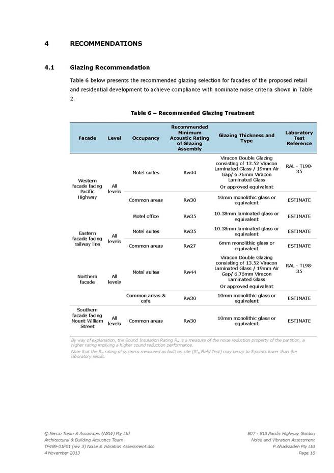
The proposed motel use is short stay accommodation with suitable acoustic treatment to ensure amenity and comfort for visitors is provided. Please refer to the acoustic assessment prepared by Renzo Tonin and Associates.
The proposed uses shall not impact on the amenity of adjacent residential uses. The motel uses are low impact and windows have been minimised on the Mt. William Street frontage to minimise privacy concerns. The car wash which may generate noise during business hours is located away from residential areas
The proposed development therefore is fully consistent with the objectives of the zone.
As previously concluded, the proposed development is consistent with the objectives of the zone given it comprises a mix of permissible uses, being a motel, carwash and café, which are considered to support the viability of the nearby Gordon local centre. The proposed uses are compatible non-residential uses in the location which benefits from significant exposure to users of the Pacific Highway, and in particular south-bound traffic.
Additionally, the applicant has provided sufficient grounds for the proposed variation in response to the objectives of the development standard (Clause 4.3 – Height of buildings) as follows:
(a) to ensure that the height of development is appropriate for the scale of the different centres within the hierarchy of Ku-ring-gai centres
The proposed development is located within the Gordon Town Centre, within the G4 zone as identified in the Local Centres DCP. The DCP which sets out the desired character, streetscape presentation and bulk and scale of buildings in the centre, only provides guidance for the subject site in terms of achieving street activation.
The LEP permits heights on the adjacent B5 and R4 lands of 11.5 m. The LEP singles out the subject site for a height limit of 9.5 m. All other commercially zoned sites in the town centre have a height limit of at least 11.5 m.
The existing residential buildings across Mt. William Street from the subject site are 3-4 storeys and give rise to an additional 4 storey by virtue of a similar topographical shift from the Pacific Highway towards the rail corridor.
The sites directly across Pacific Highway have height limits of 23.5 and 26.5 m. The DCP requires a 3 storey street wall with levels above setback.
The proposed development achieves this vision by establishing a 3 storey street wall (building) to the Pacific Highway.
b) to establish a transition in scale between the centres and the adjoining lower density residential and open space zones to protect local amenity
The site is only adjoined by residentially zoned land at one interface which is to the existing multi-unit residential development across Mt. William Street. This development is 3-4 storeys in height, with increased height towards the rail corridor.
The other residential areas which are near to the subject site are across the rail corridor to the east. These sites have permissible heights ranging from 9.5 m to 17.5 m.
Between the site and the residentially zoned land to the north east, is a B5 zoned site with a height limit of11.5m.
c) to enable development with a built form that is compatible with the size of the land to be developed
The proposed development complies with the applicable FSR control of 1:1, the other primary development control for built form. The proposed development concentrates built form towards the south west, the portions of the site with street frontages and which are closest to the core of the town centre. The proposed development has a relatively small building site coverage and minimises built form at narrower portions of the site towards the north.
The proposed development therefore achieves the objective.
The building height non-compliance relates to the proposed motel building having a height in excess of the 9.5 metres maximum permitted by the LEP. The maximum extent of the breach is 3.3 metres, which equates to a height of 12.8 metres and occurs near the rear boundary of the site, adjacent to the railway corridor. The extent of technical non-compliance along the Pacific Highway facade is negligible (approximately 0.6 metres breach to the roof level) due to the fall of the land to the rear, and the visible building façade height from the ground floor level to the roof is 9.5 metres, with the exception of an additional 0.8 metres height for the lift overrun, which is set back approximately 2 metres from the façade.
Accordingly, the motel building presents as a moderate three-storey building to the main frontages as viewed from the public domain along the east elevation (Pacific Highway) and north elevation. As a result of the site’s topography, the additional basement level is only visible to the south elevation (Mount William Street) and west elevation (railway corridor) which do not represent primary frontages and would not be discernible from the predominant public domain spaces around the site.
The resultant building height is appropriate given the location in proximity to the Gordon local centre and surrounding land uses and is commensurate with the size of the land to be developed. The FSR complies with the required standard (1:1) as indicated above and the building achieves appropriate scale. Council’s Urban Design Consultant has supported the proposed building height having regard to the scale of existing development and that identified for the desired future character of the area. No significant impacts are envisaged to the amenity of the streetscape, neighbouring or environment.
The development is considered to be in the public interest.
Concurrence of the Director General
Circular PS 08-003 issued on 9 May 2008 informed Council that it may assume the Director-General’s concurrence for exceptions to development standards.
In accordance with the provisions of Clause 4.6 (5):
In deciding whether to grant concurrence, the Director General must consider:
(a) whether contravention of the development standard raises any matter of significance for State or regional environmental planning, and
(b) the public benefit of maintaining the development standard, and
(c) any other matters required to be taken into consideration by the Director-General before granting the concurrence.
Wether contravention of the development standard raises any matter of significance for state or regional environmental planning
It is considered that the objectives of the height standard in the LEP are achieved and that approval of the proposed development would not raise any matters of significance for state or regional environmental planning. The proposed variation to Clause 4.3 – Height of buildings of the Ku-ring-gai (Local Centres) Local Environmental Plan 2012 has been assessed on its merits and this does not infer that future variation of this standard would be granted in any other instance unless appropriate justification can been provided.
The public benefit of maintaining the development standard
Given the minor nature of the proposed variation it is considered that there is minimal public benefit in maintaining the development standard having regard to the merits of this application. It is considered that no public benefit would be achieved in reducing the building height simply to achieve compliance with the stated height provision.
Any other matters required to be taken into consideration by the Director-General before granting the concurrence
All relevant State and local planning provisions have been taken into consideration in the assessment of the application prior to the granting of concurrence to the proposed variation of Clause 4.3 – Height of buildings of the Ku-ring-gai (Local Centres) Local Environmental Plan 2012.
Conclusion
The proposed variation is negligible as viewed from the main public domain spaces around the site and satisfies the criteria outlined in Clause 4.6. The proposed development will not result in any adverse impacts upon the amenity of adjoining properties or public domain areas, having regard to considerations of streetscape character, aesthetics, overshadowing, privacy, and environmental quality. The height, mass and scale of the development is appropriate for that of the Gordon local centre, protects local amenity in the immediate context and is compatible with the size of the land to be developed in accordance with the height objectives of the LEP. Having regard to these considerations, in conjunction with the site constraints as discussed above, strict compliance with Clause 4.3 – Height of buildings is considered unreasonable and unnecessary in this instance.
Overall, the proposal has been designed to comply with provisions of the Ku-ring-gai LEP (Local Centres) 2012 and Ku-ring-gai (Local Centres) DCP 2013 as far as practicable and may be supported by Council.
Clause 5.9 – Preservation of trees or vegetation
The site does not currently feature any landscaping area, trees or vegetation, however, the proposal involves provision of a new landscaped area (12m2) to the Pacific Highway frontage at the north-western corner of the site. A Robinia tree located on Council’s road reserve at the south-eastern corner of the site is required to be removed by the development. The subject tree has been assessed by Council’s Tree Management Coordinator (Operations department) and is considered to be in average condition as discussed above (internal referrals). No objections have been raised in relation to the tree removal or other landscaping aspects of the development. Council’s Landscape Assessment Officer has recommended new tree planting on the nature strip to be consistent with Council’s Public Domain Strategy (Condition 56).
Clause 5.10 – Heritage conservation
The site does not contain a heritage item and is not located within a heritage conservation area. The site is within the broad vicinity of a heritage item at 21 Mount William Street, however this property is located on the opposite side of the railway corridor to the rear (north-east) and there is no direct visual connection between the sites. Accordingly, the proposed development would not have any effect on the heritage significance of this item.
Clause 6.1 – Earthworks
Minor excavation (approximately 0.7 metres) is proposed to level the floor within the existing basement. The earthworks will not restrict the existing or future use of the site, adversely impact on neighbouring amenity, the quality of the water table or disturb any known relics. Additionally, the fill to be removed will be disposed of appropriately. The site adjoins the railway corridor to the rear and RailCorp have provided conditions of consent in this regard (Conditions 28-32).
Clause 6.2 - Stormwater and water sensitive urban design
Council’s Development Engineer is satisfied that aspects of stormwater management and water sensitive urban design for the proposed development are acceptable having regard to the requirements of the LEP.
Policy provisions (DCPs, Council policies, strategies and management plans)
Ku-ring-gai Local Centres Development Control Plan
VOLUME A
Part 3 – Subdivision and amalgamation
Part 3A.1 Land amalgamation
The proposal involves development across four existing lots and site amalgamation is proposed as required by the DCP.
In accordance with Part 3A.1, land amalgamation is to increase the width of the street frontage and avoid irregular lot configuration. In particular, lot amalgamation is to avoid creating:
i) a primary street frontage less than 20m as required by KLEP (Local Centres) 2012;
ii) a lot size less than that required by KLEP (Local Centres) 2012; and/or
iii) a highly constrained site.
The proposed development complies with the land amalgamation requirements of the DCP as summarised below:
(i) The primary street (Pacific Highway) frontage created will be 73.9 metres.
(ii) There are no lot size restrictions applicable for the site and the proposed lot size of 764m2 is acceptable on merit.
(iii) The existing allotments are significantly constrained as a result of their irregular shapes, small areas and positioning between the railway corridor to the rear and Pacific Highway to the front.
(iv) The amalgamated lots would increase development potential of the land in general and would facilitate the proposed development without creating an unreasonable burden on adjoining RailCorp land.
(v) The resultant lot shape, orientation and design is acceptable.
(vi) The proposed building footprint is logically concentrated to the widest part of the site and not within any areas of ecological, landscaping or heritage significance.
(vii) The proposal would not create any significant impacts on the amenity of any neighbouring properties. The nearest residential property is a three-storey flat building located across Mount William Street (803-805 Pacific Highway) and the resultant building separation is approximately 21 metres.
Part 8 – Mixed use development controls
Part 8 of the DCP relates to mixed use buildings located within the urban centres that are composed of a mixture of two or more of the following uses:
i) retail or commercial uses at ground and lower levels; and
ii) residential apartments on upper levels; and/or
iii) offices on upper levels.
The proposed development is comprised of commercial uses at the ground level in conjunction with a motel (short-term accommodation on a commercial basis) on the ground level and on upper levels. Notwithstanding this, the introduction to Part 8 of the DCP states the following:
New non-residential buildings will be required to meet the objectives and controls related to commercial aspects of this Part and where relevant, provisions related to adjoining residential development.
Accordingly, the following compliance table for Part 8 is provided.
|
COMPLIANCE TABLE |
||
|
Development control |
Proposed |
Complies |
|
8A.1 Building setbacks (N/A) |
|
|
|
Nil required setback: Refer Volume B, Part 1D.3 Local Centre Building Setbacks (below)
|
N/A: Refer Volume B, Part 1D.3 Local Centre Building Setbacks)
Nil setback to street frontages.
Nil to 3.1 metres setback to rear boundary.
|
N/A
|
|
8A.2 Building separation |
|
|
|
The minimum separation between residential buildings on the development sites and the adjoining sites must be:
Up to 4th storey 12m between habitable rooms/balconies 9m between habitable rooms/balconies and non-habitable rooms 6m between non-habitable rooms
5 to 8 storeys over the podium 18m between habitable rooms/balconies 13m between habitable rooms/balconies and non-habitable rooms 9m between non-habitable rooms
|
The proposed commercial building is a non-residential and non-office building.
Notwithstanding, building separation to the nearest residential property is 21 metres (803-805 Pacific Highway).
|
YES
|
|
8A.3 Wind impact |
|
|
|
10m/second at the footpath |
No change at the Pacific Highway frontage.
|
YES |
|
8A.4 Site coverage |
|
|
|
In R4 zones - the site coverage must not exceed 35% of the site area |
N/A: B5 zone
Existing site coverage is 100%. Proposal involves provision of new ~12m2 landscaping area. |
N/A |
|
8A.5 Deep soil landscaping |
||
|
For mixed use development in R4 zonings, residential flat development must have a minimum deep soil landscaping area of 40% for a site area less than 1800m2 and 50% for a site area of 1800m2 or more |
N/A: B5 zone |
N/A |
|
8B – Access and parking |
||
|
8B.1 Vehicle and Service Access and Loading Facilities |
||
|
In accordance with Volume B, 1D.6, being: - No vehicle access via the Pacific Highway |
Car wash access via Pacific Highway. |
NO (discussed below) |
|
8B.2 Car parking provision |
||
|
Design All parking to be within basement.
|
All parking is within the basement. |
YES |
|
Car parking shall not project above 1m for supporting frontages.
|
The basement car park is below the existing and finished ground levels at the relevant (Pacific Highway) street frontage. |
YES |
|
Car parking to comply with AS2890.1
|
Compliant |
YES |
|
Car parking rates In accordance with Volume C Part 2R: 31 spaces required
|
18 car spaces 2 motorbike spaces |
NO (discussed below) |
|
8B.3 Bicycle parking and support facilities provision |
||
|
Commercial - A minimum of 1 bicycle space per 600m2 for staff - A minimum of 1 bicycle space per 2500m2 for visitors |
10 spaces |
YES |
|
8C Building design and sustainability – N/A: Refer to Volume C Part 3 – Building design and sustainability |
||
|
8C.7 – Building entries |
||
|
Buildings must address the street either: with main entrances to lift lobbies directly accessible and visible from the street; or with the path to the building entry readily visible from the street where site configuration is conducive to having a side entry. |
The motel lobby main entrance is accessible and visible from the Pacific Highway.
|
YES |
|
Buildings with facades over 18m long must have multiple entries.
|
The Pacific Highway façade (~19m length) has entries to the motel lobby and café.
|
YES |
|
Building entry must be integrated with building facade design. At street level, the entry is to be articulated with awnings, porticos, recesses or projecting bays for clear identification.
|
The motel entry is well integrated with the building design and identified by a recessed area between planter boxes along the front facade. |
YES |
|
All entry areas must be well lit and designed to avoid any concealment or entrapment areas. All light spill is prohibited.
|
The entry area does not contain concealment or entrapment areas. Light spill will be minimised by the arrangement of building form. |
YES |
|
8C.8 – Internal common circulation |
||
|
The design of internal common circulation space must comply with the provisions in AS1428.1 and AS1428.2 to provide adequate pedestrian mobility and access.
|
A BCA report which demonstrates compliance with the standards has been provided. |
YES |
|
All common circulation areas including foyers, lift lobbies and stairways must have: i) appropriate levels of lighting with a preference for natural light where possible; ii) short corridor lengths that give clear sight lines; iii) clear signage noting apartment numbers, common areas and general direction finding; iv) natural ventilation; v) low maintenance and robust materials. |
Appropriate lighting, sight lines, way finding, ventilation and materials to be available to lift lobbies and foyers. Amenity aspects for the motel are supported by Council’s urban design consultant. |
YES
|
|
8C.9 – Roof forms and podiums |
||
|
Service elements to be integrated into the design of the roof |
Air conditioning is integrated in the building design on the upper levels. The lift overrun above the roof is minimal. |
YES |
|
Roof design must respond to solar access |
The roof design maintains solar access. |
YES |
|
8C.12 Building facades |
||
|
For building façade street wall controls for mixed use buildings in urban precincts (precinct G4), refer to Volume B Part 1D.3. |
The proposal accords with the building setbacks and public domain provisions of Volume B Part 1D.3. |
YES |
|
8C.13 – Corner building articulation |
||
|
Street corners must be emphasised by accentuating parts of the building façade, through: i)changes in height, colour or facade materials; ii)change in building articulation; iii)facade orientation; iv)change in roof expression; v)splayed setbacks or curves; vi)corner entries.
Corner buildings are to address both street frontages. |
The site is not a typical corner site, although has dual frontages: the main being the Pacific Highway and secondary being the short access road, Mount William Street, which serves as access to the proposed development and the flat building at 803-805 Pacific Highway.
The proposal reasonably articulates all street frontages. The cantilevered roof feature oriented to southbound traffic along the Pacific Highway presents a contemporary design aesthetic and capitalises on the lot shape. Refer to urban design comments (external referrals). |
YES |
|
8C.14 – Ground floor commercial uses |
||
|
Buildings on principle active street frontages must provide facades that address the street and public domain with appropriate façade treatments at street level. Refer to Volume B Part 1D.3. |
The development achieves the purpose of a supporting active street frontage as required to the Pacific Highway. Refer to discussion as per Volume B Part 1D.4 (below). |
YES |
|
8C.15 – Awnings |
||
|
Provide awnings along the supporting active street frontages (including mixed use buildings in R4 zones) wherever practical, especially at key pedestrian entrances. |
Awnings are provided at building entries to the motel and café along the supporting active street (Pacific Highway) frontage. |
YES |
|
8C.16 – Colonnades |
||
|
All colonnade spaces must be within the property boundary.
|
Colonnade space to the café is within the property boundary. |
YES
|
|
Colonnades are to have a height/width ratio no less than 1.5:1, a minimum width of 2.4m, and a minimum soffit height of 3.6m. |
Height 2.8m Width: 3.0 metres Ratio: 0.93:1
|
NO (discussed below) |
|
8C.20 – Late night trading |
||
|
Development for late night trading premises must be designed to minimise the impacts of noise production on nearby and adjoining premises |
No late night trading proposed (hours of operation 8am to 7pm). |
YES |
8B – Access and parking: vehicle and service access and loading facilities (8B.1)
The vehicle and service access and loading facilities requirements of Part 8B.1 of the DCP defer to the site specific requirements prescribed by Volume B, Part 1D.6, which identify specific vehicular and pedestrian access points to sites within the precinct (Precinct G4). No specific access points are identified for the subject site, however, for Precinct G4 it is stated that vehicle access via the Pacific Highway is not permissible. The development proposes access to and from the car wash via the Pacific Highway. Notwithstanding the non-compliance in this regard, given the Pacific Highway is a classified road, the application was referred to the RMS who have raised no objection to the proposal, subject to conditions as discussed above. Council’s Development Engineer has also raised no objection to the proposal having regard to vehicle and service access and loading facilities and, as such, the proposal is acceptable in this regard.
8B – Access and parking: car parking rates (8B.2)
The car parking rates requirement of Part 8B.2 of the DCP defer to the rates prescribed by Volume C, Part 2R, which specifies 31 spaces are required for the development. The proposal provides a total of 18 car spaces and 2 motorbike spaces, representing a 63% shortfall of the required number of spaces. The applicant has submitted a traffic assessment in support of the proposed parking provision and this is accepted as discussed above by Council’s Development Engineer.
8C – Building design and sustainability: colonnades (8C.16)
As required by Part 8C.16 of the DCP, colonnades are to have a height/width ratio no less than 1.5:1 and a minimum height of 3.6 metres. The colonnade to the proposed café entrance does not comply with these numerical requirements, having a height/width ratio of 0.93:1 and a height of 2.8 metres. However, the proposed colonnade dimensions are acceptable on merit having regard to the DCP objectives of providing street activation, pedestrian amenity with weather protection, high visibility and facilitating outdoor dining. Council’s Urban Design Consultant has not raised any objections with regard to the proposed colonnade dimensions. Additionally, the proposed width of 3.0 metres exceeds the minimum width requirement of 2.4 metres.
Part 12 – Signage and Advertising
The proposed business identification signs for the motel, café and car wash are subject to the signage provisions of the DCP. Details of the proposed signage are as follows:
West elevation (Pacific Highway, immediate street frontage):
· one under awning sign, ‘Gordon Inn’ (3.53m x 0.31m), and one street address sign for the motel, ‘807-813’ (1.03m x 0.18m)
· one under awning sign for the café, ‘Gordon Café (3.22m x 0.31m)
· one fascia sign for the car wash office building, ‘Gordon Carwash’ (2.81m x 1.08m)
North elevation (Pacific Highway southbound approach, building facade):
· one fascia sign for the motel, ‘Gordon Inn’ (2.72m x 1.15m)
South elevation (Mount William Street frontage):
· one fascia sign for the motel, ‘Gordon Inn’ (2.72m x 1.15m)
All signs will feature pin fixed stainless steel lettering and will be non-illuminated.
In accordance with the DCP requirements, the proposed development provides a co-ordinated presentation of signs for the multiple uses on the site. The signage is integrated with the host building in each case and responds to the respective scale, proportions and architecture of the building.
Part 12.2 of the DCP permits a maximum of one sign per street frontage. The motel indirectly provides two fascia signs visible to the Pacific Highway given the building’s design configuration, which capitalises on the triangular shape of the site by addressing the Pacific Highway southbound traffic on approach to the site as well as the immediate street frontage. This is considered acceptable and satisfies the DCP objectives as only one sign is present on each building frontage such that there is no dominance of signage, whilst enabling clear identification of the business.
Additionally, all proposed signs have a maximum size of less than 6m2 and maximum projection from wall of 300mm in accordance with the DCP requirements. Overall, signage dimensions and placement are satisfactory having regard to proportions of the respective building facades and will encourage the effective identification of businesses whilst not appearing excessive in accordance with the objectives of the DCP.
Part 13 – Tree and Vegetation Preservation
The site does not currently feature any landscaping area, trees or vegetation, however, the proposal involves provision of a new landscaped area (12m2) to the Pacific Highway frontage at the north-western corner of the site. Council’s Landscape Assessment Officer has supported the application having regard to the tree and vegetation preservation provisions of the DCP.
VOLUME B
Part 1 – Urban precincts and sites
Part 1D.1 Local Centre Urban Precincts
The site is located within Precinct G4: Mixed Use within the Gordon Local Centre as identified in Part 1D.1 of the DCP. Development is to be designed to support and enhance the planned future character for the precinct in accordance with Part 1D.1, which is identified as follows:
Precinct G4: Mixed Use
This precinct is located on the northern periphery of Gordon Centre between Ryde Road, the Pacific Highway and Merriwa Street.
xii) The area is planned to become a mixed use precinct providing a support role to the core retail precincts. The precinct will offer opportunities for a wide range of uses such as bulky goods, bulk suppliers and the like; business and employment related uses; medical, recreational and other professional services; as well as residential apartment buildings.
xiii) This precinct will provide an urban edge to define the Pacific Highway and provide a good quality entry experience for drivers and train passengers arriving in Gordon from the north.
xiv) Fitzsimons Lane has potential to become a smaller scale street with active uses including small retail facilities, cafes or corner stores where they meet the needs of employees and residents in the precinct.
The proposed uses comprising a motel, café and car wash are permissible within the zone of the site as identified in relation to the KLEP (Local Centres) 2012 and compatible with the planned future character for the precinct as above.
The built form of the combined motel and café along the property frontage provides a suitable urban edge to define the Pacific Highway and will provide a good quality entry experience for drivers and passengers arriving in Gordon from the north. The proposal is supported by Council’s Urban Design Consultant having regard to relevant design principles including context, scale, built form and aesthetics, including quality of materials and finishes.
Part 1D.2 Local Centre Community Infrastructure
Part 1D.2 requires development to support and to compliment the provision of Key Community Infrastructure. There are no items of infrastructure identified by the DCP that relate to the subject site.
Part 1D.3 Local Centre Building Setbacks
Part 1D.3 (Precinct G4) sets specific building setback requirements for buildings in the B4 zone. These are not applicable to the subject site, which is in the B5 zone. The DCP does not provide specific building setback requirements for the proposed development, however, the applicable objectives of Part 1D.1 are as follows:
1. To create cohesive streetscapes with consistent building alignments and setbacks in the commercial areas.
2. To facilitate modulation and articulation of building facades.
3. To require building setbacks in appropriate locations to provide opportunities for street tree plantings or footpath widening.
4. To require building setbacks in appropriate locations to allow widening of roads, lanes and streets.
5. To improve pedestrian accessibility and safety.
6. To allow reduced building setbacks for residential developments in the R4 zone in close proximity to the commercial areas
Building setbacks for the proposed development are satisfactory having regard to the above objectives. The proposed motel building with integrated café is located to the south-eastern/wide area of the site and aligned with the primary street frontage (Pacific Highway/south-western boundary). The café provides a terrace area at the street level and suitable street activation is provided to the Pacific Highway. The proposed building is also aligned with the secondary street frontage (Mount William Street/south-eastern boundary).
The proposed building provides varied rear setbacks to the skewed boundary with the adjoining railway corridor and a modulated appearance with provision of balconies. The building abuts the boundary at the north-western corner and setbacks are provided along the rear wall up to 3.1 metres at the south-eastern corner.
The proposed car wash area to the north-western/narrow end of the site is largely free of structures, with the exception of a small office at the street frontage. A new landscaped area is provided to the north-western corner which will soften the appearance of built form on the approach to the site from the north along the Pacific Highway.
The proposed motel building facade is well articulated and modulated providing a contemporary design with a cantilevered roof structure and shade sails to the north-western façade as viewed on the approach from the north along the Pacific Highway, and timber cladding, planter boxes and balconies to the south-western façade fronting the Pacific Highway directly.
The proposed building footprint does not conflict with any planned key infrastructure items or modifications. Works as required to the existing road reserve will not compromise pedestrian accessibility and safety (Condition 48).
The building setbacks provided are suitable and will not have any significant impacts having regard to neighbouring amenity. The nearest residential property is the flat building located across Mount William Street and the resultant building separation is approximately 21 metres (greater than the 12 metres minimum required by the DCP for residential development). As such, no built form impacts, privacy or amenity impacts are envisaged in this regard. Shadow diagrams have been provided indicating no undue shadow cast to any neighbouring properties.
Accordingly, the proposal is consistent with the building setback objectives of the DCP as demonstrated above.
Part 1D.4 Local Centre Built Form
Part 1D.4 nominates the Pacific Highway (south-western) frontage of the site as a ‘supporting active frontage’, although there are no specific built form controls relating to the site.
Supporting active frontage as defined in the DCP:
“is located on primary streets or secondary streets or lanes. This frontage will support active uses at ground level however it is acknowledged that vehicle and service access will be a requirement.
Note: Also see Volume A Part 8C-14”.
Volume A Part 8C-14 relates to ground floor commercial uses and provides that buildings on supporting active frontages must:
i) minimise the extent of blank walls;
ii) support dispersed pedestrian-oriented activities with well articulated entrances;
iii) provide facades that address the street and public domain and integrate vehicle access
where provided; and
iv) provide awnings, especially at key pedestrian entry points.
Council’s Urban Design Consultant has considered that the proposal achieves the support role as required by the DCP.
As discussed above, the building is well articulated and modulated to the primary frontages in particular, with minimal extent of blank walls. Visual interest is provided to the facades that suitably address the street and public domain, including cantilevered roof elements and balconies, and use of differing materials and finishes.
Integrated vehicle access to the car wash is provided from the Pacific Highway and to the motel basement car park from Mount William Street and is not expected to unreasonably detract from the active uses provided at the ground floor level.
The entrances to the café and motel are level with the footpath, well articulated and the awning, shade sails and openable shopfront to café will provide direct physical and visual connection with the public domain.
The proposed development is considered to provide an appropriate supporting active frontage and is acceptable having regard to the relevant controls and objectives of Volume A Part 8C-14, including supporting pedestrian activity and enhancing the amenity and safety of the public domain.
Part 1D.4 Local Centre Public Domain and Pedestrian Access
Part 1D.4 nominates specific measures to be provided within local centres precincts to increase the pedestrian permeability of the commercial area. There are no specific measures identified in relation to the subject site. However, the existence of the pedestrian access path adjacent to the site’s rear boundary is noted in this regard. The path travels beneath the railway line and connects the southern extent of Mount William Street to the northern side of the railway corridor. The proposed development is considered to provide increased vitality to this link as a result of providing new active uses and renewing the site from its present dilapidated state. This is consistent with the objective of improving commercial activity, safety and street life of the commercial streets in the precinct.
Part 1D.6 Local Centre Building Entries, Car Parking and Service Access
Part 1D.6 identifies specific vehicular and pedestrian access points to sites within the precinct (Precinct G4). No specific access points are identified for the subject site, however, for Precinct G4 it is stated that vehicle access via the Pacific Highway is not permissible. The development proposes access to and from the car wash via the Pacific Highway. Notwithstanding this, given the Pacific Highway is a classified road, the application was referred to the RMS who have not objected to the proposal, subject to conditions as discussed above. Council’s Development Engineer also considers the proposal to be acceptable having regard to access.
Additionally, Part 1D.6 requires that lobbies are to be located on the Pacific Highway (amongst other streets) and as such the proposed motel lobby is compliant in this regard. Overall, the proposal is considered acceptable having regard to the objectives of Part 1D.6.
Part 2 – Site design for water management
Council’s Development Engineer is satisfied that water management aspects of the proposed development are acceptable having regard to the requirements of the DCP.
Part 3 – Land contamination
A contamination investigation report has been submitted with the application and the site is suitable for the proposed development as discussed above having regard to SEPP 55.
Part 7 – Heritage items and conservation areas
The site does not contain a heritage item and is not located within a heritage conservation area. The site is within the broad vicinity of a heritage item at 21 Mount William Street, however this property is located on the opposite side of the railway corridor to the rear (north-east) and there is no direct visual connection between the sites. Accordingly, the proposed development would not impact the heritage significance of this item and is therefore acceptable having regard to the heritage considerations of the DCP.
Part 8 – Development near rail corridors and busy roads
The application has been referred to RailCorp and RMS having regard to the location of the proposed development in relation to the North Shore railway line to the rear of the site and the busy road (Pacific Highway) at the site frontage. Conditions have been provided by each authority in response (Conditions 5, 6, 10, 13, 14, 15, 26, 28-32, 68, 69).
An acoustic assessment has been submitted in support of the application and potential noise impacts will be mitigated by suitable construction materials.
A small landscaped area at the north-western corner of the site and planter boxes adjacent to the motel entrance will provide an enhanced visual setting for the site along the Pacific Highway frontage in accordance with the DCP controls .
VOLUME C
Part 1 – Site design
This part relates to earthworks and landscape design.
Minor excavation (approximately 0.7 metres) is proposed to level the floor within the existing basement. The earthworks will not restrict the existing or future use of the site, adversely impact neighbouring properties, landscaping or environmental values. A new landscaping area is proposed in the north-western corner of the site which will enhance the landscape character of the area.
Part 2 – Access and parking
Access provisions have been addressed by the BCA Assessment report submitted with the application. Equitable access is provided to the development by at grade entrances from the footpath and provision of a lift to each level, including the basement car park. Two accessible motel rooms and car parking spaces are provided.
The proposal involves provision of a basement car park accessible from Mount William Street. Council’s Development Engineer has supported the proposal with respect to parking provision, which includes 18 car spaces, 2 motorbike spaces, and 10 bicycle spaces.
Part 3 – Building design and sustainability
Part 3.1 Green buildings
Building design and sustainability provisions of the DCP apply given BASIX standards are not applicable to the proposed development. Accordingly, an ecologically sustainable design (ESD) report has been submitted in support of the application indicating ESD and energy efficiency features incorporated with the development, including:
· High level of solar access to the rooms facing north-east
· High levels of daylight available through the windows, reducing the need for artificial lighting
· Balconies to the north will help shield against high altitude summer sun to the windows underneath them
· Naturally ventilated hallway
· Incorporation of thermal mass
· 15.76m3 rainwater tank for the car was water usage
The report provides additional recommendations to improve upon the existing sustainability elements of the proposed development and comply with the performance requirements of the DCP. These recommendations are required to be adopted by condition (Condition 16).
Part 3.2 Social impact
The proposed development is acceptable having regard to social considerations and no adverse impacts are expected in this regard.
Part 3.3 Building services
The proposed development includes a plant room on Level 1 and on Level 2 for air conditioning units and other servicing equipment. The services will be appropriately concealed by a metal louvre screen and will not detract from the visual or general amenity of the streetscape or building users.
Part 3.4 Waste management
An acceptable waste management plan in accordance with the DCP has been submitted with the application. Sufficient storage is provided for waste associated with the proposed uses, including a screened garbage bin storage area adjacent to the car wash office, chemical storage area for the car wash, basement storage and house-keeping/garbage areas provided for the motel on levels 1 and 2. Waste collection is proposed to be undertaken by a private contractor.
Part 3.5 Acoustic privacy
The proposed car wash is expected to generate some noise associated with the operation of equipment such as vacuums and hoses, however, the level of noise likely to be generated is considered acceptable given existing noise levels associated with traffic on the Pacific Highway, and the site location away from residential areas. Additionally, noise impacts will be limited to business hours in order to protect user amenity for the motel (Condition 77).
An acceptable acoustic assessment has been submitted in support of the application. Potential noise impacts to the motel, including vehicular traffic and the railway corridor, will be suitably mitigated by noise attenuating construction materials. Council’s Environmental Health Officer is satisfied with the proposal, subject to conditions, including that all noise generating equipment associated with the mechanical exhaust ventilation will be adequately soundproofed for residential amenity (Conditions 60, 74).
Part 3.6 Visual privacy
The proposed development will not compromise the visual privacy of any neighbouring properties and provides suitable privacy for users of the motel building.
The nearest residential property is the flat building located across Mount William Street (803-805 Pacific Highway) and the resultant building separation is approximately 21 metres, precluding any potential for overlooking between the properties. The development adjoins RailCorp land to the rear/north-eastern boundary and would not present any overlooking to residential properties beyond the railway corridor, being separated by a distance of over 40 metres to the closest property (19 Mount William Street).
The motel windows do not present any significant internal visual privacy issues and privacy screens as indicated on plans between adjoining balconies will prevent any direct overlooking between these elements.
Part 3.7 – Materials, finishes and colours
The proposed materials and finishes to be used are considered to be acceptable by Council’s Urban Design Consultant. The proposed feature materials, including louvres and timber cladding, are compatible with the contemporary design of the building and will complement the streetscape, provide visual interest, enhance façade articulation and minimise bulk and scale of the building.
Overall, the proposed development is acceptable having regard to the building design and sustainability provisions of the DCP.
Part 4 – Water management
Council’s Development Engineer is satisfied that the proposed development has been designed to manage stormwater as per the requirements of the DCP, subject to conditions.
Part 5 – Notification
The application has been notified in accordance with the requirements of the DCP. The submissions received are addressed above.
Section 94 Development Contributions Plan 2010
The development attracts a section 94 contribution of $81,542.65 which is required to be paid prior to the issue of the Construction Certificate (Condition 34).
Town Centres Public Domain Plan 2010
Staff from Council’s Strategy and Environment Department have reviewed the proposal with respect to the Town Centres Public Domain Plan 2010 and concluded that the subject site is not within any of the key areas that are of primary concern within the plan.
However, it is noted that the footpath along the Pacific Highway is to be large format paver with street tree planting to detail design. Works to the footpath are to be in accordance with the public domain plan as required by condition (Condition 16).
Additionally, the existence of the pedestrian link adjacent to the rear of the site which provides access beneath the rail corridor is acknowledged in the plan. Given the derelict nature of the subject site in its current state, it is likely that redevelopment of the site would increase the attractiveness and vitality of this existing pedestrian link.
Likely Impacts
The likely impacts of the development have been considered within this report and are deemed to be acceptable, subject to conditions as recommended below.
Suitability of the Site
The site is considered suitable for the proposed development, subject to a condition in accordance with the recommendations of the Phase 2 detailed site investigation as discussed above (Condition 18).
Public Interest
The proposal is considered to be in the public interest.
Conclusion
Having regard to the provisions of section 79C of the Environmental Planning and Assessment Act 1979, the proposed development is considered to be satisfactory.
|
A. THAT Council, as the consent authority, is satisfied that the request under Clause 4.6 of the Ku-ring-gai Local Environmental Plan (Local Centres) 2012 to vary the building height development standard is well founded. Council is also satisfied that the proposed development will be in the public interest and is consistent with the objectives of the development standard and the B5 Business Development zone.
AND
B. THAT Council, as the consent authority, grant development consent to DA0529/13 for partial demolition of existing structures and construction of a motel, café and car wash at 807-813 Pacific Highway, Gordon, for a period of two years from the date of the notice of determination, subject to the following conditions:
Conditions that identify approved plans:
1. Approved architectural plans and documentation (new development)
The development must be carried out in accordance with the following plans and documentation listed below and endorsed with Council’s stamp, except where amended by other conditions of this consent:
Reason: To ensure that the development is in accordance with the determination.
2. Inconsistency between documents
In the event of any inconsistency between conditions of this consent and the drawings/documents referred to above, the conditions of this consent prevail.
Reason: To ensure that the development is in accordance with the determination.
Conditions to be satisfied prior to demolition, excavation or construction:
3. Asbestos works
All work involving asbestos products and materials, including asbestos-cement-sheeting (ie. Fibro), must be carried out in accordance with the guidelines for asbestos work published by WorkCover Authority of NSW.
Reason: To ensure public safety
4. Waste disposal
The developer is to appropriately characterise any fill for waste disposal in accordance with the NSW EPA, 2009 Waste Classification Guidelines Part 1: Classifying Waste. Prior to it being removed from the site, and the disposal of this fill should be undertaken by a licensed asbestos removal contractor, in accordance with the WHS Act, 2011 and relevant WorkCover guidance. The asbestos removalist contractor should provide asbestos clearance upon completion of the excavation works.
Reason: Environmental protection and site safety.
5. Roads and Maritime Services - excavation requirements
The developer is to submit design drawings and documents relating to the excavation of the site and support structures to Roads and Maritime for assessment, in accordance with Technical Direction GTD2012/001.
The developer is to submit all documentation at least six (6) weeks prior to commencement of construction and is to meet the full cost of the assessment by Roads and Maritime.
The report and any enquiries should be forwarded to: Project Engineer, External Works Sydney Asset Management Roads and Maritime Services PO Box 973 Parramatta CBD 2124 Telephone 8849 2114 Fax 8849 2766
If it is necessary to excavate below the level of the base of the footings of the adjoining roadways, the person acting on the consent shall ensure that the owner/s of the roadway is/are given at least seven (7) days notice of the intention to excavate below the footings. The notice is to include complete details of the work.
Reason: To comply with Roads and Maritime Services requirements.
6. Roads and Maritime Services - stormwater discharge
The post-development stormwater discharge from the subject site into the Roads and Maritime drainage system is not to exceed the pre-development discharge.
Detailed design plans and hydraulic calculations of any changes to the stormwater drainage system are to be submitted to the Roads and Maritime for approval, prior to the commencement of any works.
Details should be forwarded to: The Sydney Asset Management Roads and Maritime Services PO Box 973 Parramatta CBD 2124
A plan checking fee will be payable and a performance bond may be required before the Roads and Maritime approval is issued. With regard to the Civil Works requirement please contact the Roads and Maritime Project Engineer, External Works Ph: 8849 2114 or Fax: 8849 2766.
Reason: To comply with Roads and Maritime Services requirements.
7. Notice of commencement
At least 48 hours prior to the commencement of any development (including demolition, excavation, shoring or underpinning works), a notice of commencement of building or subdivision work form and appointment of the principal certifying authority form shall be submitted to Council.
Reason: Statutory requirement.
8. Notification of builder’s details
Prior to the commencement of any development or excavation works, the Principal Certifying Authority shall be notified in writing of the name and contractor licence number of the owner/builder intending to carry out the approved works.
Reason: Statutory requirement.
9. Dilapidation survey and report (public infrastructure)
Prior to the commencement of any development or excavation works on site, the Principal Certifying Authority shall be satisfied that a dilapidation report on the visible and structural condition of all structures of the following public infrastructure, has been completed and submitted to Council:
Public infrastructure
· Full road pavement width, including kerb and gutter, of Pacific Highway southbound and Mount William Street over the site frontage, including the full intersection. · All driveway crossings and laybacks opposite the subject site.
The report must be completed by a consulting structural/civil engineer. Particular attention must be paid to accurately recording (both written and photographic) existing damaged areas on the aforementioned infrastructure so that Council is fully informed when assessing any damage to public infrastructure caused as a result of the development.
The developer may be held liable to any recent damage to public infrastructure in the vicinity of the site, where such damage is not accurately recorded by the requirements of this condition prior to the commencement of works.
Note: A written acknowledgment from Council must be obtained (attesting to this condition being appropriately satisfied) and submitted to the Principal Certifying Authority prior to the commencement of any excavation works.
Reason: To record the structural condition of public infrastructure before works commence.
10. Construction and traffic management plan
The applicant must submit to Council a Construction Traffic Management Plan (CTMP), which is to be approved by Council and Roads and Maritime services prior to the commencement of any works on site.
The plan is to consist of a report with Traffic Control Plans attached.
The report is to contain commitments which must be followed by the demolition and excavation contractor, builder, owner and subcontractors. The CTMP applies to all persons associated with demolition, excavation and construction of the development.
The report is to contain construction vehicle routes for approach and departure to and from all directions, number of trucks, hours of operation, access arrangements and traffic control.
The report is to contain a site plan showing entry and exit points. Swept paths are to be shown on the site plan showing access and egress for an 11 metre long heavy rigid vehicle. All demolition and construction vehicles are to be contained wholly within the site and vehicles must enter the site before stopping.
The Traffic Control Plans are to be prepared by a qualified person (red card holder). One must be provided for each of the following stages of the works:
o Demolition o Excavation o Concrete pour o Construction of vehicular crossing and reinstatement of footpath o Traffic control for vehicles reversing into or out of the site.
Traffic controllers must be in place at the site entry and exit points to control heavy vehicle movements in order to maintain the safety of pedestrians and other road users.
When a satisfactory CTMP is received, a letter of approval will be issued with conditions attached. Traffic management at the site must comply with the approved CTMP as well as any conditions in the letter issued by Council. Council’s Rangers will be patrolling the site regularly and fines may be issued for any non-compliance with this condition.
Reason: To ensure that appropriate measures have been considered during all phases of the construction process in a manner that maintains the environmental amenity and ensures the ongoing safety and protection of people, and to comply with the requirements of Roads and Maritime Services.
11. Erosion and drainage management
Earthworks and/or demolition of any existing buildings shall not commence until an erosion and sediment control plan is submitted to and approved by the Principal Certifying Authority. The plan shall comply with the guidelines set out in the NSW Department of Housing manual "Managing Urban Stormwater: Soils and Construction" certificate. Erosion and sediment control works shall be implemented in accordance with the erosion and sediment control plan.
Reason: To preserve and enhance the natural environment.
12. Construction waste management plan
Prior to the commencement of any works, the Principal Certifying Authority shall be satisfied that a waste management plan, prepared by a suitably qualified person, has been prepared in accordance with the Ku-ring-gai Local Centres Development Control Plan (DCP), Volume C, Part 3.4 - Waste Management.
The plan shall address all issues identified in the DCP, including but not limited to: the estimated volume of waste and method for disposal for the construction and operation phases of the development.
Note: The plan shall be provided to the Certifying Authority.
Reason: To ensure appropriate management of construction waste.
Conditions to be satisfied prior to the issue of the construction certificate:
13. Roads and Maritime Services - proposed roadworks
The design and construction of the proposed driveways on Pacific Highway shall be in accordance with Roads and Maritime requirements. Details of these requirements should be obtained from Roads and Maritime Project Services Manager, Traffic Projects Section, Parramatta (telephone 8849 2138).
Detailed design plans of the proposed kerb and gutter works are to be submitted to Roads and Maritime for approval prior to the issue of a Construction Certificate and commencement of any road works.
A plan checking fee (amount to be advised) and lodgement of a performance bond may be required from the applicant prior to the release of the approved road design plans by Roads and Maritime.
Reason: To comply with Roads and Maritime Services requirements.
14. Roads and Maritime Services - noise mitigation
The proposed development should be designed such that road traffic noise from Pacific Highway is mitigated by durable materials to satisfy requirements under Clause 102(3) of SEPP (Infrastructure) 2007. Roads and Maritime Environmental Noise Management Manual provides practical advice in selecting noise mitigation treatments.
Reason: To comply with Roads and Maritime Services requirements.
15. Roads and Maritime Services – Pacific Highway road reserve
Roads and Maritime has previously acquired a strip of land for road along the Highway frontage of the subject property. All buildings or structures are to be clear of the Highway road reserve (unlimited in height or depth).
Reason: To comply with Roads and Maritime Services requirements.
16. Ecologically Sustainable Design
The development is to incorporate the recommendations of the Ecologically Sustainable Design (ESD) report as referenced in Condition No. 1 of this consent. Annotated Construction Certificate plans are required to be submitted to the satisfaction of the Principal Certifying Authority clearly indicating elements/systems described in the ESD report as applicable.
Reason: To provide ecologically sustainable design measures.
17. Anti-graffiti measures
The development is to incorporate anti-graffiti design measures such as graffiti-resistant coatings to external surfaces facing the public domain and/or a management strategy to address and minimise the potential for graffiti. Details are to be provided to the satisfaction of the Principal Certifying Authority prior to the issue of a Construction Certificate.
Reason: To provide streetscape amenity.
18. Site contamination and remediation.
A remediation Action plan (RAP) and site Audit Statement ( SAS) is to be prepared by a suitably qualified person addressing all site contamination and remediation issues identified in Phase 2 Detailed Site Investigation report prepared by WSP dated 3/11/2014 submitted in support of the application.
The site is to be remediated and validated in accordance with the report/s prior to execution of any works associated with this development, prior to any construction certificate or the release of the Subdivision certificate, whichever occurs first.
A site audit statement is to be submitted with Council clearly indicating that the site is suitable for the proposed use. Conditions of the site audit statement shall form part of this consent. An Accredited Site Auditor is to be appointed to manage all recommended site contamination and remediation measures.
Any variation to the proposed RAP shall be approved in writing by the Accredited Site Auditor and Council prior to the commencement if such work.
Reason: SEPP 55 and environmental safety
19. Amendments to approved landscape plan
Prior to the issue of a Construction Certificate, the Principal Certifying Authority shall be satisfied that the approved landscape plans, listed below and endorsed with Council’s stamp, have been amended in accordance with the requirements of this condition as well as other conditions of this consent:
The above landscape plan(s) shall be amended in the following ways:
Eucalyptus saligna is unsuitable for the provided space and location, substitute a smaller growing species of native tree selected from Council’s Town Centres Public Domain Strategy for Gordon , 2D.3, “Main Road/ Residential-Native”.
Prior to the issue of the Construction Certificate, the Principal Certifying Authority shall be satisfied that the landscape plan has been amended as required by this condition.
Note: An amended plan, prepared by a landscape architect or qualified landscape designer shall be submitted to the Certifying Authority.
Reason: To ensure adequate landscaping of the site
20. Amendments to approved engineering plans
Prior to the issue of a Construction Certificate, the Certifying Authority shall be satisfied that the approved engineering plan(s), listed below and endorsed with Council’s stamp, have been amended in accordance with the requirements of this condition as well as other conditions of this consent:
The above engineering plan(s) shall be amended as follows:
· Building and pavement levels are to be consistent with those shown on the approved architectural plans.
Note: An amended engineering plan, prepared by a qualified engineer shall be submitted to the Certifying Authority.
Reason: To ensure that the development is in accordance with the determination.
21. Long service levy
In accordance with Section 109F(i) of the Environmental Planning and Assessment Act a Construction Certificate shall not be issued until any long service levy payable under Section 34 of the Building and Construction Industry Long Service Payments Act 1986 (or where such levy is payable by instalments, the first instalment of the levy) has been paid. Council is authorised to accept payment. Where payment has been made elsewhere, proof of payment is to be provided to Council.
Reason: Statutory requirement.
22. Outdoor lighting
Prior to the issue of a Construction Certificate, the Certifying Authority shall be satisfied that any outdoor lighting will comply with AS/NZ1158.3: 1999 Pedestrian Area (Category P) Lighting and AS4282: 1997 Control of the Obtrusive Effects of Outdoor Lighting.
Note: Details demonstrating compliance with these requirements are to be submitted prior to the issue of a Construction Certificate.
Reason: To provide high quality external lighting for security without adverse affects on public amenity from excessive illumination levels.
23. Access for people with disabilities (commercial)
Prior to the issue of the Construction Certificate, the Certifying Authority shall be satisfied that access for people with disabilities from the public domain and all car parking areas on site to all tenancies within the building is provided. Consideration must be given to the means of dignified and equitable access.
Compliant access provisions for people with disabilities shall be clearly shown on the plans submitted with the Construction Certificate. All details shall be provided to the Principal Certifying Authority prior to the issue of the Construction Certificate. All details shall be prepared in consideration of the Disability Discrimination Act and the relevant provisions of AS1428.1, AS1428.2, AS1428.4 and AS 1735.12.
Reason: To ensure the provision of equitable and dignified access for all people in accordance with disability discrimination legislation and relevant Australian standards.
24. Landscape plan
Prior to the issue of the Construction Certificate, the Principal Certifying Authority shall be satisfied that a landscape plan has been completed in accordance with Council’s DA Guide, relevant development control plans and the conditions of consent by a Landscape Architect or qualified Landscape Designer.
Note: The Landscape Plan must be submitted to the Principal Certifying Authority.
Reason: To ensure adequate landscaping of the site.
25. Recycling and waste management
Prior to the issue of the Construction Certificate, the Certifying Authority shall be satisfied that the development provides a common garbage collection/separation area sufficient in size to store all wheelie garbage bins and recycling bins provided by Council for the number of units in the development in accordance with DCP 40. The garbage collection point is to be accessible by Council’s Waste Collection Services.
The responsibility for:
· the cleaning of waste rooms and waste service compartments; and · the transfer of bins within the property, and to the collection point once the development is in use;
shall be determined when designing the system and clearly stated in the Waste Management Plan.
Note: The architectural plans are to be amended and provided to the Certifying Authority.
Reason: Environmental protection.
26. Design of works in public road (Roads Act approval)
Prior to issue of the Construction Certificate, the Certifying Authority shall be satisfied that engineering plans and specifications prepared by a qualified consulting engineer have been approved by Council’s Team Leader Urban Design and Development Engineer. The plans to be assessed must be to a detail suitable for construction issue purposes and must detail the following infrastructure works required in Pacific Highway:
· new vehicular crossings · paving and street tree planting · removal of robinia tree · shared footway/ cycleway as per the Ku-ring-gai Bicycle Plan.
Development consent does not give approval to these works in the road reserve. The applicant must obtain a separate approval under sections 138 and 139 of The Roads Act 1993 for the works in the road reserve required as part of the development. The Construction Certificate must not be issued, and these works must not proceed until Council has issued a formal written approval under the Roads Act 1993.
The required plans and specifications are to be designed in accordance with Council's Public Domain plan 2010 or as agreed by Council. Construction of the works must proceed only in accordance with any conditions attached to the Roads Act approval issued by Council.
A minimum of three (3) weeks will be required for Council to assess the Roads Act application. Early submission of the Roads Act application is recommended to avoid delays in obtaining a Construction Certificate. An engineering assessment and inspection fee (set out in Council’s adopted fees and charges) is payable and Council will withhold any consent and approved plans until full payment of the correct fees. Plans and specifications must be marked to the attention of Council’s Development Engineers. In addition, a copy of this condition must be provided, together with a covering letter stating the full address of the property and the accompanying DA number.
Reason: To ensure that the plans are suitable for construction purposes.
27. Design of food preparation and storage areas
Plans and specifications complying with the requirements of the Food Act and Regulations, Australian Standard AS 4674 2004, AS 1668 Parts 1 and 2 shall be submitted to and approved by the Principal Certifying Authority prior to the issue of the Construction Certificate. Plans and specifications shall include the following:
· floor plans, showing the layout of the fixtures and fittings, bulk food storage and staff personal effects storage areas · elevations and sections showing floor, wall and ceiling construction and finishes · elevations and sections showing the installation of fixtures and fittings · coolroom and freezer construction (if applicable) · external garbage storage area · grease trap · all proposed mechanical ventilation systems · staff and public toilet facilities
Reason: To ensure compliance with standards for food premises.
28. RailCorp conditions - noise and vibration
An acoustic assessment is to be submitted to Council prior to the issue of a construction certificate demonstrating how the proposed development will comply with the Department of Planning's document titled "Development Near Rail Corridors and Busy Roads- Interim Guidelines".
29. RailCorp conditions - stray currents and electrolysis from rail operations
Prior to the issue of a Construction Certificate the Applicant is to engage an Electrolysis Expert to prepare a report on the Electrolysis Risk to the development from stray currents. The Applicant must incorporate in the development all the measures recommended in the report to control that risk. A copy of the report is to be provided to the Principal Certifying Authority with the application for a Construction Certificate.
30. RailCorp conditions - crane and other aerial operations
Prior to the issuing of a Construction Certificate the Applicant is to submit to RailCorp a plan showing all craneage and other aerial operations for the development and must comply with all RailCorp requirements. The Principal Certifying Authority shall not issue the Construction Certificate until written confirmation has been received from RailCorp confirming that this condition has been satisfied.
31. RailCorp conditions - drainage
Given the development site's location next to the rail corridor, drainage from the development must be adequately disposed of/managed and not allowed to be discharged into the corridor unless prior approval has been obtained from RailCorp.
32. RailCorp conditions – miscellaneous
(a) No amendments will be made to the Development Application without RailCorp's prior written consent which RailCorp may, in its absolute discretion, withhold or in respect of which RailCorp may impose any conditions.
(b) All works are to comply with the Building Code of Australia and Australian Standards.
(c) The existing sewerage system located on RailCorp's land shall be protected during demolition and retained in-situ. Any damage caused to the sewerage system as a result of demolition works will be borne by the Applicant.
(d) During the works, the Applicant shall not hinder RailCorp's ability to undertake maintenance and emergency activities.
(e) Any works must be performed in accordance with WorkCover's requirements to ensure any possible contaminants do not pose a risk to human health or the environment.
(f) The proponent must provide RailCorp with sufficient evidence regarding the presence (or otherwise) of hazardous materials in the structure prior to the commencement of demolition. This is typically achieved through a Hazardous Materials Survey;
(g) If hazardous materials are present, the proponent must ensure that no contamination of the RailCorp land occurs as a result of the demolition of these hazardous materials. This should be demonstrated through an Environmental Management Plan which details the methods for protecting the environment during the works (to be supplied pre-demolition) and a clearance from a reputable occupational hygienist (to be supplied following the completion of demolition). The proponent must take responsibility, and bear the cost of remediation, if any contamination of the RailCorp land occurs as a result of demolition.
(h) this consent does not give the Applicant the right to commence construction on RailCorp land without obtaining further approval from RailCorp.
Reason: To comply with RailCorp requirements.
Conditions to be satisfied prior to the issue of the construction certificate or prior to demolition, excavation or construction (whichever comes first):
33. Infrastructure restorations fee
To ensure that damage to Council Property as a result of construction activity is rectified in a timely matter:
a) All work or activity taken in furtherance of the development the subject of this approval must be undertaken in a manner to avoid damage to Council Property and must not jeopardise the safety of any person using or occupying the adjacent public areas.
b) The applicant, builder, developer or any person acting in reliance on this approval shall be responsible for making good any damage to Council Property, and for the removal from Council Property of any waste bin, building materials, sediment, silt, or any other material or article.
c) The Infrastructure Restoration Fee must be paid to the Council by the applicant prior to both the issue of the Construction Certificate and the commencement of any earthworks or construction.
d) In consideration of payment of the Infrastructure Restorations Fee, Council will undertake such inspections of Council Property as Council considers necessary and also undertake, on behalf of the applicant, such restoration work to Council Property, if any, that Council considers necessary as a consequence of the development. The provision of such restoration work by the Council does not absolve any person of the responsibilities contained in (a) to (b) above. Restoration work to be undertaken by the Council referred to in this condition is limited to work that can be undertaken by Council at a cost of not more than the Infrastructure Restorations Fee payable pursuant to this condition.
e) In this condition:
“Council Property” includes any road, footway, footpath paving, kerbing, guttering, crossings, street furniture, seats, letter bins, trees, shrubs, lawns, mounds, bushland, and similar structures or features on any road or public road within the meaning of the Local Government Act 1993 (NSW) or any public place; and
“Infrastructure Restoration Fee” means the Infrastructure Restorations Fee calculated in accordance with the Schedule of Fees & Charges adopted by Council as at the date of payment and the cost of any inspections required by the Council of Council Property associated with this condition.
Reason: To maintain public infrastructure.
34. Section 94 Contributions - Centres (For DAs determined on or after 19 December 2010)
This development is subject to a development contribution calculated in accordance with Ku-ring-gai Contributions Plan 2010, being a s94 Contributions Plan in effect under the Environmental Planning and Assessment Act, as follows:
Infrastructure Type Total Gordon TC New Roads & Road Mods $81,542.65
Development Contributions Total $81,542.65
The contribution shall be paid to Council prior to the issue of any Construction Certificate, Linen Plan, Certificate of Subdivision or Occupation Certificate whichever comes first in accordance with Ku-ring-gai Contributions Plan 2010.
The contributions specified above are subject to indexation and will continue to be indexed to reflect changes in the consumer price index and housing price index until they are paid in accordance with Ku-ring-gai Contributions Plan 2010 to reflect changes in the consumer price index and housing price index. Prior to payment, please contact Council directly to verify the current payable contributions.
Copies of Council’s Contribution Plans can be viewed at Council Chambers, 818 Pacific Hwy Gordon or on Council’s website at www.kmc.nsw.gov.au.
Reason: To ensure the provision, extension or augmentation of the Key Community Infrastructure identified in Ku-ring-gai Contributions Plan 2010 that will, or is likely to be, required as a consequence of the development.
Conditions to be satisfied during the demolition, excavation and construction phases:
35. Road opening permit
The opening of any footway, roadway, road shoulder or any part of the road reserve shall not be carried out without a road opening permit being obtained from Council (upon payment of the required fee) beforehand.
Reason: Statutory requirement (Roads Act 1993 Section 138) and to maintain the integrity of Council’s infrastructure.
36. Prescribed conditions
The applicant shall comply with any relevant prescribed conditions of development consent under clause 98 of the Environmental Planning and Assessment Regulation. For the purposes of section 80A (11) of the Environmental Planning and Assessment Act, the following conditions are prescribed in relation to a development consent for development that involves any building work:
· The work must be carried out in accordance with the requirements of the Building Code of Australia · In the case of residential building work for which the Home Building Act 1989 requires there to be a contract of insurance in force in accordance with Part 6 of that Act, that such a contract of insurance is in force before any works commence.
Reason: Statutory requirement.
37. Hours of work
Demolition, excavation, construction work and deliveries of building material and equipment must not take place outside the hours of 7.00am to 5.00pm Monday to Friday and 8.00am to 12 noon Saturday. No work and no deliveries are to take place on Sundays and public holidays.
Excavation or removal of any materials using machinery of any kind, including compressors and jack hammers, must be limited to between 7.30am and 5.00pm Monday to Friday, with a respite break of 45 minutes between 12 noon 1.00pm.
Where it is necessary for works to occur outside of these hours (ie) placement of concrete for large floor areas on large residential/commercial developments or where building processes require the use of oversized trucks and/or cranes that are restricted by the RTA from travelling during daylight hours to deliver, erect or remove machinery, tower cranes, pre-cast panels, beams, tanks or service equipment to or from the site, approval for such activities will be subject to the issue of an "outside of hours works permit" from Council as well as notification of the surrounding properties likely to be affected by the proposed works.
Note: Failure to obtain a permit to work outside of the approved hours will result in on the spot fines being issued.
Reason: To ensure reasonable standards of amenity for occupants of neighbouring properties.
38. Remaining structure to be made safe
Following the demolition of part or all of the existing building to the satisfaction of RailCorp, any remaining structure is to be made safe for the course of the works.
Reason: Safety and amenity.
39. Approved plans to be on site
A copy of all approved and certified plans, specifications and documents incorporating conditions of consent and certification (including the Construction Certificate if required for the work) shall be kept on site at all times during the demolition, excavation and construction phases and must be readily available to any officer of Council or the Principal Certifying Authority.
Reason: To ensure that the development is in accordance with the determination.
40. Engineering fees
For the purpose of any development related inspections by Ku-ring-gai Council engineers, the corresponding fees set out in Councils adopted Schedule of Fees and Charges are payable to Council. A re-inspection fee per visit may be charged where work is unprepared at the requested time of inspection, or where remedial work is unsatisfactory and a further inspection is required. Engineering fees must be paid in full prior to any final consent from Council.
Reason: To protect public infrastructure.
41. Statement of compliance with Australian Standards
The demolition work shall comply with the provisions of Australian Standard AS2601: 2001 The Demolition of Structures. The work plans required by AS2601: 2001 shall be accompanied by a written statement from a suitably qualified person that the proposal contained in the work plan comply with the safety requirements of the Standard. The work plan and the statement of compliance shall be submitted to the satisfaction of the Principal Certifying Authority prior to the commencement of any works.
Reason: To ensure compliance with the Australian Standards.
42. Construction noise
During excavation, demolition and construction phases, noise generated from the site shall be controlled in accordance with the recommendations of the approved noise and vibration management plan.
Reason: To ensure reasonable standards of amenity to neighbouring properties.
43. Site notice
A site notice shall be erected on the site prior to any work commencing and shall be displayed throughout the works period.
The site notice must:
· be prominently displayed at the boundaries of the site for the purposes of informing the public that unauthorised entry to the site is not permitted · display project details including, but not limited to the details of the builder, Principal Certifying Authority and structural engineer · be durable and weatherproof · display the approved hours of work, the name of the site/project manager, the responsible managing company (if any), its address and 24 hour contact phone number for any inquiries, including construction/noise complaint are to be displayed on the site notice · be mounted at eye level on the perimeter hoardings/fencing and is to state that unauthorised entry to the site is not permitted
Reason: To ensure public safety and public information.
44. Dust control
During excavation, demolition and construction, adequate measures shall be taken to prevent dust from affecting the amenity of the neighbourhood. The following measures must be adopted:
· physical barriers shall be erected at right angles to the prevailing wind direction or shall be placed around or over dust sources to prevent wind or activity from generating dust · earthworks and scheduling activities shall be managed to coincide with the next stage of development to minimise the amount of time the site is left cut or exposed · all materials shall be stored or stockpiled at the best locations · the ground surface should be dampened slightly to prevent dust from becoming airborne but should not be wet to the extent that run-off occurs · all vehicles carrying spoil or rubble to or from the site shall at all times be covered to prevent the escape of dust · all equipment wheels shall be washed before exiting the site using manual or automated sprayers and drive-through washing bays · gates shall be closed between vehicle movements and shall be fitted with shade cloth · cleaning of footpaths and roadways shall be carried out daily
Reason: To protect the environment and amenity of surrounding properties.
45. Use of road or footpath
During excavation, demolition and construction phases, no building materials, plant or the like are to be stored on the road or footpath without written approval being obtained from Council beforehand. The pathway shall be kept in a clean, tidy and safe condition during building operations. Council reserves the right, without notice, to rectify any such breach and to charge the cost against the applicant/owner/builder, as the case may be.
Reason: To ensure safety and amenity of the area.
46. Guarding excavations
All excavation, demolition and construction works shall be properly guarded and protected with hoardings or fencing to prevent them from being dangerous to life and property.
Reason: To ensure public safety.
47. Toilet facilities
During excavation, demolition and construction phases, toilet facilities are to be provided, on the work site, at the rate of one toilet for every 20 persons or part of 20 persons employed at the site.
Reason: Statutory requirement.
48. Protection of public places
If the work involved in the erection, demolition or construction of the development is likely to cause pedestrian or vehicular traffic in a public place to be obstructed or rendered inconvenient, or building involves the enclosure of a public place, a hoarding or fence must be erected between the work site and the public place.
If necessary, a hoarding is to be erected, sufficient to prevent any substance from, or in connection with, the work falling into the public place.
The work site must be kept lit between sunset and sunrise if it is likely to be hazardous to persons in the public place.
Any hoarding, fence or awning is to be removed when the work has been completed.
Reason: To protect public places.
49. Recycling of building material (general)
During demolition and construction, the Principal Certifying Authority shall be satisfied that building materials suitable for recycling have been forwarded to an appropriate registered business dealing in recycling of materials. Materials to be recycled must be kept in good order.
Reason: To facilitate recycling of materials.
50. Maintenance period for works in public road
A maintenance period of six (6) months applies to all work in the public road reserve carried out by the applicant - after the works have been completed to the satisfaction of Ku-ring-gai Council. In that maintenance period, the applicant shall be liable for any section of the public infrastructure work which fails to perform in the designed manner, or as would reasonably be expected under the operating conditions. The maintenance period shall commence once the applicant receives a formal letter from Council stating that the works involving public infrastructure have been completed satisfactorily.
Reason: To protect public infrastructure.
51. Road reserve safety
All public footways and roadways fronting and adjacent to the site must be maintained in a safe condition at all times during the course of the development works. Construction materials must not be stored in the road reserve. A safe pedestrian circulation route and a pavement/route free of trip hazards must be maintained at all times on or adjacent to any public access ways fronting the construction site. Where public infrastructure is damaged, repair works must be carried out when and as directed by Council officers. Where pedestrian circulation is diverted on to the roadway or verge areas, clear directional signage and protective barricades must be installed in accordance with AS1742-3 (1996) “Traffic Control Devices for Work on Roads”. If pedestrian circulation is not satisfactorily maintained across the site frontage, and action is not taken promptly to rectify the defects, Council may undertake proceedings to stop work.
Reason: To ensure safe public footways and roadways during construction.
52. Services
Where required, the adjustment or inclusion of any new utility service facilities must be carried out by the applicant and in accordance with the requirements of the relevant utility authority. These works shall be at no cost to Council. It is the applicants’ full responsibility to make contact with the relevant utility authorities to ascertain the impacts of the proposal upon utility services (including water, phone, gas and the like). Council accepts no responsibility for any matter arising from its approval to this application involving any influence upon utility services provided by another authority.
Reason: Provision of utility services.
53. Sydney Water Section 73 Compliance Certificate
The applicant must obtain a Section 73 Compliance Certificate under the Sydney Water Act 1994. An application must be made through an authorised Water Servicing Co-ordinator. The applicant is to refer to “Your Business” section of Sydney Water’s web site at www.sydneywater.com.au <http://www.sydneywater.com.au> then the “e-develop” icon or telephone 13 20 92. Following application a “Notice of Requirements” will detail water and sewer extensions to be built and charges to be paid. Please make early contact with the Co-ordinator, since building of water/sewer extensions can be time consuming and may impact on other services and building, driveway or landscape design.
Reason: Statutory requirement.
54. Trees on nature strip
Removal of the following tree/s from Council's nature strip access shall be undertaken at no cost to Council by an experienced tree removal contractor/arborist holding public liability insurance amounting to a minimum cover of $10,000,000:
Reason: To ensure protection of existing trees.
55. No storage of materials beneath trees
No activities, storage or disposal of materials shall take place beneath the canopy of any tree protected under Council's Tree Preservation Order at any time.
Reason: To protect existing trees.
56. Tree planting on nature strip
Trees shall be planted, at no cost to Council, in the nature strip/ paving fronting the property along Pacific Highway. The species, number of trees, locations, and container size shall be consistent with Council’s Town Centres Public Domain Strategy. Planting shall be consistent with the Technical Manual, section 3E.4. Tree Planting in Fully Paved Footpath (footpath width 3.3-4m)
Reason: To provide appropriate landscaping within the streetscape.
57. Removal of refuse
All builders' refuse, spoil and/or material unsuitable for use in landscape areas shall be removed from the site on completion of the building works.
Reason: To protect the environment.
58. On site retention of waste dockets
All demolition, excavation and construction waste dockets are to be retained on site, or at suitable location, in order to confirm which facility received materials generated from the site for recycling or disposal.
· Each docket is to be an official receipt from a facility authorised to accept the material type, for disposal or processing. · This information is to be made available at the request of an Authorised Officer of Council.
Reason: To protect the environment.
Conditions to be satisfied prior to the issue of an Occupation Certificate:
59. Construction of food preparation and storage areas Prior to the issue of the occupation certificate, the Principal Certifying Authority shall be satisfied that the construction of the premises is in accordance with the requirements of the Food Act 2003, Food Standards Code 3.2.3 Food Premises and Equipment and Australian Standard 4674-2004 Design, Construction and Fit-out of Food Premises.
Reason: To ensure compliance with standards for food premises.
60. Mechanical ventilation
Following completion, installation and testing of all the mechanical ventilation systems, the Principal Certifying Authority shall be satisfied of the following prior to the issue of any Occupation Certificate:
1. The installation and performance of the mechanical systems complies with:
· The Building Code of Australia · Australian Standard AS1668 · Australian Standard AS3666 where applicable
2. The mechanical ventilation system in isolation and in association with other mechanical ventilation equipment, when in operation will not be audible within a habitable room in any other residential premises before 7am and after 10pm Monday to Friday and before 8am and after 10pm Saturday, Sunday and public holidays. The operation of the unit outside these restricted hours shall emit a noise level of not greater than 5dbA above the background when measured at the nearest adjoining boundary.
Note: Written confirmation from an acoustic engineer that the development achieves the above requirements is to be submitted to the Principal Certifying Authority prior to the issue of the Occupation Certificate.
Reason: To protect the amenity of surrounding properties.
61. Completion of landscape works
Prior to the release of the Occupation Certificate, the Principal Certifying Authority is to be satisfied that all landscape works, including the removal of all noxious and/or environmental weed species, have been undertaken in accordance with the approved plan(s) and conditions of consent.
Reason: To ensure that the landscape works are consistent with the development consent.
62. Retention and re-use positive covenant
Prior to issue of the Occupation Certificate, the applicant must create a positive covenant and restriction on the use of land under Section 88B or 88E of the Conveyancing Act 1919, burdening the property with the requirement to maintain the site stormwater retention and re-use facilities on the property.
The terms of the instruments are to be generally in accordance with the Council's "draft terms of Section 88B instruments for protection of retention and re-use facilities" and to the satisfaction of Council (refer to Volume C Part 4R.9 of Ku-ring-gai Local Centres Development Control Plan). For existing titles, the positive covenant and the restriction on the use of land is to be created through an application to the Land Titles Office in the form of a request using forms 13PC and 13RPA. The relative location of the reuse and retention facility, in relation to the building footprint, must be shown on a scale sketch, attached as an annexure to the request forms.
Registered title documents showing the covenants and restrictions must be submitted to and approved by the Principal Certifying Authority prior to issue of an Occupation Certificate.
Reason: To protect the environment.
63. Provision of copy of OSD designs if Council is not the PCA
Prior to issue of the Occupation Certificate, the following must be provided to Council’s Development Engineer:
· a copy of the approved Construction Certificate stormwater detention/retention design for the site · A copy of any works-as-executed drawings required by this consent · The Engineer’s certification of the as-built system.
Reason: For Council to maintain its database of as-constructed on-site stormwater detention systems.
64. Certification of drainage works (dual occupancies and above)
Prior to issue of the Occupation Certificate, the Principal Certifying Authority is to be satisfied that:
· the stormwater drainage works have been satisfactorily completed in accordance with the approved Construction Certificate drainage plans · the minimum retention and on-site detention storage volume requirements of BASIX and Ku-ring-gai Local Centres Development Control Plan have been achieved · retained water is connected and available for use · all grates potentially accessible by children are secured · components of the new drainage system have been installed by a licensed plumbing contractor in accordance with the Plumbing and Drainage Code AS3500.3 2003 and the Building Code of Australia · all enclosed floor areas, including habitable and garage floor levels, are safeguarded from outside stormwater runoff ingress by suitable differences in finished levels, gradings and provision of stormwater collection devices
Note: Evidence from a qualified and experienced consulting civil/hydraulic engineer documenting compliance with the above is to be provided to Council prior to the issue of an Occupation Certificate.
Reason: To protect the environment.
65. WAE plans for stormwater management and disposal (dual occupancy and above)
Prior to issue of the Occupation Certificate, a registered surveyor must provide a works as executed survey of the completed stormwater drainage and management systems. The survey must be submitted to and approved by the Principal Certifying Authority prior to issue of the Occupation Certificate. The survey must indicate:
· as built (reduced) surface and invert levels for all drainage pits · gradients of drainage lines, materials and dimensions · as built (reduced) level(s) at the approved point of discharge to the public drainage system · as built location and internal dimensions of all detention and retention structures on the property (in plan view) and horizontal distances to nearest adjacent boundaries and structures on site · the achieved storage volumes of the installed retention and detention storages and derivative calculations · as built locations of all access pits and grates in the detention and retention system(s), including dimensions · the size of the orifice or control fitted to any on-site detention system · dimensions of the discharge control pit and access grates · the maximum depth of storage possible over the outlet control · top water levels of storage areas and indicative RL’s through the overland flow path in the event of blockage of the on-site detention system
The works as executed plan(s) must show the as built details above in comparison to those shown on the drainage plans approved with the Construction Certificate prior to commencement of works. All relevant levels and details indicated must be marked in red on a copy of the Principal Certifying Authority stamped construction certificate stormwater plans.
Reason: To protect the environment.
66. OSD positive covenant/restriction
Prior to issue of the Occupation Certificate, the applicant must create a positive covenant and restriction on the use of land under Section 88E of the Conveyancing Act 1919, burdening the owner with the requirement to maintain the on-site stormwater detention facilities on the lot.
The terms of the instruments are to be generally in accordance with the Council's "draft terms of Section 88B instrument for protection of on-site detention facilities" and to the satisfaction of Council (refer to Volume C Part 4R.9 of Ku-ring-gai Local Centres Development Control Plan). For existing titles, the positive covenant and the restriction on the use of land is to be created through an application to the Land Titles Office in the form of a request using forms 13PC and 13RPA. The relative location of the on-site detention facility, in relation to the building footprint, must be shown on a scale sketch, attached as an annexure to the request forms.
Registered title documents, showing the covenants and restrictions, must be submitted and approved by the Principal Certifying Authority prior to issue of an Occupation Certificate.
Reason: To protect the environment.
67. Sydney Water Section 73 Compliance Certificate
Prior to issue of an Occupation Certificate the Section 73 Sydney water Compliance Certificate must be obtained and submitted to the Principal Certifying Authority
Reason: Statutory requirement.
68. Certification of as-constructed driveway/car park
Prior to issue of an Occupation Certificate, the Principal Certifying Authority is to be satisfied that:
§ the as-constructed car park complies with the approved Construction Certificate plans
§ the completed vehicle access and accommodation arrangements comply with Australian Standard 2890.1 - 2004 “Off-Street car parking" in terms of minimum parking space dimensions
Note: Evidence from a suitably qualified and experienced traffic/civil engineer indicating compliance with the above is to be provided to and approved by the Principal Certifying Authority prior to the issue of an Occupation Certificate.
Reason: To ensure that vehicular access and accommodation areas are compliant with the consent.
69. Construction of works in public road - approved plans
Prior to issue of the Occupation Certificate, the Principal Certifying Authority must be satisfied that all approved road, footpath and/or drainage works have been completed in the road reserve in accordance with the Council Roads Act approval and accompanying drawings, conditions and specifications.
The works must be supervised by the applicant’s designing engineer and completed and approved to the satisfaction of Ku-ring-gai Council and Roads and Maritime Services.
The supervising consulting engineer is to provide certification upon completion that the works were constructed in accordance with the Council approved stamped drawings. The works must be subject to inspections by Council at the hold points noted on the Roads Act approval. All conditions attached to the approved drawings for these works must be met prior to the Occupation Certificate being issued.
Reason: To ensure that works undertaken in the road reserve are to the satisfaction of Council.
70. Mechanical ventilation
Prior to the issue of the Occupation Certificate, the Principal Certifying Authority shall be satisfied that all mechanical ventilation systems are installed in accordance with Part F4.5 of the Building Code of Australia and comply with Australian Standards AS1668.2 and AS3666 Microbial Control of Air Handling and Water Systems of Building.
Reason: To ensure adequate levels of health and amenity to the occupants of the building.
71. Fire safety certificate
Prior to the issue of the Occupation Certificate, the Principal Certifying Authority shall be satisfied that a Fire Safety Certificate for all the essential fire or other safety measures forming part of this consent has been completed and provided to Council.
Note: A copy of the Fire Safety Certificate must be submitted to Council.
Reason: To ensure suitable fire safety measures are in place.
Conditions to be satisfied at all times:
72. Garbage and recycling facilities
All waste and recycling bins associated with the business are to be stored on the property within a designated waste storage area.
Reason: To prevent pollution of the environment and to protect the amenity of the area.
73. Outdoor lighting
At all times for the life of the approved development, any outdoor lighting shall not detrimentally impact upon the amenity of other premises and adjacent dwellings and shall comply with, where relevant, AS/NZ1158.3: 2005 Pedestrian Area (Category P) Lighting and AS4282: 1997 Control of the Obtrusive Effects of Outdoor Lighting.
Reason: To protect the amenity of surrounding properties.
74. Noise control - plant and machinery
All noise generating equipment associated with any proposed mechanical ventilation system/s shall be located and/or soundproofed so the equipment is not audible within a habitable room in any residential premises before 7am and after 10pm Monday to Friday and before 8am and after 10pm Saturday, Sunday and public holidays. The operation of the unit outside these restricted hours shall emit a noise level of not greater than 5dbA above the background when measured at the nearest boundary.
Reason: To protect the amenity of surrounding residents.
75. Loading and unloading
At all times, all loading and unloading of service vehicles in connection with the use of the premises shall be carried out wholly within the site.
Reason: To ensure safe traffic movement.
76. Unobstructed driveways and parking areas
At all times, all driveways and parking areas shall be unobstructed. Driveways and car spaces shall not be used for the manufacture, storage or display of goods, materials or any other equipment and shall be used solely for vehicular access and for the parking of vehicles associated with the use of the premises.
Reason: To ensure safe traffic movement.
77. Hours of operation
At all times, the hours of operation for the carwash and cafe are to be restricted to 8am to 7pm (daily).
Reason: To protect the amenity of the area.
78. Seating capacity
The internal and external seating capacity of the cafe is to be restricted to a combined maximum of 19 patrons at any one time.
Reason: To comply with BCA requirements.
|
|
Joshua Daniel Executive Assessment Officer |
Richard Kinninmont Team Leader- Development Assessment - Central |
|
Corrie Swanepoel Manager Development Assessment Services |
Michael Miocic Director Development & Regulation |
|
A1View |
Location sketch |
|
2014/287181 |
|
|
|
A2View |
Zoning sketch |
|
2014/287186 |
|
|
A3View |
Photomontages |
|
2013/323670 |
|
|
A4View |
Phase 2 - Detailed Site Investigation |
|
2014/280333 |
|
|
A5View |
Ecological Sustainable Design (ESD) report |
|
2014/184732 |
|
|
A6View |
Acoustic Report |
|
2013/323580 |
|
|
A7View |
Access Report |
|
2013/323590 |
|
|
A8View |
BCA Assessment report |
|
2014/184736 |
|
|
A9View |
Statement of Environmental Effects |
|
2013/323576 |
|
|
A10View |
Clause 4.6 Variation Request |
|
2014/298605 |
|
Ordinary Meeting of Council - 9 December 2014 |
GB.18 / 378 |
|
|
|
|
Item GB.18 |
DA0131/14 |
|
|
24 September 2014 |
development application
Summary Sheet
|
Report title: |
2-4 Newhaven Place St Ives- Demolition of Existing Structures and Construction of a Residential Flat Building containing 27 units |
|
ITEM/AGENDA NO: |
GB.18 |
|
ion ofApplication No: |
DA0131/14 |
|
Property Details: |
2-4 Newhaven Street, St Ives Lot & DP No: Lot 17 DP225420 Lot 16 DP225420 Site area (m2): 2,325.5m2 Zoning: R4 High Density Residential |
|
Ward: |
St Ives |
|
Proposal/Purpose: |
Demolition of existing structures and construction of a Residential Flat Building containing 27 units.
|
|
Type of Consent: |
Local |
|
Applicant: |
Mr Stefano Macri |
|
Owner: |
Mr David & Mrs Jacqueline Lee Stock (2 Newhaven Place) and Mr Maxwell Bruce Morison & Mrs Diana Marie Morison (4 Newhaven Place) |
|
Date Lodged: |
14/04/2014 |
|
Recommendation: |
Approval. |
Purpose of Report
To determine Development Application No. 0131/14 for the demolition of the existing buildings and construction of a residential flat building comprising 27 units.
integrated planning and reporting
Places, Spaces & Infrastructure
|
Community Strategic Plan Long Term Objective |
Delivery Program Term Achievement |
Operational Plan Task |
|
P2.1 A robust planning framework is in place to deliver quality design outcomes and maintain the identity and character of Ku-ring-gai |
Applications are assessed in accordance with State and local plans |
Assessments are of a high quality, accurate and consider all relevant legislative requirements |
Executive Summary
|
Issues: |
Height, Floor Space Ratio, Street Setbacks and Sydney Turpentine Ironbark Forest (STIF) an Endangered Ecological Community. |
|
Submissions: |
16 submissions |
|
Land and Environment Court: |
N/A |
|
Recommendation: |
Approval |
|
DA and PRE-DA History |
|
|
21 March 2005 |
DA1424/04 DA lodged for two residential flat buildings with 66 units on land at No 2, 4, 10 &12 Newhaven Place and was withdrawn prior to determination. |
|
3 November 2011 |
PRE0147/11 Pre-DA consultation for a two storey residential flat building with mixed use development consisting of a child care facility at ground level with 26 units above.
Issues raised included: Permitted number of storeys, FSR (top floor/in total), impact on trees, setback of courtyards, building width/articulation, internalisation of corridors, natural light and ventilation for kitchens. |
|
14 April 2014 |
Application lodged (Child care facility not part of application). |
|
17-April 2014 |
Application was publicly advertised and neighbour notified in accordance with Councils notification procedures. |
|
22 April 2014 |
Referral sent to RMS under provisions of State Environmental Planning Policy (Infrastructure) 2007. |
|
24 April 2014 to 26 May 2014 |
The application was notified to neighbouring property owners for a period of 30 days. 16 submissions were received. |
|
12 May 2014 |
Conditions for Councils consideration received from RMS. |
|
11 June 2014 |
A letter was sent to the applicant advising of outstanding issues relating to: Planning - building height - floor space ratio Urban Design - main building entry was required to be visible and directly accessible - improved access to communal open spaces - improved expression of the balconies on the south-eastern corner of the building - improved entrances to Units 10,16,22 and 26 - bathrooms not to open onto living rooms - walls to be removed to change awkward geometry to some Units - lift lobby window increased - improvement to efficiency of space at Unit 26 - improvements to cross ventilation - improved connection to open space - inaccuracies on the plans Landscaping - inaccurate BASIX calculations; - disabled access ramp to communal open space required - construction impacts on trees; - inaccuracies on the plans Engineering - water balance model error - amendments to the engineers report - inaccuracies on the plans |
|
|
|
|
22 July 2014 |
Amended plans and additional information was received from the applicant. |
|
28 August 2014 |
Additional landscaping information regarding the environmental site management plan was requested from the applicant. |
|
2 September 2014 |
Additional landscaping information was received from the applicant. |
|
24 September 2014 |
Additional engineering information regarding traffic signal controls was requested from the applicant. |
|
25 September 2014 |
Additional engineering information regarding traffic signal controls was received from the applicant. |
|
3 October 2014 |
Further engineering changes were requested regarding the concealment of traffic signal for the basement car park. |
|
15 October 2014 |
Engineering changes were received from the applicant regarding the concealment of traffic signal controls for the basement car park. |
The Site
Site description
The subject site comprises two parcels of land known as 2 & 4 Newhaven Place, St Ives:
· 2 Newhaven Place St Ives Lot 17, DP225420 (area 1,022.50m2)
· 4 Newhaven Place St Ives Lot 16, DP225420 (area 1,303.00m2 )
The site is near level, with a cross fall of approximately 1m from the eastern (rear) to the western (front) side of the site. The site is of irregular triangular configuration with a 65.9m frontage to Newhaven Place (west), secondary frontage of 93.8m to Link Road (east), a southern (side) boundary of 63.3m and a northern (side) boundary of 3m, resulting in an overall site area of 2325.5m2.
The site currently contains two, two storey dwelling houses, both with in-ground swimming pools. Twelve large Syncarpia glomulifera (Sydney Turpentine) trees are located within the front and rear setbacks. These trees from part of the Sydney Turpentine Ironbark Forest (STIF) which is listed as an Endangered Ecological Community (EEC) under the NSW Threatened Species Conservation Act 1995.
Surrounding development
Surrounding development is characterised by medium to high density development representative of an area that has undergone change.
To the immediate south there is a two storey brick house with an in‐ground pool (8 Newhaven Place). To the immediate south-west (6 Newhaven Place) is a single storey brick house and to the immediate south east is a single storey brick house with an in ground pool (10 Newhaven Place) . With the exception of these dwellings, Newhaven Place is characterised by large residential flat building housing developments. To the immediate east, across Link Road, is Masada College (school) and Masada Synagogue and to the immediate north and west are residential flat building developments.
The Proposal
The proposal is to demolish all existing dwellings and associated structures and construct a five storey residential flat building (RFB) comprising:
• two levels of basement car parking for 36 vehicles, bicycle parking, waste collection area and storage,
• five storeys of residential development comprising 1 x 1 bedroom, 22 x 2 bedroom and 4 x 3 bedrooms, and
• comprehensive landscaping works, including the retention and enhancement of all existing Sydney Turpentine trees.
Consultation
Community
In accordance with the notification requirements of the Ku-ring-gai Local Centres Development Control Plan 2013 (Local Centres DCP), owners of surrounding properties were given notice of the application. In response, Council received submissions from the following:
1. Mr D F & Mrs L E Clift- 14/17-19 Newhaven Place St Ives
2. Mr H J & Mrs K Klupiec- 15/17-19 Newhaven Place St Ives
3. Mr R I Ross- 13/1-7 Newhaven Place St Ives
4. Mr W & Mrs J Drayer- 18/17-19 Newhaven Place St Ives
5. Dr A W & Mrs M C Lacey- 32/9 Newhaven Place St Ives
6. Mr D C & Mrs L D Cheney- 21/17-19 Newhaven Place St Ives
7. Ms K Mueller- 17/17-19 Newhaven Place St Ives
8. Mr A J & Mrs B M Rowbotham- 3/1-7 Newhaven Place St Ives
9. Ms M D Hird- 33/1-7 Newhaven Place St Ives
10. Mr B Jessep Chairman-SP80818, 9-15 Newhaven Place St Ives
11. Mr T K & Mrs E C Rattray- 31/9 Newhaven Place St Ives
12. Mr J Pardoe- 22/17-19 Newhaven Place St Ives
13. Mr P & Mrs J Gregory- 2/1-17 Newhaven Place St Ives
14. Dr R Starzecki & Dr O Katchan- 8 Newhaven Place St Ives
15. Mr G E Stevens-32/1-7 Newhaven Place St Ives
16. Mr S Ding – 6 Newhaven Place St Ives
The submissions raised the following issues:
The proposal will result in a significant increase in traffic and a reduction in available street parking along Newhaven Place during construction and when occupied.
Council’s Development Engineer has not raised concerns regarding the potential for the development to generate significant amounts of traffic. Furthermore, the application’s car parking space requirements have been satisfied. It would be unreasonable for Council to request additional off-street car parking beyond that development standard in order to reduce any concerns regarding the potential for a reduction in street car parking in Newhaven Place.
During construction a works zone will be required by way of Council’s controls along the site frontage. This will assist in minimising impacts in relation to vehicle sight lines, general road safety and conflicts with construction related vehicles (Condition 11).
The basement driveway at the northern end of the site is awkwardly located to the Link Road and Newhaven Place intersection and is considered unsafe in terms of turning manoeuvres and sightlines.
Council’s Development Engineer has assessed this aspect of the proposal and has not raised a concern in this regard.
The site is unsuitable for a residential flat building.
The site is zoned R4 high density residential, which permits medium density development in the form of five storey residential flat buildings. The suitability of this type of development is discussed in detail in this report.
It has been demonstrated that it can reasonably satisfy the principal development standards in the KLEP (Local Centres) 2012 and the minor departures given the site constraints relating to biodiversity and an irregular shaped lot configuration are justified.
Construction noise
A condition of consent has been recommended (Condition 19) requiring a noise and vibration management plan to be prepared in accordance with AS 2436-2010 and the Office of Environment and Heritage Interim Construction Noise Guidelines in preparation for construction at the site and to ensure minimal impacts in this regard.
Overshadowing on neighbouring properties
At 9 am in midwinter, any shadows cast by the proposal in addition to the existing arrangement would be cast over Newhaven Place and a small portion of open space in the North West corner of No.8 Newhaven Place. Overshadowing impacts at 9am generated by the proposal would be less than the current overshadowing cast on the open space at No. 8 Newhaven Place. The proposal complies with the Local Centres DCP control.
Development too close to trees
Council’s Landscape Assessment Officer has not raised concerns regarding any significant encroachment into any tree protection zones/structural root zones at the site. The proposal seeks to retain all trees that comprise part of the onsite Sydney Turpentine Ironbark Forest EEC and the area identified as “biodiversity significance” under the Local Centres LEP.
Within Council
Building
Council’s Senior Building Surveyor has commented on the proposal as follows:
“The proposed building design complies in general with the Building Code of Australia (BCA) requirements. Detail BCA assessment will be undertaken by the Principal Certifying Authority at the Construction Certificate assessment stage. A condition of consent has been recommended (Condition 85).”
Landscaping
Council’s Landscape Assessment Officer commented on the proposal as follows:
“Deep soil landscape area-Part 7A.4 Volume A Ku-ring-gai Local Centres DCP
Site area (2325.5m2)
Numerical compliance 50% (1162.5m2)
Proposed deep soil area 53% (1233m2)
Tree impacts
An arborists report, prepared by Advanced Treescape Consulting, dated 1/04/14, has been submitted. The tree numbers refer to this report.
Trees to be removed
Trees 9, 11, 12, 14, 30, 32, 33, 36, 38, 39, 40, 41, 42, 46, 47, 48, 51, 52, 53, 57, 59, 60, 61 (23 trees). As part of the arborist assessment consideration was given to the presence of areas of biodiversity significance and the STIF EEC at the site and is considered satisfactory .There is no objection to the removal of these trees. The trees identified for removal do not form part of the STIF EEC and are not located within areas of biodiversity significance.
Trees to be retained
Twelve existing trees are to be retained within the site. The trees are mostly mature locally occurring native trees that are representative of the Sydney Turpentine Ironbark community.
Tree 27/ Syncarpia glomulifera (Turpentine) This tree is located within the frontage to Newhaven Place. The proposed basement excavation is approximately 10 metres from the tree. The building is outside of the canopy spread. The level of impact is considered acceptable.
Tree 28/ Syncarpia glomulifera (Turpentine) This tree is located within the frontage to Newhaven Place. The proposed basement excavation is approximately 9 metres from the tree. The building is outside of the canopy spread. The level of impact is considered acceptable.
Tree 29/ Syncarpia glomulifera (Turpentine) This tree is located within the frontage to Newhaven Place. The proposed basement excavation is approximately 6 metres from the tree. The tree will require minor canopy pruning to provide building clearance. The level of impact is considered acceptable.
Tree 31/ Syncarpia glomulifera (Turpentine) This tree is located within the frontage to Newhaven Place at the corner with Link Road. The proposed driveway excavation is approximately 2.5 metres from the tree. The associated stormwater line and inlet pit is 1.5m from the tree and within the structural root zone. To preserve the health and condition of the tree, the inlet pit should be relocated to the east so it does not encroach within 2.4m from the tree as measured from the centre of the trunk (Condition 21). Tree 31 is incorrectly shown on the landscape plan and the proposed path conflicts with the correct location of the tree. The path has been conditioned to be relocated directly north of the tree (Condition 20). There are no canopy impacts. The level of impact is considered acceptable with conditions.
Tree 34/ Syncarpia glomulifera (Turpentine) This tree is located within the frontage to Newhaven Place at the corner with Link Road. The level of impact of the proposed decorative gravel path and seating is considered acceptable.
Tree 35/ Eucalyptus spp. This tree is located within the frontage to Link Road at the corner with Newhaven Place. The level of impact of the proposed decorative gravel path and seating is considered acceptable.
Tree 43/ Syncarpia glomulifera (Turpentine) This tree is located in the frontage to Newhaven Place. The proposed basement excavation is approximately 9 metres from the tree. The tree will require minor canopy pruning to provide building clearance. The level of impact is considered acceptable.
Tree 44/ Stenocarpus sinuatus (Firewheel Tree) This tree is located in the frontage to Newhaven Place. The proposed basement excavation is approximately 6 metres from the tree. The tree will require minor canopy pruning to provide building clearance. The level of impact is considered acceptable.
Tree 45/ Syncarpia glomulifera (Turpentine) This tree is located in the frontage to Newhaven Place. The proposed basement excavation is approximately 9 metres from the tree and will result in a 19% encroachment within the tree protection zone. The tree is adjacent to the private courtyard of the front units however the proposed landscape treatment is considered acceptable. Minor canopy pruning will be required to provide clearance. The level of impact is considered acceptable.
Tree 49/ Macadamia tetraphylla (Macadamia) This tree is located on the southern boundary, within the adjoining property. The level of impact is considered acceptable.
Tree 54/ Syncarpia glomulifera (Turpentine) This tree is located in the south-eastern corner of the site. The proposed basement excavation is approximately 9 metres from the tree. The proposed level changes are approximately 3.5m from the tree for a paved area of the communal open space, reflect the existing levels. The level of impact is considered acceptable with a condition requiring pier and beam footings (Condition 29).
Tree 56/ Syncarpia glomulifera (Turpentine) This tree is located in the south-eastern corner of the site. The excavation for the proposed 1.8m masonry boundary wall is within the structural root zone of this tree. The level of impact is considered acceptable with a condition requiring pier and beam footings (Condition 29).
Tree 58/ Syncarpia glomulifera (Turpentine) This tree is located in the south-east corner of the site. The proposed basement excavation is approximately 9 metres from the tree. The proposed level changes approximately 4.0m from the tree for a paved area of the communal open space. The excavation for the proposed 1.8m masonry boundary wall is within the structural root zone of this tree. The level of impact is considered acceptable with a condition requiring pier and beam footings (Condition 29).
Street trees to be retained
Trees 1 – 8 Newhaven Place – All trees are to be protected during construction (Condition 60).
Tree 21/ Syncarpia glomulifera (Turpentine) This tree is located on the nature strip along Link Road. The excavation for the proposed 1.8m masonry boundary wall is within the structural root zone of this tree. The level of impact is considered acceptable with a condition requiring pier and beam footings (Condition 29).
Tree 22/ Cupressocyparis x leylandii (Leyland Cypress) This tree is located on the nature strip along Link Road. The excavation for the proposed 1.8m masonry boundary wall is within the structural root zone of this tree. The level of impact is considered acceptable with a condition requiring pier and beam footings (Condition 29).
Tree 23/ Syncarpia glomulifera (Turpentine) This tree is located on the nature strip along Link Road. The excavation for the proposed 1.8m masonry boundary wall is within the structural root zone of this tree. The level of impact is considered acceptable with a condition requiring pier and beam footings (Condition 29).
Tree 24/ group of Cupressocyparis x leylandii (Leyland Cypress) This tree is located on the nature strip along Link Road. The excavation for the proposed 1.8m masonry boundary wall is within the structural root zone of this tree. The level of impact is considered acceptable with a condition requiring pier and beam footings (Condition 29).
Tree 25/ Angophora floribunda (Sydney Red Gum) This tree is located on the nature strip along Link Road. The excavation for the proposed 1.8m masonry boundary wall is within the structural root zone of this tree. The level of impact is considered acceptable with a condition requiring pier and beam footings (Condition 29).
Tree 26/ Brachychiton acerifolius (Illawarra Flame Tree) This tree is located on the nature strip along Link Road. The excavation for the proposed 1.8m masonry boundary wall is within the structural root zone of this tree. The level of impact is considered acceptable with a condition requiring pier and beam footings (Condition 29).
Landscape plan
Communal open space -Part 7C.1 Volume A Ku-ring-gai Local Centres DCP
The development is required to provide at least 10% of the site as communal open space or 232 m2 with at least one single area with a minimum area of 80m2 and a minimum dimension of 8m. At least 50% of the primary communal open space must receive direct sunlight for at least 3 hours between 9am and 3pm on 21st June. This has been demonstrated for the podium area and the northern and eastern areas of the site.
The proposal provides a principal north facing communal open space at the south-eastern end of the site of approximately 125m2. The area receives good solar access, complies with the minimum 8m width and includes an area of active lawn as well as a BBQ area with seating and a pergola. The proposal provides disabled access to the principal communal open space.
An area of communal open space has been provided at the northern end of the site at the corner of Link Road and Newhaven Place. This area provides passive recreation opportunities with seating and gravel paths. Privacy is provided by way of hedge planting to the street frontage which will be managed at a height that allows casual surveillance from the street.
A further area of communal open space has been provided along the Newhaven Place frontage. The area provides passive recreation for residents and is accessible from the front entry path. The proposed use of a Dichondra lawn for this medium traffic area is acceptable.
The communal open spaces have been integrated with the significant natural features of the site and provide both amenity and opportunities for casual surveillance.
Front fence
To preserve existing trees along the Link Road frontage, the proposed masonry wall will need to be of piered construction within the tree protection zones of the following trees, Tree 23, 25, 26, 56 and 58 (Condition 60).
BASIX compliance
The BASIX certificate reflects the development for common area garden, lawn and indigenous/low water use planting in accordance with the Landscape BASIX compliance plan.
The BASIX certificate reflects the development for individual dwellings area garden in accordance with the Landscape BASIX compliance plan.
Environmental site management plan
The Environmental Site Management Plan is considered satisfactory.
Conclusion
The application is acceptable, subject to conditions.”
Engineering
Council’s Development Engineer commented on the proposal as follows:
“Water management
The BASIX water commitments have not been changed (still a 5,000 litre rainwater tank with re-use for irrigation only). However, the Civil Engineering Report now contains a water balance model, demonstrating that a 15 000 litres rainwater tank with re-use for toilet flushing, clothes washing and irrigation will result in an 89% reduction in runoff days. This is satisfactory and the report should be stamped and cited as a condition of consent (Condition 1).
The water management plans do not show the widened entry drive, however this can be amended on the Construction Certificate issue, as there are no major implications for the design.
Parking and traffic
The traffic signal has been deleted from the entry driveway and a two lane configuration adopted. This is satisfactory, however Drawing DA06 Issue C still has a notation “Stop here on red signal” and “Traffic signal” shown at the top of the driveway. A recommended condition requires the deletion of these notes on the Construction Certificate plans (Condition 21).
To calculate the required parking provision, the traffic engineer has used Council’s DCP 43. This no longer applies to this site; fortunately the rates in the Local Centres DCP are the same. The development requires 29 resident and 7 visitor parking spaces. Three resident spaces and one visitor space must be accessible. The traffic report has used DCP 31 for consideration of this issue. This is incorrect. The correct number of spaces is provided, not a surplus as stated in the report.
Submissions have been received regarding parking and traffic flow in Newhaven Place. The parking provisions are a Local Centres DCP control with which the development complies and it would therefore be unreasonable for Council to request additional on-site parking from the applicant.
Construction traffic management plan
An amended Environmental Site Management Plan has been received, showing the large vehicle reversing into the site under traffic control. This is for tree protection purposes and will be acceptable under traffic control.
A swept path analysis of the site and Newhaven Pace indicates that a Works Zone will be required for the whole site frontage and has been recommended (refer to Condition 11).
Council infrastructure
A new footpath will be required for the frontage of the site in Newhaven Place and has been recommended (Condition 36). The footpath alignment and materials will need to be endorsed by the project arborist, so a design is to be submitted prior to the issue of the Construction Certificate.
Conclusion
The application is acceptable, subject to conditions”
Ecology
Council’s Ecological Assessment Officer commented on the proposal as follows:
“This ecological review of the study area was based on the results of a desktop review and a site inspection on the 1st of July 2014.
During the site inspection, Sydney Turpentine Ironbark Forest (STIF) listed as an Endangered Ecological Community (EEC) under the Threatened Species Conservation Act 1995 was identified.
The STIF comprised of a number of large Syncarpia glomulifera (Sydney Turpentine) and Angophora costata (Smooth-barked Apple) specimens within a disturbed exotic understorey dominated by pasture grass.
Environmental controls
The native vegetation within the site has been mapped as an area of biodiversity significance under the Local centres LEP 2012. The site is also mapped as a category 2 support for core B biodiversity significance under the Local centres DCP.
Impacts of the proposal
The proposal does not propose the removal of any trees that comprise part of the onsite STIF or from the area identified as “biodiversity significance”.
The proposed RFB has been sited with consideration to the tree protection zones/structural root zones of a large Syncarpia glomulifera (Sydney Turpentine) and Angophora costata (Smooth-barked Apple) within the subject property. These trees form part of the onsite STIF community.
As the proposed RFB has been designed such that impacts to Sydney Turpentine Ironbark Forest canopy trees are no greater than a minor encroachment in accordance with the AS4970-2009 Protection of Trees on Development sites, the impact of the proposal upon the STIF community is considered to be acceptable.
Further consideration has been given to section 5A of the Environmental Planning & Assessment Act 1979 “7-PART TEST” and it is considered that the proposal will not result in a significant impact upon the onsite STIF.
Conclusion
The application is acceptable, subject to conditions”
Urban design
Council’s Urban Design Consultant commented on the proposal as follows:
PRINCIPLE 1: CONTEXT
Good design responds and contributes to its context. Context can be defined as the key natural and built features of an area. Responding to context involves identifying the desirable elements of a location’s current character or, in the case of precincts undergoing a transition, the desired future character as stated in planning and design policies. New buildings will thereby contribute to the quality and identity of the area.
“This site is within a 5 to 7 minute easy walk to the St Ives Local Centre and thus affords the transport, recreational and services amenity desired in higher density urban areas.
The proposed development is consistent with the emerging character as it changes from that of detached low density housing on single suburban lots (approximately 1000m2) to amalgamated lots of high density residential flat building types.
Adjacent to the south are three residential lots accommodating single and two-storey detached houses yet to be developed with a further two lots around the cul-de-sac as yet undeveloped.
The architectural expression of the proposed development is its strength in achieving a character that will make a positive contribution to the surrounding urban fabric. It sits well on the site amongst the established STIF (Sydney Turpentine/Ironbark Forest) community identified as an ‘Area of Biodiversity Significance’.
Important to the emerging context is the engagement of the interface between the private and public domains. The amended scheme has relocated the front entry to achieve a direct line of sight from the street to the front door. This is supported. Ground floor units do not propose a direct street address but do provide access to the front landscape communal space. While the relocation to the front elevation is supported, the location of the entry results in the lift not being visible once inside the ground floor lobby which is not supported in the RFDC Part 2 Building Entry p60-61 and links into RFDC Part 2 Safety p56-57 in that a furtive space is created within the lobby. This could be addressed if the entry was relocated between Units 2 and 3 but would result in the loss of the new clear line of sight to the rear communal space that has been created.
Where there is a need to prioritise, from an urban design perspective, it is preferable to ensure a direct line of sight from the main building entry to the lift as this is used more frequently and is important in establishing a safe entry and building character. The use of signage or mirrors may then assist in access to the communal space. However, on a merit-based assessment, it is accepted that the alignment of the hallways achieves clear sightlines to each individual unit entry that would not be achieved with a direct access point to the lift between Units 02 and 03. Therefore, the proposed amendments are acceptable in this regard.
The basement entry while remaining quite a dominant feature of the streetscape being located at the highly visible north-western corner of the site at the junction of the two street frontages has been adequately resolved with the clear front entry and blade walls and colour that assists in drawing attention to the pedestrian entry rather than the car park.
The paths from Units 1, 2 and 3 into the landscape common space encourage the use of the front garden area.”
PRINCIPLE 2: SCALE
Good design provides an appropriate scale in terms of the bulk and height that suits the scale of the street and the surrounding buildings. Establishing an appropriate scale requires a considered response to the scale of existing development. In precincts undergoing a transition, proposed bulk and height needs to achieve the scale identified for the desired future character of the area.
“The applicant has lodged Cl. 4.6 Objections seeking variations to both height (by 1100mm) and FSR (0.1 above permitted). It is noted the original scheme sought a variation of 1550mm in height (incorrectly identified by the applicant as 800mm).
The site is triangular which presents some challenges to planning efficiencies that should be considered in assessing the merits of the variations. Other variations are also sought, being the reduction of some 4 metres for the setback to the secondary street frontage (Link Road).
These all have a contributing effect upon the proposed development’s appropriateness of scale. The proponents have stated that the site is only 75m2 short of having the required minimum lot size that would enable an increased height of 3 metres. The site is on the northern side of development sites to the south and the impact to that future development must also be considered.
The shortfall has been acknowledged in our review together with the fact that the triangular site results in two of the three boundaries requiring larger street setbacks than would be the case for a rectangular site.
The sought variations are supported on urban design grounds having addressed issues previously identified and it can be stated that the proposal from an urban context is consistent with surrounding development”.
PRINCIPLE 3: BUILT FORM
Good design achieves an appropriate built form for a site and the building’s purpose, in terms of building alignments, proportions, building type and the manipulation of building elements. Appropriate built form defines the public domain, contributes to the character of streetscapes and parks, including views and vistas, and provides internal amenity and outlook.
“The building type as an RFB is consistent with the R4 zoning and surrounding urban context.
Site geometry and location of trees comprising the STIF community around the site have in large part informed the arrangement of massing into an essentially triangular shape. This building type can be in danger of resulting in a built form that is overly wide unless quite heavily articulated. The proposal has sought to address this by providing a deep slot along the Link Road side that effectively separates the building above ground level into two distinct parts. There is a further subordinated articulation at the south-eastern corner with the treatment of the balconies that is acknowledged but may be impractical as will be discussed.
The base, middle and top of the building are clearly defined. Each has its own distinct yet cohesive character that is acceptable. The building is sited well in the landscape.
There is an order to the façade composition that is clearly expressed, though to some extent this expression is not necessarily directly integrated with the internal spatial hierarchy, but has a formal strength externally that carries it.
Amendments have addressed the expression of the balconies at the south-eastern corner that results in more useable space to the balconies and likely be more efficient to construct”.
PRINCIPLE 4: DENSITY
Good design has a density appropriate for a site and its context, in terms of floor space yields (or number of units or residents). Appropriate densities are sustainable and consistent with the existing density in an area or, in precincts undergoing a transition, are consistent with the stated desired future density. Sustainable densities respond to the regional context, availability of infrastructure, public transport, community facilities and environmental quality.
“From an urban design perspective the sought variation to height is supported in terms of the built form as impact to the neighbouring properties to the south is considered to be acceptable given the setbacks required at the top floor level and given the variation partly arises out of the awkward site geometry. While the proponent’s argument that the site area is “only 75m2” less than the 2400m2 required for an increased height limit, in the absence of any scaled development controls, it is difficult to say where the limit should be as to where a slight shortfall warrants an increase.
The variation to FSR is also, arguably, the difference between achieving adequate setbacks to Link Road or not as the case may be.
The sought variation to FSR is relatively slight (within the 1.3:1 that would be permitted on sites greater than 2400m2) and such is supported as amendments have now better resolved the building entry and relationship with the communal open space”.
PRINCIPLE 5: RESOURCE, ENERGY AND WATER EFFICIENCY
Good design makes efficient use of natural resources, energy and water throughout its full life cycle, including construction. Sustainability is integral to the design process. Aspects include demolition of existing structures, recycling of materials, selection of appropriate and sustainable materials, adaptability and reuse of buildings, layouts and built form, passive solar design principles, efficient appliances and mechanical services, soil zones for vegetation and reuse of water.
“Satisfactory solar access is achieved.
Satisfactory cross ventilation is achieved. Amendments to some living rooms at the corners of the proposed building provide individual cross ventilation without compromising available wall area (needed for furnishing the rooms) with the use of vertical windows (location to allow for required spandrel separations).
The retention of the areas of biodiversity that give the site so much of its character within the Newhaven Place precinct result in provision of deep soil is significantly above that required under the RFDC (25%) and the Local Centres DCP- Part 7A.4 at 50%. This is supported as both making a positive contribution to the streetscape and contributing to effective control of stormwater.
The common lift lobbies provide natural light and ventilation with amendments moving the front entry of Units 10, 16, 22 and 26 which increases the size of the proposed opening and increases the communal amenity.
Water capture and re-use is supported”.
PRINCIPLE 6: LANDSCAPE
Good design recognises that together landscape and buildings operate as an integrated and sustainable system, resulting in greater aesthetic quality and amenity for both occupants and the adjoining public domain. Landscape design builds on the site’s natural and cultural features in responsible and creative ways. It enhances the development’s natural environmental performance by co-ordinating water and soil management, solar access, micro-climate, tree canopy and habitat values. It contributes to the positive image and contextual fit of development through respect for streetscape and neighbourhood character, or desired future character. Landscape design should optimise usability, privacy and social opportunity, equitable access and respect for neighbour’s amenity, and provide for practical establishment and long term management.
“The landscape character is generally acceptable. The dominant outlook will be of established tree canopies in a leafy surround. These assist greatly in screening from neighbouring development and give the precinct its distinctive STIF character.
As previously discussed, access to the communal open space has been better resolved achieving a much clearer visual and physical connection between the access from the building to the actual outdoor space. The current direct line of sight through the building is positive although is achieved at the expense of providing a clear line of sight to the lift from the main entry door.
Retention of the trees along Newhaven Place and Link Road frontages is supported and retains the distinct established landscape character of this part of the Newhaven Place precinct.
Paths leading directly from ground floor units to the communal spaces are supported. This is consistent with the intent of the RFDC in provision of distinctly garden apartment types at ground level, which also contribute to activating the public/private interface”.
PRINCIPLE 7: AMENITY
Good design provides amenity through the physical, spatial and environmental quality of a development. Optimising amenity requires appropriate room dimensions and shapes, access to sunlight, natural ventilation, visual and acoustic privacy, storage, indoor and outdoor space, efficient layouts and service areas, outlook and ease of access for all age groups and degrees of mobility.
“Amenity is generally good. Provision of primary and secondary balconies is supported.
Solar access – it is claimed no units have sole orientation to west, this is not accurate as it appears up to 8 units (29.6%) have sole aspect to west. However, deep balconies and screens to windows can be accepted as addressing this adverse orientation when in context of the triangular shape of the site, the predominant westerly aspect in the lot geometry and the more challenging internal planning options that result”.
PRINCIPLE 8: SAFETY AND SECURITY
Good design optimises safety and security, both internal to the development and for the public domain. This is achieved by maximising overlooking of public and communal spaces while maintaining internal privacy, avoiding dark and non-visible areas, maximising activity on streets, providing clear, safe access points, providing quality public spaces that cater for desired recreational uses, providing lighting appropriate to the location and desired activities, and clear definition between public and private spaces.
“Generally satisfactory.
As previously mentioned, the front entry does not provide clear sightlines from the main entry to the lift and is contrary to the SEPP 65 RFDC Part 2 Safety p56-57 and the Local Centres DCP Objectives and Part 7C.9 CLs 4 (iii), however, it is acknowledged as a better option than to locate unit entries around corners”.
PRINCIPLE 9: SOCIAL DIMENSIONS AND HOUSING AFFORDABILITY
Good designs respond to the social context and needs of the local community in terms of lifestyles, affordability, and access to social facilities. New developments should optimise the provision of housing to suit the social mix and needs in the neighbourhood or, in the case of precincts undergoing transition, provide for the desired future community. New developments should address housing affordability by optimising the provision of economic housing choices and providing a mix of housing types to cater for different budgets and housing needs.
“Ground floor units should be providing for families and/or pets where easy access to courtyard spaces and communal spaces can be maximised consistent with the RFDC Part 3 p77-78”
.
PRINCIPLE 10: AESTHETICS
Quality aesthetics require the appropriate composition of building elements, textures, materials and colours and reflect the use, internal design and structure of the development. Aesthetics should respond to the environment and context, particularly to desirable elements of the existing streetscape or, in precincts undergoing transition, contribute to the desired future character of the area.
“The proposed aesthetic is satisfactory and will make a positive contribution to the new urban character of the Newhaven Place precinct.
The materials selection and colour palette presents a contemporary aesthetic that is expressed through the architectural language of the built form that creates a clear narrative of the proposed development.
The use of materials is confident, the arrangement of which helps to create interest to the built form and integrates well with the expression of massing and in turn with the expression of architectural elements”.
Outside Council
Roads and Maritime Services
The application was referred to Roads and Maritime Services (RMS) for advice only as the application does not require a formal referral under Division 17, Section 104 of the State Environmental Planning Policy (Infrastructure) 2007. This is only required when an RFB proposes 75 units or more with access to a classified road or to a road that connects to classified road (if access within 90m of the connection, measured along alignment of connecting road).
The Manager of Land Use and Assessment from RMS replied with considerations for Council on 12 May 2014, which have been considered as part of Council’s Development Engineer’s assessment (refer to Engineering) and have been incorporated into conditions of consent (Conditions 5, 10 and 11).
Statutory Provisions
Environmental Planning and Assessment Act 1979 (EP&A Act)
The proposal is “Local Development” under Part 4 of the EP&A Act and requires development consent.
The provisions of Section 79C (1) of the EP&A Act determine the matters for consideration in assessing a development application as stated below:
(a) The provisions of:
(i) any environmental planning instrument, and
(ii) any proposed instrument that is or has been the subject of public consultation under this Act and that has been notified to the consent authority (unless the Director General has notified the consent authority that the making of the proposed instrument has been deferred indefinitely or has not been approved), and
(iii) any development control plan; and
(iv) any planning agreement that has been entered into under section 93F, or any draft planning agreement that a developer has offered to enter into under section 93F, and
(v) the regulations (to the extent that they prescribe matters for the purposes of this paragraph), and
(vi) any coastal zone management plan (within the meaning of the Coastal Protection Act 1979), that apply to the land to which the development application relates.
(b) the likely impacts of that development, including environmental impacts on both the natural and built environments, and social and economic impacts in the locality,
(c) the suitability of the site for the development,
(d) any submissions made in accordance with this Act or the regulations,
(e) the public interest.
The relevant provisions of environmental planning instruments, proposed instruments, DCPs, the regulations and policies are addressed in the following sections of this report. The likely impacts, suitability of the site and public interest are also addressed below and the submissions received have previously been addressed.
Sydney Regional Environmental Planning Policy (Sydney Harbour Catchment) 2005 (SREP 2005)
SREP 2005 applies to the site as the site is located in the Sydney Harbour Catchment. The Planning Principles in Part 2 of the SREP must be considered in the preparation of environmental planning instruments, development control plans, environmental studies and master plans. The proposal is not affected by the provisions of the SREP which relate to the assessment of development applications as the site is not located in the Foreshores and Waterways Area as defined by the Foreshores and Waterways Area Map.
State Environmental Planning Policy No. 55 - Remediation of Land (SEPP 55)
The provisions of SEPP 55 require consideration of the potential for a site to be contaminated. The site has a history of residential use and is unlikely to be contaminated. A search of Council’s and the Environment Protection Authority contaminated land records databases on 1 November 2014 did not identify any contamination at the site. Further investigation is not warranted.
State Environmental Planning Policy (Building Sustainability Index: BASIX) 2004 (BASIX)
An amended BASIX certificate was submitted with the amended plans. The application documentation is consistent with the commitments identified in the BASIX certificates.
State Environmental Planning Policy (Infrastructure) 2007 (SEPP Infrastructure)
SEPP Infrastructure sets out the process for simplifying the approval pathway and establishing permissibility for defined categories of infrastructure within the state.
The application was referred to the RMS for advice only as the application does not require a formal approval under Division 17, Section 104 of SEPP Infrastructure.
The Manager of Land Use and Assessment from RMS replied with considerations for Council on 12 May 2014, which have been considered as part of Council’s Development Engineers’ assessment as noted earlier in the Outside Council referral section of the report.
State Environmental Planning Policy No 65-Design Quality of Residential Flat Development (SEPP65)
SEPP 65 aims to improve the design quality of residential flat buildings across New South Wales and to provide an assessment framework and design code for assessing “good design”.
A Design Verification Statement, has been submitted with the application in accordance with clause 50(1A) of the Environmental Planning and Assessment Regulation 2000.
The application has been assessed by Council’s Urban Design Consultant and is considered to be acceptable.
Residential Flat Design Code Compliance Table
Pursuant to Clause 30(2) of SEPP 65, in determining a development application for a residential flat building, the consent authority is to take into consideration the Residential Flat Design Code (RFDC). The following table is an assessment of the proposal against the guidelines provided in the RFDC.
|
PART 02 SITE DESIGN |
||
|
Site Configuration |
||
|
Deep Soil Zones |
A minimum of 25 percent of the open space area of a site should be a deep soil zone; more is desirable. Exceptions may be made in urban areas where sites are built out and there is no capacity for water infiltration. In these instances, stormwater treatment measures must be integrated with the design of the residential flat building. |
YES |
|
Fences + walls |
Define the edges between public and private land to provide privacy and security and contribute positively to the public domain. |
YES |
|
Open Space |
The area of communal open space required should generally be at least between 25 and 30 percent of the site area. Larger sites and brown field sites may have potential for more than 30 percent. |
YES |
|
|
The minimum recommended area of private open space for each apartment at ground level or similar space on a structure, such as on a podium or car park, is 25m2 . |
YES |
|
Orientation |
Optimise solar access, contribute positively to desired streetscape character, support landscape design with consolidated open space areas, protect amenity of existing development and improve thermal efficiency. |
YES |
|
Stormwater management |
Minimise impact on the health and amenity of natural waterways, preserve existing topographic and natural features and minimise the discharge of sediment and other pollutants to the stormwater drainage system. |
YES |
|
Safety
|
Carry out a formal crime risk assessment for all residential developments of more than 20 new dwellings. |
YES |
|
|
Ensure Residential flat developments are safe and secure for residents and visitors. |
YES |
|
Visual Privacy |
up to four storeys/12 metres
- 12 metres between habitable rooms/balconies - 9 metres between habitable/balconies and non-habitable rooms - 6 metres between non-habitable rooms
five to eight storeys/up to 25 metres
- 18 metres between habitable rooms/balconies - 13 metres between habitable/balconies and non-habitable rooms - 9 metres between non-habitable rooms |
YES |
|
Building Entry |
Create entrances which provide a desirable residential identity, provide clear orientation for visitors and contribute positively to the streetscape and building façade design. |
YES |
|
Parking |
Provide adequate parking for occupants, visitors and disabled. |
YES |
|
Pedestrian Access |
Identify the access requirements from the street or car parking area to the apartment entrance. |
YES |
|
|
Follow the accessibility standard set out in Australian Standard AS 1428 (parts 1 and 2), as a minimum.
Provide barrier free access to at least 20 percent of dwellings in the development. |
YES |
|
PART 03 BUILDING DESIGN |
||
|
Building Configuration |
||
|
Apartment layout |
Single-aspect apartments should be limited in depth to 8 metres from a window. |
YES |
|
|
The back of a kitchen should be no more than 8 metres from a window. |
YES |
|
|
The width of cross-over or cross-through apartments over 15 metres deep should be 4 metres or greater to avoid deep narrow apartment layouts. |
YES |
|
|
If Council chooses to standardise apartment sizes, a range of sizes that do not exclude affordable housing should be used. As a guide, the Affordable Housing Service suggest the following minimum apartment sizes, which can contribute to housing affordability: (apartment size is only one factor influencing affordability)
- 1 bedroom apartment 50m² - 2 bedroom apartment 70m² - 3 bedroom apartment 95m² |
YES |
|
Apartment Mix |
Include a mixture of unit types for increased housing choice. |
YES |
|
Balconies |
Provide primary balconies for all apartments with a minimum depth of 2 metres. Developments which seek to vary from the minimum standards must demonstrate that negative impacts from the context-noise, wind – can be satisfactorily mitigated with design solutions. |
YES |
|
Ceiling Heights |
The following recommended minimum dimensions are measured from finished floor level (FFL) to finished ceiling level (FCL).
- in residential flat buildings or other residential floors in mixed use buildings: - in general, 2.7 metres minimum for all habitable rooms on all floors, 2.4 metres is the preferred minimum for all non-habitable rooms, however 2.25m is permitted. |
YES |
|
Ground Floor Apartments |
Optimise the number of ground floor apartments with separate entries and consider requiring an appropriate percentage of accessible units. This relates to the desired streetscape and topography of the site.
|
YES |
|
|
Provide ground floor apartments with access to private open space, preferably as a terrace or garden.
|
YES |
|
Internal Circulation |
In general, where units are arranged off a double-loaded corridor, the number of units accessible from a single core/corridor should be limited to eight.
|
YES |
|
Storage |
In addition to kitchen cupboards and bedroom wardrobes, provide accessible storage facilities at the following rates:
- studio apartments 6m³ - one-bedroom apartments 6m³ - two-bedroom apartments 8m³ - three plus bedroom apartments 10m³ |
YES |
|
Building Amenity |
||
|
Acoustic Privacy |
Ensure a high level of amenity by protecting the privacy of residents within apartments and private open space |
YES |
|
Daylight Access |
Living rooms and private open spaces for at least 70% of apartments in a development should receive a minimum of three hours direct sunlight between 9am and 3pm in mid-winter. |
YES |
|
|
Limit the number of single-aspect apartments with a southerly aspect (SW-SE) to a maximum of 10% of the total units proposed. |
YES |
|
Natural Ventilation |
Building depths, which support natural ventilation typically, range from 10 to 18 metres. |
YES |
|
|
Sixty percent (60%) of residential units should be naturally cross ventilated. |
YES |
|
|
Twenty five percent (25%) of kitchens within a development should have access to natural ventilation. |
YES |
|
Building Performance |
||
|
Waste Management |
Supply waste management plans as part of the development application submission as per the NSW Waste Board.
|
YES |
|
Water Conservation |
Rainwater is not to be collected from roofs coated with lead- or bitumen-based paints, or from asbestos- cement roofs. Normal guttering is sufficient for water collections provided that it is kept clear of leaves and debris. |
YES |
Local content
Ku-ring-gai Local Environmental Plan (Local Centres) 2012 (Local Centres LEP)
A Local Environmental Plan (LEP) is an Environmental Planning Instrument made under Part 3 of the EP&A Act for the purpose of environmental planning within each Local Government Area (LGA). This report has considered the following provisions of the Local Centres LEP:
Zoning and permissibility:
The site is zoned R4 High Density Residential. The proposed development is defined as a residential flat building and is permissible in the zone and is consistent with the objectives of the zone as follows:
Objectives of zone:
· To provide for the housing needs of the community within a high density residential environment.
· To provide a variety of housing types within a high density residential environment.
· To enable other land uses that provide facilities or services to meet the day to day needs of residents.
· To provide for high density residential housing close to public transport, services and employment opportunities.
The development:
· provides increased housing choice (including adaptable dwellings) in proximity to public transport
· complies with deep soil landscaping requirements and includes a landscape strategy which provides for the protection of the STIF EEC and enhancement of the landscaped character of the area
· achieves a high level of residential amenity through a high standard of building and landscape design
· will be energy and water efficient through compliance with BASIX requirements
· has a rear garden adjacent to a rear garden of another property
· has an onsite detention system to minimise impact on downstream waterways
· has a basement car park with dedicated storage areas for waste, household items and bicycles
The above demonstrates that the proposal is consistent with the objectives of the R4 High Density Residential zone.
Development standards
|
Development standard |
Proposed |
Complies |
|
Height of buildings: 14.5 metres |
15.3 to15.6m (Lift overrun) |
NO |
|
Floor space ratio: 1.0:1 |
1.1:1 |
NO |
|
Minimum allotment size: 1200m2 |
2,325.5m2 |
YES |
|
Minimum street frontage: 30 metres |
65.9m (Primary frontage: Newhaven Place)
93.8m (Secondary frontage: Link Road) |
YES
YES |
4.3 Height of buildings
The proposed height exceeds the Local Centres LEP height control by up to 1.1m, particularly at the lift overrun. A clause 4.6 variation has been lodged in support of the 7.6% variation to the standard. A detailed assessment is included below.
4.4 Floor space ratio
The proposed floor space ratio (FSR) of 1.1: 1 exceeds the prescribed FSR development standard of 1.0:1 under the provisions of Clause 4.4 of the Local Centres LEP. The maximum allowable gross floor area (GFA) at the site is 2,325,5m2. The proposal has a GFA of 2,522.5m2 representing a non-compliance of 197m2. A clause 4.6 variation has been lodged in support of the 8.5% variation to the standard. A detailed assessment is included below.
4.6 Exceptions to development standards (Height of buildings):
The proposed development breaches the height of buildings development standard of the Local Centres LEP. The applicant has made a submission pursuant to Clause 4.6 to vary this development standard. Clause 4.6 provides flexibility in applying certain development standards on the following grounds:
(1) The objectives of this clause are as follows:
(a) to provide an appropriate degree of flexibility in applying certain development standards to particular development,
(b) to achieve better outcomes for and from development by allowing flexibility in particular circumstances.
(2) Development consent may, subject to this clause, be granted for development even though the development would contravene a development standard imposed by this or any other environmental planning instrument. However, this clause does not apply to a development standard that is expressly excluded from the operation of this clause.
(3) Development consent must not be granted for development that contravenes a development standard unless the consent authority has considered a written request from the applicant that seeks to justify the contravention by demonstrating:
(a) that compliance with the development standard is unreasonable or unnecessary in the circumstances of the case, and
(b) that there are sufficient environmental planning grounds to justify contravening the development standard.
(4) Development consent must not be granted for development that contravenes a development standard unless:
(a) the consent authority is satisfied that:
(i) the applicant’s written request has adequately addressed the matters required to be demonstrated by subclause (3), and
(ii) the proposed development will be in the public interest because it is consistent with the objectives of the particular standard and the objectives for development within the zone in which the development is proposed to be carried out, and
(b) the concurrence of the Director-General has been obtained.
Whether compliance with the standard is unreasonable and unnecessary in the circumstances of the case
The applicant has provided justification that strict compliance with the height development standard is unnecessary and unreasonable for the following reasons:
i. the additional height does not result in any perceptible increases in overshadowing, loss of
privacy or view impacts with the relevant separation controls under the DCP and RFDC being adhered to.
ii. the site is 75m2 or 3% under the 2,400m2 site area standard which permits a building height of 17.5m. This site area to height control is available within Newhaven Place Notwithstanding the above, an attempt to acquire an additional 75m2 of land from the adjoining property to the south has been made by the applicant, however this has been unsuccessful.
iii. the 800 to 1100mm technical height non-compliance will not be apparent from ground level and does not undermine Council’s planning policies.
The site is of an unusual and difficult configuration, being triangular, with two roads forming two significant boundaries to the east and west. An assessment against streetscape character, aesthetics, overshadowing, privacy, and environmental quality has concluded that the proposal will not result in any adverse impacts on the amenity of adjoining properties and areas of biodiversity significance. The height of the development is a response to the shape of the lot and satisfying various DCP controls which seek desirable amenity outcomes, the proposal protects local amenity in the immediate context and is compatible with the size of the land to be developed in accordance with the height objectives of the Local Centres LEP.
To expand on the applicant’s variation request above, to require strict compliance is unreasonable and unnecessary the exceedance will not be materially evident from ground level given that the fifth floor is recessed from the fourth storey by 2.6 to 4.7m from the facade in accordance with the Local Centres DCP ‘Top storey design and roof forms’ control. The lift overrun is 1.1m above the 14.5m height control which only occupies 2% of the roof area and is set back 4.7m from the façade.
The height of the proposed development is sympathetic to surrounding development within Newhaven Place, which consists of predominantly six to seven storey RFBs. The site is directly opposite 1-7 Newhaven Place which comprises two 7 Storey RFB blocks.
The proposal is consistent with the R4 High density residential zone objectives in addition to the building height objectives of the LEP. Additionally, Council’s Urban Design Consultant has no objection to the proposed building height. In the circumstances, insistence on compliance with the Clause 4.3 – Height of buildings development standard would be unreasonable and unnecessary.
Environmental planning grounds to justify contravening the development standard
The applicant has provided sufficient environmental planning grounds for the proposed variation to the development standard, which are summarised as follows:
i. the site does not adjoin lower density residential, but rather adjoins and a similar zone with 17.5m height controls.
ii. the proposal does not exceed the maximum 17.5 height control which is the basis of Council’s desired future planning for the area and establishment of the future built form character.
iii. the proposed additional height does not affect attaining the desired streetscape character of the area.
iv. the proposed development does not impact on the environmental quality of the site or adjoining sites.
v. the additional height of the development does not result in unreasonable bulk and scale.
It is considered that contravention of the development standard raises no matter of significance for state or regional environmental planning and that there is no public benefit in maintaining the development standard in this particular case.
Public interest – Development consistent with the zone objectives and objectives of the development standard
The objectives of the R4 zoning are as follows:
· to provide for the housing needs of the community within a high density residential environment
· to provide a variety of housing types within a high density residential environment
· to enable other land uses that provide facilities or services to meet the day to day needs of residents
· to provide a transition between low density residential housing and higher density forms of development
The applicant has provided sufficient grounds for the proposed variation to the development standard in response to the objectives of the R4 High density residential zone as follows:
The proposal provides required housing needs as established by Council’s residential housing strategy and various supporting studies, in a high density environment in close proximity to schools, public transport, services and shops.
The proposal is not inconsistent with any of the applicable or relevant zone objectives.
The building height non-compliance relates to the proposed RFB having a height in excess of the 14.5m maximum permitted by the Local Centres LEP. The maximum extent of the breach is 1.1m (lift overrun), which equates to a height of 15.6m and occurs near the eastern boundary of the site for a length of 2.5m, adjacent to Link Road. The extent of technical non-compliance along the remainder of the building is considered negligible (approximately 0.8m breach to the roof level of the 5th storey) due to the recessed fifth storey only the building façade up to the fourth storey will be the only dominant structure at 12m high from natural ground floor level.
Accordingly, the RFB has been designed in accordance with Council’s Local Centres DCP, resulting in a moderate four-storey building to all frontages as viewed from the public domain along the western (Newhaven Place),eastern and northern elevation (Link Road). As a result of the retention of established Sydney Turpentine trees on the northern, eastern and western boundaries and compliant top storey setbacks to Newhaven Place and the southern side boundary the fifth storey will be discernable from the public domain and neighbouring properties.
The resultant building height is appropriate given the surrounding RFBs. As indicated above when considering the triangular lot configuration the RFB achieves appropriate scale. Council’s Urban Design Consultant does not object to the proposed building height having regard to minimising any impact to the neighbouring properties to the south as acceptable given the setbacks required at the top floor level and given the variation partly arises out of the awkward site geometry. No significant impacts are envisaged to the amenity of the streetscape, neighbours or environment.
The development is considered to be in the public interest.
Concurrence of the Director General
Circular PS 08-003 issued on 9 May 2008 informed Council that it may assume the Director-General’s concurrence for exceptions to development standards.
In accordance with the provisions of Clause 4.6 (5):
In deciding whether to grant concurrence, the Director General must consider:
(a) whether contravention of the development standard raises any matter of significance for State or regional environmental planning, and
(b) the public benefit of maintaining the development standard, and
any other matters required to be taken into consideration by the Director-General before granting the concurrence.
Wether contravention of the development standard raises any matter of significance for state or regional environmental planning
It is considered that the objectives of the height standard in the LEP are achieved and that approval of the proposed development would not raise any matters of significance for state or regional environmental planning. The proposed variation to Clause 4.3 – Height of buildings of the Local Centres LEP has been assessed on its merits and this does not infer that future variation of this standard would be granted in any other instance unless appropriate justification can been provided.
The public benefit of maintaining the development standard
Given the minor nature of the proposed variation it is considered that there is minimal public benefit in maintaining the development standard having regard to the merits of this application. It is considered that no public benefit would be achieved in reducing the building height simply to achieve compliance with the stated height provision.
Any other matters required to be taken into consideration by the Director-General before granting the concurrence
All relevant State and local planning provisions have been taken into consideration in the assessment of the application prior to the granting of concurrence to the proposed variation of Clause 4.3 – Height of buildings of the Ku-ring-gai (Local Centres) Local Environmental Plan 2012.
Conclusion
The proposed variation is negligible as viewed from the streetscape and satisfies the criteria outlined in Clause 4.6. The proposed development will not result in any adverse impacts upon the amenity of adjoining properties or public domain areas, having regard to considerations of streetscape character, aesthetics, overshadowing, privacy, and environmental quality. The height, mass and scale of the development is appropriate for that of Newhaven Place and protects local amenity in the immediate context and is compatible with the size of the land to be developed in accordance with the height objectives of the LEP. Having regard to these considerations, in conjunction with the site constraints as discussed above, strict compliance with Clause 4.3 – Height of buildings is considered unreasonable and unnecessary in this instance.
The proposal has been designed to comply with the provisions of the Ku-ring-gai LEP (Local Centres) 2012 and Ku-ring-gai (Local Centres) DCP 2013 as far as practicable.
4.6 Exceptions to development standards (Floor space ratio):
The proposed development breaches the FSR development standard of the LEP. The applicant has made a submission pursuant to Clause 4.6 to vary this development standard. Clause 4.6 provides flexibility in applying certain development standards on the following grounds:
(1) The objectives of this clause are as follows:
(a) to provide an appropriate degree of flexibility in applying certain development standards to particular development,
(b) to achieve better outcomes for and from development by allowing flexibility in particular circumstances.
(2) Development consent may, subject to this clause, be granted for development even though the development would contravene a development standard imposed by this or any other environmental planning instrument. However, this clause does not apply to a development standard that is expressly excluded from the operation of this clause.
(3) Development consent must not be granted for development that contravenes a development standard unless the consent authority has considered a written request from the applicant that seeks to justify the contravention by demonstrating:
(a) that compliance with the development standard is unreasonable or unnecessary in the circumstances of the case, and
(b) that there are sufficient environmental planning grounds to justify contravening the development standard.
(4) Development consent must not be granted for development that contravenes a development standard unless:
(a) the consent authority is satisfied that:
(i) the applicant’s written request has adequately addressed the matters required to be demonstrated by subclause (3), and
(ii) the proposed development will be in the public interest because it is consistent with the objectives of the particular standard and the objectives for development within the zone in which the development is proposed to be carried out, and
(b) the concurrence of the Director-General has been obtained.
Whether compliance with the standard is unreasonable and unnecessary in the circumstances of the case
The applicant has provided justification that strict compliance with the FSR development standard is unnecessary and unreasonable for the following reasons:
i. The proposal is not an overdevelopment and does not crowd the site with buildings, rather the buildings are subservient to the landscape which is evidenced by the provision of an additional 70.5m2 of additional deep soil planting which is well in excess of the requirement.
ii. The additional bulk and scale does not result in any perceptible increases in overshadowing, loss of privacy or view impacts with the relevant separation controls under the DCP and RFDC being adhered to.
iii. The site is 75m2 or 3% under the 2,400m2 site area standard which permits a FSR of 1.3:1. This site area to FSR control is available within Newhaven Place. Notwithstanding the above, an attempt to acquire an additional 75m2 of land from the adjoining property to the south has been made by the applicant, however this has been unsuccessful.
iv. The additional floor space is essentially contained within the upper level, which has been designed to be light weight and recessive and to be consistent with the scale of surrounding development.
v. No adverse impacts arise as a result of the minor variation to the FSR, in terms of amenity impacts on neighbours or streetscape, and the building sits comfortably within the existing and likely future character of the area.
The site is an unusual and difficult configuration, being triangular, with two roads forming two significant boundaries to the east and west. An assessment against streetscape character, aesthetics, overshadowing, privacy, and environmental quality has concluded that the proposal will not result in any adverse impacts on the amenity of adjoining properties and areas of biodiversity significance. The mass and scale of the development is a response to the shape of the lot, the FSR non-compliance forms part of the design simply responding to the awkward geometry of the site. The proposal protects local amenity in the immediate context and is compatible with the size of the land to be developed in accordance with the FSR objectives of the Local Centres LEP.
To expand on the applicant’s variation request above, to require strict compliance is unreasonable and unnecessary in the regard that the excess GFA is located on the fifth floor and is recessed from the fourth storey by 2.6 to 4.7m from the facade in accordance with the Local Centres DCP ‘Top storey design and roof forms’ control concealing the additional building bulk. One of the design resolutions of the RFB is its response to the geometry of the site enabling the building to conceal any additional GFA beyond the FSR standard, even with the removal of the additional 197m2 the building’s response to the site is its dominant feature and no discernable change would be apparent.
Furthermore, the non-compliance does not result in an undesirable development density given the proposed additional 70.5m2 of deep soil landscaping and the retention and protection of trees forming part of the STIF EEC and areas of biodiversity significance identified in the Local Centres LEP.
The bulk and scale of the proposed development is sympathetic to surrounding development within Newhaven Place, which consists of predominantly six to seven storey RFBs, opposite the site at 1-7 Newhaven Place comprises two 7 Storey RFB blocks with higher FSRs.
The proposal is consistent with the R4 High density residential zone objectives in addition to the FSR objectives of the LEP. Additionally, Council’s Urban Design Consultant has no objection to the proposed FSR. In the circumstances, insistence on compliance with the Clause 4.4 – Floor space ratio development standard would be unreasonable and unnecessary
Environmental planning grounds to justify contravening the development standard
The applicant has provided sufficient environmental planning grounds for the proposed variation to the development standard, which are summarised as follows:
i. The proposal has been designed having particular regard to the environmental constraints (retention of Sydney Turpentine trees along Newhaven Place) and its contextual setting noting the predominance of 5 storey buildings with FSR’s in the order of 1.3:1 or greater.
ii. The LEP permits an upper most FSR in Newhaven Place of 1.3:1. The proposal does not exceed this maximum which is the basis of Council’s desired future planning for the area and establishment of residential yield within the local centres.
iii. The scale is consistent with the exiting established and future character of the area.
iv. The proposed additional FSR does not affect attaining the desired streetscape character of the area.
v. The proposed additional FSR does not result in unreasonable bulk and scale.
It is considered that contravention of the development standard raises no matter of significance for state or regional environmental planning and that there is no public benefit in maintaining the development standard in this particular case.
Public interest – Development consistent with the zone objectives and objectives of the development standard
The objectives of the R4 zoning are as follows:
· to provide for the housing needs of the community within a high density residential environment
· to provide a variety of housing types within a high density residential environment
· to enable other land uses that provide facilities or services to meet the day to day needs of residents
· to provide a transition between low density residential housing and higher density forms of development
The applicant has provided sufficient grounds for the proposed variation to the development standard in response to the objectives of the R4 High density residential zone as follows:
The proposal provides required housing needs as established by Council’s residential housing strategy and various supporting studies, in a high density environment in close proximity to schools, public transport, services and shops.
The proposal is not inconsistent with any of the applicable or relevant zone objectives.
The FSR non-compliance relates to the proposed RFB having an additional 197m2 GFA beyond the allowable maximum GFA of 2,325.5m2 permitted by the Local Centres LEP. The maximum extent of the breach is evident on the fifth storey, however, due to the recessed fifth storey and the generous provision of deep soil landscaping the bulk and scape of the building is not discernable.
Accordingly, the RFB has been designed in accordance with Council’s Local Centres DCP and presents as a moderate four-storey building to all frontages as viewed from the public domain along the western (Newhaven Place) and eastern and northern elevation (Link Road). As a result of the retention of established Sydney Turpentine trees on the northern, eastern and western boundaries and compliant top storey setbacks to Newhaven Place and the southern side boundary the fifth storey will be discernable from the public domain and neighbouring properties.
The resultant bulk and scale is appropriate given the surrounding RFBs and the deign responding to the site geometry of the site. As indicated above, when considering the triangular lot configuration the RFB achieves appropriate scale. Council’s Urban Design Consultant has no objection to the proposed FSR having regard to the improvements made to the building entry and relationship with the communal open space during the assessment process. No significant impacts are envisaged to the amenity of the streetscape, neighbours or environment.
The development is considered to be in the public interest.
Concurrence of the Director General
Circular PS 08-003 issued on 9 May 2008 informed Council that it may assume the Director-General’s concurrence for exceptions to development standards.
In accordance with the provisions of Clause 4.6 (5):
In deciding whether to grant concurrence, the Director General must consider:
(c) whether contravention of the development standard raises any matter of significance for State or regional environmental planning, and
(d) the public benefit of maintaining the development standard, and
any other matters required to be taken into consideration by the Director-General before granting the concurrence.
Wether contravention of the development standard raises any matter of significance for state or regional environmental planning
It is considered that the objectives of the FSR in the LEP are achieved and that approval of the proposed development would not raise any matters of significance for state or regional environmental planning. The proposed variation to Clause 4.4 – Floor space ratio of the Local Centres LEP has been assessed on its merits and this does not infer that future variation of this standard would be granted in any other instance unless appropriate justification can been provided.
The public benefit of maintaining the development standard
Given the minor nature of the proposed variation, it is considered that there is minimal public benefit in maintaining the development standard having regard to the merits of this application. It is considered that no public benefit would be achieved in this instance in reducing the FSR simply to achieve compliance with the stated FSR provision.
Any other matters required to be taken into consideration by the Director-General before granting the concurrence
All relevant State and local planning provisions have been taken into consideration in the assessment of the application prior to the granting of concurrence to the proposed variation of Clause 4.4 – Floor space ratio of the Ku-ring-gai (Local Centres) Local Environmental Plan 2012.
Conclusion
The proposed variation is negligible and achieves appropriate scale, form and density within the site and within the centre of St Ives and satisfies the criteria outlined in Clause 4.6. The proposed development will not result in any adverse impacts on the amenity of adjoining properties or public domain areas, having regard to considerations of streetscape character, aesthetics, overshadowing, privacy, and environmental quality. The mass and scale of the development is appropriate for that of Newhaven Place and protects local amenity in the immediate context and is compatible with the size of the land to be developed in accordance with the height objectives of the LEP. Having regard to these considerations, in conjunction with the site constraints as discussed above, strict compliance with Clause 4.4 – Floor space ratio is considered unreasonable and unnecessary in this instance.
The proposal has been designed to comply with the provisions of the Ku-ring-gai LEP (Local Centres) 2012 and Ku-ring-gai (Local Centres) DCP 2013 as far as practicable.
6.3 Biodiversity protection
The site has been mapped as containing ‘Areas of biodiversity significance’. Council’s Ecological Officer has attended site to ground truth the proposal against the Local Centres LEP mapping and concluded that the proposal does not propose the removal of any trees that comprise part of the onsite STIF EEC or trees from the area identified as ‘Areas of biodiversity significance’.
Policy Provisions (DCPs, Council policies, strategies and management plans)
Ku-ring-gai Local Centres Development Control Plan (Local Centres DCP)
|
COMPLIANCE TABLE |
||
|
Development control |
Proposed |
Complies |
|
Volume A |
||
|
Part 3 Land amalgamation and subdivision |
||
|
Lot amalgamation is to avoid creating: |
|
|
|
A primary street frontage less than that required by KLEP (Local Centres) 2012 |
Both street frontages >30m |
YES |
|
A lot size less than that required by KLEP (Local Centres) 2012 |
Amalgamated lot >1200m2 |
YES |
|
A highly constrained site |
No isolated and highly constrained sites will be created by the development |
YES |
|
Part 7 Residential flat development controls |
||
|
7A – Site design |
||
|
7A.1 Building Setbacks |
||
|
A minimum street setback of 10m is required. |
>10m (Newhaven Place) 6m (Link Road)
|
YES NO |
|
A 2m articulation zone must be provided behind the street setback with no more than 40% of the zone occupied by the building. |
<40% |
YES |
|
The building line is to be parallel to the prevailing building line in the street. |
Building line is parallel to prevailing building line in the streetscape |
YES |
|
A minimum side setback of 6m is required up to the fourth storey. |
6m |
YES |
|
A minimum of 9m to the fifth storey and above. |
9m |
YES |
|
Side setback areas behind the building line are not to be used for driveways or vehicular access into the building. |
Side setback adjacent to residential flat building does not contain a driveway |
YES |
|
Driveways must be set back a minimum of 6m from the side boundary within the street setback to allow for deep soil planting. |
The driveway is setback 18.5m from the northern corner of the site |
YES |
|
Side and rear setbacks at the zone interface must be a minimum of 9m to the fourth storey and above |
>9m from zone boundary SP2 Educational Establishment zone at 9-15 Link Road |
YES
|
|
Basements must not encroach into the street, side and rear setbacks. |
No encroachments |
YES |
|
Ground floor terraces and courtyards must have a minimum setback of 8m from the street boundary |
>8m |
YES |
|
Ground floor terraces and courtyards must have a minimum setback of 4m from the side and rear boundaries |
Min. 3m (Units 1 & 6) |
NO |
|
A maximum of 15% of the total area of the street setback is to be occupied by private terraces and courtyards |
<15% |
YES |
|
7A.2 Building separation |
||
|
The minimum separation between residential buildings on the development sites and the adjoining sites must be:
Up to 4th storey 12m between habitable rooms/balconies 9m between habitable rooms/balconies and non-habitable rooms 6m between non-habitable rooms
From 5th to 7th storey 18m between habitable rooms/balconies 13m between habitable room/balcony and non-habitable rooms 9m between non-habitable rooms |
12m 9.5m 12m
18m 13m
18m |
YES YES YES
YES YES
YES |
|
7A.3 Site coverage |
|
|
|
The site coverage may be up to a maximum of 35% of the site area providing that the deep soil landscaping requirements in Part 7A.4 can be met. |
35% |
YES |
|
Where a site incorporates an access handle the site coverage must not exceed 35% of the total site area less 35% of the access handle. |
No access handle |
N/A |
|
7A.4 Deep soil landscaping |
||
|
Residential flat development must have a minimum deep soil landscaping area of 40% for a site area less than 1800m2 and 50% for a site area of 1800m2 or more |
53% |
YES |
|
Lots with the following sizes are to support a minimum number of tall trees capable or attaining a mature height of 13m on shale transitional soil and 10m on sandstone derived soils
1200m2 of less / 1 per 400m2 of site area 1201-1800m2 / 1 per 350m2 of site area 1801m2 or more / 1 per 300m2 of site area |
The site area is 2325.5 m2 and the soil type is shale transitional. A minimum of 8 trees with a mature height of at least 13m are required. More than 9 trees are proposed. |
YES |
|
At least 50% of all tree plantings are to be locally occurring trees and spread around the site. |
At least 50% of the proposed tree plantings are locally occurring trees. |
YES |
|
7B – Access and parking |
||
|
7B.1 – Car Parking Provision |
||
|
Residential flat developments must provide on-site car parking within basements |
A basement car park is proposed |
YES |
|
Basement car park areas must be consolidated under building footprints. |
The basement car park is located under the building footprint |
YES |
|
The basement car park must not project more than 1m above existing ground level to the floor level of the storey immediately above. |
<1m |
YES |
|
Direct internal access must be provided from the basement car park to each level of the building |
Lift access from the basement to all floors of the RFB has been provided. |
YES |
|
For residential flat developments not within 400m of a railway station the car parking rates for the following apartment types apply:
One bedroom: 1 spaces (1 required) Two bedroom:1 spaces (22 required) Three bedroom:1.5 spaces(6 required)
|
A minimum of 36 spaces are required. 29 spaces for the residents of the residential flat building have been provided. |
YES |
|
For every 4 apartments one visitor car space is required. At least one visitor car space is to comply with the dimensional and location requirements of AS2890.6 |
7 visitor spaces provided |
YES |
|
One visitor car space is to be provided with a tap to make provision for on-site car washing |
One car washing bay provided |
YES |
|
Each adaptable housing dwelling is to be provided with at least one car space which complies with the dimensional and locational requirements of AS2890.6 |
Each adaptable dwelling has a car space which complies with the dimensional and locational requirements of AS2890.6. |
YES |
|
A space to the temporary parking of service and removalist vehicles is to be provided. The space is to have a minimum dimension of 3.5m x 6m and minimum manoeuvring area 7m wide. |
The required space is provided on basement Level 1 |
YES |
|
7B.2 Bicycle Parking Provision |
||
|
A minimum of 1 bicycle space per 5 units shall be provided within the residential car park area (6 required) |
6 resident bicycle spaces provided |
YES |
|
A minimum of 1 bicycle space per 10 units shall be provided for visitors in the visitor car park area (3 required) |
3 visitor bicycle spaces provided |
YES |
|
7C - Building design and sustainability |
||
|
|
||
|
7C.1 - Communal Open Space |
||
|
At least 10% of the site area must be provided as communal open space with a minimum dimension of 5m |
>10% with a minimum dimension of 8m |
YES |
|
A single parcel of communal open space with a minimum area of 80m2, minimum dimensions of 8m and 3 hours solar access to 50% of the space on 21 June must be provided |
More than 125m2 of the communal open space area would achieve 3 hours solar access to >50% of the space. |
YES |
|
The communal open space must be provided at ground level behind the building line |
Communal open space is forward of the front building line |
NO |
|
Shared facilities such as BBQs, shade structures, play equipment and seating are to be provided in the communal open space |
BBQ and seating areas provided. |
YES |
|
7C.2 – Private open space |
||
|
Ground floor and podium apartments are to have a terrace or private courtyard with a minimum area of 25m2 |
>25m2 |
YES |
|
All apartments not at the ground floor or podium level are to include private open space with a minimum area (internal dimension) of:: - 10m2 – 1 bedroom apartment - 12m2 – 2 bedroom apartment - 15m2 – 3 bedroom or larger apartment
|
1 bedroom min. 18m2 2 bedroom min. 13.4m2 3 bedroom min. 18m2
|
YES
|
|
The primary outdoor open space must have a minimum dimension of 2.4m |
2.4m |
YES |
|
The primary private open space is to have direct access from the main living areas |
All outdoor spaces are accessed from the main living area |
YES |
|
Private open space for ground and podium level apartments is to be differentiated from common areas by: A change in level Screen planting, such as hedges and low shrubs A fence wall to a maximum height of 1.8m, any solid wall component is to be a maximum height of 1.2m with 30% transparent component above plus gate to the common area. |
Changes in level, planting and fencing are used to differentiate ground level private open space from common areas. |
YES |
|
7C.3 – Solar access |
||
|
A minimum of 70% of apartments in each building must receive at least 3 hours direct sunlight to living rooms and adjacent private open space between 9am and 3pm on 21 June |
>70% |
YES |
|
A minimum of 50% of the common open space for residents use must receive direct sunlight for 3 hours between 9m and 3pm on 21 June |
>50% of the common open space will receive 3 hours solar access |
YES |
|
The number of single aspect apartments with a southerly aspect (SW to SE) is limited to 10% of the total number of apartments proposed in each building. |
None proposed |
YES |
|
All developments must allow the retention of 3 hours sunlight between 9am and 3pm on 21 June to living areas and the principal portion of the private and communal open space of existing residential flat buildings and multi-dwelling housing on adjoining lots and any residential development in adjoining lower density zones |
3 hours of sunlight retained |
YES |
|
Overshadowing must not compromise the development potential of the adjoining yet to be developed sites. |
An indicative building footprint for a RFB at 6 to 8 Newhaven Place indicates the building footprint would be located towards the south creating increased separation from the proposal and reduced overshadowing on future building. |
YES |
|
Developments must allow the retention of a minimum 4 hours direct sunlight to all existing neighbouring solar collectors and solar hot water services |
No impact on neighbouring solar collectors and solar hot water services |
YES |
|
All developments must utilise shading and glare control |
Shading devices are proposed |
YES |
|
7C.4 – Natural Ventilation |
||
|
All habitable rooms are to have operable windows or doors |
Operable windows and doors provided |
YES |
|
At least 60% of apartments must have natural cross ventilation |
70% |
YES |
|
At least 25% of kitchens are to be immediately adjacent to an operable window |
100% |
YES |
|
Cross ventilation is not to be dependent on skylights or open corridors where it would impact on privacy |
No reliance on windows to open corridors or skylights |
YES |
|
7C.5 – Apartment depth and width |
||
|
Dual aspect apartments are to have a maximum internal plan depth of 18m from glass line to glass line |
Max. 9m |
YES |
|
Single aspect apartments are to have a maximum internal plan depth of 8m from glass line to internal face of wall of habitable area |
Max. 8m |
YES |
|
The width of dual aspect apartments over 15m deep must be 4m or greater to avoid deep narrow apartment layouts |
No single aspect apartments are over 15m deep |
YES |
|
All kitchens must not be located more than 8m to the back wall of the kitchen from an external opening |
All kitchen are within 8m on an external opening |
YES |
|
7C.6 – Apartment mix and sizes |
||
|
A range of apartment sizes and types must be included in the development |
1, 2 and 3 bedroom units |
YES |
|
One bedroom and studio apartments are to have a minimum floor area of 38.5m2 |
Min. 56m2
|
YES |
|
Two bedroom apartments are to have a minimum floor area of 70m2 |
Min. 77m2 |
YES |
|
Three bedroom apartments are to have a minimum floor area of 95m2 |
Min. 104m2 |
YES |
|
A mix of 1, 2 and 3 bedroom apartments are to be provided on the ground level |
1 x 1 bedroom unit 4 x 2 bedroom units 1 x 3 bedroom units |
YES |
|
At least one apartments for each 10 apartments is to be designed as adaptable housing Class C |
3 adaptable apartment has been provided |
YES |
|
At least 70% of apartments in the development are to be visitable |
70% |
YES |
|
7C.7 – Room sizes |
||
|
Living areas in apartments with two or more bedrooms are to have living areas with a minimum internal plan dimension of 4m |
Min. 4m |
YES |
|
Living areas in one bedroom apartments are to have a minimum internal plan dimension of 3.5m |
Min. 4m |
YES |
|
Bedrooms in one and two bedroom apartments must have minimum internal plan dimension of 3m (excluding wardrobes) |
Min. 3m |
YES |
|
In apartments with 3 or more bedrooms at least two bedrooms are to have minimum internal plan dimension of 3m (excluding wardrobes) |
Min. 3m |
YES |
|
Built in wardrobes are to be provided to all studio apartments, to all bedrooms in one and two bedroom apartments and to at least two bedrooms in apartments of three or more bedrooms |
Built in wardrobes have been provided. |
YES |
|
7C.8 – Building entries |
||
|
Buildings must address the street either: with main entrances to lift lobbies directly accessible and visible from the street; or with the path to the building entry readily visible from the street where site configuration is conducive to having a side entry. |
The main entry to the building forms part of the front façade and would be identifiable by two red blade walls. A second informal entry from Link Road has been provided. A third entrance is available from Newhaven place through the southern side setback area to the communal open space at the rear. |
YES |
|
Buildings with facades over 18m long must have multiple entries.
|
The façade of the building is 42m long. Three entries have been provided. |
YES |
|
Building entry must be integrated with building facade design. At street level, the entry is to be articulated with awnings, porticos, recesses or projecting bays for clear identification.
|
The entries to the building are identified through a red rendered wall. |
YES |
|
All entry areas must be well lit and designed to avoid any concealment or entrapment areas. All light spill is prohibited.
|
The entry area does not contain concealment or entrapment areas. Light spill will be minimised by the proposed blade walls. |
YES |
|
Lockable mail boxes must be provided close to the street. They must be at 90 degrees to the street and to Australia Post standards and integrated with front fences or building entries.
|
Mailboxes are located at the front boundary of the site and are orientated 90 degrees to the street alignment. |
YES |
|
On large development sites comprising multiple building blocks, clear entries, sightlines and way-finding signs are to be provided. |
The layout of the development is relatively simple and way finding signage is unlikely to be necessary.
|
YES |
|
7C.9 Internal Common Circulation |
||
|
The design of internal common circulation space must comply with the provisions in AS1428.1 and AS1428.2 to provide adequate pedestrian mobility and access.
|
An access report which demonstrates compliance with the standards has been provided. |
YES |
|
All common circulation areas including foyers, lift lobbies and stairways must have: i) appropriate levels of lighting with a preference for natural light where possible; ii) short corridor lengths that give clear sight lines; iii) clear signage noting apartment numbers, common areas and general direction finding; iv) natural ventilation; v) low maintenance and robust materials.
|
All common circulations areas have natural lighting and ventilation. All corridors are short in length and provide clear sight lines. |
YES
|
|
Where artificial lighting is required energy efficient lights are to be used in conjunction with timers or daylight controls.
|
This issue is addressed by the BASIX certificate |
YES |
|
All single common corridors must: - serve a maximum of 8 units - >1.5m wide - >1.8m wide at lift lobbies |
No corridor serves more than 6 units. All corridors are 1.8m wide at lift lobbies and 1.5m wide elsewhere. |
YES
|
|
7C.10 Building facades |
||
|
Street, side and rear building facades must be modulated and articulation with wall planes varying in depth by not less than 0.6m. No single wall plane is to exceed 81m2 in area. |
<47m2. |
YES |
|
The continuous length of a single building on any elevation must not exceed 36m. The length of a single building elevation facing the side or rear may exceed 36m providing that:
The façade is recessed to an adequate depth and width to appear as distinctive bays or wings The recess is common area with landscaping which includes at least one medium tree with an 8m canopy diameter at maturity. |
The facade elevations exceed more than 36m. Design criteria of DCP complied with. |
NO
YES |
|
Air conditioning units must not be located on the building façade or with the private open space |
Air conditioning units are located in the basement plant rooms |
YES |
|
Balconies that run the full length of the building façade are not permitted |
No balconies that run the full length of the building façade are proposed. |
YES |
|
Balconies must not project more than 1.5m from the outermost wall of the building facade |
Balconies at northern tip project up to 3.8m. |
NO |
|
Windows to a habitable room are to be situated to encourage opportunities for passive surveillance to the site and on site areas surrounding the building |
Windows to a habitable room are located to provide for passive surveillance to the site and areas surrounding the building. |
YES |
|
7C.11 – Building storeys |
||
|
Sites with the following maximum building heights under the Ku-ring-gai LEP (Local Centres) are to have a maximum number of storeys above the basement as follows: 11.5m = 3 storeys 14.5m = 4 storeys 17.5m = 5 storeys 23.5m = 7 storeys |
The site is subject to a height limit of 14.5m and the building has a height of 5 storeys |
YES |
|
7C.12 – Ground floor apartments |
||
|
The finished ground level outside the living area at the building line of a ground level apartment must not be more than 0.9m below existing ground level. |
All private open space areas are above NGL. |
YES |
|
Where the finished ground level outside the living area at the building line is more than 0.5m, the private open space must be level for a minimum of 2.4m from the living area.
|
Levels consistent with DCP control |
YES |
|
No obstructions, such as retaining walls or fences, are permitted to project beyond a 45˚ control plane, (10am sun angle at 23 March) drawn from the finished ground level outside the living area at the building line to the end of the private open space. Plants may project beyond the 45˚ control plane.
|
No obstructions |
YES |
|
7C.13 – Top storey design and roof forms |
||
|
The gross floor area of the top storey is not to exceed 60% of the gross floor area of the storey immediately below. |
60% |
YES |
|
The top storey of a building is to be set back from the outer face of the floors below on all sides (roof projection is allowed beyond the outer face of the top storey).
|
Top storey is setback by 2.6 to 4.7m (variable) |
YES |
|
The upper storeys of residential buildings are to be articulated with differentiated roof forms, maisonettes or mezzanine penthouses and the like.
|
A skillion roof is proposed |
YES |
|
Service elements are to be integrated into the overall design of the roof so as not to be visible from the public domain or any surrounding development. These elements include lift overruns, plant equipment, chimneys, vent stacks, water storage, communication devices and signage.
|
The lift overruns have been integrated into the design of the building. No plant equipment, chimneys, vent stacks, water storage, communication devices and signage is located on the roof. |
YES |
|
Roof design must respond to solar access, for example, by using eaves and skillion roofs.
|
The eaves of the skillion roofs will provide sun protection to the windows on the top floor level. |
YES |
|
Where solar panels are provided they must be integrated into the roof line.
|
Solar panels are not proposed |
N/A |
|
Lightweight pergolas, privacy screens and planters are permitted on the roof, provided they do not increase the bulk of the building, create visual clutter or impact on significant views from adjoining properties.
|
No lightweight pergolas, privacy screens or planters are located on the roof. |
YES |
|
7C.14 – Internal ceiling heights |
||
|
The minimum ceiling height for a habitable room shall be 2.4m |
2.7m min. |
YES |
|
The minimum ceiling height for a non-habitable room shall be 2.25m |
2.7m min. |
YES |
|
7C.15 – Visual privacy |
||
|
Buildings must be designed to ensure privacy for residents of the development and of the neighbouring site. The use of offset balconies, recessed balconies, vertical fins, solid and semi-transparent balustrades, louvres/screen panels and planter boxes is encouraged. |
Privacy for residents of the development and neighbouring sites has been considered. Recessed balconies and louvres will be utilised. |
YES |
|
Privacy for ground floor apartments should be achieved by the use of a change in level and/or screen planting. |
Changes in level, fencing and landscaping such as hedge planting will be used to achieve privacy |
YES |
|
Continuous transparent balustrades are not permitted to balconies or terraces for the lower 3 storeys.
|
No continuous balconies across the facades |
YES |
|
Screening between apartments must be integrated with the overall building design.
|
Screening devices are integrated into the design of the building |
YES |
|
Landscaped screening must be provided to adjoining sites.
|
Landscape planting has been provided adjacent to the site boundaries |
YES |
|
7C.16 - Storage |
||
|
Storage space shall be provided at the following minimum volumes: - 6m3 for studio and one bedroom apartments - 8m3 for two bedroom units - 10m3 for two bedroom units - 12m3 for units with three or more bedrooms At least 50% of the required storage space must be provided inside the apartment. |
Storage provision complies with these requirements. |
YES |
|
7C.17 – External air clothes drying facilities |
||
|
Each apartment is required to have access to an external air clothes drying area, e.g. a screened balcony, a terrace or common area. |
All apartments have access to a external clothes drying areas |
YES |
|
External air clothes drying areas must be screened from public and common open space areas. |
All external clothes drying area are screened from public and common open space areas |
YES |
|
Where space is provided in common areas clothes lines are to be provided.
|
Provisions integrated |
YES |
|
7C.18 - Fencing |
||
|
Front fences and walls (to a public street) and side fences in the street setback must not be higher than: i) 0.9m if of closed construction (such as masonry, lapped and capped timber or brushwood fences); or ii) 1.2m if of open construction (such as open paling and picket fences).
Note: Open fencing includes: panels set into a timber frame or between brick piers, where any solid base is not taller than 0.9m, and panels are spaced pickets, palings, or lattice. |
A light weight 1.2m high hedge fence is proposed on the front boundary (Newhaven Place)
|
YES
|
|
Closed front fences with a maximum height of 1.8m may be considered where the site fronts a busy road or other sources of undesirable noise. These fences are to be set back at least 2m from the front boundary and screened by landscaping. Note: Rendered masonry boundary walls are generally inappropriate to the landscape character of Ku-ring-gai. |
The site is adjacent to Link Road, and is a busy RMS road. A 1.8m high fence is proposed for a portion of the rear boundary (Link Road) to match the finish of the RFB.
|
YES |
|
Fences and walls must step down and follow the natural contours of the site.
|
The new front fence has been stepped to follow the natural slope of the site |
YES |
|
Hedges and shrub planting on the front boundary are to have a maximum height of 1.2m.
|
A light weight 1.2m high hedge fence is proposed on the front boundary (Newhaven Place)
|
YES |
|
All fencing must be designed to highlight entrances, and be compatible with buildings, letterboxes and garbage storage areas.
|
Openings exist in the front and rear fences to identify the location of the pedestrian entry to the site |
YES |
|
External finishes for fencing must be robust and graffiti resistant.
|
The external finishes are robust & graffiti resistant |
YES |
An assessment of the variations to the site design and building design controls identified in the compliance table is provided below.
Building setbacks and encroachments
Site Design Control No. 1 and No. 11 in Part 7A.1 ‘Building Setbacks’ and ‘Encroachments’ of the Local Centres DCP requires a 10m street setback. The site shares frontages with Newhaven Place and Link Road and is required to satisfy this control. The primary frontage for the proposal would be Newhaven Place and a 10m setback has been provided. The second street setback (including the basement) from Link Road is 6m and does not comply with the 10m control. The objectives of the control are to ensure a garden setting dominated by canopy trees is used to soften the development, provision of effective landscaping, adequate building separation to alleviate amenity impacts, improve natural ventilation and acoustic control.
Given the constrained triangular shape of the lot, it is considered appropriate that the development has been designed to address Newhaven Place as its primary frontage; the enforcement of a 10m street setback to Link Road which can be considered to be a rear setback is considered unreasonable as full enforcement could produce a building that would be out of proportion and scale. Departure from the control still results in the objectives being satisfied for the following reasons:
i. A minimum 10m setback from the primary street boundary (Newhaven Place) will provide adequate space for landscaping and tree planting.
ii. The proposal includes for an additional 70.5m2 (53%) of deep soil landscaping in excess of the 50% requirement further reducing the impact of the built form on Newhaven Place and Link Road.
iii. The proposal includes the retention of 12 mature Sydney Turpentine trees within both street setbacks areas that form part of the STIF EEC. The retention of these trees will support the garden setting, alleviate amenity impacts and maintain the canopy of trees.
iv. A minimum setback of 6m is provided to the side boundaries.
v. Both building lines to the street are consistent with and parallel to the prevailing building line within the streetscape.
Given the above, it considered reasonable to accept the variation of the site design control in the interest of achieving a positive design and amenity outcome.
Ground floor courtyard encroachments
Site Design Control No. 12 in Part 7A.1 ‘Encroachments’ of the Local Centres DCP does not permit the encroachment of ground floor terraces and courtyards within 4m of the side setback area. The ground floor courtyards of Units 1 and 6 encroach 1m into the side setback area on the southern side boundary. The intent of this control is to ensure a uniform communal landscape treatment around the site as a mechanism to soften the built form and ensure that adequate deep soil landscaping is dedicated to the communal open space.
Seeking to amend the extent of the encroachment would remove approximately 14m2 and 17m2 from Units 1 and 6 reducing the amount of effective private open space. Departure from the control still results in the objectives being satisfied for the following reasons:
i. The proposed design includes an additional 70.5m2 (53%) of deep soil landscaping in excess of the 50% requirement further reducing the impact of the built form on adjacent properties.
ii. The encroachment has not compromised the provision of a pedestrian path linking Newhaven Place to the communal open space at the rear and compromise tree plantings within communal area along the side setback area.
iii. The provision of a 1.2m hedge screen fence along the boundaries of the terraces for Units 1 and 6 and tree planting within the private open space would screen any visual and mitigate noise impacts on the adjacent properties.
Communal open space
The development positions its required area of communal open space within the northern tip and south-eastern corner of the site, contrary to the controls of the DCP which requires this area to be located at the rear of the site.
However, the location of the communal open space within the front setback is acceptable in this instance given the triangular shape, multiple street frontages and the need to protect the STIF EEC. These proposed locations are favourable for solar access and benefits from a high level of amenity provided by the retained Sydney turpentine trees that are set within the area.
A complying design where the communal open space is located elsewhere would necessitate the removal of the STIF trees, as the building would have to be moved in order to provide the required quantum of open space.
Façade length
Design Control No. 4 in Part 7C.10 ‘Building facades’ of the Local Centres DCP limits the continuous length of a single building on any elevation to 36 metres. The objective of this control is to promote view corridors between buildings and provide a leafy outlook from all apartments. Variations to the design control may be considered if the façade is recessed to an adequate depth and width to appear as distinctive bays or wings and the recess is common area with landscaping which includes at least one medium tree with an 8m canopy diameter at maturity.
The northern and southern facades of the building are 42 metres in length. The walls of the eastern elevation are staggered in plan whilst the western elevation is articulated and landscaping is provided. While a recess capable of supporting a tree with an 8m canopy spread is not provided on the southern elevation, significant plantings as part of the landscaping scheme are proposed and break the mass of the façade, along with varying finishes and colours.
Balcony projection
Site Design Control No. 9 in Part 7C.10 ‘Building Facades’ of the Local Centres DCP does not permit the projection of balconies more than 1.5m from the outermost wall of the building façade. The proposed balconies at the northern elevation of the RFB for Units 10, 16, 22 and 26 project 2.6m from the façade of the building. The intent of this control is to integrate building elements into the overall building form and façade design.
Given the unique shape of the lot, it is considered appropriate that the development has been designed to respond to the triangular shape while providing effective private open space that satisfies the minimum width dimension of 2.4m (Control 4 in Part 7C.2). These two competing interests have resulted in a non-compliant façade. The departure from the control is considered acceptable given the need for the building to address both street frontages at this point and also to utilise an opportunity to take advantage of the northern aspect. Council’s Urban Designer commented on the facade of the design stating that the design has a clearly expressed composition, each level is clearly defined and is supported (refer to Urban Design). A departure from the standard can be supported.
Volume B – Part 2 site design for water management
The configuration and composition of the development is considered to be consistent with the controls of Part 2 – site design for water management.
Volume B – Part 6 biodiversity controls
The subject site is mapped within the DCP as containing vegetation representative of Category 3 vegetation- Landscape remnant.
The design of the scheme acknowledges this vegetation which is successfully integrated into the design to retain and enhance this vegetation.
Consistent with the comments of Council’s Landscape Assessment Officer and Ecological Assessment Officer, the proposed development is consistent with the controls of the DCP and achieves the objectives for biodiversity retention and enhancement within the Local Centres LEP.
Volume C- Part 1 site design
The configuration and composition of the development is considered to be consistent with the controls of Part 1 – site design contained within the DCP.
Volume C – Part 2 access and parking
The development’s basement has been designed to satisfy the design criteria and controls as required by Part 2 of the DCP.
In addition to this, the application is supported by a detailed traffic report and analysis that demonstrates that the development will have an acceptable impact upon traffic flows and movements within the local area, and the basement supports the necessary movements for vehicles that need to access it.
The basement is also acceptable, providing the ancillary facilities required by the DCP including bicycle parking, adaptable car parking, car wash bay and a temporary parking space for service and removalists vehicles.
Volume C – Part 4 water management
A detailed stormwater plan has been submitted which demonstrates how stormwater generated by the development will be captured and conveyed to Council’s trunk drainage system.
Consistent with the comments of Council’s Development Engineer, the stormwater system’s design is consistent with the controls of the DCP.
Volume C – Part 5 notification controls
The proposed development has been notified in accordance with the requirements of Volume C – Part 5 of the notification controls.
Section 94 Development Contributions Plan 2010
The development attracts a section 94 contribution of $681,055.91 which is required to be paid prior to the issue of the Construction Certificate (Condition 42).
Likely Impacts
The likely impacts of the development have been considered within this report and are deemed to be acceptable, subject to conditions.
Suitability of the Site
The site is suitable for the proposed development.
Public Interest
Approval of the application is considered to be in the public interest.
Conclusion
Having regard to the provisions of section 79C of the Environmental Planning and Assessment Act 1979, the proposed development is considered to be satisfactory.
|
A. THAT Council, as the consent authority, is satisfied that the requests under Clause 4.6 of Ku-ring-gai Local Centres LEP 2012 to vary the building height and floor space ratio development standards are well founded. Council is also satisfied that the proposed development will be in the public interest and is consistent with the objectives of the building height and floor space ratio development standard and the R4 High Density Residential zone.
AND
B. THAT Council, as the consent authority, grant development consent to DA00131/14 for the demolition of the existing dwellings and construction of a residential flat building containing 27 units and basement car parking on land at 2 to 4 Newhaven Place St Ives, subject to the following conditions:
Conditions that identify approved plans:
1. Approved architectural plans and documentation (new development)
The development must be carried out in accordance with the following plans and documentation listed below and endorsed with Council’s stamp, except where amended by other conditions of this consent:
Reason: To ensure that the development is in accordance with the determination.
2. Inconsistency between documents
In the event of any inconsistency between conditions of this consent and the drawings/documents referred to above, the conditions of this consent prevail.
Reason: To ensure that the development is in accordance with the determination.
Conditions to be satisfied prior to demolition, excavation or construction:
3. Asbestos works
All work involving asbestos products and materials, including asbestos-cement-sheeting (i.e. Fibro), must be carried out in accordance with the guidelines for asbestos work published by WorkCover Authority of NSW.
Reason: To ensure public safety.
4. Fauna Protection
Prior to works commencing and/or tree removal works a qualified ecologist shall investigate trees for fauna occupation. The ecologist shall supervise the relocation of any fauna found within the trees into the installed nest boxes in accordance with appropriate licensing requirements.
Prior to tree removal three nest boxes are to be installed within close proximity to the area in which tree removal is being undertaken. One microchiropteran bat box and one small bird box and one medium mammal box are to be installed by an ecologist within indigenous trees to be retained within the site.
The qualified ecologist must hold an Animal Ethics Permit from the Department of Industry & Investment and a wildlife license under section 132C of the National Parks and Wildlife Act 1974 issued by the Office of Environment & Heritage. Evidence of engagement of the qualified ecologist and the required licensing must be provided to the Private Certifying Authority with a copy to Council prior to the trees being removed.
Reason: To ensure the protection of fauna species.
5. Roads and Maritime Services
The developer is to submit design drawings and documents relating to the excavation of the site and support structures to Roads and Maritime for assessment, in accordance with Technical Direction GTD2012/001.
The developer is to submit all documentation at least six (6) weeks prior to commencement of construction and is to meet the full cost of the assessment by Roads and Maritime.
The report and any enquiries should be forwarded to:
Project Engineer, External Works Sydney Asset Management Roads and Maritime Services PO Box 973 Parramatta CBD 2124
Telephone: 8848 2114 Fax: 8849 2766
If it is necessary to excavate below the level of the base of the footings of the adjoining roadways, the person acting on the consent shall ensure that the owner/s of the roadway is/are given at least seven (7) days’ notice of the intention to excavate below the base of the footings. The notice is to include complete details of the work.
Reason: To comply with RMS requirements.
6. Notice of commencement
At least 48 hours prior to the commencement of any development (including demolition, excavation, shoring or underpinning works), a notice of commencement of building or subdivision work form and appointment of the principal certifying authority form shall be submitted to Council.
Reason: Statutory requirement.
7. Notification of builder’s details
Prior to the commencement of any development or excavation works, the Principal Certifying Authority shall be notified in writing of the name and contractor license number of the owner/builder intending to carry out the approved works.
Reason: Statutory requirement.
8. Dilapidation survey and report (public infrastructure)
Prior to the commencement of any development or excavation works on site, the Principal Certifying Authority shall be satisfied that a dilapidation report on the visible and structural condition of all structures of the following public infrastructure, has been completed and submitted to Council:
Public infrastructure
· Full road pavement width, including kerb and gutter, of Newhaven Place and Link Road over the site frontage, including the full intersection. · All driveway crossings and laybacks opposite the subject site.
The report must be completed by a consulting structural/civil engineer. Particular attention must be paid to accurately recording (both written and photographic) existing damaged areas on the aforementioned infrastructure so that Council is fully informed when assessing any damage to public infrastructure caused as a result of the development.
The developer may be held liable to any recent damage to public infrastructure in the vicinity of the site, where such damage is not accurately recorded by the requirements of this condition prior to the commencement of works.
Note: A written acknowledgment from Council must be obtained (attesting to this condition being appropriately satisfied) and submitted to the Principal Certifying Authority prior to the commencement of any excavation works.
Reason: To record the structural condition of public infrastructure before works commence.
9. Dilapidation survey and report (private property)
Prior to the commencement of any demolition or excavation works on site, the Principal Certifying Authority shall be satisfied that a dilapidation report on the visible and structural condition of all structures upon the following lands, has been completed and submitted to Council:
The dilapidation report must include a photographic survey of adjoining properties detailing their physical condition, both internally and externally, including such items as walls ceilings, roof and structural members. The report must be completed by a consulting structural/geotechnical engineer as determined necessary by that professional based on the excavations for the proposal and the recommendations of the submitted geotechnical report.
In the event that access for undertaking the dilapidation survey is denied by a property owner, the applicant must demonstrate in writing to the satisfaction of the Principal Certifying Authority that all reasonable steps have been taken to obtain access and advise the affected property owner of the reason for the survey and that these steps have failed.
Note: A copy of the dilapidation report is to be provided to Council prior to any excavation works been undertaken. The dilapidation report is for record keeping purposes only and may be used by an applicant or affected property owner to assist in any civil action required to resolve any dispute over damage to adjoining properties arising from works.
Reason: To record the structural condition of likely affected properties before works commence.
10. Construction and traffic management plan
The applicant must submit to Council a Construction Traffic Management Plan (CTMP), which is to be approved by Council and Roads and Maritime Services (RMS) prior to the commencement of any works on site.
The plan is to consist of a report with Traffic Control Plans attached.
The report is to contain commitments which must be followed by the demolition and excavation contractor, builder, owner and subcontractors. The CTMP applies to all persons associated with demolition, excavation and construction of the development.
The report is to contain construction vehicle routes for approach and departure to and from all directions.
The report is to contain a site plan showing entry and exit points. Swept paths are to be shown on the site plan showing access and egress for an 11 metre long heavy rigid vehicle.
The Traffic Control Plans are to be prepared by a qualified person (red card holder). One must be provided for each of the following stages of the works:
o Demolition o Excavation o Concrete pour o Construction of vehicular crossing and reinstatement of footpath o Traffic control for vehicles reversing into or out of the site.
Traffic controllers must be in place at the site entry and exit points to control heavy vehicle movements in order to maintain the safety of pedestrians and other road users.
When a satisfactory CTMP is received, a letter of approval will be issued with conditions attached. Traffic management at the site must comply with the approved CTMP as well as any conditions in the letter issued by Council. Council’s Rangers will be patrolling the site regularly and fines may be issued for any non-compliance with this condition.
Reason: To ensure that appropriate measures have been considered during all phases of the construction process in a manner that maintains the environmental amenity and ensures the ongoing safety and protection of people.
11. Work zone
A Works Zone is to be provided in Newhaven Place subject to the approval of the Ku-ring-gai Local Traffic Committee.
No loading or unloading must be undertaken from the public road or nature strip unless within a Works Zone which has been approved and paid for.
In the event the work zone is required for a period beyond that initially approved by the Traffic Committee, the applicant shall make a payment to Council for the extended period in accordance with Council’s schedule of fees and charges for work zones prior to the extended period commencing.
Reason: To ensure that appropriate measures have been made for the operation of the site during the construction phase.
12. Erosion and drainage management
Earthworks and/or demolition of any existing buildings shall not commence until an erosion and sediment control plan is submitted to and approved by the Principal Certifying Authority. The plan shall comply with the guidelines set out in the NSW Department of Housing manual "Managing Urban Stormwater: Soils and Construction" certificate. Erosion and sediment control works shall be implemented in accordance with the erosion and sediment control plan.
Reason: To preserve and enhance the natural environment.
13. Marking of trees to be removed
All trees that are to be removed within the Sydney Turpentine Ironbark Forest conservation area and the development area, are to be clearly marked on site by the Project Arborist in accordance with the approved plans. All other trees are to be retained.
Reason: To protect existing trees during the construction phase.
14. Tree protection measures
To preserve the following tree/s, no work shall commence until the area beneath their canopy is fenced off or protected as shown on the following plan/s, to prevent any activities, storage or the disposal of materials within the fenced area. The ground protection and tree protection fence/s shall be maintained intact until the completion of all demolition/building work on site.
The tree protection fencing shall be constructed of galvanised pipe at 2.4 metre spacing’s and connected by securely attached chain mesh fencing to a minimum height of 1.8 metres in height prior to work commencing. Ground protection should be in accordance with Section 4.5 of AS4970-2009 Protection of trees on development sites.
Reason: To protect existing trees during construction phase.
15. Tree protective fencing type galvanised mesh
The tree protection fencing shall be constructed of galvanised pipe at 2.4 metres spacing and connected by securely attached chain mesh fencing to a minimum height of 1.8 metres in height prior to work commencing.
Reason: To protect existing trees during construction phase.
16. Tree protection signage
Prior to works commencing, tree protection signage is to be attached to each tree protection zone, displayed in a prominent position and the sign repeated at 10 metres intervals or closer where the fence changes direction. Each sign shall contain in a clearly legible form, the following information:
Tree protection zone.
· This fence has been installed to prevent damage to the trees and their growing environment both above and below ground and access is restricted. · Any encroachment not previously approved within the tree protection zone shall be the subject of an arborist's report. · The arborist's report shall provide proof that no other alternative is available. · The Arborist's report shall be submitted to the Principal Certifying Authority for further consultation with Council. · The name, address, and telephone number of the developer.
Reason: To protect existing trees during the construction phase.
17. Tree fencing inspection
Upon installation of the required tree protection measures, an inspection of the site by the Principal Certifying Authority is required to verify that tree protection measures comply with all relevant conditions.
Reason: To protect existing trees during the construction phase.
18. Seed bank
Prior to works commencing and/or tree removal works, seed and vegetative material from locally occurring native trees at the site shall be collected and propagated for use in subsequent landscape works at the site. Seed and vegetative propagation material is to be collected, stored and propagated by a native propagation nursery
Reason: To conserve and enhance local species diversity and preserve existing indigenous plant species characteristic of endangered Sydney Turpentine Ironbark Forest.
19. Noise and vibration management plan
Prior to the commencement of any works, a noise and vibration management plan is to be prepared by a suitably qualified expert addressing the likely noise and vibration from demolition, excavation and construction of the proposed development and provided to the Principal Certifying Authority. The management plan is to identify amelioration measures to achieve the best practice objectives of AS 2436-2010 and NSW Department of Environment and Climate Change Interim Construction Noise Guidelines. The report shall be prepared in consultation with any geotechnical report that itemises equipment to be used for excavation works.
The management plan shall address, but not be limited to, the following matters:
· identification of the specific activities that will be carried out and associated noise sources · identification of all potentially affected sensitive receivers, including residences, churches, commercial premises, schools and properties containing noise sensitive equipment · the construction noise objective specified in the conditions of this consent · the construction vibration criteria specified in the conditions of this consent · determination of appropriate noise and vibration objectives for each identified sensitive receiver · noise and vibration monitoring, reporting and response procedures · assessment of potential noise and vibration from the proposed demolition, excavation and construction activities, including noise from construction vehicles and any traffic diversions · description of specific mitigation treatments, management methods and procedures that will be implemented to control noise and vibration during construction · construction timetabling to minimise noise impacts including time and duration restrictions, respite periods and frequency · procedures for notifying residents of construction activities that are likely to affect their amenity through noise and vibration · contingency plans to be implemented in the event of non-compliances and/or noise complaints
Reason: To protect the amenity afforded to surrounding residents during the construction process.
Conditions to be satisfied prior to the issue of the construction certificate:
20. Amendments to approved landscape plan
Prior to the issue of a Construction Certificate, the Principal Certifying Authority shall be satisfied that the approved landscape plans, listed below and endorsed with Council’s stamp, have been amended in accordance with the requirements of this condition as well as other conditions of this consent:
The above landscape plan(s) shall be amended in the following ways:
The pedestrian path located between the car park access ramp and Tree 31 is to be relocated to the north of the tree in order to rectify an inconsistency between the landscape plans and the actual location of the tree.
Prior to the issue of the Construction Certificate, the Principal Certifying Authority shall be satisfied that the landscape plan has been amended are required by this condition.
Note: An amended plan, prepared by a landscape architect or qualified landscape designer shall be submitted to the Certifying Authority.
Reason: To ensure adequate landscaping of the site.
21. Amendments to approved engineering plans
Prior to the issue of a Construction Certificate, the Certifying Authority shall be satisfied that the approved engineering plan(s), listed below and endorsed with Council’s stamp, have been amended in accordance with the requirements of this condition as well as other conditions of this consent:
The above engineering plan(s) shall be amended as follows:
The car park entry ramp is to be widened to be consistent with the architectural plans.
The stormwater inlet pit at Tree 31 is to be relocated to the east so it does not encroach within 2.4m of the tree, when measured from the centreline of the trunk.
Annotations regarding ‘Stop here on red signal’ and ‘Traffic signal’ as shown at the top of the driveway are to be deleted.
The above amendments are required to ensure compliance with the following:
· Australian Standard 2890.1 - “Off-street car parking”. · Ku-ring-gai Council Water Management Development Control Plan 47.
Note: An amended engineering plan, prepared by a qualified engineer shall be submitted to the Certifying Authority.
Reason: To ensure that the development is in accordance with the determination.
22. Long service levy
In accordance with Section 109F(i) of the Environmental Planning and Assessment Act a Construction Certificate shall not be issued until any long service levy payable under Section 34 of the Building and Construction Industry Long Service Payments Act 1986 (or where such levy is payable by instalments, the first instalment of the levy) has been paid. Council is authorised to accept payment. Where payment has been made elsewhere, proof of payment is to be provided to Council.
Reason: Statutory requirement.
23. Builder’s indemnity insurance
The applicant, builder, developer or person who does the work on this development, must arrange builder’s indemnity insurance and submit the certificate of insurance in accordance with the requirements of Part 6 of the Home Building Act 1989 to the Certifying Authority for endorsement of the plans accompanying the Construction Certificate.
It is the responsibility of the applicant, builder or developer to arrange the builder's indemnity insurance for residential building work over the value of $20,000. The builder's indemnity insurance does not apply to commercial or industrial building work or to residential work valued at less than $20,000, nor to work undertaken by persons holding an owner/builder's permit issued by the Department of Fair Trading (unless the owner/builder's property is sold within 7 years of the commencement of the work).
Reason: Statutory requirement.
24. Outdoor lighting
Prior to the issue of a Construction Certificate, the Certifying Authority shall be satisfied that all outdoor lighting will comply with AS/NZ1158.3: 1999 Pedestrian Area (Category P) Lighting and AS4282: 1997 Control of the Obtrusive Effects of Outdoor Lighting.
Note: Details demonstrating compliance with these requirements are to be submitted prior to the issue of a Construction Certificate.
Reason: To provide high quality external lighting for security without adverse affects on public amenity from excessive illumination levels.
25. External service pipes and the like prohibited
Proposed water pipes, waste pipes, stack work, duct work, mechanical ventilation plant and the like must be located within the building. Details confirming compliance with this condition must be shown on construction certificate plans and detailed with construction certificate specifications. Required external vents or vent pipes on the roof or above the eaves must be shown on construction certificate plans and detailed with construction certificate specifications. External vents or roof vent pipes must not be visible from any place unless detailed upon development consent plans. Where there is any proposal to fit external service pipes or the like this must be detailed in an amended development (S96) application and submitted to Council for determination.
Vent pipes required by Sydney Water must not be placed on the front elevation of the building or front roof elevation. The applicant, owner and builder must protect the appearance of the building from the public place and the appearance of the streetscape by elimination of all external services excluding vent pipes required by Sydney Water and those detailed upon development consent plans.
Reason: To protect the streetscape and the integrity of the approved development.
26. Access for people with disabilities (residential)
Prior to the issue of the Construction Certificate, the Certifying Authority shall be satisfied that access for people with disabilities to and from and between the public domain, residential units and all common open space areas is provided. Consideration must be given to the means of dignified and equitable access.
Compliant access provisions for people with disabilities shall be clearly shown on the plans submitted with the Construction Certificate. All details shall be provided to the Principal Certifying Authority prior to the issue of the Construction Certificate. All details shall be prepared in consideration of the Disability Discrimination Act, and the relevant provisions of AS1428.1, AS1428.2, AS1428.4 and AS 1735.12.
Reason: To ensure the provision of equitable and dignified access for all people in accordance with disability discrimination legislation and relevant Australian Standards.
27. Adaptable units
Prior to the issue of the Construction Certificate, the Certifying Authority shall be satisfied that the nominated adaptable units within the development application, Unit 7, 13 and 19, are designed as adaptable housing in accordance with the provisions of Australian Standard AS4299-1995: Adaptable Housing.
Note: Evidence from an appropriately qualified professional demonstrating compliance with this control is to be submitted to and approved by the Certifying Authority prior to the issue of the Construction Certificate.
Reason: Disabled access & amenity.
28. Excavation for services
Prior to the issue of the Construction Certificate, the Principal Certifying Authority shall be satisfied that no proposed underground services (i.e.: water, sewerage, drainage, gas or other service) unless previously approved by conditions of consent, are located beneath the canopy of any tree protected under Council’s Tree Preservation Order, located on the subject allotment and adjoining allotments.
Note: A plan detailing the routes of these services and trees protected under the Tree Preservation Order shall be submitted to the Principal Certifying Authority.
Reason: To ensure the protection of trees.
29. Pier and beam footings near trees
Prior to the issue of the Construction Certificate, the Principal Certifying Authority shall be satisfied that the footings of the approved driveway will be isolated pier construction within the specified radius of the trunk/s of the following tree/s:
The piers shall be located such that no roots of a diameter greater than 30mm will be severed or injured during the construction period. The suspended section of the driveway shall be of reinforced concrete and placed in positions with the base of the beam being a minimum of 50mm above existing soil levels.
Note: Structural details of the pier or pier and beam construction shall be submitted to the Principal Certifying Authority.
Reason: To protect existing trees.
30. Recycling and waste management
Prior to the issue of the Construction Certificate, the Certifying Authority shall be satisfied that the development provides a common garbage collection/separation area sufficient in size to store all wheelie garbage bins and recycling bins provided by Council for the number of units in the development in accordance with DCP 40. The garbage collection point is to be accessible by Council’s Waste Collection Services.
The responsibility for:
· the cleaning of waste rooms and waste service compartments; and · the transfer of bins within the property, and to the collection point once the development is in use;
shall be determined when designing the system and clearly stated in the Waste Management Plan.
Note: The architectural plans are to be amended and provided to the Certifying Authority.
Reason: Environmental protection.
31. Noise from plant in residential zone
Where any form of mechanical ventilation equipment or other noise generating plant is proposed as part of the development, prior to the issue of the Construction Certificate the Certifying Authority, shall be satisfied that the operation of an individual piece of equipment or operation of equipment in combination will not exceed more than 5dB(A) above the background level during the day when measured at the site’s boundaries and shall not exceed the background level at night (10.00pm -6.00 am) when measured at the boundary of the site.
C1. Note: A certificate from an appropriately qualified acoustic engineer is to be submitted with the Construction Certificate, certifying that all mechanical ventilation equipment or other noise generating plant in isolation or in combination with other plant will comply with the above requirements.
Reason: To comply with best practice standards for residential acoustic amenity.
32. Location of plant (residential flat buildings)
Prior to the issue of the Construction Certificate, the Certifying Authority shall be satisfied that all plant and equipment (including but not limited to air conditioning equipment) is located within the basement.
C1. Note: Architectural plans identifying the location of all plant and equipment shall be provided to the Certifying Authority.
Reason: To minimise impact on surrounding properties, improved visual appearance and amenity for locality.
33. Driveway grades - basement car parks
Prior to the issue of the Construction Certificate, longitudinal driveway sections are to be prepared by a qualified civil/traffic engineer and be submitted for to and approved by the Certifying Authority. These profiles are to be at 1:100 scale along both edges of the proposed driveway, starting from the centreline of the frontage street carriageway to the proposed basement floor level. The traffic engineer shall provide specific written certification on the plans that:
· vehicular access can be obtained using grades of 20% (1 in 5) maximum and · all changes in grade (transitions) comply with Australian Standard 2890.1 -“Off-street car parking” (refer clause 2.5.3) to prevent the scraping of the underside of vehicles.
If a new driveway crossing is proposed, the longitudinal sections must incorporate the driveway crossing levels as issued by Council upon prior application.
Reason: To provide suitable vehicular access without disruption to pedestrian and vehicular traffic.
34. Basement car parking details
Prior to issue of the Construction Certificate, certified parking layout plan(s) to scale showing all aspects of the vehicle access and accommodation arrangements must be submitted to and approved by the Certifying Authority. A qualified civil/traffic engineer must review the proposed vehicle access and accommodation layout and provide written certification on the plans that:
· all parking space dimensions, driveway and aisle widths, driveway grades, transitions, circulation ramps, blind aisle situations and other trafficked areas comply with Australian Standard 2890.1 - 2004 “Off-street car parking” · a clear height clearance of 2.6 metres (required under DCP40 for waste collection trucks) is provided over the designated garbage collection truck manoeuvring areas within the basement · no doors or gates are provided in the access driveways to the basement car park which would prevent unrestricted access for internal garbage collection at any time from the basement garbage storage and collection area · notations relating to any traffic signal at the top of the driveway have been deleted · the vehicle access and accommodation arrangements are to be constructed and marked in accordance with the certified plans
Reason: To ensure that parking spaces are in accordance with the approved development.
35. Car parking allocation
Car parking within the development shall be allocated in the following way:
Each adaptable dwelling must be provided with car parking complying with the dimensional and location requirements of AS2890.1 - parking spaces for people with disabilities.
At least one visitor space shall also comply with the dimensional and location requirements of AS2890.1 - parking spaces for people with disabilities.
Consideration must be given to the means of access from disabled car parking spaces to other areas within the building and to footpath and roads and shall be clearly shown on the plans submitted with the Construction Certificate.
Reason: To ensure equity of access and appropriate facilities are available for people with disabilities in accordance with federal legislation.
36. Number of bicycle spaces
The basement car park shall be adapted to provide 9 bicycle spaces in accordance with the Local Centres DCP 2013. The bicycle parking spaces shall be designed in accordance with AS2890.3. Details shall be submitted to the satisfaction of the Certifying Authority prior to the issue of a Construction Certificate.
Reason: To provide alternative modes of transport to and from the site.
37. Design of works in public road (Roads Act approval)
Prior to issue of the Construction Certificate, the Certifying Authority shall be satisfied that engineering plans and specifications prepared by a qualified consulting engineer have been approved by Council’s Development Engineer. The plans to be assessed must be to a detail suitable for construction issue purposes and must detail the following infrastructure works required in Newhaven Place:
· kerb inlet pits and box culvert to connect site stormwater system to Council's existing pit at the corner · new footpath for the frontage of the site and new driveway crossing (footpath location and material to be endorsed by project arborist)
Development consent does not give approval to these works in the road reserve. The applicant must obtain a separate approval under sections 138 and 139 of The Roads Act 1993 for the works in the road reserve required as part of the development. The Construction Certificate must not be issued, and these works must not proceed until Council has issued a formal written approval under the Roads Act 1993.
The required plans and specifications are to be designed in accordance with the General Specification for the Construction of Road and Drainage Works in Ku-ring-gai Council, dated November 2004. The drawings must detail existing utility services and trees affected by the works, erosion control requirements and traffic management requirements during the course of works. Survey must be undertaken as required. Traffic management is to be certified on the drawings as being in accordance with the documents SAA HB81.1 - 1996 - Field Guide for Traffic Control at Works on Roads - Part 1 and RTA Traffic Control at Work Sites (1998). Construction of the works must proceed only in accordance with any conditions attached to the Roads Act approval issued by Council.
A minimum of three (3) weeks will be required for Council to assess the Roads Act application. Early submission of the Roads Act application is recommended to avoid delays in obtaining a Construction Certificate. An engineering assessment and inspection fee (set out in Council’s adopted fees and charges) is payable and Council will withhold any consent and approved plans until full payment of the correct fees. Plans and specifications must be marked to the attention of Council’s Development Engineers. In addition, a copy of this condition must be provided, together with a covering letter stating the full address of the property and the accompanying DA number.
Reason: To ensure that the plans are suitable for construction purposes.
38. Energy Australia requirements
Prior to issue of the Construction Certificate, the applicant must contact Energy Australia regarding power supply for the subject development. A written response detailing the full requirements of Energy Australia (including any need for underground cabling, substations or similar within or in the vicinity the development) shall be submitted to the Principal Certifying Authority for approval prior to issue of the Construction Certificate.
Any structures or other requirements of Energy Australia shall be indicated on the plans issued with the Construction Certificate, to the satisfaction of the Principal Certifying Authority and Energy Australia. The requirements of Energy Australia must be met in full prior to issue of the Occupation Certificate.
Reason: To ensure compliance with the requirements of Energy Australia.
39. Utility provider requirements
Prior to issue of the Construction Certificate, the applicant must make contact with all relevant utility providers whose services will be impacted upon by the development. A written copy of the requirements of each provider, as determined necessary by the Certifying Authority, must be obtained. All utility services or appropriate conduits for the same must be provided by the developer in accordance with the specifications of the utility providers.
Reason: To ensure compliance with the requirements of relevant utility providers.
40. Underground services
All electrical services (existing and proposed) shall be undergrounded from the proposed building on the site to the appropriate power pole(s) or other connection point. Undergrounding of services must not disturb the root system of existing trees and shall be undertaken in accordance with the requirements of the relevant service provided. Documentary evidence that the relevant service provider has been consulted and that their requirements have been met are to be provided to the Certifying Authority prior to the issue of the Construction Certificate. All electrical and telephone services to the subject property must be placed underground and any redundant poles are to be removed at the expense of the applicant.
Reason: To provide infrastructure that facilitates the future improvement of the streetscape by relocation of overhead lines below ground.
Conditions to be satisfied prior to the issue of the construction certificate or prior to demolition, excavation or construction (whichever comes first):
41. Infrastructure restorations fee
To ensure that damage to Council Property as a result of construction activity is rectified in a timely matter:
a) All work or activity taken in furtherance of the development the subject of this approval must be undertaken in a manner to avoid damage to Council Property and must not jeopardise the safety of any person using or occupying the adjacent public areas.
b) The applicant, builder, developer or any person acting in reliance on this approval shall be responsible for making good any damage to Council Property, and for the removal from Council Property of any waste bin, building materials, sediment, silt, or any other material or article.
c) The Infrastructure Restoration Fee must be paid to the Council by the applicant prior to both the issue of the Construction Certificate and the commencement of any earthworks or construction.
d) In consideration of payment of the Infrastructure Restorations Fee, Council will undertake such inspections of Council Property as Council considers necessary and also undertake, on behalf of the applicant, such restoration work to Council Property, if any, that Council considers necessary as a consequence of the development. The provision of such restoration work by the Council does not absolve any person of the responsibilities contained in (a) to (b) above. Restoration work to be undertaken by the Council referred to in this condition is limited to work that can be undertaken by Council at a cost of not more than the Infrastructure Restorations Fee payable pursuant to this condition.
e) In this condition:
“Council Property” includes any road, footway, footpath paving, kerbing, guttering, crossings, street furniture, seats, letter bins, trees, shrubs, lawns, mounds, bushland, and similar structures or features on any road or public road within the meaning of the Local Government Act 1993 (NSW) or any public place; and
“Infrastructure Restoration Fee” means the Infrastructure Restorations Fee calculated in accordance with the Schedule of Fees & Charges adopted by Council as at the date of payment and the cost of any inspections required by the Council of Council Property associated with this condition.
Reason: To maintain public infrastructure.
42. Section 94 Contributions - Centres. (For DAs determined on or after 19 December 2010)
This development is subject to a development contribution calculated in accordance with Ku-ring-gai Contributions Plan 2010, being a s94 Contributions Plan in effect under the Environmental Planning and Assessment Act, as follows:
The contribution shall be paid to Council prior to the issue of any Construction Certificate, Linen Plan, Certificate of Subdivision or Occupation Certificate whichever comes first in accordance with Ku-ring-gai Contributions Plan 2010.
The contributions specified above are subject to indexation and will continue to be indexed to reflect changes in the consumer price index and housing price index until they are paid in accordance with Ku-ring-gai Contributions Plan 2010 to reflect changes in the consumer price index and housing price index. Prior to payment, please contact Council directly to verify the current payable contributions.
Copies of Council’s Contribution Plans can be viewed at Council Chambers, 818 Pacific Hwy Gordon or on Council’s website at www.kmc.nsw.gov.au.
Reason: To ensure the provision, extension or augmentation of the Key Community Infrastructure identified in Ku-ring-gai Contributions Plan 2010 that will, or is likely to be, required as a consequence of the development.
Conditions to be satisfied during the demolition, excavation and construction phases:
43. Road opening permit
The opening of any footway, roadway, road shoulder or any part of the road reserve shall not be carried out without a road opening permit being obtained from Council (upon payment of the required fee) beforehand.
Reason: Statutory requirement (Roads Act 1993 Section 138) and to maintain the integrity of Council’s infrastructure.
44. Prescribed conditions
The applicant shall comply with any relevant prescribed conditions of development consent under clause 98 of the Environmental Planning and Assessment Regulation. For the purposes of section 80A (11) of the Environmental Planning and Assessment Act, the following conditions are prescribed in relation to a development consent for development that involves any building work:
· The work must be carried out in accordance with the requirements of the Building Code of Australia · In the case of residential building work for which the Home Building Act 1989 requires there to be a contract of insurance in force in accordance with Part 6 of that Act, that such a contract of insurance is in force before any works commence.
Reason: Statutory requirement.
45. Hours of work
Demolition, excavation, construction work and deliveries of building material and equipment must not take place outside the hours of 7.00am to 5.00pm Monday to Friday and 8.00am to 12 noon Saturday. No work and no deliveries are to take place on Sundays and public holidays.
Excavation or removal of any materials using machinery of any kind, including compressors and jack hammers, must be limited to between 7.30am and 5.00pm Monday to Friday, with a respite break of 45 minutes between 12 noon 1.00pm.
Where it is necessary for works to occur outside of these hours (i.e.) placement of concrete for large floor areas on large residential/commercial developments or where building processes require the use of oversized trucks and/or cranes that are restricted by the RTA from travelling during daylight hours to deliver, erect or remove machinery, tower cranes, pre-cast panels, beams, tanks or service equipment to or from the site, approval for such activities will be subject to the issue of an "outside of hours works permit" from Council as well as notification of the surrounding properties likely to be affected by the proposed works.
Note: Failure to obtain a permit to work outside of the approved hours will result in on the spot fines being issued.
Reason: To ensure reasonable standards of amenity for occupants of neighbouring properties.
46. Temporary irrigation
Temporary irrigation within the Tree Protection Fencing is to be provided. Irrigation volumes are to be determined by the Project Arborist.
Reason: To protect trees to be retained on site.
47. Demolition of existing site structures
To preserve the health and condition of existing trees to be retained, all demolition of existing building and landscape structures including tree removal, are to be undertaken within the access restricted to the existing driveways and building platforms. Where vehicular access is required across existing soft landscape area, temporary ground protection capable of supporting the vehicles is to be constructed in accordance with Section 4.5.3, AS4970-2009 Protection of trees on development sites.
Reason: To protect trees to be retained on site.
48. Approved plans to be on site
A copy of all approved and certified plans, specifications and documents incorporating conditions of consent and certification (including the Construction Certificate if required for the work) shall be kept on site at all times during the demolition, excavation and construction phases and must be readily available to any officer of Council or the Principal Certifying Authority.
Reason: To ensure that the development is in accordance with the determination.
49. Engineering fees
For the purpose of any development related inspections by Ku-ring-gai Council engineers, the corresponding fees set out in Councils adopted Schedule of Fees and Charges are payable to Council. A re-inspection fee per visit may be charged where work is unprepared at the requested time of inspection, or where remedial work is unsatisfactory and a further inspection is required. Engineering fees must be paid in full prior to any final consent from Council.
Reason: To protect public infrastructure.
50. Statement of compliance with Australian Standards
The demolition work shall comply with the provisions of Australian Standard AS2601: 2001 The Demolition of Structures. The work plans required by AS2601: 2001 shall be accompanied by a written statement from a suitably qualified person that the proposal contained in the work plan comply with the safety requirements of the Standard. The work plan and the statement of compliance shall be submitted to the satisfaction of the Principal Certifying Authority prior to the commencement of any works.
Reason: To ensure compliance with the Australian Standards.
51. Further geotechnical input
The geotechnical and hydrogeological works implementation, inspection, testing and monitoring program for the excavation and construction works must be in accordance with the report by SMEC Testing Services Pty Ltd dated January 2014. Over the course of the works, a qualified geotechnical/hydrogeological engineer must complete the following:
· further geotechnical investigations and testing recommended in the above report(s) and as determined necessary · further monitoring and inspection at the hold points recommended in the above report(s) and as determined necessary · written report(s) including certification(s) of the geotechnical inspection, testing and monitoring programs
Reason: To ensure the safety and protection of property.
52. Compliance with submitted geotechnical report
A contractor with specialist excavation experience must undertake the excavations for the development and a suitably qualified and consulting geotechnical engineer must oversee excavation.
Geotechnical aspects of the development work, namely:
· appropriate excavation method and vibration control · support and retention of excavated faces · hydrogeological considerations
must be undertaken in accordance with the recommendations of the geotechnical report prepared by SMEC Testing Services Pty Ltd dated January 2014. Approval must be obtained from all affected property owners, including Ku-ring-gai Council, where rock anchors (both temporary and permanent) are proposed below adjoining property (ies).
Reason: To ensure the safety and protection of property.
53. Construction signage
All construction signs must comply with the following requirements:
· are not to cover any mechanical ventilation inlet or outlet vent · are not illuminated, self-illuminated or flashing at any time · are located wholly within a property where construction is being undertaken · refer only to the business(es) undertaking the construction and/or the site at which the construction is being undertaken · are restricted to one such sign per property · do not exceed 2.5m2 · are removed within 14 days of the completion of all construction works
Reason: To ensure compliance with Council's controls regarding signage.
54. Approval for rock anchors
Approval is to be obtained from the property owner for any anchors proposed beneath adjoining private property. If such approval cannot be obtained, then the excavated faces are to be shored or propped in accordance with the recommendations of the geotechnical and structural engineers.
Reason: To ensure the ongoing safety and protection of property.
55. Maintenance period for works in public road
A maintenance period of six (6) months applies to all work in the public road reserve carried out by the applicant - after the works have been completed to the satisfaction of Ku-ring-gai Council. In that maintenance period, the applicant shall be liable for any section of the public infrastructure work which fails to perform in the designed manner, or as would reasonably be expected under the operating conditions. The maintenance period shall commence once the applicant receives a formal letter from Council stating that the works involving public infrastructure have been completed satisfactorily.
Reason: To protect public infrastructure.
56. Road reserve safety
All public footways and roadways fronting and adjacent to the site must be maintained in a safe condition at all times during the course of the development works. Construction materials must not be stored in the road reserve. A safe pedestrian circulation route and a pavement/route free of trip hazards must be maintained at all times on or adjacent to any public access ways fronting the construction site. Where public infrastructure is damaged, repair works must be carried out when and as directed by Council officers. Where pedestrian circulation is diverted on to the roadway or verge areas, clear directional signage and protective barricades must be installed in accordance with AS1742-3 (1996) “Traffic Control Devices for Work on Roads”. If pedestrian circulation is not satisfactorily maintained across the site frontage, and action is not taken promptly to rectify the defects, Council may undertake proceedings to stop work.
Reason: To ensure safe public footways and roadways during construction.
57. Services
Where required, the adjustment or inclusion of any new utility service facilities must be carried out by the applicant and in accordance with the requirements of the relevant utility authority. These works shall be at no cost to Council. It is the applicants’ full responsibility to make contact with the relevant utility authorities to ascertain the impacts of the proposal upon utility services (including water, phone, gas and the like). Council accepts no responsibility for any matter arising from its approval to this application involving any influence upon utility services provided by another authority.
Reason: Provision of utility services.
58. Temporary rock anchors
If the use of temporary rock anchors extending into the road reserve is proposed, then approval must be obtained from Council and/or the Roads and Traffic Authority in accordance with Section 138 of the Roads Act 1993. The Applicant is to submit details of all the work that is to be considered, and the works are not to commence until approval has been granted. The designs are to include details of the following:
· How the temporary rock anchors will be left in a way that they will not harm or interfere with any future excavation in the public road · That the locations of the rock anchors are registered with Dial Before You Dig · That approval of all utility authorities likely to use the public road has been obtained. All temporary rock anchors are located outside the allocations for the various utilities as adopted by the Streets Opening Conference. · That any remaining de-stressed rock anchors are sufficiently isolated from the structure that they cannot damage the structure if pulled during future excavations or work in the public road. · That signs will be placed and maintained on the building stating that de-stressed rock anchors remain in the public road and include a contact number for the building manager. The signs are to be at least 600mm x 450mm with lettering on the signs is to be no less than 75mm high. The signs are to be at not more than 60m spacing. At least one sign must be visible from all locations on the footpath outside the property. The wording on the signs is to be submitted to Council’s Director Technical Services for approval before any signs are installed.
Permanent rock anchors are not to be used where any part of the anchor extends outside the development site into public areas or road reserves.
All works in the public road are to be carried out in accordance with the Conditions of Construction issued with any approval of works granted under Section 138 of the Roads Act 1993.
Reason: To ensure the ongoing safety and protection of property.
59. Sydney Water Section 73 Compliance Certificate
The applicant must obtain a Section 73 Compliance Certificate under the Sydney Water Act 1994. An application must be made through an authorised Water Servicing Co-ordinator. The applicant is to refer to “Your Business” section of Sydney Water’s web site at www.sydneywater.com.au <http://www.sydneywater.com.au> then the “e-develop” icon or telephone 13 20 92. Following application a “Notice of Requirements” will detail water and sewer extensions to be built and charges to be paid. Please make early contact with the Co-ordinator, since building of water/sewer extensions can be time consuming and may impact on other services and building, driveway or landscape design.
Reason: Statutory requirement.
60. Arborist’s report
The trees to be retained shall be inspected and monitored by an AQF Level 5 Arborist in accordance with AS4970-2009 during and after completion of development works to ensure their long term survival. Regular inspections and documentation from the project arborist to the Principal Certifying Authority are required at the following times or phases of work. All reports should include dated, a brief description of the trees inspected, and any mitigation works prescribed. An arborist report prepared by About Trees, dated 27/11/13, has been submitted as part of the application. Tree numbers refer to this report.
All works as recommended by the project arborist are to be undertaken by an experienced arborist with a minimum AQF Level 3 qualification.
Reason: To ensure protection of existing trees.
61. Treatment of tree roots
If tree roots are required to be severed for the purposes of constructing the approved works, they shall be cut cleanly by hand, by an experienced Arborist/Horticulturist with a minimum qualification of Horticulture Certificate or Tree Surgery Certificate. All pruning works shall be undertaken as specified in Australian Standard 4373-2007 - Pruning of Amenity Trees.
Reason: To protect existing trees.
62. Hand excavation
All excavation, excluding for basement, within the specified radius of the trunk(s) of the following tree(s) shall be hand dug. No tree roots of 50mm or greater in diameter located within the specified radius of the trunk(s) of the following, tree(s) shall be severed or injured in the process of any hand excavation.
Reason: To protect existing trees.
63. No storage of materials beneath trees
No activities, storage or disposal of materials shall take place beneath the canopy of any tree protected under Council's Tree Preservation Order at any time.
Reason: To protect existing trees.
64. Removal of refuse
All builders' refuse, spoil and/or material unsuitable for use in landscape areas shall be removed from the site on completion of the building works.
Reason: To protect the environment.
65. Removal of noxious plants & weeds
All noxious and/or environmental weed species shall be removed from the property prior to completion of building works:
Reason: To protect the environment.
66. Survey and inspection of waste collection clearance and path of travel
At the stage when formwork for the ground floor slab is in place and prior to concrete being poured, a registered surveyor is to:
· ascertain the reduced level of the underside of the slab at the driveway entry, · certify that the level is not lower than the level shown on the approved DA plans; and · certify that the minimum headroom of 2.6 metres will be available for the full path of travel of the small waste collection vehicle from the street to the collection area. · This certification is to be provided to Council’s Development Engineer prior to any concrete being poured for the ground floor slab. · No work is to proceed until Council has undertaken an inspection to determine clearance and path of travel.
At the stage when formwork for the ground floor slab is in place and prior to concrete being poured, Council’s Development Engineer and Manager Waste Services are to carry out an inspection of the site to confirm the clearance available for the full path of travel of the small waste collection vehicle from the street to the collection area. This inspection may not be carried out by a private certifier because waste management is not a matter listed in Clause 161 of the Environmental Planning and Assessment Regulation 2000.
Reason: To ensure access will be available for Council’s contractors to collect waste from the collection point.
67. On site retention of waste dockets
All demolition, excavation and construction waste dockets are to be retained on site, or at suitable location, in order to confirm which facility received materials generated from the site for recycling or disposal.
· Each docket is to be an official receipt from a facility authorised to accept the material type, for disposal or processing. · This information is to be made available at the request of an Authorised Officer of Council.
Reason: To protect the environment.
Conditions to be satisfied prior to the issue of an Occupation Certificate:
68. Easement for waste collection
Prior to the issue of the Occupation Certificate, an easement for waste collection is to be created under Section 88B or 88E of the Conveyancing Act 1919. The terms of the easement are to be generally in accordance with Council's draft terms for an easement for waste collection and shall be to the satisfaction of Council's Development Engineer.
Reason: To permit legal access for Council, Council's contractors and their vehicles over the subject site for waste collection.
69. Lot amalgamation
Prior to the issue of an occupation certificate, the Principal Certifying Authority is to be satisfied that Lot 16 in DP225420 and Lot 17 in DP225420 have been amalgamated and registered by NSW Land & Property Information (LPI).
Reason: To ensure orderly development of the site.
70. Compliance with BASIX Certificate
Prior to the issue of an Occupation Certificate, the Principal Certifying Authority shall be satisfied that all commitments listed in BASIX Certificate No. 533864M_04 have been complied with.
Reason: Statutory requirement.
71. Clotheslines and clothes dryers
Prior to the issue of the Occupation Certificate, the Principal Certifying Authority shall be satisfied that the units either have access to an external clothes line located in common open space or have a mechanical clothes dryer installed.
Reason: To provide access to clothes drying facilities.
72. Mechanical ventilation
Following completion, installation and testing of all the mechanical ventilation systems, the Principal Certifying Authority shall be satisfied of the following prior to the issue of any Occupation Certificate:
1. The installation and performance of the mechanical systems complies with:
· The Building Code of Australia · Australian Standard AS1668 · Australian Standard AS3666 where applicable
2. The mechanical ventilation system in isolation and in association with other mechanical ventilation equipment, when in operation will not be audible within a habitable room in any other residential premises before 7am and after 10pm Monday to Friday and before 8am and after 10pm Saturday, Sunday and public holidays. The operation of the unit outside these restricted hours shall emit a noise level of not greater than 5dbA above the background when measured at the nearest adjoining boundary.
Note: Written confirmation from an acoustic engineer that the development achieves the above requirements is to be submitted to the Principal Certifying Authority prior to the issue of the Occupation Certificate.
Reason: To protect the amenity of surrounding properties.
73. Completion of landscape works
Prior to the release of the Occupation Certificate, the Principal Certifying Authority is to be satisfied that all landscape works have been undertaken in accordance with the approved plan(s) and conditions of consent.
Reason: To ensure that the landscape works are consistent with the development consent.
74. Completion of tree works
Prior to the release of the Occupation Certificate, the Principal Certifying Authority is to be satisfied that all tree works, including pruning in accordance with AS4373-2007 or remediation works in accordance with AS4370-2009, have been undertaken in accordance with the approved plan(s) and conditions of consent. All monitoring reports shall be provided to the Principal Certifying Authority prior to the release of the Occupation Certificate.
Reason: To ensure that the tree works are consistent with the development consent.
75. Retention and re-use positive covenant
Prior to issue of the Occupation Certificate, the applicant must create a positive covenant and restriction on the use of land under Section 88B or 88E of the Conveyancing Act 1919, burdening the property with the requirement to maintain the site stormwater retention and re-use facilities on the property.
The terms of the instruments are to be generally in accordance with the Council's "draft terms of Section 88B instruments for protection of retention and re-use facilities" and to the satisfaction of Council (refer to Volume C Part 4R.9 of Ku-ring-gai Local Centres Development Control Plan). For existing titles, the positive covenant and the restriction on the use of land is to be created through an application to the Land Titles Office in the form of a request using forms 13PC and 13RPA. The relative location of the reuse and retention facility, in relation to the building footprint, must be shown on a scale sketch, attached as an annexure to the request forms.
Registered title documents showing the covenants and restrictions must be submitted to and approved by the Principal Certifying Authority prior to issue of an Occupation Certificate.
Reason: To protect the environment.
76. Certification of drainage works (dual occupancies and above)
Prior to issue of the Occupation Certificate, the Principal Certifying Authority is to be satisfied that:
· the stormwater drainage works have been satisfactorily completed in accordance with the approved Construction Certificate drainage plans · the minimum retention and on-site detention storage volume requirements of Ku-ring-gai Local Centres Development Control Plan have been achieved · retained water is connected and available for use · all grates potentially accessible by children are secured · components of the new drainage system have been installed by a licensed plumbing contractor in accordance with the Plumbing and Drainage Code AS3500.3 2003 and the Building Code of Australia · all enclosed floor areas, including habitable and garage floor levels, are safeguarded from outside stormwater runoff ingress by suitable differences in finished levels, gradings and provision of stormwater collection devices
Note: Evidence from a qualified and experienced consulting civil/hydraulic engineer documenting compliance with the above is to be provided to Council prior to the issue of an Occupation Certificate.
Reason: To protect the environment.
77. WAE plans for stormwater management and disposal (dual occupancy and above)
Prior to issue of the Occupation Certificate, a registered surveyor must provide a works as executed survey of the completed stormwater drainage and management systems. The survey must be submitted to and approved by the Principal Certifying Authority prior to issue of the Occupation Certificate. The survey must indicate:
· as built (reduced) surface and invert levels for all drainage pits · gradients of drainage lines, materials and dimensions · as built (reduced) level(s) at the approved point of discharge to the public drainage system · as built location and internal dimensions of all detention and retention structures on the property (in plan view) and horizontal distances to nearest adjacent boundaries and structures on site · the achieved storage volumes of the installed retention and detention storages and derivative calculations · as built locations of all access pits and grates in the detention and retention system(s), including dimensions · the size of the orifice or control fitted to any on-site detention system · dimensions of the discharge control pit and access grates · the maximum depth of storage possible over the outlet control · top water levels of storage areas and indicative RL’s through the overland flow path in the event of blockage of the on-site detention system
The works as executed plan(s) must show the as built details above in comparison to those shown on the drainage plans approved with the Construction Certificate prior to commencement of works. All relevant levels and details indicated must be marked in red on a copy of the Principal Certifying Authority stamped construction certificate stormwater plans.
Reason: To protect the environment.
78. OSD positive covenant/restriction
Prior to issue of the Occupation Certificate, the applicant must create a positive covenant and restriction on the use of land under Section 88B or 88E of the Conveyancing Act 1919, burdening the owner with the requirement to maintain the on-site stormwater detention facilities on the lot.
The terms of the instruments are to be generally in accordance with the Council's "draft terms of Section 88B instrument for protection of on-site detention facilities" and to the satisfaction of Council (refer to Volume C Part 4R.9 of Ku-ring-gai Local Centres DCP). For existing titles, the positive covenant and the restriction on the use of land is to be created through an application to the Land Titles Office in the form of a request using forms 13PC and 13RPA. The relative location of the on-site detention facility, in relation to the building footprint, must be shown on a scale sketch, attached as an annexure to the request forms.
Registered title documents, showing the covenants and restrictions, must be submitted and approved by the Principal Certifying Authority prior to issue of an Occupation Certificate.
Reason: To protect the environment.
79. Sydney Water Section 73 Compliance Certificate
Prior to issue of an Occupation Certificate the Section 73 Sydney water Compliance Certificate must be obtained and submitted to the Principal Certifying Authority
Reason: Statutory requirement.
80. Certification of as-constructed driveway/car park - RFB
Prior to issue of an Occupation Certificate, the Principal Certifying Authority is to be satisfied that:
· the as-constructed car park complies with the approved Construction Certificate plans
· the completed vehicle access and accommodation arrangements comply with Australian Standard 2890.1 - 2004 “Off-Street car parking" in terms of minimum parking space dimensions
· finished driveway gradients and transitions will not result in the scraping of the underside of cars
· no doors, gates, grilles or other structures have been provided in the access driveways to the basement car park, which would prevent unrestricted access for internal garbage collection from the basement garbage storage and collection area
· the vehicular headroom requirements of: - Australian Standard 2890.1 - “Off-street car parking”, - 2.6 metres height clearance for waste collection trucks (refer DCP 40) are met from the public street into and within the applicable areas of the basement car park.
Note: Evidence from a suitably qualified and experienced traffic/civil engineer indicating compliance with the above is to be provided to and approved by the Principal Certifying Authority prior to the issue of an Occupation Certificate.
Reason: To ensure that vehicular access and accommodation areas are compliant with the consent.
81. Construction of works in public road - approved plans
Prior to issue of the Occupation Certificate, the Principal Certifying Authority must be satisfied that all approved road, footpath and/or drainage works have been completed in the road reserve in accordance with the Council Roads Act approval and accompanying drawings, conditions and specifications.
The works must be supervised by the applicant’s designing engineer and completed and approved to the satisfaction of Ku-ring-gai Council.
The supervising consulting engineer is to provide certification upon completion that the works were constructed in accordance with the Council approved stamped drawings. The works must be subject to inspections by Council at the hold points noted on the Roads Act approval. All conditions attached to the approved drawings for these works must be met prior to the Occupation Certificate being issued.
Reason: To ensure that works undertaken in the road reserve are to the satisfaction of Council.
Conditions to be satisfied at all times:
82. No door restricting internal waste collection in basement
At all times, the basement garbage storage and collection area is to be accessible by Council’s Waste Collection Services. No doors, grilles, gates or other devices shall be provided in any location which would prevent this service. Where a gate, door or the like is to be erected, unimpeded access to the garbage collection point is to be provided by other means through written agreement with Council’s Waste Collection Services.
Reason: To facilitate access to the garbage collection point.
83. Noise control - plant and machinery
All noise generating equipment associated with any proposed mechanical ventilation system/s shall be located and/or soundproofed so the equipment is not audible within a habitable room in any other residential premises before 7am and after 10pm Monday to Friday and before 8am and after 10pm Saturday, Sunday and public holidays. The operation of the unit outside these restricted hours shall emit a noise level of not greater than 5dbA above the background when measured at the nearest boundary.
Reason: To protect the amenity of surrounding residents.
84. Car parking
At all times, the visitor car parking spaces are to be clearly identified and are to be for the exclusive use of visitors to the site. On site permanent car parking spaces are not to be used by those other than an occupant or tenant of the subject building. Any occupant, tenant, lessee or registered proprietor of the development site or part thereof shall not enter into an agreement to lease, license or transfer ownership of any car parking spaces to those other than an occupant, tenant or lessee of the building. These requirements are to be enforced through the following:
· restrictive covenant placed on title pursuant to Section 88B of the Conveyancing Act, 1919 · restriction on use under Section 68 of the Strata Schemes (Leasehold Development) Act, 1986 to all lots comprising in part or whole car parking spaces
Reason: To ensure adequate provision of visitor parking spaces.
85. Loading and unloading
At all times, all loading and unloading of service vehicles in connection with the use of the premises shall be carried out wholly within the site.
Reason: To ensure safe traffic movement.
86. Fire Safety Certificate
Prior to the issue of the Occupation Certificate, the Principal Certifying Authority shall be satisfied that a Fire Safety Certificate for all the essential fire or other safety measures forming part of this consent has been completed and provided to Council.
Note: A copy of the Fire Safety Certificate must be submitted to Council
Reason: To ensure suitable fire safety measures are in place.
|
||||||||||||||||||||||||||||||||||||||||||||||||||||||||||||||||||||||||||||||||||||||||||||||||||||||||||||||||||||||||||||||||||||||||||||||||||||||||||||||||||||||||||||||||||||||||||||||||||||||||||||||||||||||||||||||||||||||||||||||||||||||||
|
Scott McInnes Major Project Planner |
Selwyn Segall Team Leader - Development Assessment North |
|
Shaun Garland Acting Manager Development Assessment Services |
Michael Miocic Director Development & Regulation |
|
A1View |
Zoning extract |
|
2014/298272 |
|
|
|
A2View |
Notification map |
|
2014/298271 |
|
|
A3View |
Architectural plans |
|
2014/298274 |
|
|
A4View |
Cl. 4.6 Variation request to development standard (Building height) |
|
2014/092647 |
|
|
A5View |
Cl. 4.6 Variation request to development standard (FSR) |
|
2014/092645 |
|
Ordinary Meeting of Council - 9 December 2014 |
GB.19 / 493 |
|
|
|
|
Item GB.19 |
S09771 |
|
|
9 September 2014 |
Report following the Public Hearing into the Proposed Reclassification of Four Sites in Pymble, Gordon (two sites) and Roseville
EXECUTIVE SUMMARY
|
purpose of report: |
To have Council consider the feedback following the exhibition and public hearing for the Planning Proposal to reclassify four sites within Gordon, Roseville, and Pymble from community to operational land status. |
|
|
|
|
background: |
The Planning Proposal for the subject sites was formally exhibited from 22 August to 19 September 2014 and a public hearing was held on Monday 20 October 2014. The Chairperson’s report on the public hearing was received on Monday 10 November 2014 and was placed on Council’s website as required. |
|
|
|
|
comments: |
This report reviews the submissions from the exhibition of the Planning Proposal and the findings from the Public Hearing and makes recommendations on the Planning Proposal which outlines the proposed reclassification from Community land to Operational land. |
|
|
|
|
recommendation: |
That Council considers each property on its individual merits and adopts proposed reclassification of certain Council owned lands. |
Purpose of Report
To have Council consider the feedback following the exhibition and public hearing for the Planning Proposal to reclassify four sites within Gordon, Roseville, and Pymble from community to operational land status.
Background
At the Ordinary meeting of Council on 30 April 2013 Council adopted a report recommending that Planning Proposals be prepared to reclassify a number of sites, including the subject four sites, from Community land to Operational land.
What is Community classified land?
Community classified land is a land classification that essentially holds land in a restrictive trust. Community classification prohibits a Council from selling, exchanging or granting an interest to another party other than in accordance with the provisions of the Local Government Act 1993.
What is Operational classified land?
Operational classified land is a land classification that facilitates active management of land for a variety of purposes. An operational classification permits Council to sell, exchange, or grant an interest – including a longer term lease – to another party other than in accordance with the provisions of the Local Government Act 1993.
About the project
The Planning Proposal is to reclassify four sites within the local centres of Gordon (two sites), Pymble and Roseville from Community land to Operational land. The four sites are:
· 818 Pacific Highway, Gordon;
· 2-4 Moree Street, Gordon;
· 62 Pacific Highway, Roseville; and
· 1186-1188 Pacific Highway, Pymble.
A detailed description of each site and a map extracted and condensed from the Planning Proposal is provided below.
Overview of the properties
Site 1: 818 Pacific Highway, Gordon
This site comprises Lot 2 in DP 786550 and has an area of 5,203 square metres. The site is roughly L shaped with frontages of 40.215 metres to the Pacific Highway and of 25.79 metres to Dumaresq Street, Gordon. This site also fronts Radford Place, Gordon.
The site comprises Ku-ring-gai Council Chambers and Administration Centre and associated car parking which accommodates approximately 70 parking spaces. Vehicular access to the site is via Radford Place and Dumaresq Street. Pedestrian entry is from Pacific Highway with a rear access from the parking area off Radford Place.
Records indicate that the site was acquired by Ku-ring-gai Council in 1927 for use as Council’s Chambers building. The acquisition was funded by Council’s general funds.
Ku-ring-gai Council Chambers was originally built on its current site in 1928, to the design of Neave and Berry, with other information stating that Hardy Wilson was the architect. The rear of the site was gradually purchased up until 1984 with rear additions to the Council Chambers during the intervening period including two extensions in 1960 and 1983. The later extensions were not sympathetic to the original heritage building. The original Council Chambers are identified as a heritage item under the Ku-ring-gai Local Environmental Plan (Local Centres) 2012.
The building no longer provides adequate facilities to cater for current and future growth of community and civic functions and administrative services.
A Right of Way of variable width and limited in height to RL 122.9m AHD runs north from Radford Place. The Right of Way is in favour of Lot 1 in DP786550, which comprises the former “SUN” building (828 Pacific Highway, Gordon) (owned by Council).
The site benefits from easements for drainage.
In June 1994, Council resolved to classify the site as Operational land in accordance with Clause 6(3) of Schedule 7 of the Local Government Act 1993. On the making of this resolution, the land was discharged from any trusts, estates, interests, dedications, conditions, restrictions and covenants affecting the land or any part of the land, subject to the terms of the resolution. (Attachment A1 is a copy of this resolution). However, there is uncertainty as to whether the land was subsequently reclassified as Community land which it is possible to do simply by resolution. That would involve analysing 20 years of resolutions seeking to find a reference that may or may not be there. Consequently, for the relief of any doubt, this site is included in this current planning proposal.
Site 2: 2-4 Moree Street, Gordon;
This site comprises Lots 4 and 5 in DP 3965. It is rectangular in shape and comprises two main elements: a Council car park (Lot 4) with an area of 985m2; and a lot of vacant land (Lot 5) with an area of 499.6m2. The site has a frontage of 50 metres to Moree Street, Gordon. Lot 4 is affected by an easement for drainage.
The car park accommodates 25 spaces and is accessed via Moree Street. It provides car parking for visitors to the local centre of Gordon. The car park is subject to Council’s Car Parks Generic Plan of Management dated February 2009.
Ku-ring-gai Council owns both lots. Lot 4 was acquired in 1963 for extension of land for car parking purposes. The acquisition was funded from Council’s general funds. Lot 5 was acquired in 1985 to extend the car park. The acquisition was funded by Council’s, Gordon Local Fund and Gordon Car Parking Trust Fund. This lot currently comprises vacant land.
Site 3: 62 Pacific Highway, Roseville
The site comprises Lot 2 in DP 202148 and has an area of 1,732 square metres. The site is a battle-axe shape and is situated on the corner of Pacific Highway and MacLaurin Parade, Roseville. The site has a frontage of 62 metres to Pacific Highway to the east, a frontage of 33 metres to MacLaurin Parade to the south and a frontage of 59 metres to the west to Larkin Lane.
The site is known as “Memorial Park” and comprises recreational space which is mostly lawn with some trees and shrubs. The north-western section of the site comprises a car park that provides 6 parking spaces located off Larkin Lane at the rear of the Roseville Memorial Club.
North of the site is Roseville Memorial Club.
The intention is to reclassify the site from Community land to Operational land to facilitate its subdivision and excise the parking area at the rear of the Roseville Memorial Club which totals approximately 156sqm. The land containing Memorial Park itself will then be reclassified back to Community land.
The site was compulsorily purchased by Ku-ring-gai Council in 1946 for the purpose of public open space.
Site 4: 1186-1188 Pacific Highway, Pymble
The site comprises Lot 1 in DP 86583 and has an area of 5,356 square metres. The site has a frontage of 66 metres to Pacific Highway. The rear of the site abuts the North Shore rail line. The site is owned by the Ku-ring-gai Council.
The site is subject to a restrictive covenant to the effect that:
The land hereby transferred shall not be used for any purpose other than for community or Municipal Council purposes and without limiting the generality of the foregoing community purposes shall include use of public health, recreation, enjoyment or other public purpose of the like nature or any use authorised by Part X111 of the Local Government Act.
The site contains “Ku-ring-gai Town Hall” and Pymble Presbytery Building, which are currently used for storage purposes. A car park which accommodates 31 spaces is located to the rear of the site. Vehicular access to the site is provided via Pacific Highway. Pymble Station is within 600m of walk the site.
The “Ku-ring-gai Town Hall” formally the “Sacred Heart Roman Catholic Church”, is a Spanish style design by the architectural company Hennessy and Hennessy and built in 1934 by Welch Brothers. Ku-ring-gai Town Hall is a community venue, with a capacity of up to 300 people. Although, today the site has potential for adaptive reuse in the future. It also has a separate meeting room.
The two-storey Presbytery building has a sandstone brick and stucco exterior, a slate hipped roof with gabled front and wooden shingle detailing. The building has gothic style featured windows detailed by exposed brickwork, open tiled porch with timbered columns and sandstone foundations. The building contains seven (7) rooms (including kitchen) on the ground floor, and four (4) rooms upstairs, and is available for lease for community purposes.
Both buildings are heritage items under Ku-ring-gai Local Environmental Plan (Local Centres) 2012. The site was purchased by Ku-ring-gai Council in 1989.
A search of Council records indicates that in June 1994, Council resolved to classify the site as Operational land in accordance with Clause 6(3) of Schedule 7 of the Local Government Act 1993. (Attachment A1 is a copy of this resolution). However, there is uncertainty as to whether the land was subsequently reclassified as Community land which it is possible to do simply by resolution. That would involve analysing 20 years of resolutions seeking to find a reference that may or may not be there. Consequently, for the relief of any doubt, this site is included in this current planning proposal.
Comments
The Planning Proposal to reclassify the four sites (Attachment A6) was submitted to the Department of Planning & Infrastructure (DPI) for a Gateway Determination under Section 56 of the Environmental Planning and Assessment Act 1979 (EP&A Act). The main objective of the Planning Proposal was to apply for the reclassification of the sites from Community land to Operational land.
A Gateway Determination was issued by the NSW Department of Planning on 4 June 2014. (Attachment A4).
State Agency consultation was conducted in accordance with the gateway requirements. Submissions were received from the following agencies:
· NSW Transport RMS
· NSW Rural Fire Service
· NSW Office of Environment & Heritage
The specific content of the responses is discussed in detail later in the report as part of the Consultation section.
Opportunities and constraints for each of the properties
It is emphasised that the present process is one of reclassification only to formally ensure that the properties are each subject to a current operational classification. Any further events such as lease, divestment, redevelopment, joint venture or leverage of the inherent value for any purpose must be subject to further investigation and comprehensive reports to Council for specific decisions. Notwithstanding, as part of the present classification process, some investigations have been undertaken into the context of future options for each site.
Memorial Park and axe-handle utilised for car parking at 62 Pacific Highway, Roseville
This property is the most straightforward of the four contained in the present Planning Proposal. The intended outcome of the present process is to facilitate the subdivision of the property generally along the present zoning line that separates Memorial Park from the axe handle used as car parking.
The present single allotment is currently subject to more than one zoning, accordingly, the zone lines are artificially created lines following no other geographic or property line. As illustrated by the map below, which is an extract from the zoning maps relating to Ku-ring-gai Local Environmental Plan (Local Centres) 2012, the line between the RE1 and B2 zones does not appear to line up with the southern boundary of the adjoining RSL property. The whole of Memorial Park is to remain zoned RE1 Public Recreation (except for that part which is reserved for future road widening if ever required). The main park is approximately 1,577 sqm. The narrow access handle is approximately 156 sqm. These will be the approximate sizes of the two new allotments.
For the relief of any doubt, this report includes the recommendation to reclassify the land and also to delegate to the General Manager the authority to effect the subdivision. Further, that on registration of the new allotments, the allotment comprising Memorial Park (being approximately 1,577sqm) should be classified back to Community land on registration of the subdivision. Any further use, lease or divestment of the car parking axe handle (being approximately 156sqm) will need to be the subject of a separate future report to Council. All that the recommended reclassification and subdivision practically achieves is the availability of the potential to address other options in respect of the axe handle in a timely manner.
For practical purposes, the location of the subdivision line should form a continuation of the southern boundary of the RSL at Lot 1 in DP202148 rather than following the slightly offset zone line. The aerial photo sheds some light on a possible reason for the offset line – being the presence of a small tree. It should be noted, however, that all trees of a reasonable size are protected by Tree Preservation Orders and this will not be affected by reclassification. The actual single car space width of the offset of the zone line appears to be an anomaly and should not be perpetuated in the line of subdivision.
Disclaimer: It should also be noted that actual property boundaries superimposed on an aerial photo do not always present with precision accuracy and the image below should not be taken to imply any encroachment by the RSL on Memorial Park.
Car parking and curtilage at 2-4 Moree Street Gordon
The properties at 2 and 4 Moree Street adjoin another Council-owned property at 4A Moree Street which is currently Operational land. Together these three properties provide an opportunity to leverage their combined land value to obtain broader benefits to the community through the better use of land assets that an at-grade car park in the largest local centre in Ku-ring-gai. Part of the combined site is targeted for a laneway or roadway linkage from Moree Street through to St Johns Lane and the location of the link is somewhat constrained by historically significant properties fronting St Johns Avenue.
Reclassification of 2 and 4 Moree Street to Operational land, in combination with 4A Moree Street will facilitate a better solution for this land as a valuable site in the Gordon local centre located very close to the Pacific Highway and commercially zoned. It is emphasised that any proposal to leverage, lease or divest the land will need to be the subject of a separate and detailed report following reclassification.
The sources of funding for these sites included funds reserved or levies for car parking provision. Accordingly, Council will need to make provision for alternate car parking in Gordon as part of any leverage, redevelopment or divestment of these or other sites.
Council Chambers, offices, car parking and access via Radford Place at 818 Pacific Highway Gordon
This property is essentially Ku-ring-gai Council’s core place of business. Like the Depot at Suakin Street, it primarily has an operational purpose rather than acting as a community facility. Community activities carried out within the building such as immunisation programmes and various talks, are undertaken on an ad hoc basis rather than being a primary function of the building. Community talks are also carried out the meeting rooms in Suakin Street notwithstanding its operational classification.
As demonstrated throughout the process of this and other recent reclassification processes, this site, along with adjoining Council-owned properties at 828 Pacific Highway and 9-17 Dumaresq Street, is planned to be a future civic precinct including new community facilities, parkland and car parking as well as civic buildings and functions. The achievement will ultimately involve rearrangements and reordering of current functions on the site including the relocation of office and civic functions from 818 to 828 Pacific Highway, the demolition of the 1960s and 1980s extensions at the rear of the 1928 heritage building and the stabilisation and support of that building until the delivery of a new rear interface incorporating new community facilities and much more.
The first step in this delivery is the classification of the land as Operational. In respect of this property, that alone is the subject of this report and is included in the recommendation.
Pymble Town Hall at 1186-1188 Pacific Highway Pymble comprising the former Sacred Heart Church and associated Presbytery, car parking and grounds
Ku-ring-gai Council acquired the property in 1989 from the Catholic Church. While settlement took place in December 1989, there was a fairly lengthy period of discussions through much of 1989. While there is no apparent definitive statement as to the source of funding in files for Pymble Town Hall itself, there is a demonstrably clear parallel process within the series of files relating to the divestment of a Pymble Community Facility including a reference to co-ordination of the dates of settlement. The very strong implication is that the divestment of one property funded the acquisition of the other, whether directly or through a holding account or general revenue.
Twenty-five years of maintenance of an historic church and Presbytery continues to constitute a cost to ratepayers. Expenditure over that period has varied considerably depending on the various issues, however the Presbytery in particular is in need of considerable upgrade and maintenance works.
Current use of the Pymble Presbytery
Pymble Presbytery is a large historic house somewhat altered internally to accommodate its long-term use as a presbytery. Over the years of Council ownership, it has been used for various purposes including music lessons. The property was the subject of several reports to Council during 2013.
At the OMC of 12 March 2013, Council considered the outcome of an Expression of Interest process to find a lessee for the presbytery building, 1188 Pacific Highway, Pymble . At that meeting, the decision was deferred pending further investigation. The matter was returned to Council on 26 March 2013 where Council resolved to accept the Smart School of Music and Art Pty Ltd as the new tenants:
Council resolved in part:
A. That Council accept the Expression of Interest submission from Smart School of Music & Art Pty Ltd as the new tenants for the lease of the Pymble Presbytery Building (also known as the Ku-ring-gai Performing Arts Resource Centre).
B. That Council staff undertake negotiations for a lease with Smart School of Music & Art Pty Ltd for the occupation of the building.
The Smart School of Music & Art is understood to be commencing its occupation of the Presbytery in early 2015 and may be in the building as early as January. The agreed lease referred to in B. above includes carrying out of works, some by Council and some by the School themselves (especially internal upgrade works), which will improve the amenity of this historic building.
As part of any consideration of the future of this property after reclassification, current lease agreements must be considered. Part of the potential benefit of reclassification to operational land in general is the enhanced capacity to enter into longer-term leasing arrangements that incorporate aspects of property management. Such options are likely to be realistically achievable only in return for some longer-term certainty of tenure and exclusivity of use.
In the case of the lease to Smart School of Music & Art, Council had to obtain Ministerial approval in order to grant a five year lease over Community land (which was granted). Operational classification would allow Council autonomy in such operational matters.
Current use of the Pymble Town Hall
In 2014 there were twelve permanent hirers of Ku-ring-gai Town Hall (former Sacred Heart Church) and a further three permanent hirers of the associated meeting rooms. The main users of the Town Hall are:
· Gospel Light Evangelical Church for four hours on Sundays
· Akaido totalling 3.5 hours per week across three days
· Ku-ring-gai Philharmonic at three hours one day a week
· Ku-ring-gai Youth Orchestra at two hours one day a week during school term
· Rock and Soul Choir at 1.5 hours per week during school terms
· Fechtschule Sankt Peter at two hours a week during school terms
There is one monthly user (three hours); one user five times a year for 3-4 hours; two quarterly users (7 hours and 9 hours respectively four times a year); one user for 9 hours on two days twice a year; and one user for 2 hours two days a week during the school holidays.
The main hall user also uses a meeting room concurrent with the hall booking (four hours on Sundays) plus two hours during the week. The other two meeting room hirers are booked in for 3 hours a week during school terms and 2 hours once a month respectively.
There have been a total of 12 casual bookings on Saturdays and 6 casual bookings on Sundays in 2014. While available for casual bookings during the week, this is a rarely taken up. By way of example, an outdoor exercise group will sometimes use the hall as a fall-back option in inclement weather.
It is important to emphasise that the act of reclassifying the property to Operational status does not preclude on-going usage of the building by these groups. It does open up the potential for Council to be able to consider broader use of the building by commercial hirers at other times and on longer term agreements.
It is worth noting that Council is well-advanced in the pre-delivery planning for the twin Lindfield community facility projects which will include new community facilities of the type that could accommodate most of the present community users of the former Sacred Heart Church. Further, following the completion of Lindfield projects, community facility projects in both Gordon and Turramurra will be staged, both already being in preliminary planning or consultation stage.
Public exhibition
A total of 16 submissions were received including some received direct to - and as a result of - the Public Hearing. There were some submissions which were very similar but to which some additional information has been added or slight variations in wording. Submissions to both KMC and to the Mayor and Councillors have been included where known. Some submissions referred to an individual property, some referred to two or more properties and some referred generically to the reclassification process and/or to all four properties.
|
Issues raised in submissions |
Commentary |
|
818 Pacific Highway Gordon |
|
|
Until such time as the Council can outline a Masterplan for the proposed “Gordon Community Hub” and indicate how it is to be funded on the current site, the reclassification should not proceed. The Civic Centre proposal has now been adopted but without any funding under the current 2010 Section 94 Developer (sic) Contributions Plan. |
Operational classification is appropriate for the core place of administrative business of the Council. Council cannot instigate discussions involving prospective partners in the case of land with a community classification. Ku-ring-gai Contributions Plan 2010 (being a section 94 development contributions plan under the Environmental Planning and Assessment Act 1979) identifies community facilities in Gordon within the works programme on page 211. This Development Contributions Plan subsumed predecessor plans which also included a new Community Facility to be located on a central site. At the time those plans were drafted, this site was yet to be determined. Additionally land for future open space for the Gordon Local Centre has also been funded through development contributions under past plans and its embellishment (and location) is included on page 207 of the current plan. This park is also to be incorporated within the civic and community precinct in the heart of Gordon Local Centre. The civic/ administrative component of the community and civic hub cannot be funded through development contributions. |
|
2-4 Moree Street Gordon |
|
|
We strongly oppose the reclassification of council land in Moree Street Gordon:
The car park serves as the sole car park for the medical centre which serves 20,000 residents of Gordon and surrounds. Patients can be frail and immobile and need the car park.
The presence of a safe drop-off zone and car park is essential to the centre’s accreditation.
It is the sole car park available for the ten or so shops on the highway. |
The issue of the availability of car parking is specifically mentioned in the recommendation of the Chairperson and commented on later in this report. The leverage or divestment of this site would be the subject of a future detailed report. |
|
We believe that reclassification would render our business not viable; a carefully staged approach to redevelopment would be an alternative to the reclassification of the land right now. |
Reclassification from Community land to Operational land is an essential precursor to the lawful capacity to enter into any discussions in respect of any prospective staged redevelopment. Reclassification itself changes little but the potential to begin such a process. This would lead to further reports to Council prior to any decisions being made. |
|
I understand Council also owns 4A. Council shouldn’t make a decision based on its own interest/benefit. For my own opinion, we need some bigger, more varied shopping centres. I believe this will benefit the surrounding suburbs. |
The writer appears to be in favour of leveraging the value of this site for commercial development with the value translated back into improvements to Gordon for the benefit of the local population. Reclassification would be an essential precursor to this objective. Council does own 4A and this is already classified as operational land. |
|
The 25 spaces in Moree Street should be retained until such time as additional parking is planned for Gordon. There should be no net loss of car parking. |
This issue is specifically mentioned in the recommendation of the Chairperson and commented on later in this report. The leverage or divestment of this site would be the subject of a future detailed report. |
|
62 Pacific Highway Roseville |
|
|
This has become a local “sacred” site as Memorial Park. It was acquired in 1946 after the Second World War with good reason. It should be retained as a small community (memorial) park. |
There is no intention to do anything other than retain Memorial Park (which also retains its RE1 existing recreation zoning apart from a small area impacted by a prospective future widening of the Pacific Highway). Community land cannot be subdivided, which requires the whole of the property to be reclassified in order to separate the axe handle that is currently paved for car parking on to its own title, leaving Memorial Park on its own title. The proposed resolution includes wording to authorise the reclassification of Memorial Park itself back to Community land on registration of the subdivision. |
|
The “handle” could be improved and used to create a quieter corner of the park away from the Pacific Highway or could be the location for a selection of children’s play equipment. |
The handle is 156sqm in area, just one car length wide, and is located behind the rear entrance to the RSL and parallel to Larkin Lane. It is currently asphalted and used by the RSL for restricted car parking and includes access to the loading area for the RSL across it. Neither use suggested is reasonably feasible. |
|
There is neither mention nor guarantee of a time frame to reclassify Memorial Park back to community land. |
The recommendations include references to reclassify Memorial Park back to community land on registration of the subdivision to address this community concern. |
|
Concern about source of funding for acquisition being listed as unknown. |
The land was acquired in 1946 by Council immediately after the Second World War. The specific source of funding is not known. It was may have been General Revenue, indeed that is likely, but that cannot be stated definitively. |
|
1186-1188 Pacific Highway Pymble |
|
|
This site should never have been purchased by Council as is a “white elephant” but it should be retained as community land and developed by Council in consultation with residents as a community asset.
|
Operational classification does not preclude use as a community asset; it broadens the range of uses and facilitates longer terms leases, all of which would need to be reported to Council before any decision was made. Any divestment would also need to be the subject of further reporting. |
|
Please do not reclassify (Pymble Town Hall and Presbytery). We stand to lose something special if this takes place. It is a gorgeous landmark, an architectural and visual historic site. It has been used for a friend’s daughter’s 18th birthday party and a fundraiser for cancer. |
The heritage listing of the site is not altered by this proposal. Operational classification does not preclude use as a community asset; it broadens the range of uses and permits longer terms leases, all of which would need to be reported to Council before any decision was made. Any divestment would also need to be the subject of further reporting. |
|
Community groups provided substantial historical detail relating to the place of the Sacred Heart Catholic Church, presbytery and grounds in the context of the history of Pymble. This submission (as for all the submissions) has been circulated in hard copy to all councillors as well as being publicly available at the public hearing. |
The heritage listing of the site is not altered by this proposal which relates to reclassification only. Likewise the zoning will not change as part of this planning proposal. |
|
One of the worst planning decisions made by KMC was to allow units to surround Grand View. We fear the reclassification would allow the sale of the car park of Pymble Town Hall, repeat the blunder and leave the TH unusable due to lack of parking. This historic property needs it context. |
The heritage listing of the site is not altered by this proposal which relates to reclassification only. Likewise the zoning will not change as part of this planning proposal. Any future development would be subject to formal DA assessment. In the event of divestment, Council could also place restrictions on the future development to preserve the facilities (car parking) and amenity (views and frontage) of the heritage buildings. |
|
The town hall is used regularly by the Ku-ring-gai Philharmonic Orchestra and other community groups; it is a hub and lovely landmark. The presbytery is of less significance to the community generally, if one must be sold. |
The current usage of the Pymble Town Hall and Presbytery is discussed in the section above. Part of the future of the Gordon Civic Hub is the delivery of new community facilities which in the current preliminary master planning stage includes practice and performance space(s) as it is recognised that mid-size performances spaces are lacking in Ku-ring-gai, especially modern purpose built spaces. |
|
Development of R4 housing on the Pymble Town Hall site would be in excess of Ku-ring-gai’s required 10,000 dwellings and we understand no direction has been issued to Ku-ring-gai to increase this number. |
The reclassification of Pymble Town Hall does not alter the fact that Ku-ring-gai Council, as the property owner, has complete control over its future use. Any decision to divest, leverage, lease or subdivide the property would need to be the subject of a separate report to Council justifying the proposal on its merits. |
|
Loss of this site would result in a net loss of community facilities for Pymble. |
Pymble is located close to Gordon and within direct public transport access. A new multi-purpose community facility is proposed for Gordon on the current Civic site. Lindfield and Turramurra are also targeted for new community facilities including libraries over the life of the current development phase in Ku-ring-gai. Planning for Lindfield, also located in very close proximity to the rail line is well advanced while Turramurra, again along the main northern railway line, has commenced preliminary community consultations. All of these are larger centres than Pymble and Roseville. |
|
Concern about the impact on the natural environment especially the biodiversity and tree cover on the Pymble site, with particular reference to historical importance both in terms of flora and fauna and culturally. Particularly noting also the value of the soil layer as a seed bank for Blue Gum High Forest and other species being lost through redevelopment which is the potential outcome on this site if reclassified. Emphasis on the value of the context and curtilage of the buildings. |
Reclassification itself facilitates a wider range of uses of the site including longer term leases. Any future development or divestment of the site would need to be the subject of a further report. It is emphasised that the heritage protection of this building is not being altered by the proposal for reclassification. |
|
Valuers are able to make recommendations on assumed facts. |
Valuers make recommendations with extensive reference to comparable sales. There simply are not multiple recent sales in or near Pymble that would compare to Pymble Town Hall, Presbytery, curtilage, car parking and landscaping. Valuers are professionally liable for their advice; none approached by Council were prepared to commit to a specific indicative figure for this unique and iconic site. Accordingly, that influencing factor on its potential value was duly recorded as a factor within the property information sheet. |
|
Funding source unknown. |
This matter has been discussed above. |
|
The Sun Building / 828 Pacific Highway |
|
|
Council should have been open about its proposal to purchase The Sun/Oracle building well before the purchase on 4 December 2012. I made a submission (28 May 2012) in response to the Delivery and Operational Plan 2012-2013. |
There has been information available in Council reports, and regularly published financial documents throughout Council’s search for alternative accommodation over many years. |
|
Council’s conflict of interest has ‘fettered’ its discretion in proposing to sell the properties to pay debt incurred. |
It is emphasised that each and every property is undergoing a thorough and public process of Planning Proposals, associated site-specific documents, exhibition and independent public hearing. Following this intensive, specific focus including community input, it is not inevitable that every property will prove suitable for reclassification and/or for any subsequent leverage, lease or divestment which is a further, additional and separate process. Classification simply provides scope to consider a wider range of possibilities. In the case of 818 Pacific Highway Gordon, however, being the present Chambers site, it is essential that the entire site has an operational classification to facilitate the future delivery of the civic and community precinct outlined in numerous planning documents since the earliest town centre planning from 2006 onwards. Asset rationalisation is part of the longstanding process of asset renewal for the future of Ku-ring-gai. |
|
Queries the propriety of Council’s acquisition of the building prior to reclassification processes. |
Council had been seeking alternative accommodation over some years. The timing of the availability of the building at 828 Pacific Highway was not of Council’s choosing. Formal reclassification processes take several years to undertake. |
|
General Opposition |
|
|
I oppose the proposed reclassification of 1186-1188 Pacific Highway Pymble and support its retention as community land (2 submissions) |
Noted and reported. |
|
I object to the reclassification as in most cases this will lead to selling off of land owned by the community. |
Noted and reported. |
|
The clear and repeated message to Council is that ratepayers do not support the purchase of the building at 828 Pacific Hwy Gordon and the reclassification of properties including these to repay that debt. |
Noted and reported. |
|
General Support |
|
|
I fully support this proposal that the coordinated and orderly use of land would be best facilitated by classifying the sites as Operational Land to enable Council to respond to new opportunities to implement planning strategies contained in KLEP 2012. |
Noted and reported. |
|
General Comments |
|
|
I cannot see any land area measurements of the properties. I note indicative values per square metre. It seems that putting a value on each property has been avoided. |
The A3 fold out which contains the indicative land values per square metre (column 12) also contains the site areas for each property (column 3). |
|
One community group objected to the reclassification of three of the properties but gave qualified support to 62 Pacific Highway Roseville in respect of the axe handle subject to Memorial Park being returned to a Community classification as soon as possible, to the axe handle remaining car parking and that any funds should be reinvested in community facilities in Roseville. |
Noted and reported. |
Agency consultation
NSW Rural Fire Services
The RFS raised no objections to the reclassifications. They did note that, in the event of any redevelopment of 1186-1188 Pacific Highway Pymble, reference to the document Planning for Bushfire Prone Lane 2006 would be relevant.
Roads and Maritime Services
The RMS raised no objections to the proposed reclassification of the properties though they did note that there may be future issues related to any future development or alteration of the properties as follows:
In respect of 818 Pacific Highway (being the Council Chambers, rear car park and part Radford Place), RMS noted that any future master planning for the site should include a Traffic Impact Assessment and that any direct vehicular assess to the Pacific Highway would not be supported.
In respect of 2-4 Moree Street, any future proposed use should include a Traffic Impact Assessment particularly in respect of the Moree Street / Pacific Highway intersection.
In respect of 1186-1188 Pacific Highway Pymble, RMS noted that there is no alternative access to the site other than the existing access from the Pacific Highway. RMS would be concerned at any drastic intensification of access and any subdivision should contain provision for sharing the current access point. A full Traffic Impact Assessment would be required.
In respect of 62 Pacific Highway Roseville, RMS was only concerned about the retention SP2 area at the part of the site that fronts the Pacific Highway. As no change to zoning is contemplated by this Planning Proposal, which relates only to reclassification, this is not a relevant issue in respect of the specific Planning Proposal.
Heritage Council of NSW
The Sacred Heart Church and Presbytery in Pymble was protected by a s130 order under the Heritage Act 1977 by order of the Acting Minister for Planning and Environment dated 7 August 1981 as printed in the Government Gazette. The 1928 original Council Chambers Building is also a Heritage Item.
Accordingly, Council contacted the Heritage Council for comment prior to the exhibition process and their response was also included in the exhibition documentation.
It is emphasised that none of the properties are being rezoned nor does the proposed reclassification affect the heritage status of the properties in any way. The response from the Heritage Council of NSW is found in Attachment A3.
Restrictive covenant
The site at 1186-1188 Pacific Highway Pymble, being the former Sacred Heart Catholic Church and associated Presbytery, is currently subject to a restrictive covenant as follows:
The land hereby transferred shall not be used for any purpose other than for community or municipal purposes and without limiting the generality of the foregoing community purposes shall include use of public health, recreation, enjoyment of other public purpose of the like nature or any use authorised by Part XIII of the Local Government Act.
It should be noted that the Local Government Act referred to is the Local Government Act 1919 wherein Part XIII related to Public Recreation though it also included places such as libraries in its jurisdiction. This Act was wholly superseded by the Local Government Act 1993.
Investigation into the process of negotiations between the Catholic Church and Ku-ring-gai Council indicate that this was a restriction requested by the Catholic Church at the time of sale. It should be noted that, prior to the Local Government Act 1993, nothing under its predecessor, the Local Government Act 1919, effectively precluded the Council – or a newly elected Council – from changing its mind and resolving to on-sell the property. It is also clear from the files that, at the time, a reduction in the original asking price had been negotiated with the Catholic Church and it is not improbable that the inclusion of this covenant in the contract as part of the final negotiations was to ensure that Council did not change its mind without due process.
Firstly it is noted that a quarter of a century has now elapsed since this purchase. It is also noted that since the gazettal of the Local Government 1993, itself over twenty years ago, there has been an extensive process involved in the reclassifying of Community land – and the extinguishment of any covenants – which requires formal exhibition and, in the case of reclassification, a formal, independently chaired Public Hearing. The legislative capacity to extinguish restrictive covenants through the LEP process came into being in recognition that past restrictions are not necessarily fit for the future in perpetuity. In the specific case of the former Sacred Heart Church and Presbytery, it is not considered appropriate that the former vendor from 25 years in the past should continue to have a say in the management of government property.
Accordingly, it is recommended that this restrictive covenant be extinguished as per the Planning Proposal to facilitate a wider range of options for this site.
Public hearing
The Public Hearing was held on Monday 20 October 2014 with Mr Lawrence Winnacott presiding as independent chairperson. Seven people addressed the Public Hearing. The Chairpersons Report is at Attachment A2.
Chairpersons report
In the chairperson’s report, Mr Winnacott recommended that Council proceed with the reclassification of the four sites from Community land to Operational land under the provisions of NSW Local Government Act 1993, subject to the following conditions:
1. In respect of No. 62 Pacific Highway Roseville Council confirm by resolution that following reclassification to operational land and completion of the subdivision to excise the north-western area presently used for parking that the balance of the land will be reclassified back to community land.
2. In respect of Nos. 2-4 Moree Street Gordon,
(a) Council confirm that with any divestment or development of the sites Council will require the reinstatement of the number of public car parking spaces presently available on No. 2 and potentially available on No. 4 either on the site or an alternative suitable site within the Gordon local centre.
(b) In considering any divestment or redevelopment of the site Council consult with business owners in the vicinity regarding the provisions of public parking on or in the vicinity of the site.
3. In respect of Nos. 1186-1188 Pacific Highway Pymble, Council have regard to submissions made to the public hearing relating to the site in considering its options regarding future development or divestment.
4. Council write to all persons and organisations that made a submission to the public hearing thanking them for their input and advising them of Council’s decision.
The full copy of the Chairpersons Report is at Attachment A2.
integrated planning and reporting
Leadership and Governance
|
Community Strategic Plan Long Term Objective |
Delivery Program Term Achievement |
Operational Plan Task |
|
L2.1 Council rigorously manages its financial resources and assets to maximise delivery of services. |
Council maintains and improves its long term financial position and performance. |
Appropriate assets are identified for disposal to discharge loan by 2016-17. |
Governance Matters
The Gateway Determination was dated 4 June 2014 and provided for a period of 9 months for completion. The maximum period expires on 6 March 2015 however Council is required to include within this period a minimum of 6 weeks for the Department to finalise the process (requiring lodgement by mid-January 2015 at the latest).
Risk Management
Council is obligated to review and manage all its land holdings in an orderly and efficient manner. There may be a risk to Council’s reputation and a potential risk to it financially by not using its land holdings for the highest and best use.
Financial Considerations
Council delivers a variety of services to the community and in doing so, must ensure that the assets supporting these services are managed with a whole-of-life asset management approach.
To ensure the long-term financial sustainability of Council, it is essential to balance the community’s expectations for services with their ability to pay for the infrastructure assets used to provide the services. Maintenance of service levels for infrastructure services requires appropriate investment over the whole of the asset life cycle.
The reclassification of the sites to Operational land provides Council with the flexibility required to respond to new development opportunities and provide a range of other community facilities and services. The co-ordinated and orderly use of the land would be best facilitated by classifying the sites as Operational land to enable Council to respond to new opportunities to implement planning strategies contained within the Ku-ring-gai Local Environmental Plan (Local Centres) 2012 and supporting studies such as the Ku-ring-gai Community Facilities Study, in particular for the Gordon Civic Hub.
Social Considerations
The proposed reclassification of these sites may have a social benefit for the community in that it enables future development of the land consistent with its current and future zoning under Ku‑ring-gai Local Environmental Plan (Local Centres) 2012. The co-ordinated and orderly use of the land would be best facilitated by classifying the sites as Operational land. This would enable Council to respond to new opportunities to implement planning strategies contained within the Ku‑ring-gai Local Environmental Plan (Local Centres) 2012 and supporting studies such as the Ku‑ring-gai Community Facilities Study, particularly in relation to the Gordon Civic Hub.
The reclassification of the current Council Offices site at 818 Pacific Highway Gordon, which includes the car park at the rear and part Radford Place, is directly critical to the achievement of the long held strategy to deliver LGA level community facilities on this civic site. Together with other Council property at 828 Pacific Highway Gordon and 9-17 Dumaresq Street Gordon, a consolidated group of civic and community facilities can be delivered.
Ku-ring-gai Community Facilities Strategy 2014
Ku-ring-gai Council is currently investigating the creation of a community, civic and cultural precinct in Gordon local centre; the new facility could include:
· Central Library;
· Council Administration;
· Council Chambers;
· Civic and Cultural Centre including:
o a generous, open foyer space with Council customer service point;
o space for gathering and temporary displays;
o large hall/auditorium;
o gallery and exhibition space for permanent and temporary exhibitions;
o larger meeting/activity spaces;
o studios and workshop space;
o potential inclusion of retail space (e.g. a café); and
o connection to an outdoor public space (e.g. town plaza).
The reclassification of the current Chambers site is essential to the provision of these new civic and community facilities in Gordon. The relocation of Council’s Administrative functions into 828 Pacific Highway Gordon would allow the demolition of the 1960s and 1980s extensions (which are in poor condition) to the rear of the heritage building; the 1928 Heritage building will be retained. The enlarged site at the rear of the heritage listed former chambers building would be suitable for the provision of a new community and cultural centre.
An indicative layout for the Gordon Civic Hub is illustrated below showing scope for a new public park or civic space located on the site of the existing Council car park. The present car park could be rendered redundant with the move to 828 Pacific Highway although additional public car parking could be also provided underneath a civic park as an option for the Gordon Local Centre as a whole.
Indicative layout of potential Gordon Civic Hub
Ku-ring-gai Public Domain Plan 2010 illustrates the possible character of a new park on the site:
· generally flat open area with northern aspect;
· stepped terrace linking with civic building;
· series of retaining walls, levelled terrace areas and gardens;
· relocation of War Memorial from Pacific Highway;
· large open formal area for civic ceremonies and community events; and
· possible public car park under park.
In order to more clearly define and document Council plans to deliver new community facilities across the LGA, which to some degree are already defined in the Ku-ring-gai Contributions Plan 2010, Council engaged Elton Consulting to develop a strategy for the provision of community facilities across the Ku-ring-gai LGA by Ku-ring-gai Council. The Ku-ring-gai Community Facilities Strategy 2014 Attachment A5 provides a framework for the future provision of community facilities. It aims to assist Council in taking an integrated, strategic approach to the planning and provision of community facilities and to deliver a network of facilities that collectively meets the needs of the Ku-ring-gai community into the future.
This strategy will provide Council with a blueprint for the future provision of community facilities across the Ku-ring-gai LGA. It will provide a long term and strategic direction that considers the needs of the whole LGA over the next 20 years.
The strategy includes analysis of existing facility provision, identification of gaps, and an analysis of population growth and change to determine future needs and community facility requirements. The study also involved consideration of key trends in community facility provision, development of guiding principles and a proposed hierarchy and standards for community facilities. These principles, hierarchy and standards were then applied to the Ku-ring-gai LGA context to formulate a strategy for community facility provision in the Ku-ring-gai LGA.
The Ku-ring-gai Community Facilities Strategy 2014 supports Council’s proposal for a community, civic and cultural hub in Gordon. It finds that, based on the 2011 resident population of Ku-ring-gai which is 109,146 people (and without taking into account future population growth), the data suggests there is a current and immediate need for a sub-regional level cultural facility to serve the LGA.
The study further notes:
“As the primary local centre in the LGA, Gordon is the most suitable location for this regional level facility. It offers opportunities for co-location with other facilities in the local centre”.
“A regional level cultural facility presents a more sustainable approach, with resources focused on the provision of a high quality, activated, purpose-built and managed facility with a range of offerings. Future planning works should consider the potential rationalisation of some facilities with suitable uses relocated to the proposed regional cultural facility in Gordon”.
The strategy describes the potential character of the new civic hub as a place that:
· offers civic engagement, community pride and celebration;
· is welcoming, inviting, accessible – a people place not bureaucratic;
· provides good integration with outdoor/public/civic space;
· is for community gathering, events, celebrations, performance; and
· has an active, vibrant atmosphere.
The map of Ku-ring-gai below shows the potential new regional civic / cultural facility as R01 in Gordon. District level community hubs are proposed for Lindfield, Turramurra and St Ives (D03, D01 and D02 respectively); and possible new neighbourhood facilities are proposed for Wahroonga and Pymble. In addition the study notes that Council is planning for a new regional outdoor events / entertainment precinct at St Ives Showground (S01).
Source: Draft Ku-ring-gai Community Facilities Strategy
In summary, it is essential that the Council landholdings at 818 Pacific Highway Gordon have an operational classification to enable the delivery of these civic and community facilities for the benefit of all Ku-ring-gai. This central location in the main centre of Ku-ring-gai, ensures that the area is accessible to all Ku-ring-gai residents, of all ages and transport dependencies.
It must be emphasised that Ku-ring-gai is not attempting to compete with Willoughby City Council or duplicate the facilities available at the Chatswood Concourse, as has been suggested by a number of people. The Concourse is an accessible location not far from the boundary between Ku-ring-gai and Willoughby at Roseville, and will continue to provide services for the residents of Ku-ring-gai and other local areas.
Provision of cultural community facilities at Gordon relates to the provision of complementary facilities that reflect the values of Ku-ring-gai residents. This includes the provision of community space adaptable for cultural use including:
· provision of community display space for key Ku-ring-gai collections including but not limited to Cavalcade of Fashion;
· provision of community display space for local artists; and
· provision of a small scale modern performance space / auditorium.
Environmental Considerations
The Planning Proposal to reclassify the four sites from Community land to Operational land status will not affect or remove the application of the current Ku-ring-gai Local Environmental Plan (Local Centres) 2012 for the application of the riparian, biodiversity or heritage overlays.
The planning proposal to reclassify the sites alone will not result in any additional environmental effects. Any issues that may arise in relation to the planning controls including the riparian, biodiversity or heritage overlays will be addressed during the assessment of any application/s for the development on the land.
Community Consultation
The Planning Proposal was placed on public exhibition in accordance with the Gateway Determination from 22 August 2014 to 19 September 2014. Notification letters were sent to the properties nearby.
Further notification and an advertisement was placed in the local press for the public hearing. The public hearing was conducted by an independent chairperson on Monday 20 October 2014.
The Chairperson’s report on the Public hearing was received by Council on Monday 10 November 2014 and placed on Council’s website.
All persons who made a submission to the Planning proposal or the Public Hearing for whom Council has contact details have been notified of this matter being reported back to Council.
Internal Consultation
Input from all Council Departments has been sought (where relevant) in the preparation of this report. Cross Council consultation was sought to clarify and investigate issues made in submissions.
Summary
The Planning Proposal to reclassify the subject sites was formally exhibited from 22 August to 19 September 2014 and a public hearing was held on Monday 20 October 2014. The Chairperson’s report on the public hearing was received on Monday 10 November 2014 and was placed on Council’s website as required.
This report reviews the submissions from the exhibition of the Planning Proposal and the findings from the public hearing and makes recommendations on the Planning Proposal that outlines the proposed reclassifications from Community land to Operational land.
Following the review of the public submission and the findings of the public hearing report it is recommended that all four sites be reclassified from Community to Operational land status and the Planning Proposal be forwarded to the Department of Planning & Environment for finalisation.
|
A. That the property of 62 Pacific Highway Roseville be reclassified from Community land to Operational land as per the planning proposal.
B. That the Council delegate authority to the General Manager to undertake all necessary requirements to effect a subdivision of 62 Pacific Highway Roseville to achieve the separation of the area that currently comprises Memorial Park from the axe handle currently utilised for car parking purposes generally along the zoning line between the RE1 zoned land and the B2 zoned land but primarily in a continuing line extended from the southern boundary of the property owned by the RSL, following the reclassification of the land to Operational Land.
C. That, upon registration of the subdivision of 62 Pacific Highway Roseville, referred to above, the new allotment which comprises Memorial Park be classified as community land and the new allotment which comprises the area utilised primarily for car parking retain an Operational classification.
D. That 2 and 4 Moree Street Gordon be reclassified from Community land to Operational land as per the planning proposal.
E. That 818 Pacific Highway Gordon be reclassified from Community land to Operational land as per the planning proposal.
F. That 1186-1188 Pacific Highway Pymble be reclassified from Community land to Operational land as per the planning proposal.
G. That in any further reports in respect of the future use, leasing or divestment of the property known as Pymble Town Hall (formerly known as the Sacred Heart Church) and the adjoining former Presbytery, current leasing and usage arrangements and the submissions to the exhibition and public hearing held in the record folder S10299 be taken into consideration.
H. That Council note that under the terms of the Gateway Determination it cannot exercise any plan making delegations under Section 59 of the EP&A Act in view of the interests to be extinguished and that, therefore, the Planning Proposal be submitted to the Department of Planning and Environment in accordance with section 58 of the EP&A Act, and that the Minister be requested to make the plan.
I. That delegated authority be granted to the General Manager to effect any typographical corrections and clarifications to the Planning Proposal and undertake the submission of the Planning Proposal to the NSW State Government in accordance with Division 4 of the Environmental Planning and Assessment Act 1979 for completion.
J. That all persons who made a submission be notified of Council’s decision.
|
|
Kate Paterson Infrastructure Co-ordinator |
Antony Fabbro Manager Urban & Heritage Planning |
|
Andrew Watson Director Strategy & Environment |
|
|
A1View |
Copy of the Resolution of Council dated 17 June 1994 |
|
2014/256255 |
|
|
|
A2View |
Independent Chairperson's Report from the Public Hearing |
|
2014/284866 |
|
|
A3View |
Response from the Office of Environmental and Heritage |
|
2014/185497 |
|
|
A4View |
Gateway Determination from the NSW State Government |
|
2014/138688 |
|
|
A5View |
Ku-ring-gai Community Facilities Strategy 2014 (Draft) |
|
2014/065798 |
|
|
A6View |
Planning Proposal for the Reclassification of four sites in the Local Centres |
|
2014/208922 |
|
APPENDIX No: 2 - Independent Chairperson's Report from the Public Hearing |
|
Item No: GB.19 |
REPORT TO KU RING GAI
COUNCIL ON PUBLIC HEARING
INTO RECLASSIFICATION OF
COMMUNITY LAND AS
OPERATIONAL LAND
REPORT TO KU RING GAI COUNCIL
ON PUBLIC HEARING INTO
RECLASSIFICATION OF COMMUNITY LAND AS
OPERATIONAL LAND
818 PACIFIC HIGHWAY GORDON
2-4 MOREE STREET GORDON
62 PACIFIC HIGHWAY ROSEVILLE
1186-1188 PACIFIC HIGHWAY PYMBLE
IN ACCORDANCE WITH
PROVISIONS OF SECTION 29 OF THE LOCAL
GOVERNMENT ACT 1993
Prepared by
Lawrence Stephen Winnacott
Director
Lawrence Winnacott & Associates Pty. Limited
Appointed Chairman
November 2014
1.0 INTRODUCTION :
This report relates to a proposal by Ku ring gai Council to change the classification of certain land in the suburbs of Gordon, Roseville and Pymble. The report includes the results of a public hearing arranged by the Council for the reclassification. I was appointed by Council to preside at the hearing.
2.0 LAND CLASSIFICATION :
Under the NSW Local Government Act 1993 ( LG Act) all public land must be classified as either community or operational. The Act defines public land as ;
Public land means any land (including a public reserve) vested in or under the control of the Council, but does not include;
(a) a public road, or
(b) land to which the Crown Lands Act 1989 applies, or
(c) a common, or
(d) land subject to the Trustees of Schools of Arts Enabling Act 1902, or
(e) a regional park under the National Parks and Wildlife Act 1974.
The NSW Department of Local Government Practice Note No. 1 May 2000 relating to public land management states ;
All public land must be classified by Council as either community or operational. The main effect of classification is to restrict the alienation and use of land. Operational land has no special restrictions other than those that may apply to any piece of land.
Community land is different. Classification as community land reflects the importance of the land to the community because of its use or special features. Generally, it is land intended for public access and use, or where other restrictions applying to the land create some obligation to maintain public access (such as a trust deed, or dedication under Section 94 of the Environmental Planning and Assessment Act, 1979). This gives rise to the restrictions in the Act, intended to preserve the qualities of the land. Community land ;
· cannot be sold,
· cannot be leased, licenced or any other estate granted over the land for more than 21 years,
· must have a plan of management prepared for it.
3.0 RECLASSIFICATION OF PUBLIC LAND :
The LG Act provides that reclassification of land from community to operational may be undertaken ;
1. by a local environmental plan,
2. by resolution, but only if certain conditions are met.
Section 30 of the LG Act relates to reclassification of community land as operational and provides as follows ;
30(1) A local environmental plan that reclassifies community land as operational land may make provision to the effect that, on commencement of the plan, the land, if it is a public reserve, ceases to be a public reserve, and that the land is by operation of the plan discharged from any trusts, estates, interests, dedications, conditions, restrictions and covenants affecting the land or any part of the land, except for ;
(a) any reservations that except land out of a Crown grant relating to the land, and
(b) reservations of minerals (within the meaning of the Crown Lands Act 1989).
(2) The provision referred to in sub-section (1) has effect according to its tenor, but only if the Governor has, before the making of the local environmental plan, approved of the provision.
4.0 THE PROPOSAL :
Ku ring gai Council has proposed the reclassification of the sites listed in the table below from community land to operational land.
TABLE A
PROPOSED RECLASSIFICATION SITES
818 Pacific Highway Gordon Lot 2 DP 786550
2-4 Moree Street Gordon Lots 4 and 5 DP 3965
62 Pacific Highway Roseville Lot 2 DP 202148
1186-1188 Pacific Highway Pymble Lot 1 DP 86583
Council proposes to reclassify the sites through the Local Environmental Plan (LEP) process. Accordingly the Council has prepared a Planning Proposal under Section 55 of the Environmental Planning and Assessment Act 1979 (EP & A Act). Council referred the Planning Proposal to the NSW Department of Planning and Environment. On 4th June 2014 the Department’s Director, Metropolitan Delivery (Parramatta) as delegate of the Minister for Planning issued a Gateway Determination, subject to specified conditions, under Section 56 of the EP & A Act. Following receipt of the Gateway Determination Council placed the Planning Proposal on public exhibition during the period 22nd August 2014 to 19th September 2014. As required by the determination Council also consulted with Roads and Maritime Services, NSW Rural Fire Service and Office of Environment and Heritage regarding the Planning Proposal.
5.0 PUBLIC HEARING :
Where there is a proposal to reclassify community land to operational land, Section 29 of the LG Act provides that Council must arrange a public hearing .
Section 47G of the LG Act provides in part as follows ;
(2) The person presiding at a public hearing must not be ;
(a) a councillor or employee of the Council holding the public hearing, or
(b) a person who has been a councillor or employee of that Council at any time during the five years before the date of his or her appointment.
(3) Not later than four days after it has received a report from the person presiding at the public hearing as to the result of the hearing, the Council must make a copy of the report available for inspection by the public at a location within the area of the Council.
In accordance with the above provisions I was appointed to preside at the hearing and prepare a report. This document comprises the report of the public hearing in accordance with the requirements of Section 29 of the LG Act.
The general administration of the public hearing was undertaken by Council staff. I have been informed that notice of the public hearing was given by Council, as required by the Gateway Determination, in accordance with the NSW Department of Planning Practice Note PN09-003 dated 12th June 2009 for Classification and Reclassification of Public Land Through a Local Environmental Plan.
The public hearing was held at the Council Chambers at Gordon on Monday 20th October 2014 between the hours 5pm – 7pm. The hearing proceedings included ;
· welcome and introduction to hearing from Chairman.
· Council presentation
· public presentations.
· concluding remarks and comments on next steps from Chairman.
Prior to the hearing I read all submissions received by the Council and inspected all sites proposed for reclassification.
With the appointment of an independent Chairman a public hearing provides an opportunity for a person independent from the Council to consider the submissions and provide an independent report for consideration by the Council. As Chairman, I advised the public hearing that I did not have any conflict of interest regarding the properties the subject of the public hearing and as required by Section 47G(2) of the LG Act I am not a person who has been a Councillor or employee of Ku ring gai Council at any time during the five years before the date of my appointment to preside at the public hearing.
This report summarises written submissions received by Council and oral presentations made to the public hearing. The report provides conclusions and recommendations on the proposed reclassifications. The proceedings of the hearing were recorded and a transcript of the recording has been prepared.
6.0 PLANNING PROVISIONS RELATING TO THE RECLASSIFICATION SITES:
The provisions of Ku ring gai Local Environmental Plan (Local Centres) 2012 (LEP) which came into effect on 8th February 2013 apply to each of the sites proposed for reclassification. The provisions of Ku ring gai Local Centres Development Control Plan (DCP) which came into effect on 7th June 2013 also apply to the sites. Relevant provisions of these planning documents relating to each site are provided below.
818 PACIFIC HIGHWAY GORDON:
This site is contained within LEP zone B2 – Local Centre. The objectives of this zone are ;
· To provide a range of retail, business, entertainment and community uses that serve the needs of people who live in, work in and visit the local area.
· To encourage employment opportunities in accessible locations.
· To maximise public transport patronage and encourage walking and cycling.
· To provide for residential housing close to public transport, services and employment opportunities.
· To encourage mixed use buildings that effectively integrate suitable business, office, residential, retail and other development.
The LEP development standards include maximum floor space ratio 3.0:1 and maximum building height 26.5 metres.
The site contains areas for biodiversity significance. The Ku ring gai Council Chambers is listed as a heritage item.
The site is located in DCP Urban Precinct G3 within the Gordon Local Centre. The objectives of the Gordon Local Centre are ;
1. To create distinctive commercial precincts that provide a range of services, facilities and experiences.
2. To create vibrant commercial areas with distinctive and memorable characters.
3. To enhance the role of Gordon as the civic and administrative heart of the Ku ring gai LGA by providing a range of new civic, community and cultural facilities.
4. To enhance and develop the role of Gordon as the primary retail and commercial centre for Ku ring gai.
5. To protect and enhance the distinctive scale and character of St. Johns Avenue, Gordon.
6. To provide opportunities for new speciality retail, cafes and restaurants to be located away from the Highway.
7. To create a new urban park on Wade Lane as a community focal point for Gordon.
The DCP states for Precinct G3 (Civic Hub) as follows ;
This precinct is located on the northern edge of the retail core and is broadly defined by the intersection of the Pacific Highway, Park Avenue, Pearson Avenue and Dumaresq Street.
The area currently supports a number of Council and community services including ;
Council chambers and administrative building, Gordon preschool, Gordon library, Lifeline Harbour to Hawkesbury, Gordon Police Station and the old Gordon School building (which provides rooms for a number of groups and activities including a heritage society and the youth activity centre).
(viii) The precinct also contains three significant heritage items including the old Gordon school, the Council chambers building and Gordon pre-school.
(ix) The vision for this precinct is for it to become the civic hub for the LGA. Council will retain a strong long term presence in the area, Council is planning for a range of improved civic and community facilities as well as a public park. Accommodation for a range of community services will be encouraged.
(x) New buildings will be designed to protect and enhance the setting of the two of the three heritage listed building by creating setbacks between new and old and allowing the heritage buildings to be viewed in “the round”.
(xi) Improvements to Park Avenue are also proposed to provide better safety and amenity including widening the walkways on the bridge over the rail line and reducing traffic movements in Park Avenue.
The community infrastructure plan for the Gordon Centre is shown on DCP figure 1D. 2 – 1. For the subject site this provides as follows ;
14. Improvements to the existing pedestrian way between Dumaresq Street and McIntyre Street.
15. Construction of a new urban park on Council owned land in Dumaresq Street.
16. Construction of multipurpose community facility.
The DCP also contains detailed design guidelines for developments within the Gordon Local Centre.
2-4 MOREE STREET GORDON :
This site is contained within LEP Zone B2 – Local Centres. The objectives for this zone are as outlined above.
LEP development standards for this site include maximum floor space ratio 2.5:1 and maximum building height of 20.5 metres.
These sites are located within the DCP Gordon Local Centre. The objectives for this centre are as outlined above.
The DCP Community Infrastructure Plan for the Gordon Local Centre is shown on Figure 1D.2-1. The subject sites are located on the south eastern side of Moree Street between the Pacific Highway and what is referred to in the DCP as a new 15 metre wide street, two way traffic, with on street parking between Moree Street and St. Johns Avenue. This proposed street would separate the B2 Local Centre zoned sites from the R2 Low Density Residential zoned area to the west.
62 PACIFIC HIGHWAY, ROSEVILLE:
The LEP zoning map shows that this site has a split zoning with the main body of the site zoned RE1 – Public Recreation, the hatchet handle at the rear of the RSL Club zoned B2 – Local Centre and a narrow strip of land adjoining the Pacific Highway zoned SP2 – Infrastructure (Classified Road). The LEP objectives for the Local Centre Zone are as outlined above.
The LEP objectives for the Public Recreation Zone are as follows ;
· To enable land to be used for public open space or recreational purposes.
· To provide a range of recreational settings and activities and compatible land uses.
· To protect and enhance the natural environment for recreational purposes.
· To protect, manage and restore areas of high ecological, scientific, cultural or aesthetic value.
The subject site is located in the DCP Roseville Local Centre. The DCP objectives for this centre are as follows ;
1. To create distinct commercial precincts that provide a range of services, facilities and experiences.
2. To create vibrant commercial areas with distinctive and memorable characters.
3. To improve the vitality of the precincts by encouraging a mix of uses and activities as well as housing.
4. To retain and enhance the distinctive scale and character of Hill Street.
5, To support and enhance the lifestyle and evening entertainment precinct along Pacific Highway.
6. To establish a small mixed use precinct incorporating a new urban square at the western rail station entrance.
7. To create a new “Village Green” on Lord Street behind the Hill Street shops.
The subject site is shown on the Urban Precinct Plan as being within Precinct R2. For this precinct the DCP provides as follows ;
Precinct R2: Pacific Highway Shops
This precinct incorporates the traditional strip retail fronting Pacific Highway and a Council carpark on Larkin Lane. The shops have largely lost their role as local shops and the area has become established as an entertainment precinct with cafes, restaurants and antique shops. Roseville Cinema and the RSL club provide an anchor role for this precinct attracting people from across northern Sydney and beyond.
(iv) This precinct has potential to continue to grow and develop as a boutique entertainment precinct which offers an alternative to what is currently available in larger centres such as Chatswood.
(v) The character of this precinct will be preserved and enhanced. Small scale infill development or sympathetic adaptive re-use of existing character buildings will be encouraged.
(vi) New low scale residential or commercial development may be located at the rear of the sites facing Larkin Lane.
The DCP Key Community Infrastructure Plan Figure 1F. 2-1 provides for the subject site as follows ;
Embellishment of Roseville Memorial Park to urban park standard.
1186-1188 PACIFIC HIGHWAY, PYMBLE :
This site is contained within LEP Zone R4 High Density Residential. The objectives for this zone are as follows ;
· To provide for the housing needs of the community within a high density residential environment.
· To provide a variety of housing types within a high density residential environment.
· To enable other land uses that provide facilities or services to meet the day to day needs of residents.
· To provide for high density residential housing close to public transport, services and employment opportunities.
The LEP contains development standards applying to the property including a maximum floor space ratio 0.5:1 and maximum building height 9.5 metres. The Ku ring gai Town Hall located on the site is listed in the LEP as a heritage item. The site is identified as bushfire prone land.
The DCP contains detailed standards for development permissible under the R4 – High Density Zone.
8.0 SUBMISSIONS :
Council did not make a written submission to the public hearing but did make an oral presentation. A summary of the oral presentations is included below. A summary of public written submissions is contained in Table B. The written submissions are held in Council’s records and each submission has been assigned a number.
PRESENTATION BY COUNCIL
Anthony Fabbro – Mr. Fabbro elaborated on information regarding the four sites proposed for reclassification contained in the Planning Proposal. This included information regarding the acquisition of each site by the Council, a description of each site, the planning provisions relating to each site, the process for Council’s consideration of future action for the sites if they are reclassified from community to operational land. During the course of the hearing Mr. Fabbro answered questions that I put to him arising from matters raised in the presentations made to the hearing by members of the public.
PRESENTATIONS BY THE PUBLIC
G.J. Tabuteau – Mr. Tabuteau made written submissions on behalf of the Friends of Pymble dated 9th September and 16th October 2014. These submissions are numbered 004. Mr. Tabuteau stated that the Friends of Pymble is a community group of about 85 to 90 residents in Pymble and has been in operation for about 15 years. He stated the group objects to the proposed reclassification of 1186-1188 Pacific Highway Pymble. Mr. Tabuteau stated that even though the Council is undertaking a public hearing into the proposed reclassification there is a sense in the community that the ultimate outcome is a foregone conclusion. He stated that the restrictive covenant which applies to the property and which is referred to in the Planning Proposal document should be retained.
Mr. Tabuteau addressed the heritage significance of the site and referred to the two buildings having a heritage listing. He was concerned that it would be inconsistent with the heritage value of the buildings if the outcome of reclassification, and rezoning and sale for development results in a development encircling these buildings with high rise which would compromise the heritage setting and restrict views from the site towards the Blue Mountains. He referred to development which has occurred around the nearby heritage listed Grandview dwelling house at 1178 Pacific Highway Pymble.
Mr. Tabuteau referred to the exploration carried out by Governor Phillip in 1788 including to the North Shore and the area around Pymble. He submitted that because of the historic significance the site presents an opportunity for the creation of a park retaining the curtilage of the two heritage buildings.
Mr. Tabuteau referred to the history of development of the Pymble area and the heritage significance of the development which had taken place on the subject site.
Anne Waterford – Mrs. Waterford had not made a written submission. She objected to the reclassification of No. 62 Pacific Highway Roseville. She stated that she was concerned that if the land was reclassified to operational land there was no certainty that once a subdivision had taken place and the hatchet handle was excised that the main body of the public reserve would be reclassified back to community land.
Paul Cooper – Mr. Cooper’s written submission dated 19th September 2014 is numbered 010. He explained he is the convenor of the Pymble Action Group for the Environment. The grounds of objection to the reclassification of No. 1186-1188 Pacific Highway Pymble are the same reasons as set out in the submission from the Friends of Pymble dated 9th September 2014. He stated that the site should be retained as public land and that the exiting covenant should be retained. He stated that this is the last site on Pymble Hill from which an uninterrupted view to the Blue Mountains to the west is available.
Janet Harwood – Ms. Harwood had not made a written submission. However following her presentation to the public hearing she provided her written speech notes. These are numbered 015. Ms. Harwood objects to the proposed reclassification of property 1186-1188 Pacific Highway Pymble.
Ms. Harwood expressed her concern about rapid loss of biodiversity. She expressed concern about the development which has occurred around the heritage listed house Grandview as it has lost its curtilage and name sake view to what she refers to as unconstrained and unhistorical development. She expressed concern that similar development could occur on the subject site if reclassification occurs.
Ms. Harwood expressed concern regarding what she referred to as the entire growing chain of apartments that is likely to be built on this site if it is reclassified and that such development would remove the seed bank and soils, blue gums, blackbutts and other flora and fauna habitat. She expressed concern that what she referred to as this last building of different architecture to what is steadily being built along the highway could even be considered for the reclassification list.
Ms. Harwood referred to examples in England where historic buildings had been retained surrounded by undisturbed curtilages. She advocated that a similar approach should be adopted for protection of the heritage significance of the subject site.
Michelle Huang – Ms. Huang had not made a written submission to the Council. She expressed concern about possible future development on Nos. 2-4 Moree Street Gordon. She sought clarification regarding future development that may occur on this site and its relationship to the low density residential area further to the west in Moree Street. At my request Mr. Fabbro responded to the question explaining that the sites are zoned B2 – Local Centre and that this provides the potential for mixed use redevelopment as part of a larger redevelopment. The adjoining site to the west at No. 4A Moree Street which is owned by Council is also zoned B2 – Local Centre and is classified as operational land. Mr. Fabbro explained that any future development on the subject sites would require a development application and the relationship between any such development and the neighbouring low density residential zone would be a matter for consideration in the assessment of any application. Also at least the existing quantum of public carparking would be retained on site together with any additional parking that may be required for the new development.
Kathy Cowley – Ms. Cowley had not made a written submission to Council. However following her presentation she submitted a letter to the Public Hearing dated 20th October 2014 as President of the Friends of Ku ring gai Environment Inc. This is numbered 016.
Ms. Cowley objected to the proposed reclassification of sites 818 Pacific Highway and 2-4 Moree Street Gordon and 1186-1188 Pacific Highway Pymble. She advised that objection is not raised to the reclassification of 62 Pacific Highway Roseville on the basis that the memorial park will revert back to community land classification.
Ms. Cowley submitted that Council has not provided adequate and justifiable reasons to reclassify the three sites she objects to. She stated the reclassification is not in the public interest and will not deliver an overall benefit to the Ku ring gai community. She submitted that rate payers do not support the purchase of the building at No. 828 Pacific Highway Gordon and the reclassification of 23 properties to fund this purchase.
Ms. Cowley questioned the basis upon which sites had been selected for proposed reclassification. She was concerned that no criteria had been put forward for selecting sites for reclassification or determining whether such sites were underutilised. She submitted that Council has a conflict of interest between its role of managing community land and as an entrepreneur.
In relation to property 1186-1188 Pacific Highway Pymble Ms. Cowley referred to the Ku ring gai Community Facilities Strategy. She stated that currently the Ku ring gai Town Hall meets the requirements set out in the strategy for the provision of community facilities for the Pymble area and that it is imperative that this facility is retained. She stated that to remove this community facility from the Pymble centre would be contrary to the recommendation of the strategy. She also referred to the historic significance of the site and the heritage significance of the buildings on it.
In relation to No. 818 Pacific Highway Gordon she stated that until such time as Council can outline a masterplan for the proposed Gordon community hub and indicate how it is to be funded, the reclassification of the heritage listed Council chambers should not proceed. Ms. Cowley referred to what she considered to be inadequate public information relating to the funding for the proposed Gordon community hub. She stated that the Planning Proposal document does not provide an enhanced picture of the overall community benefit of reclassification and divestment of this site. She submitted that the heritage listed Council chambers is an iconic building and should be retained for community use and not be divested.
In regard to property 2-4 Moree Street Gordon Ms. Cowley expressed concern that there is no certainty at this time that with any future development of the site that the existing public carparking spaces will be retained. She referred to the need for public parking in Gordon and stated that the existing public carpark should be retained until such time as there is a guarantee that those spaces will be planned for Gordon.
Dinah Warner - Ms Warner had not made a written submission. She advised that she had been a resident of Ku ring gai for over 80 years. She expressed concern about the lack of open space in the area and that more open space is required. She considers Ku ring gai to be a special place and is concerned at the extent of development which is taking place.
TABLE B
SUMMARY OF WRITTEN SUBMISSIONS
TO PUBLIC HEARING
“See Above” applies to oral presentations to the public hearing.
|
Submission Number |
Name |
Summary of Submission |
|
001 |
Alan Fredericks |
Fully supports this proposal that the co-ordinated use of land would be facilitated by classification of the sites as operational land to enable Council to respond to new opportunities to implement the planning strategies contained in KLEP 2012 |
|
002 |
Rodger Howard |
He states Council should have been open about its proposal to purchase No. 828 Pacific Highway Gordon. In respect of property No. 1186-1188 Pacific Highway Pymble it is stated that this site should never have been purchased by Council and is a white elephant but it should be retained as community land and developed by the Council in consultation with the residents as a community asset.
In respect of No. 62 Pacific Highway Roseville he states that this has become a local sacred site as a memorial park. It should be retained as a small community memorial park. The submission is critical of Council reclassifying public land to operational and selling land counter to residents values and wishes. |
|
003 |
Sophie York |
She objects to reclassification of 1186-1188 Pacific Highway Pymble as it is a gorgeous landmark which is an architectural and visual historical site. The site is well used by the community and should be retained as community land. |
|
004 |
G. Tabuteau Friends of Pymble |
See above |
|
005 |
B. & P. McLean |
They object to reclassification of 1186-1188 Pacific Highway Pymble as reclassification will create the opportunity for the existing carparking area to be sold for residential flat development replicating the blunder of development around the heritage listed house Grandview. Removal of the parking area would result in the Town Hall becoming unusable. Further development on the site would devalue the wonderful and rare example Spanish Mission architecture. |
|
006 |
Andrew Rothfield |
The town hall is well used by community groups and is a lovely local landmark. The presbytery is of less significance to the community generally if we must choose one to be sold. |
|
007 |
Edwina Potiris |
She objects to reclassification of 1186-1188 Pacific Highway Pymble and supports its retention as community land. |
|
008 |
Spiros Potiris |
He opposes reclassification of 1186-1188 Pacific Highway Pymble and supports retention of community land. |
|
009 |
Anne Carroll |
She opposes reclassification of 62 Pacific Highway Roseville. The reclassification is relevant to the axe handle land only and that the memorial park be subject to a resolution to reclassify back to community land. The need for open space is increasing as more multi-storey apartment buildings are being constructed in the near vicinity. The site provides important open space for this part of Roseville. The handle could be improved and used to create a quieter corner of the park away from the Pacific Highway, or could be the location for a selection of children’s play equipment. There is no mention or guarantee of a time frame to reclassify the memorial park back to community land. |
|
010 |
Paul Cooper |
See above |
|
011 |
Jo-Ann Goh Gordon Medical Centre |
She objects to reclassification of 2-4 Moree Street Gordon. The carpark on Moree Street serves as the sole carpark for the medical centre which serves 20,000 residents of Gordon and the surrounding suburbs. It would be difficult for patients, including frail and immobile to visit the medical centre without the carpark. Carparking and an adequate safe drop-off zone for patients is required for medical centre accreditation. The carpark also serves shops on Pacific Highway and its removal would make them not viable. |
|
012 |
Anne Carroll |
She objects to reclassification of 1186-1188 Pacific Highway Pymble. Concern is expressed about lack of information regarding Council’s funding for the purchase of the site. The site is significant from a history, heritage, and local community amenity point of view. The site provides views able to be accessed by the community to Blue Mountains. Other historic sites in the vicinity have lost their views due to poor over development. |
|
013 |
Katrina Ganin |
She objects to reclassification of all sites as this will lead to the selling off of land owned by the community. |
|
014 |
Anonymous |
Refers to Gordon Centre carpark and believes that Council should plan it wisely and listen to public suggestions. |
|
015 |
Janet Harwood |
See above |
|
016 |
Kathy Cowley |
See above |
STATUTORY AUTHORITY SUBMISSIONS:
Heritage Council of New South Wales:
Council referred the Planning Proposal to the NSW Office of Environment and Heritage for comment. By letter dated 23rd July 2014 the Heritage Division, on behalf of the Heritage Council, provided advice referring to the heritage listed Ku ring gai Town Hall and Ku ring gai Council Chamber sites. The letter advised ;
The provisions of Clause 5.10 Heritage Conservation of Ku ring gai LEP (Local Centres) 2012 provide for the statutory protection and management framework for the listed items of heritage significance. Reclassification of the land from “community” to “operational” will not change the heritage listing status of the items and the provisions of Clause 5.10 of Ku ring gai LEP (Local Centres) 2012 will still apply.
Subsequently, the heritage listing of the Ku ring gai Council Chambers building and the Ku ring gai Town Hall will be a matter for any future user of the sites to consider as part of any future development application involving adaptive reuse, alterations and additions or new development.
NSW Rural Fire Service:
By letter dated 25th July 2014 the Service advised that it raises no objection to the proposed reclassifications. It advised that as 1186-1188 Pacific Highway Pymble is partially shown as bushfire prone land, Planning for Bushfire Protection 2006 should be considered in relation to any future development proposal on the land.
Roads and Maritime Services:
By letter dated 30th July 2014 Roads and Maritime Services advised Council that it raises no objections to the proposed reclassifications. The letter provides general comments and site specific comments for each of the proposed reclassification sites. These comments principally relate to any future development proposals for the sites. These matters would be relevant for consideration with any future development applications for the sites.
9.0 CONTEXT :
The context for consideration of the proposed reclassification of the four subject sites from community land to operational land is set out in the Planning Proposal dated April 2014. A review of the Planning Proposal and the attached Council staff report to Council’s meeting on 30th April 2013 indicates that Council’s planning for the Ku ring gai Local Centres has reached an advanced stage. A new local environmental plan, Ku ring gai LEP (Local Centres) 2012 came into effect on 8th February 2013. The LEP zoned land within the local centres, including the four sites proposed for reclassification, specifying those forms of development that are permissible and those forms of development that are prohibited. The LEP also contains development standards limiting the scale of permissible development and provisions relating to heritage conservation.
To complement the new LEP Ku ring gai Local Centres Development Control Plan came into effect on 7th June 2013. The DCP establishes a framework for future development in the Ku ring gai Local Centres under the LEP. The intent of the DCP is to provide more detailed provisions for development to achieve the purpose of the LEP.
Provisions of the LEP and DCP relevant to the four sites proposed for reclassification are referred to in Section 6.0 above in this report. Consistent with the DCP vision for the Gordon Local Centre Precinct G3 for it to become a civic hub for the local government area , the Council has completed the acquisition of property No. 828 Pacific Highway Gordon. The Planning Proposal and the report to Council’s meeting on 30th April 2013 state that this purchase is to be funded by the rationalisation of underutilised Council assets including asset sales. In order to give further consideration to this matter the Council resolved at its meeting on 30th April 2013 to prepare a Planning Proposal to reclassify and/or rezone nineteen sites, including the four sites the subject of this report, from community land to operational land.
Other than resolving to prepare the Planning Proposal Council has made no decision on any intended use, development or divestment of the sites the subject of the Planning Proposal. In the event that the sites are reclassified to operational land the future of each site will be a matter for further consideration by Council.
Any proposed development for the subject sites would be limited to the forms of development permissible under the LEP. Proposed development would require lodgement of a development application and assessment having regard to relevant matters for consideration specified in the Environmental Planning and Assessment Act. For those sites listed in the LEP as containing heritage items specific consideration must be given in dealing with any development application to the Heritage Conservation provisions contained in Clause 5.10 of the LEP.
In considering the possible divestment of land Council adopted on 14th June 2014 its Ku ring gai Council Acquisition and Divestment of Land Policy 2014. The policy states in its introduction as follows ;
The acquisition and divestment of land by Council requires a formal process that is underpinned by probity, due diligence, analysis of risk and other key issues. Land acquisitions and/or divestments undertaken by Council are crucial to the strategic provision of open space, operational and community benefits, and achieving objectives associated with the development, growth and revitalisation of the local centres.
10.0 COMMENT ON SPECIFIC SITES:
Having regard to the written submissions and oral presentations to the public hearing outlined above in this report, comment is provided on each of the specific sites proposed for reclassification.
10.1 818- 828 Pacific Highway Gordon:
This site comprises Ku ring gai Council chambers and administration centre and associated carparking which accommodates approximately 70 parking spaces. The Council chambers building was erected in 1928 and is listed as a heritage item in the LEP. The 1960’s and 1980’s additions at the rear of the building are in poor condition and are not functioning effectively as an administrative centre for staff or for the public.
The Planning Proposal states that in June 1994 Council resolved to classify the site as operation land. There is lack of clarity as to whether the land was subsequently reclassified as community land. In order to overcome any doubt the matter is now proposed for reclassification in the proposed LEP amendment.
The site is zoned by the LEP B2 – Local Centre. It is identified in the DCP as part of the proposed civic hub which is intended to enhance the role of Gordon as the civic and administrative heart of the Ku ring gai LGA by providing a range of new civic, community and cultural facilities. The planning proposal and proposed reclassification does not affect the LEP listing of the Council chambers as a heritage item.
The planning proposal states that it is intended that the 1928 heritage building will be retained, restored and incorporated as an important part of the future community and civic precinct of 818-828 Pacific Highway, Gordon.
Reclassification of this key site will facilitate Council considering a range of options for redevelopment including preservation and restoration of the heritage listed Council chambers building.
10.2 2-4 Moree Street, Gordon:
Property No. 2 is a ground level public parking area containing twenty five parking spaces. Property No. 4 is a vacant lot acquired to extend the carpark. Both sites are zoned B2 – Local Centre. The adjoining site at No. 4A Moree Street is also owned by Council. It is zoned B2 – Local Centre and classified as operation land.
The DCP proposes part of No. 4A to be used to construct a new road between Moree Street and St. Johns Avenue. That part of No. 4A not required for road construction may be consolidated with Nos. 2 and 4 and potentially with other properties zoned B2 – Local Centre to provide a site suitable for redevelopment.
Objectors to the reclassification of these sites have expressed concern at the loss of public parking in this location. In relation to planning for Ku ring gai town centres the Council resolved on 13th November 2006 as follows ;
That Council adopt a policy position that commits Council to ensuring that there will be no loss of numbers within each centre of existing publicly owned carparking as a result of town centre planning and redevelopment and that there will be no loss of commuter carparking in the Turramurra town centre.
Reclassification will enable Council to consider future development and possible options for these sites. However it is appropriate that Council commits to the replacement of the existing twenty five public parking spaces currently provided on property No. 2 and the potential number of parking spaces that could be provided on No. 4 by incorporation of these into any future development of the sites or provided elsewhere in the Gordon local centre. It is also appropriate to consult with local business owners who rely on the availability of public parking on the sites in its planning for any redevelopment.
10.3 No. 62 Pacific Highway Roseville:
This site is a battleaxe allotment known as Memorial Park. The north western handle section of the site comprises a carpark that provides six parking spaces located off Larkin Lane at the rear of the Roseville Memorial Club.
The intention is to reclassify the site from community land to operational land to facilitate its subdivision and to excise the parking area at the rear of the Club. The land containing the memorial park can then be reclassified back to community land and remain as a public park.
Objectors to the proposed reclassification expressed concern that there was no certainty that following reclassification to operational land and the subdivision of the site and the excision of the land at the rear of the memorial club that the main body of the park will be reclassified back to community land. Such reclassification to community land can be achieved by Council resolution.
That part of the site at the rear of the memorial club has been used for many years for parking purposes. The land is zoned in the LEP as B2 – Local Centre consistent with the zoning of the club site, other commercial sites along the Pacific Highway and the Larkin Lane public carpark.
For the reasons outlined in the Planning Proposal it is appropriate for the reclassification of the site to take place. However to address concerns raised at the public hearing it is appropriate that Council state, by resolution, its intention to reclassify the memorial park to community land following excision of the battleaxe handle parking area.
10.4 1186-1188 Pacific Highway Pymble:
This site was purchased by Council in 1989 . It is developed with a former Catholic Church now known as the Ku ring gai Town Hall and a two storey former presbytery building. A parking area is located at the rear of the site. The site is zoned R4 – High Density Residential in Ku ring gai LEP (Local Centres) 2012. The LEP lists the Ku ring gai Town Hall as a heritage item. The site is the subject to a restrictive covenant to the effect that ;
The land hereby transferred shall not be used for any purpose other than for community or municipal purposes and without limiting the generality of the foregoing community purposes shall include use of public health, recreation, enjoyment or other public purpose of the like nature or any use authorised by Part XIII of the Local Government Act.
Submissions made to the public hearing object to the reclassification because of the historic and heritage significance of the site and buildings on it. It has been submitted that the site should be retained by the Council and made into a park retaining the curtilage of the two buildings. A considerable amount of information was put to the public hearing about the historic and heritage significance of the site. It is beyond the scope of this report to determine the accuracy or significance of this information. It is apparent from the public submissions that there is a strong opinion in the local community on these matters.
Ku ring gai Council records include the 1981 Ku ring gai Historical Register and a 2013 Heritage Data Form. Both of these documents contain extensive information on the development and use of the site by the Catholic Church for religious and educational purposes over a period of 126 years from 1863 and following divestment by the church to Council in 1989 for community purposes. The development and use of the site has evolved over the past 151 years with various redevelopments and ownership change.
The Planning Proposal states that in June 1994 Council resolved to classify the site as operational land. However there is uncertainty as to whether the land was subsequently reclassified as community land and consequently this site is included in the Planning Proposal.
Since acquisition by Council the site has provided, over the years, community facilitates of various types in the two buildings. Council has had prepared the Ku ring gai Community Facility Strategy dated 10th March 2014. This strategy proposes a hierarchy of facilities for Ku ring gai including ;
A sub regional facility providing a new large, specialist facility, centrally located in the LGA’s primary local centre, Gordon. This facility would have an arts/cultural focus and serve the wide LGA. The facility would be part of a large civic/cultural precinct that also includes Council administration, Council chambers and library.
The Hierarchy also proposes facilities at a district, local and neighbourhood level.
The Community Facilities Strategy identifies existing community centre facilities to be reviewed having regard to suitable facilities being incorporated into new district facilities, retained as local or neighbourhood community facilities or rationalised. Among the existing facilities to be reviewed is the Ku ring gai Town Hall.
At this stage no decision has been made regarding whether the site should continue to be owned by Council and provide community facilities or whether it should be divested and the existing buildings retained and used for a wider range of non community uses or redeveloped for high density housing or other permissible forms of development under the LEP.
The reclassification of the site to operational land as resolved by Council in 1994, and as now proposed, would provide greater flexibility to Council in considering future ownership and use of this site. Further consideration of these matters would be undertaken by Council within the context of its Acquisition and Divestment of Land Policy and the public notification procedures for proposed development contained in the DCP. Furthermore any proposed development on the site would require consideration to be given to the heritage conservation provisions of the LEP.
11.0 CONCLUSION:
The public hearing received sixteen separate written submissions from the public. The hearing was held on 20th October 2014 and received eight oral presentations.
The submissions and presentations varied widely including complete support for reclassification of all sites, support for reclassification of some sites subject to conditions, objection to reclassification of specific sites, criticism of Council’s planning process and objection to all reclassifications and any property divestments.
From information available in the Planning Proposal document and presented to the public hearing Council’s planning for the Ku ring gai local centres has reached an advanced stage. Council had put in place a new LEP and DCP providing a framework for the provision of appropriate facilities and development opportunities in its local centres. The proposed reclassification of the four subject sites to operational land will enable this process to be advanced further.
Based on the information available at the time of the public hearing it has been concluded that all of the proposed sites are suitable for reclassification from community to operational land subject to the recommendations set out below.
12.0 RECOMMENDATION:
Council proceed with the reclassification of the sites listed in Table A contained in Section 4.0 of this report from community land to operational land under the provisons of NSW Local Government Act 1993, subject to the following ;
1. In respect of No. 62 Pacific Highway Roseville Council confirm by resolution that following reclassification to operational land and completion of the subdivision to excise the north western area presently used for parking that the balance of the land will be reclassified back to community land.
2. In respect of Nos. 2-4 Moree Street Gordon,
(a) Council confirm that with any divestment or development of the sites Council will require the reinstatement of the number of public carparking spaces presently available on No. 2 and potentially available on No. 4 either on the site or an alternative suitable site within the Gordon local centre.
(b) In considering any divestment or redevelopment of the site Council consult with business owners in the vicinity regarding the provisons of public parking on or in the vicinity of the site.
3. In respect of Nos. 1186-1188 Pacific Highway Pymble, Council have regard to submissions made to the public hearing relating to the site in considering it’s options regarding future development or divestment.
4. Council write to all persons and organisations that made a submission to the public hearing thanking them for their input and advising them of Council’s decision.
Lawrence S. Winnacott
Lawrence Winnacott & Associates Pty. Limited,
Chairman
|
APPENDIX No: 6 - Planning Proposal for the Reclassification of four sites in the Local Centres |
|
Item No: GB.19 |
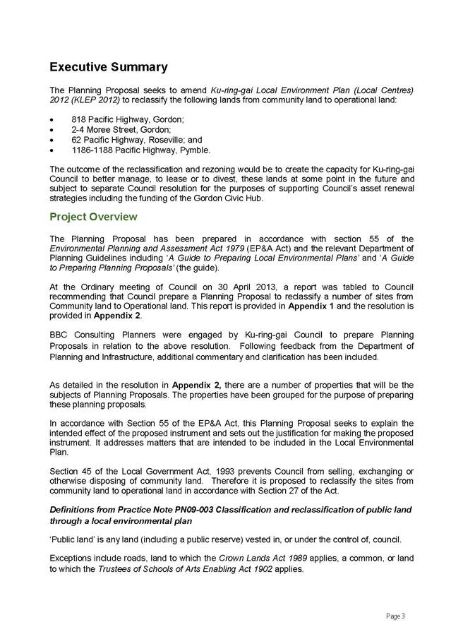
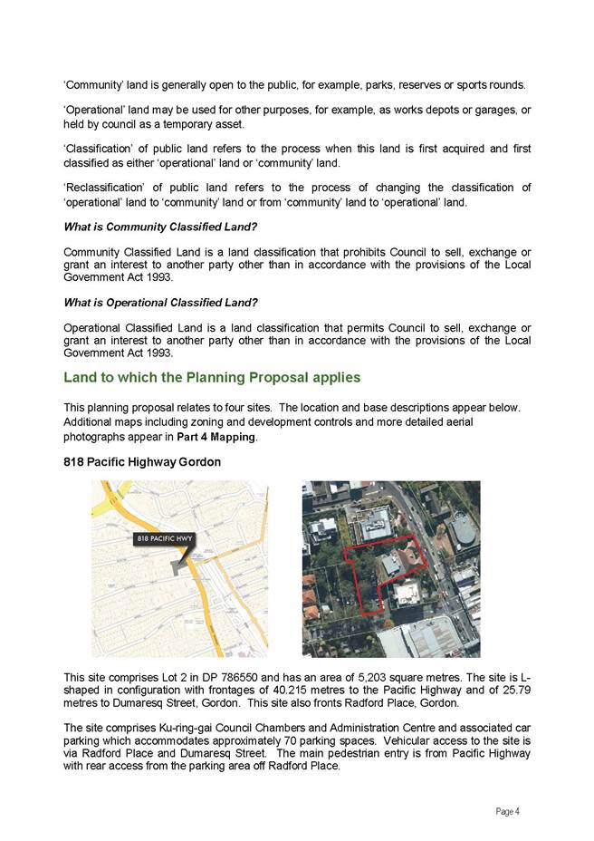
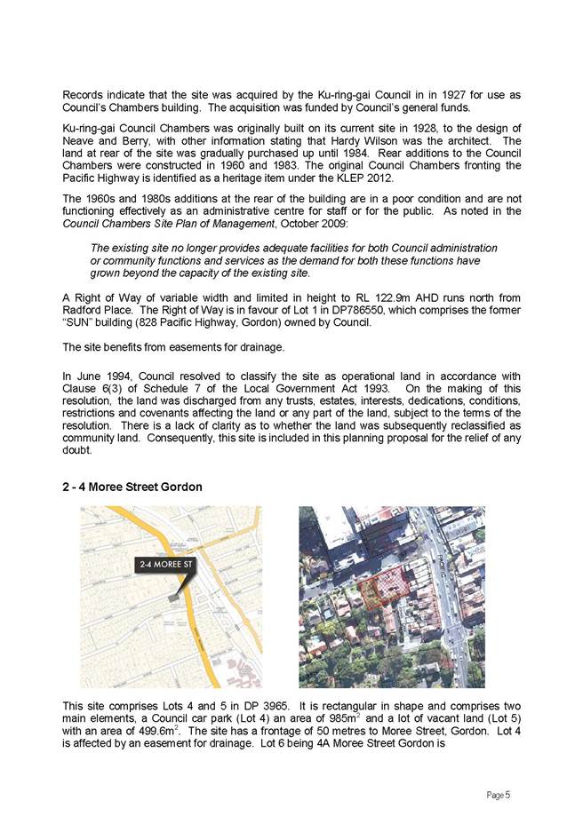
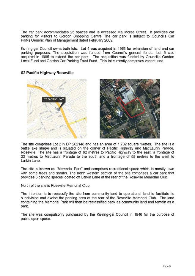
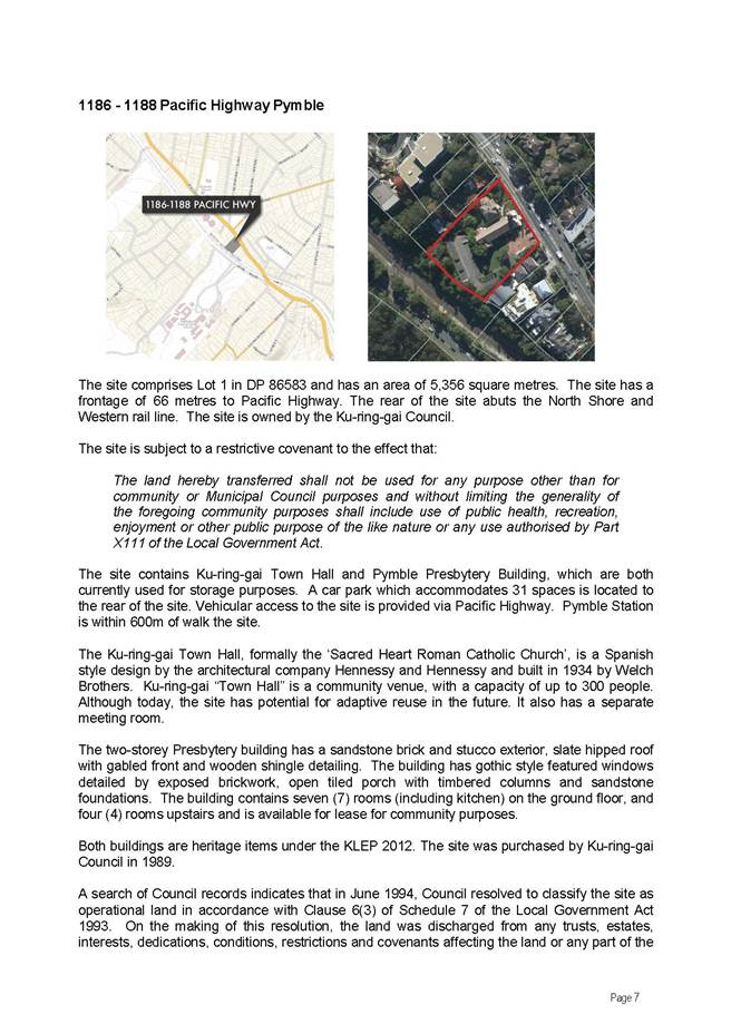
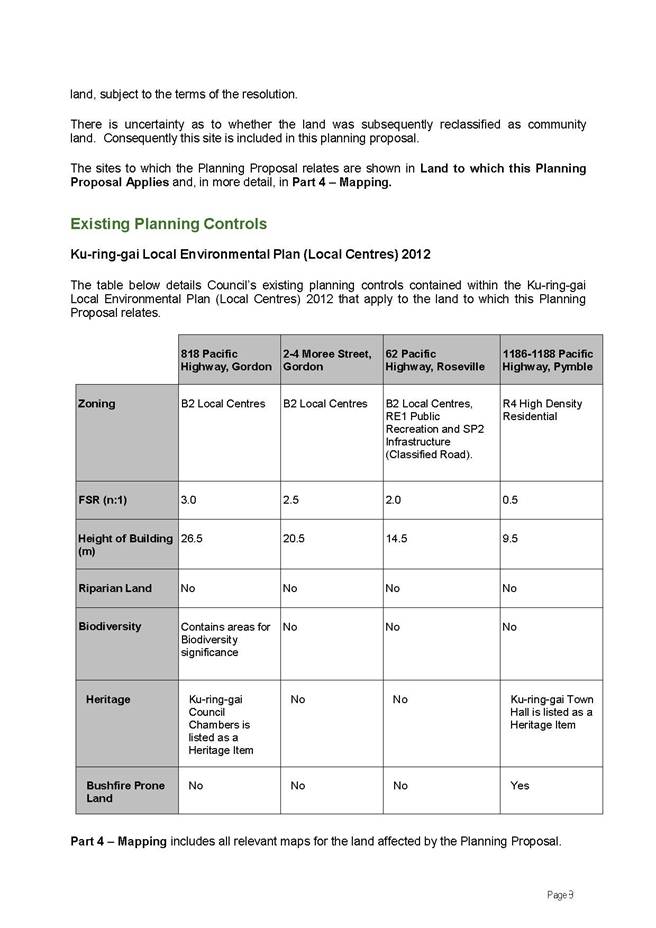
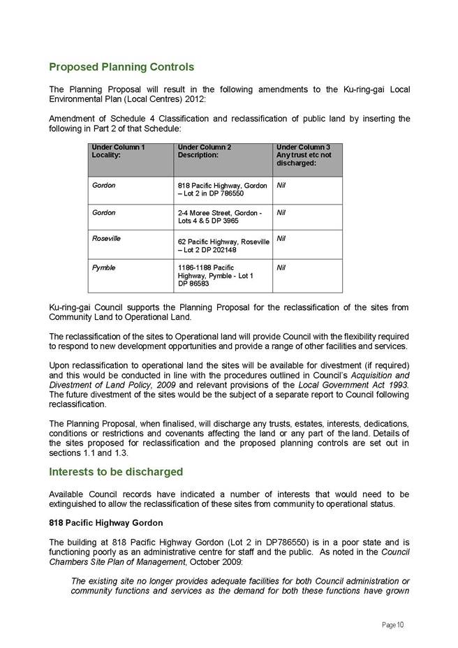
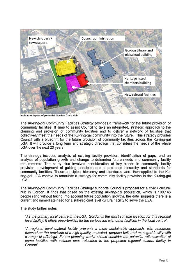
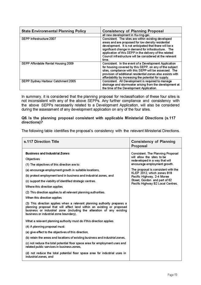
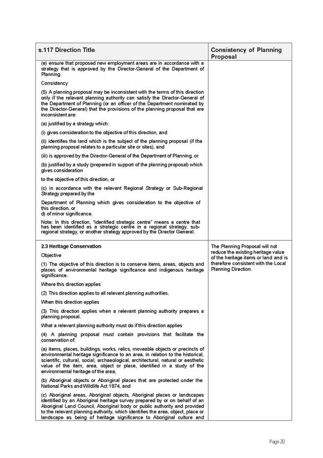
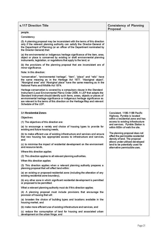
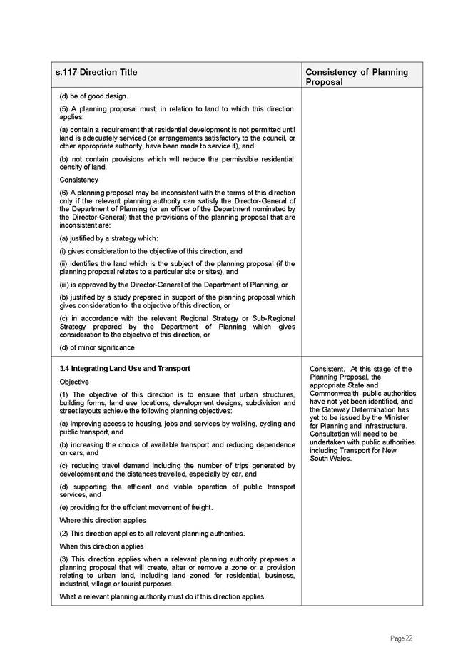
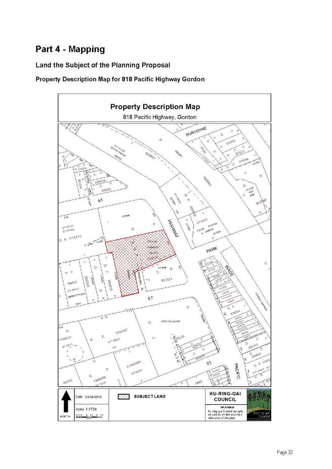
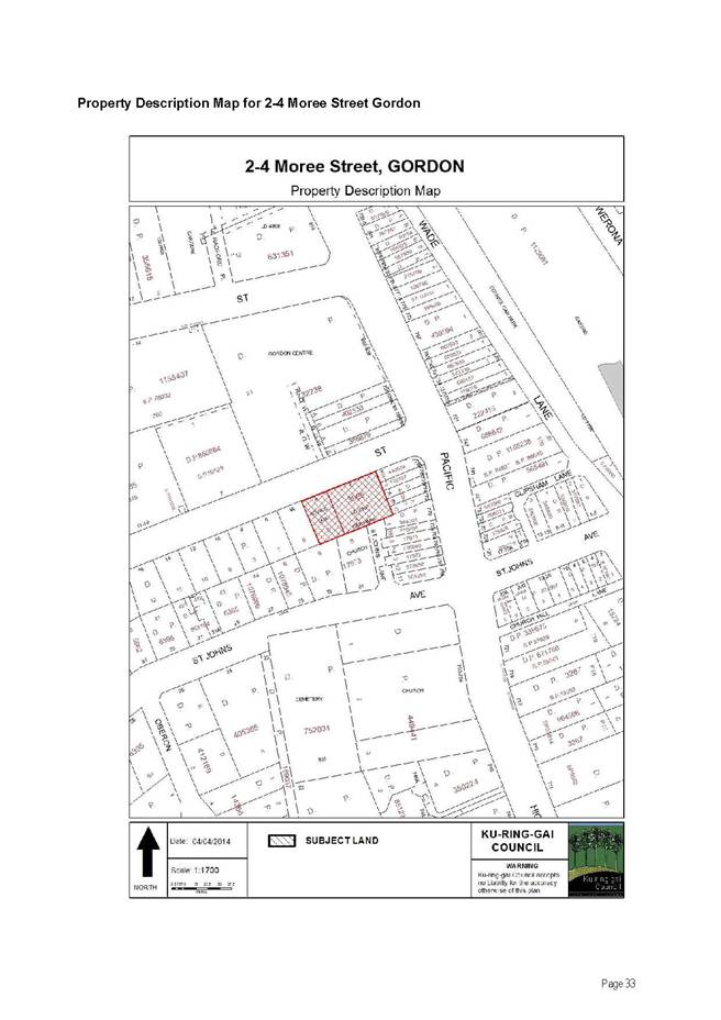
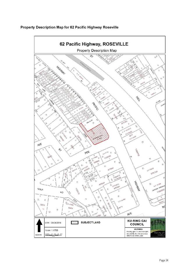
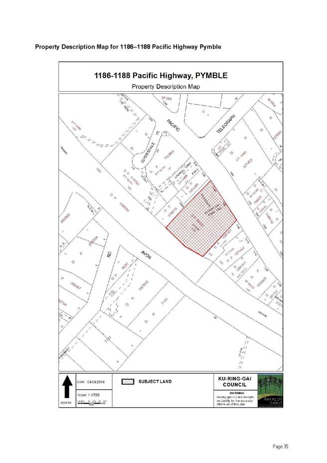
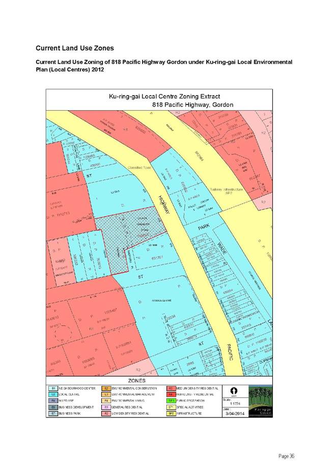
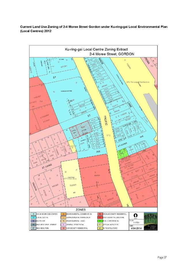
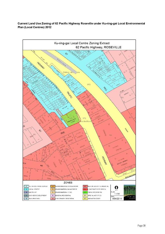
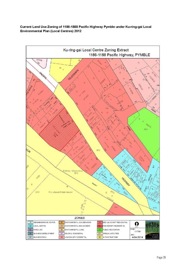
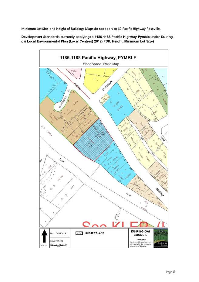
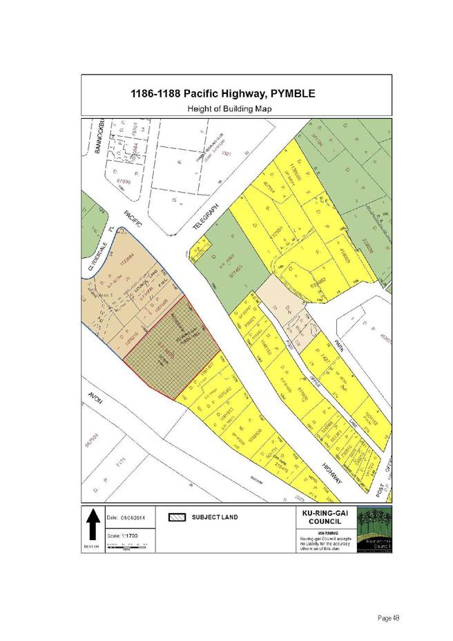
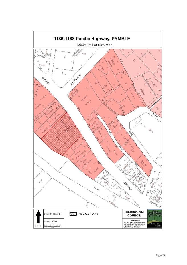
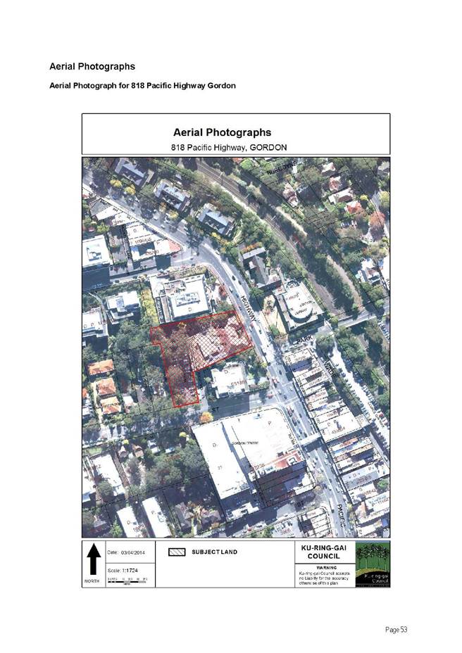
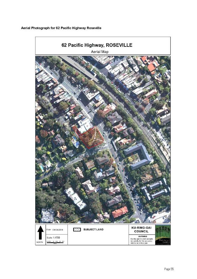
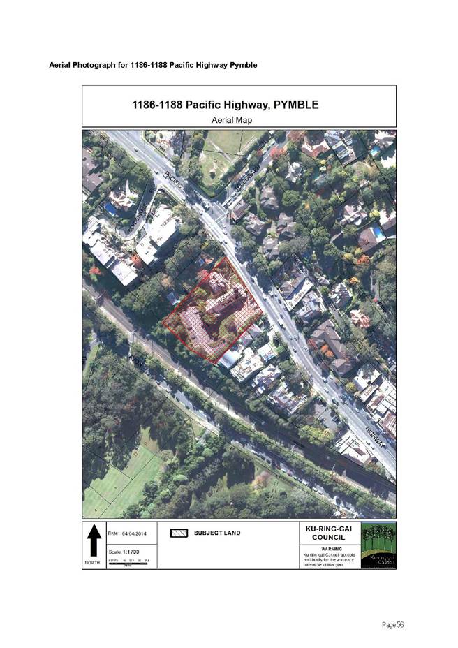
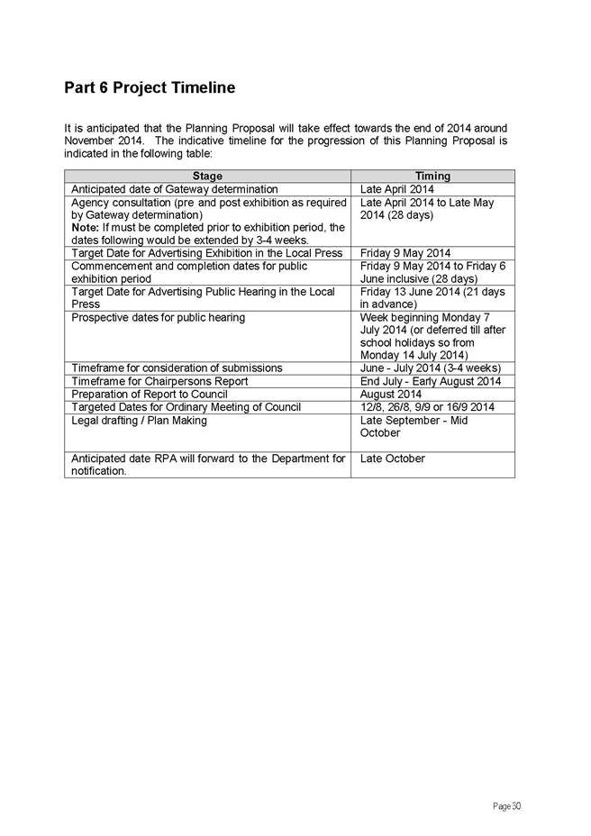

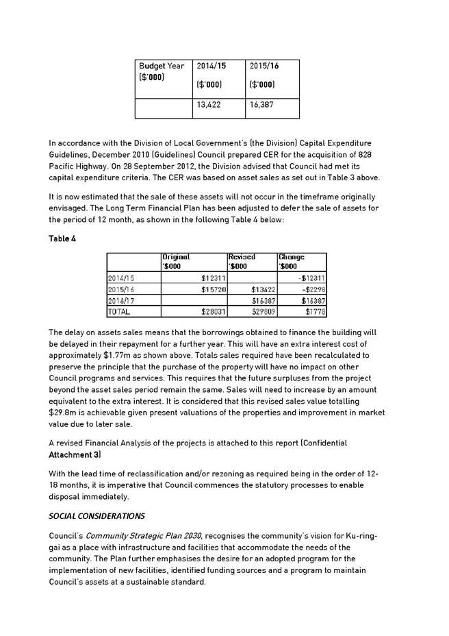
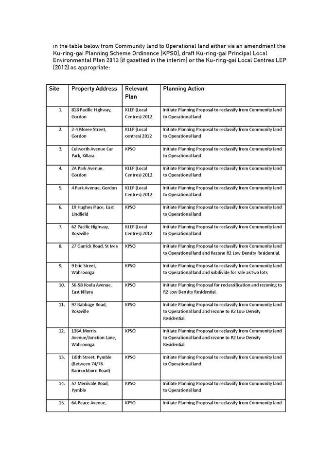
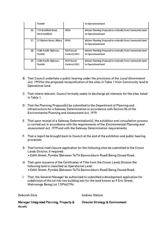

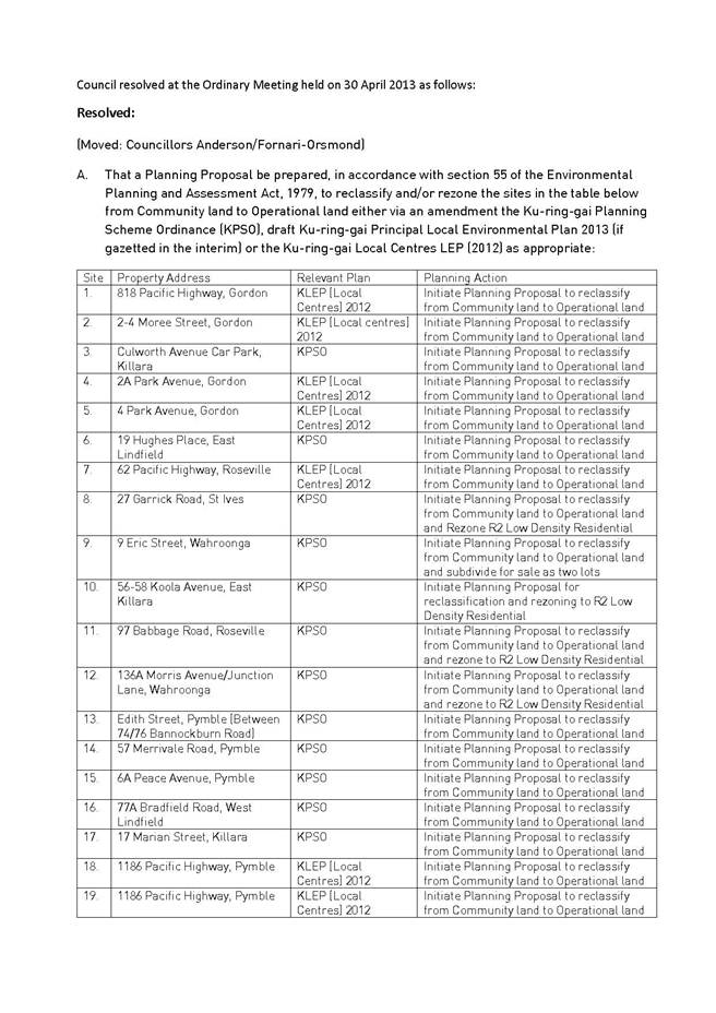
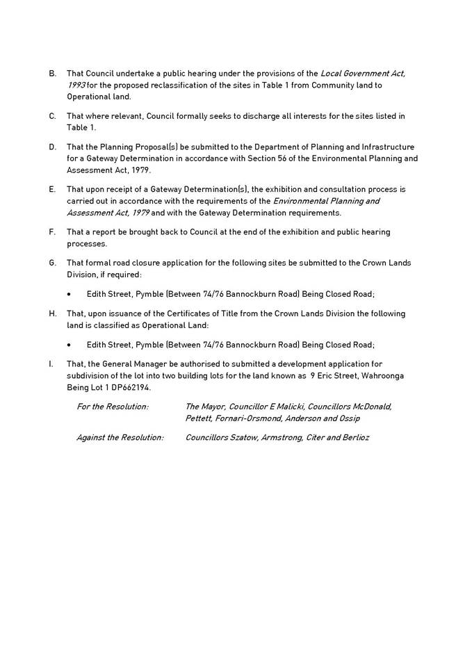
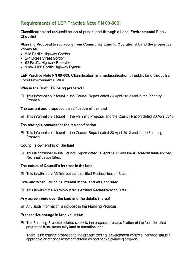
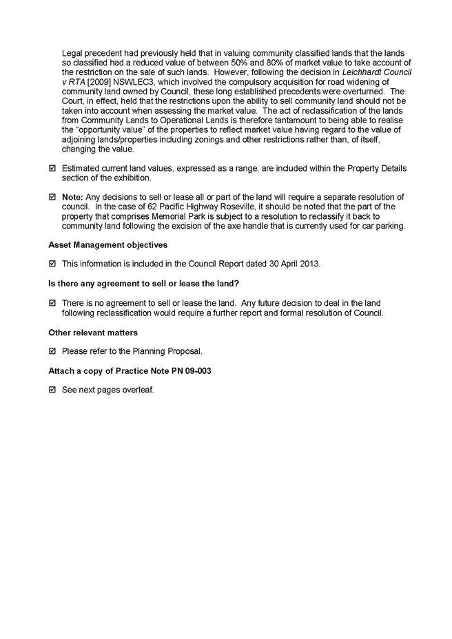
|
Ordinary Meeting of Council - 9 December 2014 |
GB.20 / 702 |
|
|
|
|
Item GB.20 |
S10342 |
|
|
1 December 2014 |
Amendments to Sports Facilities
Plan of Management For Adoption -
post exhibition report
EXECUTIVE SUMMARY
|
purpose of report: |
To rectify an anomaly in the Sports Facilities Plan of Management to bring the permitted hours of clubhouse use in line with longstanding lease and licence arrangements, as well as the permitted hours of sportsground use, so that future lease and licence renewals and new agreements with sporting clubs can be negotiated in accordance with the Plan of Management. Also to permit earlier tennis court hiring times at appropriate locations. |
|
|
|
|
background: |
At the Ordinary Meeting of Council held on 9 September 2014 it was resolved that Council publicly exhibit the recommended amendments to the Sports Facilities Plan of Management. |
|
|
|
|
comments: |
Council publicly exhibited the draft Plan of Management for a period of 28 days plus a further 14 days to receive submissions from 3 October to 14 November 2014. 44 submissions were received for various locations and one petition was received in relation to Lindfield Oval. When the SFPOM was prepared and adopted in 2010 it was intended that the permitted hours of use for clubhouses and amenities at sportsgrounds would correspond with the permitted hours of use for the ground itself and allow the longstanding practice of clubs holding functions such as fundraising nights and presentation nights later into the evening on Fridays and Saturdays. Due to an error the permitted hours on Saturdays were left unchanged at 6.00pm, and hence do not correspond with permitted use of sportsgrounds or allow clubs to hold occasional club functions. The amendments to the SFPOM rectify this anomaly. |
|
|
|
|
recommendation: |
That Council adopts an amendment to the SFPOM to permit the use of clubhouses and amenities until 10pm on Fridays and Saturdays, and 12.00 midnight for club functions. That clubs give surrounding residents at least seven days’ notice in writing of any club function that is going to finish after 10pm. That tennis court bookings be permitted from 7.00am instead of 8.00am, at all Council courts other than Hamilton Park courts and Turramurra Memorial Park courts seven days, and other than Killara Park on Sundays.
|
Purpose of Report
To rectify an anomaly in the Sports Facilities Plan of Management to bring the permitted hours of clubhouse use in line with longstanding lease and licence arrangements, as well as the permitted hours of sportsground use, so that future lease and licence renewals and new agreements with sporting clubs can be negotiated in accordance with the Plan of Management. Also to permit earlier tennis court hiring times at appropriate locations.
Background
The Sports Facilities Plan of Management (SFPOM) was adopted by Council on 20 April 2010. It approved the use of sportsgrounds for organised sports competitions on Saturday evenings until 8.30pm (with lights permitted until 9.00pm for pack up of the ground), however the intensity of clubhouse use on Saturdays was inadvertently left unchanged from the previous plan of management at 8.00am-6.00pm.
This matter was initially reported to Council on 14 May 2014 and it was resolved in Minute No.138 that consideration of the matter be deferred pending a further report from Council staff.
Subsequently at the Ordinary Meeting of Council held on 9 September 2014 (Minute No. 291) it was resolved:
(Moved: Councillors Ossip/McDonald)
A. That Council place on public exhibition the recommended amendments to the Sports Facilities Plan of Management.
B. That Council amend the Sports Facilities Plan of Management to permit the use of clubhouses and amenities until 10.00pm on Friday and Saturday evenings and until 12.00am on Friday and Saturday evenings for occasional club functions and special events.
C. That the Sports Facilities Plan of Management and future renewal of club leases and licences require clubs to give at least seven days’ notice in writing to all residents in adjacent streets on any occasion that a club function or event to be held at the clubhouse is expected to extend past 10.00pm.
D. That the Sports Facilities Plan of Management be amended to permit tennis courts to be booked from 7.00am seven days per week at certain locations where it is considered appropriate, subject to Council staff approval.
E. That Council staff continually monitor tennis court bookings prior to 8.00am and if any issues arise at any particular location bookings at that location revert back to 8.00am.
Comments
Under the current SFPOM, clubhouse and amenities use is permitted until 10.00pm on weekdays and 6.00pm on weekends.
Unfortunately, due to an error in the current SFPOM, the permitted hours of use for clubhouses and amenities do not correspond with the permitted hours of use of sportsgrounds, which is 9.30pm weekdays, 9.00pm Saturdays and 6.00pm Sundays. It was undoubtedly the intention of the SFPOM when it was prepared and adopted in 2010 for the hours of use of sportsgrounds to correspond with the hours of use of clubhouses and amenities and allow the longstanding practice of clubs holding functions such as fundraising nights and presentation nights later into the evening on Fridays and Saturdays, however due to an editorial oversight the clubhouse permitted hours on Saturdays were inadvertently left at 8.00am-6.00pm.
This situation needs to be rectified so that lease and licence agreements with sporting clubs can be negotiated in accordance with the Sports Facilities Plan of Management and brought to future Council meetings for approval.
It is considered appropriate for clubhouse and amenities use on Fridays and Saturdays to be permitted until 10.00pm. It is also considered appropriate to permit clubs to host occasional club functions until 12.00 midnight. In order to keep residents informed of any potential impacts, the SFPOM and any future renewal of a clubhouse lease and licence will include a requirement for the club to give at least seven days’ notice in writing to all residents in adjacent streets on any occasion that a function or event to be held at the clubhouse is expected to extend past 10.00pm.
Sundays would retain the existing limit of 6.00pm.
Council officers have also used this opportunity to review the rest of the SFPOM and identified an issue relating to tennis courts that needs to be addressed. Currently Council’s 71 tennis courts are not permitted to be hired before 8.00am. At some locations where courts are very close to residents this is a reasonable time, however at other locations such as Regimental Park courts, Killara, Warrimoo Oval courts St Ives Chase and Tryon Road courts, East Lindfield, there are no adverse impacts on residents at any time of the day caused by the playing of tennis and the courts are sitting idle when they could be used.
It is therefore recommended that the SFPOM be amended to permit tennis courts to be booked from 7.00am seven days per week at certain locations where it is considered appropriate, subject to Council approval. This situation would be continually monitored by staff and if any issues arise at any particular location bookings at that location revert back to 8.00am. This extension of time for tennis court usage will encourage and facilitate a healthy recreational activity within the community and may also potentially increase court hire revenue for Council.
Public Exhibition Submissions
The 42-day public exhibition period for the amendments to the Sport Facilities Plan of Management commenced on 3 October and ended on 14 November 2014. One petition – for the Lindfield Oval Clubhouse – and 44 submissions were received during the public exhibition period. The full submissions received are attached in Attachment A1.
The concerns raised in the submissions have been grouped according to location and the concerns raised in each submission have been addressed below.
Killara Park:
Submission 14 (of Attachment A1)
1. Dusk is a more appropriate time for facilities to be closed and vacated
2. Unauthorised use is an issue
3. Expects an increase of noise and disruption as a result of these longer hours
Council comments
1. As a community facility, the restriction of clubhouse use to only dusk is not consistent with sportsfield use times and is considered unreasonable. Being a very small venue, it does not cater for functions and is generally only used on game days and for club meetings.
2. The use of the premises is restricted within the lease terms which have already been approved by Council via public notice.
3. The subject of noise levels emitted from all Council premises is a general compliance issue and subject to on-going management by Council’s Development & Regulation Department.
Submission 29
1. Already limited car parking
2. It’s an old, established neighbourhood
3. The building is small and should only cater for small numbers – this amendment indicated large numbers are expected
4. Noted that behaviour of people from Killara Station/Greengate hotel sometimes results in unwanted behaviour – anticipates same will occur as a result of this POM changing
5. “Wheelies” around the roundabout
6. The Strata Plan did not envisage the proposed changes
7. Young people do not mix well with alcohol
Council comments
1. Permitted car parking is to be subject to on-going management by council rangers as is current situation.
2. The premises have already been in existence for many years as a community building. Access times to the building must be consistent to allow functionality for community purposes.
3. Hours of use of the premises are unrelated to numbers of persons who will use the facilities. Being a very small venue, it does not cater for functions and is generally only used on game days and for club meetings.
4. After hours community disturbances is a NSW Police enforcement issue and not specifically related to these facilities.
5. As per 4 above.
6. The proposed changes are not considered to have any adverse impact on strata plans.
7. As per 4 above.
Submission 32
1. 10pm is a more appropriate time
2. Understood “special events” to be 18th and 21st parties – risky for alcohol abuse, violence and anti-social behaviour
3. Litter is currently a concern
4. How will Council police/manage these events?
5. Expects property damage to be indemnified by Council.
Council comments
1. 10pm is considered too restrictive for community functions which often do not start until 8pm.
2. The extended use time only applies to activities conducted inside closed doors. All usage will be in accordance with current lease approvals. Any drunken or disorderly behaviour falls under the NSW Police jurisdiction.
3. The clubs are responsible for their own management in accordance with the lease conditions. All general litter issues are currently addressed by Council’s Operations Department.
4. Community clubs will be required to give residents prior notice of special events. Clubs will manage their own events and will be subject to lease conditions.
5. All council buildings are insured for property damage.
Submission 37
1. Current time of 10pm is sufficient
2. Presumes ‘extended use’ means private/public parties – alcohol/drugs may be involved
3. How will Council police/manage these events?
4. Reimbursement for resident property damages for Council approved events – how is this being managed?
Council comments
1. 10pm is considered too restrictive for community functions which often do not start until 8pm.
2. No sub-letting is permitted under the clubhouse lease. All activities must be club related. Being a very small venue, it does not cater for functions and is generally only used on game days and for club meetings.
3. Community clubs will be required to give residents prior notice of special events. Clubs will manage their own events and will be subject to lease conditions. Police can be called if unlawful behaviour is instigated.
4. All resident property damage remains a police matter.
Submission 38
1. People have in the past rung our doorbell
2. We have found drug paraphernalia on our doorstep in the past
Council comments
1. Council will respond to any indiscretions reported in accordance with the lease conditions.
2. As above.
Submission 43
1. Facilities never intended as a ‘party’ venue
2. 12am hours are unnecessary for sports tournaments
3. How will Council police/manage these events?
4. tennis should not occur on Sundays at 7am
Council comments
1. All usage will be in accordance with current lease approvals. The premises can only be used for club related activities. No subletting is permitted. Being a very small venue, it does not cater for functions and is generally only used on game days and for club meetings.
2. Club meetings and sports functions will be held inside the premises after hours, not sports tournaments. Meetings and functions are necessary and can on occasions run late at night.
3. Community clubs will be required to give residents prior notice of special events. Clubs will manage their own events and will be subject to lease conditions. Police can be called if unlawful behaviour is instigated.
4. Early morning tennis accessibility is consistent with Council’s approved Community Strategic Plan Long Term Objective (Section C4.1) which promotes “a community that embraces healthier lifestyle choices and practices”.
Hamilton Park Turramurra:
Submission 8, 8a and 8b
1. Tennis should not occur before 8am at this location due to close proximity of residential properties.
2.
Council comments
1. Agreed to leave at 8am at this location
Roseville Chase Oval:
Submission 9
1. The speed signs are already ignored – please install speed humps for pedestrian safety and reduce noise level of speeding cars
2. No loud noise after 11pm
3. Car-park is used as a speedway at night – police arrive after the vehicles have left – speed hump may reduce this activity
4. Illegal dumping of green waste – needs to be enforced
Council comments
1. Council has a long list of road works (including speed humps). Ormonde Road and Cardigan Road Roseville Chase road is not listed for construction this financial year, however Council’s Traffic Manager may decide to include in next year’s program depending on available funding.
2. Club meetings and sports functions will be held inside the premises after hours, not sports events. Meetings and occasional club functions are necessary and may not start until 8pm. It is therefore considered to be reasonable for these inside activities to run occasionally to 12.00 midnight on Fridays and Saturdays.
3. Speeding cars in the carpark is on the whole not related to the clubhouse activities. Permitted late clubhouse use by cricket and rugby officials will act as added security and deter late night vandals at this location.
4. Can be addressed by Council’s late night security company rounds and CTV monitors.
Acron Oval St Ives:
Submission 12
1. The venue isn’t suitable for functions and meetings – is Council constructing more?
2. How will this be policed?
Council comments
1. Meetings and occasional club functions are necessary and may not start until 8pm. It is therefore reasonable for these inside activities to be permitted inside the small clubhouse. There are no new venues being created in the near future at Acron Oval. Being a very small venue, it does not cater for functions and is generally only used on game days and for club meetings.
2. Community clubs will be required to give residents prior notice of special events. Clubs will manage their own events and will be subject to lease conditions. Police can be called if unlawful behaviour occurs.
Lofberg Oval West Pymble:
Submission 28
1. Thinks this is open to ‘parties’/pub like atmosphere
2. This is a nice residential street – will destroy the suburb
3. Already has noise concerns/issues
4. Finishing hours are currently not enforced
Council comments
1. All usage will be in accordance with current lease approvals. The premises can only be used for club related activities. No subletting is permitted. There are no changes to the existing use of this clubhouse, which already occurs until midnight occasionally under the current lease.
2. Meetings and occasional club functions are necessary for normal function of a community sports club run by volunteers. No subletting is permitted, only rugby meetings and functions. The clubhouse is close to Yanko Road which is a busy collector road.
3. Council’s Development & Regulation Department is responsible for the monitoring of noise issues and can test the noise levels to ascertain if lawfully compliant.
4. Council’s Development & Regulation Department is responsible for ensuring compliance.
Hassall Park St Ives:
Submission 24
1. Already has traffic concerns
2. Oval is already heavily used
3. Area is tranquil
Council comments
1. Any traffic concerns should be referred to Council’s Development & Regulation Department. Being a very small venue, it does not cater for functions and is generally only used on game days and for club meetings.
2. Council monitors ground usage upon the issue of seasonal approvals for sportsground usage.
3. Any activities inside the clubhouse will remain the same and not expected to affect the amenity of the locality.
Submission 22
1. Events to be restricted to Club events - published on website yearly in advance
2. 7 days is not enough warning for occasional club functions
3. There should be a maximum number of functions per year
Council comments
1. All events are subject to the conditions of the clubhouse licence agreement.
2. 7 days is considered reasonable to communicate a more accurate picture as to what will occur in terms of impact on residents. Being a very small venue, it does not cater for functions and is generally only used on game days and for club meetings.
3. Local sports club, scout and girl guide leases are managed by volunteers and renewed periodically based on past performance under the lease. Placing a ceiling on number of functions per year to sport clubs, scouts and girl guides is not practical as these groups need to be able to react to changing demands throughout the year.
Submission 27
1. Current lease restrictions have been successfully enforced by Council with less disruption to residents, which is an improvement on previous leases
2. Concerns that increased hours will result in an approach for extending building for mirroring commercial licenced properties
3. There should be a maximum number of functions per year
4. Events need to be policed properly
5. Extra social events will results in more traffic
6. The existing restricted parking should be extended throughout the year
Council comments
1. All functions are subject to the conditions of the clubhouse licence agreement.
2. Any changes to building would require Council approval and subject to public consultation.
3. Restricting events to a particular number per year is not practical given the sports clubs are managed by volunteers and need to be able to react to changing demands (i.e. extraordinary meetings etc).
4. Clubs will manage their own events and will be subject to lease conditions. Police can be called if unlawful behaviour is instigated.
5. Being a very small venue, it does not cater for functions and is generally only used on game days and for club meetings. Therefore no additional traffic is expected at Acron Oval.
6. Council’s Development & Regulation Department is responsible ensuring compliance.
Warrimoo Oval St Ives Chase:
Submission 35
1. This leaves it to open ended party use
2. Event will continue after 12am on the viewing deck
3. It will now be used every Fri and Sat by anyone
4. How will it be policed (noise and litter)
Council comments
1. The sports club must use premises for community purposes in accordance with lease conditions as approved by Council.
2. The viewing deck is not part of the clubhouse agreement and not permitted for late night use. Only the internal part of the building can be used to 12am.
3. Usage is strictly restricted to local registered community groups, not anyone.
4. The sports club, scouts & girl guides are responsible for managing all functions. Litter bins and ground maintenance is managed by Council’s Operations Department.
Submission 19
1. 2014 soccer club party was out of control – police had to be called and went well after 12 midnight.
2.
Council comments
1. Usage will be monitored by Council’s Community & Development & Regulation Departments. The soccer club, scouts & girl guides must adhere to their lease conditions. Leases are reviewed periodically and are subject to approval based on their performance under the previous lease.
Submission 16
1. Recent party did not finish at midnight
2. There should be a limit to the number of events every year
Council comments
1. Usage will be monitored by Council’s Community & Development & Regulation Departments
2. Local sports club, scout and girl guide leases are managed by volunteers and renewed periodically based on past performance under the lease. Placing a ceiling on number of functions per year to sport clubs, scouts and girl guides is not practical as these groups need to be able to react to changing demands throughout the year.
Submission 15
1. Recent party did not finish at midnight
Council comments
1. Usage will be monitored by Council’s Community & Development & Regulation Departments. The soccer club, scouts & girl guides must adhere to their lease conditions. Leases are reviewed periodically and are subject to approval based on their performance under the lease.
Submission 13
1. Recently youths vandalised/bent back a fence and drove on the oval
Council comments
1. Vandalism is already an issue at many sports grounds late at night. Permitted late clubhouse use by soccer officials will act as added security and deter late night vandals at this location.
Submission 10
1. It’s not possible to have noise stop at midnight at events – cars leaving etc.
Council comments
1. The sports club is required to manage events and comply with the terms of the lease on an on-going basis. Council’s Development & Regulation Department monitor compliance of hours of use within the Plan of Management regulations.
Sir David Martin Reserve (Auluba Oval) South Turramurra:
Submission 2
1. No specific concerns as the proposed later time amendments have been in practice at Auluba Oval for many years now and the present situation is not a problem.
Council comments
1. The amendment to the plan of management simply formalises the clubhouse hours that have been in practice in recent years.
Submission 20 and 44
1. A phone number should be provided to occupiers of properties for after-hours concerns
2. Should be a set number of special events per year
3. Should be a set number of people per event
4. How will drunk people be controlled?
5. People coming from public areas to these venues to continue drinking
6. Alcohol free zone from the shops should be extended to carpark in oval
7. Club activities only (i.e. no parties)
Council comments
1. Agreed – this will become part of lease conditions.
2. The local sports club’s lease is managed by volunteers and renewed periodically based on past performance under the lease. Placing a ceiling on number of functions per year to sport clubs, scouts and girl guides is not practical as these groups need to be able to react to changing demands throughout the year.
3. The sports club is required to manage numbers and comply with the terms of the lease on an on-going basis. Leases are reviewed periodically and based on performance assessment.
4. Sports club officials will be responsible to the management of functions. NSW Police will be contacted should any issues arise.
5. As above.
6. Alcohol free zones are not dealt with within this Plan. Nevertheless, this aspect can be investigated by Council.
7. This a leasing issue and all clubs must operate in accordance with the lease conditions, which does not permit sub-letting or hiring for parties.
Submission 25
1. Current 10pm finishing time is not observed.
2. Sometimes when there are no lights on the field young people run around and scream
3. Sometimes floodlights are on when there is no-one on the field (usually in heavy rain)
Council comments
1. Council’s Development & Regulation Department is responsible ensuring compliance.
2. The presence of sports club officials and members at facilities late at night will deter vandalism.
3. The management of flood lights is subject to on-going monitoring by Council’s Community Department.
Submission 26
1. 10pm as currently in place is sufficient – and not often observed.
Council comments
1. 10pm is considered too restrictive for community functions which often do not start until 8pm.
Cliff Oval, Wahroonga
Submission 1
1. This will allow meetings up to 12am on 2 nights per week
2. There are enough venues in a 3km radius with security and facilities for special events and functions
3. Vandalism is an issue that will have to be addressed after functions have officially closed
Council comments
1. Correct in theory, however the frequency of meetings is anticipated to be quite low.
2. The clubhouse premises are managed by volunteers for club related functions which are much smaller than those occurring at licensed RSL or Leagues Club premises.
3. Vandalism after 12am has always been an issue, however it is not directly related to this Plan of Management. Police and Council’s Development & Compliance Departments to address.
Submission 3
1. Improvements to Cliff Ave have not been made – no kerb or guttering
2. Cars speeding
3. What happens when all the additional cars leave the function – who is responsible for their actions?
Council comments
1. Council has not funded new kerb and gutter construction for some years as Council has given higher priority to pavement rehabilitation. This is not likely to change in the foreseeable future due to the limited funding available to Council and frequent opposition to removal of existing grass swales or other natural looking drainage.
2. Council’s Development & Regulation Department to monitor inside the sportsgound precincts and enforce compliance. NSW Police to monitor the adjacent street.
3. The club is responsible for its patrons leaving the sportsground facilities. NSW Police the streets.
Submission 5
1. 12am does not exist – change this to 12 midnight.
Council comments
1. Agreed to change.
Submission 30A and B
1. A clubhouse should be for sporting activities, not RSL type entertainment
2. It will invite public attendance (leading to more cars, people and noise)
3. It is a junior club – not for alcoholic consumption
4. There is now no limited weekend use (of the oval)
5. Sports use often starts at 6:30am on Sat and Sunday – club or not?
Council comments
1. Sports club events are managed by volunteers and functions will be community based by nature.
2. The extension of clubhouse operation hours is not expected to bring in any more people than who currently attend existing functions. Extending the hours is formalising existing club members’ usage and expectations under current lease arrangements.
3. Wahroonga Rugby Club also has senior rugby players. Liquor is consumed on restrictive basis.
4. The oval usage is subject to seasonal hire agreements and is restricted to existing training times after hours.
5. Early morning use on weekend has not been booked through Council and is unauthorised.
Submission 33
1. Sounds like it is changing into a social club – no longer a sports club/for club members and spectators
2. Revenue maximising stream for the whole year, not just the rugby season
3. Will open to non-sport related activities (weddings etc)
4. How will numbers be limited?
5. Unrestricted number of ‘occasional functions/events’
Council comments
1. Sports functions and activities are to remain as the primary focus.
2. Club volunteers will manage any activities. Sports clubs are not for profit with all revenue placed towards sports development programs encouraging community health and wellbeing. Intensification of functions and revenue-raising is not the objective of amending the POM, and these are not expected to be an outcome of amending the lease.
3. Restricted to community events only. Not weddings.
4. Clubs officials will manage numbers and act in accordance with lease conditions.
5. Placing a ceiling on number of functions per year to sport clubs, scouts and girl guides is not practical as these groups need to be able to react to changing demands and club fundraising endeavours throughout the year.
Submission 36
1. The hours of use will not be strictly enforced i.e. noise past 10pm.
Council comments
1. Council’s Development & Regulation Department is responsible for ensuring compliance.
Submission 41A and B
1. Complaints about access to thoroughfares (locked gates)
Council comments
1. Gate access is managed by Council’s Operations Department.
Submission 42
1. Gifts of land to Council included that they only be used by children
2. Current parking issues – over driveways etc
3. Currently being used more than 7 times a year for social/entertainment of the rugby club
4. Social functions regularly being held on Mon, Tues, Fri and Sundays – mainly attended by men and alcohol involved
5. Children are being turned away from the oval
6. Noise from training and games up until 9:30 – and commences at 7:30
7. Not enough rubbish bins currently
8. Drug deals and alcohol consumption currently takes place outside the venue at night time – this will increase with the extended hours of use
9. There are enough venues in the surrounding areas already for social nights/events
10. Tennis court extension hours will create noise from 6:30.
Council comments
1. All members of the community can access community facilities regardless of age.
2. Council’s Development & Regulation Department is responsible for ensuring compliance.
3. Club to access the facility in accordance with lease conditions (separate to this POM).
4. Club to access the facility in accordance with lease conditions (separate to this POM).
5. Council’s Development & Regulation Department is responsible for ensuring compliance.
6. Council’s Development & Regulation Department is responsible for ensuring compliance.
7. Responsibility of Council’s Operations Department.
8. NSW Police issue. Extended hours presence of sports grounds by sports club volunteers will deter ant-social behaviour.
9. Sports club events are managed by volunteers and functions will be community based by nature.
10. Under the proposal, no tennis court access is allowable before 7am. Council’s Development & Regulation Department is responsible for ensuring compliance.
Lindfield Oval
Submission 40
1. Has become a place of drinking alcohol
2. Not enough bins at the oval
3. Cricket Club offered alcohol for sale
4. Public events not associated with the oval like State of Origin are being celebrated at the clubhouse
5. New flood lights said they did not ‘alter the hours of use nor increase the number of bookings at the oval’
6. More sport than normal has been played at the oval this year – more noise and later games and training has taken place.
7. More than one sport should be played at the oval through winter – and it’s not gender diverse
Council comments
1. Council’s Development & Regulation Department is responsible for ensuring compliance.
2. Responsibility of Council’s Operations Department.
3. Council’s Development & Regulation Department is responsible for ensuring compliance.
4. Televised sports events at clubhouses is not inconsistent with the clubhouse permitted use provided it is in accordance with the lease conditions.
5. The use of clubhouse buildings is independent of oval use.
6. The encouragement of physical exercise at community sportsgrounds is consistent with Council’s Community Strategic Plan and Operational & Delivery plans.
7. Agreed – to be explored by Council.
Submission 6
1. Driving in the dark will be compromised
2. Not enough rubbish bins – brings rats and birds
3. Who is paying the water/electricity and cleaning?
4. Floodlights are kept on occasionally overnight
Council comments
1. Council’s Development & Regulation Department is responsible ensuring compliance.
2. Responsibility of Council’s Operations Department.
3. Sports Clubs are responsible for payment of all their own outgoings.
4. Council’s Community Department manage all floodlighting. Light are programmed to switch off after bookings are finished. Lights may not be functioning properly if they are on overnight.
Submission 34
1. Current issues include – increased usage, noise pollution, increased litter, no warning of special events in 2014, hours of use not being adhered to. Propose the following:
1. M-F, 8am-10pm, S 8am-10pm, Sun 9am-6pm
2. Restrictions on loudspeakers and music after 6pm, 7 nights a week
3. 2 club functions per year until 12pm
4. Remove or define ‘occasional club functions and special events’
5. Restrict sale of alcohol to licencing agreements and within hours as above
6. Why not have a trial of the extensions
Council comments
1. Extended hours are necessary for clubs to fulfil their functional requirements for the sporting community.
2. Agreed - loudspeakers and music will not be permitted outside club buildings after 6pm.
3. Too restrictive for sports clubs.
4. Not agreed to remove.
5. Sports groups to perform in accordance with lease conditions.
6. Trial not necessary. Extension is in the Plan of Management only. The club’s lease has permitted the later hours for many years.
Submission 17
1. Does the liquor licence allow for sale of alcohol at Lindfield Cricket and Rugby?
2.
Council comments
1. All liquor sales are subject to approval from the Office of Liquor, Gaming & Racing.
Submission 11
1. Lindfield Oval should not be a late night party venue – only a day time sporting purposes. Club should secure venues like restaurants for late night events.
Council comments
1. Late night events will not be common and restricted to club events only, as has been the case for many years.
Submission 31
1. New flood lights said they did not ‘alter the hours of use nor increase the number of bookings at the oval’
2. Appears to be functioning as a local pub
3. Affected more by the football season than the cricket
Council comments
1. Clubhouse hours are not directly related to sportsground lights usage.
2. The cricket and rugby clubs use the premises for club functions only.
3. Acknowledged that rugby uses the facility more than the cricket.
Petition – Lindfield Oval
A petition signed by 54 people living near Lindfield Oval was presented to the Ordinary Meeting of Council on 25 November 2014 in relation to the proposed amendments to the Sports Facilities Plan of Management. This petition was considered as part of this report and, for reference purposes, is included below.
"We, the undersigned ratepayers and residents living in the vicinity of Lindfield Oval (being Crown Land managed by Council), strongly object to the proposed increase in operating hours and occasional parties at the clubhouse.
We are severely affected by the following:
1. the erratic operating hours
2. the sale of alcohol, except for the exact dates and times authorised under the licensing agreement with the Police
3. the lack of control of excessive consumption of alcohol
4. the public urinating and vomiting near our properties
5. the frequent parties and resulting intolerable noise levels
6. the invasion of floodlights into our properties
7. the blocking of residents driveways
8. the damage to street trees
9. the destruction of our private properties
10. the occasional near unconscious young person on our properties
We respectfully ask Council to vote for the following:
11. Operating hours as existing Monday – Friday, 8 am to 9.30 pm, Saturday, 8 am —9.00pm and Sunday, 8.00am-6.00pm
12. Only 2 parties a year, one each at the end of the football season and the cricket season, no other functions up to 12.00am
13. No sale of alcohol on the premises, except for the exact dates and times authorised under the licensing agreement with the Police
14. Lights out at 10.00pm Monday to Friday / 9.3Opm Saturday, except for the aforementioned parties;
15. Consideration of residents in relation to parking of vehicles”.
Council Comments
1. The new proposed structured hours will force the respective clubs to adhere to a format that is not erratic and enforced by Council Development & Regulation Department.
2. Sale of alcohol must be in accordance with all approvals, whether they be police, council or Office of Liquor Gaming & Racing.
3. The sports clubs are responsible for the behaviour of all members including alcohol consumption. Should any unlawful incidences occur, these will be addressed by NSW Police.
4. As above.
5. Responsibility of Council’s Development & Regulation Department to monitor.
6. Floodlight times are independent to clubhouse access times. Floodlight usage will not be extended to that already approved.
7. Responsibility of Council’s Development & Regulation Department to monitor.
8. Responsibility of Council’s Operations Department to monitor.
9. General vandalism (graffiti etc) and drug use is expected to be reduced with the increased presence of sports club officials at the clubhouse precincts at night (ie cricketers & rugby players).
10. Lindfield Oval is frequented by vandals, drug users and other non-sports related people on occasions. NSW Police are aware of the issues and will work with club officials to tackle this problem.
Council Comments
11. The existing operating hours are too restrictive for sports functions. Council’s approved Strategic Plan encourages organised sports and social interaction within the community to be fostered.
12. Restricting clubs in the number of functions a year is impractical.
13. The sale of alcohol must be in accordance with all necessary approvals, whether they be police, council or Office of Liquor Gaming & Racing.
14. 10pm Monday to Thursday agreed. Sports clubs require late access on Friday and Saturday nights to Midnight on occasions to ensure sports functions, such as fundraising nights and presentation nights can operate properly.
15. Parking of vehicles is monitored by Council’s Development & Regulation Department.
Following consideration of the submissions it is recommended that Council adopt the Sports Facilities Plan of Management as exhibited, with the following amendments to the exhibited Draft Plan of Management:
1. Resolution B - delete the words “and special events”.
2. Resolution C – delete the words “and events”.
3. Resolution D – at the end of the resolution add the words “other than at Hamilton Park tennis courts and Turramurra Memorial Park tennis courts, where bookings may not commence until 8.00am seven days, and Killara Park, where bookings may not commence until 8.00am on Sundays”.
These recommendations are reflected in the Recommendations section of this report.
The use of the words “special events” and “events” in the exhibited amendments lead to a heightened level of concern among some residents, as reflected in some of the submissions received during the public exhibition period. These words, on reflection, were poorly chosen as they did not give an accurate description of how clubhouses are permitted to be used by sporting clubs under their respective leases and licences. Deleting these words and leaving club functions in the amendment is more accurate and less confusing.
With respect to the amendment to the tennis courts booking hours, it has been recommended that Hamilton Park tennis courts and Turramurra Memorial Park tennis courts, and Killara Park courts on Sundays, be removed from the earlier booking times due to resident concerns and/or the close proximity of neighbouring residential properties.
As these post-exhibition amendments are not considered substantial, under the Local Government Act 1993, Section 40 Adoption of Plans of Management it is not necessary to re-exhibit the plan of management. Under the Local Government Act 1993, if Council adopts an amended plan without re-exhibiting the amended draft plan, it must give public notice of that adoption, and of the terms of the amended plan of management, as soon as practicable after the adoption. This public notice will occur if Council adopts the amendments as recommended.
integrated planning and reporting
Community Strategic Plan - Theme P7 Enhancing community buildings and facilities
|
Community Strategic Plan Long Term Objective |
Delivery Program Term Achievement |
Operational Plan Task |
|
P7.1 Multipurpose community buildings and facilities are available to meet the community’s diverse and changing needs. |
P7.1.2 Usage of existing community buildings and facilities is optimised.
|
Community leases are reviewed and implemented in line with leasing policy.
|
Governance Matters
Under the Local Government Act 1993, Section 40 Adoption of Plans of Management:
(1) After considering all submissions received by it concerning the draft plan of management, the council may decide to amend the draft plan or to adopt it without amendment as the plan of management for the community land concerned.
(2) If the council decides to amend the draft plan it must either:
(a) publicly exhibit the amended draft plan in accordance with the provisions of this Division relating to the public exhibition of draft plans, or
(b) if it is of the opinion that the amendments are not substantial, adopt the amended draft plan without public exhibition as the plan of management for the community land concerned.
(2A) If a council adopts an amended plan without public exhibition of the amended draft plan, it must give public notice of that adoption, and of the terms of the amended plan of management, as soon as practicable after the adoption.
Risk Management
Any risk management issues will be identified and addressed in the lease, licence and hire agreements for each clubhouse.
Financial Considerations
The extension of time for tennis court usage may potentially increase court hire revenue for Council.
Social Considerations
This amendment will allow community clubs to enter into licence agreements with Council for the use of clubhouse facilities during similar hours that sportsgrounds are in use.
The extension of time for tennis court usage will encourage and facilitate a healthy recreational activity within the community.
Environmental Considerations
It is not considered that bringing clubhouse use into line with sportsground use will lead to any significant environmental impacts. If there are any impacts at a particular location these can be dealt with through clauses in the respective lease and licence agreements and, if necessary, revocation of a lease or licence.
Community Consultation
Under Section 38 of the Local Government Act 1993 Council publicly exhibited the draft Plan of Management for a period of 28 days plus a further 14 days to receive submissions from 3 October to 14 November 2014.
The public exhibition included public notification of the exhibition period in the North Shore Times, on Council’s website and at Council’s Administration Centre and libraries.
Additionally, residents living in streets adjacent to all sportsground clubhouses who could potentially be impacted by the amended clubhouse hours were notified in writing about the public exhibition of the draft plan of management.
Internal Consultation
Council officers in the Community Department and Strategy and Environment Departments have been consulted in the preparation of this report.
Summary
Council publicly exhibited the draft Plan of Management for a period of 28 days plus a further 14 days to receive submissions from 3 October to 14 November 2014. 44 submissions were received for various locations and one petition was received in relation to Lindfield Oval.
When the SFPOM was prepared and adopted in 2010 it was intended that the permitted hours of use for clubhouses and amenities at sportsgrounds would correspond with the permitted hours of use for the ground itself and allow the longstanding practice of clubs holding functions, such as fundraising nights and presentation nights, later into the evening on Fridays and Saturdays. Due to an editorial error in the 2010 SFPOM, the permitted hours on Saturdays were left unchanged at 6pm, and hence do not correspond with permitted use of sportsgrounds, which allows matches until 8.30pm and lights out by 9.00pm, or allow clubs to host occasional club functions. This situation needs to be rectified so that licence agreements with sporting clubs can be negotiated in accordance with the SFPOM.
It is also considered appropriate to permit tennis court bookings at certain courts that are not too close to residents to commence at 7.00am instead of 8.00am.
It is considered appropriate for clubhouse and amenities use on Fridays and Saturdays to be permitted until 10.00pm. It is also considered appropriate to permit clubs to host occasional club functions until 12.00 midnight. In order to keep residents informed of any potential impacts, the SFPOM and any future renewal of a clubhouse lease and licence will include a requirement for the club to give at least seven days’ notice in writing to all residents in adjacent streets on any occasion that a function or event to be held at the clubhouse is expected to extend past 10.00pm.
An issue relating to tennis court hiring times in the SFPOM has also been identified. Currently Council’s 71 tennis courts are not permitted to be hired before 8.00am. At some locations where courts are very close to residents, such as Hamilton Park South Turramurra and Turramurra Memorial Park, 8.00am is a reasonable starting time, however at other locations there are no adverse impacts on residents at any time of the day caused by the playing of tennis and the courts are sitting idle when they could be used by the community.
It is therefore recommended that the SFPOM be amended to permit tennis courts to be booked from 7.00am seven days per week at certain locations where it is considered appropriate, subject to Council staff approval. This situation would be continually monitored by staff and if any issues arise at any particular location bookings at that location revert back to 8.00am. Following feedback received during the exhibition period, it is recommended that no change occur at Hamilton Park tennis courts and Turramurra Memorial Park tennis courts, and that no change occur at Killara Park tennis courts on Sundays.
Following consideration of the submissions it is recommended that Council adopt the Sports Facilities Plan of Management as exhibited with the following amendments to the exhibited Draft Plan of Management:
1 Resolution B - delete the words “and special events”.
2 Resolution C – delete the words “and events”.
3 Resolution D – at the end of the resolution add the words “other than at Hamilton Park tennis courts and Turramurra Memorial Park tennis courts, where bookings may not commence until 8.00am seven days, and Killara Park, where bookings may not commence until 8.00am on Sundays”.
|
A. That Council adopt an amendment to the Sports Facilities Plan of Management to permit the use of clubhouses and amenities until 10.00pm on Fridays and Saturdays, and until 12.00 midnight on Fridays and Saturdays for club functions.
B. That the Sports Facilities Plan of Management and future renewal of club leases and licences require clubs to give at least seven days’ notice in writing to all residents in adjacent streets on any occasion that a club function to be held at the clubhouse is expected to extend past 10.00pm.
C. That the Sports Facilities Plan of Management be amended to permit tennis courts to be booked from 7.00am seven days per week at certain locations where it is considered appropriate, subject to Council staff approval, other than at Hamilton Park tennis courts and Turramurra Memorial Park tennis courts, where bookings may not commence until 8.00am seven days, and Killara Park, where bookings may not commence until 8.00am on Sundays.
D. That Council continually monitor tennis court bookings prior to 8.00am, and if any issues arise at any particular location, bookings at that location shall revert back to 8.00am. |
|
Roger Faulkner Team Leader Sport & Recreation Planning |
Ian Dreghorn Manager Strategic Projects |
|
Mark Taylor Manager Community & Recreation Services |
Andrew Watson Director Strategy & Environment |
|
A1View |
Submissions Received - Public Exhibition - Sports Facilities Plan of Management |
|
2014/303606 |