|
APPENDIX No: 1 - Draft Submission - Phase 1 Amendments to the Local Government Act 1993 |
|
Item No: GB.1 |
Ordinary Meeting of Council
TO BE HELD ON Tuesday, 8 March 2016 AT 7:00pm
Level 3, Council Chamber
Agenda
** ** ** ** ** **
NOTE: For Full Details, See Council’s Website –
www.kmc.nsw.gov.au under the link to business papers
DECLARATIONS OF INTEREST
Confirmation of Reports to be Considered in Closed Meeting
Address the Council
NOTE: Persons who address the Council should be aware that their address will be tape recorded.
Documents Circulated to Councillors
CONFIRMATION OF MINUTEs
Minutes of Ordinary Meeting of Council 5
File: S02131
Meeting held 23 February 2016
Minutes numbered 16 to 29
minutes from the Mayor
Petitions
GENERAL BUSINESS
i. The Mayor to invite Councillors to nominate any item(s) on the Agenda that they wish to have a site inspection.
ii. The Mayor to invite Councillors to nominate any item(s) on the Agenda that they wish to adopt in accordance with the officer’s recommendation allowing for minor changes without debate.
GB.1 Fit for the Future Reforms - Development of a new Local Government Act - Council Submission to Phase 1 Consultation 30
File: S09752
To provide Council with details of the consultation process for the proposed Phase 1 amendments to the Local Government Act 1993, and to confirm Council’s response to the Office of Local Government’s call for submissions to the proposal.
Recommendation:
That the General Manager provides the attached draft submission (Attachment A1), in regards to Phase 1 consultation on the development of a new local government act, to the Office of Local Government on or before Tuesday, 15 March 2016.
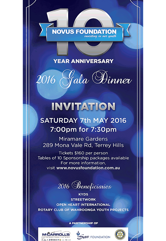
GB.2 The Novus Foundation 2016 Gala Dinner 100
File: CY00043/8
To advise Council of a request from the Novus Foundation to purchase sponsorship package tickets for the Gala Dinner to be held at Miramare Gardens Function Centre, Terrey Hills on Saturday 7 May 2016.
Recommendation:
That Council purchase a bronze sponsorship package of a table of 10 tickets for the Novus Foundation 2016 Gala Dinner for $1,600, and that Councillors who are interested in attending the dinner advise the General Manager by Friday 8 April 2016.
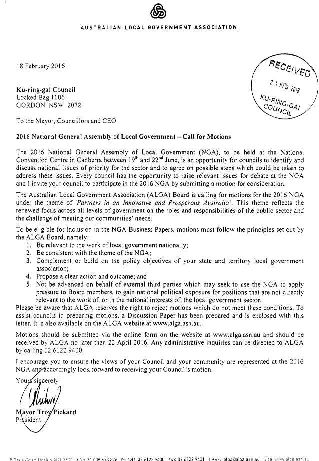
GB.3 2016 National General Assembly of Local Government - Call for Motions 105
File: S02133
To inform Councillors of an invitation from the Australian Local Government Association (ALGA) to submit motions to the 2016 National General Assembly (NGA) of Local Government.
Recommendation:
That Councillors provide any proposed motions for the 2016 National General Assembly of Local Government to the Manager Records & Governance by Wednesday 23 March 2016, and that a further report providing details of any proposed motions be referred to Council at its meeting on 5 April 2016 for approval prior to submission to the ALGA.
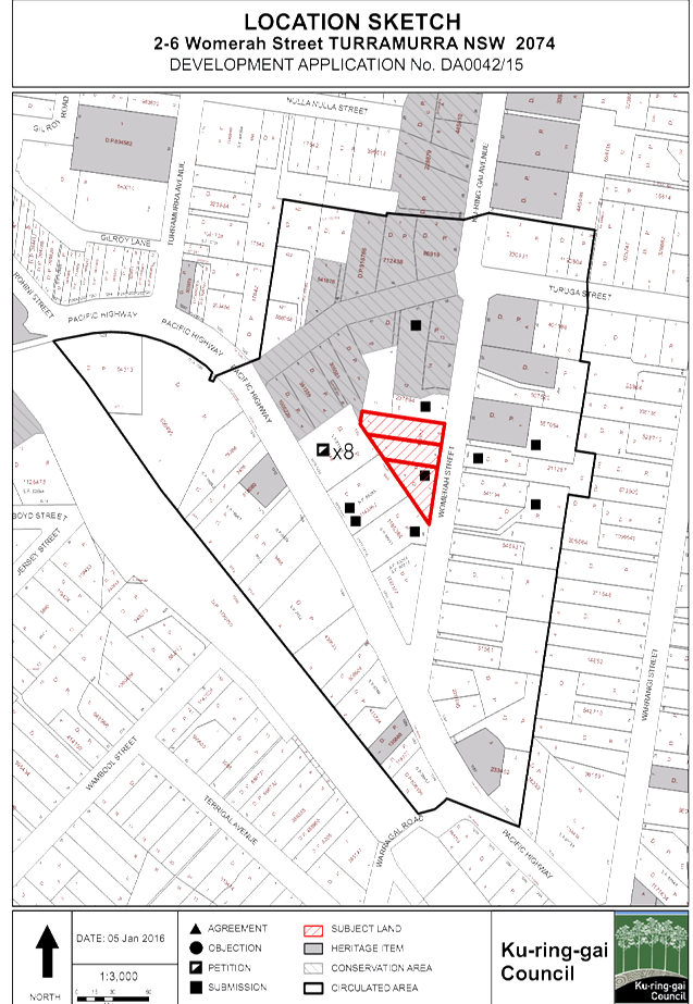
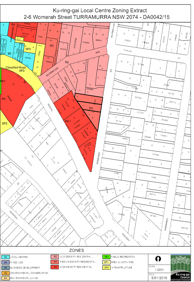
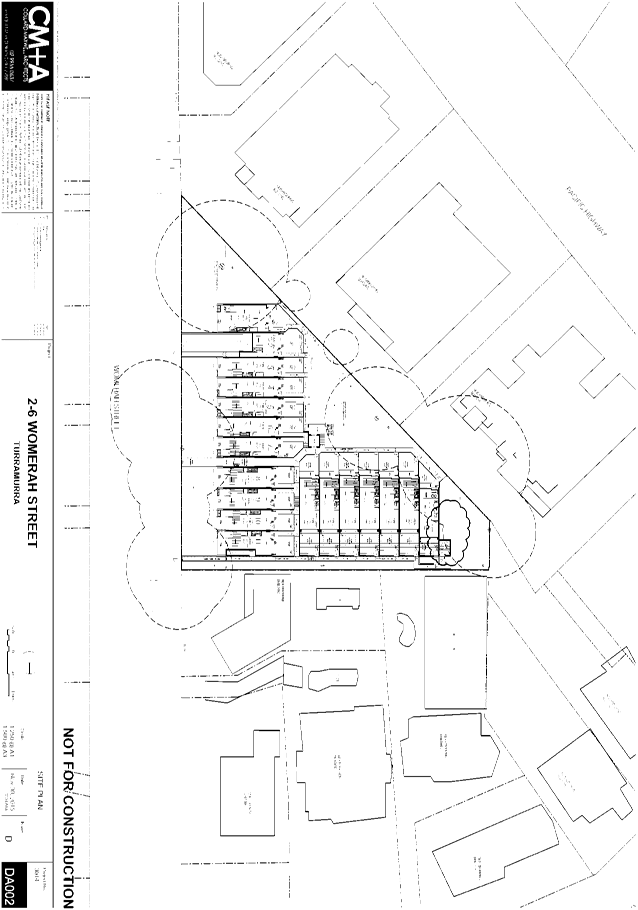
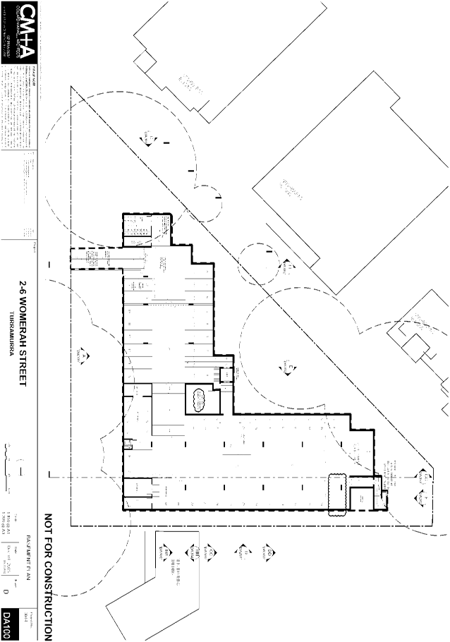
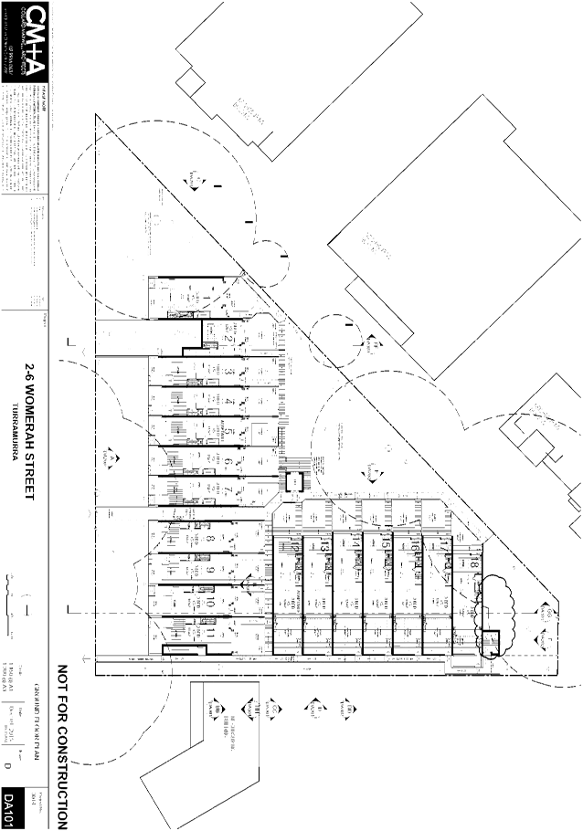
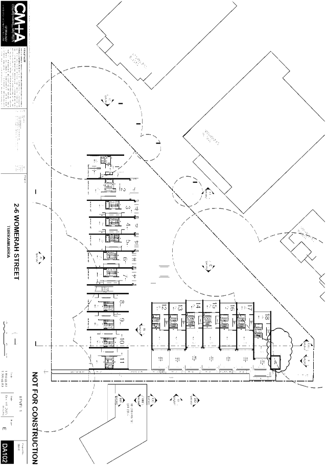
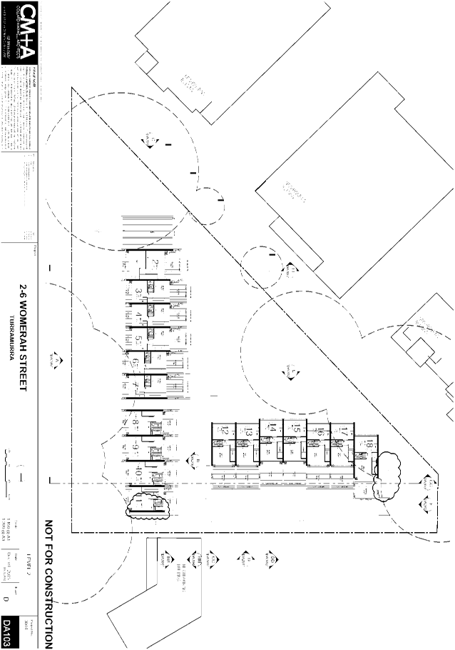
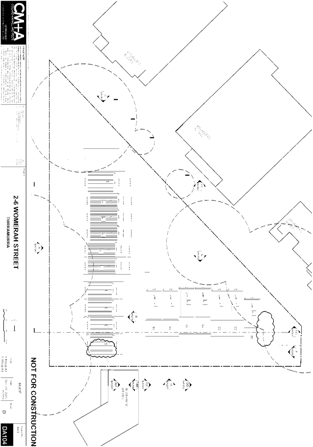
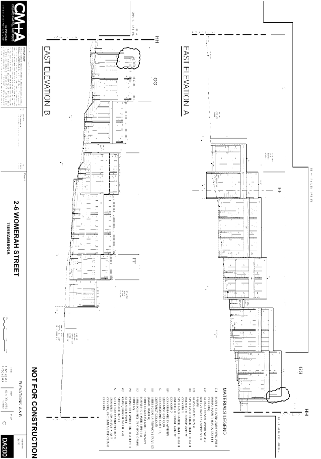
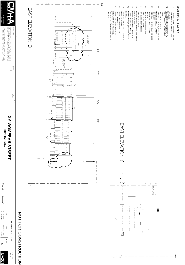
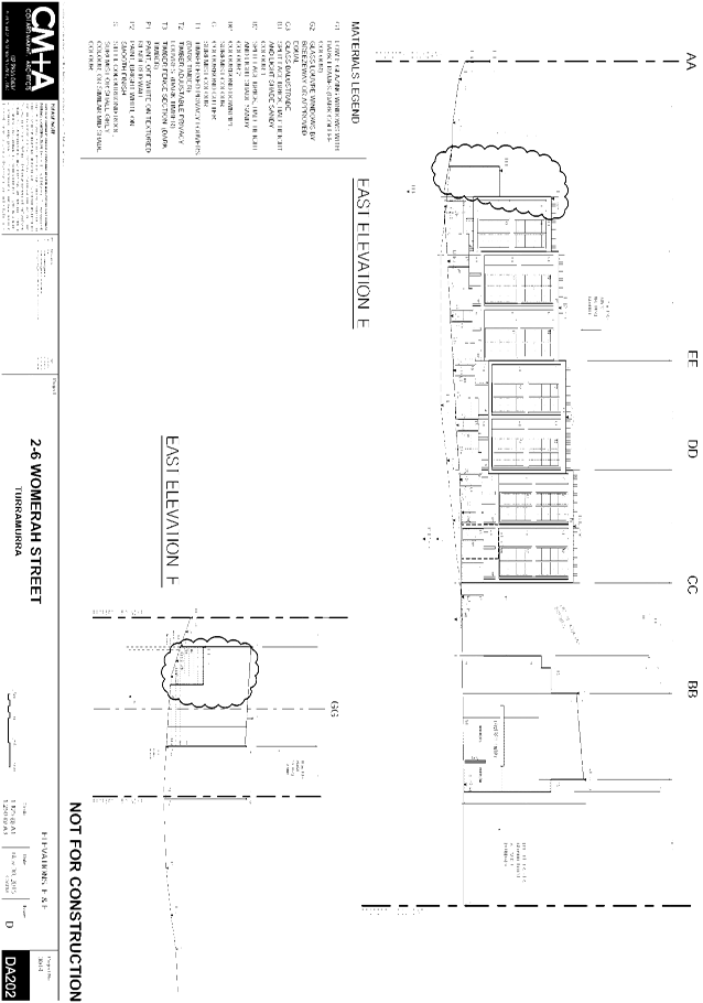
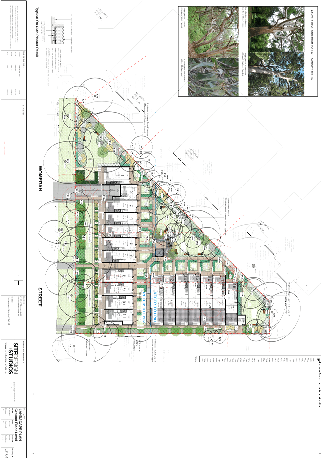
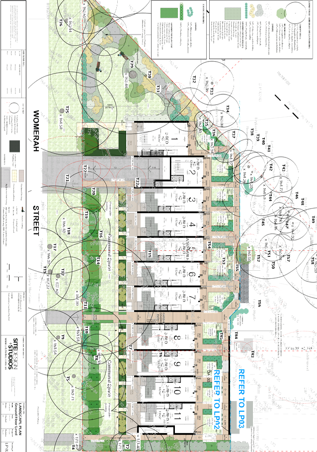
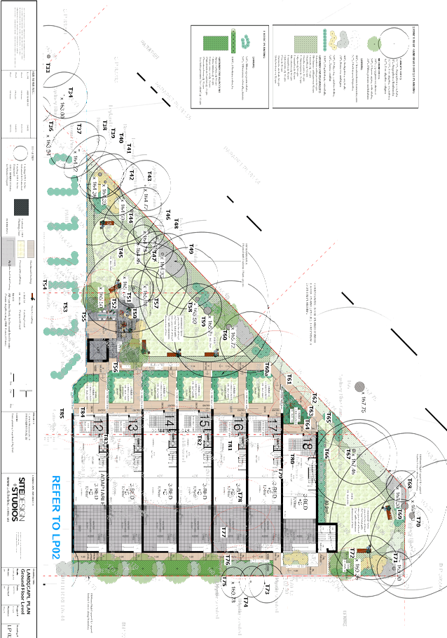
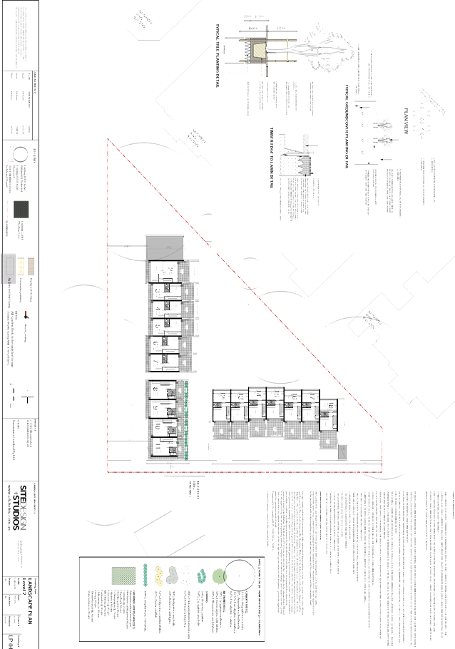
GB.4 2 - 6 Womerah Street, Turramurra - Demolish existing structures, construct 18 town-houses including basement parking and lot consolidation 121
File: DA0042/15
Ward: Wahroonga
Applicant: Collard Maxwell Architects
Owner: Turramurra Gardens Pty Ltd
Demolish existing structures, construct 18 town-houses, including basement parking and lot consolidation
Recommendation:
Approval
GB.5 Draft Revised Voluntary Planning Agreement Policy 2016 for Exhibition 226
File: S06198
The purpose of this report is to present a draft revised Planning Agreement Policy for public exhibition.
Recommendation:
That the draft revised Planning Agreement Policy 2016 be placed on public exhibition. That a report be presented to Council after the close of the exhibition period.
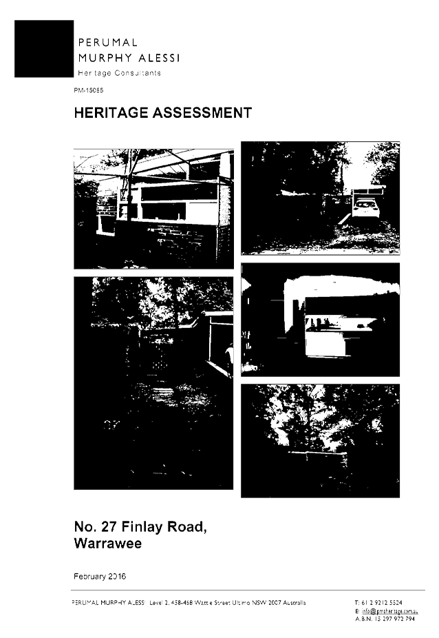
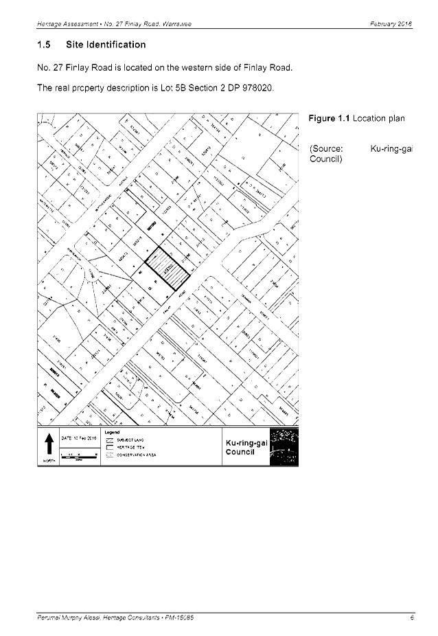
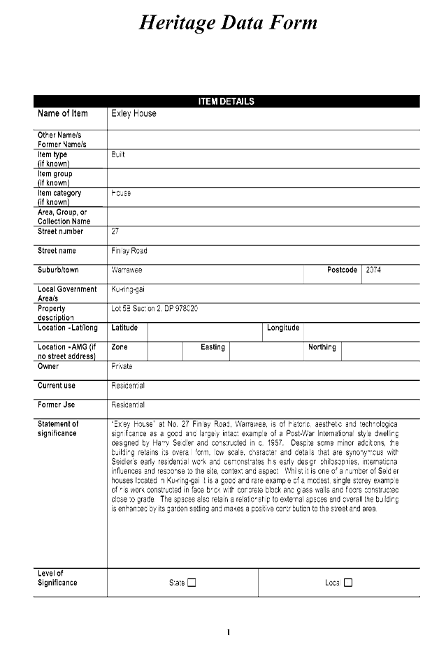
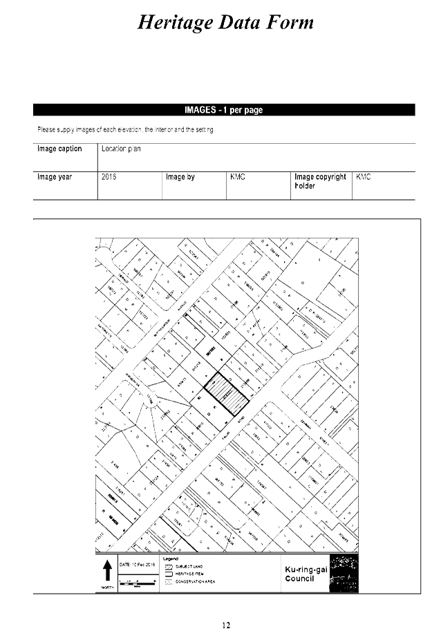
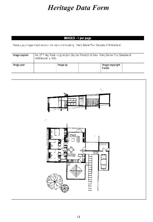
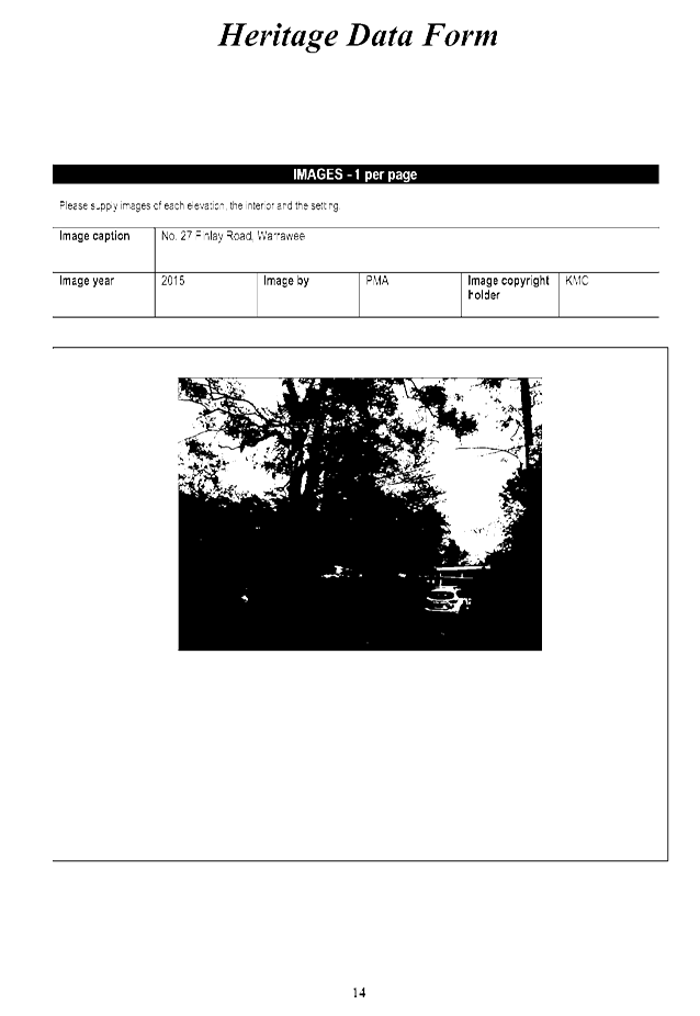
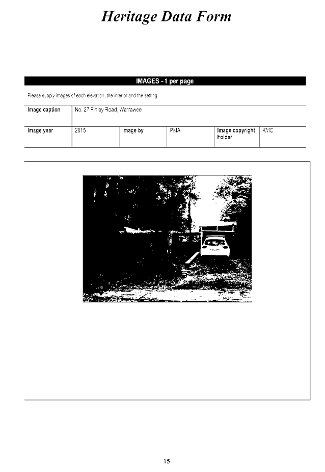
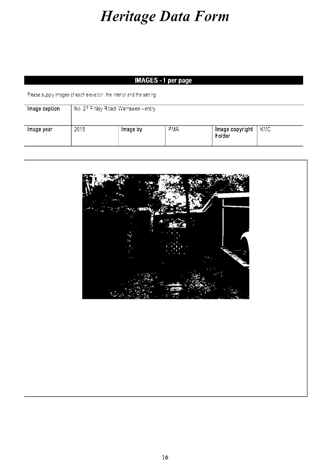
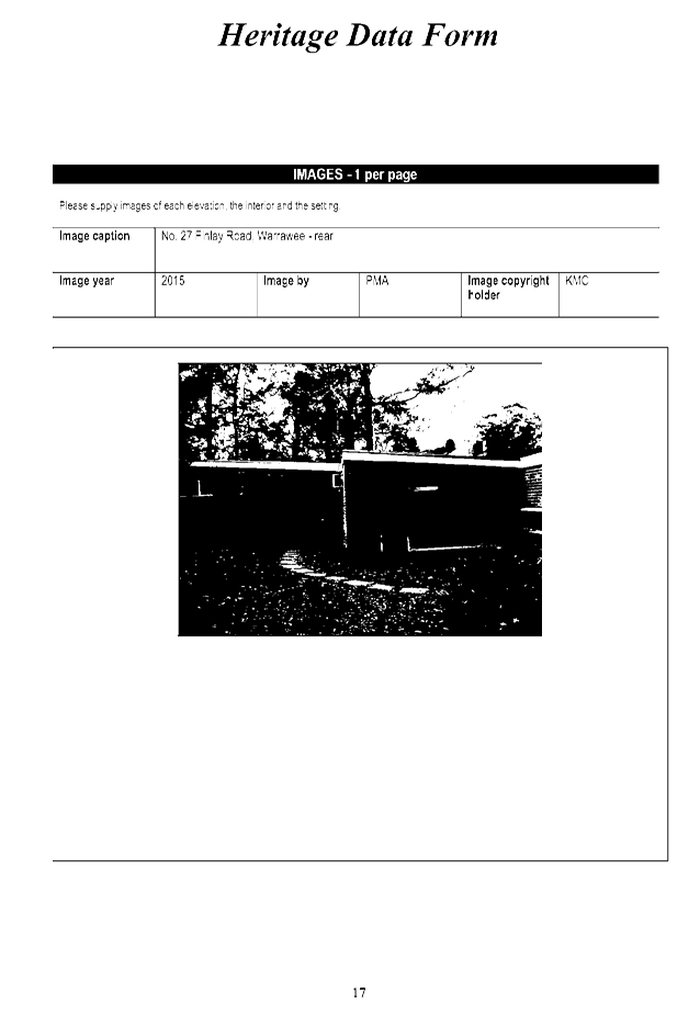
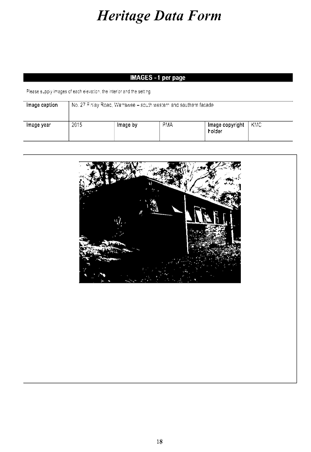
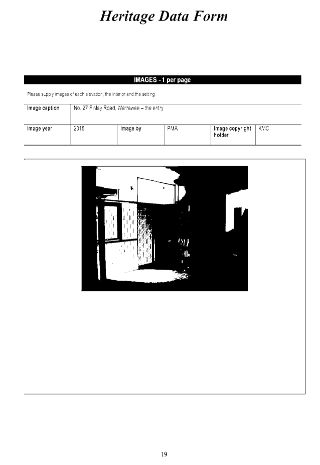
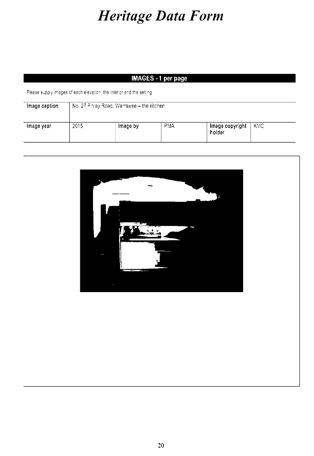
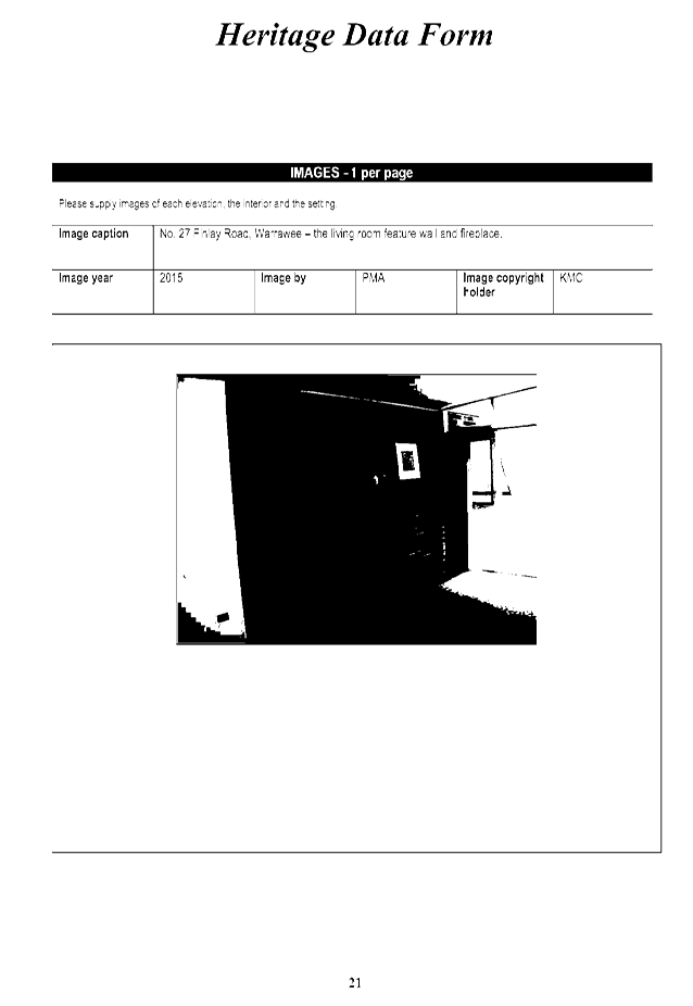
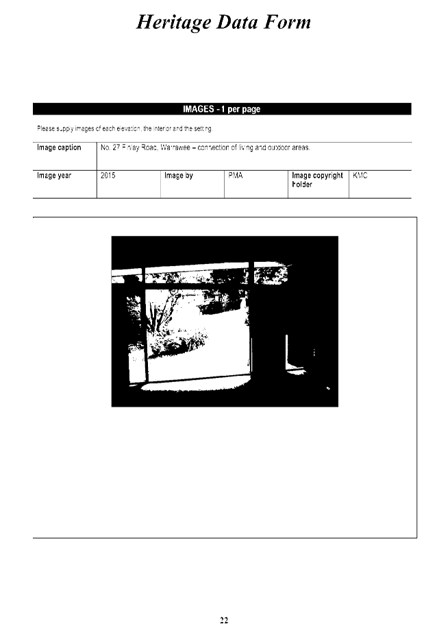
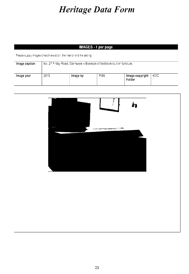
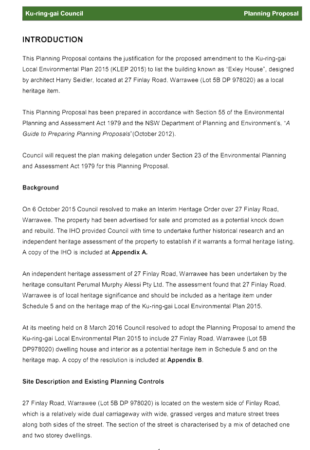
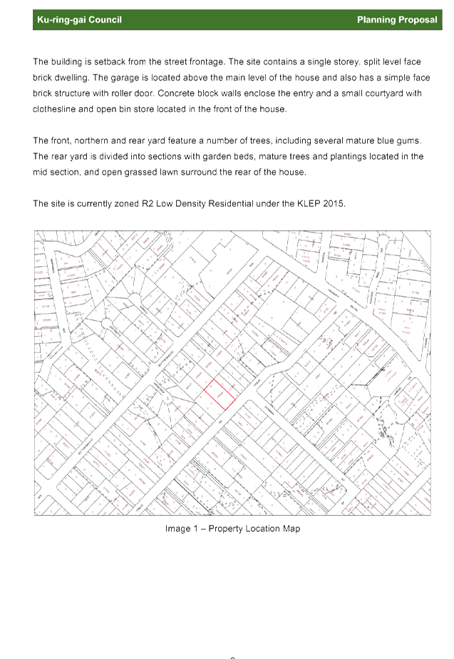
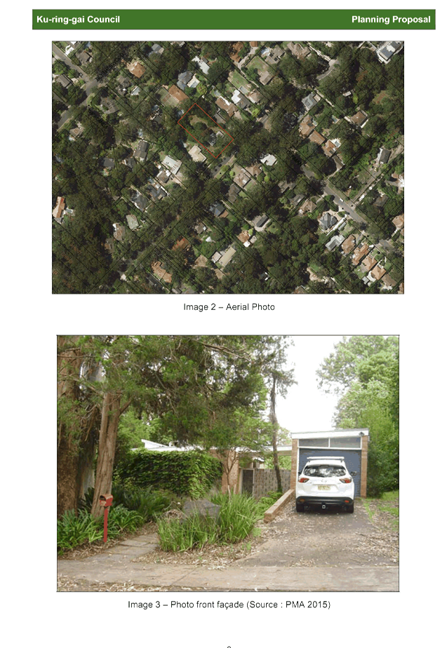
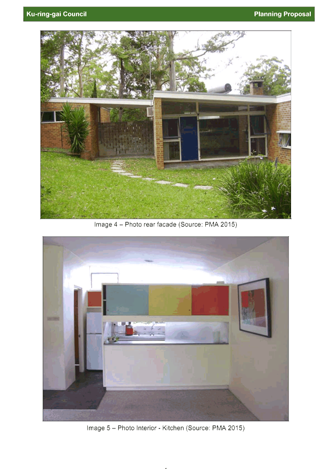
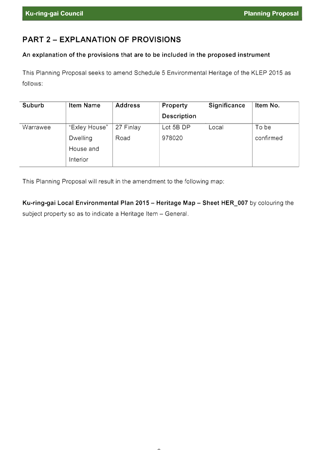
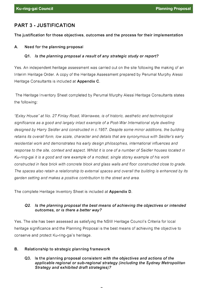
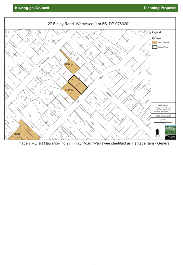
GB.6 Planning proposal to include 27 Finlay Road, Warrawee as an item of local heritage under KLEP 2015 271
File: S10066
To have Council consider 27 Finlay Road, Warrawee as a potential heritage item under the Ku-ring-gai Local Environmental Plan 2015.
Recommendation:
That the Planning Proposal be adopted to list 27 Finlay Road, Warrawee as an item of local heritage significance under KLEP 2015.
Extra Reports Circulated to Meeting
BUSINESS WITHOUT NOTICE – SUBJECT TO CLAUSE 241 OF GENERAL REGULATIONS
Questions Without Notice
Inspections Committee – SETTING OF TIME, DATE AND RENDEZVOUS
** ** ** ** ** **
Minute Ku-ring-gai Council Page
MINUTES
OF Ordinary Meeting of Council
HELD ON Tuesday, 23 February 2016
|
Present: |
The Mayor, Councillor C Szatow (Chairperson) (Gordon Ward) Councillors E Malicki & J Pettett (Comenarra Ward) Councillor D Citer (Gordon Ward) Councillors C Berlioz & D Ossip (St Ives Ward) Councillors J Anderson & D Armstrong (Roseville Ward) Councillor D McDonald (Wahroonga Ward) |
|
|
|
|
Staff Present: |
General Manager (John McKee) Director Corporate (David Marshall) Director Development & Regulation (Michael Miocic) Director Operations (Greg Piconi) Director Strategy & Environment (Andrew Watson) Director Community (Janice Bevan) Corporate Lawyer (Jamie Taylor) Manager Corporate Communications (Virginia Leafe) Manager Records and Governance (Amber Moloney) Minutes Secretary (Sigrid Banzer) |
The Meeting commenced at 7.00 pm
The Mayor offered the Prayer
|
16 |
Apologies
File: S02194
|
|
|
Resolved:
(Moved: Councillors McDonald/Armstrong)
That the apologies from Councillor Fornari-Orsmond (family matter) and Councillor Anderson (unwell) be accepted and leave of absence granted.
CARRIED UNANIMOUSLY |
DECLARATIONS OF INTEREST
The Mayor adverted to the necessity for Councillors and staff to declare a Pecuniary Interest/Conflict of Interest in any item on the Business Paper.
Councillor D Citer declared a significant non-pecuniary conflict of interest in respect of the item – GB8 - Proposed Merger of Ku-ring-gai Council with Hornsby Shire Council – Submission to Delegate.
On 22 February 2016 Cr Citer was elected Vice President of the Hornsby State Electorate and believed that his election to this position has affected his ability to vote impartially on the item. He withdrew from the Chamber taking no part in discussion and voting on the item.
Address the Council
The following member(s) of the public address Council on items not on the agenda:
A Martin Footpath
C Lewis Heritage
DOCUMENTS CIRCULATED TO COUNCILLORS
The Mayor adverted to the documents circulated in the Councillors’ papers and advised that the following matters would be dealt with at the appropriate time during the meeting:
|
Late Items: |
MM.1 - Ku-ring-gai Woman of the Year Award and Davidson Electorate's 2016 Local Woman of the Year Award - Report by Mayor PA dated 17 February 2016 PT.1 – Unsafe Footpath Beechworth Road Pymble – petition from 10 year old resident requesting Council to upgrade the footpath on Beechworth Road Pymble. GB.8 - Proposed Merger of Ku-ring-gai Council with Hornsby Shire Council – Submission to Delegate - Report by General Manager dated 9 February 2016 an attachment. GB.9 – Australian Local Government Women’s Association Conference 2016 – To inform Councillors of the upcoming ALGWA Conference to be held on 10 – 12 March 2016 in Gunnedah. |
|
Memorandums |
GB.8 - Proposed Merger of Ku-ring-gai Council with Hornsby Shire Council – Submission to Delegate – Memorandum by General Manager dated 23 February 2016 |
CONFIRMATION OF MINUTEs
|
17 |
Minutes of Ordinary Meeting of Council
File: S02131
|
|
|
Meeting held 9 February 2016 Minutes numbered 01 to 15
|
|
|
Resolved:
(Moved: Councillors Berlioz/McDonald)
That Minutes numbered 01 to 15 circulated to Councillors were taken as read and confirmed as an accurate record of the proceedings of the Meeting.
CARRIED UNANIMOUSLY |
Councillor Anderson arrived
minutes from the Mayor
|
18 |
Ku-ring-gai Woman of the Year Award and Davidson Electorate's 2016 Local Woman of the Year Award
File: CY00455/4 Vide: MM.1
|
|
|
I am pleased to advise that Brenda Williams was named the Ku-ring-gai Woman of the Year by the NSW Minister for Women Pru Goward at Ku-ring-gai Netball Association Headquarters in Canoon Road at South Turramurra earlier this month.
Ms Williams has been volunteering with Ku-ring-gai Netball Association since its inception in 1969, and is the life patron of the Association.
She began umpiring netball in 1956 and officiated at the first netball World Club Cup Championships.
I would also like to mention Julia Eagles, who has been named the Davidson Electorate’s 2016 Local Woman of the Year.
Ms Eagles is a volunteer in policing with NSW Police and actively promotes their crime prevention initiatives. In addition, Ms Eagles also volunteers with Council’s Bushcare and Street Care programs as well as the Ku-ring-gai Neighbourhood Centre.
I thank both Ms Williams and Ms Eagles for their commitment and hard work as a volunteer in Ku-ring-gai and for their wonderful contribution to our community.
|
|
|
Resolved:
A. That this Mayoral Minute be received and noted.
B. That the Mayor write to Ms Williams and Ms Eagles on behalf of Council congratulating them on their award.
CARRIED UNANIMOUSLY |
PETITIONS
|
19 |
Unsafe Footpath Beechworth Road Pymble
File: 88/05121/01 Vide: PT.1
|
|
|
“We, the undersigned, request Council to put in a footpath on Beechworth Road Pymble, [Seventeen (17) Signatures].”
I am writing this letter because I have found a dangerous and unsafe situation in my street, Beechworth Road, Pymble. I have found that local people have been walking and bike riding along the street and they have been injured because of the bumpy nature strip. I am writing to ask for this to be fixed.
The people living along Beechworth Road are mainly elderly people and young families. I have noticed people have been falling over and spraining their ankles really badly from the tree roots popping through the ground, the uneven dirt and holes in the ground. The uneven soil means that the community is unsafe and may injure themselves when walking or bike riding.
Lots of people in the suburb enjoy bike riding. Bike riding provided exercise to old and young people. It makes us fit and healthy and we can also enjoy being out in the environment. I am only 10 and I bike ride about once a week up and down my street. I have found this situation hard because of the unsafe nature strip. I am not allowed to ride on the road because it is too dangerous, however at the moment the nature strip is also too dangerous. We need to do something about this problem!
Thank you for your time in reading this letter and I hope to hear from you soon with a solution to the dangerous and uneven nature strip.
|
|
|
Resolved:
(Moved: The Mayor Councillor Szatow/Councillor Malicki)
That the petition be received and referred to the appropriate Officer of Council for attention.
CARRIED UNANIMOUSLY |
GENERAL BUSINESS
|
20 |
Investment Report as at 31 January 2016
File: S05273 Vide: GB.2
|
|
|
To present Council’s investment portfolio performance for January 2016. |
|
|
Resolved:
(Moved: Councillors Berlioz/Armstrong)
A. That the summary of investments and performance for January 2016 be received and noted.
B. That the Certificate of the Responsible Accounting Officer be noted and the report adopted.
CARRIED UNANIMOUSLY |
|
21 |
Analysis of Land and Environment Court Costs - 2nd Quarter 2015 to 2016
File: S05273 Vide: GB.3
|
|
|
To report legal costs in relation to development control matters in the Land and Environment Court for the six months ended 31 December 2015. |
|
|
Resolved:
(Moved: Councillors Berlioz/McDonald)
That the
analysis of Land and Environment Court costs for the year ended
CARRIED UNANIMOUSLY |
|
22 |
Torrens Title subdivision of one lot into two lots
File: DA0307/15 Vide: GB.4
|
||||||||||||||||||||||||||||||||||||||||||||||||||||||||
|
|
Torrens title subdivision of one lot into two lots |
||||||||||||||||||||||||||||||||||||||||||||||||||||||||
|
|
Resolved:
(Moved: Councillors Berlioz/Pettett)
That Council, as the consent authority, grant development consent to DA0307/15 for the Torrens title subdivision of one lot into two lots at 42 Ridge Street, Gordon for a period of two (2) years from the date of the Notice of Determination, subject to the following conditions:
Conditions that identify approved plans:
1. Approved architectural plans and documentation (new development)
The development must be carried out in accordance with the following plans and documentation listed below and endorsed with Council’s stamp, except where amended by other conditions of this consent:
Reason: To ensure that the development is in accordance with the determination.
2. Inconsistency between documents
In the event of any inconsistency between conditions of this consent and the drawings/documents referred to above, the conditions of this consent prevail.
Reason: To ensure that the development is in accordance with the determination.
Conditions to be satisfied prior to demolition, excavation or construction:
3. Asbestos works
All work involving asbestos products and materials, including asbestos-cement-sheeting (ie. Fibro), must be carried out in accordance with the guidelines for asbestos work published by WorkCover Authority of NSW.
Reason: To ensure public safety
4. Notice of commencement
At least 48 hours prior to the commencement of any development (including demolition, excavation, shoring or underpinning works), a notice of commencement of building or subdivision work form and appointment of the principal certifying authority form shall be submitted to Council.
Reason: Statutory requirement.
5. Notification of builder’s details
Prior to the commencement of any development or excavation works, the Principal Certifying Authority shall be notified in writing of the name and contractor licence number of the owner/builder intending to carry out the approved works.
Reason: Statutory requirement.
6. Tree protection fencing
To preserve the following tree/s, no work shall commence until the area beneath their canopy is fenced off at the specified radius from the trunk/s to prevent any activities, storage or the disposal of materials within the fenced area. The fence/s shall be maintained intact until the completion of all demolition/building work on site.
Reason: To protect existing trees during the construction phase.
7. Tree protection fencing excluding structure
To preserve the following tree/s, no work shall commence until the area beneath their canopy excluding that area of the approved site access/stormwater works shall be fenced off for the specified radius from the trunk to prevent any activities, storage or the disposal of materials within the fenced area. The fence/s shall be maintained intact until the completion of all demolition/building work on site:
Reason: To protect existing trees during the construction phase.
8. Tree protective fencing type galvanised mesh
The tree protection fencing shall be constructed of galvanised pipe at 2.4 metre spacing and connected by securely attached chain mesh fencing to a minimum height of 1.8 metres in height prior to work commencing.
Reason: To protect existing trees during construction phase.
9. Tree protection signage
Prior to works commencing, tree protection signage is to be attached to each tree protection zone, displayed in a prominent position and the sign repeated at 10 metres intervals or closer where the fence changes direction. Each sign shall contain in a clearly legible form, the following information:
10. Tree protection zone
· This fence has been installed to prevent damage to the trees and their growing environment both above and below ground and access is restricted. · Any encroachment not previously approved within the tree protection zone shall be the subject of an arborist's report. · The arborist's report shall provide proof that no other alternative is available. · The Arborist's report shall be submitted to the Principal Certifying Authority for further consultation with Council. · The name, address, and telephone number of the developer.
Reason: To protect existing trees during the construction phase.
11. Tree protection - avoiding soil compaction
To preserve the following tree/s and avoid soil compaction, no work shall commence until temporary measures to avoid soil compaction (eg rumble boards) beneath the canopy of the following tree/s is/are installed:
Reason: To protect existing trees during the construction phase.
12. Tree fencing inspection
Upon installation of the required tree protection measures, an inspection of the site by the Principal Certifying Authority is required to verify that tree protection measures comply with all relevant conditions.
Reason: To protect existing trees during the construction phase.
Conditions to be satisfied prior to the issue of the construction certificate:
13. Submission of plans for drainage works
For the issue of a Construction Certificate plans suitable for construction of the required internal drainage works shall be submitted to and approved by the Principal Certifying Authority.
Reason: Stormwater drainage to be available for the new lots.
14. Long service levy
In accordance with Section 109F(i) of the Environmental Planning and Assessment Act a Construction Certificate shall not be issued until any long service levy payable under Section 34 of the Building and Construction Industry Long Service Payments Act 1986 (or where such levy is payable by instalments, the first instalment of the levy) has been paid. Council is authorised to accept payment. Where payment has been made elsewhere, proof of payment is to be provided to Council.
Reason: Statutory requirement.
15. Builder’s indemnity insurance
The applicant, builder, developer or person who does the work on this development, must arrange builder’s indemnity insurance and submit the certificate of insurance in accordance with the requirements of Part 6 of the Home Building Act 1989 to the Certifying Authority for endorsement of the plans accompanying the Construction Certificate.
It is the responsibility of the applicant, builder or developer to arrange the builder's indemnity insurance for residential building work over the value of $20,000. The builder's indemnity insurance does not apply to commercial or industrial building work or to residential work valued at less than $20,000, nor to work undertaken by persons holding an owner/builder's permit issued by the Department of Fair Trading (unless the owner/builder's property is sold within 7 years of the commencement of the work).
Reason: Statutory requirement.
16. Excavation for services
Prior to the issue of the Construction Certificate, the Principal Certifying Authority shall be satisfied that no proposed underground services (ie: water, sewerage, drainage, gas or other service) unless previously approved by conditions of consent, are located beneath the canopy of any tree protected under Council’s Tree Preservation Order, located on the subject allotment and adjoining allotments.
Note: A plan detailing the routes of these services and trees protected under the Tree Preservation Order shall be submitted to the Principal Certifying Authority.
Reason: To ensure the protection of trees.
17. Design of works in public road (Roads Act approval)
Prior to issue of the Construction Certificate, the Certifying Authority shall be satisfied that engineering plans, in accordance with the stormwater drainage plans, Project No. 21779, Dwg. No. EA01(E), EA02(C), EA03(E), EA04(D) and EA05(D), prepared by Trehy Ingold Neate Land Development and specifications have been approved by Council’s Development Engineer. The plans to be assessed must be to a detail suitable for construction issue purposes and must detail the following infrastructure works required in Holford Crescent:
· stormwater drainage works
Development consent does not give approval to these works in the road reserve. The applicant must obtain a separate approval under sections 138 and 139 of The Roads Act 1993 for the works in the road reserve required as part of the development. The Construction Certificate must not be issued, and these works must not proceed until Council has issued a formal written approval under the Roads Act 1993.
The required plans and specifications are to be designed in accordance with the General Specification for the Construction of Road and Drainage Works in Ku-ring-gai Council, dated November 2004. The drawings must detail existing utility services and trees affected by the works, erosion control requirements and traffic management requirements during the course of works. Survey must be undertaken as required. Traffic management is to be certified on the drawings as being in accordance with the documents SAA HB81.1 - 1996 - Field Guide for Traffic Control at Works on Roads - Part 1 and RTA Traffic Control at Work Sites (1998). Construction of the works must proceed only in accordance with any conditions attached to the Roads Act approval issued by Council.
A minimum of three (3) weeks will be required for Council to assess the Roads Act application. Early submission of the Roads Act application is recommended to avoid delays in obtaining a Construction Certificate. An engineering assessment and inspection fee (set out in Council’s adopted fees and charges) is payable and Council will withhold any consent and approved plans until full payment of the correct fees. Plans and specifications must be marked to the attention of Council’s Development Engineers. In addition, a copy of this condition must be provided, together with a covering letter stating the full address of the property and the accompanying DA number.
Reason: To ensure that the plans are suitable for construction purposes.
18. Energy Australia requirements
Prior to issue of the Construction Certificate, the applicant must contact Energy Australia regarding power supply for the subject development. A written response detailing the full requirements of Energy Australia (including any need for underground cabling, substations or similar within or in the vicinity the development) shall be submitted to the Principal Certifying Authority for approval prior to issue of the Construction Certificate.
Any structures or other requirements of Energy Australia shall be indicated on the plans issued with the Construction Certificate, to the satisfaction of the Principal Certifying Authority and Energy Australia. The requirements of Energy Australia must be met in full prior to issue of the Occupation Certificate.
Reason: To ensure compliance with the requirements of Energy Australia.
19. Utility provider requirements
Prior to issue of the Construction Certificate, the applicant must make contact with all relevant utility providers whose services will be impacted upon by the development. A written copy of the requirements of each provider, as determined necessary by the Certifying Authority, must be obtained. All utility services or appropriate conduits for the same must be provided by the developer in accordance with the specifications of the utility providers.
Reason: To ensure compliance with the requirements of relevant utility providers.
20. Underground services
All electrical services (existing and proposed) shall be undergrounded from the proposed building on the site to the appropriate power pole(s) or other connection point. Undergrounding of services must not disturb the root system of existing trees and shall be undertaken in accordance with the requirements of the relevant service provided. Documentary evidence that the relevant service provider has been consulted and that their requirements have been met are to be provided to the Certifying Authority prior to the issue of the Construction Certificate. All electrical and telephone services to the subject property must be placed underground and any redundant poles are to be removed at the expense of the applicant.
Reason: To provide infrastructure that facilitates the future improvement of the streetscape by relocation of overhead lines below ground.
Conditions to be satisfied prior to the issue of the construction certificate or prior to demolition, excavation or construction (whichever comes first):
21. Infrastructure restorations fee
To ensure that damage to Council Property as a result of construction activity is rectified in a timely matter:
a) All work or activity taken in furtherance of the development the subject of this approval must be undertaken in a manner to avoid damage to Council Property and must not jeopardise the safety of any person using or occupying the adjacent public areas.
b) The applicant, builder, developer or any person acting in reliance on this approval shall be responsible for making good any damage to Council Property, and for the removal from Council Property of any waste bin, building materials, sediment, silt, or any other material or article.
c) The Infrastructure Restoration Fee must be paid to the Council by the applicant prior to both the issue of the Construction Certificate and the commencement of any earthworks or construction.
d) In consideration of payment of the Infrastructure Restorations Fee, Council will undertake such inspections of Council Property as Council considers necessary and also undertake, on behalf of the applicant, such restoration work to Council Property, if any, that Council considers necessary as a consequence of the development. The provision of such restoration work by the Council does not absolve any person of the responsibilities contained in (a) to (b) above. Restoration work to be undertaken by the Council referred to in this condition is limited to work that can be undertaken by Council at a cost of not more than the Infrastructure Restorations Fee payable pursuant to this condition.
e) In this condition:
“Council Property” includes any road, footway, footpath paving, kerbing, guttering, crossings, street furniture, seats, letter bins, trees, shrubs, lawns, mounds, bushland, and similar structures or features on any road or public road within the meaning of the Local Government Act 1993 (NSW) or any public place; and
“Infrastructure Restoration Fee” means the Infrastructure Restorations Fee calculated in accordance with the Schedule of Fees & Charges adopted by Council as at the date of payment and the cost of any inspections required by the Council of Council Property associated with this condition.
Reason: To maintain public infrastructure.
22. Section 94 development contributions - other than identified centres (For DAs determined on or after 19 December 2010).
This development is subject to a development contribution calculated in accordance with Ku-ring-gai Contributions Plan 2010, being a s94 Contributions Plan in effect under the Environmental Planning and Assessment Act, as follows:
The contribution shall be paid to Council prior to the issue of any Construction Certificate, Linen Plan, Certificate of Subdivision or Occupation Certificate whichever comes first in accordance with Ku-ring-gai Contributions Plan 2010.
The contributions specified above are subject to indexation and may vary at the time of payment in accordance with Ku-ring-gai Contributions Plan 2010 to reflect changes in the consumer price index and housing price index. Prior to payment, please contact Council directly to verify the current payable contributions.
Copies of Council’s Contribution Plans can be viewed at Council Chambers, 818 Pacific Hwy Gordon or on Council’s website at www.kmc.nsw.gov.au.
Notwithstanding the total above, in accordance with the s94E Direction issued by the Minister for Planning dated 3 March 2011, for so long as it remains legally in force, the maximum amount payable for the subject development application shall be $20,000 x 1 = $20,000.00.
Reason: To ensure the provision, extension or augmentation of the Key Community Infrastructure identified in Ku-ring-gai Contributions Plan 2010 that will, or is likely to be, required as a consequence of the development.
Conditions to be satisfied during the demolition, excavation and construction phases:
23. Road opening permit
The opening of any footway, roadway, road shoulder or any part of the road reserve shall not be carried out without a road opening permit being obtained from Council (upon payment of the required fee) beforehand.
Reason: Statutory requirement (Roads Act 1993 Section 138) and to maintain the integrity of Council’s infrastructure. 24. Prescribed conditions
The applicant shall comply with any relevant prescribed conditions of development consent under clause 98 of the Environmental Planning and Assessment Regulation. For the purposes of section 80A (11) of the Environmental Planning and Assessment Act, the following conditions are prescribed in relation to a development consent for development that involves any building work:
· The work must be carried out in accordance with the requirements of the Building Code of Australia · In the case of residential building work for which the Home Building Act 1989 requires there to be a contract of insurance in force in accordance with Part 6 of that Act, that such a contract of insurance is in force before any works commence.
Reason: Statutory requirement.
25. Hours of work
Demolition, excavation, construction work and deliveries of building material and equipment must not take place outside the hours of 7.00am to 5.00pm Monday to Friday and 8.00am to 12 noon Saturday. No work and no deliveries are to take place on Sundays and public holidays.
Excavation or removal of any materials using machinery of any kind, including compressors and jack hammers, must be limited to between 7.30am and 5.00pm Monday to Friday, with a respite break of 45 minutes between 12 noon 1.00pm.
Where it is necessary for works to occur outside of these hours (ie) placement of concrete for large floor areas on large residential/commercial developments or where building processes require the use of oversized trucks and/or cranes that are restricted by the RTA from travelling during daylight hours to deliver, erect or remove machinery, tower cranes, pre-cast panels, beams, tanks or service equipment to or from the site, approval for such activities will be subject to the issue of an "outside of hours works permit" from Council as well as notification of the surrounding properties likely to be affected by the proposed works.
Note: Failure to obtain a permit to work outside of the approved hours will result in on the spot fines being issued.
Reason: To ensure reasonable standards of amenity for occupants of neighbouring properties.
26. Approved plans to be on site
A copy of all approved and certified plans, specifications and documents incorporating conditions of consent and certification (including the Construction Certificate if required for the work) shall be kept on site at all times during the demolition, excavation and construction phases and must be readily available to any officer of Council or the Principal Certifying Authority.
Reason: To ensure that the development is in accordance with the determination.
27. Site notice
A site notice shall be erected on the site prior to any work commencing and shall be displayed throughout the works period.
The site notice must:
· be prominently displayed at the boundaries of the site for the purposes of informing the public that unauthorised entry to the site is not permitted · display project details including, but not limited to the details of the builder, Principal Certifying Authority and structural engineer · be durable and weatherproof · display the approved hours of work, the name of the site/project manager, the responsible managing company (if any), its address and 24 hour contact phone number for any inquiries, including construction/noise complaint are to be displayed on the site notice · be mounted at eye level on the perimeter hoardings/fencing and is to state that unauthorised entry to the site is not permitted
Reason: To ensure public safety and public information.
28. Dust control
During excavation, demolition and construction, adequate measures shall be taken to prevent dust from affecting the amenity of the neighbourhood. The following measures must be adopted:
· physical barriers shall be erected at right angles to the prevailing wind direction or shall be placed around or over dust sources to prevent wind or activity from generating dust · earthworks and scheduling activities shall be managed to coincide with the next stage of development to minimise the amount of time the site is left cut or exposed · all materials shall be stored or stockpiled at the best locations · the ground surface should be dampened slightly to prevent dust from becoming airborne but should not be wet to the extent that run-off occurs · all vehicles carrying spoil or rubble to or from the site shall at all times be covered to prevent the escape of dust · all equipment wheels shall be washed before exiting the site using manual or automated sprayers and drive-through washing bays · gates shall be closed between vehicle movements and shall be fitted with shade cloth · cleaning of footpaths and roadways shall be carried out daily
Reason: To protect the environment and amenity of surrounding properties.
29. Toilet facilities
During excavation, demolition and construction phases, toilet facilities are to be provided, on the work site, at the rate of one toilet for every 20 persons or part of 20 persons employed at the site.
Reason: Statutory requirement.
30. Maintenance period for works in public road
A maintenance period of six (6) months applies to all work in the public road reserve carried out by the applicant - after the works have been completed to the satisfaction of Ku-ring-gai Council. In that maintenance period, the applicant shall be liable for any section of the public infrastructure work which fails to perform in the designed manner, or as would reasonably be expected under the operating conditions. The maintenance period shall commence once the applicant receives a formal letter from Council stating that the works involving public infrastructure have been completed satisfactorily.
Reason: To protect public infrastructure.
31. Road reserve safety
All public footways and roadways fronting and adjacent to the site must be maintained in a safe condition at all times during the course of the development works. Construction materials must not be stored in the road reserve. A safe pedestrian circulation route and a pavement/route free of trip hazards must be maintained at all times on or adjacent to any public access ways fronting the construction site. Where public infrastructure is damaged, repair works must be carried out when and as directed by Council officers. Where pedestrian circulation is diverted on to the roadway or verge areas, clear directional signage and protective barricades must be installed in accordance with AS1742-3 (1996) “Traffic Control Devices for Work on Roads”. If pedestrian circulation is not satisfactorily maintained across the site frontage, and action is not taken promptly to rectify the defects, Council may undertake proceedings to stop work.
Reason: To ensure safe public footways and roadways during construction.
32. Services
Where required, the adjustment or inclusion of any new utility service facilities must be carried out by the applicant and in accordance with the requirements of the relevant utility authority. These works shall be at no cost to Council. It is the applicants’ full responsibility to make contact with the relevant utility authorities to ascertain the impacts of the proposal upon utility services (including water, phone, gas and the like). Council accepts no responsibility for any matter arising from its approval to this application involving any influence upon utility services provided by another authority.
Reason: Provision of utility services.
33. Erosion control
Temporary sediment and erosion control and measures are to be installed prior to the commencement of any works on the site. These measures must be maintained in working order during construction works up to completion. All sediment traps must be cleared on a regular basis and after each major storm and/or as directed by the Principal Certifying Authority and Council officers.
Reason: To protect the environment from erosion and sedimentation.
34. Sydney Water Section 73 Compliance Certificate
The applicant must obtain a Section 73 Compliance Certificate under the Sydney Water Act 1994. An application must be made through an authorised Water Servicing CoOrdinator. The applicant is to refer to “Your Business” section of Sydney Water’s web site at www.sydneywater.com.au <http://www.sydneywater.com.au> then the “e-develop” icon or telephone 13 20 92. Following application a “Notice of Requirements” will detail water and sewer extensions to be built and charges to be paid. Please make early contact with the CoOrdinator, since building of water/sewer extensions can be time consuming and may impact on other services and building, driveway or landscape design.
Reason: Statutory requirement.
35. Project arborist
An arborist report prepared by Tree Consulting by Jo, dated 8/07/15 has been submitted with the application. A suitably qualified project arborist (AQF level 5) is to be engaged to advise the Principal Certifying Authority on the protection of trees at the site and to supervise the installation and maintenance of tree protection measures required by this consent.
Prior to the commencement of any works including demolition on the site in areas required to be protected by this consent, the project arborist shall inspect the site and satisfy himself/herself that the protection measures are in accordance with the approved design and must provide a written certification to the Principal Certifying Authority to that effect.
If not satisfied, the project arborist must provide to the Principal Certifying Authority a list of works that are to be completed to ensure compliance with all conditions of consent relating to the protection of trees at the site. Those works must be undertaken to the satisfaction of the project arborist. Reason: To ensure protection of existing trees
36. Arborist’s report
All trees to be retained shall be inspected and monitored by an AQF Level 5 Arborist in accordance with AS4970-2009 during and after completion of development works to ensure their long term survival. Regular inspections and documentation from the project arborist to the Principal Certifying Authority are required during all works within the canopy spread of all existing trees on site and overhanging from adjoining sites, including date, brief description of the works inspected, and any mitigation works prescribed.
All monitoring shall be provided to the Principal Certifying Authority prior to issue of the Occupation Certificate.
All works as recommended by the project arborist are to be undertaken by an experienced arborist with a minimum AQF Level 3 qualification.
Reason: To ensure protection of existing trees.
37. Treatment of tree roots
If tree roots are required to be severed for the purposes of constructing the approved works, they shall be cut cleanly by hand, by an experienced Arborist/Horticulturist with a minimum qualification of Horticulture Certificate or Tree Surgery Certificate. All pruning works shall be undertaken as specified in Australian Standard 4373-2007 – Pruning of Amenity Trees.
Reason: To protect existing trees.
38. Thrust boring
Excavation for the installation of any services within the specified radius of the trunk/s of the following tree/s shall utilise the thrust boring method. Thrust boring shall be carried out at least 600mm beneath natural ground level to minimise damage to tree/s root system:
Reason: To protect existing trees.
39. No storage of materials beneath trees
No activities, storage or disposal of materials shall take place beneath the canopy of any tree protected under Council's Tree Preservation Order at any time.
Reason: To protect existing trees.
40. Removal of refuse
All builders' refuse, spoil and/or material unsuitable for use in landscape areas shall be removed from the site on completion of the building works.
Reason: To protect the environment.
41. Removal of noxious plants & weeds
All noxious and/or environmental weed species shall be removed from the property prior to completion of works.
Reason: To protect the environment.
42. On site retention of waste dockets
All demolition, excavation and construction waste dockets are to be retained on site, or at suitable location, in order to confirm which facility received materials generated from the site for recycling or disposal.
· Each docket is to be an official receipt from a facility authorised to accept the material type, for disposal or processing. · This information is to be made available at the request of an Authorised Officer of Council.
Reason: To protect the environment.
Conditions to be satisfied prior to the issue of an Occupation Certificate:
43. WAE plans for stormwater management
Prior to issue of the Subdivision Certificate, a registered surveyor must provide a works as executed survey of the completed stormwater drainage and management systems.
Reason: To protect the environment.
Conditions to be satisfied prior to the issue of a Subdivision certificate:
44. Removal of noxious plants & weeds
The following noxious and/or environmental weed species listed below shall be removed from the property by a qualified bush regenerator prior to the issue of the Occupation Certificate:
Reason: To protect and enhance the natural environment
45. Certification of drainage works
Prior to issue of the Subdivision Certificate, the Principal Certifying Authority is to be satisfied that the internal stormwater drainage works have been completed in accordance with the approved Construction Certificate plans.
Note: Evidence from a qualified and experienced consulting civil/hydraulic engineer documenting compliance with the above is to be provided to Council prior to issue of the Subdivision Certificate.
Reason: To protect the environment.
46. Sydney Water Section 73 Compliance Certificate
Prior to release of the linen plan/issue of the subdivision certificate, the Section 73 Sydney Water compliance certificate which refers to the subdivision application must be obtained and submitted to the Council.
Reason: Statutory requirement.
47. Requirements of public authorities for connection to services
Prior to the issue of the Subdivision Certificate, the Principal Certifying Authority shall be satisfied that the applicant has complied with the requirements of any public authorities (e.g. Energy Australia, Sydney Water, Telstra Australia, AGL, etc) in regard to the connection, relocation and/or adjustment of the services affected by the proposed subdivision. All costs related to the relocation, adjustment or support of services are the responsibility of the applicant.
Note: Details of compliance with the requirements of any relevant public authorities are to be submitted to the Principal Certifying Authority.
Reason: To ensure that services are available to the allotments of land.
48. Construction of works in public road
Prior issue of the Subdivision Certificate all drainage works in the public road must be completed in full, inspected and approved by Council. The applicant’s designing engineer is to provide certification upon completion that the works were constructed in accordance with the Council approved drawings. This certification shall be provided prior to release of the linen plan/issue of the Subdivision Certificate. The completed works are to be approved by Council’s Development Engineer prior to release of the linen plan/issue of the Subdivision Certificate.
Reason: To ensure completion of all drainage works in the public road.
49. Infrastructure repair - subdivision works
Prior to issue of the Subdivision Certificate, any infrastructure within the road reserve along the frontage of the subject site or within close proximity, which has been damaged as a result of subdivision works, must be fully repaired to the satisfaction of Council’s Development Engineer and at no cost to Council.
Reason: To protect public infrastructure.
50. Provision of services
Prior to issue of the Subdivision Certificate, separate underground electricity, gas and phone or appropriate conduits for the same, must be provided to each allotment to the satisfaction of the utility provider. A suitably qualified and experienced engineer or surveyor is to provide certification that all new lots have ready underground access to the services of electricity, gas and phone. Alternatively, a letter from the relevant supply authorities stating the same may be submitted to satisfy this condition.
Reason: Access to public utilities.
51. Issue of Subdivision Certificate
The Subdivision Certificate must not be issued until all conditions of development consent have been satisfied and a Final Certificate has been issued by the Principal Certifying Authority.
Reason: To ensure that the development is completed prior to transfer of responsibility for the site and development to another person.
52. Submission of 88b instrument
Prior to the issue of the Subdivision Certificate, the applicant must submit an original instrument under Section 88B of the Conveyancing Act with the plan of subdivision, plus six (6) copies to Council. Ku-ring-gai Council must be named as the authority whose consent is required to release, vary or modify the burdens.
Reason: To create all required easements, rights-of-carriageway, positive covenants, restrictions-on-use or other burdens/benefits as may be required.
53. Submission of plans of subdivision (Torrens title)
For endorsement of the subdivision certificate, the applicant shall submit an original plan of subdivision plus 6 copies, suitable for endorsement by Council. The following details must be submitted with the plan of subdivision and its copies:
a) the endorsement fee current at the time of lodgement b) the 88B instrument (if required) plus 6 copies c) all surveyor’s and/or consulting engineers’ certification(s) required under this subdivision consent d) The Section 73 (Sydney Water) Compliance Certificate for the subdivision. e) Proof of payment of S94 contribution
Council will check the consent conditions on the subdivision. Failure to submit the required information will delay endorsement of the linen plan and may require payment of rechecking fees. Plans and copies of subdivision must not be folded. Council will not accept bonds in lieu of completing subdivision works.
Reason: Statutory requirement.
54. General easement/R.O.W. provision and certification
Prior to issue of the Subdivision Certificate, a registered surveyor is to provide details to Council that all physical structures are fully contained within the proposed allotments or will be fully covered by the proposed burdens upon registration of the final plan of subdivision. Alternatively, where the surveyor is of the opinion that creation of burdens and benefits is not required, then proof to this effect must be submitted to the Principal Certifying Authority.
Reason: To ensure that all physical structures are fully contained within the proposed allotments or will be fully covered by the proposed burdens upon registration of the final plan of subdivision.
CARRIED UNANIMOUSLY |
||||||||||||||||||||||||||||||||||||||||||||||||||||||||
|
23 |
Flood Risk Management Committee Meeting Minutes - 9 September 2015
File: S10746 Vide: GB.5
|
|
|
For Council to consider and note the minutes of the Flood Risk Management Committee meeting held on 9 September 2015. |
|
|
Resolved:
(Moved: Councillors Berlioz/Armstrong)
That Council receives and notes the minutes of the Flood Risk Management Committee meeting held on 9 September 2015.
CARRIED UNANIMOUSLY |
|
24 |
Delivery Program 2013-2017 and Operational Plan 2015-2016 - Bi-annual Report
File: FY00382/8 Vide: GB.6
|
|
|
To report to Council on the progress of the Delivery Program 2013/2017 and Operational Plan 2015/2016, for the period July to December 2015. |
|
|
Resolved:
(Moved: Councillors Berlioz/McDonald)
A. That the report on the six (6) monthly progress review of the Delivery Program, 2013/2017 and Operational Plan 2015/2016 for the period of July 2015 to December 2015 be received and noted.
B. That 2015/2016 Tasks C4.1.2.1.5 and P4.1.2.1.1 and Critical Action P4.1.2.1 as listed in the report remain on hold for the current year, subject to their ability to proceed and availability of resources.
CARRIED UNANIMOUSLY |
|
25 |
Lovers Jump Creek Flood Study - Draft Report
File: S09972 Vide: GB.7
|
|
|
To seek Council’s endorsement to exhibit the Lovers Jump Creek Flood Study – Draft Report. |
|
|
Resolved:
(Moved: Councillors Berlioz/McDonald)
A. That Council places the Lovers Jump Creek Flood Study – Draft Report on public exhibition for a period of 28 days.
B. That all properties identified as mainstream and overland flood planning areas in the Lovers Jump Creek Flood Study – Draft Report are directly notified about the public exhibition.
C. That following the public exhibition period, feedback is provided to Jacobs to inform the final Lovers Jump Creek Flood Study.
D. That the final Lovers Jump Creek Flood Study is presented to Council for endorsement, with any amendments and corrections.
CARRIED UNANIMOUSLY |
|
26 |
Australian Local Government Women's Conference 2016
File: FY00581 Vide: GB.9
|
|
|
To inform Councillors of the upcoming ALGWA conference to be held on 10-12 March 2016 in Gunnedah. |
|
|
Resolved:
(Moved: Councillors Berlioz/Pettett)
That any Councillors interested in attending the 2016 ALGWA Conference advise the General Manager by Monday 29 February 2016.
CARRIED UNANIMOUSLY |
|
27 |
2015 - 2016 Budget Review - 2nd Quarter ended December 2015
File: S09112/4 Vide: GB.1
|
|
|
To inform Council of the results of the 2nd quarter budget review of 2015/16 and seek approval to adjust the annual budget based on the actual financial performance and trend for the period 1 July 2015 to 31 December 2015. |
|
|
Resolved:
(Moved: Councillors Berlioz/McDonald)
That Council receive and note the December 2015 Quarterly Budget Review and adopt the recommended changes to the 2015/16 budget.
That the Babbage Road Shops Upgrade project be deferred until the 1st quarter of the 2016/2017 financial year. The Babbage Road Shops are notified of the reason so that they can inform residents as well.
CARRIED UNANIMOUSLY |
Councillor Citer withdrew during discussion
|
28 |
Proposed Merger of Ku-ring-gai Council with Hornsby Shire Council – Submission to Delegate
File: S09638 Vide: GB.8
|
|
|
To update Council on the process for the proposed merger of Ku-ring-gai Council with part of Hornsby Council and to seek Council’s endorsement of a submission to the Delegate of the Chief Executive of the Office of Local Government. |
|
|
Resolved:
(Moved: Councillors Malicki/McDonald)
That Council delegate to the General Manager the authority to finalise and lodge its submission on the proposed merger of Ku-ring-gai Council with part of Hornsby Shire Council, consistent with the draft submission provided with this report.
For the Resolution: The Mayor, Councillor Szatow, Councillors , McDonald, Pettett, Malicki, Armstrong, Berlioz and Ossip
Against the Resolution: Councillor Anderson
|
Councillor Citer returned
|
29 |
Fresh Food Market - St Ives Old School Site
File: S0936 Vide: QN.1
|
|
|
Question Without Notice from Councillor Christiane Berlioz
I would like an explanation as to why after having extensive community consultation about establishing a fresh food market in St Ives on the old school site, the whole idea has been dismissed.
Answer by Manager Corporate Communications
The Manager Corporate Communications advised the markets have not been dismissed but there is a ‘speed bump’. There are no toilets on site, the DA requires that there are toilets on site, the market provider has to hire them and they are not prepared to pay the cost to hire them, so we are having negotiations with the YMCA about using their toilets, there is still ongoing discussion.
|
The Meeting closed at 8.01 pm
The Minutes of the Ordinary Meeting of Council held on 23 February 2016 (Pages 1 - 4) were confirmed as a full and accurate record of proceedings on 8 March 2016.
__________________________ __________________________
General Manager Mayor / Chairperson
|
Ordinary Meeting of Council - 8 March 2016 |
GB.1 / 29 |
|
|
|
|
Item GB.1 |
S09752 |
|
|
18 January 2016 |
Fit for the Future Reforms - Development of a new Local Government Act - Council Submission to Phase 1 Consultation
EXECUTIVE SUMMARY
Purpose of Report
To provide Council with details of the consultation process for the proposed Phase 1 amendments to the Local Government Act 1993, and to confirm Council’s response to the Office of Local Government’s call for submissions to the proposal.
Background
In 2012, the Minister for Local Government, the Hon Don Page MP, appointed the Local Government Acts Taskforce (the Taskforce) and the Independent Local Government Review Panel (the Panel) to provide recommendations regarding reform in the Local Government sector. Both parties released their final recommendations in October 2013.
Three rounds of consultation were undertaken during the development of the Taskforce recommendations:
· The first round of general consultation was held following the release of the Taskforce’s Preliminary Ideas paper (Attachment A3). The Mayor and General Manager provided input on behalf of Council via a workshop hosted by the Taskforce in October 2012.
· A second round of consultation was held following the release of a discussion paper titled A New Local Government Act for NSW in April 2013 (Attachment A4). Council provided a written response in June 2013 (Attachment A5).
· The Taskforce provided a final report containing 32 recommendations to the Minister on 16 October 2013 (Attachment A6).Council provided a written submission to the report in March 2014 (Attachment A7).
Four rounds of consultation were undertaken during the development of the Panel recommendations:
· The first round of consultation was held in July 2012 following the release of the Panel’s consultation paper, Strengthening your Community (Attachment A8). Council did not provide a submission.
· The second round of consultation was held in November 2012 following the release of the Panel’s Better Stronger Local Government – the Case Sustainable for Change paper (Attachment A9). Council did not provide a submission.
· The third round of consultation was held in April 2013 following the release of the Panel’s progress report, Future Directions for NSW Local Government: Twenty Essential Steps (Attachment A10). Council provided a written submission in June 2013 (Attachment A11).
· The Panel provided a final report containing 65 recommendations to the minister on 25 October 2013 (Attachment A12). Council provided a written submission to the report in April 2014 (Attachment A13).
The NSW Government released its response to the final Panel and Taskforce recommendations in September 2014 (Attachment A14). The response indicated broad support of the recommendations and committed to the development of a new Local Government Act, based on recommendations from both the Taskforce and the Panel, to be phased in from 2016/17.
Phase 1 of amendments to the Local Government Act 1993 focuses mainly on changes to the governance and strategic business planning processes of councils. Phase 2 will focus on the way in which councils raise revenue and exercise their regulatory functions.
Comments
The Office of Local Government has invited feedback from Councils and their communities on the proposed Phase 1 amendments to the Local Government Act 1993 via an online facility. The aim of this consultation is to use feedback received about the Phase 1 amendments to inform the legislative drafting process.
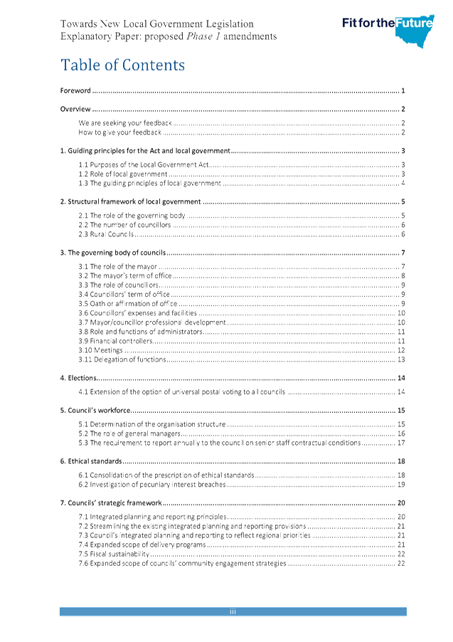
Attachment A2 is an explanatory paper released by the Office of Local Government which provides full details of the proposed Phase 1 amendments. Phase 1 is designed to:
· Embed strategic business planning principles across the range of council functions and practices;
· Promote independent and sustainable councils engaged with and accountable to their local communities that have the capacity to deliver on local and regional needs; and
· Support a culture of continuous improvement in council to ensure the effective and efficient delivery of the strategic goals agreed to with their local communities.
The following is a summary of proposed amendments. The current provision/s to relating to each one is provided in brackets.
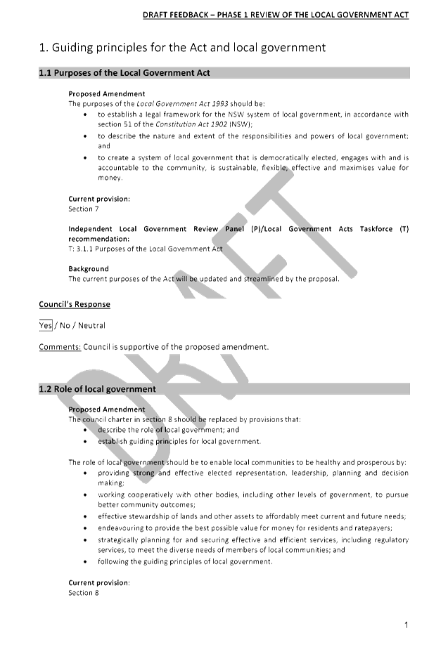
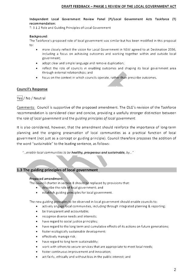
1. Guiding principles for the Act and local government
1.1. Purposes of the Local Government Act (Section 7)
1.2. Role of local government (Section 8)
1.3. The guiding principles of local government (Section 8)
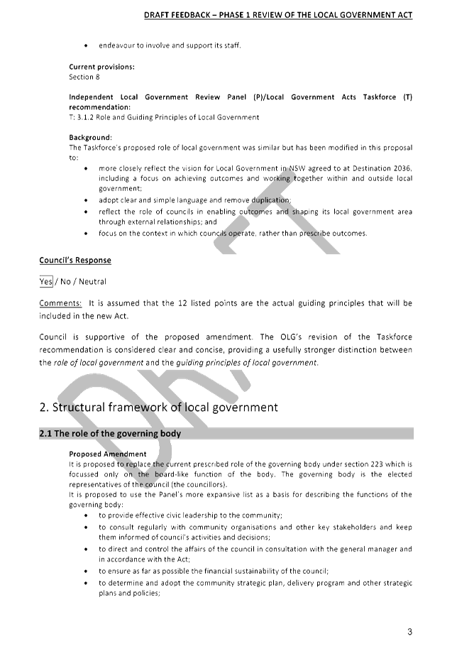
2. Structural framework of local government
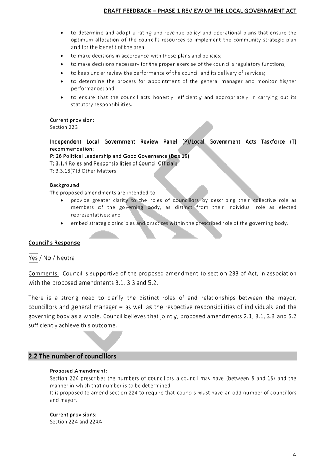
2.1. The role of the governing body (Section 223)
2.2. The number of councillors (Sections 224 and 224A)
2.3. Rural councils (Sections 224A and 365)
3. The governing body of councils
3.1. The role of the mayor (Section 226)
3.2. The mayor’s term of office (Section 230)
3.3. The role of councillors (Section 232)
3.4. Councillors’ term of office (Sections 233 and 234)
3.5. Oath of affirmation of office (No current provision)
3.6. Councillors’ expenses and facilities (Sections 235-254A and Schedule 1)
3.7. Mayor/councillor professional development (No current provision)
3.8. Role and function of administrators (Sections 255-259, 438I, 438M and 438Y)
3.9. Financial controllers (No current provision)
3.10. Meetings (Sections 9-11, and 360-376; Clauses 231-273)
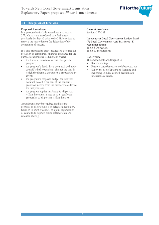
3.11. Delegation of functions (Sections 377-381)
4. Elections
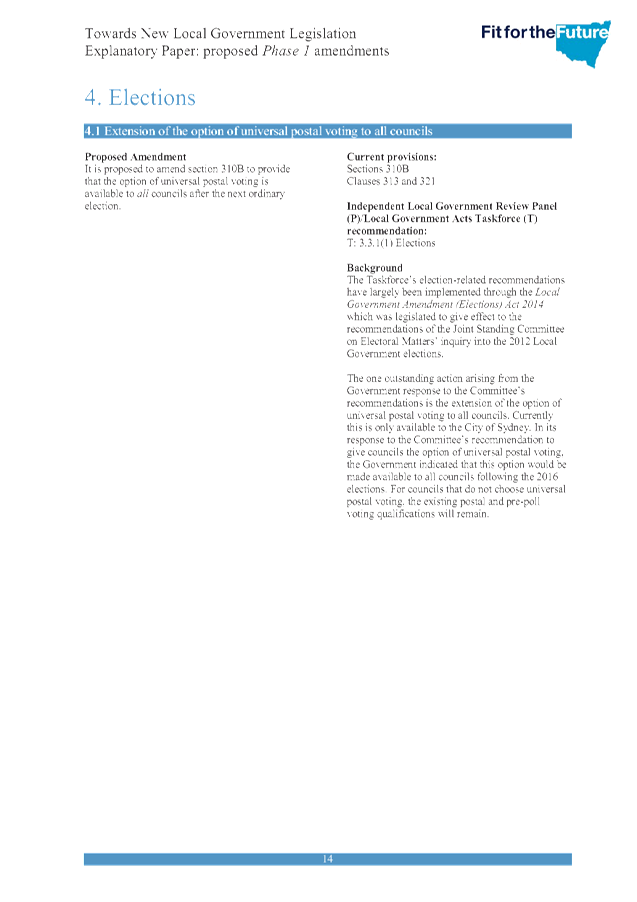
4.1. Extension of the option of universal postal voting to all councils (Section 310B; Clauses 313 and 321)
5. Council’s workforce
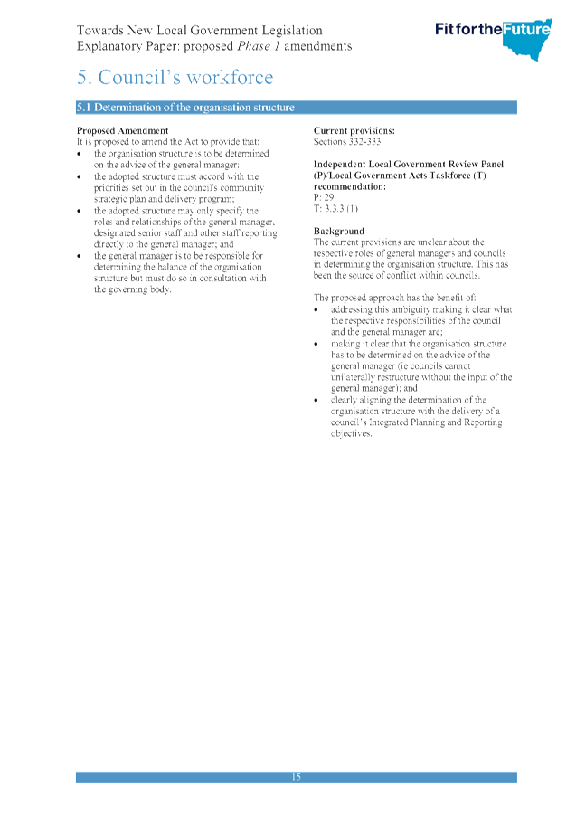
5.1. Determination of the organisational structure (Sections 332-333)
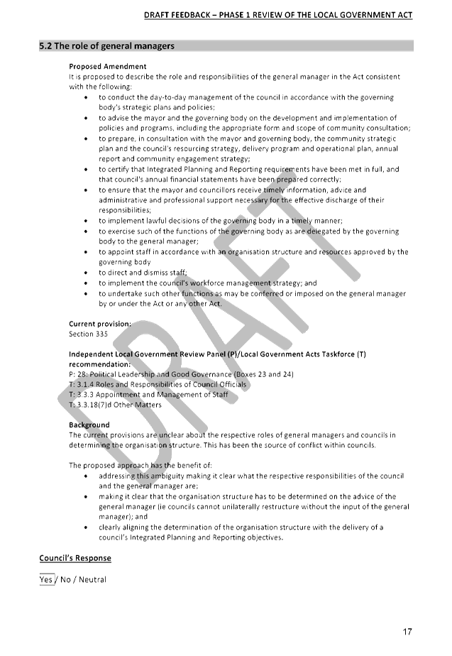
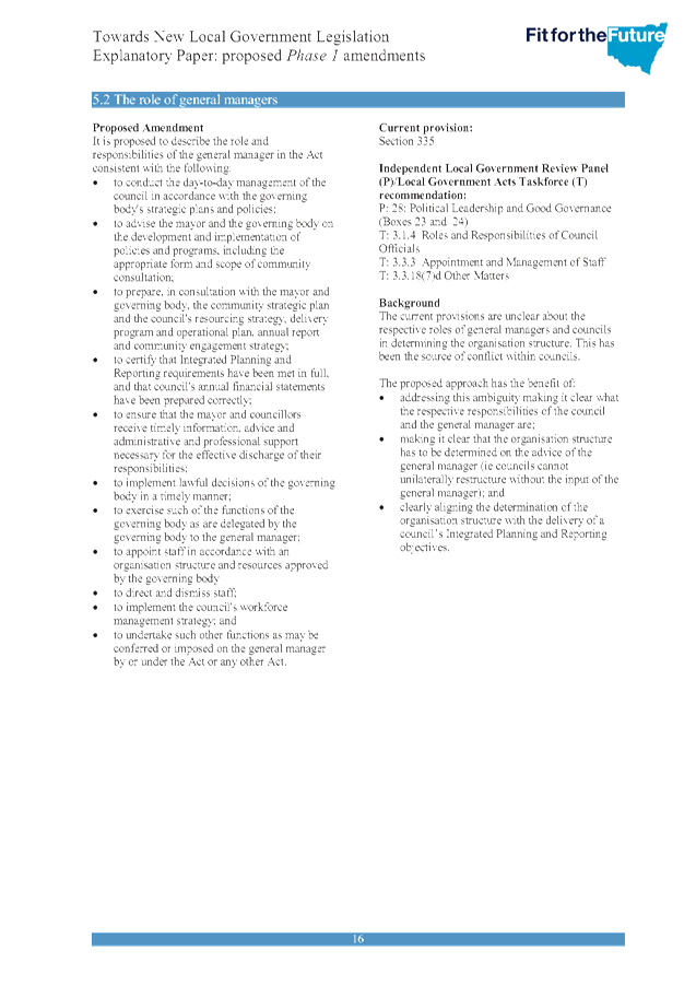
5.2. The role of general managers (Section 335)
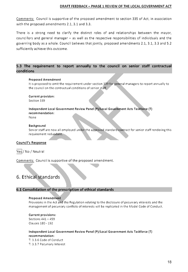
5.3. The requirement to report annually to the council on senior staff contractual conditions (Section339)
6. Ethical standards
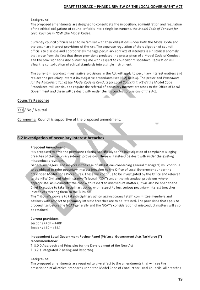
6.1. Consolidation of the prescription of ethical standards (Sections 441-459; Clauses 180-192)
6.2. Investigation of pecuniary interest breaches (Sections 440F-440P and 460-468A)
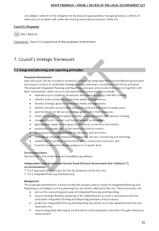
7. Council’s strategic framework
7.1. Integrated planning and reporting principles (Sections 402-406)
7.2. Streamlining the existing integrated planning a reporting provisions (Sections 402-406)
7.3. Council’s integrated planning and reporting to reflect regional priorities (Sections 402 and 404)
7.4. Expanded scope of delivery programs (Sections 404 and 406)
7.5. Fiscal sustainability (Clause 201)
7.6. Expanded scope of councils’ community engagement strategies (Sections 14, 18-20, and 402)
8. Council Performance
8.1. Annual reports (Sections 428-428A)
8.2. State of the environment reports (Section 428A)
8.3. Performance measurement (Section 429)
8.4. Internal audit (Discretionary guidelines issued under section 23A)
8.5. Sector-wide performance audits by the Auditor-General (No current provision)
8.6. Financial management (Sections 408-411)
8.7. Financial reporting (Sections 412-421)
8.8. External audit (Sections 422-427)
Feedback on Phase 1 amendments is to be submitted via an online form, accessible through the Office of Local Government website. The form identities each of the proposed amendments, and asks respondents to indicate whether they support the proposed amendment, do not support the proposed amendment, or are neutral towards the proposed amendment. A space to provide comments against each of the proposed amendments is also provided.
Attachment A1 is a transcription of the online form. It has been populated with draft responses which have been compiled in consultation with relevant members of staff. The process for development of this draft submission was as follows:
· 21/01/2016: survey template and related information circulated to General Manager, Directors, and key management staff.
· 4/02/2016: first round of staff responses collected and collated.
· 4/02/2016-23/02/2016: discussions with key management staff to clarify and streamline responses.
· 23/02/2016: final responses collected from General Manager, Directors, and key management staff.
· 24/02/2016: collated draft response circulated to General Manager, Directors, and key management staff for final comments and updates.
· 01/03/2016: draft response circulated to Councillors via the Business Papers.
integrated planning and reporting
Leadership and Governance
|
Community Strategic Plan Long Term Objective |
Delivery Program Term Achievement |
Operational Plan Task |
|
A shared long-term vision for Ku-ring-gai underpins strategic collaboration, policy development and community engagement. |
Council's responses to government policy and reforms are guided by and aligned with the adopted Community Strategic Plan 'Our Community Our Future 2030'. |
Analyse and provide appropriate submissions to government proposals affecting the local government industry. |
Governance Matters
The requirements for a review of the Act are contained within the provisions of section 747 of the Local Government Act 1993 which states;
747 Review of Act
(1) The Minister is to review this Act to determine whether the policy objectives of the Act remain valid and whether the terms of the Act remain appropriate for securing those objectives.
(2) The review is to be undertaken as soon as possible after the period of 5 years from the date of assent to this Act.
(3) A report of the outcome of the review is to be tabled in each House of Parliament within 12 months after the end of the period of 5 years.
Risk Management
There are no considerable risk management considerations associated with the recommendation of this report.
Financial Considerations
There are no financial considerations associated with the recommendation in this report.
Social Considerations
There are no social considerations associated with the recommendation in this report.
Environmental Considerations
There are no environmental considerations associated with the recommendation in this report.
Community Consultation
None undertaken or required.
Internal Consultation
The process for development of this draft submission was as follows:
· 21/01/2016: survey template and related information circulated to General Manager, Directors, and key management staff.
· 4/02/2016: first round of staff responses collected and collated.
· 4/02/2016-23/02/2016: discussions with key management staff to clarify and streamline responses.
· 23/02/2016: final responses collected from General Manager, Directors, and key management staff.
· 24/02/2016: collated draft response circulated to General Manager, Directors, and key management staff for final comments and updates.
· 01/03/2016: draft response circulated to Councillors via the Business Papers.
Summary
The Office of Local Government has invited feedback from Councils and their communities on the proposed Phase 1 amendments to the Local Government Act 1993 via an online facility. A draft submission from Council has been coordinated from responses provided by relevant staff members and is submitted for Council’s consideration (Attachment A1).
Following the consultation period, it is anticipated that amending legislation could be introduced into and passed by the NSW Parliament in 2016.
|
That the General Manager provides the attached draft submission (Attachment A1), in regards to Phase 1 consultation on the development of a new local government act, to the Office of Local Government on or before Tuesday, 15 March 2016. |
|
Amber Moloney Manager Records and Governance |
David Marshall Director Corporate |
|
Draft Submission - Phase 1 Amendments to the Local Government Act 1993 |
|
2016/038183 |
||
|
|
Explanatory Paper - Proposed Phase 1 Local Government Legislation Amendments - Released January 2016 |
|
2016/011933 |
|
|
|
Local Government Acts Taskforce - Prelimiary Ideas Paper - Released October 2012 |
2016/012427 |
||
|
|
Local Government Acts Taskforce - A New Local Government Act for NSW - Discussion Paper - Released April 2013 |
2016/012780 |
||
|
|
Submission - Local Government Acts Taskforce - A New Local Government Act for NSW - June 2013 |
2016/011997 |
||
|
|
Local Government Acts Taskforce - Report to the Minister for Local Government Hon Don Page MP - A New Local Government Act for New South Wales and Review of the City of Sydney Act 1988 - Released October 2013 |
2016/012285 |
||
|
|
Submission - Local Government Acts Taskforce - Report to the Minister for Local Government Hon Don Page MP - A New Local Government Act for New South Wales and Review of the City of Sydney Act 1988 - April 2014 |
2014/062596 |
||
|
|
Independent Local Government Review Panel Consultation Paper - Strengthening Your Community - Released July 2012 |
2016/017441 |
||
|
|
Independent Local Government Review Panel - Better Stronger Local Government - The Case for Sustainable Change - Released November 2012 |
2016/017319 |
||
|
|
Independent Local Government Review Panel - Future Directions for NSW Local Government: Twenty Essential Steps - Released April 2013 |
2016/017456 |
||
|
|
Submission - Independent Local Government Review Panel - Future Directions for NSW Local Government: Twenty Essential Steps – June 2013 |
2013/160576 |
||
|
|
Independent Local Government Review Panel - Revitalising Local Government - Final Report to the Minister - Released October 2013 |
2014/012852 |
||
|
|
Submission - Independent Local Government Review Panel - Revitalising Local Government - April 2014 |
2016/016906 |
||
|
|
NSW Government Response - Independent Local Government Review Panel and Local Government Acts Taskforce Recommendations - Released September 2014 |
2016/012753 |
|
APPENDIX No: 1 - Draft Submission - Phase 1 Amendments to the Local Government Act 1993 |
|
Item No: GB.1 |
|
APPENDIX No: 2 - Explanatory Paper - Proposed Phase 1 Local Government Legislation Amendments - Released January 2016 |
|
Item No: GB.1 |


|
Ordinary Meeting of Council - 8 March 2016 |
GB.2 / 100 |
|
|
|
|
Item GB.2 |
CY00043/8 |
|
|
26 February 2016 |
The Novus Foundation 2016 Gala Dinner
EXECUTIVE SUMMARY
|
purpose of report: |
To advise Council of a request from the Novus Foundation to purchase sponsorship package tickets for the Gala Dinner to be held at Miramare Gardens Function Centre, Terrey Hills on Saturday 7 May 2016.
|
|
|
|
|
background: |
The Novus Foundation was established in 2006 to support the welfare of young people in the Hornsby and Ku-ring-gai region. The Foundation concentrates on matters which impact young people, particularly those under 25, and their ability to perform to their natural level of capability – aiming to ensure that the next generation of young adults can take their place in society without limitations caused by ill-health, lack of training or shortage of opportunity. This year marks the 10th anniversary of the Foundation. Council has been associated with the Novus Foundation for the past 6 years, and has sponsored the annual gala event by purchasing a bronze level sponsorship table for the past 2 consecutive years. |
|
|
|
|
comments: |
Proceeds from the Novus Foundation fundraising in 2016 will support KYDS, StreetWork, Open Heart International and Rotary Club of Wahroonga Youth Projects. Individual tickets for the dinner are $160 per person and sponsorship packages (tables of 10) are available for $1,600, $3,300, $5,500, $11,000 and $22,000. |
|
|
|
|
recommendation: |
That Council purchase a bronze sponsorship package of a table of 10 tickets for the Novus Foundation 2016 Gala Dinner for $1,600, and that Councillors who are interested in attending the dinner advise the General Manager by Friday 8 April 2016.
|
Purpose of Report
To advise Council of a request from the Novus Foundation to purchase sponsorship package tickets for the Gala Dinner to be held at Miramare Gardens Function Centre, Terrey Hills on Saturday 7 May 2016.
Background
The Novus Foundation was established in 2006 to support the welfare of young people in the Hornsby and Ku-ring-gai region. The Foundation concentrates on matters which impact young people, particularly those under 25, and their ability to perform to their natural level of capability – aiming to ensure that the next generation of young adults can take their place in society without limitations caused by ill-health, lack of training or shortage of opportunity.
The Novus Foundation develops and supports projects and organisations that are investing in youth, primarily in the areas of:
· Direction – giving young people improved mentoring and guidance
· Education – giving young people wider access to skills
· Health – giving young people access to health programs, including youth related medical research
This year marks the 10th anniversary of the Foundation and its ongoing contribution to the health and welfare of young people in the Hornsby and Ku-ring-gai community.
Council has been associated with the Novus Foundation for the past 6 years, and has sponsored the annual gala event by purchasing a bronze level sponsorship table for the past 2 consecutive years.
Comments
The Novus Foundation will be holding a Gala Dinner on Saturday 7 May 2016 at Miramare Gardens Function Centre, Terrey Hills. The purpose of the Gala Dinner is to raise funds for nominated projects. In 2016, the Novus Foundation is supporting the following organisations:
· KYDS
· StreetWork
· Open Heart International
· Rotary Club of Wahroonga Youth Projects
All funds raised for KYDS at this years’ Novus dinner will be directed to HSC Survival workshops and one-to-one counselling support services particularly targeted to senior high school students.
Individual tickets for the Gala Dinner are $160.00 per person. The following Sponsorship packages are also available:
· Bronze sponsorship: $1,600. Includes gala dinner table of 10.
· Silver sponsorship: $3,300. Includes a gala dinner table of 10, table identification, gala dinner program acknowledgement, and logo on screen.
· Gold sponsorship: $5,500. Includes a gala dinner table of 10, prominent table position, table identification, gala dinner program acknowledgement, link on Novus website and logo on screen.
· Platinum sponsorship: $11,000. Includes a gala dinner table of 10, prominent table position, MC acknowledgement, table identification, gala dinner program acknowledgment, regular logo on screen, link on Novus website and logo on (event) screen.
· Diamond sponsorhip: $22,000. Includes two gala dinner tables of 10 (each), prominent table position, MC acknowledgement, table identification, gala dinner program acknowledgment, regular logo on screen, link on Novus website and logo on (event) screen.
A copy of the invitation from The Novus Foundation is attached to this report (Attachment A1).
integrated planning and reporting
|
Community Strategic Plan Long Term Objective |
Delivery Program Term Achievement |
Operational Plan Task |
|
An equitable and inclusive community that cares and provides for its members.
|
Access has increased for communities that face barriers to using social services and facilities.
|
Implement priority recommendations and programs from Council’s Youth Strategy.
|
Governance Matters
The Payment of Expenses and Provision of Facilities to Councillors Policy provides for Council to meet the reasonable costs of Councillors attendance at formal functions, including functions for charities and community service groups, as authorised by resolution of Council.
Risk Management
There are no significant risk management matters directly associated with this report.
Financial Considerations
Individual tickets for Novus Foundation Gala Dinner are $160 per person and sponsorship packages (tables of 10) are available for $1,600, $3,300, $5,500, $11,000 and $22,000.
The Payment of Expenses and Provision of Facilities to Councillors Policy provides for Council to meet the reasonable costs of Councillors attendance at formal functions, including functions for charities and community service groups, as authorised by resolution of Council. Funds are available in the 2015/16 budget for the purchase of a bronze level sponsorship.
Social Considerations
By supporting the Novus Foundation, Council is contributing to the health and welfare of youth in the local community. Attendance at the Gala Dinner will enable Councillors to meet other members of the community who support the Novus Foundation. The dinner will also provide opportunities to obtain further details about individual projects from representatives of various community organisations.
Environmental Considerations
There are no significant environmental considerations associated with this report.
Community Consultation
None undertaken or required.
Internal Consultation
None undertaken or required.
Summary
Council has received an invitation to purchase tickets for the Novus Foundation Gala Dinner to be held on Saturday 7 May 2016 at Miramare Gardens Function Centre at Terrey Hills. Individual tickets are $160 per person and sponsorship packages (tables of 10) are available for $1,600, $3,300, $5,500, $11,000 and $22,000.
Council has been associated with the Novus Foundation for the past 6 years, and has sponsored the annual gala event by purchasing a bronze level sponsorship table for the past 2 consecutive years.
This report recommends that Council purchase a bronze level sponsorship package of a table of 10 tickets for the 2016 Gala Dinner for $1,600.
|
A. That Council purchase a bronze level sponsorship package of a table of 10 tickets for $1,600 for the Novus Foundation Gala Dinner on Saturday 7 May 2016.
B. That any Councillors who would like to attend the Novus Foundation 2016 Gala Dinner advise the General Manager by Friday 8 April 2016.
|
|
Amber Moloney Manager Records and Governance |
David Marshall Director Corporate |
|
Invitation - Novus Foundation Dinner 2016 |
|
2016/052143 |
|
Ordinary Meeting of Council - 8 March 2016 |
GB.3 / 105 |
|
|
|
|
Item GB.3 |
S02133 |
|
|
29 February 2016 |
2016 National General Assembly of Local Government - Call for Motions
EXECUTIVE SUMMARY
|
purpose of report: |
To inform Councillors of an invitation from the Australian Local Government Association (ALGA) to submit motions to the 2016 National General Assembly (NGA) of Local Government. |
|
|
|
|
background: |
The National General Assembly of Local Government (NGA) is held annually and provides an opportunity for councils to identify and discuss national issues of priority for the sector and to agree on possible steps which could be taken to address these issues. The NGA typically attracts more than 700 mayors, councillors and senior officers from councils across Australia. The 2016 NGA will be held at the National Convention Centre in Canberra between 19 and 22 June 2016. |
|
|
|
|
comments: |
The ALGA has written to all councils inviting submissions of motions for the 2016 National General Assembly of Local Government (NGA). The theme for the 2016 NGA is ‘Partners in an Innovative and Prosperous Australia’. Motions for submission must be consistent with this theme. Motions must be submitted to the ALGA by 22 April 2016. |
|
|
|
|
recommendation: |
That Councillors provide any proposed motions for the 2016 National General Assembly of Local Government to the Manager Records & Governance by Wednesday 23 March 2016, and that a further report providing details of any proposed motions be referred to Council at its meeting on 5 April 2016 for approval prior to submission to the ALGA. |
Purpose of Report
To inform Councillors of an invitation from the Australian Local Government Association (ALGA) to submit motions to the 2016 National General Assembly (NGA) of Local Government.
Background
The National General Assembly of Local Government (NGA) is held annually and provides an opportunity for councils to identify and discuss national issues of priority for the sector and to agree on possible steps which could be taken to address these issues.
The NGA typically attracts more than 700 mayors, councillors and senior officers from councils across Australia. The 2016 NGA will be held at the National Convention Centre in Canberra between 19 and 22 June 2016.
Comments
The ALGA has written to all councils inviting submissions of motions for the 2016 National General Assembly of Local Government (NGA).
The theme for the 2016 NGA is ‘Partners in an Innovative and Prosperous Australia’. Motions for submission must be consistent with this theme.
To be eligible for inclusion in the NGA Business Papers, motions must confirm to the following principles:
· Be relevant to the work of local government nationally;
· Be consistent with the theme of the NGA;
· Complement or build on the policy objectives of your state and territory local government association;
· Propose a clear action and outcome, and
· Not be advanced on behalf of external third parties which may seek to use the NGA to apply pressure to Board members, to gain national political exposure for positions that are not directly relevant to the work of, or in the national interests of the local government sector.
A Discussion Paper (Attachment A1) has been prepared by the ALGA to assist Councils in preparing motions.
Motions must be submitted online to the ALGA by 22 April 2016. Once submitted, motions will be reviewed by the ALGA Board’s NGA Sub-Committee and by state and territory local government associations to determine eligibility for inclusion in the NGA Business Papers.
Motions that are agreed to at the NGA become Resolutions of the NGA. These Resolutions are then considered by the ALGA Board when setting national local government policy, when the Board is making representations to the Federal Government at Ministerial Councils, during meetings and in ALGA publications. The ALGA Board is not bound by any Resolution passed at the NGA.
This report recommends that any Councillors wishing to submit a motion provide details of the motion to the Manager Records & Governance by Wednesday 23 March 2016. A further report will be provided to Council at its meeting on 5 April 2016 to consider all proposed motions and approve them prior to submission to the ALGA.
A separate report will be provided to Council at its meeting on 22 March 2016 requesting nominations for delegates to attend the NGA.
integrated planning and reporting
Leadership and Governance
|
Community Strategic Plan Long Term Objective |
Delivery Program Term Achievement |
Operational Plan Task |
|
Council leads the community by advocating, influencing and participating in policy development to the benefit of the local area |
Council actively engages with stakeholders to inform the development of Council’s strategies and plans as appropriate |
Pursue opportunities to contribute to policy development affecting Ku-ring-gai at state and regional levels
|
Governance Matters
There are no governance matters associated with the recommendations in this report.
Risk Management
There are no risk management considerations associated with the recommendations in this report.
Financial Considerations
There are no financial considerations associated with the recommendations in this report.
Social Considerations
There are no social considerations associated with the recommendations in this report.
Environmental Considerations
There are no environmental considerations associated with the recommendations in this report.
Community Consultation
None undertaken or required.
Internal Consultation
None undertaken or required.
Summary
The ALGA has written to all councils inviting submissions of motions for the 2016 National General Assembly of Local Government (NGA).
The theme for the 2016 NGA is ‘Partners in an Innovative and Prosperous Australia’. Motions for submission must be consistent with this theme.
Motions must be submitted online to the ALGA by 22 April 2016. This report recommends that any Councillors wishing to submit a motion provide the relevant details to the Manager Records & Governance by Wednesday 23 March 2016. A further report will be provided to Council at its meeting on 5 April 2016 to consider all proposed motions and approve them prior to submission to the ALGA.
|
A. That Councillors provide any proposed motions for the 2016 National General Assembly of Local Government to the Manager Records & Governance by Wednesday 23 March 2016; and
B. That a further report be provided to Council at its meeting on 5 April 2016, requesting that Council consider all proposed motions and approve them prior to submission to the ALGA.
|
|
Amber Moloney Manager Records and Governance |
David Marshall Director Corporate |
|
2016 National General Assembly of Local Government - Call for Motions |
|
2016/049246 |
|
APPENDIX No: 1 - 2016 National General Assembly of Local Government - Call for Motions |
|
Item No: GB.3 |
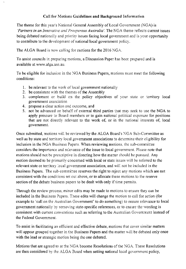


|
Ordinary Meeting of Council - 8 March 2016 |
GB.4 / 121 |
|
|
|
|
Item GB.4 |
DA0042/15 |
|
|
21 December 2015 |
development application
Summary Sheet
|
Report title: |
2 - 6 Womerah Street, Turramurra - Demolish existing structures, construct 18 town-houses including basement parking and lot consolidation |
|
ITEM/AGENDA NO: |
GB.4 |
|
Application No: |
DA0042/15 |
|
Property Details: |
2-6 Womerah Street, Turramurra Lot & DP No: Lots 2-4, DP390157 Site area (m2): 1246m2 Zoning: R3 Medium Density Residential |
|
Ward: |
|
|
Proposal/Purpose: |
Demolish existing structures, construct 18 town-houses, including basement parking and lot consolidation
|
|
Type of Consent: |
Integrated |
|
Applicant: |
Collard Maxwell Architects |
|
Owner: |
Turramurra Gardens Pty Ltd |
|
Date Lodged: |
14 February 2015 |
|
Recommendation: |
Approval |
Purpose of Report
To determine Development Application DA0042/15 for demolition of existing structures and construction of 18 townhouses, including basement parking and lot consolidation.
integrated planning and reporting
PLACES, SPACES & INFRASTRUCTURE
|
Community Strategic Plan Long Term Objective |
Delivery Program Term Achievement |
Operational Plan Task |
|
P2.1 A robust planning framework is in place to deliver quality design outcomes and maintain the identity and character of Ku-ring-gai
|
Applications are assessed in accordance with State and local plans
|
Assessments are of high quality, accurate and consider all relevant legislative requirements
|
Executive Summary
|
Issues: |
Front setback Solar access Storage |
|
Submissions: |
Yes – 9 submissions and 1 petition received |
|
Land and Environment Court: |
No |
|
Recommendation: |
Approval |
History
Site
The site has a history of low density residential use.
Pre-DA
5 June 2014 A Pre DA lodgement consultation for the proposed development was held on 5 June 2014. The proposal at this time was for 24 townhouses. Key issues raised during the meeting were as follows:
- impacts on Blue Gum High Forest
- permissibility
- SEPP 65 considerations
- compliance with DCP controls
With regard to compliance with DCP controls, concerns were raised in relation to pedestrian entries, building setbacks, building separation, vehicular access, bicycle parking, private open space, solar access, natural ventilation, dwelling depth/room sizes, adaptable dwellings, building façade, top storey design, visual privacy, riparian/biodiversity controls and development within a Heritage Conservation Area.
DA history
13 February 2015 The application was lodged with Council.
23 February 2015 The applicant was asked to submit a three dimensional model.
17 March 2015 The applicant was asked to provide a fee for Integrated Development (DPI Water).
22 May 2015 Following submission of the model, the application was notified to owners and residents of surrounding properties for a period of 30 days.
30 June 2015 A flora and fauna assessment report was submitted by the applicant.
14 July 2015 A response from DPI Water was received.
24 July 2015 A preliminary assessment letter was sent to the applicant. The preliminary assessment letter raised concerns relating to front setback, pedestrian entry, solar access, amenity, floor space ratio, storage, adaptable and visitable housing, aesthetics, tree impacts, tree removal, deep soil landscaping, setbacks to courtyards, landscape plan detail, environmental site management plan, stormwater management, car parking, traffic management and Construction Traffic management.
21 August 2015 The applicant was granted an extension of time to submit the required information.
3 September 2015 Additional information, comprising amended plans and reports, was submitted.
15 October 2015 A second preliminary assessment letter concerning matters not addressed by the amended plans was sent. These matters included: floor space ratio, solar access, adaptable housing, pedestrian pathways, deep soil, setbacks to courtyards and architectural and landscape plan details.
4 December 2015 Amended architectural, landscape and stormwater plans were received.
19 February 2016 Amended stormwater plans were received following concerns raised by Council’s Development Engineer and Landscape Officer.
The Site
Site description
The site:
|
Visual character study category: |
Pre 1920 |
|
Easements/rights of way: |
Yes – Easement to drain water across Lot 2 DP 390157 (No. 6 Womerah) |
|
Heritage Item: |
No |
|
Heritage conservation area: |
No - adjoins to Ku-ring-gai Avenue Conservation Area |
|
In the vicinity of a heritage item: |
Yes – Nos. 3, 5, 12, 23, 27, 29 Womerah Avenue |
|
Bush fire prone land: |
No |
|
Endangered species: |
Yes – part Blue Gum High Forest |
|
Urban bushland: |
No |
|
Contaminated land: |
No |
The site is a triangular shaped allotment located on the western side of Womerah Street, Turramurra (Figure 1). The site comprises three lots – Lot 4 DP 390157, Lot 3 DP 390157 and Lot 2 DP 390157. The site has a total area of 3342m2.
The site has a moderate slope, with a fall of approximately 8 metres from its north-eastern corner to its south-eastern corner.
Development on each of the existing allotments currently comprises the following:
· a single storey dwelling with associated swimming pool at No. 2 Womerah Avenue
· a two storey dwelling at No. 4 Womerah Avenue
· a single storey dwelling with associated swimming pool at No. 6 Womerah Avenue
The site is identified by Local Centres LEP as containing riparian land and land of biodiversity significance.
Surrounding development
The site is surrounded by residential development. To the west and south-west of the site are four to five storey residential flat buildings at Nos. 1219-1223 Pacific Highway, Nos. 1215-1217 Pacific Highway and No. 2B Womerah Street.
To the north of the site are single dwellings. Across the street and to the north are Heritage Conservation Areas.
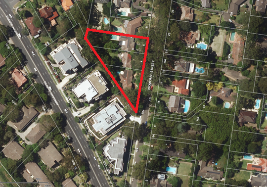
Figure 1: Subject site and surrounding properties
The Proposal
The application proposes demolition of three existing dwellings and associated structures and construction of a multi-unit development comprising 18 townhouses and basement carparking.
The proposal comprises two ‘buildings’ over a shared basement. Building A comprises dwellings 1-11 and is adjacent to the eastern site boundary. These dwellings are oriented towards Womerah Street. Building B comprises Dwellings 12-18 and is adjacent to the northern site boundary.
The proposed dwellings are as follows:
Dwelling 1: Three bedroom townhouse with study
Dwelling 2: Two bedroom townhouse with study
Dwelling 3: Three bedroom townhouse with study
Dwelling 4: Three bedroom townhouse with study
Dwelling 5: Three bedroom townhouse with study
Dwelling 6: Three bedroom townhouse with study
Dwelling 7: Three bedroom townhouse with study
Dwelling 8: Three bedroom townhouse
Dwelling 9: Three bedroom townhouse
Dwelling 10: Three bedroom townhouse
Dwelling 11: Three bedroom townhouse with study
Dwelling 12: Three bedroom townhouse with study
Dwelling 13: Three bedroom townhouse with study
Dwelling 14: Three bedroom townhouse with study
Dwelling 15: Three bedroom townhouse with study
Dwelling 16: Three bedroom townhouse with study
Dwelling 17: Three bedroom townhouse with study
Dwelling 18: Three bedroom townhouse with study
All townhouses are three storeys in height, except for Dwelling 1 which is two storeys in height.
Basement parking for 41 car spaces (including 5 visitor spaces) is proposed. The basement also accommodates resident storage, car wash bay, bin storage area, bicycle storage and a services room. Lift access is proposed from the basement to ground level.
Two adaptable dwellings are proposed (Dwellings 5 and 12).
Areas of communal open space are proposed to the west and south of the proposed dwellings.
The proposal also includes associated landscaping and stormwater works.
Amended plans and additional information received 3 September 2015
The following was submitted in response to concerns raised by Council officers:
· amended architectural plans showing deletion of Dwelling 19
· amended access report
· amended Statement of Heritage Impact
· amended Traffic Impact report
· amended stormwater plans
· amended landscape plans
· amended BASIX certificate
· amended Flora and Fauna impact assessment
· amended Statement of Environmental Effects
Amended plans and additional information received 4 December 2015
The following was submitted in response to concerns raised by Council officers not adequately addressed previously:
· amended architectural plans
· amended landscape plans
Additional information received 19 February 2016
An amended stormwater plan was received on 19 February 2016.
Consultation
Community
In accordance with Local Centres Development Control Plan, owners of surrounding properties were given notice of the application. In response, submissions from the following were received:
1. Y. Liu – No. 22/1215-1217 Pacific Highway, TURRAMURRA NSW 2074
2. Y. Benson – No .18/1215-1217 Pacific Highway, TURRAMURRA NSW 2074
3. N. Saville – No. 5/2B Womerah Street, TURRAMURRA NSW 2074
4. S. Riley – PO Box 36, TURRAMURRA NSW 2074
5. L. Lee – No. 17 Ku-ring-gai Avenue, TURRAMURRA NSW 2074
6. A. and W. Simmons – No. 16a Womerah Street, TURRAMURRA NSW 2074
7. Jensen Bowers on behalf of D. Haydon No. 13 Womerah Street, TURRAMURRA – No. 72 Costin Street, FORTITUDE VALLEY, QLD 4006
8. A. and D. Lukas – No.8 Womerah Street, TURRAMURRA NSW 2074
9. A. Manson – No. 2 Womerah Street, TURRAMURRA NSW 2074
A petition containing eight (8) signatures was also received from the residents of No. 1219-1223 Pacific Highway, Turramurra.
The submissions raised the following issues:
Loss of native flora and fauna
The submission raises concern with removal of a tree of high retention value Tree 60a Red Cedar. It also raises concern regarding removal of the following trees of moderate retention value: Tree 61 and Tree 62 Weeping Lillypillys, Tree 65 Jacaranda and Tree 82 Fiddlewood. Further, removal of Tree 58 Bottlebrush, of low retention value, is proposed. The submission states that these trees are utilised by native birds.
A Flora and Fauna Impact Assessment (prepared by Keystone Ecological, undated) was submitted with the application. The Impact Assessment does not identify the presence of any endangered fauna on site and concludes that the proposed development will not result in a significant impact upon the Blue Gum High Forest community on site.
Whilst the application proposes retention of a large number of trees, unfortunately not all vegetation on the site can be retained. In accordance with part 5a of the Environmental Planning and Assessment Act, priority has been given to retention of Blue Gum High Forest species, as well as trees of high retention value (Figure 2). Whilst Tree 60a has been identified as being of high retention value, its central location within the site makes it difficult to retain.
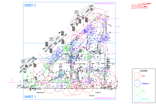
Figure 2: Tree retention values
Solar access to proposed townhouses
Solar access to the proposed townhouses has been assessed and is addressed in detail elsewhere in this report.
Solar access to No. 1219-1223 Pacific Highway
Amended solar access diagrams were submitted during the assessment of the Development Application. The amended diagrams indicate that the adjoining development at No. 1219-1223 Pacific Highway will be unaffected by the proposed development from 12pm to 3pm. The proposal therefore complies with Council’s solar access provisions contained within Local Centres Development Control Plan, section 6C.3 Solar Access, Control 5.
Noise during construction
The standard hours of work are between 7am to 5pm, Monday to Friday and 8am to 12pm Saturday. No work or deliveries are to take place on Sundays and public holidays. Excavation or removal of materials using materials is limited to between the hours of 7.30am and 5pm, Monday to Friday with a respite break of 45 minutes between 12pm and 1pm. (Condition 43)
These hours are consistent throughout Ku-ring-gai. It would be an unreasonable burden on the developer to restrict the hours further. It is also noted that further restrictions on construction hours would result in protracted construction times.
Accessibility
The submission raises concern regarding accessibility to the dwellings via the one shared lift.
An Accessibility report (prepared by Trevor R. Howse, dated 1 September 2015) was submitted with the Development Application. The report assesses the proposed development against Part D3 of the Building Code of Australia (BCA) 2015 and Australian Standard 4299-1995. The report indicates that the proposed lift is acceptable, though notes that further detail is required to be shown on the Construction Certificate plans.
A condition requiring compliance with the requirements of the Access report is recommended. Condition 1
Density in Turramurra; excessive traffic and overcrowding of Pacific Highway
The subject site was zoned for medium density development after extensive community consultation and strategic assessment. With any increase in density, an increase in traffic movement is to be expected. This was taken into consideration during the rezoning process.
An Assessment of Traffic and Parking Implications (prepared by Transport and Traffic Planning Associates, dated November 2014) was submitted with the Development Application. The report concludes that the traffic generation of the proposed development will not present any adverse traffic implications. Council’s Development Engineer has reviewed the Assessment and agrees with the findings of the report.
Loss of outlook (No. 17 Kuring-gai Avenue)
The subject site is heavily vegetated and provides a vegetated backdrop for adjoining properties. The dwelling at No. 17 Ku-ring-gai Avenue (also known as No. 12 Womerah Street) is located approximately 32 metres from the northern boundary of the subject site. The proposed dwellings are set back 8 metres from the northern side boundary. This results in a building separation of approximately 40 metres which is considered ample.
It is also noted that substantial landscaping is also proposed along the northern boundary to soften the impact of the proposed development on adjoining properties to the north and prevent overlooking impacts.
Loss of outlook (No. 1215/1217 Pacific Highway)
The subject site is heavily vegetated and provides a vegetated backdrop for adjoining properties. The site contains a large number of trees, including those forming part of the Blue Gum High Forest Endangered Ecological Community. Whilst some trees are proposed to be removed to facilitate the proposed development, a large number of canopy trees will be retained and will continue to provide a vegetated outlook to adjoining properties.
Whilst a dwelling was previously proposed within the westernmost corner of the site (Townhouse 19), it is noted that the application has been amended to delete this dwelling. This reduces the built form visible from No. 1215/1217 Pacific Highway and allows for the retention of additional vegetation.
Proximity to grand federation homes
Council’s Heritage Advisor has reviewed the proposed development and considers that the proposal will have minimal impact on the nearby heritage items and Heritage Conservation Area.
Traffic danger - request traffic calming in Womerah Street
Council’s Team Leader Traffic has reviewed the proposed development and has noted that, whilst there is no traffic count data available for Womerah Street, vehicles do not appear to be speeding along Womerah Street. The Team Leader does not consider speed humps to be warranted in this instance.
Request provision of ‘no parking’ signs along Womerah Street
A Construction Traffic Management Plan (CTMP) is required to be submitted to Council prior to issue of the Construction Certificate. Council’s Traffic Section will review the development and provide comments at that stage.
Safety concerns – intersection of Womerah Street
and Pacific Highway
A Traffic and Parking Assessment Report (prepared by Transport and Traffic
Planning Associates Pty Ltd dated 20 August 2015) was submitted with the
application. The Traffic Report states that
the projected increase in traffic activity is minimal and is not expected to significantly affect traffic flows in the
surrounding road network. Council’s Development Engineer has reviewed the
Report and agrees with its findings.
Sight lines from No.13 Womerah Street
No. 13 Womerah Street is a battle-axe allotment located opposite the southern end of the subject site. The site contains a turning bay and vehicles leaving the site would leave in a forward direction. Given that no changes to existing on-street parking are proposed in the subject application, it is considered that no changes with regard to sight lines will result.
Kerb and guttering
Several submissions have queried whether kerb and guttering is to be provided as part of the application.
Council’s Development Engineer has reviewed the proposed development and has recommended a condition requiring provision of a kerb from the existing wing of the southern side of No. 6 Womerah Avenue to the existing pipe culvert. Condition 80
Construction Traffic Management – worker parking during construction, planned movements of large construction vehicles
It is recommended that a condition be imposed requiring provision of a detailed Construction Traffic Management Plan (CTMP) to Council’s engineers prior to the commencement of any works on site. Condition 9
Privacy impacts to No. 17 Ku-ring-gai Avenue
The southern boundary of No. 17 Ku-ring-gai (also known as No. 12 Womerah Street) is located 18 metres from the northern boundary of the subject site. The proposed multi-dwelling development is three storeys in height. The courtyards and terraces of the dwellings are set back between 3 and 8 metres from the northern boundary. Substantial landscaping comprising shrubs and small trees is also proposed adjacent to the northern boundary.
Given the proposed setbacks and substantial landscaping, the proposed development will not result in any adverse privacy impacts to adjacent properties to the north.
Request provision of hedge along southern boundary of No. 17 Ku-ring-gai Avenue
The subject application relates to the subject site only. Council cannot require provision of landscaping on an adjacent property as a result of the subject application. Landscaping on adjacent properties can only be provided by adjacent property owners.
Request deletion of Building B
The subject site is zoned for medium density development. The proposal comfortably complies with Council’s floor space ratio requirements, as well building height requirements and side and rear setback requirements. Building B is appropriately set back from the northern boundary and will not result in any adverse privacy or bulk impacts to adjoining properties. As such, it would be unreasonable to require its deletion.
Impacts on Blue Gum High Forest species from excavation
A Flora and Fauna Impact Assessment was submitted with the Development Application. The assessment concludes that the proposed development will not result in a significant impact on the Blue Gum High Forest Community. Council’s Ecological Assessment Officer has reviewed the assessment and agrees with its recommendations.
Confusion due to house numbers
There is already a No. 2A and 2B Womerah Street. To avoid confusion, the submission requests that the development be known as No. 4-6 Womerah Street.
Whilst this is a reasonable request, it is not a matter of consideration during the development assessment process. This matter will be dealt with by Council’s Land Information team at the time of subdivision.
Incorrect calculation of floor space ratio
The submission states that the applicant has incorrectly used the Gross Leasable Areas calculation to calculate floor space ratio.
The applicant has submitted a floor space ratio calculation of 0.62:1. This calculation was checked and found to be accurate.
Loss of property values
This is not a valid consideration under section 79C of the Environmental Planning and Assessment Act.
Amended plans received 3 September 2015
The amended plans were not notified to surrounding residents as the proposed amendments do not result in a greater environmental impact than the original proposal.
Amended plans received 4 December 2015
The amended plans were not notified to surrounding residents as the proposed amendments do not result in a greater environmental impact than the original proposal.
Amended stormwater plan received 25 February 2016
The amended plans were not notified to surrounding residents as the proposed amendments do not result in a greater environmental impact than the original proposal.
Department of Primary Industries – Water
Under the provisions of section 91 of the Environmental Planning and Assessment Act 1979, the proposal is integrated development on the basis that it requires development consent from Ku-ring-gai Council as well as a Controlled Activity Approval under the Water Management Act 2000.
Department of Primary Industries reviewed the application and provided the following comments:
On the basis of the review of site investigation and design documents provided, DPI Water considers that the volume of groundwater to be extracted for excavation purposes or for any remediation of perched groundwater or deeper groundwater flows, and the duration of dewatering, are not likely to be significant in terms of resource management.
Therefore, an authorisation for the extraction of groundwater for the proposed activities is not considered to be warranted at this time, however we do require that certain Conditions of Approval be issued to the applicant so that the minor amount of dewatering to be undertaken is done in accordance with the NSW Aquifer Interference Policy.
Should the proposed excavation into the groundwater table result in the requirement for a significantly greater predicted inflow and subsequent dewatering volume, then DPI Water should be consulted as soon as possible, and an authorisation may need to be obtained for the activity.
The General Terms of Approval from the Department of Primary Industry are included as recommended conditions of consent. Conditions 88-90
Within Council
Urban design
Council's Urban Design Consultant has reviewed the application and provided the following comments:
PRINCIPLE 1: CONTEXT
Good design responds and contributes to its context. Context can be defined as the key natural and built features of an area. Responding to context involves identifying the desirable elements of a location’s current character or, in the case of precincts undergoing a transition, the desired future character as stated in planning and design policies. New buildings will thereby contribute to the quality and identity of the area.
The subject site provides a transition between a high density residential zone to the south and a low density residential zone to the north along Womerah Street.
The issue of providing a front entry path to Dwellings 3 through 11 has been resolved. Landscape ground floor plan (LP01 RevB) shows a ‘permeable pathway paving’ connecting from the ‘entry statement’ pathway to the front deck of Dwellings 3 through 11. This pathway is appropriately separated from the decks by planting which will provide some privacy to the kitchen area of these townhouses, particularly to those townhouses which sit lower than this pathway. This aspect is now considered acceptable. It is noted that the landscape ground floor plan (LP01 RevB) shows that there is ‘permeable pathway paving’ leading to Dwelling 1 proposed on Council land.
The issue of stairs within the northern courtyards of Dwellings 12 through 18 remains as described previously. The CM+A letter, dated 30 November 2015 (p2) states that these secondary exits and rear stairs are a ‘BCA requirement.’ This aspect should be referred to Council's certification section for comment. It would be preferable if the stairs to each of these townhouses were removed to discourage use of the northern setback as a thoroughfare, and to avoid the need for high fences for privacy on top of the already high retaining wall which will further increase the height of the courtyard wall and restrict outlook (DA302).
PRINCIPLE 2: SCALE
Good design provides an appropriate scale in terms of the bulk and height that suits the scale of the street and the surrounding buildings. Establishing an appropriate scale requires a considered response to the scale of existing development. In precincts undergoing a transition, proposed bulk and height needs to achieve the scale identified for the desired future character of the area.
Dwellings 1, 2, 6, 7, 8 and 9 are set back 9.4 metres from the front property boundary. This does not meet the 10 metres required by the controls. Whilst the articulation provided by the 600mm encroachment is considered a positive feature, ideally the entire composition should be set back a further 600mm to ensure the minimum primary street setbacks are met. This aspect should be addressed from an urban design perspective, however it is understood that this aspect has been found acceptable from a planning perspective.
The issue of setting back the third storey of Dwelling 11 has been resolved. The level 2 plan (DA103D) shows that the top floor of Dwelling 11 has been set back at its northern edge. This improves the relationship of the proposal to the low density residential zone to the immediate north (DA200C). This aspect is now considered acceptable.
PRINCIPLE 3: BUILT FORM
Good design achieves an appropriate built form for a site and the building’s purpose, in terms of building alignments, proportions, building type and the manipulation of building elements. Appropriate built form defines the public domain, contributes to the character of streetscapes and parks, including views and vistas, and provides internal amenity and outlook.
The issue of Dwellings 1, 2, 17 and 18 being oriented towards the boundary has been discussed previously. This aspect is considered acceptable from an urban design perspective.
The proposal provides 41 car parking spaces plus loading bay. This meets the 32 spaces required by the controls with 9 additional spaces. This aspect is considered acceptable.
The proposal provides 24 bicycle spaces. This meets the 6 spaces required by the controls with 18 additional spaces. This aspect is considered acceptable.
The issue of laundries to Dwellings 2, 8, 9, 10 and 11 remains as described previously. Each of these laundries do not appear to have adequate space to provide a dedicated laundry tub. This aspect should be referred to Council's building section for comment.
PRINCIPLE 4: DENSITY
Good design has a density appropriate for a site and its context, in terms of floor space yields (or number of units or residents). Appropriate densities are sustainable and consistent with the existing density in an area or, in precincts undergoing a transition, are consistent with the stated desired future density. Sustainable densities respond to the regional context, availability of infrastructure, public transport, community facilities and environmental quality.
The issue of floor space ratio remains as described previously. The proposed floor space ratio is stated as 0.62:1 (DA001C),.Whilst the proposal appears unlikely to exceed the maximum floor space ratio, this aspect should be verified.
PRINCIPLE 5: RESOURCE, ENERGY AND WATER EFFIENCY
Good design makes efficient use of natural resources, energy and water throughout its full life cycle, including construction. Sustainability is integral to the design process. Aspects include demolition of existing structures, recycling of materials, selection of appropriate and sustainable materials, adaptability and reuse of buildings, layouts and built form, passive solar design principles, efficient appliances and mechanical services, soil zones for vegetation and reuse of water.
The proposal is considered to be acceptable in terms of this principle.
PRINCIPLE 6: LANDSCAPE
Good design recognises that together, landscape and buildings, operate as an integrated and sustainable system, resulting in greater aesthetic quality and amenity for both occupants and the adjoining public domain. Landscape design builds on the site’s natural and cultural features in responsible and creative ways. It enhances the development’s natural environmental performance by co-ordinating water and soil management, solar access, micro-climate, tree canopy and habitat values. It contributes to the positive image and contextual fit of development through respect for streetscape and neighbourhood character, or desired future character. Landscape design should optimise usability, privacy and social opportunity, equitable access and respect for neighbour’s amenity, and provide for practical establishment and long term management.
The issue of private open spaces to Dwellings 1, 2, 17 and 18 being set back less than 3 metres from the south-western boundary has been discussed previously. This aspect is, however, considered acceptable from an urban design perspective.
The issue of outlook from living rooms to Dwellings 7 and 12 through 18 remains as described previously. If ‘green walls’ are to be relied upon to ameliorate this issue, they should be clearly documented on the landscape and architectural plans. This aspect should be referred to Council’s landscape section for comment. This aspect should be addressed.
PRINCIPLE 7: AMENITY
Good design provides amenity through the physical, spatial and environmental quality of a development. Optimising amenity requires appropriate room dimensions and shapes, access to sunlight, natural ventilation, visual and acoustic privacy, storage, indoor and outdoor space, efficient layouts and service areas, outlook and ease of access for all age groups and degrees of mobility.
The issue of solar access remains. The justification provided in the CM+A letter, dated 12 January 2016, (p1) appears to rely upon the RFDC Rule of Thumb (p85) that ’at least 70 percent of apartments in a development should receive a minimum of three hours direct sunlight between 9am and 3pm in midwinter.’ Further, the letter suggests that the RFDC Rule of Thumb (p85) ‘In dense urban areas a minimum of two hours may be acceptable’ is relevant. The area should not be considered a ‘dense urban area.’ Residential flat buildings are prohibited in the R3 zone. The proposal is for multi-dwelling housing and should be assessed as such. The control iin KLCDCP2013 Volume A Part 6C.3(2) which states ‘(All) Dwellings must receive a minimum of three hours direct sunlight to at least one living room and the primary private open space between 9am and 3pm on 21st June’ is also applicable.
The calculations provided in the CM+A letter, dated 12 January 2016, (p3) show that Dwellings 6, 7 and 8 do not achieve 3 hours solar access to living rooms. Also, Dwelling 1 is shown to receive solar access from 11.30, however the solar access diagrams show that solar access is not received until 13.00 (less than 2 hours). Therefore, only 14 of 18 (78%) townhouses receive 3 hours solar access to living rooms. This does not meet the 100% required by the controls and is not considered to meet the objective ‘to ensure a high level of internal amenity for occupants.’ This aspect should be addressed.
18 of 18 (100%) townhouses are naturally cross ventilated. This aspect is considered acceptable.
18 of 18 (100%) of kitchens are immediately adjacent to an operable window.
The second bedroom in Dwelling 1 is less than 3 metres wide. This does not meet the minimum of 3 metres required by the controls. This comprises the furnishability of functionality of these rooms. This aspect should be addressed.
The issue of storage remains as described previously. Storage within bedrooms cannot count towards the required storage. This aspect should be addressed.
PRINCIPLE 8: SAFETY AND SECURITY
Good design optimises safety and security, both internal to the development and for the public domain. This is achieved by maximising overlooking of public and communal spaces while maintaining internal privacy, avoiding dark and non-visible areas, maximising activity on streets, providing clear, safe access points, providing quality public spaces that cater for desired recreational uses, providing lighting appropriate to the location and desired activities, and clear definition between public and private spaces.
The issue of street address to Dwellings 3 through 11 has been resolved. A clear pathway has been provided connecting from the ‘entry statement’ to the front deck of these townhouses (see PRINCIPLE 1: CONTEXT). This aspect is now considered acceptable. The issue of street address to Dwellings 1, 2 and 12 through 18 remains as previously described. It is suggested that way finding signage be provided to assist with orientation.
PRINCIPLE 9: SOCIAL DIMENSIONS AND HOUSING AFFORDABILITY
Good designs respond to the social context and needs of the local community in terms of lifestyles, affordability, and access to social facilities. New developments should optimise the provision of housing to suit the social mix and needs in the neighbourhood or, in the case of precincts undergoing transition, provide for the desired future community. New developments should address housing affordability by optimising the provision of economic housing choices and providing a mix of housing types to cater for different budgets and housing needs.
The issue of accessibility to townhouses has been resolved. The adaption plans for Dwelling 5 (DA409G) and Dwelling 12 (DA410G) show that an accessible laundry can be accommodated within their respective dining rooms at their ground floors. This aspect is now considered acceptable.
The issue of the chairlift to negotiate floor levels appears to remain as previously described. This aspect should be referred to Council's building section for comment.
PRINCIPLE 10: AESTHETICS
Quality aesthetics require the appropriate composition of building elements, textures, materials and colours and reflect the use, internal design and structure of the development. Aesthetics should respond to the environment and context, particularly to desirable elements of the existing streetscape or, in precincts undergoing transition, contribute to the desired future character of the area.
All air conditioning units have been located on balconies and terraces. This does not meet the requirements of the controls. However in this instance, as the air conditioning units are located in secondary open spaces are not visible from the street, or from communal open spaces, this aspect could be acceptable. It is suggested that screening the air conditioning units may improve their appearance from within the dwelling. Townhouse 1 does not appear to have nominated air conditioning unit locations. These are air conditioning units should be located in the garden areas and screened with planting.
The issue of blank end facades has been partially addressed. The north elevation of Townhouse 11 has been improved through including a setback to the top floor (see Principle 2: Scale) and the inclusion of a second material treatment, however provision of windows to this elevation would further assist (Principle 7: Amenity).
The south elevation of Dwelling 1 does not appear to have been amended. This elevation is a blank masonry wall without articulation or openings and will be visible within the streetscape. It is suggested that a second material be introduced in a similar way to Dwelling 11, and that a window be introduced (Principle 7: Amenity). The applicant has previously states that ‘windows on the southern façade of Townhouse 1 and the northern façade of Dwelling 11 have been avoided for privacy and BCA reasons.’ This aspect should be referred to Council’s Building Unit for comment.
CONCLUSION
The sole remaining issue is the provision of solar access to all dwellings.
Other lesser issues include: removal of stairs to courtyards of townhouses 12 through 18; the primary street boundary setback; the provision of laundry tubs to townhouses 2, 8, 9, and 11 (to be verified); calculation of floor space ratio (to be verified); improvement of the outlook from the living rooms of townhouses 7 and 12 through 18 through the inclusion of green walls; the provision of bathroom windows to side elevations (to be verified); bedroom widths; storage volumes; consideration of way finding strategy; adaptable dwelling chairlift (to be verified); air conditioning unit location; and the treatment of blank end facades.
Planner’s comments: As discussed elsewhere in this report, the proposed front setback is considered acceptable from a planning perspective.
Floor space ratio has been calculated at 0.62:1 which comfortably complies with the maximum floor space ratio of 0.8:1 permitted by the KLEP.
The matter of laundry tubs was discussed with the applicant. The applicant was confident that the tubs could be accommodated within the floor plate of the proposed combined bathroom/laundry and agreed to accept a condition to this effect. It is noted that many of these bathrooms feature a large vanity which could be reduced in size in an amended floor plan. The condition is to be satisfied, through the provision of amended plans, prior to issue of the Construction Certificate. Condition 18
It is agreed that the courtyards to Dwellings 12-18 offer poor residential amenity. The courtyard stairs were discussed with Council’s Building Surveyor who advised that they were not required for BCA reasons. As such, they should be deleted. Deletion of the stairs, as well as several other changes to improve amenity to the courtyards are recommended via Condition 16. The amendments required by the condition include the following:
· deletion of the rear stairs and green walls; provision of a planter box which is easier to maintain
· amendments to the northern fire egress path to minimise usage and privacy impacts
· reduction in the height of the fence along the northern elevation of the courtyards to improve amenity, outlook and solar access
· reduction in the height of the courtyard walls between the dwellings to improve amenity
The provision of bathroom windows to side elevations (which the applicant has advised are fire walls) was discussed with Council’s Building Surveyor. Council’s Building Surveyor advised that BCA requirements preclude the provision of windows within firewalls. As such, it would not be reasonable to require provision of such windows.
With regard to bedroom width in Dwelling 1, it is agreed that the proposed bedroom 2 offers poor amenity. Bedroom 2 is undersized (2.95 metres in width) and does not contain a built-in-robe. Given that bedroom 3 of this dwelling is also undersized, it is recommended that a condition be imposed requiring the consolidation of bedrooms 2 and 3 so that Dwelling 1 becomes a two bedroom dwelling. Condition 16
In relation to storage, in excess of 12m3 of total storage space is proposed for each dwelling. Each dwelling benefits from a storage area within the basement (minimum area 7.5m3) as well as between 4m3 and 6m3 of internal storage. Internal storage areas are located under the stairs or within study nooks or study/media rooms. The use of media/study rooms for storage is consistent with Section 6C.12 which states that “storage spaces within dwellings can be in the form of cupboards in halls, living rooms, laundries, flexible spaces (which can be used as studios/media rooms etc.)” Storage areas within bedrooms have not been included.
Whilst the breakdown between internal and external storage is non-compliant for 16 out of 18 of dwellings, it is noted that the overall storage area proposed exceeds Council’s minimum requirements for all dwellings bar Dwelling 1. As aforementioned, a condition is recommended requiring internal design changes to Dwelling 1 to improve amenity. Condition 16 As a two bedroom dwelling, Dwelling 1 will comply with the minimum requirements.
To reduce the visual impact of the air conditioning units, a condition is recommended concerning the provision of metal louvre enclosures to all air conditioning units located on balconies. This will improve amenity by reducing the visual impact of such structures. The air conditioning unit to Dwelling 1 is to be located within the garden and screened with vegetation. Condition 17
With regarding to the chair lifts in the adaptable dwellings, it is noted that an Access Report (prepared by Trevor R Howse, dated 1 September 2015) was submitted with the application. The Access Report addresses the proposed chair lifts and states that an alternative building solution will be required to demonstrate that the proposed use of an internal stairway lift satisfies the requirements of AS 4299 – 1995. It is also noted that Council’s Building Surveyor has reviewed the proposed development and has raised no objections.
As recommended by Council’s Urban Design Consultant, a condition requiring a way-finding strategy to be submitted to the Principal Certifying Authority prior to issue of the Construction Certificate is recommended. Condition 38
The issue of solar access is discussed under the considerations of the proposal against the solar access controls of the Local Centres and DCP below.
Engineering
Council's Development Engineer commented on the amended proposal as follows:
The following documents were used for the assessment:
· Statement of Environmental Effects prepared by Glendinning Minto & Associates Pty Ltd dated September 2015;
· Stormwater Management Plans DA-STW-01-16 issues ‘E’ prepared by LP Consulting Australia Ltd dated 25 August 2015;
· BASIX Certificate 658340M prepared by Collard Maxwell Architects Pty Ltd dated 31 August 2015;
· Site Survey Plan prepared by SDG and Development Solutions dated 5 December 2013;
· Architectural Plans drawings issue ‘B’ and ‘C’ prepared by CM+A Architects dated 20 August 2015;
· Landscape Plan prepared by Site design & studio dated 27 August 2015;
· Traffic and Parking Assessment Report Ref: 14110 prepared by Transport and Traffic Planning Associates Pty Ltd dated November 2014 and 20 August 2015;
· Accessibility Report prepared by Trevor R Howse dated 23 August 2015; and
· Geotechnical Investigation prepared by Asset Geotechnical Engineering Pty Ltd Ref: 2616-R1 dated 10 October 2014.
Stormwater disposal
The subject site has sufficient fall towards the street to allow collected stormwater to be directed to the street kerb inlet drainage system via an on-site detention tank.
There exists a 1.525 metres wide drainage easement containing a 375mm diameter pipe along the south western boundary which is also identified as a Category 3(a) Riparian Zone. A flood analysis using DRAINS model was conducted on the existing drainage easement and 375mm pipe in relation to unit’s 15-18 basement floor levels. The design engineer has proposed a 300mm freeboard incorporated into the planter wall to prevent from those townhouses being subject to inundation. The design also shows the overland flow to be contained within the relocated easement.
A design and longitudinal section of the new easement and relocated pipe to be created around the proposed building has been submitted. A deferred commencement condition would be recommended, that the applicant be required to obtain the consent of the beneficiaries to H91186 to extinguish the easement as the Schedule A condition.
If approval were to be granted for the development, CCTV inspection of the Council pipe that runs along the southern boundary would be required before and after the building works. This is in the interest of all parties so that any existing damage or deficiencies can be identified.
The stormwater design shows the collection of roof water and surface runoff to be conveyed to a 78m3 belowground detention tank located under the driveway ramp. The overflow from the detention facility is to be directed to the existing 525mm diameter pipe within the front southern corner of the site.
Accompanying the stormwater plan is a design report prepared by LP Consulting Australia, which demonstrates the 50% reduction in runoff days required under Volume C Part 4B.3 of the DCP has been satisfied. A revised BASIX Certificate has been submitted, with the water commitments requiring a central water tank (rainwater or stormwater) of 50,000 litres. The tank is also to be configured to collect runoff from at least 660 square metres of roof area.
A pump-out system with storage capacity of 6.1m3 has been provided within the basement carpark to drain the basement subsoil drainage and driveway area with the rising main directed to the OSD tank. The pump-out tank has been sized in accordance with AS3500.3:2003 and the Local Centres DCP requirements.
A water quality model (MUSIC Modelling) has been submitted to investigate stormwater runoff quality from the subject site. The stormwater treatment standards / targets outlined in Council’s Local Centres DCP Volume C Clause 4B.6 would be achieved.
The Stormwater Management Plans DA-STW-01-16 issues ‘E’ prepared by LP Consulting Australia Ltd dated 25 August 2015 is acceptable.
Traffic generation
According to the traffic generation rates nominated by The Roads & Maritime Services (RMS) ‘Guide to Traffic Generating Developments’, the development would generate approximately 9 peak hour vehicle trips which would represent one vehicle trip every 7 minutes during the peak hour. According to the above guidelines the vehicle trips is considered to be very low traffic generation. The increase in traffic flows in Womerah Street is not expected to have a significant effect on traffic flows or on the operation of the intersection with the arterial road network.
Vehicular access and accommodation arrangements
The site is zoned ‘R3’ under the Local Centres LEP. The parking provisions have been determined using Ku-ring-gai Council Local Centres Development Control Plan for multi-dwelling housing. The site is located greater than 400m walking distance from the Turramurra Railway Station. The following parking provisions have been adopted:
Ku-ring-gai Council Local Centres DCP Volume C Clause 2R.2 ‘Car Parking Rates’
|
Multi-Dwelling Housing |
Parking Space Requirement |
|
1 bedroom unit |
1 space per unit |
|
2 bedroom unit |
1.25 space per unit |
|
3 bedroom unit |
1.5 spaces per unit |
|
Visitor car spaces |
1 space per 4 units |
1 x 2 bedrooms = 1 x 1.25 spaces/unit = 1.25 spaces
17 x 3 bedrooms = 17 x 1.5 spaces/unit = 26 spaces
18 dwellings - visitor space/4 dwellings = 5 visitor spaces
Total parking spaces required = 33 spaces
The development provides 41 off-street parking spaces, including 2 adaptable spaces and 5 visitor spaces. The required parking has been assessed under a different car parking rate as specified by the applicant. Nevertheless, the car parking requirements have been satisfied.
Vehicle access to the car parking facility is to be provided via a single width driveway of 3.7 metres wide for entry / exit. The proposed location is similar to the existing driveways along Womerah Street where adequate sight distances are available. The driveway clear width satisfied the requirements of Volume C Clause 2.2 of the DCP. The use of the single lane driveway and ramp is also compliant with Clause 3.2.2 of AS2890.1:2004 given that the traffic flows will be in the order of 9 peak hour vehicle movements which are acceptable for a two-way access driveway.
A temporary service /car wash space has been provided which doubles up as garbage collection area. The bay satisfies the minimum dimension of 3.5m x 6m.
The adaptable parking spaces are to comply with the requirements specified within the access consultant’s report with reference to the relevant Australian Standards specified. Space 18 shows the shared zone to be 1.4 metres wide.
The driveway gradients comply with Australian Standard 2890.1 (2004) “Off-Street car parking” as do the dimensions of the parking bay, ramp grades and aisle widths.
Waste collection
The development allows a garbage truck to enter and depart the garbage/room recycle storage area in a forward direction. The driveway grades and turning manoeuvrability are suitable for the small waste collection vehicle as shown by the swept paths within the Appendix of the Traffic Report.
A clear head height of greater than 2.6 metres as shown on the Section plan has been provided to access the basement area and also provided over the travel path of the waste service vehicle.
The proposed 24x240L bins for waste, paper and recycling satisfies the minimum bin requirements.
The requirements as per Volume C Part 3.4 of the Local Centres DCP have been satisfied.
Construction management
Based on the scale of works and expected construction vehicle movements, a detailed construction traffic management plan (CTMP) is conditioned and must be submitted for review by Council Engineers prior to the commencement of any works on site.
The CTMP should include truck routes to and from the site in all directions, and turning paths for a heavy rigid vehicle to identify any need for construction stage parking restrictions opposite. Trucks will not be permitted to travel further north in Womerah Street, so a route must be identified for travel to the site from the south and away from the site to the north. Left in from Pacific Highway and left-out onto Pacific Highway is recommended.
Impacts on Council infrastructure
It is conditioned that detailed design drawings for a new 1.2m wide concrete footpath be provided along the entire site frontage. The design is also to show an asphalt kerb from the existing wing of the southern side driveway of No. 6 Womerah to the existing pipe culvert. Detail to include cross section from the centreline of the road to the kerb demonstrating a 3% crossfall to the road shoulder. All existing driveway crossings are to be made redundant and reinstated to kerb and gutter.
Drawings are to be submitted and assessed by Council’s Operations Department for approval under the Roads Act.
Geotechnical investigation
The preliminary investigation was undertaken based on four borehole testing. The results identified subsurface conditions comprising thin silty topsoil over silty clays then merge into residual silty clays then weathered shale bedrock at moderate depths in the range of 3.6 metres and 10.25 metres. The report suggests that groundwater was encountered at depth of 2.7 metres with the proposed depths of basement excavation being greater than 3 metres.
The Development Application has been referred to the NSW Office of Water for comment and they have advised licencing of the extraction of groundwater for the proposed activities is not considered to be warranted. However, General Terms of Approval for construction dewatering have been provided.
A dilapidation report is to be submitted to include a survey of the adjoining dwelling at No. 8 Womerah St, Turramurra. Condition 8
All other recommendations during the construction phase shall be carried out as specified within the report. It is also recommended that further geotechnical input be required in particular to groundwater monitoring.
Response to submissions
Submissions have been received which raise traffic and construction traffic as issues.
The site has been zoned for this type of development. Any improvements required as a result of the zoning would be identified in the contributions plan, so there is no scope to require individual developments to carry out works or indeed to refuse such developments on traffic grounds.
Parking rates are specified in Council’s planning controls so that adequate space is provided for residents and visitors within these developments and parking does not spill over into the surrounding streets. The off-street parking provided is more than required under Council’s car parking rates.
It is also of note that matters such as traffic movement would be expected given this type of development. The traffic report does justify that the projected increase in traffic activity is minimal and is not expected to significantly affect traffic flows in the surrounding road network.
Commuter parking in this area is an existing situation. Matters raised such as parking restrictions, traffic calming devices and extending the ‘no parking’ hours, limiting parking to one side of the street etc. no-parking signs from the corner of Womerah Street and the Pacific Highway could be referred to Traffic Section.
Council’s Team Leader Traffic has provided the following comments:
Womerah Street is a residential street that runs between Ku-ring-gai Avenue/Turuga Street and Pacific Highway. Several changes were made by Council in the recent years to kerbside parking arrangements. Council has no records of any traffic speeding issues in Womerah Street, but the issues with long-term parking were resolved by introducing 4 Hour parking restrictions. There is no traffic count data available for Womerah Street, but vehicles do not appear to be speeding along this street. Council’s Traffic and Transport Policy does not allow any speed humps in Ku-ring-gai, except outside schools and bus terminus, but the street is not wide enough to consider further traffic calming measures if warranted.
Construction related vehicles will utilise the existing 4 hour parking restrictions. This will create congestion along Womerah Street as both sides of the street could be parked out during day-time. At the moment, the existing 4-Hour parking restrictions discourage commuters from parking in the street. Further consideration may be given to restricting parking in Womerah Street during the construction period i.e. temporary kerbside parking restrictions from the boundary of No. 6 and 9 to Ku-ring-gai Avenue.
Allowing vehicles parking on both sides of the road is a kind of traffic calming treatment. Motorists are using the existing driveways as passing bays when negotiating vehicles on the opposite side. There have been no complaints about it so far.
The existing 4 hour parking restrictions are the result of extensive resident consultation. If the 4 hour limit is removed from one side then commuters will start parking in the street all day. This will have a great impact on Womerah Street residents.
Planner’s comments: Conditions have been recommended to address the aforementioned engineering matters. Conditions 6, 8- 12, 21, 31-32, 34, 46 -47 , 53, 57, 67 , 73-81 and 86
Landscaping
Council's Landscape Assessment Officer commented on the proposal as follows:
Impacts on significant existing trees –Clause 5.9, KLEP; Cl 1.3 Volume C Ku-ring-gai Local Centres DCP
An Arboricultural Assessment’ prepared by Earthscape Horticultural Services and dated January 2015, has been submitted with the application. Tree numbers refer to this report.
Tree removal
The application proposes the removal of 38 trees of moderate to low retention value and the following tree of high retention value.
Tree 60a/ Toona ciliata (Red Cedar) This tree is located on the south western boundary. The proposed basement will result in a major encroachment within the tree protection zone. There is no landscape objection to the removal of this tree.
Planner’s comment: Whilst Tree 60a is of high landscape significance, its central location on the site makes it difficult to retain. As a large number of canopy trees of high significance are proposed to be retained, no objection is raised to the removal of this tree.
Street trees to be removed
Tree 21/ Jacaranda mimosifolia (Jacaranda) This tree has been pruned heavily for overhead wires and is largely supporting epicormic growth. There is no landscape objection to the removal of this tree.
Tree 23/ Jacaranda mimosifolia (Jacaranda) This tree has been pruned heavily for overhead wires and is largely supporting epicormic growth. There is no landscape objection to the removal of this tree.
Trees to be retained
Tree 1/ Melaleuca styphelioides (Prickly Paperbark) This tree is located on the northern boundary of the site and provides screening amenity. The proposed path is beyond an existing retaining wall. The elevated entry path is to be replaced with a path laid above grade. Canopy pruning is required for building clearance. The level of impact is considered acceptable.
Tree 2/ Camellia sasanqua (Chinese Camellia) This tree is located on the northern boundary of the site and provides screening amenity. The proposed path is beyond an existing retaining wall. The elevated entry path is to be replaced with a path laid above grade. The level of impact is considered acceptable.
Tree 8/ Camellia sasanqua (Chinese Camellia) This tree is located within the front setback of the site. The level of impact is considered acceptable.
Tree 10/ Jacaranda mimosifolia (Jacaranda) Tree 57/ This tree is located on the front boundary. The proposed path is located within the structural root zone. The path is to be constructed 1-200mm above grade. Retaining walls to sides of path are to be replaced with edging if required. The grated drain to the proposed path at the front boundary and associated pipes are to be deleted. The proposed 1.5 metres width path along the nature strip conflicts within this tree and should be deleted (this is conditioned). The level of impact is considered acceptable.
Tree 11/ Eucalyptus saligna (Sydney Blue Gum) This tree is located on the front boundary. The proposed path is located within the structural root zone. The path is to be constructed 1-200mm above grade. Retaining walls to sides of path are to be replaced with edging if required. The grated drain to the proposed path at the front boundary and associated pipes are to be deleted. The proposed path to the kerb is to be deleted. The proposed 1.5 metres width path along the nature strip conflicts within this tree and should be deleted (this is conditioned). The level of impact is considered acceptable.
Tree 29/ Eucalyptus saligna (Sydney Blue Gum) This tree is located at the south eastern corner of the site. The proposed encroachment for the basement and driveway is less than 10% of the tree protection zone. The proposed trenching for the 150mm pipe is located within the tree protection zone. Non-destructive excavation methods are to be adopted for services (10.8.3, Arboricultural Assessment, Earthscape Horticultural Services, January 2015). The level of impact is considered acceptable.
Tree 37/ Podocarpus elatus (Brown Pine) This tree is located on the south- western boundary of the site. To be pruned for access path. The level of impact is considered acceptable.
Tree 38/ Podocarpus elatus (Brown Pine) This tree is located on the south-western boundary of the site. To be pruned for access path. The level of impact is considered acceptable.
Tree 59/ Eucalyptus saligna (Sydney Blue Gum) This tree is located on the south-western boundary of the site. The proposed basement is outside of the tree protection zone. The filling for the proposed private courtyards and barbeque area will not result in a major encroachment within the tree protection zone. Existing levels are to be retained within the remaining tree protection zone within the communal open space (this is conditioned). The level of impact is considered acceptable.
Tree 60/ Jacaranda mimosifolia (Jacaranda) Tree 57/ This tree is located on the southwest boundary of the site. The proposed encroachment is less than 10% of the tree protection zone. The level of impact is considered acceptable.
Tree 66/ Eucalyptus saligna (Sydney Blue Gum) This tree is located on the south-western boundary of the site, within the adjoining property. The proposed encroachment is less than 10% of the tree protection zone. The level of impact is considered acceptable.
Tree 69/ Eucalyptus saligna (Sydney Blue Gum) This tree is located on the western boundary of the site. The proposed encroachment is less than 10% of the tree protection zone. The level of impact is considered acceptable.
Tree 70/ Eucalyptus saligna (Sydney Blue Gum) This tree is located on the western boundary of the site, within the adjoining property. The proposed encroachment is less than 10% of the tree protection zone. The level of impact is considered acceptable.
Street trees to be retained
Tree 4/ Eucalyptus saligna (Sydney Blue Gum) This tree is located at the north-eastern corner of the site within the nature strip. The proposed path is located within the structural root zone, however it is within the existing driveway and is proposed to be at existing grade. The level of impact is considered acceptable.
Tree 5/ Eucalyptus saligna (Sydney Blue Gum) This tree is located on the nature strip. The proposed basement excavation will result in an encroachment of less than 10% within the tree protection zone. The proposed 1.5 metres wide path along the nature strip conflicts within this tree and should be reduced in width (this is conditioned). The level of impact is considered acceptable.
Tree 9/ Eucalyptus pilularis (Blackbutt) This tree is located on the nature strip. The proposed encroachment is less than 10% of the tree protection zone. The level of impact is considered acceptable.
Tree 12/ Eucalyptus saligna (Sydney Blue Gum) This tree is located on the nature strip. The proposed encroachment is less than 10% of the tree protection zone. The level of impact is considered acceptable.
Tree 13/ Eucalyptus saligna (Sydney Blue Gum) This tree is located on the nature strip. The proposed encroachment is less than 10% of the tree protection zone. The level of impact is considered acceptable.
Tree 17/ Eucalyptus saligna (Sydney Blue Gum) This tree is located on the nature strip. The proposed encroachment is less than 10% of the tree protection zone. The level of impact is considered acceptable.
Tree 18/ Jacaranda mimosifolia (Jacaranda) Tree 57/ This tree is located on the nature strip. The proposed encroachment is less than 10% of the tree protection zone. The level of impact is considered acceptable.
Tree 25/ Jacaranda mimosifolia (Jacaranda) Tree 57/ This tree is located on the nature strip. The proposed encroachment is less than 10% of the tree protection zone. The level of impact is considered acceptable.
Tree 26/ Jacaranda mimosifolia (Jacaranda) Tree 57/ This tree is located on the nature strip. The proposed trenching for the stormwater line is located outsidethe tree protection zone.
Deep soil landscaping –Cl 6A.5 Volume A Ku-ring-gai Local Centres DCP
The minimum deep soil landscaping requirement for the proposal development is 40% of the site area.
The applicant claims that a deep soil area of 42% is provided but this is not concurred with as the following areas have been erroneously included as deep soil area:
Areas to be excluded –
· areas of paving greater than 1.2m in width –central paved BBQ area (21.2m2)
· all structures – area over basement (104.04m2), retaining walls to side entry path along northern boundary, retaining walls to private courtyards of Units 1, 2 (2.5m2)
· area of deep soil less than 2 metres in width between southern site boundary and retaining wall to private courtyard of Unit 1 and (9.9m2)
· between retaining wall to northern entry path and wall of private courtyards
Excluding the above areas will result in a non-compliance with the deep soil requirement (36.49% or 1220m2).
To provide sufficient deep soil to boundaries and preserve existing trees and neighbour amenity, certain modifications are required Condition 16.
Tree replenishment - Cl 6A.5 Volume A Ku-ring-gai Local Centres DCP
The site should support a minimum 12 trees that can attain 13 metres in height. The proposal provides in excess of this number of trees.
Communal Open Space– Cl 6C.1 Volume A Ku-ring-gai Local Centres DCP
The proposal does not include more than 10 dwellings that are not facing the street and therefore does not require communal open space in accordance with the controls. However a communal open space has been provided at the centre of the site.
Private Open Space– Cl 6C.2 Volume A Ku-ring-gai Local Centres DCP
To ensure sufficient space for deep soil planting within the adjoining common areas, the proposed private open space at ground floor are to be consistent with the controls as follows:
· Ground floor private courtyards should provide a minimum 8m setback to the street boundary, 3 metres from a side boundary and 4 metres from the rear boundary.
The proposal is non-compliant with these controls as follows:
· Dwellings 3-11 have a 6.6 metres setback from the front boundary (8metres setback required)
· Dwellings1, 2 and 17 have less than the required 3 metres setback to the southern boundary.
· Dwelling 18 has less than the required 3 metres setback to the southern and northern boundary.
As the proposal does not comply with the minimum deep soil requirement, the proposed encroachments are to be amended by Condition 16.
Screen planting –Cl 1.3 Volume C Ku-ring-gai Local Centres DCP
Northern boundary – Eleaocarpus reticulatus (Blueberry Ash) 6m, Kunzea ambigua 3m. A 7 metres length of the northern boundary to Dwelling 18 is void of screen planting due to the proposed access path. The private courtyard setback is to be reduced to ensure sufficient width for boundary screen planting Condition 16
South-western boundary – Existing screen planting are to be retained where possible. Proposed additional shrub planting up to 3 metres is located along boundary.
Western boundary – Existing screen planting of Pittosporum undulatum and Waterhousea floribunda is to be retained. Proposed additional canopy tree planting of is located along boundary. The proximity of several of these trees to existing mature canopy trees will restrict their establishment and long term viability and they are to be deleted .Condition 16.
Landscape plan
Insufficient information have been provided on the landscape plan regarding the proposed ‘green walls’ and upper terrace ‘plant screening’ to Dwellings 12 -18. Screen planting to upper terraces is to be achieved by proposed boundary planting. These proposed landscape treatments have not been included in the BASIX Certificate calculation of area of garden and lawn for individual dwellings. It is therefore recommended that they are to be deleted where indicated on the architectural plans. Condition 16
The landscape plan is considered satisfactory subject to amendments that are be conditioned. Refer below.
BASIX
The BASIX certificate has required 204m2 common area landscape that is to be indigenous/low water use species. An area of indigenous/low water use species within common area garden has been provided south of Dwelling 1 at the south-eastern corner of the site. The landscape plan is to be amended to add notation identifying area nominated (204m2) as indigenous/low water use species Condition 20.
The BASIX certificate landscape areas for individual dwellings are consistent with the landscape plan.
Stormwater plan
A rainwater tank is indicated within the central area of deep soil on the stormwater plans and architectural plans.
The stormwater plan is to be amended by Condition 21 as follows:
· The proposed grated drains at the end of the three front footpaths and associated pipes are likely to have adverse impacts on existing trees and are to be deleted and replaced with rainscaping.
Environmental site management plan
Location of site buildings, temporary access and material handling areas have been shown located outside of the tree protection zone of existing trees in accordance with recommendations in the Tree Protection Plan (Appendix 6, Arboricultural Assessment, Earthscape Horticultural Services, January 2015).
Conclusion
The proposal is acceptable, subject to conditions.
Ecology
Council's Ecological Assessment Officer commented on the proposal as follows:
During the site inspection the vegetation was inspected to determine the presence/ absence of native plant communities. The vegetation onsite was determined to be representative of Blue Gum High Forest (BGHF) listed as a Critically Endangered Ecological Community (CEEC) under the Threatened Species Conservation Act 1995. Native ground covers were sparse to absent due to past clearing and the establishment of landscape gardens.
Ecological constraints/environmental controls
The native vegetation within the site has been mapped as “biodiversity significance” category 2 support for core (a) under the KLEP 2013.
Ecological impacts
A detailed flora and fauna investigation and assessment of the proposal upon threatened species, endangered ecological communities and endangered populations has been prepared by Keystone.
An impact assessment (7-part test) has been provided in accordance with section 5a of the Environmental Planning & Assessment Act 1979 to assess the impacts of the proposal upon the BGHF community. The impact assessment conclusion that the proposed development will not result in a significant impact upon the BGHF community is supported. The concerns raised by the Landscape Assessment Officer with regard to BGHF canopy trees have been adequately addressed, ensuring that all BGHF canopy trees are not detrimentally affected.
Conclusion
The application is acceptable on ecological grounds.
Heritage
Council's Heritage Advisor commented on the proposal as follows:
The site does not contain a heritage item and does not adjoin a heritage item.
However the site is in the vicinity of a number of heritage items listed in Schedule 5 of the Ku-ring-gai Local Centres LEP 2012 and the Ku-ring-gai LEP 2015.
Ku-ring-gai Local Centres LEP 2012 Heritage Listings include:
· 1 Ku-ring-gai Avenue,
· 17 Ku-ring-gai Avenue,
· Ku-ring-gai Avenue Conservation Area (C6B)
Ku-ring-gai LEP 2015 Heritage Listings include:
• Nos. 3, 5, 23, 27 & 29 Womerah Street; and
· Ku-ring-gai Avenue Conservation Area (C6A)
The area contains a high proportion of individual heritage items (both local and State) , particularly along the Pacific Highway and Ku-ring-gai Avenue.
The site directly adjoins a HCA – Area C 6A. The HCA precinct includes both sides of Womerah Street (including the road reserve and street trees) and a small part of Turuga Street and the remaining eastern side of Ku-ring-gai Avenue and part of Boomerang Street. The Womerah Street boundary of the subject site is the western boundary of the HCA.
The site partially adjoins a Heritage Conservation Area (HCA) – Area C6B which includes Ku-ring-gai Avenue, from the Pacific Highway including a small portion of the Pacific Highway to the junction with Turuga Street. The part of the west side is listed in the Local Centres LEP. The site is subject to the Local Centres DCP.
Clause 5.10 of the Local Centres LEP requires that before granting consent to the proposed works, Council must consider the effect of the works on the heritage item, nearby items or conservation area concerned.
The following is the statement of significance for Area C 6A:
The Ku-ring-gai Avenue HCA is of historic, aesthetic, social and technological significance as one of the most prestigious Federation period streets in Sydney and potentially NSW. Ku-ring-gai Avenue derives its fine aesthetic qualities from its collection of grand Federations period residences set in generous and well-proportioned garden settings which blend into the mature Brush Box street planting. Many on these residences were designed by prominent Sydney architects, including Thomas Cosh, Arthur Stanton Cook, G M Pitt, Robertson Marks and Sir John Sulman.
The Avenue is also of historical and social significance for tis association with the important artist Grace Cossington Smith, whose works were inspired by her home and its setting; and for its association with prestigious and influential early twentieth architects, including Charles Slayter, Thomas Cosh, John Spencer Stansfield, Sir John Sulman and Arthur Stanton Cook.
The following is the statement of significance for Area C 6B:
Historical significance:
Ku-ring-gai Avenue HCA is of historical significance as one of the most prestigious Federation-period streets in the Sydney metropolitan area, which evidences the lifestyles of Sydney society’s elite in the period for 1890s to the 1920s.
Proposed development
The site is triangular in shape and the proposed building layout follows the Womerah Street frontage and the northern boundary of the site, leaving the south western part of the site as open space.
The architectural style is contemporary. The Womerah Street elevation will have horizontal banding and vertical glazing within a concrete frame and low pitched sloping roofs. The glazing has been divided into vertical proportions which will complement the surrounding HCA.
The proposed materials will be varied and include brickwork cladding, glass louvre windows, glass balustrades, painted and rendered walls - smooth and textured, timber louvres and a steel colorbond roof.
The proposed colour scheme includes light colours which are not sympathetic with the surrounding conservation area. The colour scheme should reflect the surrounding building colours in the nearby conservation area which are predominantly dark recessive colours. The ground and first floor should be finished in dark colours to appear recessive and the top floor should be a mid-tone range as it is already set back.
The courtyards facing the common open space and courtyards on the northern side should have colour finishes to match the front elevations with dark recessive colours.
The proposed form of the building will step back at the top floor level. There is little variation in street setbacks with a small separation between Dwellings 7 and 8. The separation between Dwellings 7 and 8 should be increased.
Views to the south of the heritage item at No .17 Ku-ring-gai Avenue will be restricted because of the established vegetation to the south. The dwelling is orientated to the north with its primary views to the front of the property.
The curtilages associated with the heritage items are lot boundary curtilages. The proposed development does not impinge on the associated curtilages. This ensures the retention of significance of the heritage items and their settings.
The proposed development will have a large physical separation from the nearby heritage items and the established vegetation within the area will contribute to the buffers between the heritage items by screening views to the site. The overall development steps down, following the topography of the Womerah Street landscape and is set back from the street boundary.
The front fence facing Womerah Street should be a 1.2 metres, simple timber picket fence with timber posts to be sympathetic with the streetscape and provide some privacy.
The established landscape character of the streetscape will be maintained. The development will be set back from Womerah Street with a driveway entry and two path entries. There will be some additional planting that will create a buffer between the town houses which is acceptable.
Conclusion and recommendations
The proposed development will have minimal impact on the surrounding heritage items and conservation areas and is acceptable on heritage grounds, subject conditions requiring archival recording of buildings to be demolished (Condition 7) and minor design amendments referred to above (Condition 19)
•
Building
Council's Building Officer has reviewed the proposed development and considers it satisfactory, subject to Conditions 42 and 84.
Statutory Provisions
State Environmental Planning Policies
State Environmental Planning Policy No. 55 - Remediation of Land
The provisions of SEPP 55 require Council to consider the potential for a site to be contaminated. The subject site has a history of residential use and as such, it is unlikely to contain any contamination and further investigation is not warranted in this case.
Sydney Regional Environmental Plan No. 20 - Hawkesbury-Nepean River
SREP 20 applies to land within the catchment of the Hawkesbury Nepean River. The general aim of the plan is to ensure that development and future land uses within the catchment are considered in a regional context. The Plan includes strategies for the assessment of development in relation to water quality and quantity, scenic quality, aquaculture, recreation and tourism.
The proposed development is considered to achieve the relevant aims under this policy.
State Environmental Planning Policy (Building Sustainability Index: BASIX) 2004
A valid BASIX certificate has been submitted. The certificate demonstrates compliance with the provisions of the SEPP and adequately reflects all amendments to the application.
State Environmental Planning Policy No. 65 – Design Quality of Residential Apartment Development
SEPP 65 aims to improve the design quality of residential flat buildings across NSW and provides an assessment framework, the Residential Flat Design Code (RFDC), for assessing ‘good design’.
Clause 50(1A) of the EPA Regulation 2000 requires the submission of a design verification statement from the building designer at lodgement of the development application. A design verification statement has been submitted by Charles Fortin Registration Number 8208) who is an architect at Collard Maxwell Architects which submits the application has been designed in accordance with the design quality principles under Part 2 of SEPP 65.
The SEPP requires the assessment of any development application for residential flat development against 10 principles contained in Clauses 9-18, which was undertaken by Council’s Urban Design Consultant and consideration of the matters contained in the publication “Residential Flat Design Code” which is undertaken below.
Residential Flat Design Code Compliance Table
Pursuant to Clause 30(2) of SEPP 65 in determining a development application for a residential flat building the consent authority is to take into consideration the Residential Flat Design Code (RFDC). The following table is an assessment of the proposal against the guidelines provided in the RFDC.
|
|
Guideline |
Consistency with Guideline |
|
PART 02 SITE DESIGN |
||
|
Site Configuration |
|
|
|
Deep Soil Zones |
A minimum of 25 percent of the open space area of a site should be a deep soil zone. |
YES
|
|
Open Space |
The area of communal open space required should generally be at least between 25% and 30%. |
NO
Refer comments below
|
|
|
The minimum private open space for each apartment at ground level is 25m2.
|
YES |
|
Planting on Structures |
Medium trees (8 metres canopy diameter at maturity) - minimum soil volume 35m³ - minimum soil depth 1 metre - approximate soil area 6m x 6 m or equivalent
|
YES
|
|
Visual Privacy |
The minimum separation between residential buildings on the development sites and the adjoining sites must be:
Up to 4th storey 12m between habitable rooms/balconies 9m between habitable rooms/balconies and non-habitable rooms 6m between non-habitable rooms |
NO
Refer comments below |
|
Pedestrian Access
|
Identify the access requirements from the street or car parking area to the apartment entrance.
|
YES
|
|
|
Follow the accessibility standard set out in Australian Standard AS 1428 (parts 1 and 2), as a minimum.
Provide barrier free access to at least 20 percent of dwellings in the development. |
YES
|
|
Vehicle Access
|
Generally limit the width of driveways to a maximum of six metres.
|
YES
|
|
|
Locate vehicle entries away from main pedestrian entries |
YES
|
|
PART 03 BUILDING DESIGN |
||
|
Building Configuration |
|
|
|
Apartment layout |
The back of a kitchen should be no more than 8 metres from a window |
YES
|
|
|
1 bed – 50m² 2 bed – 70m² 3 bed – 95m² |
YES |
|
Apartment Mix |
Include a mixture of unit types for increased housing choice. |
YES
|
|
Balconies |
Provide primary balconies for all apartments with a minimum depth of 2 metres. Developments which seek to vary from the minimum standards must demonstrate that negative impacts from the context-noise, wind – can be satisfactorily mitigated with design solutions. |
YES
|
|
Ceiling Heights |
2.7 metres minimum for all habitable rooms on all floors, 2.4 metres is the preferred minimum for all non-habitable rooms, however 2.25m is permitted. |
YES
|
|
Ground Floor Apartments |
Optimise the number of ground floor apartments with separate entries and consider requiring an appropriate percentage of accessible units. This relates to the desired streetscape and topography of the site.
|
YES |
|
|
Provide ground floor apartments with access to private open space, preferably as a terrace or garden.
|
YES
|
|
Internal Circulation |
In general, where units are arranged off a double-loaded corridor, the number of units accessible from a single core/corridor should be limited to eight. |
N/A
|
|
Storage |
In addition to kitchen cupboards and bedroom wardrobes, provide accessible storage facilities at the following rates:
- two-bedroom apartments 8m³ - three plus bedroom apartments 10m³
|
YES
|
|
Building Amenity |
|
|
|
Daylight Access |
Living rooms and private open spaces for at least 70 percent of apartments in a development should receive a minimum of 3 hours direct sunlight between 9 am and 3 pm in mid winter. |
YES
|
|
Building depths, which support natural ventilation typically range from 10 to 18 metres.
|
YES
|
|
|
|
Sixty percent (60%) of residential units should be naturally cross ventilated. |
YES |
|
Building Performance |
|
|
|
Waste Management |
Supply waste management plans as part of the development application submission as per the NSW Waste Board.
|
YES
|
|
Water Conservation |
Rainwater is not to be collected from roofs coated with lead- or bitumen-based paints, or from asbestos- cement roofs. Normal guttering is sufficient for water collections provided that it is kept clear of leaves and debris. |
YES
|
Open space
The RFDC Rule of Thumb requires communal open space of between 25% and 30% of the site area. Where developments are unable to achieve the recommended communal open space, they must demonstrate that residential amenity is provided in the form of increased private open space. The minimum recommended area for private open space at ground level is 25m2.
The objective of open space is to provide amenity in the form of landscape design, daylight and ventilation, visual privacy, recreation and social activities and stormwater management.
The proposed development does not comply with the Rule of Thumb requirement for communal open space, having a total communal open space area of 660.3m2 or 19.7% of the site area. Nonetheless, the proposed development is considered acceptable as the minimum requirement is intended to apply to residential flat buildings. The subject development is for multi-dwelling housing and comprises townhouses with large areas of private open space. Each dwelling has approximately 35m2 of private open space. In addition, each dwelling features additional terraces at first and/or second floor level with areas varying between 5m2 and 14.9m2. It is therefore considered that each dwelling will have adequate access to open space and will benefit from a high level of residential amenity. The proposed non-compliance is therefore acceptable.
Building separation
For buildings up to four storeys in height, the RFDC requires building separation as follows:
- 12m between habitable rooms/balconies
- 9m between habitable rooms/balconies and non-habitable rooms
- 6m between non-habitable rooms
The objectives of these requirements relate to scale, visual and acoustic privacy, solar access, provision of open space and provision of deep soil zones.
A separation of 6 metres is provided between the living room of Dwelling 11 and the courtyard of Dwelling 12. The proposed non-compliance is acceptable for the following reasons:
No adverse privacy impacts will result as there is a fence and courtyard wall preventing overlooking between the two areas.
The proposal will not result in any adverse bulk impacts as the non-compliance occurs at ground level only.
Adequate solar access will be available to both dwellings.
Local Content (LEP, KPSO, etc)
Ku-ring-gai LEP (Local Centres) 2012
Zoning and permissibility:
The site is zoned R3 Medium Density Residential. The proposed development is defined as multi-dwelling housing.
R3 Zone objectives
• to provide for the housing needs of the community within a medium density residential environment.
• to provide a variety of housing types within a medium density residential environment.
• to enable other land uses that provide facilities or services to meet the day to day needs of residents.
• to provide a transition between low density residential housing and higher density forms of development.
The proposed development upholds the zone objectives as it provides medium density living and a variety of housing choices including two and three bedroom dwellings, as well as adaptable dwellings. The proposed development provides a transition between high density development to the west and south and low density development (within a Heritage Conservation Area) to the north and east.
Development standards:
|
Development standard |
Proposed |
Complies |
|
Height of buildings: 11.5m |
10.02m |
YES |
|
Floor space ratio (FSR): 0.8:1 |
0.62:1 |
YES |
|
Site requirements for multi dwelling housing and residential flat buildings: minimum width 30m (sites more than 1800m2) |
84.74m |
YES |
Clause 5.9 – Preservation of trees or vegetation
Council’s Landscape Assessment Officer is satisfied that the proposed development will not unduly impact upon any existing significant trees or vegetation, subject to conditions.
Clause 5.10 – Heritage conservation
The subject site does not contain a heritage item, is not located within close proximity to an Item nor is it within a heritage conservation area. The proposed works do not affect any archaeological or Aboriginal objects or Aboriginal places of heritage significance. Moreover, Council’s Heritage Advisor is satisfied that the proposal, subject to minor amendments, will be acceptable in the context of nearby heritage items and conservation areas.
Clause 6.1 – Earthworks
The proposed development will not restrict the existing or future use of the site, adversely impact on neighbouring amenity, the quality of the water table or disturb any known relics. Additionally, the fill to be removed will be disposed of appropriately.
Clause 6.3 - Biodiversity protection
Council’s Ecological Assessment Officer is satisfied that the proposed development has been designed to minimise impacts on the diversity and condition of native vegetation, fauna and habitat as per the requirements of the LEP.
Clause 6.4 – Riparian land and waterways
Council’s Ecological Assessment Officer is satisfied that the proposed development is designed, sited and will be managed to avoid any potential adverse environmental impacts as per the requirements of the LEP.
Policy Provisions (DCPs, Council policies, strategies and management plans)
|
PART 6A SITE DESIGN |
||
|
6A.1 SITE LAYOUT |
||
|
Site layout to respond to site analysis |
Site Analysis provided |
YES |
|
Any dwelling with a frontage to the street must address the street. Minimum of one dwelling to address the street
|
Dwellings 1-11 address the street |
YES |
|
Minimise hard surface to maximise landscaping |
Adequate landscaped areas are proposed. |
YES |
|
Long straight driveways will not be permitted. |
Short driveway proposed.
|
YES
|
|
Provide single pedestrian entry from street level. Second entrance permitted where several dwellings address the street. |
Several pathways are proposed from Womerah Street. |
NO |
|
Layout to be based on figure 6A.1-2
|
The site is an irregular shaped allotment. |
N/A |
|
6A.2 BUILDING SETBACKS |
||
|
10m from primary street boundary |
10m setback to building, balconies setback 9.4m
|
NO |
|
Parallel to prevailing building line |
Parallel to building line |
YES |
|
3m minimum side setback from any boundary |
3m to all boundaries |
YES |
|
Driveways setback minimum 3m from side boundary |
20m setback from driveway to southern boundary
|
YES |
|
Setback areas not to be used for at grade driveways |
Proposed driveway is not within side setback |
YES |
|
Setback areas not be used for at grade parking |
Basement parking proposed |
YES |
|
Minimum 6m rear setback
|
8.76m setback to western rear boundary proposed |
YES
|
|
Basement areas must meet the street and rear setback requirements and a minimum 3m from any side boundary |
Basement does not protrude into setbacks |
YES |
|
Ground floor private terraces/courtyards may encroach into the setback area – 8m from the primary street boundary and 4m from the rear boundary
Ground floor side setback encroachment only if deep soil planting requirements are met.
No more than 15% of the total area of any street setback is to be occupied by private terrace/courtyards.
Eaves, open pergolas, blades, fins and columns are allowable where they do not increase the bulk and scale
|
Front courtyards are 8m from eastern (front) boundary
Courtyards to Dwellings 1, 2, 17, and 18 encroach within side boundary.
Courtyards comprise 12.5% of front setback area
Proposed blade walls encroach to 9.3m but do not increase apparent bulk
|
YES
NO
YES
YES |
|
6A.3 BUILDING SEPARATION |
||
|
The minimum separation between residential buildings on the development site and the adjoining site must comply with the following:
Up to 2nd Storey: i) 3m between non habitable rooms ii) 6m between rooms/balconies in all other cases 3rd Storey: i) 12m between habitable rooms/balconies ii) 7m between habitable room/balcony and non-habitable room iii) 3m between non-habitable rooms |
6m separation between (Dwellings 11 and 12)
|
NO
|
|
6A.4 SITE COVERAGE |
||
|
Site coverage for multi-dwelling housing may be up to 40% for Townhouses. |
The proposed development has a site coverage of 28.1%. |
YES |
|
6A.5 DEEP SOIL LANDSCAPING |
||
|
Multi-unit dwelling development must have Deep soil landscaping of a minimum 40% |
Deep soil area of 36.49% proposed. Condition 16 amendments will ensure compliance
|
YES (by condition) |
|
Lots with the following sizes are to support a minimum number of tall trees capable or attaining a mature height of 13m on shale transitional soil and 10m on sandstone derived soils:
- 1200m2 of less / 1 per 400m2 of site area - 1201-1800m2 / 1 per 350m2 of site area - 1801m2 or more / 1 per 300m2 of site area |
13 additional canopy trees proposed. |
YES |
|
At least 50% of all tree plantings are to be locally occurring trees and spread around the site. |
Sydney Blue Gum Forest species proposed. |
YES |
|
6B ACCESS AND PARKING |
||
|
6B.1 Vehicle Access |
||
|
Driveway to be 3m from side boundary and separated by a landscaped verge |
Proposed driveway is set back 22m from southern boundary |
YES |
|
No more than one driveway to be established |
One access point only |
YES |
|
Driveway to be designed to avoid straight, long gun barrel appearance |
Short driveway proposed. |
YES |
|
On-site vehicle turning areas must be designed to permit turning in a single reversing movement |
Manoeuvrability is acceptable. |
YES |
|
On-site vehicle turning areas must be located within the basement or concealed from the view of the public domain |
Manoeuvring areas are located within the basement. |
YES |
|
Minimum waste collection room to be 2.6m in height if located in basement |
Head height of more than 2.6m proposed. |
YES |
|
6B.2 CAR PARKING PROVISION |
||
|
Basement car parking must be consolidated under building footprint |
Provided under building footprint |
YES |
|
The basement car park must not project more than 1m above existing ground level to the floor level of the storey immediately above |
Basement projects a maximum of 1m. |
YES |
|
Where possible direct access must be provided from basement car park to entry |
Direct access to dwellings not provided. Access is via shared lift to ground level. |
YES |
|
Car parking spaces, circulation areas, roadways and ramps are to comply with AS2890.1 |
Proposal complies with relevant Australian Standard. |
YES |
|
Parking rates The following parking rates apply as required under Volume C Part 2R.2: 1 bedroom: 1 space 2 bedrooms: 1-1.5 spaces 3 bedrooms: 1.5 spaces |
Refer discussion below.
|
YES |
|
At least one visitor space per 4 dwellings. 1 space to be adaptable in accordance with AS2890.6. One space to be provided with tap to allow car washing. |
5 spaces required and provided.
2 adaptable spaces required and provided
1 space provided for car washing/deliveries
|
YES
YES
YES |
|
6B.3 BICYCLE PARKING PROVISION |
||
|
Where basement parking is provided: 1 bicycle parking space per 5 units: 3 spaces 1 bicycle parking space per 10 units for visitors within visitors parking area |
Bicycle storage for 24 bicycles is proposed. |
YES
|
|
6C.1 COMMUNAL OPEN SPACE |
||
|
A minimum of 8% of the site area is to be provided as communal open space (8% of 3345m2 = 268m2)
One parcel must have an area of 72m2 and a minimum dimension of 6m. |
The proposal entails 483.1m2 communal open space.
The largest parcel is 382.4m2 and has a minimum dimension of more than 6m. |
YES |
|
6C.2 PRIVATE OPEN SPACE |
||
|
Multi-dwelling housing development must provide a minimum (internal dimension) 35m² of private open space per dwelling at ground floor, and must ensure: i) a single space of minimum 25m² with a minimum internal space of 4m and direct assess from a living area ii) The remaining spaces must have a minimum internal dimension of 2m.
|
All dwellings feature ground floor courtyards with an area of 25m2 or more.
Dwelling 2 has a private open space of 34.5m2.
|
YES
NO |
|
All private open space area requirements are exclusive of any areas for the provision of services |
No services are shown within courtyards.
|
YES |
|
Primary private open space is to have direct access from the main living areas |
Primary area of private open space for Dwellings 1-11 is at the rear and is adjacent to the living area.
Dwellings 12-19 each have two courtyards which are roughly equal in size (summer courtyard and winter courtyard). The primary area of private open space is adjacent to the winter courtyard.
|
YES |
|
Private open space (outdoor) for ground dwellings is to be differentiated from common areas by: i) Change in level and/or: ii) screen planting such as hedges or shrubs and/or; iii) fence/wall to max height of 1.8m.
Any solid wall component to have max 1.2m height with 30% transparent component on top. Gate to be provided from common area. |
Private open space is differentiated by fencing. A condition is recommended clarifying fencing height. |
YES |
|
6C.3 SOLAR ACCESS |
||
|
All dwellings must receive min 3 hours direct sunlight to at least one living room & POS between 9am - 3pm on 21st June |
14 out of 18 (78%) of dwellings receive 3 hours solar access to living areas and primary areas of private open space.
|
NO |
|
Adjoining dwellings to receive 3 hours between 9am – 3pm on 21st June to living areas and private open space |
Adjoining dwellings receive 3+ hours. |
YES |
|
All development must utilise shading and glare control. |
Louvres are proposed for shading and glare control. |
YES |
|
6C.4 NATURAL VENTILATION |
||
|
All habitable rooms are to have windows or doors that can be opened and closed |
Windows and doors provided to all habitable rooms (including studies) |
YES |
|
All dwellings are to have natural cross ventilation |
All dwellings have natural cross ventilation |
YES |
|
At least 25% of kitchens are to be immediately adjacent to an operable window |
All kitchens are immediately adjacent to an operable window. |
YES |
|
Building layout and section to increase the potential for cross ventilation. |
Layout facilitates cross-ventilation. |
YES |
|
Select doors and operable windows to maximise natural ventilation opportunities established by the dwellings layout |
Folding doors are proposed to maximise ventilation. |
YES |
|
All habitable rooms are to be naturally ventilated without relying solely on light wells or skylights |
Habitable rooms are not reliant on light wells or skylights for ventilation |
YES |
|
6C.5 DWELLING DEPTH, WIDTH AND ROOM SIZE |
||
|
Maximum internal plan depth of a dwelling is to be 14m from glass line to glass line |
The maximum internal depth is 12m. |
YES |
|
Each dwelling to have minimum dimension of 4m |
Minimum dimension of 4.2m proposed. |
YES |
|
Living areas must have a minimum internal plan dimension of 4m |
Living areas have a minimum internal width of 4.2m. |
YES |
|
Multi-dwelling housing with three or more bedrooms must have at least two bedrooms with a minimum internal plan dimension of 3m (excluding wardrobe space) |
Second bedroom to Dwelling 1 has a width of 2.95m and depth of 3.3m. Condition 16 will ensure compliance.
|
YES (by condition) |
|
Built-in wardrobes are to be provided to at least two bedrooms in apartments of three or more bedrooms |
Dwelling 1 has a built-in-robe to only one bedroom
|
NO |
|
6C.6 DWELLING MIX |
||
|
All Multi-dwelling housing development must contain at least one dwelling for each 10 dwellings (or part thereof) designed as adaptable housing in accordance with the provisions of AS4299-1995: Adaptable Housing Class C |
Two adaptable housing dwellings are required for the proposed development. Dwellings 5 and 12 are proposed as adaptable. |
YES |
|
6C.7 BUILDING ENTRIES |
||
|
The entry path is to be directly accessible and visible from the street |
Entry paths are directly accessible and visible from street |
YES |
|
Building entry must be integrated with building facade design. At street level, the entry is to be articulated with awnings, porticos, recesses or projecting bays for clear identification. |
Building entry is centrally located. |
YES |
|
All light spill is prohibited |
A condition is recommended to control light spill Condition 24 |
YES |
|
6C.8 BUILDING FACADES |
||
|
Building length is not to exceed 36m |
A building length of 34.5m is proposed. |
YES |
|
All building facades must be modulated and articulated with wall planes varying in depth by not less than 0.3m. Where external walls are longer than 12m, the building alignment must be stepped by a minimum 0.6m articulation (projection or indentation) in the façade. This can be achieved by: i) Expressing building layout or structure, such as vertical bays or party walls; ii) Expressing the variation in floor to floor height, particularly at lower level iii) Using a variety of window types to create a rhythm or express the building uses iv) Using recessed balconies and deep windows to add visual depth v) Using change of texture and colour |
All building facades are sufficiently modulated and articulated. |
YES |
|
Building facades must be designed to respond to solar access by using solar protection elements such as eaves and louvres as environmental controls |
Solar protection measures (fixed and moveable louvres) are in place. |
YES |
|
All building elements including shading devises and awnings must be coordinated and integrated within the overall façade design |
The proposal presents a well integrated design. |
YES |
|
Where individual air conditioning units are used, they must not be located on the building façade or on balconies or terraces |
Air conditioning units are located within secondary terraces. |
NO |
|
Balconies that run the full length of the building façade are not permitted |
No balconies that run the full length of the façade are proposed.
|
YES |
|
Balconies must not project more than 1.2m from the outermost wall of the building facade |
Second floor balconies project 1m (Dwellings 6-9) past ground level setback |
YES |
|
Blade walls are not to be the sole element used to provide articulation |
The façade is well articulated and includes Juliet balconies as well as blade walls. |
YES |
|
6C.9 TOP STOREY DESIGN AND ROOF FORMS |
||
|
The gross floor area of the top storey is not to exceed 60% of the gross floor area of the storey immediately below. |
Top floor comprises 68% of floor below. |
NO |
|
Where the third storey is not incorporated into the roof form it must be set back from the outer wall of the floor below on all sides |
Top floor of rear block not set back from walls below |
NO |
|
Service elements are to be integrated into the overall design of the roof so as not to be visible from the public domain or any surrounding development. |
No visible services are proposed. |
YES |
|
Roof design must respond to solar access by using eaves or skillion roofs |
Skillion roofs proposed. |
YES |
|
Roof forms modulated |
Roof forms are modulated and multi-levelled.
|
YES |
|
6C.10 INTERNAL CEILING HEIGHTS |
||
|
2.7m for all habitable rooms |
Adequate ceiling heights proposed. |
YES |
|
2.25m for all non-habitable rooms |
Adequate ceiling heights proposed. |
YES |
|
6C.11 VISUAL PRIVACY |
||
|
Buildings must be designed to ensure privacy. Design options under DCP to be used. |
The proposal has been designed to protect privacy. Louvres are proposed between balconies. |
YES |
|
Continuous transparent balustrades are not permitted to balconies/terraces |
Continuous transparent balconies are not proposed. |
YES |
|
Screening between dwellings must be integrated with the overall building design |
Screening has been integrated by way louvres between balconies. |
YES |
|
Landscape screening must be provided to adjoining sites |
Screen planting is proposed adjacent to all site boundaries. |
YES |
|
6C.12 STORAGE |
||
|
12m³ storage space must be provided |
Storage in excess of 12m3 is proposed for all dwellings, bar Dwelling 1 which has 11.5m3. |
NO |
|
50% of storage space to be provided within the dwelling. Remaining storage located outside the dwelling to be specifically allocated to that dwelling |
Less than 50% of proposed storage in within each dwelling. |
NO |
|
6C.13 EXTERNAL AIR CLOTHES DRYING FACILITIES |
||
|
Provide one external air clothes drying area for each dwelling |
A clothesline is proposed for each dwelling. |
YES |
|
Must be screened from public areas and common areas |
Clotheslines are within areas of private open space. |
YES |
|
6C.14 FENCING |
||
|
Front fences and walls (to public street) and side fences in the street setback must not be higher than: 900mm solid construction 1.2m open style construction |
No front fence proposed. |
N/A |
|
Hedges and shrubs no higher than 1.2m along entire front boundary |
Shrubs and small trees are proposed adjacent to the front boundary. |
YES |
|
All fences to highlight entrances, and be compatible with buildings, letterboxes and garbage storage areas |
Intercom and mailboxes are proposed within the main entry. |
YES |
|
External finishes must be robust and graffiti resistant |
External finishes are robust. |
YES |
|
VOLUME C |
||
|
PART 1 SITE DESIGN |
||
|
1.1 GENERAL |
||
|
The development must respond to site attributes as identified in the site analysis |
A site analysis is provided. The proposal responds to the |
YES |
|
Must demonstrate how the proposal responds to the site and contextual attributes |
Site analysis demonstrates adequately how the application has responded to the site and contextual attributes
|
YES |
|
1.2 EARTHWORKS AND SLOPE |
||
|
Development must demonstrate consideration of site topography, drainage, soil landscapes, flora, fauna and bushfire hazard |
The proposed development has been designed to “step down” the site. |
YES |
|
Development must be accommodated within the natural slope of the land |
The proposed development has been designed to “step down” the site. |
YES |
|
Existing ground level is to be maintained for a distance of 2m from any boundary |
A condition has been recommended requiring the retention of natural ground level adjacent to the northern side boundary. |
YES |
|
Retaining walls, excavated and filled areas shall be located and constructed to have no adverse impact on: i) Structures to be retained on the site ii) Structures on adjacent public or private land iii) Trees to be retained onsite or on adjoining sites |
This matter has been addressed by Council’s Landscape Officer. Condition 16 is recommended to relocate retaining walls away from site boundaries to maximise deep soil area. |
YES (by condition) |
|
Excavated and filled areas are to be constructed so as not to redirect or concentrate stormwater or surface runoff onto adjoining properties |
Assessed and found to be satisfactory |
YES |
|
Design of proposal must consider the impacts of altered subsurface/groundwater flows or direction on groundwater dependent ecosystems or species |
Assessed and found to be satisfactory |
YES |
|
1.3 LANDSCAPE DESIGN |
||
|
Council’s Landscape Assessment Officer has assessed the proposed development and has provided comments elsewhere in this report.
|
||
|
PART 2 ACCES AND PARKING |
||
|
2.1 EQUITABLE ACCESS |
||
|
Applications are to demonstrate how access to and within the development meets the requirements of the Disability Discrimination Act 1992 (DDA) |
An Access Report has been submitted with the application .Two adaptable dwellings are proposed (Dwellings 5 and 12). Two adaptable car parking spaces are proposed. One accessible space is also proposed for visitors. A lift is proposed to provide access from the basement level carpark to ground floor level common open space. |
YES
|
|
At least 70% of dwellings are to be ‘visitable.’ A visitable housing unit is to have at least one wheelchair accessible entry and path of travel to the living area and to a toilet that is either accessible or visitable. |
89% of dwellings (16 out of 18) are accessible from the basement carpark via the lift. |
YES |
|
2.2 VEHICLE ACCES. 2.3 VEHICLE ACCESS, 2.3 BASEMENT CAR PARKING, 2.4 VISITOR PARKING, 2.5 PARKING FOR PEOPLE WITH A DISABILITY, 2.6 PEDESTRIAN MOVEMENT WITHIN CARPARKS, BICYCLE PARKING AND FACILITIES |
||
|
Council’s Development Engineer has assessed the proposed development and has provided comments elsewhere in this report.
|
||
|
PART 3 BUILDING DESIGN AND SUSTAINABILITY |
||
|
3.3 BUILDING SERVICES |
||
|
All applicants must consult with service providers |
The applicant is to consult with service providers. A condition is recommended to this effect. |
YES |
|
Air conditioning units located within basements must be screened and have adequate ventilation |
A services area is provided within the basement which could be used to house air conditioning units. |
YES |
|
3.4 WASTE MANAGEMENT |
||
|
All waste and recycling facilities must comply with the BCA and all relevant Australian Standards |
Council’s Development Engineer has assessed the proposed waste storage facilities and considers them acceptable. |
YES |
|
All waste and recycle to be stored within site |
A garbage storage room is proposed within the basement. |
YES |
|
Access to collection point |
A condition is recommended to ensure the waste storage room is accessible. |
YES |
|
Storage Room to be provided and easily accessible |
A storage room is provided within the basement. |
YES |
|
3.5 ACOUSTIC PRIVACY |
||
|
Building to comply with separation requirements of DCP |
The proposal entails a minor non-compliance with Council’s building separation requirements.
|
NO |
|
3.6 VISUAL PRIVACY |
||
|
Private open spaces and principle living spaces of the proposal and adjacent dwellings to be protected from direct or unreasonable overlooking |
The development has been designed so that private open spaces are not directly overlooked. |
YES |
|
3.7 MATERIALS, FINISHES & COLOURS |
||
|
Comprehensive details provided with application |
Comprehensive details have been supplied. A condition is recommended requiring minor amendments to the colour palette for heritage reasons Condition 19 |
YES |
|
3.9 CONSTRUCTION, DEMOLITION & DISPOSAL |
||
|
Waste management plan provided with application |
Waste management plan satisfactory |
YES |
|
PART 4 WATER MANAGEMENT |
||
|
Council’s Development Engineer has assessed the proposed development and has provided comments elsewhere in this report.
|
||
Section 6A.1 Site layout
Control 5 states that a single pedestrian entry from the street is to be provided. A secondary entry may be permitted where several dwellings address the street along an extended street frontage. Control
The proposed development features several pathways within the front setback – a primary entrance, a fire egress adjacent to the driveway, a fire egress adjacent to the northern boundary and a private entrance for Dwelling 1.
No objection is raised to the provision of multiple pathways given the large site frontage (84.74m). The proposed primary entrance and fire egress adjacent to the driveway are acceptable. However, the proposed fire egress adjacent to the northern site boundary is considered to obscure the pedestrian hierarchy. A condition is recommended requiring this pathway to be amended. Condition 16 A condition is also recommended requiring a way-finding strategy for the site, as required by Council’s Urban Design Consultant. Condition 38
Section 6A.1 Building setbacks
Control 1 specifies a minimum front setback requirement of 10 metres. Control 12 allows eaves, open pergolas, blades/fins/columns to encroach within the front setback where they do not increase the apparent bulk of the building.
The relevant objectives are as follows:
1. To soften the built form and maintain the garden character of Ku-ring-gai.
2. To ensure buildings are set within a garden setting dominated by canopy trees.
4. To allow space to protect existing trees and provide for the planting of large trees, especially at the front and rear of the development.
6. To reduce the visual bulk of buildings from the street.
7. To maintain the rhythm of the built form on the street.
Setback is defined by the LEP as the horizontal distance between (a) a building wall, (b) the outside post of any balcony, deck or the like or (c) the supporting posts of a carport or verandah roof, whichever is the shortest.
The proposed development is set back a minimum of 10 metres at ground floor level. Blade walls encroach on the front setback to a minimum of 9.4 metres, though do not increase the apparent bulk of the building and are therefore acceptable. However, at first and second floor levels, the proposed balconies are set back a minimum of 9.7 metres and result in a technical non-compliance with Council’s numeric requirement.
The proposed technical non-compliance is considered acceptable for the following reasons:
(i). The proposed balconies are unroofed structures which will not result in adverse bulk impacts to the street. The balconies do not protrude beyond the blade walls, which are permitted by Control 12.
(ii). The proposed development allows for the retention of substantial canopy trees within the front set back and road reserve. The proposal is therefore consistent with objectives 2 and 6, as noted above.
(iii). The proposed front setback maintains the rhythm of the street which contains numerous examples of short front setabcks. For instance, the adjoining dwelling to the north has a minimum front setback of approximately 7.8 metres. Further, the dwelling at No. 10 Womerah Street is set back a minimum of approximately 10 metres and the garage of No. 12 Womerah Street has a minimum set back of 5 metres (Figure 1).
Control 10 specifies that ground floor private terraces may encroach into the side setback only where the deep soil landscaping requirements have been met. The courtyards for Dwellings 1, 2, 17 and 18 encroach within the side boundary. As discussed, within the Landscaping section of this report, a condition is recommended requiring these courtyards to be set further back from the southern boundary to allow more area for boundary screen planting. Condition 20
Section 6A.3 Building separation
Building separation has been addressed under the RFDC section of this report.
Section 6A.5 Deep soil landscaping
Control 1 states that multi-unit housing development must have a minimum deep soil area of 40%.
The objectives of Section 6A.5 are as follows:
1) To provide consolidated deep soil zones in all residential development sites especially at the front and rear.
2) To provide quality landscaping that contributes to the garden character of Ku-ring-gai.
3) To ensure that most of the deep soil landscaping is within common areas.
4) To provide landscaping that provides habitat for native indigenous plants and animals and contributes to biodiversity in the area.
5) To provide viable deep soil landscaped areas for the retention and/or planting of large and medium sized trees.
· to provide shade and amenity
· to soften the built form
· to capture carbon
· for the sustainable maintenance and enhancement of the tree canopy
6) To provide for reduced deep soil landscaping for sites where at grade parking is provided to improve accessibility.
The applicant has calculated the deep soil area at 42% (1427m2), however Council’s Landscape Assessment Officer has determined that it has been calculated incorrectly.
A number of design changes have been recommended in order to achieve sufficient and compliant deep soil and preserve existing trees and neighbour amenity (Condition 20)
Section 6C.2 Private open space
Control 1 states that multi-dwelling housing developments must provide a minimum of 35m2 of private open space per dwelling at ground floor. This must include a single space of 25m2 with an internal dimension of 4 metres.
The objectives of this requirement are as follows:
1. To provide private useable areas for residents to enjoy outdoor living.
2. To provide private open space (e.g. balcony, deck, terrace) that is integrated into the overall design of the development.
3. To ensure that private open space design allows views and passive surveillance of the street.
4. To provide for the safety and visual privacy of residents.
All dwellings as proposed comply with the minimum requirements specified above, except for Dwelling 2 which has a ground floor courtyard measuring 34.5m2.The proposed amendments to courtyard setbacks to address deep soil provision will result in a slight reduction to the private open space areas for Dwellings 1, 2 and 18. Whilst Dwellings 1 and 18 will still comply with Council’s minimum private open space requirements, Dwelling 2 will have a ground floor private open space of approximately 33m2.
The proposed non-compliance is considered acceptable for the following reasons:
(i). The non-compliance is minor in nature.
(ii). The proposed private open space comprises a useable area and includes a deck, garden area and clothesline.
(iii). The ground floor courtyard for Dwelling 2 is supplemented by a first floor balcony (8m2) first floor terrace (13m2) and second floor balcony (17.5m2). The first floor terrace and second floor balcony are of a useable size and will provide additional spaces for the residents to enjoy outdoor living. The first floor balcony provides passive surveillance of the street.
Section 6C.3 Solar access
Control 2 states that all dwellings must receive a minimum of 3 hours direct sunlight to at least one living room and the primary private open space between 9am and 3pm on 21st June.
The relevant objectives are as follows:
1) To ensure a high level of internal amenity for occupants
2) To provide direct access to daylight in all habitable rooms
5) To provide a comfortable internal environment during summer
Council’s Urban Design Consultant has determined that 14 out of a total of18 dwellings (78%) receive 3 hours of solar access to their primary living area and primary area of private open space.
Dwellings 1, 6, 7 and 8 receive less than 3 hours of solar access to their primary living room. Dwellings 6 and 7 receive less than 3 hours to their primary area of private open space. The distribution of solar access to these dwellings is outlined in the table below. The table also outlines supplementary living rooms and areas of private open space.
|
|
Primary living room |
Media room/study |
Primary private open space (rear courtyard) |
Front courtyard |
Other |
|
Dwelling 1 |
2 hours |
N/A |
4 ¼ hours |
3 hours |
N/A |
|
Dwelling 6 |
2 hours |
3 hours |
2 ¼ hours |
3 hours |
Terrace adjacent to media room (14m2) – 3 hours |
|
Dwelling 7 |
2.5 hours |
3 hours |
2.5 hours |
3 hours |
Terrace adjacent to media room (14m2) – 3 hours |
|
Dwelling 8 |
2.5 hours |
N/A |
3 hours |
3 hours |
Second floor terrace (10.4m2) – 2 hours |
Whilst the abovementioned dwellings do not receive the specified amount of solar access to their primary living area and/or private open space, it is considered that the dwellings will receive adequate solar access and offer reasonable amenity. This is consistent with the approach that Council has accepted in other multi-unit developments in which the benefits of receiving solar access to different rooms and spaces across the day has been recognised.
In addition to the above, the following is also noted:
(i). The site is an irregular shaped allotment, with the shortest boundary facing north. The proposed “L-shaped” development is a reasonable response to the irregular site configuration and vegetative constraints, though makes full compliance with Council’s solar access requirements very difficult to achieve.
(ii). The proposal does not represent an over-development of the site, having an FSR of only 0.62:1.
(iii). The proposed development complies with the solar access requirements of the RFDC, with 78% of dwellings receiving 3 hours of solar access to their living area and private open space.
Section 6C.5 Dwelling depth, width and room size
Control 5 states that dwellings are to have at least two bedrooms with a minimum internal plan dimension of 3 metres (excluding wardrobe space). Control 6(iii) states that built-in wardrobes are to be provided to at least two bedrooms in dwellings of three or more bedrooms.
The objective of these requirements is to ensure adequate amenity for occupants and to provide dwellings with well-proportioned and functional rooms.
The second bedroom of Dwelling 1 does not comply with this requirement, having a width of 2.95 metres. Furthermore, only one bedroom in Dwelling 1 has a built-in-robe, in contravention of Control 6. To improve the amenity of this dwelling, a condition requiring the consolidation of bedrooms 2 and 3 is recommended. Condition 16
Section 6C.8 Building facades
Control 5 states that where individual air conditioning units are used, they must not be located on the building façade or on balconies or terraces.
The proposed development is inconsistent with this requirement and features air conditioning units on secondary balconies/terraces. As ample private open space is provided, no objection is raised to the location of the air conditioning units. To reduce visual impacts, a condition is recommended requiring screening details to be submitted prior to issue of the Construction Certificate. (Condition 17)
Section 6C.9 Top floor design
Control 1 states that where a third storey is proposed, the gross floor area of the top storey must not exceed 60% of the gross floor area of the storey immediately below it. Control 2 states that where a third storey is not incorporated within the roof form, it must be set back from the outer wall of the floor below on all sides.
The objective of these requirements is as follows:
1) To minimise the visual bulk of the buildings.
The rear block of the propsed development does not comply with the requirements listed above as the top floor area comprises 68% of the area of the floor below. Nonetheless, it is considered to satisfy the objective of Section 6C.9 and is supported for the following reasons:
(i). From ground floor and above, the proposed development comprises three separate buildings. From the street, the development appears as separate two buildings as the third building is located towards the rear of the site.
(ii). As viewed from the street, the top floor is set back from both sides and does not result in any adverse bulk impacts to the adjoining properties, No. 2B Womerah Street and No. 8 Womerah Street.
(iii). The top floor of the building located towards the rear of the site is not set back from the floor below, however, this will not be apparent from the street. The rear building is set back between 8.76 metres and 11.3 metres from the rear property boundary and will not result in any adverse bulk impacts on the adjoining properties to the rear, 1219-1223 Pacific Highway and 5 Ku-ring-gai Avenue.
Section 6C.12 Storage
Control 1 requires a minimum of 10m3 of storage for dwellings with two bedrooms and 12m3 of storage for dwellings with three or more bedrooms. Control 2 specifies that at least 50% of the storage space must be provided within the dwelling in the form of cupboards or flexible spaces (which can be used as studies, media rooms etc.) The remainder can be located within the basement.
The objective of this requirement is to ensure all dwellings have adequate and accessible storage for everyday household items.
Storage is provided for the proposed dwellings as follows (numerical non-compliances are identified with an *):
|
Dwelling |
Internal storage |
Basement storage |
Total |
|
Dwelling 1 |
4m3 * |
7.5m3 |
11.5m3 * |
|
Dwelling 2 |
5.8m3 * |
7.5m3 |
13.3m3 |
|
Dwelling 3 |
8.5m3 |
7.5m3 |
16m3 |
|
Dwelling 4 |
5.7m3 * |
7.5m3 |
13.2m3 |
|
Dwelling 5 |
5.7m3 * |
7.5m3 |
13.2m3 |
|
Dwelling 6 |
5.7m3 * |
7.5m3 |
13.2m3 |
|
Dwelling 7 |
5.7m3 * |
7.5m3 |
13.2m3 |
|
Dwelling 8 |
4.5m3 * |
7.5m3 |
14m3 |
|
Dwelling 9 |
4.5m3 * |
9.5m3 |
14m3 |
|
Dwelling 10 |
4.5m3 * |
9.5m3 |
14m3 |
|
Dwelling 11 |
6m3 |
7.5m3 |
13.5m3 |
|
Dwelling 12 |
4.25m3 * |
9.5m3 |
13.75m3 |
|
Dwelling 13 |
4.25m3 * |
9.5m3 |
13.75m3 |
|
Dwelling 14 |
4.25m3 * |
9.5m3 |
13.75m3 |
|
Dwelling 15 |
4.25m3 * |
9.5m3 |
13.75m3 |
|
Dwelling 16 |
4.25m3 * |
9.5m3 |
13.75m3 |
|
Dwelling 17 |
4.25m3 * |
9.5m3 |
13.75m3 |
|
Dwelling 18 |
4.25m3 * |
9.5m3 |
13.75m3 |
Whilst the breakdown between internal and external storage is non-compliant for 16 out of 18 of dwellings, it is noted that the overall storage area proposed exceeds Council’s minimum requirements for all dwellings bar Dwelling 1. As mentioned above, Condition 16 is recommended requiring internal design changes to Dwelling 1 to improve amenity. As a two bedroom dwelling, Dwelling 1 will comply with the minimum requirements.
In relation to the proposed amount of internal storage, it is noted that Dwellings 1-7 and 12-18 contain a media/study. This is consistent with Section 6C.12 which states that “storage spaces within dwellings can be in the form of cupboards in halls, living rooms, laundries, flexible spaces (which can be used as studios/media rooms etc.)”
Section 94 Plan
The subject site is included within the Local Centres catchment area for Turramurra-Warrawee.
The development attracts a section 94 contribution of $529,217.69, which is required to be paid by Condition 40. The required contribution is based on 2 x two bedroom townhouses and 16 x three bedroom townhouses.
Likely Impacts
The proposed development will not result in any unreasonable impacts with regard to streetscape, visual bulk, privacy or solar access. The proposed development will not result in any unreasonable impacts to existing trees on the subject and adjoining sites, nor will it result in any detrimental impacts to the Endangered Ecological Community located on site. The proposal will not result in any adverse impacts to the adjoining Heritage Conservation Areas, nor will it result in any adverse stormwater impacts.
Suitability of the Site
The site is zoned for medium density residential purposes and is suitable for the proposed multi-dwelling housing development. Whilst the site is constrained by the presence of an Endangered Ecological Community, the proposed development represents an appropriate design response and is suitable for the site.
Public Interest
All submissions received have been considered in the assessment of this application.
The approval of the application is considered to be in the in the public interest.
Conclusion
Having regard to the provisions of section 79C of the Environmental Planning and Assessment Act 1979, the proposed development is considered to be satisfactory.
|
THAT the Council, as the consent authority, grant Deferred Commencement Development Consent to DA0042/15 for demolition of existing structures, construction of 18 town-houses, including basement parking, and lot consolidation on land at No. 2-6 Womerah Street Turramurra, for a period of two (2) years from the date of the Notice of Determination, subject to the following conditions:
SCHEDULE A - Deferred commencement condition
Evidence required to satisfy the following condition must be submitted to Council within twelve (12) months of the date of this consent.
This consent does not operate until the following deferred commencement condition has been satisfied:
Extinguish of drainage easements (deferred commencement)
Prior to the operation of the consent, the applicant must submit to Council registered title documents confirming that the existing interallotment drainage easement benefitting the property owner(s) under instrument H91186 has been extinguished.
Reason: To allow the development to proceed without adversely affecting the rights of the benefitting property owner(s).
Upon receipt of written notification from Council that the abovementioned condition has been satisfied, the following conditions will apply:
SCHEDULE B - The standard conditions of consent are set out as follows:
Conditions that identify approved plans:
1. Approved architectural plans and documentation (new development)
The development must be carried out in accordance with the following plans and documentation listed below and endorsed with Council’s stamp, except where amended by other conditions of this consent:
Reason: To ensure that the development is in accordance with the determination.
2. Inconsistency between documents
In the event of any inconsistency between conditions of this consent and the drawings/documents referred to above, the conditions of this consent prevail.
Reason: To ensure that the development is in accordance with the determination.
Conditions to be satisfied prior to demolition, excavation or construction:
3. Asbestos works
All work involving asbestos products and materials, including asbestos-cement-sheeting (ie. Fibro), must be carried out in accordance with the guidelines for asbestos work published by WorkCover Authority of NSW.
Reason: To ensure public safety.
4. Notice of commencement
At least 48 hours prior to the commencement of any development (including demolition, excavation, shoring or underpinning works), a notice of commencement of building or subdivision work form and appointment of the principal certifying authority form shall be submitted to Council.
Reason: Statutory requirement.
5. Notification of builder’s details
Prior to the commencement of any development or excavation works, the Principal Certifying Authority shall be notified in writing of the name and contractor licence number of the owner/builder intending to carry out the approved works.
Reason: Statutory requirement.
6. Dilapidation survey and report (public infrastructure)
Prior to the commencement of any development or excavation works on site, the Principal Certifying Authority shall be satisfied that a dilapidation report on the visible and structural condition of all structures of the following public infrastructure, has been completed and submitted to Council:
Public infrastructure
· Full road pavement width, including kerb and gutter, of Womerah Street over the site frontage. · All driveway crossings and laybacks opposite the subject site.
The report must be completed by a consulting structural/civil engineer. Particular attention must be paid to accurately recording (both written and photographic) existing damaged areas on the aforementioned infrastructure so that Council is fully informed when assessing any damage to public infrastructure caused as a result of the development.
The developer may be held liable to any recent damage to public infrastructure in the vicinity of the site, where such damage is not accurately recorded by the requirements of this condition prior to the commencement of works.
Note: A written acknowledgment from Council must be obtained (attesting to this condition being appropriately satisfied) and submitted to the Principal Certifying Authority prior to the commencement of any excavation works.
Reason: To record the structural condition of public infrastructure before works commence.
7. Archival recording of buildings
Prior to the commencement of any development or excavation works on site, the Principal Certifying Authority shall be satisfied that an archival report has been submitted to Council’s Heritage Advisor.
The report must consist of an archival standard photographic record of the building (internally and externally), its garden and views of it from the street illustrating its relationship to neighbouring properties and the streetscape. Recording shall be undertaken in accordance with the guidelines for “Photographic Recording of Heritage Items Using Film or Digital Capture (2006)” prepared by the New South Wales Heritage Office.
Information shall be bound in an A4 report format. It shall include copies of photographs, referenced to plans of the site. Two (2) copies (one (1) copy to include negatives or CD of images shall be submitted to Council's Heritage Advisor. The recording document will be held in the local studies collection of Ku-ring-gai Library, the local historical society and Council’s files.
Note: A written acknowledgment from Council must be obtained (attesting to this condition being appropriately satisfied) and submitted to the Principal Certifying Authority prior to the commencement of any works.
Reason: To ensure the proper management of historical artefacts and to ensure their preservation.
8. Dilapidation survey and report (private property)
Prior to the commencement of any demolition or excavation works on site, the Principal Certifying Authority shall be satisfied that a dilapidation report on the visible and structural condition of all structures upon the following lands, has been completed and submitted to Council:
· No.8 Womerah Street, Turramurra
The dilapidation report must include a photographic survey of adjoining properties detailing their physical condition, both internally and externally, including such items as walls ceilings, roof and structural members. The report must be completed by a consulting structural/geotechnical engineer as determined necessary by that professional based on the excavations for the proposal and the recommendations of the submitted geotechnical report.
In the event that access for undertaking the dilapidation survey is denied by a property owner, the applicant must demonstrate in writing to the satisfaction of the Principal Certifying Authority that all reasonable steps have been taken to obtain access and advise the affected property owner of the reason for the survey and that these steps have failed.
Note: A copy of the dilapidation report is to be provided to Council prior to any excavation works been undertaken. The dilapidation report is for record keeping purposes only and may be used by an applicant or affected property owner to assist in any civil action required to resolve any dispute over damage to adjoining properties arising from works.
Reason: To record the structural condition of likely affected properties before works commence.
9. Construction and traffic management plan
The applicant must submit to Council a Construction Traffic Management Plan (TMP), which is to be approved prior to the commencement of any works on site.
The plan is to consist of a report with Traffic Control Plans attached.
The report is to contain commitments which must be followed by the demolition and excavation contractor, builder, owner and subcontractors. The TMP applies to all persons associated with demolition, excavation and construction of the development.
The report is to contain construction vehicle routes for approach and departure to and from all directions.
The report is to contain a site plan showing entry and exit points. Swept paths are to be shown on the site plan showing access and egress for a 12.5 metre long heavy rigid vehicle and if required for demolition and excavation stages a 19.0 metre long articulated vehicle are to be shown.
The Traffic Control Plans are to be prepared by a qualified person (red card holder). One must be provided for each of the following stages of the works:
· demolition · excavation · concrete pour · construction of vehicular crossing and reinstatement of footpath · traffic control for vehicles reversing into or out of the site
Traffic controllers must be in place at the site entry and exit points to control heavy vehicle movements in order to maintain the safety of pedestrians and other road users.
When a satisfactory TMP is received, a letter of approval will be issued with conditions attached. Traffic management at the site must comply with the approved TMP as well as any conditions in the letter issued by Council. Council’s Rangers will be patrolling the site regularly and fines will be issued for any non-compliance with this condition.
Reason: To ensure that appropriate measures have been considered during all phases of the construction process in a manner that maintains the environmental amenity and ensures the ongoing safety and protection of people.
10. Work zone
A works zone shall be provided in Womerah Street as approved by Council's Traffic Section. The applicant must make a written application to the Ku-ring-gai Local Traffic Committee to install the work zone. Work zones are provided specifically for the set down and pick up of materials and not for the parking of private vehicles associated with the site. Work zones will generally not be approved where there is sufficient space on-site for the setting down and picking up of goods being taken to or from a construction site.
If the work zone is approved by the Local Traffic Committee, the applicant must obtain a written copy of the related resolution from the Ku-ring-gai Local Traffic Committee and submit this to the Principal Certifying Authority prior to commencement of any works on site.
Where approval of the work zone is resolved by the Committee, the necessary work zone signage shall be installed (at the cost of the applicant) and the adopted fee paid prior to commencement of any works on site. At the expiration of the work zone approval, the applicant is required to remove the work zone signs and reinstate any previous signs at their expense.
In the event the work zone is required for a period beyond that initially approved by the Traffic Committee, the applicant shall make a payment to Council for the extended period in accordance with Council’s schedule of fees and charges for work zones prior to the extended period commencing.
Reason: To ensure that appropriate measures have been made for the operation of the site during the construction phase.
11. Sediment controls
Prior to any work commencing on site, sediment and erosion control measures shall be installed along the contour immediately downslope of any future disturbed areas.
The form of the sediment controls to be installed on the site shall be determined by reference to the Landcom manual ‘Managing Urban Stormwater: Soils and Construction’. The erosion controls shall be maintained in an operational condition until the development activities have been completed and the site fully stabilised. Sediment shall be removed from the sediment controls following each heavy or prolonged rainfall period.
Reason: To preserve and enhance the natural environment.
12. Erosion and drainage management
Earthworks and/or demolition of any existing buildings shall not commence until an erosion and sediment control plan is submitted to and approved by the Principal Certifying Authority. The plan shall comply with the guidelines set out in the NSW Department of Housing manual "Managing Urban Stormwater: Soils and Construction" certificate. Erosion and sediment control works shall be implemented in accordance with the erosion and sediment control plan.
Reason: To preserve and enhance the natural environment.
13. Tree protection fencing
To preserve the following tree/s, no work shall commence until the area beneath their canopy is fenced off at the specified radius from the trunk/s to prevent any activities, storage or the disposal of materials within the fenced area. The fence/s shall be maintained intact until the completion of all demolition/building work on site.
The tree protection fencing shall be constructed of galvanised pipe at 2.4 metre spacings and connected by securely attached chain mesh fencing to a minimum height of 1.8 metres in height prior to work commencing.
Reason: To protect existing trees during construction phase.
14. Tree protection signage
Prior to works commencing, tree protection signage is to be attached to each tree protection zone, displayed in a prominent position and the sign repeated at 10 metres intervals or closer where the fence changes direction. Each sign shall contain in a clearly legible form, the following information:
Tree protection zone.
· This fence has been installed to prevent damage to the trees and their growing environment both above and below ground and access is restricted. · Any encroachment not previously approved within the tree protection zone shall be the subject of an arborist's report. · The arborist's report shall provide proof that no other alternative is available. · The Arborist's report shall be submitted to the Principal Certifying Authority for further consultation with Council. · The name, address, and telephone number of the developer.
Reason: To protect existing trees during the construction phase.
15. Tree fencing inspection
Upon installation of the required tree protection measures, an inspection of the site by the Principal Certifying Authority is required to verify that tree protection measures comply with all relevant conditions.
Reason: To protect existing trees during the construction phase.
Conditions to be satisfied prior to the issue of the construction certificate:
16. Amendments to architectural plans
The following amendments are to be made to the architectural plans, to the satisfaction of the Principal Certifying Authority, prior to issue of the Construction Certificate:
1. The proposed retaining wall along the northern boundary of the site is to be set back a distance of 2 metres from the boundary for its entire length. Existing levels are to be retained within 2 metres of the northern boundary, with the proposed retaining wall directly adjacent to the fire access/maintenance path. 2. The proposed retaining wall and associated private open space to Dwelling 1 is to be set back 2 metres from the southern boundary of the site. 3. The proposed retaining wall and associated private open space to Dwelling 2 is to be set back 3 metres from the southern boundary of the site. 4. The proposed private open space to Dwelling 18 is to be reduced so that it does not extend north of the line of the private open space to Dwellings 12-17. The retaining wall and maintenance path is to follow the setbacks as per Dwellings 12 to 17 and as required in item 1 above. 5. The proposed ‘green walls’ and upper terrace ‘plant screening’ are to be deleted. 6. Insufficient soil depth for the proposed shrub planting has been provided to rear courtyard of Dwellings 2-7 (Refer Section FF, DA303/D, 30/11/15 and Section HH, DA304/D, 1/12/15, CM+A). Sufficient soil depth over the basement is to be provided to ensure viability of proposed shrub planting as indicated on the landscape plan. 7. The rear stairs within the courtyards of Dwellings 12-18 are to be deleted and replaced with planter boxes. The rear gates are also to be deleted. 8. The fence along the northern boundary of the courtyards to Dwellings 12-18 is to be replaced with a lightweight, visually transparent, timber or mental fence with a maximum height of 1.2m. 9. The courtyard walls between Dwellings 12-18 are to have a maximum height of 1.8m. 10. The timber pathway for the fire egress within the northern side setback is to be deleted and replaced with stepping stones from the front boundary to the fire stairs. The stepping stone path is to run adjacent to the rear fence of Dwellings 12-18. The garden area between the path and Dwelling 18 is to be deleted. 11. Level 1 of Dwelling 1 is to be re-designed to delete Bedroom 3 and provide a built-in-robe to Bedroom 2. Bedroom 2 is to be enlarged so it has minimum dimensions of 3m x 3m, exclusive of the built-in-robe. An open study or storage cupboards may be provided in any excess floor area.
Reason: To improve amenity to the proposed dwellings and maintain amenity to adjoining properties.
17. Screening of air conditioning units
All air conditioning units located on balconies/terraces are to be screened by enclosures comprised of metal louvres.
The air conditioning unit for Dwelling 1 is to be located within the garden area and screened by vegetation.
Details of the proposed screens/vegetation are to be submitted to the satisfaction of the Principal Certifying Authority, prior to issue of the Construction Certificate.
Reason: To maintain residential amenity.
18. Laundry tubs
Laundry tubs are to be provided to all laundries, as per the requirements of the BCA. Tubs are to be incorporated into the proposed combined bathroom/laundry.
Amended plans are to be submitted to the satisfaction of the Principal Certifying Authority, prior to issue of the Construction Certificate.
Reason: To ensure compliance with the BCA.
19. Schedule of external finishes
An amended schedule of external finishes is to be submitted to the satisfaction of the Principal Certifying Authority, prior to issue of the Construction Certificate. The amended schedule is to incorporate the following changes:
· the ground and first floor are to be finished in mid-dark toned colours to appear recessive and the top floor to be finished in a mid-tone range · the courtyards facing the common open space and courtyards on the northern side are to have colour finishes to match the front elevations with mid-dark recessive and mid-tone colours.
Reason: To ensure the development is in keeping with the adjacent Heritage Conservation Area.
20. Amendments to approved landscape plan
Prior to the issue of a Construction Certificate, the Certifying Authority shall be satisfied that the approved landscape plans, listed below and endorsed with Council’s stamp, have been amended in accordance with the requirements of this condition as well as other conditions of this consent:
The above landscape plan(s) shall be amended in the following ways:
1. The landscape plan is to be amended in accordance with the approved architectural plans and all relevant conditions.
2. The fence and associated gates shown to the front setback of Units 1, 3-11 is to be deleted. The extent of private courtyards are to be in accordance with the private open space areas indicated on the deep soil and coverage calculations, DA005 Issue C, C M A, 14/08/15.
3. The retaining wall proposed with nil setback to the entire length of the northern boundary is to be relocated directly adjacent the path. Existing levels are to be retained within the 2 metres setback of the northern site boundary.
4. Insufficient soil depth for the proposed shrub planting has been provided to rear courtyard of Units 2-7 (Refer Section FF, DA303/D, 30/11/15 and Section HH, DA304/D, 1/12/15, CM+A). Sufficient soil depth over the basement is to be provided to ensure viability of proposed shrub planting as indicated on the landscape plan.
5. All proposed paving excluding the driveway crossover within the Council nature strip is to be deleted. The proposed widening of the vehicle crossover for the pedestrian path linking to the fire exit is to be deleted and a maximum 3.7m width crossover is to be shown.
6. To preserve the landscape character of the adjoining heritage conservation areas, the proposed dividing planting of Photinia within the front edge planting is to be deleted.
7. An additional three (3) medium trees that can achieve a minimum height of 6-8 metres at maturity are to be shown along the northern boundary to Units 16-18. In addition a continuous hedge of Syzigium resilience or similar is to be included to provide sufficient screen planting to adjoining property along the entire length of the development.
8. The plant schedule is to be amended to delete Syzigium resilience from the list of ‘Medium Trees’.
9. The proposed planting of Dodonea and Clerodendron as screen planting shrubs is to be substituted with more hardy species such as Syzigium resilience.
10. Tree 66 is to be labelled in bold as per all trees on adjoining sites.
Prior to the issue of the Construction Certificate, the Principal Certifying Authority shall be satisfied that the amended landscape plan has been submitted as required by this condition.
Note: An amended landscape plan shall be submitted to the Certifying Authority.
Reason: To improve the landscape amenity of the proposal and ensure compliant deep soil area.
21. Amendments to approved engineering plans
Prior to the issue of a Construction Certificate, the Certifying Authority shall be satisfied that the approved engineering plan(s), listed below and endorsed with Council’s stamp, have been amended in accordance with the requirements of this condition as well as other conditions of this consent:
The above engineering plan(s) shall be amended as follows:
1. The easement depicted along the rear northern and western boundary on Plan DA-STW-04 is to be deleted.
2. Section-A on Plan DA-STW-16 is to be amended to show that the natural ground level is to be retained for a distance of 2 metres from the northern side boundary. The retaining wall structure is to be provided adjacent to the path as shown. Allowance for 150mm clearance is to be provided to ensure that the overland flow is captured and directed towards the rear western landscaped area.
3. Section-B on Plan DA-STW-16 is to be deleted.
4. Plans to show the 250mm high berm to terminate approximately 3m from the south western boundary. This will enable the overland flow to be conveyed towards the natural depression along the south western boundary. The design is to ensure that there is no nuisance flooding directed towards the downstream property.
5. Dwg. No DA-STW-08 is to be amended to show that the inspection / access opening to the rainwater tank shall be readily accessible from a point external to the site building and within the common area (i.e. not within the private courtyards).
6. The proposed grated drains at the end of the three front footpaths and associated pipes are to be deleted and replaced with rainscaping to avoid impacts on existing trees.
Note: An amended engineering plan, prepared by a qualified engineer shall be submitted to the Certifying Authority.
Reason: To ensure that the development is in accordance with the determination.
22. Long service levy
In accordance with Section 109F(i) of the Environmental Planning and Assessment Act a Construction Certificate shall not be issued until any long service levy payable under Section 34 of the Building and Construction Industry Long Service Payments Act 1986 (or where such levy is payable by instalments, the first instalment of the levy) has been paid. Council is authorised to accept payment. Where payment has been made elsewhere, proof of payment is to be provided to Council.
Reason: Statutory requirement.
23. Builder’s indemnity insurance
The applicant, builder, developer or person who does the work on this development, must arrange builder’s indemnity insurance and submit the certificate of insurance in accordance with the requirements of Part 6 of the Home Building Act 1989 to the Certifying Authority for endorsement of the plans accompanying the Construction Certificate.
It is the responsibility of the applicant, builder or developer to arrange the builder's indemnity insurance for residential building work over the value of $20,000. The builder's indemnity insurance does not apply to commercial or industrial building work or to residential work valued at less than $20,000, nor to work undertaken by persons holding an owner/builder's permit issued by the Department of Fair Trading (unless the owner/builder's property is sold within 7 years of the commencement of the work).
Reason: Statutory requirement.
24. Outdoor lighting
Prior to the issue of a Construction Certificate, the Certifying Authority shall be satisfied that all outdoor lighting will comply with AS/NZ1158.3: 1999 Pedestrian Area (Category P) Lighting and AS4282: 1997 Control of the Obtrusive Effects of Outdoor Lighting.
Note: Details demonstrating compliance with these requirements are to be submitted prior to the issue of a Construction Certificate.
Reason: To provide high quality external lighting for security without adverse affects on public amenity from excessive illumination levels.
25. Air drying facilities
Prior to the issue of the Construction Certificate, the Certifying Authority shall be satisfied that a common open space area dedicated for open air drying of clothes is provided. This area is to be located at ground level behind the building line and in a position not visible from the public domain.
In lieu of the above, written confirmation that all units will be provided with internal clothes drying facilities prior to the Occupation Certificate is to be submitted to the Certifying Authority prior to the issue of the Construction Certificate.
Reason: Amenity & energy efficiency.
26. Access for people with disabilities (residential)
Prior to the issue of the Construction Certificate, the Certifying Authority shall be satisfied that access for people with disabilities to and from and between the public domain, residential units and all common open space areas is provided. Consideration must be given to the means of dignified and equitable access.
Compliant access provisions for people with disabilities shall be clearly shown on the plans submitted with the Construction Certificate. All details shall be provided to the Principal Certifying Authority prior to the issue of the Construction Certificate. All details shall be prepared in consideration of the Disability Discrimination Act, and the relevant provisions of AS1428.1, AS1428.2, AS1428.4 and AS 1735.12.
Reason: To ensure the provision of equitable and dignified access for all people in accordance with disability discrimination legislation and relevant Australian Standards.
27. Adaptable units
Prior to the issue of the Construction Certificate, the Certifying Authority shall be satisfied that the nominated adaptable units within the development application, Dwellings 5 and 12, are designed as adaptable housing in accordance with the provisions of Australian Standard AS4299-1995: Adaptable Housing.
Note: Evidence from an appropriately qualified professional demonstrating compliance with this control is to be submitted to and approved by the Certifying Authority prior to the issue of the Construction Certificate.
Reason: Disabled access & amenity.
28. Excavation for services
Prior to the issue of the Construction Certificate, the Principal Certifying Authority shall be satisfied that no proposed underground services (ie: water, sewerage, drainage, gas or other service) unless previously approved by conditions of consent, are located beneath the canopy of any tree protected under Council’s Tree Preservation Order, located on the subject allotment and adjoining allotments.
Note: A plan detailing the routes of these services and trees protected under the Tree Preservation Order shall be submitted to the Principal Certifying Authority.
Reason: To ensure the protection of trees.
29. Noise from plant in residential zone
Where any form of mechanical ventilation equipment or other noise generating plant is proposed as part of the development, prior to the issue of the Construction Certificate the Certifying Authority, shall be satisfied that the operation of an individual piece of equipment or operation of equipment in combination will not exceed more than 5dB(A) above the background level during the day when measured at the site’s boundaries and shall not exceed the background level at night (10.00pm –6.00 am) when measured at the boundary of the site.
C1. Note: A certificate from an appropriately qualified acoustic engineer is to be submitted with the Construction Certificate, certifying that all mechanical ventilation equipment or other noise generating plant in isolation or in combination with other plant will comply with the above requirements.
Reason: To comply with best practice standards for residential acoustic amenity.
30. Driveway crossing levels
Prior to issue of the Construction Certificate, driveway and associated footpath levels for any new, reconstructed or extended sections of driveway crossings between the property boundary and road alignment must be obtained from Ku-ring-gai Council. Such levels are only able to be issued by Council under the Roads Act 1993. All footpath crossings, laybacks and driveways are to be constructed according to Council's specifications "Construction of Gutter Crossings and Footpath Crossings".
Specifications are issued with alignment levels after completing the necessary application form at Customer Services and payment of the assessment fee. When completing the request for driveway levels application from Council, the applicant must attach a copy of the relevant development application drawing which indicates the position and proposed level of the proposed driveway at the boundary alignment.
This development consent is for works wholly within the property. Development consent does not imply approval of footpath or driveway levels, materials or location within the road reserve, regardless of whether this information is shown on the development application plans. The grading of such footpaths or driveways outside the property shall comply with Council's standard requirements. The suitability of the grade of such paths or driveways inside the property is the sole responsibility of the applicant and the required alignment levels fixed by Council may impact upon these levels.
The construction of footpaths and driveways outside the property in materials other than those approved by Council is not permitted.
Reason: To provide suitable vehicular access without disruption to pedestrian and vehicular traffic.
31. Driveway grades - basement carparks
Prior to the issue of the Construction Certificate, longitudinal driveway sections are to be prepared by a qualified civil/traffic engineer and be submitted for to and approved by the Certifying Authority. These profiles are to be at 1:100 scale along both edges of the proposed driveway, starting from the centreline of the frontage street carriageway to the proposed basement floor level. The traffic engineer shall provide specific written certification on the plans that:
· vehicular access can be obtained using grades of 20% (1 in 5) maximum and · all changes in grade (transitions) comply with Australian Standard 2890.1 -“Off-street car parking” (refer clause 2.5.3) to prevent the scraping of the underside of vehicles.
If a new driveway crossing is proposed, the longitudinal sections must incorporate the driveway crossing levels as issued by Council upon prior application.
Reason: To provide suitable vehicular access without disruption to pedestrian and vehicular traffic.
32. Basement car parking details
Prior to issue of the Construction Certificate, certified parking layout plan(s) to scale showing all aspects of the vehicle access and accommodation arrangements must be submitted to and approved by the Certifying Authority. A qualified civil/traffic engineer must review the proposed vehicle access and accommodation layout and provide written certification on the plans that:
· all parking space dimensions, driveway and aisle widths, driveway grades, transitions, circulation ramps, blind aisle situations and other trafficked areas comply with Australian Standard 2890.1 - 2004 “Off-street car parking” · a clear height clearance of 2.6 metres (Volume C Part 3.4 of the Local Centres DCP for waste collection trucks) is provided over the designated garbage collection truck manoeuvring areas within the basement · no doors or gates are provided in the access driveways to the basement carpark which would prevent unrestricted access for internal garbage collection at any time from the basement garbage storage and collection area · the vehicle access and accommodation arrangements are to be constructed and marked in accordance with the certified plans
Reason: To ensure that parking spaces are in accordance with the approved development.
33. Car parking allocation
Car parking within the development shall be allocated in the following way:
Each adaptable dwelling must be provided with car parking complying with the dimensional and location requirements of AS2890.1 – parking spaces for people with disabilities.
At least one visitor space shall also comply with the dimensional and location requirements of AS2890.1 – parking spaces for people with disabilities.
Consideration must be given to the means of access from disabled car parking spaces to other areas within the building and to footpath and roads and shall be clearly shown on the plans submitted with the Construction Certificate.
Reason: To ensure equity of access and appropriate facilities are available for people with disabilities in accordance with federal legislation.
34. Design of works in public road (Roads Act approval)
Prior to issue of the Construction Certificate, the Certifying Authority shall be satisfied that engineering plans and specifications prepared by a qualified consulting engineer have been approved by Council’s Development Engineer. The plans to be assessed must be to a detail suitable for construction issue purposes and must detail the following infrastructure works required in Womerah Street:
· A 1.2m wide concrete footpath shall be provided along the entire legth of the subject site. The project arborist is to provide comment on the design and construction of the footpath within the structural roots zone of existing street trees. · An asphalt kerb from the existing wing of the southern side driveway of No. 6 Womerah Street to the existing pipe culvert is to be provided. Detail to include cross section from the centreline of the road to the kerb demonstrating a 3% crossfall to the road shoulder. · All existing driveway crossings are to be made redundant and reinstated to kerb and gutter.
Development consent does not give approval to these works in the road reserve. The applicant must obtain a separate approval under sections 138 and 139 of The Roads Act 1993 for the works in the road reserve required as part of the development. The Construction Certificate must not be issued, and these works must not proceed until Council has issued a formal written approval under the Roads Act 1993.
The required plans and specifications are to be designed in accordance with the General Specification for the Construction of Road and Drainage Works in Ku-ring-gai Council, dated November 2004. The drawings must detail existing utility services and trees affected by the works, erosion control requirements and traffic management requirements during the course of works. Survey must be undertaken as required. Traffic management is to be certified on the drawings as being in accordance with the documents SAA HB81.1 - 1996 - Field Guide for Traffic Control at Works on Roads - Part 1 and RTA Traffic Control at Work Sites (1998). Construction of the works must proceed only in accordance with any conditions attached to the Roads Act approval issued by Council.
A minimum of three (3) weeks will be required for Council to assess the Roads Act application. Early submission of the Roads Act application is recommended to avoid delays in obtaining a Construction Certificate. An engineering assessment and inspection fee (set out in Council’s adopted fees and charges) is payable and Council will withhold any consent and approved plans until full payment of the correct fees. Plans and specifications must be marked to the attention of Council’s Development Engineers. In addition, a copy of this condition must be provided, together with a covering letter stating the full address of the property and the accompanying DA number.
Reason: To ensure that the plans are suitable for construction purposes.
35. Energy Australia requirements
Prior to issue of the Construction Certificate, the applicant must contact Energy Australia regarding power supply for the subject development. A written response detailing the full requirements of Energy Australia (including any need for underground cabling, substations or similar within or in the vicinity the development) shall be submitted to the Principal Certifying Authority for approval prior to issue of the Construction Certificate.
Any structures or other requirements of Energy Australia shall be indicated on the plans issued with the Construction Certificate, to the satisfaction of the Principal Certifying Authority and Energy Australia. The requirements of Energy Australia must be met in full prior to issue of the Occupation Certificate.
Reason: To ensure compliance with the requirements of Energy Australia.
36. Utility provider requirements
Prior to issue of the Construction Certificate, the applicant must make contact with all relevant utility providers whose services will be impacted upon by the development. A written copy of the requirements of each provider, as determined necessary by the Certifying Authority, must be obtained. All utility services or appropriate conduits for the same must be provided by the developer in accordance with the specifications of the utility providers.
Reason: To ensure compliance with the requirements of relevant utility providers.
37. Underground services
All electrical services (existing and proposed) shall be undergrounded from the proposed building on the site to the appropriate power pole(s) or other connection point. Undergrounding of services must not disturb the root system of existing trees and shall be undertaken in accordance with the requirements of the relevant service provided. Documentary evidence that the relevant service provider has been consulted and that their requirements have been met are to be provided to the Certifying Authority prior to the issue of the Construction Certificate. All electrical and telephone services to the subject property must be placed underground and any redundant poles are to be removed at the expense of the applicant.
Reason: To provide infrastructure that facilitates the future improvement of the streetscape by relocation of overhead lines below ground.
38. Way-finding strategy
A way-finding strategy for the development is to be devised and submitted to the satisfaction of the Principal Certifying Authority prior to issue of the Construction Certificate. The way-finding strategy is to include directional signage at the main entrance of the development giving clear directions to the primary entrance each dwelling through the central covered entry. This is to be supplemented by smaller signs at pathway junctions. The path along the northern boundary of the site is to be used for fire egress only and is not to be used for pedestrian access to the site.
Reason: To ensure the hierarchy of pedestrian pathways is clear and to direct pedestrians to the primary entrance of each dwelling.
Conditions to be satisfied prior to the issue of the construction certificate or prior to demolition, excavation or construction (whichever comes first):
39. Infrastructure restorations fee
To ensure that damage to Council Property as a result of construction activity is rectified in a timely matter:
a) All work or activity taken in furtherance of the development the subject of this approval must be undertaken in a manner to avoid damage to Council Property and must not jeopardise the safety of any person using or occupying the adjacent public areas.
b) The applicant, builder, developer or any person acting in reliance on this approval shall be responsible for making good any damage to Council Property, and for the removal from Council Property of any waste bin, building materials, sediment, silt, or any other material or article.
c) The Infrastructure Restoration Fee must be paid to the Council by the applicant prior to both the issue of the Construction Certificate and the commencement of any earthworks or construction.
d) In consideration of payment of the Infrastructure Restorations Fee, Council will undertake such inspections of Council Property as Council considers necessary and also undertake, on behalf of the applicant, such restoration work to Council Property, if any, that Council considers necessary as a consequence of the development. The provision of such restoration work by the Council does not absolve any person of the responsibilities contained in (a) to (b) above. Restoration work to be undertaken by the Council referred to in this condition is limited to work that can be undertaken by Council at a cost of not more than the Infrastructure Restorations Fee payable pursuant to this condition.
e) In this condition:
“Council Property” includes any road, footway, footpath paving, kerbing, guttering, crossings, street furniture, seats, letter bins, trees, shrubs, lawns, mounds, bushland, and similar structures or features on any road or public road within the meaning of the Local Government Act 1993 (NSW) or any public place; and
“Infrastructure Restoration Fee” means the Infrastructure Restorations Fee calculated in accordance with the Schedule of Fees & Charges adopted by Council as at the date of payment and the cost of any inspections required by the Council of Council Property associated with this condition.
Reason: To maintain public infrastructure.
40. Section 94 Contributions - Centres. (For DAs determined on or after 19 December 2010)
This development is subject to a development contribution calculated in accordance with Ku-ring-gai Contributions Plan 2010, being a s94 Contributions Plan in effect under the Environmental Planning and Assessment Act, as follows:
The contribution shall be paid to Council prior to the issue of any Construction Certificate, Linen Plan, Certificate of Subdivision or Occupation Certificate whichever comes first in accordance with Ku-ring-gai Contributions Plan 2010.
The contributions specified above are subject to indexation and will continue to be indexed to reflect changes in the consumer price index and housing price index until they are paid in accordance with Ku-ring-gai Contributions Plan 2010 to reflect changes in the consumer price index and housing price index. Prior to payment, please contact Council directly to verify the current payable contributions.
Copies of Council’s Contribution Plans can be viewed at Council Chambers, 818 Pacific Hwy Gordon or on Council’s website at www.kmc.nsw.gov.au.
Reason: To ensure the provision, extension or augmentation of the Key Community Infrastructure identified in Ku-ring-gai Contributions Plan 2010 that will, or is likely to be, required as a consequence of the development.
Conditions to be satisfied during the demolition, excavation and construction phases:
41. Road opening permit
The opening of any footway, roadway, road shoulder or any part of the road reserve shall not be carried out without a road opening permit being obtained from Council (upon payment of the required fee) beforehand.
Reason: Statutory requirement (Roads Act 1993 Section 138) and to maintain the integrity of Council’s infrastructure.
42. Prescribed conditions
The applicant shall comply with any relevant prescribed conditions of development consent under clause 98 of the Environmental Planning and Assessment Regulation. For the purposes of section 80A (11) of the Environmental Planning and Assessment Act, the following conditions are prescribed in relation to a development consent for development that involves any building work:
· The work must be carried out in accordance with the requirements of the Building Code of Australia · In the case of residential building work for which the Home Building Act 1989 requires there to be a contract of insurance in force in accordance with Part 6 of that Act, that such a contract of insurance is in force before any works commence.
Reason: Statutory requirement.
43. Hours of work
Demolition, excavation, construction work and deliveries of building material and equipment must not take place outside the hours of 7.00am to 5.00pm Monday to Friday and 8.00am to 12 noon Saturday. No work and no deliveries are to take place on Sundays and public holidays.
Excavation or removal of any materials using machinery of any kind, including compressors and jack hammers, must be limited to between 7.30am and 5.00pm Monday to Friday, with a respite break of 45 minutes between 12 noon 1.00pm.
Where it is necessary for works to occur outside of these hours (ie) placement of concrete for large floor areas on large residential/commercial developments or where building processes require the use of oversized trucks and/or cranes that are restricted by the RTA from travelling during daylight hours to deliver, erect or remove machinery, tower cranes, pre-cast panels, beams, tanks or service equipment to or from the site, approval for such activities will be subject to the issue of an "outside of hours works permit" from Council as well as notification of the surrounding properties likely to be affected by the proposed works.
Note: Failure to obtain a permit to work outside of the approved hours will result in on the spot fines being issued.
Reason: To ensure reasonable standards of amenity for occupants of neighbouring properties.
44. Approved plans to be on site
A copy of all approved and certified plans, specifications and documents incorporating conditions of consent and certification (including the Construction Certificate if required for the work) shall be kept on site at all times during the demolition, excavation and construction phases and must be readily available to any officer of Council or the Principal Certifying Authority.
Reason: To ensure that the development is in accordance with the determination.
45. Dust control
During excavation, demolition and construction, adequate measures shall be taken to prevent dust from affecting the amenity of the neighbourhood. The following measures must be adopted:
· physical barriers shall be erected at right angles to the prevailing wind direction or shall be placed around or over dust sources to prevent wind or activity from generating dust · earthworks and scheduling activities shall be managed to coincide with the next stage of development to minimise the amount of time the site is left cut or exposed · all materials shall be stored or stockpiled at the best locations · the ground surface should be dampened slightly to prevent dust from becoming airborne but should not be wet to the extent that run-off occurs · all vehicles carrying spoil or rubble to or from the site shall at all times be covered to prevent the escape of dust · all equipment wheels shall be washed before exiting the site using manual or automated sprayers and drive-through washing bays · gates shall be closed between vehicle movements and shall be fitted with shade cloth · cleaning of footpaths and roadways shall be carried out daily
Reason: To protect the environment and amenity of surrounding properties.
46. Post-construction dilapidation report
The applicant shall engage a suitably qualified person to prepare a post construction dilapidation report at the completion of the construction works. This report is to ascertain whether the construction works created any structural damage to adjoining buildings, infrastructure and roads. The report is to be submitted to the Principal Certifying Authority. In ascertaining whether adverse structural damage has occurred to adjoining buildings, infrastructure and roads, the Principal Certifying Authority must:
· compare the post-construction dilapidation report with the pre-construction dilapidation report · have written confirmation from the relevant authority that there is no adverse structural damage to their infrastructure and roads.
A copy of this report is to be forwarded to Council at the completion of the construction works.
Reason: Management of records.
47. Compliance with submitted geotechnical report
A contractor with specialist excavation experience must undertake the excavations for the development and a suitably qualified and consulting geotechnical engineer must oversee excavation.
Geotechnical aspects of the development work, namely:
· appropriate excavation method and vibration control · support and retention of excavated faces · hydro-geological considerations
must be undertaken in accordance with the recommendations of the Geotechnical Investigation prepared by Asset Geotechnical Engineering Pty Ltd Ref: 2616-R1, dated 10 October 2014. Approval must be obtained from all affected property owners, including Ku-ring-gai Council, where rock anchors (both temporary and permanent) are proposed below adjoining property(ies).
Reason: To ensure the safety and protection of property.
48. Use of road or footpath
During excavation, demolition and construction phases, no building materials, plant or the like are to be stored on the road or footpath without written approval being obtained from Council beforehand. The pathway shall be kept in a clean, tidy and safe condition during building operations. Council reserves the right, without notice, to rectify any such breach and to charge the cost against the applicant/owner/builder, as the case may be.
Reason: To ensure safety and amenity of the area.
49. Guarding excavations
All excavation, demolition and construction works shall be properly guarded and protected with hoardings or fencing to prevent them from being dangerous to life and property.
Reason: To ensure public safety.
50. Toilet facilities
During excavation, demolition and construction phases, toilet facilities are to be provided, on the work site, at the rate of one toilet for every 20 persons or part of 20 persons employed at the site.
Reason: Statutory requirement.
51. Recycling of building material (general)
During demolition and construction, the Principal Certifying Authority shall be satisfied that building materials suitable for recycling have been forwarded to an appropriate registered business dealing in recycling of materials. Materials to be recycled must be kept in good order.
Reason: To facilitate recycling of materials.
52. Construction signage
All construction signs must comply with the following requirements:
· are not to cover any mechanical ventilation inlet or outlet vent · are not illuminated, self-illuminated or flashing at any time · are located wholly within a property where construction is being undertaken · refer only to the business(es) undertaking the construction and/or the site at which the construction is being undertaken · are restricted to one such sign per property · do not exceed 2.5m2 · are removed within 14 days of the completion of all construction works
Reason: To ensure compliance with Council's controls regarding signage.
53. Maintenance period for works in public road
A maintenance period of six (6) months applies to all work in the public road reserve carried out by the applicant - after the works have been completed to the satisfaction of Ku-ring-gai Council. In that maintenance period, the applicant shall be liable for any section of the public infrastructure work which fails to perform in the designed manner, or as would reasonably be expected under the operating conditions. The maintenance period shall commence once the applicant receives a formal letter from Council stating that the works involving public infrastructure have been completed satisfactorily.
Reason: To protect public infrastructure.
54. Road reserve safety
All public footways and roadways fronting and adjacent to the site must be maintained in a safe condition at all times during the course of the development works. Construction materials must not be stored in the road reserve. A safe pedestrian circulation route and a pavement/route free of trip hazards must be maintained at all times on or adjacent to any public access ways fronting the construction site. Where public infrastructure is damaged, repair works must be carried out when and as directed by Council officers. Where pedestrian circulation is diverted on to the roadway or verge areas, clear directional signage and protective barricades must be installed in accordance with AS1742-3 (1996) “Traffic Control Devices for Work on Roads”. If pedestrian circulation is not satisfactorily maintained across the site frontage, and action is not taken promptly to rectify the defects, Council may undertake proceedings to stop work.
Reason: To ensure safe public footways and roadways during construction.
55. Services
Where required, the adjustment or inclusion of any new utility service facilities must be carried out by the applicant and in accordance with the requirements of the relevant utility authority. These works shall be at no cost to Council. It is the applicants’ full responsibility to make contact with the relevant utility authorities to ascertain the impacts of the proposal upon utility services (including water, phone, gas and the like). Council accepts no responsibility for any matter arising from its approval to this application involving any influence upon utility services provided by another authority.
Reason: Provision of utility services.
56. Erosion control
Temporary sediment and erosion control and measures are to be installed prior to the commencement of any works on the site. These measures must be maintained in working order during construction works up to completion. All sediment traps must be cleared on a regular basis and after each major storm and/or as directed by the Principal Certifying Authority and Council officers.
Reason: To protect the environment from erosion and sedimentation.
57. Sydney Water Section 73 Compliance Certificate
The applicant must obtain a Section 73 Compliance Certificate under the Sydney Water Act 1994. An application must be made through an authorised Water Servicing CoOrdinator. The applicant is to refer to “Your Business” section of Sydney Water’s web site at www.sydneywater.com.au then the “e-develop” icon or telephone 13 20 92. Following application a “Notice of Requirements” will detail water and sewer extensions to be built and charges to be paid. Please make early contact with the CoOrdinator, since building of water/sewer extensions can be time consuming and may impact on other services and building, driveway or landscape design.
Reason: Statutory requirement.
58. Project arborist
A suitably qualified project arborist (AQF level 5) is to be engaged to advise the Principal Certifying Authority on the protection of trees at the site and to supervise the installation and maintenance of tree protection measures required by this consent.
Prior to the commencement of any works including demolition on the site in areas required to be protected by this consent, the project arborist shall inspect the site and satisfy himself/herself that the protection measures are in accordance with the approved design and must provide a written certification to the Principal Certifying Authority to that effect.
If not satisfied, the project arborist must provide to the Principal Certifying Authority a list of works that are to be completed to ensure compliance with all conditions of consent relating to the protection of trees at the site. Those works must be undertaken to the satisfaction of the project arborist.
Reason: To ensure protection of existing trees.
59. Arborist’s report
All trees to be retained shall be inspected and monitored by an AQF Level 5 Arborist in accordance with AS4970-2009 during and after completion of development works to ensure their long term survival. Regular inspections and documentation from the project arborist to the Principal Certifying Authority are required during all works within the canopy spread of all existing trees on site and overhanging from adjoining sites, including date, brief description of the works inspected, and any mitigation works prescribed.
All monitoring shall be provided to the Principal Certifying Authority prior to issue of the Occupation Certificate.
• All works as recommended by the project arborist are to be undertaken by an experienced arborist with a minimum AQF Level 3 qualification.
Reason: To ensure protection of existing trees.
60. Trees on nature strip
Removal/pruning of the following tree/s from Council's nature strip to permit vehicular access shall be undertaken at no cost to Council by an experienced tree removal contractor/arborist holding public liability insurance amounting to a minimum cover of $10,000,000:
Reason: To ensure protection of existing trees.
61. Canopy/root pruning
Canopy and/or root pruning of the following tree/s which is necessary to accommodate the approved building works shall be undertaken by an experienced Arborist/Horticulturist, with a minimum qualification of the Horticulture Certificate or Tree Surgery Certificate. All pruning works shall be undertaken as specified in Australian Standard 4373-2007 - Pruning of Amenity Trees.
Reason: To protect the environment.
62. Treatment of tree roots
If tree roots are required to be severed for the purposes of constructing the approved works, they shall be cut cleanly by hand, by an experienced Arborist/Horticulturist with a minimum qualification of Horticulture Certificate or Tree Surgery Certificate. All pruning works shall be undertaken as specified in Australian Standard 4373-2007 – Pruning of Amenity Trees.
Reason: To protect existing trees.
63. Hand excavation
All excavation except for the basement and driveway within the specified radius of the trunk(s) of the following tree(s) shall be hand dug:
Reason: To protect existing trees.
64. No storage of materials beneath trees
No activities, storage or disposal of materials shall take place beneath the canopy of any tree protected under Council's Tree Preservation Order at any time.
Reason: To protect existing trees.
65. Removal of refuse
All builders' refuse, spoil and/or material unsuitable for use in landscape areas shall be removed from the site on completion of the building works.
Reason: To protect the environment.
66. Canopy replenishment trees to be planted
The canopy replenishment trees to be planted shall be maintained in a healthy and vigorous condition until they attain a height of 5.0 metres whereby they will be protected by Council’s Tree Preservation Order. Any of the trees found faulty, damaged, dying or dead shall be replaced with the same species.
Reason: To maintain the treed character of the area.
67. Survey and inspection of waste collection clearance and path of travel
At the stage when formwork for the ground floor slab is in place and prior to concrete being poured, a registered surveyor is to:
· ascertain the reduced level of the underside of the slab at the driveway entry, · certify that the level is not lower than the level shown on the approved DA plans; and · certify that the minimum headroom of 2.6 metres will be available for the full path of travel of the small waste collection vehicle from the street to the collection area. · This certification is to be provided to Council’s Development Engineer prior to any concrete being poured for the ground floor slab. · No work is to proceed until Council has undertaken an inspection to determine clearance and path of travel.
At the stage when formwork for the ground floor slab is in place and prior to concrete being poured, Council’s Development Engineer and Manager Waste Services are to carry out an inspection of the site to confirm the clearance available for the full path of travel of the small waste collection vehicle from the street to the collection area. This inspection may not be carried out by a private certifier because waste management is not a matter listed in Clause 161 of the Environmental Planning and Assessment Regulation 2000.
Reason: To ensure access will be available for Council’s contractors to collect waste from the collection point.
68. On site retention of waste dockets
All demolition, excavation and construction waste dockets are to be retained on site, or at suitable location, in order to confirm which facility received materials generated from the site for recycling or disposal.
· Each docket is to be an official receipt from a facility authorised to accept the material type, for disposal or processing. · This information is to be made available at the request of an Authorised Officer of Council.
Reason: To protect the environment.
Conditions to be satisfied prior to the issue of an Occupation Certificate:
69. Easement for waste collection
Prior to issue of the Occupation Certificate, an easement for waste collection is to be created under Section 88B of the Conveyancing Act 1919. This is to permit legal access for Council, Council’s contractors and their vehicles over the subject property for the purpose of collecting waste from the property. The terms of the easement are to be generally in accordance with Council’s draft terms for an easement for waste collection and shall be to the satisfaction of Council’s Development Engineer.
Reason: To permit legal access for Council, Council’s contractors and their vehicles over the subject site for waste collection.
70. Compliance with BASIX Certificate
Prior to the issue of an Occupation Certificate, the Principal Certifying Authority shall be satisfied that all commitments listed in BASIX Certificate No. 658340M_02 have been complied with.
Reason: Statutory requirement.
71. Completion of landscape works
Prior to the release of the Occupation Certificate, the Principal Certifying Authority is to be satisfied that all landscape works, including the removal of all noxious and/or environmental weed species, have been undertaken in accordance with the approved plan(s) and conditions of consent.
Reason: To ensure that the landscape works are consistent with the development consent.
72. Completion of tree works
Prior to the release of the Occupation Certificate, the Principal Certifying Authority is to be satisfied that all tree works, including pruning in accordance with AS4373-2007 or remediation works in accordance with AS4370-2009, have been undertaken in accordance with the approved plan(s) and conditions of consent.
Reason: To ensure that the tree works are consistent with the development consent.
73. Retention and re-use positive covenant
Prior to issue of the Occupation Certificate, the applicant must create a positive covenant and restriction on the use of land under Section 88E of the Conveyancing Act 1919, burdening the property with the requirement to maintain the site stormwater retention and re-use facilities on the property.
The terms of the instruments are to be generally in accordance with the Council's "draft terms of Section 88B instruments for protection of retention and re-use facilities" and to the satisfaction of Council (refer to Council’s Local Centres DCP Volume C Part4R.9). For existing titles, the positive covenant and the restriction on the use of land is to be created through an application to the Land Titles Office in the form of a request using forms 13PC and 13RPA. The relative location of the reuse and retention facility, in relation to the building footprint, must be shown on a scale sketch, attached as an annexure to the request forms.
Registered title documents showing the covenants and restrictions must be submitted to and approved by the Principal Certifying Authority prior to issue of an Occupation Certificate.
Reason: To protect the environment.
74. Certification of drainage works
Prior to issue of the Occupation Certificate, the Principal Certifying Authority is to be satisfied that:
· the stormwater drainage works have been satisfactorily completed in accordance with the approved Construction Certificate drainage plans · the minimum retention and on-site detention storage volume requirements of BASIX and Council’s Local Centres DCP Volume C Part 4B.5 respectively, have been achieved · retained water is connected and available for use · basement and subsoil areas are able to drain via a pump/sump system installed in accordance with AS3500.3 and Council’s Local Centres DCP Volume C Part 4R.6 · all grates potentially accessible by children are secured · components of the new drainage system have been installed by a licensed plumbing contractor in accordance with the Plumbing and Drainage Code AS3500.3 2003 and the Building Code of Australia · all enclosed floor areas, including habitable and garage floor levels, are safeguarded from outside stormwater runoff ingress by suitable differences in finished levels, gradings and provision of stormwater collection devices
Note: Evidence from a qualified and experienced consulting civil/hydraulic engineer documenting compliance with the above is to be provided to Council prior to the issue of an Occupation Certificate.
Reason: To protect the environment.
75. WAE plans for stormwater management and disposal (dual occupancy and above)
Prior to issue of the Occupation Certificate, a registered surveyor must provide a works as executed survey of the completed stormwater drainage and management systems. The survey must be submitted to and approved by the Principal Certifying Authority prior to issue of the Occupation Certificate. The survey must indicate:
· as built (reduced) surface and invert levels for all drainage pits · gradients of drainage lines, materials and dimensions · as built (reduced) level(s) at the approved point of discharge to the public drainage system · as built location and internal dimensions of all detention and retention structures on the property (in plan view) and horizontal distances to nearest adjacent boundaries and structures on site · the achieved storage volumes of the installed retention and detention storages and derivative calculations · as built locations of all access pits and grates in the detention and retention system(s), including dimensions · the size of the orifice or control fitted to any on-site detention system · dimensions of the discharge control pit and access grates · the maximum depth of storage possible over the outlet control · top water levels of storage areas and indicative RL’s through the overland flow path in the event of blockage of the on-site detention system
The works as executed plan(s) must show the as built details above in comparison to those shown on the drainage plans approved with the Construction Certificate prior to commencement of works. All relevant levels and details indicated must be marked in red on a copy of the Principal Certifying Authority stamped construction certificate stormwater plans.
Reason: To protect the environment.
76. Basement pump-out maintenance
Prior to issue of the Occupation Certificate, the Principal Certifying Authority shall be satisfied that a maintenance regime has been prepared for the basement stormwater pump-out system.
Note: A maintenance regime specifying that the system is to be regularly inspected and checked by qualified practitioners is to be prepared by a suitable qualified professional and provided to the Principal Certifying Authority.
Reason: To protect the environment.
77. OSD positive covenant/restriction
Prior to issue of the Occupation Certificate, the applicant must create a positive covenant and restriction on the use of land under Section 88E of the Conveyancing Act 1919, burdening the owner with the requirement to maintain the on-site stormwater detention facilities on the lot.
The terms of the instruments are to be generally in accordance with the Council's "draft terms of Section 88B instrument for protection of on-site detention facilities" and to the satisfaction of Council (refer to Council’s Local Centres DCP Volume C Part 4R.9). For existing titles, the positive covenant and the restriction on the use of land is to be created through an application to the Land Titles Office in the form of a request using forms 13PC and 13RPA. The relative location of the on-site detention facility, in relation to the building footprint, must be shown on a scale sketch, attached as an annexure to the request forms.
Registered title documents, showing the covenants and restrictions, must be submitted and approved by the Principal Certifying Authority prior to issue of an Occupation Certificate.
Reason: To protect the environment.
78. CCTV report of pipe after work
Prior to issue of the Occupation Certificate, a closed circuit television inspection and report on the Council drainage pipeline traversing the site is to be undertaken by appropriate contractors and provided to Council’s Development Engineer. The report is to include a copy of the footage of the inside of the pipeline. Any damage that has occurred to the section of the pipeline since the commencement of construction on the site must be repaired in full to the satisfaction of Council’s Development Engineer at no cost to Council.
Reason: To protect the environment.
79. Sydney Water Section 73 Compliance Certificate
Prior to issue of an Occupation Certificate the Section 73 Sydney water Compliance Certificate must be obtained and submitted to the Principal Certifying Authority
Reason: Statutory requirement.
80. Certification of as-constructed driveway/carpark - RFB
Prior to issue of an Occupation Certificate, the Principal Certifying Authority is to be satisfied that:
· the as-constructed car park complies with the approved Construction Certificate plans
· the completed vehicle access and accommodation arrangements comply with Australian Standard 2890.1 - 2004 “Off-Street car parking" in terms of minimum parking space dimensions
· finished driveway gradients and transitions will not result in the scraping of the underside of cars
· no doors, gates, grilles or other structures have been provided in the access driveways to the basement carpark, which would prevent unrestricted access for internal garbage collection from the basement garbage storage and collection area
· the vehicular headroom requirements of: - Australian Standard 2890.1 - “Off-street car parking”, - 2.6 metres height clearance for waste collection trucks are met from the public street into and within the applicable areas of the basement carpark.
Note: Evidence from a suitably qualified and experienced traffic/civil engineer indicating compliance with the above is to be provided to and approved by the Principal Certifying Authority prior to the issue of an Occupation Certificate.
Reason: To ensure that vehicular access and accommodation areas are compliant with the consent.
81. Reinstatement of redundant crossings and completion of infrastructure works
Prior to issue of the Occupation Certificate, the Principal Certifying Authority must be satisfied that he or she has received a signed inspection form from Council which states that the following works in the road reserve have been completed:
· new concrete driveway crossing in accordance with levels and specifications issued by Council · removal of all redundant driveway crossings and kerb laybacks (or sections thereof) and reinstatement of these areas to footpath, turfed verge and upright kerb and gutter (reinstatement works to match surrounding adjacent infrastructure with respect to integration of levels and materials) · full repair and resealing of any road surface damaged during construction · full replacement of damaged sections of grass verge to match existing
This inspection may not be carried out by the Private Certifier because restoration of Council property outside the boundary of the site is not a matter listed in Clause 161 of the Environmental Planning and Assessment Regulation 2000.
All works must be completed in accordance with the General Specification for the Construction of Road and Drainage Works in Ku-ring-gai Council, dated November 2004. The Occupation Certificate must not be issued until all damaged public infrastructure caused as a result of construction works on the subject site (including damage caused by, but not limited to, delivery vehicles, waste collection, contractors, sub-contractors, concrete vehicles) is fully repaired to the satisfaction of Council. Repair works shall be at no cost to Council.
Reason: To protect the streetscape.
82. Infrastructure repair
Prior to issue of the Occupation Certificate, the Principal Certifying Authority must be satisfied that any damaged public infrastructure caused as a result of construction works (including damage caused by, but not limited to, delivery vehicles, waste collection, contractors, sub-contractors, concrete vehicles) is fully repaired to the satisfaction of Council Development Engineer and at no cost to Council.
Reason: To protect public infrastructure.
83. Mechanical ventilation
Prior to the issue of the Occupation Certificate, the Principal Certifying Authority shall be satisfied that all mechanical ventilation systems are installed in accordance with Part F4.5 of the Building Code of Australia and comply with Australian Standards AS1668.2 and AS3666 Microbial Control of Air Handling and Water Systems of Building.
Reason: To ensure adequate levels of health and amenity to the occupants of the building.
84. Fire safety certificate
Prior to the issue of the Occupation Certificate, the Principal Certifying Authority shall be satisfied that a Fire Safety Certificate for all the essential fire or other safety measures forming part of this consent has been completed and provided to Council.
Note: A copy of the Fire Safety Certificate must be submitted to Council.
Reason: To ensure suitable fire safety measures are in place.
Conditions to be satisfied at all times:
85. Outdoor lighting
At all times for the life of the approved development, all outdoor lighting shall not detrimentally impact upon the amenity of other premises and adjacent dwellings and shall comply with, where relevant, AS/NZ1158.3: 2005 Pedestrian Area (Category P) Lighting and AS4282: 1997 Control of the Obtrusive Effects of Outdoor Lighting.
Reason: To protect the amenity of surrounding properties.
86. No door restricting internal waste collection in basement
At all times, the basement garbage storage and collection area is to be accessible by Council’s Waste Collection Services. No doors, grilles, gates or other devices shall be provided in any location which would prevent this service. Where a gate, door or the like is to be erected, unimpeded access to the garbage collection point is to be provided by other means through written agreement with Council’s Waste Collection Services.
Reason: To facilitate access to the garbage collection point.
87. Car parking
At all times, the visitor car parking spaces are to be clearly identified and are to be for the exclusive use of visitors to the site. On site permanent car parking spaces are not to be used by those other than an occupant or tenant of the subject building. Any occupant, tenant, lessee or registered proprietor of the development site or part thereof shall not enter into an agreement to lease, license or transfer ownership of any car parking spaces to those other than an occupant, tenant or lessee of the building. These requirements are to be enforced through the following:
· restrictive covenant placed on title pursuant to Section 88B of the Conveyancing Act, 1919 · restriction on use under Section 68 of the Strata Schemes (Leasehold Development) Act, 1986 to all lots comprising in part or whole car parking spaces
Reason: To ensure adequate provision of visitor parking spaces.
INTEGRATED REFERRAL CONDIITONS:
88. Prior to Construction
The applicant shall assess the likely impacts of the dewatering activities on other groundwater users or structures or public infrastructure; this assessment will include an appropriate bore, spring or groundwater seep census and considerations relevant to potential subsidence or excessive settlement induced in nearby buildings and property, and be documented together with all calculations and information to support the basis of these in a report provided to the Consent Authority prior to the commencement of construction.
89. Requirements for dealing with groundwater during excavation
a) If for any reason the take of groundwater during construction is expected to exceed 3ML in a 12 month period, then an authorisation shall be obtained for the take of groundwater as part of the activity. b) Groundwater shall not be pumped or extracted for any purpose other than temporary construction dewatering at the site identified in the development application.
90. Requirements for dealing with the on-going take of groundwater post-construction
a) Monitoring (measurement and recording) of discharge volumes arising from groundwater extraction must be undertaken on a monthly basis for the life of the building using a method compliant with the NSW Water Extraction Monitoring Policy; (e.g. pumping diary, pump revolution meter, operating hour meter, electricity meter or flow meter). The design of the drainage system to isolate groundwater inflows from other sources is the responsibility of the proponent of the development (i.e. the developer). b) Such records are to be maintained by the building management for the life of the development to demonstrate the negligible take of groundwater. Where sump pumps have not been operated during the calendar month this must nevertheless be identified in the monitoring record (e.g. as a ‘nil’ entry). Should the annual take of groundwater exceed 2.5 ML the NSW Office of Water should be contacted for advice.
|
|||||||||||||||||||||||||||||||||||||||||||||||||||||||||||||||||||||||||||||||||||||||||||||||||||||||||||||||||||||||||||||||||||||||||||||||||||||||||||||||||||||||||||||||||||||||||||||||||||||||||||||||||||||||
|
Brodee Gregory Senior Assessment Officer |
Richard Kinninmont Team Leader - Development Assessment North |
|
Corrie Swanepoel Manager Development Assessment Services |
Michael Miocic Director Development & Regulation |
|
Location sketch |
|
2016/051199 |
||
|
|
Zoning extract |
|
2016/051197 |
|
|
|
Site plan |
|
2015/325070 |
|
|
|
Basement Plan |
|
2015/325101 |
|
|
|
Ground floor plan |
|
2015/325103 |
|
|
|
Level 1 Plan |
|
2015/325105 |
|
|
|
Level 2 Plan |
|
2015/325129 |
|
|
|
Roof Plan |
|
2015/325133 |
|
|
|
Elevations A and B |
|
2015/325136 |
|
|
|
Elevations C and D |
|
2015/325141 |
|
|
|
Elevations E and F |
|
2015/325142 |
|
|
|
Landscape Plan |
|
2015/325196 |
|
Ordinary Meeting of Council - 8 March 2016 |
GB.5 / 218 |
|
|
|
|
Item GB.5 |
S06198 |
|
|
29 October 2015 |
Draft Revised Voluntary Planning Agreement Policy 2016 for Exhibition
EXECUTIVE SUMMARY
|
purpose of report: |
The purpose of this report is to present a draft revised Planning Agreement Policy for public exhibition. |
|
|
|
|
background: |
Ku-ring-gai’s current Planning Agreement Policy 2008 is due for review. Two planning agreements have been executed under the current policy and, with increasing development activity in the area, the number of proposed planning agreements is likely to increase. It is timely to review the policy in accordance with current best practice. |
|
|
|
|
comments: |
This report provides an overview of the policy issues behind planning agreements and presents a revised draft policy for exhibition. |
|
|
|
|
recommendation: |
That the draft revised Planning Agreement Policy 2016 be placed on public exhibition. That a report be presented to Council after the close of the exhibition period. |
Purpose of Report
The purpose of this report is to present a draft revised Planning Agreement Policy for public exhibition.
Background
Ku-ring-gai’s current Planning Agreement Policy 2008 is due for review. Two planning agreements have been executed under the current policy and the number of prospective planning agreements is only increasing with the amount of development currently occurring in Ku-ring-gai.
Comments
Draft Revised Planning Agreement Policy 2016
Overview
Planning agreements are a mechanism for planning authorities and developers to negotiate outcomes in respect of applications to modify an environmental planning instrument (such as a Local Environmental Plan) or applications for development consent that create an opportunity for a public benefit to be provided – especially development consents which give rise to development contributions and the opportunity for contributions in-kind.
Planning agreements may specify how non-monetary development contributions are to be implemented by a developer. Planning agreements may also authorise development contributions for a variety of public purposes which may go beyond contributions that would be possible under a direct or indirect development contributions plan under Section 94 or Section 94A of the Act, respectively.
Proposed Planning Agreements must be publicly advertised. This will, ideally, take place concurrent with a draft Local Environmental Plan or development application although they can occur after these events and arise from an aspect of the development. This includes a subsequent application to deliver all or part of required monetary contributions in kind on works in the vicinity of the site. Submissions from the public may be made and must be considered.
Ku-ring-gai Council’s current Planning Agreement Policy 2008 was adopted concurrent with the original Town Centres s94 Contributions Plan 2008 before it was integrated with the former Ku-ring-gai Section 94 Contributions Plan 2004-2009 as the present Ku-ring-gai Contributions Plan 2010. Following the execution of two planning agreements (for the UTS community facilities and roads and for the partial Dumaresq Street to Moree Street road link), it is time to review this policy.
Planning Agreements are one of several mechanisms available to Ku-ring-gai Council to implement the public domain works associated with the Ku-ring-gai Local Centres Development Control Plan 2013, to implement Ku-ring-gai Contributions Plan 2010, and to assist in the orderly redevelopment in Ku-ring-gai for the public benefit.
Key Updates from 2008 to 2016
The content of and process and procedures for negotiating, exhibiting and executing planning agreements are set out in the Environmental Planning and Assessment Act 1979 and the Environmental Planning and Assessment Regulation 2000. There has been no change to this legislation as far as it relates to this policy. The review of the 2008 planning agreement policy was chiefly to benchmark against more recent examples of best practice in Local Government.
The review of and amendments to the 2008 policy have been undertaken in accordance with:
· the best practice guidelines contained the Planning Agreements Practice Note issued 19 July 2005 by the then Department of Infrastructure Planning and Natural Resources;
· the recommendations contained in the ICAC report “Anti-corruption safeguards and the NSW planning system” February 2012;
· the recommendations contained in the ICAC position paper “Corruption risks in the NSW development approval processes” September 2007;
· the discussion contained in the article by Lindsay Taylor Lawyers “The governance and probity framework for voluntary planning agreement” October 2015; and
· the review of recent examples of other Councils planning agreement policies, specifically Warringah Council Planning Agreement Policy 2014, Waverly Council Planning Agreement Policy 2014 and Canterbury Council Planning Agreement Policy 2015.
The key updates and amendments to the 2016 policy include:
· costs – the policy has been amended to ensure that the developer will pay for Council’s costs of and incidental to the negotiation, preparation and entering into a planning agreement, as well as the monitoring and enforcing of the agreement;
· monitoring and review – the policy has been amended to include a section on the monitoring and review of planning agreements;
· dispute resolution – the policy has been amended to include a section on dispute resolution;
· broader context – the policy has been amended to explain the wider context within which planning agreements are used by Council in promoting and achieving the aims and objectives of Council’s statutory planning framework. The planning agreement policy is linked back to Council’s Community Strategic Plan 2030, LEPs and DCPs and Contributions Plan;
· public facilities – the policy has been amended to include an attachment which provides information on the types of public facilities, infrastructure and services that may be provided under a planning agreement;
· negotiation – the policy has been amended to include a step-by-step outline of the negotiation process for a planning agreement. A flow chart of this process has also been included as an attachment to the policy;
· probity – the policy has been amended with the following key elements to address probity issues:
o ensuring that all negotiations with developers and their consultants are sufficiently documented;
o ensuring developers are informed about Councils values and business ethics by the inclusion of Councils Statement of Business Ethics as an attachment to the policy;
o ensuring appropriate delegations and separations of responsibilities and ensuring staff and Councillors understand their varied roles;
o ensuring that planning agreements are negotiated independently of the assessment of development applications to which they relate;
o ensuring staff involved in the consideration of planning agreements are free from conflicts of interest;
o requiring a Council resolution prior to the notification of and entering into a planning agreement; and
o making clear that public submissions will be considered by Council following the exhibition of a planning agreement.
The revised Draft Ku-ring-gai Planning Agreement Policy 2016 can be found at Attachment A1.
The revised draft policy sets out the matters for consideration in the negotiation of a planning agreement and the process to be followed in negotiating, exhibiting and entering into a planning agreement. It sets out the fundamental principles of the use of planning agreements. It cross-references a number of policies of the Council including Ku-ring-gai’s Statement of Business Ethics.
integrated planning and reporting
|
Community Strategic Plan Long Term Objective |
Delivery Program Term Achievement |
Operational Plan Task |
|
L3.1 The organisation is recognised and distinguished by its ethical decision making, efficient management, innovation and quality customer service |
L3.1.3 Councils Governance framework is developed to ensure probity, transparency and the principles of sustainability are integrated and applied into our policies, plans, guidelines and decision making processes. |
Maintain a policy review program to ensure the currency of all policy documents. |
FIT FOR THE FUTURE IMPROVEMENT ACTION PLAN
The NSW Government's Fit for the Future initiative required all councils to prepare an Improvement Proposal and supporting Implementation Plan demonstrating how all seven Fit for the Future benchmarks would be met by 2016/17, and maintained or improved thereafter.
Council's Fit For the Future Improvement Proposal and supporting Implementation Plan underpins the decision to stand alone and not merge with Hornsby Council. The objectives established in the Improvement Proposal and Implementation Plan are embedded in Council's adopted Integrated Planning and Reporting documents including the Revised Delivery Program 2013-2017 and Operational Plan 2015-2016, Long Term Financial Plan 2015/16 to 2024/25 and Asset Management Strategy 2015/16 to 2024/25.
Essentially the matters that are the subject of this report are operational matters reflecting business as usual. It is not in the interests of either a stand-alone Ku-ring-gai or a larger amalgamated Council, that the on-going revision of policies to bring them up to date should be delayed.
Governance Matters
The revised draft Planning Agreement Policy is a key supporting document for governance in Ku-ring-gai. The 2008 document is outdated and requires revision. Good governance is an essential and integrated component of negotiating and preparing Planning Agreements.
Risk Management
The negotiation of a planning agreement involves a large number of Council staff from a number of areas of expertise as well as the engagement of a specialist legal team.
Financial Considerations
The opportunity to have works that are identified in current adopted planning documents such as Ku-ring-gai Local Centres Development Control Plan 2013 and Ku-ring-gai- Contributions Plan 2010 concurrent with development provides on opportunity for the earlier delivery of public infrastructure at a fixed and agreed price. The draft Planning Agreement Policy 2016 sets the framework within which discussions on delivery can occur.
Social Considerations
The effective and efficient delivery of infrastructure both by Council and by third parties, facilitated by a Planning Agreement, provides a social benefit to the people of Ku-ring-gai.
Environmental Considerations
Environmental considerations are a component part of the delivery of all infrastructure whether by Council or by a developer under agreement with Council.
Community Consultation
This report recommends that the Draft Planning Agreement Policy 2016 be placed on exhibition and be reported back to Council following the close of the exhibition for Council to consider any submissions received.
Internal Consultation
This report was prepared by the Strategy & Environment Department in consultation with staff from other Departments where relevant.
Summary
Ku-ring-gai’s current Planning Agreement Policy 2008 is due for review. Two planning agreements have been executed under the current policy and, with increasing development activity in the area, the number of proposed planning agreements is likely to increase.
The policy has been reviewed in accordance with current best practice and recommendations on the probity and governance framework for planning agreements.
|
A. That the revision of Ku-ring-gai Planning Agreement Policy 2008 known as Draft Ku-ring-gai Planning Policy 2016 be placed on public exhibition for a minimum period of 28 days.
B. That following the close of the exhibition a report be brought back to Council to consider any submissions received.
|
|
Alexandra Plumb Urban Planner |
Kate Paterson Infrastructure Co-ordinator |
|
Antony Fabbro Manager Urban & Heritage Planning |
Andrew Watson Director Strategy & Environment |
|
Draft Ku-ring-gai Planning Agreement Policy 2016 |
|
2016/054282 |
|
Ordinary Meeting of Council - 8 March 2016 |
GB.6 / 263 |
|
|
|
|
Item GB.6 |
S10066 |
|
|
15 February 2016 |
Planning proposal to include 27 Finlay Road, Warrawee as an item of local heritage under KLEP 2015
EXECUTIVE SUMMARY
|
purpose of report: |
To have Council consider 27 Finlay Road, Warrawee as a potential heritage item under the Ku-ring-gai Local Environmental Plan 2015. |
|
|
|
|
background: |
On 6 October 2015 Council resolved to make an interim heritage order over 27 Finlay Road, Warrawee. On 9 October 2015 the interim heritage order came into effect. |
|
|
|
|
comments: |
A heritage assessment has been prepared for the local heritage listing of 27 Finlay Road, Warrawee.
Exley House has aesthetic significance as a good and highly intact example of a Post-war Internationalist style dwelling and technical/research significance for what the building could reveal about the design philosophies, building practices and building materials of the Post-war period, and the work of prominent Post-war architects such as Harry Seidler. |
|
|
|
|
recommendation: |
That the Planning Proposal be adopted to list 27 Finlay Road, Warrawee as an item of local heritage significance under KLEP 2015. |
Purpose of Report
To have Council consider 27 Finlay Road, Warrawee as a potential heritage item under the Ku-ring-gai Local Environmental Plan 2015.
Background
On 6 October 2015 Council resolved to make an interim heritage order over 27 Finlay Road, Warrawee. On 9 October 2015 the interim heritage order came into effect. The IHO provided Council with time to undertake further historical research and an independent heritage assessment of the property to establish if it warrants a formal heritage listing.
Under the conditions of the Interim Heritage Order the order will lapse on 9 April 2016 unless Council passes a resolution to place the item on the heritage schedule of the KLEP 2015 to protect and manage the item or it nominates the item for inclusion on the State Heritage Register.
Comments
An independent heritage assessment of 27 Finlay Road, Warrawee (Lot 5B, DP 978020) has been undertaken by the heritage consultant Perumal Murphy Alessi Pty Ltd. The assessment found it is of local heritage significance and should be included as a heritage item under Schedule 5 and on the heritage map of the Ku-ring-gai Local Environmental Plan 2015 (KLEP 2015).
A heritage item is a place, which may include built structures, landscapes, moveable objects and relics, that have recognised cultural significance. In NSW, heritage items of local significance are assessed against 7 criteria:
a) Historical significance – an item is important in the course, or pattern, of the cultural or natural history of the local area;
b) Historical association significance – an item has strong or special association with the life or works of a person, or group of persons, of importance to the local area’s cultural or natural history;
c) Aesthetic significance – an item is important in demonstrating aesthetic characteristics and/or a high degree of creative or technical achievement in the local area;
d) Social significance – an item has a strong or special association with a particular community or cultural group in the local area, for social, cultural or spiritual reasons;
e) Technical/research significance – an item has potential to yield information that will contribute to an understanding of the local area’s scientific, cultural or natural history;
f) Rarity – an item possesses uncommon, rare or endangered aspects of the local area’s cultural or natural history; and
g) Representativeness - an item is important in demonstrating the principal characteristics of a class of the local area’s cultural or natural places; or cultural or natural environments.
27 Finlay Road, Warrawee fulfils several criteria for heritage significance. In particular, it has aesthetic, historic and technical significance to Ku-ring-gai. A heritage assessment of 27 Finlay Road, Warrawee is in Attachment A1 and the completed State Heritage Inventory form is in Attachment A2 and a planning proposal for the listing of 27 Finlay road, Warrawee is attached in Attachment A3.
History and significance of 27 Finlay Road, Warrawee
Construction of Exley House at 27 Finlay Road, Warrawee was completed in 1958 for the owner Cecil Exley. Exley commissioned the locally known architect Harry Seidler. Work by Seidler in Ku-ring-gai up until this time included three houses with design features inspired by the work of Corbusier and Marcel Breuer, in an architectural style which became known as the International style. These houses were a departure from the pitched roof-form and compartmentalised internal spaces of traditional housing stock that dominated Ku-ring-gai.
Exley House has aesthetic significance as a good and highly intact example of a Post-war Internationalist style dwelling and technical/research significance for what the building could reveal about the design philosophies, building practices and building materials of the Post-war period, and the work of prominent Post-war architects such as Harry Seidler.
The statement of significance prepared by Perumal Murphy Alessi for 27 Finlay Road, Warrawee reads:
Exley House at No. 27 Finlay Road, Warrawee, is of historic, aesthetic and technological significance as a good and largely intact example of a Post-War International style dwelling designed by Harry Seidler and constructed in c. 1957. Despite some minor additions, the building retains its overall form, low scale, character and details that are synonymous with Seidler’s early residential work and demonstrates his early design philosophies, international influences and response to the site, context and aspect. Whilst it is one of a number of Seidler houses located in Ku-ring-gai it is a good and rare example of a modest, single storey example of his work constructed in face brick with concrete block and glass walls and floors constructed close to grade. The spaces also retain a relationship to external spaces and overall the building is enhanced by its garden setting and makes a positive contribution to the street and area.
Condition of 27 Finlay Road, Warrawee
The property at 27 Finlay Road, Warrawee appears to be in good condition throughout including the interior. The property was in the past and continues to be occupied as a residence. The sale photos show a well maintained house and garden. Other photos taken during the inspection show some wear and tear particularly with regards to the paint on some kitchen cupboards and external doors. When the property was inspected in January 2016 the house was found to still be in good condition.
The property has undergone some modifications including but not limited to the addition of an en-suite to the main bedroom and the inclusion of a roller door on the carport. These changes are not considered to have had a detrimental impact on the heritage significance of the property.
Given the cultural significance of 27 Finlay Road, Warrawee as a heritage place to Ku-ring-gai it is recommended that a planning proposal be prepared to include it in KLEP 2015 as a heritage item dwelling house and the interior under Schedule 5 and on the heritage map.
integrated planning and reporting
Theme 3: Places, Spaces and Infrastructure
|
Community Strategic Plan Long Term Objective |
Delivery Program Term Achievement |
Operational Plan Task |
|
Ku-ring-gai’s heritage is protected, promoted and responsibly managed.
|
Strategies, plans and processes are in place to effectively protect and preserve Ku-ring-gai’s heritage assets. |
Identify gaps in existing strategies and plans.
|
FIT FOR THE FUTURE IMPROVEMENT ACTION PLAN
The NSW Government's Fit for the Future initiative required all councils to prepare an Improvement Proposal and supporting Implementation Plan demonstrating how all seven Fit for the Future benchmarks would be met by 2016/17, and maintained or improved thereafter.
Council's Fit For the Future Improvement Proposal and supporting Implementation Plan underpins the decision to stand alone and not merge with Hornsby Council. The objectives established in the Improvement Proposal and Implementation Plan are embedded in Council's adopted Integrated Planning and Reporting documents including the Revised Delivery Program 2013-2017 and Operational Plan 2015-2016, Long Term Financial Plan 2015/16 to 2024/25 and Asset Management Strategy 2015/16 to 2024/25.
Governance Matters
This report addresses the first stage in obtaining a gateway for a Planning Proposal which seeks to list an item of local heritage significance under an amendment to the KLEP 2015. If the planning proposal is supported by the Department, the draft plan will be placed on exhibition seeking further State agency and stakeholder feedback prior to being reported back to Council.
The process for the preparation and implementation of planning proposals is governed by the provisions of the Environmental Planning and Assessment Act, 1979.
Council will seek the plan-making delegation under Section 23 of the EP&A Act to finalise the Planning Proposal. This involves Council taking on the Director General’s function under s59(1) of the Act in liaising with the Parliamentary Counsel’s Office (PCO) to draft the required local environmental plan to give effect to the Planning Proposal as well the Minister’s function under s59(2) of the Act in making the Plan.
Risk Management
There is a community expectation that places of heritage significance within the Ku-ring-gai Council LGA will be identified and protected. There is a strategic risk of damaging the reputation of Council if these culturally significant places are not identified and considered for protection.
Financial Considerations
The cost of preparing this report is covered by the Ku-ring-gai draft Principal Local Environmental Plan - Urban Planning & Heritage Budget – Strategy and Environment Department.
Social Considerations
The identification and protection of Ku-ring-gai’s heritage places contributes to the ongoing conservation of Ku-ring-gai’s community-valued historic landscape and garden suburbs.
Environmental Considerations
The retention and conservation of heritage places has an important role in protecting the environment. The environmental sustainability benefits afforded by the retention of heritage places includes the substantial reduction in building, demolition and new construction waste, and the conservation of embodied energy in the existing buildings.
Community Consultation
As part of making the Interim Heritage Order for the site, the IHO was published in the NSW Government Gazette. The property owners and the NSW Heritage Council were notified, along with a public notice placed in the North Shore Times on 16 October 2015.
The affected property owner will be notified of this report going to Council and will be further notified and have the opportunity to provide feedback during the formal exhibition period.
Should the Planning Proposal receive a favourable Gateway Determination, it will be exhibited in accordance with the Department’s Gateway Determination requirements and with explanatory heritage information. This will involve appropriate notification and receipt of submissions on the draft plan from the relevant State agencies and the general community and a further report back to Council.
Internal Consultation
Consultation with relevant Departments of Council has taken place in preparing this report, in particular, Development and Regulation.
Summary
An independent heritage study to assess the heritage significance of 27 Finlay Road, Warrawee has found that the property is of local heritage significance. The purpose of this report is to have Council consider the inclusion of 27 Finlay Road, Warrawee as a potential heritage item under the Ku-ring-gai Local Environmental Plan 2015.
|
A. That Council adopts the planning proposal to amend KLEP 2015 to include: 27 Finlay Road, Warrawee (Lot 5B, DP 978020) dwelling house and the interior as a potential heritage item in Schedule 5 and on the Heritage Map.
B. That the Planning Proposal be forwarded to the Department of Planning and Environment for a Gateway Determination in accordance with the provisions of the EP&A Act and Regulations.
C. That in order to facilitate an expedient Gateway Determination, the NSW Heritage Office be consulted prior to submitting the Planning Proposal to the Department of Planning and Environment. Should comments not be received within 21 days, the Planning Proposal is to be submitted regardless.
D. That Council requests the plan making delegation under Section 23 of the EP&A Act for this Planning Proposal.
E. That upon receipt of a Gateway Determination, the exhibition and consultation process is carried out in accordance with the requirements of the Environmental Planning and Assessment Act, 1979 and with the Gateway Determination requirements.
|
|
Andreana Kennedy Heritage Specialist Planner |
Antony Fabbro Manager Urban & Heritage Planning |
|
Andrew Watson Director Strategy & Environment |
|
|
Heritage assessment - 27 Finlay Road Warrawee |
|
2016/039176 |
||
|
|
Heritage inventory form - 27 Finlay Road Warrawee |
|
2016/039178 |
|
|
|
Planning proposal - 27 Finlay Road, Warrawee |
|
2016/053476 |