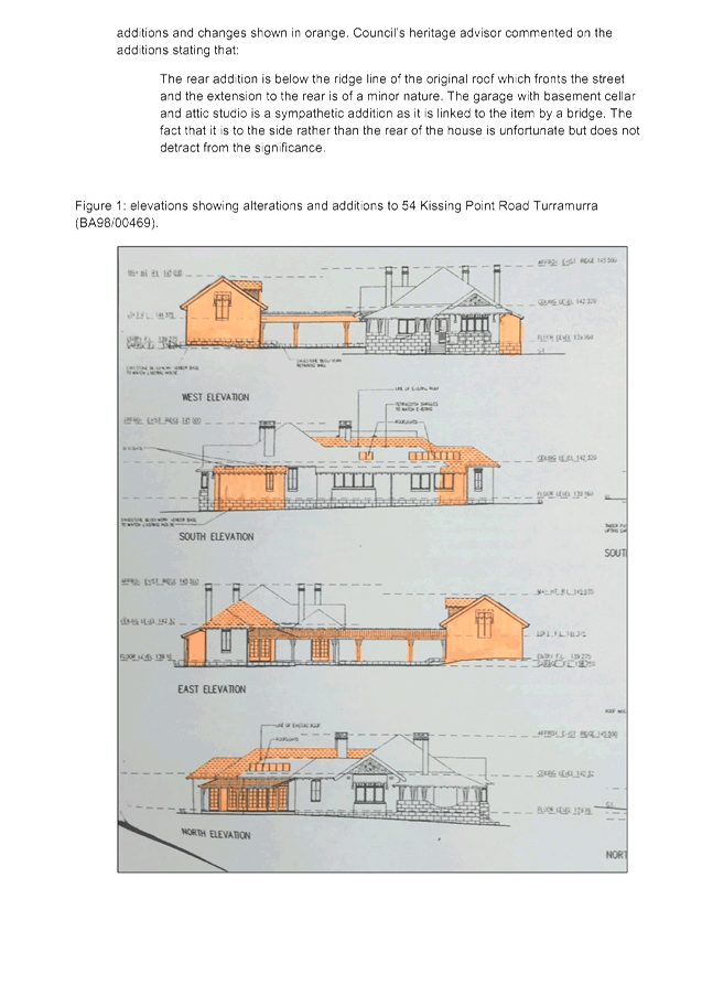
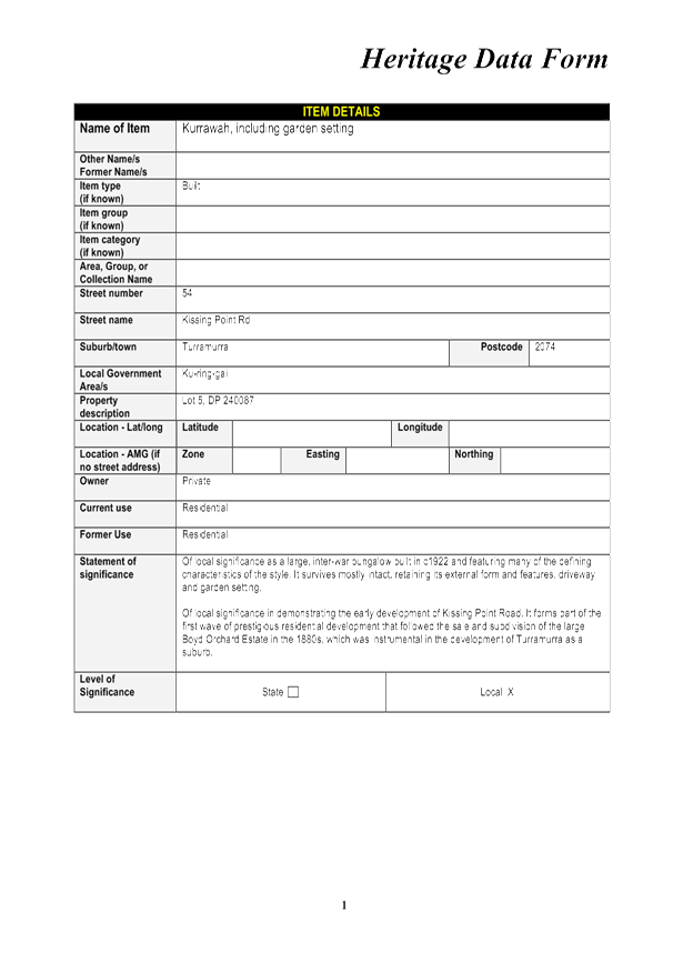
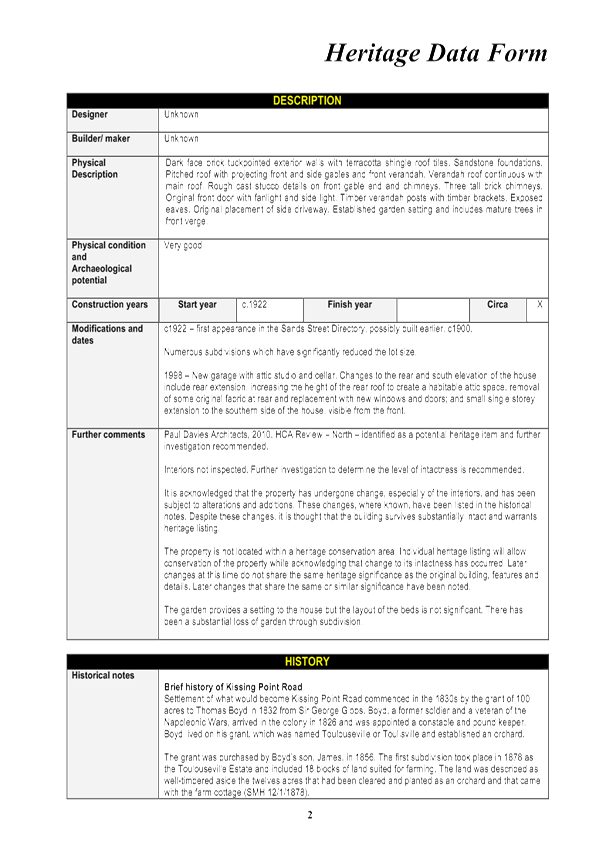
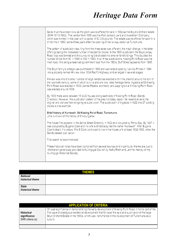
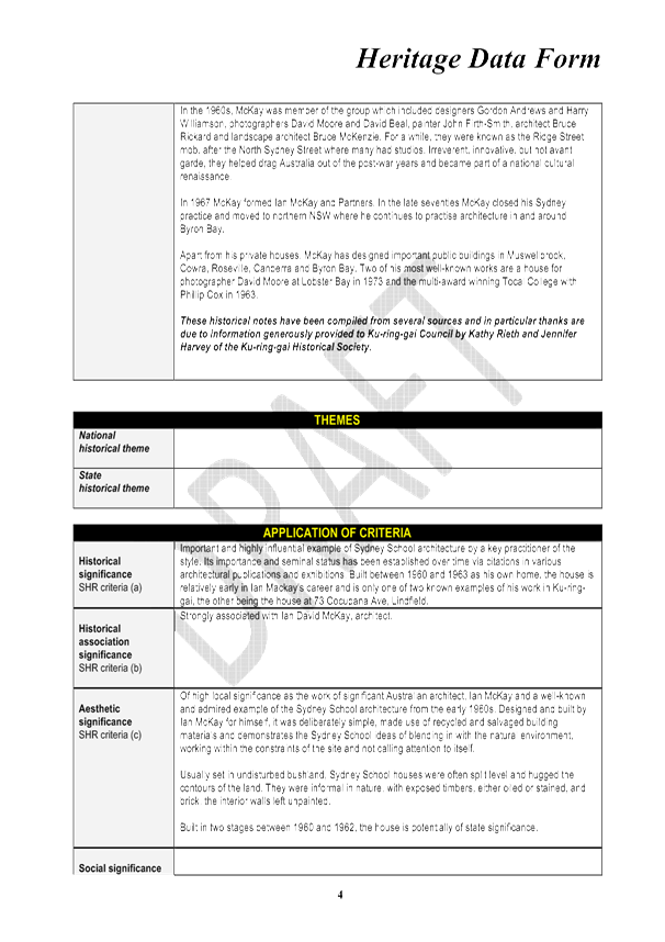
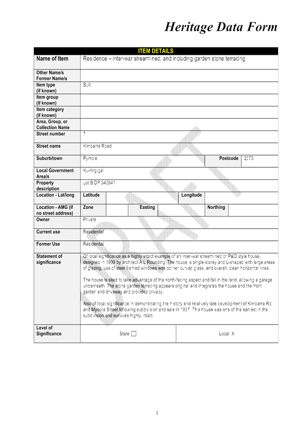
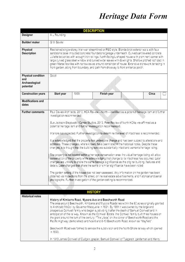
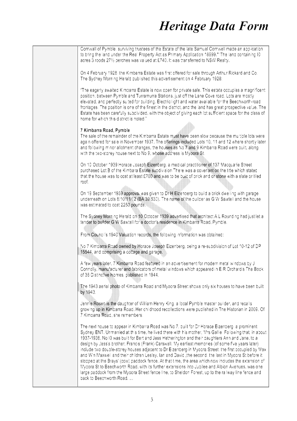
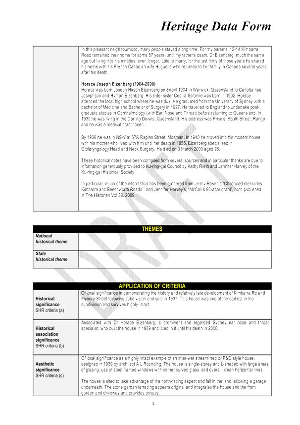
Ordinary Meeting of Council
TO BE HELD ON Tuesday, 19 July 2016 AT 7:00 pm
Level 3, Council Chamber
Agenda
** ** ** ** ** **
NOTE: For Full Details, See Council’s Website –
www.kmc.nsw.gov.au under the link to business papers
DECLARATIONS OF INTEREST
Address the Council
NOTE: Persons who address the Council should be aware that their address will be tape recorded.
Documents Circulated to Councillors
CONFIRMATION OF MINUTEs
Minutes of Ordinary Meeting of Council 7
File: S02131
Meeting held 28 June 2016
Minutes numbered 142 to 160
minutes from the Mayor
MM.1 Ban on Smoking in Ku-ring-gai's Public Places 74
File: S03433
This Mayoral Minute is to report back to my Councillor colleagues and the community the results of the resident survey carried out during June on a proposed ban on smoking in all Ku-ring-gai’s outdoor public places.
The survey was conducted as the result of a unanimous Council resolution on 24 May, after I raised the idea of a total ban in a Mayoral Minute on the same date.
Our current policy, based on NSW legislation, prohibits smoking within 10 metres of a Council building or playground. A complete ban on smoking in parks, bushland, reserves and playgrounds has the advantage of being a clear and easily enforceable policy, not open to interpretation and misunderstandings.
Banning smoking in public spaces across our community will not only protect young people from the harmful effects of smoking, but serves as an important step in discouraging them from taking up smoking in the first place.
It is not only the health impacts that we are concerned about. Cigarette butts, according to the Clean Up Australia organisation, are a leading cause of litter and a pollutant in the environment. They are also poisonous to native wildlife.
It seems the vast majority of our community agree with our considered view that smoking should be banned in all public spaces across the municipality.
The results of the resident survey are contained in the Council report but to summarise, an overwhelming number of those who responded – over 80% - agree with a total ban.
Those most in favour were in the 25 to 39 age group. We can deduce from this that these are the residents most likely to be raising young children.
We all know the negative health impacts of smoking. Approximately one in five of all cancer deaths in NSW are due to tobacco smoking. Not just lung cancer but throat, tongue, bowel and other preventable cancers.
Even more concerning is the growing body of scientific evidence showing passive smoke is almost as harmful. In children it is linked to sudden infant death syndrome; bronchitis; pneumonia and other lung/airways infections, middle ear disease and higher rates of worsening asthma.
We have a duty to our youngest and most vulnerable residents to protect them from these entirely preventable effects on their health. As children, they have no say and rely on adults to speak and act for them.
Indeed, I would go so far as to say that with all the evidence we have about the dire consequences of smoking, it would be negligent of us as a Council not to implement a total ban on smoking in public spaces.
Similar bans are already in place in the Northern Beaches and North Sydney council areas and Martin Place in Sydney’s CBD is another successful example of a busy public space which is now completely smoke free. These bans have been well received by the public.
Our Community Strategic Plan states Ku-ring-gai Council’s vision: “Ku-ring-gai will be a creative, healthy and liveable place where people respect each other and conserve the magnificent environment and society for the children and grandchildren of the future”.
Banning smoking from all Ku-ring-gai’s outdoor public spaces complements this vision and I am confident that our community and future generations will benefit greatly from the implementation of the proposed ban.
Petitions
PT.1 Petition regarding proposed Childcare Centre at 34 Brisbane Avenue East Lindfield 76
File: DA0589/15
“We , the undersigned, (one hundred and thirty five [135] signatures), call on Ku-ring-gai Council to DECLINE Development Application DA0589/15 for 34 Brisbane Avenue East Lindfield (and any further submissions relating to the site of a similar nature) submitted for demolition and construction of a childcare centre for forty (40) children, for the following reasons:
· This development is not an essential business for this residential area.
· This development is not required to meet local community needs – there are already at least three childcare centres operating in the local area (Tryon Road, Carlyle Road and Clanville Road).
· This development raises serious safety concerns due to increased traffic flow and its proximity to Lindfield East Public School which is already very busy with young children at drop off and pick up times; in particular, the driveways proposed on Melbourne Road and Brisbane Avenue are frequently crossed by young children on their way to and from school.
· The amenity of local residents will be adversely affected by heightened noise levels and waste management.
· This development will negatively affect property values for surrounding properties in one of the most sought after residential streets in East Lindfield – no one wants to buy a property next to a childcare centre.
GENERAL BUSINESS
i. The Mayor to invite Councillors to nominate any item(s) on the Agenda that they wish to have a site inspection.
ii. The Mayor to invite Councillors to nominate any item(s) on the Agenda that they wish to adopt in accordance with the officer’s recommendation allowing for minor changes without debate.
GB.1 Ban on Smoking in Public Places – Results of Survey 77
File: S03433
To inform Council of the outcome of an online community survey regarding the ban on smoking in public places.
Recommendation:
That Council receive and note the results of the community survey on smoking in public places.
GB.2 34 Billyard Avenue, Wahroonga - Landscaping works including new front fence - Heritage item in heritage conservation area 89
File: DA0097/15
Ward: Wahroonga
Applicant: Mr Bruce Nathaniel Gray
Owner: Dr B Gray and Mrs J Gray
To determine DA0097/15 for landscaping works including new front fence – heritage item in heritage conservation area
Recommendation:
Refusal
GB.3 Heritage Reference Committee minutes 121
File: CY00413/4
Council to consider the minutes of the Heritage Reference Committee (HRC) meeting held on 12 May 2016.
Recommendation:
That Council receive and note the Heritage Reference Committee meeting minutes from 12 May 2016.
GB.4 Membership of the Heritage Reference Committee 126
File: CY00413/4
Council to consider an amendment to the membership of the Heritage Reference Committee (HRC).
Recommendation:
That the Council adopts the new changes in the Heritage Reference Committee Guidelines to allow for the membership of up to three community members and alternate representatives for the members from organisations.
GB.5 Consideration of planning proposal to list additional heritage items following public exhibition 145
File: S10654
For Council to consider the listing of three heritage items following the public exhibition and a Councillor site inspection.
Recommendation:
That Council resolves to adopt the planning proposal to list the additional 3 deferred heritage items.
GB.6 Update Report on the Development Contributions System 180
File: S06785/3
The purpose of this report is to provide Council with an overview of key activities and highlights in the development contributions system over the past six months and anticipated actions and highlights for the coming twelve months.
Recommendation:
That the information in the report be received and noted.
Extra Reports Circulated to Meeting
Motions of which due Notice has been given
NM.1 Inclusive Playgrounds 194
File: S02621
Notice of Motion from Councillor Berlioz dated 11 July 2016
On 28 August 2014 the Disability Inclusion Act was passed by parliament. The Act provides regulation around the accessibility of mainstream services and facilities, the promotion of community inclusion and the provision of funding, support and services for people with disability.
Council in line with the legislation has developed an Access and Disability Inclusion Plan with a range of actions relating to access and Council buildings, facilities, information and the local environment.
Ms Ghatt who started a Facebook Group - Play For All Australia recently addressed Council pointing out that providing access to facilities does not necessarily result in inclusiveness. This is particularly applicable to children’s playgrounds.
Her group is campaigning for design of new local council playgrounds and upgrades not only for accessibility to traditional equipment but to include built elements for children of all abilities including special needs.
‘Access’ means making concessions to enable persons with additional needs to use a space like ramps or special amenities. ‘Inclusion’ empowers people of all abilities to utilise and interact with a space.
Playgrounds are an important space for children of all abilities to socialize, play side by side and foster a sense of belonging. It is also a space where parents with children with disability can take their children to play and engage freely with the outside environment., It is therefore necessary to include design considerations and special equipment that make inclusive play possible..
In order for playgrounds in Ku-ring-gai to support and integrate children and young people with a range of learning and physical abilities, as well as those with sensory impairments, I move:
That Council:
A. Ensure that new playgrounds and those undergoing
upgrades provide accessible and inclusive areas and equipment that enable
children of all abilities to play along-side each other and interact.
B. Ensure Accessible and Inclusive design is the
starting point for new playground developments and upgrades with consultation
from representatives of children with disabilities, such as parents, children
users, and advocates from special needs schools and/or organisations.
C. Representatives should be selected to inform the range of disabilities including learning, physical and sensory.
D. Consider the allocation of additional funding, if
necessary, for accessible and inclusive design playground elements that
specifically supports the integration of children with additional needs into
the play space.
BUSINESS WITHOUT NOTICE – SUBJECT TO CLAUSE 241 OF GENERAL REGULATIONS
Questions Without Notice
Inspections Committee – SETTING OF TIME, DATE AND RENDEZVOUS
** ** ** ** ** **
Minute Ku-ring-gai Council Page
MINUTES
OF Ordinary Meeting of Council
HELD ON Tuesday, 28 June 2016
Present: |
The Mayor, Councillor C Szatow (Chairperson) (Gordon Ward) Councillors E Malicki & J Pettett (Comenarra Ward) Councillor D Citer (Gordon Ward) Councillors C Berlioz & D Ossip (St Ives Ward) Councillors J Anderson & D Armstrong (Roseville Ward) Councillors C Fornari-Orsmond & D McDonald (Wahroonga Ward) |
|
|
Staff Present: |
General Manager (John McKee) Director Development & Regulation (Michael Miocic) Director Operations (Greg Piconi) Director Strategy & Environment (Andrew Watson) Director Community (Janice Bevan) Acting Director Corporate (Angela Apostol) Corporate Lawyer (Jamie Taylor) Manager Corporate Communications (Virginia Leafe) Manager Records and Governance (Amber Moloney) Minutes Secretary (Sandy Ryrie) Minutes Secretary (Sigrid Banzer) |
|
|
Others Present: |
Manager Communications (Virginia Leafe) Manager Urban & Heritage Planning (Antony Fabbro) Team Leader Urban Design (Bill Royal) Senior Urban Designer (Louise Drum) |
The Meeting commenced at 7:00 pm
The Mayor offered the Prayer
Councillor Ossip withdrew during discussion
APOLOGIES
The General Manager advised the Director Corporate was on leave and Ms Apostol would be Acting Director Corporate.
DECLARATIONS OF INTEREST
The Mayor adverted to the necessity for Councillors and staff to declare a Pecuniary Interest/Conflict of Interest in any item on the Business Paper.
Councillor Malicki declared a less than significant, non-pecuniary conflict of interest in Item GB.4 - 17 Ancona and 25 Trentino Road Turramurra DA0073/16 as she knows the applicant and left the chamber during debate.
The General Manager advised all senior staff would be absent from the chamber during debate on C.1 General Manager’s performance review.
Councillor Ossip returned
141 |
CONFIRMATION OF REPORTS TO BE CONSIDERED IN CLOSED MEETING
File: S02499/9
|
|
Resolved:
(Moved: Councillors McDonald/Fornari-Orsmond)
A. That in accordance with the provisions of Section 10 of the Local Government Act 1993, all officers’ reports be released to the press and public, with the exception of the following Confidential reports and their respective attachments: C.1 General Manager's Performance Review Attachment A1 - GM 2016 Performance Agreement - Annual Review Report In accordance with S10A(2)(a) C.2 Cameron Park Extension Voluntary Administration Attachment A1 - Independent Detailed Financial and Performance Assessment Attachment A2 - External Administration - Appointment of external administrator Attachment A3 - BCR Advisory - administrators appointed In accordance with S10A(2)(d)
B. That in accordance with the provisions of Section 10 of the Local Government Act 1993, all officers’ reports be released to the press and public, with the exception of with the exception of the confidential attachments to the following General Business items:
GB.1 Annual Report on Contractual Conditions of Senior Staff 2015 / 2016 Attachment A1: Confidential - Annual Report on Contractual Conditions of Senior Staff 2015 / 2016 In accordance with s10(2)(a).
GB.6 Turramurra Community Hub Master Plan - Post Exhibition Attachment A1: RLB - Concept Design Stage Estimate - Turramurra Community Hub - FINAL In accordance with s10(2)(d)(ii). Attachment A2: Turramurra Community Hub - Peer Review of Feasibility Analysis Final - Addendum 6 - April 2016 In accordance with s10(2)(d)(ii).
GB.10 Tender T12-2016 - Roseville Chase Community Hall Roofing and Building Upgrades Attachment A1: List of tenders received and additional financial information In accordance with s10(2)(d)(ii). Attachment A2: Tender Evaluation Panel Report In accordance with s10(2)(d)(ii). Attachment A3: Independent Financial and Performance Assessment In accordance with s10(2)(d)(ii).
GB.11 Tender RFT10-2016 - Golden Jubilee and Lofberg Playground Upgrades Attachment A1: List of Tenders received In accordance with s10(2)(d)(iii). Attachment A2: Tender Evaluation Panel's recommendation In accordance with s10(2)(d)(iii). Attachment A3: Corporate Scorecard's Financial Assessment In accordance with s10(2)(d)(iii).
CARRIED UNANIMOUSLY |
Address the Council
The following member(s) of the public address Council on items not on the agenda:
J Milburn Slow clothing
M Gooley Eruv
J Kitson Biodiversity Conservation Bill
J Watts Eruv
P Moate Eruv
DOCUMENTS CIRCULATED TO COUNCILLORS
The Mayor adverted to the documents circulated in the Councillors’ papers and advised that the following matters would be dealt with at the appropriate time during the meeting:
Councillors Information: |
Refer GB.6 – Turramurra Master Plan Post Exhibition Memorandum from Director Strategy & Environment dated 27 June 2016 advising that a copy of the masterplan is available in the Councillors’ room and also on the website. Refer GB.6 – Turramurra Master Plan Post Exhibition Memorandum from Director Strategy & Environment dated 28 June 2016 with answers to Councillors’ questions . |
Late Confidential Items: |
C.1 - General Manager's Performance Review - Report by Mayor PA dated 23 June 2016 an attachment. C.2 - Cameron Park Extension Voluntary Administration - Report by Director Operations dated 27 June 2016 with attachments. |
CONFIRMATION OF MINUTEs
142 |
Minutes of Ordinary Meeting of Council
File: S02131 |
|
Meeting held 14 June 2016 Minutes numbered 117 to 140
|
|
Resolved:
(Moved: Councillors Berlioz/McDonald)
That Minutes numbered 117 to 140 circulated to Councillors were taken as read and confirmed as an accurate record of the proceedings of the Meeting.
CARRIED UNANIMOUSLY |
GENERAL BUSINESS
143 |
Gum Tree on North-Western Corner of Burgoyne Street and Pearson Avenue, Gordon
File: RT1/08 Vide: PT.1
|
|
“We, the undersigned petition the Council to have the above-mentioned tree cut down and removed. (Eighteen (18) signatures).”
Over the last decade, and especially over the last few years, this tree has caused considerable damage to resident and passing cars [notably child care and commuter] [in Burgoyne Street], a power pole [in Burgoyne Street], Foxtel services [to 10 Pearson Avenue], electricity service wires [to three houses in Burgoyne Street and Pearson Avenue], and street lighting [in Burgoyne Street].
Last Saturday, a very big branch came down without any warning and crushed some mature native plants with a street care programme assigned to Richard Brady, a long time resident in Burgoyne Street. Half the road was obstructed. And on 27th February, 2016, a very big branch came down over Burgoyne Street, snapping a power pole into 2 and totally closing the road until police and emergency services arrived. These incidents, along with others, are on Council records.
Because the car park to the nearby pre-school in Park Avenue/Pearson Avenue is now inadequate, many mothers use this end of Burgoyne Street for casual parking before 9am and around 3pm. As do employees of Lifeline during the week. A not insignificant number have expressed their concern, especially when debris from the subject tree is all too often found lying on the road [or on car roofs].
We shouldn’t have to live in fear that a tree will, sooner or later, destroy a car or damage a house. Or worse, possible injure or kill somebody.
We ask that the Council address our concerns. The tree needs to be cut down and removed.
|
|
Resolved:
(Moved: Councillors Szatow/Citer)
That the petition be received and referred to the appropriate Officer of Council for attention.
CARRIED UNANIMOUSLY |
144 |
Annual Report on Contractual Conditions of Senior Staff 2015 / 2016
File: S10214 Vide: GB.1
|
|
To report on the contractual conditions of senior staff in accordance with section 339 of the Local Government Act 1993.
|
|
Resolved:
(Moved: Councillors Malicki/McDonald)
That Council receive and note the report.
CARRIED UNANIMOUSLY |
145 |
Mayor and Councillor Fees for 2016 / 2017 - Local Government Remuneration Tribunal Report and Determination
File: S03158/2 Vide: GB.2
|
|
To determine the mayor and councillor fees for the 2016/17 financial year.
|
|
Resolved:
(Moved: Councillors Malicki/McDonald)
That effective 1 July 2016: A. the annual Councillor fee be set at $18,840; and B. the annual Mayoral fee to be set at $41,090, in addition to the Councillor fee.
CARRIED UNANIMOUSLY |
146 |
Investment Report as at 31 May 2016
File: S05273 Vide: GB.3
|
|
To present Council’s investment portfolio performance for May 2016.
|
|
Resolved:
(Moved: Councillors Malicki/McDonald)
A. That the summary of investments and performance for May 2016 be received and noted.
B. That the Certificate of the Responsible Accounting Officer be noted and the report adopted.
CARRIED UNANIMOUSLY |
147 |
1089 Pacific Highway, Pymble - construct residential flat building comprising 13 units, including basement parking, landscaping and strata subdivision
File: DA0130/15 Vide: GB.5
|
|||||||||||||||||||||||||||||||||||||||||||||||||||||||||||||||||||||||||||||||||||||||||||||||||||||||||||||||||||||||||||||||||||||||||||||||
|
Construct residential flat building comprising 13 units, including basement parking, landscaping and strata subdivision
|
|||||||||||||||||||||||||||||||||||||||||||||||||||||||||||||||||||||||||||||||||||||||||||||||||||||||||||||||||||||||||||||||||||||||||||||||
|
Resolved:
(Moved: Councillors Malicki/Pettett)
PURSUANT TO SECTION 80(1) OF THE ENVIRONMENTAL PLANNING AND ASSESSMENT ACT, 1979
THAT Council, as the consent authority, is of the opinion that the requests submitted under clause 4.6 of KLEP 2015 to vary the building height and minimum site requirements development standards have met the requirements of clause 4.6(3) of KLEP 2015. Council is also of the opinion that strict compliance with the development standards is unreasonable and unnecessary in the circumstances of the case and that there are sufficient environmental planning grounds to justify the variations to the development standards.
AND
THAT Council, as the consent authority, being satisfied that the proposed development will be in the public interest, grant development consent to DA0130/15 for the construction of a residential flat building comprising 13 units, including basement parking, landscaping and strata subdivision at 1089 Pacific Highway for a period of two (2) years from the date of the Notice of Determination, subject to the following conditions
Conditions that identify approved plans:
1. Approved architectural plans and documentation (new development)
The development must be carried out in accordance with the following plans and documentation listed below and endorsed with Council’s stamp, except where amended by other conditions of this consent:
Reason: To ensure that the development is in accordance with the determination.
2. Amended architectural plans
Prior to the issue of the Construction Certificate, the Principal Certifying Authority shall be satisfied that the approved plans listed in Condition 1 above and endorsed with Council’s stamp, have been amended in accordance with the requirements of this condition as well as other conditions of this consent:
(a) The chamfer is to be removed from the balconies to Units 1, 5 and 9. The balconies are to be squared off and have the following dimensions:
(i) Unit 1 balcony - 3.3m deep by 4.1m long (ii) Units 5 and 9 balconies – 2.6m deep by 4.6m long
The southern balustrade wall of the balconies must be solid, rendered and painted to match the finish of the northern wall.
(b) A garden maintenance storage area and connection to water must be provided within the communal roof top terrace area. The storage area is to be low scale storage area and not visible from the public domain.
(c) A water outlet is to be provided to the primary private open space (balcony or terrace) of each unit.
(d) Any exposed basement walls must be clad in face brick to match the walls over.
(e) The basement must be designed as a tanked structure.
(f) A visitor car parking space must be deleted from the basement and replaced with a shared service vehicle and car wash space.
(g) A bicycle rack must be provided for visitors and located in an accessible area close to the building entry.
(h) Intercom access for visitors must be provided in a safe location within the driveway.
Reason: To ensure that the development is in accordance with the determination.
3. Amended strata plans
Prior to the issue of the Subdivision Certificate, the Principal Certifying Authority shall be satisfied that the approved architectural plans listed below and endorsed with Council’s stamp, have been amended in accordance with the requirements of this condition as well as other conditions of this consent:
The above plans shall be amended in the following ways:
(a) To reflect the amendments to the development as illustrated in the approved architectural plans.
Reason: To ensure that the development is in accordance with the determination.
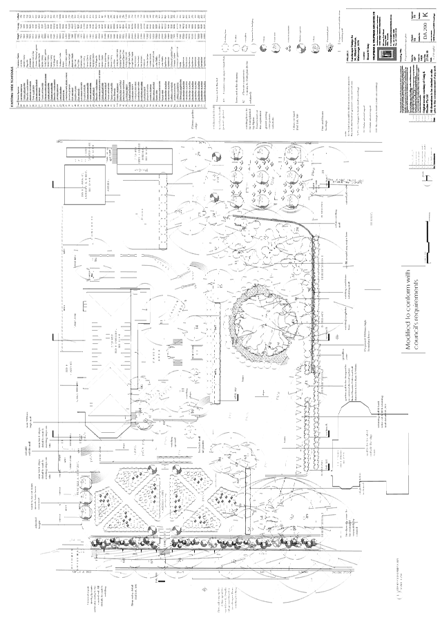
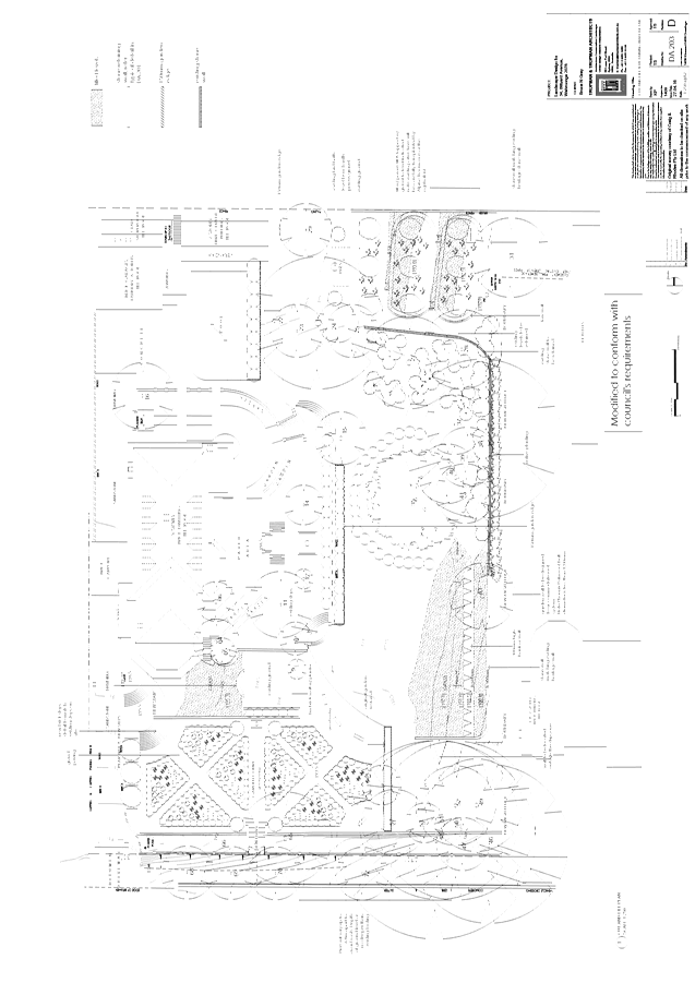
4. Approved landscape plans
Landscape works shall be carried out in accordance with the following landscape plan(s), listed below and endorsed with Council’s stamp, except where amended by other conditions of this consent:
Reason: To ensure that the development is in accordance with the determination.
5. Amendments to approved landscape plans
Prior to the issue of a Construction Certificate, the Principal Certifying Authority shall be satisfied that the approved landscape plans, listed below and endorsed with Council’s stamp, have been amended in accordance with the requirements of this condition as well as other conditions of this consent:
The above landscape plan(s) shall be amended in the following ways:
(a) The proposed ground levels within the front setback of Pacific Highway and in the vicinity of Unit 1 are to be shown to be modified so as to create a batter that meets the approximate level at the top of the protruding basement (RL.167.36) The proposed vegetated embankment is to be planted with soil stabilising species and is not to exceed a 1:3 slope.
Prior to the issue of the Construction Certificate, the Principal Certifying Authority shall be satisfied that the landscape plan has been amended are required by this condition.
Note: An amended plan, prepared by a landscape architect or qualified landscape designer shall be submitted to the Certifying Authority.
Reason: To ensure adequate landscaping of the site.
6. Inconsistency between documents
In the event of any inconsistency between conditions of this consent and the drawings/documents referred to above, the conditions of this consent prevail.
Reason: To ensure that the development is in accordance with the determination.
Conditions to be satisfied prior to demolition, excavation or construction:
7. Asbestos works
All work involving asbestos products and materials, including asbestos-cement-sheeting (ie. Fibro), must be carried out in accordance with the guidelines for asbestos work published by WorkCover Authority of NSW.
Reason: To ensure public safety.
8. Notice of commencement
At least 48 hours prior to the commencement of any development (including demolition, excavation, shoring or underpinning works), a notice of commencement of building or subdivision work form and appointment of the principal certifying authority form shall be submitted to Council.
Reason: Statutory requirement.
9. Notification of builder’s details
Prior to the commencement of any development or excavation works, the Principal Certifying Authority shall be notified in writing of the name and contractor licence number of the owner/builder intending to carry out the approved works.
Reason: Statutory requirement.
10. RMS concurrence conditions
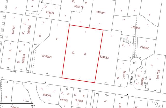
(a) Roads and Maritime has previously vested a strip of land as road along the Pacific Highway frontage of the subject property, as shown by grey colour on the attached Aerial - “X”.
All buildings and structures, together with any improvements integral to the future use of the site. are to be wholly within the freehold property (unlimited in height or depth), along the Pacific Highway boundary.
(b) The redundant driveways on Pacific Highway shall be removed and replaced with kerb and gutter to match existing.
(c) The design and construction of the kerb and gutter on Pacific Highway shall be in accordance with Roads and Maritime requirements. Details of these requirements should be obtained from Roads and Maritime Project Services Manager. Traffic Projects Section. Parramatta (telephone 88492138).
Detailed design plans of the proposed kerb and gutter are to be submitted to Roads and Maritime for approval prior to the issue of a Construction Certificate and commencement of any road works.
A plan checking fee (amount to be advised) and lodgement of a performance bond may be required from the applicant prior to the release of the approved road design plans by Roads and Maritime.
(d) Detailed design plans and hydraulic calculations of any changes to the stormwater drainage system are to be submitted to Roads and Maritime for approval, prior to the commencement of any works.
Details should be forwarded to: The Sydney Asset Management Roads and Maritime Services P0 Box 973 Parramatta CBD 2124.
A plan checking fee will be payable and a performance bond may be required before Roads and Maritime approval is issued. With regard to the Civil Works requirement please contact the Roads and Maritime Project Engineer, External Works Ph: 8849 2114 or Fax: 8849 2766.
(e) The proposed development should be designed such that road traffic noise from Pacific Highway is mitigated by durable materials in order to satisfy the requirements for habitable rooms under Clause 102 (3) of State Environmental Planning Policy (Infrastructure) 2007.
(f) The developer is to submit design drawings and documents relating to the excavation of the site and support structures to Roads and Maritime for assessment, in accordance with Technical Direction GTD201 2/001.
The developer is to submit all documentation at least six (6) weeks prior to commencement of construction and is to meet the full cost of the assessment by Roads and Maritime.
The report and any enquiries should be forwarded to: Project Engineer, External Works Sydney Asset Management Roads and Maritime Services PO Box 973 Parramatta CBD 2124. Telephone 8849 2114 Fax 8849 2766
If it is necessary to excavate below the level of the base of the footings of the adjoining roadways, the person acting on the consent shall ensure that the owner/s of the roadway is/are given at least seven (7) days notice of the intention to excavate below the base of the footings. The notice is to include complete details of the work.
(g) All demolition and construction vehicles are to be contained wholly within the site and vehicles must enter the site before stopping. A construction zone will not be permitted on Pacific Highway.
Reason: Statutory requirement.
11. Notice of proposed work (contaminated land)
A notice of proposed work form must be given to Council’s Development Assessment Officer, in accordance with SEPP 55, Clause 16. Note: At least 30 days notice is required, except in the case of work required to be carried out immediately under the terms of remediation order (in which case, at least 1 days notice is required).
SEPP 55, Clause 16 requires that the notice must:
(a) be in writing (b) provide the name, address and telephone number of the person who has the duty of ensuring that the notice is given (c) briefly describe the remediation work (d) show why the person considers that the work is category 2 remediation work by reference to Clause 9, 14 and (if it applies) 15(1) (e) specify, by reference to its property description and street address (if any), the land on which the work is to be carried out (f) provide a map of the location of the land (g) provide estimates of the dates for the commencement and completion of the work
The following additional information must be submitted with the notice to Council:
(h) copies of any preliminary investigation, detailed investigation and remediation action plan for the site (i) contact details for the remediation contractor and any other party responsible for ensuring compliance of remediation work with regulatory requirements
Reason: Protection of the environment and compliance with SEPP 55.
12. Dilapidation survey and report (public infrastructure)
Prior to the commencement of any development or excavation works on site, the Principal Certifying Authority shall be satisfied that a dilapidation report on the visible and structural condition of all structures of the following public infrastructure, has been completed and submitted to Council:
Public infrastructure
(a) Full road pavement width, including kerb and gutter, of Bannockburn Road, Reservoir Road and Pacific Highway southbound over the site frontage, including the intersections. (b) All driveway crossings and laybacks opposite the subject site.
The report must be completed by a consulting structural/civil engineer. Particular attention must be paid to accurately recording (both written and photographic) existing damaged areas on the aforementioned infrastructure so that Council is fully informed when assessing any damage to public infrastructure caused as a result of the development.
The developer may be held liable to any recent damage to public infrastructure in the vicinity of the site, where such damage is not accurately recorded by the requirements of this condition prior to the commencement of works.
Note: A written acknowledgment from Council must be obtained (attesting to this condition being appropriately satisfied) and submitted to the Principal Certifying Authority prior to the commencement of any excavation works.
Reason: To record the structural condition of public infrastructure before works commence.
13. Dilapidation survey and report (private property)
Prior to the commencement of any demolition or excavation works on site, the Principal Certifying Authority shall be satisfied that a dilapidation report on the visible and structural condition of all structures upon the following lands, has been completed and submitted to Council:
(a) 1 Bannockburn Road (b) 1A Bannockburn Road
The dilapidation report must include a photographic survey of adjoining properties detailing their physical condition, both internally and externally, including such items as walls ceilings, roof and structural members. The report must be completed by a consulting structural/geotechnical engineer as determined necessary by that professional based on the excavations for the proposal and the recommendations of the submitted geotechnical report.
In the event that access for undertaking the dilapidation survey is denied by a property owner, the applicant must demonstrate in writing to the satisfaction of the Principal Certifying Authority that all reasonable steps have been taken to obtain access and advise the affected property owner of the reason for the survey and that these steps have failed.
Note: A copy of the dilapidation report is to be provided to Council prior to any excavation works been undertaken. The dilapidation report is for record keeping purposes only and may be used by an applicant or affected property owner to assist in any civil action required to resolve any dispute over damage to adjoining properties arising from works.
Reason: To record the structural condition of likely affected properties before works commence.
14. Geotechnical report
Prior to the commencement of any bulk excavation works on site, the applicant shall submit to the Principal Certifying Authority, the results of a detailed geotechnical investigation comprising a minimum of three cored boreholes to at least 1 metre below the proposed basement level. The report is to address such matters as:
(a) appropriate excavation methods and techniques (b) vibration management and monitoring (c) dilapidation survey (d) support and retention of excavated faces (e) hydrogeological considerations
The recommendations of the report are to be implemented during the course of the works.
Reason: To ensure the safety and protection of property.
15. Construction and traffic management plan
The applicant must submit to Council a Construction Traffic Management Plan (CTMP), which is to be approved prior to the commencement of any works on site.
The plan is to consist of a report with Traffic Control Plans attached.
The report is to contain commitments which must be followed by the demolition and excavation contractor, builder, owner and subcontractors. The CTMP applies to all persons associated with demolition, excavation and construction of the development.
The report is to contain construction vehicle routes for approach and departure to and from all directions.
The report is to contain a site plan showing entry and exit points. Swept paths are to be shown on the site plan showing access and egress for an 11 metre long heavy rigid vehicle.
The Traffic Control Plans are to be prepared by a qualified person (red card holder). One must be provided for each of the following stages of the works:
(a) Demolition (b) Excavation (c) Concrete pour (d) Construction of vehicular crossing and reinstatement of footpath (e) Traffic control for vehicles reversing into or out of the site.
Traffic controllers must be in place at the site entry and exit points to control heavy vehicle movements in order to maintain the safety of pedestrians and other road users.
When a satisfactory CTMP is received, a letter of approval will be issued with conditions attached. Traffic management at the site must comply with the approved CTMP as well as any conditions in the letter issued by Council. Council’s Rangers will be patrolling the site regularly and fines may be issued for any non-compliance with this condition.
Reason: To ensure that appropriate measures have been considered during all phases of the construction process in a manner that maintains the environmental amenity and ensures the ongoing safety and protection of people.
16. Work zone
If a works zone is proposed, an application must be made to Council, and installation of the Works Zone will be subject to the approval of the Ku-ring-gai Local Traffic Committee.
No loading or unloading must be undertaken from the public road or nature strip unless within a Works Zone which has been approved and paid for.
In the event the work zone is required for a period beyond that initially approved by the Traffic Committee, the applicant shall make a payment to Council for the extended period in accordance with Council’s schedule of fees and charges for work zones prior to the extended period commencing.
Reason: To ensure that appropriate measures have been made for the operation of the site during the construction phase.
17. Erosion and drainage management
Earthworks and/or demolition of any existing buildings shall not commence until an erosion and sediment control plan is submitted to and approved by the Principal Certifying Authority. The plan shall comply with the guidelines set out in the NSW Department of Housing manual "Managing Urban Stormwater: Soils and Construction". Erosion and sediment control works shall be implemented in accordance with the erosion and sediment control plan.
Reason: To preserve and enhance the natural environment.
18. Tree protection fencing excluding structure
To preserve the following tree/s, no work shall commence until the area beneath their canopy excluding that area of the approved building and basement shall be fenced off for the specified radius from the trunk to prevent any changes in soil levels, activities, storage or the disposal of materials within the fenced area. The fence/s shall be maintained intact until the completion of all demolition/building work on site:
Reason: To protect existing trees during the construction phase.
19. Tree protection signage
Prior to works commencing, tree protection signage is to be attached to each tree protection zone, displayed in a prominent position and the sign repeated at 10 metres intervals or closer where the fence changes direction. Each sign shall contain in a clearly legible form, the following information:
Tree protection zone.
(a) This fence has been installed to prevent damage to the trees and their growing environment both above and below ground and access is restricted. (b) Any encroachment not previously approved within the tree protection zone shall be the subject of an arborist's report. (c) The arborist's report shall provide proof that no other alternative is available. (d) The Arborist's report shall be submitted to the Principal Certifying Authority for further consultation with Council. (e) The name, address, and telephone number of the developer.
Reason: To protect existing trees during the construction phase.
20. Tree fencing inspection
Upon installation of the required tree protection measures, an inspection of the site by the Principal Certifying Authority is required to verify that tree protection measures comply with all relevant conditions.
Reason: To protect existing trees during the construction phase.
Conditions to be satisfied prior to the issue of the construction certificate:
21. Noise control measures
Prior to commencement of any works the Principal Certifying Authority shall be satisfied that suitable acoustic measures have been employed in the design of the project to ensure that recommendations as provided for in the Noise Assessment (Ref 206-237) prepared by Acoustic Noise and Vibration Solutions P/L dated 6 May 2016 as submitted with this application, and that the requirements of Section F Health and Amenity Clause F4.5 Ventilation of rooms of the Building Code of Australia are met.
Note: Plans, specifications and certifications of the proposed acoustic measures (including but not limited to acoustic barriers/screens) to achieve the recommendations of the Noise Assessment (Ref 2016-237) prepared by Acoustic Noise and Vibration Solutions P/L dated 6 May 2016 are to be submitted for consideration and approval prior to the issue of the Construction Certificate.
Reason: To ensure adequate levels of health and amenity to the occupants of the building.
22. Noise and vibration management plan
Prior to commencement of any works the Principal Certifying Authority shall be satisfied that a noise and vibration management plan is prepared to ensure noise generated during excavation, demolition and construction phases is minimised and reasonable standards of amenity to neighbouring properties is provided.
Reason: To ensure reasonable standards of amenity to neighbouring properties.
23. Visitable dwellings
Plans demonstrating compliance with Council's visitable housing requirements contained within Part 23.1 of KDCP 2015 are to be submitted to the satisfaction of the Principal Certifying Authority, prior to issue of the Construction Certificate.
A visitable dwelling is a dwelling that can be accessed by people who use wheelchairs in that there must be at least one accessible entry and accessible path of travel to the living area and to a toilet that is either accessible or visitable as defined by AS 4299.
At least 70% of dwellings within the development must be visitable.
Reason: To ensure equitable access.
24. Building design - environmental management plan
Prior to the issue of the Construction Certificate, the Principal Certifying Authority shall be satisfied that the building is designed in accordance with the approved environmental management plan ENVIRHOD00876AB, prepared by Coffey Environments Australia Pty Ltd, dated 21 December 2012.
Reason: SEPP 55 and environmental safety.
25. Tanked basement design
Prior to the issue of the Construction Certificate, the Principal Certifying Authority shall be satisfied that the basement is designed as a tanked structure.
Reason: To protect the environment and prevent the discharge of contaminated groundwater into Council's stormwater system.
26. Long service levy
In accordance with Section 109F(i) of the Environmental Planning and Assessment Act a Construction Certificate shall not be issued until any long service levy payable under Section 34 of the Building and Construction Industry Long Service Payments Act 1986 (or where such levy is payable by instalments, the first instalment of the levy) has been paid. Council is authorised to accept payment. Where payment has been made elsewhere, proof of payment is to be provided to Council.
Reason: Statutory requirement.
27. Builder’s indemnity insurance
The applicant, builder, developer or person who does the work on this development, must arrange builder’s indemnity insurance and submit the certificate of insurance in accordance with the requirements of Part 6 of the Home Building Act 1989 to the Certifying Authority for endorsement of the plans accompanying the Construction Certificate.
It is the responsibility of the applicant, builder or developer to arrange the builder's indemnity insurance for residential building work over the value of $20,000. The builder's indemnity insurance does not apply to commercial or industrial building work or to residential work valued at less than $20,000, nor to work undertaken by persons holding an owner/builder's permit issued by the Department of Fair Trading (unless the owner/builder's property is sold within 7 years of the commencement of the work).
Reason: Statutory requirement.
28. Outdoor lighting
Prior to the issue of a Construction Certificate, the Certifying Authority shall be satisfied that all outdoor lighting will comply with AS/NZ1158.3: 1999 Pedestrian Area (Category P) Lighting and AS4282: 1997 Control of the Obtrusive Effects of Outdoor Lighting.
Note: Details demonstrating compliance with these requirements are to be submitted prior to the issue of a Construction Certificate.
Reason: To provide high quality external lighting for security without adverse affects on public amenity from excessive illumination levels.
29. Air drying facilities
Prior to the issue of the Construction Certificate, the Certifying Authority shall be satisfied that a common open space area dedicated for open air drying of clothes is provided. This area is to be located at ground level behind the building line and in a position not visible from the public domain.
In lieu of the above, written confirmation that all units will be provided with internal clothes drying facilities prior to the Occupation Certificate is to be submitted to the Certifying Authority prior to the issue of the Construction Certificate.
Reason: Amenity & energy efficiency.
30. External service pipes and the like prohibited
Proposed water pipes, waste pipes, stack work, duct work, mechanical ventilation plant and the like must be located within the building. Details confirming compliance with this condition must be shown on construction certificate plans and detailed with construction certificate specifications. Required external vents or vent pipes on the roof or above the eaves must be shown on construction certificate plans and detailed with construction certificate specifications. External vents or roof vent pipes must not be visible from any place unless detailed upon development consent plans. Where there is any proposal to fit external service pipes or the like this must be detailed in an amended development (S96) application and submitted to Council for determination.
Vent pipes required by Sydney Water must not be placed on the front elevation of the building or front roof elevation. The applicant, owner and builder must protect the appearance of the building from the public place and the appearance of the streetscape by elimination of all external services excluding vent pipes required by Sydney Water and those detailed upon development consent plans.
Reason: To protect the streetscape and the integrity of the approved development.
31. Access for people with disabilities (residential)
Prior to the issue of the Construction Certificate, the Certifying Authority shall be satisfied that access for people with disabilities to and from and between the public domain, residential units and all common open space areas is provided. Consideration must be given to the means of dignified and equitable access.
Compliant access provisions for people with disabilities shall be clearly shown on the plans submitted with the Construction Certificate. All details shall be provided to the Principal Certifying Authority prior to the issue of the Construction Certificate. All details shall be prepared in consideration of the Disability Discrimination Act, and the relevant provisions of AS1428.1, AS1428.2, AS1428.4 and AS 1735.12.
Reason: To ensure the provision of equitable and dignified access for all people in accordance with disability discrimination legislation and relevant Australian Standards.
32. Adaptable units
Prior to the issue of the Construction Certificate, the Certifying Authority shall be satisfied that the nominated adaptable units within the development application, Units 4 and 8, are designed as adaptable housing in accordance with the provisions of Australian Standard AS4299-1995: Adaptable Housing.
Note: Evidence from an appropriately qualified professional demonstrating compliance with this control is to be submitted to and approved by the Certifying Authority prior to the issue of the Construction Certificate.
Reason: Disabled access & amenity.
33. Excavation for services
Prior to the issue of the Construction Certificate, the Principal Certifying Authority shall be satisfied that no proposed underground services (ie: water, sewerage, drainage, gas or other service) unless previously approved by conditions of consent, are located beneath the canopy of any tree protected under Council’s Tree Preservation Order, located on the subject allotment and adjoining allotments.
Note: A plan detailing the routes of these services and trees protected under the Tree Preservation Order shall be submitted to the Principal Certifying Authority.
Reason: To ensure the protection of trees.
34. Recycling and waste management
Prior to the issue of the Construction Certificate, the Certifying Authority shall be satisfied that the development provides a common garbage collection/separation area sufficient in size to store all wheelie garbage bins and recycling bins provided by Council for the number of units in the development in accordance with Council’s DCP. The garbage collection point is to be accessible by Council’s Waste Collection Services.
The responsibility for:
(a) the cleaning of waste rooms and waste service compartments; and (b) the transfer of bins within the property, and to the collection point once the development is in use;
shall be determined when designing the system and clearly stated in the Waste Management Plan.
Note: The architectural plans are to be amended and provided to the Certifying Authority.
Reason: Environmental protection.
35. Noise from road and rail (residential only)
Prior to the issue of the Construction Certificate, the Certifying Authority shall submit evidence to Council demonstrating that the development will be acoustically designed and constructed to ensure that the following LAeq levels are not exceeded: (a) in any bedroom in the building-35 dB(A) at any time between 10 pm and 7 am, (b) anywhere else in the building (other than a garage, kitchen, bathroom or hallway)-40 dB(A) at any time.
Plans and specifications of the required acoustic design shall be prepared by a practicing acoustic engineer and shall be submitted to the Principal Certifying Authority.
Reason: To minimise the impact of noise from the adjoining road or rail corridor on the occupants of the development.
36. Noise from plant in residential zone
Where any form of mechanical ventilation equipment or other noise generating plant is proposed as part of the development, prior to the issue of the Construction Certificate the Certifying Authority, shall be satisfied that the operation of an individual piece of equipment or operation of equipment in combination will not exceed more than 5dB(A) above the background level during the day when measured at the site’s boundaries and shall not exceed the background level at night (10.00pm –6.00 am) when measured at the boundary of the site.
C1. Note: A certificate from an appropriately qualified acoustic engineer is to be submitted with the Construction Certificate, certifying that all mechanical ventilation equipment or other noise generating plant in isolation or in combination with other plant will comply with the above requirements.
Reason: To comply with best practice standards for residential acoustic amenity.
37. Driveway crossing levels
Prior to issue of the Construction Certificate, driveway and associated footpath levels for any new, reconstructed or extended sections of driveway crossings between the property boundary and road alignment must be obtained from Ku-ring-gai Council. Such levels are only able to be issued by Council under the Roads Act 1993. All footpath crossings, laybacks and driveways are to be constructed according to Council's specifications "Construction of Gutter Crossings and Footpath Crossings".
Specifications are issued with alignment levels after completing the necessary application form at Customer Services and payment of the assessment fee. When completing the request for driveway levels application from Council, the applicant must attach a copy of the relevant development application drawing which indicates the position and proposed level of the proposed driveway at the boundary alignment.
This development consent is for works wholly within the property. Development consent does not imply approval of footpath or driveway levels, materials or location within the road reserve, regardless of whether this information is shown on the development application plans. The grading of such footpaths or driveways outside the property shall comply with Council's standard requirements. The suitability of the grade of such paths or driveways inside the property is the sole responsibility of the applicant and the required alignment levels fixed by Council may impact upon these levels.
The construction of footpaths and driveways outside the property in materials other than those approved by Council is not permitted.
Reason: To provide suitable vehicular access without disruption to pedestrian and vehicular traffic.
38. Driveway grades - basement carparks
Prior to the issue of the Construction Certificate, longitudinal driveway sections are to be prepared by a qualified civil/traffic engineer and be submitted for to and approved by the Certifying Authority. These profiles are to be at 1:100 scale along both edges of the proposed driveway, starting from the centreline of the frontage street carriageway to the proposed upper basement floor level. The traffic engineer shall provide specific written certification on the plans that:
(a) vehicular access can be obtained using grades of 20% (1 in 5) maximum and (b) all changes in grade (transitions) comply with Australian Standard 2890.1 -“Off-street car parking” (refer clause 2.5.3) to prevent the scraping of the underside of vehicles.
If a new driveway crossing is proposed, the longitudinal sections must incorporate the driveway crossing levels as issued by Council upon prior application.
Reason: To provide suitable vehicular access without disruption to pedestrian and vehicular traffic.
39. Basement car parking details
Prior to issue of the Construction Certificate, certified parking layout plan(s) to scale showing all aspects of the vehicle access and accommodation arrangements must be submitted to and approved by the Certifying Authority. A qualified civil/traffic engineer must review the proposed vehicle access and accommodation layout and provide written certification on the plans that:
(a) all parking space dimensions, driveway and aisle widths, driveway grades, transitions, circulation ramps, blind aisle situations and other trafficked areas comply with Australian Standard 2890.1 - 2004 “Off-street car parking” (b) a clear height clearance of 2.6 metres (required for waste collection trucks) is provided over the designated garbage collection truck manoeuvring areas within the basement (c) no doors or gates are provided in the access driveways to the basement carpark which would prevent unrestricted access for internal garbage collection at any time from the basement garbage storage and collection area (d) the vehicle access and accommodation arrangements are to be constructed and marked in accordance with the certified plans
Reason: To ensure that parking spaces are in accordance with the approved development.
Conditions to be satisfied prior to the issue of the construction certificate or prior to demolition, excavation or construction (whichever comes first):
40. Infrastructure restorations fee
To ensure that damage to Council Property as a result of construction activity is rectified in a timely matter:
(a) All work or activity taken in furtherance of the development the subject of this approval must be undertaken in a manner to avoid damage to Council Property and must not jeopardise the safety of any person using or occupying the adjacent public areas. (b) The applicant, builder, developer or any person acting in reliance on this approval shall be responsible for making good any damage to Council Property, and for the removal from Council Property of any waste bin, building materials, sediment, silt, or any other material or article. (c) The Infrastructure Restoration Fee must be paid to the Council by the applicant prior to both the issue of the Construction Certificate and the commencement of any earthworks or construction. (d) In consideration of payment of the Infrastructure Restorations Fee, Council will undertake such inspections of Council Property as Council considers necessary and also undertake, on behalf of the applicant, such restoration work to Council Property, if any, that Council considers necessary as a consequence of the development. The provision of such restoration work by the Council does not absolve any person of the responsibilities contained in (a) to (b) above. Restoration work to be undertaken by the Council referred to in this condition is limited to work that can be undertaken by Council at a cost of not more than the Infrastructure Restorations Fee payable pursuant to this condition. (e) In this condition:
“Council Property” includes any road, footway, footpath paving, kerbing, guttering, crossings, street furniture, seats, letter bins, trees, shrubs, lawns, mounds, bushland, and similar structures or features on any road or public road within the meaning of the Local Government Act 1993 (NSW) or any public place; and
“Infrastructure Restoration Fee” means the Infrastructure Restorations Fee calculated in accordance with the Schedule of Fees & Charges adopted by Council as at the date of payment and the cost of any inspections required by the Council of Council Property associated with this condition.
Reason: To maintain public infrastructure.
41. Section 94 contributions - centres
This development is subject to a development contribution calculated in accordance with Ku-ring-gai Contributions Plan 2010, being a s94 Contributions Plan in effect under the Environmental Planning and Assessment Act, as follows (based on the December Quarter 2015 figures):
Infrastructure type Total LGA Wide Local Recreational & Cultural $23,179.30 Pymble TC New Roads & Road Modifications $33,366.77 Pymble TC Local Parks & Sporting Facilities $197,165.40 Pymble TC Townscape Transport & Pedestrian Facilities $90,764.94
Development Contributions Total $344,476.41
The contribution shall be paid to Council prior to the issue of any Construction Certificate, Linen Plan, Certificate of Subdivision or Occupation Certificate whichever comes first in accordance with Ku-ring-gai Contributions Plan 2010.
The contributions specified above are subject to indexation and will continue to be indexed to reflect changes in the consumer price index and housing price index until they are paid in accordance with Ku-ring-gai Contributions Plan 2010 to reflect changes in the consumer price index and housing price index. Prior to payment, please contact Council directly to verify the current payable contributions.
Copies of Council’s Contribution Plans can be viewed at Council Chambers, 818 Pacific Hwy Gordon or on Council’s website at www.kmc.nsw.gov.au.
Reason: To ensure the provision, extension or augmentation of the Key Community Infrastructure identified in Ku-ring-gai Contributions Plan 2010 that will, or is likely to be, required as a consequence of the development.
Conditions to be satisfied during the demolition, excavation and construction phases:
42. Road opening permit
The opening of any footway, roadway, road shoulder or any part of the road reserve shall not be carried out without a road opening permit being obtained from Council (upon payment of the required fee) beforehand.
Reason: Statutory requirement (Roads Act 1993 Section 138) and to maintain the integrity of Council’s infrastructure.
43. Prescribed conditions
The applicant shall comply with any relevant prescribed conditions of development consent under clause 98 of the Environmental Planning and Assessment Regulation. For the purposes of section 80A (11) of the Environmental Planning and Assessment Act, the following conditions are prescribed in relation to a development consent for development that involves any building work:
(a) The work must be carried out in accordance with the requirements of the Building Code of Australia. (b) In the case of residential building work for which the Home Building Act 1989 requires there to be a contract of insurance in force in accordance with Part 6 of that Act, that such a contract of insurance is in force before any works commence.
Reason: Statutory requirement.
44. Hours of work
Demolition, construction work and deliveries of building material and equipment must not take place outside the hours of 7.00am to 5.00pm Monday to Friday and 8.00am to 12 noon Saturday. No work and no deliveries are to take place on Sundays and public holidays.
Excavation using machinery must be limited to between 7.00am and 5.00pm Monday to Friday, with a respite break of 45 minutes between 12 noon and 1.00pm. No excavation using machinery is to occur on Saturdays, Sundays or public holidays.
Where it is necessary for works to occur outside of these hours (ie) placement of concrete for large floor areas on large residential/commercial developments or where building processes require the use of oversized trucks and/or cranes that are restricted by the RTA from travelling during daylight hours to deliver, erect or remove machinery, tower cranes, pre-cast panels, beams, tanks or service equipment to or from the site, approval for such activities will be subject to the issue of an "outside of hours works permit" from Council as well as notification of the surrounding properties likely to be affected by the proposed works.
Note: Failure to obtain a permit to work outside of the approved hours will result in on the spot fines being issued.
Reason: To ensure reasonable standards of amenity for occupants of neighbouring properties.
45. Approved plans to be on site
A copy of all approved and certified plans, specifications and documents incorporating conditions of consent and certification (including the Construction Certificate if required for the work) shall be kept on site at all times during the demolition, excavation and construction phases and must be readily available to any officer of Council or the Principal Certifying Authority.
Reason: To ensure that the development is in accordance with the determination.
46. Engineering fees
For the purpose of any development related inspections by Ku-ring-gai Council engineers, the corresponding fees set out in Councils adopted Schedule of Fees and Charges are payable to Council. A re-inspection fee per visit may be charged where work is unprepared at the requested time of inspection, or where remedial work is unsatisfactory and a further inspection is required. Engineering fees must be paid in full prior to any final consent from Council.
Reason: To protect public infrastructure.
47. Statement of compliance with Australian Standards
The demolition work shall comply with the provisions of Australian Standard AS2601: 2001 The Demolition of Structures. The work plans required by AS2601: 2001 shall be accompanied by a written statement from a suitably qualified person that the proposal contained in the work plan comply with the safety requirements of the Standard. The work plan and the statement of compliance shall be submitted to the satisfaction of the Principal Certifying Authority prior to the commencement of any works.
Reason: To ensure compliance with the Australian Standards.
48. Construction noise
During excavation, demolition and construction phases, noise generated from the site shall be controlled in accordance with the recommendations of the approved noise and vibration management plan.
Reason: To ensure reasonable standards of amenity to neighbouring properties.
49. Site notice
A site notice shall be erected on the site prior to any work commencing and shall be displayed throughout the works period.
The site notice must:
(a) be prominently displayed at the boundaries of the site for the purposes of informing the public that unauthorised entry to the site is not permitted (b) display project details including, but not limited to the details of the builder, Principal Certifying Authority and structural engineer (c) be durable and weatherproof (d) display the approved hours of work, the name of the site/project manager, the responsible managing company (if any), its address and 24 hour contact phone number for any inquiries, including construction/noise complaint are to be displayed on the site notice (e) be mounted at eye level on the perimeter hoardings/fencing and is to state that unauthorised entry to the site is not permitted
Reason: To ensure public safety and public information.
50. Dust control
During excavation, demolition and construction, adequate measures shall be taken to prevent dust from affecting the amenity of the neighbourhood. The following measures must be adopted:
(a) physical barriers shall be erected at right angles to the prevailing wind direction or shall be placed around or over dust sources to prevent wind or activity from generating dust (b) earthworks and scheduling activities shall be managed to coincide with the next stage of development to minimise the amount of time the site is left cut or exposed (c) all materials shall be stored or stockpiled at the best locations (d) the ground surface should be dampened slightly to prevent dust from becoming airborne but should not be wet to the extent that run-off occurs (e) all vehicles carrying spoil or rubble to or from the site shall at all times be covered to prevent the escape of dust (f) all equipment wheels shall be washed before exiting the site using manual or automated sprayers and drive-through washing bays (g) gates shall be closed between vehicle movements and shall be fitted with shade cloth (h) cleaning of footpaths and roadways shall be carried out daily
Reason: To protect the environment and amenity of surrounding properties.
51. Further geotechnical input
The geotechnical and hydro-geological works implementation, inspection, testing and monitoring program for the excavation and construction works must be in accordance with the report submitted prior to the commencement of works. Over the course of the works, a qualified geotechnical/hydro-geological engineer must complete the following:
(a) further geotechnical investigations and testing recommended in the above report(s) and as determined necessary (b) further monitoring and inspection at the hold points recommended in the above report(s) and as determined necessary (c) written report(s) including certification(s) of the geotechnical inspection, testing and monitoring programs
Reason: To ensure the safety and protection of property.
52. Compliance with submitted geotechnical report
A contractor with specialist excavation experience must undertake the excavations for the development and a suitably qualified and consulting geotechnical engineer must oversee excavation.
Geotechnical aspects of the development work, namely:
(a) appropriate excavation method and vibration control (b) support and retention of excavated faces (c) hydro-geological considerations
must be undertaken in accordance with the recommendations of the geotechnical report prepared prior to commencement of works. Approval must be obtained from all affected property owners, including Ku-ring-gai Council, where rock anchors (both temporary and permanent) are proposed below adjoining property(ies).
Reason: To ensure the safety and protection of property.
53. Use of road or footpath
During excavation, demolition and construction phases, no building materials, plant or the like are to be stored on the road or footpath without written approval being obtained from Council beforehand. The pathway shall be kept in a clean, tidy and safe condition during building operations. Council reserves the right, without notice, to rectify any such breach and to charge the cost against the applicant/owner/builder, as the case may be.
Reason: To ensure safety and amenity of the area.
54. Guarding excavations
All excavation, demolition and construction works shall be properly guarded and protected with hoardings or fencing to prevent them from being dangerous to life and property.
Reason: To ensure public safety.
55. Toilet facilities
During excavation, demolition and construction phases, toilet facilities are to be provided, on the work site, at the rate of one toilet for every 20 persons or part of 20 persons employed at the site.
Reason: Statutory requirement.
56. Protection of public places
If the work involved in the erection, demolition or construction of the development is likely to cause pedestrian or vehicular traffic in a public place to be obstructed or rendered inconvenient, or building involves the enclosure of a public place, a hoarding or fence must be erected between the work site and the public place.
If necessary, a hoarding is to be erected, sufficient to prevent any substance from, or in connection with, the work falling into the public place.
The work site must be kept lit between sunset and sunrise if it is likely to be hazardous to persons in the public place.
Any hoarding, fence or awning is to be removed when the work has been completed.
Reason: To protect public places.
57. Construction signage
All construction signs must comply with the following requirements:
(a) are not to cover any mechanical ventilation inlet or outlet vent (b) are not illuminated, self-illuminated or flashing at any time (c) are located wholly within a property where construction is being undertaken (d) refer only to the business(es) undertaking the construction and/or the site at which the construction is being undertaken (e) are restricted to one such sign per property (f) do not exceed 2.5m2 (g) are removed within 14 days of the completion of all construction works
Reason: To ensure compliance with Council's controls regarding signage.
58. Approval for rock anchors
Approval is to be obtained from the property owner for any anchors proposed beneath adjoining private property. If such approval cannot be obtained, then the excavated faces are to be shored or propped in accordance with the recommendations of the geotechnical and structural engineers.
Reason: To ensure the ongoing safety and protection of property.
59. Road reserve safety
All public footways and roadways fronting and adjacent to the site must be maintained in a safe condition at all times during the course of the development works. Construction materials must not be stored in the road reserve. A safe pedestrian circulation route and a pavement/route free of trip hazards must be maintained at all times on or adjacent to any public access ways fronting the construction site. Where public infrastructure is damaged, repair works must be carried out when and as directed by Council officers. Where pedestrian circulation is diverted on to the roadway or verge areas, clear directional signage and protective barricades must be installed in accordance with AS1742-3 (1996) “Traffic Control Devices for Work on Roads”. If pedestrian circulation is not satisfactorily maintained across the site frontage, and action is not taken promptly to rectify the defects, Council may undertake proceedings to stop work.
Reason: To ensure safe public footways and roadways during construction.
60. Services
Where required, the adjustment or inclusion of any new utility service facilities must be carried out by the applicant and in accordance with the requirements of the relevant utility authority. These works shall be at no cost to Council. It is the applicants’ full responsibility to make contact with the relevant utility authorities to ascertain the impacts of the proposal upon utility services (including water, phone, gas and the like). Council accepts no responsibility for any matter arising from its approval to this application involving any influence upon utility services provided by another authority.
Reason: Provision of utility services.
61. Temporary rock anchors
If the use of temporary rock anchors extending into the road reserve is proposed, then approval must be obtained from Council and/or Roads and Maritime Services in accordance with Section 138 of the Roads Act 1993. The Applicant is to submit details of all the work that is to be considered, and the works are not to commence until approval has been granted. The designs are to include details of the following:
(a) How the temporary rock anchors will be left in a way that they will not harm or interfere with any future excavation in the public road. (b) That the locations of the rock anchors are registered with Dial Before You Dig (c) That approval of all utility authorities likely to use the public road has been obtained. All temporary rock anchors are located outside the allocations for the various utilities as adopted by the Streets Opening Conference. (d) That any remaining de-stressed rock anchors are sufficiently isolated from the structure that they cannot damage the structure if pulled during future excavations or work in the public road. (e) That signs will be placed and maintained on the building stating that de-stressed rock anchors remain in the public road and include a contact number for the building manager. The signs are to be at least 600mm x 450mm with lettering on the signs is to be no less than 75mm high. The signs are to be at not more than 60m spacing. At least one sign must be visible from all locations on the footpath outside the property. The wording on the signs is to be submitted to Council’s Director Operations for approval before any signs are installed.
Permanent rock anchors are not to be used where any part of the anchor extends outside the development site into public areas or road reserves.
All works in the public road are to be carried out in accordance with the Conditions of Construction issued with any approval of works granted under Section 138 of the Roads Act 1993.
Reason: To ensure the ongoing safety and protection of property.
62. Sydney Water Section 73 Compliance Certificate
The applicant must obtain a Section 73 Compliance Certificate under the Sydney Water Act 1994. An application must be made through an authorised Water Servicing Coordinator. The applicant is to refer to “Your Business” section of Sydney Water’s web site at www.sydneywater.com.au <http://www.sydneywater.com.au> then the “e-develop” icon or telephone 13 20 92. Following application a “Notice of Requirements” will detail water and sewer extensions to be built and charges to be paid. Please make early contact with the Coordinator, since building of water/sewer extensions can be time consuming and may impact on other services and building, driveway or landscape design.
Reason: Statutory requirement.
63. Project arborist
A suitably qualified project arborist (AQF level 5) is to be engaged to advise the Principal Certifying Authority on the protection of trees at the site and to supervise the installation and maintenance of tree protection measures required by this consent.
Prior to the commencement of any works including demolition on the site in areas required to be protected by this consent, the project arborist shall inspect the site and satisfy himself/herself that the protection measures are in accordance with the approved design and must provide a written certification to the Principal Certifying Authority to that effect.
If not satisfied, the project arborist must provide to the Principal Certifying Authority a list of works that are to be completed to ensure compliance with all conditions of consent relating to the protection of trees at the site. Those works must be undertaken to the satisfaction of the project arborist.
Reason: To ensure protection of existing trees
64. Arborist’s report
All trees to be retained shall be inspected and monitored by an AQF Level 5 Arborist in accordance with AS4970-2009 and recommendations in the Arboricultural Impact Assessment, prepared by Redgum Horticultural, dated 3/12/15, during and after completion of development works to ensure their long term survival. Regular inspections and documentation from the project arborist to the Principal Certifying Authority are required during all works within the canopy spread of all existing trees on site and overhanging from adjoining sites, including date, brief description of the works inspected, and any mitigation works prescribed.
All monitoring shall be provided to the Principal Certifying Authority prior to issue of the Occupation Certificate.
All works as recommended by the project arborist are to be undertaken by an experienced arborist with a minimum AQF Level 3 qualification.
Reason: To ensure protection of existing trees.
65. Canopy/root pruning
Canopy and/or root pruning of the following tree/s which is necessary to accommodate the approved works shall be undertaken by an experienced Arborist/Horticulturist, with a minimum qualification of the AQF3. All pruning works shall be undertaken as specified in Australian Standard 4373-2007 - Pruning of Amenity Trees.
Reason: To protect the environment.
66. Treatment of tree roots
If tree roots are required to be severed for the purposes of constructing the approved works, they shall be cut cleanly by hand, by an experienced Arborist/Horticulturist with a minimum qualification of Horticulture Certificate or Tree Surgery Certificate. All pruning works shall be undertaken as specified in Australian Standard 4373-2007 – Pruning of Amenity Trees.
Reason: To protect existing trees.
67. Excavation near trees
No mechanical excavation for the basement and driveway shall be undertaken within the specified radius of the trunk/s of the following tree/s until root pruning by hand to a minimum 700mm depth along the perimeter line of such works is completed:
Reason: To protect existing trees.
68. Hand excavation
All excavation, excluding for the approved basement, within the specified radius of the trunk(s) of the following tree(s) shall be hand dug:
Reason: To protect existing trees.
69. No storage of materials beneath trees
No activities, storage or disposal of materials shall take place beneath the canopy of any tree protected under Council's Tree Preservation Order at any time.
Reason: To protect existing trees.
70. Removal of refuse
All builders' refuse, spoil and/or material unsuitable for use in landscape areas shall be removed from the site on completion of the building works.
Reason: To protect the environment.
71. Canopy replenishment trees to be planted
The canopy replenishment trees to be planted shall be maintained in a healthy and vigorous condition until they attain a height of 5.0 metres whereby they will be protected by Council’s Tree Preservation Order. Any of the trees found faulty, damaged, dying or dead shall be replaced with the same species.
Reason: To maintain the treed character of the area.
72. Survey and inspection of waste collection clearance and path of travel
At the stage when formwork for the ground floor slab is in place and prior to concrete being poured, a registered surveyor is to:
(a) Ascertain the reduced level of the underside of the slab at the driveway entry. (b) Certify that the level is not lower than the level shown on the approved DA plans. (c) Certify that the minimum headroom of 2.6 metres will be available for the full path of travel of the small waste collection vehicle from the street to the collection area. (d) This certification is to be provided to Council’s Development Engineer prior to any concrete being poured for the ground floor slab. (e) No work is to proceed until Council has undertaken an inspection to determine clearance and path of travel.
At the stage when formwork for the ground floor slab is in place and prior to concrete being poured, Council’s Development Engineer and Manager Waste Services are to carry out an inspection of the site to confirm the clearance available for the full path of travel of the small waste collection vehicle from the street to the collection area. This inspection may not be carried out by a private certifier because waste management is not a matter listed in Clause 161 of the Environmental Planning and Assessment Regulation 2000.
Reason: To ensure access will be available for Council’s contractors to collect waste from the collection point.
73. On site retention of waste dockets
All demolition, excavation and construction waste dockets are to be retained on site, or at suitable location, in order to confirm which facility received materials generated from the site for recycling or disposal.
(a) Each docket is to be an official receipt from a facility authorised to accept the material type, for disposal or processing. (b) This information is to be made available at the request of an authorised officer of Council.
Reason: To protect the environment.
74. Contamination management
The site controls set out in Section 8 of the environmental management plan ENVIRHOD00876AB, prepared by Coffey Environments Australia Pty Ltd, dated 21 December 2012, must be implemented to address environmental hazards and risks that may arise during the construction phase of works.
Any variation to the Environmental Management Plan shall be approved in writing by the site auditor accredited under the Contaminated Land Management Act 1997 and Council prior to the commencement of such work.
Reason: SEPP 55 and environmental safety.
Conditions to be satisfied prior to the issue of an Occupation Certificate:
75. Easement for waste collection
Prior to the issue of the Occupation Certificate, an easement for waste collection is to be created under Section 88B of the Conveyancing Act 1919. The terms of the easement are to be generally in accordance with Council's draft terms for an easement for waste collection and shall be to the satisfaction of Council's Development Engineer.
Reason: To permit legal access for Council, Council's contractors and their vehicles over the subject site for waste collection.
76. Compliance with BASIX Certificate
Prior to the issue of an Occupation Certificate, the Principal Certifying Authority shall be satisfied that all commitments listed in BASIX Certificate No. 610248M_03 dated 12 May 2016 have been complied with.
Reason: Statutory requirement.
77. Clotheslines and clothes dryers
Prior to the issue of the Occupation Certificate, the Principal Certifying Authority shall be satisfied that the units either have access to an external clothes line located in common open space or have a mechanical clothes dryer installed.
Reason: To provide access to clothes drying facilities.
78. Mechanical ventilation
Following completion, installation and testing of all the mechanical ventilation systems, the Principal Certifying Authority shall be satisfied of the following prior to the issue of any Occupation Certificate:
(a) The installation and performance of the mechanical systems complies with:
(i) The Building Code of Australia (ii) Australian Standard AS1668 (iii) Australian Standard AS3666 where applicable
(b) The mechanical ventilation system in isolation and in association with other mechanical ventilation equipment, when in operation will not be audible within a habitable room in any other residential premises before 7am and after 10pm Monday to Friday and before 8am and after 10pm Saturday, Sunday and public holidays. The operation of the unit outside these restricted hours shall emit a noise level of not greater than 5dbA above the background when measured at the nearest adjoining boundary.
Note: Written confirmation from an acoustic engineer that the development achieves the above requirements is to be submitted to the Principal Certifying Authority prior to the issue of the Occupation Certificate.
Reason: To protect the amenity of surrounding properties.
79. Completion of landscape works
Prior to the release of the Occupation Certificate, the Principal Certifying Authority is to be satisfied that all landscape works, including the removal of all noxious and/or environmental weed species, have been undertaken in accordance with the approved plan(s) and conditions of consent.
Reason: To ensure that the landscape works are consistent with the development consent.
80. Accessibility
Prior to the issue of an Occupation Certificate, the Principal Certifying Authority shall be satisfied that:
(a) the lift design and associated functions are compliant with AS 1735.12 & AS 1428.2 (b) the level and direction of travel, both in lifts and lift lobbies, is audible and visible (c) the controls for lifts are accessible to all persons and control buttons and lettering are raised (d) international symbols have been used with specifications relating to signs, symbols and size of lettering complying with AS 1428.2 (e) the height of lettering on signage is in accordance with AS 1428.1 – 1993 (f) the signs and other information indicating access and services incorporate tactile communication methods in addition to the visual methods
Reason: Disabled access and services.
81. Retention and re-use positive covenant
Prior to issue of the Occupation Certificate, the applicant must create a positive covenant and restriction on the use of land under Section 88B or 88E of the Conveyancing Act 1919, burdening the property with the requirement to maintain the site stormwater retention and re-use facilities on the property.
The terms of the instruments are to be generally in accordance with the Council's "draft terms of Section 88B instruments for protection of retention and re-use facilities" and to the satisfaction of Council (refer to appendices of Ku-ring-gai Development Control Plan). For existing titles, the positive covenant and the restriction on the use of land is to be created through an application to the Land Titles Office in the form of a request using forms 13PC and 13RPA. The relative location of the reuse and retention facility, in relation to the building footprint, must be shown on a scale sketch, attached as an annexure to the request forms.
Registered title documents showing the covenants and restrictions must be submitted to and approved by the Principal Certifying Authority prior to issue of an Occupation Certificate.
Reason: To protect the environment.
82. Certification of drainage works
Prior to issue of the Occupation Certificate, the Principal Certifying Authority is to be satisfied that:
(a) the stormwater drainage works have been satisfactorily completed in accordance with the approved Construction Certificate drainage plans (b) the minimum retention and on-site detention storage volume requirements of BASIX and Ku-ring-gai Development Control Plan have been achieved (c) retained water is connected and available for use (d) all grates potentially accessible by children are secured (e) components of the new drainage system have been installed by a licensed plumbing contractor in accordance with the Plumbing and Drainage Code AS3500.3 2003 and the Building Code of Australia (f) all enclosed floor areas, including habitable and garage floor levels, are safeguarded from outside stormwater runoff ingress by suitable differences in finished levels, gradings and provision of stormwater collection devices
Note: Evidence from a qualified and experienced consulting civil/hydraulic engineer documenting compliance with the above is to be provided to Council prior to the issue of an Occupation Certificate.
Reason: To protect the environment.
83. WAE plans for stormwater management and disposal
Prior to issue of the Occupation Certificate, a registered surveyor must provide a works as executed survey of the completed stormwater drainage and management systems. The survey must be submitted to and approved by the Principal Certifying Authority prior to issue of the Occupation Certificate. The survey must indicate:
(a) as built (reduced) surface and invert levels for all drainage pits (b) gradients of drainage lines, materials and dimensions (c) as built (reduced) level(s) at the approved point of discharge to the public drainage system (d) as built location and internal dimensions of all detention and retention structures on the property (in plan view) and horizontal distances to nearest adjacent boundaries and structures on site (e) the achieved storage volumes of the installed retention and detention storages and derivative calculations (f) as built locations of all access pits and grates in the detention and retention system(s), including dimensions (g) the size of the orifice or control fitted to any on-site detention system (h) dimensions of the discharge control pit and access grates (i) the maximum depth of storage possible over the outlet control (j) top water levels of storage areas and indicative RL’s through the overland flow path in the event of blockage of the on-site detention system
The works as executed plan(s) must show the as built details above in comparison to those shown on the drainage plans approved with the Construction Certificate prior to commencement of works. All relevant levels and details indicated must be marked in red on a copy of the Principal Certifying Authority stamped construction certificate stormwater plans.
Reason: To protect the environment.
84. OSD positive covenant/restriction
Prior to issue of the Occupation Certificate, the applicant must create a positive covenant and restriction on the use of land under Section 88B or 88E of the Conveyancing Act 1919, burdening the owner with the requirement to maintain the on-site stormwater detention facilities on the lot.
The terms of the instruments are to be generally in accordance with the Council's "draft terms of Section 88B instrument for protection of on-site detention facilities" and to the satisfaction of Council (refer to appendices of Ku-ring-gai DCP). For existing titles, the positive covenant and the restriction on the use of land is to be created through an application to the Land Titles Office in the form of a request using forms 13PC and 13RPA. The relative location of the on-site detention facility, in relation to the building footprint, must be shown on a scale sketch, attached as an annexure to the request forms.
Registered title documents, showing the covenants and restrictions, must be submitted and approved by the Principal Certifying Authority prior to issue of an Occupation Certificate.
Reason: To protect the environment.
85. Sydney Water Section 73 Compliance Certificate
Prior to issue of an Occupation Certificate the Section 73 Sydney water Compliance Certificate must be obtained and submitted to the Principal Certifying Authority
Reason: Statutory requirement.
86. Certification of as-constructed driveway/carpark
Prior to issue of an Occupation Certificate, the Principal Certifying Authority is to be satisfied that:
(a) the as-constructed car park complies with the approved Construction Certificate plans (b) the completed vehicle access and accommodation arrangements comply with Australian Standard 2890.1 - 2004 “Off-Street car parking" in terms of minimum parking space dimensions (c) finished driveway gradients and transitions will not result in the scraping of the underside of cars (d) no doors, gates, grilles or other structures have been provided in the access driveways to the basement carpark, which would prevent unrestricted access for internal garbage collection from the basement garbage storage and collection area (e) the vehicular headroom requirements of:
(i) Australian Standard 2890.1 - “Off-street car parking”, (ii) 2.6 metres height clearance for waste collection trucks are met from the public street into and within the applicable areas of the basement carpark.
Note: Evidence from a suitably qualified and experienced traffic/civil engineer indicating compliance with the above is to be provided to and approved by the Principal Certifying Authority prior to the issue of an Occupation Certificate.
Reason: To ensure that vehicular access and accommodation areas are compliant with the consent.
87. Reinstatement of redundant crossings and completion of infrastructure works
Prior to issue of the Occupation Certificate, the Principal Certifying Authority must be satisfied that he or she has received a signed inspection form from Council which states that the following works in the road reserve have been completed:
(a) new concrete driveway crossing in accordance with levels and specifications issued by Council (b) removal of all redundant driveway crossings and kerb laybacks (or sections thereof) and reinstatement of these areas to footpath, turfed verge and upright kerb and gutter (reinstatement works to match surrounding adjacent infrastructure with respect to integration of levels and materials) (c) full repair and resealing of any road surface damaged during construction (d) full replacement of damaged sections of grass verge to match existing
This inspection may not be carried out by the Private Certifier because restoration of Council property outside the boundary of the site is not a matter listed in Clause 161 of the Environmental Planning and Assessment Regulation 2000.
All works must be completed in accordance with the General Specification for the Construction of Road and Drainage Works in Ku-ring-gai Council, dated November 2004. The Occupation Certificate must not be issued until all damaged public infrastructure caused as a result of construction works on the subject site (including damage caused by, but not limited to, delivery vehicles, waste collection, contractors, sub contractors, concrete vehicles) is fully repaired to the satisfaction of Council. Repair works shall be at no cost to Council.
Reason: To protect the streetscape.
88. Mechanical ventilation
Prior to the issue of the Occupation Certificate, the Principal Certifying Authority shall be satisfied that all mechanical ventilation systems are installed in accordance with Part F4.5 of the Building Code of Australia and comply with Australian Standards AS1668.2 and AS3666 Microbial Control of Air Handling and Water Systems of Building.
Reason: To ensure adequate levels of health and amenity to the occupants of the building.
89. Fire safety certificate
Prior to the issue of the Occupation Certificate, the Principal Certifying Authority shall be satisfied that a Fire Safety Certificate for all the essential fire or other safety measures forming part of this consent has been completed and provided to Council.
Note: A copy of the Fire Safety Certificate must be submitted to Council.
Reason: To ensure suitable fire safety measures are in place.
90. Soil vapour abatement system
Prior to the release of any Occupation certificate or Strata Certificate, whichever occurs first, a soil vapour abatement system around the basement is to be installed in accordance with the Environmental Management Plan ENVIRHOD00876AB, prepared by Coffey Environments Australia Pty Ltd dated 21 December 2012, with the installation to be validated by a suitably qualified Environmental Consultant. A validation report shall be prepared by the consultant, with the report to detail the installation works conducted, the validation findings, and conclusions regarding the site’s suitability for its proposed use. The validation report is to be submitted to the site auditor, the Principal Certifying Authority, and Council, prior to the release of any Occupation Certificate or Strata Certificate, whichever occurs first.
Design, installation, and validation of the soil vapour abatement system is to be reviewed and verified by a site auditor accredited under the Contaminated Land Management Act 1997. A site audit statement, issued by the site auditor, is to be submitted to Council, clearly indicating that the site is suitable for the proposed use, prior to the release of any Occupation certificate or Strata Certificate, whichever occurs first. Any conditions of the site audit statement shall form part of this consent.
Reason: SEPP 55 and environmental safety.
91. Positive Covenant - environmental management plan
Prior to the issue of any Occupation Certificate or any Strata Subdivision Certificate (whichever comes first), a positive covenant must be registered, against the title of the property, in accordance with Section 88E of the Conveyancing Act 1919, to ensure that all obligations, requirements and recommendations are carried out in accordance with the environmental management plan ENVIRHOD00876AB, prepared by Coffey Environments Australia Pty Ltd, dated 21 December 2012.
Documents giving effect to the creation of the positive covenant must be submitted to the Council for prior to lodging with Land and Property Information NSW. The terms of the instrument are to be to the satisfaction of Council.
Registered title documents showing the covenants and restrictions must be submitted to and approved by Council prior to the issue of any Occupation Certificate or any Strata Subdivision Certificate (whichever comes first).
The positive covenant and any associated documentation must be prepared and registered at the sole cost of the applicant, including the reasonable costs of Council in obtaining legal advice on the restriction terms, the cost and expense of negotiating the terms and conditions of the restriction, producing documents or otherwise facilitating the preparation and registration of the required documents.
Reason: To ensure that the owners are aware of and comply with the ongoing obligations outlined in the environmental management plan.
92. By-laws
Prior to the issue of the issuing of any Strata Subdivision Certificate, the proposed by-laws must incorporate the following requirement:
(a) All owners and occupiers are to comply with the terms and conditions of all positive covenants and restrictions as to use applying to the property which covenants and conditions may not be modified without the consent of Council. The by-law may not be amended without prior approval of Council.
Reason: Statutory requirement.
Conditions to be satisfied prior to the issue of a Subdivision certificate:
93. Submission of certification of as-constructed development (strata)
Prior to the issue of the Subdivision Certificate, the applicant is to submit a survey report and surveyor’s certificate which confirms that
(a) The floors, external walls and ceilings depicted in the proposed strata plan for the building correspond to those of the building as constructed; (b) The floors, external walls and ceilings of the building as constructed correspond to those depicted in the building plans that accompanied the construction certificate for the building; and (c) Any facilities required by the development consent for the building (such as parking spaces, terraces and courtyards) have been provided in accordance with those requirements.
Reason: To ensure that the as-constructed development is consistent with the approval.
94. Submission of plans of subdivision (strata)
For issue of the subdivision certificate, the applicant shall submit an original plan of subdivision plus 6 copies suitable for endorsement by the consent authority. The following details must be submitted with the plan of subdivision and its copies, where Council is the consent authority:
(a) the endorsement fee current at the time of lodgement (b) the 88B instrument (if required) plus 6 copies (c) all surveyors and/or consulting engineers’ certification(s) required under this subdivision consent (d) Proof of payment of S94 contributions
All parking spaces and all areas of common property, including visitor car parking spaces and on-site detention facilities, which are to be common property, must be included on the final plans of strata subdivision. Where Council is the certifying authority, officers will check the consent conditions on the subdivision. Failure to submit the required information will delay endorsement of the linen plan and may require payment of re-checking fees.
Plans (and copies) of subdivision must not be folded. Council will not accept bonds in lieu of completing subdivision works. If the certifying authority is not Council, then a copy of all of the above must be provided to Council.
Reason: Statutory requirement.
Conditions to be satisfied prior to the issue of either an Occupation or Subdivision Certificate (which comes first):
95. Noise
(a) All noise generating equipment associated with the use of the premises including but not limited to air conditioning systems, mechanical exhaust and ventilation systems, security gates, lift motors and the like must not exceed the background noise level by more than 5 decibels between 7am and 10pm when measured at the nearest affected residence and property boundary.
Note: Written confirmation from a suitably qualified acoustic consultant that the development achieves compliance with this noise criteria is to be submitted to the Principal Certifying Authority prior to the release of the Occupation Certificate.
Reason: To protect the residential amenity.
(b) All noise generating equipment associated with the use of the premises, including but not limited to air conditioning systems, mechanical exhaust and ventilation systems, security gates, lift motors and the like must not exceed the background noise level at all between 10pm and 7am at the nearest affected residence and property boundary.
Note: Written confirmation from a suitably qualified acoustic consultant that the development achieves compliance with this noise criteria is to be submitted to the Principal Certifying Authority prior to the release of the Occupation Certificate.
Reason: To protect the residential amenity.
(c) Written confirmation is to be submitted to the Principal Certifying Authority from a suitably qualified acoustic consultant that the development complies with Australian Standard AS3671-1989; AS2107-2000; BCA noise requirements between occupancy types; the NSW Planning ‘Development Near Rail Corridors and Busy Roads - Interim Guidelines December 2008’ (DNRCBR 2008) and noise reduction recommendations of the acoustic consultant report prior to the release of the Occupation Certificate.
Reason: To protect the residential amenity.
96. Street number required
A street number must be clearly displayed at ground level of each frontage of the building prior to the issue of an Occupation Certificate.
Reason: To identify the lot.
97. Privacy screens and fixed louvers
(a) Privacy screens must not be a solid structure and must not enable the enclosure of a balcony to be weatherproof.
(b) Fixed louvers must not be operable or enable the enclosure of the lobbies to be weatherproof.
Reason: To ensure that balconies and lobbies are external spaces that cannot be enclosed and amount to gross floor area.
Conditions to be satisfied at all times:
98. Outdoor lighting
At all times for the life of the approved development, all outdoor lighting shall not detrimentally impact upon the amenity of other premises and adjacent dwellings and shall comply with, where relevant, AS/NZ1158.3: 2005 Pedestrian Area (Category P) Lighting and AS4282: 1997 Control of the Obtrusive Effects of Outdoor Lighting.
Reason: To protect the amenity of surrounding properties.
99. No door restricting internal waste collection in basement
At all times, the basement garbage storage and collection area is to be accessible by Council’s Waste Collection Services. No doors, grilles, gates or other devices shall be provided in any location which would prevent this service. Where a gate, door or the like is to be erected, unimpeded access to the garbage collection point is to be provided by other means through written agreement with Council’s Waste Collection Services.
Reason: To facilitate access to the garbage collection point.
100. Noise control - plant and machinery
All noise generating equipment associated with any proposed mechanical ventilation system/s shall be located and/or soundproofed so the equipment is not audible within a habitable room in any other residential premises before 7am and after 10pm Monday to Friday and before 8am and after 10pm Saturday, Sunday and public holidays. The operation of the unit outside these restricted hours shall emit a noise level of not greater than 5dbA above the background when measured at the nearest boundary.
Reason: To protect the amenity of surrounding residents.
101. Loading and unloading
At all times, all loading and unloading of service vehicles in connection with the use of the premises shall be carried out wholly within the site.
Reason: To ensure safe traffic movement.
102. Unobstructed driveways and parking areas
At all times, all driveways and parking areas shall be unobstructed. Driveways and car spaces shall not be used for the manufacture, storage or display of goods, materials or any other equipment and shall be used solely for vehicular access and for the parking of vehicles associated with the use of the premises.
Reason: To ensure safe traffic movement.
103. Annual Fire Safety Statement
Each 12 months after the installation of essential fire or other safety measures, the owner of a building must cause the Council to be given an Annual Fire Safety Statement for the building. In addition a copy of the statement must be given to the NSW Fire Commissioner and a copy displayed prominently in the building.
Reason: To ensure statutory maintenance of essential fire safety measures.
104. Environmental management plan
The obligations, requirements and recommendations contained in the environmental management plan ENVIRHOD00876AB, prepared by Coffey Environments Australia Pty Ltd, dated 21 December 2012 must be complied with at all times.
Reason: SEPP 55 and environmental safety.
CARRIED UNANIMOUSLY |
148 |
202020 Vision - Council Partnership
File: S04601/8 Vide: GB.8
|
|
To seek Council’s approval to become a partner organisation to the 202020 Vision campaign.
|
|
Resolved:
(Moved: Councillors Malicki/McDonald)
That Council become a partner organisation to the 202020 Vision campaign that is working towards a 20% increase in urban green space by 2020.
CARRIED UNANIMOUSLY |
149 |
Policy on Private Use of Road Reserves
File: S03467 Vide: GB.9
|
|
For Council to adopt a review of the Private Use of Road Reserves and Nature Strips Policy.
|
|
Resolved:
(Moved: Councillors Malicki/Fornari-Orsmond)
That Council adopts the revised Private Use of Road Reserves and Nature Strips Policy. CARRIED UNANIMOUSLY |
150 |
Tender T12-2016 - Roseville Chase Community Hall Roofing and Building Upgrades
File: S11018 Vide: GB.10
|
|
To consider the tenders received for the undertaking of major roofing and building upgrades to the Roseville Chase Community Hall Roseville, and to appoint the preferred tenderer.
|
|
Resolved:
(Moved: Councillors Malicki/Pettett)
A. That Council accept the tender submission from Tenderer ‘A’ as listed in the confidential attachment for the undertaking of major roofing and building upgrades to the Roseville Chase Community Hall Roseville.
B. That the Mayor and General Manager be delegated authority to execute all tender documentation on Council’s behalf in relation to the contract.
C. That the Seal of Council be affixed to the contract documents.
D. That all tenderers be advised of Council’s decision in accordance with Clause 178 of the Local Government Tendering Regulations.
CARRIED UNANIMOUSLY |
151 |
Tender RFT10-2016 - Golden Jubilee and Lofberg Playground Upgrades
File: S10800 Vide: GB.11
|
|
To consider the tenders received for the construction/ upgrade of children’s playgrounds at Golden Jubilee and Lofberg, and appoint the preferred tenderer.
|
|
Resolved:
(Moved: Councillors Malicki/McDonald)
A. That Council accept the tender submission from Tenderer ‘A’ to carry out the construction/upgrade of the playgrounds and associated landscape works at Golden Jubilee Field, Wahroonga and Lofberg, Bicentennial Park, West Pymble.
B. That Council approve the transfer of funds as detailed on the confidential attachment to this report.
C. That the Mayor and General Manager be delegated authority to execute all tender documents on Council’s behalf in relation to the contract.
D. That the Seal of Council be affixed to all necessary documents.
E. That all tenderers be advised of Council’s decision in accordance with Clause 178 of the Local Government Tendering Regulation.
CARRIED UNANIMOUSLY |
152 |
Cameron Park Extension Voluntary Administration
File: S08976 Vide: C.2
|
|
In accordance with the Local Government Act 1993 and the Local Government (General) Regulation 2005, in the opinion of the General Manager, the following business is of a kind as referred to in section 10A(2)(d)(i), of the Act, and should be dealt with in a part of the meeting closed to the public.
Section 10A(2)(d) of the Act permits the meeting to be closed to the public for business relating to commercial information of a confidential nature that would, if disclosed:
(i) prejudice the commercial position of the person who supplied it, or (ii) confer a commercial advantage on a competitor of Council, or (iii) reveal a trade secret.
This matter is classified confidential under section 10A(2)(d)(i) because it deals with tenders. Tender details, should they be revealed, may result in commercial disadvantage to parties involved in the tender process. Some information provided to Council by tenderers is provided on the basis that Council will treat it as commercial in confidence.
It is not in the public interest to reveal details of these tenders or the assessment process. Tenderers have provided sensitive information about their operations in the confidence that their details will not be made public by Council. The practice of publication of sensitive information provided by tenderers could result in the withholding of such information by tenderers and reduction in the provision of information relevant to Council’s decision.
Report by Director Operations dated 27 June 2016
|
|
Resolved:
(Moved: Councillors Malicki/McDonald)
That Council receive and note the report and that a further report be provided to Council when legal advice is received on the preferred course of action for Council. CARRIED UNANIMOUSLY |
Councillor Malicki departed
153 |
17 Ancona Road & 25 Trentino Road, Turramurra - boundary adjustment between two lots and associated site works - DA0073/16
File: DA0073/16 Vide: GB.4
|
|||||||||||||||||||||||||||||||||||||||||||||||||
|
Boundary adjustment between 17 Ancona Road and 25 Trentino Road, Turramurra including associated site works
|
|||||||||||||||||||||||||||||||||||||||||||||||||
|
Resolved:
(Moved: Councillors Fornari-Orsmond/McDonald)
PURSUANT TO SECTION 80(1) OF THE ENVIRONMENTAL PLANNING AND ASSESSMENT ACT, 1979
THAT the Council, as the consent authority, grant development consent to DA0073/16 for a boundary adjustment between 25 Trentino Road and 17 Ancona Road, the demolition of the existing tennis court on 17 Ancona Road and landscaping works, including construction of a new gazebo on land at 25 Trentino Road and 17 Ancona Road, Turramurra for a period of two (2) years from the date of the Notice of Determination, subject to the following conditions:
Conditions that identify approved plans:
1. Approved architectural plans and documentation
The development must be carried out in accordance with the following plans and documentation listed below and endorsed with Council’s stamp, except where amended by other conditions of this consent:
Reason: To ensure that the development is in accordance with the determination.
2. Inconsistency between documents
In the event of any inconsistency between conditions of this consent and the drawings/documents referred to above, the conditions of this consent prevail.
Reason: To ensure that the development is in accordance with the determination.
3. No demolition of extra fabric
Alterations to, and demolition of the existing building shall be limited to that documented on the approved plans (by way of notation). No approval is given or implied for removal and/or rebuilding of any portion of the existing building which is shown to be retained.
Reason: To ensure compliance with the development consent.
Conditions to be satisfied prior to demolition, excavation or construction:
4. Asbestos works
All work involving asbestos products and materials, including asbestos-cement-sheeting (ie. Fibro), must be carried out in accordance with the guidelines for asbestos work published by WorkCover Authority of NSW.
Reason: To ensure public safety
5. Notice of commencement
At least 48 hours prior to the commencement of any development (including demolition, excavation, shoring or underpinning works), a notice of commencement of building or subdivision work form and appointment of the principal certifying authority form shall be submitted to Council.
Reason: Statutory requirement.
6. Notification of builder’s details
Prior to the commencement of any development or excavation works, the Principal Certifying Authority shall be notified in writing of the name and contractor licence number of the owner/builder intending to carry out the approved works.
Reason: Statutory requirement.
7. Photographic archival recording
Prior to any works commencing, an archival recording of the tennis court, paths and garden elements proposed to be removed is provided.
Reason: To ensure the proper management of historical artefacts and to ensure their preservation.
8. Tree protection fencing
To preserve the following tree/s, no work shall commence until the area beneath their canopy is fenced off at the specified radius from the trunk/s to prevent any activities, storage or the disposal of materials within the fenced area. The fence/s shall be maintained intact until the completion of all demolition/building work on site.
Reason: To protect existing trees during the construction phase.
9. Tree protective fencing type galvanised mesh
The tree protection fencing shall be constructed of galvanised pipe at 2.4 metre spacing and connected by securely attached chain mesh fencing to a minimum height of 1.8 metres in height prior to work commencing.
Reason: To protect existing trees during construction phase.
10. Tree protection signage
Prior to works commencing, tree protection signage is to be attached to each tree protection zone, displayed in a prominent position and the sign repeated at 10 metres intervals or closer where the fence changes direction. Each sign shall contain in a clearly legible form, the following information:
Tree protection zone.
· This fence has been installed to prevent damage to the trees and their growing environment both above and below ground and access is restricted. · Any encroachment not previously approved within the tree protection zone shall be the subject of an arborist's report. · The arborist's report shall provide proof that no other alternative is available. · The Arborist's report shall be submitted to the Principal Certifying Authority for further consultation with Council. · The name, address, and telephone number of the developer.
Reason: To protect existing trees during the construction phase.
11. Tree protection - avoiding soil compaction
To preserve the following tree/s and avoid soil compaction, no work shall commence until temporary measures to avoid soil compaction (eg rumble boards) beneath the canopy of the following tree/s is/are installed:
Reason: To protect existing trees during the construction phase.
12. Trunk protection
To preserve the following tree/s, no work shall commence until the trunk/s are protected by the placement of 2.0 metres lengths of 50 x 100mm hardwood timbers spaced at 150mm centres and secured by 2mm wire at 300mm wide spacing over suitable protective padding material. The trunk protection shall be maintained intact until the completion of all work on site.
Any damage to the tree/s shall be treated immediately by an experienced Horticulturist/Arborist, with minimum qualification of Horticulture Certificate or Tree Surgery Certificate and a report detailing the works carried out shall be submitted to the Principal Certifying Authority:
Reason: To protect existing trees during the construction phase.
13. Tree fencing inspection
Upon installation of the required tree protection measures, an inspection of the site by the Principal Certifying Authority is required to verify that tree protection measures comply with all relevant conditions.
Reason: To protect existing trees during the construction phase.
Conditions to be satisfied prior to the issue of the construction certificate:
14. Amendments to approved landscape plan
Prior to the issue of a Construction Certificate, the Principal Certifying Authority shall be satisfied that the approved landscape plans, listed below and endorsed with Council’s stamp, have been amended in accordance with the requirements of this condition as well as other conditions of this consent:
The following changes are required to the Landscape Plan:
1. The existing northern pedestrian path within the property at 17 Ancona Road is to be modified to provide access to Ancona Road.
Prior to the issue of the Construction Certificate, the Principal Certifying Authority shall be satisfied that the landscape plan has been amended are required by this condition.
Note: An amended plan, prepared by a landscape architect or qualified landscape designer shall be submitted to the Certifying Authority.
Reason: To ensure adequate landscaping of the site
15. Long service levy
In accordance with Section 109F(i) of the Environmental Planning and Assessment Act a Construction Certificate shall not be issued until any long service levy payable under Section 34 of the Building and Construction Industry Long Service Payments Act 1986 (or where such levy is payable by instalments, the first instalment of the levy) has been paid. Council is authorised to accept payment. Where payment has been made elsewhere, proof of payment is to be provided to Council.
Reason: Statutory requirement.
16. Builder’s indemnity insurance
The applicant, builder, developer or person who does the work on this development, must arrange builder’s indemnity insurance and submit the certificate of insurance in accordance with the requirements of Part 6 of the Home Building Act 1989 to the Certifying Authority for endorsement of the plans accompanying the Construction Certificate.
It is the responsibility of the applicant, builder or developer to arrange the builder's indemnity insurance for residential building work over the value of $20,000. The builder's indemnity insurance does not apply to commercial or industrial building work or to residential work valued at less than $20,000, nor to work undertaken by persons holding an owner/builder's permit issued by the Department of Fair Trading (unless the owner/builder's property is sold within 7 years of the commencement of the work).
Reason: Statutory requirement.
17. Excavation for services
Prior to the issue of the Construction Certificate, the Principal Certifying Authority shall be satisfied that no proposed underground services (ie: water, sewerage, drainage, gas or other service) unless previously approved by conditions of consent, are located beneath the canopy of any tree protected under Council’s Tree Preservation Order, located on the subject allotment and adjoining allotments.
Note: A plan detailing the routes of these services and trees protected under the Tree Preservation Order shall be submitted to the Principal Certifying Authority.
Reason: To ensure the protection of trees.
Conditions to be satisfied prior to the issue of the construction certificate or prior to demolition, excavation or construction (whichever comes first):
18. Infrastructure restorations fee
To ensure that damage to Council Property as a result of construction activity is rectified in a timely matter:
a) All work or activity taken in furtherance of the development the subject of this approval must be undertaken in a manner to avoid damage to Council Property and must not jeopardise the safety of any person using or occupying the adjacent public areas.
b) The applicant, builder, developer or any person acting in reliance on this approval shall be responsible for making good any damage to Council Property, and for the removal from Council Property of any waste bin, building materials, sediment, silt, or any other material or article.
c) The Infrastructure Restoration Fee must be paid to the Council by the applicant prior to both the issue of the Construction Certificate and the commencement of any earthworks or construction.
d) In consideration of payment of the Infrastructure Restorations Fee, Council will undertake such inspections of Council Property as Council considers necessary and also undertake, on behalf of the applicant, such restoration work to Council Property, if any, that Council considers necessary as a consequence of the development. The provision of such restoration work by the Council does not absolve any person of the responsibilities contained in (a) to (b) above. Restoration work to be undertaken by the Council referred to in this condition is limited to work that can be undertaken by Council at a cost of not more than the Infrastructure Restorations Fee payable pursuant to this condition.
e) In this condition:
“Council Property” includes any road, footway, footpath paving, kerbing, guttering, crossings, street furniture, seats, letter bins, trees, shrubs, lawns, mounds, bushland, and similar structures or features on any road or public road within the meaning of the Local Government Act 1993 (NSW) or any public place; and
“Infrastructure Restoration Fee” means the Infrastructure Restorations Fee calculated in accordance with the Schedule of Fees & Charges adopted by Council as at the date of payment and the cost of any inspections required by the Council of Council Property associated with this condition.
Reason: To maintain public infrastructure.
Conditions to be satisfied during the demolition, excavation and construction phases:
19. Road opening permit
The opening of any footway, roadway, road shoulder or any part of the road reserve shall not be carried out without a road opening permit being obtained from Council (upon payment of the required fee) beforehand.
Reason: Statutory requirement (Roads Act 1993 Section 138) and to maintain the integrity of Council’s infrastructure.
20. Prescribed conditions
The applicant shall comply with any relevant prescribed conditions of development consent under clause 98 of the Environmental Planning and Assessment Regulation. For the purposes of section 80A (11) of the Environmental Planning and Assessment Act, the following conditions are prescribed in relation to a development consent for development that involves any building work:
· The work must be carried out in accordance with the requirements of the Building Code of Australia · In the case of residential building work for which the Home Building Act 1989 requires there to be a contract of insurance in force in accordance with Part 6 of that Act, that such a contract of insurance is in force before any works commence.
Reason: Statutory requirement. 21. Hours of work
Demolition, construction work and deliveries of building material and equipment must not take place outside the hours of 7.00am to 5.00pm Monday to Friday and 8.00am to 12 noon Saturday. No work and no deliveries are to take place on Sundays and public holidays.
Excavation using machinery must be limited to between 7.00am and 5.00pm Monday to Friday, with a respite break of 45 minutes between 12 noon and 1.00pm. No excavation using machinery is to occur on Saturdays, Sundays or public holidays.
Where it is necessary for works to occur outside of these hours (ie) placement of concrete for large floor areas on large residential/commercial developments or where building processes require the use of oversized trucks and/or cranes that are restricted by the RTA from travelling during daylight hours to deliver, erect or remove machinery, tower cranes, pre-cast panels, beams, tanks or service equipment to or from the site, approval for such activities will be subject to the issue of an "outside of hours works permit" from Council as well as notification of the surrounding properties likely to be affected by the proposed works.
Note: Failure to obtain a permit to work outside of the approved hours will result in on the spot fines being issued.
Reason: To ensure reasonable standards of amenity for occupants of neighbouring properties.
22. Approved plans to be on site
A copy of all approved and certified plans, specifications and documents incorporating conditions of consent and certification (including the Construction Certificate if required for the work) shall be kept on site at all times during the demolition, excavation and construction phases and must be readily available to any officer of Council or the Principal Certifying Authority.
Reason: To ensure that the development is in accordance with the determination.
23. Statement of compliance with Australian Standards
The demolition work shall comply with the provisions of Australian Standard AS2601: 2001 The Demolition of Structures. The work plans required by AS2601: 2001 shall be accompanied by a written statement from a suitably qualified person that the proposal contained in the work plan comply with the safety requirements of the Standard. The work plan and the statement of compliance shall be submitted to the satisfaction of the Principal Certifying Authority prior to the commencement of any works.
Reason: To ensure compliance with the Australian Standards.
24. Site notice
A site notice shall be erected on the site prior to any work commencing and shall be displayed throughout the works period.
The site notice must:
· be prominently displayed at the boundaries of the site for the purposes of informing the public that unauthorised entry to the site is not permitted · display project details including, but not limited to the details of the builder, Principal Certifying Authority and structural engineer · be durable and weatherproof · display the approved hours of work, the name of the site/project manager, the responsible managing company (if any), its address and 24 hour contact phone number for any inquiries, including construction/noise complaint are to be displayed on the site notice · be mounted at eye level on the perimeter hoardings/fencing and is to state that unauthorised entry to the site is not permitted
Reason: To ensure public safety and public information.
25. Use of road or footpath
During excavation, demolition and construction phases, no building materials, plant or the like are to be stored on the road or footpath without written approval being obtained from Council beforehand. The pathway shall be kept in a clean, tidy and safe condition during building operations. Council reserves the right, without notice, to rectify any such breach and to charge the cost against the applicant/owner/builder, as the case may be.
Reason: To ensure safety and amenity of the area.
26. Guarding excavations
All excavation, demolition and construction works shall be properly guarded and protected with hoardings or fencing to prevent them from being dangerous to life and property.
Reason: To ensure public safety.
27. Toilet facilities
During excavation, demolition and construction phases, toilet facilities are to be provided, on the work site, at the rate of one toilet for every 20 persons or part of 20 persons employed at the site.
Reason: Statutory requirement.
28. Recycling of building material (general)
During demolition and construction, the Principal Certifying Authority shall be satisfied that building materials suitable for recycling have been forwarded to an appropriate registered business dealing in recycling of materials. Materials to be recycled must be kept in good order.
Reason: To facilitate recycling of materials.
29. Road reserve safety
All public footways and roadways fronting and adjacent to the site must be maintained in a safe condition at all times during the course of the development works. Construction materials must not be stored in the road reserve. A safe pedestrian circulation route and a pavement/route free of trip hazards must be maintained at all times on or adjacent to any public access ways fronting the construction site. Where public infrastructure is damaged, repair works must be carried out when and as directed by Council officers. Where pedestrian circulation is diverted on to the roadway or verge areas, clear directional signage and protective barricades must be installed in accordance with AS1742-3 (1996) “Traffic Control Devices for Work on Roads”. If pedestrian circulation is not satisfactorily maintained across the site frontage, and action is not taken promptly to rectify the defects, Council may undertake proceedings to stop work.
Reason: To ensure safe public footways and roadways during construction.
30. Services
Where required, the adjustment or inclusion of any new utility service facilities must be carried out by the applicant and in accordance with the requirements of the relevant utility authority. These works shall be at no cost to Council. It is the applicants’ full responsibility to make contact with the relevant utility authorities to ascertain the impacts of the proposal upon utility services (including water, phone, gas and the like). Council accepts no responsibility for any matter arising from its approval to this application involving any influence upon utility services provided by another authority.
Reason: Provision of utility services.
31. Erosion control
Temporary sediment and erosion control and measures are to be installed prior to the commencement of any works on the site. These measures must be maintained in working order during construction works up to completion. All sediment traps must be cleared on a regular basis and after each major storm and/or as directed by the Principal Certifying Authority and Council officers.
Reason: To protect the environment from erosion and sedimentation.
32. Drainage to existing system
Stormwater runoff from all new impervious areas and subsoil drainage systems shall be piped to the existing site drainage system. The installation of new drainage components must be completed by a licensed contractor in accordance with AS3500.3 (Plumbing Code) and the BCA. No stormwater runoff is to be placed into the Sydney Water sewer system. If an illegal sewer connection is found during construction, the drainage system must be rectified to the satisfaction of Council and Sydney Water.
Reason: To protect the environment.
33. Sydney Water Section 73 Compliance Certificate
The applicant must obtain a Section 73 Compliance Certificate under the Sydney Water Act 1994. An application must be made through an authorised Water Servicing CoOrdinator. The applicant is to refer to “Your Business” section of Sydney Water’s web site at www.sydneywater.com.au <http://www.sydneywater.com.au> then the “e-develop” icon or telephone 13 20 92. Following application a “Notice of Requirements” will detail water and sewer extensions to be built and charges to be paid. Please make early contact with the CoOrdinator, since building of water/sewer extensions can be time consuming and may impact on other services and building, driveway or landscape design.
Reason: Statutory requirement.
34. Project arborist
A suitably qualified project arborist (AQF level 5) is to be engaged to advise the Principal Certifying Authority on the protection of trees at the site and to supervise the installation and maintenance of tree protection measures required by this consent.
Prior to the commencement of any works including demolition on the site in areas required to be protected by this consent, the project arborist shall inspect the site and satisfy himself/herself that the protection measures are in accordance with the approved design and must provide a written certification to the Principal Certifying Authority to that effect.
If not satisfied, the project arborist must provide to the Principal Certifying Authority a list of works that are to be completed to ensure compliance with all conditions of consent relating to the protection of trees at the site. Those works must be undertaken to the satisfaction of the project arborist.
Reason: To ensure protection of existing trees
35. Arborist’s report
All trees to be retained shall be inspected and monitored by an AQF Level 5 Arborist in accordance with AS4970-2009 and recommendations in Arboricultural Impact Assessment prepared by Tristan Bradshaw dated 3/02/16, during and after completion of development works to ensure their long term survival. Regular inspections and documentation from the project arborist to the Principal Certifying Authority are required during all works within the canopy spread of all existing trees on site and overhanging from adjoining sites, including date, brief description of the works inspected, and any mitigation works prescribed.
All monitoring shall be provided to the Principal Certifying Authority prior to issue of the Occupation Certificate.
· All works as recommended by the project arborist are to be undertaken by an experienced arborist with a minimum AQF Level 3 qualification.
Reason: To ensure protection of existing trees.
36. Canopy/root pruning
Canopy and/or root pruning of the following tree/s which is necessary to accommodate the approved works shall be undertaken by an experienced Arborist/Horticulturist, with a minimum qualification of the Horticulture Certificate or Tree Surgery Certificate. All pruning works shall be undertaken as specified in Australian Standard 4373-2007 - Pruning of Amenity Trees.
Reason: To protect the environment.
37. Treatment of tree roots
If tree roots are required to be severed for the purposes of constructing the approved works, they shall be cut cleanly by hand, by an experienced Arborist/Horticulturist with a minimum qualification of Horticulture Certificate or Tree Surgery Certificate. All pruning works shall be undertaken as specified in Australian Standard 4373-2007 – Pruning of Amenity Trees.
Reason: To protect existing trees.
38. Hand excavation
All excavation within the specified radius of the trunk/s of the following tree/s shall be hand dug:
Reason: To protect existing trees.
39. No storage of materials beneath trees
No activities, storage or disposal of materials shall take place beneath the canopy of any tree protected under Council's Tree Preservation Order at any time.
Reason: To protect existing trees.
40. Removal of refuse
All builders' refuse, spoil and/or material unsuitable for use in landscape areas shall be removed from the site on completion of the building works.
Reason: To protect the environment.
41. Canopy replenishment trees to be planted
The canopy replenishment trees to be planted shall be maintained in a healthy and vigorous condition until they attain a height of 5.0 metres whereby they will be protected by Council’s Tree Preservation Order. Any of the trees found faulty, damaged, dying or dead shall be replaced with the same species.
Reason: To maintain the treed character of the area.
42. On site retention of waste dockets
All demolition, excavation and construction waste dockets are to be retained on site, or at suitable location, in order to confirm which facility received materials generated from the site for recycling or disposal.
· Each docket is to be an official receipt from a facility authorised to accept the material type, for disposal or processing. · This information is to be made available at the request of an Authorised Officer of Council.
Reason: To protect the environment.
Conditions to be satisfied prior to the issue of an Occupation Certificate:
43. Completion of landscape works
Prior to the release of the Subdivision Certificate, the Principal Certifying Authority is to be satisfied that all landscape works, including the removal of all noxious and/or environmental weed species, have been undertaken in accordance with the approved plan(s) and conditions of consent.
Reason: To ensure that the landscape works are consistent with the development consent.
44. Completion of tree works
Prior to the release of the Subdivision Certificate, the Principal Certifying Authority is to be satisfied that all tree works, including pruning in accordance with AS4373-2007 or remediation works in accordance with AS4370-2009, have been undertaken in accordance with the approved plan(s) and conditions of consent.
Reason: To ensure that the tree works are consistent with the development consent.
45. Infrastructure repair
Prior to issue of the Occupation Certificate, the Principal Certifying Authority must be satisfied that any damaged public infrastructure caused as a result of construction works (including damage caused by, but not limited to, delivery vehicles, waste collection, contractors, sub contractors, concrete vehicles) is fully repaired to the satisfaction of Council Development Engineer and at no cost to Council.
Reason: To protect public infrastructure.
Conditions to be satisfied prior to the issue of a Subdivision certificate:
46. Sydney Water Section 73 Compliance Certificate
Prior to release of the linen plan/issue of the subdivision certificate, the Section 73 Sydney Water compliance certificate which refers to the subdivision application must be obtained and submitted to the Council.
Reason: Statutory requirement.
47. Submission of 88b instrument
Prior to the issue of the Subdivision Certificate, the applicant must submit an original instrument under Section 88B of the Conveyancing Act with the plan of subdivision, plus six (6) copies to Council. Ku-ring-gai Council must be named as the authority whose consent is required to release, vary or modify the burdens.
Reason: To create all required easements, rights-of-carriageway, positive covenants, restrictions-on-use or other burdens/benefits as may be required.
48. Submission of plans of subdivision (Torrens title)
For endorsement of the subdivision certificate, the applicant shall submit an original plan of subdivision plus 6 copies, suitable for endorsement by Council. The following details must be submitted with the plan of subdivision and its copies:
a) the endorsement fee current a the time of lodgement b) the 88B instrument plus 6 copies c) a copy of the Final Certificate issued for DA0073/16 d) all surveyor’s and/or consulting engineers’ certification(s) required under this subdivision consent e) The Section 73 (Sydney Water) Compliance Certificate for the subdivision.
Council will check the consent conditions on the subdivision. Failure to submit the required information will delay endorsement of the linen plan and may require payment of rechecking fees. Plans and copies of subdivision must not be folded. Council will not accept bonds in lieu of completing subdivision works.
Reason: Statutory requirement.
49. General easement/R.O.W. provision and certification
Prior to issue of the Subdivision Certificate, a registered surveyor is to provide details to Council that all physical structures are fully contained within the proposed allotments or will be fully covered by the proposed burdens upon registration of the final plan of subdivision. Alternatively, where the surveyor is of the opinion that creation of burdens and benefits is not required, then proof to this effect must be submitted to the Principal Certifying Authority.
Reason: To ensure that all physical structures are fully contained within the proposed allotments or will be fully covered by the proposed burdens upon registration of the final plan of subdivision.
CARRIED UNANIMOUSLY |
Councillor Malicki returned
154 |
General Manager's Performance Review
File: CY00254/8 Vide: C.1
|
|
In accordance with the Local Government Act 1993 and the Local Government (General) Regulation 2005, in the opinion of the General Manager, the following business is of a kind as referred to in section 10A(2)(a), of the Act, and should be dealt with in a part of the meeting closed to the public.
Section 10A(2)(a) of the Act permits the meeting to be closed to the public for business relating to personnel matters concerning particular individuals (other than Councillors).
Report by Mayor dated 23 June 2016
|
|
Resolved:
(Councillor Fornari-Orsmond/McDonald)
A. That Council recognises that overall the General Manager’s performance achieved a MORE THAN SATISFACTORY result for the 2015/2016 performance cycle.
B. That the General Manager be formally advised of the result of the Performance Review.
CARRIED UNANIMOUSLY |
155 |
Turramurra Community Hub Master Plan - Post Exhibition
File: S10467 Vide: GB.6
The following members of the public addressed Council on this item:
P Murphy J Kitson J Harwood
|
|
To report to Council the results of the public exhibition of the draft Turramurra Community Hub Master Plan.
|
|
Resolved:
(Moved: Councillors Malicki/Berlioz)
A. That the decision on the Turramurra community hub master plan as exhibited be deferred for further meetings with councillors within the next 2 weeks on a Tuesday on aspects of concern. A further meeting be held with Coles within one month. B. That prior to any decision being made on the Turramurra community hub master plan as exhibited, a report should be brought to council to determine the location of the library and community Centre facilities within the Ray Street precinct taking into account all previous resolutions of council on these facilities. C. That all action cease on the reclassification and rezoning of the Turramurra Village Park until after a decision has been made to determine the location of the library and community Centre facilities within the Ray Street precinct. D. That a separate report be prepared and reported to council on the Turramurra traffic and transport study with a view to council adopting the study in principle. . For the Resolution: The Mayor, Councillor Szatow, Councillors , McDonald, Pettett, Malicki, Armstrong, Berlioz
Against the Resolution: Councillors Citer, Fornari-Orsmond and Ossip and Anderson
|
Councillor Ossip departed
Councillor Ossip returned
156 |
Consideration of Submissions on the Non-Statutory Exhibition of the Middle Harbour Road, Lindfield - Potential Heritage Conservation Area Review
File: S10099 Vide: GB.7
The following members of the public addressed Council on this item:
P Janko I Fijan C Cowdroy J Clark U Bonzol A Pik K Denisenko
|
|
For Council to consider the comments received during the non-statutory exhibition of the Middle Harbour Road, Lindfield, Potential Heritage Conservation Area (HCA) Review, undertaken by Perumal Murphy Alessi Heritage Consultants (PMA).
|
|
Resolved:
(Moved: Councillors Anderson/McDonald)
A. That a Planning Proposal be prepared in accordance with s55 of the EP&A Act to amend KLEP 2015 to include Middle Harbour Road Heritage Conservation Area as a potential heritage conservation area in Schedule 5 and on the Heritage Map.
B. That the Planning Proposal be forwarded to the Department of Planning and Environment for a Gateway Determination in accordance with the provisions of the EP&A Act and Regulations.
C. That in order to facilitate an expedient Gateway Determination, the NSW Heritage Office be consulted prior to submitting the Planning Proposal to the Department of Planning and Environment. Should comments not be received within 21 days, the Planning Proposal is to be submitted regardless.
D. That Council requests the plan making delegation under Section 23 of the EP&A Act for this Planning Proposal.
E. That upon receipt of a Gateway Determination, the exhibition and consultation process is carried out in accordance with the requirements of the Environmental Planning and Assessment Act, 1979 and with the Gateway Determination requirements.
For the Resolution: The Mayor, Councillor Szatow, Councillors , Citer, McDonald, Malicki, Armstrong, Berlioz, Anderson, Fornari-Orsmond and Ossip
Against the Resolution: Councillor Pettett
|
QUESTIONS WITHOUT NOTICE
157 |
Legal action costs
File: S11016 Vide: QN.1
|
|
Question Without Notice from Councillor Jennifer Anderson
|
|
Would the General Manager please update Council on the legal costs relating to Council’s action on the proposed Council amalgamation?
Answered by General Manager
The General Manager advised that he will send a written memo to Councillors regarding this matter. |
158 |
Social medial policy
File: S08499 Vide: QN.2
|
|
Question Without Notice from Councillor David Citer
|
|
Could the General Manager indicate whether there is a Social Media Policy for staff and Councillors on Ku-ring-gai Council.
Answered by General Manager The General Manager advised the Manager Communications may assist, I understand it is in draft and will be coming to Council in the very near future for ratification. |
159 |
Eruv
File: CY001333/8 Vide: QN.3
|
|
Question Without Notice from Councillor David Citer |
|
I believe you were a staff member on Woollahra Council when an Eruv was approved in that LGA some years ago. Can you explain to Councillors why you believe that development application in Woollahra was approved with relative ease and met Roads Act approval with little community concern? However, we’ve hit so many speed humps in this LGA in St Ives?
Answered by Director Development & Regulation
The Director Development & Regulation advised that this takes him back a long way, and advised that his recollection was that the application was relatively uncontroversial and that it is as simple as that. It was determined by lower Committee of Council. It didn’t go to full Council. I think there would have been one or two speakers in opposition and it was approved. That was my recollection.
|
160 |
Unauthorised release of confidential memorandum on Eruv
File: S06948/4 Vide: QN.4
|
|
Question Without Notice from Councillor Elaine Malicki
|
|
Can staff please tell us what has been done to investigate the unauthorised release of the confidential memorandum on the Eruv please?
Answered by General Manager.
The General Manager advised he is happy to provide a memo on that and steps have been taken in this regard.
|
The Meeting closed at 8:31 pm
The Minutes of the Ordinary Meeting of Council held on 28 June 2016 (Pages 1 - 73) were confirmed as a full and accurate record of proceedings on 19 July 2016.
__________________________ __________________________
General Manager Mayor / Chairperson
Ordinary Meeting of Council - 19 July 2016 |
MM.1 / 70 |
|
|
Item MM.1 |
S03433 |
|
12 July 2016 |
Mayoral Minute
Ban on Smoking in Ku-ring-gai's Public Places
This Mayoral Minute is to report back to my Councillor colleagues and the community the results of the resident survey carried out during June on a proposed ban on smoking in all Ku-ring-gai’s outdoor public places.
The survey was conducted as the result of a unanimous Council resolution on 24 May, after I raised the idea of a total ban in a Mayoral Minute on the same date.
Our current policy, based on NSW legislation, prohibits smoking within 10 metres of a Council building or playground. A complete ban on smoking in parks, bushland, reserves and playgrounds has the advantage of being a clear and easily enforceable policy, not open to interpretation and misunderstandings.
Banning smoking in public spaces across our community will not only protect young people from the harmful effects of smoking, but serves as an important step in discouraging them from taking up smoking in the first place.
It is not only the health impacts that we are concerned about. Cigarette butts, according to the Clean Up Australia organisation, are a leading cause of litter and a pollutant in the environment. They are also poisonous to native wildlife.
It seems the vast majority of our community agree with our considered view that smoking should be banned in all public spaces across the municipality.
The results of the resident survey are contained in the Council report but to summarise, an overwhelming number of those who responded – over 80% - agree with a total ban.
Those most in favour were in the 25 to 39 age group. We can deduce from this that these are the residents most likely to be raising young children.
We all know the negative health impacts of smoking. Approximately one in five of all cancer deaths in NSW are due to tobacco smoking. Not just lung cancer but throat, tongue, bowel and other preventable cancers.
Even more concerning is the growing body of scientific evidence showing passive smoke is almost as harmful. In children it is linked to sudden infant death syndrome; bronchitis; pneumonia and other lung/airways infections, middle ear disease and higher rates of worsening asthma.
We have a duty to our youngest and most vulnerable residents to protect them from these entirely preventable effects on their health. As children, they have no say and rely on adults to speak and act for them.
Indeed, I would go so far as to say that with all the evidence we have about the dire consequences of smoking, it would be negligent of us as a Council not to implement a total ban on smoking in public spaces.
Similar bans are already in place in the Northern Beaches and North Sydney council areas and Martin Place in Sydney’s CBD is another successful example of a busy public space which is now completely smoke free. These bans have been well received by the public.
Our Community Strategic Plan states Ku-ring-gai Council’s vision: “Ku-ring-gai will be a creative, healthy and liveable place where people respect each other and conserve the magnificent environment and society for the children and grandchildren of the future”.
Banning smoking from all Ku-ring-gai’s outdoor public spaces complements this vision and I am confident that our community and future generations will benefit greatly from the implementation of the proposed ban.
A. That Council endorse the proposed total ban on smoking in all Ku-ring-gai’s outdoor public spaces, based on the overwhelmingly positive response to the proposal expressed through the community survey.
B. That an extensive publicity campaign be conducted alerting the Ku-ring-gai community to the ban when it comes into effect.
|
Councillor Cheryl Szatow Mayor |
|
Ordinary Meeting of Council - 19 July 2016 |
PT.1 / 72 |
|
|
Item PT.1 |
DA0589/15 |
|
5 July 2016 |
Petition
Petition regarding proposed Childcare Centre at 34 Brisbane Avenue East Lindfield
“We , the undersigned, (one hundred and thirty five [135] signatures), call on Ku-ring-gai Council to DECLINE Development Application DA0589/15 for 34 Brisbane Avenue East Lindfield (and any further submissions relating to the site of a similar nature) submitted for demolition and construction of a childcare centre for forty (40) children, for the following reasons:
· This development is not an essential business for this residential area.
· This development is not required to meet local community needs – there are already at least three childcare centres operating in the local area (Tryon Road, Carlyle Road and Clanville Road).
· This development raises serious safety concerns due to increased traffic flow and its proximity to Lindfield East Public School which is already very busy with young children at drop off and pick up times; in particular, the driveways proposed on Melbourne Road and Brisbane Avenue are frequently crossed by young children on their way to and from school.
· The amenity of local residents will be adversely affected by heightened noise levels and waste management.
· This development will negatively affect property values for surrounding properties in one of the most sought after residential streets in East Lindfield – no one wants to buy a property next to a childcare centre.
That the petition be received and referred to the appropriate Officer of Council for attention.
|
Ordinary Meeting of Council - 19 July 2016 |
GB.1 / 73 |
|
|
Item GB.1 |
S03433 |
|
6 July 2016 |
Ban on Smoking in Public Places – Results of Survey
EXECUTIVE SUMMARY
Purpose of Report
To inform Council of the outcome of an online community survey regarding the ban on smoking in public places.
Background
Council at its meeting of 24 May 2016, resolved as follows in response to Mayoral Minute (No MM1) - Ban on Smoking in Public Places:
That Council seek the views of the community through the applications of online surveys placed on the Council Website and in other appropriate Council Publications, on this initiative and that a report be brought back to Council within 12 weeks.
That Council also uses this opportunity to educate residents on current policy and regulation with regards to smoking in public places.
In response, Council created an online survey to seek the views of the community.
Comments
The survey (Attachment 1) was conducted between Friday 3 June and Sunday 26 June 2016.
The survey was promoted to the community via:
· Social media (Twitter, Facebook)
· Media release
· the Ku-ring-gai monthly e-news sent to 7,868 recipients
· Council’s Corporate advertisement in the North Shore Times
· the Mayoral e-news sent to 314 people
· Council’s website including a home page banner
Survey participation
· 461 people responded to the survey.
· 447 (97%) classified themselves as non-smokers
· 12 (3%) classifying themselves as smokers
· Female participation dominated with 333 (73%) respondents.
· 113 (25 %) males responded
· 10 people (2.2%) identified their gender as X (Indeterminate/Intersex/Unspecified)
· The most highly represented age group was 25 – 39 making up 51.6% of responses
· The second most represented group was 40-59 making up 34 % of responses
· The least represented group was from those under 18 years of age with 3 responses (0.7%).
See Appendix 1 in the attachment for a detailed breakdown of respondent by smoking status, age and gender.
Survey Results
The survey was completed by 461 people. 386 (83%) supported the ban, 73 (16%) opposed the ban and 2 (less than 1%) were undecided.
Survey Results broken down by smoker status, gender and age
By Smoker status
12 smokers (3% of survey respondents) completed the survey. Of those smokers 10 (83%) opposed the ban with 2 (17% of smokers) supporting it. 447 non-smokers (97% of survey respondents) overwhelming supporting the ban with 383 (86% of non-smokers) in favour, 62 (14% of non-smokers) opposed and 2 (less than 1%) unsure.
By Gender
333 (73% of survey respondents) were female and of this group 318 (95%) were in favour of the ban, 13 (4%) opposed the ban and 1% unsure. 113 (25%) survey respondent were male and of those 63 (56%) were in favour of the ban and 50 (44%) opposed. 10 (2.2%) respondents identified themselves as X (Indeterminate/Intersex/Unspecified) and of this, this group were opposed to the ban with 10 (83%) against and 2 (18%) in favour.
By Age
The largest age group represented in this survey was 25 -39 years old making up 52% of respondents, with the smallest group being under 18s representing less than 1%.
Not including the under 18s age group (only 3 respondents were in this age group), the group most in favour of the ban (as proportion of responses) was the 60-69 age group with 91% support. The age group least in favour was 18 -24 with 63% support. The chart below shows support for ban by age group (by percentage within the group)
Other feedback
The community was encouraged to participate in the survey. However comments were also received via Council’s Social Media feeds (Facebook and Twitter) and website. Comments received (verbatim):
· ‘Hate second hate smoke and the litter’
· ‘Agree that smoking is harmful particularly in the presence of children.’
· ‘Health of my family, especially my asthmatic son and husband. Also, it is disgusting trying to enjoy the fresh air with smokers around, and the litter that is left behind is also terrible.’
· ‘We have to stop the smokers polluting the local environment with their smoke and buts.’
· ‘Smoking must be made as difficult as possible and young people must be protected from its influence.’
· ‘Its sensible (the ban)’
· ‘Yes! Unfortunately for smokers, what they choose to do affects others around them. Can't stand second hand smoke and butts on the ground.’
· ‘Absolutely not - this is not Nazi Germany. I would just ask that smokers carry a portable ash tray or other receptacle to deposit their butts. I occasionally smoke a cigar or pipe tobacco in nature and would never support a move like this.’
· ‘I would support a ban on smoking in public.’
· ‘Yes!’
· ‘Absolutely yes’
· ‘Yes but let's take it across all the NSROC councils’
· ‘Yes yes yes’
· ‘Yes’
· ‘Yes’
· ‘They could at least have to pick up the butts.’
· ‘Dictatorship’
· ‘What about an 'off-leash' area -- the dogs get them.’
· ‘Yes’
integrated planning and reporting
Theme 5 - Leadership
Community Strategic Plan Long Term Objective |
Delivery Program Term Achievement |
Operational Plan Task |
Community Engagement
|
The community is informed and engaged in decision-making processes for community outcomes
|
Community engagement utilises effective and varied communication channels to reach all sections of the community |
Governance Matters
The survey was conducted following a Mayoral Minute from 24 May 2016, which required a report to come back to Council. Council has an existing policy on limiting smoking on Council.
Risk Management
There is proven risk to health from second hand smoke.
Financial ConsideratioN
There are no financial considerations associated with this report.
Social Considerations
Smoking is a known health hazard and leading cause of death.
Environmental Considerations
The littering of cigarette butts impacts the environment negatively.
Community Consultation
The community was invited to participate via on online survey.
Internal Consultation
No internal consultation was undertaken in conjunction with the writing of this report.
Summary
Council, at its meeting of 24 May 2016 resolved to conduct an online community survey in response to Mayoral Minute (No MM1) - Ban on Smoking in Public Places.
An online survey was conducted between Friday 3 June and Sunday 26 June 2016. The survey was completed by 461 people. 386 (83%) supported the ban, 73 (16%) opposed the ban and 2 (less than 1%) were undecided.
This report recommends that Council receive and note the results of the community survey.
A. That Council receive and note the results of the Ban on Smoking in Public Places survey. |
William Adames Community - Community Engagement Officer |
Virginia Leafe Manager Corporate Communications |
Janice Bevan Director Community |
|
Attachment - Smoking Ban Survey |
|
2016/180414 |
Ordinary Meeting of Council - 19 July 2016 |
GB.2 / 85 |
|
|
Item GB.2 |
DA0097/15 |
|
9 June 2016 |
development application
Summary Sheet
Report title: |
34 Billyard Avenue, Wahroonga - Landscaping works including new front fence - Heritage item in heritage conservation area |
ITEM/AGENDA NO: |
GB.2 |
brnApplication No: |
DA0097/15 |
Property Details: |
34 Billyard Avenue, Wahroonga Lot & DP No: 1 & 334223 Site area (m2): 6091m2 Zoning: R2 Low Density Residential |
Ward: |
|
Proposal/Purpose: |
To determine DA0097/15 for landscaping works including new front fence – heritage item in heritage conservation area |
Type of Consent: |
Local |
Applicant: |
Mr Bruce Nathaniel Gray |
Owner: |
Dr B Gray and Mrs J Gray |
Date Lodged: |
30 March 2015 |
Recommendation: |
Refusal |
Purpose of Report
To determine Development Application No. 97/15 for landscaping works, including a new front fence to a heritage item in a heritage conservation area. This application was called to full Council by Councillor Citer on 18 January 2016.
Due to the late submission of amended plans, determination of the application was deferred at the Council meeting of 24 May 2016.
integrated planning and reporting
PLACES, SPACES & INFRASTRUCTURE
Community Strategic Plan Long Term Objective |
Delivery Program Term Achievement |
Operational Plan Task |
P2.1 A robust planning framework is in place to deliver quality design outcomes and maintain the identity and character of Ku-ring-gai
|
Applications are assessed in accordance with State and local plans
|
Assessments are of high quality, accurate and consider all relevant legislative requirements
|
Executive Summary
Issues: |
Landscaping cut and fill Tree impacts Insufficient information |
Submissions: |
Yes – 2 submissions received |
Land and Environment Court: |
No |
Recommendation: |
Refusal |
History
The site was originally part of a land grant made in 1842. Approval was granted for construction of a dwelling (“Kirawan”) on the site in 1937.
The original owners lived in the dwelling until 1950 when it was sold to the Missionary Sisters of the Society of Mary.
In 1990, a subdivision was undertaken and the adjoining lot known as No. 38 Billyard Avenue was created.
The current owners purchased the site in 2007 and returned it to residential use.
Previous applications
DA0633/08
Development Application No. 633/08 for alterations and additions to the existing dwelling, conversion of existing stables to a pool house and construction of a new swimming pool and internal lift was approved on 23 September 2008.
DA0240/11
Development Application No. 240/11 for relocation of the tennis court, new lighting, new front fence, pedestrian access and retaining walls was refused on 15 August 2011. The reasons for refusal included heritage, landscape and amenity reasons.
MOD0011/16
Section 96 Application No. 11/16 for Modification to DA0633/08, proposing amendments to the stormwater plan, was approved on 9 February 2016.
Pre-DA
· PRE0135/11
Following refusal of Development Application No. 240/11, Pre-lodgement meeting No. 135/11 was held on 11 October 2011. The proposal subject of the pre DA consultation was considered unsatisfactory for the same reasons identified in the reasons for refusal.
· PRE0126/14
Pre-lodgement meeting No. 126/14 was held on 8 October 2014 and concerned provision of formal pedestrian access to Billyard Avenue, construction of a front fence, terracing, alterations to gardens and tree removal.
Concerns were raised over retention of the original pedestrian access, excessive cut and fill to the sloping lawn area and replacement of the grassed terrace with decomposed granite.
Current DA history
30 March 2015 The application was lodged with Council.
13-27 April 2015 The application was notified to adjoining property owners and residents. Two submissions were received.
4 June 2015 A preliminary assessment letter was sent to the applicant. The letter requested additional information in the form of an amended Statement of Environmental Effects, site survey, arborist’s report, impact assessment and landscape plan. Amendments were also requested in relation to fence height and design, retaining wall placement, species selection and amount of cut and fill. Concerns were also raised regarding unauthorised stormwater works which were inconsistent with the works approved pursuant to Development Consent No. 633/08.
1 November 2015 Amended architectural and landscape plans were received.
12 January 2016 The applicant was advised via email of Council’s concerns relating to unauthorised stormwater works, deficient arborist’s report, excessive cut and fill, tree impacts and lack of ecological impact assessment.
18 January 2016 The application was called to full Council by Councillor Citer.
29 January 2016 Section 96 Application No. 11/16 to rectify unauthorised stormwater works on site was lodged with Council.
9 February 2016 Section 96 Application No. 11/16 was approved under delegated authority.
11 February 2016 A site meeting was held between Council officers and the owner/applicant.
23 February 2016 The applicant was advised via email of Council’s continuing concerns relating to landscaping and ecological matters. The applicant was again asked to provide an amended arborist’s report. Alternatively, the applicant was advised that the following amendments to the proposal could be undertaken via conditions:
- deletion of the retaining wall/edging through the tree protection zones of Trees 60, 61, 62, 63 and 64
- deletion of the retaining walls, terrace and steps within the tree protection zone of Tree 23
- retention of the existing drystone wall to the south of the orchard and provision of additional retaining walls set back 2 metres from the existing retaining walls
- deletion of the proposed level changes to the north of the tennis court
- modification of proposed terracing along the eastern boundary to ensure retention of Tree 42A
- modification of the landscaped terraces adjacent to the eastern boundary so they are set back a minimum of 2 metres from the boundary and have a maximum height of 600mm above existing ground line.
The applicant was also advised that the impact assessment could be dispensed with if all cedar wattles were to be retained and an arborist’s report addressing tree impacts submitted.
11 April 2016 An amended arborist’s report was submitted.
12 April 2016 A follow up email was sent to the applicant enquiring as to when the remainder of the information would be submitted to Council.
3 May 2016 A further follow up email was sent. Due to the protracted timeframes involved, the applicant was advised that the application would be considered at the second meeting in May, regardless of whether or not the requested information was received.
18 May 2016 Further amended architectural plans were received.
24 May 2016 Due to the late submission of amended plans, determination of the application was deferred by Council to allow Council officers to assess the amended plans.
14 June 2016 Council officers requested a meeting with the applicant’s architect in order to resolve several remaining concerns relating to insufficient information and minor design changes which could not be resolved by conditions of consent.
20 June 2016 The applicant advised that neither he, nor his architect, would be meeting with Council staff to resolve the remaining issues.
THE SITE
Site Description
The site:
Visual character study category: |
Pre 1920 |
Easements/rights of way: |
No – Sewer easement on adjoining Lot 2; sewer inspection point located in north-eastern corner of subject site |
Heritage item: |
Yes |
Heritage conservation area: |
Yes |
In the vicinity of a heritage item: |
Yes – Nos. 19 and 30 Billyard Avenue |
Bush fire prone land: |
No |
Endangered species: |
Yes – Blue Gum High Forest |
Urban bushland: |
No |
Contaminated land: |
No |
The site is Lot 1 DP 334223 and is known as No. 34 Billyard Avenue. The site is situated on the northern side of the street. It is a rectangular allotment with a width of 62.505 metres and a depth of 97.535 metres. The site has an area of 6091m2.
The site is situated on the high side of the street. It has a fall of over 9 metres from the north-western corner to the south-eastern corner.
The main development on the site consists of a three storey dwelling. To the rear of the dwelling is a swimming pool, garage and stable. There is a disused tennis court within the front setback. There is a low brick wall along the front property boundary and a combined pedestrian/vehicular entrance at the western side of the site frontage.
Figure 1: Subject site and surrounding properties
Surrounding development
The site is surrounded by residential development. The adjoining property to the west is known as No. 30 Billyard Avenue and contains a one to two storey dwelling. The site is listed as a local heritage item.
The adjoining site to the east is known as No. 38 Billyard Avenue and contains a two storey dwelling.
To the rear of the site are residential properties known as Nos. 23C and 25 Water Street and No. 6 Plymouth Close.
The Proposal
The application proposes landscape works to an existing heritage item. The proposed works are as follows:
· construction of a “garden court” over the disused tennis court within the front setback
· repair works to the vehicular entry
· construction of a new front fence comprising brick piers with hob wall to a height of 1.8m
· construction of new entry stairs within the road reserve
· construction of new brick stairs providing access from the garden court to the dwelling
· construction of new garden beds to the east and north of the garden court
· construction of a new pond within courtyard to the east of the dwelling, as well as a 150mm low brick garden wall
· construction of two terraced retaining walls 600mm-900mm high (RL190.9 and RL191.5 set back a minimum of 2m from the eastern property boundary
· filling of the area behind the retaining walls
· terracing of the orchard; replanting of citrus trees
· construction of a new stonewall adjacent to the eastern boundary in the vicinity of the orchard
· construction of a new retaining wall adjacent to northern property boundary
· construction of a 1800mm boundary fence along eastern property boundary
Amended plans received 1 November 2015
The initial amended proposal included the following changes and additional information:
· revised Heritage and Environmental Impact Report
· provision of a tree removal plan
· replacement of brick paving with gravel
· provision of details for internal retaining walls
· reduction in the height of the front fence
· amendments to the species selection
· relocation of a wall to protect Tree 15 Prunus campanulata (Cherry Tree)
· clarification of cut and fill surrounding Tree 35 Magnolia x soulagiana (Magnolia)
· relocation of the front fence to protect Blue Gum High Forest species; clarification that piers are to be hand dug and beams provided
· relocation of terraced retaining walls adjacent to eastern boundary
An amended arborist’s report was also received on 11 April 2016.
Amended plans received 18 May 2016
The subsequent amended proposal included the following changes and additional information:
· deletion of the proposed retaining wall to the east of the garden court; provision of a new garden bed
· modification to the proposed terrace area between the garden court and dwelling
· retention of the dry stone wall to the south of the orchard; provision of new retaining walls with a minimum setback of 2 metres from the existing dry stone wall
· deletion of the proposed retaining wall adjacent to the eastern boundary of the orchard; continuation of the dry stone wall adjacent to the eastern boundary
· redesign of the terraced retaining walls adjacent to the eastern boundary to provide a 2 metres setback from the boundary and deletion of one of the walls
· deletion of retaining walls and steps in the vicinity of Tree 23
Consultation
Community
In accordance with Development Control Plan No. 56, owners of surrounding properties were given notice of the application. In response, submissions from the following were received:
1. Mr R. Egan – No. 40 Billyard Avene, WAHROONGA
2. Ms K. Bunce – No. 38 Billyard Avenue, WAHROONGA
The submissions raised the following issues:
Stormwater runoff to eastern properties
Council’s Development Engineer has reviewed the proposal and has inspected the existing stormwater system on site. The existing stormwater system conveys runoff to the street kerb and gutter. Council’s Development Engineer considers the existing stormwater system satisfactory and notes that the minor increase in built-upon area proposed can be accommodated by the existing system.
Conflict with proposed footpath (2017) along street frontage
The application was referred to Council’s Team Leader – Design and Projects who advised that the proposed stairs are generally satisfactory and are consistent with Council’s future plans for a footpath along the northern side of Billyard Avenue.
Privacy impacts during construction to kitchen and family room of No. 38 Billyard Avenue; request that fence be constructed
The proposed development entails provision of a new mesh fence along the eastern site boundary. The mesh fence would be visually permeable and would not prevent privacy impacts during construction. It is considered that any privacy impacts during construction would be of a temporary nature and would not result in adverse long term impacts.
Amended plans received 1 November 2015
The amended plans were not notified to surrounding residents as the proposed amendments do not result in a greater environmental impact than the original proposal.
Amended plans received 18 May 2016
The amended plans were not notified to surrounding residents as the proposed amendments do not result in a greater environmental impact than the original proposal.
Within Council
Council's Heritage Advisor commented on the proposal as follows:
Heritage status
The site is a locally listed heritage item. When the application was lodged, the area of land included in the listing included the adjoining site, now No. 38 Billyard Avenue. The listing was amended with gazettal of the KLEP 2015. The listed item now only includes Lot 1 DP 334223 – “Kiriwan”, dwelling house.
It appears the two lots were formed in 1936 after purchase of the land by Arthur Granowski and a small portion of Lot 1 on its northern side was excised from the title. A new dwelling was constructed on the second lot c1990.
Subdivision Plan 1936
The site is within the vicinity of several local heritage items including:
· Nos. 19 and 30 Billyard Avenue
· Nos. 17, 29, 31 and 35 Water Street
Clause 61E of the Ku-ring-gai Planning Scheme Ordinance requires Council to assess the impact of the proposed works on the heritage significance of the nearby heritage items.
The site is located in the Wahroonga HCA Area C 1 in LEP 218. The adjoining site at No. 38 Billyard Avenue forms the eastern boundary to the HCA.
Heritage and environmental impact report
A relatively comprehensive report has been submitted with the application prepared by Tropman and Tropman, a noted heritage and landscape architect engaged by the applicant.
The report includes a comprehensive discussion of the proposed works and makes the following recommendations:
“
· All original and early fabric and landscaping elements including significant trees and plants must be appropriately protected during construction.
· Follow specialist arborist or heritage landscape architect advice for treatment of trees to be removed/replaced.
· Landscape works to the site should be in keeping with the design style of the house, being a 1937 neo-Georgian gentleman’s residence set in a park-like setting.
· A photographic archival recording should be made of the property before, during and after the works.
The proposed landscaping works to No. 34 Billyard Avenue Wahroonga are appropriate and positive. The proposal will rejuvenate and reinvigorate the gardens and grounds which declined following the conversion of the property to a convent from 1950 to 2005. The proposed works to the gardens will enhance the neo-Georgian style of the property which returned to its original use as a family residence in 2007.
The insertion of a pedestrian entry to the southern boundary is a sympathetic interpretation of an entrance that was located along this boundary previously that was removed following the subdivision of the site in 1990. This new entry will reinstate a primary pedestrian entrance to the property, displaying the grandeur of the house and its setting upon arrival through the grounds.
Conversion of the disused tennis court to a parterre garden is in-keeping with the design style of the place and will allow for the interpretation of the tennis court which has not been used in over 60 years.”
Heritage landscape
As much of the works involve landscaping, a specialist heritage landscape consultant was engaged by Council to provide comments. The consultant’s conclusions are that further information is required and that some modification is needed to provide an outcome consistent with the significance of the site.
Comments
This work is primarily to the garden but involves new built elements including fences, retaining walls and a new pedestrian entry.
The relatively detailed heritage and environmental report refers to a 1990 subdivision plan which indicates a gate and gravel path on the adjoining site at No. 38 Billyard Avenue. It suggests this was the “normal access point” during the occupation by the Sisters as a novitiate. While this is not in dispute and may have been used in earlier occupations, the house was originally planned with its formal entrance on the west side via long driveway and pedestrian path to a porte cochere. The house is sited on a high point looking out over its garden to the east over a brick paved terrace and lower brick walled grass terrace. Service areas are to the north.
The house is largely obscured from Billyard Avenue due to the topography, stone retaining wall along Billyard Avenue which is part of the disused tennis court and established plantings. A direct view of the house is available from the driveway opening framed by the brick piers and attached curving walls. The current view is more open since some of the works approved in the 2008 application have been undertaken.
With regard to the proposed works, the landscape heritage comments suggest more information is required. This view is supported including the further comments about the detailing of the front fence with stone capping which would conflict with the existing brick capping which has an Art Deco influence on the main entry piers and the timber entry doors which are not indicated on the plan or elevation of the front fence. It is recommended that the architectural language of the existing entrance be continued in the proposed front fence.
Conclusion
While specialist heritage advice has been sought there is no objection to appropriate change to the garden. However, the overall objective is to preserve significant garden elements and structures and retain an appropriate garden setting to the item and HCA.
Planner’s comments: Amended plans were received showing revised front fencing details. The amended plans were reviewed by Council’s Heritage Landscape Consultant who considers them satisfactory.
Heritage landscape
Council’s Heritage Landscape Consultant commented on the proposal as follows:
Finishes
Issues raised in May 2015 included:
· there is no specification for the materials of the paved areas
· there is no specification for the material of the low retaining walls designated by a grey line in the plan
· there is no detail for the large semi-circular steps (design or materials)
· there is no detail for the works around the vehicular entrance from Billyard Avenue
All of these issues have now been addressed and the path width has been reduced to 1.5 metres. The use of gravel in the parterre garden and the replacement of some paved areas with grassed areas will result in a softer appearance and more permeable surface.
Comments made in May 2015 included:
The submitted application for the parterre front area ‘contemplative’ garden commences as an ostensibly formal design but at its eastern end becomes informal with a paved area wrapping around a tree and then following a most unusual line to a point partway along one of the pre-existing walls that contribute to the significance of the site. This is not sympathetic to the heritage significance of the place or sympathetic to a garden of the interwar period and forms a problematic interface with the eastern lawn that gives way to the azalea garden.
A new solution is proposed to the awkward line of the retaining wall and interface between the parterre garden and azalea garden. This is a more satisfactory proposal.
New front fence
The proposal for brickwork and brick capping for the new front fence and acknowledgement that the proposed entry is a new entry is a satisfactory outcome.
Additional retaining wall at lower wall
The owner is to be commended for undertaking further research and establishing that this was a planted area circa 1950.
Changes in ground levels across the site
The Tropman and Tropman Heritage and Environmental Impact Report argues that the eastern garden’s ground levels were altered during the construction of No. 38 Billyard Avenue. Although the Report states that the aim is to restore the site ‘to its original levels,’ if soil levels around the mature trees are considered, then what is proposed appears to vary substantially from what must have been original ground levels. When Drawing DA EX 100 Issue D is compared to the survey undertaken in 1990 that is on Council files, the levels just inside the eastern boundary of what is now No. 34 Billyard Avenue are almost exactly the same – approximately RL190. Around the ‘old apple gum’ in 1990 the level was recorded as RL189.19. On the more recent survey it is recorded as RL189.92. It is actually higher now than in 1990. Clearly, given the evidence from both surveys raising the level to RL192 over the entire eastern lawn is not returning the lawn to its original level.
It is agreed that in the orchard area, there was not the large drop that one sees today with the levels dropping from RL191.245/RL190.87 on the boundary to RL189.16/RL189.19 in what Is now the adjacent property to the east. However, raising the level to higher than RL191.245 is not consistent with the original ground levels in this part of the site.
The proposal is to raise the ground levels, quite considerably, in some locations. This will have an adverse impact on a number of mature trees in the garden. The Landscape Referral report contains further detail on trees impacted. The Tropman and Tropman Report notes that placing fill over the root zone of a tree will have a detrimental impact of the root zones of some of the trees on the site. In addition, there is insufficient clarity as to whether Tree 42A/ Phoenix canariensis will be retained.
Changes in levels will also impact the drystone walls that form part of the inter-war character of the garden. It appears that the northern retaining wall of the tennis court may be removed, although this is unclear. Part of the wall near the orchard is shown as being removed. From a heritage perspective, this wall should be retained and integrated into the plan.
Conclusion
A number of the modifications proposed are acceptable from a heritage perspective and there will be an improved outcome from these changes. However, raising the levels of the garden over such an extensive areas has the potential to impact fabric and the mature trees of the garden. It is also inconsistent with the stated aims to restore/retain the original ground levels.
Landscaping
Council's Landscape and Tree Assessment Officer commented on the amended proposal as follows:
Tree impacts
An arborist’s report prepared by Growing My Way, dated December 2014, has been submitted with the above application. Further information has been provided by this arborist in a report dated March 2016.
The arborist report is incorrect in its reference to KLEP 2015 in the consideration of existing trees on the site. All trees on the site, irrespective of size, are within the definition of ‘heritage item’ under Clause 4 (1) and 61D of the Ku-ring-gai Planning Scheme Ordinance.
Trees to be removed
Tree 30/ Elaeocarpus reticulatus (Blueberry Ash) This tree is located on the northern boundary of the orchard. There is no landscape objection to the removal of this tree.
Tree 42/ Acer negundo (Box Elder) This tree is located within the garden bed along the eastern boundary. The reference to Part 13 of Council’s DCP is incorrect as the tree is part of a listed heritage item. The removal of this tree in fair condition is unlikely to adversely affect the heritage significance of the heritage item subject to a replacement tree being provided by condition (Clause 61D (3), KPSO 2012).
Tree 44/ Liquidambar styraciflua (Liquidambar) This tree is located on the eastern boundary. There is no landscape objection to the removal of this tree.
Tree 45/ Brachychiton acerifolius (Flame Tree) This tree is located on the eastern boundary. There is no landscape objection to the removal of this tree.
Tree 58/ Acacia elata (Cedar Wattle) This tree is located to the east of the existing tennis court. There is no landscape objection to the removal of this tree.
Tree 67/ Liquidambar styraciflua (Liquidambar) This tree is located on the front boundary. The tree is planted directly east of the driveway entrance in association with trees of the same species. Removal will open out views to the house. There is no landscape objection to the removal of this tree.
Tree 71/ Liquidambar styraciflua (Liquidambar) This tree is located on the nature strip. The tree is planted in association with a row of trees of the same species. The tree is to be removed for the proposed entrance steps. There is no landscape objection to the removal of this tree.
Trees to be retained
The proposed level changes and retaining wall construction will result in a major encroachment within the tree protection zones of Trees 5, 7 and 9 in accordance with AS4970-2009 Protection of trees on development sites.
Tree 23/ Cedrus deodara (Himalayan Cedar) This tree is located to the east of the pool. The proposed ground modification to the orchard is outside of the tree protection of this tree. The proposed impact is considered acceptable.
Tree 31/ Syzygium australe (Scrub Cherry) This tree is located at the north-eastern corner of the site on the adjoining property. The proposed retaining wall and fill is setback 2 metres from the eastern boundary and is 720mm high. The proposed impact is considered acceptable.
Tree 35/ Magnolia x soulangiana (Magnolia) This tree is located in the centre of the eastern garden setback. The existing levels within the tree protection zone could be retained via condition.
Tree 42A/ Phoenix canariensis (Canary Island Palm) This tree is located on the eastern boundary of the site. The trunk and canopy of the tree must be accurately located on the survey and landscape plan.
Tree 46/ Eucalyptus saligna (Sydney Blue Gum) This tree is located at the south-eastern corner of the site. This tree is representative of Blue Gum High Forest, a critically endangered ecological community listed under the Threatened Species Conservation Act (1995). The proposed level changes and associated retaining wall are within the structural root zone. The arborist recommends the use of above ground level beams. Insufficient detail has been provided to demonstrate the long term viability of this tree.
Tree 47/ Angophora floribunda (Rough Barked Apple) This tree is located at the south-eastern corner of the site. This tree is representative of Blue Gum High Forest, a critically endangered ecological community listed under the Threatened Species Conservation Act (1995). The proposed level changes and associated retaining wall are within the structural root zone. Insufficient detail has been provided to demonstrate the long term viability of this tree.
Tree 48/ Eucalyptus pilularis (Blackbutt) This tree is located at the south-eastern corner of the site. This tree is representative of Blue Gum High Forest, a critically endangered ecological community listed under the Threatened Species Conservation Act (1995). The proposed level changes and associated retaining wall are within the structural root zone. Insufficient detail has been provided to demonstrate the long term viability of this tree.
Tree 49/ Eucalyptus paniculata (Grey Ironbark) This tree is located at the south-eastern corner of the site. This tree is representative of Blue Gum High Forest, a critically endangered ecological community listed under the Threatened Species Conservation Act (1995). The proposed level changes and associated retaining wall are 7.8 metres from the tree and are within the 9 metres tree protection zone.
Landscape plan/tree replenishment
The landscape plan is considered unsatisfactory to enable assessment. Refer below.
Cut and fill
The proposal seeks to modify the site levels as follows:
a) The upper section of the sloping lawn area between the house and the existing tennis court is proposed to be filled up to 800mm depth (Refer Figure 2). The landscape plans do not show the proposed change in levels of the existing drystone wall. The wall is a fine example of interwar stone masonry and is recommended for retention by Council’s Heritage Landscape consultant.
Figure 2: Existing drystone wall along northern side of existing tennis court with existing sloping lawn behind.
The proposed modification to the existing stone wall on the northern side of the tennis court and to the brick wall in the vicinity of Tree 5 has not been included within the Heritage Impact Statement.
The landscape plan provides insufficient detail to enable assessment of the proposed treatment of the lower half of this sloping lawn area (Figure 3). The existing levels of the sloping lawn in association with the low sandstone wall, Tree 9 and its matching pair could be retained by condition. Similarly, the levels shown at the top of the proposed stairs adjacent the driveway are to reflect the existing levels at the base of the existing brick gate pier.
Figure 3: View south of lower section of sloping lawn to the north of the existing tennis court showing low sandstone wall, steps, Tree 9 and matching pair (tree is not shown on landscape plan).
b) The sloping lawn that falls away to the east is to be raised by a series of terraces approximately 2.5 metres above existing levels from between RL 189.5 to RL192.0 (p24 SOEE). The terraced retaining structure is to be constructed 2 metres from the eastern boundary. The proposed 500mm height batter shown at the top of the wall is considered unfeasible. The batter should be shown as deleted and the maximum level of fill is to match the proposed top of wall level of 191.5.
The existing levels of both retaining walls commence approximately at grade at the northern end, increasing in height as the land falls away to the south to approximately 1 metre in height. The western wall is to be shown unconnected to the eastern wall at the northern end.
c) The proposal includes excavation and filling up to 1 metre within the northern setback in the area of the existing orchard. The assessment response is as follows:
“The proposed terraces will be modified by the addition of
separate retaining walls setback minimum 2 metres from the existing retaining
wall to the south and the northern site boundary.”
The setback from the northern boundary as shown on the landscape plan is inconsistent with this response however the 2 metres setback could be conditioned.
The proposed retaining wall and fill along the eastern boundary at the north eastern corner of the site to 720mm in height is supported, however it is not to the existing drystone wall. Existing levels should be retained in the vicinity of the existing drystone. This could be achieved via condition.
Figure 4: Existing levels along the eastern boundary at the north eastern corner of the site. Proposed 720mm high retaining wall to the orchard is to be set back minimum 2 metres from the northern site boundary as well as from the existing drystone wall.
Conclusion
The proposal is not supported in its current form for the following reasons:
· tree impacts (3.1.1 DCP 38)
· excessive cut and fill (4.3.7 DCP 38)
· insufficient information and unsatisfactory plans
Engineering
Council's Development Engineer has no objection to the proposed development, subject to standard conditions of consent.
Ecology
Council's Ecological Assessment Officer reviewed the amended plans and advised that the details regarding the front fence construction are unclear. From the information provided, it appears that the fence will impact on remnant trees which form part of onsite Blue Gum High Forest. No impact assessment has been prepared in accordance with section 5a of the Environmental Planning and Assessment Act 1979.
Statutory Provisions
Legislation
Threatened Species Conservation Act 1995
Remnant Blue Gum High Forest listed as a Critically Endangered Ecological Community under the Threatened Species Conservation Act 1995 was identified within the south-eastern frontage of the subject property.
Environmental Planning and Assessment Act 1979
From the information provided, it appears that the fence will impact on remnant trees which form part of onsite Blue Gum High Forest. No impact assessment has been prepared in accordance with section 5a of the Environmental Planning and Assessment Act 1979.
State Environmental Planning Policies
State Environmental Planning Policy No. 55 - Remediation of Land
The provisions of SEPP 55 require Council to consider the potential for a site to be contaminated. The subject site has a history of residential use and as such, it is unlikely to contain any contamination and further investigation is not warranted in this case.
Sydney Regional Environmental Plan No. 20 - Hawkesbury-Nepean River
SREP 20 applies to land within the catchment of the Hawkesbury Nepean River. The general aim of the plan is to ensure that development and future land uses within the catchment are considered in a regional context. The Plan includes strategies for the assessment of development in relation to water quality and quantity, scenic quality, aquaculture, recreation and tourism.
The proposed development is considered to achieve the relevant aims under this policy.
Local Content (LEP, KPSO, etc)
Ku-ring-gai Planning Scheme Ordinance
Part A: Development standards
Development standard |
Proposed |
Complies |
Site area: 6091m2 |
||
Building height 8m (max) |
Unchanged |
N/A |
Built upon areas 60% (3654.6m2)(max) |
16% (945m2) |
YES |
Part B: Aims and objectives for residential zones:
The development is unsatisfactory having regard to the following general aims for residential development as outlined by Schedule 9:
1 (a) to maintain, and where appropriate, improve existing amenity and environmental character of residential zones
The development is also unsatisfactory with regard to the following specific objectives:
2 (c) any building or development work shall maintain or encourage replacement of tree cover whenever possible to ensure the predominant landscape quality of the Municipality is maintained and enhanced
The proposal does not maintain the existing environmental character of the site as it will likely result in adverse impacts to trees which are required to be retained due to their ecological significance or contribution to the setting of a heritage item.
Part C: Heritage /conservation areas:
The proposal is inconsistent with clause 61D(1)b of the Ku-ring-gai Planning Scheme Ordinance which aims to conserve the heritage significance of heritage items and heritage conservation areas, including associated fabric, settings and views. In particular, the proposed development will likely result in adverse tree impacts and does not conserve the landscaped setting of the heritage item.
Draft Ku-ring-gai Local Environmental Plan 2013
At the time of lodgement, draft KLEP 2013 applied to the site. The draft LEP and supporting material was exhibited from 25 March 2013 to 6 May 2013. The particular aims of the draft LEP are to guide the future development of land and the management of environmental, social, economic, heritage and cultural resources within Ku-ring-gai. The subject site is located within an area identified on the statutory maps and as such the draft LEP forms a consideration for the assessment of this application.
As a result of the plan, the subject site will be zoned ‘R2 Low Density Residential’ and the development is permissible within this zoning. The objectives of the zone are as follows:
· To provide for the housing needs of the community within a low density residential environment.
· To enable other land uses that provide facilities or services to meet the day to day needs of residents.
· To provide housing that is compatible with the existing environmental and low density character of Ku-ring-gai
The proposed development is generally consistent with these aims.
Clause 5.10 of the draft LEP aims to conserve the heritage significance of heritage items and heritage conservation areas, including associated fabric, settings and views. The proposed development is inconsistent with clause 5.10 as it does not conserve the landscaped setting of the heritage item.
KLEP 2015 came into effect on 12 April 2015 and is generally consistent with the exhibited document.
Policy Provisions (DCPs, Council policies, strategies and management plans)
Development Control Plan No. 38 – Residential Design Guide
Landscaping cut and fill (s.4.3.7)
Section 4.3.7 of Development Control Plan No. 38 states that cut and fill should not exceed 500mm in relation to natural ground level. The objective of this requirement is to minimise cut and fill so as not to impact on existing trees to be retained or significantly alter the natural landscape or watertable.
The proposed retaining walls, as amended, are considered a reasonable response to the topography of the site. Nonetheless, the proposed 500mm height batter shown at the top of the wall is considered unfeasible. The batter should be shown as deleted and the maximum level of fill is to match the proposed top of wall level of 191.5. The connection between the eastern and western retaining walls should also be deleted. These issues could be resolved via condition.
Likely Impacts
Insufficient information has been submitted to enable an assessment of the proposed development. As such, the proposal is likely to result in a significant impact on the Blue Gum High Forest Endangered Ecological Community located on site. It is also likely to result in adverse impacts to exotic trees which form part of the landscaped setting of the heritage item. Whilst these issues could be resolved through the provision of amended plans, the applicant has not allowed Council staff the opportunity to meet with his architect. Other remaining issues could potentially be resolved via conditions of consent.
Suitability of the Site
The site is zoned for residential purposes and is listed as a heritage item under the Ku-ring-gai Planning Scheme Ordinance. Landscaping works are permissible on the site, subject to the consent of Council.
Public Interest
The subject site is a heritage item and contains Blue Gum High Forest, an Endangered Ecological Community. Insufficient information has been provided to determine the impacts of the proposed development in relation to tree and heritage impacts. As such, approval of the information would not be in the public interest.
Conclusion
Having regard to the provisions of section 79C of the Environmental Planning and Assessment Act 1979, the proposed development is considered to be unsatisfactory. Therefore, it is recommended that the application be refused.
PURSUANT TO SECTION 80(1) OF THE ENVIRONMENTAL PLANNING AND ASSESSMENT ACT, 1979
THAT Council, as the consent authority, refuse development consent to Development Application No. 97/15 for Landscaping works including new front fence on land at No. 34 Billyard Avenue, Wahroonga as shown on plans prepared by Tropman and Tropman Architects, dated 27 April 2016, Revision K, for the following reasons:
REASONS RELATED TO INSUFFICIENT INFORMATION:
1. The proposed masonry front fence will result in adverse impacts on trees to be retained.
Particulars:
a) The proposed construction of the masonry front fence is likely to have an adverse impact on the structural root zones of Tree 46/ Eucalyptus saligna (Sydney Blue Gum), Tree 47/ Angophora floribunda (Rough barked apple) and Tree 48 Eucalyptus pilularis (Blackbutt). b) The proposed bottom of beam between the piers is below the existing ground level (Proposed Elevation A & B, DA.220, Tropman and Tropman, 21/10/15). The architectural concept drawings of the front wall (Pier Detail DA.303, Tropman and Tropman, 27/04/16) rely on the use of the estimated 250mm footing depth of the existing low brick wall lack sufficient documentation including verification by a structural engineer. An accurate elevation of the proposed construction has also not been provided. c) The proposal is inconsistent with clause 61D(1)b of the Ku-ring-gai Planning Scheme Ordinance which aims to conserve the heritage significance of heritage items and heritage conservation areas, including associated fabric, settings and views. In particular, the proposed development will result in adverse tree impacts and does not conserve the landscaped setting of the heritage item. d) The proposal is inconsistent with general aim 1(a) of the Ku-ring-gai Planning Scheme Ordinance as it does not main existing amenity and environmental character. It is also inconsistent with specific aim 2(c) as it does not maintain existing treecover. e) The proposal is inconsistent with clause 4.3.5 of Development Control Plan No. 38 which states that landscape proposals should be integrated with existing trees.
2. The proposed fill between the dwelling and the tennis court will have adverse tree and heritage impacts.
Particulars:
a) The upper section of the sloping lawn area between the house and the existing tennis court is proposed to be filled up to 800mm depth. This is likely to adversely impact upon Tree 5/Prunus campanulata (Taiwan Cherry) and Tree 7/ Jacaranda mimosifolia (Jacaranda). b) The detailed levels for this area, including the treatment of the existing stone wall to the south and the brick wall to the north have not been provided. These walls are integral elements of the garden and form part of the landscaped setting of the heritage item. c) Height details for the existing and proposed retaining wall along the west and southern sides of the proposed garden court have not been provided. d) The proposed earthworks would result in adverse tree impacts and potentially involve removal of stone walls which are integral to the landscaped setting of the heritage item. The proposal is therefore inconsistent with clause 61D(1)b of the Ku-ring-gai Planning Scheme Ordinance which requires conservation of the landscaped setting of the heritage item.
3. Insufficient information submitted to enable assessment of the landscape component of the proposal.
Particulars
a) An updated survey should be provided to replace the one submitted with lodgement that is dated August 2007. Works to the house and grounds including tree removals have occurred in the interim and are required to enable assessment of proposed works.
b) The architectural plans are insufficient in respect of the following:
i) A detail of the proposed front fence including dimensioned plans, sections and elevations should be provided at 1:100 scale. ii) Details of the proposed works in the vicinity of the existing pedestrian and vehicular gates and driveway should be provided at 1:100 to clearly indicate what is to be demolished and what is to be retained. All finished levels including top of wall levels along the entry driveway are to be shown. Details of the proposed steps in the vicinity of the southern end of the main house and the existing brick piers at the top of the driveway are to be provided. iii) The reference numbers in red on the principal plans are confusing and should be shown on separate key plans attached to the response document only if required. c) The landscape plan is insufficient in respect of the following:
i) All existing garden elements should be shown on the survey plan including walls, edging and garden beds. ii) Existing levels and finished levels should be shown iii) Spot levels at the base of trees to be retained should be shown iv) Top of wall levels should be shown v) Tree 66 is to be shown as retained on the landscape plan vi) The relationship between the proposed levels of the new entry steps and the existing levels along the nature strip is to be clarified. The detail section should continue to the site boundary and show the relationship to the nature strip. vii) Proposed drainage structures including pits and tanks are to be shown. viii) The landscape plan should be consistent with the approved works to the house, pool and garden pavilion court and surrounds including the planter bed at the south end of the house ix) The trunk of Tree 42A/ Phoenix canariensis (Canary Island Palm) is to be accurately located on the survey and landscape plan to enable assessment of impacts including spot levels at the base of the tree.
d) An ESMP is to be provided indicating temporary access, stockpiles, material locations and tree protection.
4. An impact assessment is required regarding potential impacts to Blue Gum High Forest on site.
Particulars:
a) The proposed front fence is likely to impact on Blue Gum High Forest community located adjacent to the front property boundary. An impact assessment is required to be prepared in accordance with section 5a of the Environmental Planning and Assessment Act 1979 for the Blue Gum High Forest community.
REASONS WHICH COULD BE RESOLVED VIA CONDITION
5. The proposed landscaping works will result in adverse impacts to exotic trees which form part of the landscaped setting of the heritage item.
a) The landscape plan provides insufficient detail to enable assessment of the proposed treatment of the lower half of this sloping lawn area including the proposed brick planter. The existing levels of the sloping lawn, the existing sandstone walls to its southern and eastern perimeter and Tree 7/ Jacaranda mimosifolia (Jacaranda), 8/ Thuja occidentalis (Western Arbory Tree) and Tree 9 Thuja occidentalis (Western Arbory Tree) should be retained. This could be imposed by condition. b) To preserve existing trees - Tree 60/ Liquidambar styraciflua (Liquidambar), Tree 61/ Callistris columellaris (Richmond Cypress Pine), Tree 62/ Juniperus communis, Tree 63/Callistris columellaris (Richmond Cypress Pine) and Tree 64/ Pittosporum eugenioides (Tarata), the extent of gravel paving to the proposed Garden Court should not extend beyond the area of the original tennis court. This could be imposed by condition. c) The proposed ‘restored garden bed’ at the eastern end of the tennis court is not supported as insufficient detail regarding height and materials have been provided. A condition could be imposed requiring the deletion of this bed and replacement with low stone edging.
6. The proposal entails excessive filling along the eastern boundary.
Particulars
a) A level change of 2.5 metres over a distance of approximately 5 metres is proposed. The proposed 500mm height batter shown at the top of the wall is considered unfeasible. The batter should be shown as deleted and the maximum level of fill is to match the proposed top of wall level of 191.5. This could be b) The western wall is to be shown unconnected to the eastern wall at the northern end and the retaining wall at the southern end is not to extend beyond the 191.5 contour. The trunk location and canopy spread of Tree 42A should be shown on the landscape plan. Tree 43 and associated notation is to be deleted and correct reference to Tree 42A is to be shown. These amendments could be made by condition.
|
Brodee Gregory Senior Assessment Officer |
Richard Kinninmont Team Leader - Development Assessment North |
Corrie Swanepoel Manager Development Assessment Services |
Michael Miocic Director Development & Regulation |
Zoning extract |
|
2016/128568 |
||
|
Locality map |
|
2016/128567 |
|
|
Site plan |
|
2016/154105 |
|
|
Cut and fill plan |
|
2016/154106 |
|
|
Sections AA and BB |
|
2016/154114 |
|
|
Section CC |
|
2016/154115 |
|
|
Front fence detail |
|
2016/154116 |
Ordinary Meeting of Council - 19 July 2016 |
GB.3 / 115 |
|
|
Item GB.3 |
CY00413/4 |
|
20 June 2016 |
Heritage Reference Committee minutes
EXECUTIVE SUMMARY
purpose of report: |
Council to consider the minutes of the Heritage Reference Committee (HRC) meeting held on 12 May 2016. |
|
|
background: |
The minutes taken at the meeting held on 12 May 2016, and were confirmed and accepted at the Heritage Reference Committee meeting held on 16 June 2016 |
|
|
comments: |
A number of issues regarding heritage items and policies were discussed at the Heritage Reference Committee’s meeting on 10 May 2016. |
|
|
recommendation: |
That Council receive and note the Heritage Reference Committee meeting minutes from 12 May 2016. |
Purpose of Report
Council to consider the minutes of the Heritage Reference Committee (HRC) meeting held on 12 May 2016.
Background
The Ku-ring-gai Heritage Reference Committee was reformed in August 2014 in accordance with the Council’s requirements.
Comments
A range of heritage issues were discussed at the Heritage Reference Committee meeting of 12 May 2016 (please see Attachment A1). Mr Tabuteau and Mr Copper addressed the committee about the HCA peer reviews. They requested that the outcome of these reviews be presented to Council without delay. The committee then reviewed the draft heritage assessment of 24 Dudley Avenue, Roseville commenting on the curtilage, the intact fabric and the historical associations with the Sydney art community. Other items discussed included the Heritage Near Me grants program and heritage education.
integrated planning and reporting
Heritage Conservation
Community Strategic Plan Long Term Objective |
Delivery Program Term Achievement |
Operational Plan Task |
Strategies, plans and processes are in place to effectively protect and preserve Ku-ring-gai’s heritage assets. |
Implement, monitor and review Ku-ring-gai’s heritage planning provisions.
|
Identify gaps in existing strategies and plans.
|
Governance Matters
Consisting of five members, the Heritage Reference Committee includes Councillors and heritage practitioners.
The Committee provides advice on heritage matters and assists with the promotion, understanding and appreciation of heritage. While not a decision-making body, the Committee nevertheless plays an important function in shaping Ku-ring-gai's future. This Committee is also an important link in Council's communication strategy with the community.
Risk Management
In providing advice and recommendations to Council on the management of strategic heritage issues in Ku-ring-gai, this Committee assists in the future management of Ku-ring-gai’s cultural heritage.
Financial Considerations
The costs of running the Heritage Reference Committee are covered by the Strategy and Environment Department budget.
Social Considerations
The aims of the Heritage Reference Committee is to provide advice to Council on heritage matters and to provide assistance to Council in promoting an understanding and appreciation of heritage, including matters of social heritage significance.
Environmental Considerations
A role of the Heritage Reference Committee is to support Council in identifying and managing Ku‑ring-gai’s Cultural Heritage.
Community Consultation
The Heritage Reference Committee meets on a monthly basis and notification of meetings is provided on Council’s website
Internal Consultation
The Heritage Reference Committee includes Councillors and heritage practitioners and is facilitated by Council staff. Where relevant, consultation with other Departments may occur.
Summary
The Heritage Reference Committee held its meeting on 12 May 2016. The Heritage Reference Committee discussed the draft heritage assessment of 24 Dudley Avenue, Roseville, the Heritage Near Me grants program and opportunities for heritage education.
That Council receives and notes the Heritage Reference Committee Meeting Minutes of 12 May 2016. |
Andreana Kennedy Heritage Specialist Planner |
Antony Fabbro Manager Urban & Heritage Planning |
Andrew Watson Director Strategy & Environment |
|
Minutes - Heritage Reference Committee - 12 May 2016 - pdf |
|
2016/163373 |
Ordinary Meeting of Council - 19 July 2016 |
GB.4 / 120 |
|
|
Item GB.4 |
CY00413/4 |
|
6 July 2016 |
Membership of the Heritage Reference Committee
EXECUTIVE SUMMARY
purpose of report: |
Council to consider an amendment to the membership of the Heritage Reference Committee (HRC). |
|
|
background: |
The Ku-ring-gai Heritage Reference Committee was re-formed in August 2014. On 16 November 2015 Council adopted a recommendation to consider a report which amended the membership of the Heritage Reference Committee. |
|
|
comments: |
An amendment to the Heritage Reference Committee Guidelines has been made to include the membership of three community representatives. Also included is the ability for the representatives from the organisations to elect an alternate member to represent them in the event of their absence at a committee meeting. |
|
|
recommendation: |
That the Council adopts the new changes in the Heritage Reference Committee Guidelines to allow for the membership of up to three community members and alternate representatives for the members from organisations. |
Purpose of Report
Council to consider an amendment to the membership of the Heritage Reference Committee (HRC).
Background
The Ku-ring-gai Heritage Reference Committee was re-formed in August 2014. On 16 November 2015 a recommendation was put forward that a report be prepared for Council to consider changing the membership of the HRC.
A further suggestion has been made by council staff proceeding this meeting, for the HRC to consider the three organisation representatives be able to appoint an alternate from their organisation to represent them in the event of their absence.
Comments
Under the conditions of the Reference Committee Guideline the Heritage Reference Committee currently has four external member positions, three who represent organisations:
1. Community member (unoccupied);
2. Representative of the Australian Institute of Architects;
3. Representative of the National Trust;
4. Representative of the Ku-ring-gai Historical Society.
There has been general discussion about a need for better representation of community members as part of the committee. This is especially important in times when members are absent to ensure the quorum is met. It is proposed that allowing up to three community members to hold membership on the committee would provide for greater contribution and representation of the community on heritage matters.
In an event where a representative of an organisation is unable to attend a committee meeting, there should be the ability for them to elect an alternate member from their respective organisations to represent them in their absence. Again, this would ensure the quorum is formed and the expertise and contribution of the organisation is represented at each meeting.
An induction process for the nominated alternate member will apply and suitable prior notice (at least 24 hours) should be given to the committee when an alternate member will be present.
These amendments should be reflected in the Heritage Reference Committee Guidelines. A copy of these guidelines, with the recommended changes, can be found in Attachment A1.
integrated planning and reporting
Heritage conservation
Community Strategic Plan Long Term Objective |
Delivery Program Term Achievement |
Operational Plan Task |
Strategies, plans and processes are in place to effectively protect and preserve Ku-ring-gai’s heritage assets |
Implement, monitor and review Ku-ring-gai’s heritage planning provisions
|
Identify gaps in existing strategies and plans
|
Governance Matters
Consisting of five members, the Heritage Reference Committee includes Councillors, community representatives and heritage practitioners.
The HRC provides advice on heritage matters and assists with the promotion, understanding and appreciation of heritage. While not a decision-making body, the HRC nevertheless plays an important function in shaping Ku-ring-gai's future. This HRC is also an important link in Council's communication strategy with the community.
Risk Management
In providing advice and recommendations to Council on the management of strategic heritage issues in Ku-ring-gai, this Committee assists in the future management of Ku-ring-gai’s cultural heritage.
Financial Considerations
The costs of running the HRC are covered by the Strategy and Environment Department budget.
Social Considerations
The aims of the HRC are to provide advice to Council on heritage matters and to provide assistance to Council in promoting an understanding and appreciation of heritage, including matters of social heritage significance.
Environmental Considerations
A role of the HRC is to support Council in identifying and managing Ku-ring-gai’s Cultural Heritage.
Community Consultation
The HRC meets on a monthly basis and notification of meetings is provided on Council’s website.
Internal Consultation
The HRC includes Councillors and heritage practitioners and is facilitated by Council staff. Where relevant, consultation with other Departments may occur. Internal consultation has taken place with the relevant staff, including the Corporate Department, where required for the preparation of this report.
Summary
A draft amendment to the Heritage Reference Committee Guidelines has been included for review (Attachment A1). This document has been updated to provide for the requirement of up to three community representatives on the Heritage Reference Committee. The draft amendment also outlines the ability for each of the three representatives from the Australian Institute of Architects, the National Trust and the Ku-ring-gai Historical Society to elect an alternate member from their respective organisations to represent them in an event of their absence from a committee meeting.
A. That Council adopts the changes to the Heritage Reference Committee Guidelines to allow the membership of up to three community members and alternate representatives for the members from organisations.
B. That Council calls for nominations for the Community members and a further report be brought back to Council. |
Andreana Kennedy Heritage Specialist Planner |
Antony Fabbro Manager Urban & Heritage Planning |
Andrew Watson Director Strategy & Environment |
|
Heritage Reference Committee Guidelines - Draft amendment 2016 |
|
2016/181195 |
Ordinary Meeting of Council - 19 July 2016 |
GB.5 / 139 |
|
|
Item GB.5 |
S10654 |
|
21 June 2016 |
Consideration of planning proposal to list additional heritage items following public exhibition
EXECUTIVE SUMMARY
purpose of report: |
For Council to consider the listing of three heritage items following the public exhibition and a Councillor site inspection. |
|
|
background: |
On 28 April 2015 Council adopted a report to include 75 proposed heritage items and 1 heritage conservation area in a planning proposal to amend the KLEP 2015. The planning proposal received a Gateway Determination from the Department of Planning and Environment and was placed on public exhibition from Friday 9 October 2015 to Friday 6 November 2015. On 22 March 2016 the report was considered by Council. Three places were deferred from this decision pending a Councillor site inspection. |
|
|
comments: |
A Councillor site inspection of the 3 deferred properties was undertaken on 30 May 2016. |
|
|
recommendation: |
That Council resolves to adopt the planning proposal to list the additional 3 deferred heritage items. |
Purpose of Report
For Council to consider the listing of three heritage items following the public exhibition and a Councillor site inspection.
Background
On 28 April 2015 Council adopted a report to include 75 proposed heritage items and 1 heritage conservation area in a planning proposal to amend the KLEP 2015. The planning proposal received a Gateway Determination from the Department of Planning and Environment and was placed on public exhibition from Friday 9 October 2015 to Friday 6 November 2015. At the Ordinary Meeting of Council on 22 March 2016, Council considered a report on the submissions received during the public exhibition and a recommendation to heritage list additional heritage items and an additional heritage conservation area. At this meeting Council resolved:
A. That Council resolve to adopt the planning proposal to list additional heritage items and a heritage conservation area in Schedule 5 and the Heritage Map of the Ku‑ring-gai Local Environmental Plan 2015 subject to the following amendments:
a. the properties identified within Attachment A5 be removed from the planning proposal and not proceed to heritage listing.
b. the following properties be deferred from the Planning Proposal;
i. 73 Braeside Street, Wahroonga;
ii. 102 Mona Vale Road, Pymble; and
iii. 69 Kissing Point Road, Turramurra.
and three additional properties be deferred pending a site inspection
i. 54 Kissing Point Road, Turramurra
ii. 57A Lucinda Avenue, Wahroonga
iii. 7 Kimbarra Road, Pymble
B. That Council proceeds to make the Plan using its delegated authority under Section 59(2) of the Environmental Planning and Assessment Act 1979, to give effect to the amended Planning Proposal.
C. That those who made a submission be notified of Council’s resolution.
Comments
A site inspection of the 3 properties deferred for a Councillor inspection was undertaken on 30 May 2016. In attendance were the Mayor (Councillor Szatow), Councillor Malicki, Councillor Anderson and Councillor Berlioz. Council staff present were the Senior Urban Planner and Heritage Specialist Planner).
The first site inspected was 7 Kimbarra Road, Pymble. The owners of the property were unable to be in attendance so the inspection was taken from the street. It was noted that what was described in the inventory sheet as the sandstone base of the house was in fact not stone but some form of cladding. The owner later described this as concrete.
The second inspection was 57a Lucinda Avenue, Wahroonga. The owners were present and also Council’s Heritage Advisor. The inspection was of the entire property including the interior. The owners highlighted the problems with the house including points of water ingress and mould on the ceiling.
The third inspection was 54 Kissing Point Road, Turramurra. The owners had given Council permission to walk around and view the exterior of the property. The owners arrived later in the inspection. They pointed out the point where the front boundary starts and damage to the front of the house from shrinking clay.
A summary of submissions with Council’s comments on these three properties can be found at Attachment A1. The owner of 7 Kimbarra Road Pymble did not make a submission but did speak against the listing of their property at the Council meeting on 22 March 2016 citing the unfair cost disadvantage, that the listing was not initiated by the community and Councillors have not looked at the property.
It is recommended that all 3 properties proceed to heritage listing. The recommendations and explanations for proceeding can be found in Attachment A2 and the heritage inventory sheets for the properties at Attachment A3.
integrated planning and reporting
Theme 3: Places, Spaces and Infrastructure
Community Strategic Plan Long Term Objective |
Delivery Program Term Achievement |
Operational Plan Task |
P5.1 Ku-ring-gai’s heritage is protected, promoted and responsibly managed
|
P5.1.1 Strategies, plans and processes are in place to effectively protect and preserve Ku-ring-gai’s heritage assets. |
Identify gaps in existing strategies and plans.
|
Governance Matters
The process for the preparation and implementation of planning proposals is set out in provisions of the Environmental Planning and Assessment Act 1979 and the Local Government Act 1993 (where relevant).
Council sought the plan-making delegation under Section 23 of the Environmental Planning and Assessment Act 1979 to finalise the planning proposal in its letter to the Department of Planning and Environment seeking a Gateway Determination dated 5 March 2015. The Gateway Determination, issued on 10 April 2015, authorised Council to exercise the functions of the Minister for Planning and Environment under Section 59 of the Environmental Planning and Assessment Act 1979 to finalise the planning proposal. Under Section 59 of the EP&A Act the Minister (or Council as the Ministers delegate) may make a LEP in the terms as they see appropriate and may also defer the inclusion of a matter in a proposed LEP
Risk Management
There is a community expectation that places of heritage significance within Ku-ring-gai Council local government area will be identified and protected. There is a strategic risk of damaging the reputation of Council if these culturally significant places are not identified and considered for protection.
Financial Considerations
The costs associated with this matter are covered by the Strategy and Environment Department, Urban Planning and Heritage Planning budget.
Social Considerations
The identification and protection of Ku-ring-gai’s heritage places contributes to the ongoing conservation of Ku-ring-gai’s community valued historic landscape and garden suburbs
Environmental Considerations
Council is responsible for the identification and management of Ku-ring-gai’s local environmental heritage. Consideration of this matter will assist Council in meeting this requirement.
Community Consultation
Community consultation for the Planning Proposal is consistent with the prescribed consultation guidelines in the NSW Department of Planning and Environment’s document “A guide to preparing Local Environmental Plans” (April 2013).
Community consultation was conducted as per the requirements outlined in the Gateway Determination issued by the Department of Planning & Environment.
The public exhibition of the planning proposal included the following:
· notification in the North Shore Times;
· notification on Council’s website; and
· notification in writing to the affected and adjoining land owners.
During the exhibition period, the following material was available for inspection:
· Planning Proposal;
· Gateway Determination;
· heritage reports by:
i. Northern Heritage Conservation Area Review (2010)by Paul Davies Pty Ltd;
ii. Review of Potential Heritage Items in Ku-ring-gai area (2006) by Perumal Murphy Alessi; and
iii. Ku-ring-gai Heritage Study (1987) by Robert Moore, Penelope Pike, Helen Proudfoot and Lester Tropman;
· Council resolution of 28 April 2015;
· proposed heritage maps;
· heritage inventory sheets; and
· submission from Heritage Division, Office of Environment and Heritage.
The Office of Environment and Heritage raised no objections to the planning proposal. They did request that further inspections be undertaken to understand the level of intactness which was undertaken by Council staff.
The three site inspections by Councillors were undertaken in consultation with the owners. The property owners have been notified of this matter coming back to Council.
Internal Consultation
As part of the assessment of submissions the relevant internal sections of Council have been consulted, including Urban Planning and Heritage and Development and Regulation. The Council’s Heritage Reference Committee have also discussed and reviewed several items. A full set of the submissions made in response to the exhibition have been provided to Councillors and at the time of the preparation of this report a Councillor Briefing has been scheduled to further discuss the proposed heritage recommendations.
Summary
The draft planning proposal to include 75 heritage items and 1 heritage conservation area on Schedule 5 of the KLEP 2015 was placed on public exhibition from Friday, 9 October 2015 to Friday, 6 November 2015. At the meeting of 22 March 2016 Council deferred 3 items from the planning proposal pending an inspection by Councillors. The inspection occurred on 30 May 2016. It is recommended that all 3 properties proceed to heritage listing.
A. That Council includes the following additional properties in the planning proposal for additional heritage items and a heritage conservation area in Schedule 5 and the Heritage Map of the Ku-ring-gai Local Environmental Plan 2015, the additional properties being:
i. 54 Kissing Point Road, Turramurra; ii. 57A Lucinda Avenue, Wahroonga; and iii. 7 Kimbarra Road, Pymble.
B. That Council proceeds to make the Plan using its delegated authority under Section 59(2) of the Environmental Planning and Assessment Act 1979, to give effect to the amended Planning Proposal.
C That those persons who made a submission be notified of Council’s decision. |
Andreana Kennedy Heritage Specialist Planner |
Antony Fabbro Manager Urban & Heritage Planning |
Andrew Watson Director Strategy & Environment |
|
Submissions for 3 deferred items for Councillor inspection |
|
2016/174865 |
||
|
Recommendations - 3 defered heritage items - pdf |
|
2016/174869 |
|
|
Heritage inventory sheets |
|
2016/177613 |
Update Report on the Development Contributions System
EXECUTIVE SUMMARY
purpose of report: |
The purpose of this report is to provide Council with an overview of key activities and highlights in the development contributions system over the past six months and anticipated actions and highlights for the coming twelve months. |
|
|
background: |
Development contributions are a whole-of-Council activity, encompassing policy development, development assessment, customer services, financial management, project management and delivery of community assets. Many staff are involved in the delivery of community infrastructure wholly or partly funded by development contributions. |
|
|
comments: |
This report focuses on key aspects of the development contributions policy, systems management and communications and highlights progress towards new community assets. More technical detail on key projects and financial management can be found in project-specific reports and financial reports. |
|
|
recommendation: |
That the information in the report be received and noted. |
Purpose of Report
The purpose of this report is to provide Council with an overview of key activities and highlights in the development contributions system over the past six months and anticipated actions and highlights for the coming twelve months.
Background
Development contributions are a whole-of-Council activity, encompassing policy development, development assessment, customer service, financial management (including works programme cash-flow) and project management and delivery of community assets.
A report is provided to Council generally on a twice yearly basis outlining progress on the delivery of key items of infrastructure through the development contributions system. This report focuses on key aspects of the development contributions policy, systems management and communications as well as highlighting progress towards new community assets.
The last Contributions Update Report in late 2015 focused on Turramurra – with the instigation of the community consultation phases for the Turramurra local centre, the progress towards the doubling in size of Cameron Park and the acquisition of the final targeted property for the new Duff/Allen Park and the commencement of the design phase for that park. This followed a focus on Lindfield in the preceding Contributions Update Report in mid-2015 and a focus on new parkland delivery under the Open Space Acquisition Strategy 2007, in the Contributions Update Report in late 2014.
This report focuses on the commencement of a new ‘indirect’ percentage levy contributions plan that is complementary and mutually exclusive to the main ‘direct’ contributions plan as well as the systems support for that new plan. The opportunity presented by a new type of contributions plan was also taken to wholly revamp the Development Contributions pages on Council’s website which now contain much more information and links demonstrating Ku-ring-gai Council’s progress towards delivering infrastructure wholly or partly funded by development contributions.
Comments
This section highlights the key changes since the last report late in 2015 as well as providing a brief update of other major projects wholly or partly funded by development contributions. These include the new s94A Contributions Plan, webpage improvements, the completion and opening to traffic of Beans Farm Road between McIntyre Street and Dumaresq Street in Gordon and progression towards the next link between Dumaresq Street and Moree Street; the updated Planning Agreement Policy, and progress reports on current works in the delivery phase: Cameron Park Turramurra and Carcoola Reserve St Ives; and others in the documentation, planning and consultation phases: Lindfield Community Hub, Lindfield Village Green and Turramurra Community Hub.
Ku-ring-gai S94A Contributions Plan 2015
The Ku-ring-gai s94A Contributions Plan 2015 is an ‘indirect’ contributions plan meaning that the contributions are based on a percentage cost of the proposed development. This is distinct from a direct nexus approach based on a mathematical assessment of the fair and reasonable proportion of the direct known costs of providing the identified essential supporting infrastructure on a per capita or traffic generation basis relating directly to the subject development. The direct nexus approach described above for ‘direct’ contributions is the subject of Ku-ring-gai Council’s main, s94, development contributions plan: Ku-ring-gai Contributions Plan 2010.
These two contributions plans are mutually exclusive, applying to different types of development and supporting separate works programmes. Both apply to the whole Local Government Area, being distinguished by the type of development to which they apply. No one application can be subject to a contribution under both types of contributions plan.
The Ku-ring-gai s94A Contributions Plan 2015 came into effect on Sunday, 27 March 2016 for all applications lodged on or after that date. The date of lodgement was specified because the assessment process requires the provision of a formal cost report in order to determine the contributions payable, based on a percentage of the cost of the proposal. This is properly part of the assessment process and it would be unreasonable to require such an additional requirement to be retrospectively created at the point of approval as would have been the case had date of approval been specified.
Further, the lodgement date also allowed a phase-in period while certifiers were notified, and administration staff received a steadily building number of applications for data entry rather than a large number at once given that this represents a whole new process for Council. The processes are now active and a quarterly review will be convened shortly.
Some monetary S94A contributions are now starting to be received – these are receipted and recorded in the same manner as S94 contributions through the electronic receipting system in Property and Rating and are being accounted for in the contributions register in the same manner as s94 contributions.
Council’s Property and Rating mainframe system was enhanced to cater for indirect contributions. At the same time, the contributions system in Property and Rating was also refined to include an automated ‘capping’ of the s94 contributions in the areas outside the Local Centres which are subject to a s94E Direction (which limits contributions for consents outside the local centres as specified in the direction). Previously, potentially capped contributions were calculated in an Excel spreadsheet to enable the uninflated ‘cap’ to be forced for receipting purposes irrespective of any subsequent inflation of the contribution itself (the offset between the fixed capped amount that is payable and the total contribution amount that would otherwise be payable but for the cap changes each quarter so cannot be practically managed through an offset provision).
The incorporation of the ‘capping process’ in the mainframe system now allows all contributions to be calculated and receipted within the one system. This has recently become important as the process of inflation has now carried some individual contributions outside the local centres over $20,000 whereas most contributions outside the centres were under $20,000 for some years after adoption of the Ku-ring-gai Contributions Plan 2010. Contributions for higher density development within the Local Centres are higher due to the intensity of redevelopment and the concomitant demand for infrastructure in areas of high land costs. This limited area received an exemption from the s94E Direction and Ku-ring-gai is in the on-going process of delivering extensive infrastructure to support this redevelopment.
New Web Pages for Development Contributions
As part of the ‘coming into effect’ processes of the new s94A Contributions Plan, there was a need to clearly separate the two complementary but mutually exclusive contributions plans on Council’s website – which triggered a complete restructure of the online presence.
The pages are still located under the Plans & Regulations drop-down menu but are now called Development Contributions which collectively covers s94, s94A and the voluntary planning agreements under s93.
On electronic copies of the Council Business Papers, this hyperlink will deliver the reader straight to the Introductory page:
http://www.kmc.nsw.gov.au/Plans_regulations/Building_and_development/Development_Contributions
The main introductory page leads to an overview of contributions in Ku-ring-gai, individual pages for Ku-ring-gai Contributions Plan 2010 and Ku-ring-gai s94A Contributions Plan 2015 as well as retaining the superseded contributions plans in a separate page as some older consents still retain conditions referencing these superseded plans. Voluntary Planning Agreements have their own page. There are sections on obtaining quotations and the process of payment including information on inflation. A new page highlights the infrastructure recently delivered, in the process of being delivered and in the planning and community consultation stages of delivery.
Highlights of the Development Contributions Infrastructure Delivery programme showcased on the webpages include:
Delivered Infrastructure
· Balcombe Park, Wahroonga
· Curtilage Park, Warrawee
· Greengate Park, Killara
· Blair Wark VC Community Centre and Charles Bean Sportsfield (via a Planning Agreement)
· Ku-ring-gai Fitness and Aquatic Centre (a small but important contribution to the whole)
· North Turramurra Recreation Area (a small but important contribution to the whole)
Infrastructure under Construction
· Cameron Park extension, Turramurra
· Carcoola Reserve, St Ives
Infrastructure in development/financial documentation and/or consultation phases
· Dumaresq to Moree Street Road Link (planning agreements – one formalised, one under discussion prior to exhibition)
· Lindfield Village Green
· Lindfield Community Hub
· Turramurra Community Hub
· Duff Street Park Turramurra (fourth and final property recently acquired)
Infrastructure in abeyance pending the outcome of the present merger processes
· Gordon Cultural and Civic Hub
In many cases, these highlights link to other web pages providing more detail on the individual projects for the information of all interested parties: residents & ratepayers, businesses, visitors and the development industry.
New road delivered - Beans Farm Road in Gordon
Three link roads were originally planned for Gordon as part of the Local Centres planning, breaking up the long blocks from the Pacific Highway to Vale Street, facilitating traffic, bicycle and pedestrian circulation and linkages, and providing an interface between high density and medium density development.
Beans Farms Road between Dumaresq Street and McIntyre Street is the first to be delivered. Completed late in 2015, it was opened to traffic early in 2016 and its name was formally gazetted on 24 March 2016. The name of Beans Farm Road comes from the name of the land in the 1917 Gordon Parish Maps and commemorates a time when the land on which it now stands, next to medium-high density development, was once farmland.
The new road is already featuring on aerial photographs and major mapping applications including driving directions …
Since the last update report, Council has acquired the second of the two properties for the Dumaresq Street to Moree Street link. The dwelling house at 33 Moree Street has been demolished and final environmental testing and surveying of the land is being completed with the construction drawings also being prepared. Part of the road link is subject to a current Planning Agreement and discussions with the developer adjoining the Moree Street half are well advanced and likely to be reported to Council shortly.
Planning Agreement Policy 2016
A revision of the 2008 Planning Agreement Policy was reported to Council on Tuesday, 14 June 2016 and adopted as Ku-ring-gai Planning Agreement Policy 2016. All references are being updated including Council’s new Development Contributions web pages and policy pages.
Cameron Park Turramurra
The works to double the size of Cameron Park are currently under construction. There is a period of establishment following completion which means that the park should be available to the public around the end of the year.
Works completed to date
· Excavation and earthworks to prepare new levels for the park;
· Installation of new underground services including electrical, water, sewerage and storm water infrastructure;
· Construction of new multipurpose paved area with BBQs, table tennis table, shelter shed and park furniture with chess boards;
· Construction of sandstone log seating walls;
· Construction of a self-cleaning toilet;
· Installation of LED park lighting.
Works in progress
· Construction of new paths & cycle tracks within the park;
· Upgrade of the existing playground including installation of two new pieces of play equipment and a sandstone Frog Sculpture;
· Construction of a dry creek bed;
· Installation of new park furniture including seating, bubbler, bike rack, bins, bollards, and signage;
· Construction of a paved forecourt in front of the Life Start Building;
· Construction of accessible parking and short stay parking;
· Construction of new footpaths;
· Landscaping including new fencing, turf, gardens and trees;
· Around 16 weeks establishment period prior to the Park Opening.
More information is available to the public on Council’s webpages.
Carcoola Reserve, St Ives
Works to Carcoola Reserve were due to commence in mid-June 2016, however, following the recent bad weather caused by the east coast low pressure system in early June, the revised commencement date was the week beginning 27 June 2016. Construction is expected to take in the vicinity of three months.
Current status on other related major projects previously highlighted in this update report
Lindfield Community Hub
In early April 2016, Council submitted a Project Proposal to the Office of Local Government. This is a mandatory requirement for any PPP project. The submission included initial information pertaining to the project including a risk management plan and a probity management plan. Council currently awaits an official response from the Office of Local Government (OLG) on the submission.
An updated feasibility analysis of the project is currently being prepared. Once the results of this feasibility analysis are discussed and agreed upon by Council’s GMD (General Manager and Directors Group), a date for the release of the EOI will be finalised. At this stage, staff envisage that an indicative timing for the commencement of an expression of interest (EOI) process would be around October 2016 with selection of a preferred partner in 2017. Council is also in negotiations with TfNSW for the funding of 140 commuter car parking spaces, to be located within the basement level of the proposed community hub building. Final construction design and thence construction phases would continue from 2017 to about 2021.
Lindfield Village Green
In mid-2015, Council adopted a concept Master Plan following extensive and detailed community consultation and is now engaged in the process of gaining Development Consent for the project.
Council envisages being able to commence construction of the Lindfield Green late in 2017 and there is a level of expectation from the community that Council will meet this timeframe.
Council is also working closely with TfNSW to deliver up to 100 long stay (commuter) car spaces in a second level of basement. Council representatives and TfNSW meet regularly to ensure the delivery of a co-ordinated and shared outcome and are currently in negotiation of the funding agreement for the project.
Turramurra Community Hub
The preparation of a master plan for this site was triggered in July 2013 when Council considered a report on the future of its landholdings within the Ray Street Precinct in Turramurra, in light of a supermarket redevelopment proposal by Coles Group Property Developments (CGPD). At the time, the matter was deferred for a Councillor briefing and a meeting with representatives from CGPD. At the Ordinary Meeting of Council (OMC) held on 9 December 2014 Council resolved unanimously to adopt Design Option 2CA as the preferred option for the purposes of public exhibition and to prepare a draft master plan on that basis including exhibition material. During 2015 consultants were engaged to prepare a master plan as per Council’s resolution; at the same time a number of other studies were prepared and completed.
In accordance with resolution E from December 2015 the refined draft master plan was placed on public exhibition for a period of one month between 30 April and 29 May 2016. The community and all key stakeholders were extensively consulted during this period. The findings of this exhibition [community feedback & submissions received] were reported to Council on 28 June 2016.
In accordance with resolution H an amended Planning Proposal was also placed on public exhibition for the period from Friday 29 April 2016 to Friday 27 May 2016.
The Turramurra Community Hub will be a mix of community facilities, open space and retail designed to breathe new life into Turramurra Local Centre. The Hub comprises the precinct between the railway line, Ray Street and the Pacific Highway.
integrated planning and reporting
Theme One: Community, People and Culture
Community Strategic Plan Long Term Objective |
Delivery Program Term Achievement |
Operational Plan Task |
C1.1 An equitable and inclusion community that cares and provides for its members |
Our community facilities are accessible and function as cultural hubs to attract a range of users |
C6.1.1.1.1-C6.1.1.1.3 New community facilities under design and planned delivery for Lindfield Town Centre |
C4.1 A community that embraces healthier lifestyle choices and practices |
New and enhanced open space and recreation facilities have been delivered to increase community use and enjoyment |
C4.1.2.1.1; C4.1.2.1.2; and C4.1.2.1.3 Greengate Park ready to open. Eton Road Oval and community centre opened 17 December 2013. Balcombe Park Wahroonga opened last year. Cameron Park Turramurra ready to commence construction. |
Theme Three: Places, Spaces and Infrastructure
Community Strategic Plan Long Term Objective |
Delivery Program Term Achievement |
Operational Plan Task |
P1.1 Ku-ring-gai’s unique and visual character and identity is maintained |
Place making programmes are being implemented for selected council owned areas |
P1.1.1.1.2 Lindfield town centre – both east and west of the railway line/Pacific Hwy – undergoing urban renewal |
P2.1 A robust planning framework is in place to deliver quality design outcomes and maintain the identity and character of Ku-ring-gai |
Strategies, plans and processes are in place to effectively manage the impact of new development |
P8.1.1.1.1.1-2 Ku-ring-gai Contributions Plan 2010 ensures new development contributes towards the cost of delivering supporting infrastructure. |
P4.1 Our centres offer a broad range of shops and services and contain lively urban village spaces where people can live, work, shop, meet and spend leisure time |
Plans to revitalise local centres are being progressively implemented and achieve quality design outcomes in collaboration with key agencies, landholders and the community |
P1.1.1.1.2 Lindfield is the first centre to undergo comprehensive Masterplanning for revitalisation. |
P6.1 Recreation, sporting and leisure facilities are available to meet the community’s diverse and changing needs |
A programme is being implemented to improve existing recreation, sporting and leisure facilities and facilitate the establishment of new facilities. |
C4.1.2.1.2-3; New facilities are being established including: Eton Road Oval, Greengate Park and Cameron Park. |
P7 Multipurpose community buildings and facilities are available to meet the community’s diverse and changing needs |
Standards are developed to improve the condition and functionality of existing and new assets |
C6.1.2.1.2 New community facilities including a new library and multi-purpose community facilities are in the Masterplanning stages for Lindfield. |
P8.1 An improved standard of infrastructure that meets the community’s service level standards and Council’s obligations as the custodian of our community’s assets |
Our public infrastructure and assets are planned, managed and funded to meet community expectations, defined levels of service and address inter-generational equity |
C6.1.2.1.2; C4.1.2.1.3 New public infrastructure is planned to support new development and ensure that everyone who lives and works in Ku-ring-gai continues to enjoy access to public facilities. |
Theme Four: Access, Traffic and Transport
Community Strategic Plan Long Term Objective |
Delivery Program Term Achievement |
Operational Plan Task |
T1.1 A range of integrated transport choices are available to enable effective movement to, from and around Ku-ring-gai |
A network of safe and convenient links to local centres, major land uses and recreational opportunities is in place |
C6.1.2.1.1; T1.1.3.1.1 Lindfield Commuter car park, park, community facilities and realigned Drovers Way. |
T3.1 An accessible public transport and regional road network that meets the diverse and changing needs of the community |
A strategic access, traffic and transport plan is being implemented for the Northern Sydney Region |
C6.1.2.1.1; T 1.1.3.1.1 Commuter car parking and new link roads |
Theme Six: Leadership and Governance
Community Strategic Plan Long Term Objective |
Delivery Program Term Achievement |
Operational Plan Task |
L1.1 A shared long term vision for Ku-ring-gai underpins strategic collaboration, policy development and community engagement |
Council’s responses to government policy and reforms are guided by and aligned with the adopted Community Strategic Plan 2030 “Our Community – Our Future” |
L1.1.2.1.1 and L1.1.2.1.2 Ku-ring-gai made a comprehensive submission to the White Paper and Planning Bill and continues to have input into on-going planning for the future Planning System in respect of the future contributions system with the Department of Planning and Infrastructure |
L2.1 Council rigorously manages its financial resources and assets to maximise delivery of services |
Council expenditure satisfies the needs of the community and Council has increased its commitment to infrastructure asset management priorities |
C6.1.1.1.2 Council is leveraging the value of its assets to combine with contributions to deliver major community assets in Lindfield |
FIT FOR THE FUTURE IMPROVEMENT ACTION PLAN
Until such time as there is a resolution of the issue of Council amalgamation, Ku-ring-gai remains committed to delivering the objectives identified under the Fit for the Future programme, noting that Ku-ring-gai was found to be fit on all criteria except Scale and Capacity which related primarily to total population.
The NSW Government's Fit for the Future initiative required all councils to prepare an Improvement Proposal and supporting Implementation Plan demonstrating how all seven Fit for the Future benchmarks would be met by 2016/17, and maintained or improved thereafter.
Council's Fit For the Future Improvement Proposal and supporting Implementation Plan underpins the decision to stand alone and not merge with Hornsby Council. The objectives established in the Improvement Proposal and Implementation Plan are embedded in Council's adopted Integrated Planning and Reporting documents including the Revised Delivery Program 2013-2017 and Operational Plan 2015-2016, Long Term Financial Plan 2015/16 to 2024/25 and Asset Management Strategy 2015/16 to 2024/25 and updates of these documents.
Development contributions and the funding and delivery of infrastructure supporting development are some aspects among many of the Fit for the Future issues.
Governance Matters
Regular reporting
The need to give members of Council and the community more information on the progress and activity in the development contributions systems was identified as part of the Delivery Program and the Operational Plans. This update report has been provided regularly (twice-yearly) since 2011.
Risk Management
A rolling works program
The works programme arising out of Ku-ring-gai Contributions Plan 2010 through to at least 2031 is a multi-million dollar undertaking. Infrastructure delivery will be possible only through the receipt of contributions which will be affected by several economic cycles over the life of the contributions plan. The risks in taking such a strategic horizon are managed through regular reviews of the contributions plan, at a minimum after the release of data from each five-yearly census or, more frequently, if the pace or scale of development is definitely changed by any statutory process or economic cycle. The rate and scale of development is monitored by Council staff. Sydney Water figures for delivered dwelling yield are also referenced.
Proposed reforms to the Planning Legislation that governs development contributions
It is now accepted that the Planning Reforms which were intended to replace the Environmental Planning and Assessment Act with a new piece of legislation have stagnated since they failed to gain Senate support at the end of 2013 and are no longer likely to be finalised as originally envisaged.
There are alternative mechanisms available to the NSW Government for the introduction of some of the reforms affecting development contributions, for example via Ministerial Direction under s94E or via amendments to the Environmental Planning and Assessment Regulation.
Presently the NSW Government is actively engaged in reviewing the governance of many aspects of residential development. There is also a sub-regional planning process currently being undertaken by the NSW State Government. Sub-regional planning is related to Local Government Areas and this process is running parallel to an extensive process of Local Government Reform by the NSW State Government.
Financial Considerations
Council maintains a dynamic Long Term Financial Plan. The works program of Ku-ring-gai Contributions Plan 2010 was integrated into the Long Term Financial Plan from the start of 2011 and adopted by Council on 3 May 2011. Since that date, it has been updated annually and duly reported to Council to ensure its currency. Staff from both the Finance Unit and the Urban Planning & Heritage Unit monitor both income and development growth respectively and liaise to maintain a deliverable works programme. The scheduling of works through to the long term should be considered somewhat fluid depending on strategic opportunities that might arise from time-to-time and the management of cash flows during the economic cycle.
In this context, the Ku-ring-gai Contributions Plan 2010 comprises a large range of works from small-scale parkland embellishments to major community infrastructure which facilitates considerable flexibility in managing a financially deliverable work programme over time.
Contributions are also now just starting to be received under Ku-ring-gai s94A Contributions Plan 2015. The receipting for these contributions is also fully integrated into Property and Rating and the financial systems. While it is still early in the life of this plan, future reports should be able to provide an indication of the rate of receipts and the instigation of the first works funded by that Contributions Plan.
Ku-ring-gai Council Finance staff continue to refine the cash-flow management of development contributions to support and facilitate the delivery programme over the life of the Contributions Plan.
Social Considerations
The Ku-ring-gai Local Government Area has been going through a period of change commencing in 2004. This is bringing about population growth and demographic change following years of declining and stable population since the 1980s. Infrastructure is essential to support and encourage the integration of the new residents in Ku-ring-gai, both among residents of the new dwellings being built and those moving into larger existing housing vacated by the members of Ku‑ring-gai’s older population who have ‘downsized’ into smaller local accommodation.
The provision of additional community infrastructure providing both outdoor and indoor community spaces will continue to support this process and help Ku-ring-gai continue to be a vibrant and popular place to live for all ages.
Ku-ring-gai Council continues to prioritise the delivery of community infrastructure in areas of high development activity and in accessible locations for the majority of residents as well as local businesses and their employees.
The 2016 census date is rapidly approaching and is scheduled for Tuesday, 9 August 2016. There has been significant change in Ku-ring-gai since the 2011 census with the construction of many more medium-high density units and it will be very interesting to see the changes in the Ku-ring-gai population as a whole as a result of the delivery of newer housing types.
Environmental Considerations
Environmental considerations are part of the detailed design of every item of infrastructure provided for in the Contributions Plan. The provision of this infrastructure is required to support cohesive and sustainable communities in areas of increasing urbanisation.
Community Consultation
As outlined in the main part of this report, Ku-ring-gai has revamped the webpages that relate to the development contributions system including highlighting the roiling infrastructure delivery programme.
Internal Consultation
The management of the development contributions system is a truly whole-of-Council system from policy development, to contributions calculation, through inflation and receipting to infrastructure development. All aspects of the contributions system are co-ordinated across Council with input from all areas with a direct interest in that aspect on an on-going basis.
The recent management of the processes and procedures required to support the new indirect percentage levy Ku-ring-gai S94A Contributions Plan 2015, is an example of co‑operation from a large number of staff across Development and Regulation (planning, building, enforcement and administration), Customer Services, IT, Finance and Strategic Planning.
Summary
This report summarises Ku-ring-gai’s achievements in infrastructure delivery and well as highlighting where Ku-ring-gai is heading in the delivery of infrastructure funded, or partly funded, by development contributions across the LGA with particular reference to the local centres where the majority of redevelopment is concentrated.
It includes an update on the bringing into effect of a new, mutually exclusive and complementary percentage levy contributions plan, the Ku-ring-gai S94A Contributions Plan 2015. The opportunity to revamp the development contributions webpages was triggered by the need to include the s94A plan and to ensure it remained separate to the s94 plan, and this has resulted in the long-awaited opportunity to showcase Council’s rolling infrastructure delivery programme.
It should be remembered that this is a summary outline report. Much more extensive technical and financial detail is reported quarterly in Council’s Long Term Financial Plan, in Council’s annual budget and, in the case of major items of infrastructure, such as Lindfield Community Hub, Lindfield Village Green and the Turramurra Community Hub Project and major new parks, these are also subject to separate, more detailed, project reporting on a regular basis.
That the update report on the development contributions system in Ku-ring-gai be received and noted. |
Kate Paterson Infrastructure Co-ordinator |
Antony Fabbro Manager Urban & Heritage Planning |
Andrew Watson Director Strategy & Environment |
|
Ordinary Meeting of Council - 19 July 2016 |
NM.1 / 187 |
|
|
Item NM.1 |
S02621 |
|
11 July 2016 |
Notice of Motion
Inclusive Playgrounds
Notice of Motion from Councillor Berlioz dated 11 July 2016
On 28 August 2014 the Disability Inclusion Act was passed by parliament. The Act provides regulation around the accessibility of mainstream services and facilities, the promotion of community inclusion and the provision of funding, support and services for people with disability.
Council in line with the legislation has developed an Access and Disability Inclusion Plan with a range of actions relating to access and Council buildings, facilities, information and the local environment.
Ms Ghatt who started a Facebook Group - Play For All Australia recently addressed Council pointing out that providing access to facilities does not necessarily result in inclusiveness. This is particularly applicable to children’s playgrounds.
Her group is campaigning for design of new local council playgrounds and upgrades not only for accessibility to traditional equipment but to include built elements for children of all abilities including special needs.
‘Access’ means making concessions to enable persons with additional needs to use a space like ramps or special amenities. ‘Inclusion’ empowers people of all abilities to utilise and interact with a space.
Playgrounds are an important space for children of all abilities to socialize, play side by side and foster a sense of belonging. It is also a space where parents with children with disability can take their children to play and engage freely with the outside environment., It is therefore necessary to include design considerations and special equipment that make inclusive play possible..
In order for playgrounds in Ku-ring-gai to support and integrate children and young people with a range of learning and physical abilities, as well as those with sensory impairments, I move:
That Council:
A. Ensure that new playgrounds and those undergoing
upgrades provide accessible and inclusive areas and equipment that enable
children of all abilities to play along-side each other and interact.
B. Ensure Accessible and Inclusive design is the
starting point for new playground developments and upgrades with consultation
from representatives of children with disabilities, such as parents, children
users, and advocates from special needs schools and/or organisations.
C. Representatives should be selected to inform the range of disabilities including learning, physical and sensory.
D. Consider the allocation of additional funding, if
necessary, for accessible and inclusive design playground elements that
specifically supports the integration of children with additional needs into
the play space.
That the above Notice of Motion as printed be adopted.
|
Councillor Christiane Berlioz Councillor for St Ives Ward |
|