|
APPENDIX No: 1 - Small Equipment applications summary |
|
Item No: GB.1 |


Ordinary Meeting of Council
TO BE HELD ON Tuesday, 22 November 2016 AT 7:00 pm
Level 3, Council Chamber
Agenda
** ** ** ** ** **
NOTE: For Full Details, See Council’s Website –
www.kmc.nsw.gov.au under the link to business papers
DECLARATIONS OF INTEREST
Confirmation of Reports to be Considered in Closed Meeting
NOTE:
A. That in accordance with the provisions of Section 10 of the Local Government Act , all officers’ reports be released to the press and public, with the exception of the following confidential report and respective attachments:
C.1 Ku-ring-gai Fitness & Aquatic Centre - Legal proceedings update
Attachment A1: Without prejudice offer
Attachment A2: Legal advice
In accordance with s10A(2)(g)
B. That in accordance with the provisions of Section 10 of the Local Government Act , all officers’ reports be released to the press and public, with the exception of confidential attachments to the following General Business report:
GB.10 Gordon Hub Master Plan - Update
Attachment A1: .......... Coles letter dated 20 October 2016 and attachment
In accordance with s10A(2)(d)(i) and s10A(2)(d)(ii)
SPECIAL PRESENTATION TO COUNCIL – REMEMBRANCE DAY – MATTHEW CLEWORTH, KILLARA HIGH SCHOOL
PRESENTATION OF CHEQUES FOR ENVIRONMENTAL LEVY SMALL GRANTS SCHEME – ROUND 18
Address the Council
NOTE: Persons who address the Council should be aware that their address will be tape recorded.
Documents Circulated to Councillors
CONFIRMATION OF MINUTEs
Minutes of Ordinary Meeting of Council 7
File: S02131
Meeting held 8 November 2016
Minutes numbered 295 to 302
minutes from the Mayor
Petitions
GENERAL BUSINESS
i. The Mayor to invite Councillors to nominate any item(s) on the Agenda that they wish to have a site inspection.
ii. The Mayor to invite Councillors to nominate any item(s) on the Agenda that they wish to adopt in accordance with the officer’s recommendation allowing for minor changes without debate.
GB.1 2016 Ku-ring-gai Community Grants Program 33
File: FY00430/8
To advise Council of applications received from community groups for the 2016 Ku-ring-gai Community Grants program, and to recommend subsequent funding allocations.
Recommendation:
That Council approve recommendations in this report for funding of $106,700 for community and cultural groups.
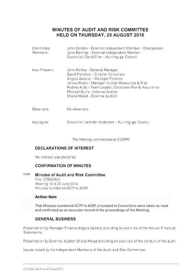
GB.2 Audit and Risk Committee Minutes 134
File: CY00458/4
To provide Council with a copy of the Minutes from the meetings of the Audit and Risk Committee held in August 2016.
Recommendation:
Council receives and notes the Report.
GB.3 2016 - 2017 Budget Review - 1st Quarter ended September 2016 140
File: S09112/5
To inform Council of the results of the 1st quarter budget review of 2016/17 and seek approval to adjust the annual budget based on the actual financial performance and trend for the period 1 July 2016 to 30 September 2016.
Recommendation:
That Council receive and note the September 2016 Quarterly Budget Review and that the recommended changes to the 2016/17 Budget be adopted.
GB.4 Investment Report as at 31 October 2016 188
File: S05273
To present Council’s investment portfolio performance for October 2016.
Recommendation:
That the summary of investments performance for October 2016 be received and noted; and that the Certificate of the Responsible Accounting Officer be noted and report adopted.
GB.5 Analysis of Land and Environment Court Costs - 1st Quarter 2016 to 2017 197
File: S05273
To report legal costs in relation to development control matters in the Land and Environment Court for the quarter ended 30 September 2016.
Recommendation:
That the analysis of Land and Environment Court costs for the quarter ended 30 September 2016 be received and noted.
GB.6 Christmas/New Year Recess Delegations 2016/2017 209
File: CY00259/8
To grant appropriate Delegations during the Christmas/New Year recess period for 2016/2017.
Recommendation:
The appropriate Delegations of Authority be granted to the Mayor, Deputy Mayor and the General Manager for the Christmas/New Year recess period for 2016/2017.
GB.7 Taldumande Youth Services 2017 Charity Dinner 213
File: CY00043/8
To inform Councillors of the Taldumande Youth Services 2017 Charity Dinner being held on 22 March 2017 at Luna Park, Sydney.
Recommendation:
That Council consider the invitation to purchase tickets for the 2017 Taldumande Youth Services Charity Dinner.
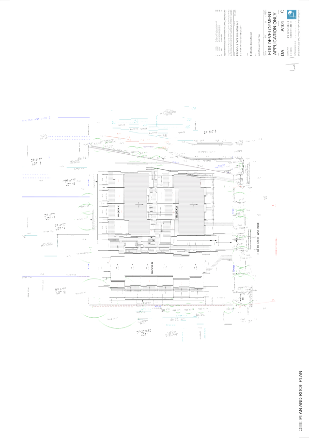
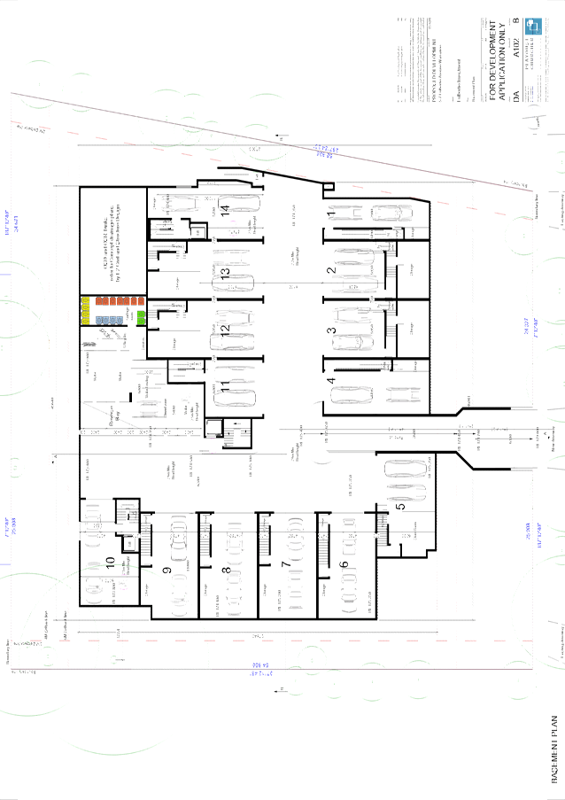
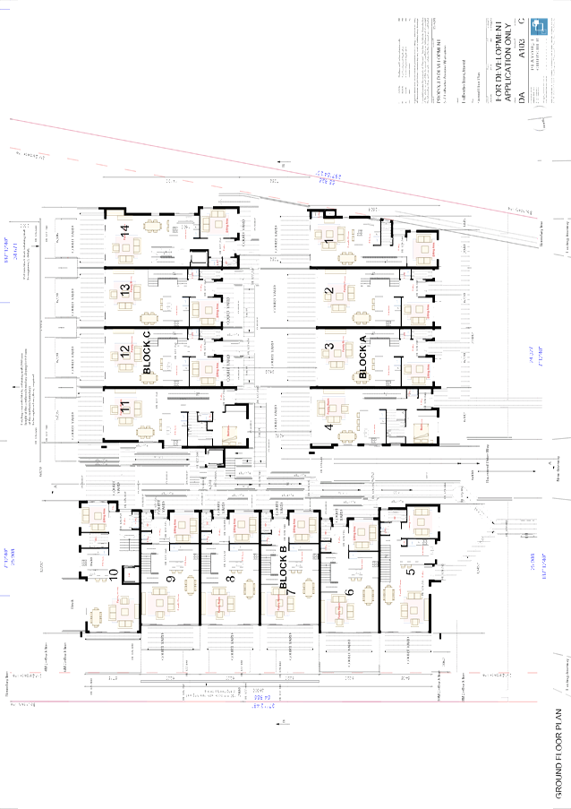
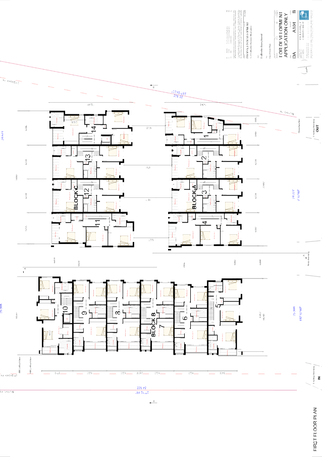
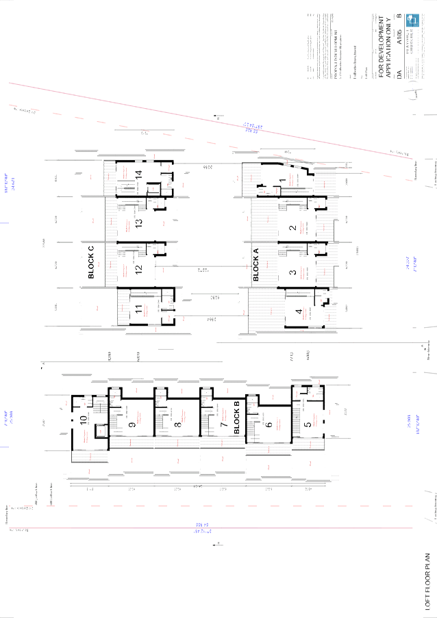
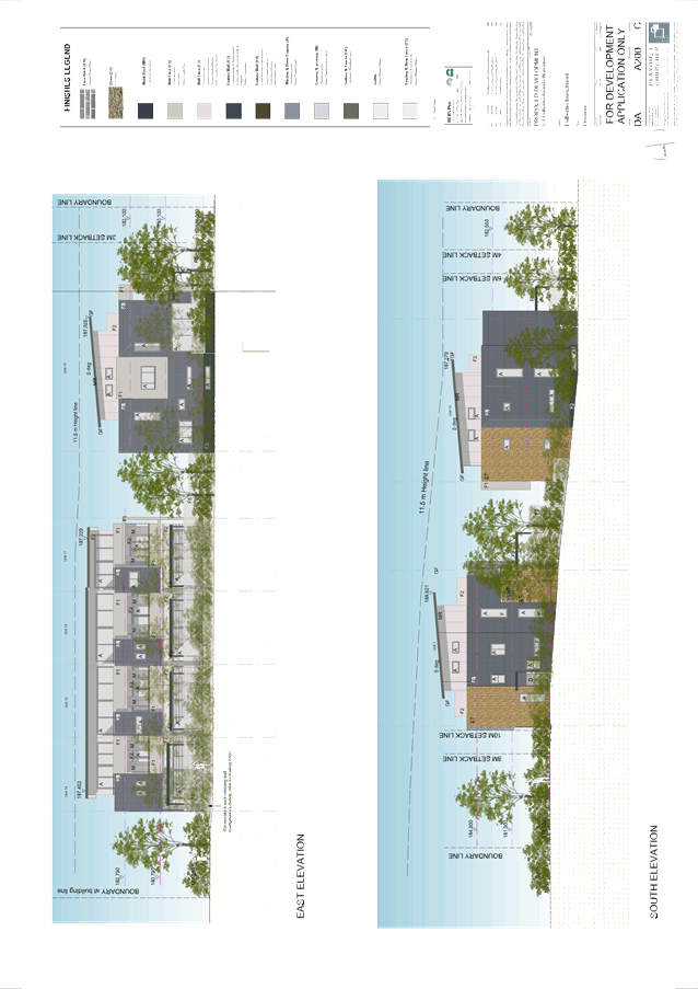
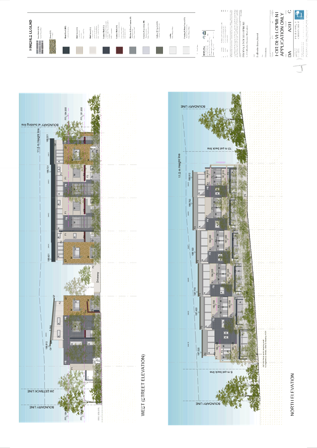
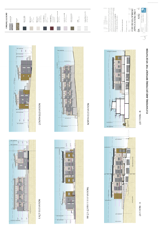
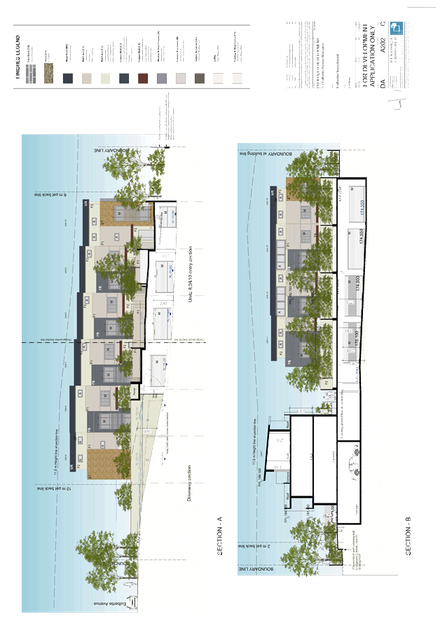
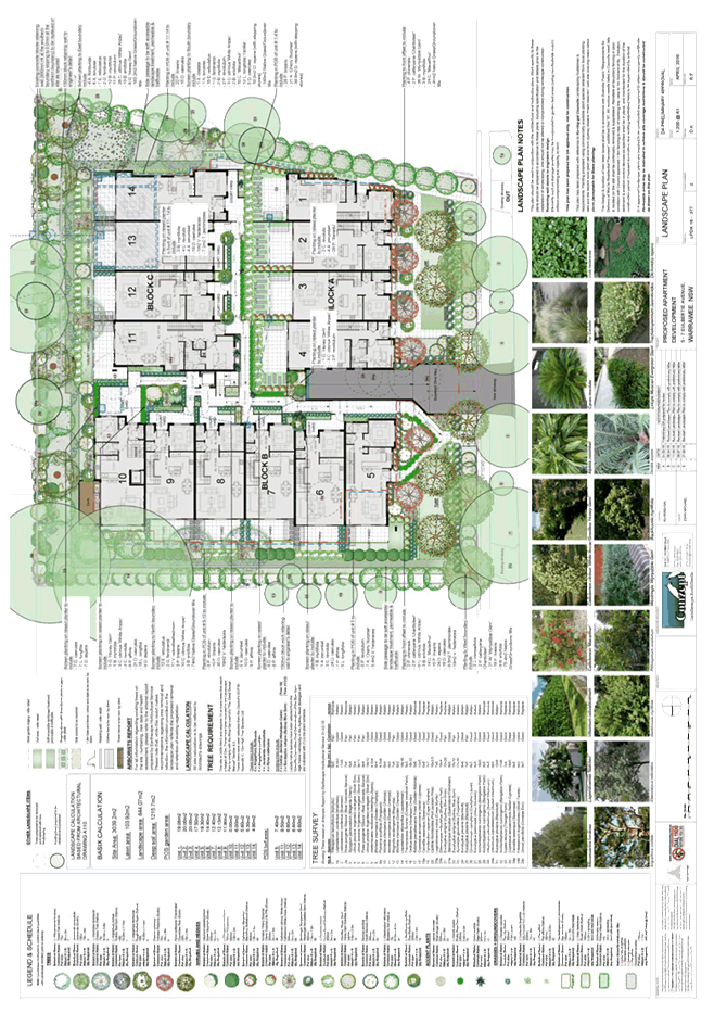
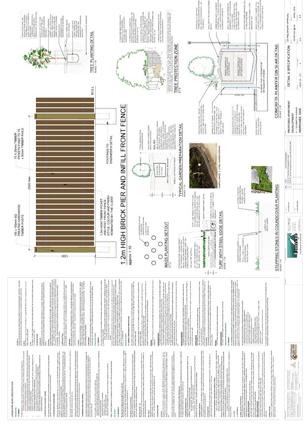
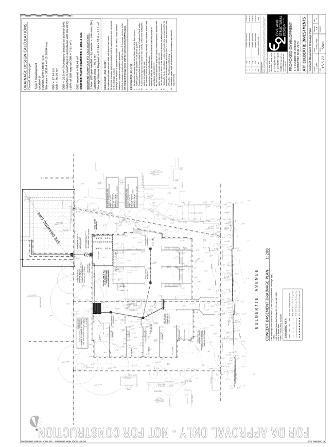
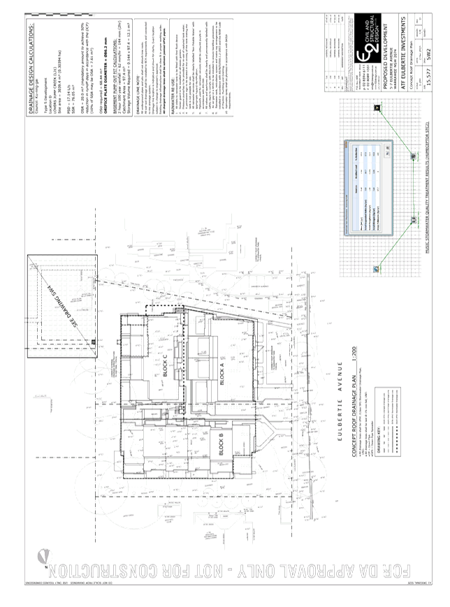
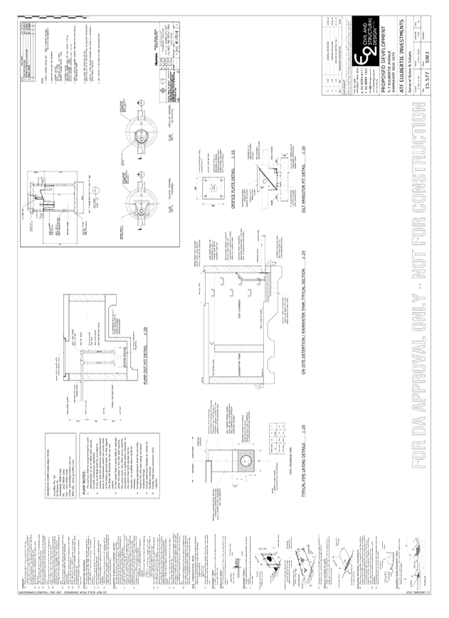
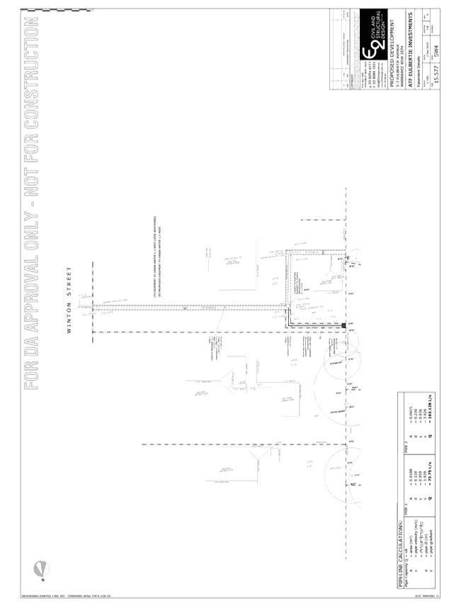
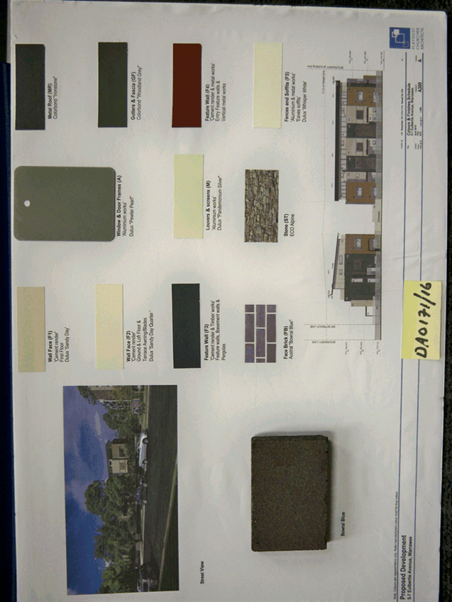
GB.8 DA0171/16 5 - 7 Eulbertie Avenue, Warrawee - demolition of existing structures and construction of 14 townhouses and basement car park 216
File: DA0171/16
Ward: Wahroonga
Applicant: Eulbertie Investments Pty Ltd
Owner: P & S Brereton and D & R Cains
Demolition of existing structures and construction of 14 townhouses, basement car park and site landscaping works
Recommendation:
Approval
GB.9 Update Report on the Development Contributions System 309
File: S06785/3
The purpose of this report is to provide Council with an overview of key activities and highlights in the development contributions system over the past six months and anticipated actions and highlights for the coming twelve months.
Recommendation:
That the information in the report be received and noted.
That Ku-ring-gai s94A Contributions Plan 2015 be amended in the manner discussed in the report, exhibited and reported back to Council for adoption after the exhibition period.
GB.10 Gordon Hub Master Plan - Update 325
File: S10376
To seek Council approval to re-commence the master planning process for a Cultural Hub in Gordon.
Recommendation:
That Council resolves to re-commence the master planning process for a Cultural Hub in Gordon.
GB.11 Correction to Schedule 5 of KLEP 2015 342
File: S10051
For Council to consider amendments to Schedule 5 of the KLEP 2015 to correct erroneous heritage listings.
Recommendation:
That Council prepare a Planning Proposal to amend Schedule 5 of the KLEP 2015 to correct erroneous listings.
Extra Reports Circulated to Meeting
BUSINESS WITHOUT NOTICE – SUBJECT TO CLAUSE 241 OF GENERAL REGULATIONS
Questions Without Notice
Inspections Committee – SETTING OF TIME, DATE AND RENDEZVOUS
Confidential Business to be dealt with in Closed Meeting
C.1 Ku-ring-gai Fitness & Aquatic Centre - Legal proceedings update
File: S10420
In accordance with the Local Government Act 1993 and the Local Government (General) Regulation 2005, in the opinion of the General Manager, the following business is of a kind as referred to in section 10A(2)(g), of the Act, and should be dealt with in a part of the meeting closed to the public.
Section 10A(2)(g) of the Act permits the meeting to be closed to the public for business relating to advice concerning litigation, or advice that would otherwise be privileged from production in legal proceedings on the ground of legal professional privilege.
This matter is classified confidential under section 10A(2)(g) because it contains advice concerning a legal matter that:
(a) is a substantial issue relating to a matter in which the Council is involved
(b) is clearly identified in the advice, and
(c) is fully discussed in that advice.
It is not in the public interest to release details of the legal advice as it would prejudice Council’s position in court proceedings.
Report by Manager Strategic Projects dated 31 October 2016
John McKee
General Manager
** ** ** ** ** **
Minute Ku-ring-gai Council Page
MINUTES
OF Ordinary Meeting of Council
HELD ON Tuesday, 8 November 2016
|
Present: |
The Mayor, Councillor J Anderson (Chairperson) Councillors E Malicki & J Pettett (Comenarra Ward) Councillors C Szatow & D Citer (Gordon Ward) Councillors C Berlioz & D Ossip (St Ives Ward) Councillor D Armstrong (Roseville Ward) Councillors C Fornari-Orsmond & D McDonald (Wahroonga Ward) |
|
|
|
|
Staff Present: |
General Manager (John McKee) Director Corporate (David Marshall) Director Development & Regulation (Michael Miocic) Director Operations (Greg Piconi) Director Strategy & Environment (Andrew Watson) Director Community (Janice Bevan) Corporate Lawyer (Jamie Taylor) Manager Urban & Heritage Planning (Antony Fabbro) Acting Manager Corporate Communications (Sally Williams) Manager Records and Governance (Amber Moloney) Minutes Secretary (Christine Dunand) |
The Meeting commenced at 7:00 pm
The Mayor offered the Prayer
DECLARATIONS OF INTEREST
The Mayor adverted to the necessity for Councillors and staff to declare a Pecuniary Interest/Conflict of Interest in any item on the Business Paper.
Cr Ossip declared no conflict of interest in respect to item GB.6 Roads Act Application for the purpose of Creating an Eruv in St Ives. Cr Ossip, however, advised that an email, which had been sent to all Councillors, came from an individual who made a financial donation to his campaign four and a half (4.5) years ago, the donation was small in nature and comprised of a very small proportion of the total funds expended during his campaign.
Secondly, Cr Ossip advised he does not live within the boundaries of the eruv, nor does any of his family members or close associates, and they do not stand to benefit should the eruv be approved.
Cr Ossip remained in the Chamber during the debate.
Address the Council
The following member of the public addressed Council on items not on the agenda:
J Harwood 21st Century Decision Making - Sheldon Forest
DOCUMENTS CIRCULATED TO COUNCILLORS
The Mayor adverted to the documents circulated in the Councillors’ papers and advised that the following matters would be dealt with at the appropriate time during the meeting:
|
Late Councillors Information: |
GB.3 – Council Meeting Cycle for 2017 Memorandum from Director Corporate dated 8 November 2016 advising a typographical error in Part B. of the Recommendation.
GB.6 – Roads Act Application for the purpose of Creating an Eruv in St Ives Memorandum from Director Operations dated 8 November 2016 advising a proposed recommendation. |
|
295 |
CONFIRMATION
OF REPORTS TO BE CONSIDERED IN CLOSED MEETING File: S02499/9
|
|
|
Resolved:
(Moved: Councillors McDonald/Szatow)
That in accordance with the provisions of Section 10 of the Local Government Act 1993, all officers’ reports be released to the press and public, with the exception of confidential attachments to the following General Business reports:
GB.5 Tender T16/2016 - Turramurra Memorial Park Amenities Upgrades Attachment A1: Tender Assessment and Recommendation Report In accordance with 10A2(d)(iii) Attachment A2: Tender Evaluation Panel Summary In accordance with 10A2(d)(iii) Attachment A3: Independent Performance & Financial Assessment In accordance with 10A2(d)(iii) Attachment A4: Additional financial Assessment In accordance with 10A2(d)(iii)
CARRIED UNANIMOUSLY |
CONFIRMATION OF MINUTEs
|
296 |
Minutes of Ordinary Meeting of Council File: S02131
|
|
|
Meeting held 25 October 2016 Minutes numbered 280 to 294
|
|
|
Resolved:
(Moved: Councillors Fornari-Orsmond/McDonald)
That Minutes numbered 280 to 294 circulated to Councillors were taken as read and confirmed as an accurate record of the proceedings of the Meeting.
CARRIED UNANIMOUSLY |
GENERAL BUSINESS
|
297 |
Environmental Levy Small Grants Scheme - Round 18
File: S04553/12 Vide: GB.2
|
|
|
To seek Council’s endorsement to fund round eighteen (18) of the Environmental Levy’s Community Small Grants Scheme.
|
|
|
Resolved:
(Moved: Councillors Citer/Pettett)
That Council supports the recommendation of the small grants assessment panel to fund sixteen (16) projects under round eighteen (18) of the Environmental Levy Community Small Grants Scheme, totalling $47,654.
CARRIED UNANIMOUSLY |
|
298 |
Council Meeting Cycle for 2017
File: CY00438/4 Vide: GB.3
|
||||||||||||||||||||||||||||||||||||||||||||||||||||||||||||
|
|
To consider the Council Meeting Cycle for 2017 which takes into account school holidays, public holidays and the Christmas recess.
|
||||||||||||||||||||||||||||||||||||||||||||||||||||||||||||
|
|
Resolved:
(Moved: Councillors Citer/Armstrong)
A. That the proposed scheduled meeting cycle for 2017 is as follows:
For 2018: B. That the first meeting of 2018 be held on Tuesday, 6 February 2018 with the normal meeting cycle to resume on Tuesday, 27 February 2018.
CARRIED UNANIMOUSLY |
|
299 |
Tender T16/2016 - Turramurra Memorial Park Amenities Upgrades
File: S11232 Vide: GB.5
|
|
|
To consider the tenders received for the upgrading of the existing brick and tile amenity and construction of a new interconnecting toilet which is compliant with the Disability Discrimination Act (DDA), and appoint the preferred tenderer.
|
|
|
Resolved:
(Moved: Councillors Citer/McDonald)
A. That Council accept the tender submission from Tenderer ‘A’ for the upgrade of existing amenities and construction of a new toilet complaint with the Disability Discrimination Act at Turramurra Memorial Park.
B. That the Mayor and General Manager be delegated authority to execute all tender documentation on Council’s behalf in relation to the contract.
C. That the Seal of Council be affixed to the contract documents.
D. That all tenderers be advised of Council’s decision in accordance with Clause 178 of the Local Government Tendering Regulations.
CARRIED UNANIMOUSLY |
|
300 |
Consideration of submissions on the planning proposal to list 24 Dudley Avenue Roseville as a heritage item
File: S11058 Vide: GB.1
|
|
|
For Council to consider the submissions received during the public exhibition of the Planning Proposal to list 24 Dudley Avenue, Roseville as a local heritage item.
The following members of the public addressed Council on this matter:
C Kyprianou P Kyprianou S Kyprianou
|
|
|
Resolved:
(Moved: Councillors Anderson/Szatow)
A. That the Planning Proposal to list the property known as ‘Ambleside’ at 24 Dudley Avenue, Roseville as a local heritage item under the Ku-ring-gai Local Environmental Plan 2015 proceed without variation.
B. That Council proceeds to make the Plan, using its delegated authority, under Section 59(2) of the Environmental Planning & Assessment Act 1979.
C. That those who made submissions be notified of Council’s decision.
For the Resolution: The Mayor, Councillor Anderson, Councillors , McDonald, Malicki, Berlioz and Szatow
Against the Resolution: Councillors Citer, Pettett, Armstrong, Fornari-Orsmond and Ossip
The voting being EQUAL, the Mayor exercised her Casting Vote IN FAVOUR of the Resolution
The above Resolution was subject to an Original
Motion which was LOST. The Lost Original Motion was: (Moved: Councillors Armstrong/Szatow)
A. That the Planning Proposal to list the property known as ‘Ambleside’ at 24 Dudley Avenue, Roseville as a local heritage item under the Ku-ring-gai Local Environmental Plan 2015 be refused.
B. That those who made submissions be notified of Council’s decision.
For the Motion: Councillors Citer, Pettett, Armstrong, Fornari-Orsmond and Ossip
Against the Motion: The Mayor, Councillor Anderson, Councillors McDonald, Malicki, Berlioz and Szatow
The voting being EQUAL, the Mayor exercised her Casting Vote AGAINST of the Motion
Councillor
McDonald moved a Procedural Motion asking the Mayor to seek a vote on the
matter as there had been 2 speakers For and 2 Against. For the Procedural Motion: Councillors Citer, McDonald, Pettett, Malicki, Berlioz, Szatow, Fornari-Orsmond and Ossip
Against the Procedural Motion: The Mayor, Councillor Anderson and Councillor Armstrong
|
Councillor Citer withdrew during discussion
Councillor Citer returned
|
301 |
12 Rutland Place, North Wahroonga- Two lot sub-division and associated civil works.
File: DA0064/16 Vide: GB.4
|
||||||||||||||||||||||||||||||||||||||||||
|
|
Proposed two lot subdivision and associated civil works
The following members of the public addressed Council on this matter:
D Underwood C Morris
|
||||||||||||||||||||||||||||||||||||||||||
|
|
Resolved:
(Moved: Councillors McDonald/Fornari-Orsmond)
THAT Council, as the consent authority, being satisfied that the proposed development will be in the public interest, grant deferred development consent to DA0064/16 for a two lot subdivision and associated civil works at 12 Rutland Place, North Wahroonga for a period of two (2) years from the date on which the consent becomes operable.
SCHEDULE A: Deferred Commencement - Term to be satisfied prior to the consent becoming operable
The following deferred commencement term must be complied with to the satisfaction of Council within 24 months of the date of issue of this deferred commencement consent.
A. Drainage easement (deferred commencement)
The applicant shall submit documentary evidence that the property benefits from a registered drainage easement. This consent will not operate until the documentary evidence has been submitted to and approved by Council’s Development Engineer. This documentation must include evidence that the easement has been registered with NSW land and Property Information.
Reason: To ensure that provision is made for stormwater drainage from the site in a proper manner that protects adjoining properties.
Once the consent becomes operable, the conditions in Schedule B will apply. Upon written receipt from Council that the demonstrated condition in Schedule A has been satisfied, the following conditions will apply:
SCHEDULE B: Conditions of consent:-
Conditions that identify approved plans:
1. Approved architectural plans and documentation (new development)
The development must be carried out in accordance with the following plans and documentation listed below and endorsed with Council’s stamp, except where amended by other conditions of this consent:
Reason: To ensure that the development is in accordance with the determination.
2. Inconsistency between documents
In the event of any inconsistency between conditions of this consent and the drawings/documents referred to above, the conditions of this consent prevail.
Reason: To ensure that the development is in accordance with the determination.
Conditions to be satisfied prior to demolition, excavation or construction:
3. Project arborist
A project Arborist shall be commissioned prior to any works occurring on site to ensure all tree protection measures are carried out in accordance with the conditions of consent.
The project arborist shall have a minimum AQF Level 5 qualification with a minimum of 5 years’ experience. Details of the arborist including name, business name and contact details shall be provided to the Principal Certifying Authority with a copy to Council.
Reason: To ensure the protection of existing trees
4. Asbestos works
All work involving asbestos products and materials, including asbestos-cement-sheeting (ie. Fibro), must be carried out in accordance with the guidelines for asbestos work published by WorkCover Authority of NSW.
Reason: To ensure public safety
5. Nest boxes
Prior to works commencing and/or tree removal works being undertaken four nest boxes comprising of (2 microbat & 1 small mammal shall be installed within retained trees within the site. The nest boxes shall be constructed of durable wood material (marine ply) and installed at a minimum height of 6 metres from the ground and positioned under the direction of a qualified ecologist.
The qualified ecologist must hold an Animal Ethics Permit from the Office of Environment & Heritage and a wildlife licence under section 132C of the National Parks and Wildlife Act 1974 <http://www.legislation.nsw.gov.au/viewtop/inforce/act+80+1974+first+0+N> issued by the Office of Environment and Heritage.
Reason: To ensure protection of fauna species which could be potentially displaced by the removal of a trees/native vegetation.
6. Fauna protection
Prior to works commencing and/or tree removal works a qualified ecologist shall investigate trees for fauna occupation. In accordance with appropriate licensing requirements the ecologist shall supervise the relocation of any fauna found within the trees approved for removal into installed nest boxes.
The qualified ecologist must hold an Animal Ethics Permit from the Office of Environment & Heritage and a wildlife licence <http://www.environment.nsw.gov.au/wildlifelicences/ScientificResearchLicences.htm> under section 132C of the National Parks and Wildlife Act 1974 <http://www.legislation.nsw.gov.au/viewtop/inforce/act+80+1974+first+0+N> issued by the Office of Environment and Heritage.
Evidence of engagement of the qualified ecologist and the required licensing must be provided to the Private Certifying Authority with a copy to Council prior to the trees being removed.
Reason: To ensure protection of fauna species.
7. Tree identification
Prior to works commencing the existing trees shall be numbered in accordance with the arborists report and/or the approved plans. Trees shall be clearly tagged with confirmation from the project arborist that all marked trees correspond with those shown on the approved plan.
Reason: To protect existing trees during the construction phase.
8. Notice of commencement
At least 48 hours prior to the commencement of any development (including demolition, excavation, shoring or underpinning works), a notice of commencement of building or subdivision work form and appointment of the principal certifying authority form shall be submitted to Council.
Reason: Statutory requirement.
9. Sediment controls
Prior to any work commencing on site, sediment and erosion control measures shall be installed along the contour immediately downslope of any future disturbed areas.
The form of the sediment controls to be installed on the site shall be determined by reference to the Landcom manual ‘Managing Urban Stormwater: Soils and Construction’. The erosion controls shall be maintained in an operational condition until the development activities have been completed and the site fully stabilised. Sediment shall be removed from the sediment controls following each heavy or prolonged rainfall period.
Reason: To preserve and enhance the natural environment.
10. Erosion and drainage management
Earthworks and/or demolition of any existing buildings shall not commence until an erosion and sediment control plan is submitted to and approved by the Principal Certifying Authority. The plan shall comply with the guidelines set out in the NSW Department of Housing manual "Managing Urban Stormwater: Soils and Construction" certificate. Erosion and sediment control works shall be implemented in accordance with the erosion and sediment control plan.
Reason: To preserve and enhance the natural environment.
11. Trunk and branch protection
To preserve the following tree/s, no work shall commence until the trunk/s and branches are protected by the placement of 50 x 100mm timbers over suitable protective padding material in accordance with Section 4.5.2 of AS4970-2009. The trunk and branch protection shall be maintained intact until the completion of all work on site.
Any damage to the tree/s shall be treated immediately by an experienced Horticulturist/Arborist, with a minimum AQF Level 3 qualification and a report detailing the works carried out shall be submitted to the Principal Certifying Authority:
Reason: To protect existing trees during the construction phase.
12. Tree protection measures inspection
Upon installation of the required tree protection measures, an inspection of the site by the project arborist and/or the Principal Certifying Authority is required to verify that tree protection measures comply with all relevant conditions.
Reason: To protect existing trees during the construction phase.
13. Construction waste management plan
Prior to the commencement of any works, the Principal Certifying Authority shall be satisfied that a waste management plan, prepared by a suitably qualified person, has been prepared in accordance with Council’s Waste Management controls in the Ku-ring-gai Development Control Plan (KDCP).
The plan shall address all issues identified in Part 24 of the KDCP, including but not limited to: the estimated volume of waste and method for disposal for the construction and operation phases of the development.
Note: The plan shall be provided to the Certifying Authority.
Reason: To ensure appropriate management of construction waste.
14. Marking of trees to be removed
All trees that are to be removed within the development area, are to be clearly marked on site by the Project Arborist in accordance with the approved plans. All other trees are to be retained.
Reason: To protect existing trees during the construction phase.
Conditions to be satisfied prior to the issue of the construction certificate:
15. Civil design drawings
Prior to issue of the Construction Certificate, the applicant must submit, for approval by the Principal Certifying Authority, structural design details of the driveway access and associated retaining walls to proposed Lot 21. The driveway design and details of the retaining wall is to be prepared by a qualified civil engineer in accordance with AS2890.1:2004 'Off-street car parking' and AS4678 'Earth Retaining Structures'.
Reason: To protect the environment and provide suitable vehicular access.
16. Amendments to approved engineering plans
Prior to the issue of a Construction Certificate, the Certifying Authority shall be satisfied that the approved engineering plan(s), listed below and endorsed with Council’s stamp, have been amended in accordance with the requirements of this condition as well as other conditions of this consent:
The above engineering plan shall be amended as follows:
· To preserve T31 - Angophora costata (Sydney Red Gum) Pit B1 and the connecting pipe between Pit B1and Pit A5 are to be deleted · All trees are to be numbered in accordance with the approved Survey Plan by Mepstead & Associates Project no. 5401-SUB1 Revision D, dated 5 August 2016
The above amendments are required to ensure compliance with the following:
· Australian Standard 2890.1- “Off-street car parking”. · Ku-ring-gai Council Water Management Development Control Plan 47. · To preserve trees protected under the Council’s Tree Preservation Order and as specified in other conditions of consent.
Note: An amended engineering plan, prepared by a qualified engineer and endorsed by the Project Arborist, shall be submitted to the Certifying Authority.
Reason: To ensure that the development is in accordance with the determination.
Conditions to be satisfied prior to the issue of the construction certificate or prior to demolition, excavation or construction (whichever comes first):
17. Infrastructure damage security bond and inspection fee
To ensure that any damage to Council property as a result of construction activity is rectified in a timely matter:
(a) All work or activity undertaken pursuant to this development consent must be undertaken in a manner to avoid damage to Council property and must not jeopardise the safety of any person using or occupying the adjacent public areas.
(b) The applicant, builder, developer or any person acting in reliance on this consent shall be responsible for making good any damage to Council property and for the removal from Council property of any waste bin, building materials, sediment, silt, or any other material or article.
(c) The Infrastructure damage security bond and infrastructure inspection fee must be paid to Council by the applicant prior to both the issue of the Construction Certificate and the commencement of any earthworks or construction.
(d) In consideration of payment of the infrastructure damage security bond and infrastructure inspection fee, Council will undertake such inspections of Council Property as Council considers necessary and will also undertake, on behalf of the applicant, such restoration work to Council property, if any, that Council considers necessary as a consequence of the development. The provision of such restoration work by the Council does not absolve any person of the responsibilities contained in (a) to (b) above. Restoration work to be undertaken by Council referred to in this condition is limited to work that can be undertaken by Council at a cost of not more than the Infrastructure damage security bond payable pursuant to this condition.
(e) In this condition:
“Council property” includes any road, footway, footpath paving, kerbing, guttering, crossings, street furniture, seats, letter bins, trees, shrubs, lawns, mounds, bushland, and similar structures or features on any road or public road within the meaning of the Local Government Act 1993 (NSW) or any public place; and
“Infrastructure damage security bond and infrastructure inspection fee” means the Infrastructure damage security bond and infrastructure inspection fee as calculated in accordance with the Schedule of Fees & Charges adopted by Council as at the date of payment and the cost of any inspections required by the Council of Council property associated with this condition.
Reason: To maintain public infrastructure.
18. Section 94 development contributions - other than identified centres (For DAs determined on or after 19 December 2010).
This development is subject to a development contribution calculated in accordance with Ku-ring-gai Contributions Plan 2010, being a s94 Contributions Plan in effect under the Environmental Planning and Assessment Act, as follows:
The contribution shall be paid to Council prior to the issue of any Construction Certificate, Linen Plan, Certificate of Subdivision or Occupation Certificate whichever comes first in accordance with Ku-ring-gai Contributions Plan 2010.
The contributions specified above are subject to indexation and may vary at the time of payment in accordance with Ku-ring-gai Contributions Plan 2010 to reflect changes in the consumer price index and housing price index. Prior to payment, please contact Council directly to verify the current payable contributions.
Copies of Council’s Contribution Plans can be viewed at Council Chambers, 818 Pacific Hwy Gordon or on Council’s website at www.kmc.nsw.gov.au.
Contributions outside the designated centres may be subject to a maximum contribution total in accordance with the s94E Direction issued by the Minister for Planning dated 21 August 2012, for so long as it remains legally in force. If the total amount above is an exact multiple of $20,000 then the contributions calculated in accordance with Ku-ring-gai Contributions Plan 2010 exceeded the maximum contribution payable and have been capped. If the process of inflation carries the contribution above over the maximum amount permitted by the s94E Direction prior to payment, the amount will be limited at time of receipt. Please contact Council to verify the total contributions payable prior to payment.
Reason: To ensure the provision, extension or augmentation of the Key Community Infrastructure identified in Ku-ring-gai Contributions Plan 2010 that will, or is likely to be, required as a consequence of the development.
Conditions to be satisfied during the demolition, excavation and construction phases:
19. Road opening permit
The opening of any footway, roadway, road shoulder or any part of the road reserve shall not be carried out without a road opening permit being obtained from Council (upon payment of the required fee) beforehand.
Reason: Statutory requirement (Roads Act 1993 Section 138) and to maintain the integrity of Council’s infrastructure.
20. Prescribed conditions
The applicant shall comply with any relevant prescribed conditions of development consent under clause 98 of the Environmental Planning and Assessment Regulation. For the purposes of section 80A (11) of the Environmental Planning and Assessment Act, the following conditions are prescribed in relation to a development consent for development that involves any building work:
· The work must be carried out in accordance with the requirements of the Building Code of Australia · In the case of residential building work for which the Home Building Act 1989 requires there to be a contract of insurance in force in accordance with Part 6 of that Act, that such a contract of insurance is in force before any works commence.
Reason: Statutory requirement.
21. Hours of work
Demolition, construction work and deliveries of building material and equipment must not take place outside the hours of 7.00am to 5.00pm Monday to Friday and 8.00am to 12 noon Saturday. No work and no deliveries are to take place on Sundays and public holidays.
Excavation using machinery must be limited to between 7.00am and 5.00pm Monday to Friday, with a respite break of 45 minutes between 12 noon and 1.00pm. No excavation using machinery is to occur on Saturdays, Sundays or public holidays.
Where it is necessary for works to occur outside of these hours (ie) placement of concrete for large floor areas on large residential/commercial developments or where building processes require the use of oversized trucks and/or cranes that are restricted by the RTA from travelling during daylight hours to deliver, erect or remove machinery, tower cranes, pre-cast panels, beams, tanks or service equipment to or from the site, approval for such activities will be subject to the issue of an "outside of hours works permit" from Council as well as notification of the surrounding properties likely to be affected by the proposed works.
Note: Failure to obtain a permit to work outside of the approved hours will result in on the spot fines being issued.
Reason: To ensure reasonable standards of amenity for occupants of neighbouring properties.
22. Approved plans to be on site
A copy of all approved and certified plans, specifications and documents incorporating conditions of consent and certification (including the Construction Certificate if required for the work) shall be kept on site at all times during the demolition, excavation and construction phases and must be readily available to any officer of Council or the Principal Certifying Authority.
Reason: To ensure that the development is in accordance with the determination.
23. Site notice
A site notice shall be erected on the site prior to any work commencing and shall be displayed throughout the works period.
The site notice must:
· be prominently displayed at the boundaries of the site for the purposes of informing the public that unauthorised entry to the site is not permitted · display project details including, but not limited to the details of the builder, Principal Certifying Authority and structural engineer · be durable and weatherproof · display the approved hours of work, the name of the site/project manager, the responsible managing company (if any), its address and 24 hour contact phone number for any inquiries, including construction/noise complaint are to be displayed on the site notice · be mounted at eye level on the perimeter hoardings/fencing and is to state that unauthorised entry to the site is not permitted
Reason: To ensure public safety and public information.
24. Dust control
During excavation, demolition and construction, adequate measures shall be taken to prevent dust from affecting the amenity of the neighbourhood. The following measures must be adopted:
· physical barriers shall be erected at right angles to the prevailing wind direction or shall be placed around or over dust sources to prevent wind or activity from generating dust · earthworks and scheduling activities shall be managed to coincide with the next stage of development to minimise the amount of time the site is left cut or exposed · all materials shall be stored or stockpiled at the best locations · the ground surface should be dampened slightly to prevent dust from becoming airborne but should not be wet to the extent that run-off occurs · all vehicles carrying spoil or rubble to or from the site shall at all times be covered to prevent the escape of dust · all equipment wheels shall be washed before exiting the site using manual or automated sprayers and drive-through washing bays · gates shall be closed between vehicle movements and shall be fitted with shade cloth · cleaning of footpaths and roadways shall be carried out daily
Reason: To protect the environment and amenity of surrounding properties.
25. Use of road or footpath
During excavation, demolition and construction phases, no building materials, plant or the like are to be stored on the road or footpath without written approval being obtained from Council beforehand. The pathway shall be kept in a clean, tidy and safe condition during building operations. Council reserves the right, without notice, to rectify any such breach and to charge the cost against the applicant/owner/builder, as the case may be.
Reason: To ensure safety and amenity of the area.
26. Guarding excavations
All excavation, demolition and construction works shall be properly guarded and protected with hoardings or fencing to prevent them from being dangerous to life and property.
Reason: To ensure public safety.
27. Protection of public places
If the work involved in the erection, demolition or construction of the development is likely to cause pedestrian or vehicular traffic in a public place to be obstructed or rendered inconvenient, or building involves the enclosure of a public place, a hoarding or fence must be erected between the work site and the public place.
If necessary, a hoarding is to be erected, sufficient to prevent any substance from, or in connection with, the work falling into the public place.
The work site must be kept lit between sunset and sunrise if it is likely to be hazardous to persons in the public place.
Any hoarding, fence or awning is to be removed when the work has been completed.
Reason: To protect public places.
28. Road reserve safety
All public footways and roadways fronting and adjacent to the site must be maintained in a safe condition at all times during the course of the development works. Construction materials must not be stored in the road reserve. A safe pedestrian circulation route and a pavement/route free of trip hazards must be maintained at all times on or adjacent to any public access ways fronting the construction site. Where public infrastructure is damaged, repair works must be carried out when and as directed by Council officers. Where pedestrian circulation is diverted on to the roadway or verge areas, clear directional signage and protective barricades must be installed in accordance with AS1742-3 (1996) “Traffic Control Devices for Work on Roads”. If pedestrian circulation is not satisfactorily maintained across the site frontage, and action is not taken promptly to rectify the defects, Council may undertake proceedings to stop work.
Reason: To ensure safe public footways and roadways during construction.
29. Services
Where required, the adjustment or inclusion of any new utility service facilities must be carried out by the applicant and in accordance with the requirements of the relevant utility authority. These works shall be at no cost to Council. It is the applicants’ full responsibility to make contact with the relevant utility authorities to ascertain the impacts of the proposal upon utility services (including water, phone, gas and the like). Council accepts no responsibility for any matter arising from its approval to this application involving any influence upon utility services provided by another authority.
Reason: Provision of utility services.
30. Erosion control
Temporary sediment and erosion control and measures are to be installed prior to the commencement of any works on the site. These measures must be maintained in working order during construction works up to completion. All sediment traps must be cleared on a regular basis and after each major storm and/or as directed by the Principal Certifying Authority and Council officers.
Reason: To protect the environment from erosion and sedimentation.
31. Drainage to drainage easement
Stormwater runoff from all new impervious areas and subsoil drainage systems shall be piped and connected to the piped Council drainage system within the site. Drainage line connections to the system shall conform and comply with the relevant detail in Council's Plan No82/024 ("Connections of Drainage Lines to Kerb and R.C. Pipe") and in the Ku-ring-gai Development Control Plan.
Reason: To protect the environment.
32. Sydney Water Section 73 Compliance Certificate
The applicant must obtain a Section 73 Compliance Certificate under the Sydney Water Act 1994. An application must be made through an authorised Water Servicing Co-ordinator. The applicant is to refer to “Your Business” section of Sydney Water’s web site at www.sydneywater.com.au then the “e-develop” icon or telephone 13 20 92. Following application a “Notice of Requirements” will detail water and sewer extensions to be built and charges to be paid. Please make early contact with the Co-ordinator, since building of water/sewer extensions can be time consuming and may impact on other services and building, driveway or landscape design.
Reason: Statutory requirement.
33. Arborist’s report
The tree/s to be retained shall be inspected and monitored by an AQF Level 5 Arborist in accordance with AS4970-2009 during and after completion of development works to ensure their long term survival. Regular inspections and documentation from the project arborist to the Principal Certifying Authority are required at the following times or phases of work including date, brief description of the works inspected, and any mitigation works prescribed.
All monitoring shall be provided to the Principal Certifying Authority prior to issue of the Occupation Certificate.
· All works as recommended by the project arborist are to be undertaken by an experienced arborist with a minimum AQF Level 3 qualification.
Reason: To ensure protection of existing trees.
34. Treatment of tree roots
If tree roots are required to be severed for the purposes of constructing the approved works, they shall be cut cleanly by hand, by an experienced Arborist/Horticulturist with a minimum qualification of Horticulture Certificate or Tree Surgery Certificate. All pruning works shall be undertaken as specified in Australian Standard 4373-2007 – Pruning of Amenity Trees.
Reason: To protect existing trees.
35. Approved tree works
Prior to works commencing the following works shall be undertaken to the specified trees;
· All trees are to be clearly tagged and identified as per the arborist report prior to the removal/pruning of any tree/s on site. · Canopy and/or root pruning as specified in the following table shall be undertaken by an experienced Arborist/Horticulturist, with a minimum AQF Level 3 qualification · All root or canopy pruning works shall be undertaken as specified in AS 4373-2007 - Pruning of Amenity Trees. · All other branches where required shall be tied back and protected during construction, under the supervision of a qualified arborist
Removal or pruning of any other tree on the site is not approved, excluding species and works exempt under Council’s Tree Preservation Order.
Reason: To ensure that the development is in accordance with the determination.
36. No storage of materials beneath trees
No activities, storage or disposal of materials shall take place beneath the canopy of any tree protected under Council's Tree Preservation Order at any time.
Reason: To protect existing trees.
37. Removal of refuse
All builders' refuse, spoil and/or material unsuitable for use in landscape areas shall be removed from the site on completion of the building works.
Reason: To protect the environment.
38. On site retention of waste dockets
All demolition, excavation and construction waste dockets are to be retained on site, or at suitable location, in order to confirm which facility received materials generated from the site for recycling or disposal.
· Each docket is to be an official receipt from a facility authorised to accept the material type, for disposal or processing. · This information is to be made available at the request of an Authorised Officer of Council.
Reason: To protect the environment.
Conditions to be satisfied prior to the issue of a Subdivision certificate:
39. Certification of drainage works
Prior to issue of the Subdivision Certificate, the Principal Certifying Authority is to be satisfied that:
· the components of the new drainage system have been installed by a licensed contractor in accordance with the National Plumbing and Drainage Code AS3500.3 (2003) and the Building Code of Australia · the stormwater drainage works have been completed in accordance with the approved Construction Certificate drainage plans and Ku-ring-gai DCP Part 25
Note: Evidence from the plumbing contractor or a qualified civil/hydraulic engineer confirming compliance with this control is to be provided to Council prior to the issue of an Occupation Certificate.
Reason: To protect the environment.
40. Certification of as-constructed driveway
Prior to issue of a Subdivision Certificate, the Principal Certifying Authority is to be satisfied that the as-constructed driveway complies with the approved Construction Certificate plans and Australian Standard 2890.1 - 2004 “Off-Street car parking".
Note: Evidence from a suitably qualified and experienced traffic/civil engineer indicating compliance with the above is to be provided to and approved by the Principal Certifying Authority prior to the issue of a Final Certificate.
Reason: To ensure that vehicular access and accommodation areas are compliant with the consent.
41. Sydney Water Section 73 Compliance Certificate
Prior to release of the linen plan/issue of the subdivision certificate, the Section 73 Sydney Water compliance certificate which refers to the subdivision application must be obtained and submitted to the Council.
Reason: Statutory requirement.
42. Requirements of public authorities for connection to services
Prior to the issue of the Subdivision Certificate, the Principal Certifying Authority shall be satisfied that the applicant has complied with the requirements of any public authorities (e.g. Energy Australia, Sydney Water, Telstra Australia, AGL, etc) in regard to the connection, relocation and/or adjustment of the services affected by the proposed subdivision. All costs related to the relocation, adjustment or support of services are the responsibility of the applicant.
Note: Details of compliance with the requirements of any relevant public authorities are to be submitted to the Principal Certifying Authority.
Reason: To ensure that services are available to the allotments of land.
43. Infrastructure repair – subdivision works
Prior to issue of the Subdivision Certificate, any infrastructure within the road reserve along the frontage of the subject site or within close proximity, which has been damaged as a result of subdivision works, must be fully repaired to the satisfaction of Council’s Development Engineer and at no cost to Council.
Reason: To protect public infrastructure.
44. Provision of services
Prior to issue of the Subdivision Certificate, separate underground electricity, gas and phone or appropriate conduits for the same, must be provided to each allotment to the satisfaction of the utility provider. A suitably qualified and experienced engineer or surveyor is to provide certification that all new lots have ready underground access to the services of electricity, gas and phone. Alternatively, a letter from the relevant supply authorities stating the same may be submitted to satisfy this condition.
Reason: Access to public utilities.
45. Issue of Subdivision Certificate
The Subdivision Certificate must not be issued until all conditions of development consent have been satisfied and an Final Certificate has been issued by the Principal Certifying Authority.
Reason: To ensure that the development is completed prior to transfer of responsibility for the site and development to another person.
46. Submission of 88b instrument
Prior to the issue of the Subdivision Certificate, the applicant must submit an original instrument under Section 88B of the Conveyancing Act with the plan of subdivision, plus six (6) copies to Council. Ku-ring-gai Council must be named as the authority whose consent is required to release, vary or modify the burdens.
Reason: To create all required easements, rights-of-carriageway, positive covenants, restrictions-on-use or other burdens/benefits as may be required.
47. Submission of plans of subdivision (Torrens title)
For endorsement of the subdivision certificate, the applicant shall submit an original plan of subdivision plus 6 copies, suitable for endorsement by Council. The following details must be submitted with the plan of subdivision and its copies:
a) the endorsement fee current at the time of lodgement b) the 88B instrument plus 6 copies c) a copy of the Final Certificate issued for DA0064/16 d) all surveyor’s and/or consulting engineers’ certification(s) required under this subdivision consent e) The Section 73 (Sydney Water) Compliance Certificate for the subdivision. f) Proof of payment of S94 contribution
Council will check the consent conditions on the subdivision. Failure to submit the required information will delay endorsement of the linen plan and may require payment of rechecking fees. Plans and copies of subdivision must not be folded. Council will not accept bonds in lieu of completing subdivision works.
Reason: Statutory requirement.
48. General easement/R.O.W. provision and certification
Prior to issue of the Subdivision Certificate, a registered surveyor is to provide details to Council that all physical structures are fully contained within the proposed allotments or will be fully covered by the proposed burdens upon registration of the final plan of subdivision. Alternatively, where the surveyor is of the opinion that creation of burdens and benefits is not required, then proof to this effect must be submitted to the Principal Certifying Authority.
Reason: To ensure that all physical structures are fully contained within the proposed allotments or will be fully covered by the proposed burdens upon registration of the final plan of subdivision.
CONDITIONS TO BE SATISFIED AT ALL TIMES:
49. Trees to be retained
The trees as numbered on plan of subdivision 5401-SUB1_D (No. D) by Mepstead & Associates, dated 5/08/2016 are to be retained.
Reason: To maintain the existing landscape character and protect the environment
INTERGRATED REFERRAL CONDITIONS:
50. Rural Fire Service Asset Protection Zones The intent of measures is to minimise the risk of bush fire attack and provide protection for emergency services personnel, residents and others assisting firefighting activities. To achieve this, the following conditions shall apply:
1. At the issue of a subdivision certificate, and in perpetuity, the entire property shall be managed as an inner protection area (IPA) as outlined within section 4.1.3 Appendix 5 of 'Planning for Bush Fire Protection 2006' and the NSW Rural Fire Service's document 'Standards for asset protection zones'.
Water and utilities The intent of measures is to minimise the risk of bush fire attack and provide protection for emergency services personnel, residents and others assisting firefighting activities. To achieve this, the following conditions shall apply:
2. The provision of water, electricity and gas to the proposed lots shall comply with section 4.1.3 of 'Planning for Bush Fire Protection 2006'.
General advice The existing dwelling is recommended to be upgraded to improve ember protection. This is to be achieved by enclosing all openings (excluding roof tile spaces) or covering openings with a noncorrosive metal screen mesh with a maximum aperture of 2mm. Where applicable, this includes any sub floor areas, openable windows, vents, weepholes and eaves. External doors are to be fitted with draft excluders.
CARRIED UNANIMOUSLY |
|
302 |
Roads Act Application For The Purpose Of Creating An Eruv In St Ives
File: S11230 Vide: GB.6
|
|
|
Council has received a Roads Act Application for the placement of plastic conduits on power poles in various areas of St Ives for the purpose of creating an eruv
The following members of the public addressed Council on this matter:
J Bass M Gooley M Rosettenstein K Guthrie A Stucken B Connelly H Haber P Moate A Shephard E Gipps A Kellerman P Thomson L Moriah A Crawley M Kellahan I Howell (on behalf of K Calinan) L Cohen L Smith Y Miller D Warner
|
|
|
Resolved: (Moved: Councillors Fornari-Orsmond/Szatow) That approval is given to the Roads Act application for the placement of plastic conduits on the power poles agreed by Ausgrid as per the list attached to the memo circulated to Councillors dated 8th November 2016 and subject to the following conditions:
1. That the applicant is responsible for the ongoing maintenance of the conduits and compliance with Ausgrid’s standards and procedures and all costs associated with the maintenance. 2. That the conduits should be a consistent colour being grey conduits with grey capping. 3. That should Council arrange for undergrounding of power lines in the future, that Council will arrange for removal of the conduits and a new application will be required for the replacement of the structures and wires. 4. That the boundary of the eruv is not to be placed on private property and must be wholly on the road reserve. 5. That for classified roads the applicant should seek RMS approval.
For the Resolution: The Mayor, Councillor Anderson, Councillors , Citer, McDonald, Pettett, Armstrong, Szatow, Fornari-Orsmond and Ossip
Against the Resolution: Councillors Malicki and Berlioz
The
above Resolution was subject to an Amendment which was LOST. The Lost
Amendment was: (Moved: Councillors Malicki/Berlioz)
That Council defers the decision on this matter until an accurate, complete application has been lodged with Council as consent authority, and approved by Ausgrid and RMS.
For the Amendment: Councillors Malicki and Berlioz
Against the Amendment: The Mayor, Councillor Anderson, Councillors Citer, McDonald, Pettett, Armstrong, Szatow, Fornari-Orsmond and Ossip
No decision was taken in respect of the above matter as the Motion when put to the vote was LOST
During discussion , Council resolved into Closed Session to the Ante Room after a Motion moved by Councillors Szatow and Berlioz and was CARRIED UNANIMOUSLY.
Council resolved to return to Open Council which was moved by Councillors Fornari-Orsmond and Szatow and was CARRIED UNANIMOUSLY.
|
The Meeting closed at 10.17pm
The Minutes of the Ordinary Meeting of Council held on 8 November 2016 (Pages 1 - 4) were confirmed as a full and accurate record of proceedings on 22 November 2016.
__________________________ __________________________
General Manager Mayor / Chairperson
|
Ordinary Meeting of Council - 22 November 2016 |
GB.1 / 32 |
|
|
|
|
Item GB.1 |
FY00430/8 |
|
|
28 October 2016 |
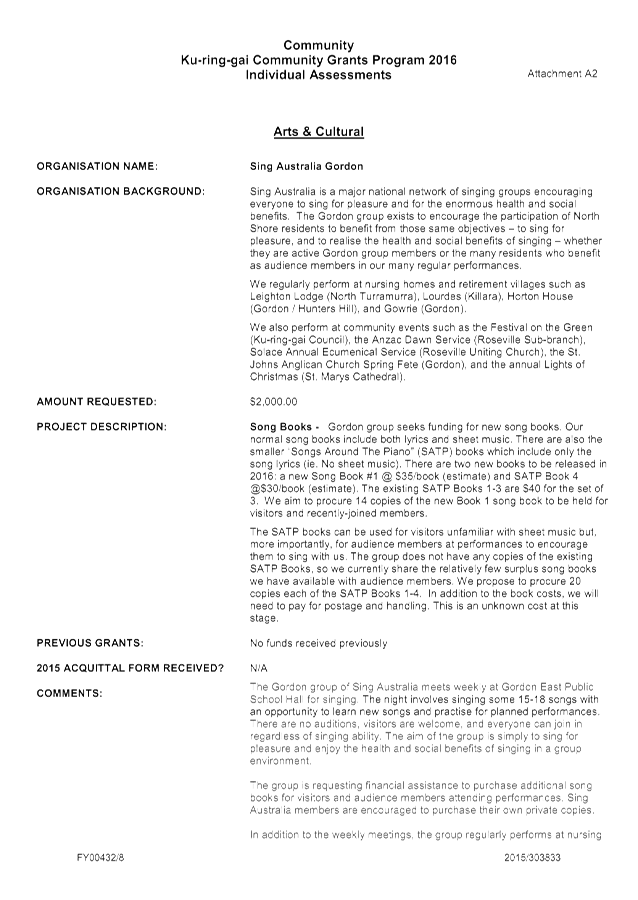
2016 Ku-ring-gai Community Grants Program
EXECUTIVE SUMMARY
Purpose of Report
To advise Council of applications received from community groups for the 2016 Ku-ring-gai Community Grants program, and to recommend subsequent funding allocations.
Background
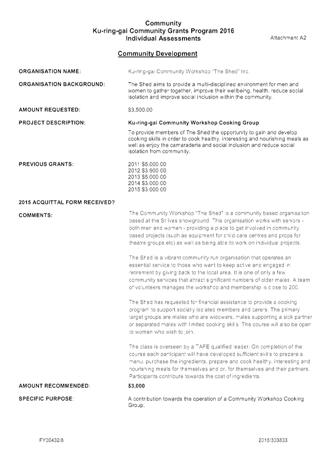
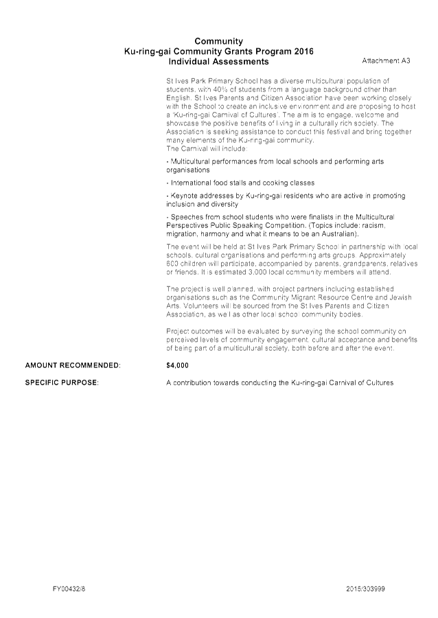
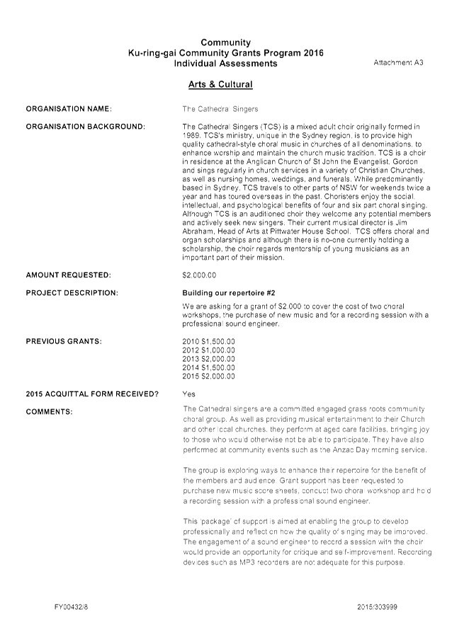
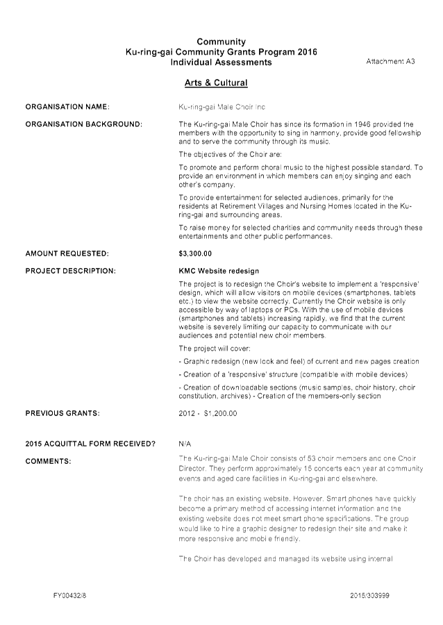
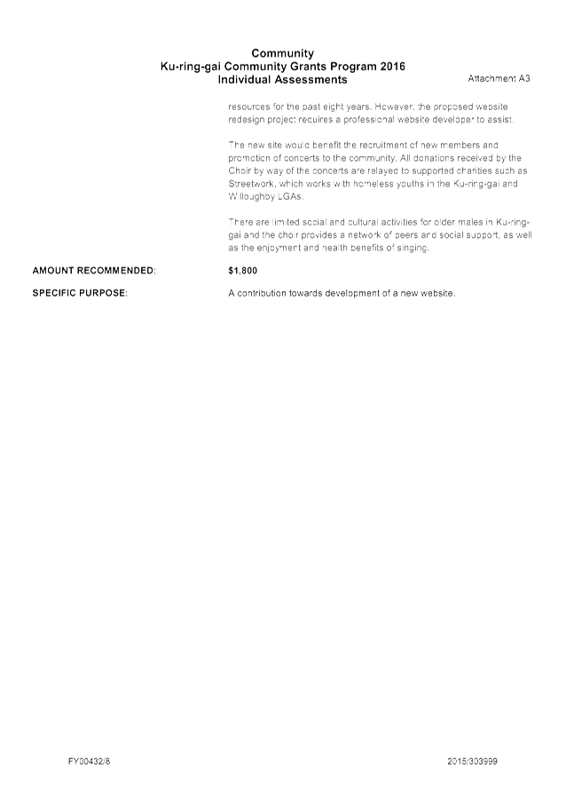
Each year Council calls for applications from community and cultural groups for grant funding to assist in providing much needed services to people in the Ku-ring-gai area. Applications totalling $136,648.73 have been received from 47 community and cultural groups.
To assist groups in completing the applications forms, Council also conducted a Grant Submissions Workshop and Information Session to outline the funding guidelines, selection criteria and priority funding areas.
Comments
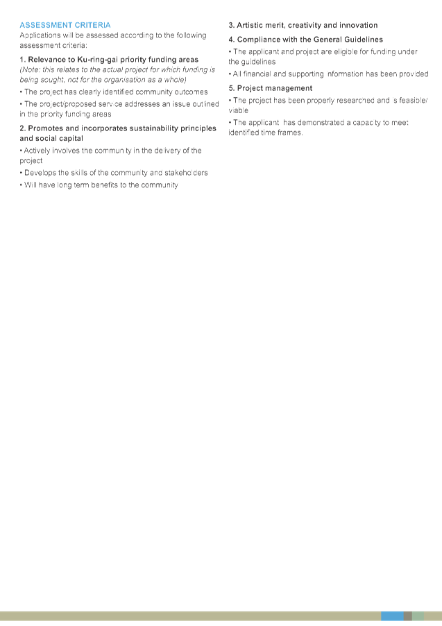
Council has $106,700 available in the 2016/17 budget for the 2016 Ku-ring-gai Community Grants Program. Applications for financial assistance (Attachments A1– A3) were assessed according to the criteria outlined in the 2016 Ku-ring-gai Community Grants Program and General Information and Guidelines (Attachment A4 – A7).
Following assessment, a sum of $102,506 for community groups, plus $4,194 for the rates and garbage rebate for Eryldene, (a standing resolution of Council), was recommended, totalling $106,700.
It is regretted that not all the organisations that have applied will be recommended for financial assistance, and in some cases the full amount could not be granted.
integrated planning and reporting
|
Community Strategic Plan Long Term Objective |
Delivery Program Term Achievement |
Operational Plan Task |
|
C1.1 An equitable and inclusive community that cares and provides for its members
|
C1.1.1 Council’s policies, programs and advocacy address the social and health needs of all age groups, reduce disadvantage and address gaps in service provision.
|
Resource and support local initiatives and organisations through the Ku-ring-gai Community Grants program.
|
Governance Matters
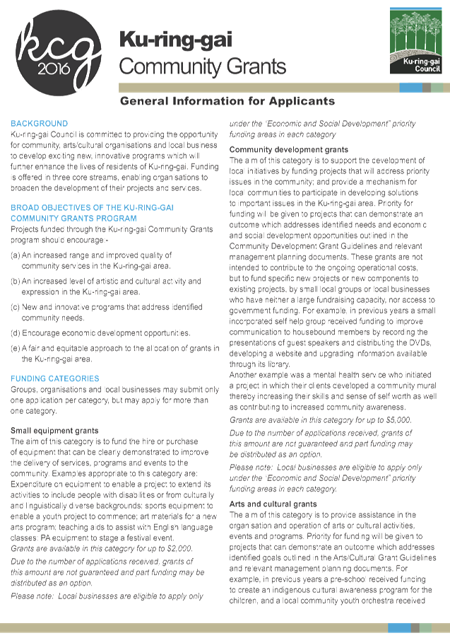
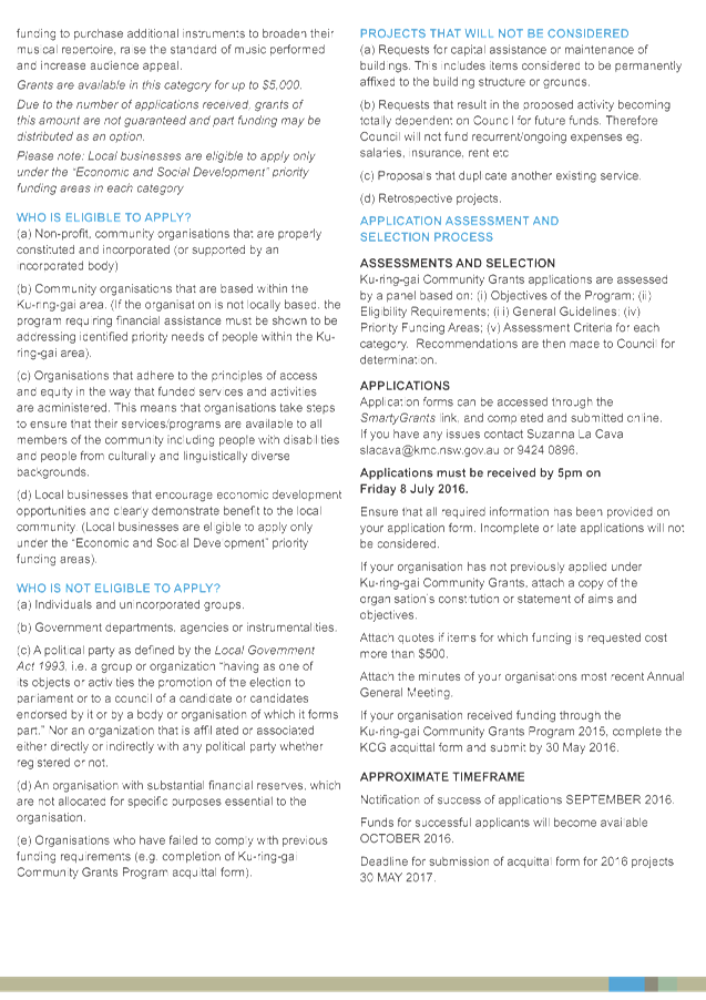
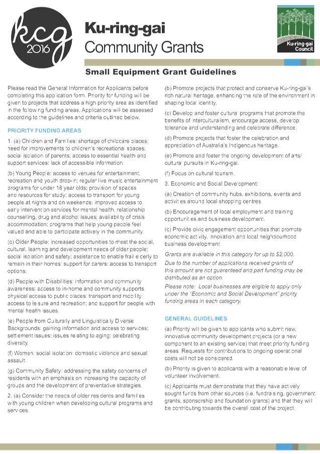
The 2016 Ku-ring-gai Community Grants Program is supported by adopted guidelines, funding categories, eligibility criteria and application and selection process information.
Risk Management
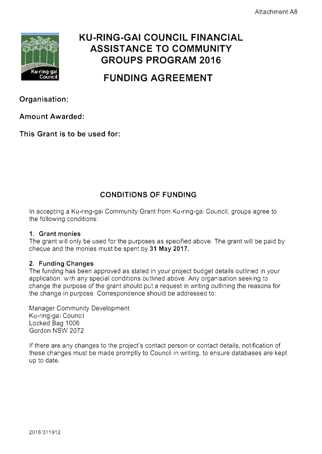
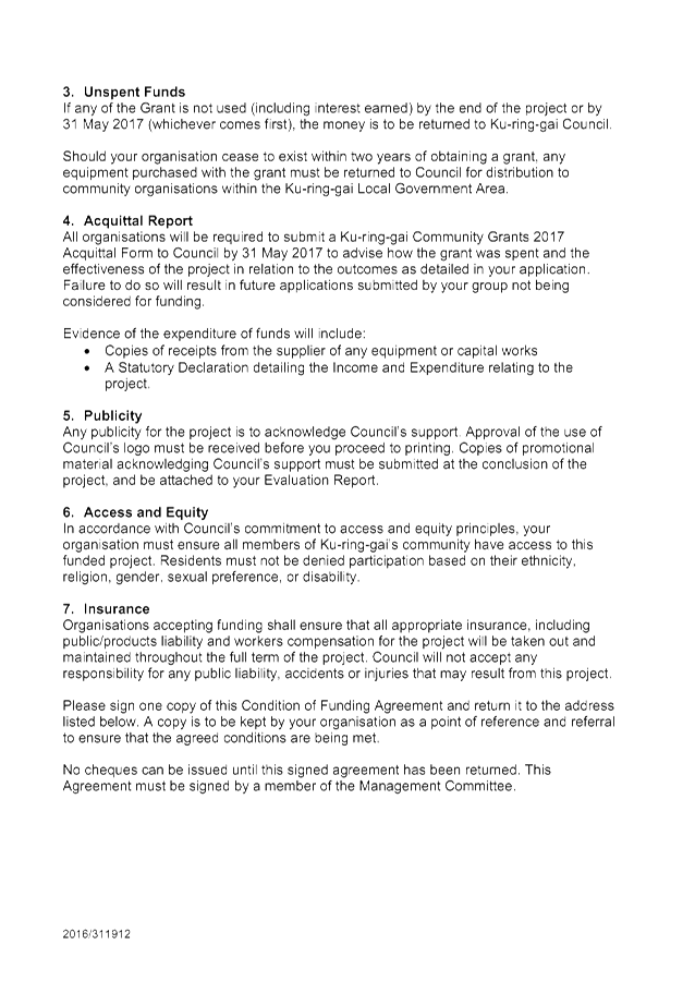
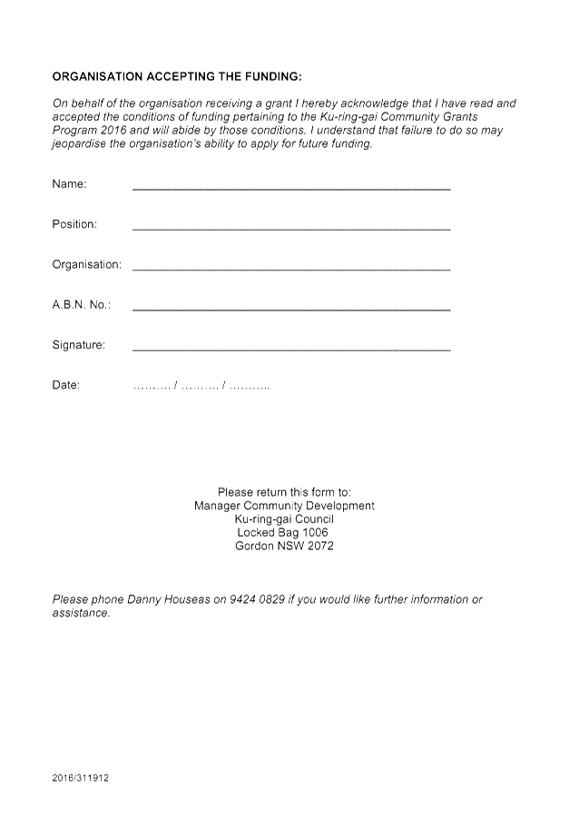
Priority funding areas have been identified for each category, e.g. Small Equipment, Community Development and Arts/Cultural grants, to assist all potential applicants. The program covers a range of projects and within each project there are a variety of associated risks. Council has in place a number of measures to mitigate those risks including a formal Funding Agreement and Acquittal Process (Attachments A8, A9). Each organisation receiving funding must comply with the terms and conditions of the program.
Financial Considerations
Council has $106,700 available in the 2016/17 budget for the 2016 Ku-ring-gai Community Grants Program. This comprises $97,900 allocated in the 2016/17 budget, plus $8,800 of returned unspent funds from the 2015 Ku-ring-gai Community Grants Program.
This report recommends that the $8,800 of returned unspent funds from 2015 be included in the 2016 Community Grants Program.
From the total amount of $106,700, $102,506 will be distributed to community and cultural groups, and $4,194 will contribute to the rates and garbage rebate for Eryldene (a standing resolution of Council).
Social Considerations
The 2016 Ku-ring-gai Community Grants Program is supported by priority funding areas based on identified social and arts/cultural needs in the Ku-ring-gai area. A key component of this program is to provide opportunities for residents to participate and engage in their local community.
Environmental Considerations
The various projects funded under this program contribute to a sustainable community and some contain elements with environmental benefits.
Community Consultation
To assist groups in completing the applications forms, Council also conducted a Grant Submissions Workshop and Information Session to outline the funding guidelines, selection criteria and priority funding areas.
Internal Consultation
Corporate and Operations departments have been consulted in the writing of this report.
Summary
Projects funded under the 2016 Ku-ring-gai Community Grants Program cover a range of target groups including, children, young people, older people, people with disabilities and people from culturally and linguistically diverse backgrounds.
The grants provided will enhance the capacity of community groups to provide much needed support services to the community. The arts/cultural projects proposed will foster celebrations and promote the development of artistic pursuits in Ku-ring-gai.
|
A. That the following community and cultural groups receive the recommended amount of financial assistance from Council in 2016.
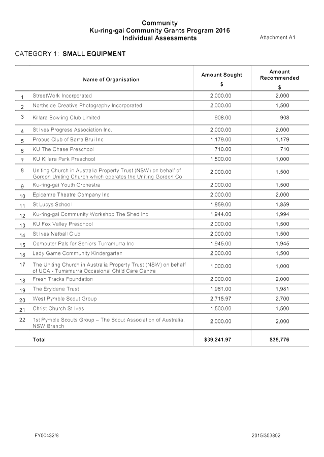
1. Category: Small Equipment
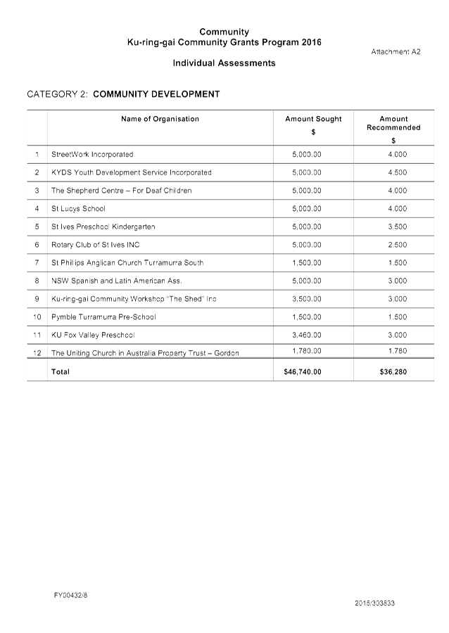
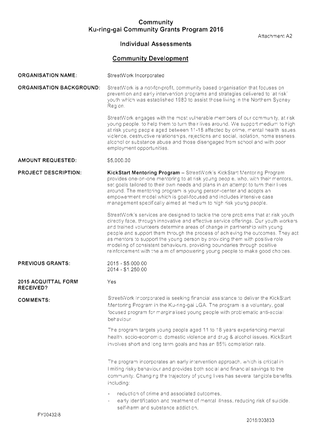
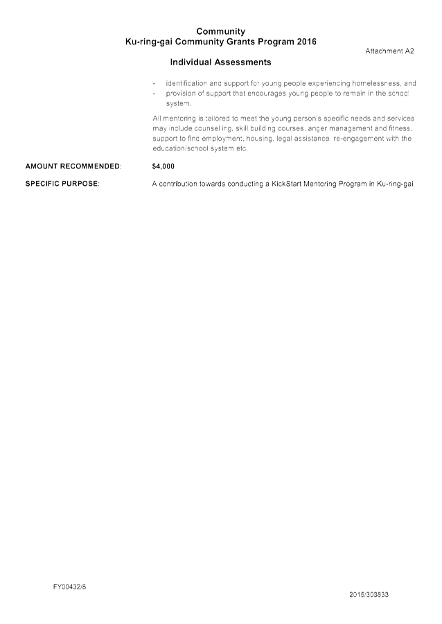
2. Category: Community Development
3. Category: Arts/Cultural
B. That $8,800 of unspent returned funds from the 2015 Ku-ring-gai Community Grants program be included in the 2016 Community Grants program for distribution to community groups.
|
|
Danny Houseas Manager Community |
Janice Bevan Director Community |
|
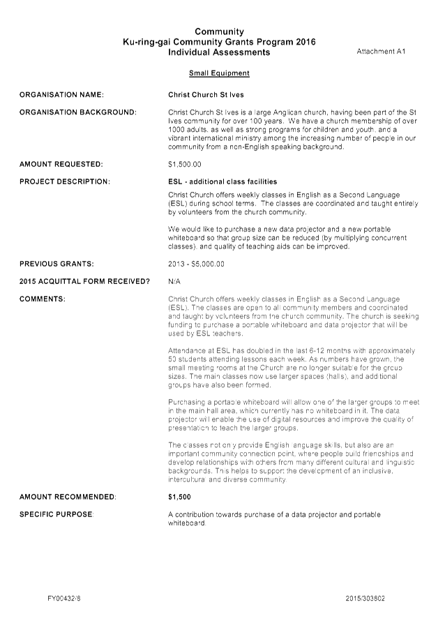
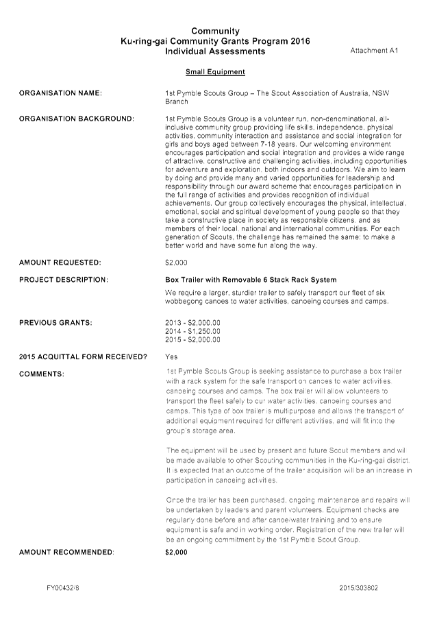
Small Equipment applications summary |
|
2016/313205 |
||
|
|
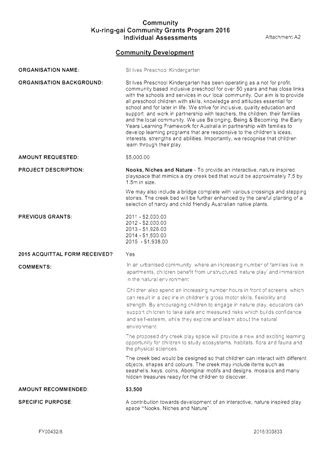
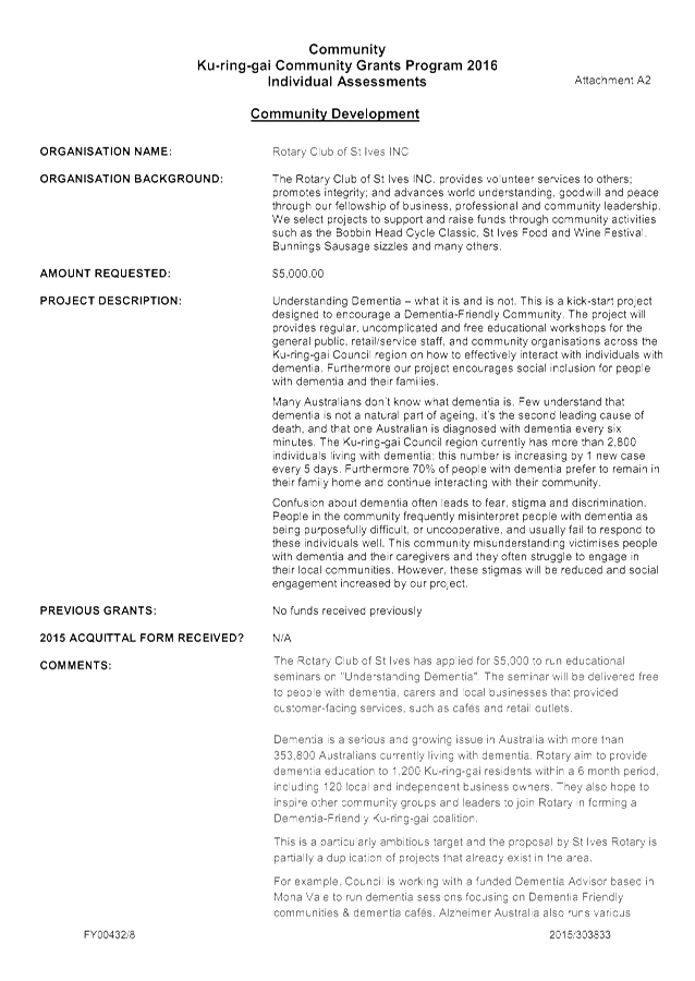
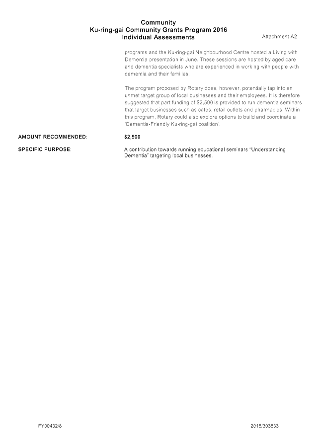
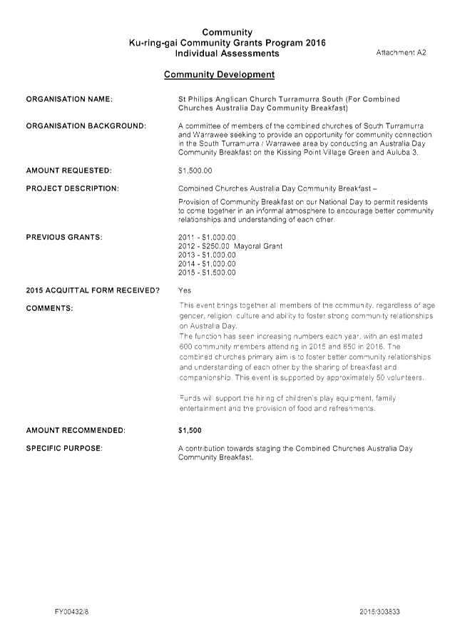
Community Development applications summary |
|
2016/310666 |
|
|
|
Arts Cultural Grants applications summary |
|
2016/310671 |
|
|
|
General Information for Applicants |
|
2016/311885 |
|
|
|
Small Equipment Guidelines |
|
2016/311889 |
|
|
|
Community Development Guidelines |
|
2016/311904 |
|
|
|
Arts Cultural Guidelines |
|
2016/311909 |
|
|
|
Funding Agreement and Conditions of Funding |
|
2016/311912 |
|
|
|
KCG Program Acquittal form |
|
2016/311917 |
|
Ordinary Meeting of Council - 22 November 2016 |
GB.2 / 133 |
|
|
|
|
Item GB.2 |
CY00458/4 |
|
|
3 November 2016 |
Audit and Risk Committee Minutes
EXECUTIVE SUMMARY
|
purpose of report: |
To provide Council with a copy of the Minutes from the meetings of the Audit and Risk Committee held in August 2016. |
|
|
|
|
background: |
During their meeting held in December 2015, the Audit and Risk Committee resolved to provide Council with a copy of the Minutes from each meeting to enhance transparency. |
|
|
|
|
comments: |
Copies of the Audit and Risk committee Minutes will now be provided to Council for their information. |
|
|
|
|
recommendation: |
Council receives and notes the Report. |
Purpose of Report
To provide Council with a copy of the Minutes from the meetings of the Audit and Risk Committee held in August 2016.
Background
During their meeting held in December 2015, the Audit and Risk Committee resolved to provide Council with a copy of the Minutes from each meeting to enhance transparency.
Comments
Copies of the Audit and Risk committee Minutes will now be provided to Council for their information.
integrated planning and reporting
Leadership and governance
|
Community Strategic Plan Long Term Objective |
Delivery Program Term Achievement |
Operational Plan Task |
|
Ku-rung-gai is well led, managed and supported by ethical organisations which deliver projects and services to the community by listening, advocating and responding to their needs. |
The Audit and Risk Committee function is supported and operating effectively. |
The Audit and Risk Committee provides a level of governance and transparency across Council. |
Governance Matters
To improve governance and transparency with respect to the operation of the Audit and Risk Committee
Risk Management
No risk management considerations
Financial Considerations
No financial impact
Social Considerations
No social implications
Environmental Considerations
No environmental implications
Community Consultation
Not applicable
Internal Consultation
Not applicable
Summary
A copy of the Minutes from the Audit and Risk Committees meeting held on 25th August 2016 are attached.
|
That Council receives and notes the report
|
|
Rodney Kidd Team Leader - Corporate Risk & Assurance |
Jennie Keato Manager People and Culture |
|
David Marshall Director Corporate |
|
|
Audit & Risk Committee Minutes 25 August 2016 |
|
2016/305855 |
|
Ordinary Meeting of Council - 22 November 2016 |
GB.3 / 139 |
|
|
|
|
Item GB.3 |
S09112/5 |
|
|
10 August 2016 |
2016 - 2017 Budget Review - 1st Quarter ended September 2016
EXECUTIVE SUMMARY
|
purpose of report: |
To inform Council of the results of the 1st quarter budget review of 2016/17 and seek approval to adjust the annual budget based on the actual financial performance and trend for the period 1 July 2016 to 30 September 2016. |
|
|
|
|
background: |
Section 203(1) of the Local Government Regulation 2005 requires that at the end of each quarter, a Budget Review Statement be prepared and submitted to Council that provides the latest estimate of Income and Expenditure for the current (2016/17) financial year. |
|
|
|
|
comments: |
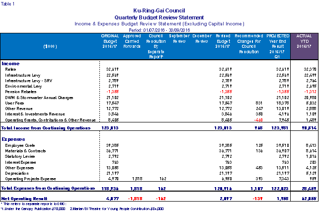
Budget adjustments proposed in this review will increase the forecast operating surplus (including capital items) by $193k compared to revised budget. This is primarily due to increased capital grants, user fees, interest on investments and other revenue partly offset by increases in expenditure. When excluding capital income, the net operating result will decrease by $139k, primarily due to deferral of Roads to Recovery grant to future years. The forecast working capital balance at 30 June 2017 is projected to remain at $4.7m, in line with the Long Term Financial Plan target. |
|
|
|
|
recommendation: |
That Council receive and note the September 2016 Quarterly Budget Review and that the recommended changes to the 2016/17 Budget be adopted. |
Purpose of Report
To inform Council of the results of the 1st quarter budget review of 2016/17 and seek approval to adjust the annual budget based on the actual financial performance and trend for the period 1 July 2016 to 30 September 2016.
Background
In accordance with Part 9, Division 3, Clause 203 of the Local Government (General) Regulation 2005 (“The Regulation”):
(1) Not later than 2 months after the end of each quarter (except the June quarter), the responsible accounting officer of a council must prepare and submit to the council a budget review statement that shows, by reference to the estimate of income and expenditure set out in the statement of the council’s revenue policy included in the operational plan for the relevant year, a revised estimate of the income and expenditure for that year.
(2) A budget review statement must include or be accompanied by:
a) a report as to whether or not the responsible accounting officer believes that the statement indicates that the financial position of the council is satisfactory, having regard to the original estimate of income and expenditure, and
b) if that position is unsatisfactory, recommendations for remedial action.
(3) A budget review statement must also include any information required by the Code to be included in such a statement.
The Office of Local Government has developed a set of minimum requirements that assists councils in meeting their obligations as set out in legislation.
At the Council meeting held on 14 June 2016, Council adopted the Revised 2013-2017 Delivery Program & Operational Plan 2016-2017, which incorporated the Annual Budget for 2016-2017.
Comments
This review analyses Council’s financial performance for the first quarter of 2016/17 and forecasts an end of financial year position by recommending budget adjustments to operating and capital budget.
Budget adjustments proposed in this review will increase the forecast operating surplus (including capital items) by $193k compared to revised budget. This is primarily due to increased capital grants, user fees, interest on investments and other revenue partly offset by lower increases in expenditure. When excluding capital income, the net operating result will decrease by $139k.
The change to the operating result is primarily due to increased Building Control and Regulation Fees (net increase $194k), increased net revenue for KFAC ($43k), savings achieved in street lighting ($50k) and higher interest income ($350k). Increased operating costs are mainly due to reclassification of capital projects to operating, being Roads and Footpath maintenance works ($187k) and Road Maintenance Block Grant ($327k). The reclassification of operating grants does not reflect increases in expenditure but rather a transfer from one category to another.
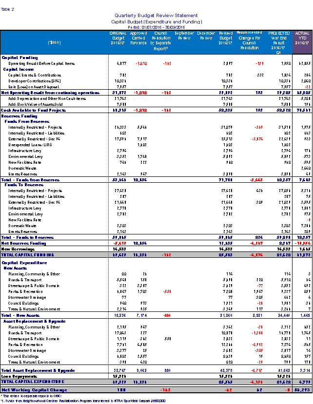
Major variations in the capital budget are due to:
· Deferral of Road Rehabilitation projects ($360k) due to over expenditure in the previous financial year;
· Lindfield Community Hub increased costs of ($450k), budget brought forward from future years;
· Deferral of projects funded from S94 to 2017/18 ($3.703m); mainly the St Ives Village Green Masterplan project, St Johns Avenue – New Railway Square, Robert Pymble Park Masterplan and other projects.
Other budget adjustments to capital projects are detailed further in the report and listed in Attachment A2.
The forecast working capital balance at 30 June 2017 will remain at $4.7m, in line with the target identified in the Long Term Financial Plan.
Quarterly Budget Review Statements (QBRS)
The Quarterly Budget Review Statements (QBRS) as prescribed by the DLG guidelines are composed of the following budget review reports:
· Income and Expenses Budget Review Statement (Table 1)
· Capital Budget (Expenditure and Funding) Budget Review Statement (Table 2)
· Proposed Operating Budget Adjustments by Resource Group (Table 3)
· Proposed Capital Budget Adjustments by Resource Group (Table 4)
· Income and Expenses Statement by Theme (Table 5)
· Cash and Investments position (Table 6)
· Contracts and Consultancy Expenses (Table 7)
· Capital & Operational Projects Summary (Table 8)
· Statement by the Responsible Accounting Officer
These statements are shown below.
Proposed Budget Adjustments
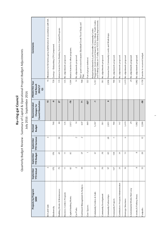
The table below lists the proposed budget adjustments, including comments for the September
Quarterly Budget Review.
Attachment A2 summarises all proposed budget adjustments for Projects.
The table below splits the current budget by six themes identified within Council’s Delivery Program 2013 – 2017. These themes are used as a platform for planning our activities to address the community’s stated needs and aspirations.
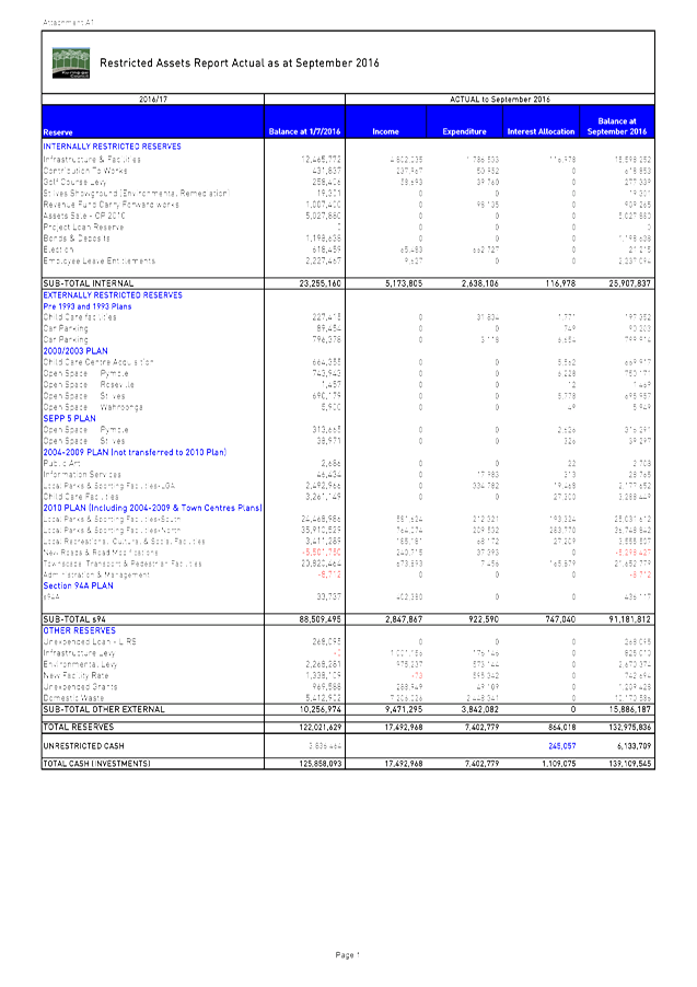
Cash and Investments position
Restricted funds are invested in accordance with Council’s Investment Policy. Total investments portfolio as per the September Investment Report is $139.3m
A detailed Restricted Assets Report as at September 2016 (Actual) is shown in Attachment A1
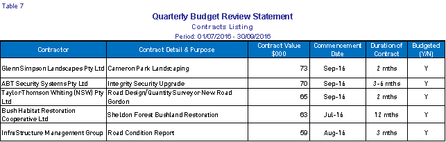
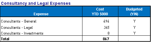
Contracts and Consultancy Expenses
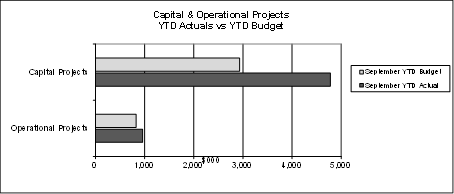
Capital & Operational Projects Summary
Actual expenditure for capital and operational projects for the period ending 30 September 2016 is $5.7m against the YTD budget of $3.8m, resulting in an unfavourable variance of $1.9m. This variance is mainly due to timing differences between the actual expenditure incurred against the budget forecast of some projects for the quarter.
The table and chart below shows the YTD actual projects expenditure against YTD budget for the quarter ended September 2016.

The proposed budget changes to operational and capital projects total $3.744m. The most significant variations and projects proposed for adjustment are listed below:
· Lindfield Community Hub (Multi-purpose community floorspace Lindfield Project) -$540k (funded by S94) – budget brought forward from 2017/18. Funds are required for project planning and to procure the necessary consultants to meet State government requirements and increased staff hours to manage the process.
· Deferral of projects to 2017/18 $3.703m (funded from S94), mainly the St Ives Village Green Masterplan project, St Johns Avenue – New Railway Square, Robert Pymble Park Masterplan and other projects.
· Deferral of Road Rehabilitation Program $360k (funded from Infrastructure & Facilities reserve) due to over expenditure in the previous financial year and $549k (funded from Roads to Recovery grant).
All Proposed Budget adjustments for each Project and explanation for the changes is detailed in
Attachment A2 – Summary of Capital and Operational Project Budget Adjustments
Major Capital Works Update
Operations Projects
The status of various projects and reviews of programs is covered in the commentary below:
§ Buildings
In the first quarter, the re-roofing and ancillary works to the Roseville Community Hall has been completed and well received by the user groups.
Other works in the program have commenced and progressing. An adjustment was required for the Turramurra Oval public toilet due to higher than expected contract costs to meet disability requirements.
§ Roads
The roads program at the end of the first quarter is progressing well with over 30% of the program completed. Works on the regional road program is now complete. All works are expected to be completed by May 2017.
§ Footpaths
Designs have commenced for all new projects and all carry forward projects are now complete.
§ Drainage
Tenders have been called for 90 Babbage Road and will be reported to Council on 22 November 2016.
§ Playgrounds
Works are progressing well on finishing off outstanding works at Cameron Park and it is expected to be open to the public in January 2017. The upgrade of play area at Carcoola Reserve is underway will some delays to the supply of play equipment due to manufacturer delays. Contracts for the upgrade of Golden Jubilee and Lofberg Playgrounds have been awarded and works have commenced at Lofberg Road playground.
§ Sportsfields
Koola Oval is now complete and ready for handover to the Maintenance Section. Howson Oval is experiencing delays with the contractor not completing finishing works. Letters of demand have been sent to the contractor. Liquidated damages charges are being applied.
§ Sports Courts
The upgrade of the sports courts is to commence in February 2017. The upgrade to the car park at Canoon Road has commenced and scheduled for completion in March 2017.
§ North Turramurra Recreation Area
§ Work on the playing fields is now complete and the synthetic field is being used for training.
§ Construction of the amenity building and golf cart storage sheds is underway and scheduled for completion by March 2017.
§ Tender for the sportsfield car park closes on 6 December 2016.
§ Numbers of players at North Turramurra Golf Course are steadily increasing since the opening of all holes.
Strategy Projects
Updates of significant projects are provided below:
§ Lindfield Village Green
Lindfield Village Green will become a public open space, located in Council’s Tryon Road car park on the eastern side of Lindfield behind the Lindfield Avenue shops. The existing at grade car park will be relocated underground and the new Village Green built on top.
Lindfield Village Green will include a public plaza, underground public car parking, a new café or restaurant, public seating, toilets and a lift connecting to the basement car park. The development will meet the highest standards of design excellence and sustainability.
After the Council approved a ‘preferred’ concept design option last year, a ‘Final’ concept design has been progressed and approved this year. The ‘Final’ concept design report was approved by Council in September 2016.
Refinement of the design is ongoing to ensure the project is technically and financially feasible while delivering the best possible outcomes for the community.
We anticipate that construction on the project will commence in early 2018 once development consent is granted. Construction should take approximately 12 months with the new facilities opening in 2019.
The project will progress according to the following timeframes. Please note these are approximate and may change.
§ Development application submission – December 2016
§ Detailed design – commence July 2017
§ Construction – commence early 2018
§ Lindfield Village Green opens to public – early 2019
§ Lindfield Community Hub
Lindfield Community Hub, located on the western side of the Lindfield Town Centre, has an estimated construction cost of approximately $150 million. The 1.3 hectare site will be a new mixed use precinct with community buildings, boutique shops, cafes, restaurants, apartments and a below-ground supermarket.
The redevelopment will create a range of community infrastructure including new streets; a large central park and town square; a new library and community centre as well as commuter parking. Council will be using development contribution funds to the project as well as land owned by Council.
We are delivering this project as a Public Private Partnership (PPP) to ensure that a high quality project is delivered and meets the expectations of residents. The project will be striving for best-practice environmental ratings including systems for power, heating and cooling and rainwater harvesting.
A Business Plan and EOI documents were sent to the Office of Local Government (OLG) in August 2016. Council received written comments from OLG PRC on 19 September 2016 and subsequently Council prepared a further response to issues raised.
On 6 September 2016 Council adopted the planning proposal amendments to facilitate the
approval of the Master Plan, and during November/December, further work will be carried out on refining documentation for the EOI, marketing and branding for the project.
§ Gordon Cultural and Civic Hub Master Plan
At the Ordinary Meeting of Council on 9 February 2016 Council resolved that the Gordon Cultural and Civic Hub Master Plan be deferred for the foreseeable future until broader strategic matters arising from the NSW Government merger proposal have been resolved. Since that time, a number of parameters have changed:
· the purchase of 810 Pacific Highway, Gordon by Aldi Australia P/L; and
· increased competition between major retailers to find suitable sites within Gordon.
In this context there is the opportunity for Council to undertake strategic planning to ensure the maximum value for the community of Gordon is captured. A report to OMC on the 22 November 2016 seeks a resolution to re-commence the master planning process for a Cultural Hub in Gordon.
§ Ku-ring-gai Fitness & Aquatic Centre
In late in 2015 Council received a “Notice of Dispute” pertaining to alleged delay costs suffered by the contractor during construction. This was reported to Council at the time and actions as per Council’s resolution have been enacted. Meanwhile, Council is working through the dispute resolution process as per the contract. The Arbitrator has been appointed and following a meeting with all parties a timetable was set. Ichor sought and received an extension to this timetable, finally presenting their evidence on 14 October. Council now has until 28 February 2017 to present its Points of Defence Cross Claim
§ St Ives Village Green Master Plan
A final concept design for a new recreation precinct was adopted by Council on 14 June 2016. The final concept was guided by extensive community consultation undertaken during the third and fourth quarter of the previous financial year.
The adopted design includes a new children’s play space and a skate area, with a central promenade linking facilities with the surrounding park. New paths, seating, shelters, lighting, picnic facilities, shade tree planting and landscaping are also planned, together with improvements to the existing public toilets and the St Ives youth centre.
The September quarter saw Council’s consultants proceeding with design development for the new recreation precinct. This will be followed by the preparation of detailed documentation for tender. It is anticipated that construction works will commence in mid to late 2017 following the public tender process and reporting to Council.
Future works will see the progressive implementation of the master plan (subject to Council approval for each component), including additional car parking in Cowan Road and Memorial Avenue, a perimeter exercise path, terraced seating around William Cowan Oval, and the eventual relocation of the tennis courts to be adjacent to the bowling club.
§ Koola Park Redevelopment, East Killara
The September quarter saw the continuation of Koola Park Stage 3 construction works, including the installation of field fencing; the commissioning of irrigation, drainage and floodlights; and the growing in and establishment of the grass playing surface and turf cricket wicket. Stage 4 early works including the new perimeter path and exercise stations, were also commenced.
Further works will see the progression of detailed planning and design for proposed improvements to the car parks and the internal access road.
§ The Mall Shops, Warrimoo Avenue St Ives
Council officers have completed detailed documentation for a range of proposed improvements aimed at revitalising the shopping centre and increasing access to the adjoin park. The project is currently out to tender and construction works are proposed to commence early 2017. The centre will remain open during the proposed works which are not expected to significantly affect the normal running of businesses.
§ Future Park Cnr Allan Avenue, Duff St & Holmes St, Turramurra
The September quarter saw work in preparation for the proposed new park at Turramurra. This included planning for the demolition of houses on site and community engagement.
Surrounding residents were invited to complete an online survey to help guide the design of the new park. An inclusive playspace design workshop was also held to draw on the communities experience to establish practical, accessible and inclusive design outcome for the park. Council’s goal is to create an attractive and engaging community recreation place for everyone in the local community to enjoy. It will be designed as a place for meeting, relaxing, playing and undertaking activities for health and well-being and will cater for the local neighbourhood and the growing residential community.
§ St Ives Showground Inclusive Playground
Council is planning a playground upgrade at St Ives Showground to address the lack of play facilities at this important site, and to enable more effective public use of the Showground which is regionally significant open space.
The additional play area will improve the opportunities for inclusion and recreation for a wide range of visitors to the St Ives Showground, in response to increasing population growth. Funding for the playground upgrade has been assisted by the NSW Department of Planning and Environment through the Metropolitan Greenspace Grant Program.
A playground concept design plan has been prepared by specialist playground designers, together with Council’s landscape architects and other technical staff, and the community has been invited to comment. Construction is planned after the St Ives Show (May) to be completed before the Medieval Faire (September) 2017.
§ Other Playgrounds
A number of other new playspace and playground upgrades were initialled or progressed during the September quarter including those at Killara Park, Loftberg Road at Bicentenial Park, Golden Jubilee Fields, Lapwing Reserve in St Ives and Park Avenue at Roseville Chase.
Statement by Responsible Accounting Officer
It is my opinion that the Quarterly Budget Review Statement for Ku-ring-gai Council for the quarter ended 30 September 2016 indicates that Council’s projected financial position at 30 June 2017 will be satisfactory, having regard to the projected estimates of income and expenditure and the original budgeted income and expenditure.
One of Council’s key performance indicators in the Long Term Financial Plan (LTFP) is to provide for a minimum available working capital balance of $4.7m. As a result of the September Review the forecast of available working capital at 30 June 2017 will remain at $4.7m, in line with the Long Term Financial Plan target.
integrated planning and reporting
Theme 6: Leadership and Governance
|
Community Strategic Plan Long Term Objective |
Delivery Program Term Achievement |
Operational Plan Task |
|
L2.1 Council rigorously manages its financial resources and assets to maximise delivery of services. |
L2.1.2 Council’s financial services provide accurate, timely, open and honest advice to the community. |
Manages financial performance to achieve targets as defined in the Long Term Financial Plan. |
FIT FOR THE FUTURE IMPROVEMENT ACTION PLAN
The NSW Government's Fit for the Future initiative required all councils to prepare an Improvement Proposal and supporting Implementation Plan demonstrating how all seven Fit for the Future benchmarks would be met by 2016/17, and maintained or improved thereafter.
Council's Fit For the Future Improvement Proposal and supporting Implementation Plan underpins the decision to stand alone and not merge with Hornsby Council. The objectives established in the Improvement Proposal and Implementation Plan are embedded in Council's adopted Integrated Planning and Reporting documents including the Revised Delivery Program 2013-2017 and Operational Plan 2015-2016, Long Term Financial Plan 2015/16 to 2024/25 and Asset Management Strategy 2015/16 to 2024/25.
|
SUSTAINABILITY |
|||||
|
Objective |
Action |
Timeframe |
Target |
Measure |
Link to Term Achievement |
|
Manage financial performance to achieve Financial Sustainability targets identified in the LTFP |
Achieve Operating surplus before capital income items to fund capital expenditure: · Monitor Operating Expenditure and Revenue against budget on a monthly basis · Report on budget variations to senior management on a monthly basis and quarterly to Council |
Monthly Reporting to Senior Management
Quarterly reporting to Council
|
Operating Surplus achieved |
Actuals meet budget and LTFP target |
L2.1.1
Council maintains and improves its long term financial position and performance |
Under Sustainability of the Improvement Action Plan, Council will monitor financial performance on a monthly and quarterly basis and aim to achieve an operating surplus before capital items to fund capital expenditure. The target is to achieve operating surplus and meet targets identified in the Annual Budget and Long Term Financial Plan. The forecast results of the September Quarterly Budget Review 2016 -2017 indicate that Council will achieve these targets by the end of the current financial year. Council achieved operating surpluses for the past 5 years.
Governance Matters
Not applicable.
Risk Management
Income and expenditure is managed through the quarterly budget review process. Although some income and expenditure cannot be directly controlled, it can be monitored and action taken to mitigate potential financial or budgetary risk. Further, Council staff utilise monthly management reporting for managing operational and project income and expenditure, and any budget variations are reported to the Director. The executive team are also provided with monthly financial reports that allow Directors to make informed decisions and plan ahead to ensure budget targets are met.
Financial Considerations
Budget adjustments proposed in this review will increase the forecast operating surplus (including capital items) by $193k compared to revised budget. When excluding capital income, the net operating result will decrease by $139k.
The forecast working capital balance at 30 June 2017 is projected to remain at $4.7m, in line with the Long Term Financial Plan target.

Social Considerations
Not applicable.
Environmental Considerations
Not applicable.
Community Consultation
Not applicable.
Internal Consultation
Finance met with each Director and managers as part of the Quarterly Business Review to ensure departmental budget target reflects current forecasts. Comments from Directors have also been included as part of this report.
Summary
The recommended budget adjustments proposed in this review will increase the forecast operating surplus (including capital items) by $193k compared to revised budget. This is primarily due to increased capital grants, user fees, interest on investments and other revenue partly offset by increases in expenditure. When excluding capital income, the net operating result will decrease by $139k, primarily due to deferral of Roads to Recovery grant to future years.
The forecast working capital balance as at 30 June 2017 will remain at $4.7m, in line with the long term financial plan target.
|
That Council receive and note the September 2016 Quarterly Budget Review and adopt the recommended changes to the 2016/17 budget.
|
|
Angela Apostol Manager Finance |
David Marshall Director Corporate |
|
Attachment A1 - Restricted Assets Report - September 2016 |
|
2016/317038 |
||
|
|
Attachment A2 - Summary of Capital and Operational Projects Budget Adjustments - September 2016 |
|
2016/317040 |
|
APPENDIX No: 2 - Attachment A2 - Summary of Capital and Operational Projects Budget Adjustments - September 2016 |
|
Item No: GB.3 |
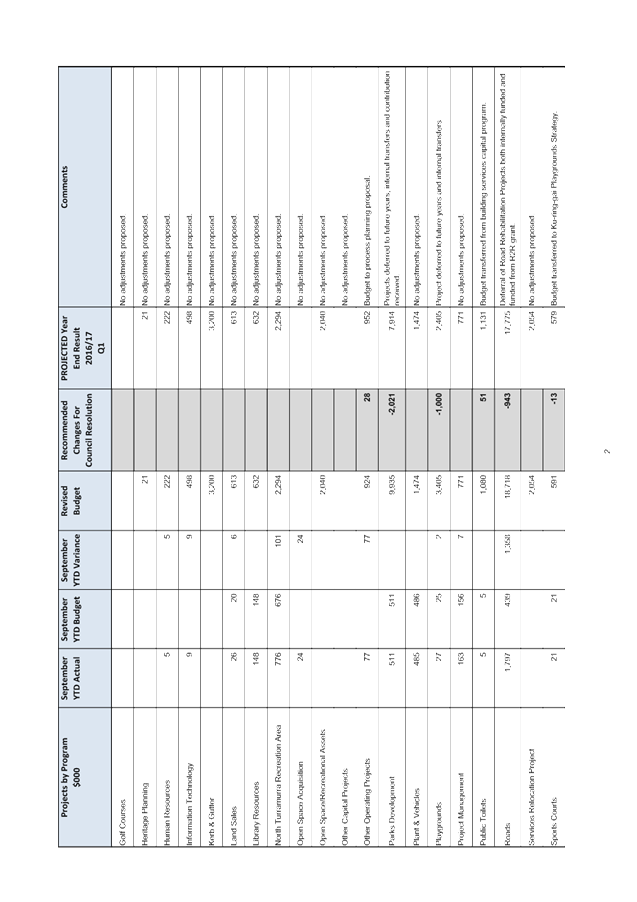
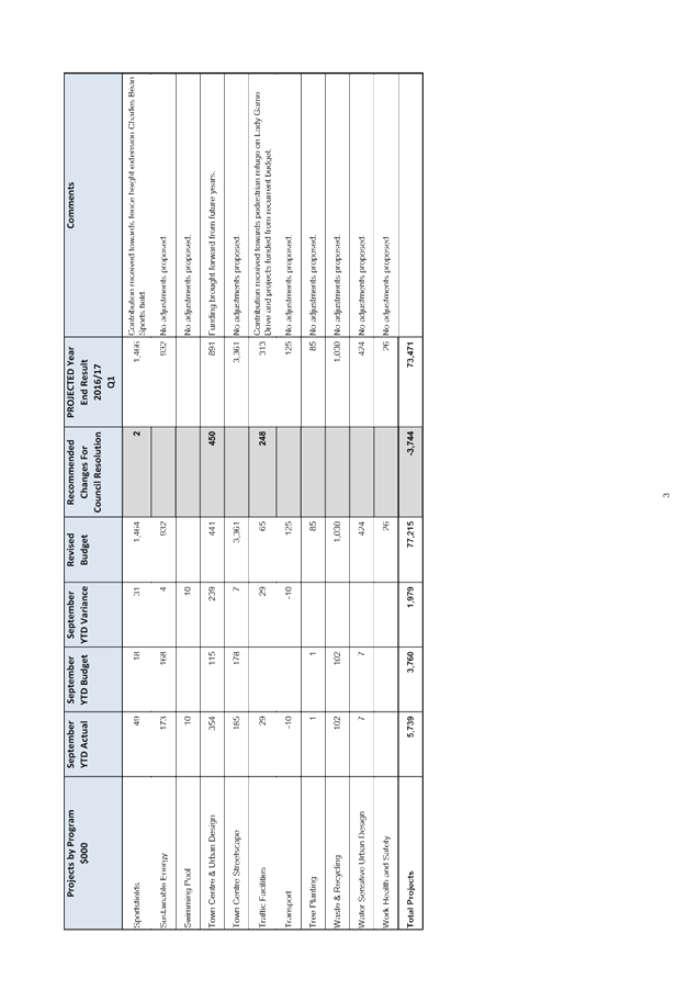
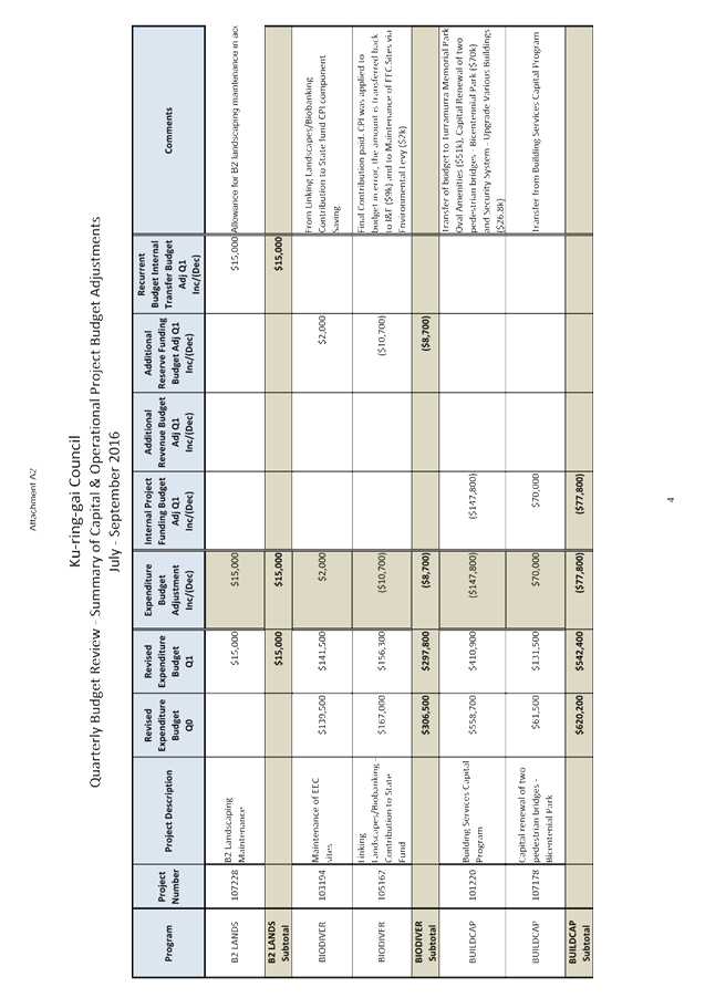
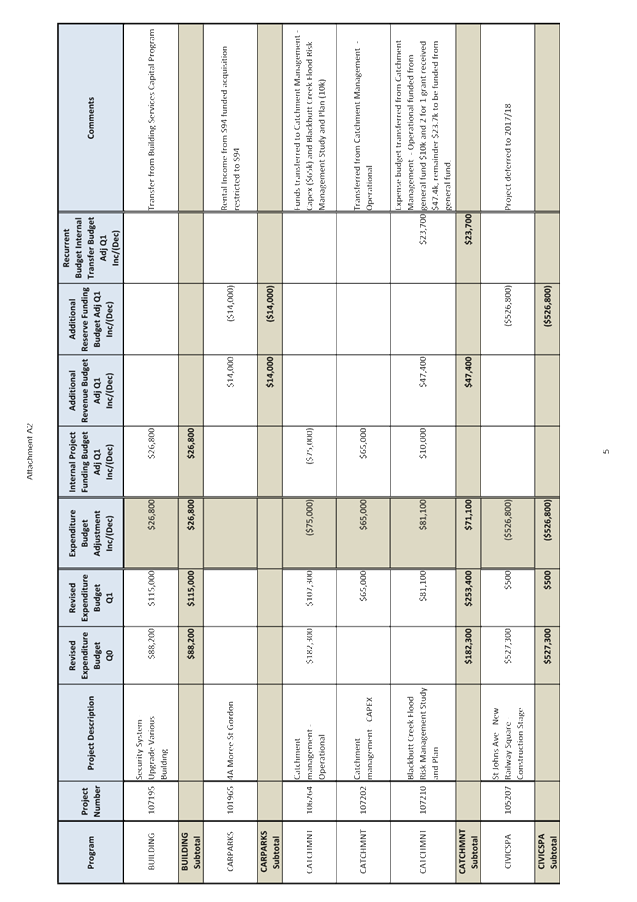
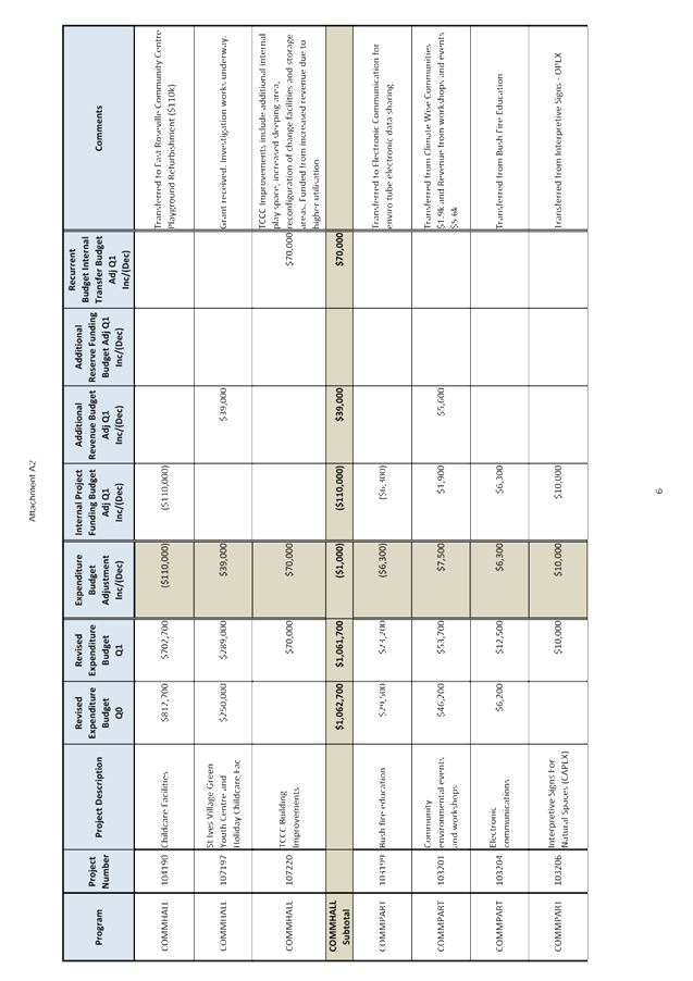


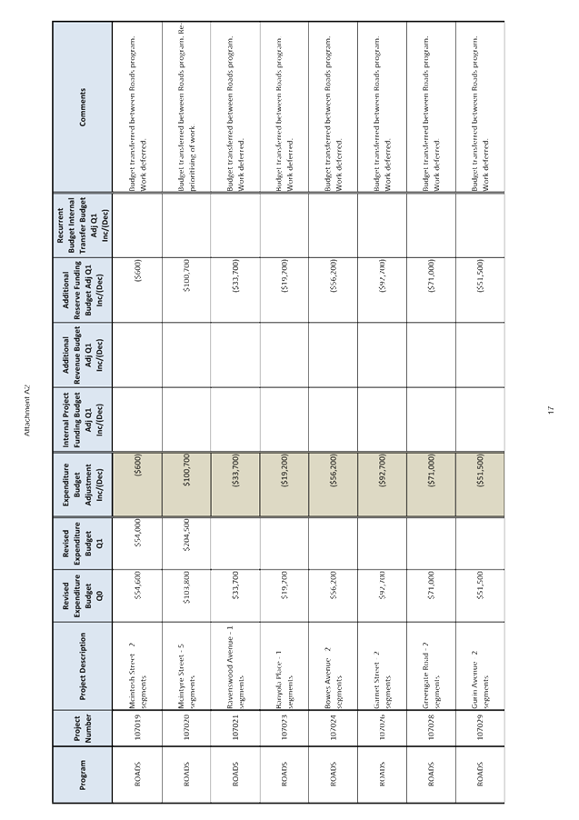
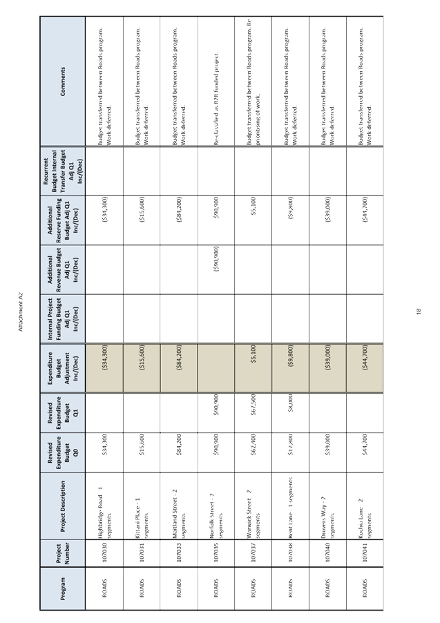
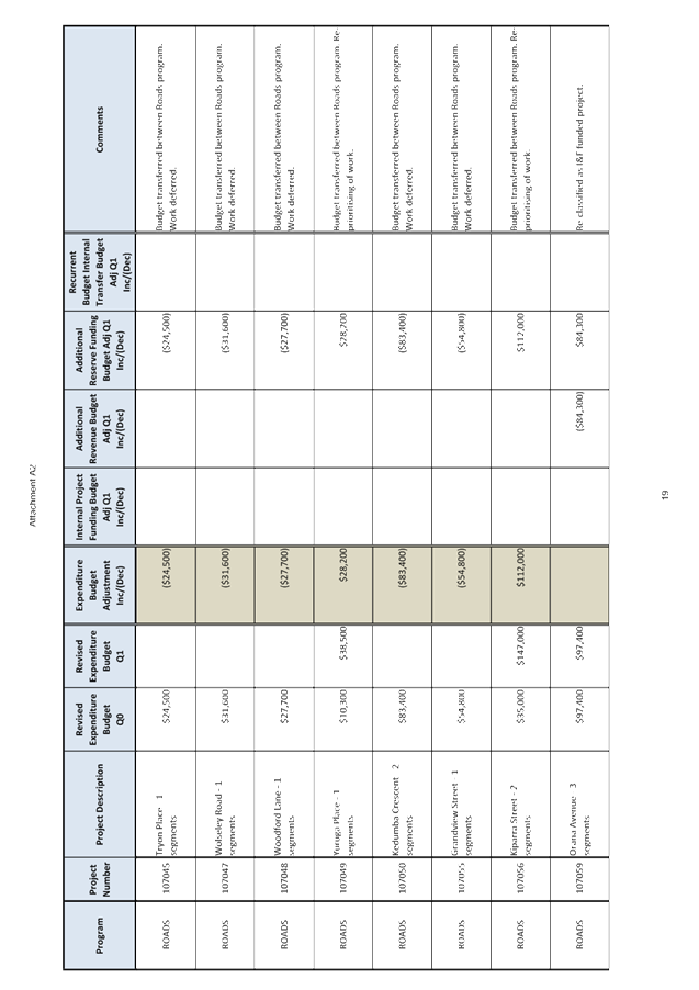


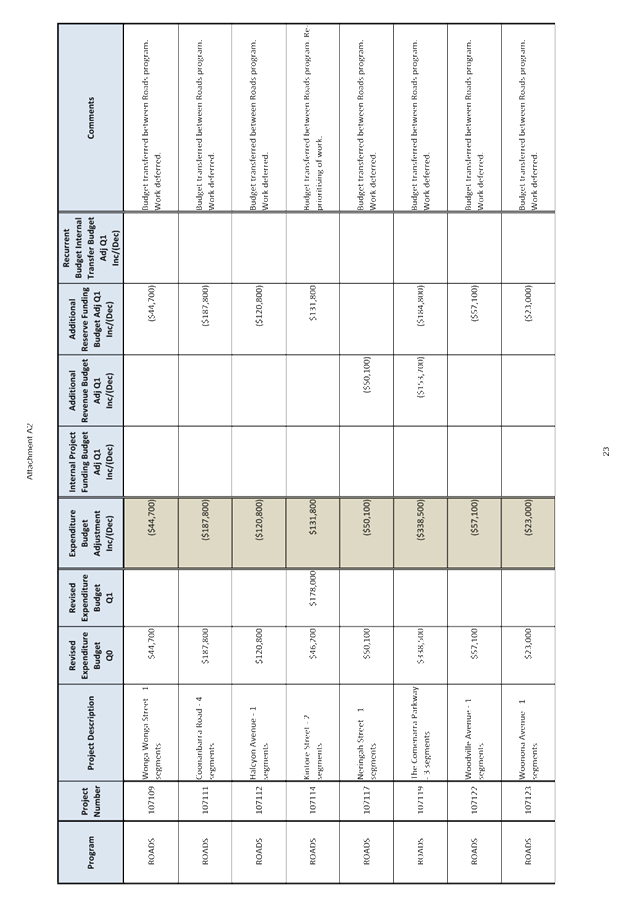
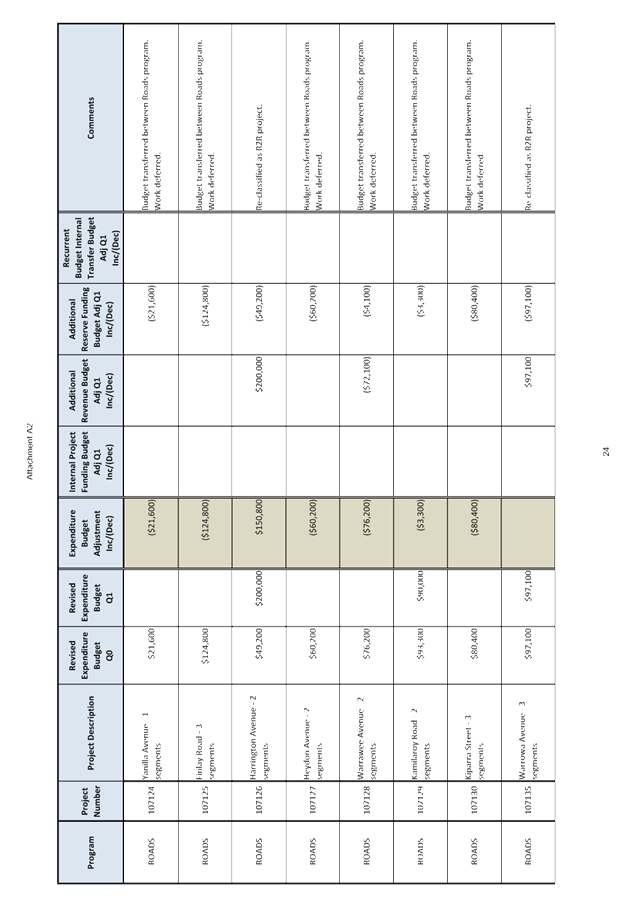
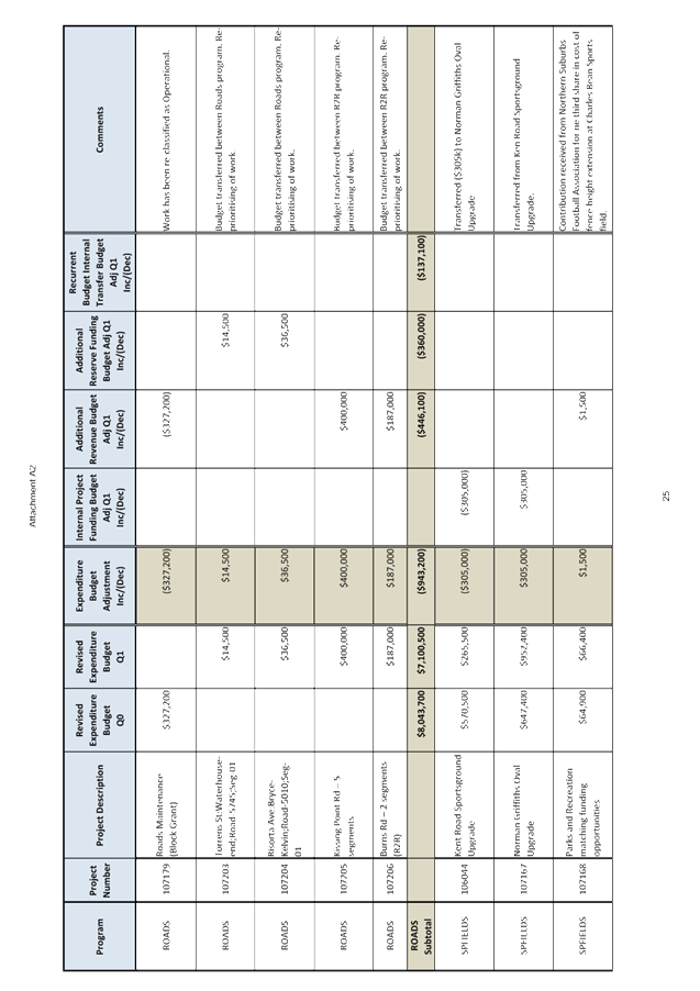
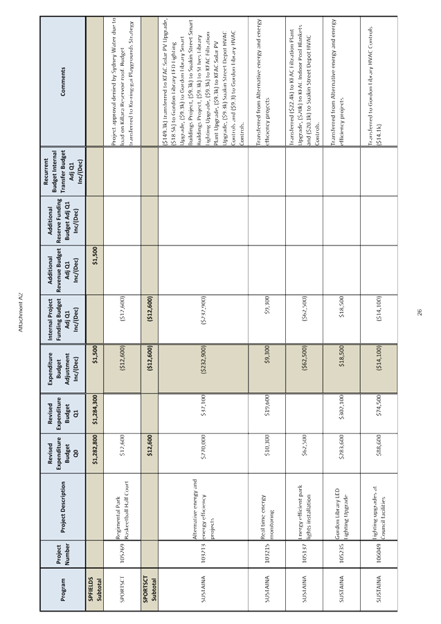
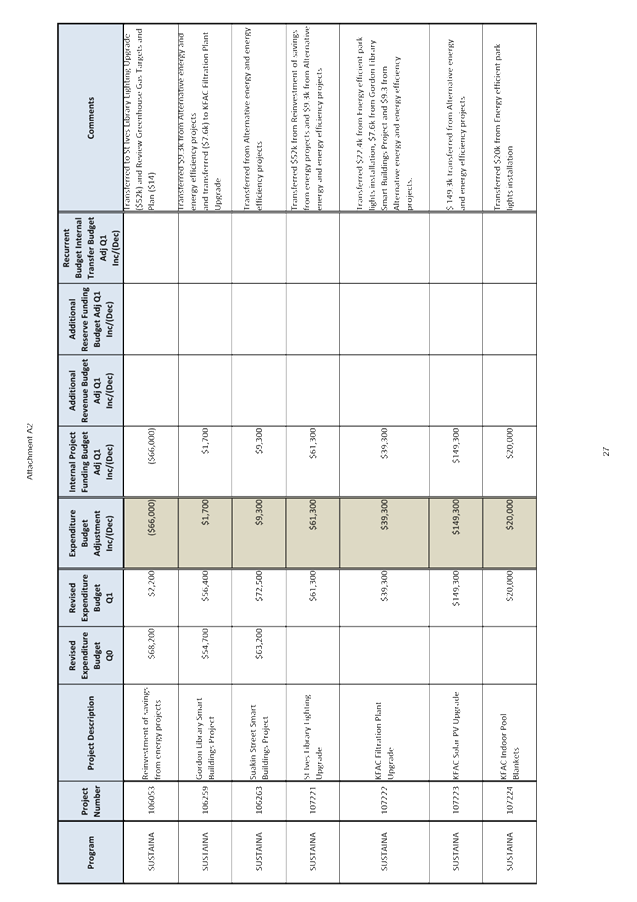
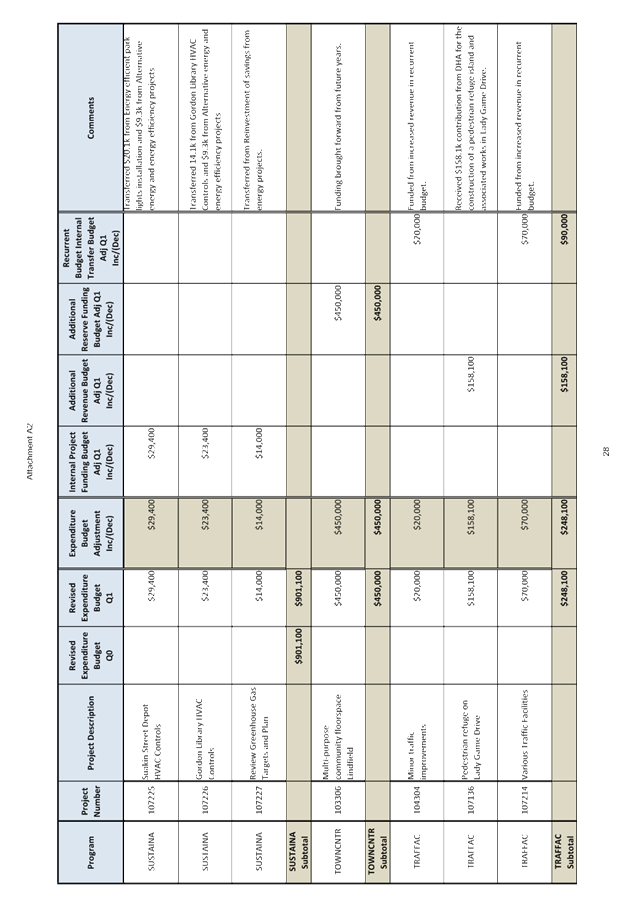
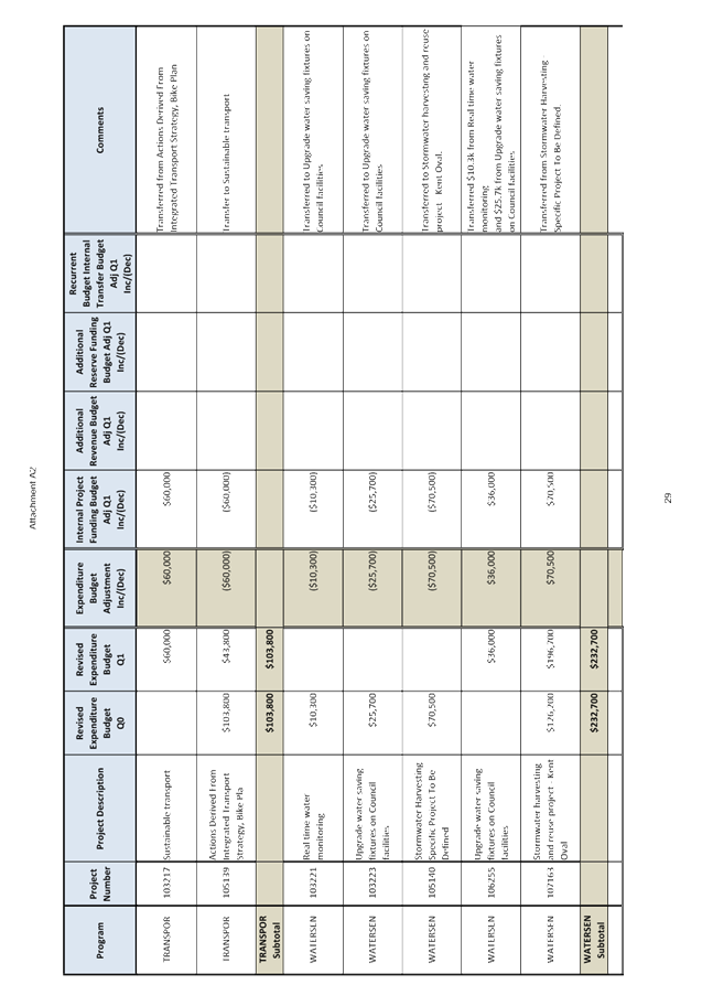
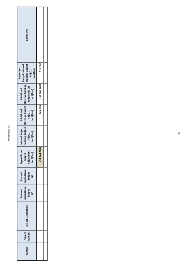
|
Ordinary Meeting of Council - 22 November 2016 |
GB.4 / 186 |
|
|
|
|
Item GB.4 |
S05273 |
|
|
20 October 2016 |
Investment Report as at 31 October 2016
EXECUTIVE SUMMARY
|
purpose of report: |
To present Council’s investment portfolio performance for October 2016. |
|
|
|
|
background: |
Council’s investments are reported monthly to Council in accordance with the Local Government Act 1993, the Local Government (General) Regulation 2005 and Council’s Investment Policy. |
|
|
|
|
comments: |
The net return on investments for the financial year to October 2016 was $1,485,000 against a budget of $1,468,000 giving a YTD favourable variance of $17,000. An increase to the interest income budget by 350,000 is proposed in the September Quarterly Budget Review due to growth in investment portfolio. Of this amount, $210,000 is restricted to Section 94 external reserves, $49,000 to the internal Infrastructure & Facilities reserve and $91,000 is unrestricted. |
|
|
|
|
recommendation: |
That the summary of investments performance for October 2016 be received and noted; and that the Certificate of the Responsible Accounting Officer be noted and report adopted. |
Purpose of Report
To present Council’s investment portfolio performance for October 2016.
Background
Council’s investments are reported monthly to Council in accordance with the Local Government Act 1993, the Local Government (General) Regulation 2005 and Council’s Investment Policy.
Comments
Investment Portfolio Performance Snapshot
The table below provides the investments portfolio performance against targets identified in Council’s Investment Policy as well as other key performance indicators based on industry benchmarks.

* As at end of October, Council had a slight overweight position to Bendigo-Adelaide Bank due to its combined investment allocation with Rural Bank, a subsidiary of Bendigo-Adelaide Bank. Council’s Investment Policy restricts exposure to individual financial institutions by their rating so that single entity exposure is limited. The current limit for the “A” rated institutions allowed by the Policy is 15%. The total funds invested in Bendigo & Rural Banks represent 17.7% of the total investment portfolio ($24m out of total portfolio of $135.9m).The overinvestment of $3.6m (or 2.6%) in Bendigo/Rural Bank is not significant compared to total investment portfolio with minimum risk exposure. This will decrease further with one investment of $2m maturing in December. Council is currently reviewing the Investment Policy and as part of this process the Counterparty investment limits will be revised as well. Overall the portfolio is well diversified across the entire credit spectrum.
Cumulative Investment Returns against Budget
The net return on investments for the month of October 2016 was $1,485,000 against a budget of $1,468,000 giving a YTD favourable variance of $17,000.
An increase to the interest income budget by 350,000 is proposed in the September Quarterly Budget Review, taking into account growth in investment portfolio due to large Section 94 contributions from previous financial year. Of this amount, $210,000 is restricted to Section 94 external reserves, $49,000 to the internal Infrastructure & Facilities reserve and $91,000 is unrestricted.
The total return on investments for the month of October is provided below

A comparison of the cumulative investment returns against year to date budget is shown in the Chart below.
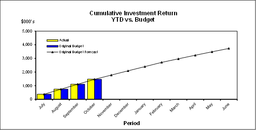
Cash Flow and Investment Movements
Council’s total cash and investment portfolio at the end of October 2016 was $135,962,000, compared to $139,291,000 at the end of September 2016, a net cash outflow of $3,329,000. The cash outflow was mainly due to creditor payments.
One investment has matured during the month of October 2016.

Investment Performance against Industry Benchmarks
Overall during the month of October the investment performance was well above the industry benchmark.
The benchmark is specific to the type of investment and the details are provided below.
Ø AusBond Bank Bill Index is used for all Council’s investments
Table 1 - Investments Performance against Industry Benchmarks

Table 2 below provides a summary of all investments by type and performance during the month.
Attachment A1 provides definitions in relation to different types of investments.
Table 2 - Investments Portfolio Summary during October 2016
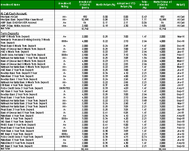
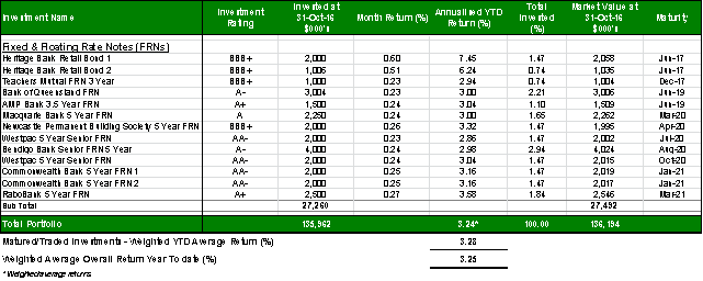
Investment by Credit rating and Maturity Profile
The allocation of Council’s investments by credit rating and the maturity profile are shown below:
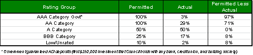
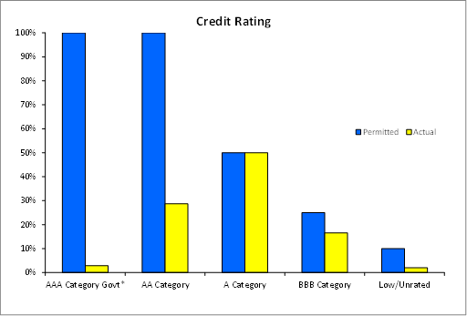
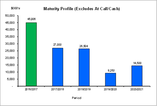
integrated planning and reporting
Leadership & Governance
|
Community Strategic Plan Long Term Objective |
Delivery Program Term Achievement |
Operational Plan Task |
|
L2.1 Council rigorously manages its financial resources and assets to maximise delivery of services |
Council maintains and improves its long term financial position and performance |
Continue to analyse opportunities to expand the revenue base of Council |
Governance Matters
Council’s investments are made in accordance with the Local Government Act (1993), the Local Government (General) Regulation 2005 and Council’s Investment Policy.
Section 212 of the Local Government (General) Regulation 2005 states:
(1) The responsible accounting officer of a council:
(a) must provide the council with a written report (setting out details of all money that the council has invested under section 625 of the Act) to be presented:
(i) if only one ordinary meeting of the council is held in a month, at that meeting, or
(ii) if more than one such meeting is held in a month, at whichever of those meetings the council by resolution determines, and
(b) must include in the report a certificate as to whether or not the investment has been made in accordance with the Act, the regulations and the council’s investment policies.
(2) The report must be made up to the last day of the month immediately preceding the meeting.
Risk Management
Council manages the risk associated with investments by diversifying the types of investment, credit quality, counterparty exposure and term to maturity profile.
Council invests its funds in accordance with The Ministerial Investment Order.
All investments are made with consideration of advice from Council’s appointed investment advisor, CPG Research & Advisory.
Financial Considerations
The original budget for interest on investments for the financial year 2016/2017 is $3,730,900. Of this amount approximately $2,244,000 is restricted for the benefit of future expenditure relating to development contributions, $980,100 transferred to the internally restricted Infrastructure & Facility Reserve, and the remainder of $506,800 is available for operations.
An increase to the interest income budget by 350,000 is proposed in the September Quarterly Budget Review, taking into account growth in investment portfolio due to large Section 94 contributions from previous financial year. Of this amount, $210,000 is restricted to Section 94 external reserves, $49,000 to the internal Infrastructure & Facilities reserve and $91,000 is unrestricted.
Social Considerations
Not applicable.
Environmental Considerations
Not applicable.
Community Consultation
None undertaken or required.
Internal Consultation
None undertaken or required.
Certification - Responsible Accounting Officer
I hereby certify that the investments listed in the attached report have been made in accordance with Section 625 of the Local Government Act 1993, clause 212 of the Local Government General Regulation 2005 and Council’s Investment Policy.
Summary
As at 31 October 2016:
· Council’s total cash and investment portfolio is $135,962,000.
· The net return on investments for the financial year to October 2016 was $1,485,000 against a budget of $1,468,000, giving a YTD favourable variance of $17,000.
· An increase to the interest income budget by 350,000 is proposed in the September Quarterly Budget Review, taking into account growth in investment portfolio due to large Section 94 contributions from previous financial year. Of this amount, $210,000 is restricted to Section 94 external reserves, $49,000 to the internal Infrastructure & Facilities reserve and $91,000 is unrestricted.
|
A. That the summary of investments and performance for October 2016 be received and noted.
B. That the Certificate of the Responsible Accounting Officer be noted and the report adopted.
|
|
Kate Chin Acting Financial Accountant |
Angela Apostol Manager Finance |
|
David Marshall Director Corporate |
|
|
Investments definitions specific to Council’s investment portfolio |
|
2016/124274 |
|
Ordinary Meeting of Council - 22 November 2016 |
GB.5 / 195 |
|
|
|
|
Item GB.5 |
S05273 |
|
|
21 October 2016 |
Analysis of Land and Environment Court Costs - 1st Quarter 2016 to 2017
EXECUTIVE SUMMARY
|
purpose of report: |
To report legal costs in relation to development control matters in the Land and Environment Court for the quarter ended 30 September 2016. |
|
|
|
|
background: |
A person may commence proceedings in the Land and Environment Court in relation to a development application which has either been refused by Council or is deemed to have been refused. An appeal may also be commenced in relation to conditions of development consent and the issue of building certificates and orders |
|
|
|
|
comments: |
For the three months ended 30 September 2016, Council’s legal and associated payments in relation to the Land and Environment Court were $202,574. This compares with the annual budget of $1,063,600. |
|
|
|
|
recommendation: |
That the analysis of Land and Environment Court costs for the quarter ended 30 September 2016 be received and noted. |
Purpose of Report
To report legal costs in relation to development control matters in the Land and Environment Court for the quarter ended 30 September 2016.
Background
A person may commence proceedings in the Land and Environment Court in relation to a development application which has either been refused by Council or is deemed to have been refused (a development application is deemed to have been refused if it has not been determined within a period of 40 days or such longer period that may be calculated in accordance with the Act). An appeal may also be commenced in relation to conditions of development consent and the issue of building certificates and orders. Council is a respondent to such proceedings.
Comments
Appeals Lodged
In quarter ended 30 September 2016, there were 13 new appeals lodged with the Land and Environment Court. The number of appeals received in prior years is as follows:
|
Financial year |
Number of appeals received (whole year) |
|
2012/2013 |
25 |
|
2013/2014 |
16 |
|
2014/2015 |
31 |
|
2015/2016 |
38 |
|
2016/2017 (as at 30 Sept 2016) |
13 |
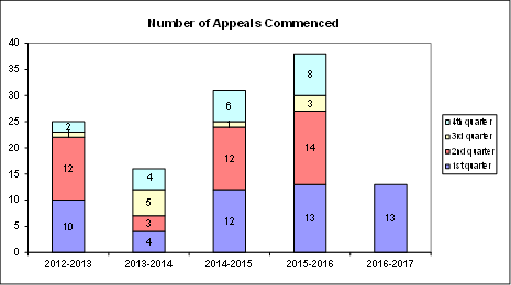
The appeals commenced during the three months ended 30 June 2016 concerned the following subject matters:
· Residential apartment buildings
· Mixed use development
· Town houses
· Child care centre
· Subdivision
· Seniors housing
· Additions and alterations
· Tree removal
· Modification of existing development consent
costs
For the quarter ended 30 September 2016, Council made payments of $202,574 on appeals and associated expenses in relation to Land & Environment Court matters. This compares with the annual budget of $1,063,600.
In addition to expenditure on appeals, a further amount of $11,014 was spent in obtaining expert advice regarding development assessment matters.
|
Land & Environment Court Costs 2013/2014 - 2016/2017 |
|||||
|
Financial Year |
Total Costs |
1st quarter September |
2nd quarter December |
3rd quarter March |
4th quarter June |
|
2013/2014* (16 appeals lodged) |
$481,043 |
$42,412 |
$124,001 |
$104,095 |
$210,535 |
|
2014/2015* (31 appeals lodged) |
$1,153,612 |
$186,803 |
$407,603 |
$194,103 |
$365,103 |
|
Financial Year |
Total Costs |
1st quarter September |
2nd quarter December |
3rd quarter March |
4th quarter June |
|
2015/2016 (38 appeals lodged) |
$1,256,887 |
$264,263 |
$290,099 |
$303,122 |
$399,403 |
|
2016/2017 (13 appeals lodged) |
$202,574 |
$202,574 |
N/A |
N/A |
N/A |
* Costs reported to Council in previous reports
The costs incurred in the three months to 30 September 2016 represent 19% of the annual budget of $1,063,600. As noted above, the number of appeals in recently reported periods has been high compared to historical averages. The number of appeals received by Council is a matter that does not lie within the control of Council, however the main factor appears to have been the amendment to the Environmental Planning and Assessment Act made in 2013 which reduced the timeframe for lodgement of an appeal from twelve months to six months. This has had the undesired effect of applicants for more substantial and complex development proposals lodging appeals for no other reason than as a mechanism to preserve early appeal rights. Notwithstanding, Council’s overall success rate in appeals is high.
In relation to costs recovered, the amount of $47,019 had been recovered as at the end of the quarter to 30 September 2016. This compares favourably to an annual budget for costs recovered of $57,500.
SUMMARY BY WARD
A summary of the above Land & Environment Court costs by Ward for the three months to 30 September 2016 is shown in the following table:

Outcomes
At an early stage of each appeal, Council as respondent, is required to file with the Court a Statement of Facts and Contentions outlining the grounds which Council asserts as warranting refusal of a development, or alternatively, that may be addressed by way of conditions of consent.
In cases where issues raised by Council are capable of resolution by the provision by the applicant of additional information or amendment of the proposal, it is the Court’s expectation that this should occur. The Court’s current practice of listing appeals for a preliminary mediation conference before a Commissioner of the Court pursuant to section 34 of the Land & Environment Court Act, strongly encourages this.
In this context, any of three outcomes can be regarded as favourable, namely:
1. If the appeal is in relation to a deemed refusal of an application which, upon assessment, is appropriate for approval: that the development is determined by Council, allowing the appeal to be discontinued by the applicant and avoiding as much as is practicable the incurring of unnecessary legal costs;
2. If the issues raised by Council are capable of resolution by the applicant providing further information, or amending the proposal: that this occurs, so that development consent should be granted, either by Council or the Court;
3. If the issues raised by Council are either not capable of resolution or the applicant declines to take the steps that are necessary to resolve them: that the appeal is either discontinued by the applicant, or dismissed (refused) by the Court.
Five matters were concluded during the quarter. A wholly or substantially favourable outcome was achieved in all matters.
· One matter was discontinued by the applicant;
· Four matters were resolved by agreement in relation to an amended proposal.
integrated planning and reporting
Leadership & Governance
|
Community Strategic Plan Long Term Objective |
Delivery Program Term Achievement |
Operational Plan Task |
|
L2.1 Council rigorously manages its financial resources and assets to maximise delivery of services. |
Achieve financial sustainability targets identified in the Long Term Financial Plan. |
Undertake quarterly reporting to Council on the financial performance of the organisation. |
Governance Matters
Under Section 428 of the Local Government Act 1993, Council is required to report legal costs, and the outcome of each case in its Annual Report.
Risk Management
Quarterly reporting of legal costs to Council together with information about the number, character and outcomes of proceedings enable ongoing oversight of this area of Council’s activity.
Financial Considerations
Land & Environment Court legal costs form part of Council’s recurrent operating budget.
Social Considerations
None undertaken or required.
Environmental Considerations
None undertaken or required.
Community Consultation
None undertaken or required.
Internal Consultation
This report has been developed with input from Council’s Corporate Lawyer, Director Corporate and Director Development & Regulation.
Summary
For the quarter ended September 2016, Council made payments of $202,574 on Land & Environment Court appeals and other development control matters. This compares with the annual budget of $1,063,600.
|
That the analysis of Land and Environment Court costs for the quarter ended 30 September 2016 be received and noted.
|
|
Tony Ly Financial Accounting Officer |
Angela Apostol Manager Finance |
|
Jamie Taylor Corporate Lawyer |
David Marshall Director Corporate |
|
Michael Miocic Director Development & Regulation |
|
|
Individual Case Summary September 2016 - Land and Environment Court Costs |
|
2016/300538 |
|
APPENDIX No: 1 - Individual Case Summary September 2016 - Land and Environment Court Costs |
|
Item No: GB.5 |
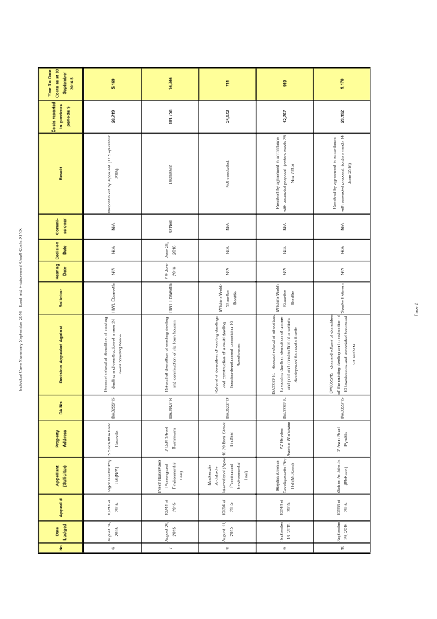
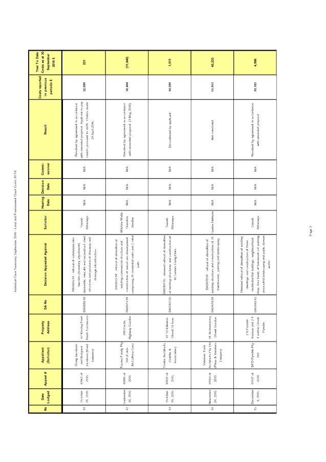
|
Ordinary Meeting of Council - 22 November 2016 |
GB.6 / 207 |
|
|
|
|
Item GB.6 |
CY00259/8 |
|
|
9 November 2016 |
Christmas/New Year Recess Delegations 2016/2017
EXECUTIVE SUMMARY
|
purpose of report: |
To grant appropriate Delegations during the Christmas/New Year recess period for 2016/2017. |
|
|
|
|
background: |
Council at its meeting of 8 November 2016 adopted a meeting cycle for 2017. Council’s last meeting of 2016 will be held on 6 December 2016 with the first meeting of 2017 being held on 7 February 2017. Thereby delegations are required to be granted during the Christmas/New Year recess period for 2016/2017. |
|
|
|
|
comments: |
The Christmas/New Year recess period is from the last Council meeting on 6 December 2016 until meetings resume on 7 February 2017. During this period, it is customary to grant Delegated Authority to the Mayor, Deputy Mayor and the General Manager. |
|
|
|
|
recommendation: |
The appropriate Delegations of Authority be granted to the Mayor, Deputy Mayor and the General Manager for the Christmas/New Year recess period for 2016/2017. |
Purpose of Report
To grant appropriate Delegations during the Christmas/New Year recess period for 2016/2017.
Background
Council at its meeting of 8 November 2016 adopted a meeting
cycle for 2017. Council’s last meeting of 2016 will be held on 6 December
2016 with the first meeting of 2017 being held on
7 February 2017. Thereby delegations are required to be granted during the
Christmas/New Year recess period for 2016/2017.
It is customary for Council to grant appropriate Delegations of Authority to the Mayor, Deputy Mayor and to the General Manager during this recess period.
integrated planning and reporting
Leadership and Governance
|
Community Strategic Plan Long Term Objective |
Delivery Program Term Achievement |
Operational Plan Task |
|
The organisation is recognised and distinguished by its ethical decision-making, efficient management, innovation and quality customer service. |
Council's Governance framework is developed to ensure probity, transparency and the principles of sustainability are integrated and applied into our policies, plans, guidelines and decision-making processes. |
Ensure effective and efficient conduct of Council and committee meetings for the benefit of councillors and the community. |
Comments
The Christmas/New Year recess period is from the last Council meeting on 6 December 2016 until meetings resume on 7 February 2017. During this period, it is customary to grant Delegated Authority to the Mayor, Deputy Mayor and the General Manager.
These Delegations of Authority will assist in the smooth functioning of the Council during the Christmas/New Year recess for 2016/2017.
Governance Matters
It is Council’s usual practice to grant delegated
authority to exercise all powers, authorities, duties and functions of Council,
except those set out in Section 377 of the Local Government Act 1993,
during the Christmas/New Year period. This year that period is from the 7
December 2016 to
6 February 2017.
Risk Management
There are no major risks associated with the recommendations in this report.
Financial Considerations
There are no financial considerations associated with this report.
Social Considerations
There are no social considerations associated with this report.
Environmental Considerations
There are no environmental considerations associated with this report.
Community Consultation
None undertaken or required.
Internal Consultation
None undertaken or required.
Summary
The Christmas/New Year recess period is from the last Council meeting on 6 December 2016 until meetings resume on 7 February 2017. During this period, it is customary to grant Delegated Authority to the Mayor, Deputy Mayor and the General Manager.
These Delegations of Authority will assist in the smooth functioning of the Council during the Christmas/New Year recess for 2016/2017.
|
A. That the following Delegations of Authority be granted to the Mayor, Deputy Mayor and the General Manager for the Christmas/New Year recess period for 2016/2017 as follows;
1. That the Mayor (Councillor Jennifer Anderson), the Deputy Mayor (Councillor David Ossip), and the General Manager (John McKee), be granted authority to exercise all powers, authorities, duties and functions of Council except those set out in Section 377 of the Local Government Act 1993 during the period 7 December 2016 to 6 February 2017, subject to the following conditions:
a. Such powers, authorities and functions may only be exercised by unanimous agreement between the Mayor, Deputy Mayor and General Manager.
b. Any such power, authority, duty or function shall only be exercised by the Mayor, Deputy Mayor and General Manager jointly where they are of the opinion that the exercise of any such power, authority, duty or function could not be deferred until the meeting of Council on 7 February 2017.
B. That consultation, subject to their availability, be held with Ward Councillors on matters where they would normally be contacted, before delegation is exercised.
|
|
Christine Dunand Governance Team Leader |
Amber Moloney Manager Records and Governance |
|
David Marshall Director Corporate |
|
|
Ordinary Meeting of Council - 22 November 2016 |
GB.7 / 211 |
|
|
|
|
Item GB.7 |
CY00043/8 |
|
|
10 November 2016 |
Taldumande Youth Services 2017 Charity Dinner
EXECUTIVE SUMMARY
|
purpose of report: |
To inform Councillors of the Taldumande Youth Services 2017 Charity Dinner being held on 22 March 2017 at Luna Park, Sydney. |
|
|
|
|
background: |
The Taldumande Youth Services 2017 Charity Dinner is being held on 22 March 2017 to celebrate the 40 year anniversary of the opening of the first Taldumande Crisis Refuge. Taldumande Youth Services is a not-for-profit organisation that supports vulnerable children, young people and their families. They operate the only 24/7 crisis refuge for young people in Northern Sydney and offer supported accommodation and community programs that provide a streamlined pathway, from homelessness and family breakdown, to independence and stability. |
|
|
|
|
comments: |
Individual tickets for the Taldumande Youth Services 2017 Charity Dinner are available for $185 or a table of 10 can be purchased for $1,750. |
|
|
|
|
recommendation: |
That Council consider the invitation to purchase tickets for the 2017 Taldumande Youth Services Charity Dinner. |
Purpose of Report
To inform Councillors of the Taldumande Youth Services 2017 Charity Dinner being held on 22 March 2017 at Luna Park, Sydney.
Background
The Taldumande Youth Services 2017 Charity Dinner is being held on 22 March 2017 to celebrate the 40 year anniversary of the opening of the first Taldumande Crisis Refuge.
Taldumande Youth Services is a not-for-profit organisation that supports vulnerable children, young people and their families. They operate the only 24/7 crisis refuge for young people in Northern Sydney and offer supported accommodation and community programs that provide a streamlined pathway, from homelessness and family breakdown, to independence and stability. Further information about the organisation and the services they provide is available on their website: https://www.taldumande.org.au/what-we-do/.
Comments
Individual tickets for the Taldumande Youth Services 2017 Charity Dinner are available for $185 or a table of 10 can be purchased for $1,750. Bookings can be made at https://www.taldumande.org.au/news/2017-charity-dinner/.
integrated planning and reporting
L1.1.3
|
Community Strategic Plan Long Term Objective |
Delivery Program Term Achievement |
Operational Plan Task |
|
Partnerships are established with government agencies, regional and local organisations and community groups and are working to achieve Ku-ring-gai’s community outcomes. |
Pursue new opportunities for partnership arrangements with other agencies, organisations and community groups to achieve community outcomes.
|
Pursue priority areas where partnership arrangements will provide tangible benefits to the local area.
|
Governance Matters
The Payment of Expenses and Provision of Facilities to Councillors Policy provides for Council to meet the reasonable costs of Councillors attendance at formal functions, including functions for charities and community service groups, as authorised by resolution of Council.
Risk Management
Nil.
Financial Considerations
Individual tickets for the Taldumande Youth Services 2017 Charity Dinner are available for $185 or a table of 10 can be purchased for $1,750.
The Payment of Expenses and Provision of Facilities to Councillors Policy provides for Council to meet the reasonable costs of Councillors attendance at formal functions, including functions for charities and community service groups, as authorised by resolution of Council. Funds are available in the 2016/17 budget.
Social Considerations
Taldumande Youth Services is a not-for-profit organisation that supports vulnerable children, young people and their families. They operate the only 24/7 crisis refuge for young people in Northern Sydney and offer supported accommodation and community programs that provide a streamlined pathway, from homelessness and family breakdown, to independence and stability.
Environmental Considerations
Nil.
Community Consultation
Nil.
Internal Consultation
Nil.
Summary
Councillors have received an invitation to attend the Taldumande Youth Services 2017 Charity Dinner which is being held on 22 March 2017 at Luna Park, Sydney.
Individual tickets for the Taldumande Youth Services 2017 Charity Dinner are available for $185 or a table of 10 can be purchased for $1,750.
|
That Council consider the invitation to purchase tickets for the 2017 Taldumande Youth Services Charity Dinner.
|
|
Amber Moloney Manager Records and Governance |
David Marshall Director Corporate |
|
Ordinary Meeting of Council - 22 November 2016 |
GB.8 / 214 |
|
|
|
|
Item GB.8 |
DA0171/16 |
|
|
17 August 2016 |
development application
Summary Sheet
|
Report title: |
DA0171/16 5 - 7 Eulbertie Avenue, Warrawee - demolition of existing structures and construction of 14 townhouses and basement car park |
|
ITEM/AGENDA NO: |
GB.8 |
|
Application No: |
DA0171/16 |
|
Property Details: |
5 – 7 Eulbertie Avenue, Warrawee Lot & DP No: Lot 1 DP 301201 and Lot 1 DP 171189 Site area (m2): 3039.2m2 Zoning: R3 |
|
Ward: |
|
|
Proposal/Purpose: |
Demolition of existing structures and construction of 14 townhouses, basement car park and site landscaping works |
|
Type of Consent: |
Local |
|
Applicant: |
Eulbertie Investments Pty Ltd |
|
Owner: |
P & S Brereton and D & R Cains |
|
Date Lodged: |
20 April 2016 |
|
Recommendation: |
Approval |
Purpose of Report
The purpose of this report is to determine DA0171/16. The application is reported to Council as the proposal is for a multi dwelling housing development comprising more than 3 dwellings that is recommended for approval.
integrated planning and reporting
|
Community Strategic Plan Long Term Objective |
Delivery Program Term Achievement |
Operational Plan Task |
|
P2.1 A robust planning framework is in place to deliver quality design outcomes and maintain the identity and character of Ku-ring-gai |
Applications are assessed in accordance with State and local plans
|
Assessments are of high quality, accurate and consider all relevant legislative requirements
|
Executive Summary
|
Issues |
· height of basement · top storey design
|
|
Submissions |
· 9 submissions objecting to the proposed development
|
|
Land & Environment Court |
No
|
|
Recommendation |
Approval
|
|
|
|
|
LEGISLATIVE REQUIREMENTS: |
|
|
|
|
|
Zoning |
R3 Medium Density Residential
|
|
Permissible under |
Ku-ring-gai Local Environmental Plan 2015
|
|
Relevant legislation |
· State Environmental Planning Policy No. 55 – Remediation of Land · State Environmental Planning Policy (Building Sustainability Index: BASIX) 2004 · Sydney Regional Environmental Plan – Sydney Harbour Catchment 2005 · Ku-ring-gai Local Environmental Plan 2015 · Ku-ring-gai Development Control Plan 2015 & 2016 · Ku-ring-gai Contributions Plan 2010
|
|
Integrated Development |
No |
History
Pre-DA
A Pre-DA consultation for this development was held between Council officers and representatives of the applicant on 15 December 2015. No significant issues were identified during the Pre-DA. Matters raised by Council officers regarding tree retention and design improvements have been successfully integrated into the current scheme.
DA history
|
20 April 2016 |
DA lodged
|
|
6 May 2016 |
DA notified and advertised for 30 days
|
|
22 June 2016 |
Preliminary assessment letter issued to applicant |
|
13 July 2016 |
A meeting was held with the applicant to discuss issues and conceptual amended plans.
|
|
31 August 2016 |
Amended plans submitted
|
|
27 September 2016 |
Further amended plans submitted |
The Site
Site description
The site is identified as Lot 1, DP 171189 and Lot 1, DP 301201 known as 5 – 7 Eulburtie Avenue, Warrawee. The site is on the eastern (low) side of Eulburtie Avenue, to the south of its intersection with the Pacific Highway.
The site is irregular in shape and has a street frontage of 50.235 metres, a side, northern, boundary of 54.855 metres, a rear, western, boundary of 60.578 metres and a side, southern, boundary of 55.825 metres.
The site is 3,039sqm in area and has a fall of 3.8 metres to the rear, western, boundary.
The site currently accommodates two dwellings, a swimming pool and a disused tennis court.
The site contains 37 trees, whilst there are 12 trees on neighbouring properties in the vicinity of the site.
Surrounding development
Adjoining the site to the north and east are single residential dwellings on landscaped lots. Nos 2 to 6 Winton Avenue are locally listed heritage items, whilst the southern section of the Warrawee Conservation Area adjoins to the north, east and north-west of the site.
Adjoining the site to the south, is a residential flat development comprising 5 storey buildings over basement parking on a large lot at 1-3 Eurbertie Avenue. To the west of the site is another 5 storey residential flat development at 2- 4 Eulbertie Avenue.
The surrounding locality contains predominately low scale residential dwellings, with medium to high density residential development along the Pacific Highway corridor.
The Proposal
The proposal as amended is for the following development:
· demolish the existing dwellings and ancillary structures
· construct a 3 storey townhouse development within 3 blocks, including:
o 2 x 4 bedroom dwellings
o 12 x 3 bedroom dwellings
· basement car park, including:
o 32 basement car spaces – 28 x residential and 4 x visitor
o 1 x service/carwash space
o garbage room
o storage and plant rooms
o 5 x bicycle spaces
o OSD and rainwater tanks
· new concrete internal driveway and new driveway crossover
· excavation to 3 metres for basement level
· landscaping, front and side boundary fencing, pedestrian entry portico, ramping, retaining walls and courtyards
· removal of 15 trees within the site
Consultation
Community
In accordance with the notification requirements of Ku-ring-gai DCP 2015, the application was notified to owners and occupants of surrounding properties and advertised in the local newspaper for a period of 30 days, between 15 January 2016 and 15 February 2016. In response, Council received submissions from the following:
|
M & R Abrahams – 2 Winton Street, Warrawee |
|
D & J Teroxy – 19 Eulbertie Avenue, Warrawee |
|
P & C Fuery – 17A Eulbertie Avenue, Warrawee |
|
G Watts 303/2 Eulbertie Avenue, Warrawee |
|
S Preston - 2 Fox Valley Road, Warrawee |
|
F & R Son – 4/1-3 Eulbertie Avenue, Warrawee |
|
H Campbell – 301/2A Eulbertie Avenue, Warrawee |
|
F Shafiei & N Davari 402/2A Eulbertie Avenue, Warrawee |
|
J Holmes – 4 Winton Street, Warrawee |
The submissions raised the following issues:
The design and scale of the development dominates, detracts and competes with the heritage items to the rear and is inconsistent with the intent of Part 19F.1 of the KDCP.
Council’s Heritage Advisor has given consideration to the built form of the development and its effect on the heritage items that adjoin. The Heritage Advisor considers that the proposed development as amended will have an acceptable impact on the heritage items and the HCA.
The bulk and scale is out of character with the surrounding area.
The site is zoned under the Ku-ring-gai Local Environmental Plan 2015 as R3 Medium Density Development, the purpose of which is to provide a transition in the built form scale between high density 5 storey residential flat development and low density single dwelling development. As the development is representative of the maximum height and FSR, it is consistent with the built form of the desired future character encouraged by the LEP.
The proposed development will have an adverse impact on solar access to Unit 301, 2 Eulbertie Avenue.
The comprehensive solar access diagrams submitted with the application demonstrate that the shadow cast by the proposed development is within the tolerances of the DCP and that the shadow impact of the development will not unreasonably impact the amenity of any adjoining property.
The proposed development will create unacceptable light spill.
Condition 89 is recommended to ensure that outdoor lighting is shielded and hooded to ensure that it does not unreasonably impact any adjoining dwelling.
The development is contrary to the objectives for privacy prescribed within the DCP.
The LEP allows multi-unit housing developments of up to three storeys in the R3 zone. The controls do not dictate how this floor spaced is to be used or allocated. Living areas at the upper storey are allowed, provided the privacy considerations of the DCP are met. It is considered that the proposal will not have an unacceptable impact in this regard, as the habitable areas of the top most floors are centred within the middle of the corresponding floor plate which provide for greater separate from adjoining properties and provide for view out, rather than down upon adjoining properties.
The proposed development will create unacceptable acoustic impacts upon adjoining properties as living and open space areas are orientated towards the neighbouring properties.
The development has been adequately designed and set back so as to reasonably maintain the acoustic privacy of residents in adjoining developments.
The proposed development does not provide adequate car parking and will place additional demands on the already over prescribed local street network.
The proposed development provides for 32 car spaces, which is the upper range for car parking for this development. The demand for car parking generated by this development is accommodated within its basement and this is considered to be acceptable by Council’s Development Engineer.
The proposal will exacerbate current issues with traffic movements in and around the local street network.
Council’s Development Engineer has considered the anticipated traffic generated by the development and is satisfied that the proposed development will not have an unacceptable impact upon surrounding streets.
The proposal will result in the loss of views and to the surrounding canopy trees and road from unit 303, 2 Eulbertie Avenue.
The development will alter the outlook from adjoining developments over the development site. However, this outlook is not assessed as constituting significant view that would warrant protection as it is an aspect over an adjoining property rather than a vista of a prominent landmark or natural vista, such as district views.
The construction period will result in unacceptable noise levels.
Condition 24 requires that, prior to construction work commencing, a noise a vibration management plan is to be prepared and adhered to during construction so that the impacts of construction noise on adjoining residents are managed to ensure that such does not unreasonably affect their amenity.
The local schools and parks are already overcrowded and prescribed.
The matter of demand for additional services and infrastructure is considered in the zoning process of land, whereby the need for additional services / infrastructure is captured within applicable contributions plan. A development contribution is applicable to this development Condition 45.
The proposed development’s traffic combined with existing local traffic requires the provision of traffic lights at the intersection of Eulbertie Avenue and the Pacific Highway.
The anticipated traffic movements generated by the development have been assessed by Council’s Development Engineer who concluded that the low volume of additional traffic movements does not necessitate signalisation of the intersection of Eulbertie Avenue and Pacific Highway.
The development does not provide sympathetic or adequate landscaping.
The proposed development includes a comprehensive landscaping plan that provides for dense screen planning around the periphery of the development. Council’s Landscape Assessment Officer considers the landscaping and screening to be satisfactory.
The proposed development has an unacceptable economic and social impact, contrary to the heads of consideration prescribed by the Act.
A detailed assessment pursuant to Section 79C of the Environmental Planning and Assessment Act, 1979 was undertaken and confirms that the proposed development has an acceptable economic and social impact and has been found to be in the public’s interest as it is consistent with the development controls and standards for this typology of development prescribed by Council’s LEP and DCP. Accordingly, it is assessed as satisfying the matters for consideration prescribed by the Act.
The controls of part 6C.10 of the DCP restrict balconies to the upper floors where they do not address a street frontage. The development currently provides for these inclusions, impacting privacy of adjoining properties
The development as lodged and initially assessed by Council was done so pursuant of the KDCP 2015, where such inclusions were not restricted. The adoption of the KDCP 2016 introduced this control, however as the development has been initially designed, assessed and notified under the KDCP 2015 controls, it was considered unreasonable to seek amendment. Despite this, the development is assessed as having an acceptable impact on privacy as the balconies have a limited depth of 2m restricting their usability.
Within Council
Landscaping
Council's Landscape Assessment Officer assessed the amended proposal and commented as follows:
Tree impacts
T14 – Liquidambar styraciflua (Liquidambar)
The amendments to Unit 10 have satisfactorily addressed the impacts on T14.
T23 – Syncarpia glomulifera (Turpentine)
The arborist has concluded that the impacts on T23 from the installation of the stormwater works will be within acceptable limits provided it is carried out by hand or with directional drilling. Condition 69 will address this issue.
Tree removal
Fifteen trees will require removal for the proposed development, including 1 dead tree, 2 trees that are exempt and 12 trees with low to moderate retention value.
|
Tree / location |
Comments |
|
T2a - Picea pungens ‘Glauca’ (Blue Spruce) / Within building footprint |
7 metres high in fair condition |
|
T9a – Plumeria acutifolia (Frangipani) / Within building footprint |
< 5 metres high |
|
T17 – Robinia pseudoacacia ‘Frisia’ (Golden Robinia) / Within building footprint |
Exempt species |
|
T18 – Cupressus sempervirens (Italian Cypress) / Within building footprint |
12 metres high in good health |
|
T18a – Camellia sasanqua (Chinese Camellia) / Within building footprint |
6 metres high in good health |
|
T19 – Calodendron capense (Cape Chestnut) / Within building footprint |
7 metres high in good health |
|
T20b – Elaeocarpus reticulatus (Blueberry Ash) / Within building footprint |
10 metres high in good health |
|
T21 – Eucalyptus saligna (Sydney Blue Gum) / Eastern boundary |
22 metres high, high levels of decay. Picus sonic testing concluded that the tree is structurally compromised and should be removed. |
|
T29 – Archontophoenix cunninghamiana (Bangalow Palm) / Southern boundary |
8 metres high in good health |
|
T32 – Archontophoenix cunninghamiana (Bangalow Palm) / Within building footprint |
11 metres high in good health |
|
T33 – Dypsis decaryi (Triangle Palm) / Within building footprint |
7 metres high in good health |
|
T34 - Cupressus sempervirens (Italian Cypress) / Within building footprint |
Dead |
|
T34a – Camellia sasanqua (Chinese Camellia) / Within building footprint |
6 metres high in good health |
|
T34b – Pittosporum eugenioides 'Variegata (Variegated Tarata) / Within building footprint |
6 metres high in good health |
|
T34c – Ulmus parvifolia (Chinese Elm) / Within building footprint |
8 metres high in good health |
Landscape plan
The landscape plan is acceptable, subject to the following amendments which are included in Condition 27:-
· To minimise impacts on the heritage conservation area, the Pittosporum revolutum within the northern side boundary is be replaced with species that will provide a denser screen.
Stormwater plan
The additional information provided by the applicant in relation to the impacts of the proposed easement on T23 is considered acceptable. Condition 69 will ensure the tree protection measures, as recommended by the arborist, are carried out.
BASIX
No low water use planting is required.
Deep soil landscaping
In accordance with KDCP Part 6A.5, the development is required to have a minimum of 40% deep soil landscaping. The deep soil plan indicates deep soil landscaping of 40% or 1215.7 square metres which is compliant with the controls. The landscaping proposed for the site will achieve the objectives outlined in Part 6A.5 of the KDCP.
Conclusion
The Landscape Assessment Officer finds the proposal acceptable, subject to conditions.
Engineering
Council's Development Engineer assessed the amended proposal and commented as follows:
Water management
The subject site has a gradual fall from the front south-western corner through to the rear north-eastern corner of approximately 3.8m. It is proposed to create a new drainage connection via a 1.2m wide drainage easement to an existing stormwater pit within the neighbouring property that drains to Winton Street.
It is understood that negotiations have commenced with the owner of No. 2 Winton Street, Warrawee regarding an interallotment drainage easement that subsequently connects into an existing drainage easement. A deferred commencement consent would be necessary, with a condition requiring that the applicant submit documentary evidence to Council demonstrating that the property has the legal right to drain stormwater over the downstream property prior to the consent operating.
The applicant’s design engineer has submitted a survey of the proposed easement route to Council’s existing drainage system and supporting calculations verifying that the existing 225mm diameter pipe within the easement has sufficient hydraulic capacity to carry post-developed flows from the subject property to Council’s public drainage system.
The stormwater plans show a combined on-site detention and rainwater tank comprising 72.10m3 and 20,000L of storage, respectively, located within the basement area. The on-site detention discharge control pit is now relocated within the communal open area. The overflow pipe from the detention system is directed to the proposed drainage easement, which is acceptable.
A revised BASIX Certificate has been submitted with water commitments, requiring a central water tank of 10,000L. The BASIX commitments are for re-use of stored rainwater for irrigation of 787sq.m of common landscaped areas. The rainwater retention and re-use has met the BASIX commitments and satisfied the 50% reduction in runoff days. The requirements of Part 25B.3-4 of the Ku-ring-gai DCP has been satisfied.
Captured stormwater is to be treated by using a proprietary pollution device downstream from the detention system prior to connection to Council’s drainage system. The captured stormwater will be treated using a Humes Model ‘Humeceptor STC2’ which has been used on previous approved multi dwelling proposals and has satisfied the pollutant load standards set out in the Ku-ring-gai DCP Part 25B.6.
The Stormwater Management Plans prepared by E2 Civil & Structural Design Pty Ltd Drawing No. 15.577 SW1/E, SW2/D, SW3/B and SW4 dated 10 August 2016 are acceptable.
Vehicular access and accommodation arrangements
The site is zoned ‘R3’ under Ku-ring-gai LEP. The parking provisions have been determined using Ku-ring-gai Development Control Plan for multi-dwelling housing. The site is located greater than 400m walking distance from Warrawee Railway Station. According to the Ku-ring-gai DCP Part 23R.2 ‘Car Parking Rates’, the total minimum 25 parking spaces is required. The development provides 32 off-street parking spaces, comprising 28 residents’ spaces (includes 2 adaptable spaces) and 4 visitor spaces. The minimum parking requirements have been met.
Vehicular access to the car parking facility is via a new 6.1m wide entry / exit driveway crossing which narrows internally to a 3.6m ramp at the basement entry. The driveway clear width should be a minimum 3.7m as per Part 23.2(7) of the Ku-ring-gai DCP. This is addressed by Condition 3.
The basement plan shows the visitor space doubling as a carwash space and garbage truck loading bay. The minimum dimension of 3.5m x 6m is satisfied and this also provides adequate manoeuvring for a service/removalist vehicle which is easily accessible by Council’s waste collection vehicle.
The disabled visitor and residential parking spaces comply with AS2890.6:2009 with regard to having a minimum width of 2.4m plus 2.4m shared area whilst the accessible parking space has been assessed under AS4299 (1995) which is referenced by the Access Consultant.
A driveway longitudinal section has been shown on the architectural plan. The design includes a maximum gradient of 5% for the first 6 metres from the boundary and a maximum grade of 20%. The driveway gradients comply with Australian Standard 2890.1 (2004) “Off-Street car parking” as do the dimensions of the parking bay, ramp grades and aisle widths.
Waste collection
The development allows a garbage truck to enter and depart the garbage/room recycle storage area in a forward direction. The driveway grades and turning manoeuvrability are suitable for the small waste collection vehicle as shown by the swept paths within the Appendix of the Traffic Report.
A clear head height of 2.6m, shown on the Section Plan, has been provided to access the basement area and also provided over the travel path of the waste service vehicle.
The sizing of the garbage collection room is adequate to provide 17x240L bins for waste, paper and recycling to satisfy the minimum bin requirements.
The requirements as per Ku-ring-gai DCP Part 24R have been satisfied.
Construction management
A preliminary Construction Management Plan has been submitted which is acceptable for DA purposes. It is proposed to utilise the existing driveways as ingress and egress points for construction vehicles. It is anticipated that all construction vehicles will enter and exit the site in a forward direction. A work zone along the site frontage may not be necessary given the available area inside the property.
Based on the scale of works and expected construction vehicle movements, a detailed construction traffic management plan (CTMP) must be submitted for review by Council Engineers prior to the commencement of any works on site (Condition 15).
Geotechnical investigation
The preliminary investigation was undertaken based on site inspection and 2 boreholes. The results identified subsurface conditions comprising surface fill covering residual silty clay that graded into weathered shale. The shale was extremely weathered to about 9m depth. The boreholes were dry during and on completion of drilling. Groundwater was measured at a shallow depth of 3m and 4m in the standpipes near the boreholes, respectively.
The applicant’s geotechnical engineer provided further comment on the high groundwater level in the boreholes. Standpipes were installed in the boreholes to allow longer term monitoring of water levels and were measured during and after completion of the geotechnical investigation. The results showed that both boreholes were dry on completion of drilling. The Groundwater Modelling Report submitted, suggests that the proposed excavation will not extend below the groundwater table and there will not be any unreasonable groundwater impacts.
A separate groundwater screening report, prepared by EIS dated 22/7/16, suggests that groundwater was encountered. Condition 25 requires that the basement be fully tanked to prevent unnecessary subsurface or groundwater extraction as per the requirement of Part 24 C.3(8) of the Ku-ring-gai DCP.
The report states that all other recommendations during the construction phase shall be carried out as specified within the report that includes dilapidation reports of nearby structures.
Conclusion
From an engineering perspective there are no objections to approval of this application, subject to conditions.
Heritage
Council's Heritage Advisor assessed the amended proposal and commented as follows:
Heritage status
The site does not contain a heritage item. The site is within the vicinity of several heritage items and directly adjoins three items at No 2, 4 & 6 Winton Street. The heritage items within the broader vicinity include:
· Nos 2 & 6 Heydon Avenue;
· No 7 Winton Street;
· Nos 1379, 1361 – 1377, 1456 & 1526 (Mahratta) Pacific Highway.
The site adjoins a Heritage Conservation Area (HCA) – Area C-2, Heydon Avenue, Warrawee and Woodville Avenue, Wahroonga. The HCA includes most of the land along the Pacific Highway from Turramurra to Wahroonga between the Pacific Highway and the Railway line. A small part of the HCA along the Pacific Highway is excluded from this area including part of Heydon Avenue, Eulbertie Avenue and Winton Street to Lowther Park Avenue and is rezoned for medium density residential development.
Most of the rezoned sites have been developed, with the exception of the subject site and No 1407 Pacific Highway. However, a small residential flat development was recently approved at No 1407 Pacific Highway.
There is also a very broad HCA on the eastern side of the railway line – Area C-3 (Warrawee) and a small HCA on the opposite side of the Pacific Highway – Area C-4 (Mahratta).
The heritage objectives in Clause 5.10 of the KLEP are:
· to conserve the environmental heritage of Ku-ring-gai;
· to conserve the heritage significance of heritage items and heritage conservation areas, including associated fabric, settings and views;
· to conserve archaeological sites; and
· to conserve Aboriginal objects and Aboriginal place of heritage significance.
Clause 5.10 (5) of the KLEP states that, before granting consent to any development within the vicinity of a heritage item or HCA, Council may require a Heritage Management Document (HMD) to be prepared before granting consent. A HMD should assess the extent to which the carrying out of the proposed development would affect the heritage significance of the adjoining and nearby heritage items and the HCA.
Demolition of existing houses
The existing houses on the site are not considered to have aesthetic or technical heritage significance but would have some historic significance. They have not previously been identified as potential heritage items. It is also considered unlikely that the site contains relics as this area was not developed prior to construction of the existing buildings on the site.
Given that Council has rezoned the site, demolition of the houses is inevitable and there is no heritage objection to demolition. However, before demolition occurs, photographic archival recording of the houses and sites will be required as a condition of consent in any future approval (Condition 13).
Ku-ring-gai Development Control Plan (KDCP)
Council has specific objectives and controls to assist applicants in preparing applications for residential development within the vicinity of heritage items and within HCAs. The following are the relevant controls:
|
20F DEVELOPMENT IN THE VICINITY OF HERITAGE ITEMS OR HERITAGE CONSERVATION AREAS (HCAS) |
|
|
20F.1 Local Character and Streetscape |
|
|
General 1 All development in the vicinity of a Heritage Item or HCA is to include a Heritage Impact Statement. |
Yes |
|
|
|
|
2 Development on sites that either directly adjoin or are in the vicinity of a Heritage Item or an HCA is to have regard to: i) the form of the existing building or buildings including height, roofline, setbacks and building alignment; ii) dominant architectural language such as horizontal lines and vertical segmentation; iii) proportions including door and window openings, bays, floor-to ceiling heights and coursing levels; iv) materials and colours; v) siting and orientation; vi) setting and context; vii) streetscape patterns. |
No
No
Partially
Partially Partially Partially N/A |
|
Views |
|
|
4 New development in the vicinity of a Heritage Item or HCA is to demonstrate that it will not reduce or impair important views to and from the Heritage Item from the public domain. |
Yes |
|
20F.2 Building Setbacks |
|
|
Setbacks |
|
|
1 The front setback of development adjacent to a Heritage Item or buildings within an HCA is to be greater than that of the Heritage Item or building within the HCA. Where variations in setbacks exist, the larger setback will apply |
No |
|
Residential Context |
|
|
2 All medium and high density development is to have a stepped facade to any common boundary with a Heritage Item or building within the HCA. The facade is to be stepped back above an 8m height from natural ground level as per Figure 20F.2-1. Facades greater than 8m high will not be permitted adjacent to a Heritage Item or building with an HCA. |
Partially |
|
3 In addition to the side and rear setback controls in Section A of this DCP, new development adjacent to a Heritage Item or building within an HCA, is to comply with the following: i) adjacent development is to have a minimum 12m building separation to the Heritage Item (more if side setback requirements are not met within the 12m) as per Figure 20F.2-2; ii) adjacent development is to not exceed a facade height of 8m from existing ground level, including balustrades; iii) adjacent development with a building mass above 8m high from existing ground level is to be stepped back an additional 6m from the Heritage Item as per Figure 20F.2-2; Where variations in setbacks exist the larger setback will apply. |
No
No
No
|
|
20F.3 Gardens and Landscaping |
|
|
Gardens, Setting and Curtilage |
|
|
1 Development in the vicinity of a Heritage Item or an HCA is to: i) retain original or significant landscape features associated with the Heritage Item or HCA, or which contribute to its setting ii) retain the established landscape character of the Heritage Item or HCA. iii) include appropriate screen planting on side and rear boundaries. |
Yes
Yes Yes |
|
20F.4 Fencing |
|
|
Fences on adjoining sites |
|
|
1 New front fences on adjacent sites are to be no higher than the front fences of the adjoining Heritage Item or HCA. Open and transparent front fences such as timber or metal picket are preferred. |
Yes |
|
2 No metal panel fencing is to be constructed on any boundary of a Heritage Item. |
Yes |
Comments on non-compliance with KDCP controls
The following controls are not complied with:
2 Development on sites that either directly adjoin or are in the vicinity of a Heritage Item or an HCA is to have regard to:
i) the form of the existing building or buildings including height, roofline, setbacks and building alignment;
The proposed development is a contemporary residential flat building and, due to its nature form, height, roofline and building alignment, is different to the nearby heritage items and properties within the HCA which are mostly residential houses of one and two storeys set in large gardens. The development is broken into 3 separate buildings which assists in reducing its scale, its impact on the adjoining heritage items and HCA. The proposed buildings align with the side boundaries, similar to other buildings in the HCA area.
2 Development on sites that either directly adjoin or are in the vicinity of a Heritage Item or an HCA is to have regard to:
ii) dominant architectural language such as horizontal lines and vertical segmentation;
The architectural language of the proposed development is contemporary and does not pick up on horizontal lines but has vertical segmentation. The use of materials provides some relief to the vertical segmentation of the proposed development. The building would be understood in context with the 5 storey residential flat buildings to the west and north and its scale would to some extent provide an interface between the different zones.
2 Development on sites that either directly adjoin or are in the vicinity of a Heritage Item or an HCA is to have regard to:
iii) proportions including door and window openings, bays, floor-to ceiling
heights and coursing levels;
The proposed development is contemporary in form and responds to the zoning of the site. The proposed buildings are larger than the adjoining items and single dwellings in the HCA. The window openings include both vertical and horizontal elements. There is a distinct change between the top floor which is partially set back from the lower levels. There are no coursing levels that respond to the adjoining heritage items or dwellings in the HCA. The floor to ceiling heights responds to the requirements for RFBs and does not relate to the adjoining Federation and Inter War dwellings. Overall, floor to ceiling heights are limited by other planning controls and the proposed development responds to those planning controls.
2 Development on sites that either directly adjoin or are in the vicinity of a Heritage Item or an HCA is to have regard to:
iv) materials and colours;
Some of the materials used in the proposed development are similar to those of the adjoining heritage items and dwellings in the HCA, such as stone and face brick. However, the “Bowral Blue” face brick used in vertical panels is not found in the surrounding items or HCA however but is evident in the adjoining 5 storey RFB. The face brick commonly found in the area is generally red to brown and the bases are of stone. Rendered surfaces in the HCA are limited as most housing is face brick, although some areas were built with painted and rendered brickwork including a number of heritage items in Yosefa Avenue designed by August Alley in the 1920s. The adjoining dwelling at No 9 Eulbertie Avenue is painted.
2 Development on sites that either directly adjoin or are in the vicinity of a Heritage Item or an HCA is to have regard to:
v) siting and orientation;
The proposed development, although much larger than the existing single dwellings, is designed as three individual buildings and attempts to relate to the siting of the existing houses on the site. The orientation lines up with the site boundaries in a conventional manner, typical of the area. The additional building (Block 3) is largely concealed behind Block A and obscured from the public realm by Block B. The proposed building also relates to the adjoining RFB and the RBF opposite the roadway.
2 Development on sites that either directly adjoin or are in the vicinity of a Heritage Item or an HCA is to have regard to:
vi) setting and context;
The context of the site is an interface between the 5 storey developments and the lower scale housing in Eulbertie. There will always be a conflict where buildings of higher scale adjoin lower scale residential development. However, the site would provide a transition in scale between the HCA and the existing RFBs.
1 The front setback of development adjacent to a Heritage Item or buildings within an HCA is to be greater than that of the Heritage Item or building within the HCA. Where variations in setbacks exist, the larger setback will apply
The front setback of Block B is about 2.2m forward of the front wall of the adjoining dwelling at No 9 Eulbertie Avenue. No 9 Eulbertie Avenue has an open flat roofed verandah extending forward of the main wall which appears to be an addition post 1943 (see attached 1943 aerial). Block B is roughly in line with the verandah of the adjoining dwelling. The SHI argues that the dwelling at No 9 Eulbertie Avenue is highly altered and has little heritage significance. However, the building is altered but still reads as a 1920s house. The main changes to the dwelling are to its north eastern elevation (opposite side of proposed development behind the building line) which includes a basement level garage and ground floor additions set well behind the main façade. Changes to the rear of the site are garden elements, including a pool and tennis court, which are commonly found in the HCA precinct. The flat roofed verandah is considered sympathetic to the dwelling. The building is currently painted although it is unknown if it was originally painted. The building is obscured from the street by a high masonry wall and existing vegetation. The wall along the front boundary is uncharacteristic but otherwise the building and vegetation contributes to the HCA. The houses further to the east are more original Inter War bungalows, with no obvious alterations and strongly contribute to the character of the HCA.
To fully comply with the required setback, the proposed building would need to be amended and set back further. Due to the isolation provided by the masonry wall, it is considered that mitigation of the setback can be achieved by providing sufficient landscape screening to the courtyards along the northern elevation of Block B. This issue has been discussed with the Landscape Assessment Officer and found to be acceptable, as is the variation.
2 All medium and high density development is to have a stepped facade to any common boundary with a Heritage Item or building within the HCA. The facade is to be stepped back above an 8m height from natural ground level as per Figure 20F.2-1. Facades greater than 8m high will not be permitted adjacent to a Heritage Item or building with an HCA.
3 In addition to the side and rear setback controls in Section A of this DCP, new development adjacent to a Heritage Item or building within an HCA, is to comply with the following:
i) adjacent development is to have a minimum 12m building separation to the Heritage Item (more if side setback requirements are not met within the 12m) as per Figure 20F.2-2;
The above controls are considered here in one response as the objectives are the same.
The setback of Block B above the 8m wall height along the north elevation facing the HCA is only 2.3m and less than that required in the DCP (6m). Similarly, the setback of Block C from the garage of the heritage item at No 2 Winton Street is less that required at 11m (12m is required) and the setback of the top floor above the 8m wall height is only about 2.3m (6m is required).
The objectives that underlie the controls ensure that new work respects the streetscape patterns through careful siting of new buildings, to ensure that new development provides a scale interface that preserves the amenity of the items and HCA and to ensure that new development does not dominate the item or HCA.
With respect to the adjoining heritage items, they are all sited with their main front to Winton Street. The dwelling at No 2 Winton Street is set back a considerable distance from the boundary of the subject site. The garage is located in its rear yard, very close to its boundary. The dwelling itself is well set back from its rear boundary. The location of the garage tends to reduce amenity impacts between the dwelling and the proposed townhouse development. However, as noted in the SHI, it will be possible to see the proposed building from within the rear rooms of the item. Mitigation would be dependent upon appropriate landscaping being achieved. Council’s Landscape Assessment Officer advised that sufficient landscaping is provided along the rear boundary of the subject site to achieve appropriate screening. In addition, the position of the courtyard to Unit 10 to the rear of the site reduces impacts on an existing mature tree. The courtyard in this position does not affect the heritage item at No 6 Winton Street as there is a tennis court located close to the boundary of the subject site and existing plantings.
Conclusion
The amended development achieves the setback provisions in the KDCP for rezoned sites adjoining heritage items and a HCA. Amendments to the landscaping plan and relocation of the courtyard to Unit 10 is proposed via a series of landscape conditions to mitigate these non-compliances.
In other respects the proposed development is considered satisfactory from a heritage perspective.
Photographic recording of the site is considered necessary before any future demolition works take place (Condition 13).
Urban design
Council's Urban Design Consultant assessed the amended proposal and commented as follows:
1. CONTEXT
There are no direct urban design impacts for the heritage items or heritage conservation areas arising from the built form of the proposed development.
The site layout results in 5 of the dwellings having a street address and a clear site strategy that complements the transition of urban character from new R4 development to the R2 heritage conservation areas.
1.1 Streetscape character
Ku-ring-gai’s existing and desired urban character is of buildings set within garden settings. This objective applies to all types of residential development.
Both the streetscape and internal site character are welcoming and ensure front setback, all side and rear setback zones are dominated by deep soil landscaping. Common areas of landscape are well located, generous and achieve a positive relationship with the built form.
1.2 Site layout
Proposed site layout is rational and achieves clear sightlines between each of the blocks and generally through the site from the street at the main pedestrian entry through to the rear boundary. Building separation is consistent with DCP requirements.
2. DENSITY
FSR is consistent with permitted density of 0.8:1.
2.1 Scale
The development is consistent with the intended scale for R3 development. The built form being expressed as three separate buildings and the individual articulation of each dwelling has resulted in a cohesive, well-proportioned development. The arrangement of the massing on site also responds to the scale of the heritage items to the east. Although R3 development will result in a building type that is different to that of the adjacent detached dwellings to the north, the proposed development is consistent with the typology intended for the site and does not present any unacceptable impacts upon the HCA.
2.2 Setbacks
The proposal satisfies the separations to the heritage items and the site layout results in and has sought to maximise the deep soil landscape zones around the perimeter of the site.
The site layout is acceptable. Further amendments have addressed potential privacy impacts to the R2 zone, the landscape character and heritage considerations from an and appear to have addressed issues to protect trees that currently form important elements in the landscape character both within the site and broader precinct.
3. LANDSCAPE AND OPEN SPACE
Generally, sufficient deep soil has been provided around the perimeter of the site to sustain larger trees and vegetation.
Trees 14, 16, 21, 22 and 23 in particular serve roles of creating the biodiversity significance (remnant canopy) and/or a treescape backdrop for the Winton Avenue heritage items when viewed from those properties and from the public domain, and/or provide visual screening to RFB development to the south and west of the subject site.
The BGHF component should be either retained and enhanced (consistent with the ecological obligations) but also to ensure any removal of trees does not result in longer term impacts to the treescape setting for the heritage items and HCAs neighbouring the site. Protecting the trees will achieve the intended landscape character that respects the heritage items and HCA and satisfies DCP objectives for buildings within a landscape setting.
The recent amendments have addressed the tree protection from to achieve treescape setting for the heritage items and visual screening of the RFB development when viewed from Winton Avenue.
3.1 Communal open space
Communal open space is not a requirement for this development.
3.2 Deep soil
Satisfies DCP requirements.
3.3 Fencing
The internal site character has been improved by removing some of the ramping so that additional internal landscaping can be achieved. This landscaping has achieved a good balance of private and communal ownership that will ensure its quality can be controlled over the long term, and not overly dependant upon the interest and diligence of individual owners to maintain.
3.4 Access ramps and landscape character
The use of ramps has been rationalised to achieve a generally pleasant internal landscape character.
3.5 Accessible paths
Amendments to the pathways to THs 12, 13 and 14 now provide required access for visitable dwellings.
4. BUILDING DESIGN AND AMENITY
The layouts of individual townhouses are efficient and comfortable with good cross ventilation and access to natural light on all levels.
4.1 Solar access
THs 04 and 11 to 14 do not appear to achieve adequate solar access to the main ground level living areas and private open space. However, the top floor living area provides solar access that compensates for the shortfall and is otherwise satisfactory.
4.2 Adaptable housing and housing choice
SEPP 65 does not apply to this development. Therefore, there may be universal housing dwellings provided that are not required under Ku-ring-gai’s DCP.
Amendments have removed all winder stair types or where retained, provide a lift for vertical circulation.
Ecology:
Council's Ecological Assessment Officer assessed the amended proposal and commented as follows:
The BGHF within the site has been mapped as a “Landscape Remnant” under the KLEP DCP 2015.
The proposal will result in the removal of T21 a Sydney Blue Gum (Eucalyptus saligna) which form part of the onsite BGHF community.
A flora and fauna investigation and assessment of the proposal upon threatened species, endangered ecological communities and endangered populations has been prepared by Keystone Ecological.
An impact assessment (7-part test) has been prepared in accordance with section 5a of the Environmental Planning & Assessment Act 1979 to assess the impacts of the proposal upon the BGHF community. The impact assessment concludes that the proposed development will not result in a significant impact upon the BGHF community.
Council’s DCP requires the retention of trees which form part of category “Landscape Remnant”.
However, the arborcultural assessment submitted with the application and as accepted by Council’s Landscape Assessment Officer, concludes that Tree 21 has only 5-15 years safe life use expectancy. Given this is substantial justification for the tree to be removed, its removal is acceptable and not assessed as having a significant impact on the critically endangered ecological community.
The proposal is acceptable subject to Condition 6 which requires provision of nest boxes on site to offset the loss caused by the tree’s removal.
Statutory Provisions
Acts
The proposal is “Local Development” under Part 4 of the Environmental Planning and Assessment Act, 1979, as amended, and requires development consent.
The relevant provisions of environmental planning instruments, proposed instruments, DCPs, the regulations and policies are addressed below. The likely impacts, suitability of the site and public interest are also addressed. It is noted that neither the site or development is subject of a voluntary planning agreement.
State Environmental Planning Policies
State Environmental Planning Policy No. 55 – Remediation of Land (SEPP 55)
The aim of SEPP 55 is to reduce the risk of harm to human health or any other aspect of the environment arising from contaminated land. The land has been historically used for residential purposes and unlikely to contain any contamination. No further investigation is considered necessary.
State Environmental Planning Policy (Building Sustainability Index: BASIX) 2004
A valid BASIX Certificate was submitted in accordance with requirements in SEPP BASIX and the EP&A Regulation 2000. The BASIX commitments are incorporated in to the drawings and are achievable, subject to Condition 76.
State Environmental Planning Policy (Sydney Harbour Catchment) 2005
Matters for consideration under SREP 2005 include biodiversity, ecology and environmental protection, public access to and scenic qualities of foreshores and waterways, maintenance of views, control of boat facilities and maintenance of a working harbour. The proposal is not in close proximity to, or within view, of a waterway or wetland and is considered satisfactory. Water re-use measures will minimise the impact on downstream waterways.
Local content
Ku-ring-gai Local Environmental Plan 2015 (KLEP 2015)
Zoning and permissibility
The site is located within the R3 Medium Density Residential zone. The proposed development is characterised as ‘multi dwelling housing’, and permissible with development consent.
Residential zone objectives
The objectives for the R3 Medium Density Residential zone are:
· To provide for the housing needs of the community within a medium density residential environment.
· To provide a variety of housing types within a medium density residential environment.
· To enable other land uses that provide facilities or services to meet the day to day needs of residents.
· To provide a transition between low density residential housing and higher density forms of development.
The proposal contributes to housing stock by providing an appropriate town house development suitably located between low and high density sites. The development is consistent with the objectives of the R3 Medium Density Residential zone.
Development standards
|
Development standard |
Proposed |
Complies |
|
4.3 Height of buildings: maximum 11.5m |
10.5m
|
YES |
|
4.4 Floor Space Ratio: maximum 0.8:1 |
· GFA – 2430m² · FSR - 0.8:1 |
YES
|
|
6.6 Requirements for multi dwelling housing and residential flat buildings: |
|
|
|
Minimum lot size - 1,200m² |
3,394m² |
YES |
|
Minimum lot width – 24m |
50.235m |
YES |
|
Minimum lot depth – 24m |
54.855m |
YES |
Clause 5.9 Preservation of trees or vegetation
The proposal involves the retention of 22 trees within the site and the removal of 15 trees from the site. The impacts of the proposal on the trees to be retained have been assessed as acceptable, subject to conditions for protection measures to be implemented. The proposed tree removal is acceptable given that the trees do not have broader landscape significance or are have been identified to be in poor health. It is proposed to replenish the site with new canopy trees and vegetation.
The development is consistent with the objectives of the clause to preserve trees and other vegetation that contribute to the amenity of the area.
Clause 5.10 Heritage conservation
The site is not a heritage item and is not located within a heritage conservation area. The proposed works do not affect any archaeological or Aboriginal objects or Aboriginal places of heritage significance.
The site adjoins at the rear locally listed heritage items at 2, 4 and 6 Winton Avenue, Warrawee.
The proposal has been assessed by Council’s Heritage Advisor as having adequate visual separation and acceptable impacts on the curtilage of the local items and on the HCA.
The development maintains the views and setting of the heritage item and is consistent with the provisions of Clause 5.10.
Clause 6.2 Earthworks
The application involves earthworks, including excavation for the basement level.
The proposed excavation facilitates the provision of a basement level for required parking and ancillary areas and the retaining walls facilitate level courtyard areas for the townhouses.
The proposed earthworks are considered to be consistent with the provisions for the following reasons:
· the earthworks do not cause disruption of drainage patterns and soil stability or impacts on, any waterway, drinking water catchment or environmentally sensitive area
· the earthworks facilitate redevelopment of the land for residential purposes
· the earthworks do not adversely impact on the existing amenity of adjoining properties
· the excavated material is to be reused on site for cut and fill landscaping and the remaining material is to be appropriately disposed of
· given the developed residential context, it is unlikely that the proposed excavation will disturb relics
· a condition is recommended to ensure that the site is stabilised during construction works mitigating the potential impacts of soil erosion (Condition 17).
Clause 6.5 Stormwater and water sensitive urban design
The application involves the collection and discharge of all roof water to a combined below ground on-site detention tank and retention tank and discharge to the street. The application also involves the provision of water quality measures consistent with KDCP 2015 controls. The proposed water management measures are incorporated into the design and achieve the BASIX water commitments and KDCP 2015 controls. It is considered that the development incorporates water sensitive urban design principles and is consistent with the objective of the clause to minimise the adverse impacts of urban stormwater.
Policy provisions
Ku-ring-gai Development Control Plan 2016 (KDCP 2015)
Ku-ring-gai Development Control Plan 2016 was amended and came into effect on 24 June 2016. The DCP replaced the Ku-ring-gai Development Control Plan 2015. As the DA was lodged prior to 24 June 2016, it has been assessed against the controls of KDCP 2015.
|
COMPLIANCE TABLE |
||||
|
Development control |
Proposed |
Complies |
||
|
Section A |
||||
|
Part 2 Site Analysis |
||||
|
Development applications are to contain a site analysis, site plan and statement of environmental effects that show how the proposed development responds to the site analysis. |
A satisfactory site analysis, site plan and statement of environmental effects were provided with the application. |
YES |
||
|
Part 6 Multi-Dwelling Housing |
||||
|
Part 6A Site Design |
||||
|
6A.1 Site Layout |
||||
|
Site layout is to respond to the site analysis in Part 2 of this DCP. |
The layout of the development on the site responds to the site analysis by addressing the street and orientating the majority of the dwellings towards to the north. |
YES |
||
|
Any dwelling with a frontage to the street (including a secondary street) is to address the street. |
Dwellings address the street. |
YES |
||
|
Hard surfaces are to be minimised to maximise opportunities for landscaping. |
The application has been amended to ensure that pathways are minimised within the street frontage and around the site to maximise landscaping. |
YES |
||
|
Long straight driveways will not be permitted.
Buildings and fences are to be staggered. |
The proposal does not involve a long straight driveway.
The building and front fencing aligns parallel to the street boundary. |
YES |
||
|
Provide a single pedestrian entry from the street. A second entry may be permitted where several dwellings address the street along an extended street frontage. |
Two pedestrian access points are proposed, providing access to the rear dwellings and those that face the street. |
YES |
||
|
The preferred layouts for multi-dwelling housing development are shown in Figures 6A.1-1 to 6A.1-3. |
The proposal is generally consistent with the suggested site layout for sites with a frontage in excess of 25m.
|
YES |
||
|
6A.2 Building Setback |
||||
|
Street setback |
||||
|
A minimum of 10m from the primary street boundary. |
Front Setback – 10m |
YES |
||
|
The building line to any street is to be parallel to the prevailing building line in the streetscape. |
The building line is parallel to the prevailing building line in the streetscape. |
YES |
||
|
Side and rear setbacks |
||||
|
A minimum setback of 3m is to be provided from any side boundary. |
Northern setback – minimum 7m
Southern setback – minimum 3m |
YES
YES |
||
|
Where the dwellings are orientated towards side boundaries, the setback is to be at least 6m. |
Northern setback – 7m
|
YES
|
||
|
A minimum setback of 6m is to be provided from the rear boundary. |
Rear setback – 7.2m |
YES |
||
|
Driveways are to be set back a minimum of 3m from the side boundary to allow for deep soil planting. |
Driveway setback >3m |
YES |
||
|
Setback areas are not to be used for at grade parking. |
The setback area is not proposed not be used for at grade parking. |
YES |
||
|
Basement areas are to meet the street and rear setback requirements and be a minimum of 3m from any side boundary. |
>3m to side and rear boundary |
YES |
||
|
Encroachments |
||||
|
Ground floor private terraces/courtyards may encroach into the setback areas. The following minimum setback to the courtyard wall are to be retained to allow deep soil planting within the adjoining common areas: · 8m from the primary street boundary; · 4m from the secondary street boundary; · 3m from any side boundary; and · 4m from the rear boundary; |
· Primary street boundary – 8m · North side boundary – 3m
|
YES |
||
|
Ground floor private terraces/courtyards may encroach into the side setback only where the deep soil landscaping requirements are met. |
The courtyards encroach into the northern side setback area; deep soil requirement met. |
YES |
||
|
No more than 15% of the total area of any street setback is to be occupied by private terraces/courtyards. |
<15% of the street setback is occupied by the entry terraces. |
YES |
||
|
The following elements may also encroach into the setback areas, where they do not increase the apparent bulk of the building: · eaves; · open pergolas; · blades, fins, columns. |
The portico is within the front setback and is considered an acceptable encroachment as it is an open entry structure within a landscape setting and does not increase the apparent bulk of the building.
|
YES |
||
|
6A.3 Building Separation |
||||
|
The minimum separation between residential buildings on the development site and any adjoining site is to comply with the following: Up to 2nd storey · 3m between non-habitable rooms; · 6m between habitable rooms/balconies, and all other cases. 3rd storey · 12m between habitable rooms/balconies; · 7m between habitable room/balcony and non-habitable room; · 3m between non-habitable rooms. |
6m building separation to the ground and first floor and 7m separation between habitable room/balcony and non-habitable room and 12m separation between habitable rooms/balconies
|
YES |
||
|
6A.4 Site coverage |
||||
|
The site coverage for multi dwelling housing may be up to a maximum 40%, provided that the deep soil landscaping requirements can be met. |
40% site coverage proposed
|
YES |
||
|
6A.5 Deep soil landscaping |
||||
|
Design |
||||
|
Multi-dwelling housing development is to have a minimum deep soil landscaping area of 40% of the site – 637sqm.
A maximum of one third of the principal private open space area may be counted as deep soil landscaping. |
40% deep soil proposed
|
YES
YES |
||
|
Deep soil zones are to be configured to retain healthy and significant trees on the site and adjoining sites, where possible. |
The deep soil zones are appropriately configured. |
YES |
||
|
Adequate deep soil areas for tree and screen planting are to be provided: · to all side boundaries; · of a minimum width of 4m along the rear boundary. This is to be within the common area. |
Deep soil zones are provided to all side boundaries with 6m along the rear boundary. These areas are allocated as common areas. |
YES |
||
|
To maximise deep soil landscaping areas, driveways and on-site vehicle turning areas are not to dominate the street setback zone. |
The driveway does not dominate the street setback. |
YES |
||
|
Tree replenishment and planting |
||||
|
Lots are to support a minimum of 1 tall tree per 350sqm of site area or part thereof, attaining a mature height of at least 13m on shale, transitional soils or 10m on sandstone derived soils. |
A minimum of 10 trees are proposed. |
YES |
||
|
In addition to the tall trees, a range of medium trees, small trees and shrubs are to be selected to ensure that vegetation is predominantly in the view of buildings. |
The landscape design is acceptable.
|
YES |
||
|
Use of locally occurring and other native species is to be maximised. At least 50% of all tree planting chosen are to be locally occurring trees and spread around the site. |
The landscape design is acceptable.
|
YES |
||
|
6B Access and Parking |
||||
|
6B.1 Vehicle Access |
||||
|
Driveways are to be located at least 3m from any side boundary and be separated from the boundary by a continuous landscaped verge and screen planting. |
>3m from the side boundary |
YES |
||
|
Not more than one driveway is to be established on any property. |
One driveway is proposed. |
YES |
||
|
Driveways are to be designed to avoid a straight, long gun barrel appearance by using appropriate landscaping and variations in alignment. Where parking is provided at grade, driveway areas are to be softened with landscaping. This may be a mix of continuous landscaping and landscape islands. |
The driveway does not adopt a straight, long gun barrel appearance. |
YES |
||
|
On-site vehicle turning areas are to be designed to permit turning in a single reversing movement. |
A single reversing movement is available. |
YES |
||
|
On-site vehicle turning areas are to be located within the basement or concealed from the view of the public domain. |
The on-site vehicle turning area is located within the basement. |
YES |
||
|
Where a waste and recycling room is provided within a basement, the minimum finished ceiling height is to be 2.6m along the path of travel from the street to the residential waste collection and manoeuvring area. This clearance is to be kept free of any overhead ducts, services or other obstructions. |
A 2.6m clearance is provided. |
YES |
||
|
6B.2 Car Parking Provision |
||||
|
Car parking design |
||||
|
To maximise landscaping area, basement car park areas are to be consolidated under building footprints. Note: Basements may be permitted to extend under the space between buildings on the site provided deep soil landscaping controls are met. |
The basement is consolidated under building footprint. |
YES |
||
|
The basement car park is not to project more than 1m above the existing ground level. |
The basement projects more than 1m above ground level. |
NO |
||
|
Wherever possible, direct access to the entry of dwellings is to be provided from basement car parks. |
Direct access is provided. |
YES |
||
|
Car parking spaces, circulation areas, roadways and ramps are to comply with AS2890.1. |
Council’s Development Engineer is satisfied that the car parking complies. |
YES |
||
|
Garages are to be integrated within the building and located behind the building line. |
The garages are internally integrated into the basement and not visible from the street. The opening to the basement is 3.7m wide via Condition 3. |
YES |
||
|
Car parking rates |
||||
|
Car parking is to be provided in accordance with the parking rates in Part 23R.2:
· 14 x 3/4 bedroom dwellings = 14 x minimum 1.5 spaces/unit = 21 spaces · 14 dwellings - visitor space/4 dwellings = 4 visitor spaces · Total parking spaces minimum required = 25 spaces |
32 off-street parking spaces are provided inclusive of 14 “double” garages and 4 visitor spaces within the basement.
|
YES |
||
|
At least one visitor car space is to be provided within the site for every 4 dwellings or part thereof. |
4 visitor spaces are provided. |
YES |
||
|
At least one visitor parking space is to be adaptable by complying with the dimensional and locational requirements of AS2890.6. |
One adaptable visitor parking space is provided. |
YES |
||
|
One visitor parking bay is to be provided with a tap, to make provision for on-site car washing. |
One temporary parking space/carwash bay is provided. |
YES |
||
|
A clearly signposted space for temporary parking of service and removalist vehicles is to be provided. The space is to have a minimum dimension of 3.5m x 6m and a minimum manoeuvring area 7m wide. Where a separate space is not provided, one of the visitor spaces may be used, where it meets these dimensions. |
A temporary parking space for service and removalist vehicles is provided. |
YES |
||
|
6B.3 Bicycle Parking Provision |
||||
|
Where basement parking is provided, the following rates of secure bicycle parking spaces and storage on site are required: · 1 bicycle parking space per 5 units or part thereof for residents within the residential car park area; and · 1 bicycle parking space (in the form of a bicycle rail) per 10 units or part thereof for visitors within the visitor car park area. |
Adequate basement storage is provided for bicycles. |
YES |
||
|
6C Building Design and Sustainability |
||||
|
6C.1 Communal Open Space |
||||
|
Where more than 10 dwellings are proposed that do not address the street, communal open space is to be provided in accordance with the controls in this Part. |
The proposal involves less than 10 dwellings that do not address the street. Communal open space is not required. |
N/A |
||
|
6C.2 Private Open Space |
||||
|
Multi-dwelling housing development is to provide a minimum (internal dimension) of 35sqm of private open space per dwelling at ground floor, and must ensure: · a single space of minimum 25sqm with a minimum internal dimension of 4m and direct access from a living area of the dwelling is provided; and · the remaining spaces have a minimum internal dimension of 2m. |
All dwellings provide a single space of minimum 25sqm.
All dwellings provide a minimum private open space of 35sqm.
|
YES |
||
|
All private open space area requirements are exclusive of any areas for the provision of services, eg. air conditioning units. |
The private open space areas are exclusive of any services.
|
YES |
||
|
The primary private open space is to have direct access from the main living areas. |
Direct access is provided. |
YES |
||
|
Private open space (outdoor) for ground dwellings is to be differentiated from common areas by: · a change in level; and/or · screen planting, such as hedges and low shrubs; and/or · a fence/wall to a maximum height of 1.8m. Any solid wall component is to be a maximum height of 1.2m with at least 30% transparent component above. A gate is to be provided to common areas. |
The courtyards are differentiated from the common areas around the perimeter of the site by an open low fence and screen planting. |
YES |
||
|
A water outlet is to be provided to the primary private open space. |
A condition is recommended to require a water outlet in the primary private open space (Condition 3).
|
YES |
||
|
6C.3 Solar Access |
||||
|
Buildings are to be oriented to optimise the northern aspect. |
The dwellings are orientated to the north or north west. |
YES |
||
|
Dwellings are to receive a minimum of three hours direct sunlight to at least one living room and the primary private open space between 9am and 3pm on 21st June. |
All dwellings receive a minimum of 3 hours direct sunlight to at least one living room and the courtyards between 9am and 3pm on 21st June. |
YES |
||
|
Use light shelves, reflectors, lightwells, skylights, atriums and clerestories where possible to maximise the quantity and quality of natural light within internal areas. |
None proposed. |
N/A |
||
|
The use of lightwells/skylights as a primary source of daylight in habitable rooms is prohibited. |
None proposed. |
N/A |
||
|
All development is to allow the retention of at least three hours of sunlight between 9am and 3pm on 21st June to the living areas and the principal portion of the private and communal open space of: · existing residential flat buildings and multi-dwelling housing on adjoining lots; and · any residential development in adjoining lower density zones.
Where existing overshadowing by buildings is greater than this, sunlight is not to be reduced by more than 20%. |
The proposal maintains at least 3 hours of sunlight between 9am and 3pm on 21st June to the living area windows and balconies on the northern façade of the existing residential flat building at 1-3 Eulbertie Avenue.
|
YES |
||
|
Overshadowing is not to compromise the development potential of the adjoining under-developed site(s). |
The adjoining R4 site is already developed. |
YES |
||
|
Developments are to allow the retention of a minimum of 4 hours direct sunlight between 9am to 3pm on 21st June to all existing neighbouring solar collectors and solar hot water services. |
The proposal does not overshadow neighbouring solar collectors and solar hot water services. |
YES |
||
|
Sun Shading |
||||
|
All developments are to utilise shading and glare control. Design solutions include: · providing external horizontal shading to north-facing windows, such as eaves, overhangs, pergolas, awnings, colonnades, upper floor balconies, and/or deciduous vegetation; · providing vertical shading to east and west windows, such as sliding screens, adjustable louvres, blinds and/or shutters; · providing shading to glazed and transparent roofs; · using low glare high performance glass with an overall 3 star Window Energy Rating Scheme rating (refer to www.wers.net); · using glass with reflectance below 20%. All shading devices are to be integrated into the building façade design. |
Shading and glare control are integrated into the building facade. |
YES |
||
|
6C.4 Natural Ventilation |
||||
|
All habitable rooms are to have windows or doors that can be opened and closed. |
Operable windows and doors are provided. |
YES |
||
|
All dwellings are to have natural cross ventilation. |
All dwellings are naturally cross ventilated. |
YES |
||
|
At least 25% of all kitchens are to be immediately adjacent to an operable window. |
6 of 14 dwellings (42%) have kitchens that are immediately adjacent to an operable window. |
YES |
||
|
The building layout and section design are to increase the potential for cross ventilation. |
All dwellings have a narrow depth and dual aspect with minimal interruptions and achieve natural cross ventilation which is an optimal outcome. |
YES |
||
|
Doors and operable windows are to be selected to maximise natural ventilation opportunities. |
Sufficient openings of varied sizes are provided to maximise natural ventilation opportunities. |
YES |
||
|
All habitable rooms are to be naturally ventilated without relying solely on lightwells or skylights. |
The proposal does not rely on skylights as a primary source of ventilation. |
YES |
||
|
6C.5 Dwelling Depth, Width and Room Size |
||||
|
The maximum internal plan depth of a dwelling is to be 14m from glass line to glass line. |
The maximum internal plan depth is less than 14m. |
YES |
||
|
Each dwelling is to have a minimum dimension of 4m. |
Minimum dimension of 4m is provided. |
YES |
||
|
Living areas must have a minimum internal plan dimension of 4m. |
Minimum dimension of 4m is provided. |
YES |
||
|
Multi-dwelling housing development with two bedrooms is to have a minimum internal plan dimension of 3m (excluding wardrobe space) in all bedrooms. |
Minimum dimension of 3m is provided. |
YES |
||
|
Multi-dwelling housing development with three or more bedrooms are to have at least two bedrooms with a minimum internal plan dimension of 3m (excluding wardrobe space). |
Minimum dimension of 3m is provided. |
YES |
||
|
Built in wardrobes are to be provided: · to all studio apartments; · to all bedrooms in one and two bedroom apartments; · to at least two bedrooms in apartments of three or more bedrooms. |
Built in wardrobes with a minimum depth of 600mm have been provided. |
YES |
||
|
6C.6 Dwelling Mix |
||||
|
All multi-dwelling housing developments are to contain at least one dwelling for each 10 dwellings or part thereof designed as adaptable housing in accordance with the provisions of AS4299-1995: Adaptable Housing Class C. |
Two adaptable dwellings are provided (Dwellings 10 and 14). |
YES |
||
|
6C.7 Building Entries |
||||
|
The entry path is to be directly accessible and visible from the street. |
The main entry path is defined by a portico and directly accessible from Eulbertie Avenue |
YES |
||
|
Building entry is to be integrated with building facade design. At street level, the entry is to be articulated with awnings, porticos, recesses or projecting bays for clear identification. |
The entry at street level is provided through a portico. |
YES |
||
|
On large development sites comprising multiple building blocks, clear entries, sightlines and way-finding signs are to be provided. |
The development is suitably configured in that regard. |
YES |
||
|
All entry areas must be well lit and designed to avoid any concealment or entrapment areas. All light spill is prohibited. |
The entry area does not contain concealment or entrapment areas. |
YES |
||
|
6C.8 Building Facades |
||||
|
Building length is not to exceed 36m. |
Maximum length of each building block does not exceed 36m. |
YES |
||
|
All building facades are to be modulated and articulated with wall planes varying in depth by not less than 0.3m. Where external walls are longer than 12m, the building alignment is to be stepped by a minimum 0.6m articulation (projection or indentation) in the facade. This can be achieved through the following: · expressing building layout or structure, such as vertical bays or party walls; · expressing the variation in floor to floor height, particularly at lower levels; · using a variety of window types to create a rhythm or express the building uses; · using recessed balconies and deep windows to add visual depth; and/or · using change of texture and colour. |
The proposed development is simple in its architectural form and well-articulated.
|
YES |
||
|
Building facades are to be designed to respond to solar access by using solar protection elements such as eaves and louvres as environmental controls. |
The building facades integrate eaves and overhangs as environmental controls. |
YES |
||
|
All building elements including shading devices and awnings are to be coordinated and integrated within the overall facade design. |
All building elements are coordinated and integrated with the overall facade design. |
YES |
||
|
When individual air conditioning units are used, they are not to be located on the building facade or on balconies or terraces. |
The air conditioning units are located within the basement. |
YES |
||
|
Balconies that run the full length of the building facade are not permitted. |
No balconies that run the full length of the building façade are proposed. |
YES |
||
|
Balconies are not to project more than 1.2m from the outermost wall of the building facade. |
The balconies within the development do not project beyond the building façade. |
YES |
||
|
Blade walls are not to be the sole element used to provide articulation. |
Blade walls are not the sole element used to provide articulation. |
YES |
||
|
6C.9 Top Storey Design and Roof Forms |
||||
|
Where a third storey is proposed, the gross floor area of the top storey of a multi-dwelling housing development is not to exceed 60% of the gross floor area of the storey immediately below it. |
Each top storey is ≤60% of the storey immediately below it.
|
YES* |
||
|
Where the third storey is not incorporated within the roof form, it is to be set back from the outer wall of the floor below on all sides. |
Setback from all outer walls. |
YES |
||
|
Attics are permissible subject to being within a hipped or gabled roof where the maximum roof pitch is 35o. They are to be designed to fit within the building envelope (with the exception of dormer windows) and are not to increase the bulk and height of the roof. |
N/A. |
YES |
||
|
Dormer windows which are no higher than the height of the main roof of the building, and no greater than 1.5m in width, may be included. |
N/A.
|
N/A |
||
|
Service elements such as drainage pipes and communication devices are to be integrated into the overall design of the roof so as not to be visible from the public domain or any surrounding development. |
The services are integrated into the building. |
YES |
||
|
Roof design is to respond to solar access, for example, by using eaves and skillion roofs. |
Roof design responds to solar access. |
YES |
||
|
Roof forms are to be modulated or broken, especially for long facades. |
Roof design is modulated. |
YES |
||
|
Where solar panels are provided they are to be integrated into the roof line. |
None proposed. |
N/A |
||
|
Lightweight pergolas, privacy screens and planters are permitted on roof terraces, provided they do not increase the bulk of the building or create visual clutter. |
None proposed. |
N/A |
||
|
6C.10 Internal Ceiling Heights |
||||
|
All multi-dwelling housing developments are to comply with the following minimum ceiling heights, measured from finished floor level (FFL) to finished ceiling level (FCL): · 2.7m for all habitable rooms; · 2.25m for all non-habitable rooms. |
Minimum 2.7m is provided. |
YES |
||
|
6C.11 Visual Privacy |
||||
|
Buildings are to be designed to ensure privacy. In addition to design options outlined in Part 24.6, design measures may also include: · off-setting balconies in relation to adjacent balconies; · using recessed balconies and/or vertical fins between adjacent private balconies; · using louvres/screen panels to windows and balconies; · incorporating planter boxes into walls or balustrades to increase the visual separation between areas; · utilising pergolas or shading devices to limit overlooking of lower building levels or common and private open space. |
Suitable visual privacy is achieved through:
· The development is separated by more than 12m from the principal living areas of neighbouring properties. · Where balconies are provided to the upper levels on the side and rear elevations that overlook neighbouring properties, they are set back further than the minimum set back prescribed by the DCP and at or below a depth of 1.5m, limiting their useability. · Existing and proposed screen landscaping within the side and rear boundary setback will minimise privacy impacts. · Fin walls and 1.8m high privacy fences are provided between private courtyards. |
YES |
||
|
Continuous transparent balustrades are not permitted to balconies/terraces. |
No continuous transparent balustrades are proposed. |
YES |
||
|
Screening between dwellings is to be integrated with the overall building design. |
Screening devices are integrated into the design of the building. |
YES |
||
|
Landscaped screening is to be provided to adjoining site(s). |
Landscape planting is proposed adjacent to the site boundaries. |
YES |
||
|
6C.12 Storage |
||||
|
Storage space are to be provided at the following minimum volumes: · 12m3 for dwellings with three or more bedrooms |
Minimum 12m3 for each dwelling is provided within the dwellings and basement. |
YES |
||
|
6C.13 External Air Clothes Drying Facilities |
||||
|
Provide one external air clothes drying area for each dwelling. |
An external air drying area is capable of being provided within the private open space of each dwelling. |
YES |
||
|
6C.14 Fencing |
||||
|
Front fences and walls (to a public street) and side fences in the street setback are not to be higher than: · 0.9m if of closed construction (such as masonry, lapped and capped timber or brushwood fences); or · 1.2m if of open construction (such as open paling and picket fences). |
Proposed front fence is 1.2m high palisade fence.
|
YES
|
||
|
Fences and walls are to step down and follow the natural contours of the site. |
The front fence is proposed to step down and follow the natural contours of the site. |
YES |
||
|
Hedges and shrub planting are desirable but no higher than 1.2m along the entire front boundary. |
New hedge planting is proposed behind the new fence. |
YES |
||
|
All fencing is to be designed to highlight entrances, and be compatible with buildings, letterboxes and garbage storage areas. |
The fencing is compatible.
|
YES |
||
|
External finishes for fencing is to be robust and graffiti resistant. |
The external finish is masonry and metal. |
YES |
||
|
Part 13 Tree and Vegetation Preservation |
||||
|
13.1 Tree and Vegetation Works |
||||
|
The injury of any tree or other vegetation protected under this DCP is prohibited without the written consent of Council. |
The proposal involves the removal of 10 trees. Council’s Landscape Officer is satisfied that the proposal will retain and protect vegetation worthy of protection. |
YES |
||
|
Section B |
|
|
||
|
Part 15 Site Design for Water Management |
||||
|
15.3 Locating the Development on Site |
||||
|
The development must not be located so as to impede, divert or increase the rate or concentration of stormwater flow across a boundary onto adjoining private property (eg. by placing a solid wall along a boundary). |
Council’s Development Engineer is satisfied that the development complies with the control. |
YES |
||
|
Sufficient space must be allowed on the property for the installation and operation of water management measures as required in this Part and Part 25 of this DCP. |
The proposal integrates water management measures on the site. |
YES |
||
|
No more than 10,000 litres of rainwater tank storage may be located above ground. |
The common rainwater tank system is located below ground. |
YES |
||
|
Stormwater management devices such as on site detention systems and large water tanks, should be located within the basement or beneath other impermeable areas. eg - driveways. |
The proposed on site detention system and retention tank is located within the basement. |
YES |
||
|
Where there is more than one dwelling, stormwater management devices should be located in common areas. |
The stormwater management devices are located in common areas. |
YES |
||
|
The stormwater management system must not result in changes to the existing ground levels within the dripline of trees to be retained. |
The proposed stormwater infrastructure does not result in changes to the existing ground levels within the dripline of the street trees. |
YES |
||
|
Part 16 Land Contamination |
||||
|
The site may be considered ‘potentially contaminated land’, and have requirements for development applications and remediation works on contaminated land. |
Not considered to be potentially contaminated land. |
N/A |
||
|
Part 20 Heritage and Conservation Areas |
||||
|
Ensure new development in the vicinity of Heritage Items respect the heritage context and is sympathetic in terms of form, scale, character, bulk, orientation, setback, colours and textures and does not mimic or adversely affect the significance of Heritage Items and their settings. |
The proposal has been assessed by Council’s Heritage Advisor as having adequate visual separation and minimal impacts on the curtilage of the heritage listed properties and 2- 6 Winton Road. |
YES |
||
|
Section C |
||||
|
Part 22 General Site Design |
||||
|
22.1 Earthworks and Slope |
||||
|
Development must be accommodated within the natural slope of the land. Level changes across the site are to be primarily resolved within the building footprint. |
The site experiences a slope from the higher rear boundary to the low front boundary. The level change is resolved through the design of the building with internalised stepping down the site. |
YES |
||
|
Landscape cut or fill should not be more than 600mm above or below natural ground line. |
The landscape cut and fill is generally no more than 600mm above or below natural ground line. |
YES |
||
|
A minimum 0.6m width is required between retaining walls to provide adequate soil area and depth to ensure that they do not read as a single level change, and for the viability of landscaping. |
Greater than 0.6m width is provided between retaining walls.
|
YES |
||
|
Existing ground level is to be maintained for a distance of 2m from any boundary. |
Existing ground level is generally maintained for a distance of 2m from all boundaries. |
YES |
||
|
Retaining walls, excavated and filled areas shall be located and constructed to have no adverse impact on: · structures on adjacent public or private land; · trees to be retained on site or on adjoining sites. |
Retaining walls, excavated and filled areas have no adverse impact on structures on adjacent public or private land or trees to be retained on site or on adjoining sites. |
YES |
||
|
22.2 Landscape Design |
||||
|
To ensure landscape design contributes to the landscape character of Ku-ring-gai. |
Council’s Landscape Officer has assessed the landscape plan and is satisfied that the design and plantings are acceptable. |
YES |
||
|
Part 23 General Access and Parking |
||||
|
23.1 Equitable Access |
||||
|
Applications must demonstrate how access to and within development meets the requirements of the Disability Discrimination Act 1992 (DDA). |
An access report was submitted demonstrating that access to and within development meets the requirements of the Disability Discrimination Act 1992 (DDA).
Conditions are recommended to ensure equitable access is provided (Condition 32). |
YES |
||
|
Entry access ramps for people with a disability must be located within the site and must not dominate the front façade. |
Proposed entry access ramps do not dominate the front façade. |
YES |
||
|
Building entries are to be clearly visible from the street. Where site configuration is conducive to having a side entry, the path to the entry must be obvious from the street. |
The building entry is clearly visible from the Street frontage. |
YES |
||
|
Ensure pedestrian areas have clear sightlines, are appropriately lit and overlooked by buildings that provide street level activity. |
The pedestrian areas have clear sightlines within the site and to the street. |
YES |
||
|
Access ways for pedestrians and for vehicles are to be separated. |
Access for pedestrians and vehicles are separated. |
YES |
||
|
23.2 General Vehicle Access |
||||
|
Car park entry and egress, for developments other than low density residential, must be provided from secondary streets or lanes where these are available. |
Council’s Development Engineer is satisfied that the proposed vehicular access has been adequately designed to achieve the control requirements. |
YES |
||
|
Vehicle access driveways must be set back a minimum of 10m from street intersections or as specified in Clause 3.2.3 of AS2890.1 (whichever is the greater). Refer to Figure 23.2-1. |
The driveway is set back greater than 10m from the intersection. |
YES |
||
|
Vehicle and pedestrian access to buildings must be separated and clearly distinguished. Vehicle access must be located a minimum of 3m from pedestrian entrances. Refer to Figure 23.2-1. |
Vehicle and pedestrian access is separated. |
YES |
||
|
Provide clear sight lines at pedestrian and vehicle crossings. |
Clear sight lines are provided. |
YES |
||
|
Driveway width – 3.7m – 6m
|
The driveway width is 3.6m into the basement and 6.1m through the site. Councils development engineer is satisfied with this arrangement. |
YES |
||
|
Vehicles must be able to enter and leave the site in a forward direction. |
The arrangement of the basement enables vehicles to enter and exit in a forward direction. |
YES |
||
|
Vehicle entries and service areas are to be set back or recessed from the main facade line and integrated into the overall façade design, so as not to dominate the building elevation. |
The entry is recessed and service areas contained within the basement. |
YES |
||
|
Service ducts, pipes and storage facilities must not be visible from the street. |
The development has been suitably arranged in this regard. |
YES |
||
|
23.3 Basement Car Parking |
||||
|
A logical and efficient structural grid must be provided to the basement car park areas. |
Council’s Development Engineer is satisfied that the proposed vehicular access has been adequately designed to achieve the control requirements. |
YES |
||
|
The minimum height between floor level and an overhead obstruction is to be 2.2m, except for the following: i) 2.5m for parking area for people with a disability; ii) 2.6m for residential waste collection and manoeuvring area; and |
Minimum clearances are provided. |
YES |
||
|
Where natural ventilation is not possible, a ventilation system for the basement car park is to be provided and designed in accordance with AS1668.2 The use of ventilation and air conditioning in buildings - Ventilation design for indoor air contaminant control. Monitoring of CO2 and variable speed fans are to be provided with any basement car park mechanical ventilation systems. |
A condition is recommended for a ventilation systems to be provided and designed in accordance with AS1668.2 The use of ventilation and air conditioning in buildings - Ventilation design for indoor air contaminant control (Condition 87). |
YES |
||
|
Unimpeded access to visitor parking and waste and recycling rooms located within a secure basement parking must be maintained. |
A condition is recommended for intercom access (Condition 3). |
YES |
||
|
Vehicle access ways to basement car parking must not be located in direct proximity to doors or windows of habitable rooms. |
Doors or windows of habitable rooms do not affect the operation of the driveway. |
YES |
||
|
Where visitor parking is situated behind a security screen or grille, intercom access for visitors must be provided in a safe location within the driveway. |
A condition is recommended (Condition 3). |
YES |
||
|
23.4 Visitor Parking |
||||
|
Where visitor parking is required by this DCP, the spaces are to be provided on site and clearly marked. |
Complying visitor parking provided. |
YES |
||
|
23.5 Parking for People with a Disability |
||||
|
Accessible car parking spaces are to be level and have a continuous path of travel to the building’s principal entrance or lift. |
Complying accessible parking capable of being provided, a condition is recommended (Condition 39). |
YES |
||
|
23.7 Bicycle Parking and Facilities |
||||
|
Bicycle parking and storage facilities are to be designed in accordance with AS2890.3 . |
Bicycle parking has been designed to satisfy the control. |
YES |
||
|
Part 24 General Building Design And Sustainability |
||||
|
24.3 Building Services |
||||
|
All applicants must consult with service providers such as energy, electricity, gas, water, telephone and fire. |
A condition is recommended to ensure that service and utilities are contacted prior to issue of a construction certificate (Conditions 41 and 42). |
YES |
||
|
Services and structures required by the providers are to be located within basements, or concealed within the facade, with appropriate access. |
Services and structures are capable of being located within the basement or concealed within the façade. |
YES |
||
|
Ventilation stacks are to be concealed within the building. Where they exhaust at street level (eg. from basements) they should be integrated within the design of the site. |
Ventilation is integrated within the building. |
YES |
||
|
With the exception of dwelling houses, all buildings must accommodate proposed or future air conditioning units within the basement or on rooftops, with provision of associated vertical/ horizontal stacks to all sections of the building. |
The air conditioning units are located within the basement.
|
YES
|
||
|
Air conditioning units located on the roof will only be permitted where they are well screened, integrated into the building form and do not result in adverse noise impacts on neighbouring occupants. |
No air conditioning units are located on the roof. |
N/A |
||
|
24.4 Waste Management |
||||
|
All waste and recycling storage containers must be stored within the boundary of the subject site. |
All waste and recycling storage containers are to be stored within the boundaries. |
YES |
||
|
24.5 General Acoustic Privacy |
||||
|
Development is to be designed to minimise the impact of external noise sources (eg busy roads, railways, swimming pools, heavy vehicle entries) on the internal and external spaces used by occupants. |
An Acoustic Report prepared by Acoustic Logic was submitted outlining construction measures necessary to minmise noise intrusion and meet maximum noise criteria. A condition is recommended to ensure that the development satisfies maximum noise criteria (Condition 90). |
YES |
||
|
Balconies and other external building elements are to be designed and located to minimise infiltration and reflection of noise onto the facade. |
The balconies are recessed and/or located to minimise reflection of noise onto the façade. |
YES |
||
|
When designing and siting active open space areas (eg BBQ areas, swimming pools, communal areas etc) regard must be paid to potential noise impacts on adjacent rooms and buildings, such as bedrooms. |
No communal open space. |
N/A |
||
|
The noise level from air conditioning systems is not to exceed the Laeq 15 minute by 5dBA measured at any bedroom window. |
A condition is recommended to ensure that noise from plant and ventilation systems does not exceed maximum criteria (Conditions 90). |
YES |
||
|
24.6 General Visual Privacy |
||||
|
Private open spaces and principal living spaces of the proposed dwelling/s and adjacent dwellings are to be protected from direct or unreasonable overlooking. |
The private open spaces and principal living spaces of the adjacent dwellings and units protected from overlooking through a combination of separation, fencing and screen landscaping. |
YES |
||
|
24.7 Sustainability of Building Materials |
||||
|
Development proposals must consider the following in the selection of building materials: · recycled or recyclable materials with low embodied energy; · materials that come from renewable sources; · materials that generate a lower environmental cost over time; · materials with a low life cycle cost and/or high durability; · production methods with a low environmental impact. |
The building is constructed from the following building materials, concrete, brick and tiles. These materials are considered to have low embodied energy and high durability. |
YES |
||
|
24.8 Materials and Finishes |
||||
|
External walls must be constructed of high quality and durable materials and finishes. |
The external walls are rendered and painted brick. |
YES |
||
|
Large, unbroken expanses of any single material and finish (rendered or not) to building facades must be avoided. |
No large unbroken expanse of a single material is proposed. |
YES |
||
|
New development is to avoid extensive use of highly reflective or gloss materials on the exterior of buildings. |
The exterior of building will take on a matte finish. |
YES |
||
|
For buildings of 3 storeys and above, a large expanse of sandstone or face brick is not to be used on the upper levels of the buildings. |
No large expanses of brick are proposed |
YES |
||
|
The exterior finish material (eg. sandstone or brick) must be integral to the overall building façade design and must not appear to be cosmetic. |
The materials are integral to the overall building façade design. |
YES |
||
|
Highly contrasting coloured bricks are to be restricted to use on building elements such as sills, window heads, string courses and to assist in the division of the building into bays. |
No contrasting coloured bricks are proposed. |
N/A |
||
|
For buildings of 3 storeys and above, lightweight materials and finishes (eg. timber and copper/steel) are encouraged for the upper levels of buildings to assist in minimising the bulk and scale of the building. |
Cement rendered walls; necessary for structural and fire safety |
YES |
||
|
Where louvres are used, they are to be an integral element in the building façade design (e.g. west facing windows). |
No louvres are proposed. |
N/A |
||
|
Where building cladding is used, consider dual purpose solutions. For example, use of photovoltaic cells mounted on panels used for cladding. |
No cladding is proposed. |
N/A |
||
|
For buildings of 3 storeys or above, recessive colours are encouraged for the upper levels of buildings to assist in minimising the bulk and scale of the building. |
Recessive colours and materials are utilised. |
YES |
||
|
24.10 Construction, Demolition and Disposal |
||||
|
Site disturbance during construction or demolition must be minimised. A site management plan showing tree protection areas, machinery usage zones, storage areas, dust sheets and location of stormwater pollution barriers may be required. |
A site management plan was submitted. |
YES |
||
|
Part 25 Water Management Controls |
||||
|
Stormwater must be discharged and managed in accordance with the controls in Part 15 and part 25 of KDCP 2015. |
Council’s Development Engineer is satisfied that the proposal has been designed to manage urban stormwater run-off as per the control requirements of the DCP, subject to conditions. |
YES |
||
6B.2 – Car parking provision
Control (2) of Part 6B.2 of the DCP limits the project of a basement car park to more than 1m above existing ground level.
Whilst the development is skillfully designed to step down the site towards the rear, the basement projects above natural ground level by up to 1.7m, departing from the control by 700mm.
Despite the non-compliance, the variation is considered acceptable on the basis that the greatest point of departure is in the middle of the site where it is not readily discernible from the public domain or any adjoining property, particularly as the development is well below its maximum height limit prescribed by the LEP.
Further, the variation is partly driven by the need to provide access into the basement for a standard small waste vehicle, which dictates a 2.6m clearance within the basement and limited grade of driveway. Were such standards not required, a more compliant basement could be achieved.
The proposed development is considered to fulfill the objectives that underly the controls of Part 6B.2 of the DCP in that the basement locates and designs car parking which is integrated with the site and building and does not dominate the site or streetscape.
6C.9 – Top storey design and roof forms
There is a technical variation that arises as a consequence of the basement design. The basement partly projects above existing ground level and is technically not defined as a basement rather a storey, despite its function as a typical basement.
As the development has been arranged as the controls envisage, being a carparking (basement) level and three levels of residential floor space above, the controls of the DCP have been applied as intended. Were the controls to be applied as technically defined, the upper most storey would have no controls, with the middle residential floor required to comply with the third storey control. This would create an undesirable disjointed outcome.
Ku-ring-gai Contributions Plan 2010
The development is subject to Section 94 contributions, levied in accordance with Ku-ring-gai Contributions Plan 2010. A credit for the two existing freestanding single family dwellings is applied to the calculation in accordance with Part 1.17 of Ku-ring-gai Contributions Plan 2010. A condition is recommended requiring the payment of Section 94 contributions (Condition 45).
Likely Impacts
The likely impacts of the development have been considered within this report and are deemed to be acceptable, subject to conditions.
Suitability of the Site
The site is suitable for the proposed development.
Public Interest
The proposal is considered to be in the public interest.
Conclusion
Having regard to the provisions of section 79C of the Environmental Planning and Assessment Act 1979, the proposed development is considered to be satisfactory.
|
THAT Council, as the consent authority, being satisfied that the proposed development will be in the public interest, grant deferred development consent to DA0171/16 for the demolition of the existing structures and construction of a townhouse development comprising of 14 dwellings with underground parking and associated landscaping at 5 – 7 Eulbertie Avenue, Warrawee for a period of two (2) years from the date on which the consent becomes operable.
Schedule A - Deferred commencement term – to be satisfied prior to the consent becoming operable
The following deferred commencement term must be complied with to the satisfaction of Council within 24 months of the date of issue this deferred commencement consent:
1. Drainage easement (deferred commencement)
The applicant shall submit documentation from Land and Property Information that the property benefits from a registered drainage easement or easements over all downstream properties as far as the public drainage system. This consent will not operate until proof of registration of an easement(s) to and approved by Council’s Development Engineer. This documentation must include evidence that the easement has been registered with NSW land and Property Information.
Reason: To ensure that provision is made for stormwater drainage from the site in a proper manner that protects adjoining properties.
Once the consent becomes operable, the conditions in Schedule B will apply. Upon written receipt from Council that the demonstrated condition in Schedule A has been satisfied, the following conditions will apply:
Schedule b – Conditions of development consent
1. Approved architectural plans and documentation (new development)
The development must be carried out in accordance with the following plans and documentation listed below and endorsed with Council’s stamp, except where amended by other conditions of this consent:
Reason: To ensure that the development is in accordance with the determination.
2. Inconsistency between documents
In the event of any inconsistency between conditions of this consent and the drawings/documents referred to above, the conditions of this consent prevail.
Reason: To ensure that the development is in accordance with the determination.
3. Amended architectural plans
Prior to the issue of the Construction Certificate, the Principal Certifying Authority shall be satisfied that the approved plans listed in Condition 1 above and endorsed with Council’s stamp, have been amended in accordance with the requirements of this condition as well as other conditions of this consent:
(a) A water outlet must be provided in the primary private open space of each dwelling. (b) Intercom access for visitors must be provided in a safe location within the driveway. (c) The driveway at the basement entry shall be a minimum width of 3.7m.
Reason: To ensure consistency with the DCP.
4. Approved landscape plans
Landscape works shall be carried out in accordance with the following landscape plan(s), listed below and endorsed with Council’s stamp, except where amended by other conditions of this consent:
Reason: To ensure that the development is in accordance with the determination.
Conditions to be satisfied prior to demolition, excavation or construction:
5. Asbestos works
All work involving asbestos products and materials, including asbestos-cement-sheeting (ie. Fibro), must be carried out in accordance with the guidelines for asbestos work published by WorkCover Authority of NSW.
Reason: To ensure public safety
6. Nest boxes
Prior to works commencing and/or tree removal works being undertaken two nest boxes comprising of (1 microbat & 1 small mammal shall be installed in retained trees within the site. The nest boxes shall be constructed of durable wood material (marine ply), installed at a minimum height of 6 metres from the ground and positioned under the direction of a qualified ecologist.
The qualified ecologist must hold an Animal Ethics Permit from the Office of Environment & Heritage and a wildlife licence under section 132C of the National Parks and Wildlife Act 1974 <http://www.legislation.nsw.gov.au/viewtop/inforce/act+80+1974+first+0+N> issued by the Office of Environment and Heritage.
Reason: To ensure protection of fauna species which could be potentially displaced by the removal of a trees/native vegetation.
7. Fauna protection
Prior to works commencing and/or tree removal works a qualified ecologist shall investigate Tree 21 for fauna occupation. In accordance with appropriate licensing requirements the ecologist shall supervise the relocation of any fauna found within the trees approved for removal into installed nest boxes.
The qualified ecologist must hold an Animal Ethics Permit from the Office of Environment & Heritage and a wildlife licence <http://www.environment.nsw.gov.au/wildlifelicences/ScientificResearchLicences.htm> under section 132C of the National Parks and Wildlife Act 1974 <http://www.legislation.nsw.gov.au/viewtop/inforce/act+80+1974+first+0+N> issued by the Office of Environment and Heritage.
Evidence of engagement of the qualified ecologist and the required licensing must be provided to the Private Certifying Authority with a copy to Council prior to the trees being removed.
Reason: To ensure protection of fauna species.
8. Tree identification
Prior to works commencing the existing trees shall be numbered in accordance with the arborists report and/or the approved plans. Trees shall be clearly tagged with confirmation from the project arborist that all marked trees correspond with those shown on the approved plan.
Reason: To protect existing trees during the construction phase.
9. Tree protection plan
Prior to works commencing tree protection works shall be carried out in accordance with the following approved tree protection plan(s), listed below and endorsed with Council’s stamp, except where amended by other conditions of this consent:
Reason: To protect existing trees during the demolition and construction phase
10. Notice of commencement
At least 48 hours prior to the commencement of any development (including demolition, excavation, shoring or underpinning works), a notice of commencement of building or subdivision work form and appointment of the principal certifying authority form shall be submitted to Council.
Reason: Statutory requirement.
11. Notification of builder’s details
Prior to the commencement of any development or excavation works, the Principal Certifying Authority shall be notified in writing of the name and contractor licence number of the owner/builder intending to carry out the approved works.
Reason: Statutory requirement.
12. Dilapidation survey and report (public infrastructure)
Prior to the commencement of any development or excavation works on site, the Principal Certifying Authority shall be satisfied that a dilapidation report on the visible and structural condition of all structures of the following public infrastructure, has been completed and submitted to Council:
Public infrastructure
· Full road pavement width, including kerb and gutter, of Eulbertie Avenue over the site frontage. · All driveway crossings and laybacks opposite the subject site.
The report must be completed by a consulting structural/civil engineer. Particular attention must be paid to accurately recording (both written and photographic) existing damaged areas on the aforementioned infrastructure so that Council is fully informed when assessing any damage to public infrastructure caused as a result of the development.
The developer may be held liable to any recent damage to public infrastructure in the vicinity of the site, where such damage is not accurately recorded by the requirements of this condition prior to the commencement of works.
Note: A written acknowledgment from Council must be obtained (attesting to this condition being appropriately satisfied) and submitted to the Principal Certifying Authority prior to the commencement of any excavation works.
Reason: To record the structural condition of public infrastructure before works commence.
13. Archival recording of buildings
Prior to the commencement of any development or excavation works on site, the Principal Certifying Authority shall be satisfied that an archival report has been submitted to Council’s Heritage Advisor.
The report must consist of an archival standard photographic record of the building (internally and externally), its garden and views of it from the street illustrating its relationship to neighbouring properties and the streetscape. Recording shall be undertaken in accordance with the guidelines for “Photographic Recording of Heritage Items Using Film or Digital Capture (2006)” prepared by the New South Wales Heritage Office.
Information shall be bound in an A4 report format. It shall include copies of photographs, referenced to plans of the site. Two (2) copies (one (1) copy to include negatives or CD of images shall be submitted to Council's Heritage Advisor. The recording document will be held in the local studies collection of Ku-ring-gai Library, the local historical society and Council’s files.
Note: A written acknowledgment from Council must be obtained (attesting to this condition being appropriately satisfied) and submitted to the Principal Certifying Authority prior to the commencement of any works.
Reason: To ensure the proper management of historical artefacts and to ensure their preservation.
14. Dilapidation survey and report (private property)
Prior to the commencement of any demolition or excavation works on site, the Principal Certifying Authority shall be satisfied that a dilapidation report on the visible and structural condition of all structures upon the following lands, has been completed and submitted to Council:
The dilapidation report must include a photographic survey of adjoining properties detailing their physical condition, both internally and externally, including such items as walls ceilings, roof and structural members. The report must be completed by a consulting structural/geotechnical engineer as determined necessary by that professional based on the excavations for the proposal and the recommendations of the submitted geotechnical report.
In the event that access for undertaking the dilapidation survey is denied by a property owner, the applicant must demonstrate in writing to the satisfaction of the Principal Certifying Authority that all reasonable steps have been taken to obtain access and advise the affected property owner of the reason for the survey and that these steps have failed.
Note: A copy of the dilapidation report is to be provided to Council prior to any excavation works been undertaken. The dilapidation report is for record keeping purposes only and may be used by an applicant or affected property owner to assist in any civil action required to resolve any dispute over damage to adjoining properties arising from works.
Reason: To record the structural condition of likely affected properties before works commence.
15. Construction and traffic management plan
The applicant must submit to Council a Construction Traffic Management Plan (TMP), which is to be approved prior to the commencement of any works on site.
The plan is to consist of a report with Traffic Control Plans attached.
The report is to contain commitments which must be followed by the demolition and excavation contractor, builder, owner and subcontractors. The TMP applies to all persons associated with demolition, excavation and construction of the development.
The report is to contain construction vehicle routes for approach and departure to and from all directions.
The report is to contain a site plan showing entry and exit points. Swept paths are to be shown on the site plan showing access and egress for an 12.5 metre long heavy rigid vehicle and 19 metre long articulated vehicle..
The Traffic Control Plans are to be prepared by a qualified person (red card holder). One must be provided for each of the following stages of the works:
· Demolition · Excavation · Concrete pour · Construction of vehicular crossing and reinstatement of footpath · Traffic control for vehicles reversing into or out of the site.
Traffic controllers must be in place at the site entry and exit points to control heavy vehicle movements in order to maintain the safety of pedestrians and other road users.
When a satisfactory TMP is received, a letter of approval will be issued with conditions attached. Traffic management at the site must comply with the approved TMP as well as any conditions in the letter issued by Council. Council’s Rangers will be patrolling the site regularly and fines will be issued for any non-compliance with this condition.
Reason: To ensure that appropriate measures have been considered during all phases of the construction process in a manner that maintains the environmental amenity and ensures the ongoing safety and protection of people.
16. Work zone
If a works zone is proposed, the applicant must make a written application to the Ku-ring-gai Local Traffic Committee to install the work zone. Work zones are provided specifically for the set down and pick up of materials and not for the parking of private vehicles associated with the site. Work zones will generally not be approved where there is sufficient space on-site for the setting down and picking up of goods being taken to or from a construction site.
If the work zone is approved by the Local Traffic Committee, the applicant must obtain a written copy of the related resolution from the Ku-ring-gai Local Traffic Committee and submit this to the Principal Certifying Authority prior to commencement of any works on site.
Where approval of the work zone is resolved by the Committee, the necessary work zone signage shall be installed (at the cost of the applicant) and the adopted fee paid prior to commencement of any works on site. At the expiration of the work zone approval, the applicant is required to remove the work zone signs and reinstate any previous signs at their expense.
In the event the work zone is required for a period beyond that initially approved by the Traffic Committee, the applicant shall make a payment to Council for the extended period in accordance with Council’s schedule of fees and charges for work zones prior to the extended period commencing.
Reason: To ensure that appropriate measures have been made for the operation of the site during the construction phase.
17. Sediment controls
Prior to any work commencing on site, sediment and erosion control measures shall be installed along the contour immediately downslope of any future disturbed areas.
The form of the sediment controls to be installed on the site shall be determined by reference to the Landcom manual ‘Managing Urban Stormwater: Soils and Construction’. The erosion controls shall be maintained in an operational condition until the development activities have been completed and the site fully stabilised. Sediment shall be removed from the sediment controls following each heavy or prolonged rainfall period.
Reason: To preserve and enhance the natural environment.
18. Erosion and drainage management
Earthworks and/or demolition of any existing buildings shall not commence until an erosion and sediment control plan is submitted to and approved by the Principal Certifying Authority. The plan shall comply with the guidelines set out in the NSW Department of Housing manual "Managing Urban Stormwater: Soils and Construction" certificate. Erosion and sediment control works shall be implemented in accordance with the erosion and sediment control plan.
Reason: To preserve and enhance the natural environment.
19. Tree protection fencing
To preserve the following tree/s, no work shall commence until the tree protection zone is fenced off at the specified radius from the trunk/s to prevent any activities, storage or the disposal of materials within the fenced area. The fence/s shall be maintained intact until the completion of all development work on site.
Reason: To protect existing trees during the construction phase.
20. Tree protective fencing type galvanised mesh
The tree protection fencing shall be constructed of galvanised pipe at 2.4 metre spacing and connected by securely attached chain mesh fencing to a minimum height of 1.8 metres in height prior to work commencing.
Reason: To protect existing trees during construction phase.
21. Tree protection signage
Prior to works commencing, tree protection signage is to be attached to each tree protection zone, displayed in a prominent position and the sign repeated at 10 metres intervals or closer where the fence changes direction. Each sign shall contain in a clearly legible form, the following information:
· Tree protection zone/No access · This fence has been installed to prevent damage to the tree/s and their growing environment both above and below ground · The name, address, and telephone number of the developer/builder and project arborist
Reason: To protect existing trees during the construction phase.
22. Tree protection measures inspection
Upon installation of the required tree protection measures, an inspection of the site by the project arborist and/or the Principal Certifying Authority is required to verify that tree protection measures comply with all relevant conditions.
Reason: To protect existing trees during the construction phase.
23. Construction waste management plan
Prior to the commencement of any works, the Principal Certifying Authority shall be satisfied that a waste management plan, prepared by a suitably qualified person, has been prepared in accordance with Council’s Waste Management controls in the Ku-ring-gai Development Control Plan.
The plan shall address all issues identified in DCP 40, including but not limited to: the estimated volume of waste and method for disposal for the construction and operation phases of the development.
Note: The plan shall be provided to the Certifying Authority.
Reason: To ensure appropriate management of construction waste.
24. Noise and vibration management plan
Prior to the commencement of any works, a noise and vibration management plan is to be prepared by a suitably qualified expert addressing the likely noise and vibration from demolition, excavation and construction of the proposed development and provided to the Principal Certifying Authority. The management plan is to identify amelioration measures to achieve the best practice objectives of AS 2436-2010 and NSW Department of Environment and Climate Change Interim Construction Noise Guidelines. The report shall be prepared in consultation with any geotechnical report that itemises equipment to be used for excavation works.
The management plan shall address, but not be limited to, the following matters:
· identification of the specific activities that will be carried out and associated noise sources · identification of all potentially affected sensitive receivers, including residences, churches, commercial premises, schools and properties containing noise sensitive equipment · the construction noise objective specified in the conditions of this consent · the construction vibration criteria specified in the conditions of this consent · determination of appropriate noise and vibration objectives for each identified sensitive receiver · noise and vibration monitoring, reporting and response procedures · assessment of potential noise and vibration from the proposed demolition, excavation and construction activities, including noise from construction vehicles and any traffic diversions · description of specific mitigation treatments, management methods and procedures that will be implemented to control noise and vibration during construction · construction timetabling to minimise noise impacts including time and duration restrictions, respite periods and frequency · procedures for notifying residents of construction activities that are likely to affect their amenity through noise and vibration · contingency plans to be implemented in the event of non-compliances and/or noise complaints
Reason: To protect the amenity afforded to surrounding residents during the construction process.
Conditions to be satisfied prior to the issue of the construction certificate:
25. Basement excavation to be fully tanked
Prior to issue of the Construction Certificate, the PCA is to be satisfied that the basement has been designed as a fully tanked structure as per the requirement of Part 24 C.3(8) of the Ku-ring-gai DCP.
If groundwater is encountered, a referral to the NSW DPI Water is required, due to the need for construction dewatering which would require an aquifer interference approval. All requirements of NSW DPI Water are to be met during design, excavation and construction.
Reason: To protect the environment.
26. Project arborist
A project Arborist shall be commissioned prior to the release of the Construction Certificate to ensure all tree protection measures are carried out in accordance with the conditions of consent.
The project arborist shall have a minimum AQF Level 5 qualification with a minimum of 5 years experience. Details of the arborist including name, business name and contact details shall be provided to the Principal Certifying Authority with a copy to Council.
Reason: To ensure the protection of existing trees
27. Amendments to approved landscape plan
Prior to the issue of a Construction Certificate, the Principal Certifying Authority shall be satisfied that the approved landscape plans, listed below and endorsed with Council’s stamp, have been amended in accordance with the requirements of this condition as well as other conditions of this consent:
The above landscape plan(s) shall be amended in the following ways:
· To minimise impacts on the heritage conservation area the Pittosporum revolutum within the northern side boundary is be replaced with species that will provide a denser screen.
Prior to the issue of the Construction Certificate, the Principal Certifying Authority shall be satisfied that the landscape plan has been amended as required by this condition.
Note: An amended plan, prepared by a landscape architect or qualified landscape designer shall be submitted to the Principal Certifying Authority.
Reason: To ensure adequate landscaping of the site.
28. Long service levy
In accordance with Section 109F(i) of the Environmental Planning and Assessment Act a Construction Certificate shall not be issued until any long service levy payable under Section 34 of the Building and Construction Industry Long Service Payments Act 1986 (or where such levy is payable by instalments, the first instalment of the levy) has been paid. Council is authorised to accept payment. Where payment has been made elsewhere, proof of payment is to be provided to Council.
Reason: Statutory requirement.
29. Builder’s indemnity insurance
The applicant, builder, developer or person who does the work on this development, must arrange builder’s indemnity insurance and submit the certificate of insurance in accordance with the requirements of Part 6 of the Home Building Act 1989 to the Certifying Authority for endorsement of the plans accompanying the Construction Certificate.
It is the responsibility of the applicant, builder or developer to arrange the builder's indemnity insurance for residential building work over the value of $20,000. The builder's indemnity insurance does not apply to commercial or industrial building work or to residential work valued at less than $20,000, nor to work undertaken by persons holding an owner/builder's permit issued by the Department of Fair Trading (unless the owner/builder's property is sold within 7 years of the commencement of the work).
Reason: Statutory requirement.
30. Air drying facilities
Prior to the issue of the Construction Certificate, the Certifying Authority shall be satisfied that a common open space area dedicated for open air drying of clothes is provided. This area is to be located at ground level behind the building line and in a position not visible from the public domain.
In lieu of the above, written confirmation that all units will be provided with internal clothes drying facilities prior to the Occupation Certificate is to be submitted to the Certifying Authority prior to the issue of the Construction Certificate.
Reason: Amenity & energy efficiency.
31. External service pipes and the like prohibited
Proposed water pipes, waste pipes, stack work, duct work, mechanical ventilation plant and the like must be located within the building. Details confirming compliance with this condition must be shown on construction certificate plans and detailed with construction certificate specifications. Required external vents or vent pipes on the roof or above the eaves must be shown on construction certificate plans and detailed with construction certificate specifications. External vents or roof vent pipes must not be visible from any place unless detailed upon development consent plans. Where there is any proposal to fit external service pipes or the like this must be detailed in an amended development (S96) application and submitted to Council for determination.
Vent pipes required by Sydney Water must not be placed on the front elevation of the building or front roof elevation. The applicant, owner and builder must protect the appearance of the building from the public place and the appearance of the streetscape by elimination of all external services excluding vent pipes required by Sydney Water and those detailed upon development consent plans.
Reason: To protect the streetscape and the integrity of the approved development.
32. Access for people with disabilities (residential)
Prior to the issue of the Construction Certificate, the Certifying Authority shall be satisfied that access for people with disabilities to and from and between the public domain, residential units and all common open space areas is provided. Consideration must be given to the means of dignified and equitable access.
Compliant access provisions for people with disabilities shall be clearly shown on the plans submitted with the Construction Certificate. All details shall be provided to the Principal Certifying Authority prior to the issue of the Construction Certificate. All details shall be prepared in consideration of the Disability Discrimination Act, and the relevant provisions of AS1428.1, AS1428.2, AS1428.4 and AS 1735.12.
Reason: To ensure the provision of equitable and dignified access for all people in accordance with disability discrimination legislation and relevant Australian Standards.
33. Adaptable units
Prior to the issue of the Construction Certificate, the Certifying Authority shall be satisfied that the nominated adaptable dwelling within the development application, dwellings 10 and 14, are designed as adaptable housing in accordance with the provisions of Australian Standard AS4299-1995: Adaptable Housing.
Note: Evidence from an appropriately qualified professional demonstrating compliance with this control is to be submitted to and approved by the Certifying Authority prior to the issue of the Construction Certificate.
Reason: Disabled access & amenity.
34. Excavation for services
Prior to the issue of the Construction Certificate, the Principal Certifying Authority shall be satisfied that no proposed underground services (ie: water, sewerage, drainage, gas or other service) unless previously approved by conditions of consent, are located within the canopy spread of any tree protected under Council’s Tree Preservation Order, located on the subject allotment and adjoining allotments.
Alternatively if underground services must be located within the canopy spread of any protected tree/s the plan shall be endorsed by the project arborist outlining any tree protection measures required. A plan detailing the routes of these services and trees protected under Council’s Tree Preservation Order shall be submitted to the Principal Certifying Authority.
Reason: To ensure the protection of trees.
35. Landscape plan
Prior to the issue of the Construction Certificate, the Principal Certifying Authority shall be satisfied that a landscape plan has been completed in accordance with Council’s DA Guide, relevant development control plans and the conditions of consent by a Landscape Architect or qualified Landscape Designer.
Note: The Landscape Plan must be submitted to the Principal Certifying Authority.
Reason: To ensure adequate landscaping of the site.
36. Noise from plant in residential zone
Where any form of mechanical ventilation equipment or other noise generating plant is proposed as part of the development, prior to the issue of the Construction Certificate the Certifying Authority, shall be satisfied that the operation of an individual piece of equipment or operation of equipment in combination will not exceed more than 5dB(A) above the background level during the day when measured at the site’s boundaries and shall not exceed the background level at night (10.00pm –6.00 am) when measured at the boundary of the site.
C1. Note: A certificate from an appropriately qualified acoustic engineer is to be submitted with the Construction Certificate, certifying that all mechanical ventilation equipment or other noise generating plant in isolation or in combination with other plant will comply with the above requirements.
Reason: To comply with best practice standards for residential acoustic amenity.
37. Driveway crossing levels
Prior to issue of the Construction Certificate, driveway and associated footpath levels for any new, reconstructed or extended sections of driveway crossings between the property boundary and road alignment must be obtained from Ku-ring-gai Council. Such levels are only able to be issued by Council under the Roads Act 1993. All footpath crossings, laybacks and driveways are to be constructed according to Council's specifications "Construction of Gutter Crossings and Footpath Crossings".
Specifications are issued with alignment levels after completing the necessary application form at Customer Services and payment of the assessment fee. When completing the request for driveway levels application from Council, the applicant must attach a copy of the relevant development application drawing which indicates the position and proposed level of the proposed driveway at the boundary alignment.
This development consent is for works wholly within the property. Development consent does not imply approval of footpath or driveway levels, materials or location within the road reserve, regardless of whether this information is shown on the development application plans. The grading of such footpaths or driveways outside the property shall comply with Council's standard requirements. The suitability of the grade of such paths or driveways inside the property is the sole responsibility of the applicant and the required alignment levels fixed by Council may impact upon these levels.
The construction of footpaths and driveways outside the property in materials other than those approved by Council is not permitted.
Reason: To provide suitable vehicular access without disruption to pedestrian and vehicular traffic.
38. Basement car parking details
Prior to issue of the Construction Certificate, certified parking layout plan(s) to scale showing all aspects of the vehicle access and accommodation arrangements must be submitted to and approved by the Certifying Authority. A qualified civil/traffic engineer must review the proposed vehicle access and accommodation layout and provide written certification on the plans that:
· all parking space dimensions, driveway and aisle widths, driveway grades, transitions, circulation ramps, blind aisle situations and other trafficked areas comply with Australian Standard 2890.1 - 2004 “Off-street car parking” · a clear height clearance of 2.6 metres is provided over the designated garbage collection truck manoeuvring areas within the basement · no doors or gates are provided in the access driveways to the basement carpark which would prevent unrestricted access for internal garbage collection at any time from the basement garbage storage and collection area · the vehicle access and accommodation arrangements are to be constructed and marked in accordance with the certified plans
Reason: To ensure that parking spaces are in accordance with the approved development.
39. Car parking allocation
Car parking within the development shall be allocated in the following way:
Each adaptable dwelling must be provided with car parking complying with the dimensional and location requirements of AS2890.1 - parking spaces for people with disabilities.
At least one visitor space shall also comply with the dimensional and location requirements of AS2890.1 - parking spaces for people with disabilities.
Consideration must be given to the means of access from disabled car parking spaces to other areas within the building and to footpath and roads and shall be clearly shown on the plans submitted with the Construction Certificate.
Reason: To ensure equity of access and appropriate facilities are available for people with disabilities in accordance with federal legislation.
40. Number of bicycle spaces
The basement car park shall be adapted to provide 5 bicycle spaces in accordance with the DCP. The bicycle parking spaces shall be designed in accordance with AS2890.3. Details shall be submitted to the satisfaction of the Certifying Authority prior to the issue of a Construction Certificate.
Reason: To provide alternative modes of transport to and from the site.
41. Energy Australia requirements
Prior to issue of the Construction Certificate, the applicant must contact Energy Australia regarding power supply for the subject development. A written response detailing the full requirements of Energy Australia (including any need for underground cabling, substations or similar within or in the vicinity the development) shall be submitted to the Principal Certifying Authority for approval prior to issue of the Construction Certificate.
Any structures or other requirements of Energy Australia shall be indicated on the plans issued with the Construction Certificate, to the satisfaction of the Principal Certifying Authority and Energy Australia. The requirements of Energy Australia must be met in full prior to issue of the Occupation Certificate.
Reason: To ensure compliance with the requirements of Energy Australia.
42. Utility provider requirements
Prior to issue of the Construction Certificate, the applicant must make contact with all relevant utility providers whose services will be impacted upon by the development. A written copy of the requirements of each provider, as determined necessary by the Certifying Authority, must be obtained. All utility services or appropriate conduits for the same must be provided by the developer in accordance with the specifications of the utility providers.
Reason: To ensure compliance with the requirements of relevant utility providers.
43. Underground services
All electrical services (existing and proposed) shall be undergrounded from the proposed building on the site to the appropriate power pole(s) or other connection point. Undergrounding of services must not disturb the root system of existing trees and shall be undertaken in accordance with the requirements of the relevant service provided. Documentary evidence that the relevant service provider has been consulted and that their requirements have been met are to be provided to the Certifying Authority prior to the issue of the Construction Certificate. All electrical and telephone services to the subject property must be placed underground and any redundant poles are to be removed at the expense of the applicant.
Reason: To provide infrastructure that facilitates the future improvement of the streetscape by relocation of overhead lines below ground.
Conditions to be satisfied prior to the issue of the construction certificate or prior to demolition, excavation or construction (whichever comes first):
44. Infrastructure damage security bond and inspection fee
To ensure that any damage to Council property as a result of construction activity is rectified in a timely matter:
(a) All work or activity undertaken pursuant to this development consent must be undertaken in a manner to avoid damage to Council property and must not jeopardise the safety of any person using or occupying the adjacent public areas.
(b) The applicant, builder, developer or any person acting in reliance on this consent shall be responsible for making good any damage to Council property and for the removal from Council property of any waste bin, building materials, sediment, silt, or any other material or article.
(c) The Infrastructure damage security bond and infrastructure inspection fee must be paid to Council by the applicant prior to both the issue of the Construction Certificate and the commencement of any earthworks or construction.
(d) In consideration of payment of the infrastructure damage security bond and infrastructure inspection fee, Council will undertake such inspections of Council Property as Council considers necessary and will also undertake, on behalf of the applicant, such restoration work to Council property, if any, that Council considers necessary as a consequence of the development. The provision of such restoration work by the Council does not absolve any person of the responsibilities contained in (a) to (b) above. Restoration work to be undertaken by Council referred to in this condition is limited to work that can be undertaken by Council at a cost of not more than the Infrastructure damage security bond payable pursuant to this condition.
(e) In this condition:
“Council property” includes any road, footway, footpath paving, kerbing, guttering, crossings, street furniture, seats, letter bins, trees, shrubs, lawns, mounds, bushland, and similar structures or features on any road or public road within the meaning of the Local Government Act 1993 (NSW) or any public place; and
“Infrastructure damage security bond and infrastructure inspection fee” means the Infrastructure damage security bond and infrastructure inspection fee as calculated in accordance with the Schedule of Fees & Charges adopted by Council as at the date of payment and the cost of any inspections required by the Council of Council property associated with this condition.
Reason: To maintain public infrastructure.
45. Section 94 development contributions - other than identified centres
This development is subject to a development contribution calculated in accordance with Ku-ring-gai Contributions Plan 2010, being a s94 Contributions Plan in effect under the Environmental Planning and Assessment Act, as follows:
The contribution shall be paid to Council prior to the issue of any Construction Certificate, Linen Plan, Certificate of Subdivision or Occupation Certificate whichever comes first in accordance with Ku-ring-gai Contributions Plan 2010.
The contributions specified above are subject to indexation and may vary at the time of payment in accordance with Ku-ring-gai Contributions Plan 2010 to reflect changes in the consumer price index and housing price index. Prior to payment, please contact Council directly to verify the current payable contributions.
Copies of Council’s Contribution Plans can be viewed at Council Chambers, 818 Pacific Hwy Gordon or on Council’s website at www.kmc.nsw.gov.au.
Contributions outside the designated centres may be subject to a maximum contribution total in accordance with the s94E Direction issued by the Minister for Planning dated 21 August 2012, for so long as it remains legally in force. If the total amount above is an exact multiple of $20,000 then the contributions calculated in accordance with Ku-ring-gai Contributions Plan 2010 exceeded the maximum contribution payable and have been capped. If the process of inflation carries the contribution above over the maximum amount permitted by the s94E Direction prior to payment, the amount will be limited at time of receipt. Please contact Council to verify the total contributions payable prior to payment.
Reason: To ensure the provision, extension or augmentation of the Key Community Infrastructure identified in Ku-ring-gai Contributions Plan 2010 that will, or is likely to be, required as a consequence of the development.
Conditions to be satisfied during the demolition, excavation and construction phases:
46. Road opening permit
The opening of any footway, roadway, road shoulder or any part of the road reserve shall not be carried out without a road opening permit being obtained from Council (upon payment of the required fee) beforehand.
Reason: Statutory requirement (Roads Act 1993 Section 138) and to maintain the integrity of Council’s infrastructure.
47. Prescribed conditions
The applicant shall comply with any relevant prescribed conditions of development consent under clause 98 of the Environmental Planning and Assessment Regulation. For the purposes of section 80A (11) of the Environmental Planning and Assessment Act, the following conditions are prescribed in relation to a development consent for development that involves any building work:
· The work must be carried out in accordance with the requirements of the Building Code of Australia · In the case of residential building work for which the Home Building Act 1989 requires there to be a contract of insurance in force in accordance with Part 6 of that Act, that such a contract of insurance is in force before any works commence.
Reason: Statutory requirement.
48. Hours of work
Demolition, construction work and deliveries of building material and equipment must not take place outside the hours of 7.00am to 5.00pm Monday to Friday and 8.00am to 12 noon Saturday. No work and no deliveries are to take place on Sundays and public holidays.
Excavation using machinery must be limited to between 7.00am and 5.00pm Monday to Friday, with a respite break of 45 minutes between 12 noon and 1.00pm. No excavation using machinery is to occur on Saturdays, Sundays or public holidays.
Where it is necessary for works to occur outside of these hours (ie) placement of concrete for large floor areas on large residential/commercial developments or where building processes require the use of oversized trucks and/or cranes that are restricted by the RTA from travelling during daylight hours to deliver, erect or remove machinery, tower cranes, pre-cast panels, beams, tanks or service equipment to or from the site, approval for such activities will be subject to the issue of an "outside of hours works permit" from Council as well as notification of the surrounding properties likely to be affected by the proposed works.
Note: Failure to obtain a permit to work outside of the approved hours will result in on the spot fines being issued.
Reason: To ensure reasonable standards of amenity for occupants of neighbouring properties.
49. Visitable dwellings
Plans demonstrating compliance with Council's visitable housing requirements contained within Part 23.1 of KDCP 2015 are to be submitted to the satisfaction of the Principal Certifying Authority, prior to issue of the Construction Certificate.
A visitable dwelling is a dwelling that can be accessed by people who use wheelchairs in that there must be at least one accessible entry and accessible path of travel to the living area and to a toilet that is either accessible or visitable as defined by AS 4299.
At least 70% of dwellings within the development must be visitable.
Reason: To ensure that the minimum number of visitable dwellings is provided within the development.
50. Approved plans to be on site
A copy of all approved and certified plans, specifications and documents incorporating conditions of consent and certification (including the Construction Certificate if required for the work) shall be kept on site at all times during the demolition, excavation and construction phases and must be readily available to any officer of Council or the Principal Certifying Authority.
Reason: To ensure that the development is in accordance with the determination.
51. Statement of compliance with Australian Standards
The demolition work shall comply with the provisions of Australian Standard AS2601: 2001 The Demolition of Structures. The work plans required by AS2601: 2001 shall be accompanied by a written statement from a suitably qualified person that the proposal contained in the work plan comply with the safety requirements of the Standard. The work plan and the statement of compliance shall be submitted to the satisfaction of the Principal Certifying Authority prior to the commencement of any works.
Reason: To ensure compliance with the Australian Standards.
52. Construction noise
During excavation, demolition and construction phases, noise generated from the site shall be controlled in accordance with the recommendations of the approved noise and vibration management plan.
Reason: To ensure reasonable standards of amenity to neighbouring properties.
53. Site notice
A site notice shall be erected on the site prior to any work commencing and shall be displayed throughout the works period.
The site notice must:
· be prominently displayed at the boundaries of the site for the purposes of informing the public that unauthorised entry to the site is not permitted · display project details including, but not limited to the details of the builder, Principal Certifying Authority and structural engineer · be durable and weatherproof · display the approved hours of work, the name of the site/project manager, the responsible managing company (if any), its address and 24 hour contact phone number for any inquiries, including construction/noise complaint are to be displayed on the site notice · be mounted at eye level on the perimeter hoardings/fencing and is to state that unauthorised entry to the site is not permitted
Reason: To ensure public safety and public information.
54. Dust control
During excavation, demolition and construction, adequate measures shall be taken to prevent dust from affecting the amenity of the neighbourhood. The following measures must be adopted:
· physical barriers shall be erected at right angles to the prevailing wind direction or shall be placed around or over dust sources to prevent wind or activity from generating dust · earthworks and scheduling activities shall be managed to coincide with the next stage of development to minimise the amount of time the site is left cut or exposed · all materials shall be stored or stockpiled at the best locations · the ground surface should be dampened slightly to prevent dust from becoming airborne but should not be wet to the extent that run-off occurs · all vehicles carrying spoil or rubble to or from the site shall at all times be covered to prevent the escape of dust · all equipment wheels shall be washed before exiting the site using manual or automated sprayers and drive-through washing bays · gates shall be closed between vehicle movements and shall be fitted with shade cloth · cleaning of footpaths and roadways shall be carried out daily
Reason: To protect the environment and amenity of surrounding properties.
55. Post-construction dilapidation report
The applicant shall engage a suitably qualified person to prepare a post construction dilapidation report at the completion of the construction works. This report is to ascertain whether the construction works created any structural damage to adjoining buildings, infrastructure and roads. The report is to be submitted to the Principal Certifying Authority. In ascertaining whether adverse structural damage has occurred to adjoining buildings, infrastructure and roads, the Principal Certifying Authority must:
· compare the post-construction dilapidation report with the pre-construction dilapidation report · have written confirmation from the relevant authority that there is no adverse structural damage to their infrastructure and roads.
A copy of this report is to be forwarded to Council at the completion of the construction works.
Reason: Management of records.
56. Compliance with submitted geotechnical report
A contractor with specialist excavation experience must undertake the excavations for the development and a suitably qualified and consulting geotechnical engineer must oversee excavation.
Geotechnical aspects of the development work, namely:
· appropriate excavation method and vibration control · support and retention of excavated faces · hydro-geological considerations
must be undertaken in accordance with the recommendations of the Geotechnical Investigation Report prepared by JK Geotechnics dated 29 February 2016 and Groundwater Modelling Report prepared by JK Geotechnics dated 4 August 2016. Approval must be obtained from all affected property owners, including Ku-ring-gai Council, where rock anchors (both temporary and permanent) are proposed below adjoining property(ies).
Reason: To ensure the safety and protection of property.
57. Use of road or footpath
During excavation, demolition and construction phases, no building materials, plant or the like are to be stored on the road or footpath without written approval being obtained from Council beforehand. The pathway shall be kept in a clean, tidy and safe condition during building operations. Council reserves the right, without notice, to rectify any such breach and to charge the cost against the applicant/owner/builder, as the case may be.
Reason: To ensure safety and amenity of the area.
58. Toilet facilities
During excavation, demolition and construction phases, toilet facilities are to be provided, on the work site, at the rate of one toilet for every 20 persons or part of 20 persons employed at the site.
Reason: Statutory requirement.
59. Recycling of building material (general)
During demolition and construction, the Principal Certifying Authority shall be satisfied that building materials suitable for recycling have been forwarded to an appropriate registered business dealing in recycling of materials. Materials to be recycled must be kept in good order.
Reason: To facilitate recycling of materials.
60. Road reserve safety
All public footways and roadways fronting and adjacent to the site must be maintained in a safe condition at all times during the course of the development works. Construction materials must not be stored in the road reserve. A safe pedestrian circulation route and a pavement/route free of trip hazards must be maintained at all times on or adjacent to any public access ways fronting the construction site. Where public infrastructure is damaged, repair works must be carried out when and as directed by Council officers. Where pedestrian circulation is diverted on to the roadway or verge areas, clear directional signage and protective barricades must be installed in accordance with AS1742-3 (1996) “Traffic Control Devices for Work on Roads”. If pedestrian circulation is not satisfactorily maintained across the site frontage, and action is not taken promptly to rectify the defects, Council may undertake proceedings to stop work.
Reason: To ensure safe public footways and roadways during construction.
61. Services
Where required, the adjustment or inclusion of any new utility service facilities must be carried out by the applicant and in accordance with the requirements of the relevant utility authority. These works shall be at no cost to Council. It is the applicants’ full responsibility to make contact with the relevant utility authorities to ascertain the impacts of the proposal upon utility services (including water, phone, gas and the like). Council accepts no responsibility for any matter arising from its approval to this application involving any influence upon utility services provided by another authority.
Reason: Provision of utility services.
62. Erosion control
Temporary sediment and erosion control and measures are to be installed prior to the commencement of any works on the site. These measures must be maintained in working order during construction works up to completion. All sediment traps must be cleared on a regular basis and after each major storm and/or as directed by the Principal Certifying Authority and Council officers.
Reason: To protect the environment from erosion and sedimentation.
63. Sydney Water Section 73 Compliance Certificate
The applicant must obtain a Section 73 Compliance Certificate under the Sydney Water Act 1994. An application must be made through an authorised Water Servicing CoOrdinator. The applicant is to refer to “Your Business” section of Sydney Water’s web site at www.sydneywater.com.au then the “e-develop” icon or telephone 13 20 92. Following application a “Notice of Requirements” will detail water and sewer extensions to be built and charges to be paid. Please make early contact with the CoOrdinator, since building of water/sewer extensions can be time consuming and may impact on other services and building, driveway or landscape design.
Reason: Statutory requirement.
64. Arborist’s report
The tree/s to be retained shall be inspected and monitored by an AQF Level 5 Arborist in accordance with AS4970-2009 during and after completion of development works to ensure their long term survival. Regular inspections and documentation from the project arborist to the Principal Certifying Authority are required at the following times or phases of work including date, brief description of the works inspected, and any mitigation works prescribed.
All monitoring shall be provided to the Principal Certifying Authority prior to issue of the Occupation Certificate.
All works as recommended by the project arborist are to be undertaken by an experienced arborist with a minimum AQF Level 3 qualification.
Reason: To ensure protection of existing trees.
65. Treatment of tree roots
If tree roots and branches are required to be severed for the purposes of constructing the approved works, they shall be cut cleanly by hand, by an experienced Arborist/Horticulturist with a minimum AQF Level 3 qualification. All root and branch pruning works shall be undertaken as specified in AS 4373-2007 - Pruning of Amenity Trees.
Reason: To protect existing trees.
66. Cutting of tree roots
Tree roots of 50mm or greater in diameter located within the specified radius of the trunk/s of the following tree/s shall not be severed or injured in the process of any works during the construction period. All root pruning works shall be undertaken by an experienced Arborist/Horticulturist, with a minimum AQF Level 3 qualification as specified in AS 4373-2007 - Pruning of Amenity Trees:
Reason: To protect existing trees.
67. Approved tree works
Prior to works commencing the following works shall be undertaken to the specified trees;
All trees are to be clearly tagged and identified as per the arborist report prior to the removal/pruning of any tree/s on site.
Removal or pruning of any other tree on the site is not approved, excluding species and works exempt under Council’s Tree Preservation Order.
Reason: To ensure that the development is in accordance with the determination.
68. Excavation near trees
No mechanical excavation shall be undertaken within the specified radius of the trunk/s of the following tree/s until root pruning is carried out by hand digging and/or air knife to a depth of 600 mm along the perimeter line of such works:
Reason: To protect existing trees.
69. Hand excavation for stormwater works
All excavation within the specified radius of the trunk/s of the following tree/s shall be carried out by hand digging and/or using an air knife.
Reason: To protect existing trees.
70. No storage of materials beneath trees
No activities, storage or disposal of materials shall take place beneath the canopy of any tree protected under Council's Tree Preservation Order at any time.
Reason: To protect existing trees.
71. Removal of refuse
All builders' refuse, spoil and/or material unsuitable for use in landscape areas shall be removed from the site on completion of the building works.
Reason: To protect the environment.
72. Canopy replenishment trees to be planted
The canopy replenishment trees to be planted shall be maintained in a healthy and vigorous condition until they attain a height of 5.0 metres whereby they will be protected by Council’s Tree Preservation Order. Any of the trees found faulty, damaged, dying or dead shall be replaced with the same species.
Reason: To maintain the treed character of the area.
73. Survey and inspection of waste collection clearance and path of travel
At the stage when formwork for the ground floor slab is in place and prior to concrete being poured, a registered surveyor is to:
· ascertain the reduced level of the underside of the slab at the driveway entry, · certify that the level is not lower than the level shown on the approved DA plans; and · certify that the minimum headroom of 2.6 metres will be available for the full path of travel of the small waste collection vehicle from the street to the collection area. This certification is to be provided to Council’s Development Engineer prior to any concrete being poured for the ground floor slab. · no work is to proceed until Council has undertaken an inspection to determine clearance and path of travel.
At the stage when formwork for the ground floor slab is in place and prior to concrete being poured, Council’s Development Engineer and Manager Waste Services are to carry out an inspection of the site to confirm the clearance available for the full path of travel of the small waste collection vehicle from the street to the collection area. This inspection may not be carried out by a private certifier because waste management is not a matter listed in Clause 161 of the Environmental Planning and Assessment Regulation 2000.
Reason: To ensure access will be available for Council’s contractors to collect waste from the collection point.
74. On site retention of waste dockets
All demolition, excavation and construction waste dockets are to be retained on site, or at suitable location, in order to confirm which facility received materials generated from the site for recycling or disposal.
· Each docket is to be an official receipt from a facility authorised to accept the material type, for disposal or processing. · This information is to be made available at the request of an Authorised Officer of Council.
Reason: To protect the environment.
Conditions to be satisfied prior to the issue of an Occupation Certificate:
75. Easement for waste collection
Prior to issue of the Occupation Certificate, an easement for waste collection is to be created under Section 88B of the Conveyancing Act 1919. This is to permit legal access for Council, Council’s contractors and their vehicles over the subject property for the purpose of collecting waste from the property. The terms of the easement are to be generally in accordance with Council’s draft terms for an easement for waste collection and shall be to the satisfaction of Council’s Development Engineer.
Reason: To permit legal access for Council, Council’s contractors and their vehicles over the subject site for waste collection.
76. Compliance with BASIX Certificate
Prior to the issue of an Occupation Certificate, the Principal Certifying Authority shall be satisfied that all commitments listed in BASIX Certificate No. 715243M_02 have been complied with.
Reason: Statutory requirement.
77. Completion of landscape works
Prior to the release of the Occupation Certificate, the Principal Certifying Authority is to be satisfied that all landscape works, including the removal of all noxious and/or environmental weed species, have been undertaken in accordance with the approved plan(s) and conditions of consent.
Reason: To ensure that the landscape works are consistent with the development consent.
78. Retention and re-use positive covenant
Prior to issue of the Occupation Certificate, the applicant must create a positive covenant and restriction on the use of land under Section 88E of the Conveyancing Act 1919, burdening the property with the requirement to maintain the site stormwater retention and re-use facilities on the property.
The terms of the instruments are to be generally in accordance with the Council's "draft terms of Section 88B instruments for protection of retention and re-use facilities" and to the satisfaction of Council (refer to Ku-ring-gai DCP Part 25R.9.2). For existing titles, the positive covenant and the restriction on the use of land is to be created through an application to the Land Titles Office in the form of a request using forms 13PC and 13RPA. The relative location of the reuse and retention facility, in relation to the building footprint, must be shown on a scale sketch, attached as an annexure to the request forms.
Registered title documents showing the covenants and restrictions must be submitted to and approved by the Principal Certifying Authority prior to issue of an Occupation Certificate.
Reason: To protect the environment.
79. Certification of drainage works
Prior to issue of the Occupation Certificate, the Principal Certifying Authority is to be satisfied that:
· the stormwater drainage works have been satisfactorily completed in accordance with the approved Construction Certificate drainage plans · the minimum retention and on-site detention storage volume requirements of BASIX and Ku-ring-gai DCP Part 25B.5 respectively, have been achieved · retained water is connected and available for use · all grates potentially accessible by children are secured · components of the new drainage system have been installed by a licensed plumbing contractor in accordance with the Plumbing and Drainage Code AS3500.3 2003 and the Building Code of Australia · all enclosed floor areas, including habitable and garage floor levels, are safeguarded from outside stormwater runoff ingress by suitable differences in finished levels, gradings and provision of stormwater collection devices
Note: Evidence from a qualified and experienced consulting civil/hydraulic engineer documenting compliance with the above is to be provided to Council prior to the issue of an Occupation Certificate.
Reason: To protect the environment.
80. WAE plans for stormwater management and disposal
Prior to issue of the Occupation Certificate, a registered surveyor must provide a works as executed survey of the completed stormwater drainage and management systems. The survey must be submitted to and approved by the Principal Certifying Authority prior to issue of the Occupation Certificate. The survey must indicate:
· as built (reduced) surface and invert levels for all drainage pits · gradients of drainage lines, materials and dimensions · as built (reduced) level(s) at the approved point of discharge to the public drainage system · as built location and internal dimensions of all detention and retention structures on the property (in plan view) and horizontal distances to nearest adjacent boundaries and structures on site · the achieved storage volumes of the installed retention and detention storages and derivative calculations · as built locations of all access pits and grates in the detention and retention system(s), including dimensions · the size of the orifice or control fitted to any on-site detention system · dimensions of the discharge control pit and access grates · the maximum depth of storage possible over the outlet control · top water levels of storage areas and indicative RL’s through the overland flow path in the event of blockage of the on-site detention system
The works as executed plan(s) must show the as built details above in comparison to those shown on the drainage plans approved with the Construction Certificate prior to commencement of works. All relevant levels and details indicated must be marked in red on a copy of the Principal Certifying Authority stamped construction certificate stormwater plans.
Reason: To protect the environment.
81. Basement pump-out maintenance
Prior to issue of the Occupation Certificate, the Principal Certifying Authority shall be satisfied that a maintenance regime has been prepared for the basement stormwater pump-out system.
Note: A maintenance regime specifying that the system is to be regularly inspected and checked by qualified practitioners is to be prepared by a suitable qualified professional and provided to the Principal Certifying Authority.
Reason: To protect the environment.
82. OSD positive covenant/restriction
Prior to issue of the Occupation Certificate, the applicant must create a positive covenant and restriction on the use of land under Section 88E of the Conveyancing Act 1919, burdening the owner with the requirement to maintain the on-site stormwater detention facilities on the lot.
The terms of the instruments are to be generally in accordance with the Council's "draft terms of Section 88B instrument for protection of on-site detention facilities" and to the satisfaction of Council (refer to Ku-ring-gai DCP Part 25R.9.1). For existing titles, the positive covenant and the restriction on the use of land is to be created through an application to the Land Titles Office in the form of a request using forms 13PC and 13RPA. The relative location of the on-site detention facility, in relation to the building footprint, must be shown on a scale sketch, attached as an annexure to the request forms.
Registered title documents, showing the covenants and restrictions, must be submitted and approved by the Principal Certifying Authority prior to issue of an Occupation Certificate.
Reason: To protect the environment.
83. Easement drainage line construction
Prior to issue of the Occupation Certificate, the Principal Certifying Authority shall be satisfied that the required interallotment drainage system has been installed and surveyed under the supervision of a designing engineer or equivalent professional.
Note: At the completion of the interallotment works, the following must be submitted to the Principal Certifying Authority for approval:
· details from the supervising engineer that that the as-constructed works comply with the approved interallotment design documentation · a full works as executed drawing of the as built interallotment drainage line (dimensions, grades, materials, invert levels) prepared by a registered surveyor, and details from the surveyor that all drainage structures are wholly contained within existing drainage easement(s)
Reason: To protect the environment.
84. Sydney Water Section 73 Compliance Certificate
Prior to issue of an Occupation Certificate the Section 73 Sydney water Compliance Certificate must be obtained and submitted to the Principal Certifying Authority
Reason: Statutory requirement.
85. Reinstatement of redundant crossings and completion of infrastructure works
Prior to issue of the Occupation Certificate, the Principal Certifying Authority must be satisfied that he or she has received a signed inspection form from Council which states that the following works in the road reserve have been completed:
· new concrete driveway crossing in accordance with levels and specifications issued by Council · removal of all redundant driveway crossings and kerb laybacks (or sections thereof) and reinstatement of these areas to footpath, turfed verge and upright kerb and gutter (reinstatement works to match surrounding adjacent infrastructure with respect to integration of levels and materials) · full repair and resealing of any road surface damaged during construction · full replacement of damaged sections of grass verge to match existing
This inspection may not be carried out by the Private Certifier because restoration of Council property outside the boundary of the site is not a matter listed in Clause 161 of the Environmental Planning and Assessment Regulation 2000.
All works must be completed in accordance with the General Specification for the Construction of Road and Drainage Works in Ku-ring-gai Council, dated November 2004. The Occupation Certificate must not be issued until all damaged public infrastructure caused as a result of construction works on the subject site (including damage caused by, but not limited to, delivery vehicles, waste collection, contractors, sub contractors, concrete vehicles) is fully repaired to the satisfaction of Council. Repair works shall be at no cost to Council.
Reason: To protect the streetscape.
86. Infrastructure repair
Prior to issue of the Occupation Certificate, the Principal Certifying Authority must be satisfied that any damaged public infrastructure caused as a result of construction works (including damage caused by, but not limited to, delivery vehicles, waste collection, contractors, sub contractors, concrete vehicles) is fully repaired to the satisfaction of Council Development Engineer and at no cost to Council.
Reason: To protect public infrastructure.
87. Mechanical ventilation
Prior to the issue of the Occupation Certificate, the Principal Certifying Authority shall be satisfied that all mechanical ventilation systems are installed in accordance with Part F4.5 of the Building Code of Australia and comply with Australian Standards AS1668.2 and AS3666 Microbial Control of Air Handling and Water Systems of Building.
Reason: To ensure adequate levels of health and amenity to the occupants of the building.
88. Fire safety certificate
Prior to the issue of the Occupation Certificate, the Principal Certifying Authority shall be satisfied that a Fire Safety Certificate for all the essential fire or other safety measures forming part of this consent has been completed and provided to Council.
Note: A copy of the Fire Safety Certificate must be submitted to Council.
Reason: To ensure suitable fire safety measures are in place.
Conditions to be satisfied at all times:
89. Outdoor lighting
At all times for the life of the approved development, all outdoor lighting shall not detrimentally impact upon the amenity of other premises and adjacent dwellings and shall comply with, where relevant, AS/NZ1158.3: 2005 Pedestrian Area (Category P) Lighting and AS4282: 1997 Control of the Obtrusive Effects of Outdoor Lighting.
Reason: To protect the amenity of surrounding properties.
90. Noise control – plant and machinery
All noise generating equipment associated with any proposed mechanical ventilation system/s shall be located and/or soundproofed so the equipment is not audible within a habitable room in any other residential premises before 7am and after 10pm Monday to Friday and before 8am and after 10pm Saturday, Sunday and public holidays. The operation of the unit outside these restricted hours shall emit a noise level of not greater than 5dbA above the background when measured at the nearest boundary.
Reason: To protect the amenity of surrounding residents.
91. Annual fire safety statement
Each 12 months after the installation of essential fire or other safety measures, the owner of a building must cause the Council to be given an Annual Fire Safety Statement for the building. In addition a copy of the statement must be given to the NSW Fire Commissioner and a copy displayed prominently in the building.
Reason: To ensure statutory maintenance of essential fire safety measures.
|
|
Adam Richardson Executive Assessment Officer |
Corrie Swanepoel Manager Development Assessment Services |
|
Richard Kinninmont Team Leader - Development Assessment North |
Michael Miocic Director Development & Regulation |
|
Zoning Extract |
|
2016/262480 |
||
|
|
Location Sketch |
|
2016/262479 |
|
|
|
Site Plan |
|
2016/266975 |
|
|
|
Basement Plan |
|
2016/239166 |
|
|
|
Ground Floor Plan |
|
2016/266974 |
|
|
|
First Floor Plan |
|
2016/239168 |
|
|
|
Top Floor Plan |
|
2016/239169 |
|
|
|
Elevations |
|
2016/266979 |
|
|
|
Elevations |
|
2016/266981 |
|
|
|
Elevations & Sections |
|
2016/266984 |
|
|
|
Sections |
|
2016/266982 |
|
|
|
Landscape Plan |
|
2016/266985 |
|
|
|
Stormwater Plans |
|
2016/239192 |
|
|
|
Colours and Finishes Schedule |
|
2016/106465 |
|
Ordinary Meeting of Council - 22 November 2016 |
GB.9 / 300 |
|
|
|
|
Item GB.9 |
S06785/3 |
|
|
11 October 2016 |
Update Report on the Development Contributions System
EXECUTIVE SUMMARY
|
purpose of report: |
The purpose of this report is to provide Council with an overview of key activities and highlights in the development contributions system over the past six months and anticipated actions and highlights for the coming twelve months. |
|
|
|
|
background: |
Development contributions are a whole-of-Council activity, encompassing policy development, development assessment, customer services, financial management, project management and delivery of community assets. Many staff are involved in the delivery of community infrastructure wholly or partly funded by development contributions. |
|
|
|
|
comments: |
This report focuses on key aspects of the development contributions policy, systems management and communications and highlights progress towards new community assets. More technical detail on key projects and financial management can be found in quarterly and annual financial reports and annual delivery programmes as well as project-specific reports for large items of community infrastructure. |
|
|
|
|
recommendation: |
That the information in the report be received and noted.
That Ku-ring-gai s94A Contributions Plan 2015 be amended in the manner discussed in the report, exhibited and reported back to Council for adoption after the exhibition period. |
Purpose of Report
The purpose of this report is to provide Council with an overview of key activities and highlights in the development contributions system over the past six months and anticipated actions and highlights for the coming twelve months.
Background
Development contributions are a whole-of-Council activity, encompassing policy development, development assessment, customer service, financial management (including works programme cash-flow) and project management and delivery of community assets.
A report is provided to Council generally on a twice yearly basis outlining progress on the delivery of key items of infrastructure through the development contributions system. This report focuses on park works-in-progress and an overview of the Ku-ring-gai s94A Contributions Plan 2015 after six months of operation.
Past Update Reports have highlighted: the new s94A Contributions Plan and improved web pages for contributions; Turramurra Community Hub project; Lindfield Community Hub and Village Green projects; Progress on the Open Space Acquisition Strategy; new parks and civic spaces; as well as general updates on works in progress, land acquisition and community consultation.
Comments
This section highlights the key changes since the last report in mid-2016 as well as providing a brief update of other major projects wholly or partly funded by development contributions.
Ku-ring-gai s94A Contributions Plan 2015
Ku-ring-gai Council adopted the inaugural s94A percentage levy contributions plan in February 2016 as a complement to the main s94 Contributions Plan (Ku-ring-gai Contributions Plan 2010). Ku-ring-gai s94A Contributions Plan 2015 has been applied to all applicable CDCs and DAs lodged since Sunday, 27 March 2016. There was a phase-in period before the first consents were formally issued inclusive of a s94A condition and contribution receipts commenced gradually from mid-April.
Overview of the first Six Months of Operation
As of the end of October 2016, Council has levied contributions in the vicinity of $712,528.33 of which $446,049.48 has been received. The rate of receipt is increasing as the phase-in period passes six months of operation although there is likely to be a lull in building activity around the Christmas/New Year period.
At current rates of receipt, Council will be able to consider instigating the implementation process for some of the identified works in the works programme of the s94A Contributions Plan, such as neighbourhood centre upgrades from the 2017/2018 financial year (for which pre-planning such as prioritisation and preliminary scoping could commence early in 2017). A mapping exercise of the location of contributing applications should be undertaken to assist prioritisation in conjunction with the current physical state of each neighbourhood centre and the scheduling of related works such as intersection improvements, and traffic & pedestrian management works. There are also other works in the s94A Contributions Plan such as playgrounds into existing local parks to improve their useability.
During the first six months of operation, a few minor practice & procedural issues have also emerged which should be improved as part of a small scale ‘housekeeping’ review. These are further outlined below.
Cost Reports and QS Reports
The first issue is that the amount at which a Quantity Surveyors Report – as distinct from a standard cost report prepared as part of a builder or architect’s quotation – is technically triggered at $500,000. The initial source of this figure was a template developed by the Council of the City of Sydney and a version is included within technical guidelines for s94A plans prepared by the Department of Planning. Willoughby Council uses a figure of $500,000 in their s94A Contributions Plans for both the Chatswood CBD and the wider Willoughby area and a number of councils use a similar figure, though others nominate higher figures up to $3million. It appears that the figure of $500,000 may originate from 2005 when the legislation was first enacted as it is unrealistically low in 2016.
The figure at which a Quantity Surveyors Report was triggered was intended to apply chiefly to larger scale redevelopments where these are subject to s94A contributions. In fact, in 2016, a baseline single dwelling and many alterations and additions exceed this figure. In Ku-ring-gai it is not uncommon for alterations and additions and knock-down re-builds to exceed $1 million.
It is proposed that the threshold for requiring a Quantity Surveyors’ Report as distinct from a cost report be amended to $1.2 million in order to negate the additional impost of a QS report for the majority of applicants for single dwellings and residential alterations and additions in Ku-ring-gai. This figure has not been derived from a CPI inflation (which does not appear to realistically reflect actual changes in construction costs in recent years), but has been derived from the given costs and types of development on which s94A Contributions have been based since Ku-ring-gai’s s94A Contributions Plan went live.
Options for Credit Card Payments
The second minor issue is that the 2015 s94A Contributions Plan inherited the wording from the 2010 s94 Contributions Plan prohibiting payment by credit card – which was done in the interests of having a consistent approach to all development contributions. While this approach seemed reasonable at the time, this is proving impractical in practice noting the difference in quantum of s94A contributions compared to s94 contributions.
For direct s94 contributions, credit card payments remain impractical since these are generally of figures ranging from $20,000 (where subject to the ‘cap’ or ‘threshold’) with many contributions of 6+ figures in the case of very large multi-unit and multi-building developments consolidating many allotments. By contrast, for indirect s94A contributions, these commence at 0.5% of building costs between $100,001 and $200,000 increasing to a maximum of 1% for building costs over $200,000. Essentially contributions can be as little as $500. The average s94A contribution levied to date is around $4,000, with many individual contributions less than this figure.
There have been numerous requests to our Customer Services Officers to pay these contributions both over the phone and at the counter by credit card, and the inability to accept payment in this form arising from the wording in the contributions plan as drafted is a disservice to our residents and small-scale business owners.
It is proposed that references to prohibiting payments by credit cards for s94A Contributions only be removed from Ku-ring-gai s94A Contributions Plan 2015 in line with Council’s acceptance of credit cards for other comparable amounts including payment of rates.
It should be noted that Council does charge a fee for credit cards based on a percentage of the total amount. This policy is likely to have the effect of limiting the dollar amount of s94A contributions charged to credit cards. As such, it is not considered necessary to impose a limit.
Revised s94E Direction effective 14 October 2016 (date of publication in the Government Gazette)
The proposed ‘housekeeping’ review is actually triggered by a change in the Ministerial Directions relating to s94A contributions.
When the s94A Contributions Plan was drafted, exhibited and adopted, two s94E Directions dating from 2006 (limiting the types and scope of s94A levies) and from 2009 (relating to the BER - Building the Education Revolution initiative) were then in effect. On Friday 14 October 2016 a new s94E Direction was published in the NSW Government Gazette which revokes the 2006 and 2009 s94E Directions.
Building the Education Revolution was an initiative of the then Federal Government in 2009. It is not a current Government policy and, as such, the NSW Government clearly anticipates that there will be no more new works funded in this way. The 2009 BER s94E Direction has been overtaken by time and its revocation was inevitable. This is a simple administrative matter and does not impact on Council’s current operation of the s94A contributions plan.
The revocation of the 2006 s94E Direction is more significant and has the effect of marginally easing a restriction on land that has been previously subdivided where there is additional measurable demand.
The 2006 s94E Direction prohibited the levying of s94A Contributions for specific types of development listed as follows:
a) for the purposes of disabled access,
b) for the sole purpose of affordable housing,
c) for the purpose of reducing the consumption of mains-supplied potable water, or reducing the energy consumption of a building,
d) for the sole purpose of the adaptive reuse of an item of environmental heritage, or
e) other than the subdivision of land, where a condition under section 94 of the Act has been imposed under a previous development consent relating to the subdivision of the land on which the development is proposed to be carried out.
The 2016 s94E Direction essentially retains only recitation e) for which the wording has been amended to read as follows:
If a development contribution under section 94 of the Environmental Planning and Assessment Act 1979 has been required in respect of the subdivision of land (initial subdivision), a levy under s94A of that Act may not be required in respect of other development on the land, unless that other development will, or is likely to increase the demand for public amenities and services beyond the increase in demand attributable to the initial subdivision.
Currently council’s s94 contribution for a residential subdivision equates to the s94 contribution for a 3+ bedroom house. The effect of this, is to cancel out any s94 contribution for the proposed dwelling as soon as the credit for the land subdivision (where the contribution has been paid) is applied - and both the former and the current s94E Directions ensure that there is no additional s94A levy imposed for the act of building a single dwelling house on such a lot.
There would be limited circumstances in which s94A would actually be leviable in these circumstances in Ku-ring-gai, at least for residential development. Some councils extend s94A to dual occupancies, which would now be leviable under that revised clause as that is a clear intensification, however Ku-ring-gai Council includes dual occupancies (where permitted) within its s94 plan so there is little practical effect for Ku-ring-gai in terms of residential development. It is possible that non-residential development outside the local centres could come under this clause, such as a childcare centre on a newly subdivided lot.
Notwithstanding, the wording in the s94A Contributions Plan should be amended to reflect the wording in the current s94E Direction.
Cost Limitations Retained
The revoked 2006 s94E Direction also included in Schedule A the limitation of no s94A for developments up to $100,000 in construction costs; 0.5% for developments between $100,001 and $200,000 and 1% for developments more than $200,000. While this s94E Direction has been revoked along with its Schedule, these limitations remain in effect because they are included in clause 25K of the Environmental Planning and Assessment Regulation, 2000. As such, their iteration in any s94E Direction is now effectively superfluous. The Regulations continue to limit the applicable percentages and no change to the s94A Contributions Plan is triggered in this regard.
Other changes between the s94E Directions
Clause 25J(3) of the Environmental Planning and Assessment Regulation, 2000, lists a number of works which are not to be included in calculating the costs applicable to the calculation of s94A contributions which may be leviable.
The items from a) to d) in the revoked 2006 s94E Direction are included at the bottom of this list as items j) to m) and reworded from that direction as follows:
(j) the costs of enabling access by disabled persons in respect of the development,
(k) the costs of energy and water efficiency measures associated with the development,
(l) the cost of any development that is provided as affordable housing,
(m) the costs of any development that is the adaptive reuse of a heritage item.
Clause 25J(2) allows councils to utilise a cost report or QS assessment to determine the cost of the development. In practice most councils, including Ku-ring-gai, require such reports to be submitted as part of the application – and there are templates in the Development Contributions Practice Notes published by the Department of Planning in 2005. The effect of the revocation of the direction does appear to place a somewhat greater onus directly on the architect, builder or Quantity Surveyor to ensure that such costs have not been included in the cost estimates provided – whereas under the Direction, Council would have been taking direct steps to ensure any development as described in that Direction was exempted.
There are two current templates from the Department of Planning Practice Notes, one for a cost report and one for a QS report – these list the costs to be summarised more generically – although the QS report does require the qualified person preparing the document to confirm that it has been prepared in accordance with the s94A Contributions Plan. It would be appropriate for the templates for both the QS and the basic cost reports to more clearly cross-reference the full list of cost inclusions and exclusions from clause 25J of the Regulations, as well as the s94A Contributions Plan. The templates also do not currently include scope to list any excluded items for a particular proposal and including such a provision would assist a review of the accuracy of the cost report for the purposes of fully complying with the Regulations. This is in Council’s interests in possible cases where Council has accepted a QS or cost report prepared by a qualified person in good faith.
In summary, amendments to the s94A contributions plan do need to be made to ensure that the document only references the current legislation in full and all references to the outdated s94E Directions are removed – especially where this may give rise to potential ambiguity. The cost report and QS report templates should also be amended to make the inclusions and exclusions that relate to preparing the cost report more clearly identifiable.
Date of Effect of the s94E Direction 2016
Lastly it should be noted that while the revised s94E Direction was signed by the Minister for Planning on 14 April 2016, it was to come into effect only when published in the Government Gazette. It was published on Friday 14 October 2016 and this is to be taken as the date of effect notwithstanding the date of signature.
Summary
It is recommended that references to the revoked s94E Directions be removed from the current Ku-ring-gai s94A Contributions Plan 2015 as part of an administrative ‘housekeeping’ review. It is also recommended that as part of this review, updates to the wording related to the development to which the plan applies and development that is exempted be redrafted to address any potential lack of clarity and to correctly reference current Directions and legislation only.
Two administrative matters relating to the options to permit payments to be made by credit card and increasing the cost threshold at which a QS report is technically required are also to be amended at the same time. The templates are also to be updated to ensure that the Regulations are cross-referenced as well as the s94A Contributions Plan itself to facilitate any compliance auditing required.
The foregoing details are essentially administrative changes triggered by a change in the legislative context of the Ministerial Directions under s94E that apply to s94A contributions to restrict their operation and application which provides the opportunity to also address some emergent procedural matters and improve clarity. This new s94E Direction is already in effect and it is important that the amendments to the Contributions Plan be exhibited as soon as possible.
The limited time between the s94E Direction coming into effect and the Christmas period, means that it has not been possible to finalise the draft document before the final OMC for 2016. However, as the changes are largely technical and administrative in nature, it is recommended that they be undertaken in December and put to exhibition as soon as possible, with an extended exhibition period over summer.
Progress Reports
Major Community Projects
Each of the major projects for Lindfield and for Turramurra, are understood to be the subject of individual status reports for this period at the close of 2016. As such, they have not been included in this particular update report.
Land Acquisition Programme Summary Information
The infrastructure programme in Ku-ring-gai Contributions Plan 2010 includes both parks and roads that require significant land acquisition.
As at 30 June 2016, Ku-ring-gai Council had expended at total of $54,635,721 acquiring 26,622sqm of land. Of this $41,555,721 relates to 19,289sqm of new parkland and $13,080,000 relates to 7,322sqm of land for new road links.
Of these, Greengate Park Killara (2,649.4sqm) and Balcombe Park Wahroonga (929.5sqm) have been delivered, as has Curtilage Park Warrawee (2,000sqm from a land dedication under an earlier contributions plan). Cameron Park (which has been expanded by 2,599.8sqm) and Carcoola Avenue (1,878.5sqm) are currently under construction and nearing completion. Beans Farm Road (2,043sqm) between McIntyre Street and Dumaresq Street has also been delivered.
The road link between Dumaresq Street and Moree Street is currently being designed for construction stage following the acquisition of the second property last Christmas (settlement 21 December 2015) which is expected to be completed in January 2017. The road link is anticipated to commence construction during 2017 as part of the development of the adjoining properties, but may proceed in two stages according to the timing of the two separate developments involved.
Lapwing Reserve, St Ives
Work on Lapwing Reserve, St Ives is nearing completion with the final works including the installation of playground equipment. If this is achieved before the end of November, it may be possible to open the park around Christmas or early in 2017. As of the date of finalising this report, the installation date had not yet been confirmed with the contractor.
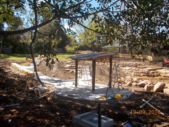
Image of Lapwing Reserve, St Ives
Cameron Park in Turramurra
As Councillors are aware, the main contractor for the Cameron Park extension went into voluntary administration in July 2016 which inevitably delayed work beyond the original estimated completion date. Work recommenced on 4 October 2016 with Council directly project managing the works. The park is currently estimated for completion around Easter 2017. Current works include completing the concreting: slabs and pathways.
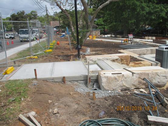
Image of Cameron Park, Turramurra
Allan Avenue Park in Turramurra (Working Name)
Following the acquisition of the fourth and final property in October 2015, Council commenced the process of ending the interim leases ahead of demolition and community consultation for the planning of the design for the new park. Until a name is formally selected “Allan Avenue Park” will be its working title just as “Bruce Avenue Park” was for Greengate Park completed in 2014.
The 2,665sqm site features some beautiful existing native trees and a quite steep landform in places together with level areas where the four houses are to be demolished – which the design can capitalise upon. Community consultation was undertaken between 11 August and 5 September 2016 with 118 responses to a 23 question survey and a number of additional emails. Questions covered the desired features of the park, equipment, age groups, access and potential names for the new park as well as demographic information.
Demolition on the site has commenced for two of the four properties with the other two to follow shortly.
Detailed design work is currently being undertaken ahead of a Councillor briefing in February ahead of reporting to Council for community consultation (exhibition) around March 2017. Reporting for adoption and tender is likely to occur around mid-year. Construction could commence towards the end of 2017 for completion in 2018, ideally before the end of the financial year.
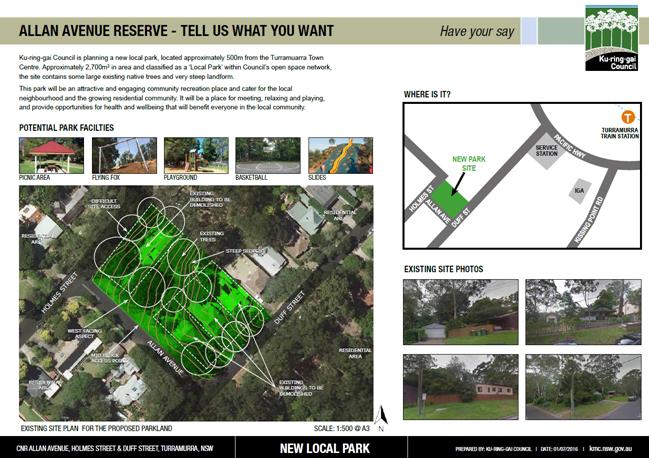
Voluntary Planning Agreements
Moree to Dumaresq Road Link, Gordon
The negotiation of the draft planning agreement with the Moree Street developers is proceeding and it is currently the intention to reach a position where the draft document can be reported to Council for the OMC of 6 December 2016. That report will be a comprehensive report on the status of that road, consequently it is unnecessary to pre-empt that report here.
Fitzsimons Lane, Gordon VPAs for land dedication
These are also progressing and it is anticipated that the first of these will also be presented to Council for exhibition early 2017.
integrated planning and reporting
Theme One: Community, People and Culture
|
Community Strategic Plan Long Term Objective |
Delivery Program Term Achievement |
Operational Plan Task |
|
C1.1 An equitable and inclusion community that cares and provides for its members |
Our community facilities are accessible and function as cultural hubs to attract a range of users |
C6.1.1.1.1-C6.1.1.1.3 New community facilities under design and planned delivery for Lindfield Town Centre |
|
C4.1 A community that embraces healthier lifestyle choices and practices |
New and enhanced open space and recreation facilities have been delivered to increase community use and enjoyment |
C4.1.2.1.1; C4.1.2.1.2; and C4.1.2.1.3 Greengate Park ready to open. Eton Road Oval and community centre opened 17 December 2013. Balcombe Park Wahroonga opened last year. Cameron Park Turramurra ready to commence construction. |
Theme Three: Places, Spaces and Infrastructure
|
Community Strategic Plan Long Term Objective |
Delivery Program Term Achievement |
Operational Plan Task |
|
P1.1 Ku-ring-gai’s unique and visual character and identity is maintained |
Place making programmes are being implemented for selected council owned areas |
P1.1.1.1.2 Lindfield town centre – both east and west of the railway line/Pacific Hwy – undergoing urban renewal |
|
P2.1 A robust planning framework is in place to deliver quality design outcomes and maintain the identity and character of Ku-ring-gai |
Strategies, plans and processes are in place to effectively manage the impact of new development |
P8.1.1.1.1.1-2 Ku-ring-gai Contributions Plan 2010 ensures new development contributes towards the cost of delivering supporting infrastructure. |
|
P4.1 Our centres offer a broad range of shops and services and contain lively urban village spaces where people can live, work, shop, meet and spend leisure time |
Plans to revitalise local centres are being progressively implemented and achieve quality design outcomes in collaboration with key agencies, landholders and the community |
P1.1.1.1.2 Lindfield is the first centre to undergo comprehensive Masterplanning for revitalisation. |
|
P6.1 Recreation, sporting and leisure facilities are available to meet the community’s diverse and changing needs |
A programme is being implemented to improve existing recreation, sporting and leisure facilities and facilitate the establishment of new facilities. |
C4.1.2.1.2-3; New facilities are being established including: Eton Road Oval, Greengate Park and Cameron Park. |
|
P7 Multipurpose community buildings and facilities are available to meet the community’s diverse and changing needs |
Standards are developed to improve the condition and functionality of existing and new assets |
C6.1.2.1.2 New community facilities including a new library and multi-purpose community facilities are in the Masterplanning stages for Lindfield. |
|
P8.1 An improved standard of infrastructure that meets the community’s service level standards and Council’s obligations as the custodian of our community’s assets |
Our public infrastructure and assets are planned, managed and funded to meet community expectations, defined levels of service and address inter-generational equity |
C6.1.2.1.2; C4.1.2.1.3 New public infrastructure is planned to support new development and ensure that everyone who lives and works in Ku-ring-gai continues to enjoy access to public facilities. |
Theme Four: Access, Traffic and Transport
|
Community Strategic Plan Long Term Objective |
Delivery Program Term Achievement |
Operational Plan Task |
|
T1.1 A range of integrated transport choices are available to enable effective movement to, from and around Ku-ring-gai |
A network of safe and convenient links to local centres, major land uses and recreational opportunities is in place |
C6.1.2.1.1; T1.1.3.1.1 Lindfield Commuter car park, park, community facilities and realigned Drovers Way. |
|
T3.1 An accessible public transport and regional road network that meets the diverse and changing needs of the community |
A strategic access, traffic and transport plan is being implemented for the Northern Sydney Region |
C6.1.2.1.1; T 1.1.3.1.1 Commuter car parking and new link roads |
Theme Six: Leadership and Governance
|
Community Strategic Plan Long Term Objective |
Delivery Program Term Achievement |
Operational Plan Task |
|
L1.1 A shared long term vision for Ku-ring-gai underpins strategic collaboration, policy development and community engagement |
Council’s responses to government policy and reforms are guided by and aligned with the adopted Community Strategic Plan 2030 “Our Community – Our Future” |
L1.1.2.1.1 and L1.1.2.1.2 Ku-ring-gai made a comprehensive submission to the White Paper and Planning Bill and continues to have input into on-going planning for the future Planning System in respect of the future contributions system with the Department of Planning and Infrastructure |
|
L2.1 Council rigorously manages its financial resources and assets to maximise delivery of services |
Council expenditure satisfies the needs of the community and Council has increased its commitment to infrastructure asset management priorities |
C6.1.1.1.2 Council is leveraging the value of its assets to combine with contributions to deliver major community assets in Lindfield |
Governance Matters
Changes to the Legislation governing s94A – new s94E Directions
This report details a change in the s94E Directions issued by the Minister as they relate to s94A contributions. Two older s94E Directions dating from 2006 and 2009 have been revoked and a new s94E Direction has been issued. This triggers a review of Ku-ring-gai Council’s current adopted s94A Contributions Plan to ensure that it accurately reflects current legislation.
Regular reporting
The need to give members of Council and the community more information on the progress and activity in the development contributions systems was identified as part of the Delivery Program and the Operational Plans. This update report has been provided regularly since 2011/12.
Risk Management
A rolling works program
The works programme arising out of Ku-ring-gai Contributions Plan 2010 through to at least 2031 is a multi-million dollar undertaking. Infrastructure delivery will be possible only through the receipt of contributions which will be affected by several economic cycles over the life of the contributions plan. The risks in taking such a strategic horizon are managed through regular reviews of the contributions plan, generally after the release of data from each five-yearly census or, potentially, more frequently, if the pace or scale of development is definitely changed by any statutory process or economic cycle. The rate and scale of development is monitored by Council staff. Sydney Water figures for delivered dwelling yield are also referenced.
Proposed reforms to the Planning Legislation that governs development contributions
It is now accepted that the Planning Reforms which were intended to replace the Environmental Planning and Assessment Act with a new piece of legislation have stagnated since they failed to gain Senate support at the end of 2013 and are no longer likely to be finalised as originally envisaged.
There are alternative mechanisms available to the NSW Government for the introduction of some of the reforms affecting development contributions, for example via Ministerial Direction under s94E or via amendments to the Environmental Planning and Assessment Regulation. One such example relates to the legislation relating to s94A being updated in October 2016 including new and revoked s94E Directions as reported in this report.
Presently the NSW Government is actively engaged in reviewing the governance of many aspects of residential development. There is also a sub-regional planning process currently being undertaken by the NSW State Government. Sub-regional planning is related to Local Government Areas and this process is running parallel to an extensive process of Local Government Reform by the NSW State Government. The anticipated release of District Plans and the consequential review of local planning documents will also include review of the associated contributions plans.
Financial Considerations
Council maintains a dynamic Long Term Financial Plan. The works program of Ku-ring-gai Contributions Plan 2010 was integrated into the Long Term Financial Plan from the start of 2011 and adopted by Council on 3 May 2011. Since that date, it has been updated annually and duly reported to Council to ensure its currency. Staff from both the Finance Unit and the Urban Planning & Heritage Unit monitor both income and development growth respectively and liaise to maintain a deliverable works programme. The scheduling of works through to the long term should be considered somewhat fluid depending on strategic opportunities that might arise from time-to-time and the management of cash flows during the economic cycle.
In this context, the Ku-ring-gai Contributions Plan 2010 comprises a large range of works from small-scale parkland embellishments to major community infrastructure which facilitates considerable flexibility in managing a financially deliverable work programme over time.
Contributions are being received under Ku-ring-gai s94A Contributions Plan 2015 at an increasing rate. The receipting for these contributions is also fully integrated into Property and Rating and the financial systems. The delivery of the initial works programme funded by this contributions plan can now be scheduled with an increasing degree of certainty of cash-flow.
Ku-ring-gai Council Finance staff continue to refine the cash-flow management of development contributions to support and facilitate the delivery programme over the life of this Contributions Plan as well as the established Contributions Plan.
Social Considerations
The Ku-ring-gai Local Government Area has been going through a period of change commencing in 2004. This is bringing about population growth and demographic change following years of declining and stable population since the 1980s. Infrastructure is essential to support and encourage the integration of the new residents in Ku-ring-gai, both among residents of the new dwellings being built and those moving into larger existing housing vacated by the members of Ku‑ring-gai’s older population who have ‘downsized’ into smaller local accommodation.
The provision of additional community infrastructure providing both outdoor and indoor community spaces will continue to support this process and help Ku-ring-gai continue to be a vibrant and popular place to live for all ages.
Ku-ring-gai Council continues to prioritise the delivery of community infrastructure in areas of high development activity and in accessible locations for the majority of residents as well as local businesses and their employees.
The 2016 census was held on Tuesday, 9 August 2016. There has been significant change in Ku-ring-gai since the 2011 census with the construction of many more medium-high density units and it will be very interesting to see the changes in the Ku-ring-gai population as a whole as a result of the delivery of newer housing types as data begins to be released. It remains to be seen whether nervousness about the anonymity of the census, combined with the changeover to electronic returns as well as the significant increase in high-density secure units in Ku-ring-gai, results in an undercount – which would be concerning given the pace of change and the need for accurate population statistics.
Environmental Considerations
Environmental considerations are part of the detailed design of every item of infrastructure provided for in the Contributions Plan. The provision of this infrastructure is required to support cohesive and sustainable communities in areas of increasing urbanisation.
Community Consultation
Extensive community consultation is part of the delivery aspect of all key items of infrastructure including new parks and community facilities. Early in 2016, Ku-ring-gai revamped the webpages that relate to the development contributions system including highlighting the rolling infrastructure delivery programme. Major items of infrastructure are highlighted with links to the specific progress pages presented online for community information.
This Update Report also specifically proposes the statutory exhibition of amendments to the adopted Ku-ring-gai s94A Contributions Plan 2015. While the revised document could not be finalised in time to be reported to the final OMC of 2016, the intended amendments are largely technical and administrative in nature and are specifically detailed in the foregoing report and in the recommendation to Council. It is proposed that the plan be amended as described, and that a copy be circulated to all Councillors ahead of the exhibition commencing. The exhibition will be extended from the statutory period of 28 days in view of the holiday period to six weeks. Following exhibition, a report will be brought back to Council as soon as practicable in 2017. This will minimise the time during which the adopted s94A Contributions Plan contains outdated references.
Internal Consultation
The management of the development contributions system is a truly whole-of-Council system from policy development, to contributions calculation, through inflation and receipting to infrastructure development. All aspects of the contributions system are co-ordinated across Council with input from all areas with a direct interest in that aspect on an on-going basis.
In the context of this report, specific consultation was undertaken concerning the repeal and replacement of the s94E Directions impacting on s94A Contributions. Consultation on the provision of opportunities for credit card payments for s94A contributions only were discussed with the Finance Unit. The proposed change to the cost threshold for QS reports as opposed to standard cost reports were discussed with Building and Compliance.
Summary
This report summarises Ku-ring-gai’s achievements in infrastructure delivery and well as highlighting where Ku-ring-gai is heading in the delivery of infrastructure funded, or partly funded, by development contributions across the LGA with particular reference to progress on some of our local parks and roads.
This Update report also provides a six month overview of the operation of the new s94A Contributions Plan, details some technical and administrative amendments to that plan related to changes in the s94E Ministerial Directions affecting the operation of s94A and some suggested procedural improvements to be drafted concurrently. Following these amendments, it is proposed that the revised document be placed on an extended exhibition over the holiday period and reported back to Council as soon as practicable in 2017.
It should be remembered that this is a summary outline report. Much more extensive technical and financial detail is reported quarterly as part of Council’s Long Term Financial Plan, in Council’s annual budget and delivery programmes and, in the case of major items of infrastructure, such as Lindfield Community Hub, Lindfield Village Green and the Turramurra Community Hub Project and major new parks, these are also subject to separate, more detailed, project reporting on a regular basis.
|
A. That the update report on the development contributions system in Ku-ring-gai be received and noted.
B. That Ku-ring-gai s94A Contributions Plan 2015 be amended as follows:
a) to increase the cost threshold at which a Quantity Surveyors Report is technically required to $1.2 million; b) to permit the payment of s94A contributions by credit card in line with other similar amounts payable to Council for other purposes in the ordinary course of business on the same terms and in addition to current payment options; c) to remove references to the revoked s94E Directions and to accurately reflect the current s94E Direction published in the Government Gazette on 14 October 2016 as well as all current legislation; d) to specifically cross reference clause 25J of the Environmental Planning and Assessment Regulation 2000 within the two cost templates and to provide scope within the template to identify any works for which costs have been duly excluded from the total; e) to objectively review the wording and definitions of applicability of s94A for any scope for perceived lack of clarity, as well as correctly referencing the current s94E Direction and legislation; and f) correction of any other typographical errors that may be identified while implementing the text changes listed above.
C. That the amended s94A contributions plan be placed on public exhibition as Draft Amendment One to Ku-ring-gai s94A Contributions Plan 2015 and be reported back to Council after the close of the exhibition period.
|
|
Kate Paterson Infrastructure Co-ordinator |
Antony Fabbro Manager Urban & Heritage Planning |
|
Deborah Silva Acting Director Strategy & Environment |
|
|
Ordinary Meeting of Council - 22 November 2016 |
GB.10 / 315 |
|
|
|
|
Item GB.10 |
S10376 |
|
|
26 October 2016 |
Gordon Hub Master Plan - Update
EXECUTIVE SUMMARY
|
purpose of report: |
To seek Council approval to re-commence the master planning process for a Cultural Hub in Gordon. |
|
|
|
|
background: |
Through the Ku-ring-gai Council Revised Delivery Program 2013-2017 and Operational Plan 2016-2017 Council has committed to preparing a master plan for a cultural hub within the Gordon Local Centre to accommodate cultural and arts activities and promote social interaction. |
|
|
|
|
comments: |
At the Ordinary Meeting of Council on 9 February 2016 Council resolved that the Gordon Cultural and Civic Hub Master Plan be deferred for the foreseeable future until broader strategic matters arising from the NSW Government merger proposal have been resolved. Since that time, a number of parameters have changed: · the purchase of 810 Pacific Highway, Gordon by Aldi Australia P/L; and · increased competition between major retailers to find suitable sites within Gordon. In this context there is the opportunity for Council to undertake strategic planning to ensure the maximum value for the community of Gordon is captured. |
|
|
|
|
recommendation: |
That Council resolves to re-commence the master planning process for a Cultural Hub in Gordon. |
Purpose of Report
To seek Council approval to re-commence the master planning process for a Cultural Hub in Gordon.
Background
At the Ordinary Meeting of Council on 15 December 2015 GB.10 Gordon Cultural and Civic Hub - Update Report - Post Site Visit and Briefing Council was updated on the progress of planning for the site and presented the findings of Phase 1 – Project Definition & Feasibility and sought Council’s approval to proceed to Phase 2 - Business Case and Master Plan for the Gordon Cultural and Civic Hub site, at 818 Pacific Highway, Gordon. At that meeting Council resolved:
A. That the matter be deferred until a tour of a range of cultural and civic facilities around Sydney is organised for Councillors.
B. That council pursues discussions and investigation of the proposal by the Department of Education for council to undertake long-term leases of a variety of existing facilities on the UTS site.
C. That a report come back to council following discussions with the Department of Education, including details on proposed facilities, costings arrangements, maintenance costs and operation model.
Resolution A to date has not been acted upon but will form part of the future work program. In relation to resolutions B and C this matter is currently the subject of further negotiations between the Department of Education and Council and will be reported to Council once a proposal has been developed.
At the Ordinary Meeting of Council on 9 February 2016 GB.9 Gordon Civic and Cultural Hub - update in response to NSW Government Merger Proposal Council considered a report advising Council of the impacts of the NSW Government Merger Proposal on the Gordon Cultural and Civic Hub Master Plan project. At that meeting Council resolved:
A. That the Gordon Cultural and Civic Hub Master Plan Project be deferred for the foreseeable future until broader strategic matters arising from the NSW Government Merger Proposal for Hornsby Shire Council (part) and Ku-ring-gai Council have been resolved.
B. That the community be notified of Council’s decision.
In relation to resolution A the project has been on hold since February 2016; in relation to resolution B the community was also notified via Council’s website and e‑mail.
At the Ordinary Meeting of Council on 11 October 2016 GB.13 Gordon Cultural and Civic Hub – Update considered a report advising on a number of parameters that have changed within Gordon local centre. The report recommended that Council resolve to re-commence the master planning process for a Cultural & Civic Hub in Gordon.
At that meeting Council resolved:
A. That the matter be deferred for a Councillor briefing to be held within the next month.
In response to this resolution a Councillor Briefing was held on 31 October, 2016. Councillors were informed of the key changes in Gordon local centre since the master plan process was deferred in February 2016 - namely the purchase by Aldi of 810 Pacific Highway, Gordon and letter from Coles Pty Ltd.
Comments
1. Introduction
Council has committed to a cultural and civic hub in the Gordon local centre, comprising:
· Cultural facilities; and
· Civic Square.
The following key Council documents have informed the planning of the site to date:
· ‘Living Culture’ Cultural Plan 2004-2009;
· Open Space Acquisition Strategy, 2006;
· Delivery Program 2013-2017 and Operational Plan 2015-2016;
· Ku-ring-gai Community Facilities Strategy 2014;
· Town Centres Public Domain Plan, 2010;
· Ku-ring-gai Contributions Plan, 2010;
· Ku-ring-gai (Local Centres) LEP, 2012; and
· Ku-ring-gai (Local Centres) DCP, 2016.
The Gordon Cultural and Civic Hub will form part of the wider ‘G3 – Civic Hub’ Precinct as nominated in the Ku-ring-gai Local Centres Development Control Plan. This precinct is located on the northern edge of the Gordon Centre retail core and is broadly defined by the intersection of the Pacific Highway, Park Avenue, Pearson Avenue and Dumaresq Street. Refer Figure 1.
Figure 1 – Precinct G3 Civic Hub and Wade Lane Car Park
The vision for this precinct is for it to become the civic and cultural ‘heart’ of the LGA. Development is to be designed to support and enhance the planned future character for this precinct. Council is planning for a range of improved civic and community facilities as well as a public park. Accommodation for a range of community services will be encouraged.
Both the Ku-ring-gai Council Revised Delivery Program 2013-2017 and Operational Plan 2016-2017 endorse a whole of centre approach to the provision of facilities. To this end the Delivery Program and Operational Plan has committed Council to preparing a master plan for a community hub within the Gordon local centre to accommodate cultural and arts activities and promote social interaction.
Building on the key documents listed above, Phase 1 – Project Definition and Feasibility was completed in 2015. Consultants were engaged to prepare a number of studies to further the planning for a cultural hub, including:
· cultural needs analysis;
· transport scenario testing;
· preliminary economic feasibility assessment;
· arboriculture assessment;
· topography and boundary survey;
· geotechnical investigations; and
· stage 1 – site contamination investigations.
The results of these studies were reported to the Ordinary Meeting of Council of 15 December 2015 and form a comprehensive basis upon which Phase 2 – Business Case and Masterplan can proceed.
2. Existing Facilities and Services
Precinct G3 currently supports a number of Council and community services including the Council Chambers and administration building, Gordon pre-school, Gordon Library, Lifeline Harbour to Hawkesbury, Gordon Police Station and the Old School Building which provides rooms for a number of groups and activities. Council also owns a multi-level public car park on Wade Lane.
3. Project Scope
While the precise nature of the facilities within the Cultural Hub is yet to be determined, the preliminary project scope is as follows:
· cultural facilities such as a multi-purpose space suitable for both performance and rehearsals;
· park/civic square;
· retail and commercial uses such as cafes, restaurants and a supermarket;
· new residential development;
· retention of the existing heritage item (Council Chambers);
· underground car parking for visitors to the hub and Council staff (as required by Council’s DCP); and
· streetscape and road improvement works.
As reported to the Ordinary Meeting of Council of 15 December 2015, Phase 1 – Project Definition & Feasibility explored four (4) options for the future development of a cultural and civic hub on the Council Chambers site at 818 Pacific Highway, Gordon, each of which included Council administration offices.
If the proposed merger of Ku-ring-gai and Hornsby Councils proceeds, it is unlikely there will be a need for Council administration offices at 818 Pacific Highway, Gordon given the location is not central to the proposed merged Council area. If the 3,750m2 previously allocated for new council administration offices in proposed Options 1B, 2 and 3, as reported to the Ordinary Meeting of Council on 15 December 2015, is not required there could be a potential benefit to the project’s overall feasibility.
4. Site Definition
818 Pacific Highway, Gordon
The Chambers site at 818 Pacific Highway currently accommodates the existing Council administrative offices, associated car parking (approximately 70 spaces) and the heritage listed Council Chambers building (the heritage listed item would be retained as part of any redevelopment proposals for the site). Vehicular access to the site is via Radford Place and Dumaresq Street. Pedestrian entry is from the Pacific Highway with rear access from the parking area off Radford Place.
9, 15 & 17 Dumaresq Street, Gordon
The three house sites at 9, 15 & 17 Dumaresq Street, Gordon are currently leased; these properties were acquired by Council under the Open Space Acquisition Strategy in 2007. These sites are again referenced in the ‘governance matters’ section later in this report concerning the proposed reclassification of these three sites from Community land to Operational land. This will provide the necessary flexibility to deal with Council landholdings in implementing the future master plan for the Gordon Hub.
810 Pacific Highway, Gordon
Aldi have recently purchased 810 Pacific Highway, Gordon. In accordance with current LEP provisions, Aldi, in isolation from the adjoining Council owned site at 818 Pacific Highway, could develop their site for a mixed use development comprising residential apartments, an Aldi supermarket, supporting retail and basement car parking.
The purchase by Aldi, of 810 Pacific Highway, Gordon changes the parameters for the Gordon Local Centre. By failing to take a more holistic approach to the strategic planning of this significant portion of Gordon Local Centre, Council runs the risk of a sub-optimal design outcome, if the opportunity to work collaboratively with the new landowners of 810 Pacific Highway, Gordon is not maximised from the outset.
Coles Group Property Development Ltd recently submitted an ‘expression of interest’ letter to Council (dated 20 October 2016) acknowledging Aldi’s purchase and have expressed their support for the recommencement of the master planning process for the Gordon Cultural Hub project – sighting it as a ‘key catalyst initiative’ for the wider LGA. Refer Confidential Attachment 1.
828 Pacific Highway, Gordon
As last reported to Council, the Council owned commercial property at 828 Pacific Highway, Gordon (Lot 1 on DP 786550) did not form part of the Gordon Cultural and Civic Hub site. The project was originally predicated on the assumption that the existing Council administrative offices would decant from 818 to 828 Pacific Highway, Gordon. The ‘service relocation project’ was reviewed as part of Council’s ‘Fit for the Future Improvement Proposal’ submission and as such was deferred. It was excluded due to the subsequent Council resolution regarding Fit for the Future and existing long term commercial leases extending to 2021 with an option for some tenancies to extend for another 5 years to, 2026.
In light of the recent acquisition of 810 Pacific Highway, Gordon by Aldi, it is considered timely to re-visit the inclusion of 828 Pacific Highway, Gordon within the project, with the intent of maximising the best possible ‘in centre’ outcome in the long term by considering planning for all three sites situated between Dumaresq and McIntyre Streets, Gordon.
It is considered that the inclusion of 828 Pacific Highway within the master plan site description would not have an impact on Council’s Fit for the Future Action Plan in the short term, but would garner wide reaching benefits in the long term by taking a more considered strategic approach to the planning of all sites from 810-828 Pacific Highway, in turn activating the northern edge of the retail core of Gordon Local Centre, including wider benefits for the community in terms of significant public domain works, community facility and civic space provision and vastly improved pedestrian connectivity. Refer Figure 2.
Figure 2 – Key Sites Gordon Local Centre
Other Council Lands
Within the vicinity of these properties Council owns a number of other parcels of land including 2 Park Avenue and 799 Pacific Highway, Gordon (Gordon library and former school building); 2A and 4 Park Avenue, Gordon (Gordon Pre-School and Lifeline); and 1 Wade Lane, Gordon (Council car park). It is recommended that these lands be considered as part of the master planning process to ensure all opportunities have been considered.
Council’s Public Domain Plan and Development Control Plan both identify the Wade Lane car park area as a major new park and this option could be investigated and developed further through this master plan process. Refer Figure 3.
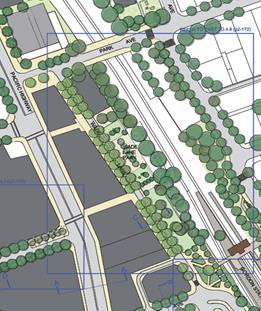
Figure 3 – Proposed Park on Wade Lane (from Town Centres Public Domain Plan, 2010)
5. Cultural Needs Analysis
As part of Phase 1 – Project Definition and Feasibility , completed in 2015, Root Projects Australia was engaged to undertake a Cultural Needs Analysis for the Ku‑ring-gai LGA, to determine the type and size of built infrastructure required to meet the current and future demand for purpose built cultural and civic spaces for creative arts groups, individuals and the greater community.
The Cultural Needs Analysis has identified that existing cultural spaces available for arts groups are in various states of disrepair, require regular/ongoing maintenance, have restricted functionality specific to user needs and that there is a distinct lack of regularly bookable and accessible quality space for rehearsal and performance activities or spaces where people can create or exhibit visual art. As existing facilities are so heavily utilised (equating to 200+ hours per week), access by cultural and arts groups is limited. This therefore impacts the ability of these groups to expand or maintain relevance to their users and members.
From the analysis undertaken, the following community needs have been identified for a cultural and civic hub that could be co-located in the one centralised facility within Gordon local centre, close to public transport, with easy access to parking. The Hub would include spaces that cater for a range of single artists or larger amateur to semi-professional groups to:
· create and rehearse in;
· perform and display in;
· work collaboratively across a range of art forms; and
· be able to be utilised for civic ceremonies and for the staging of annual cultural events.
The cultural sectors that are likely to be catered for include: theatre, dance, music, visual arts and digital media.
In order to maximise the utilisation of the hub and ensure commercial viability, the stakeholders consulted have identified that the spaces within the hub should:
· be as multi-purpose as possible;
· have the necessary technical/functional infrastructure to support the major art forms and civic events;
· have a large flat floor space with retractable seating catering for up to 300 seated patrons;
· provide a range of ancillary spaces, rehearsal spaces, studio & workshop spaces, informal activity areas, meeting/conference rooms, storage [e.g. artwork, equipment, music store] and associated back of house amenities, green room, dressing rooms, production office and multi-media edit suite;
· have a foyer space connected to the proposed retail and commercial uses, which can also be utilised for exhibitions and other events; and
· provide for business and arts incubators.
The cultural facility component of the hub is to comprise 1,500-2,000m2 of floor space including the following:
· foyer space [150m2];
· meeting rooms / conference room [80m2];
· offices for facility management [50m2];
· green room [10m2];
· re-heat kitchen;
· back of house amenities;
· multi-purpose flexible space [suitable for up to 300 people seated + stage areas between 160 - 200m2];
· rehearsal space [120m2 with ceiling height 7m clear];
· loading dock;
· dressing rooms;
· wardrobe room [20m2];
· equipment / music / piano / artwork store [50m2];
· workshop space / large studio space [80m2];
· studio spaces [4 x 12m2];
· goods lift [linked to loading dock, with a minimum internal clearance of 1800 x 1400mm];
· multi-media edit suite [1 x 10m2]; and
· production office (adjacent to edit suite).
It is important that the Gordon Cultural and Civic Hub not only addresses the needs of its immediate community but also complements and draws upon the opportunities provided by other similar facilities in the region, to avoid duplication of existing facilities, such as the Concourse in Chatswood. In this context, it could be expected that the Gordon Cultural and Civic Hub would also be in demand across the region, including a number of arts groups within Ku-ring-gai.
6. Strategic Justification
Whether Ku-ring-gai and Hornsby Councils are amalgamated or not there is strong strategic justification for a cultural hub in Gordon; the basis of which is reported in the Ku-ring-gai Community Facilities Strategy prepared by Elton Consulting in 2014. The report states:
“Sub-regional facilities usually serve populations of around 100,000 people and over…..Ku-ring-gai currently contains no sub-regional community facilities and relies on those provided in adjoining local government areas. The population of Ku-ring-gai (109,146 in 2011) however, warrants the provision within the LGA of a sub-regional level facility. Sub-regional facilities can include major cultural or civic facilities such as civic centres, performing arts centres, central libraries and exhibition space.”
Given the increasing populations of both Ku-ring-gai and Hornsby LGAs there will be sufficient populations to warrant sub-regional cultural facilities within both areas.
It is noted that the Concourse in Chatswood is a Regional facility (not sub-regional) and is significantly larger than what may be provided for in Gordon.
integrated planning and reporting
The Gordon Cultural and Civic Hub is intended to support the Council’s Vision and Community Strategic Plan 2030 which identifies a number of key themes to direct future development and interaction with the community. The development of a Cultural & Civic Hub will directly impact and support the following themes from the Strategic Plan 2030.
Theme 1 – Community, People and Culture
Theme 3 – Places, Spaces and Infrastructure
Theme 5 – Local Economy and Employment
Theme 6 – Leadership & Governance
|
Community Strategic Plan Long Term Objective |
Delivery Program Term Achievement |
Operational Plan Task |
|
Theme 1 – A healthy, safe and diverse community that respects our history and celebrates our differences in a vibrant culture of learning.
|
C2.1.1 Ku-ring-gai’s rich cultural diversity and creativity is celebrated through programs and events.
|
- Promote and support a range of cultural & nationally significant events through Council; - Promote opportunities for cultural groups to stage events consistent with Council’s Sponsorship policy. |
|
|
C4.1.2 New and enhanced open space and recreational facilities have been delivered to increase community use and enjoyment. |
- Undertake strategic land acquisitions; - Implement and monitor the Ku-ring-gai Open Space Acquisition Strategy; - Complete the design for identified parks and include design principles which facilitate passive recreation activities. |
|
Theme 3 – A range of well planned, clean and safe neighbourhoods and public spaces designed with a strong sense of identity and place. |
P1.1.1 Opportunities are provided to our community to contribute to plans for enhancing the local area and visual amenity of our local centres. |
- Develop concept plans for the neighbourhood centres informed by Community engagement. |
|
|
P4.1.3 An improvement plan for Gordon Centre is being progressively implemented in collaboration with owners, businesses and state agencies.
|
- Council resolved on 9 February 2016 to defer this project for the foreseeable future until a decision has been made regarding the NSW Government’s Merger Proposal for Hornsby Shire Council (part) and Ku-ring-gai Council. The related Critical Action will not be reported on as part of the 2016/17 Operational Plan |
|
|
P5.1.2 Conservation Management Plans are in place and being implemented for the cultural and heritage assets of the area to ensure their long term viability. |
- Identify resources for the development and implementation of heritage conservation management plans. |
|
Theme 5 – Creating economic employment opportunities through vital, attractive centres, business innovation and technology. |
E1.1.1 Ku-ring-gai’s opportunities and assets are promoted to strengthen and attract business and employment to the area. |
- Continue to identify opportunities to promote and strengthen Ku-ring-gai’s economy. |
|
Theme 6 – Ku-ring-gai is well led, managed and supported by ethical organisations which deliver projects and services to the community by listening, advocating and responding to their needs. |
L2.1.4 Council has increased its commitment to infrastructure asset management priorities. |
- Identify available funding sources in the Long Term Financial Plan and allocate to priority projects and assets. |
FIT FOR THE FUTURE IMPROVEMENT ACTION PLAN
The NSW Government's Fit for the Future initiative required all councils to prepare an Improvement Proposal and supporting Implementation Plan demonstrating how all seven Fit for the Future benchmarks would be met by 2016/17, and maintained or improved thereafter.
Council's Fit For the Future Improvement Proposal and supporting Implementation Plan underpins the decision to stand alone and not merge with Hornsby Council. The objectives established in the Improvement Proposal and Implementation Plan are embedded in Council's adopted Integrated Planning and Reporting documents including the Revised Delivery Program 2013-2017 and Operational Plan 2015-2016, Long Term Financial Plan 2015/16 to 2024/25 and Asset Management Strategy 2015/16 to 2024/25.
Ku-ring-gai Council‘s Fit for the Future Improvement Proposal Submission to the State Government in June 2015 acknowledges substantial progression of the Gordon local centre revitalisation through the Gordon Civic & Community Hub Project, which will provide, community, cultural, civic and recreational facilities and spaces with potential for commercial, retail and residential development.
Council has been laying the foundations for the Gordon Hub and other notable urban renewal ‘activation’ projects for a number of years through the construction of a comprehensive and innovative development contributions plan, the acquisition of a number of sites to augment existing land holdings, the disposal (and planned future) of a number of surplus assets to provide source of funds.
Council has been working co-operatively and constructively with State agencies such as RMS and Transport for NSW, and has engaged a comprehensive team of consultants including cultural needs advisors, transport planners, engineers, arborists, surveyors, valuation, property development, and feasibility specialists to develop and market test this project.
The Fit for the Future submission makes reference to Council’s infrastructure backlog – i.e. the cost to bring assets from poor and failed condition up to an acceptable standard, including the useful lives and condition ratings of assets. The Fit for the Future submission acknowledges that many Council-owned community facilities are ageing and/or no longer fit for purpose and will require significant investment to either renew or replace, thus reinforcing the established need for a new cultural and civic hub in Gordon local centre and disposal of the facilities it otherwise replaces.
The submission also acknowledges that a number of key priorities, long term aspirations and objectives for the Ku-ring-gai community, as identified in the Community Strategic Plan, 2013, are of relevance to the Gordon Hub project, including:
· bringing vitality to our centres, making it easier and safer to move around, increasing visitors to the area; and
· improving and renewing our infrastructure including community facilities, recreation and open space areas, roads, footpaths, drains and the public domain.
On the basis of the above, a key ‘improvement strategy and objective’ identified in the Fit for the Future submission, specifically relates to the Gordon Cultural and Civic Hub project - that a business case be prepared for the cultural hub component and a master plan for the overall Hub site.
Office of Local Government Guidelines
Council decision making during merger proposal periods is bound by specific guidelines issued by the Office of Local Government (OLG). These guidelines are issued under section 23 A of the Local Government Act 1993, meaning that all councils must consider them when exercising their functions. These guidelines provide guidance to councils that are subject of merger proposals on the appropriate exercise of their functions during the period in which a merger proposal is under consideration. The OLG acknowledge that it is important during any merger proposal period that councils continue to operate appropriately, effectively and efficiently in order to meet the needs of their communities.
These guidelines have been reviewed and it is considered that the proposed recommencement of the master planning process for a Cultural Hub in Gordon complies and is consistent with the intent of the OLG guidelines.
Governance Matters
1. Land Reclassification - 818 Pacific Highway, Gordon
At the Ordinary meeting of Council held on 30 April 2013 Council adopted a report recommending that Planning Proposals be prepared to reclassify a number of sites from Community land to Operational land, including 818 Pacific Highway, Gordon.
This site comprises Lot 2 in DP 786550 and has an area of 5,203m2. The site is roughly “L” shaped with frontages of 40.215 metres to the Pacific Highway and of 25.79 metres to Dumaresq Street, Gordon. This site also fronts Radford Place, Gordon.
A Right of Way of variable width and limited in height to RL 122.9m AHD runs north from Radford Place. The Right of Way is in favour of Lot 1 in DP786550, (828 Pacific Highway, Gordon -owned by Council).The site benefits from easements for drainage.
The electricity substation owned by Ausgrid located in the car park at the rear of 818 Pacific Highway, Gordon is subject to a 50 year lease (with an easement for access) between Council and Sydney Electricity (now Ausgrid) which expires on 1 April 2041 and this arrangement should be preserved in the short term. The lease also incorporates a right of way for access and easement for electricity purposes.
A Gateway Determination for Planning Proposal to reclassify this and three other sites from Community land to Operational land was issued by the NSW Department of Planning on 4 June 2014. The Planning Proposal was formally exhibited from 22 August to 19 September 2014 and a public hearing was held on Monday 20 October 2014. The outcomes of the public exhibition and Public Hearing were reported to Council on 9 December 2014. Council resolved to proceed with the reclassification and the Planning Proposal is now with the Department of Planning and Environment awaiting finalisation. It is understood that a decision in this regard is imminent.
2. Land Reclassification - 9, 15 & 17 Dumaresq Street, Gordon
Section 45 of the Local Government Act, 1993 prevents Council from selling; exchanging, or otherwise disposing of Community classified land. It is therefore recommended to reclassify the three Council owned sites at 9, 15 & 17 Dumaresq Street, Gordon from Community Land to Operational Land in accordance with Section 27 of the Act, which form part of the Gordon Cultural & Civic hub site.
The report to Council OMC on 15 December 2015 recommended that a Planning Proposal be prepared to reclassify the sites comprising of Lot A in DP355615 (9 Dumaresq Street, Gordon) and Lots C and D in DP 386283 (15 & 17 Dumaresq Street, Gordon), from Community land to Operational land. It is noted that Council did not resolve to progress these matters at this OMC.
The three sites are regular shaped lots with a combined street frontage to Dumaresq Street of approximately 51 metres and a total area of 3,481m2. There are no known interests registered on the title of these lots.
Council acquired the three residential properties in 2007 using section 94 Contribution Plan funds to address, in part, the lack of open space in the Gordon local centre as identified in the Ku-ring-gai Open Space Acquisition Strategy, 2006.
It is proposed to locate the new civic space (with the same area as land purchased) further up the hill to where the existing Council staff car park is currently located. The proposed park would be more centrally located, accessible to more people, and on flat land, thus increasing its passive recreational value.
The reclassification of the sites from Community land to Operational land will provide the necessary flexibility to deal with Council landholdings in implementing the future masterplan for the Gordon Cultural and Civic Hub.
Further investigations need to occur regarding any interest (either registered or implied) applying to any of the 3 lots that may restrict the future development of the land. Should any such interests be identified, the reclassification process should also extinguish these interests so as not to prevent or restrict the future development of the Gordon Cultural and Civic Hub.
Risk Management
Council does not progress planning for cultural facilities
On the basis of investigations and consultation undertaken to date, Council needs to consider the effect on its reputation should this project not proceed and as a consequence the expectations of the community not be met as a result. Given the extent of stakeholder and community consultation undertaken for the project there is a certain level of expectation within the community in relation to the delivery of a new park and a cultural facility in Gordon.
Council does not consider adjoining privately owned lands
Council runs the risk of a sub-optimal design outcome for Gordon local centre, if the opportunity to work collaboratively with the new landowners of 810 Pacific Highway, Gordon is not maximised from the outset. As it currently stands, Aldi, the new landowners could develop 810 Pacific Highway, Gordon in isolation of the Council owned site at 818 Pacific Highway, Gordon for a mixed use development including residential apartments, a supermarket, supporting retail and basement car parking.
Council considers its land holdings in isolation
Council is a significant land owner within the are known as Precinct G3 – Civic Hub identified in the Local Centres DCP, 2016 and an holistic approach to the strategic planning for this significant portion of Gordon Local Centre is important to garner wider benefits for the community in terms of public domain works, pedestrian connectivity and civic space provision.
Council does not undertake strategic planning in response to market demand for retail floor space
Council’s failure to respond to increasing demand for retail floor space in Gordon may result in pressure for ‘out of centre’ retail which would undermine the viability of Ku-ring-gai’s local centres. The planning proposal from Aldi for a supermarket in the Eastern Road, Turramurra is an example of such an outcome.
Financial Considerations
To date Council has expended approximately $160,000 on this project including salaries and consultancies.
If Council agrees to proceed with preparing master plan options, funds will be required to be brought forward as part of the December budget review. These funds are available from Development Contributions 2010 Plan Recreational, Cultural & Social Facilities allocated specifically for this project.
Social Considerations
Ku-ring-gai currently contains no sub-regional community facilities and relies on those provided in adjoining local government areas. The population of Ku-ring-gai (109,146 in 2011) warrants the provision within the LGA of a sub-regional level facility. Sub-regional facilities can include major cultural or civic facilities such as civic centres, performing arts centres, central libraries and exhibition space.
Environmental Considerations
There are no environmental considerations arising from this report. All relevant matters will be considered during the master planning process.
Community Consultation
There has been no community consultation in relation to the preparation of this report.
Internal Consultation
This report was prepared by the Strategy & Environment Department. In accordance with the OMC resolution of 11 October 2016, a Councillor Briefing was held on 31 October, 2016. Councillors were informed of the key changes in Gordon Local Centre since the master plan process was deferred in February this year - namely the purchase by Aldi of 810 Pacific Highway, Gordon.
This purchase changes the parameters for the Gordon Local Centre – it has triggered a renewed interest in the Gordon Local Centre, by significant retailers and developers seeking key development sites in local centres. The key point reiterated at this briefing, was that by failing to take a more holistic approach to the strategic planning of this significant portion of Gordon Local Centre (i.e. 810-828 Pacific Highway and 9, 15 & 17 Dumaresq Street), Council runs the risk of a sub-optimal design outcome particularly in the context of significant public domain works, improved pedestrian connectivity and community facility and civic space provision, if the opportunity to work collaboratively with the new landowners of 810 Pacific Highway, Gordon is not maximised from the outset.
Summary
With the recent purchase by Aldi of 810 Pacific Highway, Gordon, it is considered prudent to revisit the master planning process for the adjoining Council owned sites at 818 and 828 Pacific Highway, Gordon, and 9, 15 and 17 Dumaresq Street Gordon.
In accordance with current LEP provisions, Aldi, in isolation of the adjoining Council owned sites could proceed to develop their newly acquired site for a mixed use development comprising residential apartments, an Aldi supermarket, supporting retail and basement car parking.
The purchase by Aldi, of 810 Pacific Highway, Gordon considerably changes the parameters for the Gordon Local Centre. By failing to take a more holistic approach to the strategic planning of this significant portion of Gordon Local Centre, Council runs the risk of a sub optimal design outcome, if the opportunity to work collaboratively with the new landowners of 810 Pacific Highway, Gordon is not maximised from the outset.
By taking a more considered strategic approach to the planning of Council owned land in the vicinity of the chambers Council has the opportunity to play a role as catalyst for the revitalisation and activation of Gordon local centre. This would include wider benefits for the community in terms of significant public domain works, community facility and civic space provision and vastly improved pedestrian connectivity.
This report recommends that Council prepare illustrative master plan options for a cultural hub and then commence community engagement to select a preferred option. In parallel to this it is recommended that Council complete the land reclassification process for 9, 15 & 17 Dumaresq Street, Gordon to facilitate delivery of the master plan.
|
That:
A. Council resolves to re-commence the master planning process for Cultural Hub in Gordon.
B. Council prepare illustrative master plan options for public exhibition in the first half of 2017.
C. That following public exhibition of the master plan options the results are reported to Council recommending a preferred option.
D. A Planning Proposal is to be prepared, in accordance with section 55 of the Environmental Planning and Assessment Act, 1979, to reclassify Lot A in DP355615 and Lots C and D in DP 386283, known as 9, 15 & 17 Dumaresq Street, Gordon from Community land to Operational land.
E. Council formally seeks to discharge all necessary interests for Lot A in DP 355615 and Lots C and D in DP 386283, known as 9, 15 & 17 Dumaresq Street, Gordon.
F. The Planning Proposal be submitted to the Department of Planning and Environment for a Gateway Determination in accordance with Section 56 of the Environmental Planning and Assessment Act, 1979.
G. Upon receipt of the Gateway Determination, the exhibition and consultation process is carried out in accordance with the requirements of the Environmental Planning and Assessment Act, 1979 and with the Gateway Determination requirements.
H. Council undertakes a public hearing under the provisions of the Local Government Act, 1993 for the proposed reclassification of Lot A in DP355615 and Lots C and D in DP 386283, known as 9, 15 and 17 Dumaresq Street, Gordon from Community land to Operational Land.
I. A report is to be brought back to Council at the end of the exhibition and public hearing process.
|
|
Louise Drum Senior Urban Designer |
Bill Royal Team Leader Urban Design |
|
Antony Fabbro Manager Urban & Heritage Planning |
Deborah Silva Acting Director Strategy & Environment |
|
Coles letter dated 20 October 2016 and attachment |
|
Confidential |
|
Ordinary Meeting of Council - 22 November 2016 |
GB.11 / 330 |
|
|
|
|
Item GB.11 |
S10051 |
|
|
26 October 2016 |
Correction to Schedule 5 of KLEP 2015
EXECUTIVE SUMMARY
|
of report: |
For Council to consider amendments to Schedule 5 of the KLEP 2015 to correct erroneous heritage listings. |
|
|
|
|
background: |
Local heritage items are identified, assessed and managed by Council and are listed under Schedule 5 of the LEP. Four items on the KLEP 2015 have been identified by Council as not being of local significance due to erroneous listing or through gradual modification over time rendering their heritage significance insufficient to merit their listing. |
|
|
|
|
comments: |
Four Local heritage items have been identified as demonstrating insufficient heritage significance to merit their presence on the local heritage schedule of the KLEP 2015. Some properties have been gradually and extensively altered and modified over time. Subdivision of heritage lots and demolition of original properties are also reasons for heritage items to be removed. |
|
|
|
|
recommendation: |
That Council prepare a Planning Proposal to amend Schedule 5 of the KLEP 2015 to correct erroneous listings. |
Purpose of Report
For Council to consider amendments to Schedule 5 of the KLEP 2015 to correct erroneous heritage listings.
Background
Local heritage items are identified, assessed and managed by Council and are listed under Schedule 5 of the Ku-ring-gai Local Environmental Plan (KLEP) 2015. Four items on the KLEP 2015 have been identified by Council as not being of local significance due to erroneous listing or through gradual developmental change over time.
Comments
Four heritage items on the KLEP 2015 are identified as requiring consideration for removal from Schedule 5 of the KLEP 2015.
Some of these properties have been gradually and extensively altered and modified over time, and should be re-assessed as to their heritage significance. Other heritage properties have undergone subdivision, producing an inaccurate listing on the second lot not containing the listed item. Demolition of original fabric and mapping error are also reasons for heritage items to be removed.
Documentation supporting the removal of these items is included in Attachment A1.
The heritage items to be considered are listed below:
· 36A and 36B Carlotta Avenue, Gordon (Lot B, DP 366349) included in Schedule 5 as a heritage item of local significance;
· “Edelstein” 7 Grosvenor Street, Wahroonga (Lot D, DP 330058) included in Schedule 5 as a heritage item of local significance;
· 17 Bangalla Street, Warrawee (Lot 14, DP 14753) included in Schedule 5 as a heritage item of local significance;
· 14 Warrangi Street, Turramurra (Lot 2, DP 542710) included in Schedule 5 as a heritage item of local significance.
Reasons for the removal are supplied in the table below.
|
Address |
Discussion |
|
36A and 36B Carlotta Avenue, Gordon |
The heritage listing was attributed to an earlier dwelling on this site, however this item was demolished after 1992 and the listing was not removed from the State Register or Councils LEP. See the State Heritage Inventory at Attachment A2. There is currently a modern dual occupancy on this site. |
|
7 Grosvenor Street, Wahroonga |
No data sheet can be located for this property in Council’s records. This is considered an erroneous listing potentially being confused with the listed 7 Grosvenor Road, Lindfield.
The house would be considered contributory within a heritage conservation area. |
|
17 Bangalla Street, Warrawee |
This property was first listed on 2 April 2015 when the KLEP 2015 came into effect. The property was listed after a faux heritage addition to the property had been made in 1988. Further review concludes that the listing is not warranted. In 1988 the house had a substantial addition in a faux heritage style. The change from original to new build is evident in the change of brick, the quality of the tuck pointing (better in the original brickwork) and the use of wooden shingles on the new elements of the house (e.g. dormer). What is still evident of the original house illustrates a higher design quality, that is a well-considered building in proportion, scale and architectural detailing. The integrity of the fabric and the design have been compromised by changes and it is not considered to have retained its aesthetic significance, see the Heritage Inventory form at Attachment A3. The house has a level of protection through HCA controls as it is located in the Warrawee Conservation Area (C3). |
|
14 Warrangi Street, Turramurra
|
This property was first listed on 2 April 2015 when the KLEP 2015 came into effect. The property is considered to be listed in error after extensive modifications had occurred in 1986, 1993 and 2000, including a subdivision at the rear of the property in 1970. The house was listed due to its significance for its ‘contribution to the streetscape character of the area and as an intact example of an Inter-War Californian Bungalow with Art Nouveux details.’ See Attachment A4. The property is recommended to be removed due to modifications to the building altering its level of intactness as an extant example of this style of housing. Changes to the building have enlarged the size and scale of the building from its original ‘modest’ form. Modifications include a first floor addition to the rear of the property that is visible from the street, construction of non-original bay windows, bathroom renovations and the addition of a swimming pool. Also, this house is not situated in a HCA, therefore the streetscape character is not considered to be highly significant to Council. Substantial development to surrounding dwellings has occurred in the immediate area, further minimising the aesthetic and historical significance of the streetscape character and the dwelling’s contribution within it. |
integrated planning and reporting
Heritage conservation
|
Community Strategic Plan Long Term Objective |
Delivery Program Term Achievement |
Operational Plan Task |
|
Strategies, plans and processes are in place to effectively protect and preserve Ku-ring-gai’s heritage assets |
Implement, monitor and review Ku-ring-gai’s heritage planning provisions
|
Identify gaps in existing strategies and plans
|
Governance Matters
Any amendments to a Local Environmental Plan require the preparation of a Planning Proposal in accordance with s55 of the Environmental Planning and Assessment Act, 1979. Once prepared, a gateway determination must be issued under s56 of the Act before the planning proposal can be released for public consultation.
This report addresses the first stage in obtaining a gateway for a planning proposal which seeks to amend Schedule 5 of the KLEP 2015 to remove the erroneous listings. If the planning proposal is supported by the Department, the draft plan will be placed on exhibition seeking further State agency and stakeholder feedback prior to being reported back to Council.
Council will seek the plan-making delegation under Section 23 of the EP&A Act to finalise the Planning Proposal. This involves Council taking on the Director General’s function under s59(1) of the Act in liaising with the Parliamentary Counsel’s Office (PCO) to draft the required local environmental plan to give effect to the Planning Proposal as well the Minister’s function under s59(2) of the Act in making the Plan.
Risk Management
Council is responsible for the identification and management of Ku-ring-gai’s Local Cultural Heritage. Council now is in a position to make a formal determination on whether the planning proposal should be formally submitted to the Department of Planning & Infrastructure requesting a gateway determination for the removal of four local heritage listings.
Financial Considerations
The costs associated with this matter are covered by the Strategy and Environment Department - Urban Planning and Heritage budget. Additional costs may be incurred for any further heritage assessment of the sites.
Social Considerations
Ku-ring-gai Council is responsible for the identification and management of Ku-ring-gai’s local cultural heritage. Consideration of this matter will assist in meeting its requirements to identify and protect items of true local cultural heritage significance.
Environmental Considerations
Ku-ring-gai Council is responsible for the identification and management of Ku-ring-gai’s environmental heritage. Consideration of this matter will assist in meeting its requirements to identify and protect items of local cultural heritage significance.
Community Consultation
Should the Planning Proposal receive a favourable Gateway Determination, it will be exhibited in accordance with the Department’s Gateway Determination requirements. This will involve appropriate notification and receipt of submissions on the draft plan from the relevant State agencies and the general community and a further report back to Council.
Internal Consultation
Where relevant the Planning Proposal has been referred to relevant internal sections of Council.
Summary
Four heritage items have been identified as erroneous listing, and demonstrating insufficient heritage significance to merit their presence as Local heritage items on the KLEP 2015. It is recommended that Council consider their removal.
|
A. That a Planning Proposal be prepared, in accordance with section 55 of the Environmental Planning and Assessment Act, 1979, to amend the Ku-ring-gai Local Environmental Plan 2015 to remove the following properties from Schedule 5:
· 36A and 36B Carlotta Avenue, Gordon (Lot B, DP 366349); · “Edelstein” 7 Grosvenor Street, Wahroonga (Lot D, DP 330058); · 17 Bangalla Street, Warrawee (Lot 14, DP 14753); · 14 Warrangi Street, Turramurra (Lot 2, DP 542710).
B. That the Planning Proposal be submitted to the Department of Planning and Infrastructure for a Gateway Determination in accordance with Section 56 of the Environmental Planning and Assessment Act, 1979.
C. That Council request the plan-making delegation under Section 23 of the EP&A Act for this planning proposal.
D. That upon receipt of a Gateway Determination, the exhibition and consultation process is carried out in accordance with the requirements of the Environmental Planning and Assessment Act, 1979 and with the Gateway Determination requirements.
E. That a report be brought back to Council at the end of the exhibition processes.
|
|
Andreana Kennedy Heritage Specialist Planner |
Antony Fabbro Manager Urban & Heritage Planning |
|
Louisa McMullan Assistant Heritage Planner |
Deborah Silva Acting Director Strategy & Environment |
|
Removal heritage items from KLEP 2015 - Summary |
|
2016/251362 |
||
|
|
36 Carlotta Ave Gordon - SHI heritage inventory sheet data form - Moore and Pike 1989 |
|
2014/003546 |
|
|
|
SHI form - 17 Bangalla Street Warrawee |
|
2016/006767 |
|
|
|
14 Warrangi Street Turramurra - SHI - Heritage Inventory Sheet - Perumal Murphy Alessi 2006 |
|
2013/232757 |
|
APPENDIX No: 2 - 36 Carlotta Ave Gordon - SHI heritage inventory sheet data form - Moore and Pike 1989 |
|
Item No: GB.11 |