|
APPENDIX No: 1 - Development
Assessment report
|
|
Item No: GB.1
|
ASSESSMENT REPORT
|
REPORT TITLE:
|
126
Boundary Road, Wahroonga – demolition of existing dwelling and
construction of a new 2 storey dwelling house with associated landscape works
|
|
Application No:
|
DA0403/19
|
|
Property Details:
|
126
Boundary Road, Wahroonga
Lot 12
Sec 115 DP 253642
932.80m2
R2 Low
Density Residential
|
|
Ward:
|
WAHROONGA
|
|
Proposal/Purpose:
|
Demolition
of existing dwelling and construction of a new 2 storey dwelling house with
associated landscape works
|
|
Type of DEVELOPMENT:
|
Local
|
|
Applicant:
|
Roland
Gabriel Machado C/- Douglas Design
|
|
Owner:
|
Doctor RG
Machado, Mrs R Machado
|
|
Date Lodged:
|
26
September 2019
|
|
Recommendation:
|
Approval
|
Purpose of Report
To determine
Development Application No DA0403/19 which
proposes to demolish the existing dwelling and construct a new 2 storey
dwelling house with associated landscape works.
The application
is reported to the Ku-ring-gai Local Planning Panel in accordance with the
Minister’s S 9.1 Local Planning Panels Direction, dated 23 February 2018,
as it is considered contentious development attracting 10 or more unique
submissions by way of objection.
integrated planning and reporting
Places, Spaces
& Infrastructure
|
Community Strategic Plan Long Term Objective
|
Delivery Program
Term Achievement
|
Operational Plan
Task
|
|
P2.1 A robust
planning framework is in place to deliver quality design outcomes and
maintain the identity and character of Ku-ring-gai
|
Applications
are assessed in accordance with state and local plans
|
Assessments
are of a high quality, accurate and consider all relevant legislative
requirements
|
Executive Summary
|
Issues:
|
· building envelope
· privacy / overlooking
· streetscape character
· location and use of trees / screening
· drainage / stormwater runoff
· retaining walls and garden creating
overlooking
|
|
|
|
Submissions:
|
· original notification – 5
submissions
· re-notification – 5 submissions
|
|
|
|
Land
and Environment Court:
|
N/A
|
|
|
|
Recommendation:
|
Approval
|
HISTORY
Site history:
During 1972 aerial photography of the site’s locality
was carried out and on 28 February 1977, registration of the lot occurred
(shown as red shading in Figure 1 below). The subject site, legally
described as Lot 12 in DP 253642, is known as 126 Boundary Road, Wahroonga.
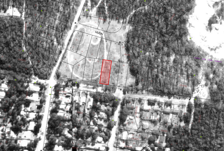
Figure
1: 1972 aerial photograph of the site and locality
Sometime
between 1977 and 1984, the site was developed for its current residential use.
Council’s records show that a swimming pool application (BA84/0189) was
approved on 26 October 1984, however, construction dates of the current
dwelling have not be able to be confirmed. Figure 2 below shows an
aerial photograph dated 1988 and the establishment of the site and locality.
Figure
2: 1988 aerial photograph of the site and locality
History of
further construction work was provided by owners of 128 Boundary Road shown as Figures
3, 4a and 4b. After completion of the dwelling at the site
(at about 1980 as stated by the owner at 128 Boundary Road), the owner of 128
Boundary Road contends that significant earthworks were carried out, within the
rear yard of the site, accommodating the swimming pool, which was approved on
26 October 1984.
The owners of
128 Boundary Road stated within their submission to Council (21 October 2019:
page 3) that:
During
construction of the original dwelling the site was cut and then backfilled and
a substantial number of large concrete piers were installed below the dwelling,
presumably to ensure stability of the proposed concrete slab. Initially the
rear of the block was substantially backfilled and levelled with soil to modify
the swimming pool surrounds and other entertaining areas but also in recent
years this surrounding area has been further modified by the deposit of
substantial amounts of soil or fill.
Photographs (Figures
4a and 4b) submitted during this DA assessment appear to be taken in
late 2015, show retaining walls and drainage pipework. It is these works that
the adjoining owners, particularly at 128 Boundary Road, raise as concerns (and
are addressed in more detail below), which they believe should be addressed as
part of the assessment of the current Development Application.
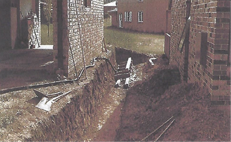
Figure 4a:
early excavation along common side boundary between the subject site and 128
Boundary Road.
|
|
|
|
Figure 5a:
2015 retaining wall and drainage
|
Figure 5b:
2015 retaining wall and drainage
|
It is relevant
to note that owners of 128 Boundary Road have made previous complaints.
Recent site inspections undertaken by Council have identified that unauthorised
earthworks have been carried out within the rear of the subject site (refer to Figure
6). In this regard, Council on 12 May 2020 issued a “Notice of Intent
to Serve a Development Control Order” requiring removal of the
unauthorised earthworks and retaining wall. Part of the Order is detailed
below:
The
circumstances of the proposed Order are as follows:
As
per Column 2 of Division 9.3, Schedule 5, Part 1 of the EP&A Act:
1. An inspection conducted
by Council’s officer on 6 May 2020, found the following unauthorised work
on the property:
a. A timber retaining wall
running parallel with the eastern boundary fence at the rear of the property.
b. The above-mentioned
retaining wall is located within one (1) metre of the boundary fence.
c. The level of the land has
been raised within 1 metre of the boundary fence.
Terms of the
Order are:
1. Demolish the timber
retaining wall running parallel with the eastern boundary fence at the rear of
the property.
2. Remove fill that is
being supported by the above-mentioned retaining wall and return the area to
natural ground levels.
Recognising
that work has been carried out, the reasons for the Oder are outlined below:
1. Development has
been carried out on the property in contravention of Section 4.2 of the
Environmental Planning and Assessment Act 1979, which states:
If
an environmental planning instrument provides that specified development may
not be carried out except with development consent, a person must not carry the
development out on land to which the provision applies unless:
i. Such development consent
has been obtained and is in force and;
ii. The development is carried out
in accordance with the consent and the instrument.
2. The work
does not meet the requirements of Exempt Development or Complying Development
as set out in the Ku-ring-gai Local Environmental Plan 2015 or the State
Environmental Planning Policy (Exempt and Complying Development Codes) 2008 and
therefore requires development consent.
3. A search
of Council’s records indicates that development consent has not been
granted for the work. As such, the public notification and exhibition
procedures have not been implemented, pursuant to the Ku-ring-gai Development
Control Plan. As a consequence, neighbouring property owners have been
denied the opportunity to participate in the development application process by
making submissions to the consent authority on the likely amenity and
environmental impacts to their properties.
4. Council
has received concerns that there is an excessive amount of water running into
the neighbouring property.
In this regard,
aspects of the proposed order, impacting upon the proposed development, are
discussed later within this report.
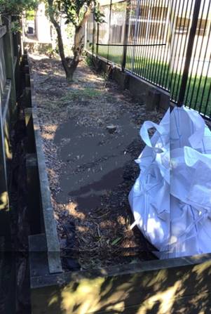
Figure 6:
raised retaining wall along eastern side boundary
Previous applications history:
A Pre-DA consultation was not undertaken
with Council prior to the lodgement of this
Development Application.
Council’s records show a history
of applications relating to the site as follows:
|
Type
|
Application
|
Description
|
Decision
|
Date
|
|
ConvBA
|
84/01891
|
Pool
|
Approved
|
26/10/1984
|
Current DA
In terms of the current application, the
following significant timeframes are as follows:
|
Date
|
Action
|
|
26
September 2019
|
Application lodged.
|
|
8 October 2019
|
The application was notified to neighbouring
property owners for a period of 14 days. Five submissions were received.
|
|
20 December 2019
|
Council forwarded a Preliminary issues
letter, dated 19 December 2019, to the applicant, raising planning issues and
included brief comments / notations raised within the submissions.
|
|
21 February 2020
|
Council received amended plans and
documentation in response to its preliminary issues letter.
|
|
11 March 2020
|
Notification of amended plans and documents
took place for a 14 day period. Five submissions were received.
|
Land and Environment Court appeal
history:
N/A
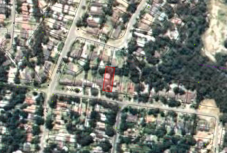
THE SITE
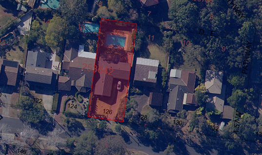
Figure 7: Aerial Photograph of the site and locality
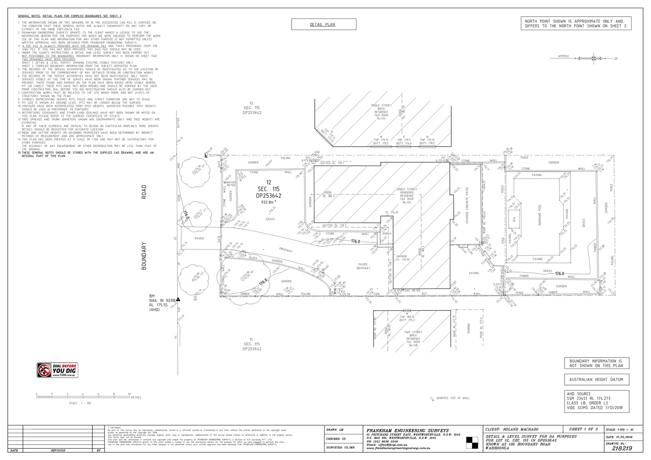
Site description:
The
subject site is described as Lot 12, Sec 115 in DP 253642 and is known is 126
Boundary Road, Wahroonga. The site is regular in shape, with a frontage of
approximately 18.29 metres to Boundary Road. Having an average depth of 51
metres and a total area of 932.80m2, the site slopes diagonally from
the south-western corner down to the north-eastern corner, with a fall of 1.27
metres across a length of approximately 54.9 metres. The submitted survey plan
shows the following ground heights:
· 175.95m AHD at the south-eastern front
corner
· 176.5m AHD at the south-western front
corner
· 176.49m AHD at the north-western rear
corner and
· 175.23m AHD at its north-eastern rear
corner.
In
addition, the survey plan shows concrete and timber retaining walls along the
common side boundary with 128 Boundary Road. However, apart from the roof and
window heights of the adjoining properties, the survey plan does not show the
natural ground heights at these properties. The height of the pool copping at
the water’s edge measures RL176.25m AHD. The height of the top of the
rear retaining wall measures between RL176.57m AHD to RL176.23m AHD.
The
site is positioned on the low side of the street, with its rear yard facing
north.
In
terms of the site’s rear yard, photographs (shown in Figures 5a
and 5b) submitted by owners at 128 Boundary Road show that, the height
of the rear yard has been elevated and this accords with the height
measurements shown on the submitted survey plan.
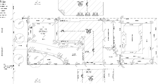
Figure 8: Survey plan of the subject site
|
Constraint:
|
Application:
|
|
Visual character
study category
|
Post - 1968.
|
|
Easements/rights of
way
|
Not situated on the land.
|
|
Heritage Item –
Local
|
No
|
|
Heritage Item –
State
|
No
|
|
Heritage conservation
area
|
No.
|
|
Within 100m of a
heritage item
|
No.
|
|
Bush fire prone land
|
Yes
|
|
Natural Resources
Biodiversity
|
No
|
|
Natural Resources
Greenweb
|
No
|
|
Natural Resources
Riparian
|
No
|
|
Within 25m of Urban
Bushland
|
Yes
|
|
Contaminated land
|
No
|
Surrounding development:
As
is characteristic of Ku-ring-gai, sites within the locality are landscaped and
present an aesthetically pleasing front setback to the streetscape. The
immediate locality is characterised by a mixture of dwelling houses with
respect to their size and shape.
The
properties that surround the site are generally zoned for low density
residential purposes. Single storey dwelling houses adjoin the site to the east
and west. Within the locality, properties are occupied by a mixture of single
and two storey dwellings of varying architectural designs.
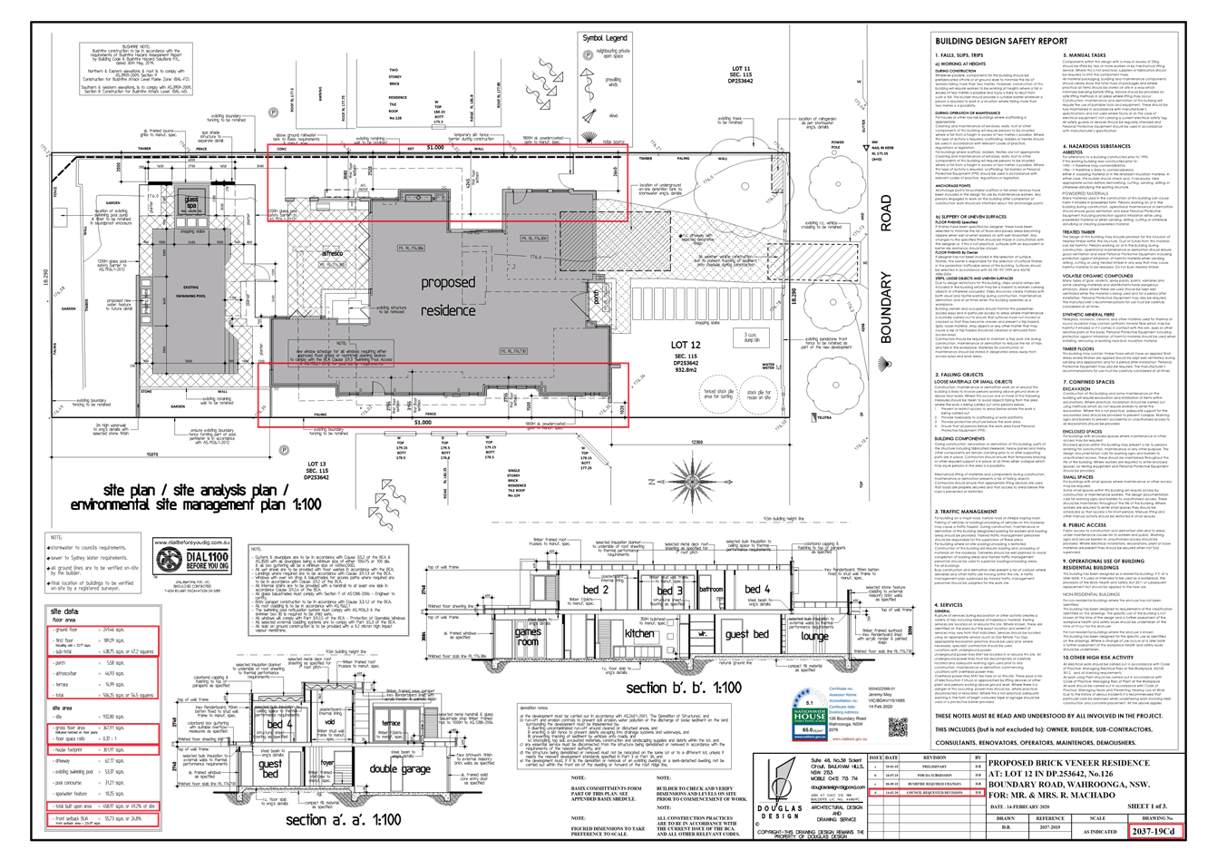
THE PROPOSAL
The Development
Application proposes to demolish the existing dwelling and construct a new 2
storey dwelling house with associated landscaping works. Within the rear yard,
the existing swimming pool is to be retained with new compliant pool safety
fencing. The existing spa is to be removed and a new in-ground spa to be
installed with a side setback measuring 2 metres to 128 Boundary Road.
Additional landscape features are proposed, such as a waterwall and side
boundary planting. The current landscape plan shows retention of retaining
walls, with the rear lawn area achieving a height of RL176.2m AHD.
The
development comprises the following:
Site
preparation:
· demolition of single level dwelling,
outdoor spa, retention of swimming pool;
· removal of internal driveway
· removal of landscaping retaining walls
and paved areas
Construction
of two-storey dwelling:
· ground floor: front porch and foyer,
open plan kitchen / living / dining space, butler’s pantry, bar, guest
bedroom with walk in robe and ensuite, formal lounge room, games room, powder room,
laundry, stairwell and covered outdoor ‘alfresco’ area
2nd
storey:
· 4 bedrooms with wardrobes, 2 en-suites,
separate bathroom, TV area, stairwell and void and terrace to front facade
Landscape
works:
· retention of in-ground swimming pool,
new outdoor spa, new shade pavilion over spa, 2 metres high wall with water
feature extending at 90o angle from western side boundary behind the
pool
· new screen planting within retaining
walls at minor side setbacks
· the front sandstone front fence is to be
retained
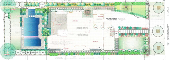
Figure 9: Site and landscape layout
The
proposed dwelling house is of contemporary design with a flat roof. Although
the design is different to that of the adjoining traditional single level
dwelling houses, it retains the residential character within the street. The
proposal provides building setbacks such that the proposed dwelling house sits
comfortably within the site.
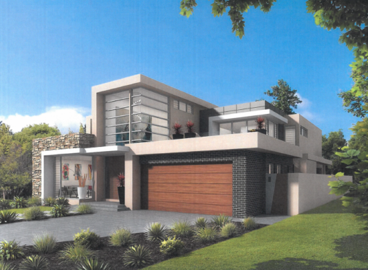
Figure 10: Photomontage of south-western view
The
proposed finished ground floor level to be RL176.30m AHD, with the rear yard
maintained at RL176.2m AHD.
CONSULTATION
Community
In
accordance with Appendix 1 of the Ku-ring-gai Community Participation Plan,
owners of surrounding properties were given notice of the application. In
response, submissions were received from the following:
1. Mr John Cowan, 151 Boundary Road, Wahroonga
2. Mr D and Mrs A
Harvey, 124 Boundary Road, Wahroonga
3. Mr G and Mrs R Van
Der Vlag, 128
Boundary Road, Wahroonga
4. Mr A Levanthal, I
Jacana Close, East Wahroonga
5. Ms M Duncan, 10 Huon
Street, North Wahroonga
The
submissions raised the following issues:
Non-compliance height and floor space ratio
Amended
documentation has been submitted. The amended proposal is compliant with the
FSR and built upon area controls. There is a slight non-compliance with the
building height envelope control, however this is acceptable for reasons
advanced below.
Privacy and amenity:
- overlooking
onto adjoining private open space areas
- loss
of visual amenity by increased bulk
- increased
shadow by shade pavilion, which is unsightly
- the
ground level along the site’s eastern side boundary “has already
been raised by substantial volume of soil or fill, some of which is pushing
against part of the existing timber paling fence on the boundary of the
properties”, where “previously the Property had a substantial slope
from east to west and also from south to north”
Condition 11
is recommended to resolve overlooking from windows along the rear (western)
portion of the development. In addition to mature landscaping and amendments to
the rear landscape features, privacy concerns are further addressed via screen
planting as shown on the landscape plan.
The
bulk and shadow of the rear pavilion within the rear yard are not a significant
issue in the context of their location and compliant side setbacks.
Condition 10
is recommended to resolve the issue of the unauthorised above ground retaining
wall along the eastern side boundary as it does not comply with the 2 metres
side setback control.
Streetscape and Neighbourhood characteristics:
- not sympathetic to current houses and
recent developments due to use of different materials and colours and height of
neighbouring land
Amended
documentation has been submitted which addresses this issue. The development
employs a modern 2 storey design that, whilst, being different to that of
traditional adjoining single dwellings, is compliant with the relevant building
controls and is not incompatible with the existing streetscape.
No acoustic report for the air conditioning system provided
has been provided
A
combination of amended documentation and recommended Conditions 15, 53,
55 and 56 will address this issue.
Trees:
- placement
of clothes line and planting of Acmena Smithii
- loss
of bush vista
- unclear
from the landscape plans whether the existing pines on the western boundary
will be retained
The
placement of the clothesline creates no environmental impact and its location
adjacent to the western elevation of the dwelling is satisfactory. In terms of
the planting of the Acmena Smithii and amended landscape plan
Council’s Tree and Landscape Assessment Officer has not raised any
concern.
The
2 storey dwelling house provides a compliant rear setback. The height of the
waterwall feature is resolved by Condition 10, which is intended
to mitigate the visual impacts of this feature when viewed from rear yard of
124 Boundary Road.
Drainage – stormwater runoff:
- existing
drainage on the subject property is not shown on existing plans and is
inadequate
- in
heavy downpours, water runs straight across the backyard of 128 Boundary Road
into the garden, causing mould on the fence and dampness
- all
stormwater drainage is to be contained within 126 Boundary Road
The
applicant has submitted amended plans/documents. Council’s Development
Engineer is satisfied with the amended plans and has recommended Conditions ,
46, 47 and 48, to address these issues. In addition to
resolving drainage seepage from retaining walls, Condition 10 requires a
2 metres clearance from the side boundary with 128 Boundary Road.
Traffic
issues
The proposal is to demolish the existing
dwelling and construct a new 2 storey dwelling house. Traffic management plans
are not required for these types of residential developments, as the use is a
low residential use replacing an existing dwelling, thus there will not be any
notable increase in traffic generation from the development. In terms of
construction activity, similarly, for low residential developments no
significant traffic flow impacts are created for the relatively short time
frames of construction activity.
Miscellaneous design issues and documentation:
- location
of air conditioning, kitchen exhaust with discharge of fumes
- confusion:
the Content page of the SOEE document refers to “Fairfield LEP
2013” as the governing document
- confusing
dimensions of rear windows, use of 3D and elevation of building
- pool
safety fence requires compliance details
- increased
fence heights due to previous fill on subject land
- no
indication that the proposed façade material complies with the BCA, NCC
especially AS1530 requirements
- exhaust
louvres are not shown on the elevations and roof plans
- location
of garbage bins not shown on the plans
- fence
details on southern elevation perspective is different – requires
description of fence type and colour, LEP prohibits front fences
- no
design details:
o to confirm the extent of overland flow
and drainage into 128 Boundary Road
o to confirm materials to be used on the
driveways, side paths and in the alfresco areas.
o to identify where the pool overflow and
backwash waters and shade roof water at the spa discharge
o to identify the extent of grass
o to clarify safety measures when cleaning
box gutters as there are no access hatched shown on the drawings
The
initial proposal provided incorrect information and lacked significant detail.
The applicant was advised of these issues and has addressed this by submitting
revised documentation and plans. In addition to submitting amended plans, the
applicant submitted a “Design Statement”, which briefly outlined
some of the changes made. As tabulated within the compliance table, it is
considered that, in the context of the application, being the demolition of the
existing dwelling and construction of a new 2 storey dwelling house with
associated landscape works, some of the issues were addressed by design changes
shown on amended plans, whilst others are addressed via recommended conditions
of consent.
Amended plans received 21 February 2020
The
amended plans were notified to owners of surrounding properties for a 14 day
period. In response, five submissions from the following were received:
1. Mr John Cowan, 151 Boundary Road, Wahroonga
2. Mr D and Mrs A Harvey, 124 Boundary
Road, Wahroonga
3. Mr G and Mrs R Van Der Vlag, 128 Boundary Road, Wahroonga
4. Mr A Levanthal, I Jacana Close, East
Wahroonga
The
submissions raised the following issues:
There still is an exceedance with the Floor Space Ratio and
Built Upon Area requirements
Within
one of the submissions, the submitter stated:
A review has been undertaken using the
Napier Blakeley format using the NWPC standard method of measurement of
building areas with an addition from the Australian Universities Commission.
By
using the above method, the submitter believes that the current design provides:
· a FSR measuring 0.526:1, by including
areas such as wall thickness, porch, the alfresco, terraces and spa roof and
· a BUA measuring 59.13% by including
areas of all stepping stones/paving in landscape areas, concrete boundary
fence.
For
the purpose of calculating FSR under Clause 4.4 of KLEP, areas such as wall
thickness, porch, the Alfresco, terraces and a spa roof are not included within
the definition of “gross floor area”:
gross floor area means the sum of the floor area of
each floor of a building measured from the internal face of external walls, or
from the internal face of walls separating the building from any other
building, measured at a height of 1.4 metres above the floor and
includes—
(a) the area of a mezzanine
and
(b) habitable rooms in a
basement or an attic and
(c) any shop, auditorium,
cinema and the like, in a basement or attic,
but excludes—
(d) any area for common
vertical circulation, such as lifts and stairs and
(e) any basement—
(i) storage
and
(ii) vehicular
access, loading areas, garbage and services and
(f) plant
rooms, lift towers and other areas used exclusively for mechanical services or
ducting and
(g) car
parking to meet any requirements of the consent authority (including access to
that car parking) and
(h) any space
used for the loading or unloading of goods (including access to it) and
(i) terraces and balconies
with outer walls less than 1.4 metres high and
(j) voids above a floor at
the level of a storey or storey above.
Therefore,
when calculated in accordance the above definition, the proposed dwelling does
not exceed the maximum FSR, as shown within the LEP compliance table, which is
further set out within this report.
For
the purposes of calculating BUA under the DCP, “built upon area means:
the area of a site containing any built
structure (whether covered or uncovered), any building, carport, terrace,
pergola, hard-surface recreation area, swimming pool, tennis court, driveway,
parking area, or any like structures, but excluding minor landscape features.
The
purpose of the DCP is to guide assessment of new development, so as to achieve
environmental outcomes that do not significantly impact upon adjoining
properties and the general locality.
Under
Control 1 of Part 4A.3, for a 2 storey development on a 932.8m2
site, a BUA of no greater than a 54% (503.71m2) shall be provided.
By adopting the definition above and, based upon the current landscape plan, a
BUA of 50.9% (475m2) has been calculated. Therefore, this aspect of
the development complies.
Visual privacy from the western window in the Master
Bedroom and Bedrooms 2 and 3 to the 124 Boundary Road swimming pool,
entertaining areas ground floor bedrooms has not been addressed in the revised
drawings
One
of the objectives of Part 23.9 of the DCP is to ensure that the level of visual
privacy to the private open space of an adjacent property is appropriate.
Objection has been made in relation to Windows C1, C2, D1, E1 and B1, that
directly overlook No. 124 Boundary Road. The current plan maintains the initial
bedroom window locations and shows that the Master Bedroom is provided with a
window seat adjacent to the corner window, which has a north and westerly
aspect. Bedroom 2 provides a direct northerly aspect. Three long windows are
provided to Bedroom 3, which face west. These windows have low sill heights.
From the common side boundary with 124 Boundary Road, the following first floor
window locations provide the following setbacks: “C1” and
“C2” >7 metres for the Master Bedroom facing north and north
west, “D1” >2.5 metres for Bedroom 2 facing northand
“E1” (x2) and “F1” >2 metres for Bedroom 3 facing
west.
The
intention is not for these windows to allow for overlooking of adjoining
properties however, they could create potential for overlooking due to their
low sill height. A window seat may benefit the occupants of the site; however,
is clearly not in the interests of occupants to the west. The low window design
may provide architectural relief; however, it is considered to be too low and
offers opportunity for overlooking.
To
address the neighbour’s concern, the development can achieve higher
window sill heights than proposed without significantly compromising amenity.
Therefore, to meet the objectives of Part 23.9. Condition 11 is
recommended which requires the window sills of the Master Bedroom and Bedroom
2, to be no lower than 1.5m measured from finished floor level.
Inconsistencies within the amended documentation
· acoustic attenuation cannot be provided
by landscaping
· the installation of the KC's approved
drainage does not work as designed
· the statement that the Street and
Neighbourhood Characteristics in the SEE is incorrect
· the architecture is dramatically
different to the local residences
· fence designs and configurations are in
difference to the street view montages provided
· the Design Statement does not refer to
the Built Envelope
The
applicant acknowledged Council’s preliminary assessment letter of 19
December 2019, however, minor discrepancies between various documents were not
addressed. Notwithstanding, as shown the compliance table, the applicant has
made significant design changes to what was initially submitted such as:
· reduction in building height
· reduction in FSR
· reduction in BUA
· reduction in building envelope
· increased side setbacks
The
development on merit is now considered to be acceptable and the inconsistencies
within these documents do not preclude a full and proper assessment of the
merits of the proposed development.
The
issue raised about noise has been considered. Given that adjoining properties
have within their rear yards recreational areas such as swimming pools, covered
terraces and lawn, it is considered that noise generated from the site will be
no different to that generated by those adjoining properties and reasonably
expected in a low density residential area. Condition Nos. 15, 53
and 56 require air conditioning and pool /spa pumps to be suitably
soundproofed.
The
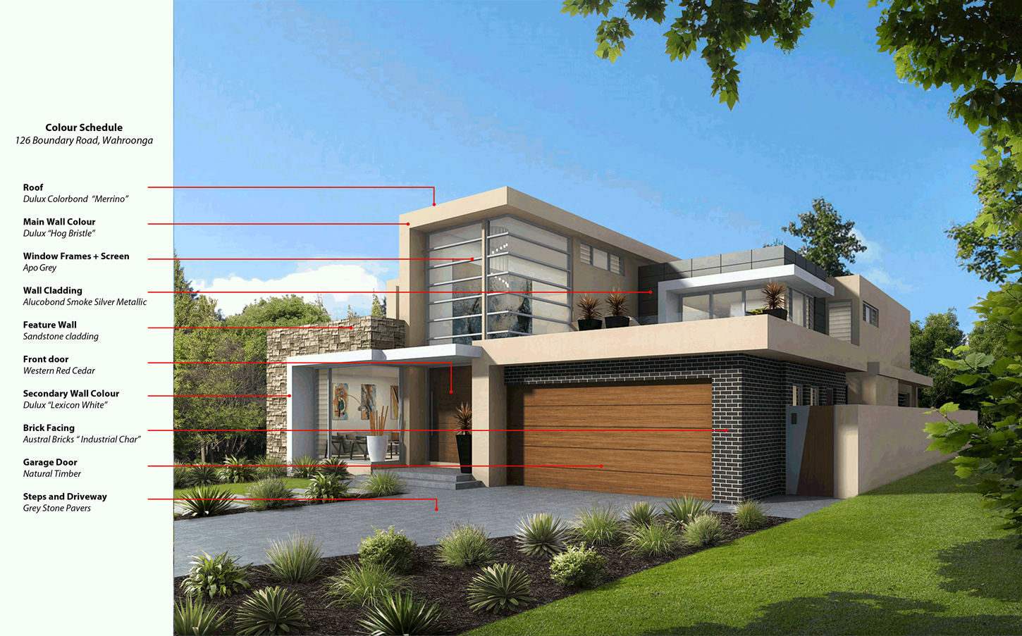
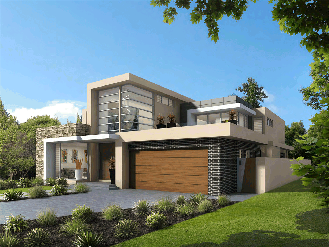
photomontage, as shown within Figure 10, is a conceptual visual
representation of the development and is accepted as being generally consistent
with the architectural plans. The proposal meets the residential objectives and
controls of Part 4 of the DCP.
In
terms of the applicant’s Design Statement, the issue concerning
“Building Envelope”, has been satisfactorily considered.
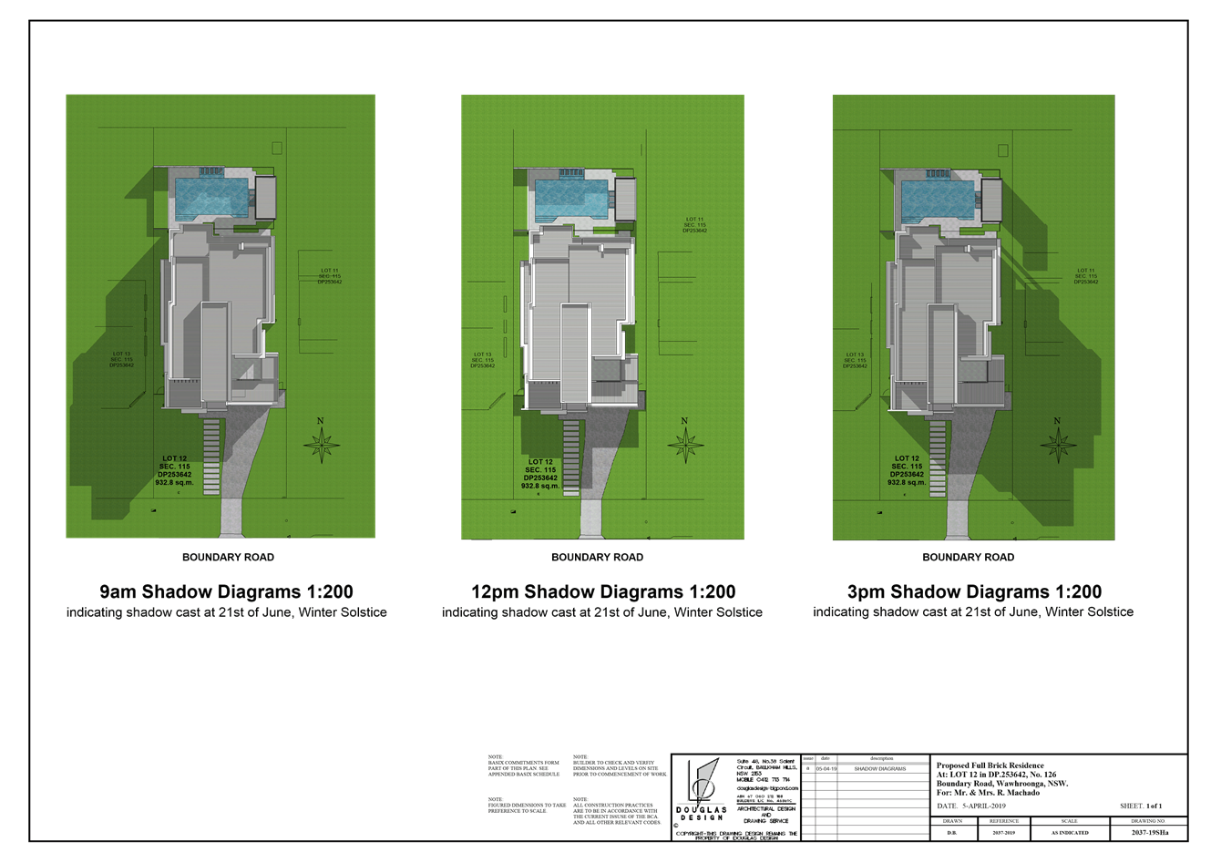
Loss of solar access and incomplete shadow diagrams- lack
of March / September equinox shadow as required
The
proposed development is for a 2 storey dwelling house. The proposal will cast
shadow on adjoining properties. This is a result of not just the
building’s design, which is compliant, but of the subdivision pattern.
The subject site has a north / south orientation. Whilst both the original and
amended plans include 9am, 12noon and 3pm shadow diagrams for the winter
solstice, shadow diagrams for the March/September autumnal and vernal equinoxes
have not been submitted nor are they required under Council’s DCP
controls.
The
applicant’s view is that, as the current building design is compliant
with building height and setbacks, built-upon area and that northerly private
open space receives full winter sun access, sufficient information is provided,
the omission of March/September shadow diagrams does not necessarily compromise
the general amenity of adjoining properties. The winter solstice is the worst
case scenario. The proposal
complies with Controls 2 and 3 of Part 4C.5 in that, between 9am and 3pm on 21st
June, at least 4 hours of solar access is achieved to the north facing windows
and north facing rear private open space areas of the site, and adjoining
properties to the east and west. Four
hours of solar access is provided within the rear yards that face north. The
applicant has submitted sufficient information and in the circumstances of the
case, the proposal is acceptable, subject to conditions.
Under
the provisions of Part 4C.5 Solar Access of the DCP Objective 1 is to:
ensure the design and siting of new
development maintains a reasonable level of daylight and sunlight to habitable
rooms, private open space and solar collectors of new and neighbouring
development.
In
achieving this objective, the applicant has sought to meet Controls 2 and 3,
which read as follows:
2 A
building is to be designed and sited to maintain solar access to adjoining
properties of at least 4 hours between 9am and 3pm on 21st June to north facing
windows and all living areas (family rooms, rumpus, lounge and kitchen) and the
principal private open space recreational areas, such as swimming pools and
patios.
3 Dwelling
design and orientation is to provide at least 4 hours between 9am and 3pm on
21st June to north facing windows and all living areas (family rooms, rumpus,
lounge and kitchen) and the principal private open space including swimming
pools and patios, to the proposed dwelling.
As
is, established above, the proposal complies with Control 2. The sites
orientation provides a dwelling and its principal private open space areas with
a northerly aspect. The dwelling design comprises a games room and covered
alfresco area to receive direct solar access. Within the dwelling, the
development provides an open ‘living, dining and kitchen’ area that
is orientated to the north and east. In this regard, compliant sunlight access
is provided consistent with Control 3.
Loss of outlook and ventilation
In
terms of outlook, the current proposal and adjoining dwellings have a northerly
outlook. The locality is characterised by large and small trees within a low
density residential setting. There are no views to significant built or natural
features that are impacted; therefore, it is considered that, as sufficient
rear yards are provided for private open space, visual outlook of adjoining
development is not significantly compromised.
The
proposal allows ventilation of natural air to adjoining developments. The
development has been designed with compliant side setbacks and building height.
Therefore, this aspect is acceptable.
Inconsistencies and ambiguities in Landscape Plans and the
planting of a Acmena smithii which may grow to 13m in height to be repositioned
The
Acmena smithii, known as Lilly Pilly, can be grown as either a hedge or
a tree (as shown by examples in Figure 11). In this instance, the
Landscape Plan shows the tree to be planted within the rear corners of the
property. Other screen planning is provided along the perimeter of the rear
yard. Council’s Tree and Landscape Assessment Officer has considered
the current proposal and is satisfied that, with suitable conditions, the
development is satisfactory.
Figure 11: examples of Acmena smithii as both a
hedge and tree
Within
the applicant’s Design Statement, “the existing sandstone fence
along the front boundary, is proposed to be retained as it is in excellent
condition”. The proposed 1.2m high rendered brick front fence with 0.7
metres powder coated infill pickets, as shown on Sheet 3 of the set of
landscape plans, is no longer proposed for this development. This aspect is
addressed by Condition 10.
Location of external kitchen ventilation
The
development is for a single dwelling. It is considered that, unlike a commercial
food premise, ventilation for domestic use and will not result in any
significant impacts. By its design, this aspect of the development is
satisfactory.
Placement of clothes line is unacceptable as it is unable
to determine its height
A
clothesline is proposed along the western elevation of the rear of the
dwelling. Depicted as a foldout clothesline, generally these have a height no
greater than 2 metres, slightly higher than a standard 1.8 metres high paling
fence. Given its location, the proposed location does not significantly
compromise the amenity of respective occupants.
We request a copy of Council’s ‘preliminary
assessment letter’ and copies of correspondence between Council and the
applicant to better understand and respond to the Council’s issues and to
assist us in the preparation of our submission
Comment:
Correspondence
between Council and the applicant are technical based documents that detail and
explain Council’s issues with an application and the applicant’s
response to them. As such, this information is not needed or required to be
used be used for any member of the public to form an opinion on the proposed
development.
Internal Referrals
Landscaping
Council’s Tree and
Landscape Assessment Officer commented on the amended application as follows:
|
SEPP
(Building Sustainability Index: BASIX) 2004
|
|
Part 3 Aims
|
Proposed
|
Satisfies
|
|
To encourage sustainable residential development
|
There are no landscape commitments in the BASIX.
|
YES
|
|
SEPP (Vegetation in Non-Rural Areas) 2017
|
|
Part 3 Aims
|
Proposed
|
Satisfies
|
|
To protect the biodiversity value of trees and other
vegetation and to preserve the amenity of non-rural areas through the
preservation of trees and other vegetation.
|
Trees to be removed
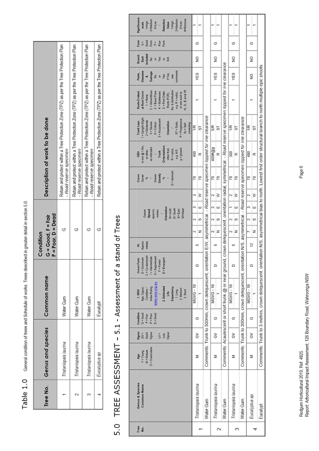
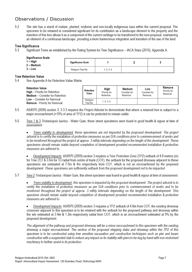
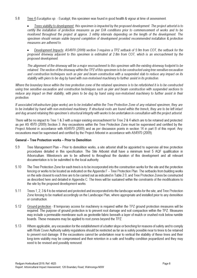
No significant trees are proposed to be removed.
|
YES
|
|
KDCP COMPLIANCE TABLE
|
|
Control
|
Proposed
|
Complies
|
|
Part 4A.4 Landscaping and Part 13 tree and vegetation
preservation
|
|
Landscape proposals are to retain existing trees where possible
|
The proposal retains significant existing trees.
|
YES
|
|
Part 16 Bushfire risk
|
|
16.1 Bushfire Risk Management
|
The bushfire report states that the site be managed as
asset protection area. The site has little existing vegetation and has only
one medium sized tree within the front setback. It is unlikely that
vegetation therefore would need to be removed for the APZ.
The bushfire
report has certified the landscape plan
|
YES
YES
|
|
Part 21 General site design
|
|
21.1 Earthworks and Slope
|
Cut and fill existing levels
|
YES
|
|
21.2 Landscape Design
To ensure the landscape design and species selection is
suitable to the site its context and considers the amenity of residents and
neighbours.
|
The initial Landscape Plan was not satisfactory.
Screen planting within side setbacks is indicated.
The site is rated BAL FZ, BAL 40 The bushfire consultant has now assessed the
landscape plan.
The proposed stormwater design has been amended to place
the OSD under the drivewayand a small rain garden to the front boundary. This
is acceptable.
|
YES
|
Other issues
The plans indicate a 2 metres high
“waterwall” to the rear of the swimming pool. The wall has been
amended and no longer extends to the western rear side boundary on the
landscape plan but is still indicated on the site plan.
No elevation and top of wall level has
been provided. It is unclear whether there may be visual impacts on the
adjacent property, to the west due to the wall extending to the boundary.
The
submitted survey plan shows the height of the pool paving measuring RL176.22
metres AHD. The current Landscape plan shows a proposed height of the water
feature measuring 2m high from the pool paving. The survey plan does not show
detailed natural ground heights at 124 Boundary Road. The site has, at the
north-western corner of the existing dwelling, an RL of 176.02 metres AHD.
Therefore, a height difference of 0.22 metres between the pool paving and the
north-western corner of the dwelling. Uncertainty about the length of wall to
the western side boundary is justified. It is considered that, given that given
the height of the rear yard, the proposed 2 metres high waterwall is excessive
and may pose a visual impact concern for 124 Boundary Road. Therefore, it is
recommended that the height of the waterwall feature be reduced to 1.8 metres
measured from the surface of the pool paving and that its setback be no less
than that of the western edge of the pool paving, which is approximately 2
metres – (Condition 10).
Engineering
Council's Development Engineer commented
on the amended application as follows:
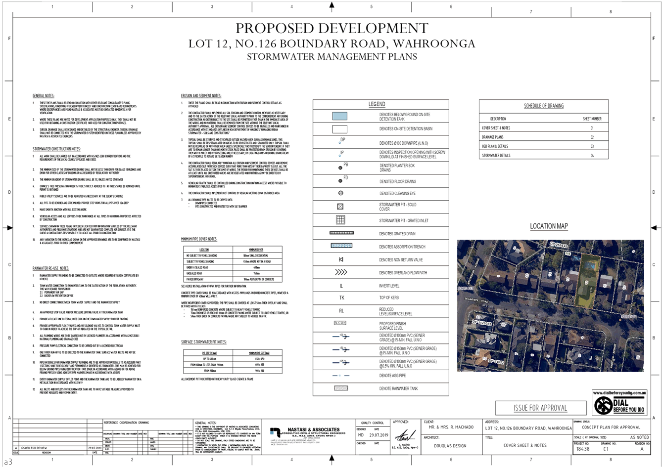
The amended stormwater management plans
Project No. 18438 Dwg. No. C1-C4 issue A prepared by Nastasi & Associates
can be stamped and listed in Condition 1.
Water management
As required, a standard concrete on-site
detention tank under a driveway has replaced previously proposed
“Atlantis Matrix” drainage cell type structure.
The provided “On-site Detention
Calculation Sheet’ shows the orifice diameter of 71mm. This is considered
acceptable as a minor difference of 7 millimetres is insignificant.
As runoff from the driveway will bypass
the on site detention, a raingarden is proposed, as shown on the drainage plan.
The proposal is considered acceptable.
A submission has been received regarding
the existing stormwater drainage system and the proposed stormwater drainage
plan. All the exiting drainage utilities (pits, pipes) will not be a part of
the new drainage systemand will be removed from the site. The proposed
stormwater management plan complies with Part 24 “Water Management”
of Ku-ring-gai DCP.
Recommendations
From an engineering perspective, there
are no objections to this application.
External Referrals
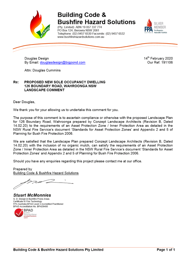
Rural Fire Services
As
the site is mapped as bushfire prone land, in accordance with the provisions of
Section 4.14 of the Environmental Planning and Assessment Act 1979, Council
consulted with the Commissioner of the NSW Rural Fire Service, concerning
measures to be taken with respect to the protection of persons, property and
the environment from danger that may arise from a bush fire. The Rural Fire
Service provided their comments/requirements to Council.
The
RFS’s requirements have been incorporated into the recommended conditions
of consent – (Condition 20, 51 and 54).
STATUTORY PROVISIONS
State Environmental Planning Policy No.
55 – Remediation of Land
The
provisions of SEPP 55 require Council to consider the potential for a site to
be contaminated. The subject site has a history of residential use and as such,
it is unlikely to contain any contamination and further investigation is not
warranted in this case
Draft State
Environmental Planning Policy (Remediation of Land)
The draft SEPP is a relevant
matter for consideration as it is an Environmental Planning Instrument that has
been placed on exhibition. New provisions will be added in the SEPP to:
· require all remediation work
that is to be carried out without development consent, to be reviewed and
certified by a certified contaminated land consultant
· categorise remediation work
based on the scale, risk and complexity of the work
· require environmental
management plans relating to post-remediation management of sites or ongoing
operation, maintenance and management of on-site remediation measures (such as
a containment cell) to be provided to Council
The site is unlikely to
contain any contamination and further investigation is not warranted in this
case.
State Environmental Planning Policy
(Vegetation in Non-Rural Areas) 2017
The
SEPP commenced on 25 August 2017 and replaced clause 5.9 of Ku-ring-gai Local
Environmental Plan 2015, which aimed to preserve trees and vegetation. The
objective of the SEPP is to protect the biodiversity values of trees and other
vegetation and to preserve the amenity of the area through the preservation of
trees and other vegetation.
The
proposed development
has been designed to
minimise impacts on the diversity and condition of native vegetation, fauna and
habitat as per the requirements of the SEPP.
Sydney Regional
Environmental Plan No. 20 - Hawkesbury-Nepean River
SREP 20 applies to land within the
catchment of the Hawkesbury Nepean River. The general aim of the plan is
to ensure that development and future land uses within the catchment are
considered in a regional context. The Plan includes strategies for the
assessment of development in relation to water quality and quantity, scenic
quality, aquaculture, recreation and tourism.
The
proposed development achieves the relevant aims under this policy as water
re-use will minimise the impact on downstream waterways.
State Environmental Planning Policy
(Building Sustainability Index: BASIX) 2004
A
valid BASIX certificate has been submitted. The certificate demonstrates
compliance with the provisions of the SEPP and adequately reflects all
amendments to the application.
Draft Environment SEPP
The
draft Environment SEPP was exhibited from 31 October 2017 to 31 January 2018.
The consolidated SEPP proposes to simplify the planning rules for a number of
water catchments, waterways and urban bushland areas. Changes proposed include
consolidating a number of SEPPs, which include:
· State Environmental Planning Policy No.
19 – Bushland in Urban Areas
· Sydney Regional Environmental Plan No.
20 – Hawkesbury-Nepean River (No.2 1997)
· Sydney Regional Environmental Plan
(Sydney Harbour Catchment) 2005
The
proposal is not inconsistent with the provisions of the draft SEPP.
Consolidating LEPs Planning Proposal
The
Planning Proposal was exhibited from 25 October 2019 to 22 November 2019. The
purpose of the Planning Proposal is to consolidate the Ku-ring-gai Local
Environmental Plan (Local Centres) 2012 and Ku-ring-gai Local Environmental
Plan 2015. The Planning Proposal is an amendment to KLEP 2015 and will correct
site specific mapping errors, resolve the status of deferred areas, remove an
existing land reservation in Gordon and amend heritage listings. The Planning
Proposal does not seek to amend the zoning and development standards that apply
to the subject site. The proposal is consistent with the Planning Proposal.
Ku-ring-gai Local Environmental Plan 2015
Zoning and permissibility:
The site is
zoned R2 Low Density Residential. The proposed development is defined as a
residential building.
Zone objectives:
The
objectives of this zone, which seek to:
· provide for the housing needs of the community within a low
density residential environment
· enable other land uses that provide facilities or services
to meet the day to day needs of residents
· provide for housing that is compatible with the existing
environmental and built character of Ku-ring-gai
The
development:
· provides housing choice within the low
density zoning of the land
· provides housing compatible with the existing environmental and built
character of Ku-ring-gai demonstrated by the proposal’s general
compliance with the relevant consideration as discussed throughout this report
The proposed
development therefore upholds the zone objectives.
Development standards:
Ku-ring-gai Local Environmental Plan 2015
|
Development standard
|
Proposed
|
Complies
|
|
Cl 4.3 -
Height of buildings:
Maximum
Building Height - 9.5 metres
|
7.9 metres
|
YES
|
|
Cl 4.4 -
Floor space ratio (FSR):
Note:
Subclause 2A Calculation 0.38:1
Gross Floor
Area no greater than 353.2 m2
|
Site area =
932.8m2:
- 0.37:1
- 347.91m2
|
YES
|
Clause 5.10 – Heritage
conservation
The
subject site does not contain a heritage item, is not located
within 100m of an Item and is not within a heritage conservation area. The
proposed works do not affect any known archaeological or Aboriginal objects or
Aboriginal places of heritage significance.
Part 6 Additional local
provisions
Clause 6.1 -
Acid sulphate soils
The site
subject of the proposed works is mapped as Class 5 land. The proposed works are
not within 500 metres of adjacent Class 1, 2, 3 or 4 land that is below 5
metres Australian Height Datum and by which the watertable is likely to be
lowered below 1 metre Australian Height Datum on adjacent Class 1, 2, 3 or 4
land. As a consequence, the proposal is acceptable in this regard.
Clause 6.2 - Earthworks
The proposal
seeks retention of the side retaining walls and rear raised lawn area, which is
not proposed to be demolished/removed. The new dwelling will not restrict the
existing or future use of the site, significantly impact on neighbouring
amenity, the quality of the water table or disturb any known relics.
Clause 6.5 - Stormwater and water sensitive urban design
Council’s
Development Engineer has given consideration to the objective of this clause
which seeks to minimise the adverse impacts of urban water on the site and
within the catchment. The stormwater design adequately manages water quality
and control discharge volumes and frequency, subject to conditions – (Conditions,
45, 46, 47 and 48).
Ku-ring-gai Development Control Plan
Part 1A.5 General aims of the DCP
The proposed
development has been assessed against the general
aims of this DCP and is
found to be acceptable in all relevant respects for the reasons given
throughout this report.
Part 2: Site analysis
A site analysis
which identifies the existing characteristics of the site and the surrounding
area has been provided as part of the development application. The site
analysis satisfies the objectives of this part of the DCP.
Part 4:
Dwelling Houses
The table below
addresses the assessment criteria contained under Part 4 of the DCP.
|
COMPLIANCE
TABLE
|
|
Development
control
|
Proposed
|
Complies
|
|
4A
– Site Design
|
|
4A.1 Local Character and Streetscape
|
|
Visual
Character
- Design
components are based on existing predominant visual character of the local
neighbourhood
|
The front component of the dwelling maintains the visual
character of the locality.
|
YES
|
|
- Consideration
to be given to visibility of on site development and relationship to scale,
layout and character of streetscape
|
Maintains the residential scale and streetscape.
|
YES
|
|
Public
domain and communal space
- Development
is to integrate with surrounding sites by appropriate scale, not exceeding
two storeys, minimising overshadowing and integrating built form and soft
landscaping.
|
The development is 2 storeys, meets the height and FSR
controls which in part determine acceptable bulk and scale, the dwelling
meets the setback controls and integrates with the predominant front
streetscape with a single driveway. There is no significant overshadowing.
|
YES
|
|
4A.2 Building Setbacks
|
|
Building
Line (Front Setback)
|
|
|
|
Two
storey
Low side
– 9m (11m average)
High side
– 12m (14m average)
|
Low side of street:
12.3m
|
YES
|
|
Building
Line (Rear Setbacks)
- 12
minimum for depths >48m
|
- 15.07m
|
YES
|
|
Building
Line (Side Setbacks)
|
|
|
|
<20m
width
- 1.5m single storey elements
- 2m two storey
|
East:
- Min. 2.52m single
storey elements
- Min. 3.08m 2
storey elements
West:
- Min. 1.5m single
storey elements
- Min. 2.755m 2
storey elements
|
YES
YES
YES
YES
|
|
4A.3 Built-Upon Area
|
|
Site Area
- 932.80m2
Max BUA
54% (503.71 m2)
|
50.9% (475m2)
– includes dwelling, alfresco, swimming pool, driveway and connecting
path, hardstand areas of the pool pump, water tank and air conditioning.
|
YES
|
|
4A.4 Landscaping
|
|
Tree
replenishment
- 850m2 to 1,000m2
x5 trees
|
All trees to be retained on site.
Refer to Landscape Plan for landscape features and Council’s Landscape
Officer’s comments.
|
YES
|
|
4B
– Access and Parking
|
|
4B.1 Vehicle Access
|
|
Driveways
|
Use of existing crossover, with new
internal driveway to replace existing.
|
YES
|
|
- <18m frontage 1 driveway
|
|
|
- 3.5m crossing
|
|
|
- Driveways designed in accordance with AS
2890.1 (2004) Off Street Car Parking
|
|
|
4B.2 Car Parking Provision
|
|
- 2 on-site parking spaces
|
Spaces available to for 2 vehicles.
|
YES
|
|
- Double 5.4 x 5.4m minimum
|
6m x 6.17m (5.17m door opening width)
|
YES
|
|
4C
– Building Design and Sustainability
|
|
4C.1 Building Envelopes
|
|
- 2 storeys
|
2 storey height
|
YES
|
|
- 9.5m height
|
7.9m
|
YES
|
|
- 4m @ 45°
|
Minor encroachment.
|
NO
Refer to discussion below
|
|
4C.2 Building facades
|
|
- Unrelieved wall length <12m
|
- 10.43m length.
|
YES
|
|
- Unrelieved wall length (4m high)
<8m
|
- 6.29m
|
YES
|
|
4C.3 First Floor Design and Roof Forms
|
|
First
floor design
- Upper levels stepped back
|
First floor provides elements to
minimise bulk and massing by stepping in from the ground floor. A minor
technical non-compliance exists to a small portion of the dwelling with
building envelope discussed above.
|
NO
Refer to discussion below
|
|
Roof
line
- Minimise bulk and overshadowing by
selection of material, colour and roof pitch, low angled pitched roofs,
inclusion of habitable rooms within roof space
|
Bulk reduced by low level rooves.
No habitable roof space provided.
|
YES
|
|
Clerestory
windows and skylights
- Sympathetic to overall design of
dwelling and streetscape
|
Not proposed.
|
YES
|
|
4C.4
Private Open Space
|
|
- Min
depth 5m and area of 50m²
|
300m2
|
YES
|
|
- At
least one north facing area
|
North facing.
|
YES
|
|
4C.5 Solar Access
|
|
- 4hrs between 9am – 3pm on June
22 to north facing windows and all living areas and POS
|
North facing areas.
Adjoining sites provided with solar
access to Private Open Space.
Plans show southern portion of
dwellings receiving shadow in parts.
|
YES
|
|
- To neighbouring properties and
dwelling itself
|
YES
|
|
- Where existing non-compliance
reduction limited to 20%
|
YES
|
|
4C.6 Natural Ventilation
|
|
- Buildings designed to incorporate
natural cross ventilation
|
Openings provided along all
elevations.
|
YES
|
|
4C.7 Ancillary Facilities
|
|
Swimming
pools, spas, equipment and fences
- 2m from boundaries
|
An existing pooland new spa provided with screening.
3m to pool’s water edge to the west and 2.2m to spa
water edge to the east.
|
YES
|
|
- <0.5m above existing ground level
|
In ground pool and spa.
|
YES
|
|
- Pumps and filters to be sound proofed
and enclosed
|
Pumps and equipment to be retained and conditioned to
meet noise requirements
as per conditions.
|
YES
|
|
4C.8 Fencing
|
|
Front
fences
- 1.2m max for visually solid forms
|
Retention of existing front sandstone
fence.
No change to existing fencing.
|
YES
|
|
Side
and rear fences
- 1.2m with front setback
|
YES
|
|
- 1.8m
|
|
|
4C.9 Waste Management
|
|
- All waste recycling storage containers
stored on site
|
Domestic waste bins are to be provided
to the dwelling, an sited behind the front building line.
|
YES
|
|
- Located at rear of site a min 3m from
openable windows
|
|
|
4C.10 Materials and Finishes
|
|
- External walls constructed of high
quality and durable materials and finishes.
|
Earth toned with light external
materials. Refer to photomontage.
|
YES
|
|
- Base colours to be light in tone
|
|
|
- Black and white colours to be avoided
|
|
|
- Strong colours to large sections of
building avoided
|
|
|
- Natural earth tones for facades close
to bushland
|
|
|
|
|
|
An assessment of the variations to the controls identified
in the compliance table is provided below.
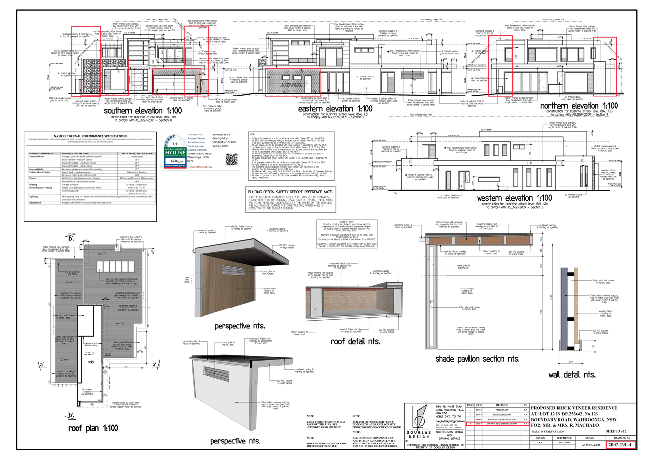
Part 4C.1
Building Envelopes
The principle
objectives of Part 4C.1 is to limit the height and bulk of buildings so they
don’t dominate adjoining developments and to ensure developments are
responsive to the site. Equally, developments should by design minimise
overshadowing and at the same time allow adequate ventilation and solar access
to private open space and habitable rooms.
Recognising the
minor encroachment outside the building envelope, a minor degree of
overshadowing occurs to the adjoining allotments. This is more due to north/
south subdivision pattern of the allotments. Each of the adjoining properties
are north facing, receiving direct solar access at mid-winter to the dwellings
and main private open space. In addition, adjoining properties achieve
the solar access requirements set out in the DCP.
The design has
been successfully arranged to generally satisfy the objectives, although there
is a minor variation to the building height plane control. The minor variation
to the building envelope is satisfactory given that the development achieves
the desired buildings setbacks and provides a building height below the maximum
9.5m building height under Clause 4.3 of KLEP. In addition, the building is
below the maximum 0.38:1 FSR under Clause 4.4 of KLEP and is within the BUA development
guideline as set out above.
Part 4C.3
First floor design and roof forms
The principle
objective of Part 4C.3 is to integrate and limit the foot print of the first
floor of a two storey dwelling house so as to avoid overbearing bulk and scale
and allow daylight and sunlight to living areas and private open space of a
proposed dwelling and adjoining properties. The amended first floor design
achieves the objectives, despite not being contained wholly within the ground
floor footprint, with a minor variation at the rear of the first floor at the
north-eastern corner. The first floor, along the Western elevation, shows that
an inward set back of the first floor from the ground floor Western wall
measuring between 0.6 metres, 1.6 metres and 4.6 metres. Along the Eastern side
elevation towards the rear of the first floor, parts of the first floor
building (being the ensuite and walk in robe) sit directly above the ground
floor. Whilst the dwelling is non-compliant, its design addresses and
appropriately manages its bulk and scale by incorporating a mix of external
building materials and finishes which assist in breaking up the building mass,
as well as achieving a well-articulated and stepped building form. Controls 1,
2 and 6 of Part 4C.3 are relevant in that the first floor design should
minimise bulk/scale and overshadowing onto adjoining owners which is considered
to be achieved.
Ku-ring-gai Development
Control Plan
Section B
Part 15 – Land Contamination
The
site is not mapped as being contaminated
and has a history of residential use and as such, it is unlikely to contain any
contamination and further investigation is not warranted in this case.
Part 16 – Bushfire Risk
The site is mapped as bush fire prone
land.
In accordance with the provisions of
section 4.14 of the Environmental Planning and Assessment Act 1979,
Council has consulted with the Commissioner of the NSW Rural Fire Service,
concerning measures to be taken with respect to the protection of persons,
property and the environment from danger that may arise from a bush fire. The
requirements satisfied by the Rural Fire Service are included in (Conditions
20, 51 and 54).
Part 17 – Riparian Lands
The site is not mapped as riparian land.
Part 18 – Biodiversity
The
site is not mapped as land comprising biodiversity significance.
Part 19 – Heritage and
Conservation Areas
The subject site does not contain a
heritage item, is not located within close proximity to an Item nor is it
within a heritage conservation area. The proposed works do not affect any
archaeological or Aboriginal objects or Aboriginal places of heritage
significance.
Ku-ring-gai Development
Control Plan
Section C
|
Development
Control
|
Proposed
|
Complies
|
|
Part
21 General Site Design
|
|
21.1
– Earthworks and slope
|
|
Development
consider site topography, drainage, soli landscapes, flora, fauna and
bushfire hazard by:
· stepping buildings down the site
· locate finished ground level as close
to the natural ground level as practicable
· lLevel changes to occur primarily
within building footprint
· minimum 0.6 metres width between
retaining walls
· maintain existing ground level within
2m from any boundary
· limit slope for embankments to 1:6
(grassed) and 1:3 (soil stabilising vegetation)
· no fill and excavation within
sensitive environments
· minimise altered groundwater flows
|
Building platform
relatively flat, with no stepping down required.
Existing retaining walls
are to remain. However, Control 5 requires that a 2 metre setback from side
boundaries is to be maintained.
Landscape plan shows new
trees and screening within the rear perimeter of the site. No major
earthworks are proposed. An opportunity to re-establish an appropriate garden
setting, such as a 2 metre retaining wall setbacks, should mitigate previous
drainage and privacy concerns.
|
NO,
Refer
to discussion below
|
|
Dwelling
houses
Excavation
within building footprint must not exceed 1m
· 0.9m maximum fill
· 1.8 m maximum level difference across
the building footprint
· retaining walls maximum 0.9m above NGL
|
No excavation required for
the dwelling footprint.
Height of rear retaining
walls measure less than 0.9m from natural ground level.
|
YES
|
|
21.2
– Landscape Design
|
|
Council’s Tree and
Landscape Assessment Officer has assessed the proposal against these
provisions and is satisfied the development is satisfactory. The site is
within Bushfire Prone Land and has been rated BAL FZ and BAL 40.
Council’s Landscape Assessment Officer is satisfied that, as the Bushfire
Consultant has assessed the current Landscape Plan, the proposed development
is satisfactory, subject to conditions – (Conditions 20 and 54).
|
|
Part
22 - General access and parking
|
|
The
proposal has been assessed against the provisions contained in these Parts.
The subject site provides sufficient on-site parking in accordance with the
car parking rates. No issues or concerns were raised by Council’s
Development Engineer in relation to this Part. The proposal meets the
relevant objectives of this control.
|
|
Part 23 – Building Design and Sustainability
|
|
23.7 Waste
Management and 23.10 Construction, Demolition and Disposal
The proposal
has been assessed against the provisions contained in these Parts. The site
provides sufficient bins for general household waste including recycling
materials. The waste storage area is also suitably located to ensure minimal
impacts.
The applicant
has lodged a Waste Management Plan with the application. The proposal is
consistent with these provisions. No issues or concerns were raised by
Council’s Development Engineer in relation to stormwater quality
control during construction and erosion and sediment control during
construction, subject to conditions – (Conditions 27, 33 and 40).
The
development will be consistent with the objectives of these Parts, subject to
conditions.
|
|
Part 23.8 and 23.9 General Acoustic and Visual Privacy
The
proposal has been assessed against the provisions contained in these Parts.
The proposal will not result in a significant detrimental impact contrary to
these provisions as the development maintains the residential character of
the locality. The existing pool and proposed spa pumps
are to be enclosed. Suitable conditions have been recommended to ensure
appropriate noise attention for any air conditioning and the pool filter.
The
amendments made to the dwelling has mitigated concerns raised.
|
|
Part 24 – Water management
|
|
Council’s
Development Engineer is satisfied that the proposed development has been
designed to manage urban stormwater as per the requirements of the DCP,
subject to conditions – (Conditions 45, 46, 47 and 48).
|
|
|
|
|
An assessment of the variations to the
controls identified in the compliance table above is provided below.
Part 21.1 – Earthworks and slope
To
relevant objectives of Part 21.1 of the DCP are:
· respect the topography of the site
· manage / minimise drainage and water
flows due to site earthworks or retaining walls
· prevent damage to buildings on adjoining
land
· minimise degradation, water pollution
and damage to infrastructure from erosion and sedimentation
Part
of the site has been filled some time ago and is retained by a retaining wall
set back 1 metre from the eastern boundary fence. There is compliance action
regarding these works, as it appears that no approval exist for them. Should
these works be proposed as part of this application, they would not be
supported under the DCP controls; however, conditions have been recommended to
mitigate the concerns raised. In recognising that fill has occurred on
site, as raised by the owner of 128 Boundary Road, it could be concluded that
the filling and raising of the rear lawn area was a result of excavated fill
from the then approved swimming pool. Control 5 of the current DCP requires
that:
5. Existing
ground level is to be maintained for a distance of 2m from any boundary.
In
this instance, the objective of Control 5 is to enable adequate area for
maintenance along the property boundary line, to minimise significant water
seepage and, at the same time, minimise overlooking where significant fill is
proposed. The rear of the site now has a raised lawn area and appears to allow
water seepage onto adjoining properties. To address this issue, Condition 10
is recommended.
Given
the water seepage issues onto 128 Boundary Road, Council has issued a a Notice
of Intention to serve a Development Control Order for the removal of the
unauthorised retaining wall along the eastern side boundary and fill within the
lawn area. The owner of the site may make representations about the proposed
order; however, as Condition 10 is recommending that works be carried
out, as discussed above, it is considered that, until an Occupation Certificate
has been issued for the development, the Order, if issued, would remain in
force. Should work not be carried out to meet Condition 10, further
action will be administered under the Proposed Order. At this stage, the owner
is yet to make representations about the Proposed Development Control Order.
Ku-ring-gai Contributions Plan 2015
The
proposed works are quoted as $1,795,700 being more than $100,000 which attracts
the payment of a contribution in accordance with Section 4.17 (1) of the
Environmental Planning and Assessment Act 1979 and Ku-ring-gai S94A
Contributions Plan 2015. Accordingly, $17,957.00 shall be paid to Council to
cater for the increased demand for community infrastructure resulting from the
development, based on development costs. – (Condition 21).
REGULATIONS
Australian Standard for Demolition - Clause 92(1)(b)
Clause
92(1)(b) of the Environmental Planning & Assessment Regulation 2000
requires the consent authority to consider the provisions of Australian
Standard AS 2601-1991: The demolition of structures. The demolition of the
existing structures will be carried out in accordance with a
construction/demolition management plan and this will be required to be
submitted prior to the issue of any Construction Certificate. Condition 23 is
recommended to this effect.
Likely Impacts
The
likely impacts of the development have been considered within this report and
are deemed to be acceptable, subject to conditions.
Suitability of the
Site
The
site is suitable for the proposed development as the building site is
relatively level, is not flood prone and does not require the removal of any
trees.
Public Interest
The public interest is best served by
the consistent application of the requirements of the relevant Environmental
Planning Instruments and by the Panel ensuring that, any adverse effects on the
surrounding area and the environment are minimised. The proposal has been
assessed against the relevant environmental planning instruments and is deemed
to be acceptable. On this basis, the proposal is not considered to raise any
issues that are contrary to the public interest.
Conclusion
Having regard
to the provisions of section 4.15 of the Environmental Planning and Assessment
Act 1979, the proposed development is considered to be satisfactory, subject to
conditions.
RECOMMENDATION
PURSUANT TO SECTION 4.16(1) OF THE
ENVIRONMENTAL PLANNING AND ASSESSMENT ACT, 1979
THAT the
Ku-ring-gai Local Planning Panel, as the consent authority, being satisfied
that the proposed development will be in the public interest, grants
development consent to DA0403/19 for demolition of an existing dwelling and
construction of a new 2 storey dwelling house with associated landscape works at
126 Boundary Road, Wahroonga, subject to conditions. Pursuant to Section 4.53 of the
Environmental Planning and Assessment Act 1979, this consent lapses if the
approved works are not physically commenced within five years of the date of the Notice of Determination.
The
conditions of the consent are set out as follows:
Conditions that
identify approved plans:
1. Approved
architectural plans and documentation (new development)
The
development must be carried out in accordance with the plans and documentation
listed below and endorsed with Council’s stamp, except where amended by
other conditions of this Development Consent:
|
Plan no.
|
Drawn by
|
Dated
|
|
Architectural Plans
|
|
Site and Section Plan
2037-19Cd Issue d Sheet 1 of 3
|
Douglas Design
|
14/02/2020
|
|
Ground & First
Floor Plans 2037-19Cd Issue d Sheet 2 of 3
|
Douglas Design
|
14/02/2020
|
|
Roof, Elevations
& Shade Pavilion Plan 2037-19Cd Sheet 3 of 3
|
Douglas Design
|
14/02/2020
|
|
Landscape Plans
|
|
LPDA 20-16 Hardscape
Plan Rev. B - Sheet 1 of 3
|
Conzept Landscape
Architects
|
14/02/2020
|
|
LPDA 20-16 Landscape
Plan Rev. B - Sheet 2 of 3
|
Conzept Landscape
Architects
|
14/02/2020
|
|
LPDA 20-16 Detail
& Specification Rev. A - Sheet 3 of 3
|
Conzept Landscape
Architects
|
11/02/2020
|
|
Stormwater Management
Plans
|
|
18438 - Issue A
Drawging Nos. C1, C2, C3 and C4
|
Natasi and Associates
|
29/07/2019
|
|
Document(s)
|
Dated
|
|
Arborist Report
prepared by Redgum Horticultural Consultants Ref: 4825
|
21 May 2019
|
|
Basix certificate No.
1029469S_02
|
14 February 2020
|
|
Bush fire risk
assessment and certification prepared by Building Code & Bushfire Hazaed
Solutions Ref: 191106
|
14 February 2020
|
|
Colour Schedule of
External Materials Ref: 126 Boundary Road Wahroonga
|
undated
|
|
Design Statement
prepared by Douglas Design Ref: DA0403/19
|
14 February 2020
|
|
Rural Fire Service
Determination Letter Ref: DA-2019-03676
|
30 October 2019
|
|
Waste Management Plan
prepared by Mr R. Machado
|
07/09/2019
|
Reason: To
ensure that the development is in accordance with the Development Consent.
2. Inconsistency
between documents
In
the event of any inconsistency between conditions of this consent and the drawings/documents
referred to above, the conditions of this Development Consent prevail.
Reason: To
ensure that the development is in accordance with the Development Consent.
Conditions to be satisfied prior to demolition,
excavation or construction:
3. Asbestos
works
All work involving asbestos products and materials, including
asbestos-cement-sheeting (i.e. fibro), must be carried out in accordance with
the guidelines for asbestos work published by Safework NSW.
Reason: To
ensure public safety.
4. Notice
of commencement
At
least 48 hours prior to the commencement of any demolition, excavation or
building works, a notice of commencement of building works or subdivision
lodgement form and appointment of the Principal Certifier form shall be submitted
to Council.
Reason: Statutory
requirement.
5. Notification
of builder’s details
Prior to the commencement of any works, the Principal Certifier
shall be notified in writing of the name and contractor licence number of the
owner/builder intending to carry out the approved works.
Reason: Statutory
requirement.
6. Tree
protection fencing
Prior to the commencement of any works, the tree protection zone
of the listed trees is to be fenced off at the specified radius from the
trunk/s to prevent any activities or storage of material within the fenced
area. The fence/s shall be maintained intact until the completion of all
demolition/building work.
|
Tree/Location
|
Radius in metres
|
|
Eucalyptus sp/ front setback
|
4m
|
Reason: To
protect existing trees.
7. Tree
protective fencing type galvanised mesh
Prior to the commencement of any works, tree protection fencing
shall be constructed of galvanised pipe at 2.4 metres spacing and connected by
securely attached chain mesh fencing to a minimum height of 1.8 metres.
Reason: To protect existing trees.
8. Inspection of tree
protection measures
Upon installation of the required tree protection measures, an
inspection is to be conducted by the project arborist or the Principal Certifier
to verify that tree protection measures comply with all relevant conditions of
this Development Consent.
Reason: To
protect existing trees.
9. Swimming
pool maintenance
Prior to the commencement of any works
the Principal Certifier is to be satisfied that, if any water is held within
the swimming pool:
a) the quantity of water in
the pool is maintained at a minimum of 50% of the capacity of the pool
b) the clarity of the water
in the pool is maintained through chlorination either by automatic or manual
dosing
c) a swimming pool barrier
is in place and maintained in accordance with the NSW Swimming Pools Act 1992
Reason: To ensure the swimming pool does not
present a risk to health or safety.
Conditions to be satisfied prior to the issue of the
construction certificate OR SUBDIVISION WORKS CERTIFICATE:
10. Amendments
to approved landscape plans
Prior to the issue of any Construction Certificate, the Certifier
shall be satisfied that the approved landscape plan(s), listed below and
endorsed with Council’s stamp, have been amended in accordance with the
requirements of this condition as well as other conditions of this Development
Consent:
|
Plan no.
|
Drawn by
|
Dated
|
|
LPDA 20-16 Hardscape
Plan Rev. B - Sheet 1 of 3
|
Conzept Landscape
Architects
|
14/02/2020
|
|
LPDA 20-16 Landscape
Plan Rev. B - Sheet 2 of 3
|
Conzept Landscape
Architects
|
14/02/2020
|
|
LPDA 20-16 Detail
& Specification Rev. A - Sheet 3 of 3
|
Conzept Landscape
Architects
|
11/02/2020
|
1. The raised garden retaining
walls, situated along the site’s eastern side boundary, must have a
minimum 2 metres side setback clearance measured from the side boundary and
must maintain natural ground level from the outerface of the retaining wall to
the boundary. The perimeter of the site must provide subsoil drainage to
minimise discharge onto adjoining properties. All subsoil drainage shall be
collected and connected into the site’s drainage system.
2. The height of the waterwall
feature is to be reduced to 1.8 metres measured from the surface of the pool
paving and the waterwall feature shall have a side setback measuring no less
than that of the western edge of the pool paving, which measures 2 metres.
Reason: To
respect the natural topography of the land and to mitigate the visual impact of
the waterwall feature.
11. Privacy
Prior to the issue of any Construction
Certificate, plans and specifications shall be submitted to the Certifier
demonstrating compliance with the following:
· Windows C1, C2 and D1, within the Master
Bedroom and Bedroom 2, must have a minimum sill height of 1.5 metres above the
finished floor level (FFL) and must be openable to satisfy BCA ventilation
requirements. Alternatively, the window/s may be permanently fixed to this
height (that is the windows are not to swing, tilt or lift open) with obscure
glazing provided up to a height of 1.6 metres above the FFL. The window must be
manufactured with the bottom section permanently fixed and fitted with obscure
glazing.
Note: Adhesive film is not
acceptable and normal double hung windows with the bottom panel fixed are also
not permitted as the fixing can easily be reversed.
Reason: To
ensure that privacy is maintained to the adjoining property at 124 Boundary
Road.
12. Compliance
with BASIX Certificate
Prior
to the issue of any Construction Certificate, the Certifier shall be satisfied
that all commitments listed in the approved BASIX Certificate (referred to
under Condition 1) are detailed on the plans forming the Construction
Certificate.
Reason: Statutory
requirement.
13. Long
service levy
A
Construction Certificate shall not be issued until any long service levy
payable under Section 34 of the Building and Construction Industry Long
Service Payments Act 1986 (or where such levy is payable by instalments,
the first instalment of the levy) has been paid. Council is authorised to
accept payment. Where payment has been made elsewhere, proof of payment is to
be provided to Council.
Reason: Statutory
requirement.
14. Builder’s
indemnity insurance
The
Applicant, builder, developer or person who does the work on this development,
must arrange builder’s indemnity insurance and submit the certificate of
insurance in accordance with the requirements of Part 6 of the Home Building
Act 1989 to the Certifier for endorsement of the plans accompanying the
Construction Certificate.
It
is the responsibility of the Applicant, builder or developer to arrange the
builder's indemnity insurance for residential building work over the value of
$20,000. The builder's indemnity insurance does not apply to commercial or
industrial building work or to residential work valued at less than $20,000,
nor to work undertaken by persons holding an owner/builder's permit issued by
the Department of Fair Trading (unless the owner/builder's property is sold
within 7 years of the commencement of the work).
Reason: Statutory requirement.
15. Acoustic
design report
An
acoustic design report shall be prepared by an appropriately qualified acoustic
consultant and submitted to the Certifier with the application for any
Construction Certificate. The acoustic design report shall identify all
mechanical ventilation equipment and other noise generating plant including,
but not limited to air conditioners, car park exhaust, bathroom/toilet and
garbage room exhaust, roller shutter doors and lifts proposed as part of the
approved development.
The
acoustic design report shall provide acoustic design detailing and
recommendations to address any potential noise impacts to ensure that the
operation of an individual piece of equipment or operation of equipment in
combination will not exceed more than 5dB(A) above the background (LA90, 15
min) level during the day and shall not exceed the background level at night
(between 10.00pm - 7.00am) when measured at the boundary, balcony or external
living area of the nearest potentially affected residential occupancies.
A
Construction Certificate shall not be issued unless the Certifier is satisfied
that the acoustic design report satisfies the requirements of this condition
and that the proposal will be constructed in accordance with its requirements.
Reason: To comply with best practice standards
for residential acoustic amenity.
16. Driveway
crossing levels
Prior
to issue of any Construction Certificate, driveway and associated footpath
levels for any new, reconstructed or extended sections of driveway crossings
between the property boundary and road alignment must be obtained from Council.
Such levels are only able to be issued by Council under the Roads Act 1993. All
footpath crossings, laybacks and driveways are to be constructed according to
Council's specifications "Construction of Gutter Crossings and Footpath
Crossings".
Specifications
are issued with alignment levels after completing the necessary application
form at Council’s Customer Services counter and payment of the assessment
fee. When completing the request for driveway levels application from Council,
the Applicant must attach a copy of the relevant development application
drawing which indicates the position and proposed level of the proposed
driveway at the boundary alignment.
This
development consent is for works wholly within the property. Development
consent does not imply approval of footpath or driveway levels, materials or
location within the road reserve, regardless of whether this information is
shown on the development application plans. The grading of such footpaths or
driveways outside the property shall comply with Council's standard
requirements. The suitability of the grade of such paths or driveways inside
the property is the sole responsibility of the Applicant and the required
alignment levels fixed by Council may impact upon these levels.
The
construction of footpaths and driveways outside the property in materials other
than those approved by Council is not permitted.
Reason: To
provide suitable vehicular access without disruption to pedestrians and
vehicular traffic.
17. Utility
provider requirements
Prior
to issue of any Construction Certificate, the Applicant must make contact with
all relevant utility providers whose services will be impacted upon by the
development. A written copy of the requirements of each provider, as determined
necessary by the Certifier, must be obtained. All utility services or
appropriate conduits for the same must be provided in accordance with the
specifications of the utility providers.
Reason: To
ensure compliance with the requirements of relevant utility providers.
Conditions to be satisfied prior to the issue of the
construction certificate, SUBDIVISION WORKS CERTIFICATE or prior to demolition, excavation or construction (whichever comes first):
18. Infrastructure
damage security bond and inspection fee
To
ensure that any damage to Council property as a result of construction activity
is rectified in a timely matter:
(a) All
work or activity undertaken pursuant to this development consent must be undertaken
in a manner to avoid damage to Council property and must not jeopardise the
safety of any person using or occupying the adjacent public areas.
(b) The
applicant, builder, developer or any person acting in reliance on this consent
shall be responsible for making good any damage to Council property and for the
removal from Council property of any waste bin, building materials, sediment,
silt, or any other material or article.
(c) The
Infrastructure damage security bond and infrastructure inspection fee must be
paid to Council by the applicant prior to both the issue of any Construction
Certificate and the commencement of any earthworks or construction.
(d) In
consideration of payment of the infrastructure damage security bond and
infrastructure inspection fee, Council will undertake such inspections of
Council Property as Council considers necessary and will also undertake, on
behalf of the applicant, such restoration work to Council property, if any,
that Council considers necessary as a consequence of the development. The
provision of such restoration work by the Council does not absolve any person
of the responsibilities contained in (a) to (b) above. Restoration work to be
undertaken by Council referred to in this condition is limited to work that can
be undertaken by Council at a cost of not more than the Infrastructure damage
security bond payable pursuant to this condition.
(e) Release
of the bond – Upon receipt of an Occupation Certificate, Council will
undertake an inspection of Councils Infrastructure and release the bond if no
damage is found.
For development relating to more than 2
dwellings, there will be a six months holding period after the receipt of the
final occupation certificate, after which you may request Council to return any
bond monies.
If there is damage found to Council
property the bond will not be released until the damage has been rectified to
Council’s satisfaction.
(f) In
this condition:
“Council property” includes
any road, footway, footpath paving, kerbing, guttering, crossings, street
furniture, seats, letter bins, trees, shrubs, lawns, mounds, bushland and
similar structures or features on any road or public road within the meaning of
the Local Government Act 1993 (NSW) or any public place; and
“Infrastructure damage security
bond and infrastructure inspection fee” means the Infrastructure damage
security bond and infrastructure inspection fee as calculated in accordance
with the Schedule of Fees & Charges adopted by Council as at the date of
payment and the cost of any inspections required by the Council of Council
property associated with this condition.
Reason: To
maintain public infrastructure.
19. Construction
Certificate plans
The
Construction Certificate plans must be consistent with the approved plans and
documents referred to in Condition No. 1 of this Development Consent.
Reason: To
ensure that the works are carried out in accordance with the Development
Consent.
20. Bush
fire risk certification
Prior
to the issue of any Construction Certificate, the Certifier must be satisfied
that the Construction Certificate is in accordance with the requirements in the
document prepared by the NSW Rural Fire Service and listed in Condition 1 of
this consent.
Reason: To
ensure that the development is in accordance with the Development Consent.
21. Section
7.12 development contributions
In
accordance with Section 4.16 of the Environmental Planning and Assessment Act
1979 and Ku-ring-gai S94A Contributions Plan 2015, $17,957.00 based on
development costs of $1,795,700.00, shall be paid to Council to provide for
additional local infrastructure improvements in accordance with the works
programme listed in the s94A Contributions Plan. (Sections of the Environmental
Planning and Assessment Act have been renumbered and former s94A is now known
as s7.12).
Contributions
payable will be adjusted in accordance with the provisions of the Ku-ring-gai
S94A Contributions Plan 2015 and inflated by the Consumer Price Index (All
Groups Sydney). Inflation is applied on all the Ku-ring-gai Contributions Plans
on the same date, being the day after the release of the Residential Property
Prices Index by the Australian Bureau of Statistics (ABS). Contact Council to
ensure your payment is current prior to payment. See Council’s website
for more information about inflation and paying contributions.
The monetary contributions
shall be paid to Council:
(a) prior
to the issue of the Subdivision Certificate where the development is for
subdivision
(b) prior
to the issue of the first Construction Certificate where the development is for
building work
(c) prior
to issue of the Subdivision Certificate or first Construction Certificate,
whichever occurs first, where the development involves both subdivision and
building work
(d) prior
to the works commencing where the development does not require a Construction
Certificate or Subdivision Certificate
It
is the professional responsibility of the Principal Certifier to ensure that
the monetary contributions have been paid to Council in accordance with the
above timeframes.
Ku-ring-gai
S94A Contributions Plan 2015 may be viewed at www.kmc.nsw.gov.au
or a copy may be inspected at Council’s Administration Centre during
normal business hours.
Reason: To cater for the increased demand for
upgrades in the public domain resulting from cumulative developments.
Conditions to be satisfied during the demolition,
excavation and construction phases:
22. Road
opening permit
The
opening of any footway, roadway, road shoulder or any part of the road reserve
shall not be carried out without a road opening permit being obtained from
Council (upon payment of the required fee) beforehand.
Reason: Statutory requirement (Roads
Act 1993 Section 138) and to maintain the integrity of Council’s
infrastructure.
23. Prescribed
conditions
The
applicant shall comply with any relevant prescribed conditions of development
consent under clause 98 of the Environmental Planning and Assessment
Regulation. For the purposes of section 4.17 (11) of the Environmental Planning
and Assessment Act, the following conditions are prescribed in relation to a
development consent for development that involves any building work:
· the work must be carried out in
accordance with the requirements of the Building Code of Australia
· in the case of residential building work
for which the Home Building Act 1989 requires there to be a contract of
insurance in force in accordance with Part 6 of that Act, that such a contract
of insurance is in force before any works commence
· if the development involves an
excavation that extends below the level of the base of the footings of a
building, structure or work (including any structure or work within a road or
rail corridor) on adjoining land, the person having the benefit of the
development consent must, at the person’s own expense:
(a) protect and
support the building, structure or work from possible damage from the
excavation
(b) where
necessary, underpin the building, structure or work to prevent any such damage
Reason: Statutory requirement.
24. Hours
of work
Demolition,
construction work and deliveries of building material and equipment must not
take place outside the hours of 7.00am to 5.00pm Monday to Friday and 8.00am to
12 noon Saturday. No work and no deliveries are to take place on Sundays and
public holidays.
Demolition
and/or excavation using machinery of any kind must be limited to between 7.00am
and 5.00pm Monday to Friday, with a respite break of 45 minutes between 12 noon
and 1.00pm. No demolition and/or excavation using machinery of any kind is to
occur on Saturdays, Sundays or public holidays.
Where
it is necessary for works to occur outside of these hours (ie) placement of
concrete for large floor areas on large residential/commercial developments or
where building processes require the use of oversized trucks and/or cranes that
are restricted by Transport for NSW (TfNSW) from travelling during daylight
hours to deliver, erect or remove machinery, tower cranes, pre-cast panels,
beams, tanks or service equipment to or from the site, approval for such
activities will be subject to the issue of an "outside of hours works
permit" from Council as well as notification of the surrounding properties
likely to be affected by the proposed works.
Note: Failure
to obtain a permit to work outside of the approved hours will result in
regulatory action.
Reason: To
ensure reasonable standards of amenity for occupants of neighbouring
properties.
25. Approved plans to be on
site
A copy of all approved and certified plans, specifications and
documents incorporating conditions of consent and certification (including the
Construction Certificate if required for the work) shall be kept on site at all
times during the demolition, excavation and construction phases and must be
readily available to any officer of Council or the Principal Certifier.
Reason: To
ensure that the development is in accordance with the determination.
26. Site
notice
A
site notice shall be erected on the site prior to any work commencing and shall
be displayed throughout the works period.
The
site notice must:
· be prominently displayed at the
boundaries of the site for the purposes of informing the public that unauthorised
entry to the site is not permitted
· display project details including, but
not limited to the details of the builder, Principal Certifier and structural
engineer
· be durable and weatherproof
· display the approved hours of work, the
name of the site/project manager, the responsible managing company (if any),
its address and 24 hour contact phone number for any inquiries, including
construction/noise complaint are to be displayed on the site notice
· be mounted at height of 1.6 metres above
natural ground on the perimeter hoardings/fencing and is to state that
unauthorised entry to the site is not permitted
Reason: To
ensure public safety and public information.
27. Dust
control
During
excavation, demolition and construction, adequate measures shall be taken to
prevent dust from affecting the amenity of the neighbourhood. The following
measures must be adopted:
· physical barriers shall be placed around
or over dust sources to prevent wind or activity from generating dust
· earthworks and scheduling activities
shall be managed to coincide with the next stage of development to minimise the
amount of time the site is left cut or exposed
· all materials shall be stored or
stockpiled at the best locations
· the ground surface should be dampened
slightly to prevent dust from becoming airborne but should not be wet to the
extent that run-off occurs
· all vehicles carrying spoil or rubble to
or from the site shall at all times be covered to prevent the escape of dust
· all equipment wheels shall be washed
before exiting the site using manual or automated sprayers and drive-through
washing bays
· gates shall be closed between vehicle
movements and shall be fitted with shade cloth
· cleaning of footpaths and roadways shall
be carried out at least daily
· no advertising or signage is permitted
to be attached to dust cloth material
Reason: To
protect the environment and the amenity of surrounding properties.
28. Use
of road or footpath
During
excavation, demolition and construction phases, no building materials, plant or
the like are to be stored on the road or footpath without written approval
being obtained from Council beforehand. The footpath shall be kept in a clean,
tidy and safe condition during building operations. Council reserves the right,
without notice, to rectify any such breach and to charge the cost against the
applicant/owner/builder, as the case may be.
Reason: To
ensure safety and amenity of the area.
29. Toilet facilities
1. Toilet facilities must be available or provided at
the work site before works begin and must be maintained until the works are
completed at a ratio of one toilet plus one additional toilet for every 20
persons working at the site.
2. Each
toilet must:
a. be a standard flushing toilet connected to a public
sewer, or
b. have
an on-site effluent disposal system approved under the Local Government Act 1993
<https://www.legislation.nsw.gov.au/>, or
c. be a
temporary chemical closet approved under the Local Government Act 1993
<https://www.legislation.nsw.gov.au/>.
Reason:
Statutory requirement.
30. Construction
signage
All
construction signs must comply with the following requirements:
· are not to cover any mechanical
ventilation inlet or outlet vent
· are not illuminated, self-illuminated or
flashing at any time
· are located wholly within a property
where construction is being undertaken
· refer only to the business(es)
undertaking the construction and/or the site at which the construction is being
undertaken
· are restricted to one such sign per
property
· do not exceed 2.5m2
· are removed within 14 days of the
completion of all construction works
Reason: To
ensure compliance with Council's controls regarding signage.
31. Road
reserve safety
All
public footways and roadways fronting and adjacent to the site must be
maintained in a safe condition at all times during the course of the
development works. Construction materials must not be stored in the road
reserve. A safe pedestrian circulation route and a pavement/route free of trip
hazards must be maintained at all times on or adjacent to any public access
ways fronting the construction site. Where public infrastructure is damaged,
repair works must be carried out when and as directed by Council officers.
Where pedestrian circulation is diverted on to the roadway or verge areas,
clear directional signage and protective barricades must be installed in
accordance with AS1742-3 (2009) “Manual for Uniform Traffic Control
Devices for Work on Roads”. If pedestrian circulation is not
satisfactorily maintained across the site frontage and action is not taken
promptly to rectify the defects, Council may undertake proceedings to stop
work.
Reason: To
ensure safe public footways and roadways during construction.
32. Services
Where
required, the adjustment or inclusion of any new utility service facilities
must be carried out in accordance with the requirements of the relevant utility
authority. These works shall be at no cost to Council. It is the
applicant’s responsibility to make contact with the relevant utility
authorities to ascertain the impacts of the proposal upon utility services
(including water, phone, gas and the like). Council accepts no responsibility
for any matter arising from its approval to this application involving any
influence upon utility services provided by another authority.
Reason: Provision
of utility services.
33. Erosion
control
Temporary
sediment and erosion control and measures are to be installed prior to the
commencement of any works on the site. These measures must be maintained in
working order during construction works up to completion. All sediment traps
must be cleared on a regular basis and after each major storm and/or as
directed by the Principal Certifier and Council officers.
Reason: To
protect the environment from erosion and sedimentation.
34. Landscape works near trees
To avoid tree impacts, all landscape works such as soil
preparation, soil spreading, mulching and planting shall be carried out by hand
within the specified radius of the following tree.
|
Tree/location
|
Radius in metres
|
|
Eucalyptus sp/ front setback
|
4 metres
|
Reason: To protect existing
trees.
35. Retention
of tree roots
No tree roots of 50mm or greater in diameter located within the
specified radius of the trunk/s of the following tree/s shall be severed or
injured in the process of any works during the construction period. All pruning
of roots less than 50mm in diameter shall be undertaken by an experienced
arborist/horticulturalist, with a minimum AQF Level 3 qualification.
|
Tree/location
|
Radius in metres
|
|
Eucalyptus sp/ front setback
|
4 metres
|
Reason: To
protect existing trees.
36. Hand
excavation
All excavation within the specified radius of the trunk/s of the
following tree/s shall be
carried out by hand digging and/or by an air knife and shall be
supervised by an experienced arborist/horticulturist, with a minimum AQF Level
3 qualification. The arborist /horticulturalist shall provide a report to the
Principal Certifier confirming compliance with this condition:
|
Tree/Location
|
Radius in metres
|
|
Eucalyptus sp/ front setback
|
4 metres
|
Reason: To protect existing
trees
37. No
storage of materials beneath trees
No activities, soil compaction, storage or disposal of materials
shall take place beneath the canopy of any tree protected under Council's
Development Control Plan at any time unless specified in other conditions of
this Development Consent.
Reason: To
protect existing trees.
38. Removal
of refuse
All builders' refuse, spoil and/or material unsuitable for use in
landscape areas shall be removed from the site on completion of the building
works.
Reason: To
protect the environment.
39. On
site retention of waste dockets
All
demolition, excavation and construction waste dockets are to be retained on
site, or at suitable location, in order to confirm which facility received
materials generated from the site for recycling or disposal.
· each docket is to be an official receipt
from a facility authorised to accept the material type, for disposal or
processing
· this information is to be made available
at the request of an authorised Council officer.
Reason: To protect the environment.
40. Maintenance
of site
All materials and equipment
must be stored wholly within the work site unless an approval to store them
elsewhere is held.
Waste materials (including
excavation, demolition and construction waste materials) must be managed on the
site and then disposed of at a waste management facility.
Any run-off and erosion
control measures required must be maintained within their operating capacity
until the completion of the works to prevent debris escaping from the site into
drainage systems, waterways, adjoining properties and roads.
During construction:
· all vehicles
entering or leaving the site must have their loads covered and
· all vehicles, before
leaving the site, must be cleaned of dirt, sand and other materials, to avoid
tracking these materials onto public roads.
At the completion of the
works, the work site must be left clear of waste and debris.
Reason: To
ensure the site is appropriately maintained.
41. Swimming
pool maintenance
During demolition, excavation or
construction if water is held within the swimming pool:
a) the quantity of water in
the pool is maintained at a minimum of 50% of the capacity of the pool; and
b) the clarity of the water
in the pool is maintained through chlorination either by automatic or manual
dosing; and
c) a swimming pool barrier
is in place and maintained in accordance with the NSW Swimming Pools Act 1992.
Reason: To
ensure the swimming pool does not present a risk to health or safety.
42. Site
fencing
The
site must be secured and fenced prior to works commencing. All
excavation, demolition and construction works shall be properly guarded and
protected with hoardings or fencing to prevent them from being dangerous to
life and property.
If
the work involved in the excavation, demolition or construction of the
development is likely to cause pedestrian or vehicular traffic in a public
place to be obstructed or rendered inconvenient, or building involves the
enclosure of a public place, a hoarding or fence must be erected between the
work site and the public place.
If
necessary, a hoarding is to be erected, sufficient to prevent any substance
from, or in connection with, the work falling into the public place (note that
separate approval is required prior to the commencement of works to erect a
hoarding or temporary fence on public property).
The
work site must be kept lit between sunset and sunrise if it is likely to be
hazardous to persons on public property.
The
site shall be secured/locked to prevent access at the end of each day.
Any
hoarding, fence or awning is to be removed when the construction work has been
completed.
Reason: To
ensure public safety.
Conditions to be satisfied prior to the issue of an
Occupation Certificate:
43. Compliance
with BASIX Certificate
Prior
to the issue of an Occupation Certificate, the Principal Certifier shall be
satisfied that all commitments listed in approved BASIX Certificate (referred
to under Condition No 1) have been complied with.
Reason: Statutory
requirement.
44. Completion
of landscape works
Prior to the issue of an Occupation
Certificate, the Principal Certifier is to be satisfied that all landscape
works, including the removal of all environmental weed species as listed in
Council’s Weed Management Policy and/or species listed within
Council’s Development Control Plan, have been undertaken in accordance
with the approved plan(s) and conditions of consent.
Reason: To
ensure that the landscape works are consistent with the Development Consent.
45. Retention and re-use
positive covenant
Prior
to issue of an Occupation Certificate, the a positive covenant and restriction
on the use of land under Section 88E of the Conveyancing Act 1919, burdening
the property with the requirement to maintain the site stormwater retention and
re-use facilities on the property shall be created.
The
terms of the instruments are to be generally in accordance with the Council's
"draft terms of Section 88B instruments for protection of retention and
re-use facilities" and to the satisfaction of Council (refer to the Water
Management Part 24R.8.2 of the relevant Ku-ring-gai Development Control Plan
2015). For existing titles, the positive covenant and the restriction on the
use of land is to be created through an application to the NSW Land Registry
Services in the form of a request using forms 13PC and 13RPA. The relative
location of the reuse and retention facility, in relation to the building
footprint, must be shown on a scale sketch, attached as an annexure to the
request forms.
Registered
title documents showing the covenants and restrictions must be submitted to and
approved by the Principal Certifier prior to issue of an Occupation
Certificate.
Reason: To
ensure appropriate storm-water management.
46. Certification
of drainage works
Prior
to issue of an Occupation Certificate, the Principal Certifier is to be
satisfied that:
1. The
stormwater drainage works have been satisfactorily completed in accordance with
the approved Construction Certificate drainage plans.
2. The minimum
retention and on-site detention storage volume requirements of Ku-ring-gai DCP
2015 Part 24 ‘Water Management’ have been achieved. Council’s
On-Site Detention And Retention Certification sheet shall be completed.
3. Retained
water is connected and available for use.
4. All grates
potentially accessible by children are secured.
5. Components of
the new drainage system have been installed by a licensed plumbing contractor
in accordance with the Plumbing and Drainage Code AS3500.3 2018 and the Building
Code of Australia.
6. All enclosed
floor areas, including habitable and garage floor levels, are safeguarded from
outside stormwater runoff ingress by suitable differences in finished levels,
gradings and provision of stormwater collection devices.
Evidence from a qualified
and experienced consulting civil/hydraulic engineer documenting compliance with
the above is to be provided to Council prior to the issue of an Occupation
Certificate.
Reason: To
ensure appropriate stormwater management.
47. Works
as executed plans for stormwater management and disposal
Prior
to issue of an Occupation Certificate, a registered surveyor must provide a
works as executed survey of the completed stormwater drainage and management
systems. The survey must be submitted to and approved by the Principal
Certifier prior to issue of an Occupation Certificate. The survey must
indicate:
· as built (reduced) surface and invert
levels for all drainage pits
· gradients of drainage lines, materials
and dimensions
· as built (reduced) level(s) at the
approved point of discharge to the public drainage system
· as built location and internal
dimensions of all detention and retention structures on the property (in plan
view) and horizontal distances to nearest adjacent boundaries and structures on
site
· the achieved storage volumes of the
installed retention and detention storages and derivative calculations
· as built locations of all access pits
and grates in the detention and retention system(s), including dimensions
· the size of the orifice or control
fitted to any on-site detention system
· dimensions of the discharge control pit
and access grates
· the maximum depth of storage possible
over the outlet control
· top water levels of storage areas and
indicative RL’s through the overland flow path in the event of blockage
of the on-site detention system
The
works as executed plan(s) must show the as built details above in comparison to
those shown on the drainage plans approved with the Construction Certificate
prior to commencement of works. All relevant levels and details indicated must
be marked in red on a copy of the Certifier stamped construction certificate
stormwater plans.
Reason: To
ensure appropriate stormwater management.
48. OSD
positive covenant/restriction
Prior
to issue of an Occupation Certificate, a positive covenant and restriction on
the use of land under Section 88E of the Conveyancing Act 1919, burdening the
owner with the requirement to maintain the on-site stormwater detention
facilities on the lot shall be created.
The
terms of the instruments are to be generally in accordance with the Council's
"draft terms of Section 88B instrument for protection of on-site detention
facilities" and to the satisfaction of Council (refer to the Water
Management Part 24R.8.1 of the relevant Ku-ring-gai Development Control Plan
2015). For existing titles, the positive covenant and the restriction on the
use of land is to be created through an application to the NSW Land Registry
Services in the form of a request using forms 13PC and 13RPA. The relative
location of the on-site detention facility, in relation to the building
footprint, must be shown on a scale sketch, attached as an annexure to the
request forms.
Registered
title documents, showing the covenants and restrictions, must be submitted and
approved by the Principal Certifier prior to issue of an Occupation
Certificate.
Reason: To
ensure appropriate stormwater management.
49. On-site
detention system marker plate
A
marker plate is to be permanently attached and displayed within the immediate
vicinity of the On-Site Detention System prior to the issue of the Occupation
Certificate.
This
marker plate can be purchased from Council.
Reason: To prevent unlawful alteration.
50. Swimming
pool (part 1)
Prior
to the issue of an Occupation Certificate, the Principal Certifier shall be
satisfied that:
1. Access
to the swimming pool/spa is be restricted by a child resistant barrier in
accordance with the regulations prescribed in the Swimming Pools Act 1992.
2. All
mechanical equipment, including filters, pumps and heaters associated with the
swimming and/or spa are housed within an enclosure. The enclosure is to be
sound-proofed to the extent that noise from the operation of the mechanical
equipment does not exceed 5dB(A) above the background noise (LA90, 15 min)
level during the day when measured at the boundary of the nearest potentially
affected residential occupancies properties and is not audible in habitable
rooms of any adjoining residences at night (from 8.00pm to 7.00am). The
background (LA90, 15 min) level is to be determined without the noise source
present.
3. The
swimming pool/spa shall be registered on the NSW Swimming Pool Register (www.swimmingpoolregister.nsw.gov.au
<http://www.swimmingpoolregister.nsw.gov.au>) in accordance
with the Swimming Pools Act 1992.
Reason: Statutory
requirement to ensure the safety of children and to protect the amenity of
surrounding properties.
51. Bush
fire risk certification
Prior
to the issue of an Occupation Certificate, the Principal Certifier shall be
satisfied that all requirements in the document prepared by the NSW Rural Fire
Service and listed in Condition 1 of this consent have been complied with.
Reason: To
ensure that the development is in accordance with the Development Consent.
52. Garbage
and recycling facilities - residential premises
Prior
to the issue of an Occupation Certificate, the Principal Certifier shall be
satisfied that the waste storage area has been installed in the basement and
adequately contains the waste bins, has rendered internal walls that are coved
at the floor/wall intersection, has a floor that is graded and drained to the
sewer and is provided with a tap with hot and cold water to facilitate
cleaning.
Reason: To protect residential amenity and to
prevent environmental pollution.
53. Mechanical noise control
Prior
to the issue of an Occupation Certificate, the Principal Certifier shall be
satisfied that the mechanical ventilation systems and other plant, including
but not limited to air conditioners, car park and garbage room exhaust, roller
shutter doors and lifts when in operation either as an individual piece of
equipment or in combination with other equipment will not exceed more than
5dB(A) above the background noise (LA90, 15 min) level during the day and shall
not exceed the background level at night (10.00pm - 7.00am) when measured at
the boundary of the nearest potentially affected residential occupancies. The
background (LA90, 15 min) level is to be determined without the source noise
present. Written confirmation from an acoustic engineer that the development
achieves the above requirements is to be submitted to the Principal Certifier.
Reason: To
protect the amenity of the occupants and neighbouring residents.
Conditions to be satisfied at all times:
54. Compliance
with bush fire requirements
All
ongoing recommendations identified in the approved document prepared by the NSW
Rural Fire Service and listed in Condition 1 of this consent, must be complied
with at all times.
Reason: To
ensure the continual implementation of measures to manage bushfire risk.
55. Noise
control - rainwater re-use system
Noise
levels associated with any rainwater re-use system/s shall not to exceed more
than 5dB(A) above the background noise (LA90, 15 min) level during the day and
shall not exceed the background level at night (between 10.00pm - 7.00am) when
measured at the boundary of the nearest potentially affected residential
occupancies. The background (LA90, 15 min) level is to be determined without
the source noise present.
Reason: To
protect the amenity of surrounding residents.
56. Noise
Control - Air Conditioning
Noise levels associated with air
conditioning units shall not exceed more than 5dB(A) above the background noise
(LA90, 15 min) level during the day and evening, when measured at the boundary
of the nearest potentially affected residential occupancies and shall not
operate at a noise level that is audible in habitable rooms of any adjoining
residences at night (between 10pm and 7am). The background (LA90, 15 min) level
is to be determined without the source noise present.
Reason: To
protect the amenity of surrounding residents.
57. Swimming
pool (part 2)
1. Access to the swimming
pool must be restricted by a child resistant barrier in accordance with the Swimming
Pools Act 1992.
2. Noise levels from the
operation of mechanical equipment, including filters, pumps and heaters
associated with the swimming pool, shall not exceed 5dB(A) above the
background noise (LA90, 15 min) level during the day when measured at the
boundary of the nearest affected residential occupancies and not be audible in
habitable rooms of any adjoining residences at night (8.00pm and 7.00am). The
background (LA90, 15 min) level is to be determined without the source noise
present.
3. Devices or structures
used for heating swimming pool water must not be placed where they are visible
from a public place.
4. The disposal of backwash
and/or the emptying of a swimming pool into a reserve, watercourse, easement or
storm water drainage system is prohibited. These waters are to discharge via a
permanent drainage line into Sydney Water's sewer in accordance with Australian
Standard AS3500.2 section 10.9. Permission is to be obtained from Sydney Water
prior to the emptying of any pool to the sewer.
5. Lighting from the
swimming pool and other communal facilities shall not detrimentally impact the
amenity of other premises and adjacent dwellings.
Reason: To ensure the safety of children and
protect the environment and amenity of surrounding properties.
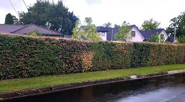
![Lilly Pilly Satinash [Acmena smithii] - $3.40,Syzygium smithii ...](KLPP_15062020_AGN_AT_files/image013.jpg)