Ku-ring-gai
Traffic Committee
TO
BE HELD ON Wednesday, 23 February 2022
AT 10.00AM
online via zoom communication
Agenda
** ** ** ** ** **
NOTE:
For Full Details, See Council’s Website –
www.kmc.nsw.gov.au
under the link to business papers
APOLOGIEs
DECLARATIONS OF INTEREST
GENERAL BUSINESS
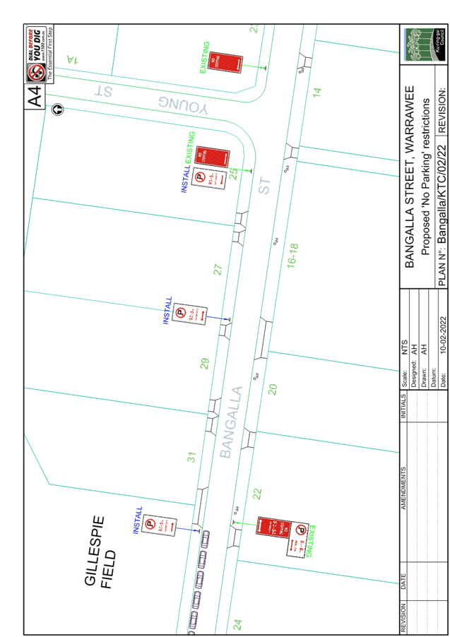
GB.1 Bangalla Street,
Warrawee
File: TDA155/21
Ward: Wahroonga
Electorate: Ku-ring-gai
To consider a proposal for
parking restrictions on the northern side of Bangalla Street in Warrawee, near
Knox Grammar School Gillespie Field.
Recommendation:
A. That
‘No Parking 9.30am to 5.30pm Sat’ restrictions installed in
Bangalla Street, Warrawee as shown in the attached Plan No. Bangalla/KTC/02/22.
B. That
Mr Lipscombe, of No.27 Bangalla Street, Warrawee and Council’s Team
Leader Regulations be informed of Council’s decision.
GB.2 Burns Road at Ellalong
Road, Turramurra
File: TM10/14
Ward: Wahroonga
Electorate: Ku-ring-gai
To consider proposed changes to
the intersection of Burns Road and Ellalong Road, Turramurra
Recommendation:
A. That
the proposed changes to the intersection of Burns Road at Elllalong Road be
implemented, as shown in the attached Plan, subject to receiving
approval of the TMP.
GB.3 Bannockburn Road,
Pymble
File: TM7/14
Ward: Wahroonga
Electorate: Ku-ring-gai
To consider the construction of a
raised pedestrian crossing on Bannockburn Road at its intersection with
Reservoir Road.
Recommendation:
That a raised wombat crossing be
constructed on Bannockburn Road, opposite the intersection with Reservoir Road,
subject to receiving funding from TfNSW.
General Discussion
** ** ** ** ** **
|
Ku-ring-gai
Traffic Committee - 23 February 2022
|
GB.1 / 4
|
|
|
|
|
Item
GB.1
|
TDA155/21TDA155/21
|
Bangalla Street, Warrawee
Ward: Wahroonga
Electorate: Ku-ring-gai
EXECUTIVE
SUMMARY
|
purpose of report:
|
To
consider a proposal for parking restrictions on the northern side of Bangalla
Street in Warrawee, near Knox Grammar School Gillespie Field.
|
|
|
|
|
background:
|
Council has received several requests from a resident
to introduce parking restrictions at the frontage of their property, to
assist with visibility and safety issues when existing their driveway.
|
|
|
|
|
comments:
|
Parking is restricted on the southern side of Bangalla
Street to allow two-way traffic flow to be maintained. Residents and
visitors are able to park unrestricted along the northern side where
Gillespie Fields is located.
|
|
|
|
|
recommendation:
|
That part-time
‘No Parking’ restrictions operative from 9.00am to 5.00pm
Saturday be introduced on the northern side of Bangalla Street from eastern
boundary of Gillespie Fields to Young Street.
|
Purpose of Report
To consider a proposal for parking restrictions on the
northern side of Bangalla Street in Warrawee, near Knox Grammar School
Gillespie Field.
Background
In August 2020, Council received a request from Mr Nocholas
Lipscombe, of No. 27 Bangalla Street for ‘No Parking’ restrictions
or a painted island at the frontage of his property to assist with visibility
and safety issues when exiting the property.
Currently, there are ‘No Parking’ restrictions
operative from 8.00am to 6.00pm Monday to Friday and ‘No Stopping’
restrictions operative from 9.30am to 5.30pm Saturday along the southern side
of Bangalla Street, between Warrawee Avenue and Young Street. Council
approved these restrictions in 2010 following suggestions from residents to
keep one side of the street clear of parked vehicles during the weekdays since
the street was not wide enough to accommodate parking on both sides.
Vehicles are not allowed to park or stop on the southern side of Bangalla
Street on Saturdays, and this arrangement is to discourage parents from
dropping off or picking up their children to/from the Gillespie Field.
Mr Lipscombe was advised that Council’s Traffic and
Transport Policy does not allow singposting individual driveways; however,
Council accepts for residents to mark driveway transverse lines to discourage
motorists from parking too close to their driveways. Furthermore, he was
advised that painted island is generally only installed where the distance
between driveways is insufficient to cater for a parking space, and vehicles
are found to be routinely parked which consequently blocks driveways.
To assist with this matter, Council arranged for the marking
of the driveway transverse lines at the driveways to Nos. 25 & 27 Bangalla
Street as part of a proposal for ‘No Stopping’ restrictions at the
intersection of Bangalla Street and Young Street, approved under TDA85/20.
In October 2021, Council received a further request from Mr
Lipscombe to reconsider ‘No Stopping’ restrictions at the frontage
of his property. Mr Lipscombe was informed of the parking restrictions
introduced on the southern side in 2010 and that it would be difficult to
justify the need to introduce further restrictions on the northern side of
Bangalla Street as it will result in the loss of available parking spaces for
residents and visitors of Gillespie Fields.
Council staff re-iterated that it is Council’s Policy
not to signpost individual driveways unless it is a driveway to a
multi-residential development comprising of at least four units and on a road
with traffic volumes of at least 2,000 vehicles per day. Mr Lipscombe then
requested for the parking restrictions on the southern side of Bangalla Street
be relocated to the northern side. He commented that households on the
‘high-side’ (southern) of Bangalla Street have much better
visibility to exit their premises. To gauge the views and comments from
the directly affected residents, Council consulted with them on the proposed
relocation of the parking restrictions from the southern side to northern side.
In response, Council received
strong objections from residents, parents and Knox Grammar School with valid
reasons. Many raised concerns with the increased number of pedestrians,
particularly young students, having to cross the road. The proposal was
also raised on a social networking service for neighbourhoods to advise all
residents in the area that ‘the proposal has progressed without
community consultation’ and encouraged parents of Knox Grammar School
students to object to the proposal.
Residents’ objections
and comments were taken into account, and, since there were no traffic
committee meetings held at the end of 2021 due to Council elections, this
matter was postponed to be considered in early 2022 when Council resolves the
new Chairperson for Traffic Committee.
Comments
Council staff inspected the area on several occasions and
noted that no vehicles parked at the frontage of No. 27 Bangalla Street during
weekdays. To address Mr Lipscombe’s concern, kerbside parking
restrictions could be considered only during Saturdays when Knox Grammar School
sporting events occur at the Gillespie Field and the demand for on-street
parking increases.
Council has now reviewed the proposal and is proposing to
introduce ‘No Parking’ restrictions operative from 9.30am to 5.00pm
Saturdays along the northern side of Bangalla Street, between the eastern
boundary of Gillespie Fields to Young Street. The proposed restrictions
would be in operation as a ‘Kiss & Drop’ area for visitors of
Gillespie Fields on Saturdays and provide clear visibility to approaching
vehicles to allow the residents to safely exit their properties.
Council will not be proceeding with any proposed relocation
of existing parking restrictions in Bangalla Street, Warrawee.
Community
Consultation
Council is currently consulting with the four directly
affected residents from No.25 – 31 Bangalla Street on the proposal with
responses due by 22 February 2022. Responses from the affected residents
will be tabled at the Traffic Committee meeting for discussion.
Summary
Knox Grammar School sporting events held at Gillespie Field
on Saturdays attract an increased volume of traffic and demand for on-street
parking on Bangalla Street. To assist with visibility and safety issues
when exiting the premises along the northern side of Bangalla Street, Council
is proposing to install ‘No Parking’ restrictions operative from
9.30am to 5.30pm on Saturdays.
Recommendation:
A. That ‘No Parking 9.30am to 5.30pm Sat’
restrictions installed in Bangalla Street, Warrawee as shown in the attached
Plan No. Bangalla/KTC/02/22.
B. That Mr Lipscombe, of No.27 Bangalla Street, Warrawee and
Council’s Team Leader Regulations be informed of Council’s
decision.
|
Andy Huynh
Assistant Traffic
Engineer
|
Deva Thevaraja
Manager Traffic &
Transport
|
|
Attachments:
|
A1 ⇩ ⇩
|
Bangalla
Street Warrawee - KTC 02 22 - Plan
|
|
2022/036240
|
|
APPENDIX No: 1 - Bangalla
Street Warrawee - KTC 02 22 - Plan
|
|
Item No: GB.1
|
|
Ku-ring-gai
Traffic Committee - 23 February 2022
|
GB.2 / 8
|
|
|
|
|
Item
GB.2
|
TM10/14
|
Burns Road at Ellalong Road, Turramurra
Ward: Wahroonga
Electorate: Ku-ring-gai
EXECUTIVE
SUMMARY
|
purpose of report:
|
To consider proposed changes to
the intersection of Burns Road and Ellalong Road, Turramurra
|
|
|
|
|
background:
|
Council has received funding under the Federal
Government’s Blackspot and NSW Safer Roads Program, to construct a
protected right turn bay on Burns Road (into Ellalong Road) and lay skid
resistant pavement to address the crash history at the site and improve
overall safety.
|
|
|
|
|
comments:
|
Under the proposed changes, right turns into and out
of Bedford Avenue at Burns Road will be prevented. Council has
consulted with over 200 residents in the area, with the majority in support
of the proposal.
|
|
|
|
|
recommendation:
|
That the proposed changes to the intersection of Burns
Road at Elllalong Road be implemented subject to receiving approval of the
TMP.
|
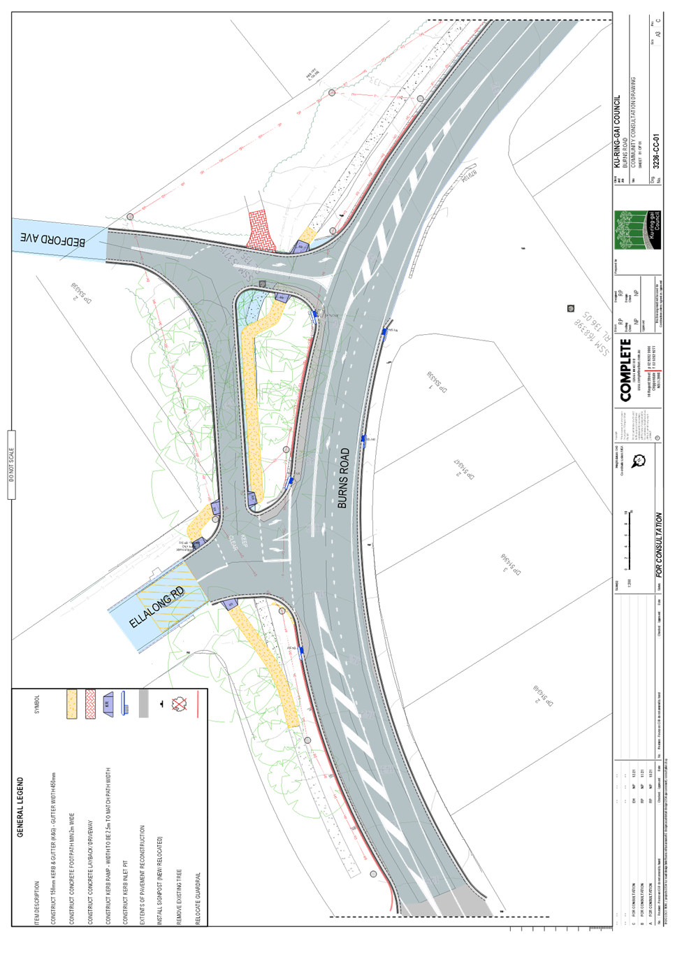
Purpose of Report
To consider proposed changes to the intersection of Burns
Road and Ellalong Road, Turramurra
Background
Council was successful in its grant funding application in
the 2020 / 2021 Australian Government Black Spot and NSW Safer Roads Program to
construct a protected right turn bay on Burns Road (into Ellalong Road) and lay
skid resistant pavement. The proposed works are considered necessary to
address the crash history at the site and improve overall safety.
The intersection of Burns Road with Ellalong Road and
Bedford Avenue is an identified site with high priority for treatment in Ku-ring-gai
Council’s 10 Year Traffic and Transport Plan. There have been numerous
collisions at the intersection of Burns Road and Ellalong Road, with several of
these occurring in wet weather.
The crash data for the 5 year period to the end of June 2021
shows that there have been 9 recorded crashes at /near this site, with 5
crashes resulting in injuries. Primary causes of the injury crashes were
from head-on crashes, rear-end and run-off-road crashes, the majority of which
occurred in wet conditions.
As part of the safety upgrade of the intersection of Burns
Road and Ellalong Road/Bedford Avenue, right turns would be prevented into and
out of Bedford Avenue at Burns Road. The length of right turn bay at
Ellalong Road would require the banning of right turn movements between Burns
Road and Bedford Avenue for safety reasons. Right turn movements at this
location would be transferred to the Ellalong Road intersection.
In October 2021, Council consulted with residents in the
area regarding the proposed changes to the intersection. With the initial
consultation, it had been proposed that left turns from Ellalong Road to Burns
Road be prevented. Under this proposal, motorists would need to turn left
into the slip road, then turn right onto Bedford Avenue before turning left
onto Burns Road.
Of the 62 respondents, 34 (55%) supported the proposed
changes. Many of those who objected to the proposal raised concerns about
not being able to turn left from Ellalong Road onto Burns Road. There was
also a petition from residents of North Turramurra from outside the survey area
who objected to the ban on left turns from Ellalong Road onto Burns Road.
Comments
After reviewing the responses from the initial consultation,
the design was amended with the following changes;
· Left turns
permitted from Ellalong Road onto Burns Road
· Left turns
permitted from Burns Road onto Ellalong Road
· Shared
bike/pedestrian path to cross the service road at Ellalong Road and proceed
along the southern side of the service road
The proposed works are shown on the attached
Plan. The amendments would resolve the issues raised regarding turning
left onto Burns Road.
The proposed changes will
have the following impacts on access to/from Bedford Avenue:
· For
south-west bound vehicles in Bedford Avenue wishing to turn right on to Burns
Road, these vehicles would need to proceed north-westerly along the service
road parallel to Burns Road, to join the southern end of Ellalong Road in order
to be able to turn right on to Burns Road; and
· For northbound
vehicles on Burns Road wishing to turn right into Bedford Avenue, these
vehicles would need to proceed to the intersection with Ellalong Road and turn
right, then turn right again into the service road parallel to Burns Road, to
join Bedford Avenue.
In December 2021, Council again consulted with residents in
the area regarding the amended Plan. Of the 45 respondents, 34 supported
the proposed works, while 11 objected to them.
Of those 11 who objected to the proposed works, 6
respondents wanted right turns from Ellalong Road onto Burns Road to be
prevented. Intersection counts undertaken in June 2021 showed that in the
4-hour period between 6am and 10am on a weekday, only 2 vehicles turned right
from Ellalong Road onto Burns Road. Between 3pm and 7pm on a weekday, only 3
vehicles turned right from Ellalong Road onto Burns Road.
Therefore, right turns could be prevented from Ellalong Road
onto Burns Road with minimal impact. Council will monitor traffic
conditions after the proposed works have been completed, to determine whether
the right turn ban should be implemented at some stage in the future.
The skid resistant road pavement will improve safety for
through traffic travelling along Burns Road, by reducing the likelihood of run
off road accidents at the bend. The right turn bay will provide improved
safety for motorists turning into Ellalong Road. It will also provide
some separation between eastbound and westbound traffic on Burns Road at the
bend, thereby reducing the probability of head-on collisions occurring.
A Traffic Management Plan (TMP) has been forwarded to TfNSW
for its approval.
Financial
Considerations
This project has been fully funded under the Federal
Government’s Blackspot and NSW Safer Roads Program. The works must
be completed before 30 June 2022.
Community
Consultation
Council has consulted with over 200 households in the
vicinity of the intersection. Of the 45 respondents, 34 supported the
proposed changes, while 11 objected to them. Council has also consulted
with Transdev regarding the proposal, and they have no objections to the
proposed intersection configuration.
Summary
The amended proposal addresses the main issues raised by
residents in the initial consultation. Under the amended proposal,
vehicles will be able to turn left onto Burns Road from Ellalong Road. It
would not be possible to permit right turns into and out of Bedford Avenue at
Burns Road, due to its close proximity to the intersection with Ellalong Road
and the proposed right turn bay.
Recommendation:
A. That
the proposed changes to the intersection of Burns Road at Elllalong Road be
implemented, as shown in the attached Plan, subject to receiving
approval of the TMP.
|
Michael Foskett
Team Leader Traffic
|
Deva Thevaraja
Manager Traffic & Transport
|
|
Attachments:
|
A1⇩
|
Burn
Road Turramurra - Plan of Proposed Works
|
|
2021/386831
|
|
APPENDIX No: 1 - Burn
Road Turramurra - Plan of Proposed Works
|
|
Item No: GB.2
|
|
Ku-ring-gai
Traffic Committee - 23 February 2022
|
GB.3 / 12
|
|
|
|
|
Item
GB.3
|
TM7/14
|
Ward: Wahroonga
Electorate: Ku-ring-gai
EXECUTIVE
SUMMARY
Purpose of Report
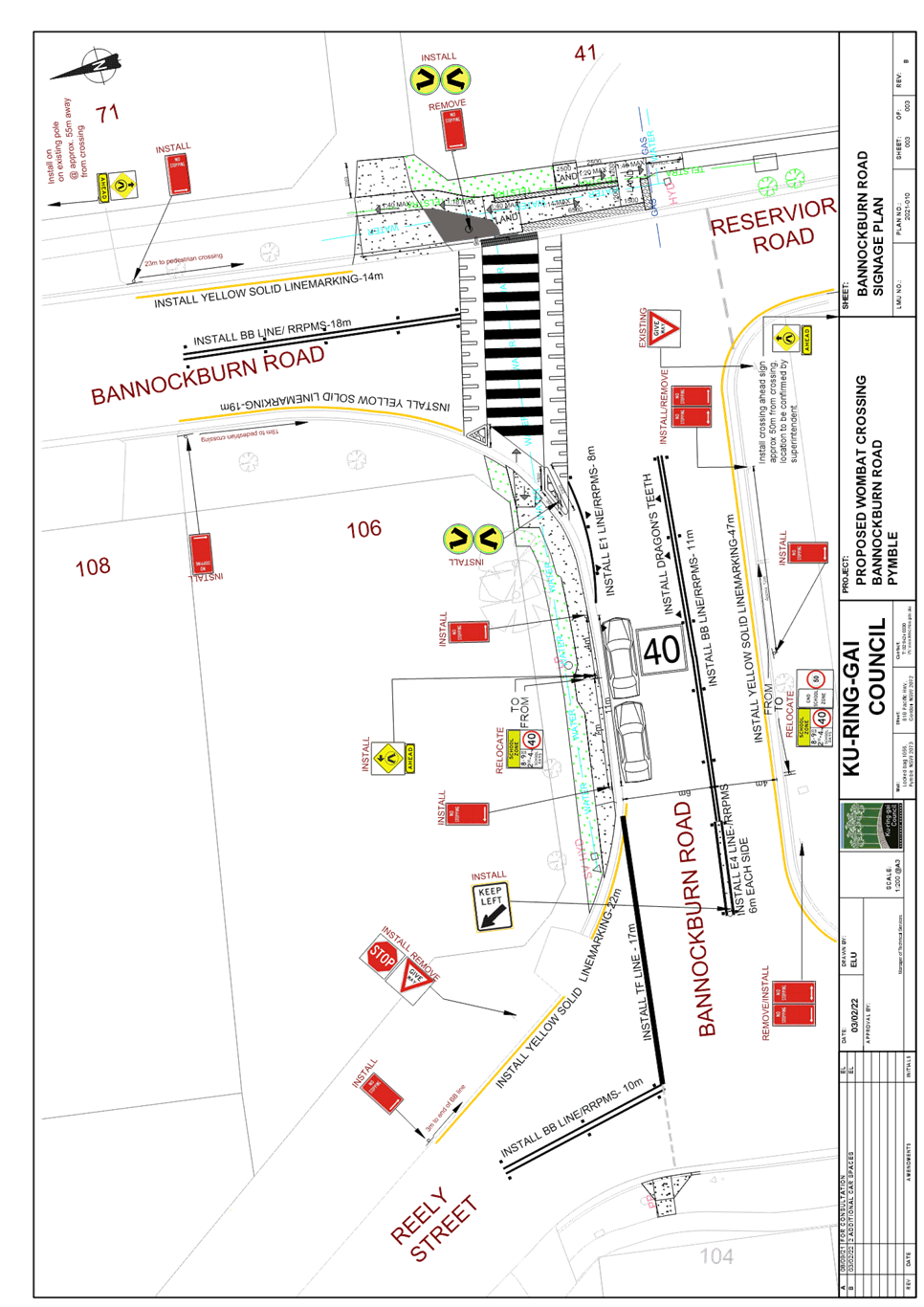
To consider the construction of a raised pedestrian crossing
on Bannockburn Road at its intersection with Reservoir Road.
Background
Council has received numerous requests from a local resident
for improved pedestrian facilities on Bannockburn Road, to the north of Pymble
Public School. Bannockburn Road runs mainly north-south. However
there is a dog-leg section between Reely Street and Reservoir Road where it
runs east-west. Many parents park in or near this section of Bannockburn
Road to pick-up or drop-off children at Pymble Public School.
The resident has raised concerns that pedestrians are
crossing at several locations in this section of roadway, and would like to see
pedestrian crossings installed and parking removed.
In 2018 Council replaced ‘No Parking’
restrictions with ‘No Stopping’ on the eastern side of the
intersection of Bannockburn Road and Reservoir Road, under TDA109/18.
This area has heavy pedestrian and vehicular traffic at drop-off/pick-up times,
and a steep slope from the footpath down to kerb level. These factors
made this area unsuitable for student drop-off/pick-up.
Council staff investigated the feasibility of providing a
pedestrian crossing in this section of Bannockburn Road in 2021.
Pedestrian/volume counts were carried out on Bannockburn Road during the school
morning and afternoon peak periods in the section of Bannockburn Road to the
north of the school. This was to determine whether the site met the
reduced warrant for sites predominantly used by children and by aged or
impaired pedestrians.
Below is the reduced warrant for sites used predominantly by
children and by aged or impaired pedestrians;
If the crossing is used predominantly by school children,
is not a suitable site for a Children’s Crossing and in two counts of one
hour duration immediately before and after school hours:
(a) P
greater than or equal to 30
AND
(b)
V greater than or equal to 200
A pedestrian (Zebra) Crossing
may be installed.
The table below summarises the results of the counts for
both the morning and afternoon peak times;
|
Time
|
Pedestrians
|
Vehicles
|
|
8.15-9.15am
|
88
|
251
|
|
2.30-3.30pm
|
121
|
251
|
The counts show that the site meets the reduced TfNSW
warrant for sites used predominantly by children.
At the time Council staff were unable to find a suitable
location for a crossing, due to various site constraints and visibility
issues. The matter was considered by the Ku-ring-gai Traffic Committee as
a late item at its Meeting on 21 July 2021, where it was recommended;
That Council continue to investigate student connectivity
and liaise with Transport for NSW for concurrence and report back to the next
Ku-ring-gai Traffic Committee Meeting.
Comments
Council staff carried out further investigations, finding it
would be possible to construct a pedestrian crossing on Bannockburn Road,
opposite Reservoir Road. This was the only location which provided
approaching motorists with adequate visibility to pedestrians crossing the
road. A plan showing the proposed raised (wombat) crossing is attached.
This location had previously not been considered due to the
steep embankment along the western side of the road. However, a survey of
the site has shown that it would be possible to construct a new section of footpath
to ramp up to the existing footpath. This would require the removal of
one tree outside #41 Crown Street. It should be noted that this tree lies
under power lines, and it requires regular pruning.
It is also proposed that a new section of footpath be
constructed along the northern side of Bannockburn Road, to connect up to the
intersection with Reely Street. Parking between Reely Street and
Reservoir Road would be prevented along the southern side, but two kerbside
parking spaces would be retained on the northern side of the roadway.
Financial
Considerations
Council has applied for funding for this project under the
revised Federal Government Stimulus Funding Program. TfNSW invited
Council to nominate projects under this Program for funding during FY21/22, but
Council has not yet heard any funding offer from the Authority.
Environmental
Considerations
The project would necessitate the removal of one tree
outside the Bannockburn Road frontage of 41 Crown Street. However the
tree is located under power lines, and requires regular pruning.
Community
Consultation
Council has consulted with affected residents regarding the
proposal. The resident at #41 Crown Street has objected to the
proposal. He is concerned about the loss of the tree affecting his
privacy. He also believes that the footpath ramp will be inconvenient for
access to his property, and it will create problems for mail delivery.
The resident is in favour of some of the parking restrictions, and also the
footpath along the northern side of Bannockburn Road. However, they
oppose the wombat crossing being constructed. The resident has e-mailed
Council with a list of alternate measures.
The resident at 71 Bannockburn Road also objected to the
proposal, as it would result in the loss of most of the on-street parking in
front of their property. While not directly affected by the proposed
wombat crossing, the resident of 114 Bannockburn Road objected to it.
This was on the grounds of loss of amenity to the owners of 41 Crown Street, as
well as being a waste of ratepayers money. The comments received from residents
will be circulated to members prior to the Traffic Committee Meeting.
Council has also consulted with Pymble Primary School,
however the school has not responded to Council. Pymble Public School
P&C has indicated that some of its members will make submissions regarding
the proposal before Friday 18 February. Response from the School’s
P&C will be tabled at the Traffic Committee meeting.
Summary
After carrying out extensive site investigations, it was
found that the only possible location for a pedestrian crossing in this area
would be on Bannockburn Road, opposite the intersection with Reservoir
Road. This is the only location where approaching motorists would have
adequate visibility to pedestrians crossing the road.
Consultation with affected residents showed that there were
3 respondents, all of whom objected to the proposed wombat crossing.
However, for safety reasons it is considered necessary to provide a raised
wombat crossing at this location. The benefits of providing a wombat crossing
would far outweigh any possible detrimental impacts.
Recommendation:
That a raised wombat crossing be constructed on Bannockburn
Road, opposite the intersection with Reservoir Road, subject to receiving
funding from TfNSW.
|
Michael Foskett
Team Leader Traffic
|
Deva Thevaraja
Manager Traffic & Transport
|
|
Attachments:
|
A1⇩
|
Bannockburn
Road Pymble - Plan of Proposed Wombat Crossing
|
|
2022/039550
|
|
APPENDIX No: 1 - Bannockburn
Road Pymble - Plan of Proposed Wombat Crossing
|
|
Item No: GB.3
|