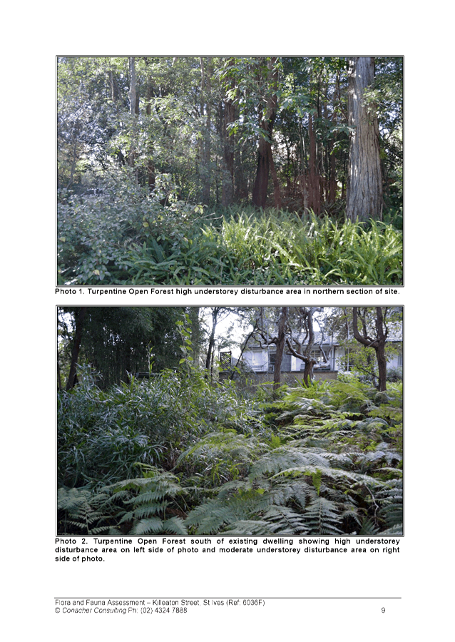
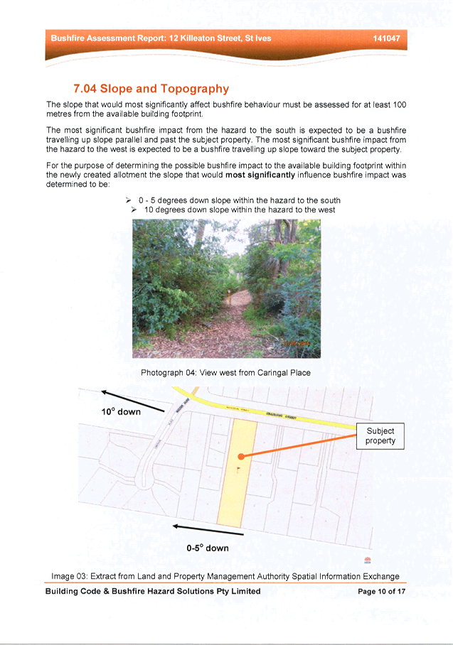
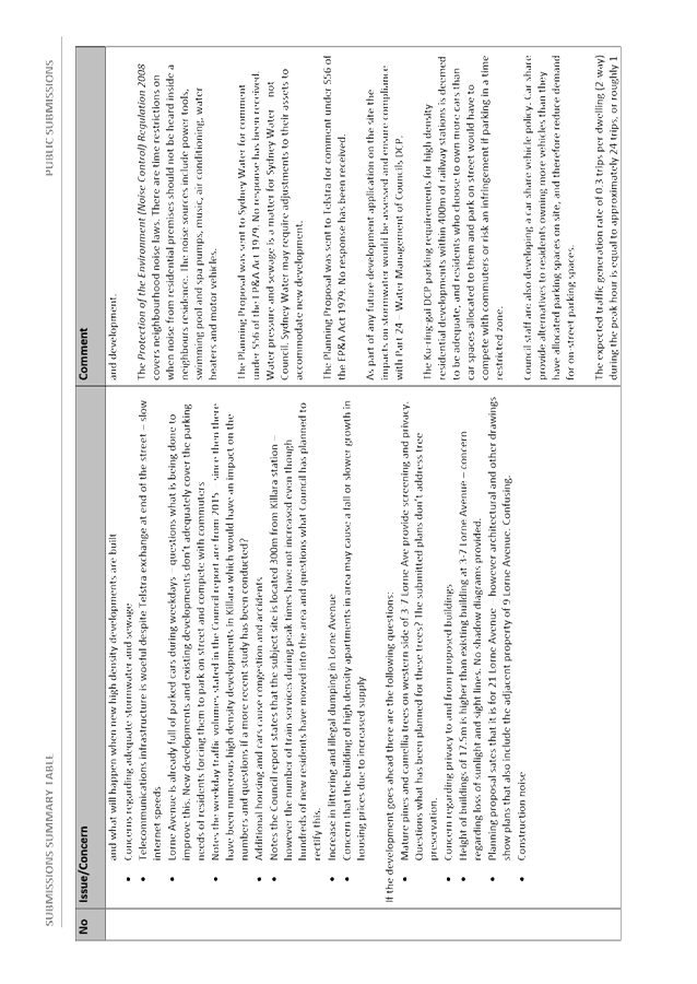
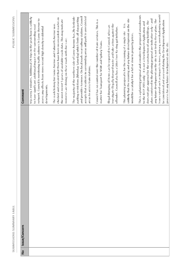
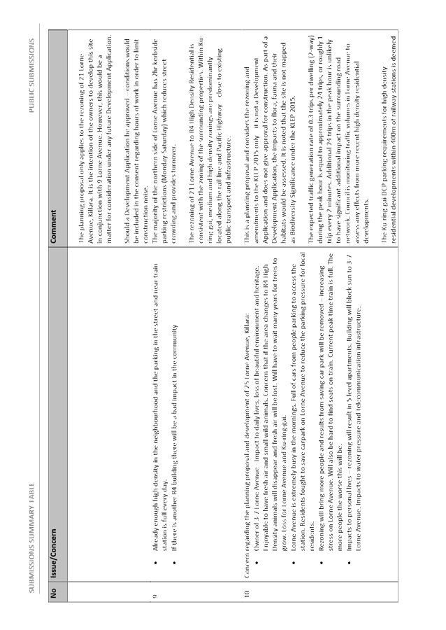
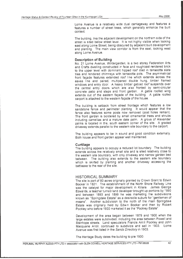
|
Resolved:
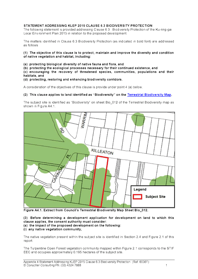
(Moved: Councillors McDonald/Fornari-Orsmond)
A. THAT Council, as the consent authority,
is of the opinion that the variation request submitted under Clause 4.6 of
Ku-ring-gai LEP (Local Centres) 2012 to vary the minimum street frontage
development standard has met the requirements of clause 4.6(4) of the
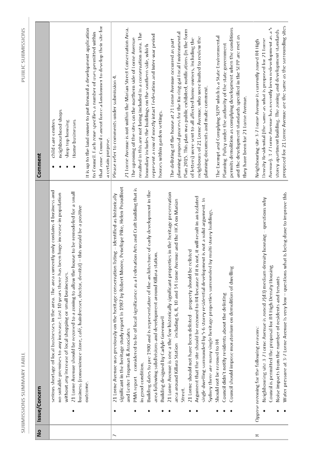
Ku-ring-gai LEP (Local Centres) 2012. Council is also of the opinion that
strict compliance with the development standard is unreasonable and
unnecessary in the circumstances of the case and that there are sufficient
environmental planning grounds to justify the variation to the development
standard.
AND
B. THAT
Council, as the consent authority, grant
development consent to DA0019/16 for the demolition of three
dwellings, construction of a multi dwelling development comprising 27
townhouses, including basement parking, landscaping and the consolidation of
three lots into one on land at 9-15 Cherry Street, Warrawee, subject to
conditions. Pursuant to Section 95(2) of the Environmental Planning and
Assessment Act 1979, this consent lapses if the approved works are not
physically commenced within two years of the date of the Notice of
Determination.
The conditions of consent are
as follows:
Conditions
that identify approved plans:
1. Approved
architectural plans and documentation (new development)
The development must be
carried out in accordance with the following plans and documentation listed
below and endorsed with Council’s stamp, except where amended by other
conditions of this consent:
|
Plan no.
|
Drawn by
|
Dated
|
|
DA02
Location Plan
|
Connor
and Solomon Architects
|
12/2015
|
|
DA03
Roof Plan
|
Connor
and Solomon Architects
|
30/03/2017
|
|
DA04
Basement Plan
|
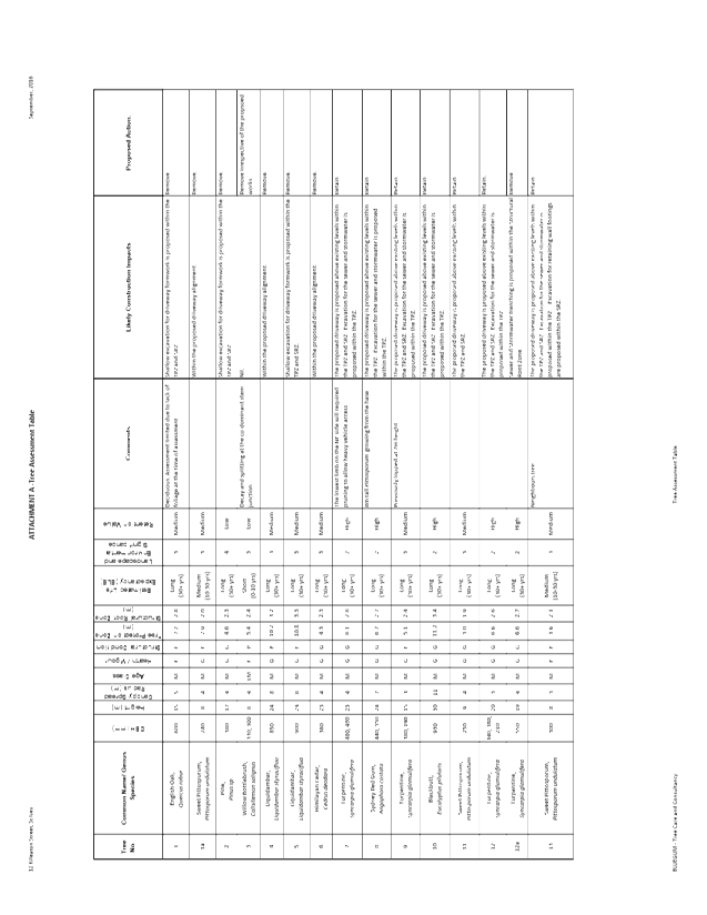
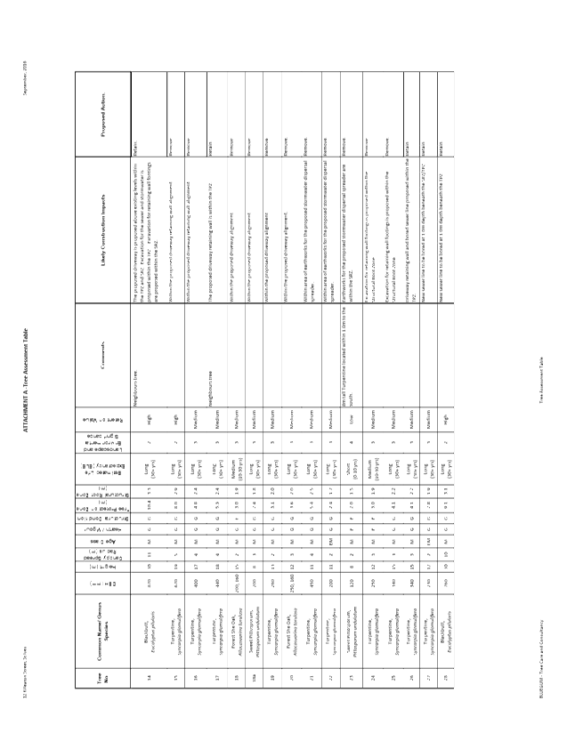
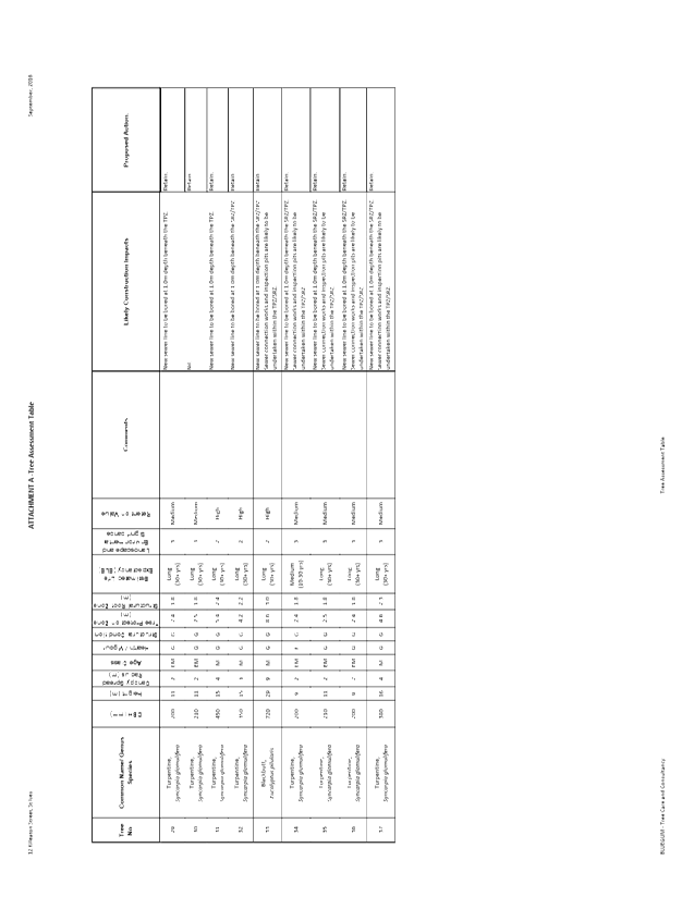
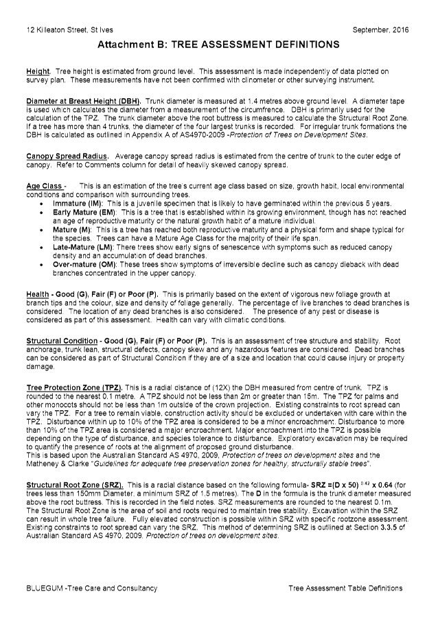
Connor
and Solomon Architects
|
30/03/2017
|
|
DA05
Ground Floor Plan
|
Connor
and Solomon Architects
|
30/03/2017
|
|
DA06
First Floor Plan
|
Connor
and Solomon Architects
|
30/03/2017
|
|
DA07
Second Floor Plan
|
Connor
and Solomon Architects
|
30/03/2017
|
|
DA08
South Elevation
|
Connor
and Solomon Architects
|
24/02/2017
|
|
DA09
North Elevation
|
Connor
and Solomon Architects
|
24/02/2017
|
|
DA10
East Elevation
|
Connor
and Solomon Architects
|
24/02/2017
|
|
DA11
West Elevation
|
Connor
and Solomon Architects
|
24/02/2017
|
|
DA12
Section A
|
Connor
and Solomon Architects
|
24/02/2017
|
|
DA13
Section B
|
Connor
and Solomon Architects
|
24/02/2017
|
|
DA14
Section C
|
Connor
and Solomon Architects
|
24/02/2017
|
|
DA15
Section D
|
Connor
and Solomon Architects
|
24/02/2017
|
|
DA22 Environmental Site
Management Plan
|
Connor
and Solomon Architects
|
24/02/2017
|
|
DA30 Adaptable housing
pre/post layout
|
Connor
and Solomon Architects
|
30/03/2017
|
|
L01/F Landscape Plan 01
|
Habitat
8
|
24/02/17
|
|
L02/F Landscape Plan 02
|
Habitat 8
|
24/02/17
|
|
L03/F Landscape Plan 03
|
Habitat 8
|
24/02/17
|
|
L04/F Landscape Plan 04
|
Habitat 8
|
24/02/17
|
|
L05/F Landscape Plan 05
|
Habitat 8
|
24/02/17
|
|
L06/F Landscape Plan 06
|
Habitat 8
|
24/02/17
|
|
H01/P2 Cover Sheet
|
AJ Whipps Consulting Group
|
15/11/2016
|
|
H02/P2 Concept sediment and
erosion plan
|
AJ Whipps Consulting Group
|
15/11/2016
|
|
H03/P2 Sediment and erosion
control details
|
AJ Whipps Consulting Group
|
15/11/2016
|
|
H04/P5 Concept stormwater
management ground
|
AJ Whipps Consulting Group
|
29/11/2016
|
|
H05/P2 Concept Stormwater
management basement
|
AJ Whipps Consulting Group
|
15/11/2016
|
|
H06/P3 Details sheet
|
AJ Whipps Consulting Group
|
15/11/2016
|
|
Document(s)
|
Dated
|
|
DA26 Sample board by Connor and Solomon Architects
|
December
2016
|
|
Basix
certificate No. 690715M_04
|
2 March
2017
|
|
Arborist
assessment, prepared by Elke Landscape Architect
|
20 February
2017
|
|
Arboricultural
Assessment prepared by Angophora Consulting Arborist
|
29 July
2016
|
|
Noise
Acoustic report by Acoustica
|
July 2016
|
|
Amended DA
Accessibility Letter by Morris Goding Accessibility Consulting
|
5 April
2017
|
|
Access
Review by Morris Goding Accessibility Consulting (Version 3)
|
24 February
2017
|
Reason: To
ensure that the development is in accordance with the determination.
Conditions
to be satisfied prior to demolition, excavation or construction:
2. Asbestos works
All
work involving asbestos products and materials, including
asbestos-cement-sheeting (ie. Fibro), must be carried out in accordance with
the guidelines for asbestos work published by WorkCover Authority of NSW.
Reason:
To ensure public safety
3. Notice
of commencement
At least 48 hours prior to the
commencement of any development (including demolition, excavation, shoring or
underpinning works), a notice of commencement of building or subdivision work
form and appointment of the principal certifying authority form shall be
submitted to Council.
Reason: Statutory
requirement.
4. Notification of builder’s
details
Prior to the commencement of any development or
excavation works, the Principal Certifying Authority shall be notified in
writing of the name and contractor licence number of the owner/builder
intending to carry out the approved works.
Reason: Statutory
requirement.
5. Dilapidation
survey and report (public infrastructure)
Prior to the
commencement of any development or excavation works on site, the Principal
Certifying Authority shall be satisfied that a dilapidation report on the
visible and structural condition of all structures of the following public
infrastructure, has been completed and submitted to Council:
Public
infrastructure
· Full
road pavement width, including kerb and gutter, of Cherry Street over the site
frontage.
· All
driveway crossings and laybacks opposite the subject site.
The report must be completed
by a consulting structural/civil engineer. Particular attention must be paid
to accurately recording (both written and photographic) existing damaged
areas on the aforementioned infrastructure so that Council is fully informed
when assessing any damage to public infrastructure caused as a result of the
development.
The developer may be held
liable to any recent damage to public infrastructure in the vicinity of the
site, where such damage is not accurately recorded by the requirements of
this condition prior to the commencement of works.
Note: A written
acknowledgment from Council must be obtained (attesting to this condition
being appropriately satisfied) and submitted to the Principal Certifying
Authority prior to the commencement of any excavation works.
Reason: To
record the structural condition of public infrastructure before works
commence.
6. Archival
recording of buildings
Prior to the commencement
of any development or excavation works on site, the Principal Certifying
Authority shall be satisfied that an archival report has been submitted to
Council’s Heritage Advisor.
The report must consist of an
archival standard photographic record of the building (internally and
externally), its garden and views of it from the street illustrating its
relationship to neighbouring properties and the streetscape. Recording shall
be undertaken in accordance with the guidelines for “Photographic
Recording of Heritage Items Using Film or Digital Capture (2006)”
prepared by the New South Wales Heritage Office.
Information
shall be bound in an A4 report format. It shall include copies of
photographs, referenced to plans of the site. Two (2) copies (one (1)
copy to include negatives or CD of images shall be submitted to Council's
Heritage Advisor. The recording document will be held in the local
studies collection of Ku-ring-gai Library, the local historical society and
Council’s files.
Note: A written acknowledgment
from Council must be obtained (attesting to this condition being
appropriately satisfied) and submitted to the Principal Certifying Authority
prior to the commencement of any works.
Reason: To
ensure the proper management of historical artefacts and to ensure their
preservation.
7. Dilapidation survey and report
(private property)
Prior to the
commencement of any demolition or excavation works on site, the Principal
Certifying Authority shall be satisfied that a dilapidation report on the visible
and structural condition of all structures upon the following lands, has been
completed and submitted to Council:
|
Address:
|
|
· 9
Lowther Park Ave (swimming pool only)
|
|
· 7
Cherry Street (unless under construction)
|
The
dilapidation report must include a photographic survey of adjoining
properties detailing their physical condition, both internally and
externally, including such items as walls ceilings, roof and structural
members. The report must be completed by a consulting structural/geotechnical
engineer as determined necessary by that professional based on the
excavations for the proposal and the recommendations of the submitted
geotechnical report.
In the event that access for
undertaking the dilapidation survey is denied by a property owner, the
applicant must demonstrate in writing to the satisfaction of the Principal
Certifying Authority that all reasonable steps have been taken to obtain
access and advise the affected property owner of the reason for the survey
and that these steps have failed.
Note: A
copy of the dilapidation report is to be provided to Council prior to any
excavation works been undertaken. The dilapidation report is for record
keeping purposes only and may be used by an applicant or affected property
owner to assist in any civil action required to resolve any dispute over
damage to adjoining properties arising from works.
Reason: To
record the structural condition of likely affected properties before works
commence.
8. Construction
and traffic management plan
The applicant must submit to
Council a Construction Traffic Management Plan (TMP), which is to be approved
prior to the commencement of any works on site.
The plan is to consist of a
report with Traffic Control Plans attached.
The report is to contain commitments
which must be followed by the demolition and excavation contractor, builder,
owner and subcontractors. The TMP applies to all persons associated
with demolition, excavation and construction of the development.
The report is to contain
construction vehicle routes for approach and departure to and from all
directions.
The report is to contain a
site plan showing entry and exit points. Swept paths are to be shown on
the site plan showing access and egress for a 12.5 metre long heavy rigid
vehicle and if required for demolition and excavation stages a 19.0 metre
long articulated vehicle are to be shown.
The Traffic Control Plans are
to be prepared by a qualified person (red card holder). One must be
provided for each of the following stages of the works:
· demolition
· excavation
· concrete
pour
· construction
of vehicular crossing and reinstatement of footpath
· traffic
control for vehicles reversing into or out of the site
· pedestrian
safety measures to be shown.
Traffic controllers must be in
place at the site entry and exit points to control heavy vehicle movements in
order to maintain the safety of pedestrians and other road users.
When a satisfactory TMP is
received, a letter of approval will be issued with conditions attached.
Traffic management at the site must comply with the approved TMP as well as
any conditions in the letter issued by Council. Council’s Rangers
will be patrolling the site regularly and fines will be issued for any
non-compliance with this condition.
Reason: To ensure that
appropriate measures have been considered during all phases of the
construction process in a manner that maintains the environmental amenity and
ensures the ongoing safety and protection of people.
9. Work
zone
A works zone shall be provided
along the site frontage to the dead end of Cherry Street. The applicant must
make a written application to the Ku-ring-gai Local Traffic Committee to
install the work zone. Work zones are provided specifically for the set down
and pick up of materials and not for the parking of private vehicles
associated with the site. Work zones will generally not be approved where
there is sufficient space on-site for the setting down and picking up of
goods being taken to or from a construction site.
If the work zone is approved
by the Local Traffic Committee, the applicant must obtain a written copy of
the related resolution from the Ku-ring-gai Local Traffic Committee and
submit this to the Principal Certifying Authority prior to commencement of
any works on site.
Where approval of the work
zone is resolved by the Committee, the necessary work zone signage shall be
installed (at the cost of the applicant) and the adopted fee paid prior to
commencement of any works on site. At the expiration of the work zone
approval, the applicant is required to remove the work zone signs and
reinstate any previous signs at their expense.
In the event the work zone is
required for a period beyond that initially approved by the Traffic
Committee, the applicant shall make a payment to Council for the extended
period in accordance with Council’s schedule of fees and charges for
work zones prior to the extended period commencing.
Reason: To
ensure that appropriate measures have been made for the operation of the site
during the construction phase.
10. Sediment
controls
Prior to any
work commencing on site, sediment and erosion control measures shall be
installed along the contour immediately downslope of any future disturbed
areas.
The form of
the sediment controls to be installed on the site shall be determined by
reference to the Landcom manual ‘Managing Urban Stormwater: Soils and
Construction’. The erosion controls shall be maintained in an
operational condition until the development activities have been completed
and the site fully stabilised. Sediment shall be removed from the sediment
controls following each heavy or prolonged rainfall period.
Reason: To
preserve and enhance the natural environment.
11. Tree
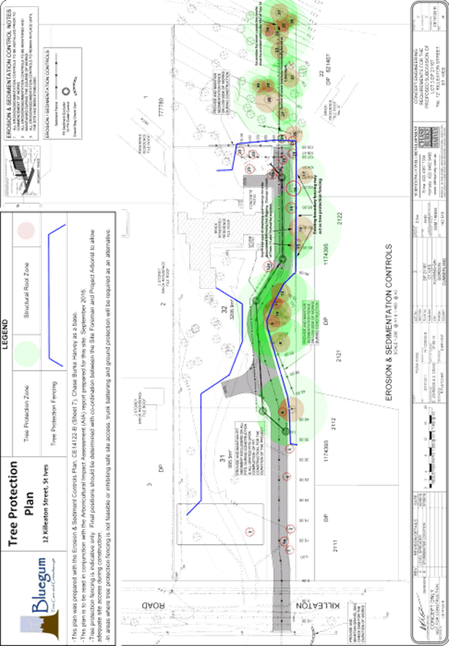
protection fencing
To
preserve the existing tree/s that are to be retained, no work shall commence
until the area beneath their canopy is fenced off as shown on the following
plan as amended by condition, to prevent any activities, storage or the
disposal of materials within the fenced area. The fence/s shall be
maintained intact until the completion of all demolition/building work on
site.
|
Plan
no.
|
Title
|
Drawn
by
|
Dated
|
|
DA22
|
Environmental
Site Management Plan
|
Connor
Solomon Architects
|
24/02/17
|
The
tree protection fencing shall be constructed of galvanised pipe at 2.4 metre
spacings and connected by securely attached chain mesh fencing to a minimum
height of 1.8 metres in height prior to work commencing.
Reason : To protect existing trees during
construction phase.
12. Tree
protection signage
Prior to works commencing, tree protection signage is to
be attached to each tree protection zone, displayed in a prominent position
and the sign repeated at 10 metres intervals or closer where the fence
changes direction. Each sign shall contain in a clearly legible form,
the following information:
Tree protection zone.
i) This fence has been installed to prevent
damage to the trees and their growing environment both above and below ground
and access is restricted.
ii) Any encroachment not previously approved within the tree
protection zone shall be the subject of an arborist's report.
iii) The arborist's report shall provide proof that no other
alternative is available.
iv) The Arborist's report shall be submitted to the Principal
Certifying Authority for further consultation with Council.
v) The name, address, and telephone number of the developer.
Reason: To
protect existing trees during the construction phase.
13. Tree
fencing inspection
Upon
installation of the required tree protection measures, an inspection of the
site by the Principal Certifying Authority is required to verify that tree
protection measures comply with all relevant conditions.
Reason: To
protect existing trees during the construction phase.
14. Construction waste management plan
Prior to the
commencement of any works, the Principal Certifying Authority shall be
satisfied that a waste management plan, prepared by a suitably qualified
person, has been prepared in accordance with Part 23 of the Ku-ring-gai
Development Control Plan (Local Centres) 2016 (DCP).
The plan
shall address all issues identified in the DCP, including but not limited to:
the estimated volume of waste and method for disposal for the construction
and operation phases of the development.
Note: The
plan shall be provided to the Certifying Authority.
Reason: To
ensure appropriate management of construction waste.
15. Noise and
vibration management plan
Prior to the commencement of
any works, a noise and vibration management plan is to be prepared by a
suitably qualified expert addressing the likely noise and vibration from
demolition, excavation and construction of the proposed development and
provided to the Principal Certifying Authority.
The management plan is to identify amelioration measures to achieve the best
practice objectives of AS 2436-2010 and NSW Department of Environment and
Climate Change Interim Construction Noise Guidelines. The report shall be
prepared in consultation with any geotechnical report that itemises equipment
to be used for excavation works.
The management plan shall
address, but not be limited to, the following matters:
· identification
of the specific activities that will be carried out and associated noise
sources
· identification
of all potentially affected sensitive receivers, including residences,
churches, commercial premises, schools and properties containing noise
sensitive equipment
· the
construction noise objective specified in the conditions of this consent
· the
construction vibration criteria specified in the conditions of this consent
· determination
of appropriate noise and vibration objectives for each identified sensitive
receiver
· noise and
vibration monitoring, reporting and response procedures
· assessment
of potential noise and vibration from the proposed demolition, excavation and
construction activities, including noise from construction vehicles and any
traffic diversions
· description
of specific mitigation treatments, management methods and procedures that
will be implemented to control noise and vibration during construction
· construction
timetabling to minimise noise impacts including time and duration
restrictions, respite periods and frequency
· procedures
for notifying residents of construction activities that are likely to affect
their amenity through noise and vibration
· contingency
plans to be implemented in the event of non-compliances and/or noise
complaints
Reason: To
protect the amenity afforded to surrounding residents during the construction
process.
Conditions
to be satisfied prior to the issue of the construction certificate:
16. Amended
architectural plans
Prior to the issue of the
Construction Certificate, the Principal Certifying Authority shall be
satisfied that the approved plans listed in Condition 1 above and endorsed
with Council’s stamp, have been amended in accordance with the
requirements of this condition as well as other conditions of this consent:
1. The small areas
of courtyard at the front of Townhouses 17, 18, 19 and 20 and the rear of
Townhouses 1-4, 8-11, 14-16, 21, 25-27 are to be deleted and replaced with
soft landscaping.
2. The entrance path
is to be set back approximately 2 metres from building line in front of
Townhouses 5-7 as for Townhouses 1-4, allowing for a narrow planter bed along
the fronts of the Townhouses similar to that provided for Townhouses 12 and
13. The southern extent of soft landscape area within the communal open space
is to be enlarged as a result. An additional strip of common area planting is
to be provided in front of private courtyard to Townhouses 11 and fronting
the communal open space as shown to Townhouses 12 and 13.
3. The private
courtyard fencing to Townhouses 25 and 26 is to be set back along the
alignment of Townhouses 21-24. The path in front of these units is to be
reduced to 1.2 metres width to allow for a 400mm width planter in front of
the courtyard fencing incorporating low planting.
4. The proposed
courtyards within the tree protection areas of Trees 8 and 9 are to be
constructed in accordance with arborist recommendations, prepared by Elke
Landscape Architect, dated 24/02/17 and Dwg Arb603/A, Elke, 24/02/17.
5. The entrance path
is to continue on the same alignment in front of Townhouses 5-7 as for Townhouses 1-4, allowing for a narrow planter
bed along the fronts of the units similar to that provided for Townhouses 12 and 13.
6. All solid masonry
courtyard fencing facing the internal communal courtyard must be no higher
than 1.2m.
7. An additional
strip of common area planting is to be provided in front of private courtyard
to Townhouses 11 and
fronting the communal open space as shown to Townhouses
12 and 13.
8. The bike storage
area is to be deleted from the front setback area within the tree protection
zone of Tree 3. The entry arbor is to be restricted to the area of
‘feature entry granite paving’ as annotated on the landscape
plans.
9. The basement plan
is to indicate shoring instead of graded batters where existing trees are to
be retained within the side setbacks.
10. A water outlet is to be
provided to the primary private open space (balcony or terrace) of each
Townhouse, the central communal open space and visitor car parking/car wash
bay space.
11. Intercom access for visitors
must be provided in a safe location within the driveway.
12. Air conditioning condenser
units are to be relocated from Townhouse balconies and located in the
basement.
Reason: To ensure that the
development is in accordance with the determination.
17. Noise control measures
Prior to commencement of any
works the Principal Certifying Authority shall be satisfied that the
recommended noise control measures as provided for in the Noise Acoustic
Report prepared by Acoustica, dated July 2016 and listed in Condition 1 as
submitted with this application and that the requirements of Section F Health
and Amenity Clause F4.5 Ventilation of rooms of the Building Code of
Australia are met.
Note: Plans,
specifications and certifications of the proposed acoustic measures to
achieve the recommendations of Noise Acoustic Report prepared by Acoustica
are to be submitted for consideration and approval prior to the issue of the
Construction Certificate:
Reason: To
ensure adequate levels of health and amenity to the occupants of the
building.
18. Consolidation of lots
Prior to issue of the
Construction Certificate, the applicant must consolidate the existing Torrens
title lots which will form the development site. Evidence of lot consolidation,
in the form of a plan registered with Land and Property Information, must be
submitted to the Principal Certifying Authority prior to issue a Construction
Certificate.
Reason: To
ensure continuous structures will not be placed across separate titles.
19. Visitable dwellings
Plans demonstrating compliance
with Council's visitable housing requirements contained within Part 23.1 of
KDCP 2015 are to be submitted to the satisfaction of the Principal Certifying
Authority, prior to issue of the Construction Certificate.
A visitable dwelling is a
dwelling that can be accessed by people who use wheelchairs in that there
must be at least one accessible entry and accessible path of travel to the
living area and to a toilet that is either accessible or visitable as defined
by AS 4299.
At least 70% of dwellings
within the development must be visitable.
Reason: To
ensure that the minimum number of visitable dwellings is provided within the
development.
20. Amendments to
approved environmental site management plan
Prior
to the issue of a Construction Certificate, the Certifying Authority shall be
satisfied that the approved environmental site management plans,
listed below and endorsed with Council’s stamp, have been amended in
accordance with the requirements of this condition as well as other
conditions of this consent:
|
Plan
no.
|
Title
|
Drawn
by
|
Dated
|
|
DA22
|
Environmental
Site Management Plan
|
Connor
Solomon Architects
|
24/02/17
|
The
above environmental site management plan(s) for Phase One and Phase
Two shall be amended in the following ways:
1. The
tree protection fencing to Tree 3 is exclude the area of the existing
driveway that is to be used for the proposed construction access.
2. The
tree protection fencing between Tree 3 and Tree 8 shall be extended to
protect the existing Lilly Pilly hedge adjacent to the eastern / rail
corridor boundary. Accordingly, the proposed turning circle, unloading
and waste recycling areas are to be set back further from the eastern
boundary to ensure the protection of the hedge that is shown to be retained
on the landscape plan.
3. All
trees are to be numbered in accordance with the approved Arboricultural
Assessment prepared by Angophora Consulting Arborist dated 29/07/16.
Prior
to the issue of the Construction Certificate, the Principal Certifying
Authority shall be satisfied that the amended environmental site management
plan has been submitted as required by this condition.
Note: An amended environmental site
management plan shall be submitted to the Certifying Authority.
Reason: To
ensure that the development is in accordance with the determination.
21. Amendments
to approved landscape plan
Prior
to the issue of a Construction Certificate, the Certifying Authority shall be
satisfied that the approved landscape plans, listed below and endorsed with
Council’s stamp, have been amended in accordance with the requirements
of this condition as well as other conditions of this consent:
|
Plan
no.
|
Title
|
Drawn
by
|
Dated
|
|
L01/F
|
Landscape Plan 01
|
Habit8
|
24/02/17
|
|
L02/F
|
Landscape Plan 02
|
Habit8
|
24/02/17
|
|
L03/F
|
Landscape Plan 03
|
Habit8
|
24/02/17
|
|
L04/F
|
Landscape Plan 04
|
Habit8
|
24/02/17
|
|
L05/F
|
Landscape Plan 05
|
Habit8
|
24/02/17
|
|
L05/F
|
Landscape Plan 05
|
Habit8
|
24/02/17
|
|
L06/F
|
Landscape Plan 06
|
Habit8
|
24/02/17
|
The
above landscape plan(s) shall be amended in the following ways:
1. The
landscape plans are to be amended to be consistent with the approved
architectural plans contained in Condition 1 of this consent.
2. Proposed
filling to front setback in the vicinity of Townhouse 1 is not permitted and
existing levels are to be retained.
3. Existing
levels are to be shown to the side setbacks within the tree protection zone
of all existing trees to be retained. An additional retaining wall is to be
shown along the southern edge of the proposed access path within the tree
protection zone of Tree 27 and the western edge of the access path within the
tree protection zone of Tree 45-49.
4. The
proposed Gleditsia in the approximate location of Tree 2 is to be substituted
with a Jacaranda mimosifolia (Jacaranda).
5. The
gravel area proposed in the front setback is to be replaced by turf.
6. The
proposed planting of an Angophora between Trees 8 and 9 is to be relocated to
the south-eastern corner of Townhouse 27, at least 8m from the building.
7. Proposed
planting of 8 indigenous canopy planting is to include four (4)Syncarpia
glomulifera (Turpentine).
8. The
proposed planting of 7 Tristaniopsis laurina adjacent the existing
Lilly Pilly hedge, located along the eastern boundary, is to be deleted.
9. The
existing Lilly Pilly hedge located along the northeastern boundary is to be
accurately located. The proposed lawn area and maintenance path along the
north eastern boundary is to be located on site subject to required setback
to existing Lilly Pilly hedge.
10. Proposed on slab
planting over basement as indicated on the landscape plan is to provided
sufficient soil depth for proposed planting.
11. The
landscape plan is to demonstrate accessible grades have been provided to the
communal open space from all units.
12. The mail box is
to be of piered construction and not strip footing and the entry paving is to
be constructed above grade.
Prior
to the issue of the Construction Certificate, the Principal Certifying
Authority shall be satisfied that the amended landscape plan has been
submitted as required by this condition.
Note: An amended landscape plan shall be submitted to the
Certifying Authority.
Reason: To
ensure that the development is in accordance with the determination.
22. Long service levy
In accordance with Section
109F(i) of the Environmental Planning and Assessment Act a Construction
Certificate shall not be issued until any long service levy payable under
Section 34 of the Building and Construction Industry Long Service Payments
Act 1986 (or where such levy is payable by instalments, the first instalment
of the levy) has been paid. Council is authorised to accept payment. Where
payment has been made elsewhere, proof of payment is to be provided to
Council.
Reason: Statutory
requirement.
23. Builder’s
indemnity insurance
The
applicant, builder, developer or person who does the work on this
development, must arrange builder’s indemnity insurance and submit the
certificate of insurance in accordance with the requirements of Part 6 of the
Home Building Act 1989 to the Certifying Authority for endorsement of the
plans accompanying the Construction Certificate.
It is the
responsibility of the applicant, builder or developer to arrange the
builder's indemnity insurance for residential building work over the value of
$20,000. The builder's indemnity insurance does not apply to commercial or
industrial building work or to residential work valued at less than $20,000,
nor to work undertaken by persons holding an owner/builder's permit issued by
the Department of Fair Trading (unless the owner/builder's property is sold
within 7 years of the commencement of the work).
Reason: Statutory
requirement.
24. Outdoor
lighting
Prior to the issue of a
Construction Certificate, the Certifying Authority shall be satisfied that
all outdoor lighting will comply with AS/NZ1158.3: 1999 Pedestrian Area
(Category P) Lighting and AS4282: 1997 Control of the Obtrusive Effects of
Outdoor Lighting.
Note: Details
demonstrating compliance with these requirements are to be submitted prior to
the issue of a Construction Certificate.
Reason: To
provide high quality external lighting for security without adverse affects
on public amenity from excessive illumination levels.
25. Access for
people with disabilities (residential)
Prior to the issue of the
Construction Certificate, the Certifying Authority shall be satisfied that
access for people with disabilities to and from and between the public
domain, residential units and all common open space areas is provided.
Consideration must be given to the means of dignified and equitable access.
Compliant access provisions
for people with disabilities shall be clearly shown on the plans
submitted with the Construction Certificate. All details shall be
provided to the Principal Certifying Authority prior to the issue of the
Construction Certificate. All details shall be prepared in consideration of
the Disability Discrimination Act, and the relevant provisions of AS1428.1,
AS1428.2, AS1428.4 and AS 1735.12.
Reason: To
ensure the provision of equitable and dignified access for all people in
accordance with disability discrimination legislation and relevant Australian
Standards.
26. Adaptable
units
Prior to the issue of the Construction Certificate, the Certifying
Authority shall be satisfied that the nominated adaptable units within the
development application, [Townhouses 21,22 and 24) are designed as adaptable
housing in accordance with the provisions of Australian Standard AS4299-1995:
Adaptable Housing OR achieve a Platinum Level performance rating in
accordance with the Livable Housing Guidelines.
Note: Evidence from an
appropriately qualified professional demonstrating compliance with this
control is to be submitted to and approved by the Certifying Authority prior
to the issue of the Construction Certificate.
Reason: Disabled
access & amenity.
27. Excavation
for services
Prior
to the issue of the Construction Certificate, the Principal Certifying
Authority shall be satisfied that no proposed underground services (ie:
water, sewerage, drainage, gas or other service) unless previously approved
by conditions of consent, are located beneath the canopy of any tree protected
under Council’s Tree Preservation Order, located on the subject
allotment and adjoining allotments.
Note: A plan detailing the routes of
these services and trees protected under the Tree Preservation Order shall be
submitted to the Principal Certifying Authority.
Reason: To
ensure the protection of trees.
28. Noise
from plant in residential zone
Where any form of mechanical
ventilation equipment or other noise generating plant is proposed as part of
the development, prior to the issue of the Construction Certificate the
Certifying Authority, shall be satisfied that the operation of an individual
piece of equipment or operation of equipment in combination will not exceed
more than 5dB(A) above the background level during the day when measured at
the site’s boundaries and shall not exceed the background level at
night (10.00pm –6.00 am) when measured at the boundary of the site.
C1. Note: A
certificate from an appropriately qualified acoustic engineer is to be
submitted with the Construction Certificate, certifying that all mechanical
ventilation equipment or other noise generating plant in isolation or in
combination with other plant will comply with the above requirements.
Reason: To
comply with best practice standards for residential acoustic amenity.
29. Location of
plant (multi dwelling housing)
Prior to the issue of the
Construction Certificate, the Certifying Authority shall be satisfied that
all plant and equipment (including but not limited to air conditioning
equipment) is located within the basement.
C1. Note: Architectural plans
identifying the location of all plant and equipment shall be provided to the
Certifying Authority.
Reason: To
minimise impact on surrounding properties, improved visual appearance and
amenity for locality.
30. Driveway crossing levels
Prior to issue of the Construction
Certificate, driveway and associated footpath levels for any new,
reconstructed or extended sections of driveway crossings between the property
boundary and road alignment must be obtained from Ku-ring-gai Council. Such
levels are only able to be issued by Council under the Roads Act 1993.
All footpath crossings, laybacks and driveways are to be constructed
according to Council's specifications "Construction of Gutter Crossings
and Footpath Crossings".
Specifications are issued with
alignment levels after completing the necessary application form at Customer
Services and payment of the assessment fee. When completing the request for
driveway levels application from Council, the applicant must attach a copy of
the relevant development application drawing which indicates the position and
proposed level of the proposed driveway at the boundary alignment.
This development consent is
for works wholly within the property. Development consent does not imply
approval of footpath or driveway levels, materials or location within the
road reserve, regardless of whether this information is shown on the
development application plans. The grading of such footpaths or driveways
outside the property shall comply with Council's standard requirements.
The suitability of the grade of such paths or driveways inside the property
is the sole responsibility of the applicant and the required alignment levels
fixed by Council may impact upon these levels.
The construction of footpaths
and driveways outside the property in materials other than those approved by
Council is not permitted.
Reason: To
provide suitable vehicular access without disruption to pedestrian and
vehicular traffic.
31. Driveway grades - basement carparks
Prior to the issue of the
Construction Certificate, longitudinal driveway sections are to be prepared
by a qualified civil/traffic engineer and be submitted for to and approved by
the Certifying Authority. These profiles are to be at 1:100 scale along both
edges of the proposed driveway, starting from the centreline of the frontage
street carriageway to the proposed basement floor level. The traffic engineer
shall provide specific written certification on the plans that:
· vehicular
access can be obtained using grades of 25% (1 in 4) maximum and
· all
changes in grade (transitions) comply with Australian Standard 2890.1
-“Off-street car parking” (refer clause 2.5.3) to prevent the
scraping of the underside of vehicles
If a new driveway crossing is
proposed, the longitudinal sections must incorporate the driveway crossing
levels as issued by Council upon prior application.
Reason: To
provide suitable vehicular access without disruption to pedestrian and
vehicular traffic.
32. Basement
car parking details
Prior to issue of the
Construction Certificate, certified parking layout plan(s) to scale showing
all aspects of the vehicle access and accommodation arrangements must be
submitted to and approved by the Certifying Authority. A qualified
civil/traffic engineer must review the proposed vehicle access and
accommodation layout and provide written certification on the plans that:
· all
parking space dimensions, driveway and aisle widths, driveway grades,
transitions, circulation ramps, blind aisle situations and other trafficked
areas comply with Australian Standard 2890.1 - 2004 “Off-street car
parking”
· a clear
height clearance of 2.6 metres (Volume C Part 23.7 of the Ku-rin-gai
Local Centres DCP for waste collection trucks) is provided over the
designated garbage collection truck manoeuvring areas within the basement
· no doors
or gates are provided in the access driveways to the basement carpark which
would prevent unrestricted access for internal garbage collection at any time
from the basement garbage storage and collection area
· the vehicle
access and accommodation arrangements are to be constructed and marked in
accordance with the certified plans
Reason: To
ensure that parking spaces are in accordance with the approved development.
33. Car parking
allocation
Car parking within the
development shall be allocated in the following way:
|
Resident car spaces
|
52
|
|
Visitor spaces
|
7 (minimum)
|
|
Total spaces
|
59
|
Each adaptable dwelling must
be provided with car parking complying with the dimensional and location
requirements of AS2890.1 - parking spaces for people with disabilities.
At least one visitor space
shall also comply with the dimensional and location requirements of AS2890.1
- parking spaces for people with disabilities.
1 resident car space will need
to be allocated to the visitor car space requirement given that only 6 car
spaces are annotated on DA04 Basement Plan, prepared by Connor and Solomon
Architects, dated 30/03/17.
Consideration must be given to
the means of access from disabled car parking spaces to other areas within
the building and to footpath and roads and shall be clearly shown on the
plans submitted with the Construction Certificate.
Reason: To ensure equity of
access and appropriate facilities are available for people with disabilities
in accordance with federal legislation.
34. Number of
bicycle spaces
The basement car park shall be
adapted to provide 28 bicycle spaces (24 in the basement and 4 adjacent to
entry Arbor) in accordance with the Ku-ring-gai Development Control Plan
(Local Centres) 2016. The bicycle parking spaces shall be designed in
accordance with AS2890.3. Details shall be submitted to the satisfaction of
the Certifying Authority prior to the issue of a Construction Certificate.
Reason: To
provide alternative modes of transport to and from the site.
35. Energy Australia requirements
Prior to issue of the
Construction Certificate, the applicant must contact Energy Australia
regarding power supply for the subject development. A written response
detailing the full requirements of Energy Australia (including any need for
underground cabling, substations or similar within or in the vicinity the
development) shall be submitted to the Principal Certifying Authority for
approval prior to issue of the Construction Certificate.
Any structures or other
requirements of Energy Australia shall be indicated on the plans issued with
the Construction Certificate, to the satisfaction of the Principal Certifying
Authority and Energy Australia. The requirements of Energy Australia must be
met in full prior to issue of the Occupation Certificate.
Reason: To
ensure compliance with the requirements of Energy Australia.
36. Utility provider requirements
Prior to issue of the
Construction Certificate, the applicant must make contact with all relevant
utility providers whose services will be impacted upon by the development. A
written copy of the requirements of each provider, as determined necessary by
the Certifying Authority, must be obtained. All utility services or
appropriate conduits for the same must be provided by the developer in
accordance with the specifications of the utility providers.
Reason: To
ensure compliance with the requirements of relevant utility providers.
37. Underground
services
All electrical services
(existing and proposed) shall be undergrounded from the proposed building on
the site to the appropriate power pole(s) or other connection point.
Undergrounding of services must not disturb the root system of existing trees
and shall be undertaken in accordance with the requirements of the relevant
service provided. Documentary evidence that the relevant service provider has
been consulted and that their requirements have been met are to be provided
to the Certifying Authority prior to the issue of the Construction
Certificate. All electrical and telephone services to the subject property
must be placed underground and any redundant poles are to be removed at the
expense of the applicant.
Reason: To
provide infrastructure that facilitates the future improvement of the
streetscape by relocation of overhead lines below ground.
Conditions
to be satisfied prior to the issue of the construction certificate or prior to demolition, excavation
or construction (whichever comes first):
38. Infrastructure damage security bond
and inspection fee
To ensure that any damage to
Council property as a result of construction activity is rectified in a
timely matter:
(a) All work or activity
undertaken pursuant to this development consent must be undertaken in a
manner to avoid damage to Council property and must not jeopardise the safety
of any person using or occupying the adjacent public areas.
(b) The applicant,
builder, developer or any person acting in reliance on this consent shall be
responsible for making good any damage to Council property and for the
removal from Council property of any waste bin, building materials, sediment,
silt, or any other material or article.
(c) The Infrastructure
damage security bond and infrastructure inspection fee must be paid to
Council by the applicant prior to both the issue of the Construction Certificate
and the commencement of any earthworks or construction.
(d) In consideration of
payment of the infrastructure damage security bond and infrastructure
inspection fee, Council will undertake such inspections of Council Property
as Council considers necessary and will also undertake, on behalf of the
applicant, such restoration work to Council property, if any, that Council
considers necessary as a consequence of the development. The provision of
such restoration work by the Council does not absolve any person of the
responsibilities contained in (a) to (b) above. Restoration work to be
undertaken by Council referred to in this condition is limited to work that
can be undertaken by Council at a cost of not more than the Infrastructure
damage security bond payable pursuant to this condition.
(e) In this condition:
“Council
property” includes any road, footway, footpath paving, kerbing,
guttering, crossings, street furniture, seats, letter bins, trees, shrubs,
lawns, mounds, bushland, and similar structures or features on any road or
public road within the meaning of the Local Government Act 1993 (NSW) or any
public place; and
“Infrastructure
damage security bond and infrastructure inspection fee” means the
Infrastructure damage security bond and infrastructure inspection fee as
calculated in accordance with the Schedule of Fees & Charges adopted by
Council as at the date of payment and the cost of any inspections required by
the Council of Council property associated with this condition.
Reason: To
maintain public infrastructure.
39. Section
94 Contributions - Centres.
This
development is subject to a development contribution calculated in accordance
with Ku-ring-gai Contributions Plan 2010, being a s94 Contributions Plan in
effect under the Environmental Planning and Assessment Act, as follows:
|
Infrastructure Type
|
Total
|
|
LGA Wide
Local Recreational & Cultural
|
$56,057.99
|
|
Turramurra
TC Local Parks & Sporting Facilities
|
$455,524.42
|
|
Turramurra
TC New Roads & Road Mods
|
$100,929.09
|
|
Turramurra
TC Townscape Transport & Pedest Fac
|
$293,723.77
|
|
Development
Contributions Total
|
$906,235.27
|
The
contribution shall be paid to Council prior to the issue of any Construction
Certificate, Linen Plan, Certificate of Subdivision or Occupation Certificate
whichever comes first in accordance with Ku-ring-gai Contributions
Plan 2010.
The
contributions specified above are subject to indexation and will continue to
be indexed to reflect changes in the consumer price index and housing price
index until they are paid in accordance with Ku-ring-gai Contributions Plan
2010 to reflect changes in the consumer price index and housing price
index. Prior to payment, please contact Council directly to verify the
current payable contributions.
Copies
of Council’s Contribution Plans can be viewed at Council Chambers, 818
Pacific Hwy Gordon or on Council’s website at www.kmc.nsw.gov.au.
Reason: To ensure the provision, extension or augmentation of the
Key Community Infrastructure identified in Ku-ring-gai Contributions Plan
2010 that will, or is likely to be, required as a consequence of the
development.
Conditions
to be satisfied during the demolition, excavation and construction phases:
40. Road opening permit
The opening of any footway, roadway, road
shoulder or any part of the road reserve shall not be carried out without a
road opening permit being obtained from Council (upon payment of the required
fee) beforehand.
Reason: Statutory requirement (Roads Act 1993 Section 138) and to maintain
the integrity of Council’s infrastructure.
41. Prescribed conditions
The applicant shall comply
with any relevant prescribed conditions of development consent under clause
98 of the Environmental Planning and Assessment Regulation. For the purposes
of section 80A (11) of the Environmental Planning and Assessment Act, the following
conditions are prescribed in relation to a development consent for
development that involves any building work:
· The
work must be carried out in accordance with the requirements of the Building
Code of Australia
· In
the case of residential building work for which the Home Building Act 1989
requires there to be a contract of insurance in force in accordance with Part
6 of that Act, that such a contract of insurance is in force before any works
commence.
Reason: Statutory
requirement.
42. Hours of work
Demolition, construction work
and deliveries of building material and equipment must not take place outside
the hours of 7.00am to 5.00pm Monday to Friday and 8.00am to 12 noon
Saturday. No work and no deliveries are to take place on Sundays and public
holidays.
Excavation using machinery
must be limited to between 7.00am and 5.00pm Monday to Friday, with a respite
break of 45 minutes between 12 noon and 1.00pm. No excavation using
machinery is to occur on Saturdays, Sundays or public holidays.
Where it is necessary for
works to occur outside of these hours (ie) placement of concrete for large
floor areas on large residential/commercial developments or where building
processes require the use of oversized trucks and/or cranes that are
restricted by the RTA from travelling during daylight hours to deliver, erect
or remove machinery, tower cranes, pre-cast panels, beams, tanks or service
equipment to or from the site, approval for such activities will be subject
to the issue of an "outside of hours works permit" from Council as
well as notification of the surrounding properties likely to be affected by
the proposed works.
Note: Failure to obtain a
permit to work outside of the approved hours will result in on the spot fines
being issued.
Reason: To
ensure reasonable standards of amenity for occupants of neighbouring
properties.
43. Approved
plans to be on site
A
copy of all approved and certified plans, specifications and documents
incorporating conditions of consent and certification (including the
Construction Certificate if required for the work) shall be kept on site at
all times during the demolition, excavation and construction phases and must
be readily available to any officer of Council or the Principal Certifying
Authority.
Reason: To
ensure that the development is in accordance with the determination.
44. Statement of compliance with
Australian Standards
The demolition work shall
comply with the provisions of Australian Standard AS2601: 2001 The Demolition
of Structures. The work plans required by AS2601: 2001 shall be accompanied
by a written statement from a suitably qualified person that the proposal
contained in the work plan comply with the safety requirements of the
Standard. The work plan and the statement of compliance shall be submitted to
the satisfaction of the Principal Certifying Authority prior to the
commencement of any works.
Reason: To
ensure compliance with the Australian Standards.
45. Construction noise
During excavation, demolition
and construction phases, noise generated from the site shall be controlled in
accordance with the recommendations of the approved noise and vibration
management plan.
Reason: To
ensure reasonable standards of amenity to neighbouring properties.
46. Site notice
A site notice shall be erected
on the site prior to any work commencing and shall be displayed throughout
the works period.
The site notice must:
· be
prominently displayed at the boundaries of the site for the purposes of
informing the public that unauthorised entry to the site is not permitted
· display
project details including, but not limited to the details of the builder,
Principal Certifying Authority and structural engineer
· be
durable and weatherproof
· display
the approved hours of work, the name of the site/project manager, the
responsible managing company (if any), its address and 24 hour contact phone
number for any inquiries, including construction/noise complaint are to be
displayed on the site notice
· be
mounted at eye level on the perimeter hoardings/fencing and is to state that
unauthorised entry to the site is not permitted
Reason: To
ensure public safety and public information.
47. Dust control
During excavation, demolition
and construction, adequate measures shall be taken to prevent dust from
affecting the amenity of the neighbourhood. The following measures must be
adopted:
· physical
barriers shall be erected at right angles to the prevailing wind direction or
shall be placed around or over dust sources to prevent wind or activity from
generating dust
· earthworks
and scheduling activities shall be managed to coincide with the next stage of
development to minimise the amount of time the site is left cut or exposed
· all
materials shall be stored or stockpiled at the best locations
· the
ground surface should be dampened slightly to prevent dust from becoming
airborne but should not be wet to the extent that run-off occurs
· all
vehicles carrying spoil or rubble to or from the site shall at all times be
covered to prevent the escape of dust
· all
equipment wheels shall be washed before exiting the site using manual or
automated sprayers and drive-through washing bays
· gates
shall be closed between vehicle movements and shall be fitted with shade
cloth
· cleaning
of footpaths and roadways shall be carried out daily
Reason: To
protect the environment and amenity of surrounding properties.
48. Post-construction dilapidation report
The applicant shall engage a
suitably qualified person to prepare a post construction dilapidation report
at the completion of the construction works. This report is to ascertain
whether the construction works created any structural damage to adjoining
buildings, infrastructure and roads. The report is to be submitted to the
Principal Certifying Authority. In ascertaining whether adverse structural
damage has occurred to adjoining buildings, infrastructure and roads, the
Principal Certifying Authority must:
· compare
the post-construction dilapidation report with the pre-construction
dilapidation report
· have
written confirmation from the relevant authority that there is no adverse
structural damage to their infrastructure and roads.
A copy of this report is to be
forwarded to Council at the completion of the construction works.
Reason: Management
of records.
49. Compliance with submitted
geotechnical report
A contractor with specialist
excavation experience must undertake the excavations for the development and
a suitably qualified and consulting geotechnical engineer must oversee
excavation.
Geotechnical aspects of the
development work, namely:
· appropriate
excavation method and vibration control
· support
and retention of excavated faces
· hydro-geological
considerations
must be undertaken in
accordance with the recommendations of the Geotechnical Report prepared
by Jeffery and Katauskas Pty Ltd Ref: 28805SYrpt dated 18 December 2015.
Approval must be obtained from all affected property owners, including
Ku-ring-gai Council, where rock anchors (both temporary and permanent) are
proposed below adjoining property(ies).
Reason: To ensure the safety
and protection of property.
50. Use
of road or footpath
During
excavation, demolition and construction phases, no building materials, plant
or the like are to be stored on the road or footpath without written approval
being obtained from Council beforehand. The pathway shall be kept in a
clean, tidy and safe condition during building operations. Council
reserves the right, without notice, to rectify any such breach and to charge
the cost against the applicant/owner/builder, as the case may be.
Reason: To
ensure safety and amenity of the area.
51. Guarding excavations
All
excavation, demolition and construction works shall be properly guarded and
protected with hoardings or fencing to prevent them from being dangerous to
life and property.
Reason: To
ensure public safety.
52. Toilet facilities
During
excavation, demolition and construction phases, toilet facilities are to be
provided, on the work site, at the rate of one toilet for every 20 persons or
part of 20 persons employed at the site.
Reason: Statutory
requirement.
53. Protection of public
places
If the work
involved in the erection, demolition or construction of the development is
likely to cause pedestrian or vehicular traffic in a public place to be
obstructed or rendered inconvenient, or building involves the enclosure of a
public place, a hoarding or fence must be erected between the work site and
the public place.
If necessary,
a hoarding is to be erected, sufficient to prevent any substance from, or in
connection with, the work falling into the public place.
The work site
must be kept lit between sunset and sunrise if it is likely to be hazardous
to persons in the public place.
Any hoarding,
fence or awning is to be removed when the work has been completed.
Reason: To
protect public places.
54. Recycling of
building material (general)
During demolition and
construction, the Principal Certifying Authority shall be satisfied that
building materials suitable for recycling have been forwarded to an
appropriate registered business dealing in recycling of materials. Materials
to be recycled must be kept in good order.
Reason: To
facilitate recycling of materials.
55. Construction
signage
All construction signs must
comply with the following requirements:
· are not to
cover any mechanical ventilation inlet or outlet vent
· are not
illuminated, self-illuminated or flashing at any time
· are
located wholly within a property where construction is being undertaken
· refer only
to the business(es) undertaking the construction and/or the site at which the
construction is being undertaken
· are
restricted to one such sign per property
· do not
exceed 2.5m2
· are
removed within 14 days of the completion of all construction works
Reason: To
ensure compliance with Council's controls regarding signage.
56. Maintenance period for works in
public road
A maintenance period of six
(6) months applies to all work in the public road reserve carried out by the
applicant - after the works have been completed to the satisfaction of
Ku-ring-gai Council. In that maintenance period, the applicant shall be
liable for any section of the public infrastructure work which fails to
perform in the designed manner, or as would reasonably be expected under the
operating conditions. The maintenance period shall commence once the
applicant receives a formal letter from Council stating that the works
involving public infrastructure have been completed satisfactorily.
Reason: To
protect public infrastructure.
57. Road reserve safety
All public footways and
roadways fronting and adjacent to the site must be maintained in a safe
condition at all times during the course of the development works.
Construction materials must not be stored in the road reserve. A safe
pedestrian circulation route and a pavement/route free of trip hazards must
be maintained at all times on or adjacent to any public access ways fronting
the construction site. Where public infrastructure is damaged, repair
works must be carried out when and as directed by Council officers. Where
pedestrian circulation is diverted on to the roadway or verge areas, clear
directional signage and protective barricades must be installed in accordance
with AS1742-3 (1996) “Traffic Control Devices for Work on Roads”.
If pedestrian circulation is not satisfactorily maintained across the site
frontage, and action is not taken promptly to rectify the defects, Council
may undertake proceedings to stop work.
Reason: To
ensure safe public footways and roadways during construction.
58. Services
Where required, the adjustment
or inclusion of any new utility service facilities must be carried out by the
applicant and in accordance with the requirements of the relevant utility
authority. These works shall be at no cost to Council. It is the
applicants’ full responsibility to make contact with the relevant utility
authorities to ascertain the impacts of the proposal upon utility services
(including water, phone, gas and the like). Council accepts no responsibility
for any matter arising from its approval to this application involving any
influence upon utility services provided by another authority.
Reason: Provision
of utility services.
59. Erosion control
Temporary sediment and erosion
control and measures are to be installed prior to the commencement of any
works on the site. These measures must be maintained in working order during
construction works up to completion. All sediment traps must be cleared on a
regular basis and after each major storm and/or as directed by the Principal
Certifying Authority and Council officers.
Reason: To
protect the environment from erosion and sedimentation.
60. Sydney Water Section 73 Compliance
Certificate
The applicant must obtain a Section
73 Compliance Certificate under the Sydney Water Act 1994. An
application must be made through an authorised Water Servicing CoOrdinator.
The applicant is to refer to “Your Business” section of Sydney
Water’s web site at www.sydneywater.com.au
then the “e-develop” icon or telephone 13 20 92. Following
application a “Notice of Requirements” will detail water and
sewer extensions to be built and charges to be paid. Please make early
contact with the CoOrdinator, since building of water/sewer extensions can be
time consuming and may impact on other services and building, driveway or
landscape design.
Reason: Statutory
requirement.
61. Project
arborist
A
suitably qualified project arborist (AQF level 5) is to be engaged to advise
the Principal Certifying Authority on the protection of trees at the site and
to supervise the installation and maintenance of tree protection measures
required by this consent.
Prior
to the commencement of any works including demolition on the site in areas
required to be protected by this consent, the project arborist shall inspect
the site and satisfy himself/herself that the protection measures are
in accordance with the approved design and must provide a written
certification to the Principal Certifying Authority to that effect.
If
not satisfied, the project arborist must provide to the Principal Certifying
Authority a list of works that are to be completed to ensure compliance with
all conditions of consent relating to the protection of trees at the site.
Those works must be undertaken to the satisfaction of the project arborist.
Reason:
To ensure protection of
existing trees.
62. Arborist’s
report
All
trees to be retained shall be inspected and monitored by an AQF Level 5
Arborist in accordance with AS4970-2009 and an Arboricultural Assessment
prepared by Angophora Consulting Arborist dated 29/07/16 and an arborist
assessment, prepared by Elke Landscape Architect, dated 20/02/17 during and
after completion of development works to ensure their long term
survival.
Regular
inspections and documentation from the project arborist to the Principal
Certifying Authority are required during all works within the canopy spread
of all existing trees on site and overhanging from adjoining sites, including
date, brief description of the works inspected, and any mitigation works
prescribed.
All
monitoring shall be provided to the Principal Certifying Authority prior to
issue of the Occupation Certificate.
· All works as recommended by the project arborist are to
be undertaken by an experienced arborist with a minimum AQF Level 3
qualification.
Reason: To
ensure protection of existing trees.
63. Canopy/root
pruning
Canopy
and/or root pruning of the following tree/s shall be undertaken by an
experienced Arborist/Horticulturist, with a minimum qualification of the
Horticulture Certificate or Tree Surgery Certificate. All pruning works
shall be undertaken as specified in Australian Standard 4373-2007 - Pruning
of Amenity Trees.
|
Schedule
|
|
Tree/Location
|
Tree
works
|
|
Tree
3/ Cedrus deodara (Himalayan Cedar) located at the north-eastern
corner of the site, immediately north of the existing driveway
|
Minor
root pruning
|
|
Tree
8/ Metasequoia glyptostroboides (Dawn Redwood) located within the
north-eastern boundary
|
Minor
canopy pruning of lower branches to provided clearance for pedestrian
access.
|
|
Tree
9/ Metasequoia glyptostroboides (Dawn Redwood) located within the
north-eastern boundary
|
Minor
canopy pruning of lower branches to provided clearance for pedestrian
access.
|
|
Lilly
Pilly hedge, located along the eastern boundary
|
Minor
canopy pruning to provided clearance for pedestrian access.
|
|
Tree
27/ Ulmus parvifolia (Chinese Elm) located at the south-western
corner of the site
|
Minor
canopy pruning of lower branches to provided building clearance
|
Reason: To
protect the environment.
64. Treatment
of tree roots
If
tree roots are required to be severed for the purposes of constructing the
approved works, they shall be cut cleanly by hand, by an experienced
Arborist/Horticulturist with a minimum qualification of Horticulture
Certificate or Tree Surgery Certificate. All pruning works shall be
undertaken as specified in Australian Standard 4373-2007 – Pruning of
Amenity Trees.
Reason: To
protect existing trees.
65. Hand
excavation
All
excavation excluding for the basement within the specified radius of the
trunk(s) of the following tree(s) shall be hand dug:
|
Schedule
|
|
Tree/Location
|
Radius
from trunk
|
|
Tree
3/ Cedrus deodara (Himalayan Cedar) located at the northeast corner
of the site, immediately north of the existing driveway
|
7.2m
|
|
Tree
8/ Metasequoia glyptostroboides (Dawn Redwood) located within the
north-eastern boundary
|
4.2m
|
|
Tree
9/ Metasequoia glyptostroboides (Dawn Redwood) located within the
north-eastern boundary
|
4.8m
|
|
Tree
21/ Liquidambar styraciflua (Liquidambar) located at the
northern corner of the site, within the adjoining property
|
6.6m
|
|
Tree
23/ Brachychiton acerifolius (Flame Tree) located at the
northern corner of the site
|
3.5m
|
|
Tree
25/ Magnolia grandiflora (Bull-bay Magnolia) located on the western
boundary
|
3.0m
|
|
Tree
27/ Ulmus parvifolia (Chinese Elm) located at the south-western
corner of the site
|
4.0m
|
|
Tree
45/ Lagerstroemia indica (Crepe Myrtle) located on the western
boundary
|
3.0m
|
|
Tree
49/ Macadamia tetraphylla (Macadamia)located on the western boundary
|
2.4m
|
Reason: To
protect existing trees.
66. No storage
of materials beneath trees
No activities,
storage or disposal of materials shall take place beneath the canopy of any
tree protected under Council's Tree Preservation Order at any time.
Reason: To
protect existing trees.
67. Removal of
refuse
All
builders' refuse, spoil and/or material unsuitable for use in landscape areas
shall be removed from the site on completion of the building works.
Reason: To
protect the environment.
68. Canopy
replenishment trees to be planted
The
canopy replenishment trees to be planted shall be maintained in a healthy and
vigorous condition until they attain a height of 5.0 metres whereby they will
be protected by Council’s Tree Preservation Order. Any of the
trees found faulty, damaged, dying or dead shall be replaced with the same
species.
Reason: To maintain the treed character of the
area.
69. Survey and inspection of waste
collection clearance and path of travel
At the stage when formwork for
the ground floor slab is in place and prior to concrete being poured, a
registered surveyor is to:
· ascertain
the reduced level of the underside of the slab at the driveway entry,
· certify
that the level is not lower than the level shown on the approved DA plans;
and
· certify
that the minimum headroom of 2.6 metres will be available for the full path
of travel of the small waste collection vehicle from the street to the
collection area.
· This
certification is to be provided to Council’s Development Engineer prior
to any concrete being poured for the ground floor slab.
· No work is
to proceed until Council has undertaken an inspection to determine clearance
and path of travel.
At the stage when formwork for
the ground floor slab is in place and prior to concrete being poured,
Council’s Development Engineer and Manager Waste Services are to carry
out an inspection of the site to confirm the clearance available for the full
path of travel of the small waste collection vehicle from the street to the
collection area. This inspection may not be carried out by a private
certifier because waste management is not a matter listed in Clause 161 of
the Environmental Planning and Assessment Regulation 2000.
Reason: To ensure access
will be available for Council’s contractors to collect waste from the
collection point.
70. On
site retention of waste dockets
All demolition,
excavation and construction waste dockets are to be retained on site, or at
suitable location, in order to confirm which facility received materials
generated from the site for recycling or disposal.
· Each
docket is to be an official receipt from a facility authorised to accept the
material type, for disposal or processing.
· This
information is to be made available at the request of an Authorised Officer
of Council.
Reason: To protect the environment.
Conditions
to be satisfied prior to the issue of an Occupation Certificate:
71. Easement for waste collection
Prior to issue of the
Occupation Certificate, an easement for waste collection is to be created
under Section 88B of the Conveyancing Act 1919. This is to permit legal
access for Council, Council’s contractors and their vehicles over the
subject property for the purpose of collecting waste from the property.
The terms of the easement are to be generally in accordance with
Council’s draft terms for an easement for waste collection and shall be
to the satisfaction of Council’s Development Engineer.
Reason: To
permit legal access for Council, Council’s contractors and their
vehicles over the subject site for waste collection.
72. Compliance with BASIX Certificate
Prior to the issue of an
Occupation Certificate, the Principal Certifying Authority shall be satisfied
that all commitments listed in the relevant BASIX Certificate have been
complied with.
Reason: Statutory
requirement.
73. Clotheslines
and clothes dryers
Prior
to the issue of the Occupation Certificate, the Principal Certifying
Authority shall be satisfied that the units either have access to an external
clothes line located in common open space or have a mechanical clothes dryer
installed.
Reason: To
provide access to clothes drying facilities.
74. Mechanical
ventilation
Following
completion, installation and testing of all the mechanical ventilation
systems, the Principal Certifying Authority shall be satisfied of the
following prior to the issue of any Occupation Certificate:
1. The
installation and performance of the mechanical systems complies with:
· The Building Code of Australia
· Australian Standard AS1668
· Australian Standard AS3666 where applicable
2. The
mechanical ventilation system in isolation and in association with other
mechanical ventilation equipment, when in operation will not be audible within a habitable room in any other residential
premises before 7am and after 10pm Monday to Friday and before 8am and after
10pm Saturday, Sunday and public holidays. The operation of the unit outside
these restricted hours shall emit a noise level of not greater than 5dbA
above the background when measured at the nearest adjoining boundary.
Note: Written confirmation from an
acoustic engineer that the development achieves the above requirements is to
be submitted to the Principal Certifying Authority prior to the issue of the
Occupation Certificate.
Reason: To
protect the amenity of surrounding properties.
75. Completion
of landscape works
Prior
to the release of the Occupation Certificate, the Principal Certifying
Authority is to be satisfied that all landscape works, including the removal
of all noxious and/or environmental weed species, have been undertaken in
accordance with the approved plan(s) and conditions of consent.
Reason: To
ensure that the landscape works are consistent with the development consent.
76. Completion
of tree works
Prior
to the release of the Occupation Certificate, the Principal Certifying
Authority is to be satisfied that all tree works, including pruning in
accordance with AS4373-2007 or remediation works in accordance with
AS4370-2009, have been undertaken in accordance with the approved plan(s) and
conditions of consent.
Reason: To
ensure that the tree works are consistent with the development consent.
77. Accessibility
Prior to the
issue of an Occupation Certificate, the Principal Certifying Authority shall
be satisfied that:
· the
lift design and associated functions are compliant with AS 1735.12 & AS
1428.2
· the
level and direction of travel, both in lifts and lift lobbies, is audible and
visible
· the
controls for lifts are accessible to all persons and control buttons and
lettering are raised
· international
symbols have been used with specifications relating to signs, symbols and
size of lettering complying with AS 1428.2
· the
height of lettering on signage is in accordance with AS 1428.1 – 1993
· the
signs and other information indicating access and services incorporate
tactile communication methods in addition to the visual methods
Reason: Disabled
access & services.
78. Retention and re-use positive
covenant
Prior to issue of the
Occupation Certificate, the applicant must create a positive covenant and
restriction on the use of land under Section 88E of the Conveyancing Act
1919, burdening the property with the requirement to maintain the site
stormwater retention and re-use facilities on the property.
The terms of the instruments
are to be generally in accordance with the Council's "draft terms of
Section 88B instruments for protection of retention and re-use
facilities" and to the satisfaction of Council (refer to Council’s
Local Centres DCP Volume C Part 24R.8). For existing titles, the positive covenant
and the restriction on the use of land is to be created through an
application to the Land Titles Office in the form of a request using forms
13PC and 13RPA. The relative location of the reuse and retention facility, in
relation to the building footprint, must be shown on a scale sketch, attached
as an annexure to the request forms.
Registered title documents
showing the covenants and restrictions must be submitted to and approved by
the Principal Certifying Authority prior to issue of an Occupation
Certificate.
Reason: To
protect the environment.
79. Certification of drainage works
Prior to issue of the
Occupation Certificate, the Principal Certifying Authority is to be satisfied
that:
· the
stormwater drainage works have been satisfactorily completed in accordance
with the approved Construction Certificate drainage plans
· the
minimum retention and on-site detention storage volume requirements of BASIX
and Ku-ring-gai Local Centres DCP Volume C Part 24C.5 respectively, have been
achieved
· retained
water is connected and available for use
· basement
and subsoil areas are able to drain via a pump/sump system installed in
accordance with AS3500.3 and Ku-ring-gai Local Centres DCP Volume C Part
24R.6
· all grates
potentially accessible by children are secured
· components
of the new drainage system have been installed by a licensed plumbing
contractor in accordance with the Plumbing and Drainage Code AS3500.3 2003
and the Building Code of Australia
· all
enclosed floor areas, including habitable and garage floor levels, are
safeguarded from outside stormwater runoff ingress by suitable differences in
finished levels, gradings and provision of stormwater collection devices
Note: Evidence from a
qualified and experienced consulting civil/hydraulic engineer documenting
compliance with the above is to be provided to Council prior to the issue of
an Occupation Certificate.
Reason: To
protect the environment.
80. WAE plans for stormwater management
and disposal
Prior to issue of the
Occupation Certificate, a registered surveyor must provide a works as
executed survey of the completed stormwater drainage and management systems.
The survey must be submitted to and approved by the Principal Certifying
Authority prior to issue of the Occupation Certificate. The survey must
indicate:
· as built
(reduced) surface and invert levels for all drainage pits
· gradients
of drainage lines, materials and dimensions
· as built
(reduced) level(s) at the approved point of discharge to the public drainage
system
· as built
location and internal dimensions of all detention and retention structures on
the property (in plan view) and horizontal distances to nearest adjacent
boundaries and structures on site
· the
achieved storage volumes of the installed retention and detention storages
and derivative calculations
· as built
locations of all access pits and grates in the detention and retention
system(s), including dimensions
· the size
of the orifice or control fitted to any on-site detention system
· dimensions
of the discharge control pit and access grates
· the
maximum depth of storage possible over the outlet control
· top water
levels of storage areas and indicative RL’s through the overland flow
path in the event of blockage of the on-site detention system
The works as executed plan(s)
must show the as built details above in comparison to those shown on the
drainage plans approved with the Construction Certificate prior to
commencement of works. All relevant levels and details indicated must be
marked in red on a copy of the Principal Certifying Authority stamped
construction certificate stormwater plans.
Reason: To
protect the environment.
81. OSD positive covenant/restriction
Prior to issue of the
Occupation Certificate, the applicant must create a positive covenant and
restriction on the use of land under Section 88E of the Conveyancing Act
1919, burdening the owner with the requirement to maintain the on-site
stormwater detention facilities on the lot.
The terms of the instruments
are to be generally in accordance with the Council's "draft terms of
Section 88B instrument for protection of on-site detention facilities"
and to the satisfaction of Council (refer to Council’s Local Centres
DCP Volume C Part 24R.8). For existing titles, the positive covenant and the
restriction on the use of land is to be created through an application to the
Land Titles Office in the form of a request using forms 13PC and 13RPA. The
relative location of the on-site detention facility, in relation to the
building footprint, must be shown on a scale sketch, attached as an annexure
to the request forms.
Registered title documents,
showing the covenants and restrictions, must be submitted and approved by the
Principal Certifying Authority prior to issue of an Occupation Certificate.
Reason: To
protect the environment.
82. Sydney Water Section 73 Compliance
Certificate
Prior to issue of an
Occupation Certificate the Section 73 Sydney water Compliance Certificate
must be obtained and submitted to the Principal Certifying Authority
Reason: Statutory
requirement.
83. Certification of as-constructed
driveway/carpark – RFB
Prior to issue of an
Occupation Certificate, the Principal Certifying Authority is to be satisfied
that:
· the
as-constructed car park complies with the approved Construction Certificate
plans
· the
completed vehicle access and accommodation arrangements comply with
Australian Standard 2890.1 – 2004 “Off-Street car parking"
and the Seniors Living State Environment Planning Policy in terms of minimum
parking space dimensions
· finished
driveway gradients and transitions will not result in the scraping of the
underside of cars
· no doors,
gates, grilles or other structures have been provided in the access driveways
to the basement carpark, which would prevent unrestricted access for internal
garbage collection from the basement garbage storage and collection area
· the
vehicular headroom requirements of:
- Australian Standard 2890.1 – “Off-street car
parking”,
- The Seniors Living SEPP (as last amended) for
accessible parking spaces,
- 2.6 metres height clearance for waste collection
trucks (refer DCP 40) are met from the public street into and within the
applicable areas of the basement carpark.
Note: Evidence from a
suitably qualified and experienced traffic/civil engineer indicating
compliance with the above is to be provided to and approved by the Principal
Certifying Authority prior to the issue of an Occupation Certificate.
Reason: To
ensure that vehicular access and accommodation areas are compliant with the
consent.
84. Reinstatement of redundant crossings
and completion of infrastructure works
Prior to issue of the
Occupation Certificate, the Principal Certifying Authority must be satisfied
that he or she has received a signed inspection form from Council which
states that the following works in the road reserve have been completed:
· new
concrete driveway crossing in accordance with levels and specifications
issued by Council
· removal of
all redundant driveway crossings and kerb laybacks (or sections thereof) and
reinstatement of these areas to footpath, turfed verge and upright kerb and
gutter (reinstatement works to match surrounding adjacent infrastructure with
respect to integration of levels and materials)
· full
repair and resealing of any road surface damaged during construction
· full
replacement of damaged sections of grass verge to match existing
This inspection may not be
carried out by the Private Certifier because restoration of Council property
outside the boundary of the site is not a matter listed in Clause 161 of the
Environmental Planning and Assessment Regulation 2000.
All works must be completed in
accordance with the General Specification for the Construction of Road and
Drainage Works in Ku-ring-gai Council, dated November 2004. The Occupation
Certificate must not be issued until all damaged public infrastructure caused
as a result of construction works on the subject site (including damage
caused by, but not limited to, delivery vehicles, waste collection,
contractors, sub contractors, concrete vehicles) is fully repaired to the
satisfaction of Council. Repair works shall be at no cost to Council.
Reason: To
protect the streetscape.
85. Infrastructure repair
Prior to issue of the
Occupation Certificate, the Principal Certifying Authority must be satisfied
that any damaged public infrastructure caused as a result of construction
works (including damage caused by, but not limited to, delivery vehicles,
waste collection, contractors, sub contractors, concrete vehicles) is fully
repaired to the satisfaction of Council Development Engineer and at no cost
to Council.
Reason: To
protect public infrastructure.
86. Fire safety certificate
Prior to the issue of the
Occupation Certificate, the Principal Certifying Authority shall be satisfied
that a Fire Safety Certificate for all the essential fire or other safety
measures forming part of this consent has been completed and provided to
Council.
Note: A copy of the Fire
Safety Certificate must be submitted to Council.
Reason: To
ensure suitable fire safety measures are in place.
Conditions
to be satisfied at all times:
87. Outdoor lighting
At all times for the life of
the approved development, all outdoor lighting shall not detrimentally impact
upon the amenity of other premises and adjacent dwellings and shall comply
with, where relevant, AS/NZ1158.3: 2005 Pedestrian Area (Category P) Lighting
and AS4282: 1997 Control of the Obtrusive Effects of Outdoor Lighting.
Reason: To
protect the amenity of surrounding properties.
88. Noise control – plant and
machinery
All noise
generating equipment associated with any proposed mechanical ventilation
system/s shall be located and/or soundproofed so the equipment is not audible
within a habitable room in any other residential premises before 7am and
after 10pm Monday to Friday and before 8am and after 10pm Saturday, Sunday
and public holidays. The operation of the unit outside these restricted
hours shall emit a noise level of not greater than 5dbA above the background
when measured at the nearest boundary.
Reason: To
protect the amenity of surrounding residents.
89. Car parking
At all times, the visitor car
parking spaces are to be clearly identified and are to be for the exclusive
use of visitors to the site. On site permanent car parking spaces are not to
be used by those other than an occupant or tenant of the subject building.
Any occupant, tenant, lessee or registered proprietor of the development site
or part thereof shall not enter into an agreement to lease, license or
transfer ownership of any car parking spaces to those other than an occupant,
tenant or lessee of the building. These requirements are to be enforced
through the following:
· restrictive
covenant placed on title pursuant to Section 88B of the Conveyancing Act,
1919
· restriction
on use under Section 68 of the Strata Schemes (Leasehold Development) Act,
1986 to all lots comprising in part or whole car parking spaces
Reason: To
ensure adequate provision of visitor parking spaces.
Integrated
referral conditions
90. Sydney
Trains concurrence conditions
a. Prior to the
issue of a Construction Certificate the Applicant shall submit to Sydney
Trains for approval certification the following items:
a. Final Geotechnical Report
b. Final detailed Structural
report/drawings
c. Construction methodology with
details pertaining to structural support during excavation.
d. Final cross sectional drawings
showing ground surface, rail tracks, sub soil profile, proposed basement
excavation and structural design of sub ground support adjacent to the Rail
Corridor.
e. Detailed Survey Plan showing the
relationship of the proposed development with respect to RailCorp's land and
infrastructure.
f. If required by Sydney Trains, an
FE analysis which assesses the different stages of loading unloading of the
site and its effect on the rock mass surrounding the rail corridor.
g. Final Drainage details
consistent with Concept Storm water Management Ground Plan (Drawing No.
H04/P5 dated 29/11/16) prepared by AJ Whipps Consulting Group.
b. If required by
Sydney Trains, prior to the commencement of works, prior to the issue of the
Occupation Certificate, or at any time during the excavation and construction
period deemed necessary by Sydney Trains, a joint inspection of the rail
infrastructure and property in the vicinity of the project is to be carried
out by representatives from Sydney Trains and the Applicant. These
dilapidation surveys will establish the extent of any existing damage and
enable any deterioration during construction to be observed. The submission
of a detailed dilapidation report will be required unless otherwise notified
by Sydney Trains.
c. Prior to the issue of a
Construction Certificate, the Applicant shall provide an accurate survey
locating the development with respect to the rail boundary and rail
infrastructure. This work is to be undertaken by a registered surveyor, to
the satisfaction of Sydney Trains representative.
d. Given the possible likelihood of
objects being dropped, thrown or blown onto the rail corridor from balconies,
windows and other external features (e.g. roof terraces and external fire
escapes) that face the rail corridor, the Applicant is required to install
measures (e.g. awning windows, louvres, enclosed balconies etc.) which
prevent the throwing of objects onto the rail corridor. The Principal
Certifying Authority shall not issue the Construction Certificate until it
has confirmed that these measures are to be installed and have been indicated
on the Construction Drawings.
e. Prior to the issue of a Construction
Certificate, the Applicant is to provide Sydney Trains with a report from a
qualified structural engineer demonstrating that the structural design of the
development satisfies the requirements of AS5100. The Principal Certifying
Authority shall not issue the Construction Certificate until it has received
written confirmation from Sydney Trains that it has received this report and
the Principal Certifying Authority has also confirmed that the measures
recommended in engineers report have been indicated on the Construction
Drawings.
f. Prior to the issue of a
Construction Certificate the Applicant is to submit to Sydney Trains the
demolition, excavation and construction methodology and staging for review
and endorsement. The Principle Certifying Authority is not to issue the
Construction Certificate until written confirmation has been received from
Sydney Trains confirming that this condition has been satisfied.
g. An acoustic assessment is to be
submitted to Council prior to the issue of a construction certificate
demonstrating how the proposed development will comply with the Department of
Planning's document titled "Development Near Rail Corridors and Busy
Roads- Interim Guidelines".
h. Prior to the issue of a
Construction Certificate the Applicant is to engage an Electrolysis Expert to
prepare a report on the Electrolysis Risk to the development from stray
currents. The Applicant must incorporate in the development all the measures
recommended in the report to control that risk. A copy of the report is to be
provided to the Principal Certifying Authority with the application for a
Construction Certificate.
i. The design,
installation and use of lights, signs and reflective materials, whether
permanent or temporary, which are (or from which reflected light might be)
visible from the rail corridor must limit glare and reflectivity to the
satisfaction of Sydney Trains. The Principal Certifying Authority is not to
issue the Construction Certificate until written confirmation has been
received from Sydney Trains confirming that this condition has been
satisfied.
j. If required by Sydney
Trains, prior to the issue of a Construction Certificate a Risk
Assessment/Management Plan and detailed Safe Work Method Statements (SWMS)
for the proposed works are to be submitted to Sydney Trains for review and
comment on the impacts on rail corridor. The Principal Certifying Authority
is not to issue the Construction Certificate until written confirmation has
been received from Sydney Trains confirming that this condition has been
satisfied.
k. No metal ladders, tapes and
plant/machinery, or conductive material are to be used within 6 horizontal
metres of any live electrical equipment. This applies to the train
pantographs and 1500V catenary, contact and pull-off wires of the adjacent
tracks, and to any high voltage aerial supplies within or adjacent to the
rail corridor.
l. Prior to the issuing of a
Construction Certificate the Applicant is to submit to Sydney Trains a plan
showing all crane age and other aerial operations for the development and
must comply with all Sydney Trains requirements. The Principal Certifying
Authority is not to issue the Construction Certificate until written
confirmation has been received from the Sydney Trains confirming that this condition
has been satisfied.
m. If required by Sydney Trains, a track
monitoring plan (including instrumentation and the monitoring regime during
excavation and construction phases) is to be submitted to Sydney Trains for
review and endorsement prior to the issuing of a Construction Certificate.
The Principal Certifying Authority is not to issue a Construction Certificate
until written confirmation has been received from Sydney Trains advising of
the need to undertake the track monitoring plan, and if required, that it has
been endorsed.
n. Unless advised by Sydney Trains
in writing, all excavation, shoring and piling works within 25m of the rail
corridor are to be supervised by a geotechnical engineer experienced with
such excavation projects.
o. No rock anchors/bolts are to be
installed into Sydney Trains property or easements.
p. Prior to the issuing of an
Occupation Certificate the Applicant is to submit as-built drawings to Sydney
Trains and Council. The as-built drawings are to be endorsed by a Registered
Surveyor confirming that there has been no encroachment into Sydney Trains
property or easements, unless agreed to be these authorities. The Principal
Certifying Authority is not to issue the final Occupation Certificate until
written confirmation has been received from Sydney Trains confirming that
this condition has been satisfied.
q. Prior to the issue of a
Construction Certificate the Applicant is to contact Sydney Trains Rail
Corridor Management Group to determine the need for public liability insurance
cover. If insurance cover is deemed necessary this insurance be for sum as
determined by Sydney Trains and shall not contain any exclusion in relation
to works on or near the rail corridor, rail infrastructure. The Applicant is
to contact Sydney Trains Rail Corridor Management Group to obtain the level
of insurance required for this particular proposal. Prior to issuing the
Construction Certificate the Principal Certifying Authority must witness
written proof of this insurance in conjunction with Sydney Trains written
advice to the Applicant on the level of insurance required.
r. Prior to the issue of a
Construction Certificate the Applicant is to contact Sydney Trains Rail
Corridor Management Group to determine the need for the lodgement of a Bond
or Bank Guarantee for the duration of the works. The Bond/Bank Guarantee
shall be for the sum determined by Sydney Trains. Prior to issuing the
Construction Certificate the Principal Certifying Authority must witness
written advice from Sydney Trains confirming the lodgement of this Bond/Bank
Guarantee.
s. Sydney Trains or Transport for
NSW (TfNSW), and persons authorised by those entities for the purpose of this
condition, are entitled to inspect the site of the development and all
structures to enable it to consider whether those structures have been or are
being constructed and maintained in accordance with the approved plans and
these conditions of consent, on giving reasonable notice to the principal
contractor for the development or the owner or occupier of the part of the
site to which access is sought.
t. Prior to the issuing of a
Construction Certificate the Applicant is to submit to Sydney Trains a plan
showing all craneage and other aerial operations for the development and must
comply with all Sydney Trains requirements. If required by Sydney Trains, the
Applicant must amend the plan showing all craneage and other aerial
operations to comply with all Sydney Trains requirements. The Principal
Certifying Authority is not to issue the Construction Certificate until
written confirmation has been received from the Sydney Trains confirming that
this condition has been satisfied.
u. Copies of any certificates,
drawings, approval/certification or documents endorsed by, given to or issued
by Sydney Trains must be submitted to Council for its records prior to the
issuing of a Construction Certificate.
v. The Applicant must provide a
plan of how future maintenance of the development facing the rail corridor is
to be undertaken. The maintenance plan is to be submitted to Sydney Trains
prior to the issuing of the Occupancy Certificate. The Principal Certifying
Authority shall not issue an Occupation Certificate until written
confirmation has been received from Sydney Trains advising that the
maintenance plan has been prepared to its satisfaction.
w. No scaffolding is to be used within 6
horizontal metres of the rail corridor unless prior written approval has been
obtained from Sydney Trains. To obtain approval the applicant will be
required to submit details of the scaffolding, the means of erecting and
securing this scaffolding, the material to be used, and the type of screening
to be installed to prevent objects falling onto the rail corridor.
x. The' following items are to be
submitted to Sydney Trains for review and endorsement prior to the issuing of
a Construction Certificate:
· Machinery
to be used during excavation/construction.
y. The Principal Certifying
Authority is not to issue the Construction Certificate until it has received
written confirmation from Sydney Trains that this condition has been complied
with.
z. Prior to the commencement of
works appropriate fencing/hoarding is to be in place along the rail
corridor/station to prevent unauthorised access to the rail corridor during
works. Details of the type of fencing and the method of erection are to be to
the satisfaction of Sydney Trains prior to the fencing/hoarding work being
undertaken.
aa. The Applicant shall have appropriate
fencing fit for the future usage of the development site to prevent
unauthorised access to the rail corridor by future occupants of the
development. Prior to the issuing of an Occupation Certificate the Applicant
shall liaise with Sydney Trains regarding the adequacy of any existing
fencing along the rail corridor boundary. Details of the type of new fencing
to be installed and the method of erection are to be to the satisfaction of
Sydney Trains prior to the fencing work being undertaken.
bb. Any conditions issued as part of Sydney
Trains approval/certification of any documentation for compliance with the
Sydney Trains conditions of consent, those approval/certification conditions
will also form part of the consent conditions that the Applicant is required
to comply with.
Reason: Statutory requirement.
CARRIED
UNANIMOUSLY
|