|
APPENDIX No: 1 - Assessment
Report
|
|
Item No: GB.3
|
ASSESSMENT
REPORT
|
Report
title:
|
23-37
LINDFIELD AVENUE LINDFIELD – STRATA TITLE SUBDIVISION OF MIXED USE
BUILDING TO CREATE 140 LOTS FOR DEVELOPMENT APPROVED UNDER PART 3A OF THE
EP&A ACT 1979 (MP08_244)
|
|
ITEM/AGENDA NO:
|
|
|
Application
No:
|
DA0357/17
|
|
Property Details:
|
23-37
Lindfield Avenue Lindfield
Lot
100 DP
No: 1234458
Site
area (m2): 3,966.20m2
Zoning: B2
Local Centres
|
|
Ward:
|
Roseville
|
|
Proposal/Purpose:
|
Strata
Title subdivision of mixed use building to create 140 lots for development
|
|
Type of Consent:
|
Local
|
|
Applicant:
|
Linker
Surveying
|
|
Owner:
|
Aqualand
Lindfield Pty Ltd
|
|
Date Lodged:
|
15
August 2017
|
|
Recommendation:
|
Approval
|
Purpose
of Report
To
determine Development Application No DA0357/17 for a strata title subdivision
to create 140 lots on the subject site. The proposed development exceeds 10%
variation to Clause 4.1 of Ku-ring-gai Local Environment Plan (Local Centres)
2012, a development standard, and therefore requires determination by the
Ku-ring-gai Independent Hearing and Assessment Panel.
integrated
planning and reporting
Places,
spaces & infrastructure
|
Community Strategic Plan Long Term Objective
|
Delivery Program
Term Achievement
|
Operational Plan
Task
|
|
P2.1
A robust planning framework is in place to deliver quality design outcomes
and maintain the identity and character of
Ku-ring-gai
|
Applications
are assessed in accordance with State and local plans
|
Assessments
are of a high quality, accurate and consider all relevant legislative
requirements
|
Executive
Summary
|
Issues:
|
Legal
proceedings and interpretation of KLEP Clause 4.1 Minimum subdivision lot
size.
Requirement
for consideration of KELP Clause 4.6 Exceptions to development standards.
Proposed
development exceeds 10% variation to development standard and requires
determination by the Ku-ring-gai Independent Hearing and Assessment Panel.
|
|
Submissions:
|
No
submissions received.
|
|
Land
& Environment Court:
|
Not
applicable.
|
|
Recommendation:
|
Approval.
|
The
Proposal
The development application seeks
consent for one hundred
and forty (140) strata
lots subdivision of the approved Aqualand mixed-use development on the site. Approval for the mixed-use development was granted under
Part 3A of the EP&A Act with consent granted by the Planning Assessment
Commission on 27 January 2012. Similarly, Section 75W modifications to the
proposal have since been issued by the Commission.
The
subdivision will create one strata lot for each residential apartment contained
within a stratum plan approved under the provision of DA0333/17 and modified
under MOD0227/17. Common areas, parking spaces and building facilities have
been nominated on the subdivision plans and are consistent with the
approval/modifications for the mixed-use development.
Each
of the proposed lots will comprise its respective component of the building and
easements will be created as part of the subdivision to allow the operation of
the subdivision and maintenance and operation of the building as required by
the legislation.
Access
to the allotments and provision of services will be regulated by the
registration of the easements that are shown on the draft plan and will be
incorporated into the future 88B Instrument.
The
proposal includes easements for:
· support and shelter
· services
· fire egress
· access to shared facilities
Easements,
restrictions and covenants required by conditions of development consent/s will
be provided on final version of the plan and 88B instrument.
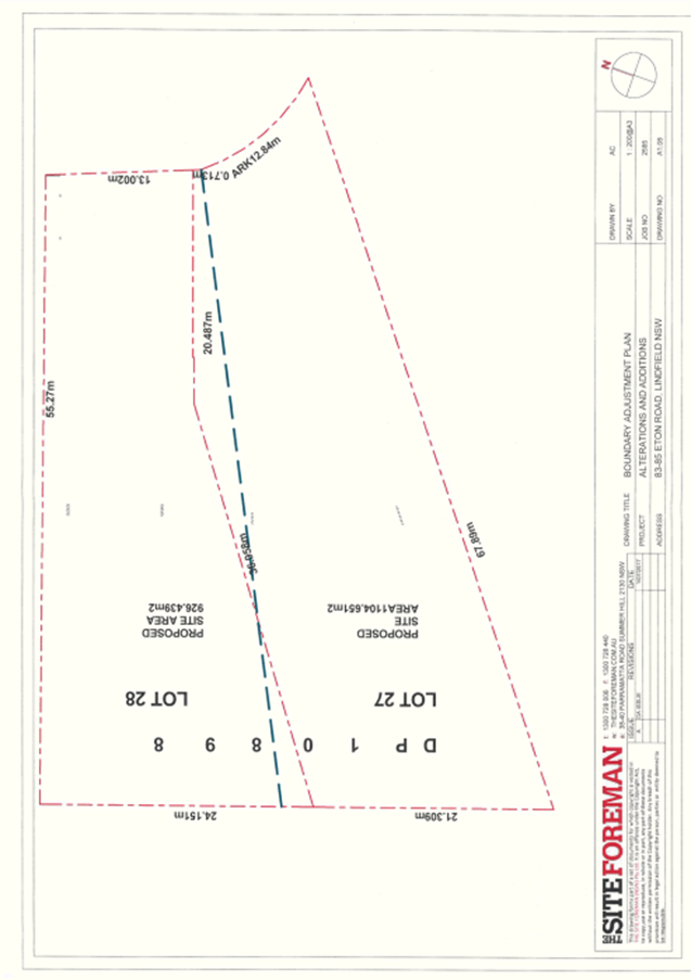
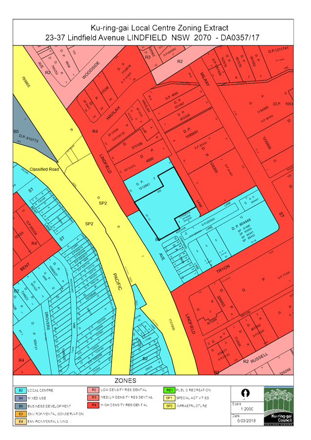
The Site
Site description
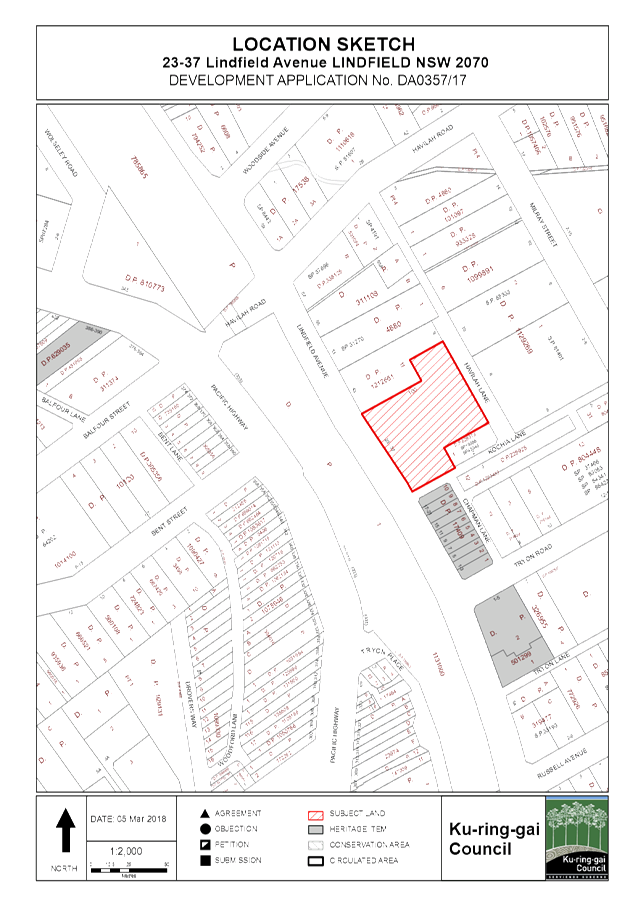
Historically,
multiple sites comprised the development site. These sites were recently
amalgamated into one lot identified as Lot 100 DP 1234458. It is irregular in
shape with a frontage of approximately 60.7 metres to Lindfield Avenue, 32
metres to Kochia Land and 60.5 metres to Havilah Lane. Having an average depth
of 66 metres (measured from Lindfield Avenue through to Havilah Lane), it has a
total area of 3,966.20 sqm. Located on the eastern side of Lindfield
Avenue, the site is effectively a corner site - positioned between Lindfield
Ave, Kocha Lane and Havilah Lane.
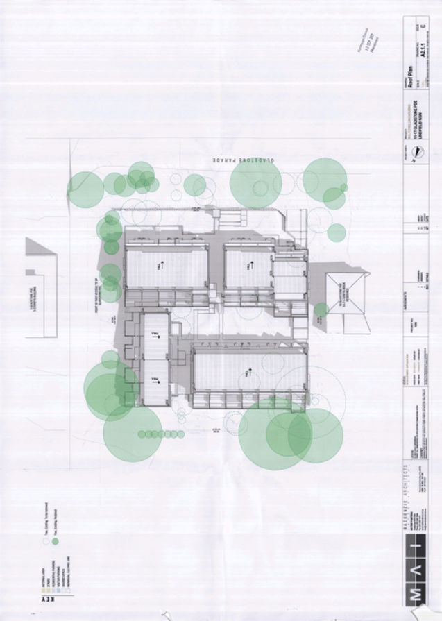
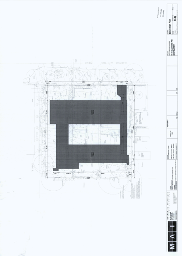
The
site is currently a construction zone being developed in accordance with the
approval issued by the Minister of Planning for Major Project MP08_0244. After
4 subsequent modification applications, the development now entails
redevelopment of the site for a mixed use development totalling 15,488.5m2
comprising:
· 1 podium with 2,720m2 in
retail GFA;
· 140 apartments in 2 residential towers
above the retail podium;
· 3 levels of basement parking for 241
vehicles; and
· 898m2 communal courtyard at
podium level.
A pre-development
application consultation was not undertaken for the proposed development.
Surrounding development
The site is located adjacent Lindfield
Station and forms part of an area undergoing significant gentrification. The
subject Aqualand development is considered to be a catalyst for gentrification
of the immediate locality. The Lindfield Village Green development, a
Ku-ring-gai Council project, has recently been approved on the adjacent council
own car parking site which will include a basement commuter / community car
park and community parkland above. Adjoining development includes shops, cafes,
commercial premises (with a focus on health providers), residential flat buildings
and school.
History
Development application
history
Council’s
electronic database references the following relevant applications made with
respect to the subject site:
|
Type
|
Application
|
Description
|
Decision
|
Date
|
|
CC
|
CCPCA0012/16
|
CC
- Private Certifier - Demolition of Existing Buildings, excavation and
construction of the mixed used retail and 112 residential units.
|
Current
|
|
|
CC
|
CCPCA0241/16
|
CC
- Private Certifier - State Planning Consent MP08-0244 MOD 3 - 141
Residential Unit Towers with Mixed use Commercial space and underground
carpark.
|
Current
|
|
|
CC
|
CCPCA0371/16
|
CC
- Private Certifier - State Planning Consent MP08-0244 MOD 3 - 141
Residential Unit Towers with Mixed use Commercial space and underground
carpark.
|
Current
|
|
|
DA
|
DA0038/15
|
Demolish
existing buildings
|
#APPROVED
|
09/03/2015
|
|
DA
|
DA0333/17
|
Stratum
subdivision of mixed use building into two lots (Proposed Lot 100 -
Residential and Proposed Lot 101 - Commercial) for development approved under
Part 3A (MP08_244)
|
#APPROVED
|
06/11/2017
|
|
Section96
|
MOD0227/17
|
Modification
to DA0333/17 proposing amendment to Condition 5 relating to issue of
Subdivision Certificate
|
#APPROVED
|
13/12/2017
|
|
DA
|
DA0357/17
|
Strata Title subdivision to create 140 lots
|
Current
|
This application
|
|
DA
|
DA0404/17
|
Use
and fitout of shops 4 & 5 for the purposes of a restaurant
|
Current
|
|
Current approvals
Approval
for the mixed-use development (currently under construction) was granted under
Part 3A of the Environmental Planning & Assessment Act 1979 with consent
granted by the Planning Assessment Commission on 27 January 2012. Similarly,
Section 75W modifications to the proposal have since been issued by the
Commission.
The
approval history associated with the development is as follows:
|
27
January 2012
|
Part
3A Project application (MP08_244) approved by Planning Assessment Commission
· A mixed-use retail and residential
development (GFA 11,889m2) comprising
· A two-level retail podium including
a medical centre
· 91 apartments contained in two
residential towers above the retail podium
· 3 levels of basement car parking for
196 vehicles
|
|
14
November 2013
|
Section
75W modification (MOD 1) was approved by the Commission to increase the
height and floor space of the development and:
· Provide 21 additional apartments (to
a total of 112)
· Amend the apartment mix
· Reconfigure the lower ground and
ground floors including a reduction in the amount of retail floor space; and
· Reconfigure the car park with a
reduction of 12 parking spaces
|
|
29 June 2015
|
Section 75W modification
(MOD 2) was approved by the Department to:
· Incorporate 7 Havilah
Lane into the site, increasing the envelope to achieve a building height of 7
storeys;
· Increase the excavation
and basement parking
· Change in dwelling mix
with the provision of 10 additional apartments (bringing the total to 122)
· Increasing the GFA by
1555m2 and
· Other minor amendments
|
|
29 January 2016
|
Section 75W modification
(MOD 3) was approved by the Commission to:
· Incorporate No 39 and No
41 Lindfield Avenue into the development resulting in an increased building
footprint, residential GFA and dwelling yield (increased to 141 apartments);
· A reduction in
retail/commercial floor area at the upper ground level and provision of an
additional 5 apartments at the upper ground level fronting Havilah Lane; and
· The fit out and use of
the approved supermarket floor space, and amendments to setback, building
heights, car parking, communal open space, internal layouts and apartment
mix.
|
|
17 March 2017
|
Section 75W modification
(MOD 4) was approved by the Commission to:
· Amend the internal floor
plan, by combining a one-bedroom and a two-bedroom apartment to create a
three-bedroom apartment. Reducing the approved apartments from 141 to 140.
The development is
currently under construction with the most recent Construction Certificate
being CCPCA0371/16.
|
|
6 November 2017
|
DA0333/17 - Stratum subdivision of
mixed use building into two lots (Proposed Lot 100 - Residential and Proposed
Lot 101 - Commercial) for development approved under Part 3A (MP08_244) -
approved by Council staff under delegation.
|
|
13 December 2017
|
MOD0227/17 - Modification to
DA0333/17 proposing amendment to Condition 5 relating to issue of Subdivision
Certificate and timing of its release - approved by Council staff under
delegation.
|
Consultation
Community
In accordance with the
notification controls of the Ku-ring-gai Development Control Plan, no
notification of the application was required and therefore none was undertaken.
Within Council
Engineering
Council's Development
Engineer commented on the proposal as follows:
The car
parking layout shown on the ‘Draft’ Strata plans are consistent
with the approved architectural plans under MP08_0244 MOD 3.
As part of
the Part 3A Project application approved by Planning Assessment Commission, OSD
and OSR positive covenant and restriction is required as part of the Final Occupation
Certificate.
The
proposal is acceptable, subject to conditions.
Outside Council
No
consultation was required.
Statutory
Provisions
State Environmental Planning Policies
State Environmental Planning Policy
No. 55 – Remediation of Land
The provisions of SEPP 55 require
Council to consider the potential for a site to be contaminated. The subject
site is presently a construction site with all previous buildings and amenities
having been removed from site. As such, it is unlikely to contain any
contamination and further investigation is not warranted in this case.
Sydney Regional
Environmental Planning Policy (Sydney Harbour Catchment) 2005
Matters for consideration
under SREP 2005 include biodiversity, ecology and environmental protection, public
access to and scenic qualities of foreshores and waterways, maintenance of
views, control of boat facilities and maintenance of a working harbour. The
proposal is not subject to the provisions that apply to the assessment of
development applications as the site is not located in the Foreshores and
Waterways Area.
Sydney Environmental
Planning Policy (Building Sustainability Index: BASIX) 2004
A BASIX certificate is not required
for a strata subdivision.
State
Environmental Planning Policy (Infrastructure) 2007
The application is immediately
adjacent to the rail corridor and consideration is required pursuant to
Division 15 Clause 85 or 86 the SEPP. As no physical works are proposed, the
proposal is considered satisfactory.
Local Content
Ku-ring-gai
LEP (Local Centres) 2012
Ku-ring-gai
Local Environmental Plan (Local Centres) 2012 is the statutory LEP for the
subject site.
In summary,
the objectives of this plan are to:
· guide future development
with respect to environmental, social, economic, heritage and cultural
outcomes,
· provide housing choice,
· achieve land-use
relationships that promote efficient use of infrastructure.
The proposed strata subdivision is consistent with the objectives
of Local Environmental Plan (Local Centres) 2012. In this regard, the application enabling the private
ownership of dwellings within a mixed use development that provides employment,
retail, business uses and housing opportunities within immediate proximity to
public transport.
Sections of Ku-ring-gai Local
Environmental Plan (Local Centres) 2012 relevant to the proposed development
are discussed below:
Zoning
and permissibility
The
site is zoned B2 Local Centres. The proposed development is defined as
subdivision and is a permissible development within the zone.
The objectives of this
zone which seek to:
· provide a range of retail, business,
entertainment and community uses that serve the needs of people who live in,
work in and visit the local area.
· encourage employment opportunities in accessible
locations.
· maximise public transport patronage
and encourage walking and cycling.
· provide for residential housing close
to public transport, services and employment opportunities.
· encourage mixed use buildings that
effectively integrate suitable business, office, residential, retail and other
development.
The proposed strata subdivision is consistent with the objectives
of the B2 Local Centres zone.
In this regard, the application enabling the private ownership of dwellings
within a mixed use development that provides employment, retail, business uses
and housing opportunities within immediate proximity to public transport.
Development
standards
Clause
2.6 Subdivision – consent requirements
(1) Land
to which this Plan applies may be subdivided, but only with development
consent.
Notes.
1 If
a subdivision is specified as exempt development in an applicable
environmental planning instrument, such as this Plan or State Environmental
Planning Policy (Exempt and Complying Development Codes) 2008, the Act enables it to be carried out
without development consent.
2 Part
6 of State Environmental
Planning Policy (Exempt and Complying Development Codes) 2008 provides that the strata subdivision
of a building in certain circumstances is complying development.
SEPP
(Exempt and Complying Development Codes) 2008 Part 6.1(1) specifies that:
‘The strata subdivision of
a building for which development consent or a complying development certificate
was granted or issued is, for 5 years from the date the consent or certificate
was granted or issued, development specified for this code’.
As
consent of the initial application for the mixed used development was approved
more than 5 years ago, the proposed development cannot be assessed under the
provisions of the SEPP. Accordingly, a Development Application is made to
Council under the provisions of the EP&A Act, Ku-ring-gai LEP and
associated legislation.
Clause
4.1 – Minimum subdivision lot size
The
objectives of this clause are to ensure that lot sizes and dimensions are able
to accommodate development consistent with relevant development controls.
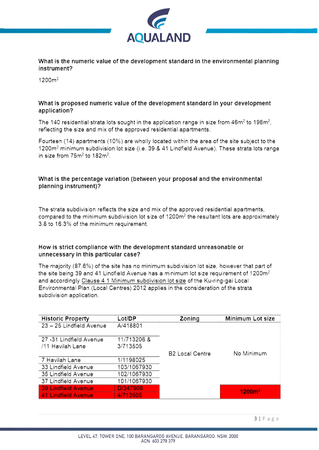
Historically,
multiple sites comprised the development site - which were recently amalgamated
into one lot identified as Lot 100 DP 1234458 No 23-37 Lindfield Avenue,
Lindfield.
The
consolidated site comprises the historical lots listed below:
|
Lot / DP
|
Address
|
Area
|
|
Lot
A DP 418801
|
23-25
Lindfield Ave
|
486.90
m2
|
|
Lot
11 DP713206
|
27-31
Lindfield Ave
|
1,017.00
m2
|
|
Lot
103 DP1067930
|
33
Lindfield Ave
|
184.20
m2
|
|
Lot
102 DP1067930
|
35
Lindfield Ave
|
212.50
m2
|
|
Lot
101 DP1067930
|
37
Lindfield Ave
|
212.70
m2
|
|
Lot D DP347906
|
39 Lindfield Ave
|
215.00 m2
|
|
Lot 4 DP713505
|
41 Lindfield Ave
|
276.00 m2
|
|
Lot
3 DP713505
|
Lindfield
Ave
|
979.00
m2
|
|
Lot
1 DP1198025
|
7
Havilah Lane
|
382.90
m2
|
|
‘The Site’
|
Total Area
|
3,966.20 m2
|
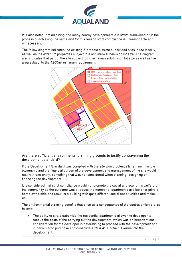
The
majority of the site is not affected by the Minimum Lot Size mapping (Clause
4.1 of the LEP). However, the lots shaded grey in the above table were subject
to a minimum lot size provision which transfers over to the recently
consolidated lot. Therefore a portion of the site (previously identified as Lot
D DP347906 and Lot 4 DP713505) has the Minimum Lot Size affectation of U1
– 1,200m2.
A
recent decision by the Land and Environment Court has confirmed that dual
occupancies cannot utilise strata subdivision to circumvent the minimum lot
size subdivision clause contained in most LEPs.
DM & Longbow Pty Ltd v
Willoughby City Council [2017] NSWLEC 173 (Longbow) was an appeal against a decision of Commissioner Dixon
(as she then was), heard by his Honour Justice Preston CJ. The decision
has significant implications with regard to strata subdivision in general, and
the application of minimum lot sizes.
Under
the provisions of Clause 4.1 of the standard instruments (and the Ku-ring-gai
Local Environmental Plan (Local Centres) 2012:
Clause
4.1(3) states:
3 The
size of any lot resulting from a subdivision of any land to which this clause
applies is not to be less than the minimum size shown on the Lot Size Map in
relation to that land.
Clause
4.1(4) states:
4 This
clause does not apply in relation to the subdivision of lots in a strata plan
or community title scheme.
In
addition to the standard clauses above, Clauses 4A and 4B the Ku-ring-gai LEP
(Local Centres) 2012 (reproduced below) further restrict achievement of
compliance when assessing a strata subdivision application:
4A In
addition to subclause (3), development consent must not be granted for subdivision
of land in any of the following zones in the subdivision would result in a lot
of less than 18 metres wide at 12 metres from the street frontage of the lot:
(a) Zone
R2 Low Density Residential
(b) Zone
R3 Medium Density Residential
(c) Zone
R4 High Density Residential
(d) Zone
E4 Environmental Living
4B In
addition to subclause (4A), development consent must be granted for a
subdivision of land in any of the following zones unless the subdivision would
result in the creation of a lot with at least 1 street frontage of not less
than 24 metres:
(a) Zone
R3 Medium Density Residential
(b) Zone
R4 High Density Residential
This
application seeks approval for 140 residential strata lots which range in size
from 46m2 to 196m2 reflecting the size and mix of the
approved residential apartments.
Fourteen
apartments (10%) are wholly located within the area of the site subject to the
1,200m2 minimum subdivision lot size (previously No 39 & No 41
Lindfield Avenue). The proposed strata lots within this portion of the site
range in size from 75m2 to 182m2.
Accordingly,
fourteen apartments within the proposed strata subdivision are:
· under the minimum lot size of 1,200m2;
· below the minimum width of 18 metres
when measured 12 metres from the street frontage; and
· have a street frontage of less than 24
metres.
It
is therefore necessary to consider the provisions of Clause 4.6 Exception to
development standards to enable the approval of the proposed strata
subdivision having due consideration to the standard wording prescribed by the
local instrument with respect to Clause 4.1 Minimum subdivision lot size
and recent decision in the interpretation of this clause by the Land and
Environment Court.
The
applicant was advised of the recent court proceedings and has submitted a
Clause 4.6 Exception to development standards written request.
Clause
4.6 Exceptions to development standards
As discussed above, exceptions to the
development standards are proposed resulting from the wording of Clause 4.1 Minimum
subdivision lot size and recent decision in the interpretation of this
clause by the Land and Environment Court DM & Longbow Pty Ltd v
Willoughby City Council [2017] NSWLEC 173 (Longbow).
Effectively,
a Clause 4.6 Exception to a Development Standard must now be considered
which has led to the requirement for the applicant to justify a variation to
the standard in the order of 625% to simply strata subdivide their
development. This variation is over 10% and the development application
must now be determined by the IHAP in accordance with the Department’s
latest guidelines (dated 21 February 2018).
With
respect to the wording of Clause 4.1 the Department of Planning has been made
aware of this issue with a redraft of Clause 4.1 of the standard LEPs proposed
in 2015 as is referenced in the Court Ruling discussed above. Section 15
(d) (applicant’s submission within the judgement) it is noted:
(d) In
2015, the NSW Department of Planning and Environment reviewed the Standard
Instrument Local Environmental Plan and proposed certain changes. One proposal
was to amend cl 4.1(4) “to clarify” that the clause does not apply
to strata subdivision by omitting the current cl 4.1(4) and replacing it with:
“(4) This clause
does not apply in relation to the following:
(a)
the subdivision of land under the Community Land Development Act 1989,
(b) the
subdivision of land into lots as a strata plan under the Strata Schemes
(Freehold Development) Act 1973,
(c) the
subdivision of lots in a strata plan under that Act.”
The Department gave as a reason for
the change: “This clause is generally being used as intended but some
councils and stakeholders have identified that the clause could be written more
clearly to remove potential ambiguity.” The Department’s proposal
has not been pursued.
The Department of Planning and
Environment was emailed and advised of these matters pertaining to the issuing
of a strata subdivision of this Part 3A approval (state significant
development) and the difficulties the current wording of Clause 4.1 now places
on council considering strata applications in light of the recent Court
judgement. A response email was received from the Department advising:
The Department of
Planning and Environment is aware of the DM & Longbow Pty Ltd v Willoughby
City Council [2017] judgement and other recent Land and Environment Court
determinations. We understand the need to clarify the intent of clause 4.1(4)
of the Standard Instrument (Local Environmental Plans) Order 2006 (SI LEP) and
are progressing an amendment to the SI LEP to make clear that the minimum lot
size shown on any applicable lot size map does not apply to creation of new
strata plans or community title schemes.
The Department aims to
have these changes to SI LEP clause 4.1(4) and any consequential amendments to
local environmental plan clauses finalised in the first quarter of 2018.
|
Clause
4.6 (KLEP) provision
|
Assessment
|
|
|
Whether
the proposed development is consistent with the objectives of the particular
standard.
|
Yes
The
objectives of the standard are necessary in this instance, being:
(a) to ensure that lot sizes and dimensions are
able to accommodate development consistent with relevant development controls
and minimise risk to life and property from environmental hazards, including
bush fires,
(b) to ensure that lot sizes and dimensions allow
development to be sited to protect natural or cultural features including
heritage items, remnant vegetation, habitat and waterways, and provide for
generous landscaping to support the amenity of adjoining properties and the
desired character of the area,
(c) to ensure that subdivision of low density
residential sites reflects and reinforces the predominant subdivision pattern
of the area.
The
application seeks strata subdivision of an allotment. Advice received from
the Department of Planning indicates that is was not the intention of the
Department to preclude strata subdivision by virtue of Clause 4.1. For this
reason, strata subdivision of the subject development does not conflict with
the set objectives of the clause.
|
|
|
Whether the proposed development is consistent with the
objectives for development within the zone.
|
Yes
· provide a range of retail, business,
entertainment and community uses that serve the needs of people who live in,
work in and visit the local area.
· encourage employment opportunities
in accessible locations.
· maximise public transport patronage
and encourage walking and cycling.
· provide for residential housing
close to public transport, services and employment opportunities.
· encourage mixed use buildings that
effectively integrate suitable business, office, residential, retail and
other development.
The proposed strata subdivision is consistent with the
objectives of the B2 Local Centres zone.
In this regard, the application enabling the private ownership of dwellings
within a mixed use development that provides employment, retail, business
uses and housing opportunities within immediate proximity to public
transport.
|
|
|
Whether
compliance with the development standard unreasonable or unnecessary in the
circumstances of the case.
|
Yes
Given
that the Department of Planning and Environment have recognised and
acknowledged and error in the wording of Clause 4.1 – firstly noted in
2015 and again acknowledged in recent court proceedings, it is considered
that strict imposition of the development standard in this instance is
considered unreasonable in the assessment of a strata subdivision of an
approved mixed use development.
|
|
|
Whether
there are sufficient environmental planning grounds to justify contravening
the development standard.
|
Yes
Strata
subdivision is a permissible form of development covered by legislation
(Strata Schemes Development Act 2015). Such development seeks to ensure that
the economic development of land is achieved meeting the objectives of the
Environmental Planning & Assessment Act 1979. The legislator (Department
of Planning and Environment) recognise that the provisions of Clause 4.1 were
never intended to apply to strata subdivision.
|
|
|
|
Whether
the proposed development is in the public interest.
|
Yes
The
proposal is considered to be in the public interest as it is consistent with
the zone and development standard objectives.
|
|
|
Whether
the proposed development is consistent with objectives of clause 4.6, being,
whether by allowing flexibility in the particular circumstances a better
outcome for and from the development is achieved.
|
Yes
The
applicant has demonstrated that the proposal is consistent with the objectives
of clause 4.6 and that allowing an appropriate degree of flexibility to
permit a contravention of the
minimum required allotment size
development standard will achieve a better outcome for and from the
development.
|
|
|
Concurrence
of the Director General
|
Yes
Circular PS 18-003
issued on 21 February 2018 informed Council that it may assume the
Director-General’s concurrence for exceptions to development standards.
However, any variation to a standard that exceeds 10% must be considered by
the Independent Hearing and Assessment Panel.
|
|
The written submission received from
the applicant is attached and supported by the assessing officer as submitted
on merit having regard to the nature of the variation being sought.
LEP - Part 5 Miscellaneous provisions
Clause
5.9 – Preservation of trees or vegetation
No
physical works are proposed.
Clause
5.10 – Heritage conservation
The
subject site does not contain a heritage item, is located within 100m of an
Item and is not within a heritage conservation area. The proposed works do not
affect any known archaeological or Aboriginal objects or Aboriginal places of
heritage significance. No physical works are proposed as part of the strata
subdivision application and accordingly it is considered that the application
for strata title will have minimal impact on the heritage buildings in close
proximity to the development site.
Ku-ring-gai Development Control Plan
Sections of the document relevant to
the proposed strata subdivision on the subject site include:
Section A
Part 3 – Land Consolidation and
Subdivision
Section C
Part 22 – General
Access and Parking
Part 25 –
Notification
The proposed development satisfies the
relevant DCP controls listed above. No planning objection is raised with
respect to the proposed application in this regard.
Section A Part 3C Strata and Community
Title Subdivision
The above mentioned control is as
follows:
1. Any
subdivision must retain the relationship between the building/or dwelling and
its associated:
i) communal
open space(s);
ii) parking
spaces (visitor and allocated);
iii) water
management devises; and
iv) waste
and recycling facilities.
2. Any
buildings included in a subdivision must comply with the relevant fire safety provisions
for that building in relation to each relevant lot proposed within the
development.
The proposed strata subdivision is of
an approved mixed use development approved by the Department of Planning and
Environment under repealed Part 3A Major Projects of the Environmental
Planning & Assessment Act 1979 and modified by way of 4 modification
applications also assessed by the Department (See Development History above). A
site inspection revealed that the construction of the approved building is very
near to complete. A review of the strata plans indicates that they are
generally consistent with that of the approved buildings plans and previously
approved stratum plans. The proposal is considered satisfactory in this
respect.
Part 25 – Notification
In accordance with the
notification controls of the Ku-ring-gai Development Control Plan, no
notification of the application was required or undertaken.
Section 94 or 94A Development Contributions Plan
Not applicable. Section 94
Contributions have been previously paid for the construction of the development
in accordance with the provisions of the relevant consents.
Likely
Impacts
The likely impacts of the development have been considered within
this report and are deemed to be acceptable, subject to conditions.
Suitability
of the Site
The site is suitable for the proposed development.
Public
Interest
The proposal is considered to be in the public interest.
Conclusion
The proposed development is of low
environmental impact that will have minimal effect on the surrounding
neighbourhood.
Having regard to the provisions of
section 79C of the Environmental Planning and Assessment Act 1979, the proposed
development is considered to be satisfactory. Therefore, it is recommended that
the application be approved, subject to conditions.
RECOMMENDATION
PURSUANT TO SECTION
80(1) OF THE ENVIRONMENTAL PLANNING AND ASSESSMENT ACT, 1979
A. THAT
the Ku-ring-gai Independent Hearing and Assessment Panel, as the consent
authority, is of the opinion that the request under Clause 4.6 of Ku-ring-gai
Local Environmental Plan (Local Centres) 2012 to vary the minimum
subdivision lot size development standards is well founded. The Ku-ring-gai
Independent Hearing and Assessment Panel is also of the opinion that
strict compliance with the development standard is unreasonable and unnecessary
in the circumstances of the case and that there are sufficient environmental
planning grounds to justify the variation to the development standard.
B. THAT
the Ku-ring-gai Independent Hearing and Assessment Panel, as the consent
authority, grant development consent to DA0357/17 for the strata title
subdivision of mixed use building to create 140 lots for development approved
under Part 3A (MP08_244) on land at 23-37 Lindfield Avenue, Lindfield, for a
period of two (2) years from the date of the Notice of Determination subject to
conditions. Pursuant to Section 95(2) of the Environmental Planning and
Assessment Act 1979, this consent lapses if the requisite Strata Subdivision
Certificate is not issued within two years of the date of the Notice of
Determination.
Conditions
that identify approved plans:
1. Approved
plans (strata)
The development must be carried out in
accordance with the following plans and documentation listed below and endorsed
with Council’s stamp, except where amended by other conditions of this
consent:
|
Plan no.
|
Drawn by
|
Dated
|
|
Strata Plan Form 2 (DRAFT) (Issue 2)
Survey Ref 170601 Sheet 1 of 17
Location Plan
|
Mark Andrew of Linker Surveying Pty
Ltd
|
27/07/2017
|
|
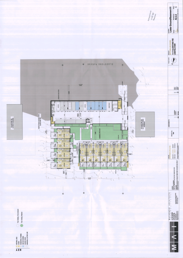
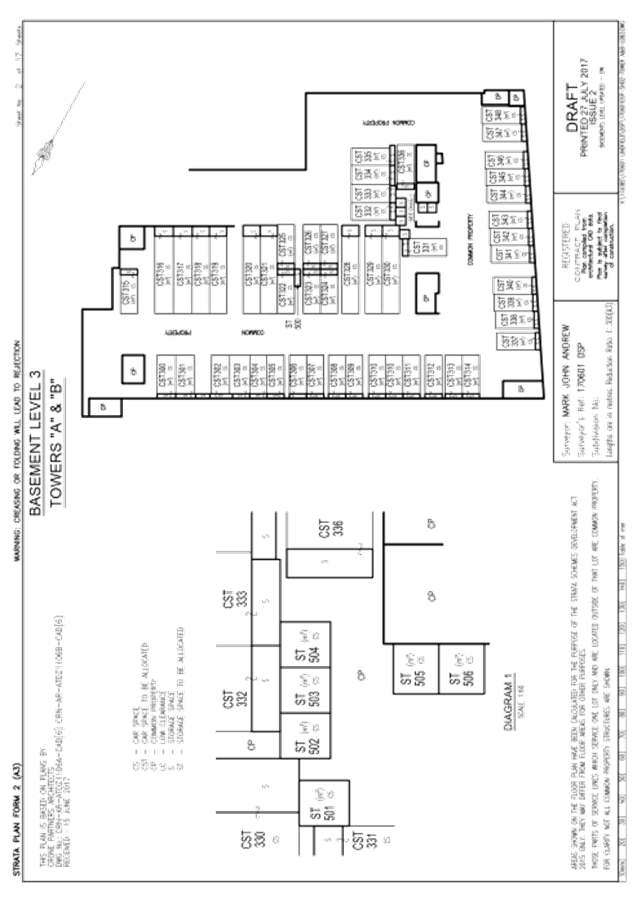
Strata Plan Form 2 (DRAFT) (Issue 2)
Survey Ref 170601 Sheet 2 of 17
Basement Level 3 - Towers
“A” & “B”
|
Mark Andrew of Linker Surveying Pty
Ltd
|
27/07/2017
|
|
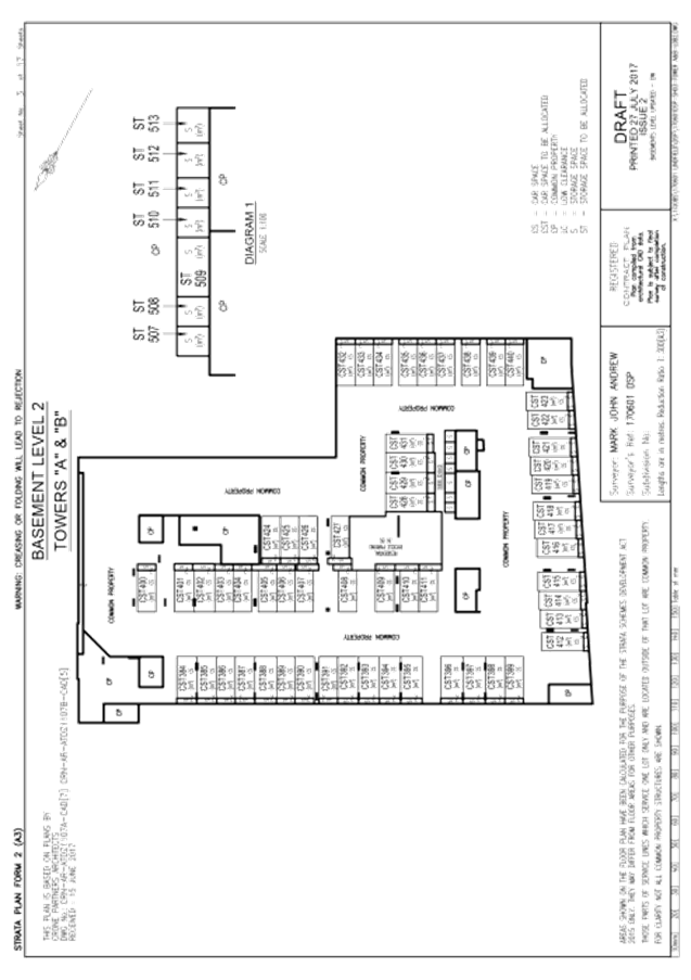
Strata Plan Form 2 (DRAFT) (Issue 2)
Survey Ref 170601 Sheet 3 of 17
Basement Level 2 - Towers
“A” & “B”
|
Mark Andrew of Linker Surveying Pty
Ltd
|
27/07/2017
|
|
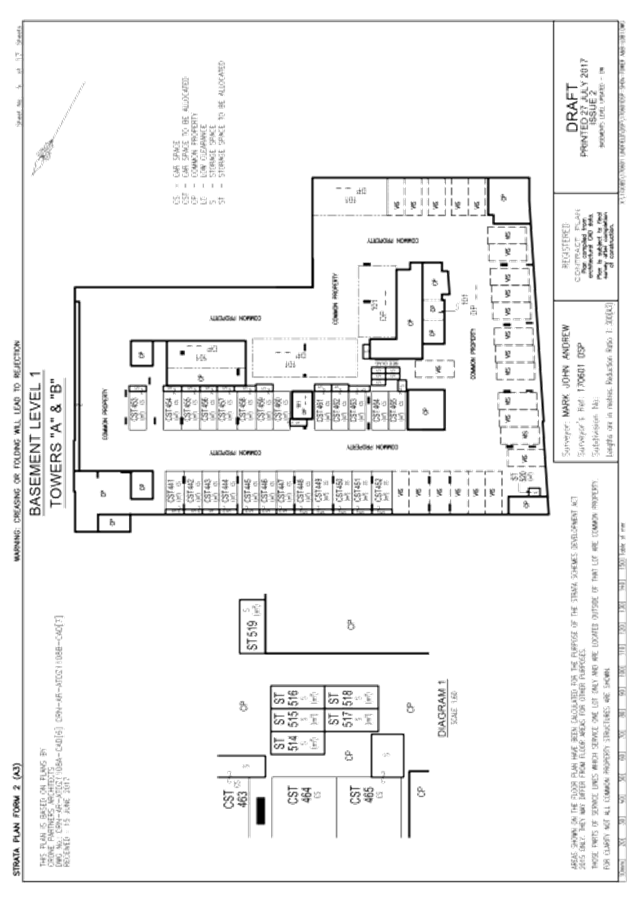
Strata Plan Form 2 (DRAFT) (Issue 2)
Survey Ref 170601 Sheet 4 of 17
Basement Level 1 - Towers
“A” & “B”
|
Mark Andrew of Linker Surveying Pty
Ltd
|
27/07/2017
|
|
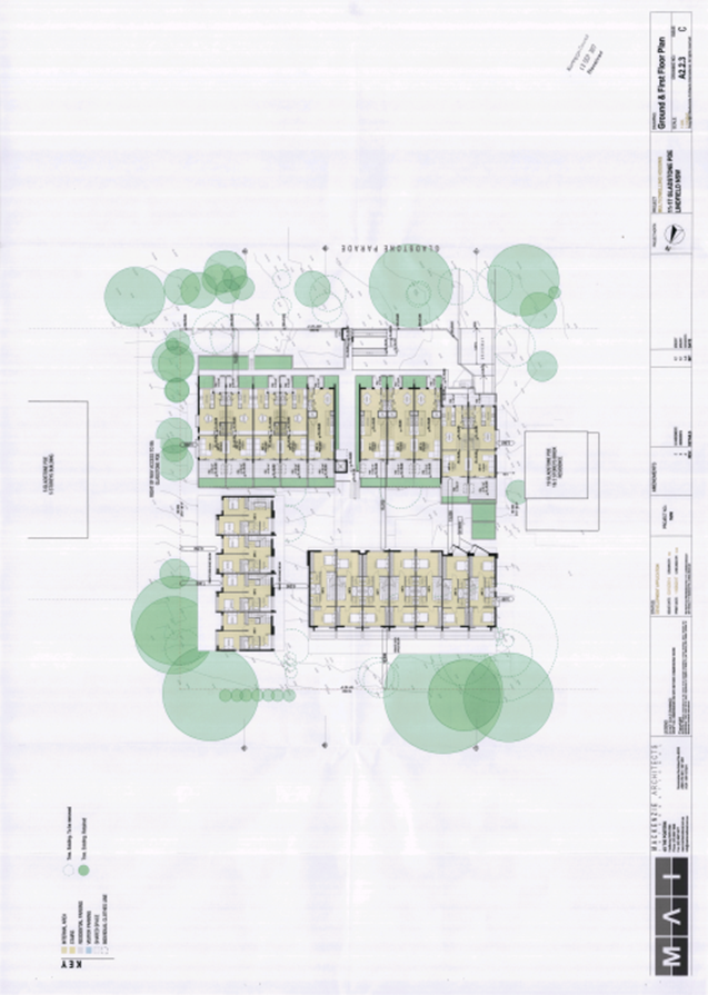
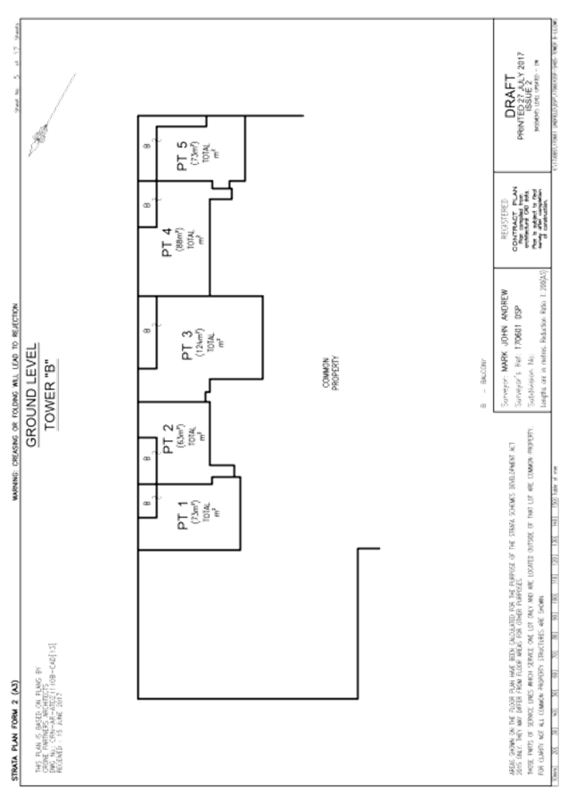
Strata Plan Form 2 (DRAFT) (Issue 2)
Survey Ref 170601 Sheet 5 of 17
Ground Level - Tower “B”
|
Mark Andrew of Linker Surveying Pty
Ltd
|
27/07/2017
|
|
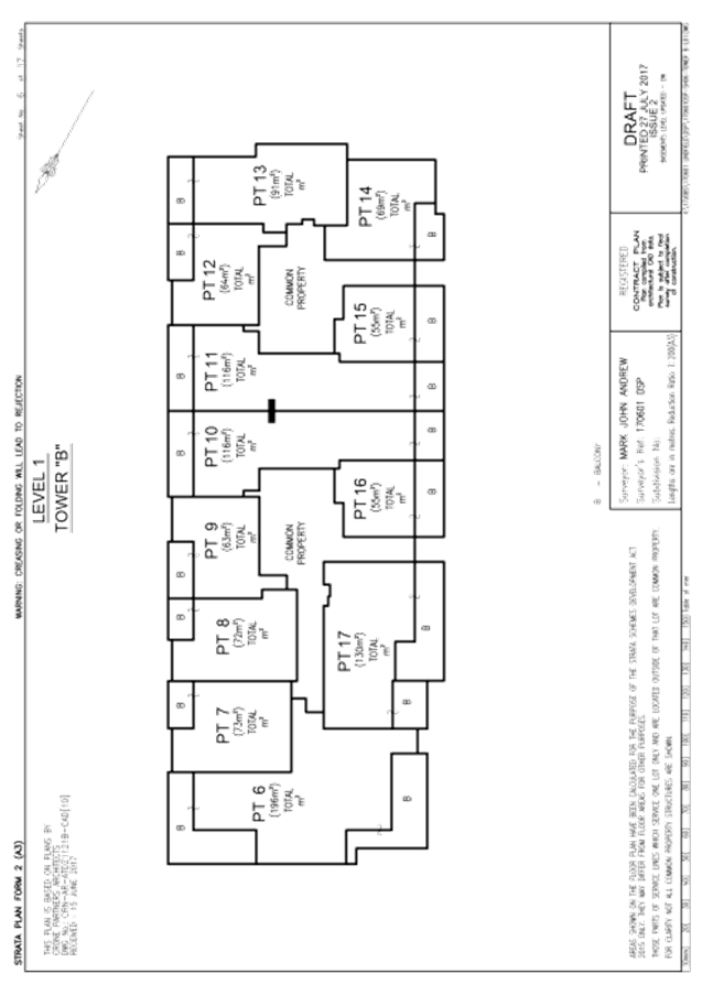
Strata Plan Form 2 (DRAFT) (Issue 2)
Survey Ref 170601 Sheet 6 of 17
Level 1 - Tower “B”
|
Mark Andrew of Linker Surveying Pty
Ltd
|
27/07/2017
|
|
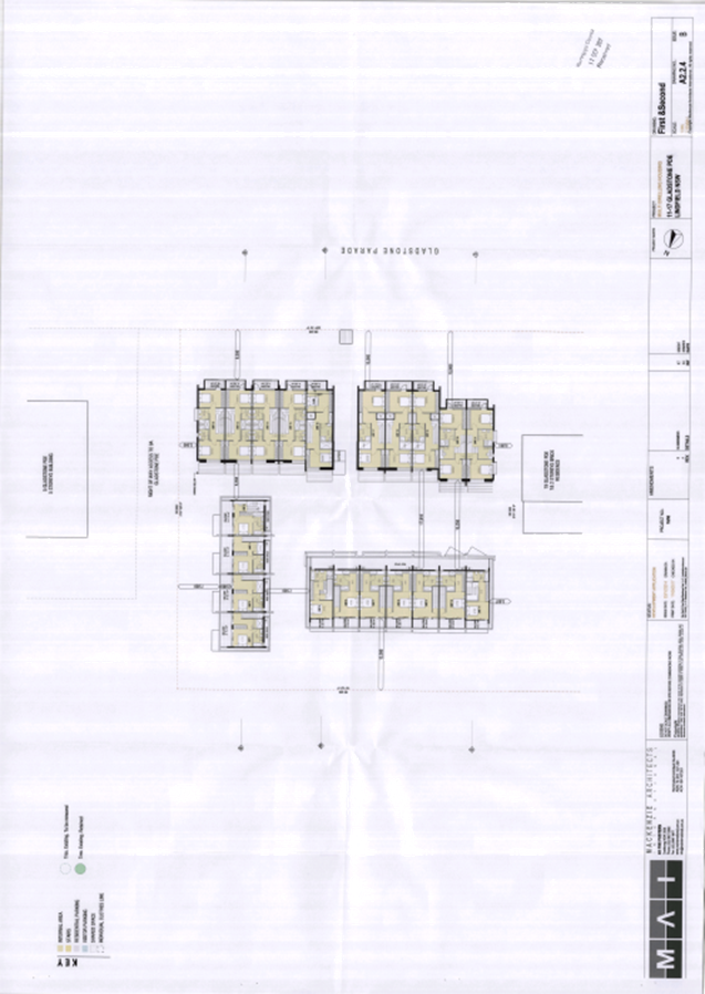
Strata Plan Form 2 (DRAFT) (Issue 2)
Survey Ref 170601 Sheet 7 of 17
Level 2 - Tower “B”
|
Mark Andrew of Linker Surveying Pty
Ltd
|
27/07/2017
|
|
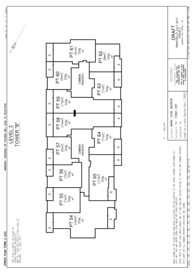
Strata Plan Form 2 (DRAFT) (Issue 2)
Survey Ref 170601 Sheet 8 of 17
Level 3 - Tower “B”
|
Mark Andrew of Linker Surveying Pty
Ltd
|
27/07/2017
|
|
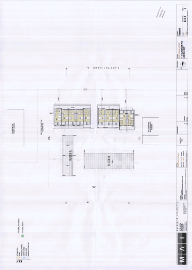
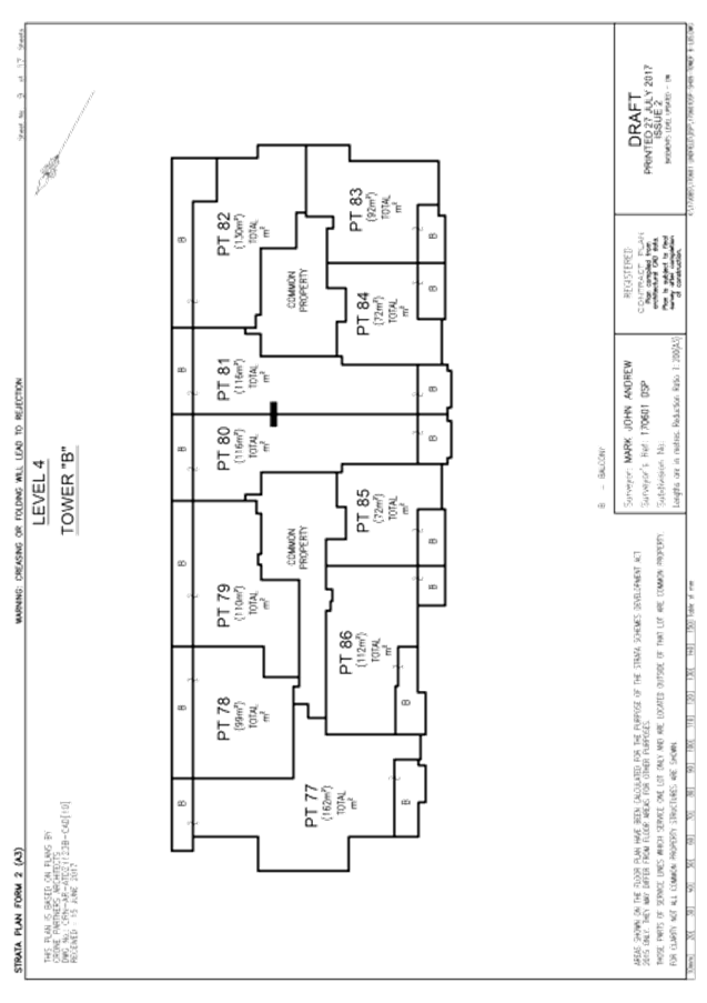
Strata Plan Form 2 (DRAFT) (Issue 2)
Survey Ref 170601 Sheet 9 of 17
Level 4 - Tower “B”
|
Mark Andrew of Linker Surveying Pty
Ltd
|
27/07/2017
|
|
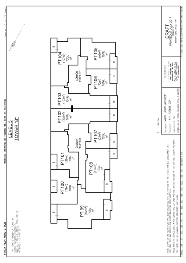
Strata Plan Form 2 (DRAFT) (Issue 2)
Survey Ref 170601 Sheet 10 of 17
Level 5 - Tower “B”
|
Mark Andrew of Linker Surveying Pty
Ltd
|
27/07/2017
|
|
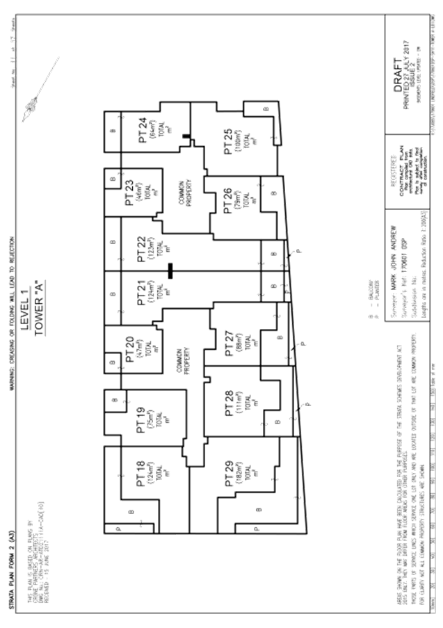
Strata Plan Form 2 (DRAFT) (Issue 2)
Survey Ref 170601 Sheet 11 of 17
Level 1 - Tower “A”
|
Mark Andrew of Linker Surveying Pty
Ltd
|
27/07/2017
|
|
Strata Plan Form 2 (DRAFT) (Issue 2)
Survey Ref 170601 Sheet 12 of 17
Level 2 - Tower “A”
|
Mark Andrew of Linker Surveying Pty
Ltd
|
27/07/2017
|
|
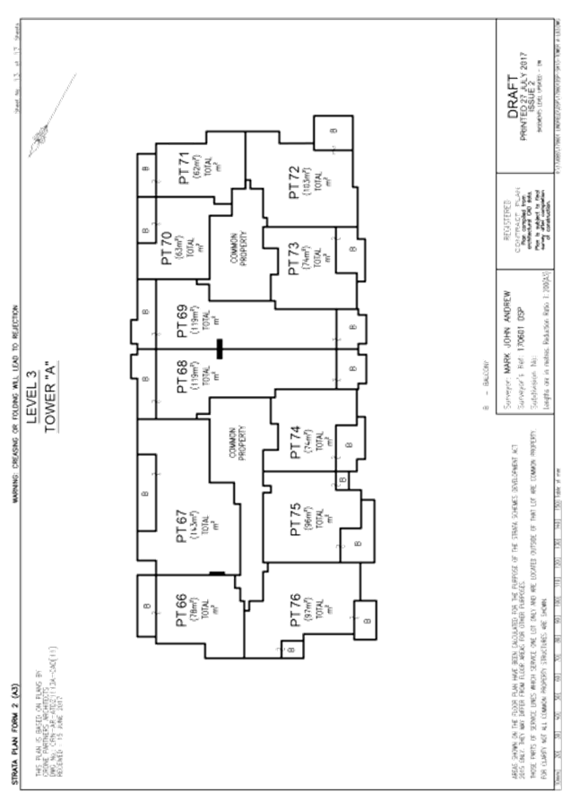
Strata Plan Form 2 (DRAFT) (Issue 2)
Survey Ref 170601 Sheet 13 of 17
Level 3 - Tower “A”
|
Mark Andrew of Linker Surveying Pty
Ltd
|
27/07/2017
|
|
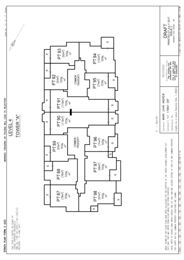
Strata Plan Form 2 (DRAFT) (Issue 2)
Survey Ref 170601 Sheet 14 of 17
Level 4 - Tower “A”
|
Mark Andrew of Linker Surveying Pty
Ltd
|
27/07/2017
|
|
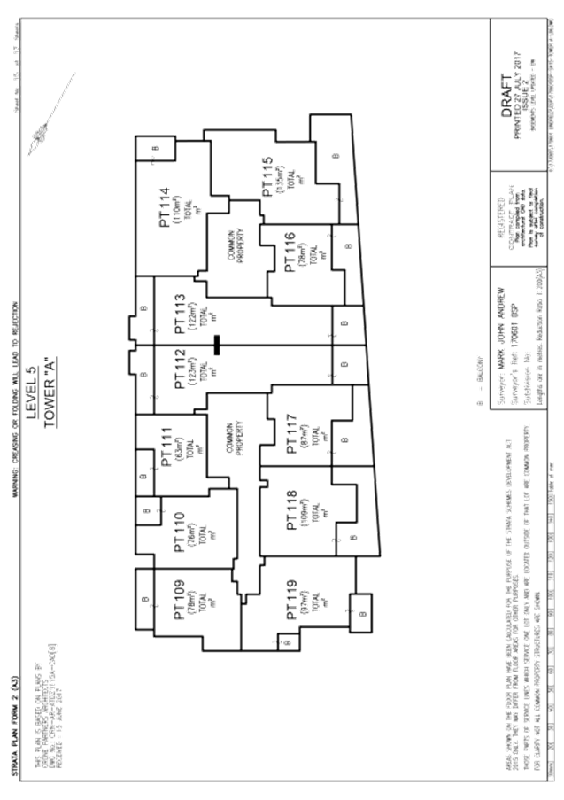
Strata Plan Form 2 (DRAFT) (Issue 2)
Survey Ref 170601 Sheet 15 of 17
Level 5 - Tower “A”
|
Mark Andrew of Linker Surveying Pty
Ltd
|
27/07/2017
|
|
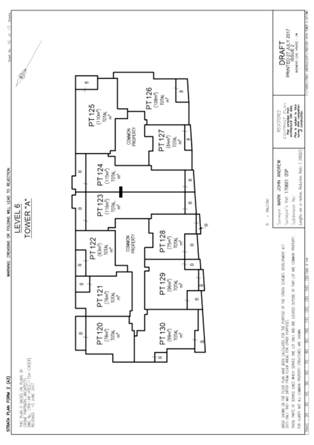
Strata Plan Form 2 (DRAFT) (Issue 2)
Survey Ref 170601 Sheet 16 of 17
Level 6 - Tower “A”
|
Mark Andrew of Linker Surveying Pty
Ltd
|
27/07/2017
|
|
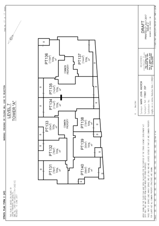
Strata Plan Form 2 (DRAFT) (Issue 2)
Survey Ref 170601 Sheet 17 of 17
Level 7 - Tower “A”
|
Mark Andrew of Linker Surveying Pty
Ltd
|
27/07/2017
|
Reason: To
ensure that the development is in accordance with the determination.
2. Inconsistency
between documents
In the event of any inconsistency
between conditions of this consent and the drawings/documents referred to
above, the conditions of this consent prevail.
Reason: To
ensure that the development is in accordance with the determination.
Conditions
to be satisfied prior to the issue of a Subdivision certificate:
3. OSD
positive covenant
Prior issue of the Subdivision
Certificate, the applicant shall create a positive covenant and restriction on
the use of land under Section 88B of the Conveyancing Act 1919, burdening the
property with the requirement to maintain the on-site stormwater detention
facilities on site. The terms of the instruments are to be generally in
accordance with the Council's "terms of Section 88B instrument for
protection of on-site detention facilities" and to the satisfaction of
Council (refer to Part 24R.8.1 of the Ku-ring-gai DCP). The location of the
on-site detention facilities for all dwellings is to be noted on the final plan
of subdivision.
Reason: To ensure
maintenance of on site stormwater detention facilities.
4. Retention
and re-use positive covenant
Prior to issue of the Subdivision
Certificate, the applicant shall create a positive covenant and restriction on
the use of land under Section 88B of the Conveyancing Act 1919, burdening the
property with the requirement to maintain the site retention and re-use
facilities. The terms of the instruments are to be generally in accordance with
the Council's "terms of Section 88B instrument for protection of on-site
retention facilities" and to the satisfaction of Council (refer to Part
24R.8.2 of the Ku-ring-gai DCP). The location of the on-site retention
facilities for all dwellings is to be noted on the final plan of subdivision.
Reason: To
ensure maintenance of site retention and re-use facilities.
5. Sydney
Water Section 73 Compliance Certificate
Prior to release of the linen
plan/issue of the subdivision certificate, the Section 73 Sydney Water
compliance certificate which refers to the subdivision application must
be obtained and submitted to the Council.
Reason: Statutory
requirement.
6. Provision
of services
Prior to issue of the Subdivision
Certificate, separate underground electricity, gas and phone or appropriate
conduits for the same, must be provided to each allotment to the satisfaction
of the utility provider. A suitably qualified and experienced engineer or
surveyor is to provide certification that all new lots have ready underground
access to the services of electricity, gas and phone. Alternatively, a letter
from the relevant supply authorities stating the same may be submitted to
satisfy this condition.
Reason: Access to
public utilities.
7. Issue
of Subdivision Certificate
The Subdivision Certificate must not
be issued until all conditions of development consent have been satisfied and a
Final Occupation Certificate has been issued by the Principal Certifying
Authority.
Reason: To
ensure that the development is completed prior to transfer of responsibility
for the site and development to another person.
8. Submission
of 88b instrument
Prior to the issue of the Subdivision
Certificate, the applicant must submit an original instrument under Section 88B
of the Conveyancing Act with the plan of subdivision, plus six (6) copies to
Council. Ku-ring-gai Council must be named as the authority whose consent is
required to release, vary or modify the burdens.
Reason: To
create all required easements, rights-of-carriageway, positive covenants,
restrictions-on-use or other burdens/benefits as may be required.
9. General
easement/R.O.W. provision and certification
Prior to issue of the Subdivision
Certificate, a registered surveyor is to provide details to Council that all
physical structures are fully contained within the proposed allotments or will
be fully covered by the proposed burdens upon registration of the final plan of
subdivision. Alternatively, where the surveyor is of the opinion that
creation of burdens and benefits is not required, then proof to this effect
must be submitted to the Principal Certifying Authority.
Reason: To
ensure that all physical structures are fully contained within the proposed
allotments or will be fully covered by the proposed burdens upon registration
of the final plan of subdivision.
10. Submission
of certification of as-constructed development (strata)
Prior to the issue of the Subdivision
Certificate, the applicant is to submit a survey report and surveyor’s
certificate which confirms that
(a) The
floors, external walls and ceilings depicted in the proposed strata plan for
the building correspond to those of the building as constructed;
(b) The
floors, external walls and ceilings of the building as constructed correspond
to those depicted in the building plans that accompanied the construction
certificate for the building; and
(c) Any
facilities required by the development consent for the building (such as
parking spaces, terraces and courtyards) have been provided in accordance with
those requirements.
Reason: To
ensure that the as-constructed development is consistent with the approval.
11. Submission
of plans of subdivision (strata)
For issue of the subdivision
certificate, the applicant shall submit an original plan of subdivision plus 6
copies suitable for endorsement by the consent authority. The following details
must be submitted with the plan of subdivision and its copies, where
Council is the consent authority:
a) the
endorsement fee current at the time of lodgement
b) the
88B instrument plus 6 copies
c) all
surveyors and/or consulting engineers’ certification(s) required under
this subdivision consent.
d) Proof
of payment of S94 contributions.
All parking spaces and all areas of
common property, including visitor car parking spaces and on-site detention
facilities, which are to be common property, must be included on the final
plans of strata subdivision. Where Council is the certifying authority,
officers will check the consent conditions on the subdivision. Failure to
submit the required information will delay endorsement of the linen plan and
may require payment of re-checking fees.
Plans (and copies) of subdivision must
not be folded. Council will not accept bonds in lieu of completing subdivision
works. If the certifying authority is not Council, then a copy of all of
the above must be provided to Council.
Reason: Statutory
requirement.
|
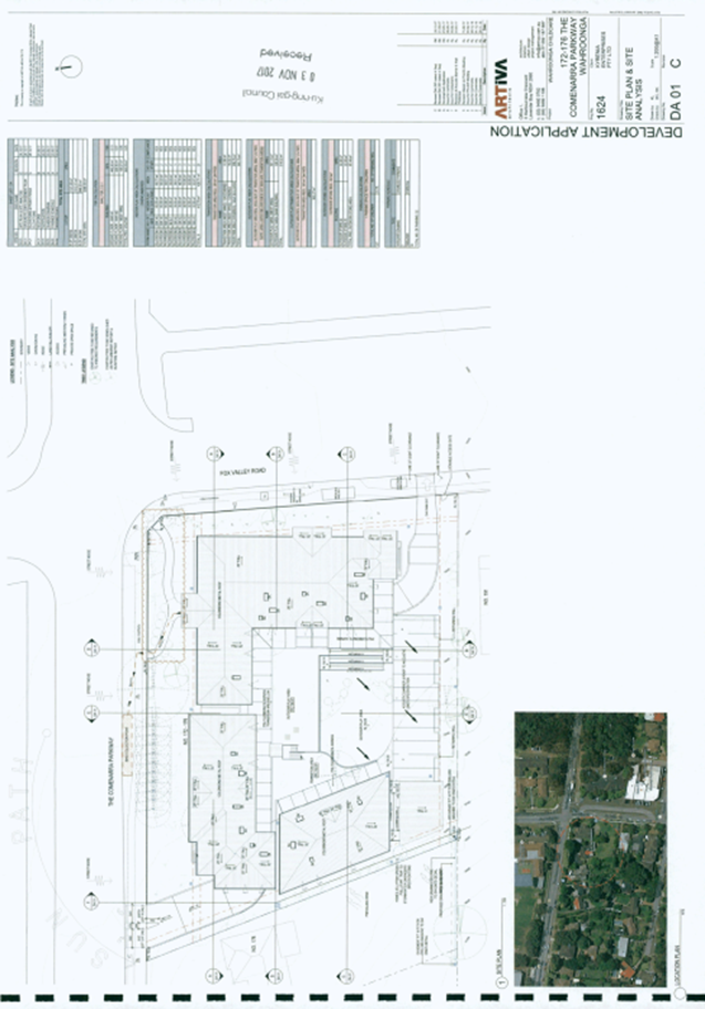
APPENDIX No: 1 - Assessment
Report - 172-176 The Comenarra Parkway Wahroonga
|
|
Item No: GB.4
|
ASSESSMENT
REPORT
|
Report title:
|
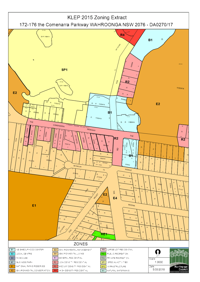
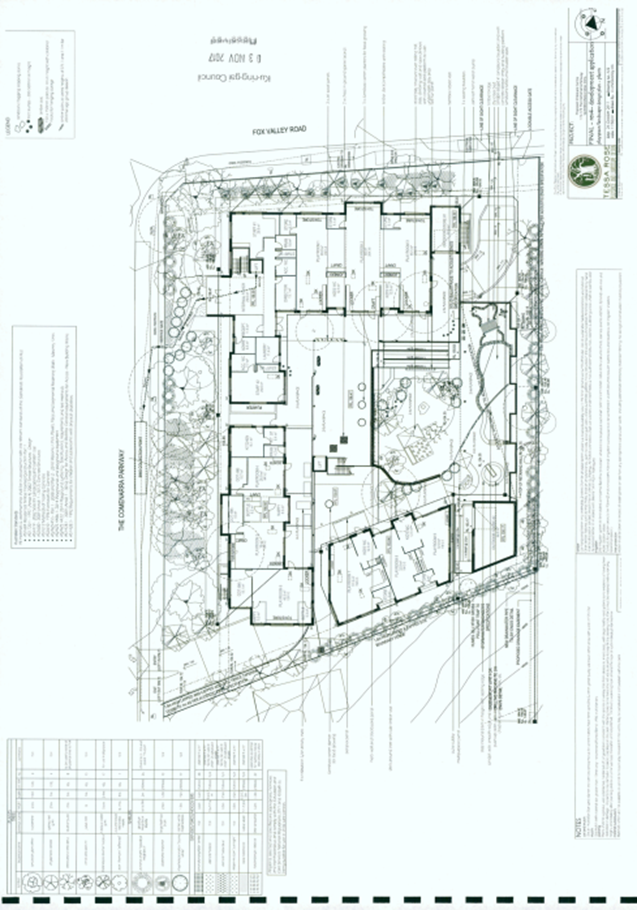
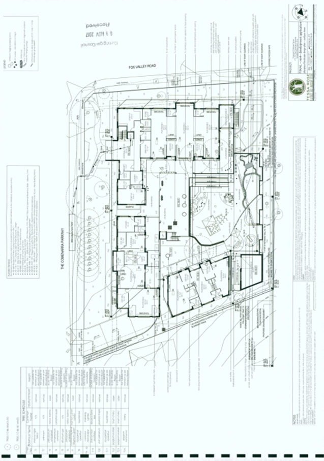
172-176 THE COMENARRA PARKWAY, WAHROONGA –
DEMOLISH EXISTING STRUCTURES AND CONSTRUCT A 127 PLACE CHILD CARE CENTRE WITH
BASEMENT PARKING
|
|
ITEM/AGENDA
NO:
|
|
|
Application No:
|
DA0270/17
|
|
Property Details:
|
172-176 The Comenarra Parkway, Wahroonga
Lot & DP No: Lot
A and B DP 368759 and Lot B
DP
347649
Site area (m2): 3,338m2
Zoning: R2
Low density residential
|
|
Ward:
|
Comenarra
|
|
Proposal/Purpose:
|
Demolition of existing structures and construction of
a 127 place child care centre with basement parking.
|
|
Type of Consent:
|
Integrated
|
|
Applicant:
|
Sam Mamari
|
|
Owner:
|
Kyrenia Enterprises Pty Ltd
|
|
Date Lodged:
|
7 July 2017
|
|
Recommendation:
|
Approval (Deferred Commencement Consent)
|
Purpose of Report
To determine Development Application No DA0270/17 for demolition
of existing structures and construction of a 127 place child care centre with
basement parking on the subject site.
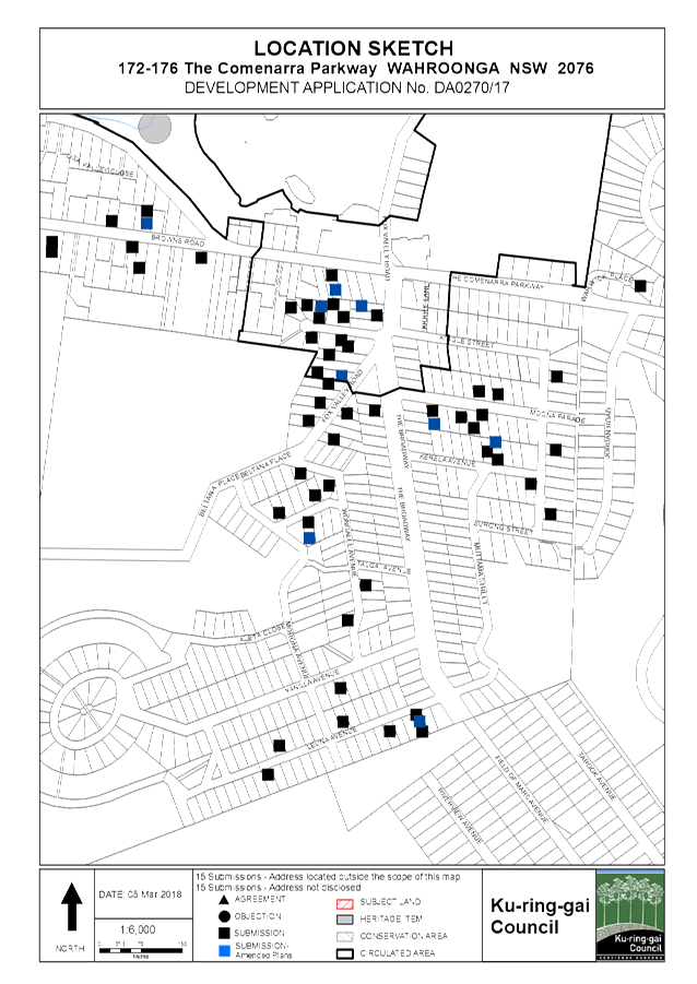
DA270/17 is referred to the Ku-ring-gai Independent Hearing
and Assessment Panel for determination as more than 10 submissions objecting to
the proposal were received.
integrated planning and reporting
Places, spaces & infrastructure
|
Community Strategic Plan
Long Term Objective
|
Delivery Program
Term Achievement
|
Operational Plan
Task
|
|
A robust planning framework
is in place to deliver quality design outcomes and maintain the identity and
character of Ku-ring-gai
|
Applications are assessed
in accordance with State and local plans
|
Assessments are of a high
quality, accurate and consider all relevant legislative requirements
|
Executive Summary
|
Issues
|
· The
Comenarra Parkway setback
· rear
southern setback
|
|
Submissions
|
· 82
submissions to original application
· 14
submissions to amended application
|
|
Land & Environment Court
|
No
|
|
Recommendation
|
Approval (Deferred Commencement Consent)
|
|
|
|
LEGISLATIVE REQUIREMENTS:
|
|
|
|
|
Zoning
|
R2 Low Density Residential
|
|
Permissible under
|
Ku-ring-gai
Local Environmental Plan 2015
|
|
Relevant legislation
|
· Environmental
Planning and Assessment Act 1979
· Rural
Fire Services Act 1997
· Children
(Education and Care Services) Supplementary Provisions Act 2011 and Children
(Education and Care Services) Supplementary Provisions Regulation 2012
· State
Environmental Planning Policy No. 55 – Remediation of Land
· State
Environmental Planning Policy (Educational Establishments and Child Care
Facilities) 2017
· Sydney
Regional Environmental Plan (Sydney Harbour Catchment) 2005
· Ku-ring-gai Local Environmental Plan 2015
· Ku-ring-gai
s94A Contributions Plan 2015
|
|
Integrated Development
|
Yes –
section 100B under Rural Fire Services Act 1997
|
History
Site
A search of the site history
reveals that it has been used for residential purposes.
Pre-DA
PRE0106/16 – Child care
centre at 172-174 The Comenarra Parkway
On 28 September 2016, a pre
development application consultation was held with the applicant for demolition
of existing structures and construction of a 94 place child care centre with
basement parking.
PRE0107/16 – Boarding
House at 176 The Comenarra Parkway
On 28 September 2016, a pre
development application consultation was held with the applicant for the
demolition of existing structures and construction of a boarding house,
comprising of 7 studio units, 2 car garage and 2 motor cycle spaces.
PRE0010/17 – Child care
centre at 172-176 The Comenarra Parkway
On 14 February 2017, a pre
development application consultation was held with the applicant for the
demolition of existing structures and construction of a 127 place child care
centre with basement parking.
DA history
|
Date
|
Action
|
|
7 July 2017
|
Application lodged.
|
|
21 July 2017
|
The application was notified and advertised for a period
of 30 days. A total of 82 submissions were received.
|
|
4 September 2017
|
A letter was sent to the applicant seeking additional
information and amended plans.
|
|
17 August 2017
|
Application called to full Council by Councillor Elaine
Malicki.
|
|
6 November 2017
|
Amended plans and additional information submitted.
|
|
10 November 2017
|
The amended application was notified for a period of 14
days. A total of 14 submissions were received.
|
|
5 December 2017
|
An email was sent on behalf of RMS requesting an amended
plan modifying the road median design.
|
|
14 December 2017
|
Amended plan modifying the median design was submitted.
|
The Site
Site description
|
Visual character study category
|
1945-1968
|
|
Easements/rights of way
|
No
|
|
Heritage Item - Local
|
No
|
|
Heritage Item - State
|
No
|
|
Heritage conservation area
|
No
|
|
Within 100m of a heritage item
|
No
|
|
Bush fire prone land
|
Yes - north eastern corner and south eastern corner
|
|
Natural Resources Biodiversity
|
Yes
– south western corner of site
|
|
Natural Resources Greenweb
|
Yes
– south western corner of site
|
|
Natural Resources Riparian
|
No
|
|
Within 25m of Urban Bushland
|
No
|
|
Contaminated
land
|
No
Former service station use
on 176 Fox Valley Road and 170D The Comenarra Parkway on opposite side of Fox
Valley Road
|
|
Within 25m of Classified Road
|
No
|
|
Within
25m of a rail corridor/tunnel
|
No
|
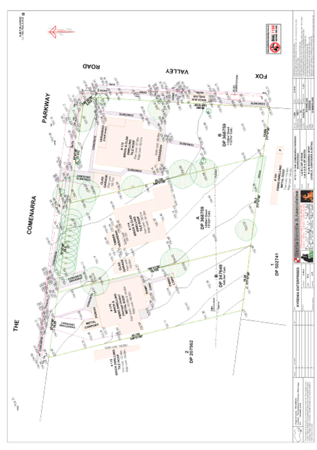
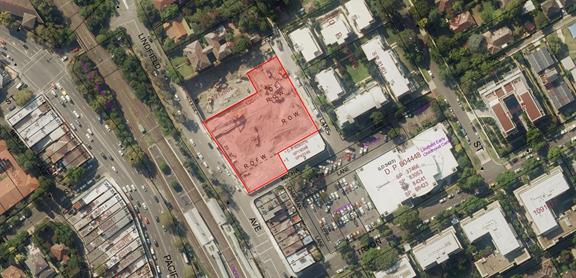
The site comprises of a large irregular shaped lot, being Lot
A and B DP 368759 and Lot B DP 347649 and has a street address of 172-176 The
Comenarra Parkway, Wahroonga.
The site is a corner lot with the main frontage to The
Comenarra Parkway and the secondary frontage is Fox Valley Road.
The site measures 3,388m² and currently accommodates 3
separate dwelling houses that address The Comenarra Parkway with rear gardens
to the south.
The site has a fall of 6.6 metres from the higher, north
eastern corner (front) to the lower, south western corner.
Surrounding development
The predominant character of the surrounding development is
one and two storey dwellings on medium to large landscaped allotments and
facilities ancillary to an educational establishment (189 Fox Valley Road) and
the Sydney Adventist Hospital.
Adjoining the site to the south is 191 Fox Valley Road which
is developed with a residential dwelling (zoned E4 under KLEP 2015). Adjoining
the site to the west is 179 The Comenarra Parkway which is developed with a residential
dwelling and zoned R2 under KLEP 2015.
The SAN site
On the opposite side of The Comenarra Parkway is the Sydney
Adventist Hospital (the SAN) which is undergoing redevelopment. The Part 3A
concept plan 07_0166 for the upgrade and expansion of hospital, new low medium
and high density dwellings, educational facilities, commercial and retail was
approved on 31 March 2010. The concept plan has been modified a number of
times.
189 Fox Valley Road (within the SAN site)
Opposite the subject site and within the SAN site, is the
former Wahroonga Adventist School, which has concept approval to be redeveloped
for 2 mixed use buildings. To date, there is no detailed development consent
(either via a development application or project approval).
Development consent to DA0453/12 was granted on 7 October
2015 for 2 residential buildings (4 and 6 storeys) for student accommodation, 2
residential buildings (4 and 6 storeys) for key worker accommodation, basement
carparking, landscaping, stormwater works and subdivision adjacent to the
former Wahroonga Adventist School.
172 Fox Valley Road (within the SAN site)
Development consent to DA0053/13
was granted on 7 October 2015 for 1 x 3 storey building and 2 x 4 storey
buildings containing offices, central atrium, café and basement parking,
landscaping, stormwater works and subdivision diagonally opposite the subject
site. Construction works have commenced on this development.
It is noted that the Department
of Planning and Environment is currently considering a modification (MOD7) to
MP 10_0070 (detailed approval for alterations and additions to the hospital
including road upgrades), to modify Condition E1 to undertake the interim
upgrade of the intersection of The Comenarra Parkway and Fox Valley Road after
completion of the Commercial development at the north-eastern corner of the
intersection of The Comenarra Parkway and Fox Valley Road. The interim upgrade
of the intersection is approved to be delivered prior to occupation of the
commercial development.
176 and 178 Fox Valley Road
On the opposite side of Fox Valley Road is the ‘Fox
Valley Shopping Centre’ and ‘Wahroonga Specialist Centre’ (zoned
B1 Neighbourhood Centre).
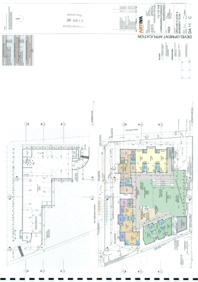
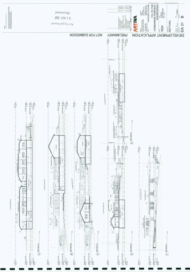
The Proposal
The application seeks
consent for:
· Demolition
of existing dwellings
· Construction
of a purpose built child care centre
· Operational
parameters, including:
o capacity for 127
children
§ 32 x 0-2 year olds
§ 35 x 2-3 year olds
§ 60 x 3-6 year olds
§ 21 full time equivalent staff
o operation between 7.30am
and 6.30pm Monday to Friday (inclusive), excluding public holidays
· Internal
layout includes:
o 9 x playrooms
o 3 x cot rooms
o 2
x bottle preparation areas
o 2
x nappy change rooms
o 4 x bathroom facilities
o kitchen
o laundry
o staff facilities and
amenities
o storage
· Basement
level parking for 32 vehicles (inclusive of 2 x accessible spaces)
· 2
x waste rooms
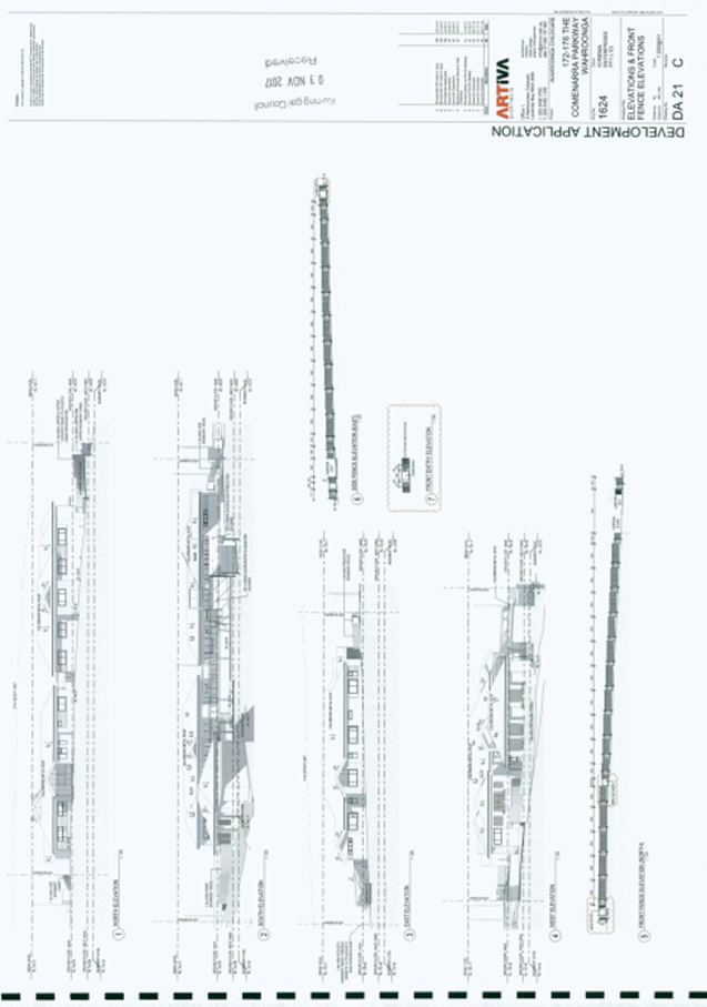
· New
driveway crossings on The Comenarra Parkway and Fox Valley Road
· ‘Left
in’ entry and ‘left out’ exit from The Comenarra Parkway and
‘left out’ exit onto Fox Valley Road
· Ramping,
lift and pathways between car park and centre
· External
areas, including covered verandah, external foyer and ramping and 994m² of
outdoor play space
· Outdoor
storage rooms 66m²
· New
boundary fencing, including acoustic walls
· Tree
removal and landscaping works
Additional
information and amended plans submitted 6 November 2017
The additional
information and amended plans proposed the following changes to the
application:
· Removal
of proposed right-hand movement, into the site from The Comenarra Parkway
· 'Left
in', 'left out' arrangement with a raised triangular island constructed at The
Comenarra Parkway driveway
· Driveway
on Fox Valley Road remains designated as exit only
· Revised
Traffic and Impact Assessment submitted confirming dates traffic surveys were
undertaken and amended trip generation during peak period
· Revised
traffic simulation using SIDRA modelling submitted
· SIDRA
analysis has been amended to include vehicle trips originating from Thornleigh
(eastbound) and from the Fox Valley Road/The Broadway (northbound)
· Swept
path diagrams for entering and existing vehicles from The Comenarra Parkway
submitted
· Swept
path diagrams for existing vehicles from Fox Valley Road submitted
· Amended
pedestrian access path provided from the north-eastern corner to the entry of
the centre
· Amended
pathway and bin collection point at the street
· Land
Title confirmation that the easement over 3 Seymour Close is a Council easement
· Request for deferred commencement consent to obtain agreement
from 180 The Comenarra Parkway for new drainage easement
· Amended
Landscape Plan
· Amended
Stormwater Plan
· Arborist
Report relating to Tree 8
· Air
Quality Assessment
· Electromagnetic
survey
Amended
plans submitted 14 December 2017
The amended
plan proposed the following change to the application:
· Modification of ‘left in’ left out’ driveways on The Comenarra Parkway to be
splayed and separated by a raised kerb and a concrete median within the
property boundary
Consultation
Community
In accordance with the notification requirements of the
KDCP, the application was notified to owners and occupants of surrounding
properties and advertised in the local newspaper between 21 July 2017 and 21
August 2017. In response, Council received 82 submissions from the following:
|
1. Mr
G P Gleeson
|
209 Fox Valley Road, Wahroonga
|
|
2. Ms
S Hodges
|
address not disclosed
|
|
3. Mr
P Johnson
|
8 Seymour Close, Wahroonga
|
|
4. Mr
G D A Feurtado
|
3 Seymour Close, Wahroonga
|
|
5. Ms
P White
|
8/100 Browns Road, Wahroonga
|
|
6. S
Ravi-Isaji
|
address not disclosed
|
|
7. Mr
W & Mrs G Brown
|
15/66-72 Browns Road, Wahroonga
|
|
8. Mr
R N & Mrs E M McLean
|
11 Seymour Close, Wahroonga
|
|
9. Mr
S G Davis
|
4 Seymour Close, Wahroonga
|
|
10. Mr
B Heath
|
217 Fox Valley Road, Wahroonga
|
|
11. Mr
A & Mrs P E Koroknay
|
203 Fox Valley Road, Wahroonga
|
|
12. Ms
D Smith
|
7 Warwick Place, Wahroonga
|
|
13. Ms
M Baird
|
7b Dennis Avenue, Wahroonga
|
|
14. Mrs
C Feurtado
|
3 Seymour Close, Wahroonga
|
|
15. Mr
M Barnett
|
12 Yanilla Avenue, Wahroonga
|
|
16. Mr
S J Turnbull
|
180 The Comenarra Parkway, Wahroonga
|
|
17. Mr
R D & Mrs G L Hinchcliffe
|
9 Seymour Close, Wahroonga
|
|
18. Mrs
N L Doyle
|
70 Campbell Drive, Wahroonga
|
|
19. Mrs
K Atkinson
|
30 Kallang Parade, Wahroonga
|
|
20. Mrs
M A Giles
|
4 Wongalee Avenue, Wahroonga
|
|
21. Mrs
A Lawrence
|
6 Wongalee Avenue, Wahroonga
|
|
22. Mr
A Stitt & Ms R Lown
|
82 Browns Road, Wahroonga
|
|
23. Mr
K A & Mrs A Lyle & Family
|
9 Kerela Avenue, Wahroonga
|
|
24. Mrs
S Baker
|
address not disclosed
|
|
25. Mr
R Jarmyn
|
address not disclosed
|
|
26. Mr
P & Mrs E Surjan
|
address not disclosed
|
|
27. Mr
S T Conway
|
9 Morona Avenue, Wahroonga
|
|
28. Mrs
M N Vernon
|
71 Browns Road, Wahroonga
|
|
29. Mr
C Tarakci & Ms L J Lesslie
|
7 Seymour Close, Wahroonga
|
|
30. Mr
R J & Mrs M J Southon
|
5 Seymour Close, Wahroonga
|
|
31. Mr
G J Jepson
|
190 The Comenarra Parkway, Wahroonga
|
|
32. Mrs
D J Sly
|
1 Morona Avenue, Wahroonga
|
|
33. Mrs
A E De Vries
|
31 Wongalee Avenue, Wahroonga
|
|
34. Mr
A C & Mrs F J Ross
|
35 Wongalee Avenue, Wahroonga
|
|
35. Mr
R & Mrs L Jarmyn
|
12 Morona Avenue, Wahroonga
|
|
36. Mrs
D Zandstra
|
6 Kallang Parade, Wahroonga
|
|
37. The
Furlong Family
|
address not disclosed
|
|
38. Mrs
H E Ledwidge
|
address not disclosed
|
|
39. Mr
C & Mrs S Allen
|
63 The Comenarra Parkway, Thornleigh
|
|
40. Mr
R J & Mrs K M Willatt
|
16 Morona Avenue , Wahroonga
|
|
41. Mr
M & Mrs M White
|
address not disclosed
|
|
42. Mr
I F T & Mrs M E J Walker
|
11/100 Browns Road, Wahroonga
|
|
43. Mr
R J Stewart
|
15 Leuna Avenue, Wahroonga
|
|
44. T
Rock
|
address not disclosed
|
|
45. Mrs
R A Diamant
|
21 Yanilla Avenue, Wahroonga
|
|
46. s
Pisheh
|
address not disclosed
|
|
47. Mr
W & Mrs C Lennie
|
address not disclosed
|
|
48. Ms
J Pinn
|
address not disclosed
|
|
49. Mr
L & Mrs L Coote
|
address not disclosed
|
|
50. Mr
F A Ledwidge
|
7 Kerela Avenue, Wahroonga
|
|
51. Mr
R A & Mrs J Lainson
|
67 Browns Road, Wahroonga
|
|
52. Professor
D G & Mrs O N Laing
|
36 Leuna Avenue, Wahroonga
|
|
53. Mr
J A Farrar
|
207 Fox Valley Road, Wahroonga
|
|
54. Ms
K Grainger, Senior Planner Jensen Bowers
|
PO Box H335, Australia Square
|
|
55. Ms
Y Heng
|
PO Box 1725, Hornsby Westfield
|
|
56. Mrs
A K Nalywajko
|
24 Wongalee Avenue, Wahroonga
|
|
57. Mr
P Fletcher MP Federal Member for Bradfield on behalf of
Ms
Ravi-Isaji
|
Level 2 280 Pacific Highway, Lindfield
|
|
58. Mr
P Fletcher MP Federal Member for Bradfield on behalf of Mr W &
Mrs
G Brown
|
Level 2 280 Pacific Highway, Lindfield
|
|
59. Mrs
Y M Heath
|
193 Fox Valley Road, Wahroonga
|
|
60. Mr
I G & Mrs V G Hanson
|
80 Browns Road, Wahroonga
|
|
61. Ms
P A Gibson, Architect
|
7 Morona Avenue, Wahroonga
|
|
62. Mr
B J & Mrs B A Freeman
|
11 Morona Avenue, Wahroonga
|
|
63. Mr
T J & Mrs A C Escott
|
2 Kerela Avenue, Wahroonga
|
|
64. Mrs
G A Downing
|
6 Leuna Avenue, Wahroonga
|
|
65. Mr
B Downing
|
6 Leuna Avenue, Wahroonga
|
|
66. Mr
A N Davie
|
12 Eurong Street, Wahroonga
|
|
67. Mr
R M Cross
|
12 Leuna Avenue, Wahroonga
|
|
68. Mr
R E & Mrs Y A Butterfield
|
3 The Broadway, Wahroonga
|
|
69. Ms
F Young
|
3 Eurong Street, Wahroonga
|
|
70. Dr
E G Salole
|
4 Eurong Street, Wahroonga
|
|
71. Mr
P Fletcher MP Federal Member for Bradfield on behalf of Mr P and Mrs E Surjan
|
Level 2 280 Pacific Highway, Lindfield
|
|
72. Mr
P Fletcher MP Federal Member for Bradfield on behalf of Mr A &
Mrs
P E Koroknay
|
Level 2 280 Pacific Highway, Lindfield
|
|
73. Mr
M C Robinson
|
188 Fox Valley Road, Wahroonga
|
|
74. Ms
K Wright
|
address not disclosed
|
|
75. F
Keet, Associate CFO, Australasian Conference Association Limited
|
Locked Bag 2014, Wahroonga
|
|
76. Mrs
N Andrews-Hay
|
182 Fox Valley Road, Wahroonga
|
|
77. Mr
T L Andrews
|
213 Fox Valley Road, Wahroonga
|
|
78. Mr
A Henskens SC MP Member for Ku-ring-gai on behalf of Mr W &
Mrs
C Lennie
|
27 Redleaf Avenue, Wahroonga
|
|
79. Ms
J Johnson
|
18 Kallang Parade, Wahroonga
|
|
80. Mr
T M-S
|
address not disclosed
|
|
81. Mr
H Sin
|
27 Leuna Avenue, Wahroonga
|
|
82. Hunter
Eye Surgeons Attention : Mr P Davies
|
Suite 1, 17 Edgar Street, Belmont
|
The submissions
raised the following issues:
· Bushfire risk and risk to safe emergency evacuation given young
children and increase in traffic congestion
A Bushfire assessment
and evacuation plan was submitted and referred to the NSW RFS
as the integrated approval body for the application. The RFS issued a Bush
Fire Safety Authority imposing conditions, including the need for a Bush Fire Emergency
Management and Evacuation Plan to be prepared in accordance with the current
standard (Condition 79).
· Traffic congestion and lack of pedestrian safety at the
intersection. Road network, intersection and light phasing require upgrading
before any further development can occur
The Comenarra Parkway and Fox Valley Road intersection is approved
to be upgraded in conjunction with the Sydney Adventist Hospital Staged
Alterations and Additions (MP 10_0070 approved by Planning Assessment
Commission under former Part 3A provisions).
The Wahroonga
Estate is expected to complete the upgrade of the intersection prior to the
occupation of the SAN Clinic in early 2019. Council’s Development
Engineer is satisfied with the proposal.
· Land should be resumed from the site to improve the
intersection
No land
on the subject site is required to undertake the planned intersection
upgrade.
· Flawed traffic data, given recent development approvals have not
been taken into consideration
Whilst the
traffic report does not include a projection of the impact of
the traffic and parking of the new SAN Clinic, the proposed upgrade of the
intersection of The Comenarra Parkway and Fox Valley Road has been
planned and designed to accommodate traffic flows from the developments in the
Wahroonga Estate Master Plan which includes the SAN Clinic. The proposal is
considered satisfactory by Council’s Development Engineer.
· Right turn into centre from The Comenarra Parkway will cause queuing
and significant east bound delay
The
application was amended to delete the right hand turn into the centre from The
Comenarra Parkway and make the driveway a left in, left out only arrangement.
· Air pollution and impact on children
The application was amended to provide an
air quality report. The report concludes that a satisfactory level
of air quality is attained for the proposed use.
· Privacy impacts to upper level of dwelling at 3 Seymour Close
The
closest structure is the proposed storage room which is 15m from the dwelling
at 3 Seymour Close. The indoor and outdoor play spaces are orientated toward
the centre of the site. All windows on the western elevation are to storage
areas and have external privacy screens. The southern edge of the outdoor play
space has an acoustic fence and roof and restricts overlooking to the
neighbouring properties. The impact on the neighbour is considered reasonable
given the separation, orientation of the play spaces and buildings into the
centre of the site and the proposed landscaping within the setbacks.
· Lack of parking for construction workers
This concern
is addressed by Condition 6 which requires a detailed Construction
Traffic Management Plan (CTMP) to be submitted prior to the issue of the
construction certificate.
· Unobstructed access should be maintained to all public footpaths
during construction
A condition is recommended requiring the public places including
footpaths to be clear of any construction activity (Condition 40).
· Site is unsuitable for a child care centre and is a very dangerous
location
Child
care centres are permissible with consent in the R2 zone. The centre has been
designed to comply with traffic, bushfire and building safety standards.
· Dust and dirt impacts during construction
A condition is recommended requiring dust to be managed during the
construction phase (Condition 38).
· Noise impacts from waste collection and deliveries
Waste
collection is proposed, kerbside along The Comenarra Parkway. The noise impact
associated with collection of 6 bins kerbside is not considered to result in
unreasonable amenity impacts on adjoining neighbours. A condition is
recommended requiring loading and unloading of goods to occur within the
basement (Condition 75).
· Child care centre is not permissible in low density zone
Under
KLEP 2015, the child care centre is permissible with consent in the R2 Low
Density Residential zone.
· Centre is within 250 metres of a mobile base station
The site is
within 300 metres of mobile telephone transmitters located at 185 Fox Valley
Road (SAN Hospital site). An electromagnetic report was submitted concluding
that the radiofrequency fields were very low and below regulated safe levels.
· Centre is within 70 metres of power lines that may carry over 33kV
Ausgrid have confirmed that the site is not within 70
metres of power-line in excess of 33kV. The site is below overhead power lines
on Fox Valley Road and an electromagnetic report was submitted concluding that
the radiofrequency fields were very low and below regulated safe levels.
· Centre is located on a major roadway and air and noise quality
report must be submitted
The centre is
within 125 metres of The Comenarra Parkway (major roadway). An acoustic report
and air quality report was submitted with the application demonstrating that
satisfactory levels of noise and air quality are attained for the proposed use.
· Centre does not have frontage to a park
The
centre does not have a frontage to a park or open space, however, is opposite a
neighbourhood shopping centre, near education and medical facilities and has a
maximum two common boundaries with surrounding residential properties. The site
meets two of the three preferred locational requirements in Part 10 of KDCP and
is considered to be appropriately located to benefit from nearby compatible
social uses.
· Noise from the operation must be limited to maximum noise criteria
A
Noise Impact Assessment was submitted with the application confirming that,
subject to acoustic barriers, fencing and roofing being erected around the
centre, the proposal can comply with the noise criteria. Fencing ranging from
1m to 1.8m is proposed along the southern and western boundaries. An acoustic
barrier and cantilevered roof (setback 3m from southern boundary) runs alongside
the outdoor play space, mitigating noise to properties to the south and south
west.
· Development does not achieve objectives of the zone or Part 10 of
KDCP
The application was amended and now generally complies with all Part
10 controls and objectives of those controls.
Additional
information and amended plans submitted 6 November 2017
In accordance with the notification requirements of KDCP,
the amended application was notified to owners and occupants of surrounding
properties between 10 November 2017 and 24 November 2017. In response, Council
received 14 submissions from the following:
|
1. Mr
S J Turnbull
|
180 The Comenarra Parkway, Wahroonga
|
|
2. Mr
R D & Mrs G L Hinchcliffe
|
9 Seymour Close, Wahroonga
|
|
3. Mr
A Stitt & Ms R Lown
|
82 Browns Road, Wahroonga
|
|
4. Mr
C Tarakci & Ms L J Lesslie
|
7 Seymour Close, Wahroonga
|
|
5. Mrs
D J Sly
|
1 Morona Avenue, Wahroonga
|
|
6. Mr
C & Mrs S Allen
|
63 The Comenarra Parkway,
Thornleigh
|
|
7. Mr
F A Ledwidge
|
7 Kerela Avenue, Wahroonga
|
|
8. Mr
R A & Mrs J Lainson
|
67 Browns Road, Wahroonga
|
|
9. Mrs
G A Downing & Mr B Downing
|
6 Leuna Avenue, Wahroonga
|
|
10. Ms
F Young
|
3 Eurong Street, Wahroonga
|
|
11. Mr
R Lawrence
|
address not disclosed
|
|
12. Mr
J A Farrar on behalf of 37 residents
|
207 Fox Valley Road, Wahroonga
|
|
13. Mr
E Herps, Senior Planner Jensen Bowers
|
PO Box H335, Australia Square
|
|
14. Mr
W A & Mrs C M Lennie
|
191 Fox Valley Road, Wahroonga
|
The submissions
raised the following additional issues:
· Traffic congestion and impact on already congested intersection
New figures available from RMS
suggest traffic generation for childcare centres to be in the order of 0.7
vehicle trips per hour for both the AM and PM peak hours. This represents
approximately 90 vehicle trips, respectively.
The RMS Guide refers to a trip as
a “one-way vehicular movement from one point to another excluding the
return journey. Therefore, a vehicle entering and leaving a land use is counted
as two trips”. This means that there will be up to 45 vehicles entering
and exiting the site during a one hour period. This is about 1 trip every
1.5 minutes.
An Intersection Assessment was
undertaken by the traffic engineer concluding that the “Level of
Service” measure for the intersection was estimated to be “D
Operating near capacity” for AM and PM peak hours for both the existing
situation and proposed childcare (under the current intersection layout) and is
acceptable.
· Increased
congestion on southern side of intersection caused by "Exit left
only" and "Entry left only" onto the Comenarra Parkway - will
necessitate all cars travelling east to make a right hand turn into Fox Valley
Rd in peak hour traffic, do a U-turn and join the queue of all the other cars
which line up at the Traffic lights in Fox Valley Road
Site access
is restricted by “left in and left out” from The Comenarra Parkway
and Fox Valley Road would remain “exit only”. An updated
SIDRA analysis for the existing and proposed weekday traffic volumes for the AM
and PM peak hour was carried out to include trips originating from Thornleigh
(east bound) and from the Fox Valley Road/The Broadway (northbound). The trips
originating from both the eastbound represent 11 trips per hour (1 trip every 5
minutes, or 1 tip every 2 traffic signal cycles) and northbound represents up
to 22 trips per hour (1 trip every 3 minutes, or 1 trip every traffic signal
cycle) which is unlikely to have a significant additional impact. This
arrangement is considered acceptable by Council’s Development Engineer
and RMS, subject to conditions.
· Inadequate
parking provided on site and within the surrounding locality
Childcare centres are permissible
in a residential zone. Parking rates are specified in Council’s planning
controls so that adequate spaces are provided for staff and visitors within the
site and to ensure that parking does not spill over into the surrounding
streets. The proposal provides for 32 spaces and complies with the parking
requirement.
· Inaccurate Traffic and Parking Report - does not give a true
reflection of the current traffic conditions and the delays encountered by
residents and the on-street parking available
Traffic counts have been carried
out by the Traffic Engineers at the signalised intersection of The Comenarra
Parkway and Fox Valley Road in the AM and PM peak periods (weekday 28 July 2016
outside school holidays). The traffic information gathered with regards
to traffic counts, generated traffic of the proposed development and the
impacts of that distribution through the adjoining road network have been
assessed by way of SIDRA computer modelling.
The traffic
counts used in the Traffic modelling is consistent with Council’s traffic
counts within the area and are deemed to be acceptable.
· Inaccurate Traffic and Parking Report - report relies heavily on the
“NSW RTA Guide to Traffic Generating Development” dated 2002
NSW RTA
‘Guide to Traffic Generating Developments” Version 2.2 dated
October 2002 is the latest version and is accepted within the transport
planning industry.
· Inaccurate Traffic and Parking Report - a recent Traffic Volume count shows a 92% increase in the volumes
provided by Motion Traffic Engineers for the AM Peak Hour exiting from Fox
Valley Road South (7.45am to 8.45am)
The submission
states that the increase in volumes occurring because the writer has “observed many vehicles coming from Fox Valley Road
north, crossing The Comenarra , then turning and exiting Fox Valley Road going
west towards Thornleigh. Most of these vehicles go through the car park
provided for the small shopping centre. Drivers believe that this is faster
than waiting in the traffic to turn from Fox Valley Road North to The Comenarra
Parkway going west to Thornleigh”.
Whilst this may be occurring at the moment, the proposed
upgrade of the intersection of The Comenarra Parkway and Fox Valley Road
would provide an additional right turn lane from Fox Valley Road (southerly) to
The Comenarra Parkway (westerly). This should reduce right turn delays and
minimise vehicles bypassing through the Fox Valley shops carpark and the
southern leg of Fox Valley Road.
· Inaccurate Traffic and Parking Report - does not include a projection of the impact of
the traffic and parking of the new SAN Clinic currently under construction
Whilst the
traffic report does not include a projection of the impact of
the traffic and parking of the new SAN Clinic, the proposed upgrade of the
intersection of The Comenarra Parkway and Fox Valley Road has been
planned and designed to accommodate traffic flows from the developments in the
Wahroonga Estate Master Plan which includes the SAN Clinic.
· The Comenarra Parkway/Fox Valley Road intersection must be
upgraded to avoid additional congestion on an already stressed intersection
The Wahroonga
Estate is expected to complete the upgrade of the intersection prior to the
occupation of the SAN Clinic in early 2019. The proposed
upgrade of the intersection of The Comenarra Parkway and Fox Valley Road
has been planned and designed to accommodate traffic flows from the
developments in the Wahroonga Estate Master Plan which includes the SAN Clinic.
· Traffic
congestion along Fox Valley Road during construction phase
A detailed
Construction Traffic Management Plan (CTMP) is required to be submitted prior
to the issue of the construction certificate (Condition 6). It would be
required that all construction vehicle routes for all stages of the development
would approach from Pennant Hills Road, turn into The Comenarra Parkway and
continue eastbound, right turn into the site (via a temporary driveway) and
left turn out of the site onto The Comenarra Parkway travelling westbound.
However, no construction vehicle movements
would be permitted to ingress / egress via The Comenarra Parkway during the
peak morning times from 7.00am to 9.30am.
A construction work zone will not be
permitted on The Comenarra Parkway or Fox Valley Road. All loading and unloading is to be carried out on
site.
· To minimise traffic impacts the centre should have to have
a significant proportion of the children come from immediately local residences
This
requirement is not enforceable but it is likely that children at the centre
would be from the immediate area or connected to parents who work in the area
i.e. SAN Clinic, SAN Hospital, Fox Valley Shops and Medical Centre.
· Evacuation
plan inadequate
A Bushfire assessment
and evacuation plan was submitted and referred to the NSW RFS
as the integrated approval body for the application. The RFS issued a Bush
Fire Safety Authority imposing conditions including the need for a Bush Fire Emergency
Management and Evacuation Plan to be prepared in accordance with the NSW Rural
Fire Services document “Guidelines for the Preparation of
Emergency/Evacuation plan (Condition 79).
· There
are two childcare facilities in vicinity of site, one directly opposite in the
SAH and a preschool at KU Fox Valley less than 900 metres away
Under
Clause 25 of the Education and Child Care SEPP Council cannot refuse consent on
the basis that the development is in close
proximity to an existing early education and care facility.
· The application fails to provide relevant consent for
stormwater discharge over adjoining private property
Documentary evidence has been
submitted from the downstream owners of No. 178 The Comenarra Parkway agreeing
to provide a new drainage easement through their property. It is understood
that negotiations are also currently underway with No. 180 The Comenarra
Parkway. A Deferred Commencement Consent is recommended which requires the applicant
to submit documentary evidence that the property has the legal right to drain
over the downstream properties before the consent can operate (Schedule A).
· The proposal does not meet the objectives of the zone as it
does not reflect the existing and intended surrounding low
density residential character of the area
The building is single
storey when viewed from The Comenarra Parkway and Fox Valley Road. This,
combined with the side setbacks and proposed landscaping along the frontages
and around the site, ensures the proposal is compatible with the surrounding
low density residential character.
· The
intensity of land use directly impacts upon the existing and expected amenity
enjoyed by residents and will not achieve Objectives of KDCP
The land size and facilities proposed are adequate to
support the number of child care places and comply with the key controls in Education
and Child Care SEPP 2017, the National Quality Framework Assessment
Checklist and Child Care Planning Guideline. The application
was amended and generally complies with all Part 10 of KDCP controls and
objectives of those controls.
· The proposed primary and secondary
front setbacks to The Comenarra Parkway and Fox Valley Road do not comply
Part
10A.2 of KDCP requires a minimum 9 metres setback to the primary frontage (The
Comenarra Parkway). The proposed building is predominately set back 9 metres
from The Comenarra Parkway, however, two sections along the facade project
forward and have a setback of 7.7m from The Comenarra Parkway. The non
compliance is considered minor as the building is single storey, a generous
side setback is provided, the projections provide articulation to the street
elevation and landscaping within the frontage is proposed.
Part
10A.2 of KDCP requires a minimum 3.8 metres and average 4.5 metres set back to
the secondary frontage (Fox Valley Road). The proposed building is setback 4.2
metres -5.8 metres from Fox Valley Road and complies.
· The
rear setback does not comply with Council’s preferred minimum
Part
10A.2 of KDCP requires a minimum 12 metres setback to the rear boundary
(southern boundary). The proposed building has a varied rear setback of 3
metres to 14 metres to the southern boundary. The variation is considered
acceptable as the encroaching structures are the single storey outdoor storage
shed and the acoustic barrier and acoustic roof alongside the outdoor play area
and the proposed 3 metres wide landscaped setback to the southern boundary
provides sufficient separation and amelioration of impacts to the neighbouring
dwelling at 191 Fox Valley Road.
Amended plan
submitted 14 December 2017
The
amended plan was not notified to surrounding residents as the proposed
amendments do not result in a greater environmental impact than the original
proposal or subsequent amendments.
Within Council
Landscaping
Council's
Landscape and Tree Assessment Officer commented on the amended proposal as
follows:
|
SEPP (VEGETATION IN NON-RURAL AREAS) 2017 COMPLIANCE
TABLE
|
|
Part 5 Miscellaneous
provisions
|
Proposed
|
Satisfies
|
|
State Environmental Planning Policy (Vegetation in
Non-Rural Areas) 2017
The objective of the SEPP
is to protect the biodiversity
values of trees and other vegetation and to preserve the amenity of the area
through the preservation of trees and other vegetation.
|
Trees to be removed:
· Tree
1 Populous italica (exempt species)
· Tree
2 Cupressus sp?
· Tree
4 Cinnamonum sp (Camphor laurel) exempt species
· Tree
5 Viburnum sp
· Tree
6 Pitosporum undulatum)
· Tree
8 Liquidambar styraciflua (see notes regarding testing required)
· Trees
9 – 18 Cupressus macrocarpa (Monterey Cypress)
· Tree
19 Brachychiton (Ilawarra Flame Tree)
· Tree
21 Liquidambar styraciflua(dead)
· Tree
24 Syzigium luehmannii
None of these, (except for
Tree 6 Pittosporum), are locally occurring native species.
Significant trees:
· Trees
8-19 are visually significant but considered unsuitable for the location due
to proximity to electrical wires, flammability bushfire ember attack.
· Tree
1 is visually significant although an exempt species.
· Tree
8 Liquidambar sp has now been tested and has been determined as unsuitable
for retention due to areas of decay within the trunk
All other trees are not
considered significant due to smaller size, visual prominence and health or
structure issues.
Trees to be retained:
· Tree
3 Pitosporum undulatum
· Tree
7 Cupressus leylandii
|
YES
|
|
KDCP
COMPLIANCE TABLE
|
|
Control
|
Proposed
|
Complies
|
|
Part
10A.3 Landscaping and Part 13 Tree and Vegetation Preservation
|
|
Landscape proposals are to
retain existing significant canopy trees (Control 5)
|
The
proposal does not retain all significant trees.
The
proposal includes the removal of a visually prominent stand of Cupressus
macrocarpa (Monterey Cypress) Trees 9-18 and Tree 8 Liquidambar styraciflua
located within the front setback to The Comenarra Parkway.
In
relation to trees 9-18 the bushfire consultant has indicated
that,
These
trees are not the preferred species for landscaping in bushfire prone areas
and to make matters worse the canopy is very close together (making them an
ideal ember trap) and they are located close to the electrical lines. We are
therefore in support of the removal.
In the
circumstances and given the proximity to electrical wires as these trees are
not yet mature, the location is not ideal given their eventual mature size.
As such there is no objection to their removal.
Tree 1
Populous nigra italica (Lombardy Poplar) located at the corner of the
Comenarra parkway and Fox Valley Rd is visually prominent, however this
species is exempt from Part 13 of Council’s DCP and can be removed
without Council consent, therefore there is no objection to removal.
Tree 8
is a mature Liquidambar styraciflua and proposed to be removed due to decay
within the main stem. The arborist has provided resistograph testing which
the arborist assesses as indicating the tree’s structure is
compromised. On this basis I support removal of this tree.
Native
canopy planting is proposed to replace trees 8-18.
The
proposed stormwater easement and stormwater line located within the rear of
No. 178 Comenarra Parkway has potential to impact Tree 26, a mature
Turpentine, Syncarpia glomulifera. The proposed invert levels for the pits to
either end of the easement within No.178 The Comenarra Parkway have now been
amended and are satisfactory.
|
YES
|
|
Landscape character
(Control 3)
|
Landscape design is
consistent with the predominant adjoining residential development types
|
YES
|
|
Appropriate plant species (Control
4)
|
Plant
species are consistent with acceptable requirements for health, safety and
welfare of children
|
YES
|
|
Landscape proposals are to
retain existing significant canopy trees (Control 5)
|
See
comments regarding Tree 8.
|
YES
|
|
Minimum landscape areas to
provide landscape character and screening to neighbours (Control 6)
|
Minimum
2 metres of landscaping is provided to primary street frontage. The proposal
exceeds this.
Minimum
1 metres of landscaping is provided to side and rear boundaries. This has
been provided.
There is
a wide area of pebble mulch around the buildings presumably for bushfire
protection purposes, which restricts the depth of planting. The proposed screen
planting in this area is nonetheless adequate and includes small trees and
large shrub planting of suitable species.
A
condition is recommended that the garden bed be widened for the benefit of
the proposed planting (Condition 16).
There is
an absence of planting to both sides of the driveway. There appears to be no
particular reason to omit planting in this area. Planting can be designed to
preserve sight lines if this is the issue. A condition is recommended
planting to both sides of the driveway is provided (Condition 16).
|
YES
YES
|
|
Tree replenishment to be
provided (Control 8)
|
Sufficient
tree replenishment has been included on the Landscape Plan. The species have
been amended as recommended, and some other species are now relocated to more
suitable locations. Additional native canopy trees are now indicated within
the front setback.
|
YES
|
|
Part 10C.6 Outdoor play spaces of Child Care Centres
|
|
Planting (Control 13)
|
Planting includes an
attractive variety of trees and shrubs that contribute to the educational
value of the centre.
|
YES
|
|
Tree plantings (Control
14)
|
Tree
plantings contribute to shading requirements.
|
YES
|
|
Part 16 Bushfire Risk
|
|
16.1 Bushfire Risk
Management
|
The
bushfire report states that Trees 9-19 pose a risk in relation to ember
attack and proximity to power lines. The trees are considered unsuitable for
the location due to proximity to electrical wires and flammability bushfire
ember attack.
No tree
removal or vegetation modification is required to maintain the APZ.
Bushfire
Report has endorsed the Landscape Plan.
|
YES
|
|
Part 21 General Site Design
|
|
21.1 Earthworks and Slope
|
Satisfactory.
|
YES
|
|
21.2 Landscape Design
To ensure the landscape
design and species selection is suitable to the site its context and
considers the amenity of residents and neighbours.
|
The landscape
design is compliant with the DCP controls, however, there appears to be an
absence of ground cover and understorey planting within the frontage and to
other areas that was previously indicated on the first version of the
Landscape Plans. A condition is recommended requiring additional ground cover
and understorey planting within the frontage and to other areas (Condition
16).
|
YES
|
The
proposal is acceptable, subject to recommended conditions.
Engineering
Council's
Development Engineer commented on the amended proposal as follows:
Water management
The subject site slopes gently
from the north-eastern corner to the south-western corner of the three lots by
approximately 7 metres. The site’s stormwater will be conveyed via an
inter-allotment drainage easement consisting of a 225mm diameter pipe that is
to run along the southern boundary of the site and will connect to the existing
Council stormwater drainage easement within 3 Seymour Close.
Documentary evidence has been
submitted from the downstream owners of No. 178 The Comenarra Parkway agreeing
to providing a new drainage easement through their property. It is understood
that negotiations are currently underway with No. 180 The Comenarra Parkway. A
Deferred Commencement condition is recommended, that the applicant shall submit
documentary evidence that the property has the legal right to drain over the
downstream properties as the Schedule A condition (Condition 1).
In discussion with
Council’s Landscape Assessing Officer, the drainage easement route
appears to be technically feasible and will not compromise tree protection so
detailed design is not required for development application purposes.
The stormwater plans, prepared
by United Consulting Engineers, show runoff from all roof areas to be collected
and conveyed to a combined detention / retention tank comprising of 50m³
and 10,000L respectively located within the basement level. The stored
rainwater would be used for garden irrigation which has been noted on the
drawings. The OSD requirements described in Part 24C.5 of the DCP have also
been satisfied.
No BASIX Certificate is
required for this type of development. The methodology adapted within the Water
Sensitive Urban Design Strategy No.16MB7179 dated 17 May 2017 prepared by
United Consulting Engineers, suggest that a 10,000L rainwater storage volume
would be adequate to satisfy Council’s streamflow objectives under Part
24C.3 of the Ku-ring-gai DCP. The rainwater tank only specifies re-use for
irrigation of common open space (irrigation and planting) on the site.
The captured stormwater is to
be treated by using a proprietary pollution device located downstream of the
detention tank prior to connection into the existing drainage system at the
rear of No. 180 The Comenarra Parkway. The captured stormwater will be treated
using a Humes model ‘Jellyfish’ which satisfies the pollutant load
standards set out in Part 24C.6 of the Ku-ring-gai DCP.
The Stormwater Drainage Plans
16MB7179/D01, D02, D03 and SW01 all issue ‘B’ dated 20 October 2017
prepared by United Consulting Engineers Pty Ltd are acceptable.
On-site parking provision
and car park circulation
An updated Traffic &
Parking Impact Report N1615527A (Version 1c) dated September 2016 prepared by
Motion Traffic Engineers Pty Ltd has been submitted. Traffic counts have been
undertaken and SIDRA analyses have been included within the report, as
requested by Roads and Maritime Services.
Ku-ring-gai DCP Part 22R.1
‘Car Parking’ requires 1 space per 4 children in care.
As it is proposed to
accommodate 127 children, this would equate to a parking requirement of 32
spaces. The number of parking spaces provided is 32 for staff and visitors
including 2 spaces designed for accessible parking.
According to the Statement of
Environmental Effects, there will be 21 staff. Staff arrivals and departures
are staggered to ensure the staff-children ratio is maintained with all staff
on site in the core 9am to 5pm. This is considered acceptable given that it
will be anticipated that fewer staff will be present early and late in the day
allowing the other spaces to be used by carers.
The number of parking spaces
satisfies the parking rates as specified in Council’s planning
controls. This addresses the submission with regards to the on-site
parking so that adequate spaces are provided for staff and visitors within the
site and parking does not spill over into the surrounding streets.
The traffic assessment is done
in consideration that vehicle access to the centre from The Comenarra Parkway
is only left in and left out (3.0m wide vehicle ingress and egress points with
a concrete traffic island) and a 3.0m wide driveway off Fox Valley Road
driveway acts as exit only. It will be conditioned that ‘Left
only’ sign on the triangular island be installed. This sign needs to be
placed on the island close to the kerb line so that any vehicles attempting to
illegally turn right could be restricted (Condition 59).
The driveway clear width
satisfies the requirements of Part 22.2 of the Ku-ring-gai DCP. Given the
location of the existing electrical substation and power pole in relation to
the new exit driveway crossing off Fox Valley Road, the pedestrian sight
distance has been checked to satisfy the requirements of Figure 3.3 of
AS2890.1:2004.
The car parking layout
specifies spaces with high turnover of child care drop off to be 2.6m wide
which is adequate for parent/carers. The parking dimension satisfies the
requirements of Australian Standard AS2890.1:2004 as does the disabled parking
dimension which includes an adjacent shared area of 2.4m under AS 2890.6:2009.
Swept paths within the traffic
report have also been submitted to demonstrate compliance with vehicle
manoeuvrability for the critical car space No. 1 as well as the basement ramp
movements. The swept tuning path analysis complies with the B99 and B85 design
vehicle.
Traffic generation
New figures available from RMS
suggest traffic generation for childcare centres to be in the order of 0.7
vehicle trips per hour for both the AM and PM peak hours. This represents
approximately 90 vehicle trips, respectively.
The RMS Guide refers to a trip
as a “one-way vehicular movement from one point to another excluding the
return journey. Therefore a vehicle entering and leaving a land use is counted
as two trips”. This means that there will be up to 45 vehicles entering
and exiting the site during a one hour period. This is about 1 trip every
1.3 minutes.
Traffic counts have been
carried out by the Traffic Engineers at the signalised intersection of The
Comenarra Parkway and Fox Valley Road in the AM and PM peak periods (weekday 28
July 2016 outside school holidays). The traffic information gathered with
regards to traffic counts, generated traffic of the proposed development and
the impacts of that distribution through adjoining road network analysed has
been assessed by way of SIDRA computer modelling.
Construction management
An indicative construction
traffic management plan has been submitted which is acceptable for development
application purposes. Construction vehicle routes have been shown for the
inbound and outbound truck routes. Based on the scale of works and expected
construction vehicle movements, a detailed construction traffic management plan
(CTMP) must be submitted for review by Council Engineers prior to the
commencement of any works on site.
The CTMP would need to show
truck routes and turning path diagrams demonstrating how construction vehicles
for all stages of development will turn into the site. For tree protection
purposes, the use of the existing driveways for construction access is encouraged.
A Works Zone will not be
required along the site frontage on Fox Valley Road given the existing Bus
Zone. It is recommended that all loading and unloading be carried out within
the site.
Waste management
Garbage collection is proposed
on-street with waste bins proposed to be wheeled out from the bin storage area
located within the basement car park. The garbage area proposed would be
adequate to accommodate bins for waste, paper and recycling thus satisfies the
minimum bin requirements under Part 24 of the Ku-ring-gai DCP. The car park
layout now provides a dedicated path for wheeling bins from the basement lobby
lifts to the street collection point.
According to the Plan of
Management, no more than six bins will be presented to the street at any given
time. The applicant proposes to engage a separate commercial contractor to
service the centre.
Geotechnical investigation
A geotechnical assessment
report, prepared by Jack Hodgson Consultants Pty Ltd Ref. MS31030 dated 13
March 2017, has been carried out which comprised of a six Dynamic Cone
Penetometer tests to refusal depths up to 1.15m. The results interpretation suggests
the subsurface conditions comprising of slightly reactive clays. Excavations
are expected to be through thin sandy top soils before shale and sandstone
bedrock is encountered at depths between 0.5m to 1.5m below current surface
levels.
The geotechnical
recommendations shall be carried out during construction as specified within
the report (Conditions 39 and 41)
Conclusion
The
proposal is acceptable, subject to recommended conditions.
Environmental Health
Council's Environmental Health
Officer commented on the amended proposal as follows:
It is
proposed that acoustic structures will be installed to the outdoor playground
area along the southern side of the property and window treatments will be
applied to the cot rooms to address noise impacts.
The
proposal is acceptable, subject to appropriate conditions (Conditions 14,
20, 25,56, 57, 72 and 74).
Building
Council's Building Officer has
commented on the amended proposal as follows:
Class 9b child care centre
with Class 7a basement carpark
The proposed building design
complies in general with the BCA requirements. Detail fire safety assessment
will be undertaken by the Principal Certifying Authority at the CC stage. The
following Building Conditions apply:
· Comply
with Building Code of Australia requirements
· CNDGS05:
Copy of the final fire safety certificate to be submitted to the Council with
the occupation certificate
Outside Council
NSW Rural Fire Services (RFS)
Under the provisions of section
91 of the Environmental Planning and Assessment Act 1979, the proposal
is Integrated Development on the basis that the application involves
development of bushfire prone land for a special fire protection purpose and
require authorisation under section 100B under the Rural Fires Act 1997.
Accordingly, the development and
submissions have been referred to NSW RFS. The RFS issued a deemed Bushfire
Safety Authority on 15 August 2017, subject to conditions (Condition 79).
NSW Roads and Maritime
Service (RMS)
The proposed development is
within close vicinity of a busy signalised intersection and adjacent to planned
RMS road upgrades. Subsequently, the application was referred to RMS for
comment.
Initially, RMS requested
additional traffic and modelling information. The additional information was
submitted and the RMS reviewed the amended application. As a result, the RMS
requested a further amended plan detailing the raised median/kerb design on The
Comenarra Parkway driveway. An amended plan was submitted and the RMS provided
the following comments:
Reference is made to Council’s email dated 15
December 2017, regarding the abovementioned Application which was referred to
Roads and Maritime Services (Roads and Maritime) for comment in accordance with
Clause 104 of the State Environmental Planning Policy (Infrastructure) 2007.
Roads and Maritime has reviewed the submitted application
and notes that the proposal adequately restricts access to left in and left out
on The Comenarra Parkway per previous Roads and Maritime advice. Therefore
Roads and Maritime raises no objections to the proposed child care centre.
Statutory Provisions
Acts
Rural Fire Services Act 1997
Under the provisions of Section
91 of the Environmental Planning and Assessment Act 1979, the proposal
is Integrated Development on the basis that the application involves
development of bushfire prone land for a special fire protection purpose and
require authorisation under section 100B under the Rural Fires Act 1997.
Accordingly, the development was
referred to NSW RFS, who issued a Bushfire Safety Authority. The conditions
within the Bushfire Safety Authority are included in the consent (Condition
79).
Children (Education and Care
Services) Supplementary Provisions Act 2011 and Children (Education and Care
Services) Supplementary Provisions Regulation 2012
The relevant Facilities
provisions of the Regulation have been considered as part of the assessment
of the application and are generally reflected in the controls in State
Environmental Planning Policy (Educational Establishments and Child Care
Facilities) 2017 and Ku-ring-gai Development Control Plan.
Environmental Planning and Assessment Act 1979
The proposal is “Integrated Development” under
Part 4 of the Environmental Planning and Assessment Act 1979 and
requires development consent and a Bushfire Safety Authority from the NSW RFS.
The relevant provisions of
environmental planning instruments, proposed instruments, DCPs, the regulations
and policies are addressed below. The likely impacts, suitability of the site
and public interest are also addressed.
State Environmental Planning Policies
State Environmental Planning
Policy No. 55 – Remediation of Land (SEPP 55)
The provisions of SEPP 55
require Council to consider the potential for a site to be contaminated. The
subject site has a history of residential uses. As such, it is unlikely to
contain any contamination.
On the opposite side of Fox
Valley Road is 176 Fox Valley Road and 170D The Comenarra Parkway and were
formerly used as a petrol station. The site has since been developed as
commercial medical suites and neighbourhood shopping centre.
Given the distance from the subject site and that the former
contaminated site has been redeveloped, further investigation is not warranted.
State Environmental Planning
Policy (Educational Establishments and Child Care Facilities) 2017 (Education
and Child Care SEPP)
The Education and Child Care
SEPP 2017 is a recent policy, gazetted on 1 September 2017. The aim of the
policy is to facilitate the effective delivery of educational establishments
and early childhood education and care facilities across the State.
The Education and Child Care
SEPP 2017 was publically exhibited between March and April 2017. The
subject application was lodged on 7 July 2017, prior to the gazettal of the
policy.
The Education and Child Care SEPP
2017 includes Savings and transitional provisions in Schedule 5 stating,
(1) This Policy does not apply to or in
respect of the determination of a development application made under Part 4 of
the Act, but not finally determined before the commencement of this Policy.
(2) Despite subclause (1), before
determining a development application referred to in that subclause for
development for the purpose of a centre-based child care facility, the consent
authority must take into consideration the regulatory requirements and the
National Quality Framework Assessment Checklist set out in Part 4 of the Child
Care Planning Guideline, in relation to the proposed development.
The relevant provisions that
must be considered prior to determination are addressed below:
· Clause
23 Centre-based child care—matters for consideration by consent
authorities
The consent
authority must take into consideration any
applicable provisions of the Child Care Planning
Guideline. The guidelines have been considered and are generally reflected
in the comprehensive controls in Part 10 of KDCP. Refer to Part 10 of the
compliance table later in this report.
· Clause
25 Centre-based child care—non-discretionary development standards
Particular
matters relating to centre-based child care that, if complied with, prevent the
consent authority from requiring more onerous standards for those matters:
|
Non-discretionary development standard
|
Complies
|
|
Location
|
Development may be located at any
distance from an existing or proposed early education and care facility
|
YES
|
|
Indoor or outdoor space
|
The unencumbered area of indoor space and the
unencumbered area of outdoor space for the development complies with the
requirements of the Education
and Care Services National Regulations
|
YES
|
|
Site area and site dimensions
|
The development may be located on a site
of any size and have any length of street frontage or any allotment depth
|
YES
|
|
Colour of building materials or shade
structures
|
The development may be of any colour or
colour scheme unless it is a State or local heritage item or in a heritage
conservation area
|
YES
|
· Clause
26 Centre-based child care—development control plans
The provisions
of KDCP that specify a requirement, standard or control in relation to any of
the following matters (including by reference to ages, age ratios, groupings,
numbers or the like, of children) does not apply to development for the purpose
of centre-based child care:
(a) operational or management plans or
arrangements (including hours of operation),
(b) demonstrated need or demand for child
care services,
(c) proximity of facility to other early
childhood education and care
(d) any matter provided for in Part 2, Part
3 and Part 4 of the Child Care Planning Guideline (other than building
height, side and rear setbacks or car parking rates).
· Part
4 Child Care Planning Guideline - National Quality
Framework Assessment Checklist
|
Regulation
|
Proposed
|
Complies
|
|
104.
Fencing or barrier that encloses outdoor spaces
|
Height,
materials and style on plans
|
YES
|
|
106.
Laundry and hygiene facilities
|
On
site facilities proposed
|
YES
|
|
107.
Unencumbered indoor space
|
Number
of children: 127
Required
area: 412.75sqm
Provided
Area: 426.71sqm
|
YES
|
|
108.
Unencumbered outdoor space
|
Number
of children: 127
Required
area: 889sqm
Provided
Area: 894.18sqm
|
YES
|
|
109.
Toilet and hygiene facilities
|
Toilets
and hand basins shown on plan
|
YES
|
|
110.
Ventilation and natural light
|
Plans
and elevations how natural ventilation and lighting is achieved
|
YES
|
|
111.
Administrative space
|
Administrative
spaces on plans
|
YES
|
|
112.
Nappy change facilities
|
Nappy
change areas on plans
|
YES
|
|
113.
Outdoor space—natural environment
|
Landscape
plans satisfactory
|
YES
|
|
114.
Outdoor space—shade
|
Shaded
areas on plans
|
YES
|
|
115.
Premises designed to facilitate supervision
|
Plans
shows supervision is facilitated
|
YES
|
The regulatory requirements
and the National Quality Framework Assessment Checklist have been considered
and the proposal is generally consistent with the requirements and aims of the Education
and Child Care SEPP 2017.
State Environmental Planning Policy
(Vegetation in Non-Rural Areas) 2017 (Vegetation SEPP)
The
Vegetation SEPP commenced on 25 August 2017 and replaced clause 5.9 of Ku-ring-gai
Local Environmental Plan 2015, which aimed to
preserve trees and vegetation.
The objective of the Vegetation
SEPP is to protect the biodiversity values of
trees and other vegetation and to preserve the amenity of the area through
the preservation of trees and other vegetation.
It is
considered that the proposed development does not unduly impact upon any
existing biodiversity or trees or vegetation on the site.
Sydney Regional
Environmental Plan (Sydney Harbour Catchment) 2005 (SREP 2005)
Matters for consideration under
SREP 2005 include biodiversity, ecology and environmental protection, public
access to and scenic qualities of foreshores and waterways, maintenance of
views, control of boat facilities and maintenance of a working harbour. The
proposal is not subject to the provisions that apply to the assessment of
development applications as the site is not located in the Foreshores and
Waterways Area.
Local content
Ku-ring-gai
Local Environmental Plan 2015 (KLEP 2015)
Zoning and permissibility:
The site is located within the
R2 Low Density Residential zone. The proposed development is characterised as a
child care centre and is permissible with consent under Part 2 of KLEP
2015. The proposal is consistent with the objectives of the zone in that the
centre provides a facility and service to meet the day to day needs of
residents that is compatible with the surrounding low density residential
character.
Development Standards
|
Development
standard
|
Proposed
|
Complies
|
|
Building
height 9.5m (max)
|
8.4m (max)
|
YES
|
|
FSR 0.3:1 or 1,016.40m² (max)
|
0.27:1 (920m²)
|
YES
|
5.9 Preservation of trees or vegetation
This
clause was repealed on 25 August 2017 and replaced with the Vegetation SEPP.
Refer to discussion above.
6.1 Acid Sulphate
Soils
The site is located within a
Class 5 Acid Sulphate Soil zone and the works will not lower the water table.
As such, no further investigation is considered necessary.
6.2 Earthworks
The application involves earthworks, including excavation up
to 3.5 metres deep and retaining walls up to 2.5 metres high. The proposed
excavation facilitates the provision of basement car parking and the retaining
walls facilitate a level outdoor play area. The proposed earthworks have been
assessed against the relevant matters and considered to be consistent with the
provisions for the following reasons:
· The
earthworks do not cause disruption of drainage patterns and soil stability or
impacts on, any waterway, drinking water catchment or environmentally sensitive
area.
· The
earthworks facilitate redevelopment of the land for a permissible purpose.
· The
earthworks do not adversely impact on the existing amenity of adjoining
properties, subject to implementation of landscaping within the setbacks.
· The
excavated material is to be reused on site for landscaping.
· Given
the developed residential context, it is unlikely that the proposed excavation
will disturb relics.
It is
considered that the development is consistent with the objectives of the clause
to ensure earthworks will not have a detrimental impact, subject to
conditions relating to control of soil and erosion (Condition 48).
6.3 Biodiversity protection
The rear, south-western, corner of
the site is identified within the biodiversity protection area under KLEP 2015.
The proposed development has been designed to minimise impact on the
significant Turpentine (Tree 26) located at the rear of 178 The Comenarra
Parkway and is consistent with the provisions of the clause subject to
recommended conditions (Conditions 50 and 52).
6.5 Stormwater
and water sensitive urban design
The objectives of this clause is to avoid or minimise the
adverse impacts of urban stormwater on the land on which development is to be
carried out, adjoining properties, native bushland, waterways and groundwater
systems.
The application proposes stormwater will be conveyed via an
inter-allotment drainage easement consisting of a 225mm diameter pipe that is
to run along the southern boundary of the site, over 178 and 180 The Comenarra
Parkway and connect into the existing Council stormwater drainage easement
within 3 Seymour Close. A deferred commencement condition is recommended
requiring the submission of documentary evidence that the property has the
legal right to drain over the downstream properties (Schedule A Condition 1).
The proposal involves the collection and conveying of all roof water to a combined
detention / retention tank located within the basement level.
The
application also involves the provision of water quality measures, such
as a proprietary pollution device to capture litter, debris and other
pollutants prior to connection into Council’s public drainage system.
The development
has been designed to manage urban stormwater run-off as per the requirements of
the LEP, subject to recommended conditions.
Policy provisions
Ku-ring-gai
Development Control Plan
|
COMPLIANCE TABLE
|
|
Development control
|
Proposed
|
Complies
|
|
Section A
|
|
Part 2 Site Analysis
|
|
Development applications are
to contain a site analysis, site plan and statement of environmental effects
that show how the proposed development responds to the site analysis.
|
A satisfactory site analysis, site
plan and statement of environmental effects were provided with the
application.
|
YES
|
|
Part 3 Land
Consolidation And Subdivision
|
|
|
|
3B Land
Consolidation
|
|
|
|
Land consolidation is to
increase the width of the street frontage and avoid irregular lot
configuration
|
The three allotments are
required to be consolidated, increasing the street frontage width to 71
metres. The lot is much larger than other residential lots in the vicinity of
the site, however, does not create a precedent for irregular lot
configuration.
|
YES
|
|
Where development is proposed
to cross lot boundaries, consolidation of the subject lots will be required.
|
A condition is recommended
requiring consolidation of the three allotments (Condition 26).
|
YES
|
|
Part 10 Child Care Centres
|
|
10A.1 Location
|
|
Preferred
locations
· 2
or less common boundaries with surrounding properties zoned residential
· Have
a frontage to a park or other open space
· Located
close to shopping facilities, public transport and other community facilities
|
· The
site shares 2 common boundaries with surrounding residential properties.
· The
centre does not have a frontage to a park or open space.
· The
centre is opposite a neighbourhood shopping centre and near education and
medical facilities.
The site meets two of the
three preferred locational requirements and is considered to be sufficiently
located to benefit from nearby compatible social uses.
|
YES
|
|
Discouraged locations:
|
|
Within
500 metres of a mobile phone base station - Radio Frequency report required
|
Site is within 300 metres of
mobile telephone transmitters located at 185 Fox Valley Road. An
electromagnetic report was submitted concluding that the radiofrequency
fields were very low and below regulated safe levels.
|
YES
|
|
Within 70 metres of power-line
in excess of 33kvs or directly below an overhead power line -
electromagnetic report that demonstrates the site is safe for use
|
Ausgrid have confirmed that
the site is not within 70 metres of power-line in excess of 33kvs. The site
is below overhead power lines on Fox Valley Road. An electromagnetic
report was submitted concluding that the radiofrequency fields were very low
and below regulated safe levels.
|
YES
|
|
Adjoining potentially
contaminated lands - evidence that the site is safe
|
Does not adjoin potentially
contaminated lands.
|
YES
|
|
Within 125 metres of a major
roadway – air and noise quality reports required
|
The centre is within 125
metres of The Comenarra Parkway (major roadway). An acoustic report and air
quality report was submitted with the application demonstrating that
satisfactory levels of noise and air quality are attained for the proposed
use.
|
YES
|
|
Where a new child care centre
is to be established in a residential street, the applicant is to demonstrate
that there will be no significant impact to residential amenity or traffic
movement
|
The proposal has been reviewed
by Council’s Development Engineer, Council’s Traffic Engineer and
the RMS. The net increase in traffic is considered to be within the
environmental capacity of the street and intersection and does not
significantly impact on residential amenity.
|
YES
|
|
10A.2 Site Planning
|
|
Centres in Residential
Areas
|
|
Development
must be appropriately located on the site having regard to the existing
setbacks of adjoining properties, setback pattern of the street and block
within which the proposal is situated, as well as Council’s minimum and
average setback requirements.
· The
Comenarra Parkway – minimum 9m
· Fox
Valley Road - minimum 3.8m/average 4.5m
· Side
– 1.5m
· Rear
– 12m
|
· The
Comenarra Parkway – 7.7m-9m
· Fox
Valley Road - 4.2m-5.8m
· Side
(west) – 3m -10.6m
· Rear
– 3m-14m
Refer to discussion later in
report.
|
NO
YES
YES
NO
|
|
The centre must be designed to minimise potential noise and overlooking
of adjoining residences by:
i. facing doors and windows
of the centre away from sensitive areas such as bedrooms, living rooms and
private open space; and
ii. facing play equipment away from
common boundaries with residential properties.
|
The proposed
building sits higher than the adjoining properties.
The openings on the
western elevation that face 178 The Comenarra Parkway are set back greater
than 3m and overlooking minimised by timber privacy screens are applied to
the external face of the windows and landscaping.
The openings on the
southern elevation that face 191 Fox Valley Road are set back greater
than 10m and overlooking minimised by acoustic fencing and landscaping.
Potential noise
impacts are buffered through the placement of the building around the
perimeter of the site. Noise from the outdoor play area is minimised through
the provision of a 3m high acoustic barrier and roofing alongside the
southern edge of the outdoor play area and 1.8m high acoustic fence along the
eastern and southern boundaries.
|
YES
|
|
Built Form
|
|
Minimum front, side and rear setbacks are to comply with the setback
requirements of the predominant adjoining residential development type of
that location.
· The
Comenarra Parkway – minimum 9m
· Fox
Valley Road - minimum 3.8m/average 4.5m
· Side
– 1.5m
· Rear
– 12m
|
· The
Comenarra Parkway – 7.7m-9m
· Fox
Valley Road - 4.2m-5.8m
· Side
(west) – 3m -10.6m
· Rear
– 3m-14m
Refer to discussion later in
report.
|
NO
YES
YES
NO
|
|
The overall building height is to be consistent with nearby dwellings.
|
Acceptable - single storey.
|
YES
|
|
Street facade treatment, including windows, doors and other
articulation, is to be consistent with the predominant adjoining residential
development type.
|
The proposed building presents
as two large single storey dwellings to The Comenarra Parkway, which is not
inconsistent with residential development in the vicinity of the site.
|
YES
|
|
The main entry to the child care centre must face a public street.
|
The main entry to the child
care centre faces The Comenarra Parkway.
|
YES
|
|
Landscaping requirements are
to be consistent with the predominant adjoining residential development type.
|
The proposed landscaping is
acceptable.
|
YES
|
|
Bushfire Prone Land
|
|
Where a child care centre is
proposed on bushfire prone lands it is to be accompanied by a report
demonstrating that the development will be safe in the event of a bushfire
and includes a satisfactory bushfire evacuation plan.
|
Bushfire assessment and
evacuation plan submitted and reviewed by NSW RFS. NSW RFS has issued a Bush
Fire Safety Authority imposing conditions including the need for a Bush Fire
Emergency Management and Evacuation Plan to be prepared (Condition 79).
|
YES
|
|
10A.3 Landscaping
|
|
The landscape design of new
child care centres is to minimise the visual impact of the building within
the streetscape.
|
The proposed landscaping is
acceptable.
|
YES
|
|
Screen planting must be
provided to adjoining dwellings where required.
|
Landscaping is provided within
the setbacks along the southern and western boundaries.
|
YES
|
|
The landscape design of the
child care centre must relate to existing streetscapes in terms of scale and
planting style and species selection.
|
The proposed landscaping is
acceptable.
|
YES
|
|
No area within the child care
centre may contain plant species that have the following characteristics:
i. plants known to be
poisonous or that produce toxins;
ii. plants with high allergen
properties;
iii. plants with thorns, spikes or
prickly foliage; and
iv. plant species that Council considers
may place the health, safety and welfare of the centre’s users at risk.
|
The proposed landscaping is
acceptable.
|
YES
|
|
The child care centre is to be
designed to provide for the protection and retention of significant canopy
trees.
|
The stormwater easement and
pipe design was amended to ensure Tree 26 (significant Turpentine) is
retained and protected.
|
YES
|
|
Low Density Residential Areas
|
|
Where adjoining land in a low
density residential area:
i. a minimum of 2m of
landscaping is to be provided to the primary street frontage; and
ii. a minimum of 1m of landscaping
at each side boundary; and
iii. a minimum of 1m landscaping at the
rear boundary.
|
Greater than 2m of
landscaping is provided to the front boundaries.
Greater than 1m of
landscaping is provided all other boundaries.
|
YES
|
|
Minimum number of medium trees
- 7
|
> 7 provided
|
YES
|
|
10B.1 Vehicle Access and Parking
|
|
Newly
constructed centres are to provide car parking within the basement of the
building where practicable.
|
Car parking provided within
the basement.
|
YES
|
|
1
parking space per 4 children with a minimum of one space accessible for
persons with a disability
Total
Children = 127
Total
spaces required = 32
|
Total 32 spaces provided including 2 spaces designed for
accessible parking.
|
YES
|
|
Accessible
parking clearly marked and close to main entrance of the building.
|
The accessible parking is
clearly marked and as close to the lift lobby as possible.
|
YES
|
|
Centre
not to have vehicular access from major road (listed under 10A.1) unless it
is demonstrated that alternate access is neither provided or practical
|
The main vehicular access is
proposed to/from The Comenarra Parkway (a major road) in a left in left out
only arrangement. An exit point from the centre is also proposed via Fox Valley
Road (not a major road at this location).
|
YES
|
|
Car parking spaces, circulation
areas, roadways and ramps to comply with AS2890.1
|
Council’s Development
Engineer is satisfied that the proposal complies.
|
YES
|
|
Designated footpath from car
park to building entrance and to the footpath on the street
|
A designated footpath from the
car park to the building entrance can be provided (Condition 15)
|
YES
|
|
Car parking areas shall be
designed in a manner that allows vehicles to travel in a forward manner
|
Vehicles travel in a forward
manner.
|
YES
|
|
Where located on a corner
site, the car parking area shall be designed to avoid use of the site as a
short cut.
|
The site is unlikely to be
used as a short cut given basement access is required.
|
YES
|
|
Car parking must be located
away from outdoor play areas of the centre.
|
The car parking is located
away from outdoor play areas.
|
YES
|
|
10B.2 Accessibility
|
|
Accessibility
to and within the building shall be provided in accordance with the Disability
Discrimination Act 1992 and the BCA.
A
continuous path of travel to and within the building in accordance with AS1428.2:
Design and Access for Mobility must be provided.
|
An
Accessibility Report was submitted with the application confirming that the proposal can achieve compliance with the access
provisions of the BCA and the Design for access and mobility Standard.
|
YES
|
|
All
key areas of the site must be linked by pathways that are accessible to
prams, wheelchairs and the like.
|
The key areas are linked by
pathways, ramps and a lift.
|
YES
|
|
In a residential area, child
care centres must be located on the ground floor of the building.
|
The centre is located on the
ground floor.
|
YES
|
|
10C.1 Solar Access and Ventilation
|
|
Common
areas including indoor and outdoor play areas are to receive a minimum of 4
hour solar access between 9am and 3pm on 21 June.
|
The common areas receive a
minimum of 4 hours solar access between 9am and 3pm on 21 June.
|
YES
|
|
The
design must not affect solar access to adjacent dwellings in accordance with
the standards associated with the adjoining dwelling type as nominated by
this DCP (refer Volume A).
|
The design does not overshadow
adjacent dwellings to less than 4 hour solar access between 9am and 3pm on 21
June.
|
YES
|
|
Where
possible, children’s sleeping areas, toilets, staff rooms are to have
access to natural light.
|
The children’s sleeping
areas, toilets and staff rooms have access to natural light.
|
YES
|
|
Centres
shall be designed to utilise natural cross ventilation as the primary
ventilation control system.
|
The centre has openings to all
aspects and can use cross ventilation as the primary ventilation control
system.
|
YES
|
|
10C.2 Noise
|
|
Where a child care centre is
to be located on a site adjoining a residential property, noise generated by
the centre must not be more than 5dB(A) above the L90 (ambient background)
noise level, as measured at any point on the adjoining residential property.
|
A Noise Impact Assessment was
submitted with the application confirming that subject to acoustic barriers,
fencing and roofing being erected around the centre, the proposal can comply
with the noise criteria.
Fencing ranging from 1m to
1.8m is proposed along the southern and western boundaries. An acoustic
barrier and cantilevered roof (setback 3m from southern boundary) runs
alongside the outdoor play space, mitigating noise to properties to the south
and south west.
It is noted that in order to
comply with the internal noise criteria, the windows of the cot rooms and
play areas facing towards The Comenarra Parkway and Fox Valley Road must be
laminated glass with full perimeter acoustic seals and remain closed. The
windows of the other rooms do not have any acoustic requirements.
A condition is recommended to
ensure that the acoustic mitigation measures are integrated into the
development and mechanical ventilation provided (Condition 57).
|
YES
|
|
10C.3 Indoor Play Spaces
|
|
The child care centre must provide
at least 3.25m² of unencumbered indoor play space per child –
412.75m²
|
426.71m² provided
|
YES
|
|
Indoor and outdoor play spaces
are to be designed so as to allow maximum and convenient supervision.
|
The indoor and outdoor spaces
allow maximum and convenient supervision.
|
YES
|
|
Clear pedestrian access must
be provided from the indoor play space to the back-up facilities of the
centre.
|
Clear pedestrian access is
provided to the back-up facilities of the centre.
|
YES
|
|
Indoor play spaces are to be
designed so as to allow sub-spaces (eg home corners, dolls and reading areas)
to be set up.
|
Sub-spaces capable of being
set up.
|
YES
|
|
The design of the indoor play
space must allow for efficient access to and supervision of frequently used
back-up facilities, such as children’s toilet facilities, nappy
changing areas and cot rooms.
|
Efficient pedestrian access is
provided to frequently used back-up facilities.
|
YES
|
|
A craft preparation area,
easily accessible by staff, is to be provided at the edge of the indoor play
space.
|
A craft preparation area is
provided at the edge of each indoor play space.
|
YES
|
|
Storage
|
|
A storeroom or storage area,
suitable for the storage of large equipment (such as gym mats) must be
directly accessible from each indoor play space.
|
A storage area is provided at
the edge of each indoor play space.
|
YES
|
|
A storage area, adjoining the
play space, must be provided for the storage of all bedding material to
ensure beds are at the closest possible distance from their place of use.
|
A storage area is provided at
the edge of each indoor play space, except for the 0-2 year old rooms, where
cot rooms are provided.
|
YES
|
|
10C.4 Back-up Facilities
|
|
Cot Rooms
|
|
Cot rooms are to have a
minimum floor area of 2.5m² per cot with a minimum gap of 800mm between
each cot.
Cot rooms are to be located
away from the indoor and outdoor play spaces and other high noise areas of
the centre.
Where it is not possible to
locate cot rooms away from high noise areas, adequate acoustic insulation
measures for the room are to be implemented.
|
3 x cot rooms with 16 cots,
min 2.5m² per cot and capable of 800mm gap between cots. The cot rooms
are located along The Comenarra Parkway frontage and away from noise areas
from within the centre. The Noise Assessment recommends that the windows are
double glazed and remain closed to achieve noise criteria.
|
YES
|
|
Cot rooms or other designated
sleep areas must be provided in accordance with the Education and Care
Services National Regulations 2011.
|
The proposal is considered to
be capable of being provided in accordance with the Children (Education and
Care Services) Supplementary Provisions Regulation 2012.
|
YES
|
|
Child Accessible Toilet Areas
|
|
All child-accessible toilet
areas are to be 12.5m², as a minimum overall area, with an additional
2.5m² for each additional toilet over the baseline figure of 3 toilets.
|
Minimum 12.5m² toilet
area
|
YES
|
|
Child-accessible toilets and
hand washing facilities are to be provided in accordance with the
requirements of the BCA.
|
A standard BCA condition is
recommended (Condition 30).
|
YES
|
|
Mirrors constructed of safety
glass are to be provided on top of the junior hand basins.
|
A condition is recommended (Condition
15).
|
YES
|
|
Separate doorways from indoor
and outdoor play spaces must be provided to allow direct access to the
child-accessible toilet area.
|
Separate doorways provided.
|
YES
|
|
Child-accessible toilet areas
must be designed with a clear line of sight allowing maximum supervision from
indoor and outdoor play spaces.
|
A clear line of sight is
available from indoor and outdoor play spaces.
|
YES
|
|
Nappy Changing Areas
|
|
Nappy changing areas are to be
located away from food and craft preparation facilities.
|
Nappy change station provided
away from food and craft preparation facilities.
|
YES
|
|
Nappy changing areas are to be
provided with a lockable gate or other means that restricts unsupervised
access by children.
|
Areas restricted by door.
|
YES
|
|
Nappy changing areas are to be
designed with windows or similar that allows staff to supervise indoor and
outdoor play spaces while using the area.
|
Staff can supervise indoor
play spaces while using the area.
|
YES
|
|
Bottle Preparation Area
|
|
Bottle preparation areas are
to provide adequate space for the following:
· a
sink and drainage board;
· an
open bench;
· a
microwave oven;
· a
refrigerator; and
· shelving
for bottle equipment.
|
Designated bottle preparation
area provided.
|
YES
|
|
Bottle preparation areas are
to be provided with a lockable gate, or other means, that will restrict
unsupervised access by children.
|
Areas restricted by door.
|
YES
|
|
Bottle preparation areas are
to be located at the edge of the indoor play spaces.
|
Located at edge of play room.
|
YES
|
|
10C.5 Staff and Parent Accessible
Area
|
|
The following minimum
dimensions apply for Staff and Parent Accessible Areas
|
Area
|
Minimum Dimension
|
|
Internal Foyer
|
15m2
|
|
External Foyer
|
10m2
|
|
Director’s Office
|
10m2
|
|
Administration Area
|
6m2
|
|
Staff Room
|
16m2 with an
additional 2m² for each additional staff member (2 x 21 = 24 + 16 =
total 58m2)
|
|
Adult Toilet Facilities
|
10m2
|
|
Kitchen
|
16m2 with an
additional 6m² for general storage space
|
|
Laundry
|
10m2
|
|
|
Area
|
Minimum Dimension
|
|
Internal Foyer
|
29.6m2
|
|
External Foyer
|
10m2
|
|
Director’s Office
|
13.1m2
|
|
Administration Area
|
18.3m2
|
|
Staff Room
|
59.4m2 including
staff room, meeting room and parent lounge
|
|
Adult Toilet Facilities
|
20m2
|
|
Kitchen
|
18.1m2 + 6.4 m2
|
|
Laundry
|
11.4m2
|
It is considered that the size
and arrangement of the staff and parent accessible areas are functional and practical
for the scale of the centre.
|
YES
|
|
All staff and parent
accessible areas must be provided with a lockable gate, or other means, that
restrains or restricts unsupervised access by children.
|
A condition is recommended
requiring all staff and parent accessible areas to be restricted with a
lockable gate, or by other means, that restrains or restricts unsupervised
access by children (Condition 15).
|
YES
|
|
Internal and External Foyer Areas
|
|
An internal foyer area must be
provided to:
i. Adjoin the main entry
point of the child care centre;
ii. Adjoin the administration area
/ director’s office; and
iii. be of a functional size,
proportionate to the number of users of the centre.
|
An internal foyer is provided
that adjoins the administration area and considered to be proportionate to
the number of users of the centre.
|
YES
|
|
The internal foyer area must
be provided with a lockable gate, or other means, that restricts unsupervised
access by children from play spaces.
|
A condition is recommended
requiring the internal foyer area to be restricted with a lockable gate, or
by other means, that restrains or restricts unsupervised access by children (Condition
15).
|
YES
|
|
An
external sheltered foyer area must be provided and must:
i. be of a functional size
for protection from weather conditions; and
ii. be designed to clearly identify
the main entry to the centre.
|
An
external sheltered foyer area is proposed that functional and identifies the
entry to the centre.
|
YES
|
|
Director’s Offices / Administration Areas
|
|
The director’s office /
administration area is to be of a functional size in relation to the number
of children in care, allowing space for a photocopier, parent and staff
meeting area and other administrative office furniture.
The director’s office /
administration area must immediately adjoin the internal foyer area and allow
for maximum supervision of this area.
|
The director’s office
and administration areas are a functional size for the number of children in
care and allows for supervision of the internal foyer.
|
YES
|
|
Staff Rooms
|
|
The staff room is to be
located away from the high noise areas of the centre such as indoor and
outdoor play spaces.
|
The staff rooms are
appropriately located.
|
YES
|
|
The staff room is to be of a
functional and comfortable size to accommodate the number of staff at the
centre.
|
The staff rooms are a
functional and comfortable size to accommodate the number of staff.
|
YES
|
|
Adult Toilet Facilities
|
|
Toilet facilities are not to
directly open to the kitchen or other food preparation area
|
The adult toilet facilities do
not directly open to the kitchen.
|
YES
|
|
Kitchens and Food Preparation Facilities
|
|
Kitchens and other food
preparation facilities are to be provided in accordance with the provisions
of the BCA.
|
A standard BCA condition is
recommended (Condition 30).
|
YES
|
|
Kitchens and other food
preparation facilities are to be designed and located so as to minimise noise
transfer to children’s rest areas.
|
The kitchen location is
satisfactory.
|
YES
|
|
Laundries
|
|
Laundries are to be provided
away from the indoor play space and food preparation areas of the child care
centre but are to be easily accessible from baby and toddler play spaces.
|
The laundry is located away
from the indoor play space and food preparation area. it is easily accessible
from the baby and toddler play spaces.
|
YES
|
|
Cleaner’s Storage Area
|
|
A storage area for all
cleaning equipment of the centre must be provided.
|
A cleaners store is provided
in the basement.
|
YES
|
|
10C.6 Outdoor Play Spaces
|
|
General
|
|
Outdoor play spaces shall:
i. provide more than 7m²
of unencumbered outdoor play space per child – 889sqm
ii. provide storage space for play
equipment of 0.5m² for each child attending the centre – 63.5sqm
|
894.18m² outdoor area
provided
67.46m² storage provided
|
YES
YES
|
|
Outdoor play spaces are to be
located in either the side or rear setback of the site.
|
Located in rear setback.
|
YES
|
|
Where a child care centre
caters for children aged above and below 3 years of age, separate outdoor
play spaces are to be provided for children aged under 3 years and children
aged between 3 and 5 years.
|
Separate outdoor play spaces
are to be provided for children aged:
· 0-2
years
· 2-5
years
|
YES
|
|
Where separate outdoor play
spaces are provided, a clear line of sight for direct access for supervision
between the areas must be available to staff.
|
A clear line of sight for
direct access for supervision between the areas is available.
|
YES
|
|
Outdoor
play spaces for children aged 3-5 years must include a variety of spaces that
allow children to engage in a range of activities, set out below:
i. an
open play space that:
- provides
adequate space for children to develop gross motor skills through activities
such as running and jumping;
- incorporates
a variety of natural ground surfaces such as grass or mulch; and
- utilises topographical
variations such as mounds.
ii. an active play space that:
- dedicates space for
climbing structures, digging areas and other play equipment;
- utilises topographical
variation; and
- integrates natural and
artificial ground surfaces.
iii. a quiet play space that:
- can be used for quiet
activities such as teaching and finger painting;
- has a stable ground
surface; and
- adjoins the transition area
of the centre.
|
The
outdoor play space includes a variety of spaces that allow children to engage
in the range of activities described.
|
YES
|
|
Play Equipment
|
|
All
outdoor play equipment must comply with the relevant Australian Standards
including AS/NZS4486.1 1997 Playgrounds and Playground Equipment.
|
A condition is recommended (Condition
15).
|
YES
|
|
Softfall
surfaces are to be used to surround play equipment and other areas where
children may be at risk of falling from an elevated height. Softfall surfaces
must comply with the relevant Australian Standards, including AS/NZS 4422
1996: Playground Surfacing.
|
A condition is recommended (Condition
15).
|
YES
|
|
Shade
|
|
Outdoor
play spaces must be shaded in accordance with the NSW Cancer Council’s Shade
for Children’s Services or any document that replaces it.
|
The outdoor play spaces are
partly shaded.
|
YES
|
|
Planting
|
|
Where the outdoor play space
of the centre adjoins a residential property, screen planting along the
common boundary with the residences is to be provided.
|
The proposed landscaping
improves screen planting along the common boundary with the residences and is
acceptable.
|
YES
|
|
Plantings in outdoor play
spaces are to include an attractive variety of trees, shrubs and other soft
landscaping measures that contribute to the educational value of the centre
through a mixture of colours, textures and forms.
|
The proposed landscaping is
acceptable.
|
YES
|
|
Tree plantings are to be used
to contribute to achieving the requirements of shading in accordance with the
NSW Cancer Council’s Shade for Children’s Services or any
document that replaces it.
|
The proposed tree placement
for shading is acceptable.
|
YES
|
|
Fencing
|
|
The perimeter of all outdoor
play spaces must be fenced to a minimum height of 1.2m.
|
Fencing is proposed around the
outdoor play spaces, a condition is recommended requiring the fence to be a
minimum 1.2m high (Condition 15).
|
YES
|
|
Where the outdoor play space
of the child care centre shares a common boundary with a residential
property, fencing along the boundary must be a minimum of 1.8m in height and
constructed of a material that ensures the privacy of the residence (eg.
overlapped timber).
|
Proposed fencing along the
southern boundary is 1.8m in height and constructed of timber.
|
YES
|
|
The construction of fences in
outdoor play spaces must not present a foothold below 900mm as measured from
the ground level.
|
A condition is recommended (Condition
15).
|
YES
|
|
Gates leading to and from the
outdoor play spaces are to be equipped with child-proof, self-locking
mechanisms.
|
A condition is recommended (Condition
15).
|
YES
|
|
Acoustic fences are encouraged
to protect visual privacy and acoustic amenity of neighbouring properties.
|
Proposed acoustic barrier
along the southern edge of the outdoor play space is 3m high and ensures
minimisation of overlooking and noise impacts.
|
YES
|
|
Noise
|
|
The outdoor play space of the
child care centre must not be exposed to an average noise level in excess of
55 dB(A) originating from external sources, during the centre’s
operating hours.
|
A Noise Assessment Report was
submitted with the application confirming that subject to acoustic barrier
and fencing, the proposal can comply with the noise criteria.
|
YES
|
|
Storage
|
|
Storage facilities for outdoor
play equipment must be provided. This storage may be part of the main
building or a separate structure sited in the outdoor play space.
|
Adequate storage provided.
|
YES
|
|
Outdoor storage areas must not
be accessible to unsupervised children.
|
A condition is recommended (Condition
15).
|
YES
|
|
Outdoor storage structures
that do not form part of the main building are to be of a solid construction
that can be locked when not in use.
|
Part of main building and
lockable.
|
YES
|
|
10C.7 Transition Area
|
|
Child care
centre must have a transition area that shall:
i. provide
3-4m² of unencumbered play space per child – 381m²
ii. incorporate
craft facilities and craft storage areas
|
381.7m² transition area
provided between the building and the outdoor play area:
· 61.7m²
uncovered
· 320m²
covered
An additional covered area of
190sqm is provided in the outdoor play area.
There is considered to be an
adequate amount of transitioning areas and shaded spaces for children to
undertake activities outdoors.
A condition is recommended to
require craft facilities and craft storage areas within the transition area (Condition
15).
|
YES
|
|
The transition area must be
designed to allow indoor and outdoor activities to be conducted undercover.
|
Indoor and outdoor activities
can be conducted undercover.
|
YES
|
|
The transition area must
adjoin the child care centre’s main building.
|
The transition areas adjoin
the main building.
|
YES
|
|
The transition area must be
located between the indoor and outdoor play spaces.
|
The transition areas are
located between the indoor and outdoor play spaces.
|
YES
|
|
The roof coverage of the
transition area must be a minimum of 4m in width.
|
The majority of the roof
coverage has a width of 4m.
Overall the area is of a
sufficient size and provides a functional space.
|
YES
|
|
The transition area must have
direct frontage to the outdoor play spaces.
|
The transition areas have a
direct frontage to the outdoor play spaces.
|
YES
|
|
Access to the transition area
must not rely solely on stairs.
|
The transition areas are at
grade with indoor areas.
|
YES
|
|
The transition area must be
designed in a manner that offers protection from unfavourable weather
conditions, including strong winds and rainfall.
|
The transition areas are
protected by the building and offer adequate weather protection.
|
YES
|
|
The transition area must be
designed in a manner that utilises natural temperature controlling measures,
including cross ventilation.
|
The area utilises natural
temperature controlling measures.
|
YES
|
|
Roofing materials used in the
transition area must not allow excessive heat to build up during summer
months.
|
The shade structures are satisfactory.
|
YES
|
|
The transition area must be
designed in a manner that does not inhibit supervision between indoor and
outdoor play spaces.
|
The transition areas do not
preclude supervision between indoor and outdoor play spaces.
|
YES
|
|
Part 13 Tree and Vegetation Preservation
|
|
13.1 Tree and Vegetation Works
|
|
The injury of any tree or
other vegetation protected under this DCP is prohibited without the written
consent of Council.
|
Council’s Landscape
Officer is satisfied that the proposal will retain and protect important
vegetation.
|
YES
|
|
Part 15 Land Contamination
|
|
The site may be considered
‘potentially contaminated land’, and have requirements for
development applications and remediation works on contaminated land.
|
The site is not considered to
be contaminated land and is suitable for child care centre land use.
|
YES
|
|
Part 16 Bushfire Risk
|
|
Development on Bushfire Prone
Land is to comply with the requirements of Planning for Bushfire Protection.
Protection of life and property from bushfire is to be considered in the
early design phase, to allow appropriate construction and design techniques
to be incorporated with biodiversity and heritage management on the site.
|
The site is mapped as bush fire prone land. In accordance with the provisions of section 91 of the Environmental
Planning and Assessment Act 1979, the DA requires approval from the NSW
RFS under Section 100B of Rural Fires Act 1997.
Council has consulted with the
Commissioner of the NSW Rural Fire Service, concerning measures to be taken
with respect to the protection of persons, property and the environment from
danger that may arise from a bush fire.
Conditions
required by the RFS are imposed in the consent (Condition 79).
|
YES
|
|
Part 18 Biodiversity
|
|
Development must be designed
and sited to minimise impact on any distinctive environmental features and to
conserve the areas of vegetation and/or habitat of the highest ecological
value on and adjacent to the site, and to minimise fragmentation and edge
effects.
The development must retain
existing site drainage patterns and minimise excavation and fill within 3m of
Greenweb lands.
Retain trees identified as
Canopy Remnant on the Greenweb map.
Development proposals must
seek to achieve no net loss of significant vegetation or habitat.
|
The proposal does not impact
on areas of vegetation and/or habitat of the high ecological value.
The proposed development will not result in a significant
impact on native vegetation near the site, subject to conditions.
The rear south western corner is mapped as Greenweb land.
The application was amended to minimise impact from stormwater pipe on the
Turpentine on 3 Seymour Close.
The development retains existing site drainage patterns
and excavation/fill is minimised within the area mapped as Greenweb land.
The proposal will result in no net loss of biodiversity on
the site.
|
YES
|
|
Part 21 General Site Design
|
|
21.1 Earthworks and Slope
|
|
Development must be
accommodated within the natural slope of the land. Level changes across the
site are to be primarily resolved within the building footprint.
Retaining walls on low and
medium residential density sites must not exceed 1m in height above existing
ground level.
|
The site experiences a slope
from the front, north-eastern corner to the rear, south-western corner.
Level changes are incorporated
into the outdoor play areas, slightly stepping down the site.
An average 1m high retaining
wall runs alongside the southern edge of the outdoor play space to create a
level area.
The impacts associated with
the elevated outdoor play space are ameliorated by provision of a 3m southern
setback, landscaping within the setback and an acoustic barrier and roof.
|
YES
|
|
Existing ground level is to be
maintained for a distance of 2m from any boundary.
|
Existing ground level is
generally maintained around the site perimeter.
|
YES
|
|
21.2 Landscape Design
|
|
Site Planning and Design,
Planting
|
Council’s Landscape
Officer is satisfied that the proposed landscaping is acceptable.
|
YES
|
|
Part 22 General access and parking
|
|
Provide well located and
designed vehicle entrances that facilitate streetscape continuity and a high
quality and amenity of the public domain.
|
Council’s Development
Engineer is satisfied that the vehicular access is acceptable.
|
YES
|
|
Part 23 General building design and sustainability
|
|
23.4 Materials and Finishes
|
Walls – painted render
(greys, beiges/yellows) with feature Timber cladding
Roof – Colorbond metal
sheeting (dark grey)
Northern and eastern fencing
– metal/timber palisade style
Southern and western fencing
– timber lapped and capped style
|
YES
|
|
23.7 Waste Management and 23.10 Construction,
Demolition and Disposal
|
The waste storage area located
in the basement to ensure minimal impacts.
The applicant has lodged a
Waste Management Plan with the application. The proposal is consistent with
these provisions.
No issues or concerns were
raised by Council’s Development Engineer in relation to stormwater
quality control during construction and erosion and sediment control during
construction subject to conditions.
A construction traffic
management plan will be required to be prepared and endorsed by RMS and
Council prior to issue of a construction certificate (Condition 6).
|
YES
|
|
Part 23.8 and 23.9 General Acoustic and Visual Privacy
|
The proposal incorporates a
combination of fencing, barriers, landscaping, separation and screening
devices to minimise overlooking and noise impacts to neighbouring properties.
|
YES
|
|
Part 24 Water Management Controls
|
|
Stormwater must be discharged
from the site in accordance with the controls for the relevant location
category, as identified in Part 24 of KDCP.
|
Council’s Development
Engineer is satisfied that the proposal has been designed to manage urban
stormwater run-off as per the control requirements of the DCP, subject to
conditions.
|
YES
|
|
Part 25 Notification
|
|
Integrated development
notification and advertising 30 days.
|
The application has been
notified in accordance with the requirements of the Regulations and DCP. The
submissions received are addressed above.
|
YES
|
|
|
|
|
|
The Comenarra Parkway setback
Part 10A.2 of KDCP requires a
minimum 9 metres setback to the primary frontage (The Comenarra Parkway). The
proposed building is predominately set back 9 metres from The Comenarra
Parkway, however, two sections along the facade project forward and has a setback
of 7.7 metres from The Comenarra Parkway.
The variation is considered
acceptable in this instance as for the following reasons:
· The
majority of the setback complies with the minimum control.
· The
two projections forward of 9 metres are minor and provide articulation to the
street elevation.
· The
western side setback is an average 7.5 metres and provides adequate separation
between the centre and the neighbouring dwelling at 178 The Comenarra Parkway
to maintain amenity.
· The
proposed setbacks maintain a wide landscaped frontage to the building.
· The
building is single storey when viewed from The Comenarra Parkway and combined
with the side setbacks and proposed landscaping, the proposal is considered to
be compatible with the scale and character of surrounding area.
· The
objectives of the control are achieved.
Rear southern setback
Part 10A.2 of KDCP requires a
minimum 12 metres setback to the rear boundary (southern boundary). The
proposed building has a rear setback that varies from 3 metres to 14 metres to
the southern boundary.
The variation is considered
acceptable in this instance as for the following reasons:
· The
majority of the internal parts of the centre comply with, and exceed the
minimum 12 metres control.
· The
structures within the 12 metres setback are the single storey outdoor storage
shed and the acoustic barrier and acoustic roof alongside the outdoor play
area.
· The
proposal provides a more generous setback, 3 metres to the outdoor play space
than the 1 metre recommended in Part 10 of KDCP.
· The
3 metres setback is proposed to be planted out with Lilly pillys, Water gums
and Judas trees capable of reaching heights of 4 metres -8 metres.
· The
visual and acoustic impacts to the neighbouring dwelling at 191 Fox Valley Road
are reasonable given the single storey nature of the structures and proposed
landscaping along the boundary.
· Based
on the existing setbacks of adjoining properties and setback pattern of the
street, the rear setback is considered appropriate for a corner lot.
· The
objectives of the control are achieved.
Hours of operation
It is proposed that the centre
will operate from 7:00am – 6:00pm, Monday to Friday, excluding Public
Holidays. These are considered to be a suitable range of hours for a long day
care centre. A condition is recommended specifying the approved hours of
operation (Condition 78).
Ku-ring-gai Contributions Plan 2015 (S94A)
The
cost of the proposed works are quoted as $4,024,514.00 being more than $100,000 and attracts the payment of a
contribution in accordance with Section 80A(1) of the Environmental Planning
and Assessment Act 1979 and Ku-ring-gai Contributions Plan 2015. Accordingly, $40,245.14
shall be paid to Council to cater for the increased demand for community
infrastructure resulting from the development, based on development costs (Condition
28).
Likely Impacts
The likely impacts of the
development have been considered within this report and are deemed to be
acceptable, subject to conditions.
Suitability of the Site
The
site is suitable for the proposed development.
Public Interest
The
proposal is considered to be in the public interest.
Conclusion
The proposed development is of
low environmental impact that will have an acceptable impact on the surrounding
neighbourhood.
Having regard to the provisions
of section 79C of the Environmental Planning and Assessment Act 1979, the
proposed development is considered to be satisfactory. Therefore, it is
recommended that the application be approved, subject to deferred commencement
and operational conditions.
Recommendation:
THAT the Ku-ring-gai Independent Hearing Assessment Panel,
as the consent authority, being satisfied that the proposed development will be
in the public interest, grant Deferred Commencement Development Consent to
DA0270/17 to demolish existing structures and construct a 127 place child care
centre with basement parking at 172-176 The Comenarra Parkway, Wahroonga,
Pursuant to Section 95(6) of the Environmental Planning and Assessment Act,
1979 this consent lapses if the approved works are not physically commenced
within a period of two (2) years from the date of the date on which the consent
becomes operable.
SCHEDULE A: Deferred
Commencement - Terms to be satisfied prior to the consent becoming operable
The following deferred commencement terms must be complied
with to the satisfaction of Council within 24 months of the date of
issue of this deferred commencement consent:
1. Drainage
easement (deferred commencement)
The
applicant shall submit documentary evidence that the property benefits from a
registered drainage easement or easements over all downstream properties as far
as the public drainage system. This consent will not operate until the documentary
evidence has been submitted to and approved by Council’s Development
Engineer. This documentation must include evidence that the easement has
been registered with NSW land and Property Information.
Reason: To ensure
that provision is made for stormwater drainage from the site in a proper manner
that protects adjoining properties.
Once the
consent becomes operable, the conditions in Schedule B will apply. Upon written
receipt from Council that the Deferred Commencement Condition in Schedule A has
been satisfied, the following Conditions will apply:
SCHEDULE
B: Conditions of Consent
1. Approved
architectural plans and documentation (new development)
The development must be carried
out in accordance with the following plans and documentation listed below and
endorsed with Council’s stamp, except where amended by other conditions
of this consent:
|
Plan no.
|
Drawn by
|
Dated
|
|
DA01, DA11, DA21Revision D
|
Artiva Architects
|
14 December 2017
|
|
DA31 Revision B
|
Artiva Architects
|
8 September 2017
|
|
Landscape plans 1/2 and 2/2
Revision 4
|
Tessa Rose
|
26 October 2017
|
|
Stormwater plans 16MB7179/D01,
16MB7179/D02, 16MB7179/D03, 16MB7179/SW01 Issue B
|
United Consulting Engineers
Pty Ltd
|
20 October 2017
|
|
Document(s)
|
Dated
|
|
Colours and finishes schedule
DA81 Revision A prepared by Artiva Architects
|
23 May 2017
|
|
Acoustic Assessment report
TJ240-02F01 (r2) prepared by Renzo Tonin and Associates
|
4 April 2017
|
|
Geotechnical report MS31030
prepared by Jack Hodgson Consultants Pty Ltd
|
13 March 2017
|
Reason: To ensure
that the development is in accordance with the determination.
2. Inconsistency
between documents
In the event of any
inconsistency between conditions of this consent and the drawings/documents
referred to above, the conditions of this consent prevail.
Reason: To ensure
that the development is in accordance with the determination.
Conditions
to be satisfied prior to demolition, excavation or construction:
3. Asbestos
works
All
work involving asbestos products and materials, including
asbestos-cement-sheeting (ie. Fibro), must be carried out in accordance with
the guidelines for asbestos work published by WorkCover Authority of NSW.
Reason: To
ensure public safety.
4. Notice
of commencement
At least 48 hours prior to the
commencement of any development (including demolition, excavation, shoring or
underpinning works), a notice of commencement of building or subdivision work
form and appointment of the principal certifying authority form shall be
submitted to Council.
Reason: Statutory
requirement.
5. Notification
of builder’s details
Prior to the commencement of any development or excavation
works, the Principal Certifying Authority shall be notified in writing of the
name and contractor licence number of the owner/builder intending to carry out
the approved works.
Reason: Statutory
requirement.
6. Construction
and traffic management plan
The applicant must submit to
Council a Construction Traffic Management Plan (TMP), which is to be approved
prior to the commencement of any works on site.
The plan is to consist of a
report with Traffic Control Plans attached.
The report is to contain
commitments which must be followed by the demolition and excavation contractor,
builder, owner and subcontractors. The TMP applies to all persons
associated with demolition, excavation and construction of the development.
The report is to contain
construction vehicle routes for approach and departure to and from all
directions.
The report is to contain a site
plan showing entry and exit points. Swept paths are to be shown on the
site plan showing access and egress for the longest heavy rigid vehicle.
The Traffic Control Plans are to
be prepared by a qualified person (red card holder). One must be provided
for each of the following stages of the works:
· demolition
· excavation
· concrete
pour
· construction
of vehicular crossing and reinstatement of footpath
· traffic
control for vehicles reversing into or out of the site.
Traffic controllers must be in
place at the site entry and exit points to control heavy vehicle movements in
order to maintain the safety of pedestrians and other road users.
When a satisfactory TMP is
received and the
relevant fees paid in accordance with Council’s adopted Fees and Charges,
a letter of approval will be issued with conditions attached. Traffic
management at the site must comply with the approved TMP as well as any
conditions in the letter issued by Council. Council’s Rangers will
be patrolling the site regularly and fines will be issued for any
non-compliance with this condition.
Reason: To ensure that appropriate
measures have been considered during all phases of the construction process in
a manner that maintains the environmental amenity and ensures the ongoing
safety and protection of people.
7. Sediment
controls
Prior to any
work commencing on site, sediment and erosion control measures shall be
installed along the contour immediately downslope of any future disturbed
areas.
The form of the
sediment controls to be installed on the site shall be determined by reference
to the Landcom manual ‘Managing Urban Stormwater: Soils and
Construction’. The erosion controls shall be maintained in an operational
condition until the development activities have been completed and the site
fully stabilised. Sediment shall be removed from the sediment controls
following each heavy or prolonged rainfall period.
Reason: To
preserve and enhance the natural environment.
8. Erosion
and drainage management
Earthworks
and/or demolition of any existing buildings shall not commence until an erosion
and sediment control plan is submitted to and approved by the Principal
Certifying Authority. The plan shall comply with the guidelines set out
in the Landcom manual "Managing Urban Stormwater: Soils and
Construction". Erosion and sediment control works shall be implemented in
accordance with the erosion and sediment control plan.
Reason: To
preserve and enhance the natural environment.
9. Tree protection
fencing
To
preserve the following tree/s, no work shall commence until the tree protection
zone is fenced off at the specified radius from the trunk/s to prevent any
activities, storage or the disposal of materials within the fenced area.
The fence/s shall be maintained intact until the completion of all development
work on site.
|
Tree/location
|
Radius
in metres
|
|
Tree
3 Pittosporum undulatum
|
3m
|
|
Tree
7 Cupressocypeus leylandii
|
3m
|
Reason: To
protect existing trees during the construction phase.
10. Tree protective fencing type galvanised
mesh
The tree protection fencing shall be constructed of galvanised
pipe at 2.4 metres spacing and connected by securely attached chain mesh
fencing to a minimum height of 1.8 metres in height prior to work commencing.
Reason: To protect existing trees during construction phase.
11. Tree
fencing inspection
Upon
installation of the required tree protection measures, an inspection of the
site by the Principal Certifying Authority is required to verify that tree
protection measures comply with all relevant conditions.
Reason: To
protect existing trees during the construction phase.
12. Construction
waste management plan
Prior to the
commencement of any works, the Principal Certifying Authority shall be
satisfied that a waste management plan, prepared by a suitably qualified
person, has been prepared in accordance with Council’s Waste Management
controls in the Ku-ring-gai Development Control Plan.
The plan shall
address all issues identified in the DCP, including but not limited to: the
estimated volume of waste and method for disposal for the construction and
operation phases of the development.
Note: The
plan shall be provided to the Certifying Authority.
Reason: To
ensure appropriate management of construction waste.
13. Noise and
vibration management plan
Prior to the commencement of any
works, a noise and vibration management plan is to be prepared by a suitably
qualified expert addressing the likely noise and vibration from demolition,
excavation and construction of the proposed development and provided to the
Principal Certifying Authority. The management
plan is to identify amelioration measures to achieve the best practice
objectives of AS 2436-2010 and NSW Department of Environment and Climate Change
Interim Construction Noise Guidelines. The report shall be prepared in
consultation with any geotechnical report that itemises equipment to be used
for excavation works.
The management plan shall
address, but not be limited to, the following matters:
· identification
of the specific activities that will be carried out and associated noise sources
· identification
of all potentially affected sensitive receivers, including residences,
churches, commercial premises, schools and properties containing noise
sensitive equipment
· the
construction noise objective specified in the conditions of this consent
· the
construction vibration criteria specified in the conditions of this consent
· determination
of appropriate noise and vibration objectives for each identified sensitive
receiver
· noise
and vibration monitoring, reporting and response procedures
· assessment
of potential noise and vibration from the proposed demolition, excavation and
construction activities, including noise from construction vehicles and any
traffic diversions
· description
of specific mitigation treatments, management methods and procedures that will
be implemented to control noise and vibration during construction
· construction
timetabling to minimise noise impacts including time and duration restrictions,
respite periods and frequency
· procedures
for notifying residents of construction activities that are likely to affect
their amenity through noise and vibration
· contingency
plans to be implemented in the event of non-compliances and/or noise complaints
Reason: To protect the amenity
afforded to surrounding residents and other occupants during the construction
process.
Conditions
to be satisfied prior to the issue of the construction certificate:
14. Acoustic
design report
Prior to the issue of the
Construction Certificate, an acoustic design report prepared by an
appropriately qualified acoustic consultant shall be submitted to and approved
by the Principal Certifying Authority. The report shall detail all acoustic
measures required to ensure that noise generated by the centre is not more than
5db(A) above the L90 (ambient background) noise level when measured
at any point on an adjoining residential property. The acoustic design is to
include masonry construction of the 3m high acoustic barrier to the outdoor
play area on the southern side of the property and other noise mitigation
measures as recommended by Renzo Tonin and Associates in Acoustic Assessment
Report No TJ240-02F01 (r2) dated 4 April 2017.
Reason: To
protect the amenity of surrounding residents.
15. Child care
centre details
Prior to the issue of the
Construction Certificate, the Principal Certifying Authority shall be satisfied
that the development provides and satisfies the following:
(a) Mirrors constructed of safety glass are
to be provided on top of the junior hand basins.
(b) All staff and parent accessible areas
and the bottle preparation area must be provided with a lockable gate, or other
means, that restrains or restricts unsupervised access by children.
(c) The internal foyer area must be
provided with a lockable gate, or other means, that restricts unsupervised
access by children from play spaces.
(d) All outdoor play equipment must comply
with the relevant Australian Standards including AS/NZS4486.1 1997
Playgrounds and Playground Equipment.
(e) Softfall surfaces are to be used to
surround play equipment and other areas where children may be at risk of
falling from an elevated height. Softfall surfaces must comply with the relevant
Australian Standards, including AS/NZS 4422 1996: Playground Surfacing.
(f) The construction of fences in outdoor
play spaces must be fenced to a minimum height of 1.2m and not present a
foothold below 900mm as measured from the ground level.
(g) Gates leading to and from the outdoor
play spaces are to be equipped with child-proof, self-locking mechanisms.
(h) Outdoor storage areas must not be
accessible to unsupervised children and must be locked when not in use.
(i) Craft facilities and craft
storage areas are to be provided within the transition area.
Reason: To ensure adequate child care centre facilities are provided.
16. Amendments
to approved landscape plan
Prior
to the issue of a Construction Certificate, the Certifying Authority shall be satisfied
that the approved landscape plans, listed below and endorsed with
Council’s stamp, have been amended in accordance with the requirements of
this condition as well as other conditions of this consent:
|
Plan
no.
|
Drawn
by
|
Dated
|
|
Drwg
1&2 rev 4
|
Tessa
Rose
|
26/10/17
|
The
above landscape plan(s) shall be amended in the following ways:
i. Provide layered planting
including to the entirety of the site frontage and to the side setback to the
driveway from The Comenarra parkway and to the areas to either side of the
driveway from Fox Valley Road. shrubs and groundcovers while ensuring the
pedestrian and vehicular sight lines are retained.
ii. Increase the garden bed width
along the rear boundary to a minimum of 1.5 metres.
Prior
to the issue of the Construction Certificate, the Certifying Authority shall be
satisfied that the landscape plan has been amended are required by this
condition.
Note: An
amended plan, prepared by a landscape architect or qualified landscape designer
shall be submitted to the Certifying Authority.
Reason: To ensure adequate landscaping of the site.
17. Long service
levy
In accordance with Section
109F(i) of the Environmental Planning and Assessment Act a Construction
Certificate shall not be issued until any long service levy payable under
Section 34 of the Building and Construction Industry Long Service Payments Act
1986 (or where such levy is payable by instalments, the first instalment of the
levy) has been paid. Council is authorised to accept payment. Where payment has
been made elsewhere, proof of payment is to be provided to Council.
Reason: Statutory
requirement.
18. Builder’s
indemnity insurance
The applicant,
builder, developer or person who does the work on this development, must
arrange builder’s indemnity insurance and submit the certificate of
insurance in accordance with the requirements of Part 6 of the Home Building
Act 1989 to the Certifying Authority for endorsement of the plans accompanying
the Construction Certificate.
It is the
responsibility of the applicant, builder or developer to arrange the builder's
indemnity insurance for residential building work over the value of $20,000.
The builder's indemnity insurance does not apply to commercial or industrial
building work or to residential work valued at less than $20,000, nor to work
undertaken by persons holding an owner/builder's permit issued by the
Department of Fair Trading (unless the owner/builder's property is sold within
7 years of the commencement of the work).
Reason: Statutory
requirement.
19. Access for
people with disabilities (commercial)
Prior to the issue of the
Construction Certificate, the Certifying Authority shall be satisfied that
access for people with disabilities from the public domain and all car parking
areas on site to all tenancies within the building is provided. Consideration
must be given to the means of dignified and equitable access.
Compliant access provisions for
people with disabilities shall be clearly shown on the plans submitted with the
Construction Certificate. All details shall be provided to the Principal Certifying
Authority prior to the issue of the Construction Certificate. All details shall
be prepared in consideration of the Disability Discrimination Act and the
relevant provisions of AS1428.1, AS1428.2, AS1428.4 and AS 1735.12.
Reason: To ensure
the provision of equitable and dignified access for all people in accordance
with disability discrimination legislation and relevant Australian standards.
20. Noise from
plant in residential zone
Prior to the issue of the
Construction Certificate the Certifying Authority, shall be satisfied that the
operation of mechanical ventilation equipment and/or other noise generating
plant including roller shutter doors and lifts, either as an individual piece
of equipment or in combination with other equipment will not exceed more than
5dB(A) above the background level during the day when measured at the
site’s boundaries and shall not exceed the background level at night
(10.00pm - 7.00am) when measured at the nearest affected residential property
boundary.
Note: A certificate from an appropriately
qualified acoustic engineer is to be submitted with the Construction
Certificate, certifying that all mechanical ventilation equipment or other
noise generating plant in isolation or in combination with other plant will
comply with the above requirements.
Reason: To comply
with best practice standards for residential acoustic amenity.
21. Driveway
crossing levels
Prior to issue of the
Construction Certificate, driveway and associated footpath levels for any new,
reconstructed or extended sections of driveway crossings between the property
boundary and road alignment must be obtained from Ku-ring-gai Council. Such
levels are only able to be issued by Council under the Roads Act 1993.
All footpath crossings, laybacks and driveways are to be constructed according
to Council's specifications "Construction of Gutter Crossings and Footpath
Crossings".
Specifications are issued with
alignment levels after completing the necessary application form at Customer
Services and payment of the assessment fee. When completing the request for
driveway levels application from Council, the applicant must attach a copy of
the relevant development application drawing which indicates the position and
proposed level of the proposed driveway at the boundary alignment.
This development consent is for
works wholly within the property. Development consent does not imply approval
of footpath or driveway levels, materials or location within the road reserve,
regardless of whether this information is shown on the development application
plans. The grading of such footpaths or driveways outside the property shall
comply with Council's standard requirements. The suitability of the grade
of such paths or driveways inside the property is the sole responsibility of
the applicant and the required alignment levels fixed by Council may impact
upon these levels.
The construction of footpaths
and driveways outside the property in materials other than those approved by
Council is not permitted.
Reason: To
provide suitable vehicular access without disruption to pedestrian and
vehicular traffic.
22. Ausgrid
requirements
Prior to issue of the
Construction Certificate, the applicant must contact Ausgrid regarding power
supply for the subject development. A written response detailing the full
requirements of Ausgrid (including any need for underground cabling,
substations or similar within or in the vicinity the development) shall be
submitted to the Certifying Authority for approval prior to issue of the
Construction Certificate.
Any structures or other
requirements of Ausgrid shall be indicated on the plans issued with the
Construction Certificate, to the
satisfaction of the Certifying Authority and Ausgrid. The requirements of
Ausgrid must be met in full prior to issue of the Occupation Certificate.
Reason: To ensure compliance with the requirements of Ausgrid.
23. Utility
provider requirements
Prior to issue of the
Construction Certificate, the applicant must make contact with all relevant
utility providers whose services will be impacted upon by the development. A
written copy of the requirements of each provider, as determined necessary by
the Certifying Authority, must be obtained. All utility services or
appropriate conduits for the same must be provided by the developer in accordance
with the specifications of the utility providers.
Reason: To
ensure compliance with the requirements of relevant utility providers.
24. Underground
services
All electrical services
(existing and proposed) shall be undergrounded from the proposed building on
the site to the appropriate power pole(s) or other connection point.
Undergrounding of services must not disturb the root system of existing trees
and shall be undertaken in accordance with the requirements of the relevant
service provided. Documentary evidence that the relevant service provider has
been consulted and that their requirements have been met are to be provided to
the Certifying Authority prior to the issue of the Construction Certificate.
All electrical and telephone services to the subject property must be placed
underground and any redundant poles are to be removed at the expense of the
applicant.
Reason: To provide
infrastructure that facilitates the future improvement of the streetscape by
relocation of overhead lines below ground.
25. Design of
food preparation areas
Plans and specifications for the
food preparation area complying with the requirements of the Food Act and
Regulations, Australian Standard AS 4676 2004, AS 1668 Parts 1 and 2 shall be
submitted to and approved by the Principal Certifying Authority prior to the
issue of the Construction Certificate. Plans and specifications shall address
the following:
· floor
plans, showing the layout of the fixtures and fittings, refrigerated and dry
food storage facilities
· elevations
and sections showing floor, wall and ceiling construction and finishes
· elevations
and sections showing the installation of fixtures and fittings
· waste
storage area showing wall and floor finishes, sewer and water tap connections
· all
proposed mechanical ventilation/exhaust systems and discharge locations
Reason: To ensure
compliance with standards for food premises.
26. Consolidation
of lots
Prior
to issue of the Construction Certificate the Applicant must consolidate the
three (3) existing Torrens lots which will form the development site. Evidence
of lot consolidation, in the form of a
plan
registered with Land and Property Information, must be submitted to the
Principal Certifying Authority prior to issue of the Construction Certificate.
Reason: To ensure continuous structures will not be placed across
separate titles.
Conditions
to be satisfied prior to the issue of the construction certificate or prior to demolition, excavation or
construction (whichever comes first):
27. Infrastructure
damage security bond and inspection fee
To ensure that any damage to
Council property as a result of construction activity is rectified in a timely matter:
(a) All work or activity undertaken
pursuant to this development consent must be undertaken in a manner to avoid
damage to Council property and must not jeopardise the safety of any person
using or occupying the adjacent public areas.
(b) The applicant, builder, developer or
any person acting in reliance on this consent shall be responsible for making
good any damage to Council property and for the removal from Council property
of any waste bin, building materials, sediment, silt, or any other material or
article.
(c) The Infrastructure damage security bond
and infrastructure inspection fee must be paid to Council by the applicant
prior to both the issue of the Construction Certificate and the commencement of
any earthworks or construction.
(d) In consideration of payment of the
infrastructure damage security bond and infrastructure inspection fee, Council
will undertake such inspections of Council Property as Council considers
necessary and will also undertake, on behalf of the applicant, such restoration
work to Council property, if any, that Council considers necessary as a
consequence of the development. The provision of such restoration work by the
Council does not absolve any person of the responsibilities contained in (a) to
(b) above. Restoration work to be undertaken by Council referred to in this
condition is limited to work that can be undertaken by Council at a cost of not
more than the Infrastructure damage security bond payable pursuant to this
condition.
(e) Release of the bond – Upon
receipt of the Final Occupation Certificate, Council will undertake an
inspection of Councils Infrastructure and release the bond if no damage is
found.
For
development relating to more than 2 dwellings, there will be a six months
holding period after the receipt of the final occupation certificate, after
which you may request Council to return any bond monies.
If there is
damage found to Council property the bond will not be released until the damage
has been rectified to Council’s satisfaction.
(f) In this condition:
“Council
property” includes any road, footway, footpath paving, kerbing,
guttering, crossings, street furniture, seats, letter bins, trees, shrubs,
lawns, mounds, bushland, and similar structures or features on any road or
public road within the meaning of the Local Government Act 1993 (NSW) or any
public place; and
“Infrastructure
damage security bond and infrastructure inspection fee” means the
Infrastructure damage security bond and infrastructure inspection fee as
calculated in accordance with the Schedule of Fees & Charges adopted by
Council as at the date of payment and the cost of any inspections required by
the Council of Council property associated with this condition.
Reason: To
maintain public infrastructure.
28. Section 94A development
contributions
In accordance with Section
80A(1) of the Environmental Planning and Assessment Act 1979 and Ku-ring-gai
S94A Contributions Plan 2015, $40,245.14 based
on development costs of $4,024,514.00, shall be paid to Council to
provide for additional local infrastructure improvements in accordance with the
works programme listed in the s94A Contributions Plan.
If the contributions are not
paid within the financial quarter that this consent is granted, the
contributions payable will be adjusted in accordance with the provisions of the
Ku-ring-gai S94A Contributions Plan 2015 and inflated by the Consumer Price
Index (All Groups Sydney).
The monetary contributions shall be paid to Council:
(a) prior to the issue of the
Subdivision Certificate where the development is for subdivision; or
(b) prior to the issue of the
first Construction Certificate where the development is for building work; or
(c) prior to issue of the
Subdivision Certificate or first Construction Certificate, whichever occurs
first, where the development involves both subdivision and building work; or
(d) prior to the works
commencing where the development does not require a Construction Certificate or
Subdivision Certificate.
It is the professional
responsibility of the Principal Certifying Authority to ensure that the
monetary contributions have been paid to Council in accordance with the above
timeframes.
Ku-ring-gai S94A Contributions
Plan 2015 may be viewed at www.kmc.nsw.gov.au
<http://www.kmc.nsw.gov.au> or a copy may be inspected at
Council’s Administration Centre during normal business hours.
Reason: To cater for the
increased demand for upgrades in the public domain resulting from cumulative
developments in accordance with Ku-ring-gai S94A Contributions Plan 2015.
Conditions
to be satisfied during the demolition, excavation and construction phases:
29. Road opening permit
The opening of any footway, roadway, road
shoulder or any part of the road reserve shall not be
carried out without a road opening permit
being obtained from Council (upon payment of the required fee) beforehand.
Reason: Statutory requirement (Roads Act 1993 Section 138) and to maintain
the integrity of Council’s infrastructure.
30. Prescribed
conditions
The applicant shall comply with
any relevant prescribed conditions of development consent under clause 98 of
the Environmental Planning and Assessment Regulation. For the purposes of
section 80A (11) of the Environmental Planning and Assessment Act, the following
conditions are prescribed in relation to a development consent for development
that involves any building work:
· the
work must be carried out in accordance with the requirements of the Building
Code of Australia
· in
the case of residential building work for which the Home Building Act 1989
requires there to be a contract of insurance in force in accordance with Part 6
of that Act, that such a contract of insurance is in force before any works
commence
· if
the development involves an excavation that extends below the level of the base
of the footings of a building, structure or work (including any structure or
work within a road or rail corridor) on adjoining land, the person having the
benefit of the development consent must, at the person’s own expense:
(a) protect and support the building,
structure or work from possible damage from the excavation, and
(b) where necessary, underpin the building,
structure or work to prevent any such damage.
Reason: Statutory requirement.
31. Hours of work
Demolition, construction work
and deliveries of building material and equipment must not take place outside
the hours of 7.00am to 5.00pm Monday to Friday and 8.00am to 12 noon Saturday.
No work and no deliveries are to take place on Sundays and public holidays.
Excavation using machinery must
be limited to between 7.00am and 5.00pm Monday to Friday, with a respite break
of 45 minutes between 12 noon and 1.00pm. No excavation using machinery
is to occur on Saturdays, Sundays or public holidays.
Where it is necessary for works
to occur outside of these hours (ie) placement of concrete for large floor
areas on large residential/commercial developments or where building processes
require the use of oversized trucks and/or cranes that are restricted by Roads and
Maritime Services (RMS) from travelling during daylight hours to deliver, erect
or remove machinery, tower cranes, pre-cast panels, beams, tanks or service
equipment to or from the site, approval for such activities will be subject to
the issue of an "outside of hours works permit" from Council as well
as notification of the surrounding properties likely to be affected by the
proposed works.
Note: Failure to obtain a permit to work outside
of the approved hours will result in on the spot fines being issued.
Reason: To ensure
reasonable standards of amenity for occupants of neighbouring properties.
32. External walls and cladding flammability
The external walls of the building including attachments
must comply with the relevant requirements of the National Construction Code
(NCC). Prior to the issue of a Construction Certificate and Occupation
Certificate the Certifying Authority and Principal Certifying Authority must:
(a) Be
satisfied that suitable evidence is provided to demonstrate that the products
and systems proposed for use or used in the construction of external walls
including finishes and claddings such as synthetic or aluminium composite
panels comply with the relevant requirements of the NCC; and
(b) Ensure
that the documentation relied upon in the approval processes include an
appropriate level of detail to demonstrate compliance with the NCC as proposed
and as built.
Reason: Statutory
requirement to ensure the safety of occupants.
33. Vibration
Vibration emitted from
activities associated with the demolition, excavation, construction and fitout
of buildings and associated infrastructure shall satisfy the values referenced
in Table 2.2 of the Environment Protection Authority Assessing Vibration - a
Technical Guideline.
Reason: To protect the amenity of surrounding residents and other
properties during the construction process.
34. Approved
plans to be on site
A copy
of all approved and certified plans, specifications and documents incorporating
conditions of consent and certification (including the Construction Certificate
if required for the work) shall be
kept
on site at all times during the demolition, excavation and construction phases
and must be readily available to any officer of Council or the Principal
Certifying Authority.
Reason: To
ensure that the development is in accordance with the determination.
35. Statement of
compliance with Australian Standards
The demolition work shall comply
with the provisions of Australian Standard AS2601: 2001 The Demolition of Structures.
The work plans required by AS2601: 2001 shall be accompanied by a written
statement from a suitably qualified person that the proposal contained in the
work plan comply with the safety requirements of the Standard. The work plan
and the statement of compliance shall be submitted to the satisfaction of the
Principal Certifying Authority prior to the commencement of any works.
Reason: To ensure
compliance with the Australian Standards.
36. Construction
noise
During excavation, demolition
and construction phases, noise generated from the site shall be controlled in
accordance with best practice objectives of AS
2436-2010 and NSW Environment Protection Authority Interim Construction Noise
Guidelines and the recommendations of the approved noise and vibration
management plan.
Reason: To protect the amenity
of surrounding residents and other properties during the construction process.
37. Site notice
A site notice shall be erected
on the site prior to any work commencing and shall be displayed throughout the
works period.
The site notice must:
· be
prominently displayed at the boundaries of the site for the purposes of
informing the public that unauthorised entry to the site is not permitted
· display
project details including, but not limited to the details of the builder,
Principal Certifying Authority and structural engineer
· be
durable and weatherproof
· display
the approved hours of work, the name of the site/project manager, the
responsible managing company (if any), its address and 24 hour contact phone
number for any inquiries, including construction/noise complaint are to be
displayed on the site notice
· be
mounted at eye level on the perimeter hoardings/fencing and is to state that
unauthorised entry to the site is not permitted
Reason: To ensure
public safety and public information.
38. Dust control
During excavation, demolition
and construction, adequate measures shall be taken to prevent dust from
affecting the amenity of the neighbourhood. The following measures must be
adopted:
· physical
barriers shall be erected at right angles to the prevailing wind direction or
shall be placed around or over dust sources to prevent wind or activity from
generating dust
· earthworks
and scheduling activities shall be managed to coincide with the next stage of
development to minimise the amount of time the site is left cut or exposed
· all
materials shall be stored or stockpiled at the best locations
· the
ground surface should be dampened slightly to prevent dust from becoming
airborne but should not be wet to the extent that run-off occurs
· all
vehicles carrying spoil or rubble to or from the site shall at all times be
covered to prevent the escape of dust
· all
equipment wheels shall be washed before exiting the site using manual or
automated sprayers and drive-through washing bays
· gates
shall be closed between vehicle movements and shall be fitted with shade cloth
· cleaning
of footpaths and roadways shall be carried out daily
Reason: To protect
the environment and amenity of surrounding properties.
39. Compliance
with submitted geotechnical report
A contractor with specialist
excavation experience must undertake the excavations for the development and a
suitably qualified and consulting geotechnical engineer must oversee
excavation.
Geotechnical aspects of the
development work, namely:
· appropriate
excavation method and vibration control
· support
and retention of excavated faces
· hydro-geological
considerations
must be undertaken in accordance
with the recommendations of the geotechnical report prepared by Jack Hodgson
Consultants Pty Ltd Ref. MS31030 dated 13 March 2017. Approval must be obtained
from all affected property owners, including Ku-ring-gai Council, where rock
anchors (both temporary and permanent) are proposed below adjoining
property(ies).
Reason: To ensure
the safety and protection of property.
40. Use
of road or footpath
During
excavation, demolition and construction phases, no building materials, plant or
the like are to be stored on the road or footpath without written approval
being obtained from Council beforehand. The pathway shall be kept in a
clean, tidy and safe condition during building operations. Council
reserves the right, without notice, to rectify any such breach and to charge
the cost against the applicant/owner/builder, as the case may be.
Reason: To ensure
safety and amenity of the area.
41. Guarding
excavations
All excavation,
demolition and construction works shall be properly guarded and protected with
hoardings or fencing to prevent them from being dangerous to life and property.
Reason: To ensure
public safety.
42. Toilet
facilities
During
excavation, demolition and construction phases, toilet facilities are to be
provided, on the work site, at the rate of one toilet for every 20 persons or
part of 20 persons employed at the site.
Reason: Statutory
requirement.
43. Protection
of public places
If the work
involved in the erection, demolition or construction of the development is
likely to cause pedestrian or vehicular traffic in a public place to be
obstructed or rendered inconvenient, or building involves the enclosure of a
public place, a hoarding or fence must be erected between the work site and the
public place.
If necessary, a
hoarding is to be erected, sufficient to prevent any substance from, or in
connection with, the work falling into the public place.
The work site
must be kept lit between sunset and sunrise if it is likely to be hazardous to
persons in the public place.
Any hoarding,
fence or awning is to be removed when the work has been completed.
Reason: To protect
public places.
44. Recycling of
building material (general)
During demolition and
construction, the Principal Certifying Authority shall be satisfied that
building materials suitable for recycling have been forwarded to an appropriate
registered business dealing in recycling of materials. Materials to be recycled
must be kept in good order.
Reason: To
facilitate recycling of materials.
45. Construction
signage
All construction signs must
comply with the following requirements:
· are
not to cover any mechanical ventilation inlet or outlet vent
· are
not illuminated, self-illuminated or flashing at any time
· are
located wholly within a property where construction is being undertaken
· refer
only to the business(es) undertaking the construction and/or the site at which
the construction is being undertaken
· are
restricted to one such sign per property
· do
not exceed 2.5m2
· are
removed within 14 days of the completion of all construction works
Reason: To ensure
compliance with Council's controls regarding signage.
46. Road reserve
safety
All public footways and roadways
fronting and adjacent to the site must be maintained in a safe condition at all
times during the course of the development works. Construction materials must
not be stored in the road reserve. A safe pedestrian circulation route and a
pavement/route free of trip hazards must be maintained at all times on or
adjacent to any public access ways fronting the construction site. Where
public infrastructure is damaged, repair works must be carried out when and as
directed by Council officers. Where pedestrian circulation is diverted on to
the roadway or verge areas, clear directional signage and protective barricades
must be installed in accordance with AS1742-3 (1996) “Traffic Control
Devices for Work on Roads”. If pedestrian circulation is not
satisfactorily maintained across the site frontage, and action is not taken
promptly to rectify the defects, Council may undertake proceedings to stop
work.
Reason: To ensure
safe public footways and roadways during construction.
47. Services
Where required, the adjustment
or inclusion of any new utility service facilities must be carried out by the
applicant and in accordance with the requirements of the relevant utility
authority. These works shall be at no cost to Council. It is the
applicants’ full responsibility to make contact with the relevant utility
authorities to ascertain the impacts of the proposal upon utility services
(including water, phone, gas and the like). Council accepts no responsibility
for any matter arising from its approval to this application involving any
influence upon utility services provided by another authority.
Reason: Provision
of utility services.
48. Erosion
control
Temporary sediment and erosion
control and measures are to be installed prior to the commencement of any works
on the site. These measures must be maintained in working order during
construction works up to completion. All sediment traps must be cleared on a
regular basis and after each major storm and/or as directed by the Principal
Certifying Authority and Council officers.
Reason: To protect
the environment from erosion and sedimentation.
49. Treatment
of tree roots
If
tree roots are required to be severed for the purposes of constructing the
approved works, they shall be cut cleanly by hand, by an experienced
Arborist/Horticulturist with a minimum qualification of Horticulture
Certificate or Tree Surgery Certificate. All pruning works shall be undertaken
as specified in Australian Standard 4373-2007 – Pruning of Amenity Trees.
Reason: To
protect existing trees.
50. Cutting
of tree roots
No
tree roots of 30mm or greater in diameter located within the specified radius
of the trunk/s of the following tree/s shall be severed or injured in the
process of any works during the construction period. All pruning works
shall be undertaken as specified in Australian Standard 4373-2007 - Pruning of
Amenity Trees:
|
Tree/Location
|
Radius
from trunk
|
|
Syncarpia
glomulifera/ within the rear of 178 The
Commenara Parkway
|
6
metres
|
Reason: To
protect existing trees.
51. Approved
tree works
Approval
is given for the following works to be undertaken to trees on the site:
|
Tree/Location
|
Approved
tree works
|
|
Trees
to be removed as indicated on sheet 2 rev4 dated 26/10/17 by Tessa Rose
|
Removal
|
Removal
or pruning of any other tree on the site is not approved, excluding species
exempt under Council’s Development Control Plan.
Reason: To
ensure that the development is in accordance with the determination.
52. Thrust
boring
Excavation
for the installation of any services within the specified radius of the trunk/s
of the following tree/s shall utilise the thrust boring method. Thrust
boring shall be carried out at least 600mm beneath natural ground level to
minimise damage to tree/s root system:
|
Tree/Location
|
Location
from trunk
|
|
Syncarpia
glomulifera/ within the rear of
178
The Commenara Parkway
|
As
indicated on plan 3 Rev B drwg No 16MB7179/D01 dated 20/10/17 by United
Consulting Engineers
|
Reason: To
protect existing trees.
53. No
storage of materials beneath trees
No
activities, storage or disposal of materials shall take place beneath the
canopy of any tree protected under Council's Tree Preservation Order at any
time.
Reason: To
protect existing trees.
54. Removal
of refuse
All
builders' refuse, spoil and/or material unsuitable for use in landscape areas
shall be removed from the site on completion of the building works.
Reason: To
protect the environment.
55. On site retention of waste dockets
All demolition,
excavation and construction waste dockets are to be retained on site, or at
suitable location, in order to confirm which facility received materials
generated from the site for recycling or disposal.
· Each
docket is to be an official receipt from a facility authorised to accept the
material type, for disposal or processing.
· This
information is to be made available at the request of an Authorised Officer of
Council.
Reason: To protect the environment.
Conditions
to be satisfied prior to the issue of an Occupation Certificate:
56. Construction of food preparation and storage areas
Prior to the issue of the
occupation certificate, the Principal Certifying Authority shall be satisfied
that the construction of the food preparation areas is in accordance with the
requirements of the Food Act 2003, Food Standards Code 3.2.3 Food Premises
and Equipment and Australian Standard 4674-2004 Design, Construction and
Fit-out of Food Premises.
Reason: To ensure
compliance with standards for food premises.
57. Acoustic
measures
Prior to the issue of the
occupation certificate, the Principal Certifying Authority shall be satisfied
that all fencing, window treatments, acoustic barriers including the 3 metres
high masonry acoustic barrier to the outdoor play area on the southern side of
the property and other noise mitigation measures as recommended in the acoustic
design report have been installed. Written advice from an acoustic engineer is
to be submitted to the Principal Certifying Authority confirming that the
acoustic measures will achieve the operational noise criteria specified by
Renzo Tonin and Associates in Acoustic Assessment Report No TJ240-02F01 (r2)
dated 4 April 2017.
Reason: To ensure an
acceptable acoustic outcome for neighbouring properties.
58. Garbage and
recycling facilities
Prior to the issue of the
occupation certificate, the Principal Certifying Authority shall be satisfied
that the waste storage area has been installed, has rendered internal walls
that are coved at the floor/wall intersection, has a floor that is graded and
drained to the sewer and is provided with a tap with hot and cold water to
facilitate cleaning.
Reason: To protect
residential and environmental amenity.
59. Raised median
Prior to the issue of the
Occupation certificate, the Principal Certifying Authority shall be satisfied
that the raised concrete median within the property boundary has been
constructed in accordance with RMS specifications. A 'left only' sign on the
triangular island is to be installed.
Reason: To restrict any
vehicles attempting to illegally turn right from the driveway.
Prior to the issue of the
Occupation Certificate the Principal Certifying Authority shall be satisfied
that the installation and performance of the mechanical systems complies with:
• The
Building Code of Australia
• Australian
Standard AS1668
• Australian
Standard AS3666 where applicable
Reason: To protect the amenity
of occupants.
60. Completion
of landscape works
Prior to the release
of the Occupation Certificate, the Principal Certifying Authority is to be
satisfied that all landscape works, including the removal of all noxious and/or
environmental weed species, have been undertaken in accordance with the
approved plan(s) and conditions of consent.
Reason: To ensure
that the landscape works are consistent with the development consent.
61. Accessibility
Prior to the issue of an Occupation Certificate, the Principal
Certifying Authority shall be satisfied that:
· the
lift design and associated functions are compliant with AS 1735.12 & AS
1428.2
· the
level and direction of travel, both in lifts and lift lobbies, is audible and
visible
· the
controls for lifts are accessible to all persons and control buttons and lettering
are raised
· international
symbols have been used with specifications relating to signs, symbols and size
of lettering complying with AS 1428.2
· the
height of lettering on signage is in accordance with AS 1428.1 – 1993
· the
signs and other information indicating access and services incorporate tactile
communication methods in addition to the visual methods
Reason: Disabled
access & services.
62. Retention and
re-use positive covenant
Prior to issue of the Occupation
Certificate, the applicant must create a positive covenant and restriction on
the use of land under Section 88E of the Conveyancing Act 1919, burdening the
property with the requirement to maintain the site stormwater retention and
re-use facilities on the property.
The terms of the instruments are
to be generally in accordance with the Council's "draft terms of Section
88B instruments for protection of retention and re-use facilities" and to
the satisfaction of Council (refer to Part 24R.8.2 of Ku-ring-gai DCP). For
existing titles, the positive covenant and the restriction on the use of land
is to be created through an application to the Land Titles Office in the form
of a request using forms 13PC and 13RPA. The relative location of the reuse and
retention facility, in relation to the building footprint, must be shown on a
scale sketch, attached as an annexure to the request forms.
Registered title documents
showing the covenants and restrictions must be submitted to and approved by the
Principal Certifying Authority prior to issue of an Occupation Certificate.
Reason: To protect
the environment.
63. Certification
of drainage works
Prior to issue of the Occupation
Certificate, the Principal Certifying Authority is to be satisfied that:
· the
stormwater drainage works have been satisfactorily completed in accordance with
the approved Construction Certificate drainage plans
· the
minimum retention and on-site detention storage volume requirements of
Ku-ring-gai DCP 'Water Management' Part 24, have been achieved
· retained
water is connected and available for use
· all
grates potentially accessible by children are secured
· components
of the new drainage system have been installed by a licensed plumbing
contractor in accordance with the Plumbing and Drainage Code AS3500.3 2003 and
the Building Code of Australia
· all
enclosed floor areas, including habitable and garage floor levels, are
safeguarded from outside stormwater runoff ingress by suitable differences in
finished levels, gradings and provision of stormwater collection devices
Note: Evidence from a qualified and
experienced consulting civil/hydraulic engineer documenting compliance with the
above is to be provided to Council prior to the issue of an Occupation
Certificate.
Reason: To protect
the environment.
64. WAE plans for
stormwater management and disposal (dual occupancy and above)
Prior to issue of the Occupation
Certificate, a registered surveyor must provide a works as executed survey of
the completed stormwater drainage and management systems. The survey must be
submitted to and approved by the Principal Certifying Authority prior to issue
of the Occupation Certificate. The survey must indicate:
· as
built (reduced) surface and invert levels for all drainage pits
· gradients
of drainage lines, materials and dimensions
· as
built (reduced) level(s) at the approved point of discharge to the public
drainage system
· as
built location and internal dimensions of all detention and retention
structures on the property (in plan view) and horizontal distances to nearest
adjacent boundaries and structures on site
· the
achieved storage volumes of the installed retention and detention storages and
derivative calculations
· as
built locations of all access pits and grates in the detention and retention
system(s), including dimensions
· the
size of the orifice or control fitted to any on-site detention system
· dimensions
of the discharge control pit and access grates
· the
maximum depth of storage possible over the outlet control
· top
water levels of storage areas and indicative RL’s through the overland
flow path in the event of blockage of the on-site detention system
The works as executed plan(s)
must show the as built details above in comparison to those shown on the
drainage plans approved with the Construction Certificate prior to commencement
of works. All relevant levels and details indicated must be marked in red on a
copy of the Principal Certifying Authority stamped construction certificate
stormwater plans.
Reason: To protect
the environment.
65. OSD positive
covenant/restriction
Prior to issue of the Occupation
Certificate, the applicant must create a positive covenant and restriction on
the use of land under Section 88E of the Conveyancing Act 1919, burdening the
owner with the requirement to maintain the on-site stormwater detention
facilities on the lot.
The terms of the instruments are
to be generally in accordance with the Council's "draft terms of Section
88B instrument for protection of on-site detention facilities" and to the
satisfaction of Council (refer to Part 24R.8.1 of Ku-ring-gai DCP). For
existing titles, the positive covenant and the restriction on the use of land
is to be created through an application to the Land Titles Office in the form
of a request using forms 13PC and 13RPA. The relative location of the on-site
detention facility, in relation to the building footprint, must be shown on a
scale sketch, attached as an annexure to the request forms.
Registered title documents,
showing the covenants and restrictions, must be submitted and approved by the Principal
Certifying Authority prior to issue of an Occupation Certificate.
Reason: To protect
the environment.
66. Reinstatement of redundant crossings and completion of
infrastructure works
Prior to issue of the Occupation
Certificate, and upon completion of any works which may cause damage to
Council’s property, the Principal Certifying Authority must be satisfied
that he or she has received a signed inspection form from Council which states
that the following works in the road reserve have been completed:
· new
concrete driveway crossing in accordance with levels and specifications issued
by Council
· removal
of all redundant driveway crossings and kerb laybacks (or sections thereof) and
reinstatement of these areas to footpath, turfed verge and upright kerb and
gutter (reinstatement works to match surrounding adjacent infrastructure with
respect to integration of levels and materials)
· full
repair and resealing of any road surface damaged during construction
· full
replacement of damaged sections of grass verge to match existing
This inspection may not be
carried out by the Private Certifier because restoration of Council property
outside the boundary of the site is not a matter listed in Clause 161 of the
Environmental Planning and Assessment Regulation 2000.
All works must be completed in
accordance with the General Specification for the Construction of Road and
Drainage Works in Ku-ring-gai Council, dated November 2004. The Occupation
Certificate must not be issued until all damaged public infrastructure caused
as a result of construction works on the subject site (including damage caused
by, but not limited to, delivery vehicles, waste collection, contractors,
sub-contractors, concrete vehicles) is fully repaired to the satisfaction of Council.
Repair works shall be at no cost to Council.
Reason: To protect
the streetscape.
67. Infrastructure
repair
Prior to issue of the Occupation
Certificate, and upon completion of any works which may cause damage to
Council’s property, the Principal Certifying Authority must be satisfied
that any damaged public infrastructure caused as a result of construction works
(including damage caused by, but not limited to, delivery vehicles, waste
collection, contractors, sub-contractors, concrete vehicles) is fully repaired
to the satisfaction of Council and at no cost to Council.
Reason: To protect
public infrastructure.
68. Fire safety
certificate
Prior to the issue of the
Occupation Certificate, the Principal Certifying Authority shall be satisfied
that a Fire Safety Certificate for all the essential fire or other safety
measures forming part of this consent has been completed and provided to
Council.
Note: A copy of the Fire Safety Certificate must
be submitted to Council.
Reason: To ensure
suitable fire safety measures are in place.
Conditions
to be satisfied at all times:
69. Use of
premises
a. The capacity of the
child care centre is limited to a maximum of 127 children at any one time.
b. The development is to
be carried out at all times in accordance with the approved operational plan of
management, as amended.
Reason: To ensure the
operation of the facility is consistent with the consent.
70. Operational
management plan
An Operational Management Plan
must be developed and adopted by Management at the Child Care Centre and cover
issues such as hours of use, child use of outdoor play areas, noise management
plans, complaints handling and security. The Operational Management Plan must
be consistent with and reflect the conditions of consent including the NSW RFS
Integrated referral conditions. A copy must kept onsite in the main office.
Reason: To ensure the
operation of the facility minimises impact on neighbouring residents.
71. Separate
consent for signage
A separate development
application for any proposed signs (other than exempt or complying signs
under any relevant instrument)
must be submitted to and approved by Council prior to the erection or display
of any such signs.
Reason: Statutory requirement.
72. Noise
All noise attenuation measures
including building construction, barriers and fencing as recommended by for
noise attenuation purposes shall remain suitably maintained and intact.
Reason: To protect residential
amenity.
73. Outdoor
lighting
At all times for the life of the
approved development, all outdoor lighting shall not detrimentally impact upon
the amenity of other premises and adjacent dwellings and shall comply with,
where relevant, AS/NZ1158.3: 2005 Pedestrian Area (Category P) Lighting and
AS4282: 1997 Control of the Obtrusive Effects of Outdoor Lighting.
Reason: To protect
the amenity of surrounding properties.
74. Noise control
- plant and machinery
All noise
generating equipment associated with any proposed mechanical ventilation
system/s shall be located and/or soundproofed so the equipment is not audible
within a habitable room in any other residential premises before 7am and after
10pm Monday to Friday and before 8am and after 10pm Saturday, Sunday and public
holidays. The operation of the unit outside these restricted hours shall
emit a noise level of not greater than 5dbA above the background when measured
at the nearest boundary.
Reason: To protect
the amenity of surrounding residents.
75. Loading and
unloading
At all times, all loading and
unloading of service vehicles in connection with the use of the premises shall
be carried out wholly within the site.
Reason: To ensure
safe traffic movement.
76. Unobstructed
driveways and parking areas
At all times, all driveways and
parking areas shall be unobstructed. Driveways and car spaces shall not be used
for the manufacture, storage or display of goods, materials or any other
equipment and shall be used solely for vehicular access and for the parking of
vehicles associated with the use of the premises.
Reason: To ensure
safe traffic movement.
77. Hours
of operation
At all times,
the hours of operation are to be restricted to:
a. Monday
to Friday (inclusive) - 7:00am - 6:00pm
b. Saturday
- Closed
c. Sunday
and public holidays - Closed
Reason: To protect
the amenity of the area.
78. Annual
fire safety statement
Each
12 months after the installation of essential fire or other safety measures,
the owner of a building must cause the Council to be given an Annual Fire
Safety Statement for the building. In addition a copy of the statement must be
given to the NSW Fire Commissioner and a copy displayed prominently in the
building.
Reason: To
ensure statutory maintenance of essential fire safety measures.
INTEGRATED REFERRAL CONDITIONS:
79. Integrated
referral conditions - NSW Rural Fire Services
Asset protection zones
The intent of measures is to
provide sufficient space and maintain reduced fuel loads so as to ensure radiant
heat levels of buildings are below critical limits and to prevent direct flame
contact with a building. To achieve this, the following conditions shall apply:
1. At the
commencement of building works and in perpetuity, the entire property shall be
managed as an inner protection area (IPA) as outlined within section 4.1.3 and
Appendix 5 of ‘Planning for Bush Fire Protection 2006’ and the NSW
Rural Fire Service's document 'Standards for asset protection zones'.
Water and utilities
The intent of measures is to
provide adequate services of water for the protection of buildings during and
after the passage of a bush fire, and to locate gas and electricity so as not
to contribute to the risk of fire to a building. To achieve this, the following
conditions shall apply:
2. Water, electricity and
gas services shall comply with section 4.2.7 of 'Planning for Bush Fire
Protection 2006'.
Evacuation and emergency
management
The intent of measures is to
provide suitable emergency and evacuation (and relocation) arrangements for
occupants of special fire protection purpose developments. To achieve this, the
following conditions shall apply:
3. A Bush Fire
Emergency Management and Evacuation Plan shall be prepared consistent with
'Development Planning- A Guide to Developing a Bush Fire Emergency Management
and Evacuation Plan December 2014'.
Design and construction
The intent of measures is that
buildings are designed and constructed to withstand the potential impacts of
bush fire attack. To achieve this, the following conditions shall apply:
4. New construction
shall comply with Sections 3 and 5 (BAL 12.5) Australian Standard AS3959-2009
'Construction of buildings in bush fire-prone areas' or NASH Standard (1.7.14
updated) ‘National Standard Steel Framed Construction in Bushfire Areas -
2014’ as appropriate and section A3.7 Addendum Appendix 3 of 'Planning
for Bush Fire Protection 2006'.
Landscaping
5. Landscaping to the site
is to comply with the principles of Appendix 5 of 'Planning for Bush Fire
Protection 2006'.
Reason: Bushfire
safety.