Ku-ring-gai
Traffic Committee
TO
BE HELD ON Thursday, 28 February 2019 AT 9.00am
Ante
Room - Level 3
Agenda
** ** ** ** ** **
NOTE:
For Full Details, See Council’s Website –
www.kmc.nsw.gov.au
under the link to business papers
APOLOGIEs
DECLARATIONS OF INTEREST
Confirmation of Reports to be Considered in Closed
Meeting
CONFIRMATION OF MINUTEs
Minutes of Ku-ring-gai Traffic Committee
File: CY00022/10
Meeting held 18 May 2018
Minutes numbered KTC01 to KTC08
GENERAL BUSINESS
GB.1 General
Matter - Traffic & Transport Policy
File: S02527
Ward: None
Electorate: None
To update Council’s Traffic
& Transport Policy, which was last updated in 2015
Recommendation:
That the updated Traffic and
Transport Policy be adopted.
GB.2 General
Matter - 10 Year Traffic and Transport Plan - Update
File: S02527
Ward: None
Electorate: None
To consider adoption of the
updated 10 Year Traffic and Transport Plan.
Recommendation:
That the draft 2019-2028 Traffic
and Transport Plan be adopted by Council.
GB.3 Roland
Avenue, Wahroonga
File: TM11/11
Ward: Wahroonga
Electorate:
Ku-ring-gai
To consider the installation of
traffic calming devices along Roland Avenue, Wahroonga.
Recommendation:
That two lane angled slow points
be installed at four locations along Roland Avenue.
GB.4 Link
Road/Stanley Street/Horace Street, St Ives
File: TM9/11
Ward: St Ives
Electorate:
Davidson
To consider the replacement of
the roundabout at the intersection of Horace Street, Link Road and Stanley
Street with traffic signals.
Recommendation:
That Council seek funding from
the RMS to replace the existing roundabout with traffic signals.
GB.5 Tryon
Road, Lindfield
File: TM6/11
Ward: Roseville
Electorate: Davidson
To
consider widening Tryon Road on both sides of Archbold Road to allow sufficient
width to provide right turn bays.
Recommendation:
That subject to available
funding, a detailed design be carried out for the proposed widening of Tryon
Road at Archbold Road.
GB.6 Archbold
Road, Lindfield
File: TM6/11
Ward: Roseville
Electorate:
Davidson
To consider measures to improve
safety at several unsignalised intersections along Archbold Road, Lindfield.
Recommendation:
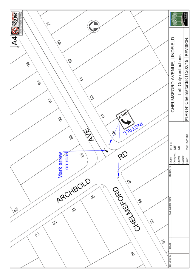
That full time ‘Left
Only’ restrictions be introduced on the eastern leg of Chelmsford Avenue
at Archbold Road.
GB.7 Park Avenue,
Roseville
File: TM8/11
Ward: Roseville
Electorate:
Davidson
To consider the installation of
‘No Stopping 8am-9.30am, 2.30pm-4pm School Days’ restrictions on
the northern side of Park Avenue near Archbold Road.
Recommendation:
That ‘No Stopping 8am-9.30am
School Days’ restrictions be installed on the northern side of Park
Avenue near Archbold Road.
GB.8 Ortona
Road, Lindfield
File: TM6/11
Ward: Roseville
Electorate: Davidson
To
consider the installation of ‘No Stopping’ restrictions on all four
legs of the intersection of Ortona Road and Eton Road, Lindfield.
Recommendation:
That ‘No Stopping’
restrictions be installed on all four legs of the intersection of Ortona Road
and Eton Road, Lindfield.
GB.9 Acron
Road, St Ives
File: TM9/11
Ward: St Ives
Electorate: Ku-ring-gai
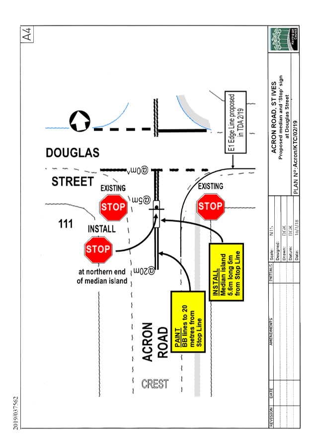
To
consider the installation of a median island and additional ‘Stop’
sign and markings in Acron Road, on the southern side of Douglas Street.
Recommendation:
A. That the BB lines in Acron
Road on the northbound approach to Douglas Street, St Ives, be extended
to a distance of 20 metres south of Douglas Street, as shown in Plan No.
Acron/KTC/02/19.
B. That a short median island be
installed in Acron Road, five metres south of Douglas Street, as shown in Plan
No. Acron/KTC/02/19, with an additional ‘Stop’ sign mounted in the
median.
C. That Mr S
Schaefer, of 50 Hayle Street, St Ives, be informed of Council’s decision.
General Discussion
Member for
Davidson
1.
Intersection of Balfour Street & Pacific Highway, Lindfield.
2.
Intersection of Tryon Road and Lindfield Avenue, Lindfield.
3.
Intersection of Pacific Highway and Beaconsfield Parade, Lindfield.
4. Archbold Road at
Owen Street, Roseville/Lindfield.
** ** ** ** ** **
|
Ku-ring-gai
Traffic Committee - 28 February 2019
|
GB.1 / 5
|
|
|
|
|
Item
GB.1
|
S02527
|
General Matter - Traffic & Transport
Policy
Ward: None
Electorate: None
EXECUTIVE
SUMMARY
|
PURPOSE OF REPORT:
|
To update
Council’s Traffic & Transport Policy, which was last updated
in 2015
|
|
|
|
|
background:
|
Council has a Traffic & Transport Policy, which is
regularly updated. The policy provides a strategic framework to assist
in dealing with traffic and transport issues. Updates are proposed to
reflect new policies and other State and Council changes.
|
|
|
|
|
comments:
|
Some minor changes are proposed, as works on the
Northconnex have commenced since the most recent update. Several other
minor changes are proposed.
|
|
|
|
|
recommendation:
|
That the updated Traffic
and Transport Policy be adopted.
|
Purpose of Report
To update Council’s Traffic & Transport Policy,
which was last updated in 2015
Background
In March 2015, Council released its most recent update of
its Traffic & Transport Policy. Regular updates to the policy
are made approximately every 3 years in order to keep up with changes to
practice, and any new strategies adopted by Council during that time.
Comments
Council’s Traffic and Transport Policy is an important
strategic document, guiding many of Council’s decision and practices
regarding on-road and related issues. This document is not intended to be
prescriptive nor address other issues.
A number of editing and other changes are proposed.
Significant changes include;
· Policy
Scope – In the 4th paragraph, reference is made to the
proposed construction of a tunnel linking the M1 Motorway to the M2. This
will be altered to note that the NorthConnex tunnel linking the M1 and M2
Motorway’s is currently under construction, and is due to open in 2020.
Reference is also made to the proposal by the RMS to improve the capacity of
the Pacific Highway as part of its Pinch Points and Clearways Programs.
· Policy
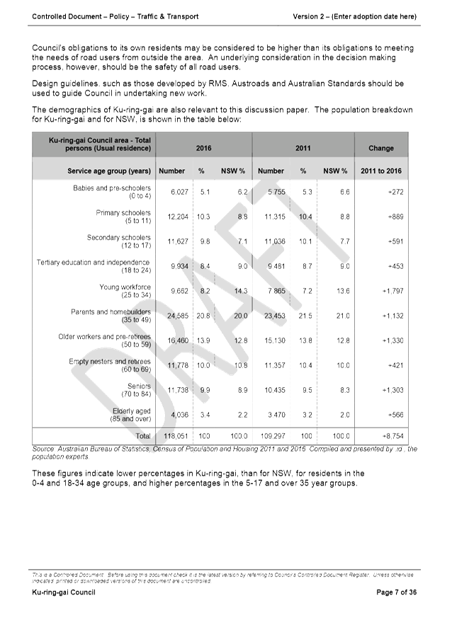
Responsibilities – Demographic data is changed, based on ABS 2016
Census QuickStats available for Ku-ring-gai.
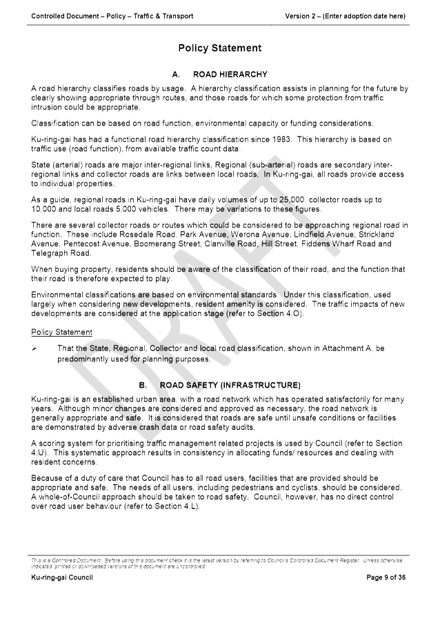
· Road Hierarchy
(Section A) – Telegraph Road has been added to the list of collector
roads which could be considered to be approaching regional road in function.
· Traffic Calming
(Section E) – Although it is not Council policy to install new speed
humps or raised thresholds, speed cushions may be considered on approaches to
intersections, including roundabouts. Speed cushions may also be
considered at mid-block locations that are not adjacent to residential
properties.
Council has been in
practice of using rumble bars at intersections and at mid-block locations where
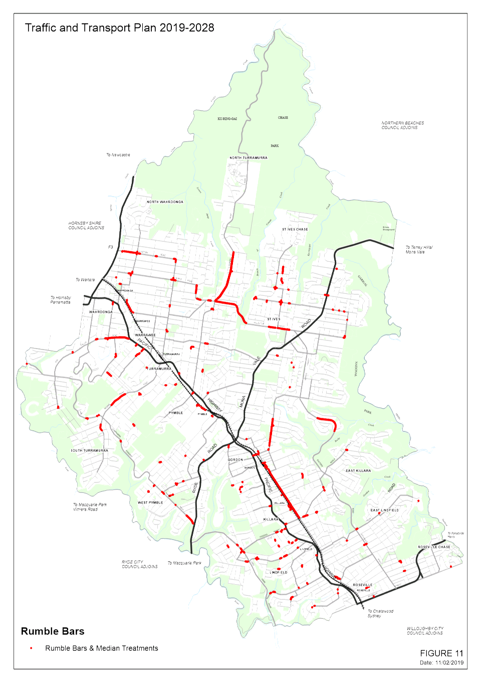
there are no adjacent residential properties. The continued use of this traffic
device is now proposed to be included in the revised Traffic & Transport Policy.
· Traffic
Facilities (Signs and Lines) (Section F) - The first paragraph has been
amended to discuss Council’s proposal to replace existing street name and
community signs with anew design.
At the Council Meeting
of 18 June 2015 Council resolved to amend the eligibility requirements for
‘No Parking’ restrictions outside multi-residential developments,
so that developments on roads with over 2,000 vehicles per day would be
eligible.
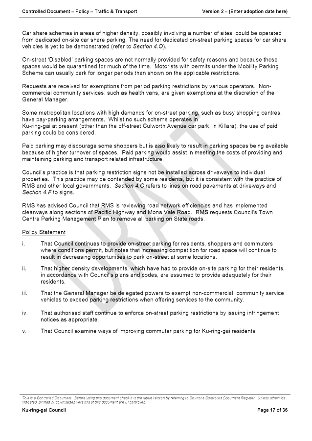
· On-Street
Parking (Section G) – The final paragraph refers to the RMS considering
implementing Clearway restrictions along Pacific Highway and possibly on other
State Roads. In 2018 the RMS implemented Clearway restrictions on
sections of Mona Vale Road and Pacific Highway.
· Council
Controlled Car Parks (Section H) – Council will carry out a risk
assessment of 90 degree parking adjacent to footpaths in its car parks, in
relation to pedestrian safety.
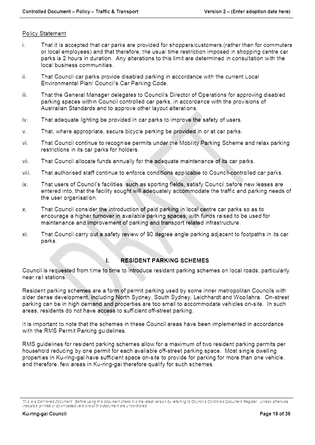
· Resident
Parking Schemes (Section I) - Additional information has been
provided regarding the feasibility of providing permits allowing Ku-ring-gai
residents to park for extended periods in commuter car parks.
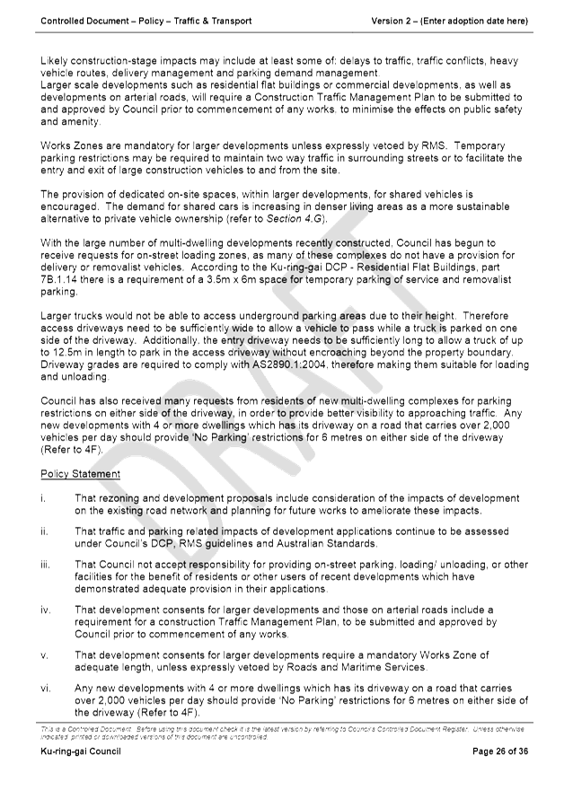
· Heavy Vehicles
(Section N) – This has been amended as S112 of the Roads Act has been
repealed. Under Heavy Vehicle National Law (HVNL) introduced in February
2014, Council is the Road Manager for roads under its control to provide access
permits for vehicle larger than general access.
· Development
Proposals (Section O) – Comment has been added regarding provision
for larger delivery vehicles to be able to load and unload in the access
driveway to multi-dwelling residences, without restricting driveway access for
residents.
It is also recommended
that new developments with 4 or more dwellings which has its driveway on a road
that carries over 2,000 vehicles per day should provide ‘No
Parking’ restrictions for 6 metres on either side of the driveway.
· Special
Events/Planned Disruptions to Traffic (Section Q) – The 2nd
last paragraph was removed, as DCP 46 is no longer relevant.
· State Roads and
Other State Responsibilities (Section R) – Comments have been updated
to note that the NorthConnex is now under construction and is due for
completion in 2020.
Additions to the updated draft policy document (attached),
other than minor editing changes, are highlighted.
It is proposed that this policy be reviewed and updated at
intervals of about three years.
While this item is not a formal Ku-ring-gai Traffic
Committee item, as it does not relate to Roads and Maritime Services
delegations to Council, it is referred to this Committee as part of the
consultative process.
Financial
Considerations
There are no direct financial implications in adopting the
proposed policy changes. The policy gives strategic direction to the
organisation and the community in relation to traffic and transport issues.
Community
Consultation
The policy refers to consultations to be undertaken by
Council when proposing changes to facilities.
Referring this policy review to the Ku-ring-gai Traffic
Committee as an informal item provides opportunities for further consultation
and feedback.
Internal Consultation
Consultation was carried out
with the Development & Assessment Services Manager and Team Leader
Development Engineer, regarding the amendments to Section 4.O Development
Proposals.
Summary
Council’s Traffic and Transport Policy was last
updated in 2015. A number of minor changes are recommended.
|
Recommendation:
That the updated Traffic and Transport Policy be adopted.
|
|
Michael Foskett
Team Leader Traffic
|
Deva Thevaraja
Manager Traffic & Transport
|
|
George Bounassif
Director Operations
|
|
|
Attachments:
|
A1 ⇩ ⇩
|
Traffic
and Transport Policy - Version 2 - DRAFT
|
|
2019/045082
|
|
APPENDIX No: 1 - Traffic and
Transport Policy - Version 2 - DRAFT
|
|
Item No: GB.1
|


|
Ku-ring-gai
Traffic Committee - 28 February 2019
|
GB.2 / 45
|
|
|
|
|
Item
GB.2
|
S02527
|
General Matter - 10 Year Traffic and
Transport Plan - Update
Ward: None
Electorate: None
EXECUTIVE
SUMMARY
|
purpose of report:
|
To consider adoption of the updated 10 Year Traffic
and Transport Plan.
|
|
|
|
|
background:
|
An objective in Council’s current Delivery
Program is the implementation of the 10 Year Traffic and Transport
Plan.
The inaugural 10 year Traffic and Transport Plan was
developed and adopted by Council in 2011. Since its adoption, the Plan has
formed the basis for future funding allocations and implementation in a
transparent way.
Due to updates in the ranking of sites identified for
traffic management works, new data and revised priorities resulting from
Council’s major urban renewal projects, the need to revise the plan has
come about.
|
|
|
|
|
comments:
|
While this plan shows Council’s updated
priorities and the basis for those priorities, actual projects undertaken
will still depend in some cases, on funding from external sources and Council
exercising discretion, where there has been previous commitment.
Priorities may also change, as traffic and other data changes over time.
It is proposed to continue to update this plan
approximately every five years, as priority rankings and traffic data are
updated.
|
|
|
|
|
recommendation:
|
That the draft 2019-2028 Traffic and Transport Plan be
adopted by Council.
|
Purpose of Report
To consider adoption of the updated 10 Year Traffic and
Transport Plan.
Background
The 10 year Traffic and
Transport Plan document links Council’s policies, data which has been
collected, as well as outcomes of our studies and local centres
proposals. It is useful to many sections of the Ku-ring-gai community and
includes the rationale for proposing and prioritising traffic management works
for a 10 year period.
Due to changes in the ranking
for sites, new data and revised priorities resulting from Council’s major
urban renewal projects, the need to revise the plan has come about.
While this plan shows
Council’s priorities and the basis for those priorities, actual projects
undertaken will still depend in some cases, on funding from external sources
and Council exercising discretion, where there has been previous commitment.
Priorities may also change, as traffic data changes over time.
It is proposed to continue to
update this plan approximately every five years, as priority rankings and
traffic data are updated.
Comments
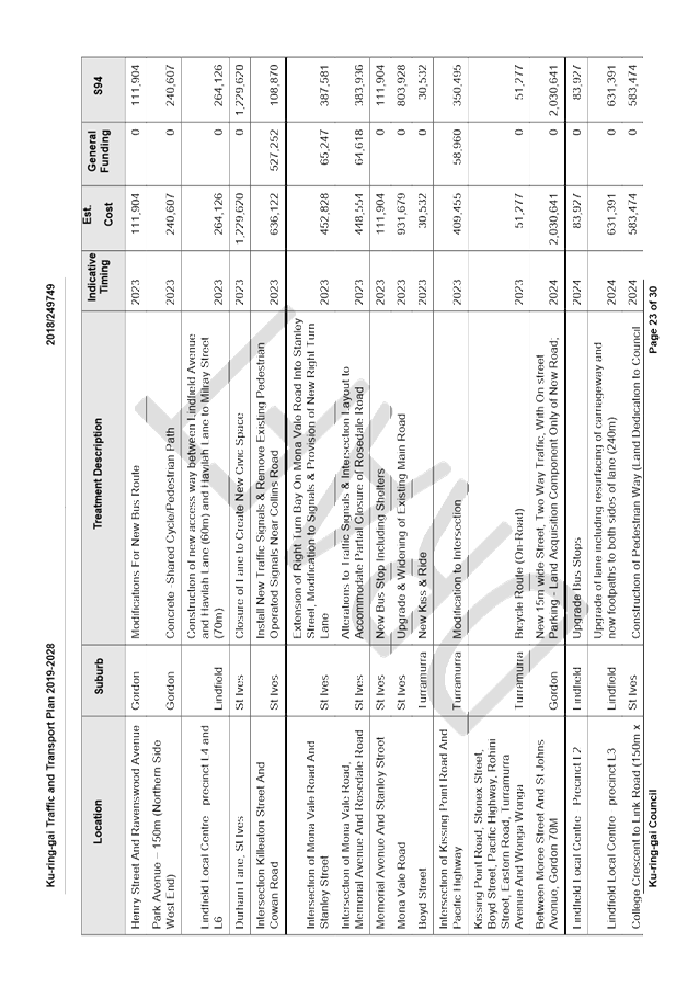
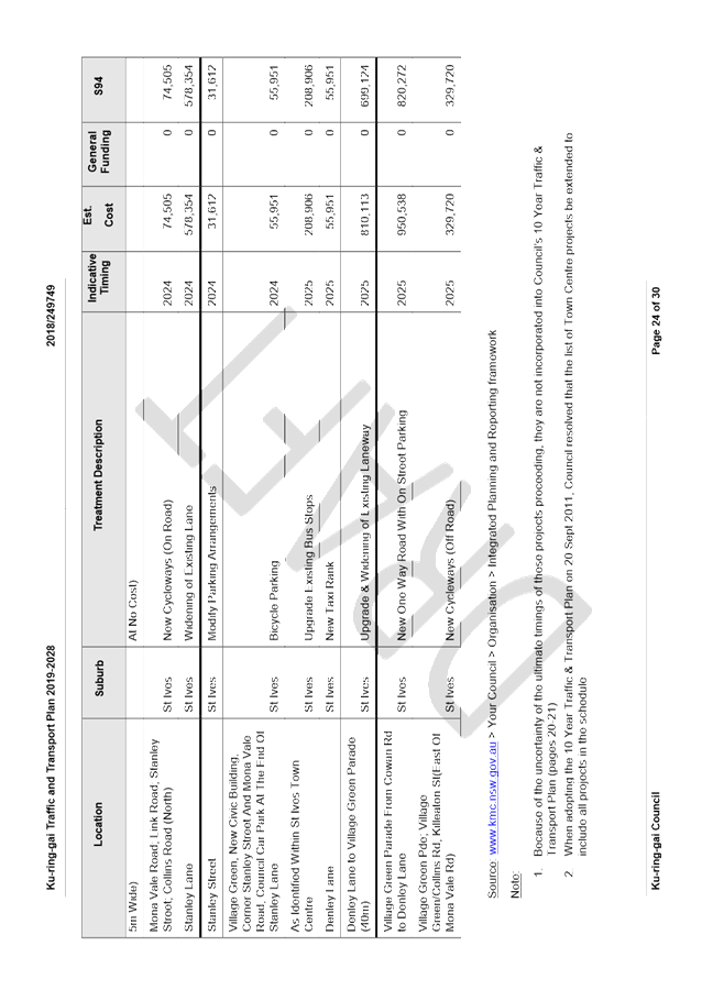
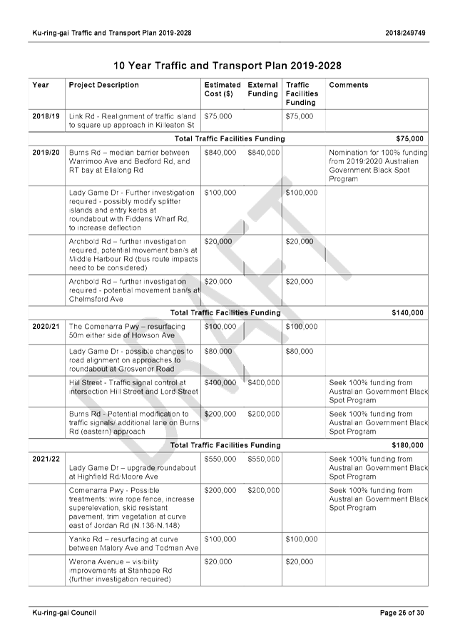
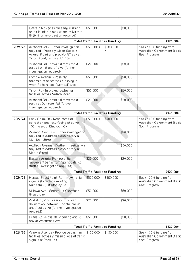
All parts of the current 10 year Traffic and Transport Plan
were revised to reflect updated local state and federal administrational
issues. The sections receiving the most focus include:
· Strategic
Context;
· Funding;
· Ranked
Projects and Project Funding in Individual Programs;
· 10 Year
Traffic and Transport Plan; and
· Attachments.
Governance
Matters
Not applicable
Risk
Management
Not applicable
Financial
Considerations
Updating projects and priorities in the 10 year plan will
assist in prioritising and forecasting future projects and their expenditure. The
updated plan will continue to assist with determining future traffic management
works.
Social
Considerations
Not applicable
Environmental
Considerations
Not applicable
Community
Consultation
No community consultation has been undertaken in the preparation
of this plan. However, the information to be provided in the plan will
inform the community regarding traffic and safety issues and proposed future
funding and programs that are based on criteria adopted by Council.
Internal
Consultation
Discussions have been held between Traffic Operations staff
and Strategy & Environment Department staff in the preparation of the Plan.
Summary
The inaugural 10 year Traffic and Transport Plan was developed
and adopted by Council in 2011. Since its adoption, the Plan has formed the
basis for future funding allocations and implementation in a transparent way.
Due to updates in the ranking of sites identified for
traffic management works, new data and revised priorities resulting from
Council’s major urban renewal projects, the need to revise the plan has
come about.
While this plan shows Council’s updated priorities and
the basis for those priorities, actual projects undertaken will still depend in
some cases, on funding from external sources and Council exercising discretion,
where there has been previous commitment. Priorities may also change, as
traffic and other data changes over time.
|
Recommendation:
That the draft 2019-2028 Traffic and Transport Plan be
adopted by Council.
|
|
Joseph Piccoli
Strategic Traffic Engineer
|
Deva Thevaraja
Manager Traffic & Transport
|
|
George Bounassif
Director Operations
|
|
|
Attachments:
|
A1⇩
|
DRAFT
Traffic & Transport Plan 2019-2028
|
|
2018/249749
|
|
|
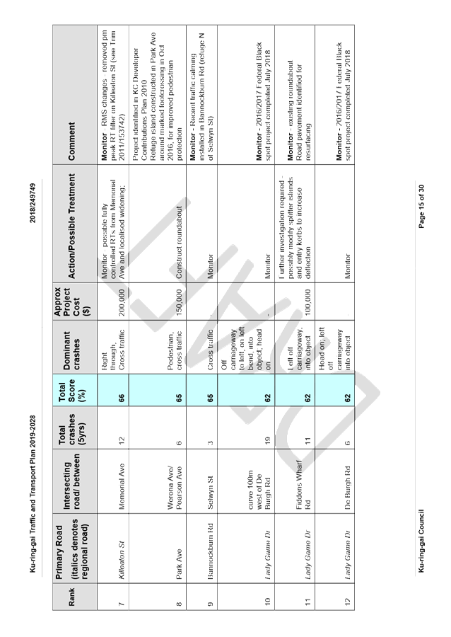
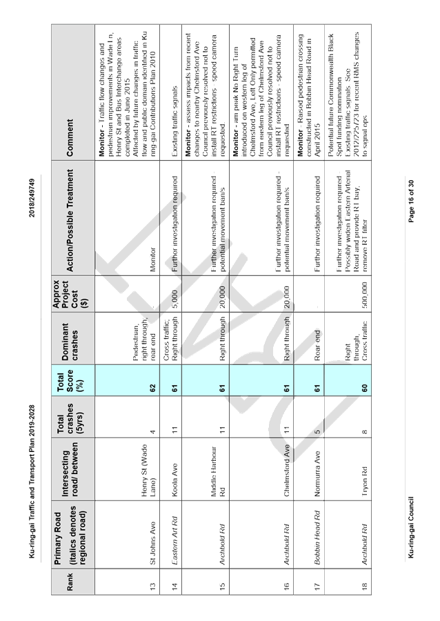
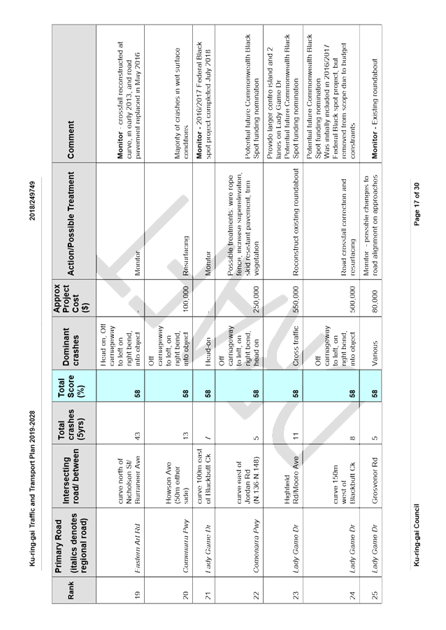
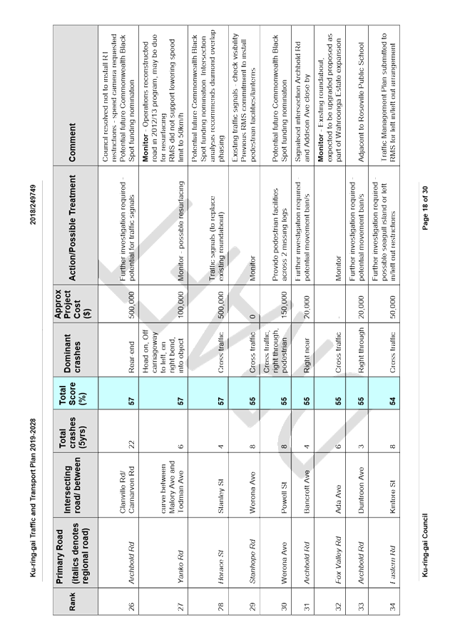
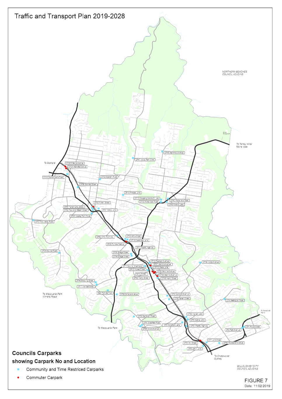
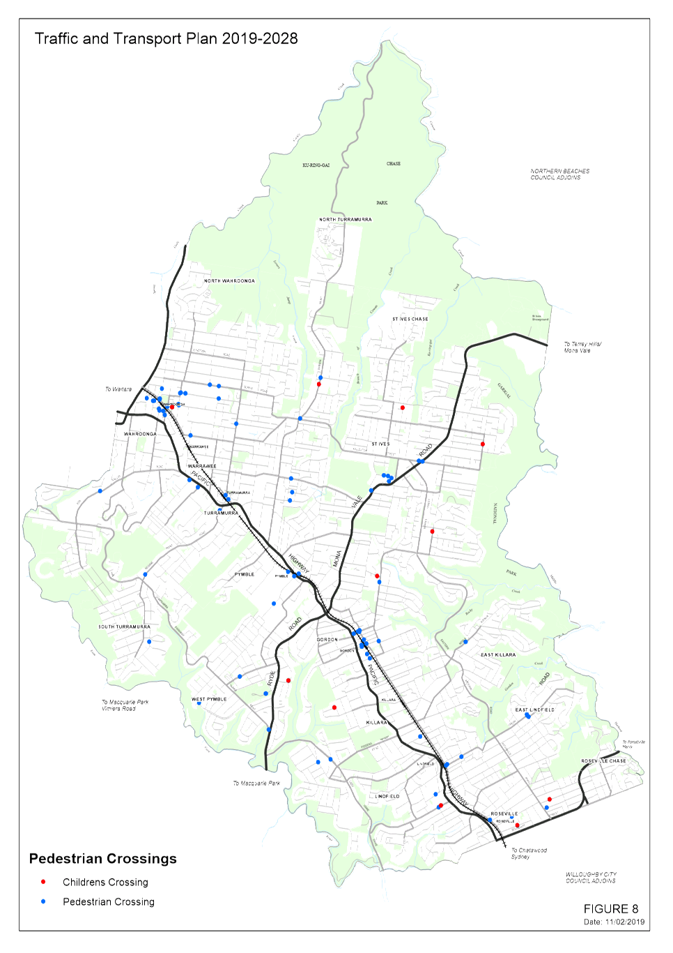
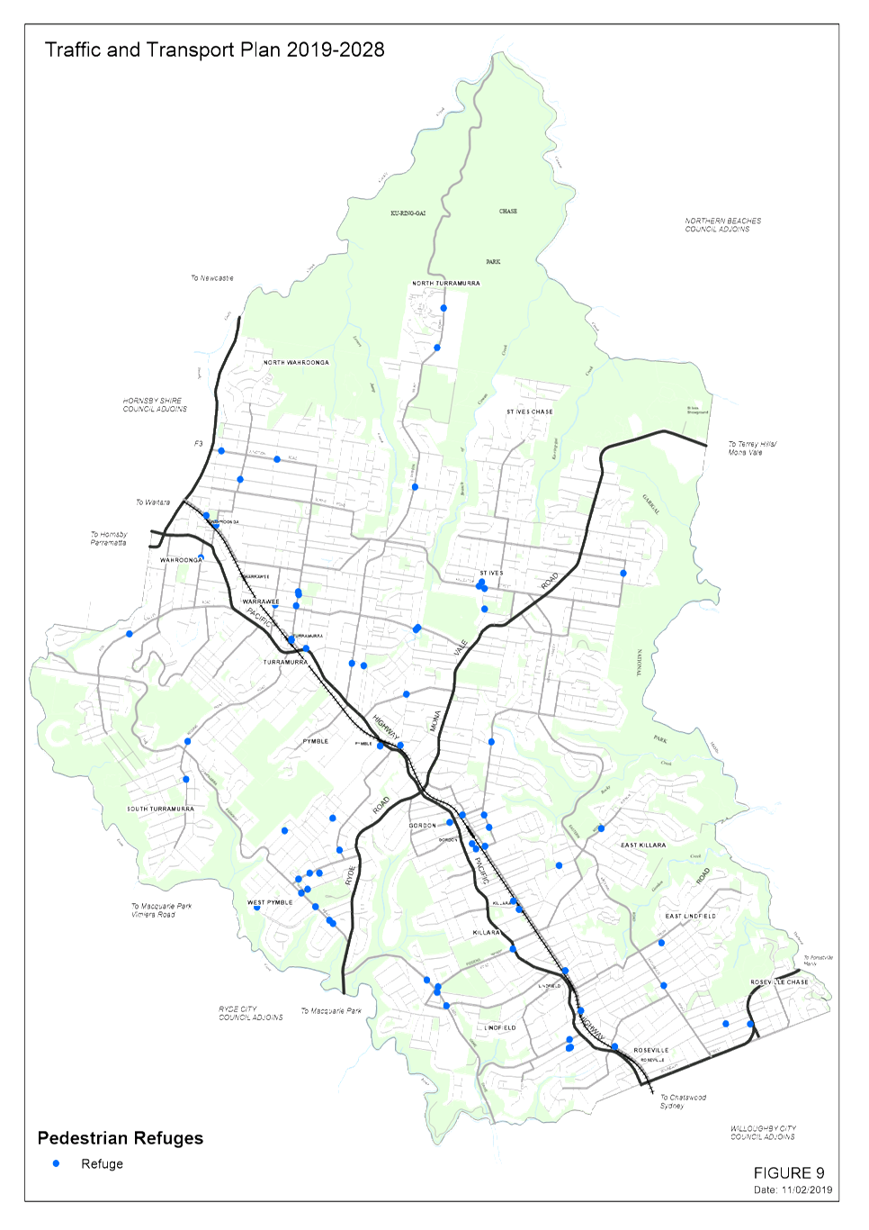
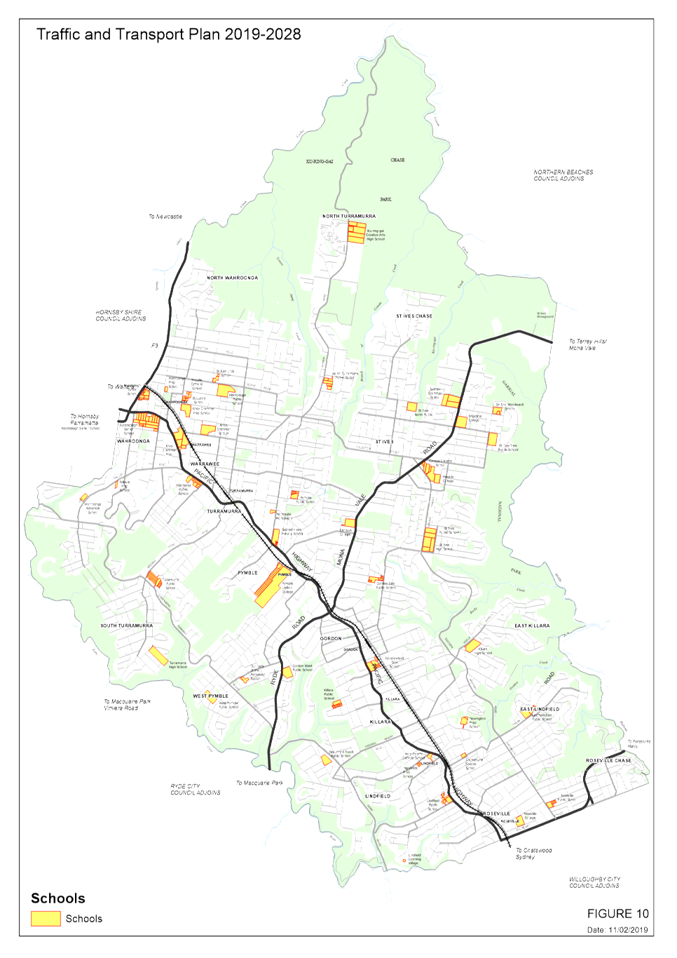
A2⇩
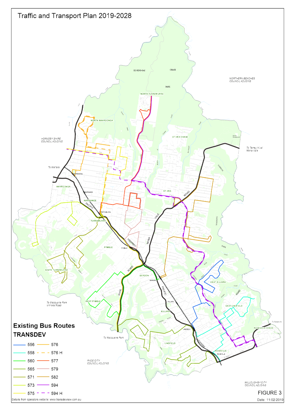
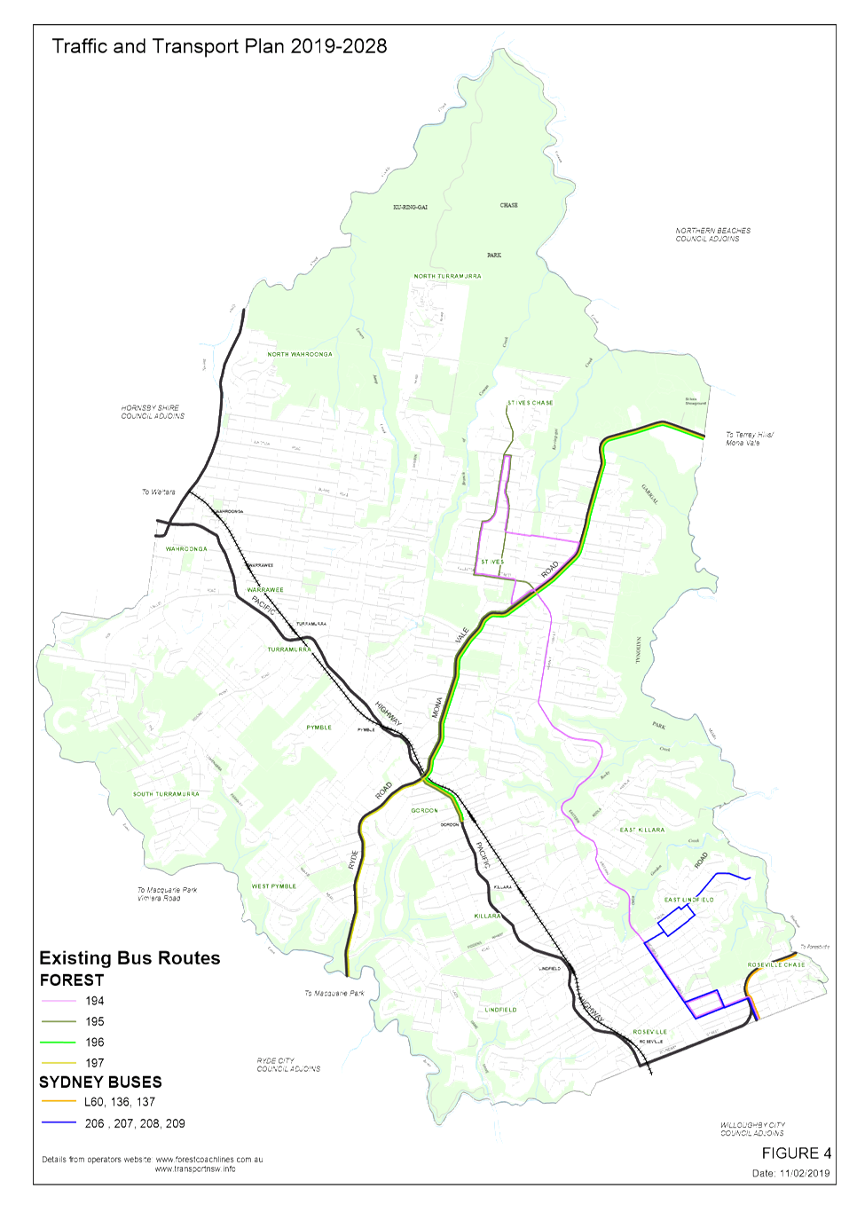
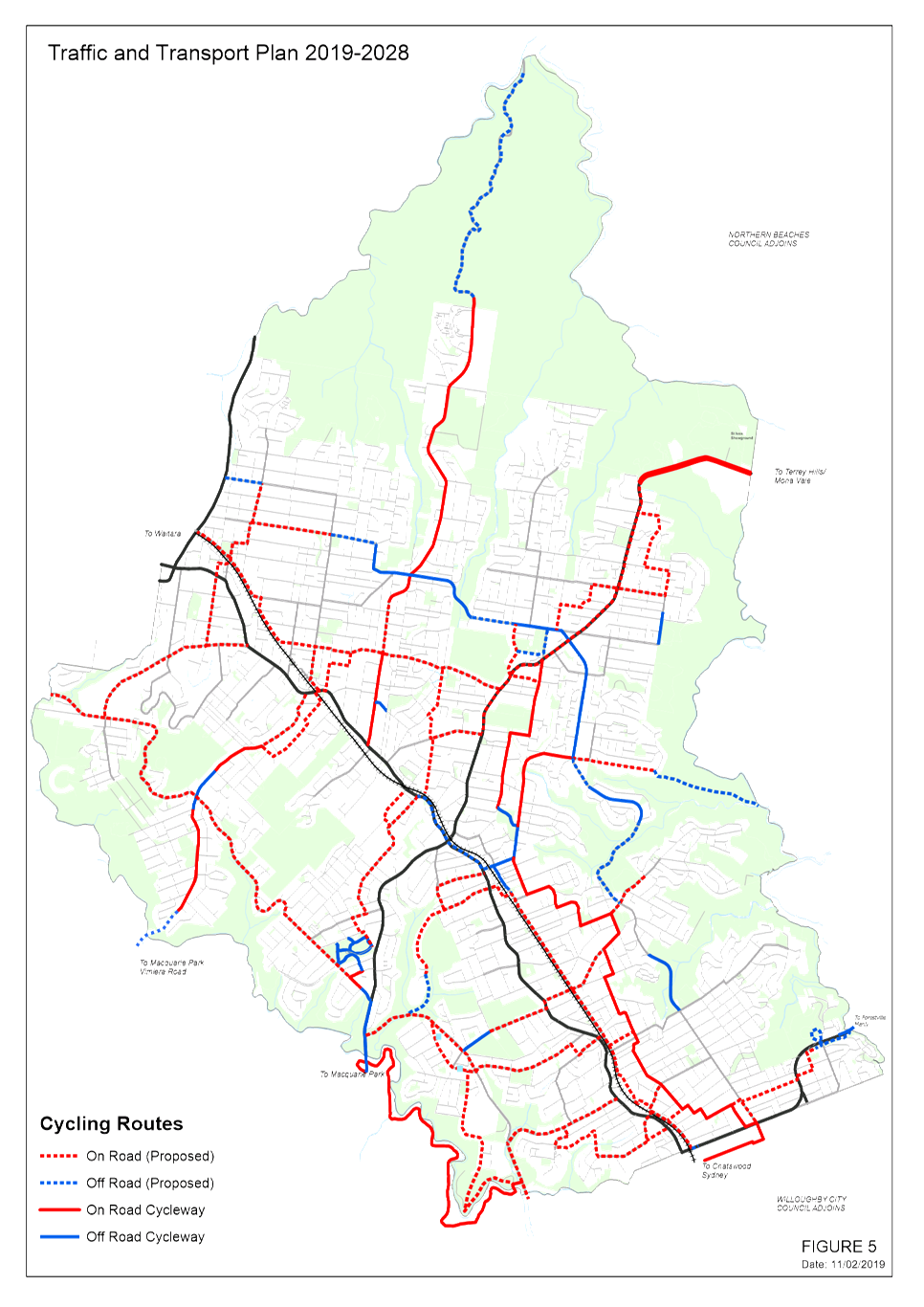
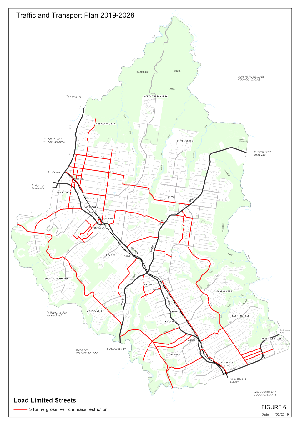
|
10
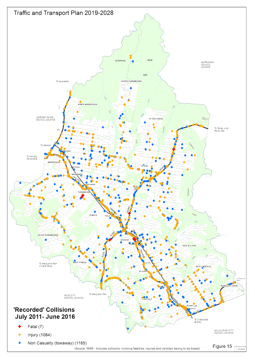
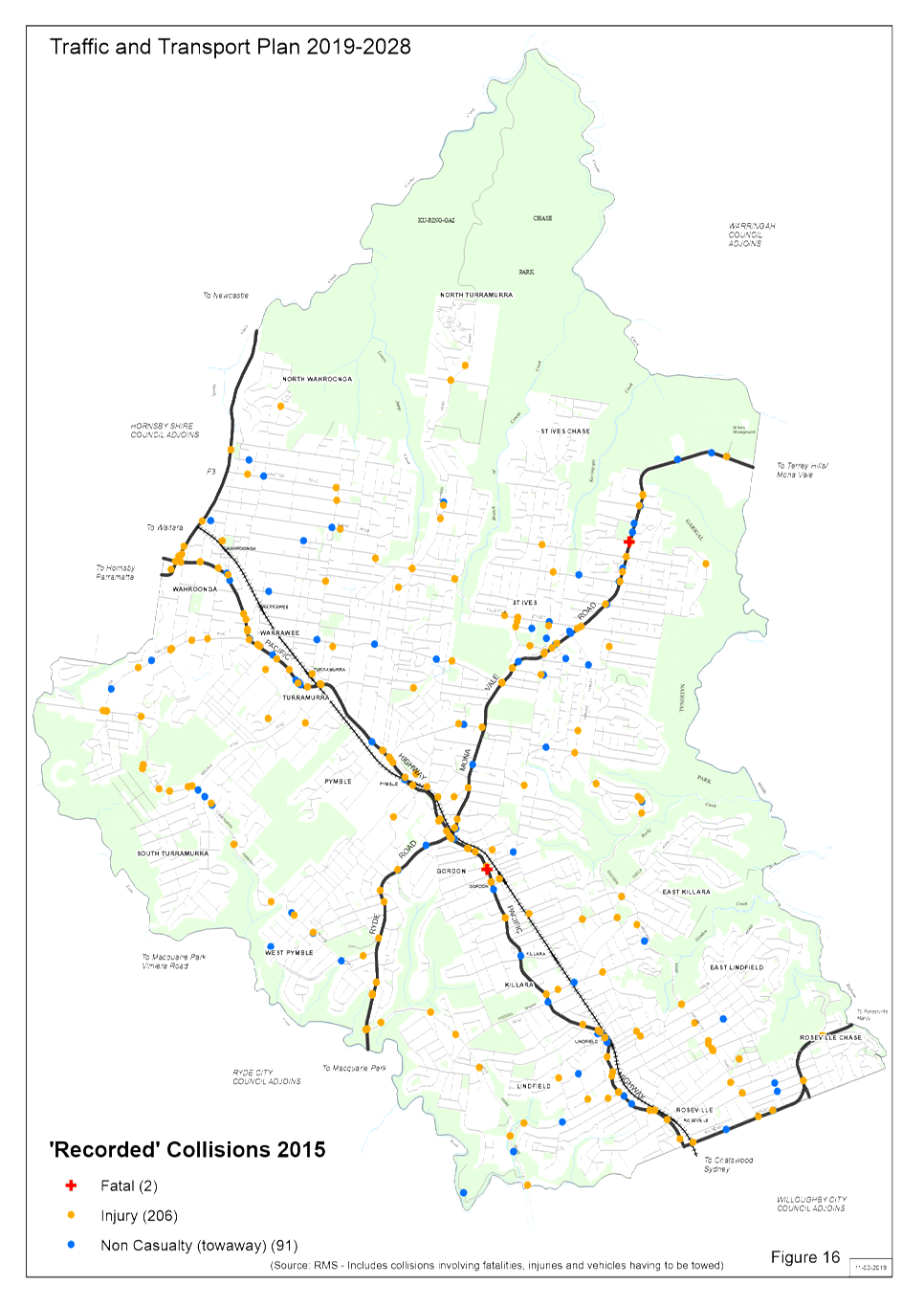
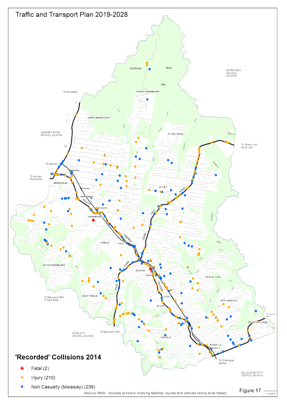
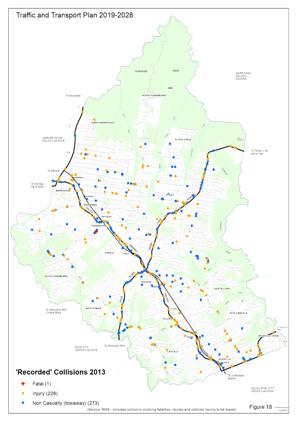
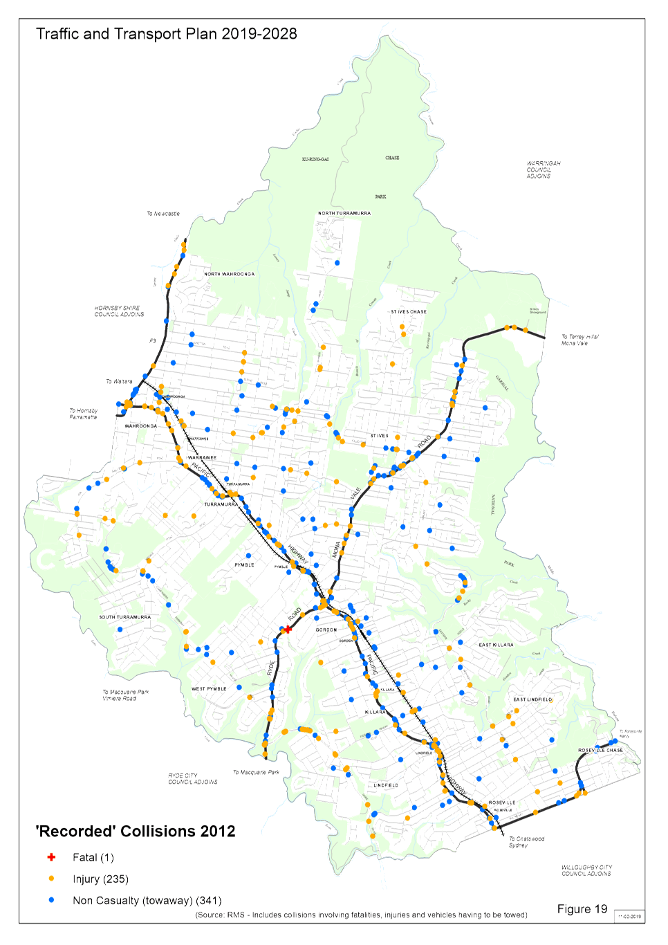
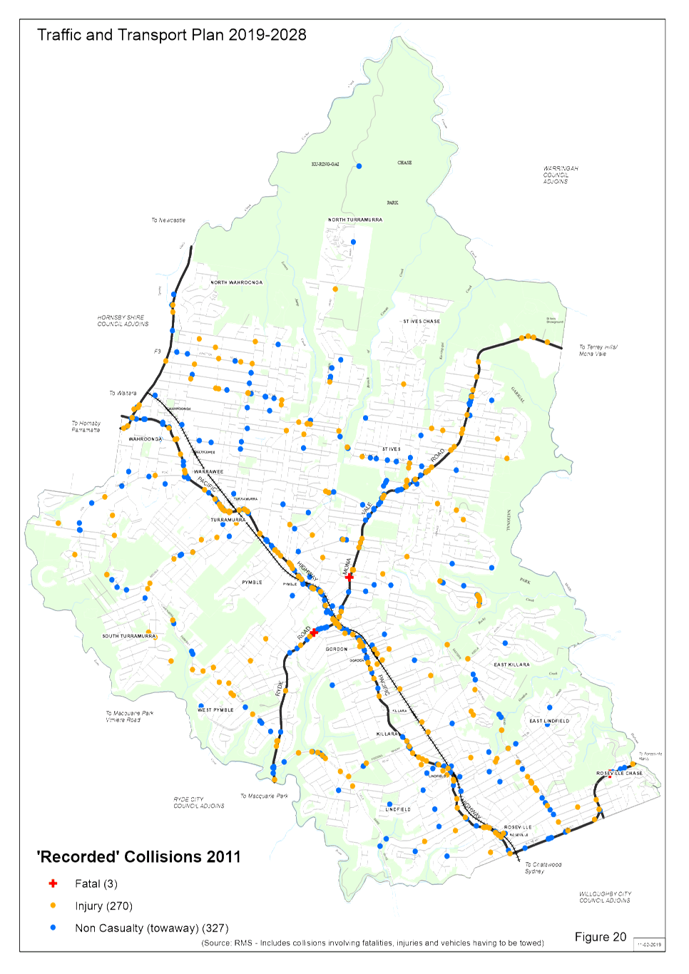
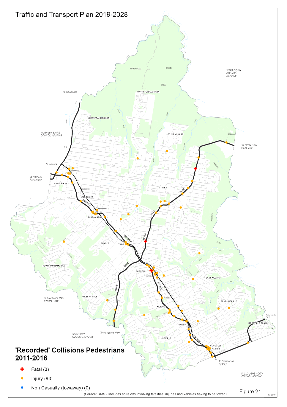
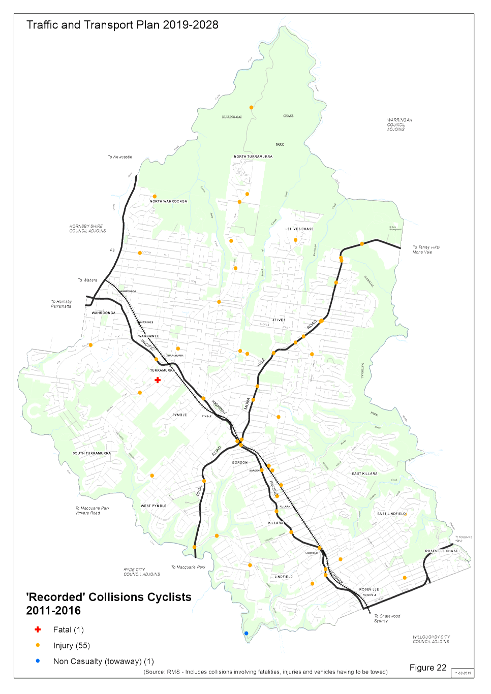
Year Traffic and Transport Plan - 2019-2028 - Figures 1 - 22
|
|
2019/040758
|
|
APPENDIX No: 1 - DRAFT
Traffic & Transport Plan 2019-2028
|
|
Item No: GB.2
|

|
APPENDIX
No: 2 - 10
Year Traffic and Transport Plan - 2019-2028 - Figures 1 - 22
|
|
Item No: GB.2
|

|
Ku-ring-gai
Traffic Committee - 28 February 2019
|
GB.3 / 100
|
|
|
|
|
Item
GB.3
|
TM11/11
|
Ward: Wahroonga
Electorate: Ku-ring-gai
EXECUTIVE
SUMMARY
|
purpose of report:
|
To consider the installation of traffic calming
devices along Roland Avenue, Wahroonga.
|
|
|
|
|
background:
|
Council has received numerous complaints from local residents
about excessive traffic volumes and speeds using local streets between
Kissing Point Road and Fox Valley Road.
|
|
|
|
|
comments:
|
Traffic counts have indicated that excessive speed is
a problem on Roland Avenue. The counts also indicated a large amount of
non-local traffic using Roland Avenue as part of a route to avoid traffic
congestion on Pacific Highway and The Comenarra Parkway.
|
|
|
|
|
recommendation:
|
That two lane angled slow points be installed at four
locations along Roland Avenue.
|
Purpose of Report
To consider the installation of traffic calming devices
along Roland Avenue, Wahroonga.
Background
Council has received numerous complaints about the speed and
volume of traffic using local roads between Kissing Point Road and Fox Valley
Road. Due to congestion on Pacific Highway and The Comenarra Parkway
during peak periods, many motorists use Roland Avenue and other local streets
as an alternative.
Council has received requests from some local residents
requesting road closures to prevent through traffic between Kissing Point Road
and Fox Valley Road via Monteith Street, Rothwell Road and Roland Avenue.
This matter was considered by Council’s Traffic Committee at its Meeting
on 18 May 2018. The Traffic Committee recommended that Rothwell Road not
be closed at Roland Avenue, as it would severely restrict local residents in
their daily local travel. It would also lead to increased traffic volumes
on adjacent local streets.
Traffic counts were undertaken in August 2018 in Roland
Avenue between Fox Valley Road and the bend. Counts were then undertaken
in October 2018 in Roland Avenue between Berilda Avenue and Monteith Street, as
well as in Mildred Street, Berilda Avenue, Monteith Street and Rothwell
Road. The counts showed that a significant increase in northbound traffic
volumes during the afternoon peak period on both Rothwell Road and Roland
Avenue, compared to other times.
The 85th percentile traffic speed, (the speed at
which 85% of vehicles travel at or below) was found to be 59km/h on Roland
Avenue. This is significantly above the speed limit of 50km/h.
Comments
Council staff investigated possible traffic calming measures
in Roland Avenue and Rothwell Road, in order to reduce speeds and discourage
non-local traffic. It was found that it would not be feasible to
introduce traffic calming measures in Rothwell Road between Finlay Road and
Roland Avenue. This is due to the narrow roadway and changes in grade
which restrict visibility to oncoming vehicles.
Council also has a policy of not installing any new speed
humps on its roads. This is due to complaints about noise, as well as
discomfort to motorists. Instead, horizontal deflection devices in the
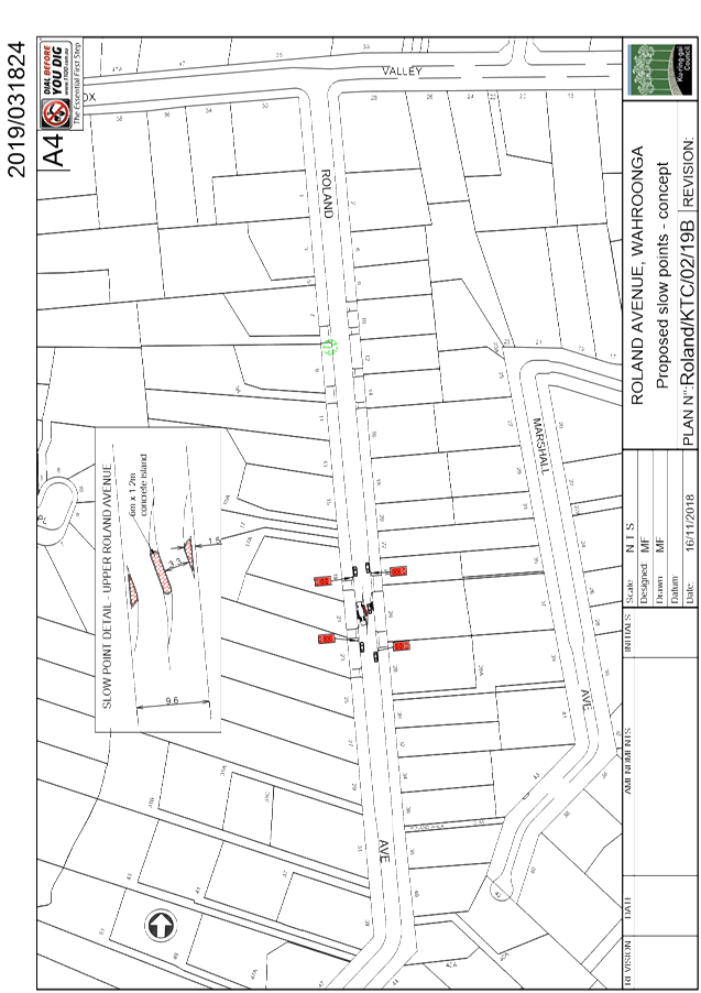
form of angled slow points are being proposed at five locations along Roland
Avenue. The slow points would reduce traffic speeds and discourage
through traffic, while imposing minimal inconvenience on local residents.
They would however, result in the loss of several on-street parking spaces.
Under the proposal, one slow point would be installed in
Roland Avenue between Fox Valley Road and the bend. Another three devices
would be installed between Mildred Street and Rothwell Road. The devices
would be two lane angled slow points, as it was considered that traffic volumes
were too high for single lane slow points.
Similar devices were installed at two locations in Grosvenor
Road, Lindfield several years ago. From observation, these devices appear
to be effective in reducing vehicle speeds to approximately 40km/h as they pass
through them. There is no record of any complaints about these devices.
The RMS is proposing to make improvements to traffic flow on
Pacific Highway between Turramurra and the start of the M1 Motorway, as part of
its Pinch Points Program. These works would involve widening Pacific
Highway to three lanes in each direction between Kissing Point Road and the
start of the M1 Motorway. These improvements would improve traffic flow
on Pacific Highway, which should have some impact on reducing the amount of
traffic using local streets between Kissing Point Road and Fox Valley Road.
However it is probable that many motorists will continue to
use these local streets to avoid congestion on Pacific Highway and The
Comenarra Parkway. Therefore it is recommended that traffic calming
measures be implemented in Roland Avenue.
Residents of Roland Avenue were consulted for their views on
the proposed slow points. Approximately 110 properties were consulted,
with 58 responses being received. Of those 58 respondents, 34 (59%) were
in favour with 24 (41%) opposed to the slow points. The major concerns
from those opposed to the proposal were loss of on-street parking (10
respondents), and increased noise (5).
Roland Avenue is used as a bus route, and the devices have
been designed to accommodate a 14.5m long bus. However it was noted that
the proposed device outside #9 would need to be modified or not constructed,
due to a tree which has a bent trunk which extends out into the roadway.
Given that seven residents living in close proximity to the location of the
proposed device objected to the proposal, it is recommended that this device
not be constructed.
However it is recommended that detailed designs be prepared
for the other four devices to be constructed, as the majority of residents
supported the proposed slow points.
Community
Consultation
As noted above, residents of
Roland Avenue have been consulted for their views on the proposed slow
points. Approximately 110 properties were consulted, with 58
responses being received. Of those 58 respondents, 34 (59%) were in
favour with 24 (41%) opposed to the slow points
Summary
Council has received complaints
about the speed and volume of traffic using local roads such as Monteith
Street, Rothwell Road and Roland Avenue to avoid traffic congestion on Pacific
Highway and The Comenarra Parkway.
It is proposed that 2 lane angled
slow points be installed at four locations along Roland Avenue in order to
reduce traffic speeds and discourage non-local traffic.
|
Recommendation:
That a detailed design be carried out for two lane angled
slow points at four locations along Roland Avenue, as shown in Plan Roland/KTC/02/19.
|
|
Michael Foskett
Team Leader Traffic
|
Deva Thevaraja
Manager Traffic & Transport
|
|
George Bounassif
Director Operations
|
|
|
Attachments:
|
A1 ⇩ ⇩
|
Plan
No. Roland/KTC/02/19 A&B
|
|
2019/031824
|
|
APPENDIX No: 1 - Plan No.
Roland/KTC/02/19 A&B
|
|
Item No: GB.3
|

|
Ku-ring-gai
Traffic Committee - 28 February 2019
|
GB.4 / 106
|
|
|
|
|
Item
GB.4
|
TM9/11
|
Link Road/Stanley Street/Horace Street,
St Ives
Ward: St Ives
Electorate: Davidson
EXECUTIVE
SUMMARY
|
purpose of report:
|
To consider the replacement of the roundabout at the
intersection of Horace Street, Link Road and Stanley Street with traffic
signals.
|
|
|
|
|
background:
|
Concerns have previously been raised about pedestrian
safety at this intersection.
At the Traffic Committee Meeting of 20 November 2017
it was recommended;
That Council carry out an assessment of the
intersection of Horace Street, Link Road and Stanley Street, St Ives, at
Council’s expense, to determine the feasibility of replacing the
roundabout with traffic lights, and submit the results, if warranted, to RMS
for its approval in principle.
|
|
|
|
|
comments:
|
Council engaged traffic consultants TAR Technologies
to carry out an assessment on the feasibility of replacing the roundabout
with traffic signals. The study found that traffic signals would lead
to increased delay times at the intersection. However the signalised
intersection would perform to a satisfactory level and improve pedestrian
safety.
|
|
|
|
|
recommendation:
|
That Council seek funding from the RMS to replace the
existing roundabout with traffic signals.
|
Purpose of Report
To consider the replacement of the roundabout at the
intersection of Horace Street, Link Road and Stanley Street with traffic
signals.
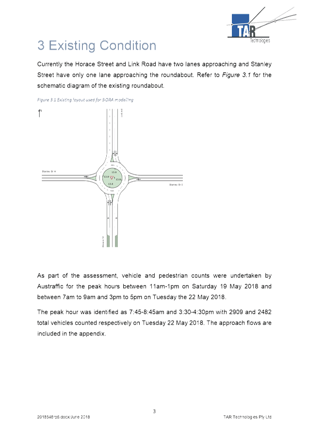
Background
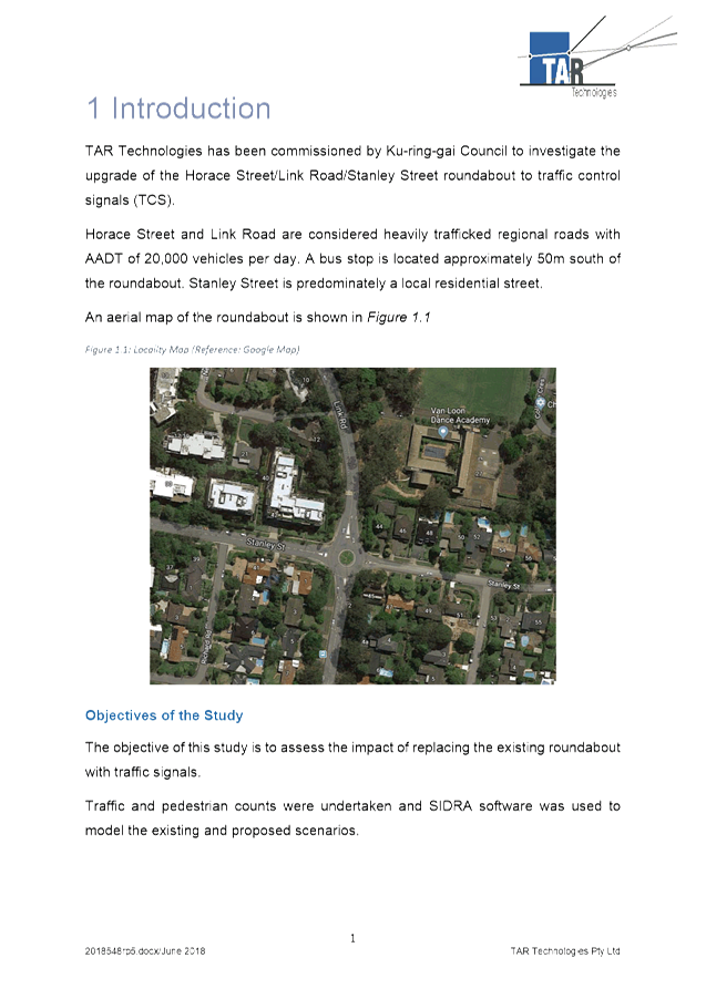
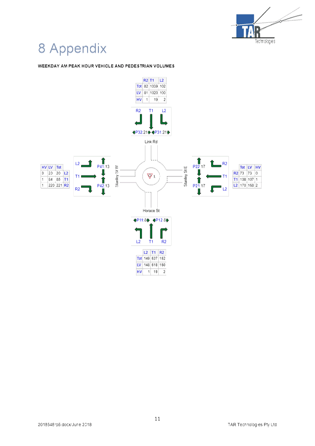
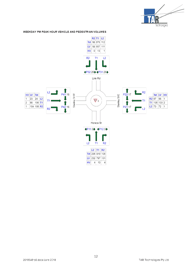
In 2017 the then Councillor Citer raised concerns about
pedestrian safety when crossing Link Road at the roundabout intersection with
Horace Street and Stanley Street. He raised concerns in particular about
the safety of students attending nearby Masada College. There are also
bus stops on both sides of Horace Street to the south of the roundabout, and it
is currently difficult for pedestrians to cross Horace Street.
Council’s crash data shows that there have been three
recorded crashes at the roundabout during the 5 year period to the end of June
2018. None of these crashes involved pedestrians. The number of
pedestrians crossing Link Road and Horace Street at this intersection is low,
as many pedestrians do not feel safe crossing the road in the vicinity of the
roundabout.
It was considered that traffic signals would improve
pedestrian safety, however there were concerns about the impact that traffic
signals would have on traffic flow.
This matter was considered by the Ku-ring-gai Traffic
Committee at its Meeting of 20 November 2017, where it was resolved;
That Council carry out an
assessment of the intersection of Horace Street, Link Road and Stanley Street,
St Ives, at Council’s expense, to determine the feasibility of replacing
the roundabout with traffic lights, and submit the results, if warranted, to
RMS for its approval in principle.
Comments
In May 2018 Council engaged traffic consultants TAR
Technologies to undertake a traffic study to determine the feasibility of
replacing the roundabout with traffic signals. The report was completed
in June 2018, and a copy of the report is attached.
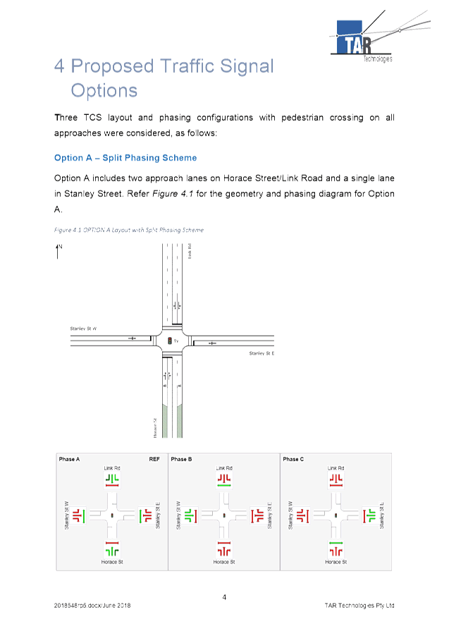
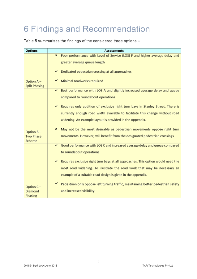
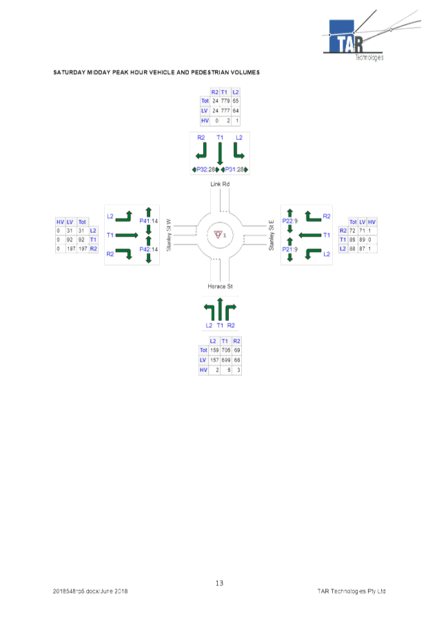
The study looked at three options for signalised phasing at
the intersection. The first option was for split phasing, where each leg
of Stanley Street would have a separate phase. This would be the cheapest
of the three options as it would not require any road widening. However
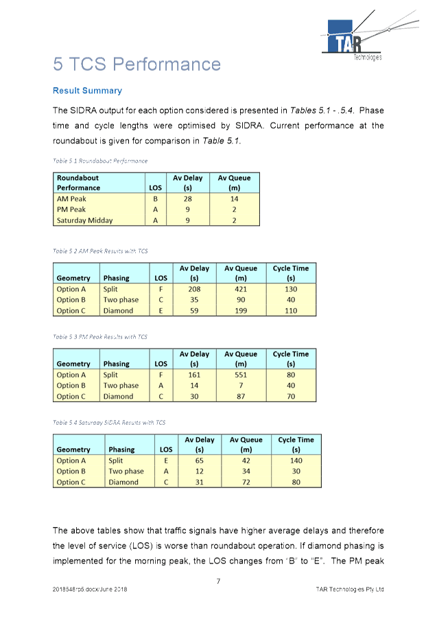
modelling using the SIDRA program showed that this option would lead to major
delays and queue lengths.
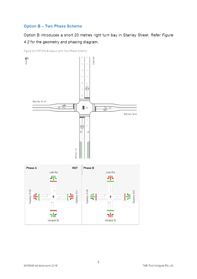
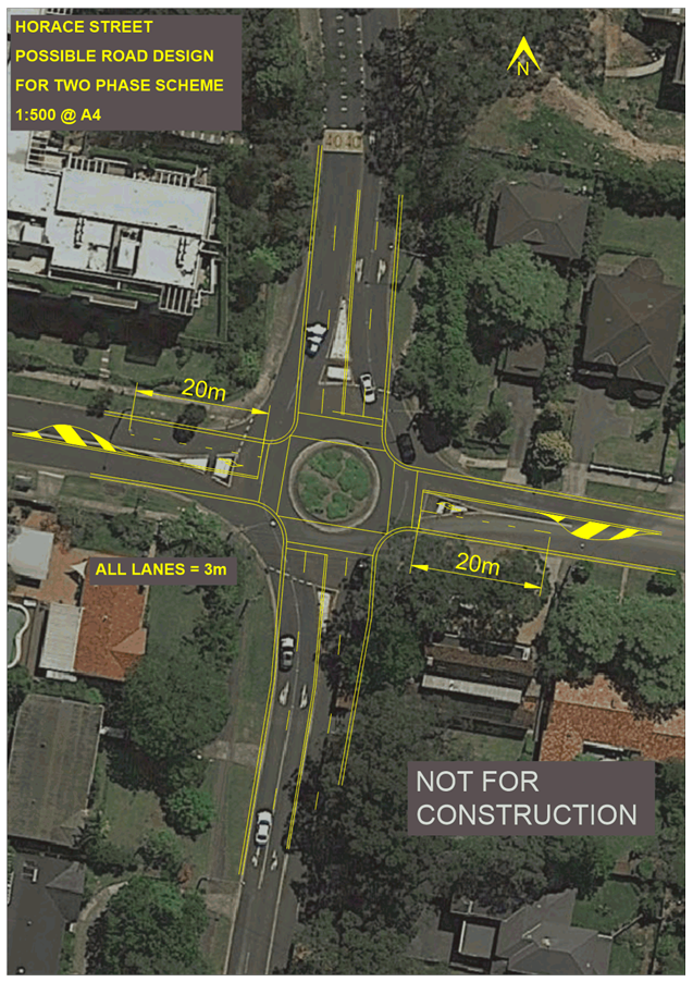
The 2nd option was for a 2 phase system, where
there would be a single phase for both legs of Stanley Street. This would
require some road widening in Stanley Street to accommodate short right turn
bays on both legs. This option provided the best performance in terms of
delay times and queue lengths. However it was not the most desirable
option in terms of pedestrian safety, as pedestrian movements would oppose
right turn movements.
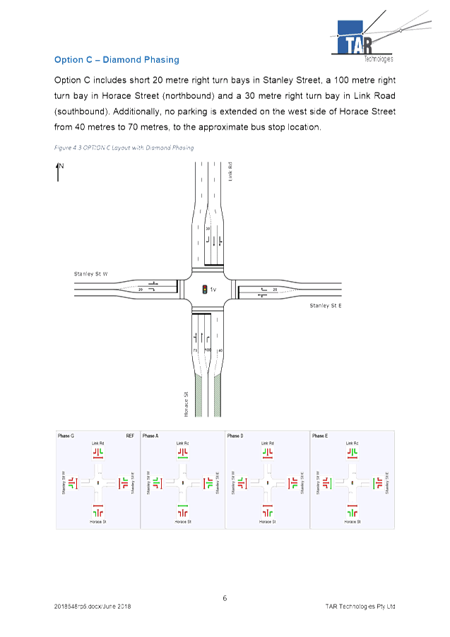
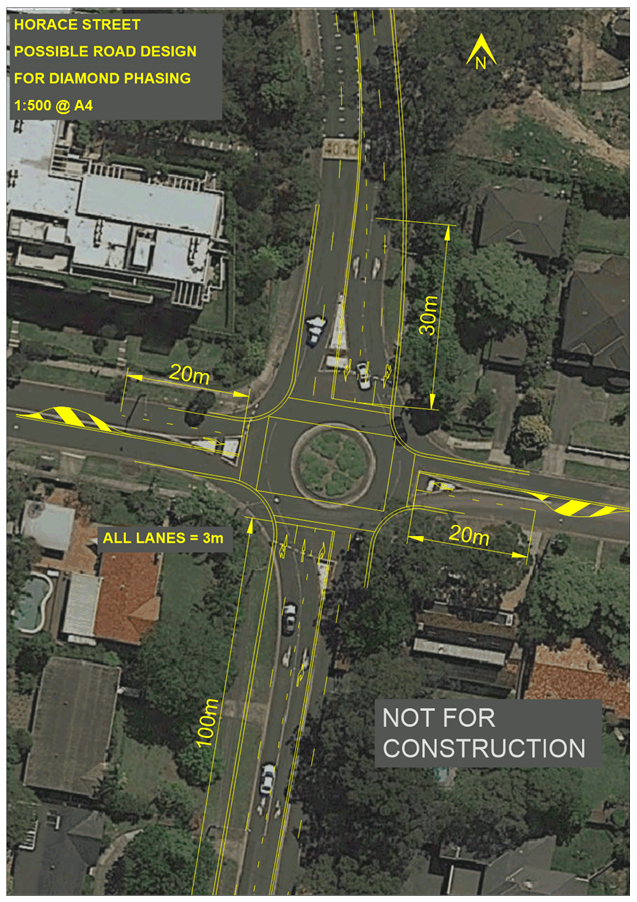
The 3rd option was for diamond phasing, which
would provide dedicated phases for right turn movements. This would be
the most expensive of the 3 options, as it would require road widening on all
four legs to accommodate the right turn bays. This option would provide
reasonable performance in terms of queue lengths and delays, but would be the
most desirable in terms of safety for motorists and pedestrians.
The study found that traffic signals would lead to increased
queue lengths and longer delays at the intersection. However, the
signalised intersection would still operate at a satisfactory standard, and
would improve safety for pedestrians. Therefore, it is recommended that
Council seek funding opportunities to replace the roundabout with traffic
signals, as per the 3rd option listed in the traffic study.
Financial
Considerations
The cost of replacing the roundabout with traffic signals
would be in the region of $1 million. Therefore, Council would need to
seek funding from the RMS to complete these works.
Summary
Council engaged traffic consultants TAR Technologies to
carry out an assessment on the feasibility of replacing the roundabout with
traffic signals. The study found that traffic signals would lead to
increased delay times at the intersection. However the signalised
intersection would perform to a satisfactory level and improve pedestrian
safety.
Therefore, it is recommended that Council seek funding from
the RMS to replace the roundabout with traffic signals.
|
Recommendation:
That Council seek funding from the RMS to replace the
roundabout on Stanley Street at Horace Street/Link Road with traffic signals.
|
|
Michael Foskett
Team Leader Traffic
|
George Bounassif
Director Operations
|
|
Deva Thevaraja
Manager Traffic & Transport
|
|
|
Attachments:
|
A1⇩
|
Traffic
Report - Intersection Analysis
|
|
2019/033107
|
|
APPENDIX No: 1 - Traffic
Report - Intersection Analysis
|
|
Item No: GB.4
|

|
Ku-ring-gai
Traffic Committee - 28 February 2019
|
GB.5 / 128
|
|
|
|
|
Item
GB.5
|
TM6/11
|
Ward: Roseville
Electorate: Davidson
EXECUTIVE
SUMMARY
|
purpose of report:
|
To consider widening Tryon Road on both sides of
Archbold Road to allow sufficient width to provide right turn bays.
|
|
|
|
|
background:
|
There are several intersections along Archbold Road
which have an accident history involving turning vehicles. If right
turn bays could be provided in Tryon Road, it would encourage more road users
to turn right from this signalised intersection. This would be a safer
option than turning right from the other unsignalised intersections.
|
|
|
|
|
comments:
|
In order to provide sufficient
width for right turn bays, Tryon Road would need to be widened by one metre
on both approaches to Archbold Road.
These works would also require traffic signal
relocation. The RMS has estimated the cost of the signal relocation to
be in the vicinity of $170,000.
|
|
|
|
|
recommendation:
|
That subject to available funding, a detailed design
be carried out for the proposed widening of Tryon Road at Archbold Road.
|
Purpose of Report
To consider widening Tryon Road on both sides of Archbold
Road to allow sufficient width to provide right turn bays.
Background
There are several unsignalised intersections along the
length of Archbold Road between Boundary Street and Tryon Road. Many of
these intersections have sub-standard sight distance for road users turning
onto or crossing Archbold Road. Many of these intersections also have a
crash history, with numerous crashes occurring involving turning vehicles.
The intersection of Archbold Road and Tryon Road is
signalised. However on both legs of Tryon Road there is only one travel
lane for vehicles to queue in. This limits the number of vehicles that
are able to exit from Tryon Road. It also discourages many road users
from using this intersection, who instead use the less safe unsignalised
intersections.
Comments
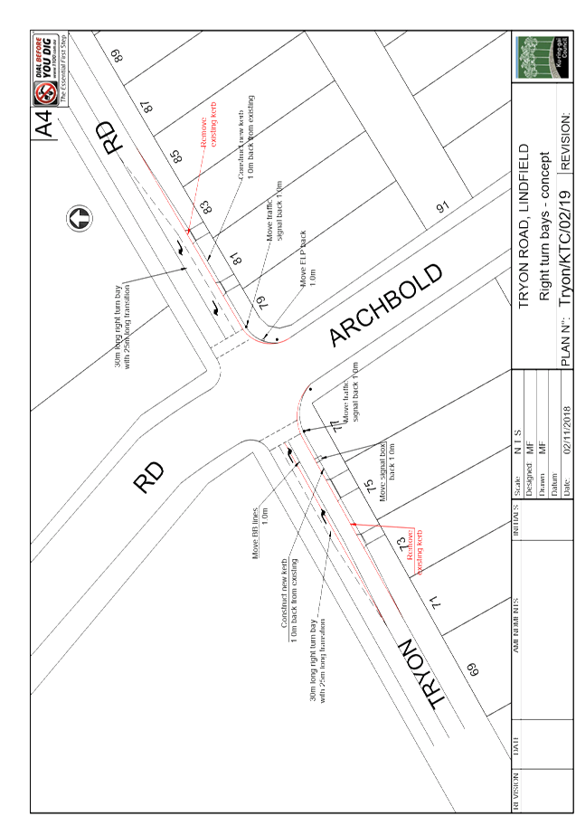
Tryon Road is 9.2 metres wide on the western leg of the
intersection, and 9.8 metres wide on the eastern leg. The entry lane on
both legs is 4.7 metres wide. This width needs to be maintained to allow
left turns into Tryon Road from Archbold Road. This leaves an exit lane
width of 4.5 metres on the western leg of Tryon Road, and an exit lane width of
5.1 metres on the eastern leg. Therefore in order to provide a dedicated
right turn bay on both legs of Tryon Road, the road would need to be widened by
1 metre on both legs.
The proposed changes are shown in the attached Plan Tryon/KTC/02/19.
It is proposed that a 30 metre long right turn bay be created on both legs of
Tryon Road, with a 25 metre long transition. This means that a 55 metre
length of kerb on both legs of Tryon Road would need to be removed and
replaced. It is proposed that the widening take place along the southern
kerb of Tryon Road, as it has a wide nature strip, and would not require the
removal and reconstruction of footpath or the removal of any trees.
The proposed road widening would also require the relocation
of 2 traffic signals plus a signal box on the southern side of Tryon
Road. A power pole on the south eastern corner of the intersection would
also need to be moved back approximately 1 metre.
The proposed works would come at a significant cost.
It is therefore recommended that subject to available funding, a detailed
design be carried out.
Financial
Considerations
The RMS has estimated that the cost of relocating the
signals and the signal box to be approximately $170,000. Additional costs
would include removal and replacement of kerb and gutter along the southern
side of Tryon Road, plus the relocation of a power pole.
Summary
There are several intersections along Archbold Road which
have an accident history involving turning vehicles. If right turn bays
could be provided in Tryon Road, it would encourage more road users to turn
right from this signalised intersection. This would be a safer option
than turning right from the other unsignalised intersections.
In order to provide sufficient width for right turn bays,
Tryon Road would need to be widened by one metre on both approaches to Archbold
Road.
|
Recommendation:
That subject to available funding, a detailed design be
prepared for the widening of Tryon Road at Archbold Road.
|
|
Michael Foskett
Team Leader Traffic
|
Deva Thevaraja
Manager Traffic & Transport
|
|
George Bounassif
Director Operations
|
|
|
Attachments:
|
A1⇩
|
Plan
No. Tryon/KTC/02/19
|
|
2019/033009
|
|
APPENDIX No: 1 - Plan No.
Tryon/KTC/02/19
|
|
Item No: GB.5
|
|
Ku-ring-gai
Traffic Committee - 28 February 2019
|
GB.6 / 132
|
|
|
|
|
Item
GB.6
|
TM6/11
|
Ward: Roseville
Electorate: Davidson
EXECUTIVE
SUMMARY
|
purpose of report:
|
To consider measures to improve safety at several
unsignalised intersections along Archbold Road, Lindfield.
|
|
|
|
|
background:
|
There are several intersections along Archbold Road
which have an accident history involving turning vehicles. Many of the
intersections have sub-standard sight distance for motorists exiting side
streets.
|
|
|
|
|
comments:
|
Sight distance to approaching vehicles on Archbold
Road from the eastern leg of Chelmsford Avenue is particularly poor, due to
the crest.
|
|
|
|
|
recommendation:
|
That full time ‘Left Only’ restrictions be
introduced on the eastern leg of Chelmsford Avenue at Archbold Road.
|
Purpose of Report
To consider measures to improve safety at several
unsignalised intersections along Archbold Road, Lindfield.
Background
There are several unsignalised intersections along the
length of Archbold Road between Boundary Street and Tryon Road. Many of
these intersections have sub-standard sight distance for road users turning
onto or crossing Archbold Road. Many of these intersections also have a
crash history, with numerous crashes occurring involving turning vehicles.
In late 2018 Council introduced ‘No Right Turn
6am-10am Mon-Fri’ restrictions on the western leg of Chelmsford Avenue at
Archbold Road. The primary reason for the restrictions was to prevent
rat-running along Chelmsford Avenue during the morning peak period. A
secondary reason was that sight distance is restricted when looking north along
Archbold Road due to the crest.
Shortly after Council proposed the right turn restrictions,
Council also received requests from residents on the eastern leg of Chelmsford
Avenue for right turns to be banned. Council staff investigated the site,
and found that sight distance was poor when exiting the eastern leg of
Chelmsford Avenue due to the crest. Therefore, it was proposed that
‘Left Only’ restrictions be introduced on the eastern leg of
Chelmsford Avenue.
Residents of Chelmsford Avenue to the east of Archbold Road
were consulted about the proposal. Of the 37 properties surveyed about
the proposal, there were 15 responses. Of the 15 respondents, 13 were in
favour of the proposal, with 2 opposed. Despite the strong resident
support for the proposal, the Chair of the Ku-ring-gai Traffic Committee
opposed the proposal following representations from Councillor Ngai.
Cllr Ngai also requested that Council consider banning right
turns out of Dudley Avenue due to concerns about sight distance.
Comments
Archbold Road is a 4 lane road with several unsignalised
intersections along its length. Although Archbold Road is straight, it
has several changes in grade which impact sight distance for motorists entering
from side streets.
Sight distance is restricted when exiting the following
streets due to a crest on Archbold Road between Middle Harbour Road and
Chelmsford Avenue;
· Middle
Harbour Road (left & right in, left out)
· Chelmsford
Avenue (am peak No Right Turn, western leg)
Sight distance is restricted when exiting the following
streets due a large dip in the road between Dudley Avenue and Park Avenue;
· Dudley
Avenue (no restrictions)
· Roseville
Avenue (left in/left out only)
· Earl Street
(left in, left & right out)
· Lord Street
(no restrictions)
· Park Avenue
(pm peak No Right Turn)
The table below gives a summary of the intersections where
multiple accidents have been recorded during the 5 year period to the end of
June 2018.
Table 1. Crash sites along Archbold Road - 5 years
to end June 2018
|
Intersection
|
No. of Crashes
|
injury crashes
|
Towaway Crashes
|
Main Crash Type
|
Comments
|
|
Middle Harbour Rd
|
9
|
6
|
3
|
6xRUM 21
|
2 crashes from illegal
right turns out of MH Rd. 3 southbound RUM 21, 3 northbound RUM 21
|
|
Tryon Rd
|
8
|
7
|
1
|
3xRUM 21
|
no clear pattern
|
|
Clanville Rd
|
6
|
4
|
2
|
2xRUM 21, 2xRUM 13
|
2 RUM 21 during pm
peak. 2 RUM 13
|
|
Chelmsford Ave
|
5
|
3
|
2
|
2xRUM 13, 2xRUM 21
|
2 RUM 21 turning right into E leg
of Chelmsford during pm peak. 2 RUM 13 turning right out of W. leg of
Chelmsford during am peak
|
|
Carnarvon Rd
|
4
|
3
|
1
|
2xRUM 21, 2xRUM 32
|
All crashes involve a
vehicle turning right into Carnarvon Rd
|
|
Bancroft Ave
|
4
|
2
|
2
|
2xRUM 13
|
no clear pattern
|
|
Woodlands Rd
|
2
|
2
|
0
|
2xRUM 32
|
both between 9.30-10am
|
|
Lord St
|
2
|
1
|
1
|
|
no clear pattern
|
The table shows that the vast majority of accidents have
occurred along the section of Archbold Road between Tryon Road and Clanville
Road. Over 70% of recorded accidents on this section of Archbold Road
involved a right turning vehicle. However of the 45 recorded accidents
along Archbold Road, only 7 involved vehicles turning right onto Archbold
Road. These accidents occurred at Clanville Road (2), Chelmsford Avenue
(2), Bancroft Avenue (2), and Lord Street (1).
The majority of accidents (24) involved vehicles turning
right from Archbold Road into side streets. This included 17 RUM 21
accidents involving a right tuning vehicle colliding with a vehicle travelling
in the opposite direction, and 7 RUM 32 accidents involving rear-end collisions
with a vehicle waiting to turn right. The solution to reduce these
accidents would be to provide dedicated right turn bays. However, there
is insufficient road reserve width to provide dedicated right turn bays without
reducing the number of travel lanes. Traffic volumes on Archbold Road are
too high to consider reducing the number of travel lanes.
Of the sites listed in table 1, the intersections with
Middle Harbour Road, Chelmsford Avenue and Lord Street all have sub-standard
sight distance for motorists turning right onto Archbold Road or crossing
Archbold Road. At these intersections the gap sight distance, based on a
design speed of 70km/h, does not meet the minimum requirement as specified in
Table 3.5 of Austroads Guide to Road Design – Part 4A: Unsignalised
and Signalised Intersections. It was also found that sight distance
for motorists turning right out of Dudley Avenue was sub-standard.
The intersection at Middle Harbour Road has the highest
number of accidents, despite the exits from both legs of Middle Harbour Road
being restricted to left only. Two of the accidents involved illegal
right turns. Another 6 accidents involved vehicles turning right from
Archbold Road into Middle Harbour Road. It would be difficult to ban
right turns into Middle Harbour Road, as buses need to turn right into the
western leg of Middle Harbour Road as part of the route for the 558 bus.
The intersection of Tryon Road and Archbold Road is
signalised. This intersection is being dealt with as a separate Traffic
Committee item.
There were also a high number of accidents recorded at the
intersection of Clanville Road and Archbold Road. Of these, 3 involved southbound
vehicles on Archbold Road turning right into Clanville Road. Another 2
accidents involved vehicles turning right out of Clanville Road. This is
somewhat surprising, given that sight distance is good in both directions when
exiting Clanville Road.
Several accidents were recorded at the intersection with
Chelmsford Avenue. Three of these involved northbound vehicles turning
right into Chelmsford Avenue. Two accidents involved vehicles turning
right out of the western leg of Chelmsford Avenue during the morning peak
period. Council will continue to monitor the effectiveness of the
‘No Right Turn 6am-10am Mon-Fri’ restrictions.
Sight distance is limited at this intersection, although it
is worse on the eastern leg of Chelmsford Avenue. In 2003 the Ku-ring-gai
Traffic Committee recommended that seagull islands be constructed on both legs
of Chelmsford Avenue at Archbold Road to restrict movements to left in/left out
only. However this recommendation was not adopted by Council.
It is recommended that due to the poor sight distance for
motorists exiting the eastern leg of Chelmsford Avenue, that ‘Left
Only’ restrictions be introduced. The proposed changes are shown in
the attached Plan Chelmsford/KTC/02/19. There was strong
resident support for these restrictions when they were proposed by Council in
October 2018, with 13 of the 15 respondents supporting the proposal.
However, one of the voting members of the Traffic Committee opposed the
proposal.
There were 4 recorded accidents at the intersection of
Archbold Road and Carnarvon Road. All 4 accidents involved vehicles
turning right into Carnarvon Road, with 2 involving vehicles being rear-ended
while waiting to turn right. Two similar crashes were also recorded at
the intersection with Woodlands Road. In 2003 the Ku-ring-gai Traffic
Committee recommended that a length of concrete median be approved and
installed in Carnarvon Road and Woodlands Road to restrict turning movements to
left in/left out. Again, this recommendation was not adopted by Council.
There were no recorded accidents at the intersection with
Dudley Avenue. It should also be noted that Council has not received any
complaints about the intersection of Archbold Road and Dudley Avenue.
Sight distance when exiting Dudley Avenue was observed to be similar to sight
distance when exiting the western leg of Chelmsford Avenue. It is
recommended that Council carry out further monitoring at this intersection.
Community
Consultation
Residents of Chelmsford Avenue to the east of Archbold Road
were consulted about the proposal to introduce ‘Left Only’
restrictions when exiting Chelmsford Avenue. Of the 37 properties
surveyed about the proposal, there were 15 responses. Of the 15
respondents, 13 were in favour of the proposal, with 2 opposed.
Internal
Consultation
Despite the strong resident support for the proposal, the
Chair of the Ku-ring-gai Traffic Committee opposed the proposal to introduce
‘Left Only’ restrictions in Chelmsford Avenue following
representations from Cllr Ngai.
Cllr Ngai also requested that Council consider banning right
turns out of Dudley Avenue due to concerns about sight distance.
Summary
There are several intersections along Archbold Road which
have an accident history involving turning vehicles. Council recently
introduced ‘No Right Turn 6am-10am Mon-Fri’ restrictions on the
western leg of Chelmsford Avenue at Archbold Road, mainly to reduce rat-running
during the morning peak period. Further monitoring should be carried out
to determine the effectiveness of the restrictions.
It is also recommended that full time ‘Left
Only’ restrictions be introduced on the eastern leg of Chelmsford Avenue
at Archbold Road, due to poor sight distance. If future funding is
available to widen Tryon Road at Archbold, thereby increasing its capacity,
then consideration could be given to introducing full time ‘Left
Only’ restrictions out of both legs of Chelmsford Avenue at Archbold
Road.
The majority of reported accidents occurred in the section
of Arhcbold Road between Tryon Road and Clanville Road, with most of these
accidents involved right turning vehicles. However only a relatively
small number of these accidents (7), involved vehicles turning right out of
side streets onto Archbold Road.
There have been no recorded accidents at the intersection of
Archbold Road and Dudley Street, and Council has not received any complaints
about this intersection. Therefore it is recommended that turning
restrictions not be introduced, but the intersection continue to be monitored.
|
Recommendation:
That ‘Left Only’ restrictions be introduced on
the eastern leg of Chelmsford Avenue at Archbold Road, as shown on Plan No.
Chelmsford/KTC/02/19.
|
|
Michael Foskett
Team Leader Traffic
|
Deva Thevaraja
Manager Traffic & Transport
|
|
George Bounassif
Director Operations
|
|
|
Attachments:
|
A1⇩
|
Plan
No. Chelmsford/KTC/02/19
|
|
2019/033072
|
|
APPENDIX No: 1 - Plan No.
Chelmsford/KTC/02/19
|
|
Item No: GB.6
|
|
Ku-ring-gai
Traffic Committee - 28 February 2019
|
GB.7 / 138
|
|
|
|
|
Item
GB.7
|
TM8/11
|
Ward: Roseville
Electorate: Davidson
EXECUTIVE
SUMMARY
|
purpose of report:
|
To consider the installation of ‘No Stopping
8am-9.30am, 2.30pm-4pm School Days’ restrictions on the northern side
of Park Avenue near Archbold Road.
|
|
|
|
|
background:
|
Council has received representations from two
residents of Park Avenue about safety concerns when exiting their driveway,
due to parked vehicles restricting visibility. There have been regular
complaints about speeding traffic on Park Avenue.
|
|
|
|
|
comments:
|
Site inspections have
confirmed that cars parked in Park Avenue outside No. 33 Archbold Road
obstruct the visibility of eastbound traffic, and that cars turn into Park
Avenue at excessive speed and accelerate up the grade.
|
|
|
|
|
recommendation:
|
That ‘No Stopping 8am-9.30am School Days’
restrictions be installed on the northern side of Park Avenue near Archbold
Road.
|
Purpose of Report
To consider the installation of ‘No Stopping
8am-9.30am, 2.30pm-4pm School Days’ restrictions on the northern side of
Park Avenue near Archbold Road.
Background
There have been regular complaints to Council about the
speed of traffic in Park Avenue. Edge lines were installed in 2013 in an
attempt to reduce speeds, and the feasibility of installing chicanes and rubber
speed cushions has also been considered.
Concerns about traffic, parking and pedestrian safety in the
area shown in the attached plan were raised again in early 2018 by Mrs
Amber Edwards, of 33 Archbold Road (on the corner of Park Avenue). TDA
54/18 was prepared to address her concerns: the excessive speed of cars
entering Park Avenue; parked cars (especially from the Airbnb opposite) obstructing
the view of approaching traffic when exiting from her Park Avenue car port; and
parents crossing Park Avenue, taking children to and from Roseville Public
School, in dangerous traffic conditions.
TDA 54/18 proposed the introduction of full time ‘No
Stopping’ restrictions on the northern side of Park Avenue between
Archbold Road and the driveway to #33 Archbold Road. It did not proceed
due to objections about the loss of on-street parking from the representative
for The Member for Davidson..
Mrs Jill Nicholson lives at No. 2 Park Avenue, and has
lodged similar complaints. She states that parked cars are a major
traffic hazard (again mentioning the Airbnb) and the visibility of approaching
traffic is restricted by parked cars when exiting her property. She notes
that her driveway is also used by other residents [three houses on Earl Street]
and all experience difficulties exiting No. 2. Mrs Nicholson says that
“For the safety of everyone concerned there should be no parking in
this area near the intersection”.
Comments
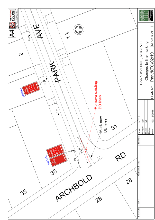
The attached Plan No. Park/KTC/02/19 Rev 1 shows
the intersection of Park Avenue and Archbold Road, Roseville. Park Avenue
is used by peak period traffic to avoid congestion on nearby State Roads and is
the main way of accessing the Roseville Chase area from Roseville railway
station and shops. This section of Park Avenue is 9.8 metres wide, kerb
to kerb, and is on a six percent uphill gradient from Archbold Road.
Site inspections have confirmed the previous findings that
cars parked in Park Avenue outside No. 33 Archbold Road obstruct the visibility
of eastbound traffic; and that cars turn into Park Avenue at excessive speed
and accelerate up the grade. The inspections also showed that the
visibility of traffic turning into Park venue was obstructed by shrubs growing
in the nature strip. These have since been removed by Council, but the
visibility of approaching traffic is still obstructed when cars are parked
between No. 2 and Archbold Road.
To address these issues, it is proposed to install a
part-time ‘No Stopping’ restriction in Park Avenue, on the
northern side between Archbold Road and the driveway to No. 2 Park
Avenue.
The proposed signage is shown in the attached Plan
No. Park/KTC/02/19 Rev 1. At this stage, it is proposed that the
‘No Stopping’ restriction would operate only at school
drop-off and pick-up times. This coincides with the general morning peak
traffic period on the busiest days near schools, when the risk of crashes is
highest.
At site inspection it was noted that the majority of motorists turning right into Park Avenue
were crossing over the double centre lines (BB lines) at the
intersection. It is therefore proposed to adjust the BB lines at the
intersection to give a wider entry angle. This will give the BB lines a
more perpendicular alignment with Archbold Road, rather than the current angled
alignment, as also shown in the attached Plan No. Park/KTC/02/19
Rev 1.
Governance
Matters
This matter was considered by the voting members of the
Ku-ring-gai Traffic Committee under TDA 188/18. The RMS representative
and the two ward Councillors did not object to the proposal. However, the
representative for the Member for Davidson has objected to the proposed
‘No Stopping 8am-9.30am, 2.30pm-4pm School Days’
restrictions. He believes that there is no evidence of speeding in this
section of Park Avenue, and that the sight lines from the two affected
driveways are no worse than any other driveway in the street.
Community
Consultation
Council consulted with the residents of #2 Park Avenue and
#33 Archbold Road. The resident of #2 Park Avenue supported the proposal,
while the resident of #33 Archbold Road did not respond.
Internal
Consultation
Council’s Open Space Department were requested to
clear a large shrub which was obstructing visibility. These works have
since been carried out.
Summary
Council has received representations from 2 residents of
Park Avenue about safety concerns when exiting their driveway, due to parked
vehicles restricting visibility. There have been regular complaints about
speeding traffic on Park Avenue.
Site inspections have confirmed that cars parked in Park
Avenue outside No. 33 Archbold Road obstruct the visibility of eastbound
traffic, and that cars turn into Park Avenue at excessive speed and accelerate
up the grade.
|
Recommendation:
A. That ‘No Stopping 8am-9.30am, 2.30pm-4pm School
Days’ restrictions be installed on the northern side of Park Avenue
near Archbold Road, as shown in Plan Park/TDA/188/18 Rev 1.
B. That the double centre lines in Park Avenue at Archbold
Road be modified, as shown in Plan Park/KTC/02/19 Rev 1.
C. That residents of No. 2 Park Avenue, 33 Archbold Road
and Council’s Team Leader Regulation be informed of Council’s
decision.
|
|
Michael Foskett
Team Leader Traffic
|
Deva Thevaraja
Manager Traffic &
Transport
|
|
George Bounassif
Director Operations
|
|
|
Attachments:
|
A1⇩
|
Plan No. Park/KTC/02/19 Rev 1
|
|
2019/031711
|
|
APPENDIX No: 1 - Plan No.
Park/KTC/02/19 Rev 1
|
|
Item No: GB.7
|
|
Ku-ring-gai
Traffic Committee - 28 February 2019
|
GB.8 / 143
|
|
|
|
|
Item
GB.8
|
TM6/11
|
Ward: Roseville
Electorate: Davidson
EXECUTIVE
SUMMARY
|
purpose of report:
|
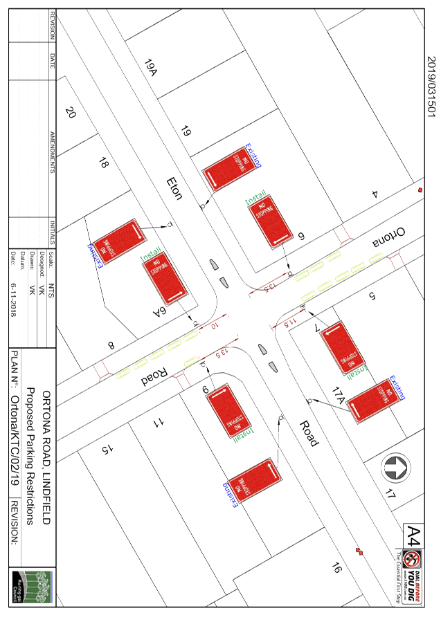
To consider the installation of ‘No
Stopping’ restrictions on all four legs of the intersection of Ortona
Road and Eton Road, Lindfield.
|
|
|
|
|
background:
|
Council’s Senior Parking Ranger has received
representations from a local resident stating cars on Ortona Road are parked
too close to the intersection of Eton Road, impeding visibility for
motorists.
|
|
|
|
|
comments:
|
Council staff observed that
parents collecting children from Lindfield Public School are illegally
parking within 10 metres of the intersection.
|
|
|
|
|
recommendation:
|
That ‘No Stopping’ restrictions be
installed on all four legs of the intersection of Ortona Road and Eton Road,
Lindfield..
|
Purpose of Report
To consider the installation of ‘No Stopping’
restrictions on all four legs of the intersection of Ortona Road and Eton Road,
Lindfield.
Background
Council has received complaints about illegal parking at the
intersection of Ortona Road and Eton Road. There are ‘No
Stopping’ restrictions in place on both legs of Eton Road at the
intersection. However Ortona Road does not have any signage on either leg
of the intersection.
Parents from the nearby Lindfield Public School are
regularly parking within 10 metres of the intersection on Ortona Road.
Some vehicles have been observed to be parking right up to the corner.
This is obstructing visibility for motorists at the intersection and creating a
safety hazard.
Comments
Council’s Traffic staff carried out an inspection
during the afternoon school pick-up time. It was observed that many
parents were parking within 10 metres of the intersection, thereby impeding
visibility for other motorists and pedestrians.
According to Australian
Road Rule 170 (3) – “A driver must not stop on a road within 10
metres from the nearest point of an intersecting road at an intersection
without traffic lights.”
In order to reinforce
the 10 metre rule, it is proposed to install ‘No Stopping’ signs on
both Ortona Road legs of the intersection with Eton Road. Due to the
location of driveways in Ortona Road, it would be possible to extend the
‘No Stopping’ restrictions slightly further in some instances
without any loss of on-street parking. The proposed changes are shown on
the Plan Ortona/KTC/02/19.
The introduction of
‘No Stopping’ restrictions would reinforce the road rules and
prevent drivers from parking too close to the intersection which would result
in safer traffic conditions.
Governance
Matters
This matter was considered by the voting members of the
Ku-ring-gai Traffic Committee under TDA 186/18. The RMS representative
did not object to the proposal. However, the representative for the
Member for Davidson has objected to the ‘No Stopping’ restrictions
extending any further than the standard 10 metres. He is concerned that
allowing increased lengths of ‘No Stopping’ restrictions would set
a precedent. However in this instance, the proposal would not result in
the loss of any on-street parking spaces, so there is no disadvantage from
extending the restrictions beyond the standard 10 metres.
Community
Consultation
Because the proposal would not result in the loss of any
on-street parking spaces, residents were not consulted about the proposal.
Summary
Council
has received complaints about vehicles parking too close to the intersection
with Eton Road on Ortona Road, particularly during school pick up and drop off
times. At present there are ‘No Stopping’ signs on Eton Road,
but not on Ortona Road.
In order to resolve this issue, it
is proposed that ‘No Stopping’ signs be installed on both Ortona
Road legs of the intersection. It is proposed that the ‘No
Stopping’ restrictions extend slightly further than the statutory 10 metres
at 3 of the 4 locations. This will provide improved visibility at the
intersection, without the loss of any on-street parking spaces.
|
Recommendation:
A. That
‘No Stopping’ restrictions be installed on Ortona Road at Eton
Road, as shown in Plan Ortona/KTC/02/19.
B. That
Council’s Team Leader Regulation be informed of Council’s
decision.
|
|
Michael Foskett
Team Leader Traffic
|
Deva Thevaraja
Manager Traffic & Transport
|
|
George Bounassif
Director Operations
|
|
|
Attachments:
|
A1⇩
|
Plan
No. Ortona/KTC/02/19
|
|
2019/031501
|
|
APPENDIX No: 1 - Plan No.
Ortona/KTC/02/19
|
|
Item No: GB.8
|
|
Ku-ring-gai
Traffic Committee - 28 February 2019
|
GB.9 / 147
|
|
|
|
|
Item
GB.9
|
TM9/11
|
Ward: St Ives
Electorate: Ku-ring-gai
EXECUTIVE
SUMMARY
|
purpose of report:
|
To consider the installation of a median island and
additional ‘Stop’ sign and markings in Acron Road, on the
southern side of Douglas Street.
|
|
|
|
|
background:
|
A resident has reported numerous crashes and
“near misses” due to northbound traffic in Acron Road failing to
stop and give way to traffic in Douglas Street.
|
|
|
|
|
comments:
|
Council staff have noted, from site inspections and
from crash records, that northbound drivers in Acron Road may have limited
awareness of the intersection with Douglas Street and the ‘Stop’
control.
|
|
|
|
|
recommendation:
|
A. That the BB lines in
Acron Road on the northbound approach to Douglas Street, St Ives, be extended
to a distance of 20 metres south of Douglas Street, as shown in Plan
No. Acron/KTC/02/19.
B. That a short median island
be installed in Acron Road, five metres south of Douglas Street, as shown in
Plan No. Acron/KTC/02/19, with an additional ‘Stop’ sign mounted
in the median.
C. That Mr S Schaefer, of 50
Hayle Street, St Ives, be informed of Council’s decision.
|
Purpose of Report
To consider the installation of a median island and
additional ‘Stop’ sign and markings in Acron Road, on the southern
side of Douglas Street.
Background
A resident has reported numerous crashes and “near
misses” due to northbound traffic in Acron Road failing to stop and give
way to traffic in Douglas Street.
Comments
Priority at the intersection is given to traffic in Douglas
Street, with ‘Stop’ signs and lines requiring traffic in Acron Road
to stop and give way. The ‘Stop’ control has been in place for over
40 years.
In Acron Road south of Douglas Street, and on the southern
side of Douglas Street, there is no kerb and gutter and there are no buildings,
just bushland and a grazing paddock. In Acron Road 40 metres south of Douglas
Street there is a crest, which for northbound traffic restricts the view ahead.
These factors, and the fact that most of the known crashes
were in daylight, suggests that some northbound drivers in Acron Road may have
a limited awareness of the fact that they are approaching an
intersection.
The same concerns were raised by another local resident in
2017, and were addressed at that time by the installation of BB lines under TDA
67/17. However, it appears that near-misses have continued to occur since then,
and site inspections have shown that the BB lines are not highly visible until
a northbound vehicle has passed the crest in Acron Road.
In order to increase driver awareness of the intersection,
and of the ‘Stop’ control facing northbound traffic, it is
proposed to extend the BB lines in Acron Road south of the intersection
to 20 metres from the stop line at Douglas Street, and to install an additional
‘Stop’ sign on a short median island. These proposals are shown in
Plan No. Acron/KTC/02/19.
Governance
Matters
Council’s Director Operations has authority, under
delegation from Council, to approve the installation of a median island and
additional ‘Stop’ sign, as recommended in this report.
Risk
Management
Concerns about crashes and “near misses” at the
intersection have now been formally brought to Council’s attention
twice by local residents. Council has an obligation to consider the
public safety risks at the intersection and determine what measures, if any,
are needed to reduce risks.
Financial
Considerations
Funding is available from the RMS block grant to Council for
traffic facilities and from internal funds.
Social Considerations
Nil.
Environmental
Considerations
Nil.
Community
Consultation
No residents at the intersection will be adversely affected
by the proposal in terms of loss of residential amenity, loss of access to
property or loss of on-street parking. Consultation is therefore
considered not necessary.
Internal
Consultation
The proposal will not affect the operations of other
sections of Council or the facilities and infrastructure they manage.
Internal consultation is therefore considered not necessary.
Summary
Complaints to Council and analysis of available crash data
indicate that northbound drivers in Acron Road, St Ives, may have limited
awareness of the fact that they are approaching the intersection with Douglas
Street and that they must stop at Douglas Street and give way to traffic in
Douglas Street.
The installation of an additional ‘Stop’ sign on
a median island in Acron Road, and extension of the double dividing (BB) lines
south of Douglas Street, are proposed to address this issue.
|
Recommendation:
A. That
the BB lines in Acron Road on the northbound approach to Douglas Street, St
Ives, be extended to a distance of 20 metres south of Douglas Street,
as shown in Plan No. Acron/KTC/02/19.
B. That
a short median island be installed in Acron Road, five metres south of
Douglas Street, as shown in Plan No. Acron/KTC/02/19, with an additional
‘Stop’ sign mounted in the median.
C. That
Mr S Schaefer, of 50 Hayle Street, St Ives, be informed of Council’s
decision.
|
|
Deva Thevaraja
Manager Traffic & Transport
|
George Bounassif
Director Operations
|
|
Attachments:
|
A1⇩
|
Plan
No. Acron/KTC/02/19
|
|
2019/037562
|
|
APPENDIX No: 1 - Plan No. Acron/KTC/02/19
|
|
Item No: GB.9
|