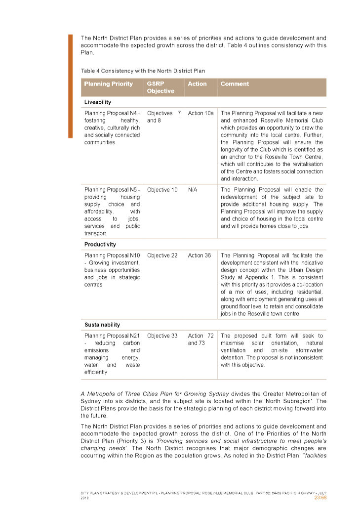
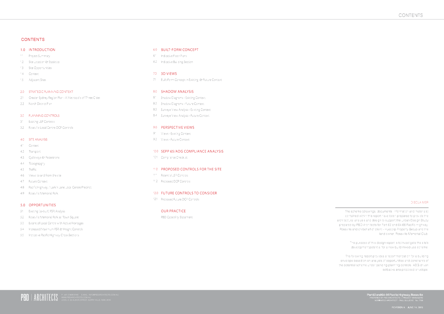
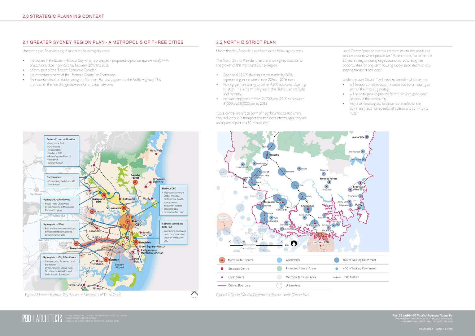
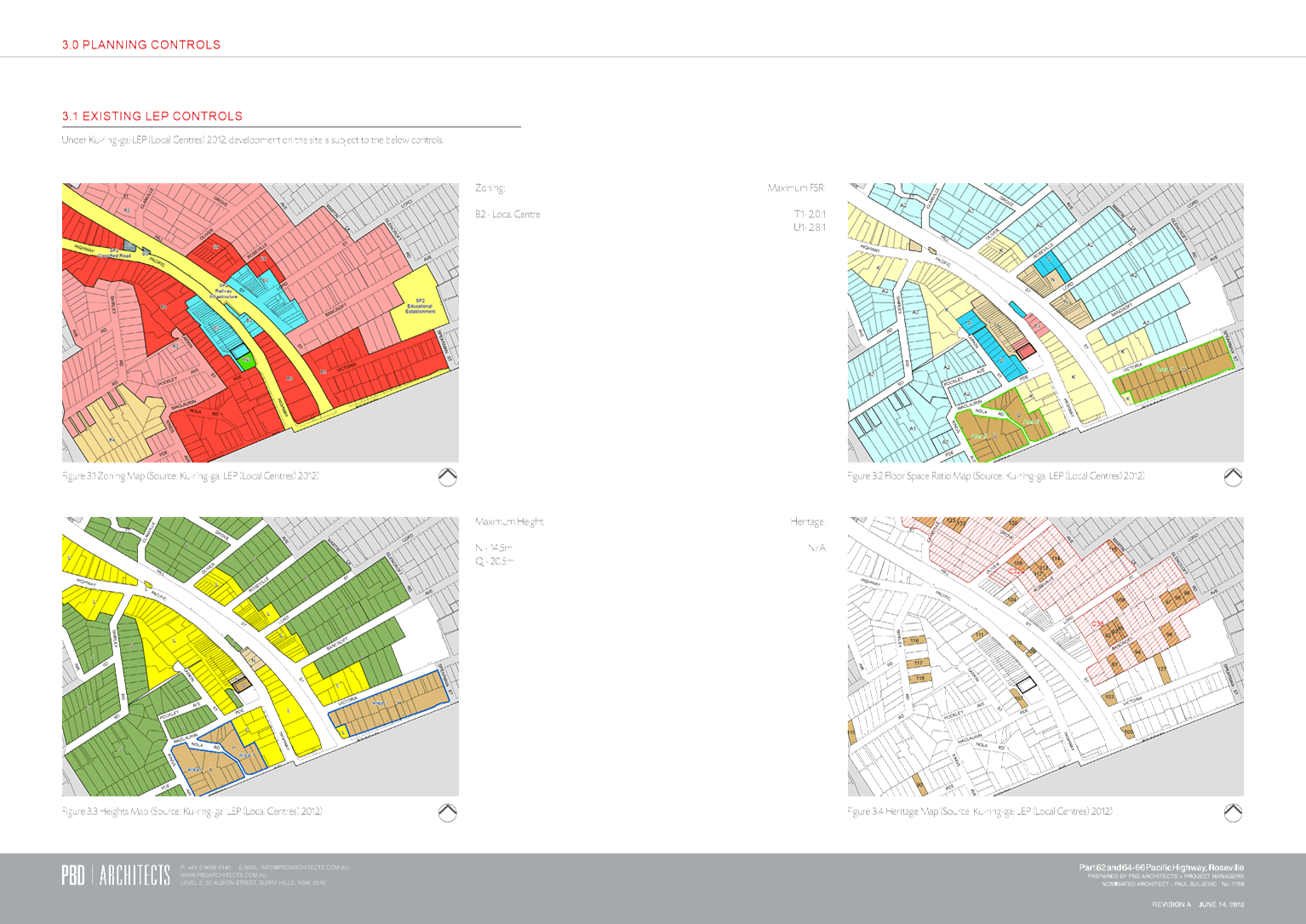
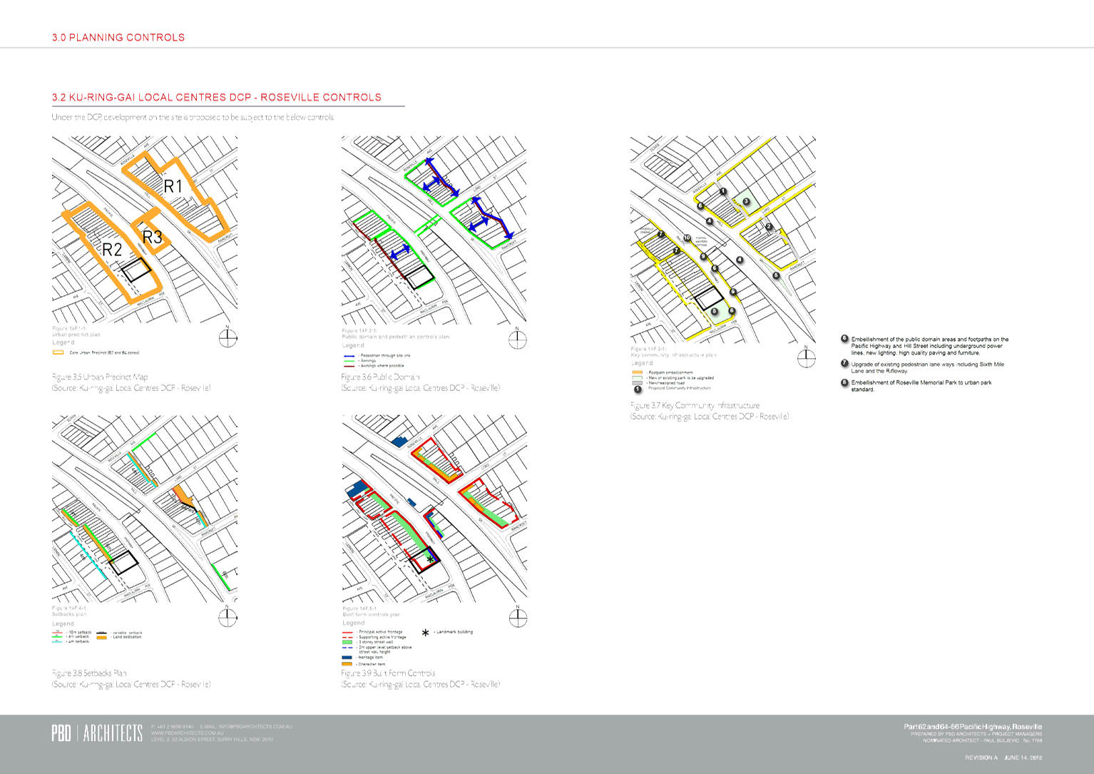
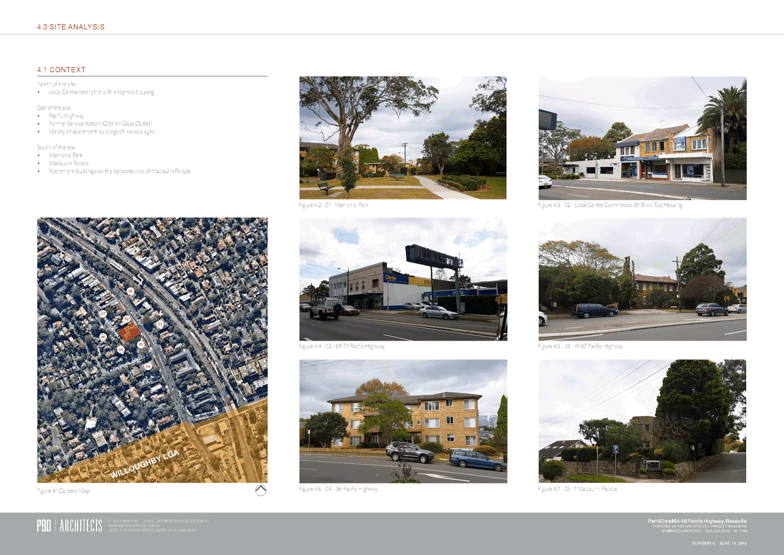
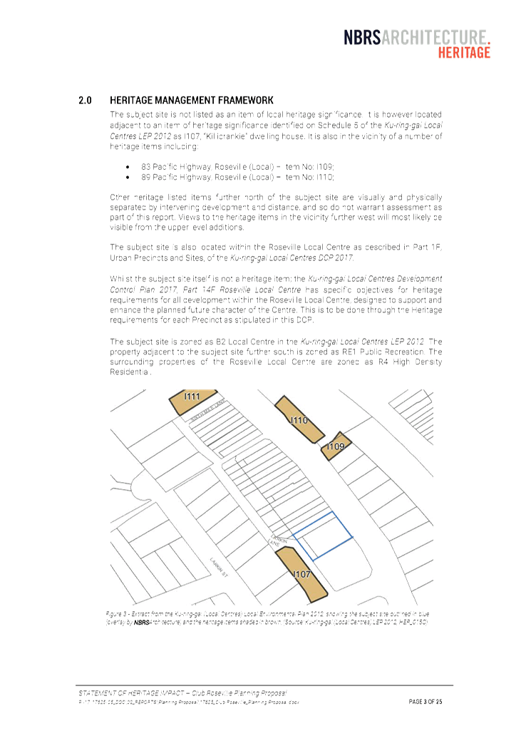
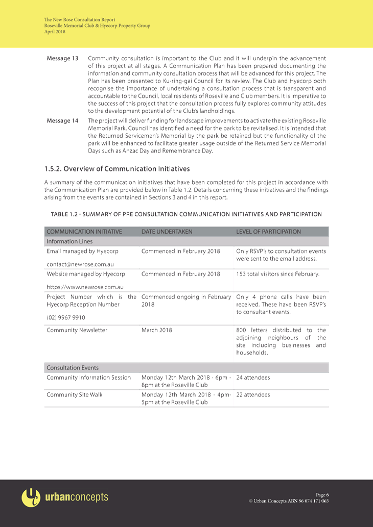
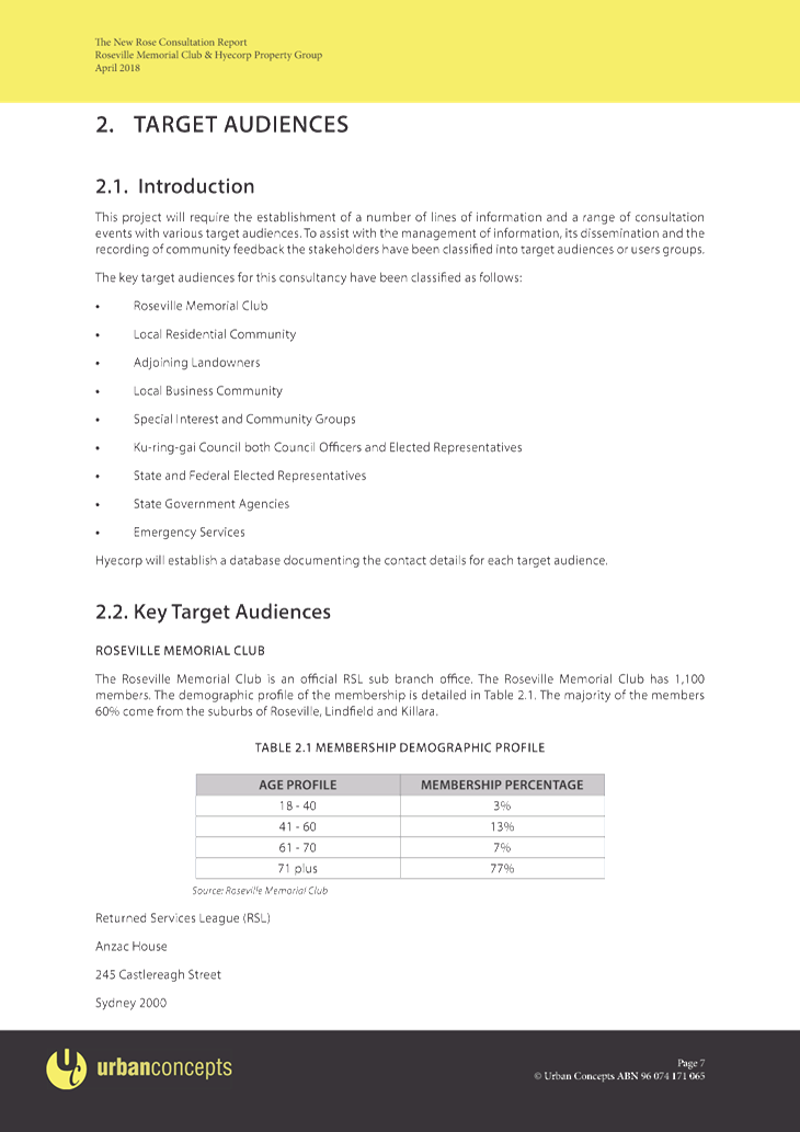
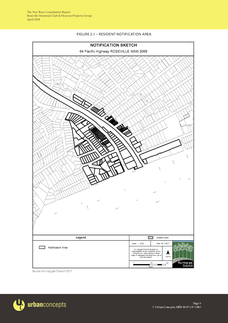
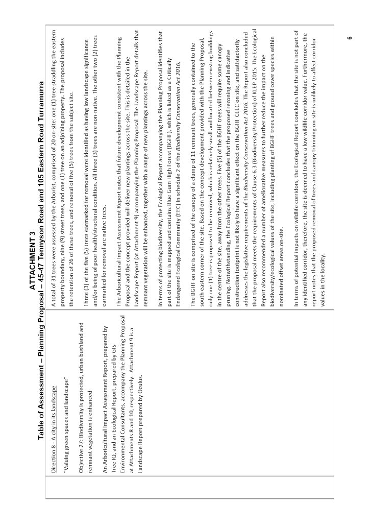
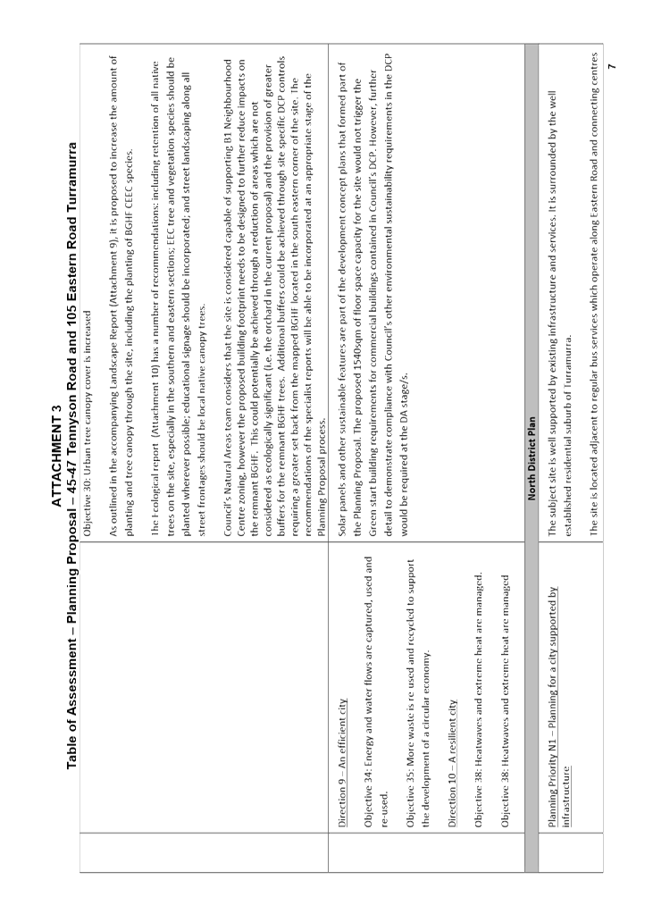
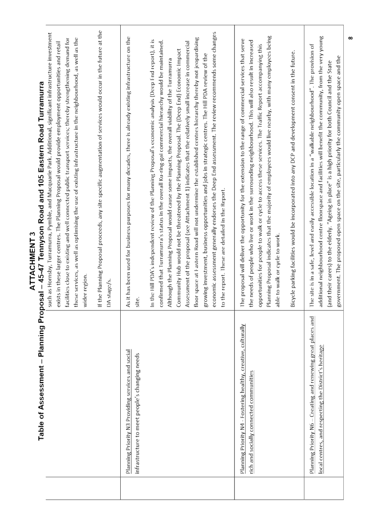
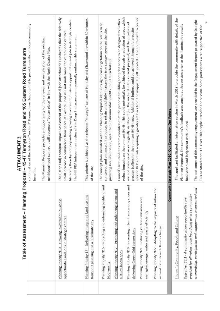
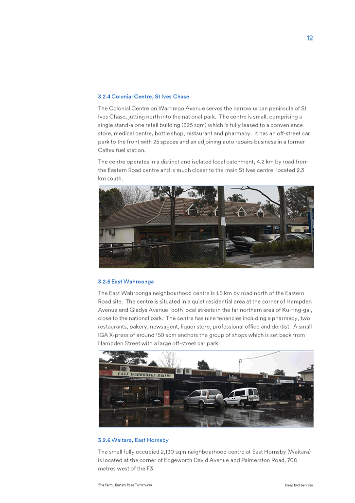
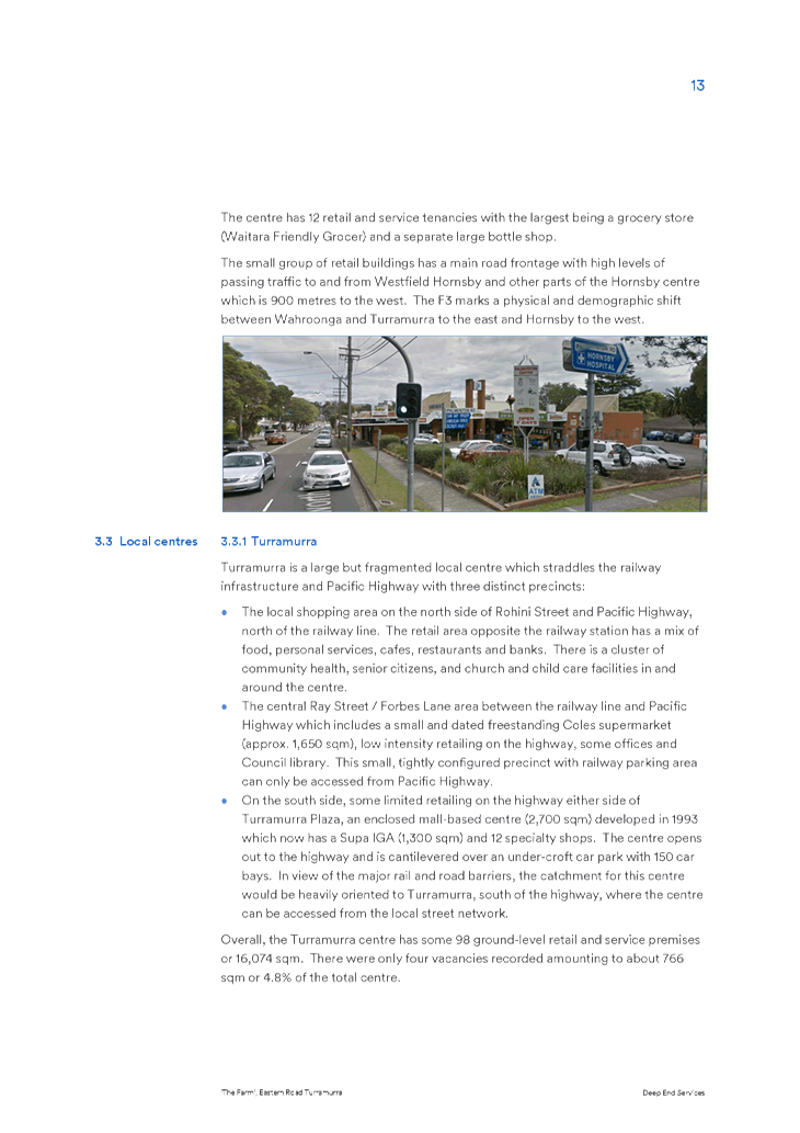
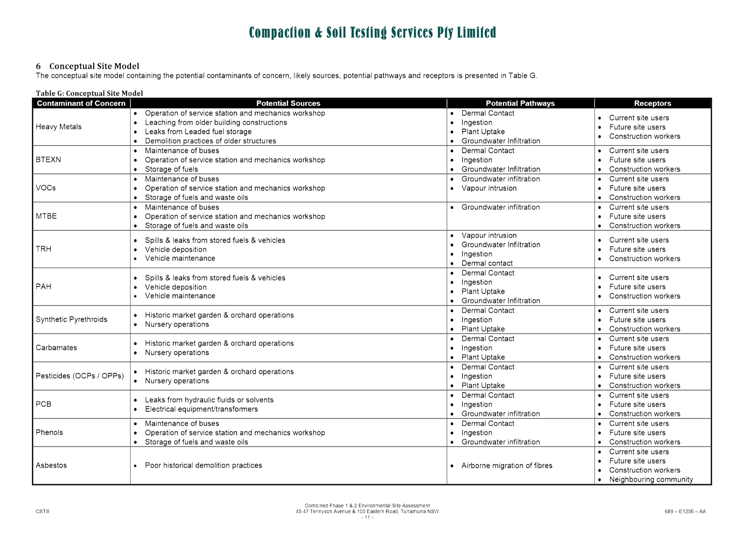
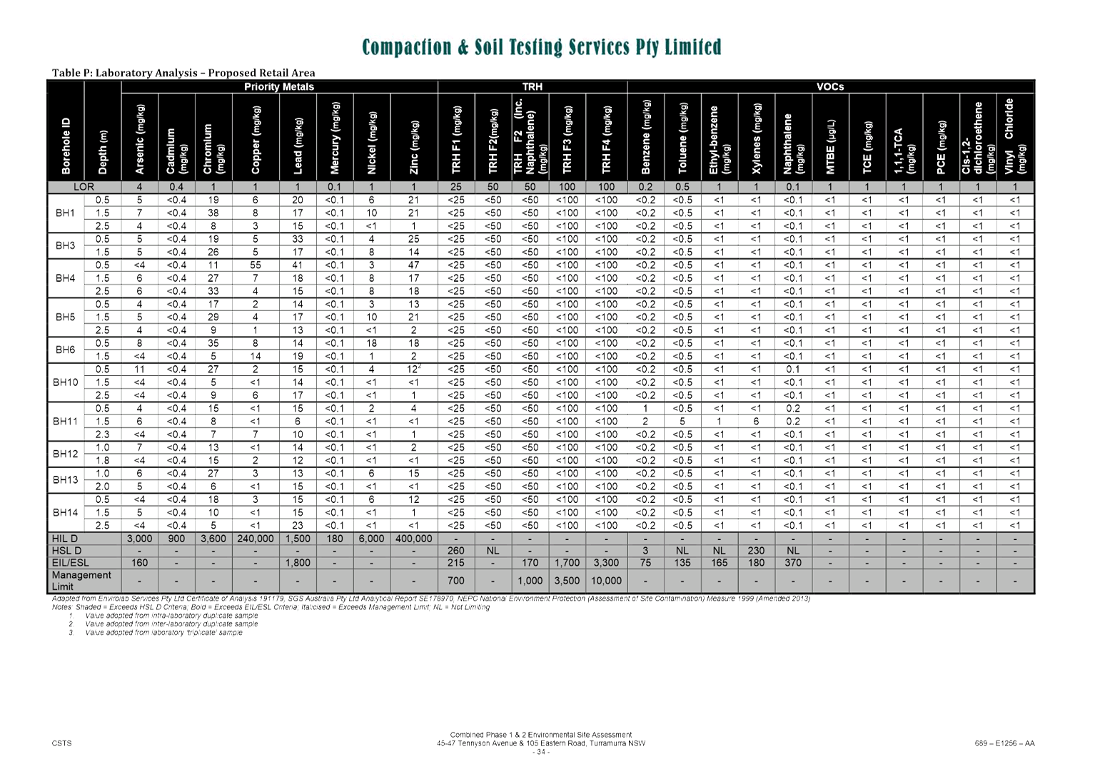
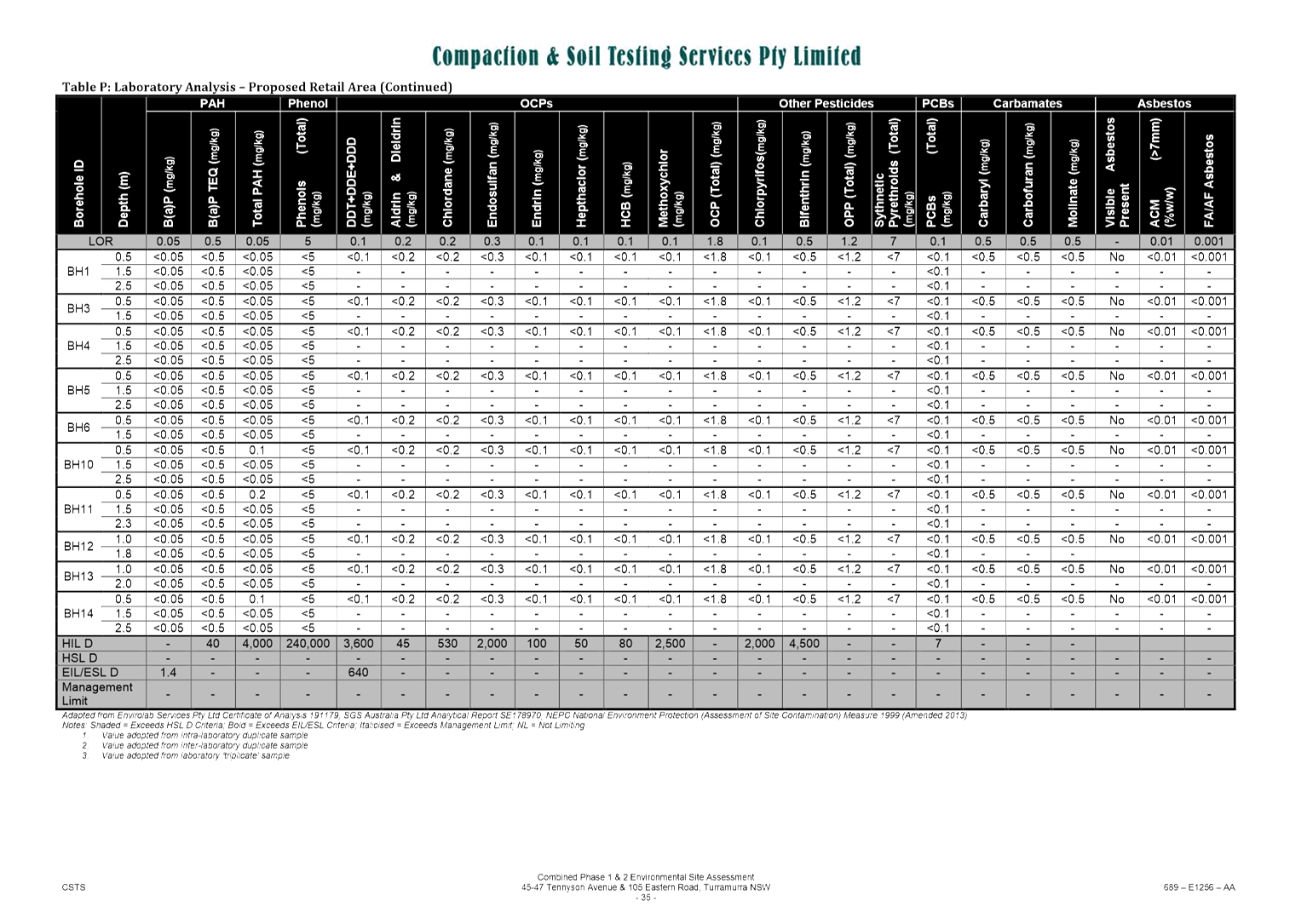
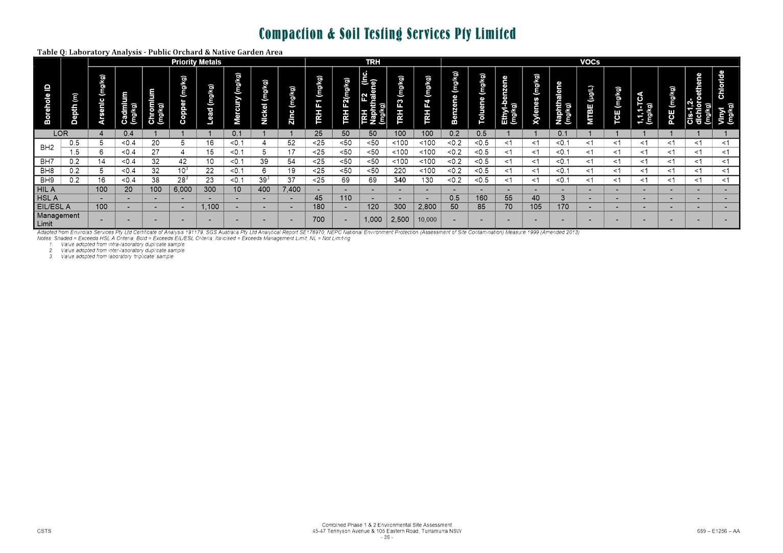
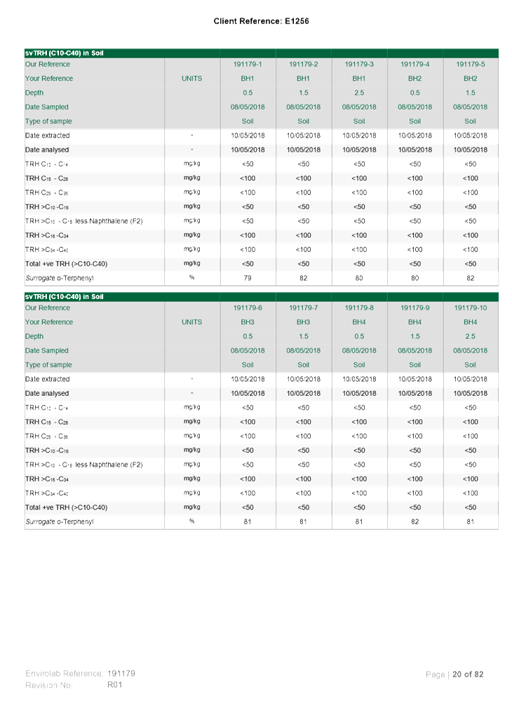
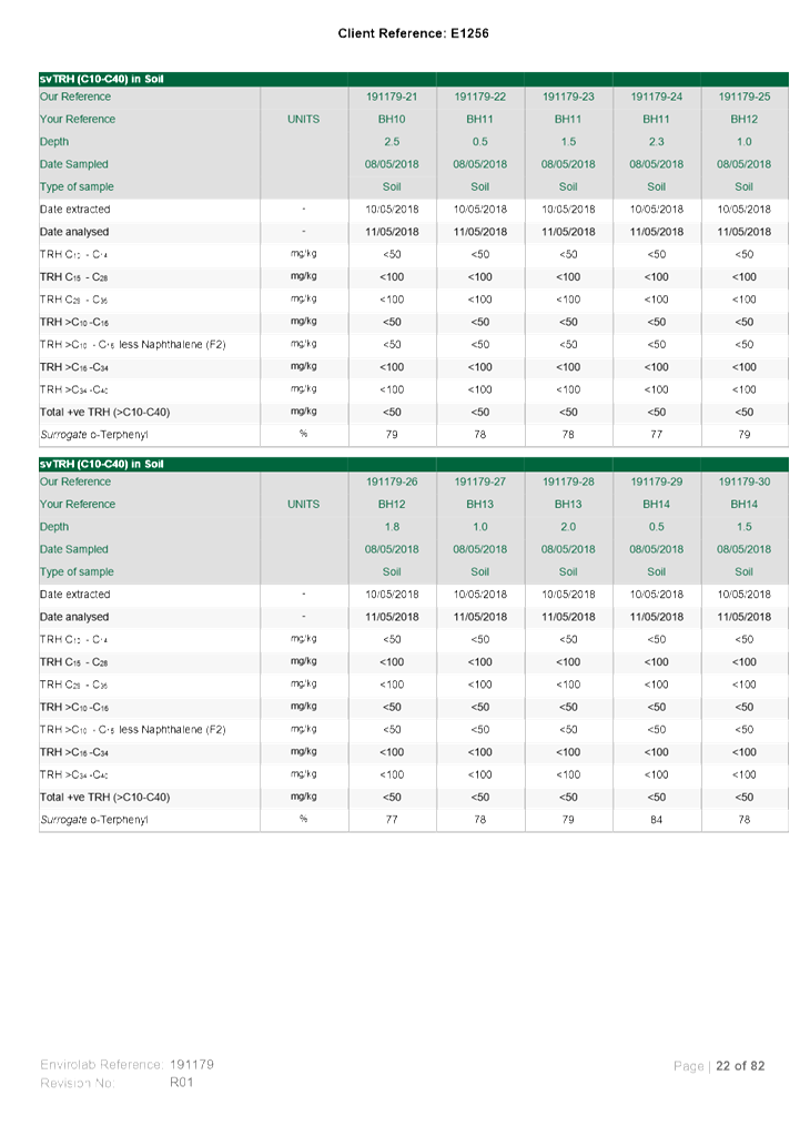
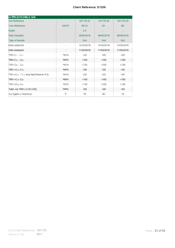
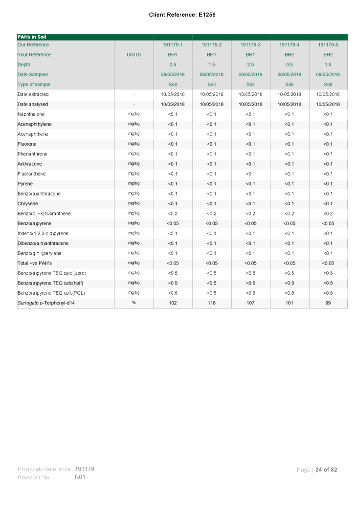
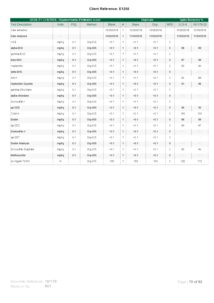
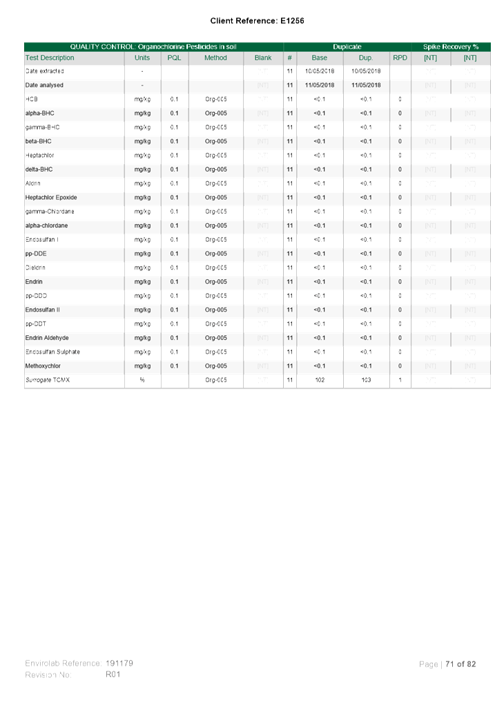
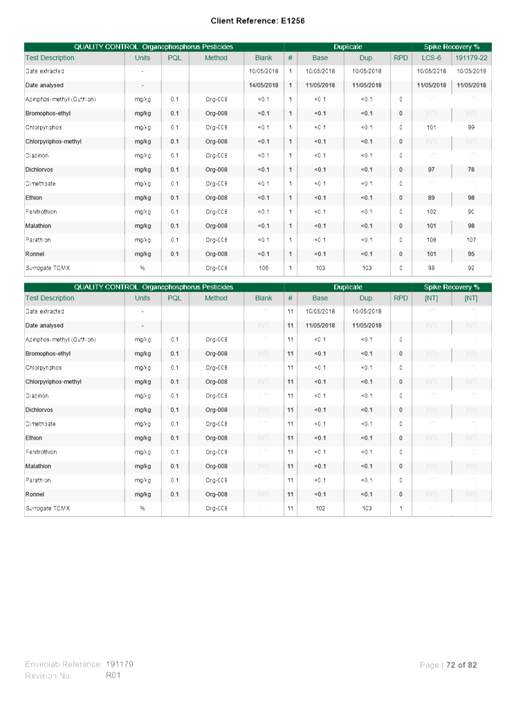
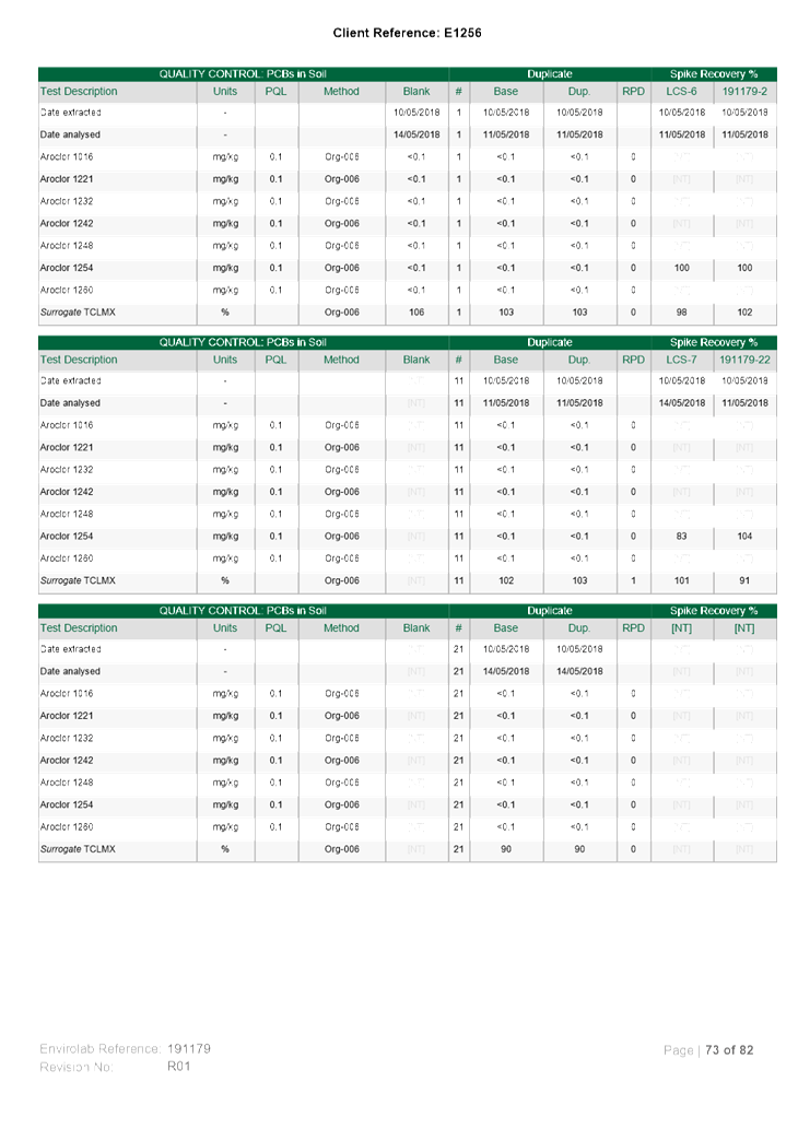
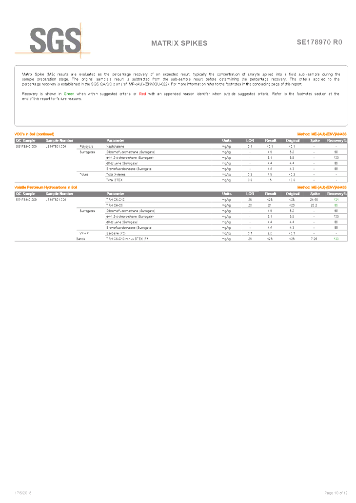
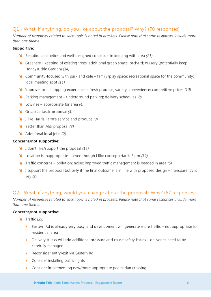
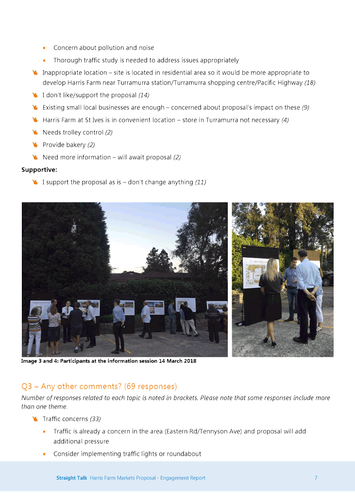
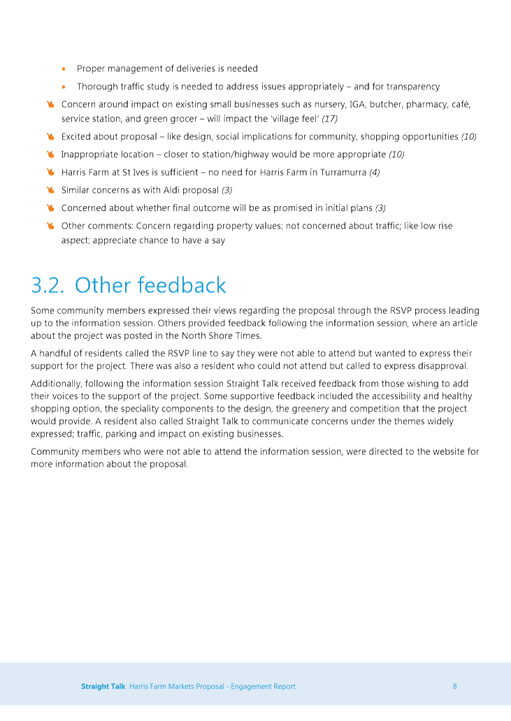
|
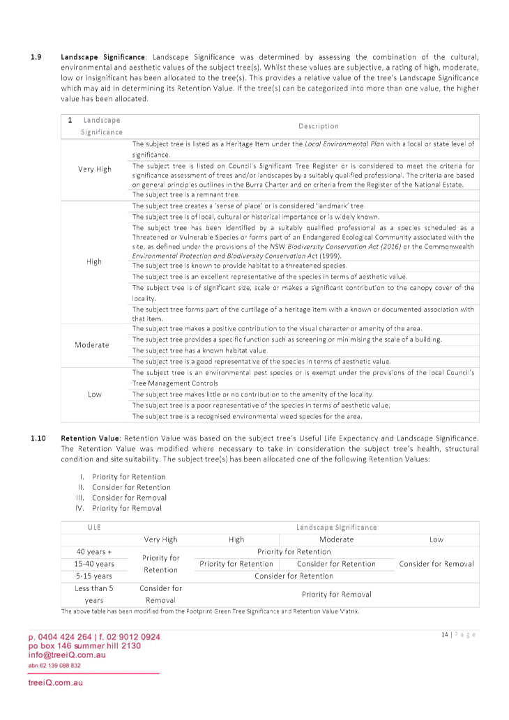
Ku-ring-gai
Local Planning Panel Meeting - 18 March 2019
|
GB.1 / 8
|
|
|
|
|
Item
GB.1
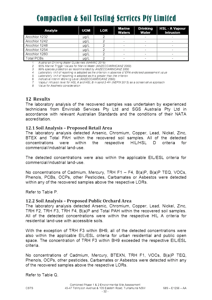
|
S12030
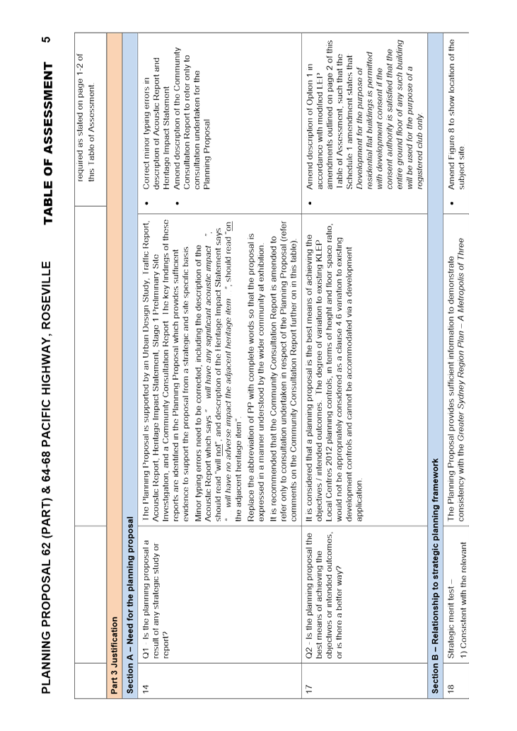
|
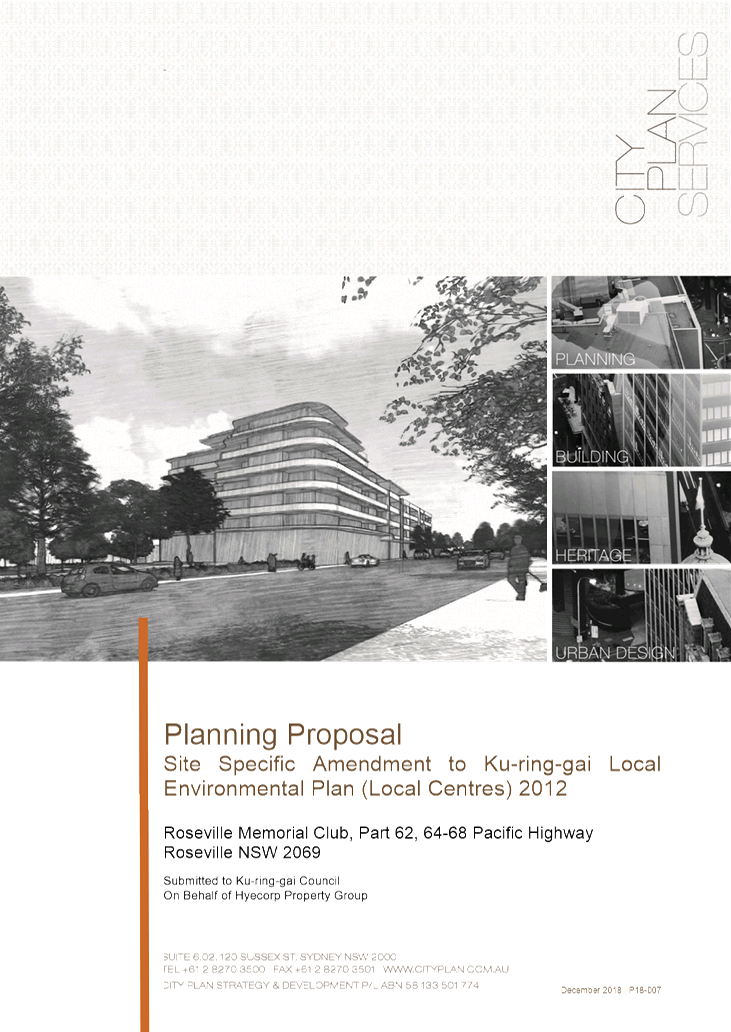
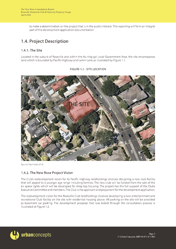
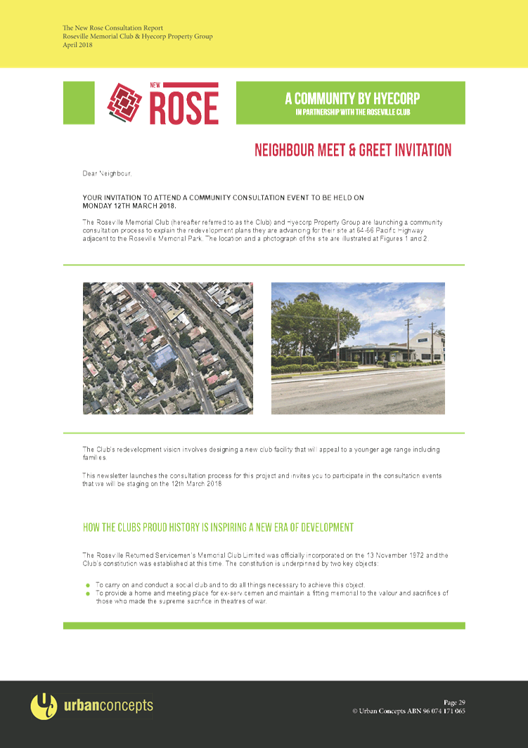
Planning Proposal for land at 62 (part)
and 64 - 68 Pacific Highway, Roseville -
Roseville Memorial Club
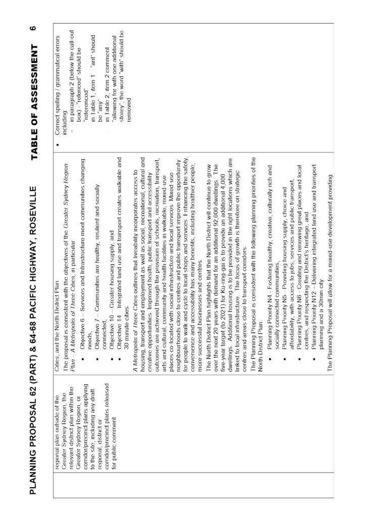
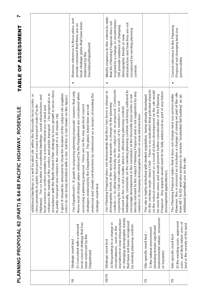
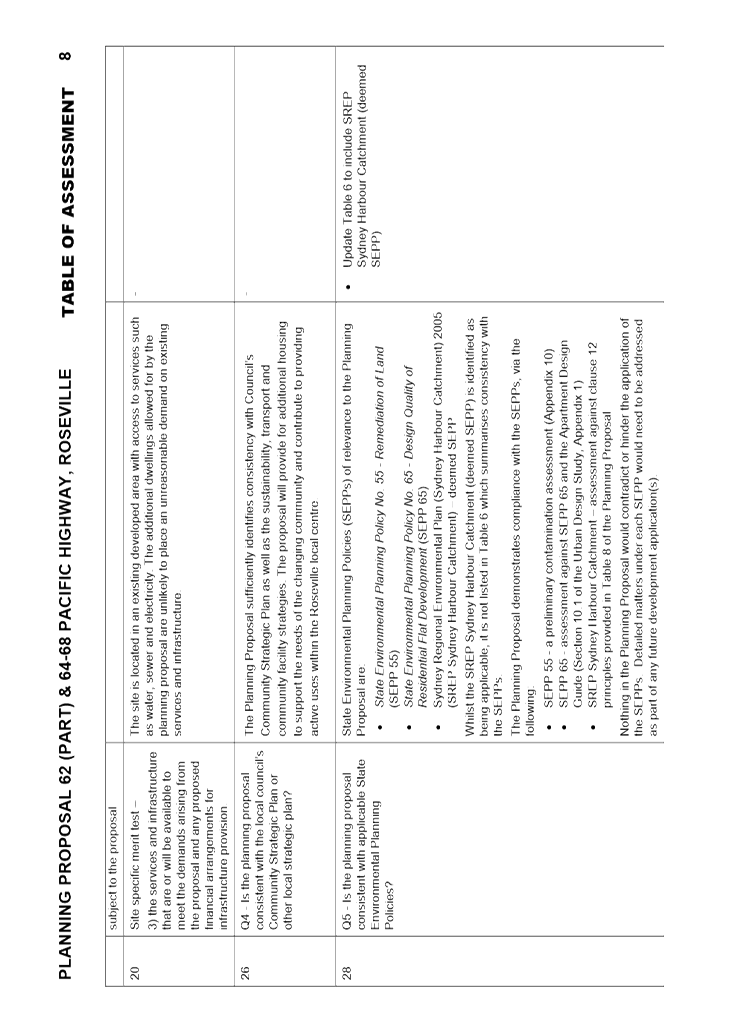
EXECUTIVE
SUMMARY
|
purpose of report:
|
To
refer the Planning Proposal for 62 (part) and 64-68 Pacific Highway,
Roseville, to the Ku-ring-gai Local Planning Panel for consideration of
strategic merit with reference to strategic plans (Greater Sydney Region
Plan and North District Plan) and advice to Council as required by the Local Planning
Panels Direction – Planning Proposals issued by the Minister for
Planning under Section 9.1 of the Environmental Planning and Assessment
Act 1979.
|
|
|
|
|
background:
|
Council has engaged consultant Helena Miller of MG
Planning Pty Ltd to conduct the assessment of this Planning Proposal and
prepare a report for the Panel on the findings.
The Planning Proposal was submitted to Council on 19
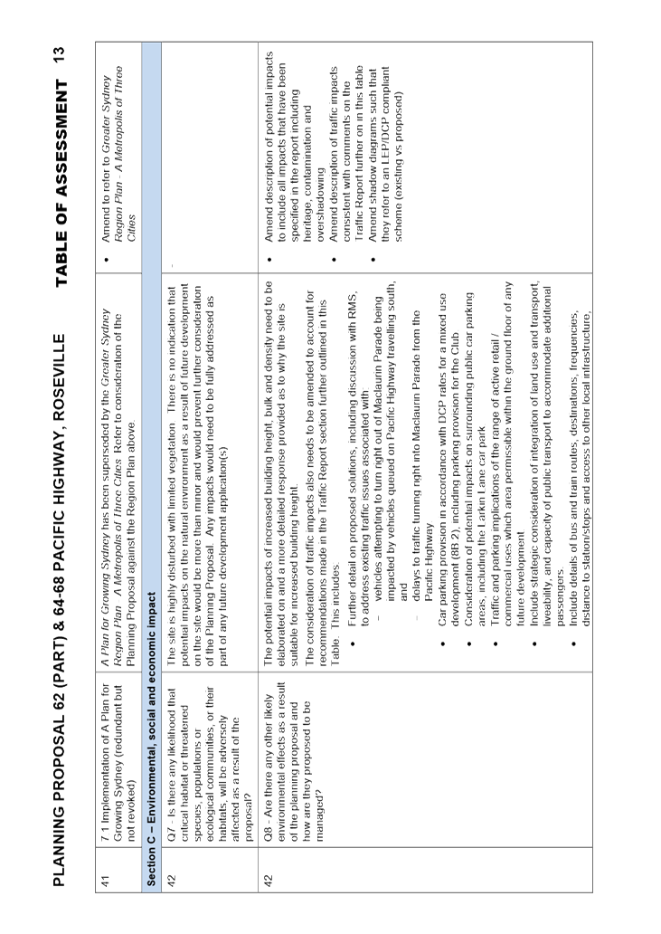
July 2018. Following review it was determined that the Planning Proposal was
incomplete and the proponent was therefore requested to make
amendments. An amended proposal was submitted on 1 August 2018, however
this submission remained incomplete. Following further submission of revised
documentation, review of the Planning Proposal formally commenced on 9
January 2019.
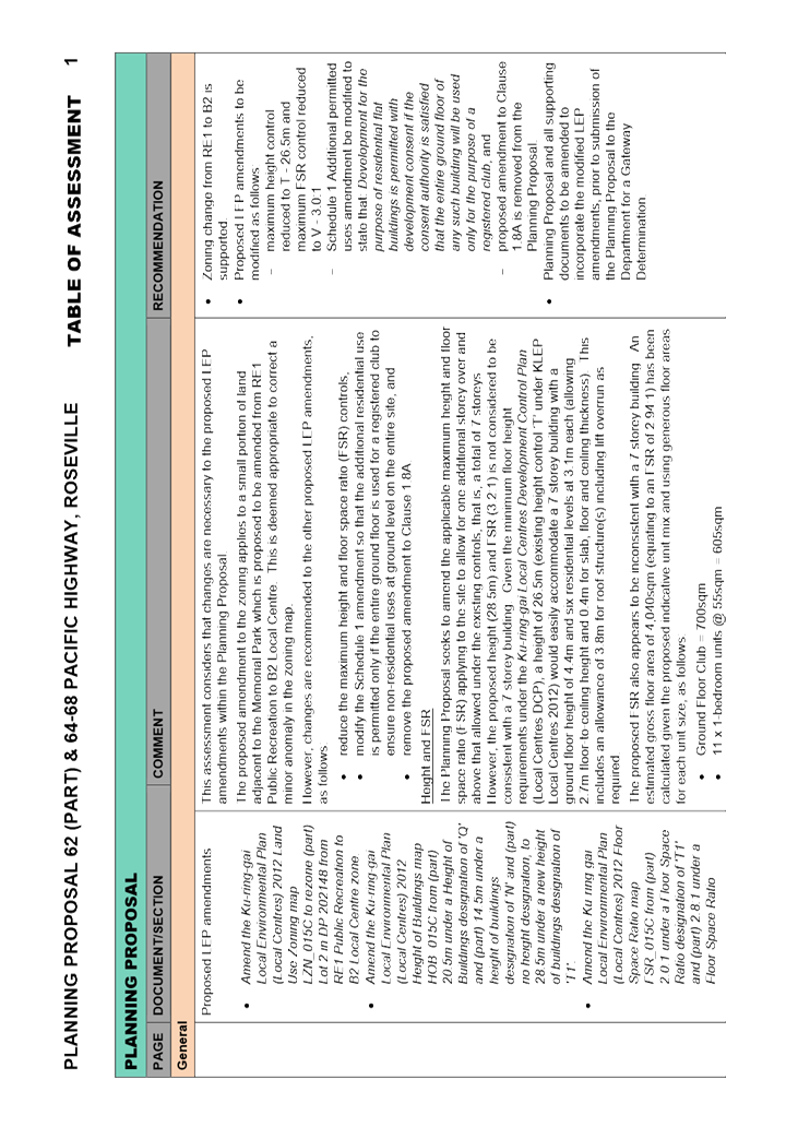
The Planning Proposal seeks to
amend the Ku-ring-gai Local Environmental Plan (Local Centres) 2012 to
change the zoning on part of the site, amend the height of building and floor
space ratio standards applying to the site, and to enable residential apartments to occur in
conjunction with the existing club use on the subject land at 62 (part) and
64-68 Pacific Highway, Roseville.
|
|
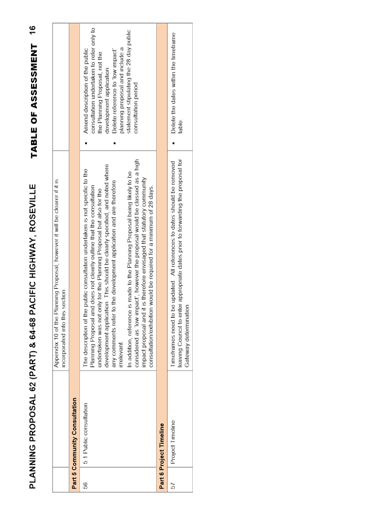
|
|
|
comments:
|
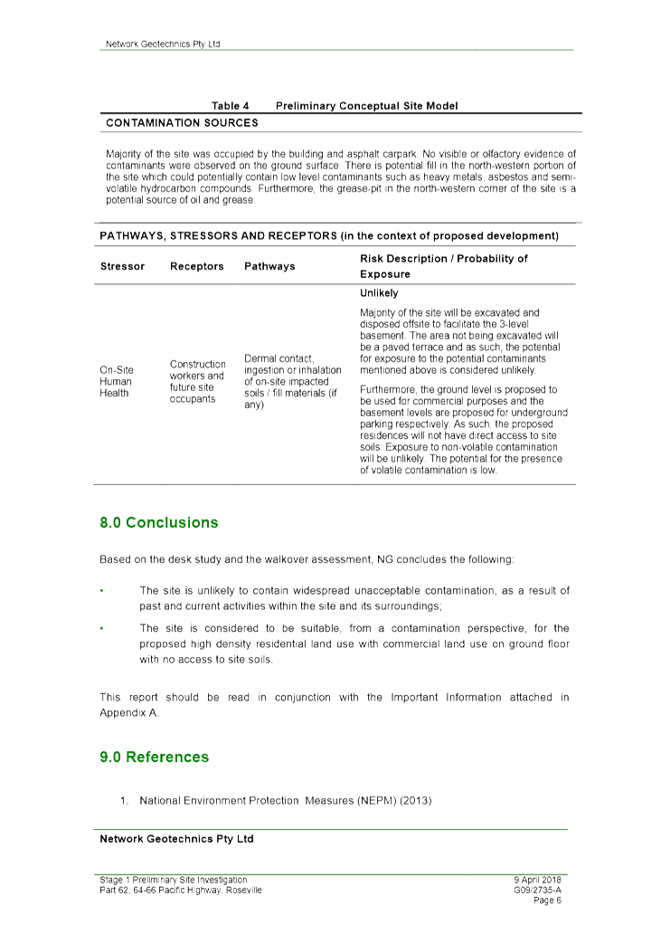
The site is currently occupied by
the Roseville Memorial Club which is housed within an existing single storey
building. The Planning Proposal seeks amendment to the KLEP Local Centres
2012 to amend the zoning to a small portion of the site; and, enable one
additional floor level over that permitted under current planning controls,
to a total of seven levels; and, to enable the provision of residential
dwellings above the ground floor club use.
|
|
|
|
|
recommendation:
|
That
the Ku-ring-gai Local Planning Panel provides advice to Council that the
Planning Proposal be amended in accordance with the recommendations of this
Report and be submitted to the Department of Planning and Environment for a
Gateway Determination.
|
Purpose of Report
To refer the Planning Proposal for 62 (part) and 64-68
Pacific Highway, Roseville, to the Ku-ring-gai Local Planning Panel for
consideration of strategic merit with reference to strategic plans (Greater
Sydney Region Plan and North District Plan) and advice to Council as required by
the Local Planning Panels Direction – Planning Proposals issued by
the Minister for Planning under Section 9.1 of the Environmental Planning
and Assessment Act 1979.
Background
Council has engaged consultant MG Planning Pty Ltd (PO Box
197, Drummoyne NSW 1470) to conduct the assessment of this Planning Proposal
and prepare a report for the Panel on the findings. Assessment of traffic and
transport issues has been carried out by Council’s Strategic Traffic
Engineer and incorporated into the Table of Assessment which details the
assessment of all Planning Proposal documents MG Planning. The Table of
Assessment may be viewed at Attachment A1.
A Planning Proposal has a separate process and different
matters of consideration to a Development Application. Whilst a Development
Application considers built form outcomes on the site, a Planning Proposal
considers the strategic aspects of an amendment to an LEP and the implications
of that amendment to the local and wider context.
The Planning Proposal seeks amendment to the local strategic
planning instrument (Ku-ring-gai Local Environmental Plan (Local Centres)
2012); as such, any assessment must consider the strategic merit of the
proposal as stipulated in the regional plan (Greater Sydney Region Plan)
and the district plan (North District Plan), and the site specific merit
relating to the local context.
The Planning Proposal was submitted to Council on 19 July
2018. Following review, it was determined that the Planning Proposal was
incomplete and the proponent was therefore requested to make amendments. An
amended proposal was submitted on 1 August 2018, however this submission
remained incomplete. Following further submission of revised documentation, the
review of the Planning Proposal formally commenced on 9 January 2019. A copy of
the Planning Proposal and its appendices is included
at Attachments A2-A12.
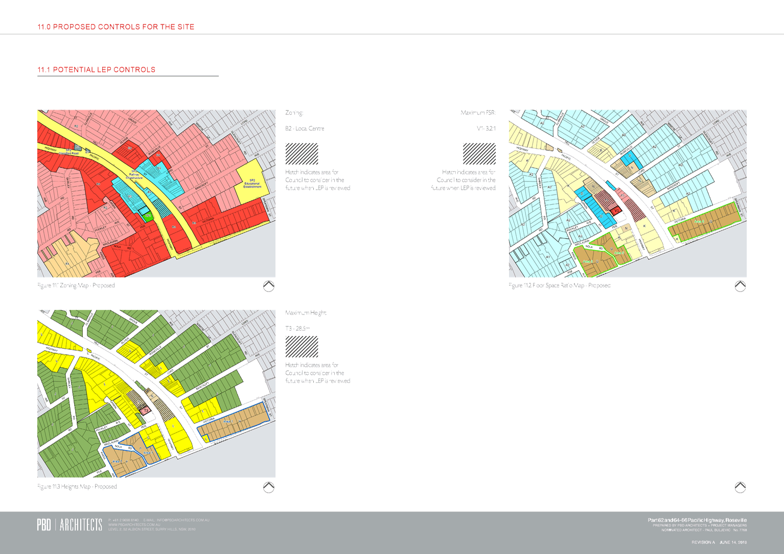
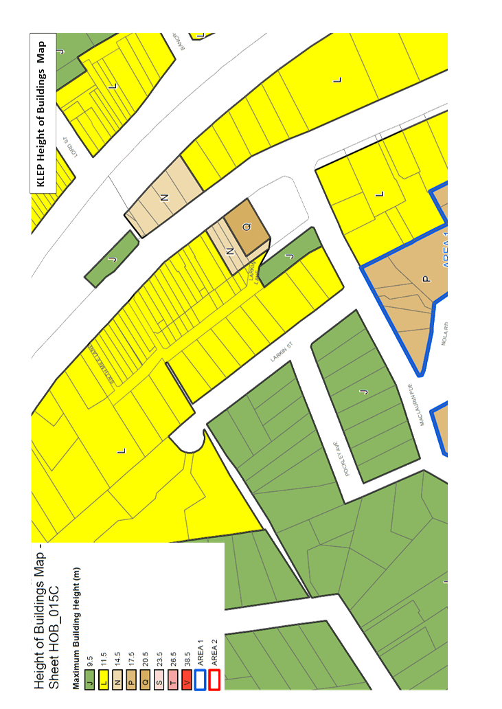
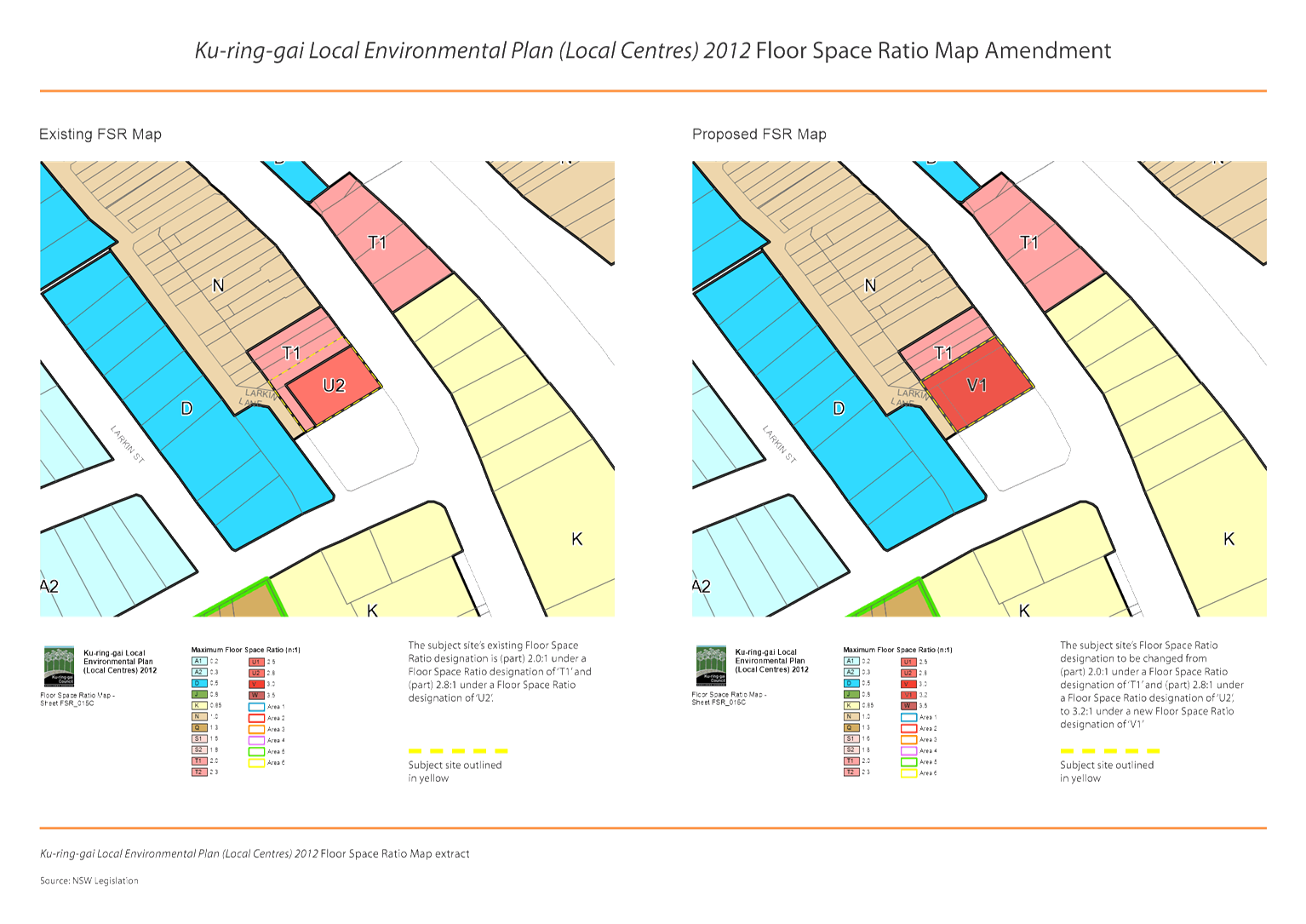
The proponent seeks to make the following amendments to the Ku-ring-gai
Local Environmental Plan (Local Centres) 2012 (KLEP Local Centres 2012):
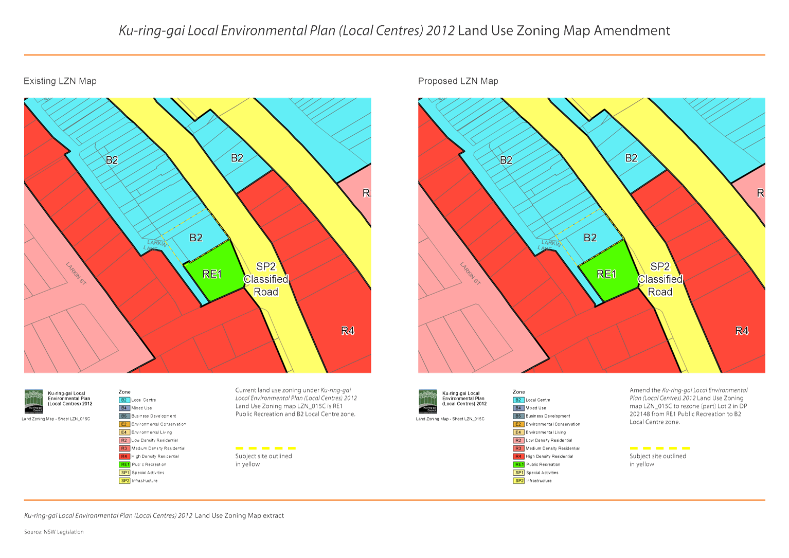
1. Amend
the Land Use Zoning Map to rezone a small part of Lot 2 in DP 202148 from RE1
Public Recreation to B2 Local Centre.
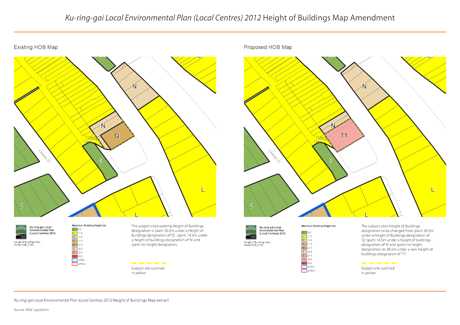
2. Amend
the Height of Buildings Map from part Q - 20.5m, part N - 14.5m and part zero
height designation, to a new height of T1 - 28.5m.
3. Amend
the Floor Space Ratio Map from part T1 - 2.0:1 and part U2 - 2.8:1, to V1 -
3.2:1.
4. Amend
Schedule 1 of the Written Instrument to allow residential flat buildings on the
site, as long as the residential flat building is wholly located above a ground
floor registered club.
5. Amend
Clause 1.8A of the Written Instrument so that proposed changes are applicable
to development applications that are lodged prior to the formal gazettal of the
amended instrument.
The proposed amendments to the KLEP Local Centres 2012 are
intended to allow for an additional floor level above that permissible under
current planning controls and to provide certainty regarding the permissibility
of residential dwellings above the ground level where undertaken in association
with the existing club use.
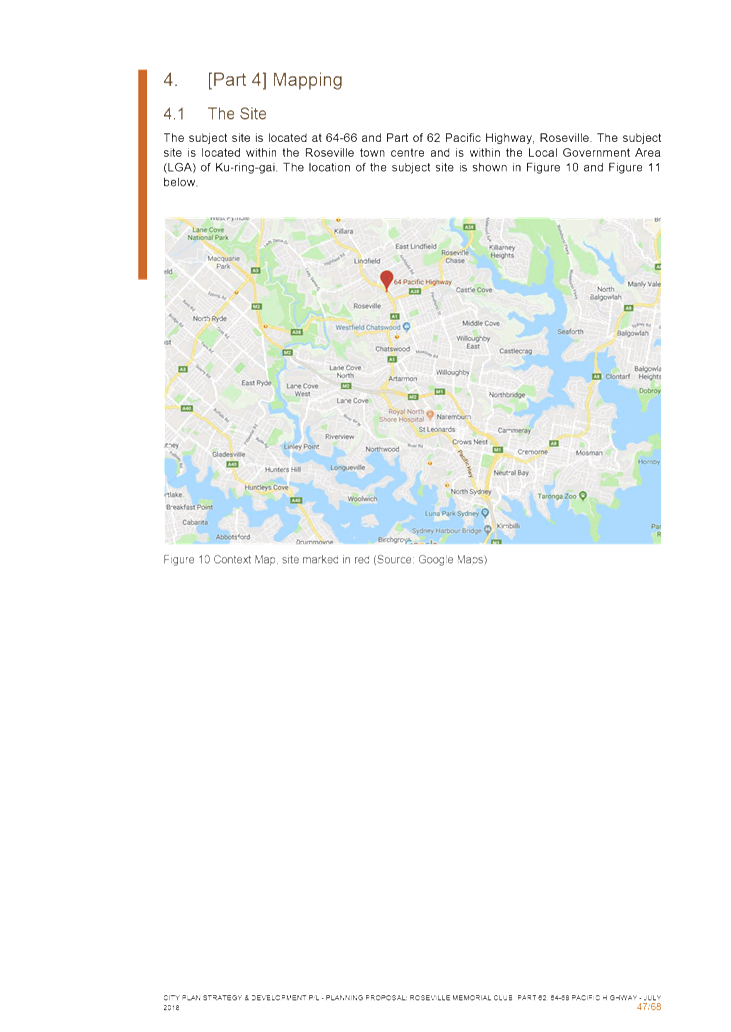
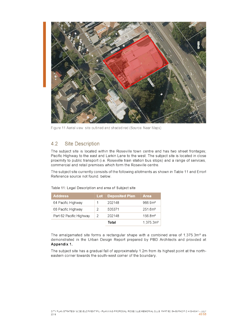
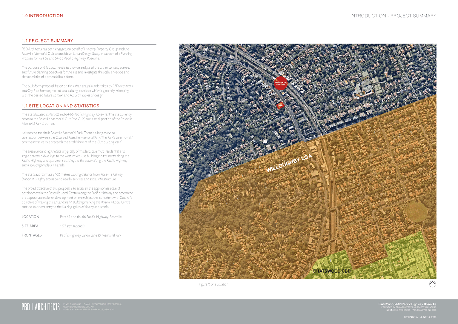
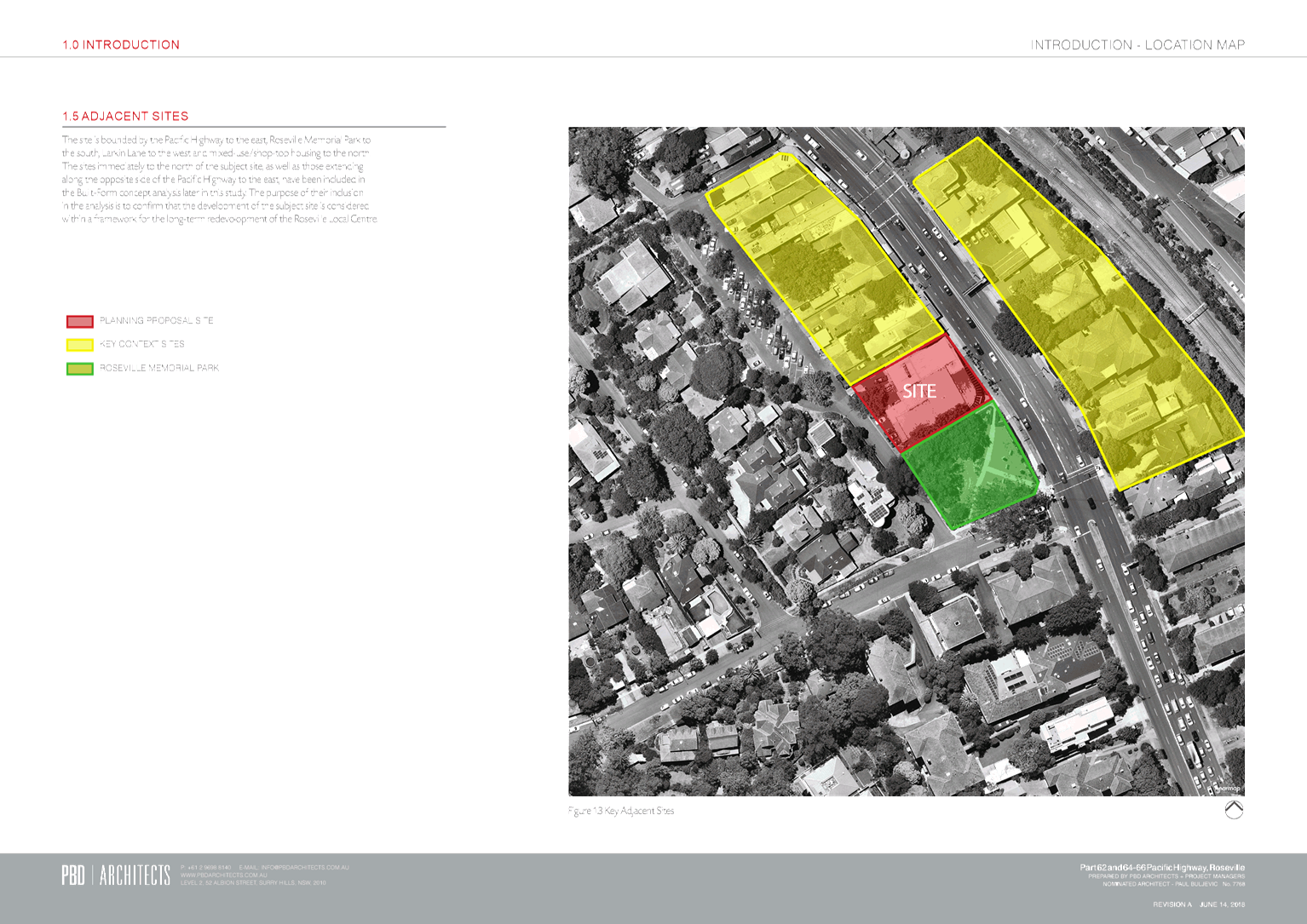
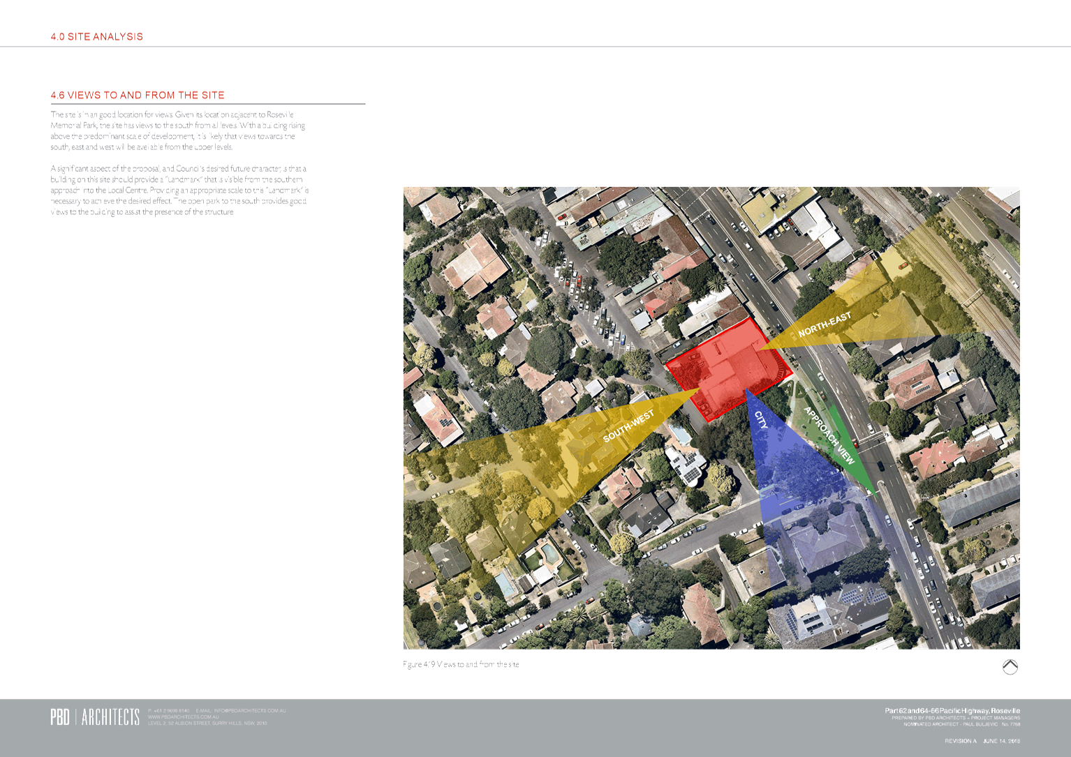
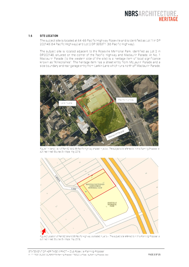
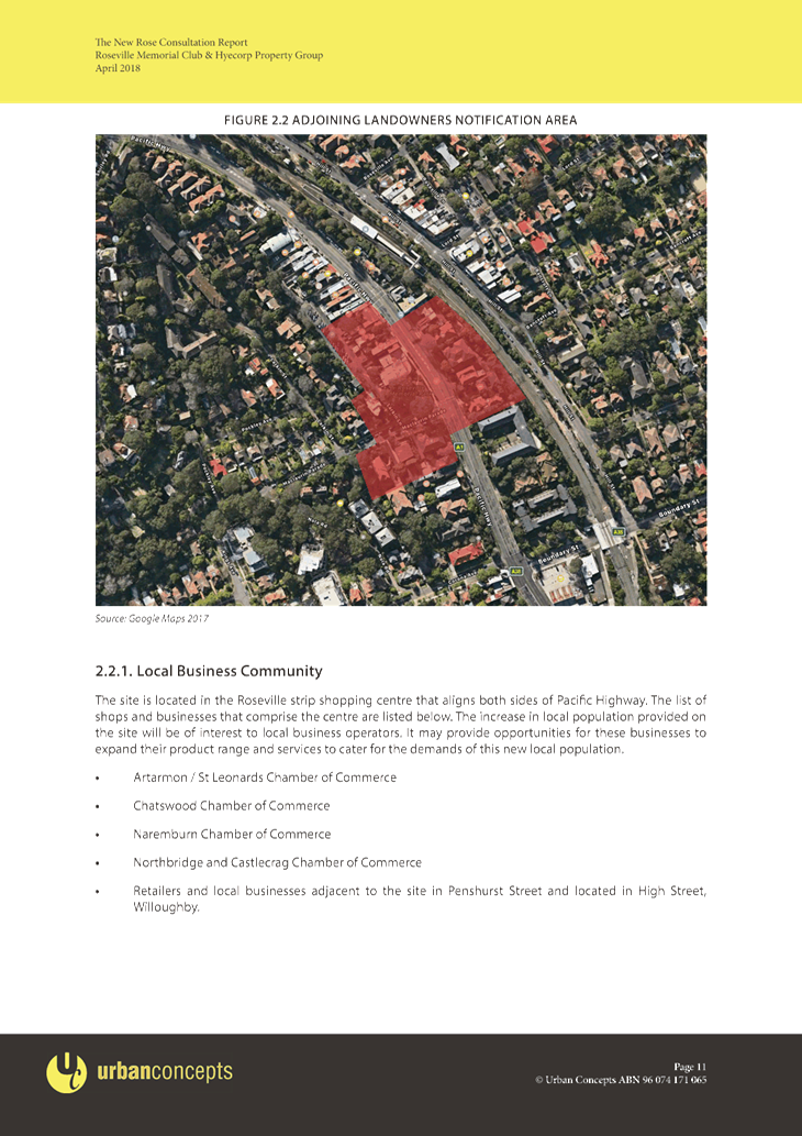
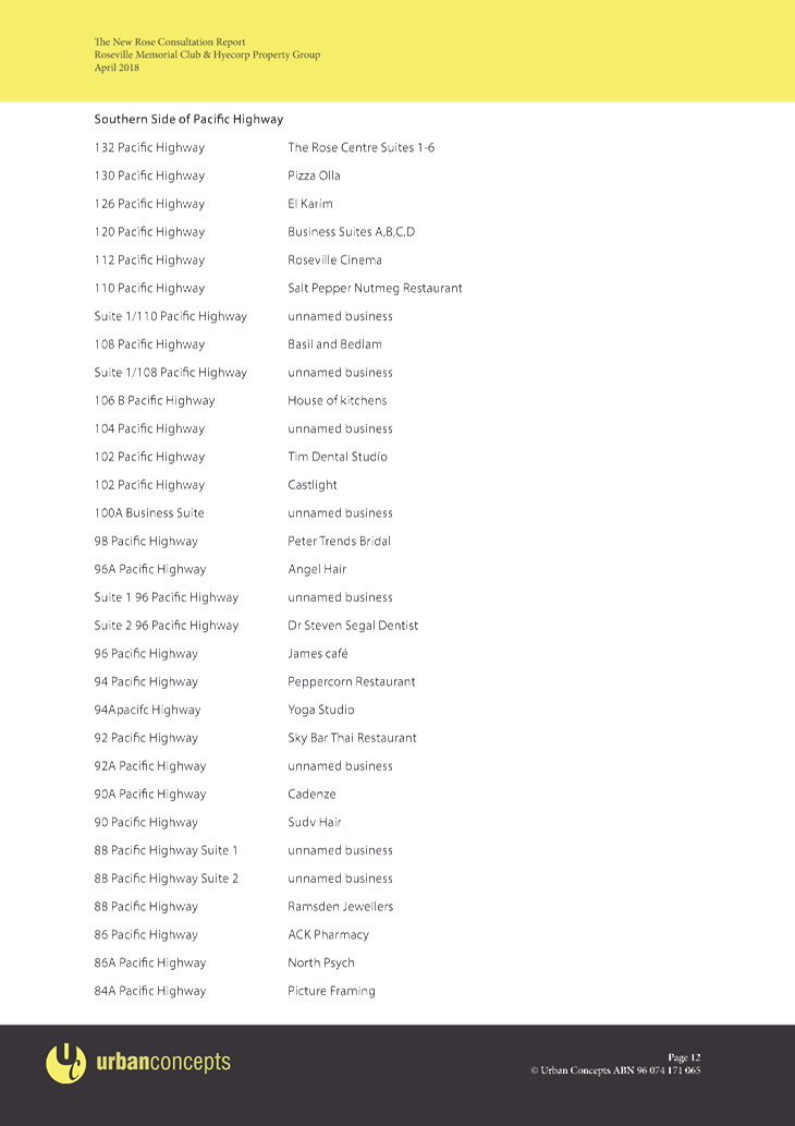
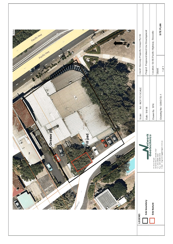
Site Description and Local Context
The site is located on the Pacific Highway at the southern
entry to the Roseville Local Centre, directly adjacent to the Council owned
Roseville Memorial Park. The site is rectangular in shape, with frontage
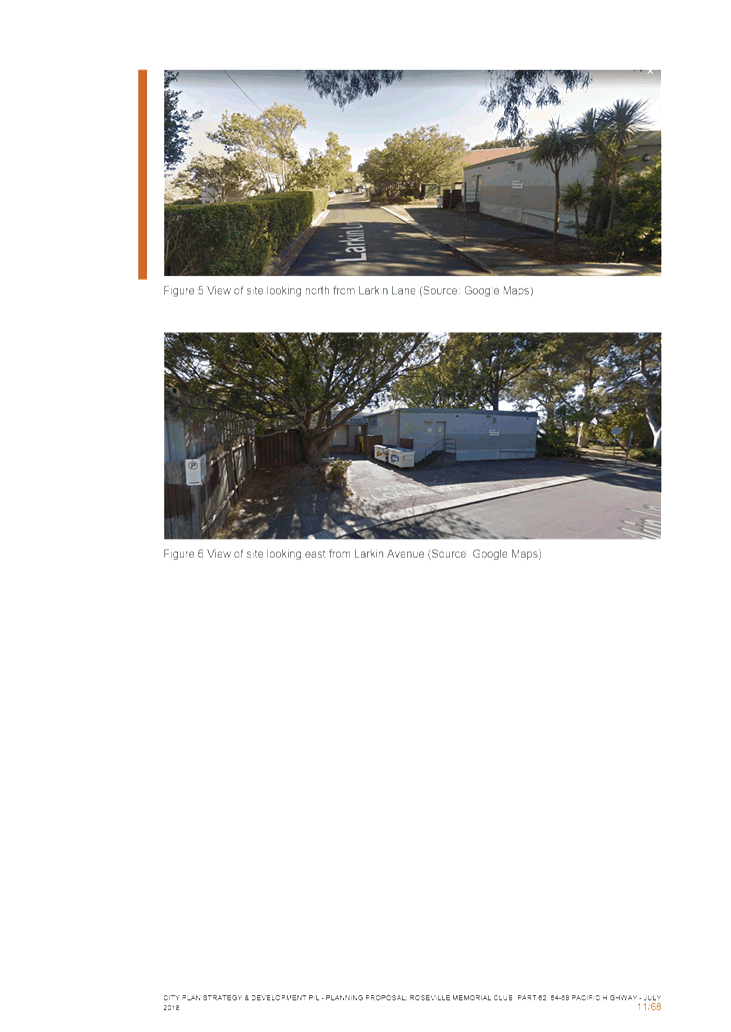
to both the Pacific Highway (east) and Larkin Lane (west). The site also has
frontage to the Park to the south.
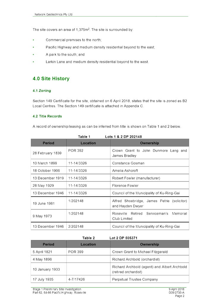
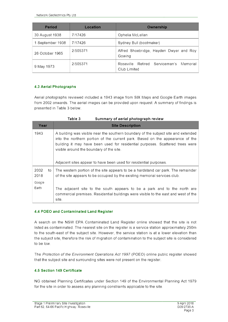
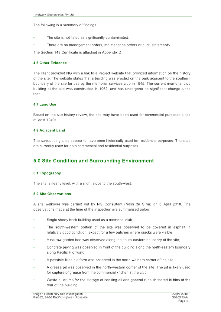
The site has a combined area of 1,375.3sqm comprising:
· Lot 1
DP202148 – 966.9sqm
· Lot 2
DP505371 – 251.6sqm, and
· Part of Lot
2 DP202148 – 156.8sqm.
Located on a high point within the locality, the site has a
slight fall from its highest point in the north-eastern corner towards the
south-west. A steep hill then falls away to the west down to a natural
valley through which Bluegum Creek flows.
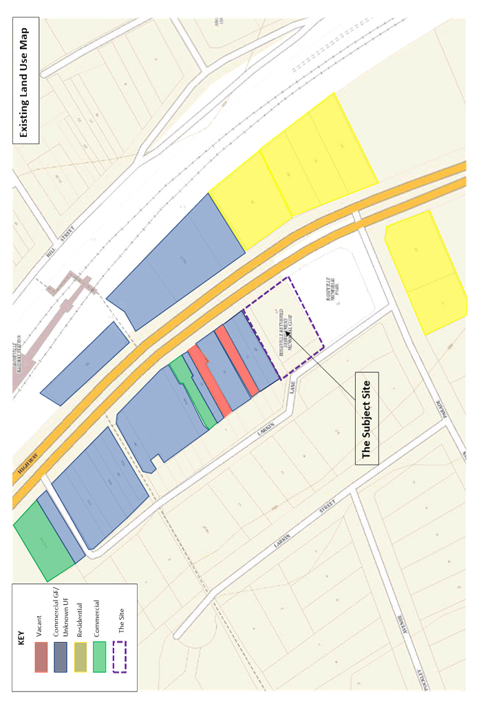
The site is occupied by the existing Roseville Memorial Club
(Roseville RSL) within a single storey building with main entrance to the
Pacific Highway. To the rear, on Larkin Lane, the site accommodates a
loading dock, car parking area, garbage and storage area. One large tree is
located within the site adjacent to the loading bay.
Ku-ring-gai Council owns part of the site included in this
Planning Proposal and described as 62 (part) Pacific Highway. This land is
located to the rear of 64 Pacific Highway, adjacent to Larkin Lane and is
currently utilised for public parking and a garden bed extending from the
Memorial Park. Council reclassified this parcel of land in December 2016 and
considered a report on 13 June 2017 for future divestment of a number of
parcels of reclassified land including the land at the rear of 64 Pacific
Highway. Council has been provided with a valuation and offer from the
Roseville RSL to acquire the land. The matter is under consideration and will
be reported to Council once negotiations progress.
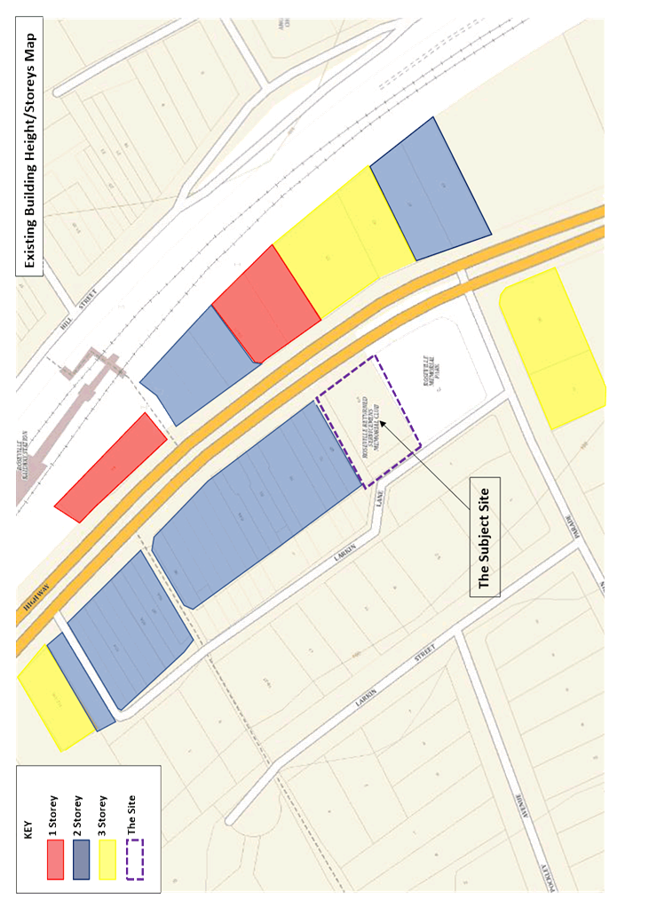
To the north, the site is directly adjoined by a two-storey
building with retail use on the ground floor. Further north the area
accommodates the retail and commercial buildings of the Roseville Local Centre
which are typically two storeys in height. The area to the north
including the subject site, is zoned B2 Local Centre.
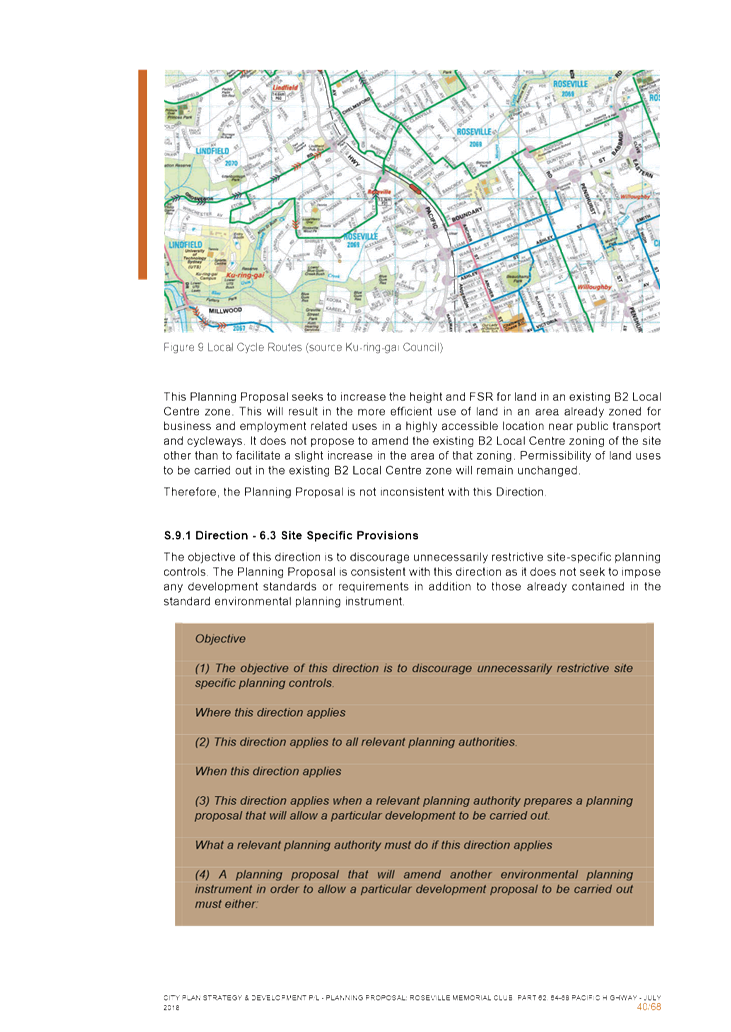
The Roseville Railway Station is located across the Pacific
Highway approximately 130 metres to the north-east of the site.
To the south, the site is directly adjacent to the Roseville
Memorial Garden which accommodates a formal garden, war memorial and a number
of substantial trees on the perimeter including two large trees adjacent to the
boundary nearest the subject site.
The surrounding area immediately to the south, east and west
is zoned R4 High Density Residential and typically accommodates three-storey
residential flat buildings along the Highway.
Directly to the west of the site, across Larkin Lane, is the
heritage listed dwelling “Killiecrankie” with its main entry on the
corner of Maclaurin Parade and Larkin Lane. Further west of Larkin Street is an
area of R2 Low Density Residential characterised by a mix of one and two-storey
detached dwellings.
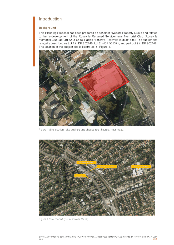
Aerial photo, site
outlined in red (Source:Nearmap 27/12/18)
Site lot boundaries,
site outlined in red (Source:Sixmaps)
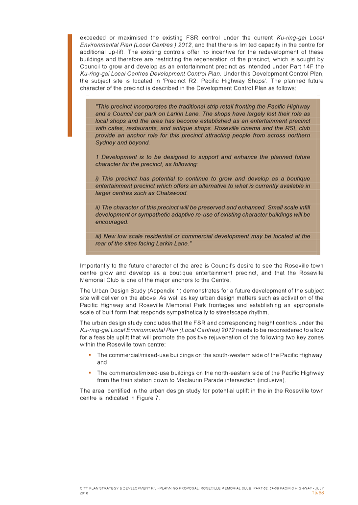
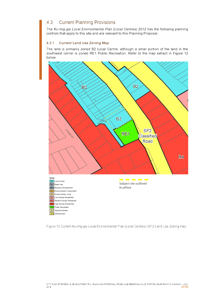
As noted above the site is currently zoned B2 Local Centre,
with a small portion of the land adjacent to the Memorial Park zoned RE1 Public
Recreation, under the Ku-ring-gai Local Environmental Plan (Local Centres)
2012.
Zoning Map Extract
KLEP Local Centres 2012
Permitted land uses in the B2 Local Centre zone include:
Boarding houses;
Centre-based child care facilities; Commercial premises; Community facilities;
Educational establishments; Entertainment facilities; Function centres; Group
homes (permanent); Hostels; Information and education facilities; Light
industries; Medical centres; Passenger transport facilities; Recreation
facilities (indoor); Registered clubs; Respite day care centres; Restricted
premises; Roads; Seniors housing; Service stations; Shop top housing; Tourist
and visitor accommodation; Water reticulation systems.
Permitted land uses in the RE1 Public Recreation zone
include:
Animal boarding
or training establishments; Bee keeping; Camping grounds; Car parks; Caravan
parks; Centre-based child care facilities; Community facilities; Emergency
services facilities; Flood mitigation works; Food and drink premises; Forestry;
Information and education facilities; Kiosks; Markets; Plant nurseries;
Recreation areas; Recreation facilities (indoor); Recreation facilities
(major); Recreation facilities (outdoor); Registered clubs; Roadside stalls;
Signage; Water recycling facilities; Water supply systems.
Development History
A Development Application (DA0134/18) was lodged with
Council on 12 April 2018 seeking consent to demolish the existing structures on
site (including Roseville RSL Club and retail tenancy) and construct a
mixed-use building comprising new ground floor RSL Club, shop-top housing
totalling 33 residential dwellings, basement parking and associated works. The
DA is understood to generally comply with the existing height and floor space
ratio controls applying to the site. However, an initial assessment made
by Council’s assessment team in September 2018 identified issues with
development on that part of the site currently zoned RE1 (Public Recreation),
plus concerns regarding landscaping, relationship to the Roseville Memorial
Park, engineering, access and service issues connected with incorporation of
Council’s land and the associated lot subdivision and consolidation. As a
result of the preliminary assessment, the subject DA has been suspended until
relevant matters are resolved.
It is understood that the proponent is in the process of
negotiating a Voluntary Planning Agreement (VPA) as part of their development
application to resolve issues regarding the incorporation of Council’s
land into the development site and to ensure the provision of public benefit
commensurate with any proposed future development of the site.
Comments
The Planning Proposal (Attachment A2 – A12) has
been assessed against the provisions of the Department of Planning and
Environment’s ‘A guide to preparing planning proposals’
and section 3.33 of the Environmental Planning and Assessment Act 1979.
A detailed evidence-based assessment of the Planning
Proposal and its supporting studies has been conducted. The Planning
Proposal provides sufficient evidence to demonstrate that the proposal has
strategic and site-specific merit. Accordingly, the Planning Proposal is
supported subject to the incorporation of the recommended amendments stipulated
in this report and in the Table of Assessment at Attachment A1.
The following is a summary assessment of the key planning
issues associated with the Planning Proposal.
Strategic Merit
A Planning Proposal must demonstrate that the proposed
amendments to the Local Environmental Plan have strategic and site specific
merit. The following is an assessment of the relevant merits of the Planning
Proposal.
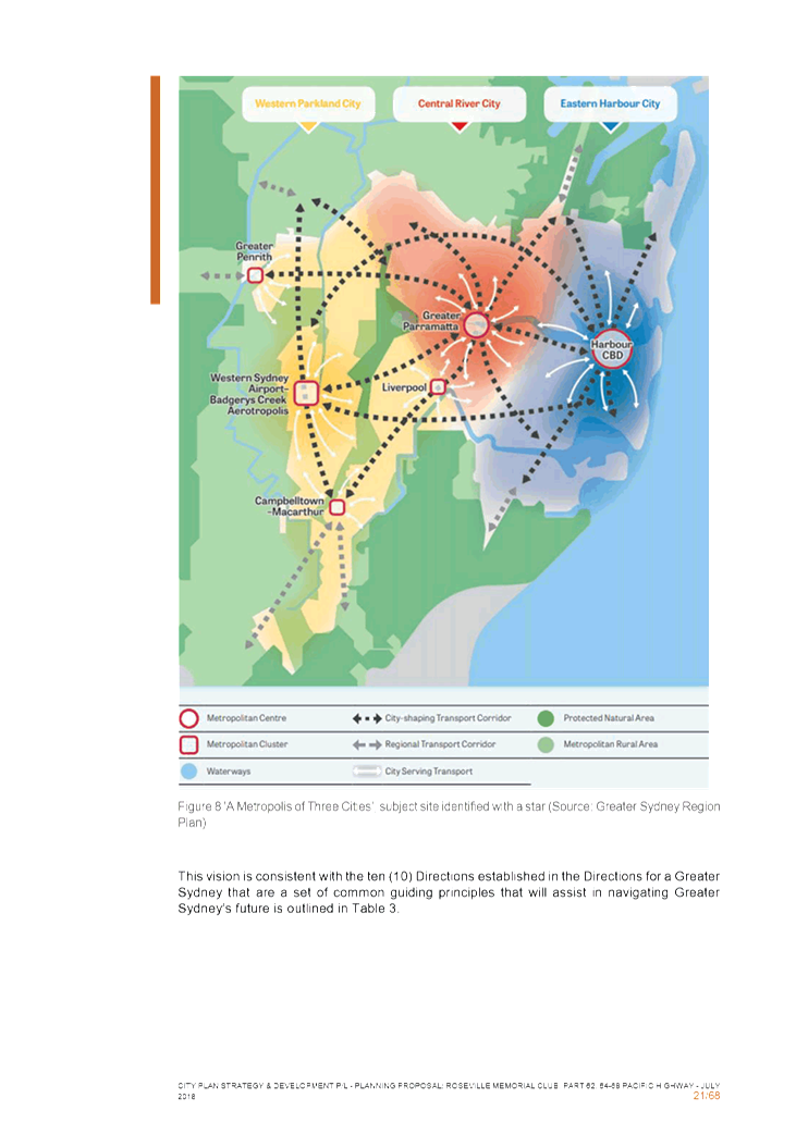
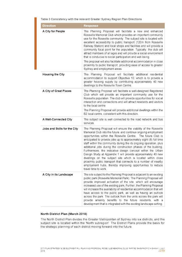
Regional Plan
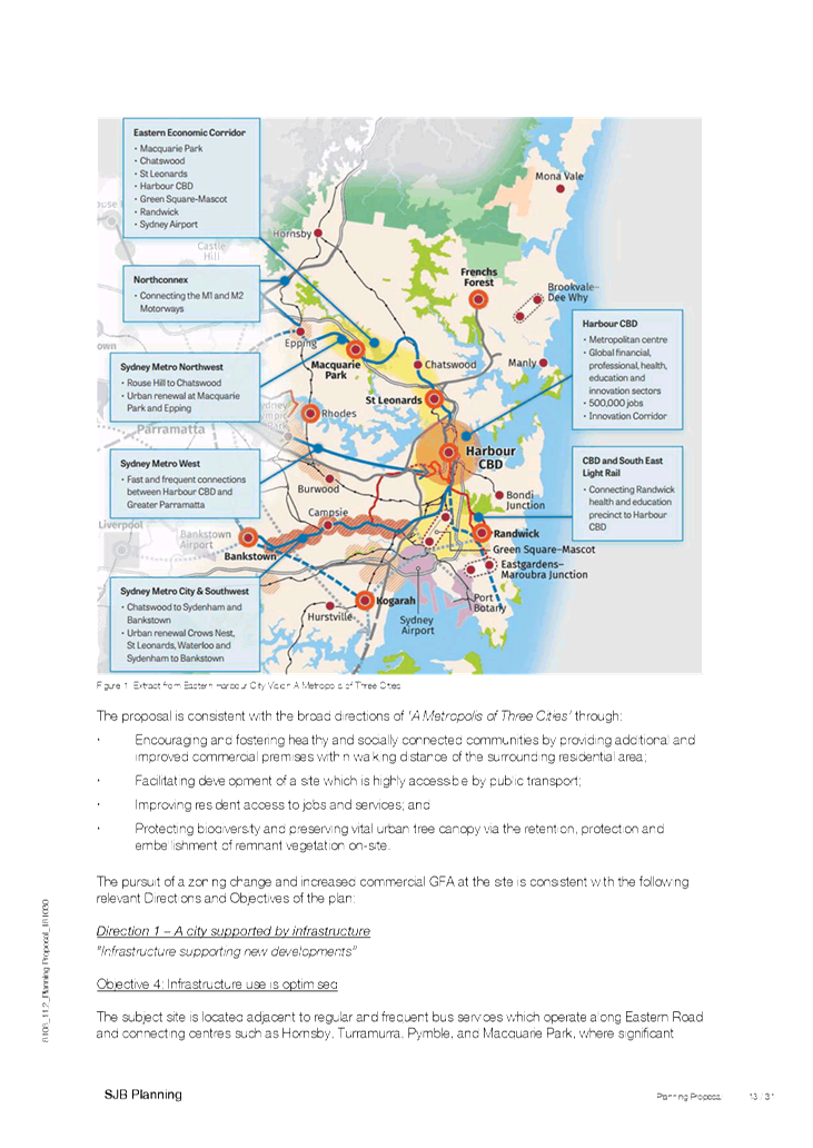
The Planning Proposal is consistent with the objectives of
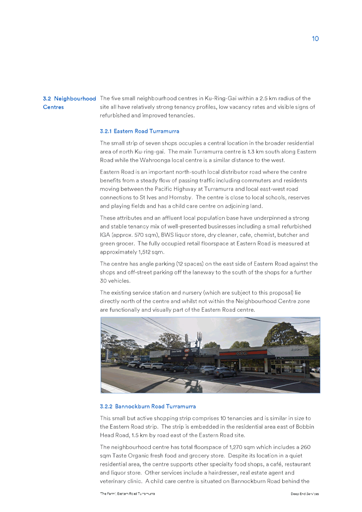
the Greater Sydney Region Plan – A Metropolis of Three Cities, in
particular:
· Objective 6
– Services and Infrastructure meet communities changing needs,
· Objective 7
– Communities are healthy, resilient and socially connected,
· Objective 10
– Greater housing supply, and
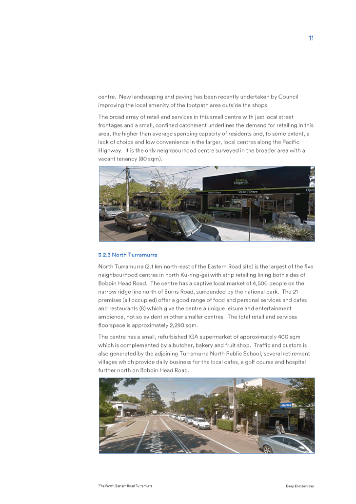
· Objective 14
– Integrated land use and transport creates walkable and 30 minute
cities.
A Metropolis of Three Cities outlines that
liveability incorporates access to housing, transport and employment as well as
social, recreational, cultural and creative opportunities. Improved
health, public transport and accessibility outcomes are achieved through the
provision of schools, recreation, transport, arts and cultural, community and
health facilities in walkable, mixed-use places co-located with social
infrastructure and local services. Mixed-use neighbourhoods close to centres
and public transport improve the opportunity for people to walk and cycle to
local shops and services. Enhancing the safety, convenience and accessibility
has many benefits, including healthier people, more successful businesses and
centres. The proposal is consistent with these principles.
District Plan
The North District Plan highlights that the North
District will continue to grow over the next 20 years with demand for an
additional 92,000 dwellings. The five-year target (to 2021) for
Ku-ring-gai is to provide an additional 4,000 dwellings. Additional
housing is to be provided in locations which are linked to local
infrastructure. The focus of growth is therefore on strategic centres and
areas close to transport corridors.
The Planning Proposal is consistent with the following
planning priorities of the North District Plan:
· Planning
Priority N4 - Fostering healthy, creative, culturally rich and socially
connected communities,
· Planning
Priority N5 - Providing housing supply, choice and affordability, with access
to jobs, services and public transport,
· Planning
Priority N6 - Creating and renewing great places and local centres, and
respecting the District’s heritage, and
· Planning
Priority N12 – Delivering integrated land use and transport planning and
a 30min city.
The Planning Proposal will allow for a mixed-use development
providing additional dwellings in a well-located site within the Roseville
Local Centre, in close proximity to public transport and a major transport
route (Pacific Highway). The co-location of residential dwellings, social
infrastructure and local services in centres provides for a more efficient use
of land and enhances the viability of the centres and public transport.
The proposal is therefore in accordance with the North District Plan strategy
to focus growth in areas close to public transport and the concept of a
30-minute city.
In accordance with the Department of Planning and
Environment’s ‘A guide to preparing planning proposals’,
a Planning Proposal is deemed to have strategic merit if it is consistent with
the relevant district plan. As outlined above it is considered that the
proposal is consistent with the objectives, priorities and strategies of both
the Greater Sydney Region Plan and the North District Plan. It is
therefore considered to have strategic merit.
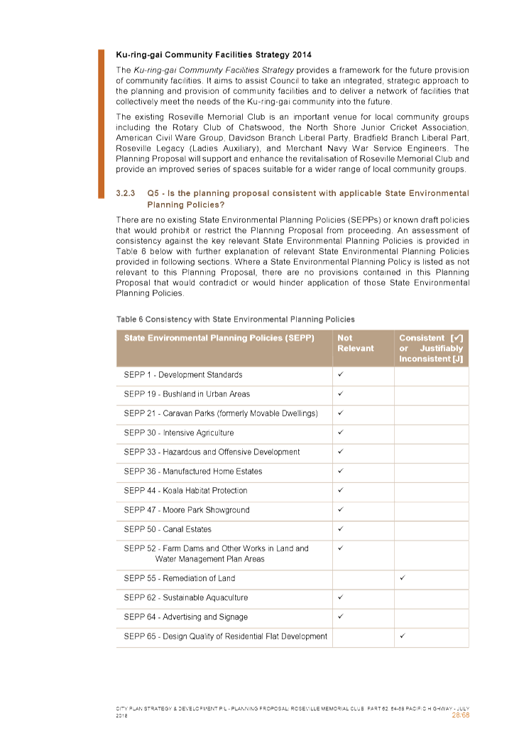
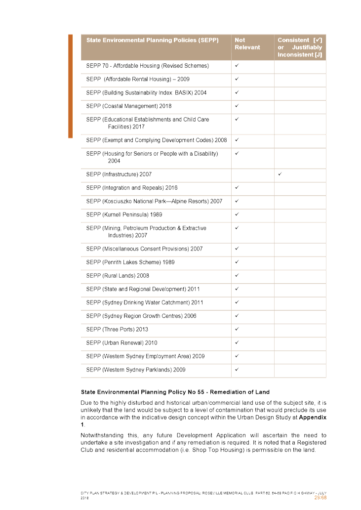
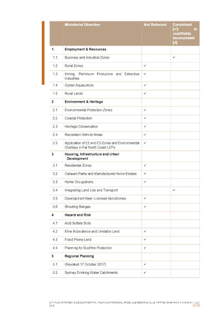
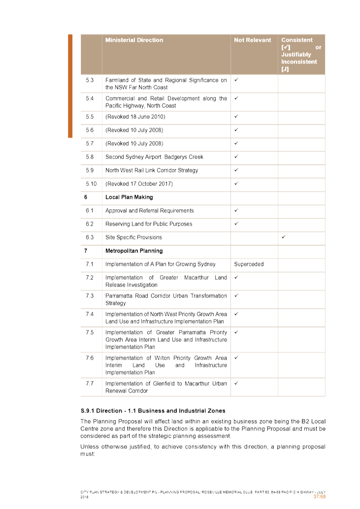
State Environmental Planning Policies (SEPPs) and
Ministerial Directions
The Planning Proposal is not inconsistent with the State
Environmental Planning Polices (SEPPs) applicable to the site and generally
consistent with the applicable Ministerial Directions (Section 9.1 Directions).
Site Specific Merit
The subject site is considered to be suitable for increased
height and density, particularly given its location near to public transport,
the Pacific Highway and the Roseville Local Centre. Notwithstanding this,
the proposal does give rise to some potential impacts that should be addressed
via amendments to the Planning Proposal prior to it being forwarded to the
Department of Planning and Environment for a Gateway Determination.
The following comments and recommended amendments are made
cognisant of the fact that a Planning Proposal is not a development application
and does not consider the specific detailed matters for consideration under
Section 4.15 of the Environmental Planning and Assessment Act 1979. A
Planning Proposal only relates to an LEP amendment, and therefore needs to
demonstrate that the proposed amendment itself is acceptable, with any future
detailed design to be assessed at the later development application
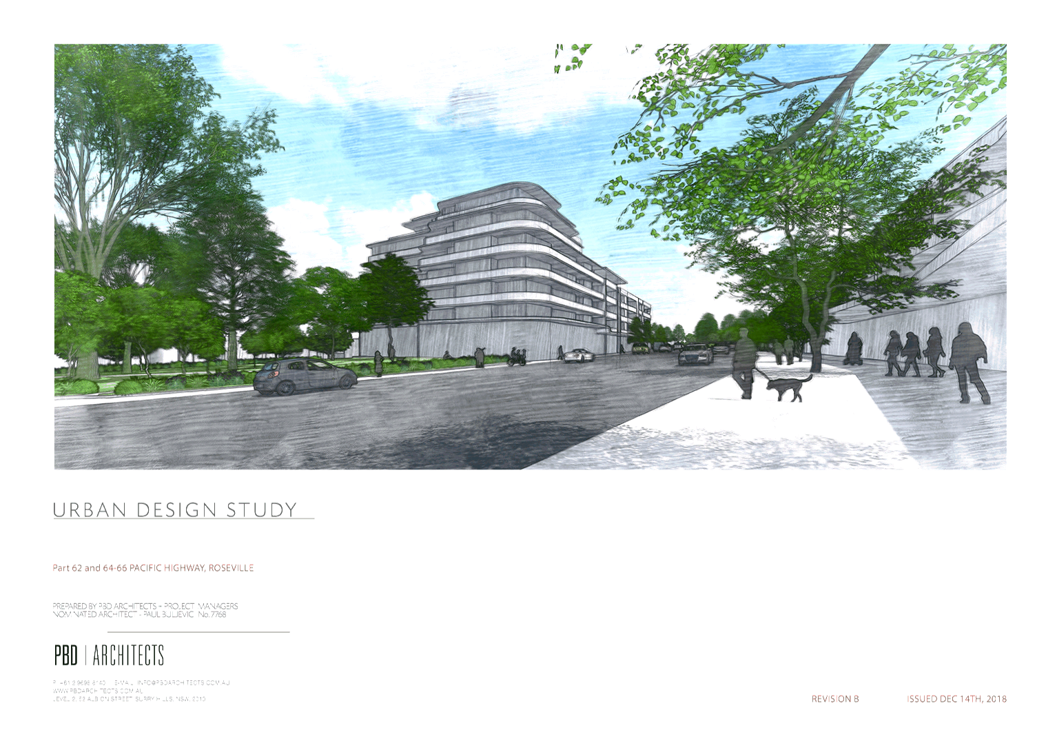
stage. Notwithstanding this, it is noted that a concept design has been
put forward as part of the Planning Proposal to illustrate the potential future
built form that could be permissible subject to approval of the LEP amendment.
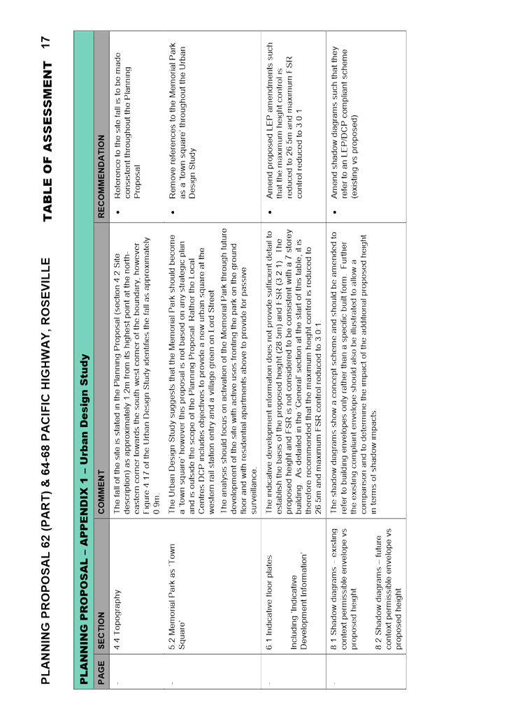
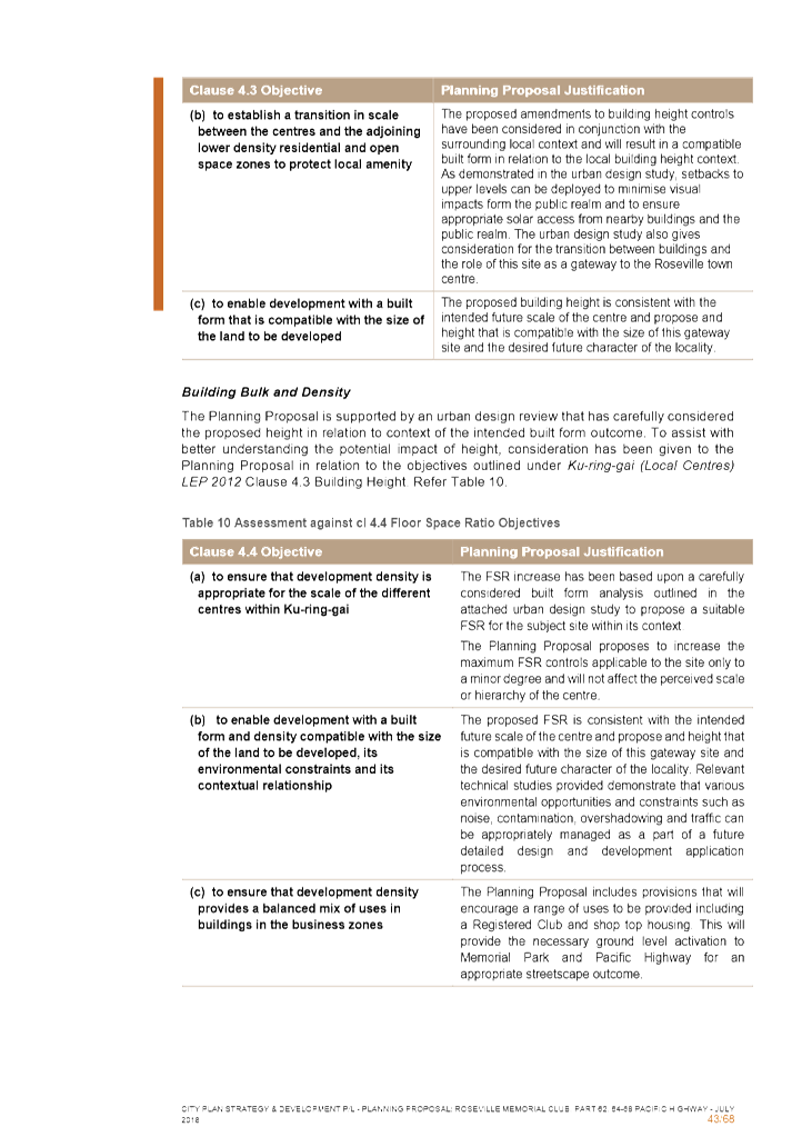
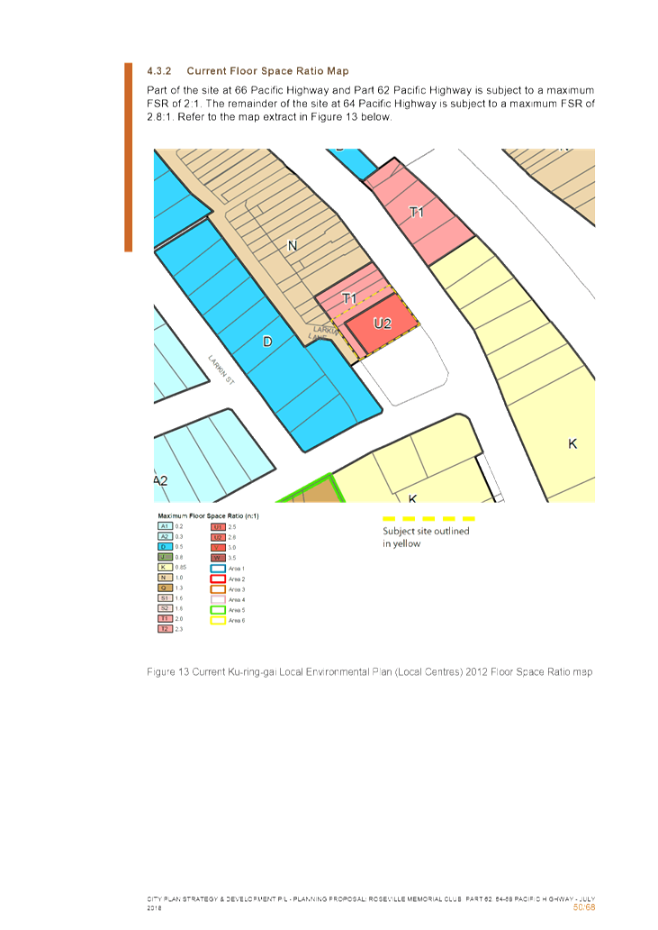
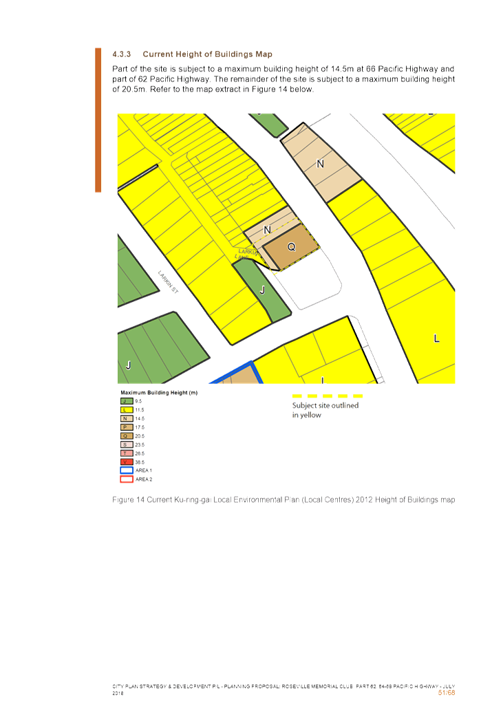
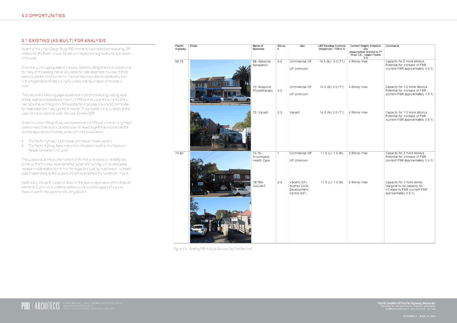
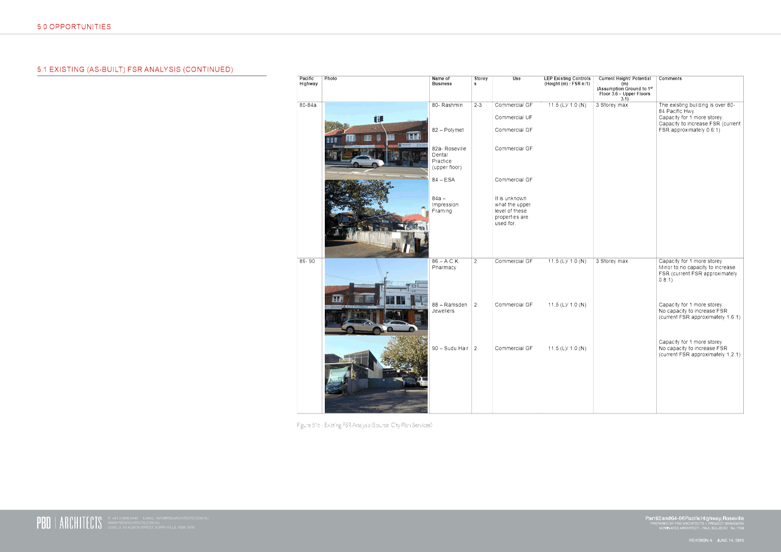
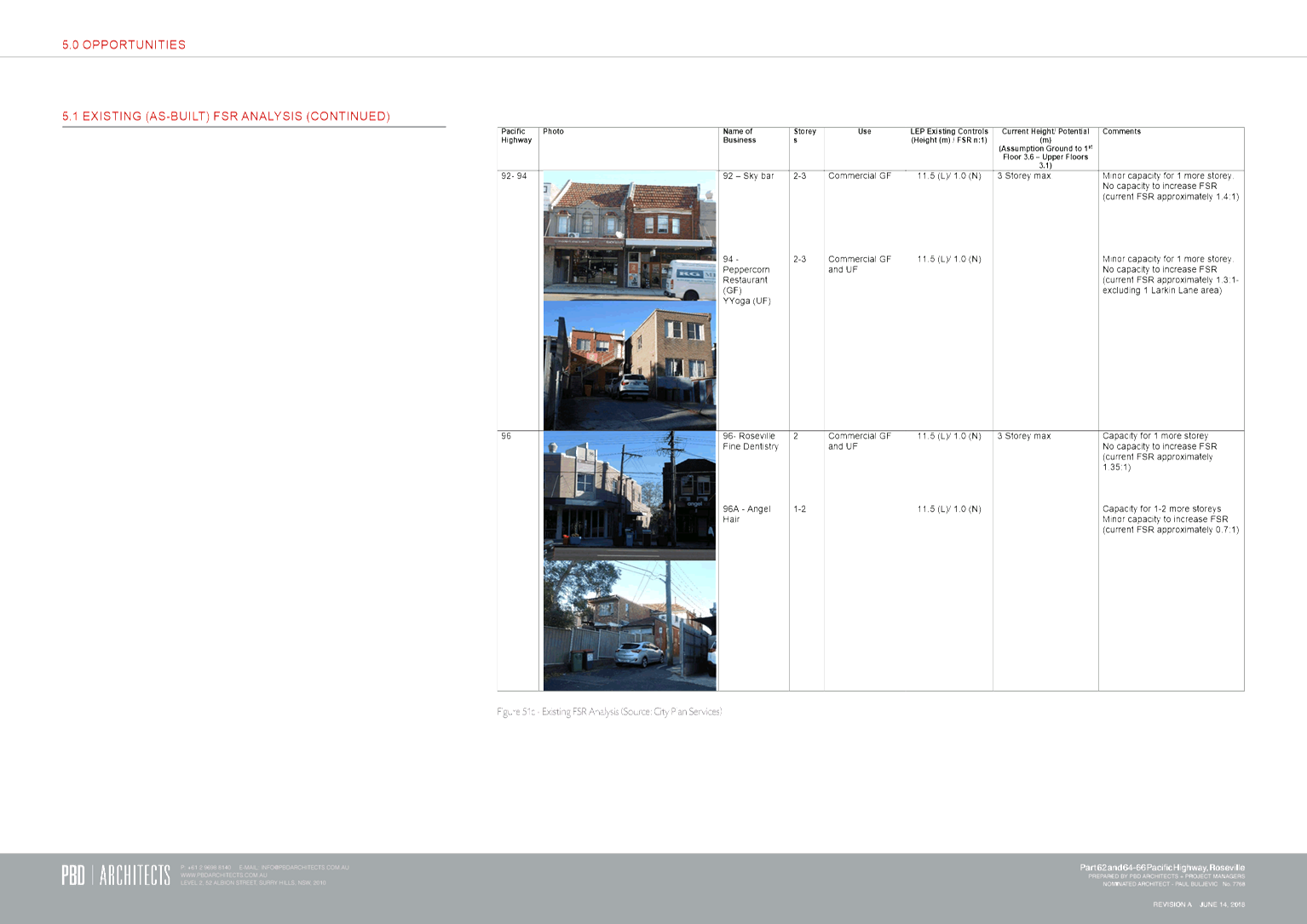
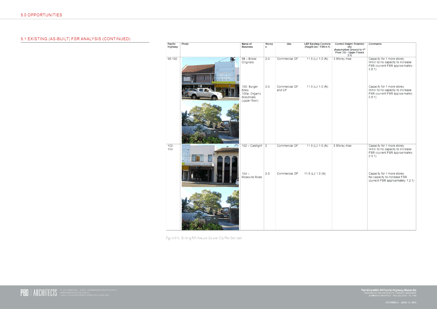
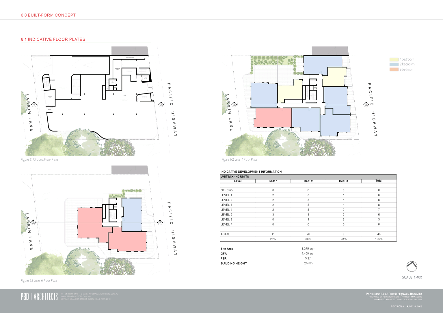
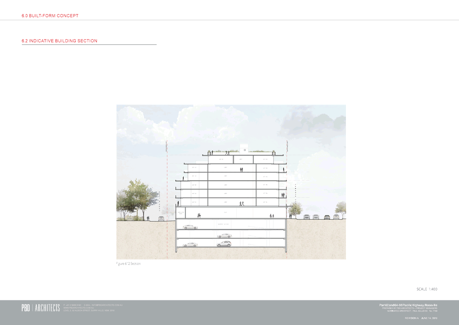
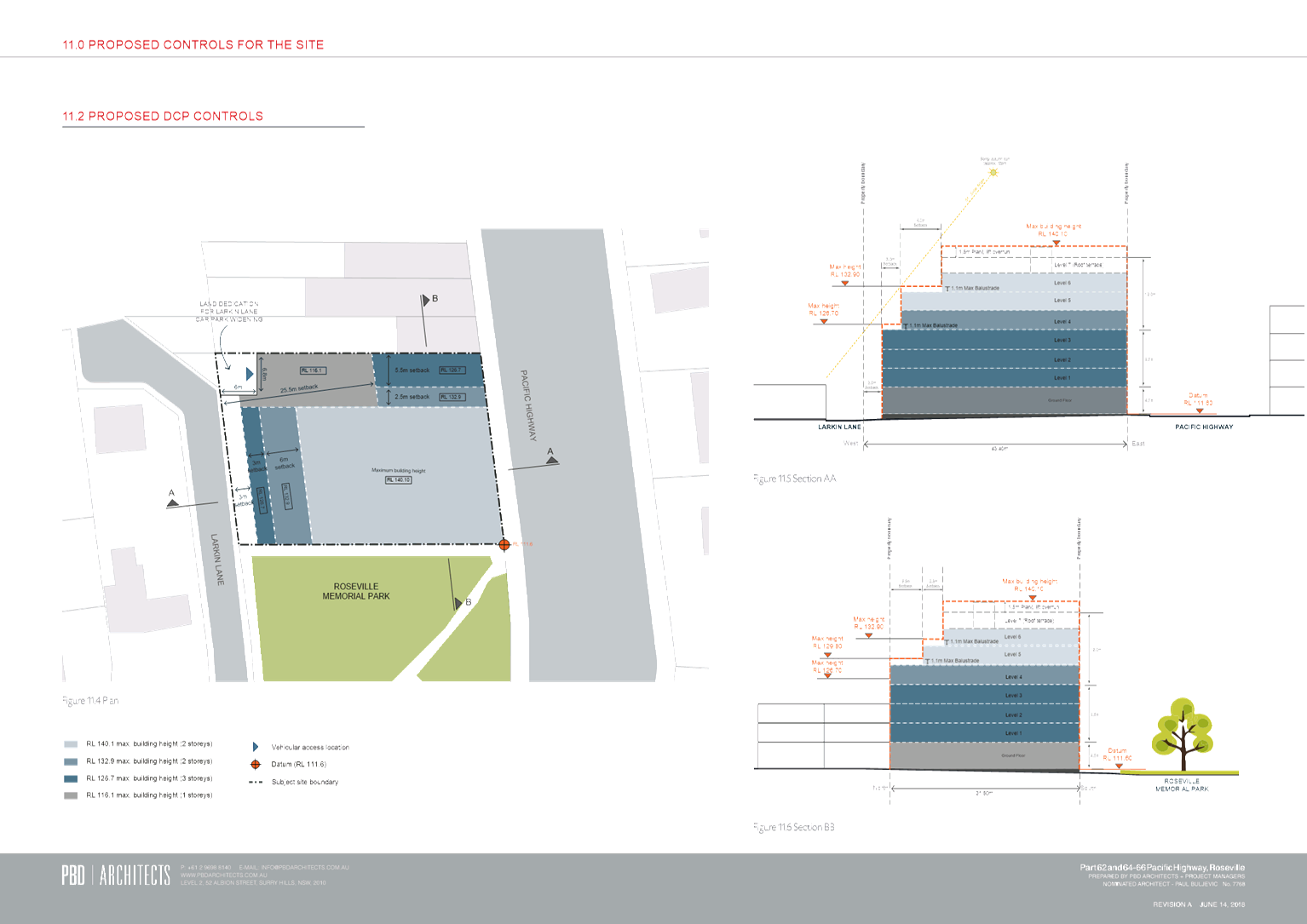
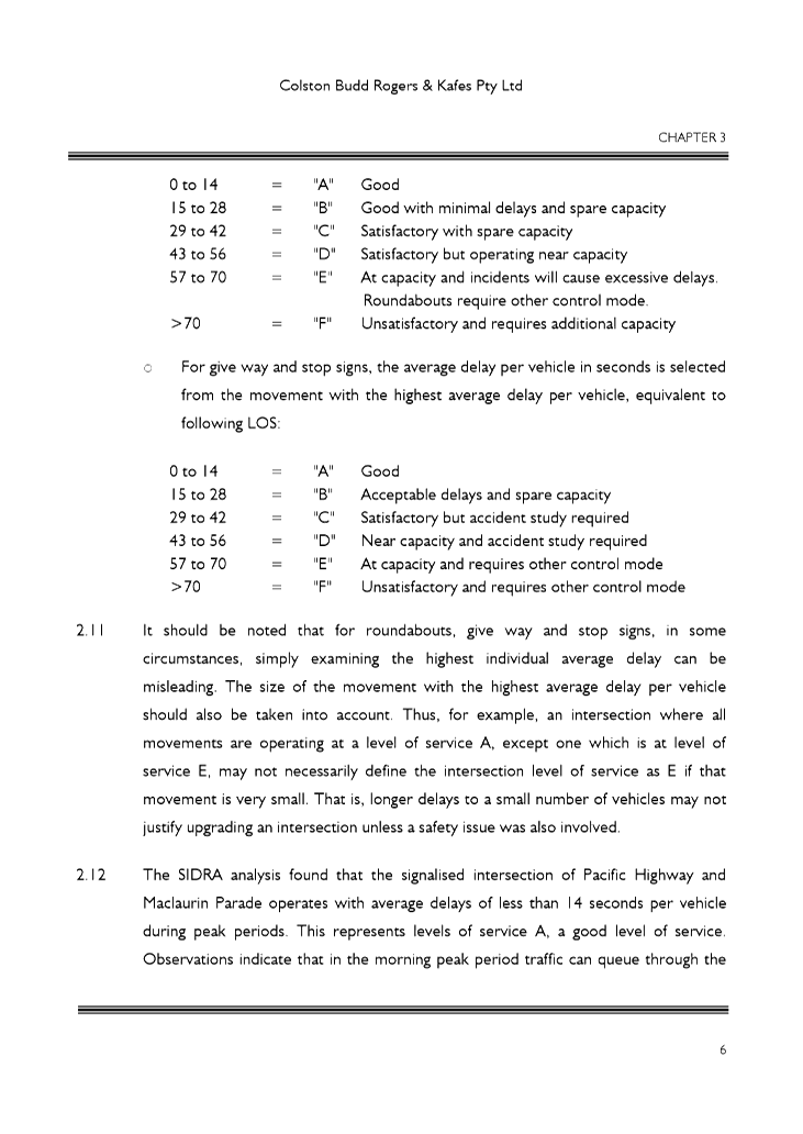
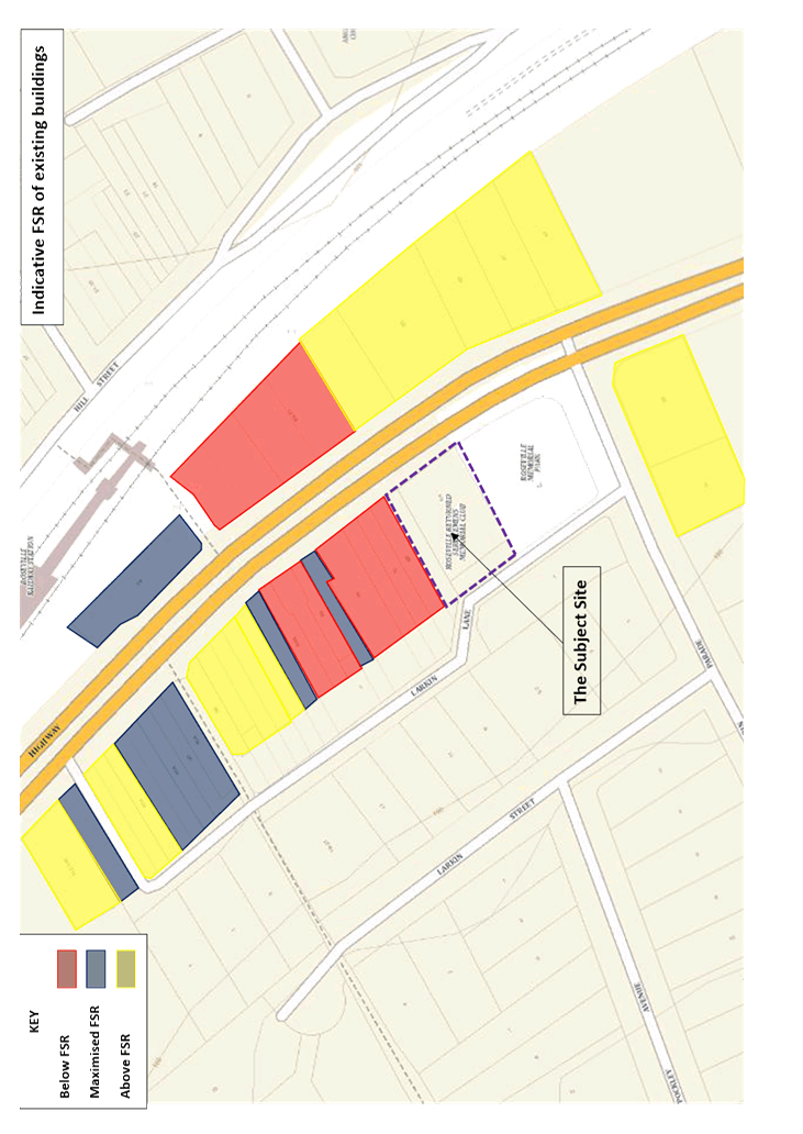
Height and floor space ratio
The Planning Proposal seeks to amend the applicable maximum
height and floor space ratio (FSR) to allow for one additional storey over and
above that allowed under the existing controls, that is, a total of 7
storeys. However, the proposed height (28.5m) and FSR (3.2:1) is not
considered to be consistent with a 7 storey building.
Given the minimum floor height requirements under the Ku-ring-gai
Local Centres Development Control Plan (Local Centres DCP), a height of
26.5m (existing height control ‘T’ under KLEP Local Centres 2012)
would easily accommodate a 7 storey building with a ground floor height of 4.4m
and six residential levels at 3.1m each (allowing 2.7m floor-to-ceiling height
and 0.4m for slab, floor and ceiling thickness). This includes an allowance
of 3.8m for roof structure(s) including lift overrun as required.
The proposed FSR also appears to be inconsistent with a 7
storey building. An estimated gross floor area of 4,040sqm (equating to
an FSR of 2.94:1) has been calculated given the proposed indicative unit mix
and using generous floor areas for each unit size, as follows:
· Ground Floor
Club = 700sqm
· 11 x
1-bedroom units @ 55sqm = 605sqm
· 20 x
2-bedroom units @ 85sqm = 1,700sqm
· 9 x
3-bedroom units @ 115sqm = 1,035sqm
· Total = 4,040sqm
/ site area 1,375sqm = FSR 2.94:1
Allowing room for error it is therefore considered that an
FSR of 3.0:1 (existing FSR control ‘V’ under KLEP Local Centres
2012) would sufficiently allow for a 7 storey building on the site.
In relation to the appropriateness of a 7 storey building in
the subject location, it is acknowledged that the Local Centres DCP identifies
the site as being suitable for a ‘landmark’ building being located
at the ‘gateway’ to the Roseville Local Centre. Greater
height than that provided for in the remainder of the local centre is therefore
considered appropriate. The current height controls for the local centre
allow for development at a scale of up to 14.5m (3-4 storeys) directly adjacent
to the site and on the opposite side of the Pacific Highway adjacent to the
railway station entrance, with other sites in the local centre having a maximum
height control of 11.5m (2-3 storeys). Existing development adjacent to the
site and to the west of the Pacific Highway (in the B2 zone) is however
predominantly 2 storey.
Given that the current applicable height controls provide
potential for a 3-4 storey building adjacent to the site, the transition of
height to a 7 storey building is not considered to be excessive, particularly
as the site is intended to accommodate a ‘landmark’ building.
Potential amendments to the Local Centres DCP are proposed in the Planning
Proposal including setbacks to the side boundary (north) of 5.5m above the
fifth storey and a further 2.5m above the sixth storey to ensure an appropriate
transition from any future development on the site to adjacent development to
the north. Setbacks to the rear of 3m above the fourth storey and a
further 6m above the sixth storey are also proposed. A setback to the east
(Pacific Highway frontage) above the sixth storey is also shown (on the
indicative section provided with the Planning Proposal) thereby providing for a
6 storey street wall height. It is considered that setbacks would ensure
appropriate height transitions to the surrounding area and should be further
considered and incorporated into site specific DCP provisions prepared by
Council, with fees for this preparation being charged to the proponent in
accordance with Council’s Fees and Charges, following Gateway Determination.
The proposed DCP provisions should be placed on public exhibition concurrent
with the Planning Proposal.
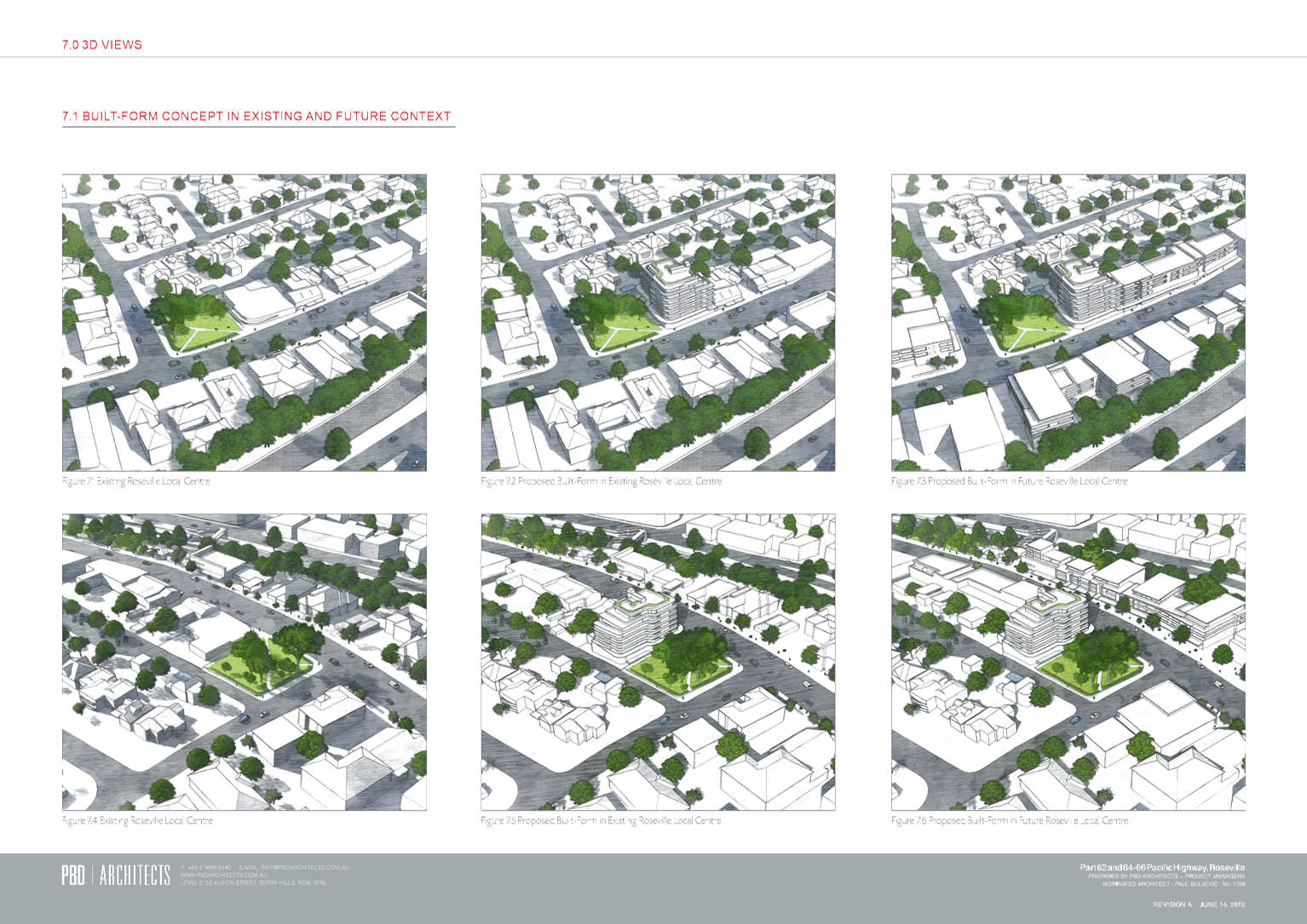
It is acknowledged that a 7 storey building adjacent to the
existing predominantly 2 storey development may appear out of context, at least
in the short term. However, given the location of the Roseville Local
Centre on the Highway and adjacent to the rail transport corridor with easy
access to the Sydney CBD, it is an area appropriate for higher density (and
height) transit-orientated development in accordance with the planning
priorities outlined in the North District Plan. Given the strategic
context, it is anticipated that the applicable heights and densities in the
local centre will be increased in the future and that the proposed height on
the site will therefore be in keeping with the future context.
It is therefore considered that it is appropriate
to increase the applicable maximum height and FSR applying to the site;
however, the Planning Proposal should be amended to include a maximum height of
26.5m and FSR of 3.0:1. In addition, site specific DCP provisions should also
be prepared to guide the future built form and interface with surrounding
development, heritage items, Memorial Park and public access to the rear at
Larkin Lane.
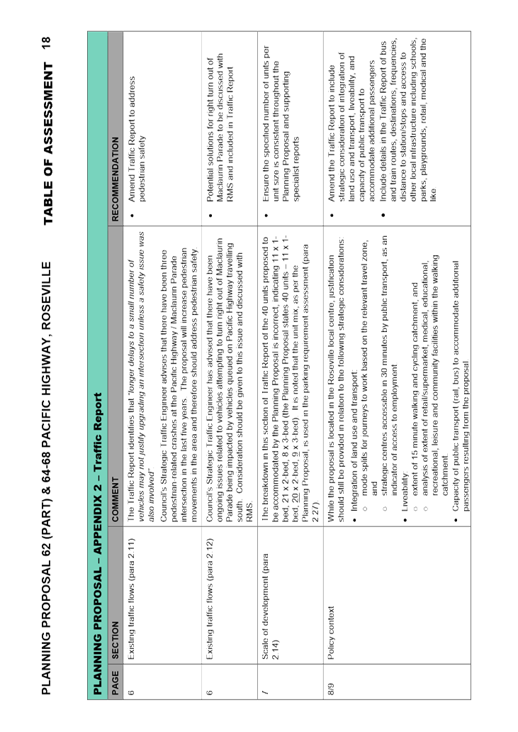
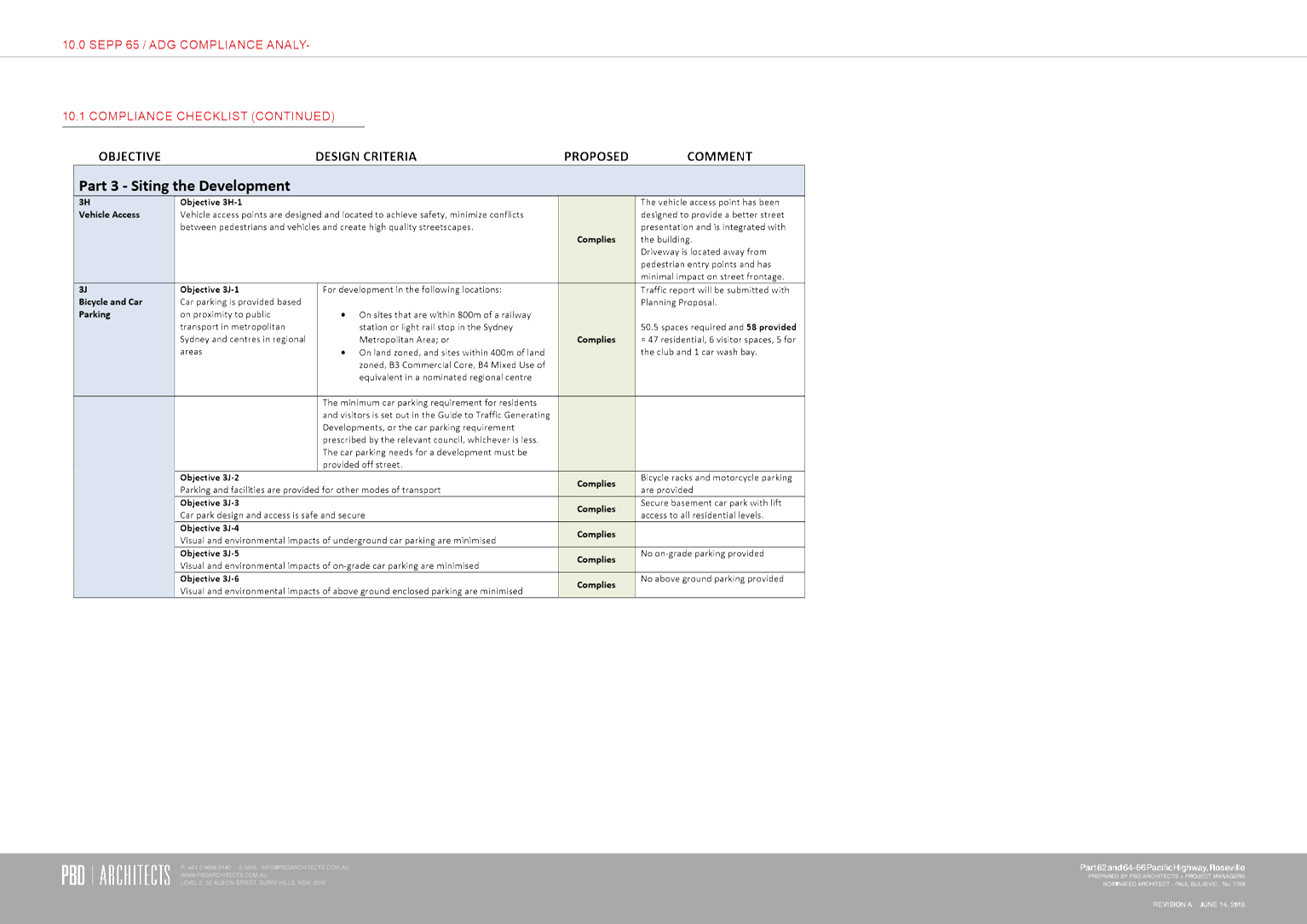
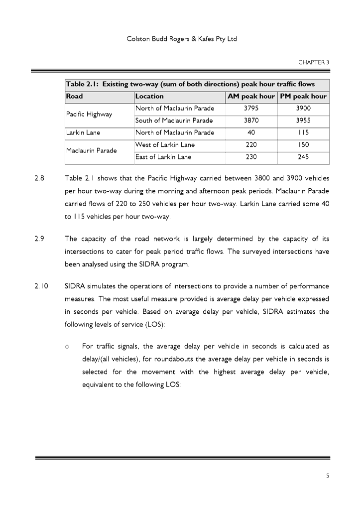
Traffic and Parking
The Traffic Report provided with the Planning Proposal (Attachment
A4) considers that the impacts of the additional dwellings, that would be
provided for with the proposed increase in height and FSR, would be minimal in
terms of traffic generation (one to two additional vehicles per hour two-way
during weekday peak periods). This is based on an increase of 20% in the
number of dwellings over that which would be achievable under a scheme that complies
with the existing controls.
The report concludes that such a low increase in traffic
generation would not have noticeable effects on the operation of the
surrounding road network, and that intersections would continue to operate at
their existing “satisfactory levels of service”, with similar
average delays per vehicle. In relation to future development of the
local centre, the report considers that the intersection of the Pacific Highway
and Maclaurin Parade would continue to operate at level of service
‘A’ which is considered to be a ‘good level of
service’.
The report does recognise that there are existing delays and
queuing with vehicles attempting to turn right out of Maclaurin Parade being
impacted by vehicles queued on the Pacific Highway travelling south, and
traffic turning right into Maclaurin Parade from the Pacific Highway. The
Traffic Report recommends the introduction of a short five second right turn
phase from the Pacific Highway to address this existing situation. The
report also recognises that future development in the local centre as a whole
will result in additional delays and queuing.
Council’s Strategic Traffic Engineer has reviewed the
Planning Proposal and advises this existing situation has been an ongoing
concern for Council and Roads and Maritime Services (RMS), and that further
discussions with RMS are required to identify potential solutions. It is
noted that previous requests by Council for a right turn phase from the Pacific
Highway were refused by RMS on the basis that it would increase delays for
northbound traffic on the Pacific Highway.
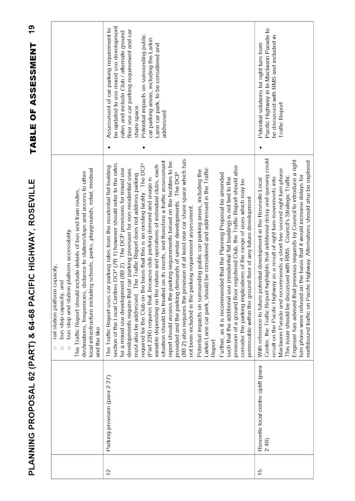
In relation to parking, the Traffic Report uses car parking
rates from the residential flat building section of the Local Centres DCP
(7B.1) whereas it should refer to the rates for a mixed use development
(8B.2).
The DCP provisions for mixed use developments require that
car parking provision for non-residential uses must also be addressed.
The Traffic Report does not address parking required for the Club on the basis
that this is an existing facility. The DCP (Part 22R) requires that,
because club parking demand and usage is variable depending on the nature and
operations of individual clubs, each situation should be treated on its merits,
and therefore a traffic assessment report should assess the parking
requirements based on the facilities to be provided and the parking demands of
similar developments. The DCP (8B.2) also requires the provision of at
least one car share space which has not been included in the parking requirement
assessment.
Potential impacts on surrounding public car parking areas,
including the Larkin Lane car park has also not been addressed in the Traffic
Report to date.
In terms of the strategic context, whilst the location of
the site in close proximity to public transport is recognised, further
justification should also be provided within the Traffic Report in relation to
the following strategic considerations:
· Integration
of land use and transport:
mode splits for journeys
to work based on the relevant travel zone, and
strategic centres
accessible in 30 minutes by public transport, as an indicator of access to
employment.
· Liveability:
extent of 15 minute
walking and cycling catchment, and
analysis of extent of
retail/supermarket, medical, educational, recreational, leisure and community
facilities within the walking catchment.
· Capacity of
public transport (rail, bus) to accommodate additional passengers resulting
from the proposal:
rail station platform
capacity,
bus stop capacity, and
bus stop and station
platform accessibility.
The Traffic Report should also be amended to include details
of bus and train routes, destinations, frequencies, distance to station/stops
and access to other local infrastructure including schools, parks, playgrounds,
retail, medical and the like.
While it is considered that the traffic and parking demand
generated by the proposed LEP amendment is generally acceptable and can be
accommodated, the Traffic Report should be amended to address the matters outlined
above and provide evidential justifications prior to the Planning Proposal
being forwarded to the Department for a Gateway Determination. Further, since
any future development is able to provide retail or business uses on the ground
floor in conjunction with shop top housing above under the KLEP Local Centres
2012, the Traffic Report should also consider the traffic and parking
implications of the range of uses which may be permissible within the ground
floor of any future development.
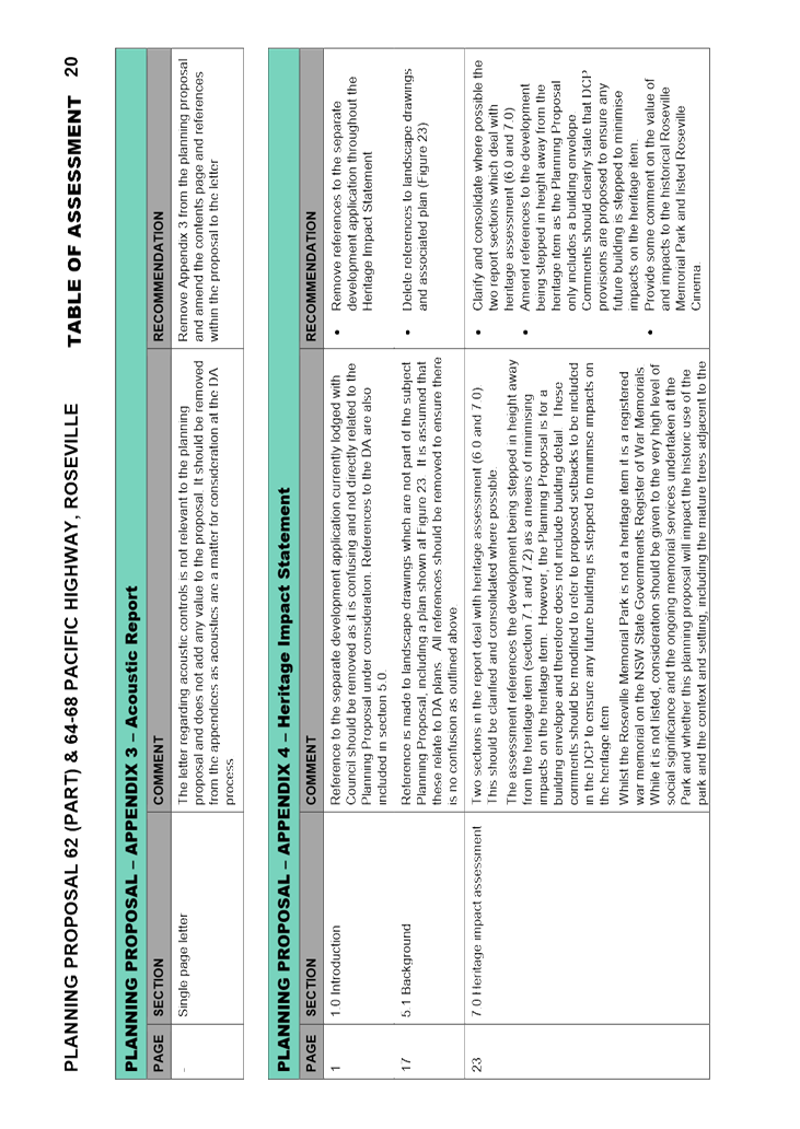
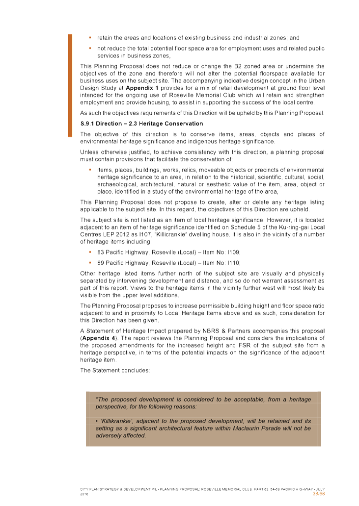
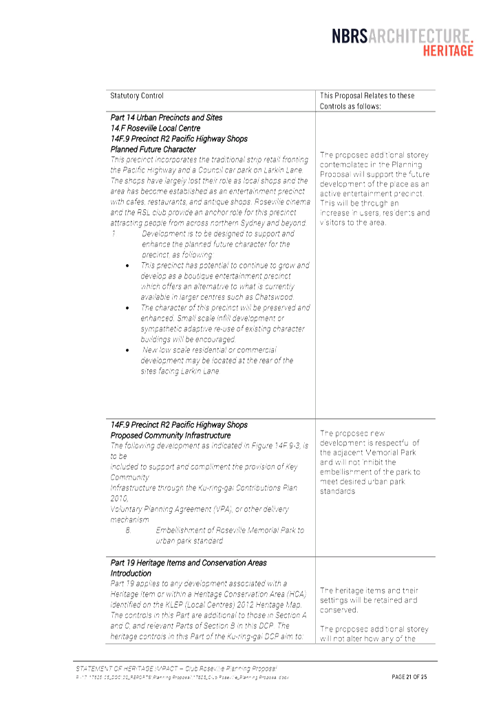
Heritage
The Heritage Impact
Assessment (HIA) provided with the Planning Proposal (Attachment A6)
identifies that anticipated impacts on heritage items in the vicinity will be
minimal and that the proposal is acceptable from a heritage perspective.
In respect of 'Killikrankie’, the heritage item
located adjacent to the site across Larkin Lane, the HIA notes that the
proposal is deemed acceptable as:
· It will not
alter how 'Killikrankie' is appreciated as the main view to the house is across
Memorial Park and will not be affected by increased height on the subject site,
· An
additional storey will alter the wider visual setting of the house, however
will have an acceptable heritage impact, and
· Views from
the Pacific Highway looking south towards the heritage item are not available
due to existing setbacks, development and vegetation.
It is agreed that the Planning Proposal is unlikely to
result in any significant impacts on heritage items in the vicinity.
Specifically it is considered that the proposal is unlikely to impact upon
views to ‘Killikrankie’ given that existing views from the Pacific
Highway are limited even across the adjacent Memorial Park, with the
substantial trees and shrubs to the north of the ‘Killikrankie’
site as well as within the Memorial Park itself restricting views. The
proposal would not impact upon this view, being located to the north of the
park. Further ‘Killikrankie’ is not currently visible from
the Pacific Highway looking south. Views to ‘Killikrankie’
from Maclaurin Parade and Larkin Lane are also currently restricted due to the
existing substantial shrubs located on the perimeter of the
‘Killikrankie’ site. This view would similarly not be
affected given the location of the proposal outside of the viewshed of ‘Killikrankie’.
The proposed increase in height on the subject site will
have some impact on the visual context of ‘Killikrankie’.
However, it is recognised that existing controls allow for a landmark building
on the site in the order of six storeys, and that any visual impacts associated
with an additional storey will be mitigated by the separation of the site from
the item across Larkin Lane and the extent of the substantial shrubs and trees
which exists on the perimeter of the ‘Killikrankie’ site and within
the adjacent Memorial Park. The Planning Proposal proposes amendments to
the Local Centres DCP to, amongst other matters, reduce the visual impact of
any future development on the site. The inclusion of setback controls
would mitigate visual impacts and ensure an appropriate height transition from
the future development to ‘Killikrankie’. Given the existing
site conditions, site separation and the built form controls that will be
included in site specific DCP provisions, it is therefore considered that the
potential visual impacts of an additional storey on the subject site are
acceptable from a heritage perspective and would not result in adverse
impacts. It is however noted that this matter will be further addressed
as part of any future development application(s).
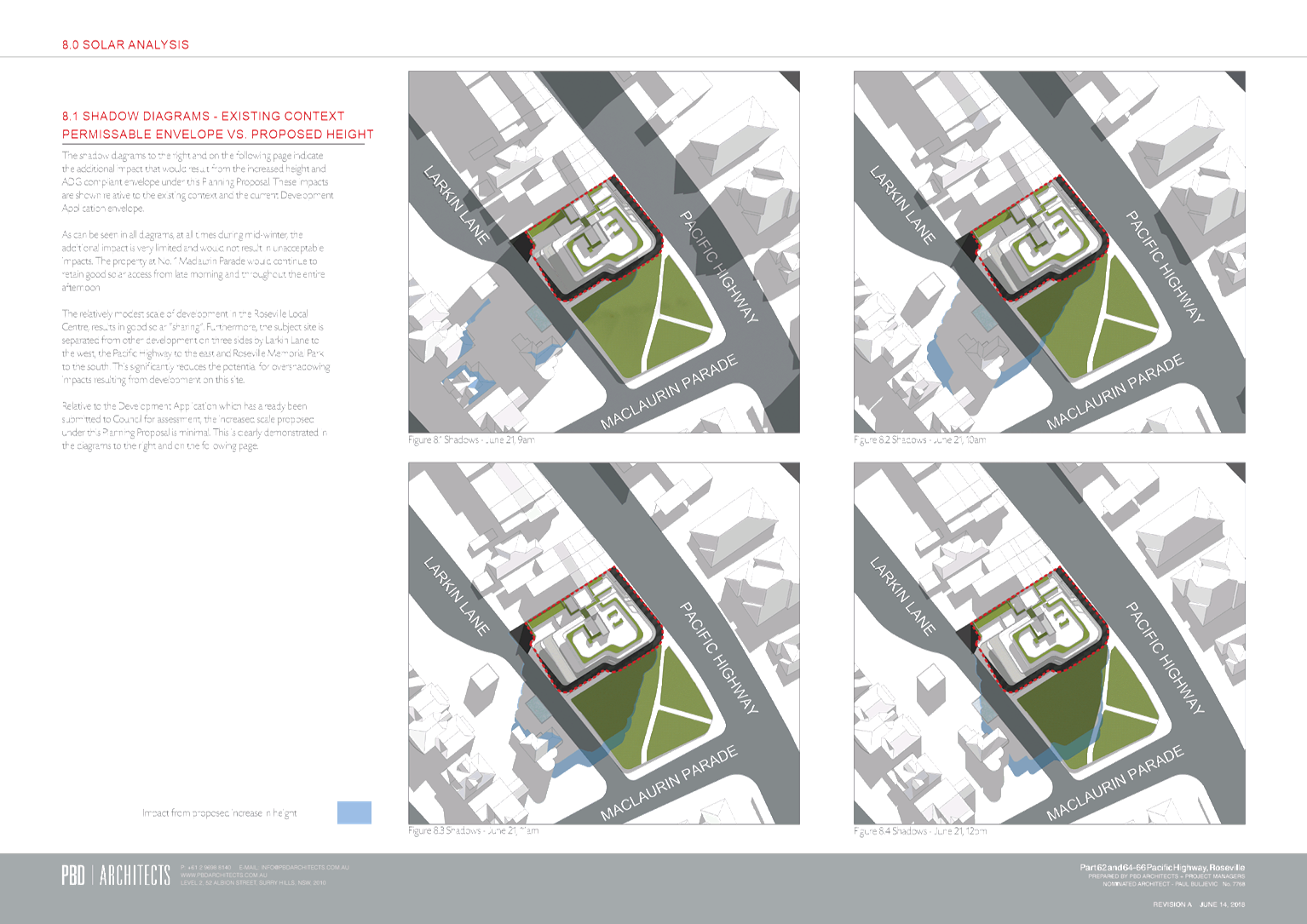
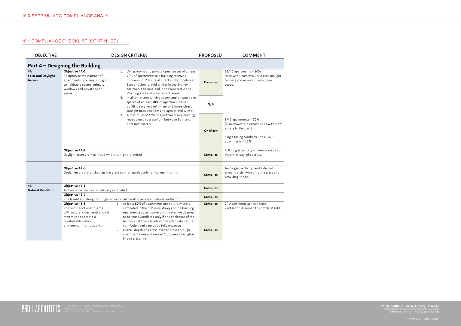
Potential impacts related to overshadowing are addressed in
the next section of this report, and it is recommended that amended shadow
diagrams be provided. However, based on the shadow diagrams provided in
the Planning Proposal’s Urban Design Report, it is evident that the
proposal could result in minor additional overshadowing to the east and south
of the ‘Killikrankie site’ until 1pm on the winter solstice (June
21). The detailed design of any future building on site will be required
to address overshadowing impacts and provide detailed shadow diagrams as part
of any future development application(s). The application will also be
required to address potential impacts on the amenity of the dwelling and the
long-term health of the mixed shrubs and mature trees which provide the garden
setting and curtilage of ‘Killikrankie’ and which contribute to its
heritage significance.
Potential overlooking and privacy issues related to
‘Killikrankie’ will also need to be addressed as part of any future
development application(s) once the final design of the building is determined.
The proposed increase in height and FSR in of itself will not result in any
adverse impact and potential impacts can be ameliorated through design
measures.
In relation to the heritage listed Former Commonwealth Bank
Building and Former Station Master's Residence (near the railway station) to
the east across the Pacific Highway, the HIA notes that the proposal is deemed
acceptable as:
· the items
are visually and physically separated from the site by the four lanes of
Pacific Highway;
· no views of
the items would be obscured or altered; and
· there are no
changes to the streetscape setting of the items.
These heritage items are located approximately 100m from the
subject site and across four lanes of the Pacific Highway and this separation
means these Items would therefore not be viewed together with future built
development on the site. Given site separation and the existing site
context it is therefore considered that this Planning Proposal enabling one
additional floor level would not adversely impact the setting of these heritage
items. Similarly, with regards to the heritage listed Roseville Cinema, the
distance separation and laneway interruptions along the Pacific Highway elevation
reduces the potential impacts of the additional floor level that this proposal
will facilitate.
For the reasons outlined above, it is therefore considered
that the heritage impacts of the Planning Proposal are not likely to be
significant and do not preclude further consideration of the Planning
Proposal. Notwithstanding due to the proximity of the site to heritage
items, a Heritage Impact Assessment would be required with any future
development application(s). The heritage impact assessment would need to
address in detail all relevant potential impacts on heritage items in the
vicinity and particularly ‘Killikrankie’, and the Roseville
Memorial Park which, while not heritage listed, is a registered war memorial on
the NSW State Governments Register of War Memorials. Any future detailed
design will be required to demonstrate that it responds to the site context and
setting and the historic use of the park as well as matters such as the impact
of basement excavation on mature trees within the park.
It is recommended that built form controls to address the
interface of any future building on the site with the adjacent
‘Killikrankie’ heritage item and historic Memorial Park are
included in site specific DCP provisions to be prepared in conjunction with the
Planning Proposal (refer to ‘Other considerations’ below).
These should include appropriate setbacks and controls on materials, finishes,
colours and the like.
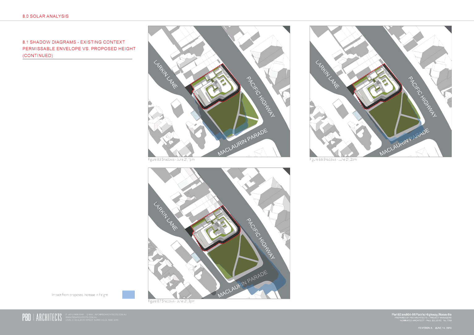
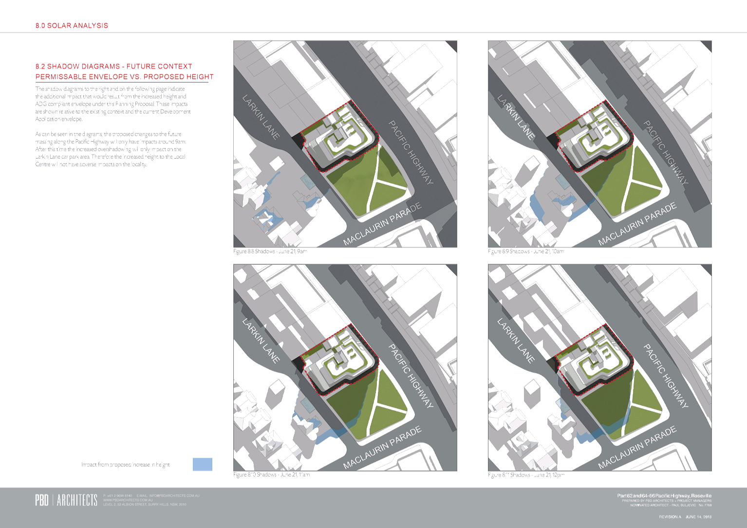
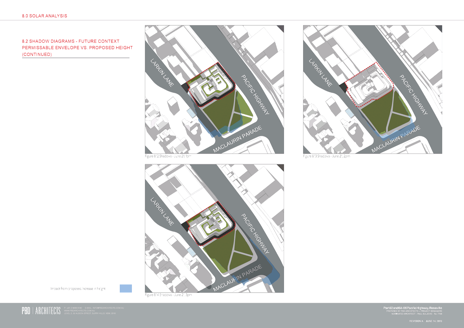
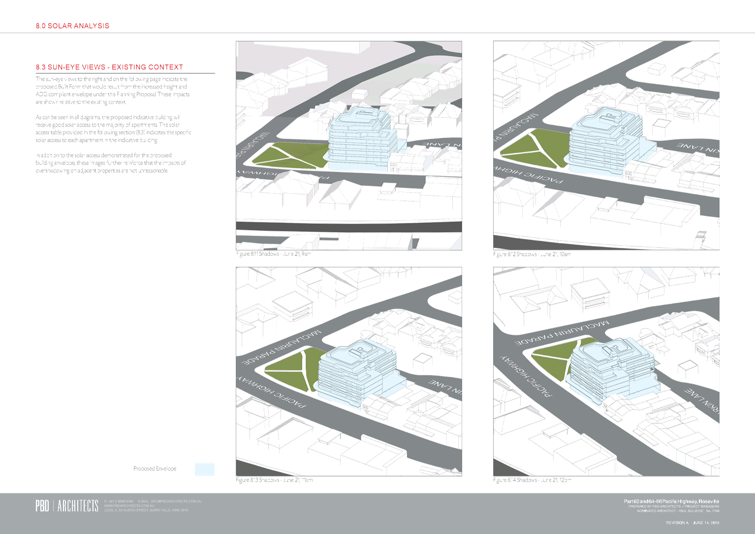
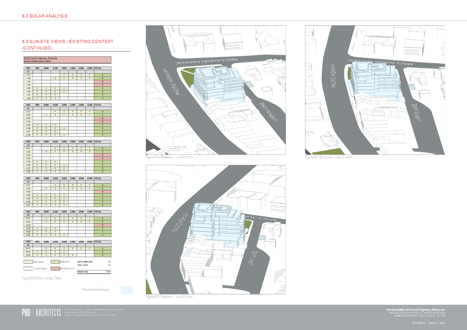
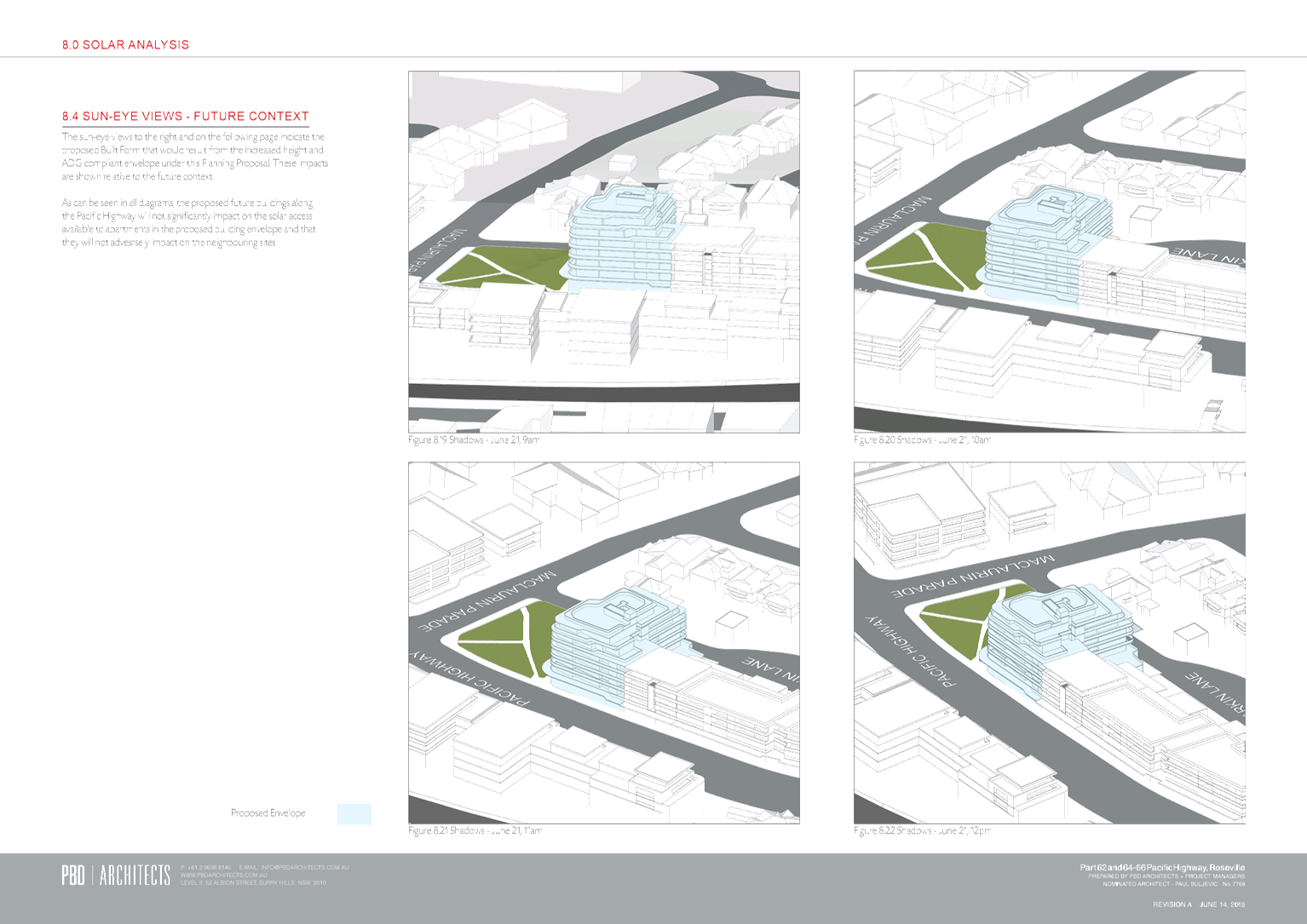
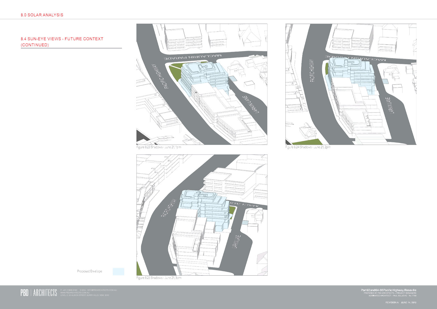
Overshadowing
Shadow diagrams have been provided in the Planning
Proposal’s Urban Design Report. However, the shadow diagrams show a
concept scheme and should be amended to refer to building envelopes only,
rather than a specific built form. Further the existing compliant
envelope should also be illustrated to allow a comparison and to determine the
impact of the additional proposed height in terms of shadow impacts.
Amended diagrams should be provided prior to the Planning Proposal being
forwarded to the Department for a Gateway Determination.
The submitted shadow diagrams however do indicate that the
overshadowing impacts associated with the increased height are not likely to be
significant. Further, the detailed design of any future building will
need to address overshadowing impacts and provide detailed shadow diagrams to
support any future development application(s). This will include shadow impacts
on the adjacent “Killikrankie” heritage item.
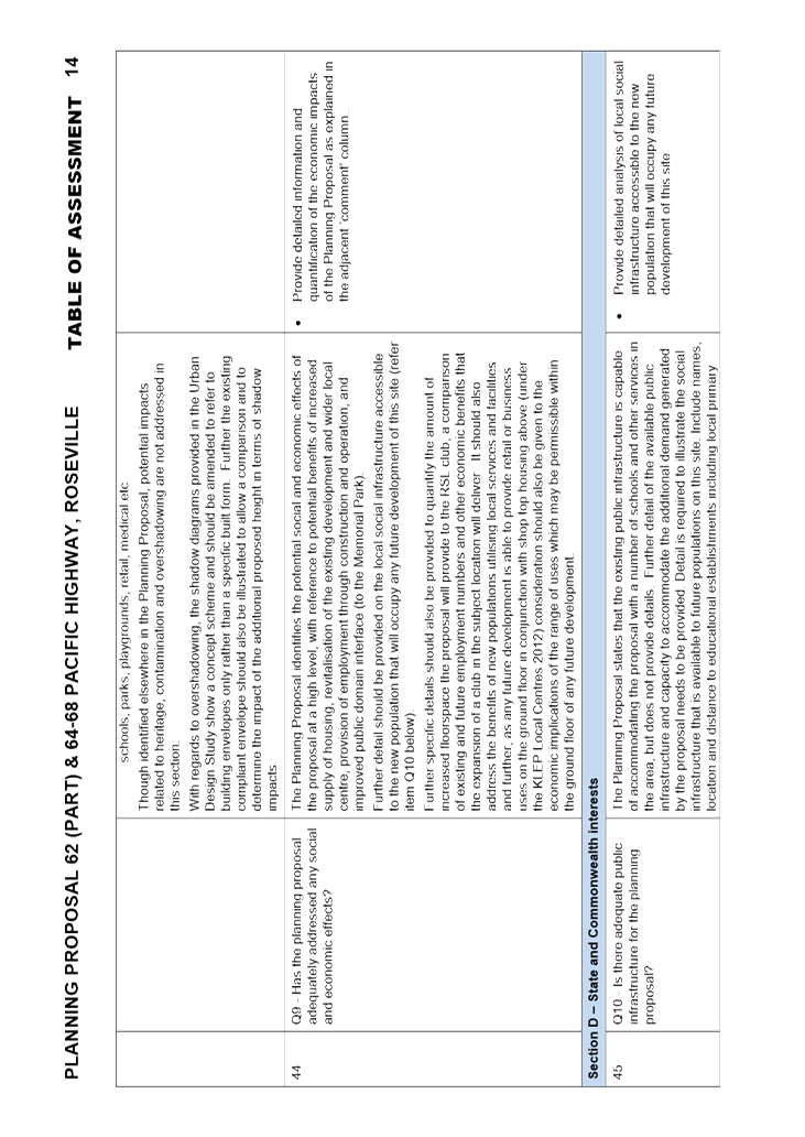
Social and Economic Impacts
The Planning Proposal identifies the potential social and
economic impacts of the proposal at a high level, with reference to potential
benefits of increased supply of housing, revitalisation of the existing
development and wider local centre, provision of employment through
construction and operation, and improved public domain interface (to the
Memorial Park).
However, further specific detail should be provided
regarding social infrastructure including the names, location and distance to
schools, parks, facilities, bus numbers and route destinations, rail line and
frequencies of all services and facilities that will serve the new population
resulting from this development.
In relation to economic assessment, details should be
included to quantify the increase in club floor space that will result from
this proposal, the economic benefits of that additional space and the benefits
of new populations utilising local services and facilities. Further,
since any future development is able to provide retail or business uses on the
ground floor, in conjunction with shop top housing above under the KLEP Local
Centres 2012, consideration should also be given to the economic implications
of the range of uses which may be permissible within the ground floor of any
future development.
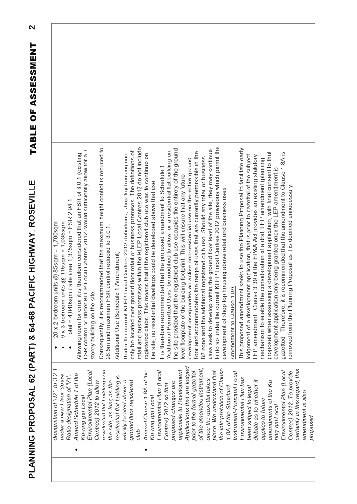
Amendment
to the Written Instrument
Under the current KLEP Local Centres 2012 definitions, shop
top housing can only be located over ground floor retail or business premises.
The definitions of retail and business premises within the KLEP Local Centres
2012 do not include registered clubs. This means that if the registered club
use was to continue on the site, no residential dwellings could be developed
above that use.
It is therefore recommended that the proposed amendment to
Schedule 1 ‘Additional Permitted Uses’ be modified to allow for a
residential flat building on the site provided that the registered club use
occupies the entirety of the ground level floorplate of the building footprint.
This will ensure that any future development incorporates an active
non-residential use on the whole ground floor and accommodates the range of
uses that are currently permissible in the B2 zone and the additional
registered club use. Should any retail or business uses seek to develop within
the ground floor level of the site, they may continue to do so under the
current KLEP Local Centres 2012 provisions which permit the development of shop
top housing above retail and business uses.
Amendments required to Planning Proposal
As noted above, the Planning Proposal is supported in
principle as it has demonstrated sufficient strategic and site specific merit
to enable it to be forwarded to the Department for a Gateway Determination,
subject to the recommended changes presented in this report and the Table of
Assessment at Attachment A1.
The key changes required to the Planning Proposal prior to
forwarding the proposal for a Gateway determination are as follows, with full
details being stipulated in the Table of Assessment at Attachment A1:
1. Amend the Planning
Proposal as stated in the Table of Assessment (Attachment A1).
This is to ensure that the content is clear, correct and
consistent with Council’s approach to land use planning prior to being
presented for Gateway Determination and subsequent public exhibition.
2. Amend Building Height
map
As outlined in this report, the map is to be amended to
include a maximum height control of 26.5m for the site as the proposed height
is considered to be excessive for a 7 storey building.
3. Amend Floor Space Ratio
map
As outlined in this report, the map is to be amended to
include a maximum FSR of 3.0:1 for the site as the proposed FSR is considered
to be excessive for a 7 storey building.
4. Amend Schedule 1
‘Additional Permitted Uses’
As outlined in this report, the proposed Schedule 1
amendment is to be modified to allow for a residential flat building on the
site provided it only occurs above the registered club use which must occupy
the entire ground floor of the site. This will ensure that no residential
uses can be applied to the ground floor and that a broader range of
non-residential land uses are permissible within the ground floor of the
development, consistent with the zoning and to provide for future flexibility.
5. Remove proposed
amendment to Clause 1.8A of the KLEP Local Centres 2012
This proposed amendment seeks to use the Planning Proposal
to facilitate early lodgement of a development application, that is, prior to
gazettal of the subject LEP amendment. Clause 3.39 of the EP&A Act
provides an existing statutory mechanism to enable the consideration of a draft
LEP amendment (Planning Proposal) when assessing a development application,
with final consent on that development application only being given when the
LEP amendment is gazetted.
6. Amend the Traffic Report
at Appendix 2 of the Planning Proposal
As outlined in this report, an amended traffic report is to
be provided which includes:
· Further
detail on proposed solutions, including discussion with RMS, to address
existing traffic issues associated with:
vehicles
attempting to turn right out of Maclaurin Parade being impacted by vehicles
queued on Pacific Highway travelling south, and
delays
to traffic turning right into Maclaurin Parade from the Pacific Highway.
· Car
parking provision in accordance with DCP rates for a mixed use development
(8B.2), including parking provision for the Club.
· Consideration
of potential impacts on surrounding public car parking areas, including the
Larkin Lane car park.
· Traffic
and parking implications of the range of active retail / commercial uses which
area permissible within the ground floor of any future development.
· Include
strategic consideration of integration of land use and transport, liveability,
and capacity of public transport to accommodate additional passengers.
· Include
details of bus and train routes, destinations, frequencies, distance to station/stops
and access to other local infrastructure including schools, parks, playgrounds,
retail, medical and the like.
7. Amend the Urban Design
Study at Appendix 1 of the Planning Proposal.
As outlined in this report, the shadow diagrams are to be
amended to show building envelopes only for both the proposed and existing LEP
and DCP controls to enable a comparison and to determine the extent of any
potential impact resulting from the proposed LEP height amendment.
The proponent is to submit to
Council two (2) hard copies of all documents (amended Planning Proposal and all
attachments) and a USB with pdf versions of all documents and a Word version of
the Planning Proposal.
Recommendations to Gateway Determination
It is recommended that changes to the Planning Proposal and
supporting studies, as outlined in this report and the Table of Assessment
at Appendix A1, be made prior to submitting the Planning Proposal to the
Department of Planning and Environment for a Gateway Determination.
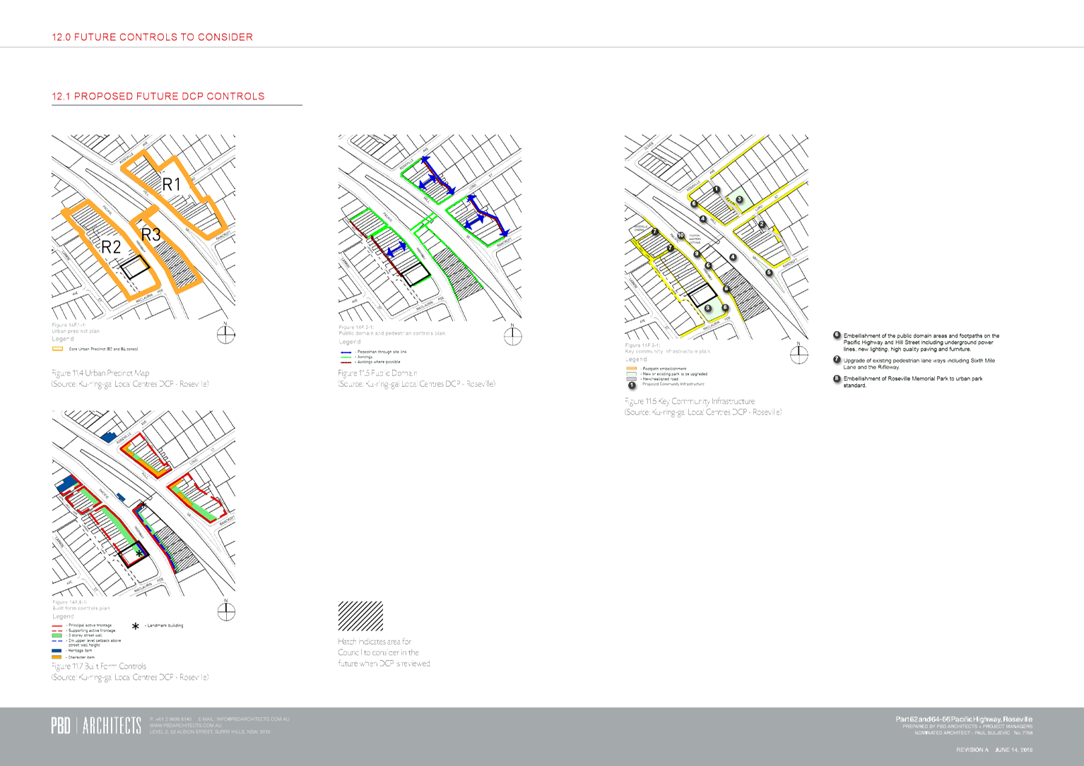
Other Considerations
Development Control Plan Amendments
Given the identification of the site as suitable for a
‘landmark’ building at the southern entrance to the Roseville Local
Centre, and the need to ensure appropriate height transitions to the
surrounding area including heritage items, and the interface with Memorial Park
and Larkin Lane, and the unique corner aspect of the site, it is recommended
that site specific provisions be prepared for inclusion in the Ku-ring-gai Local
Centres DCP to guide any future development. These provisions would be prepared
post Gateway Determination by Council and discussed with the landowner with
costs paid by the landowner in accordance with Council’s fees and
charges. The site specific amendments to the DCP would then be placed on
public exhibition concurrent with the Planning Proposal.
It is noted that potential DCP controls are provided with
the Planning Proposal, which will be considered by Council as part of the
preparation of the DCP amendment. It is recommended that, in addition to
the setbacks proposed to the north and west of the site, the DCP amendment
incorporate a setback to the east (Pacific Highway frontage) above the sixth
storey as shown on the indicative section provided with the Planning
Proposal. This will ensure an appropriate street wall height and scale to
the building on the highway frontage. Measures should specifically be
considered in the context of addressing potential impacts on the adjacent
“Killikrankie” heritage item and the historic Memorial Park.
Further detailed provisions could also be included where identified as
appropriate through the process.
integrated planning and reporting
Theme 3 - Places, Spaces and
Infrastructure
|
Community Strategic
Plan Long Term Objective
|
Delivery Program
Term Achievement
|
Operational Plan
Task
|
|
P2.1 A robust planning framework is in place to deliver
quality design outcomes and maintain the identity and character of
Ku-ring-gai
|
P2.1.1 Land use strategies, plans and processes are in
place to effectively manage the impact of new development
|
Implement and monitor the Local Environmental Plans and
supporting Development Control Plans.
|
Governance Matters
The process for the
preparation and implementation of Planning Proposals is governed by the
provisions contained in the Environmental Planning and Assessment Act 1979
and the Environmental Planning and Assessment Regulation 2000.
If Council fails to make a
decision within 90 days (from the commencement of the review of the
application) or if Council makes a decision to not support the Planning
Proposal, the proponent can make a request to the Department of Planning and
Environment for a Rezoning Review.
Local Planning Panels
Direction – Planning Proposals issued by the Minister for Planning
under Section 9.1 of the Environmental Planning and Assessment Act 1979
requires Council to refer all Planning Proposals prepared after 1 June 2018 to
the Local Planning Panel for advice, before it is forwarded to the Greater
Sydney Commission (via the Department of Planning and Environment) for a
Gateway Determination under Section 3.34 of the Environmental Planning and
Assessment Act 1979.
Risk Management
This is a privately initiated
Planning Proposal. Council should to determine its position on the matter
specifically whether the Planning Proposal should be sent to the Department of
Planning and Environment for a Gateway Determination and proceed to public
exhibition.
Council risks damage to its
reputation if it does not undertake strategic land use planning in an effective
and timely manner.
Financial Considerations
The Planning Proposal was
subject to the relevant application fee under Council’s 2017/2018 Fees and
Charges Schedule. The cost of the review and assessment of the Planning
Proposal is covered by this fee.
Social Considerations
Whilst the Roseville Memorial
Club has submitted this Planning Proposal as a means of ensuring the future
viability of the Club, by enabling a sufficient yield of residential dwellings,
it is not deemed appropriate to restrict future use of the site to a Club only
on the ground floor. Therefore, the deemed social benefits associated with the
retention of the Club is not a key consideration when considering the strategic
merit of the proposal.
Notwithstanding, the Planning
Proposal is not anticipated to result in any adverse social impacts.
Environmental Considerations
The potential environmental
impacts of the Planning Proposal have been considered in this assessment, and
there are no known impacts that prevent the further consideration of the
Planning Proposal. The impacts of any specific development that may occur
on the site as a result of the proposal would be considered in detail at the
development application stage.
Community Consultation
In the event that the
Planning Proposal is granted a Gateway Determination by the Department of
Planning and Environment, the Planning Proposal would be placed on public
exhibition in accordance with the requirements of the Gateway Determination and
the Department of Planning and Environment’s publication ‘A
Guide to Preparing Local Environmental Plans’.
The public exhibition would
include notification to the surrounding properties and advertisement within the
North Shore Times and on Council’s website.
Internal Consultation
The assessment of the
Planning Proposal has included consultation with Council’s Strategic
Traffic Engineer.
Summary
Council has engaged
consultant MG Planning Pty Ltd (PO Box 197, Drummoyne NSW 1470) to conduct the
assessment of this Planning Proposal. Assessment of traffic and transport
issues has been carried out by Council’s Strategic Traffic Engineer.
A Planning Proposal has a separate process and different
matters of consideration to a Development Application. Whilst a Development
Application considers built form outcomes on the site, a Planning Proposal
considers the strategic aspects of an amendment to an LEP and the implications
of that amendment to the local and wider context.
The Planning Proposal seeks amendment to the local strategic
planning instrument (Ku-ring-gai Local Environmental Plan (Local Centres)
2012); as such, any assessment must consider the strategic merit of the
proposal as stipulated in the regional plan (Greater Sydney Region Plan)
and the district plan (North District Plan), and the site specific merit
relating to the local context.
A Planning Proposal has been
submitted for 62 (part) and 64-68 Pacific Highway, Roseville, which seeks to
make the following amendments to the KLEP (Local Centres) 2012:
1. Amend
land use zoning from RE1 Public Recreation to B2 Local Centre zone for part of
the site (Part Lot 2 DP 202148),
2. Amend
height of building controls from 14.5m, 20.5m and part no height designation,
to 28.5m,
3. Amend
the floor space ratio map control from 2.0:1 and 2.8:1 to 3.2:1,
4. Amend
Schedule 1 to allow residential flat buildings on the site, provided the
residential flat building is wholly located above a ground floor registered
club, and
5. Amend
Clause 1.8A ‘Savings provisions relating to development
applications’ to ensure that proposed changes under the planning proposal
are applicable to development applications that are lodged prior to the formal
gazettal of the amended instrument, once the gazettal takes place.
The assessment of the Planning Proposal has resulted in the
following recommendations:
A. That
the Planning Proposal and its attached reports are amended in accordance with
the requirements of this Report and the Table of Assessment (Attachment
A1) prior to submission for Gateway determination.
B. That
changes are made to the proposed amendments to the KLEP (Local Centres) 2012 as
follows:
i. Amend
land use zoning from RE1 Public Recreation to B2 Local Centre zone for part of the
site (Part Lot 2 DP 202148),
ii. Amend
height of building controls from 14.5m, 20.5m and part no height designation,
to 26.5m,
iii. Amend
the floor space ratio map control from 2.0:1 and 2.8:1 to 3.0:1, and
iv. Amend
Schedule 1 to stipulate that development for the purpose of residential flat
buildings is permitted with development consent if the consent authority is
satisfied that the total ground floor of any such building will be used only
for the purpose of a registered club.
C. That
site specific DCP provisions be prepared for exhibition should a Gateway be
issued for the Planning Proposal.
The Planning Proposal has been assessed against the
provisions of the Department of Planning and Environment’s ‘A
guide to preparing planning proposals’ and section 3.33 of the Environmental
Planning and Assessment Act 1979.
It is considered that there is sufficient merit to enable
the Planning Proposal to be submitted to the Department of Planning and
Environment for a Gateway Determination, subject to the incorporation of the
recommended amendments stipulated in this report and in the Table of
Assessment at Attachment A1.
|
Recommendation:
A. That
the Ku-ring-gai Local Planning Panel makes a recommendation to Council that
the Planning Proposal be submitted to the Department of Planning and
Environment for a Gateway Determination, subject to the amendments detailed
in this Report and Table of Assessment at Attachment A1.
B. Should
a Gateway Determination be issued for public exhibition of the Planning
Proposal, site specific amendments to the Local Centres DCP as outlined in
this report to be prepared and placed on public exhibition concurrent with
the Planning Proposal.
|
Helena Miller
Director, MG Planning Pty
Ltd
|
Rathna Rana
Senior Urban Planner
|
Craige Wyse
Team Leader Urban Planning
|
|
Antony Fabbro
Manager Urban & Heritage Planning
|
Andrew Watson
Director Strategy & Environment
|
|
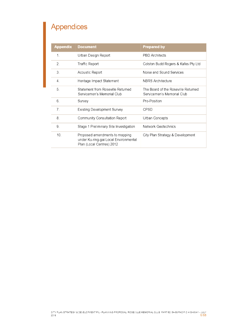
Attachments:
|
A1⇩
|
Table
of Assessment - Roseville RSL
|
|
2019/058845
|
|
|
A2⇩
|
Planning
Proposal - Roseville Memorial Club
|
|
2019/058519
|
|
|
A3⇩
|
Appendix
1 – Urban Design Report – PBD Architects
|
|
2019/058518
|
|
|
A4⇩
|
Appendix
2 – Traffic Report – Colston Budd Rogers & Kafes Pty Ltd
|
|
2019/058516
|
|
|
A5⇩
|
Appendix
3 – Acoustic Report – Noise and Sound Services
|
|
2019/058515
|
|
|
A6⇩
|
Appendix
4 – Heritage Impact Statement – NBRS Architecture
|
|
2019/058514
|
|
|
A7⇩
|
Appendix
5 – Statement from Roseville Returned Servicemen’s Memorial Club
|
|
2019/058513
|
|
|
A8⇩
|
Appendix
6 – Survey
|
|
2019/058512
|
|
|
A9⇩
|
Appendix
7 – Existing Development Survey
|
|
2019/058510
|
|
|
A10⇩
|
Appendix
8 – Community Consultation Report – Urban Concepts
|
|
2019/058509
|
|
|
A11⇩
|
Appendix
9 – Stage 1 Preliminary Site Investigation – Network Geotechnics
|
|
2019/058508
|
|
|
A12⇩
|
Appendix
10 – Local Environmental Plan Maps
|
|
2019/058507
|
|
Ku-ring-gai
Local Planning Panel Meeting - 18 March 2019
|
GB.2 / 353
|
|
|
|
|
Item
GB.2
|
S12120
|
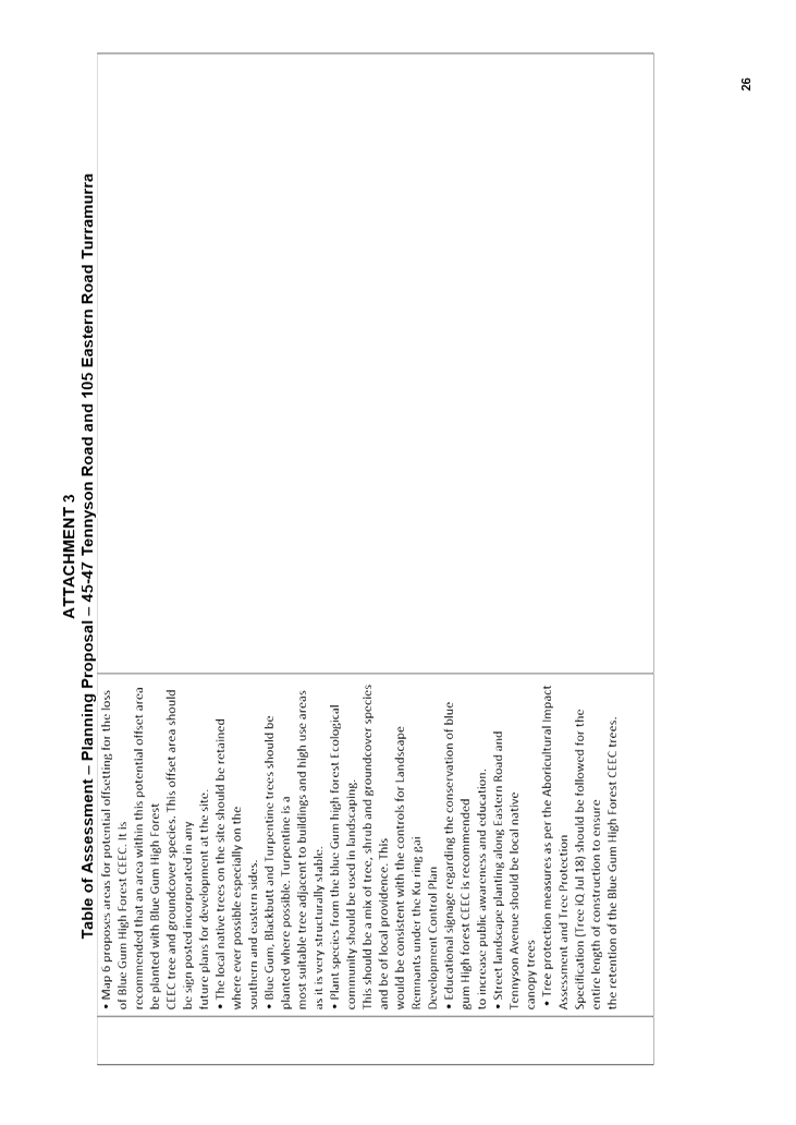
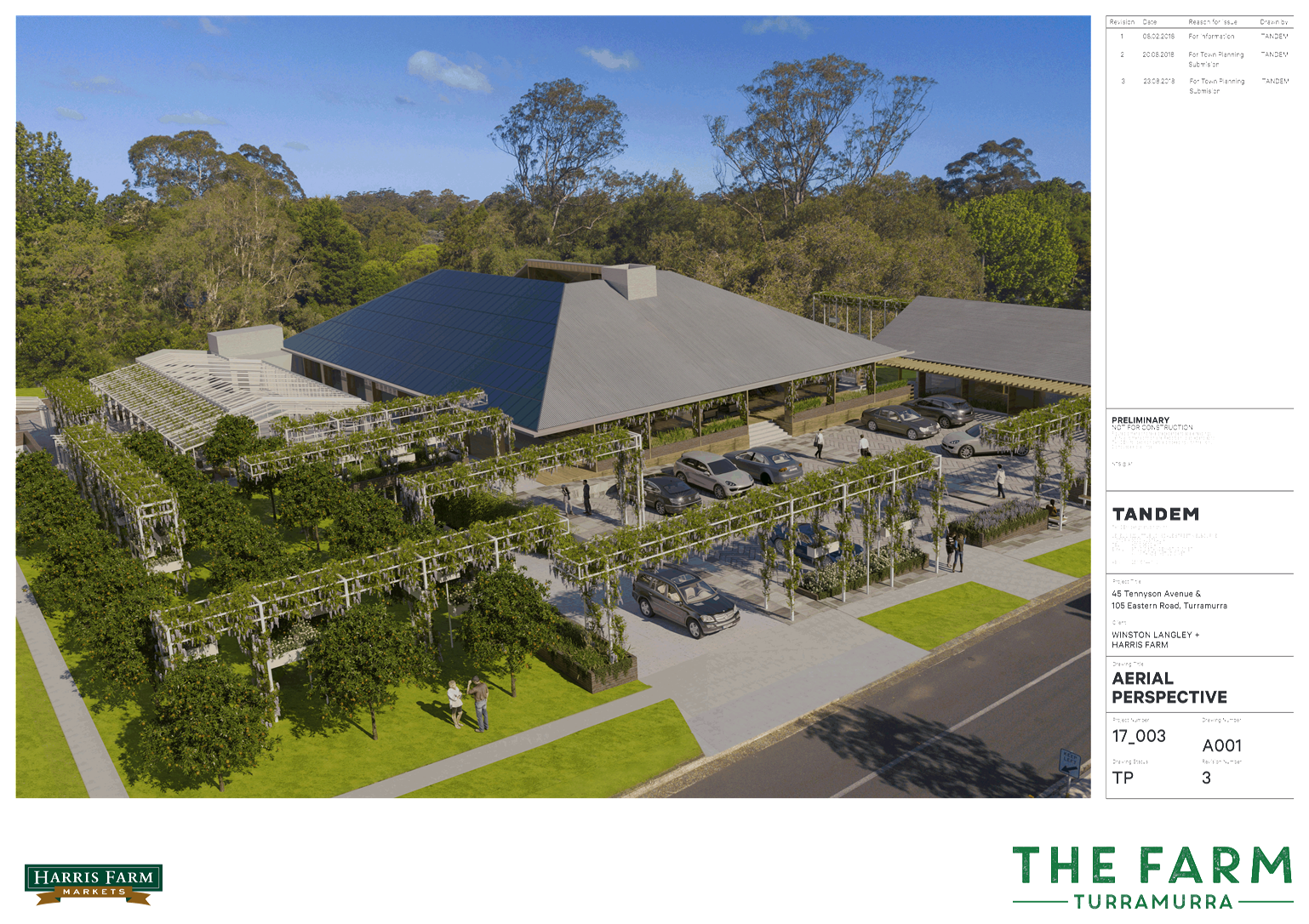
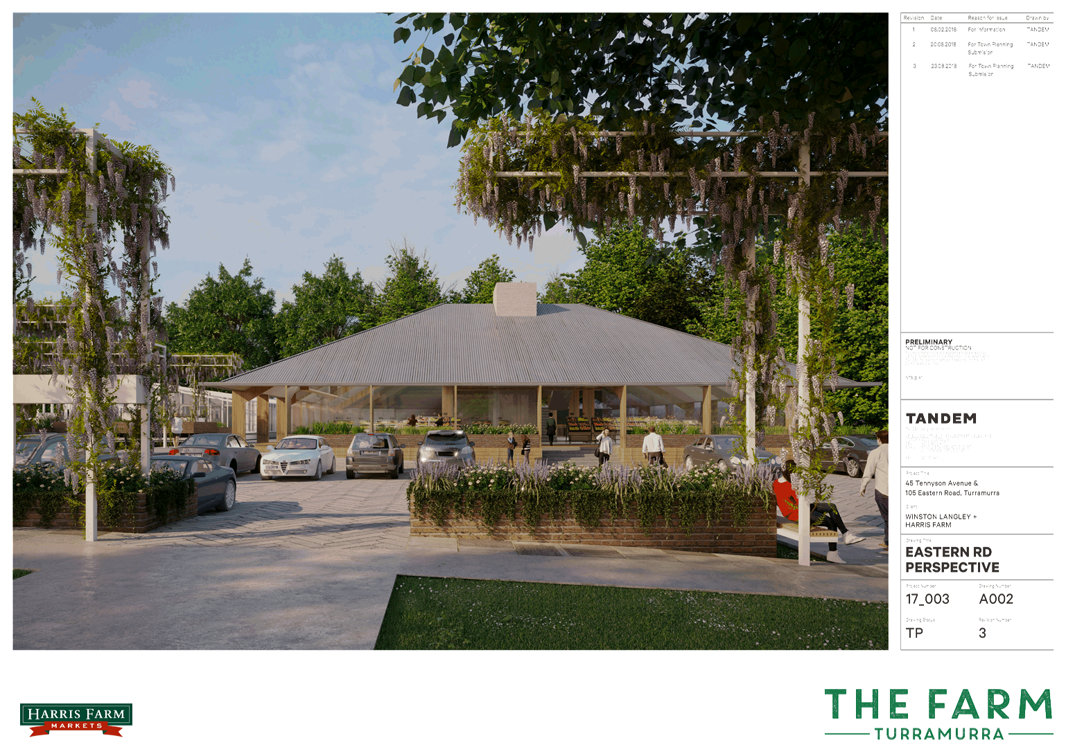
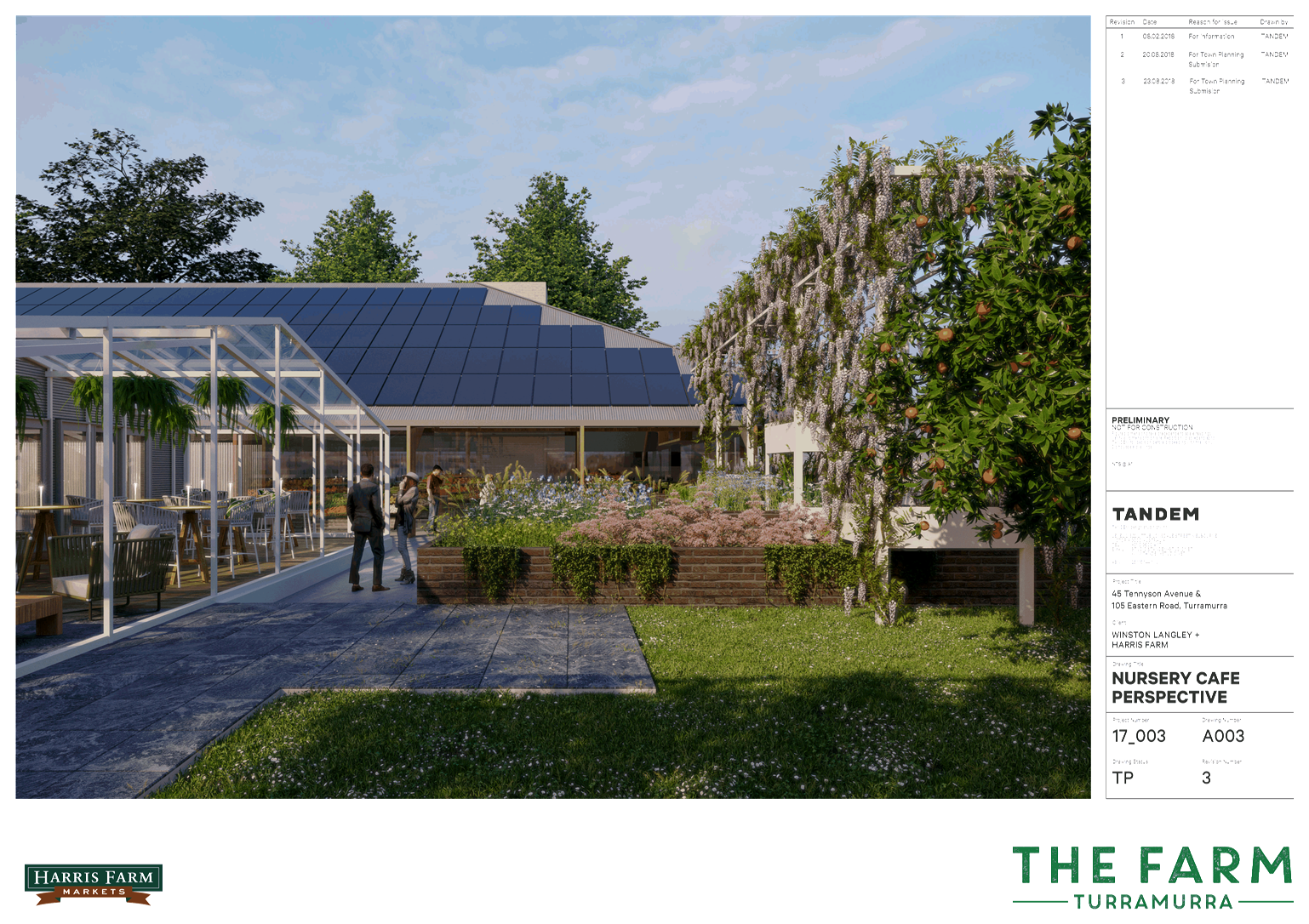
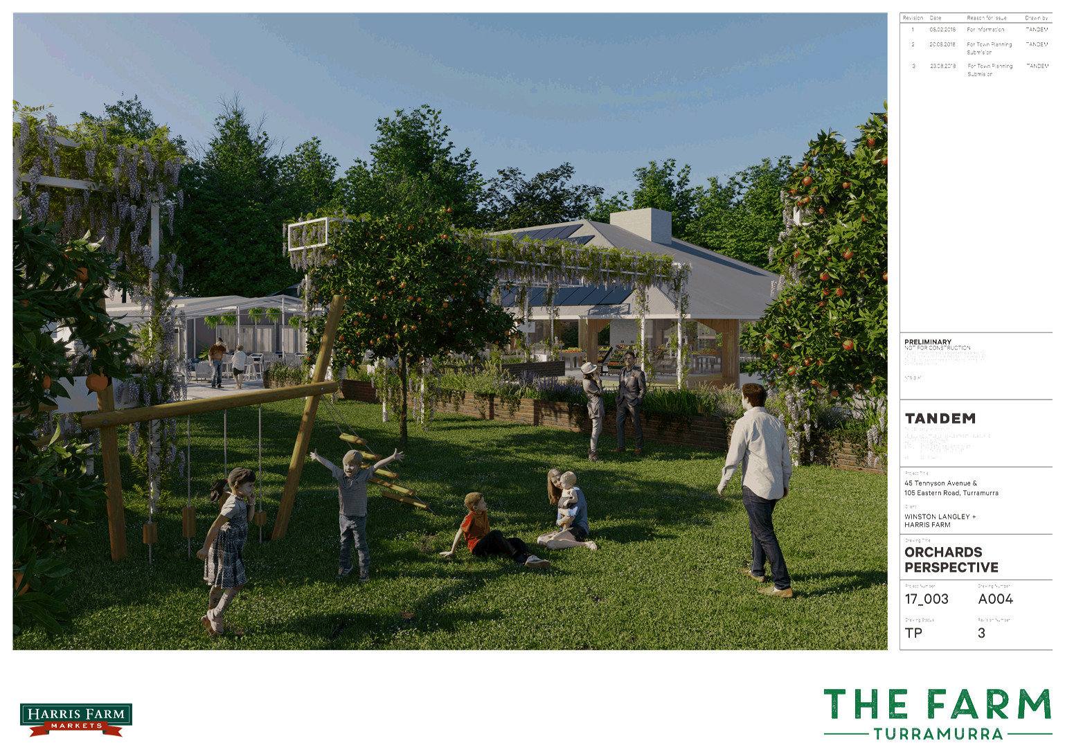
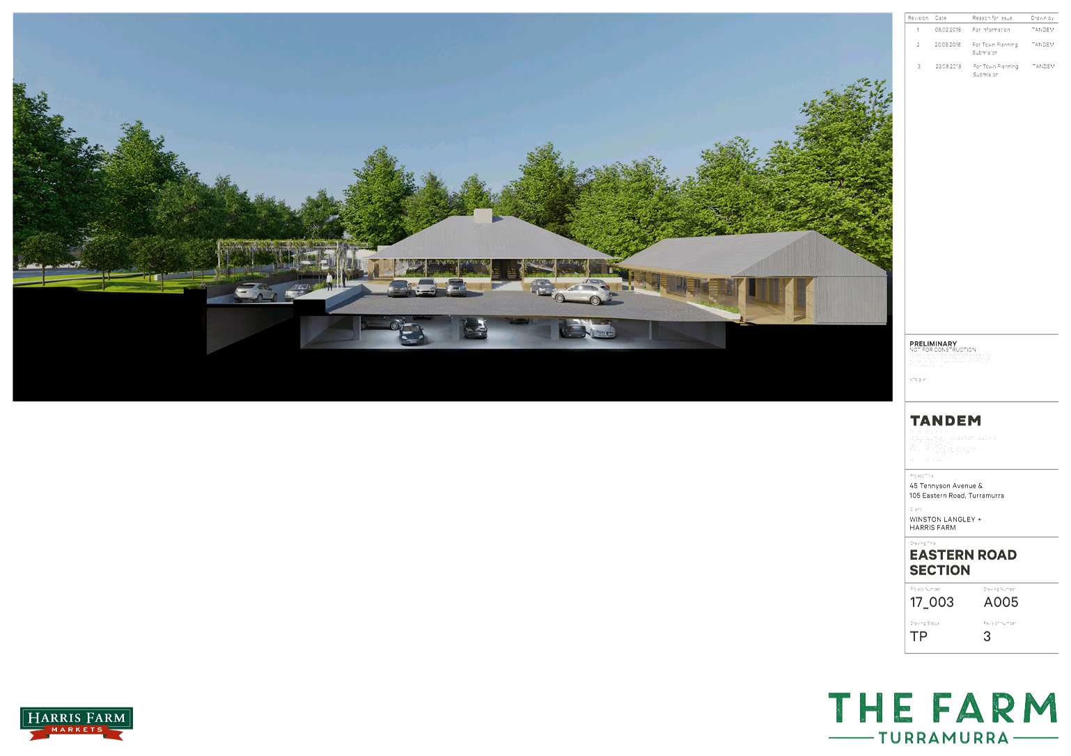
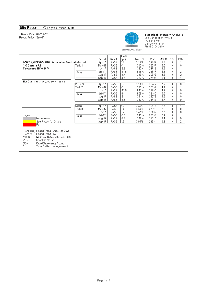
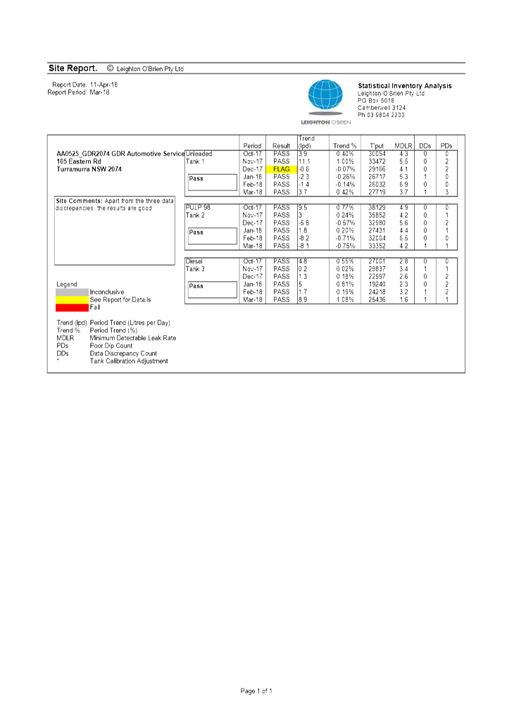
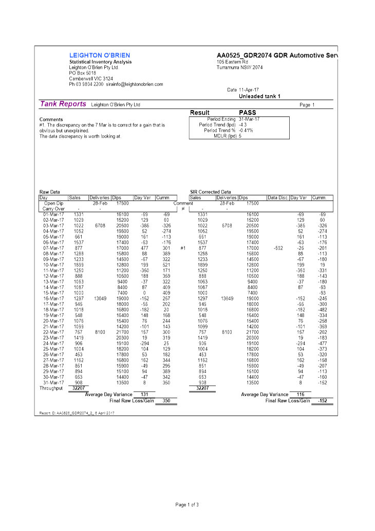
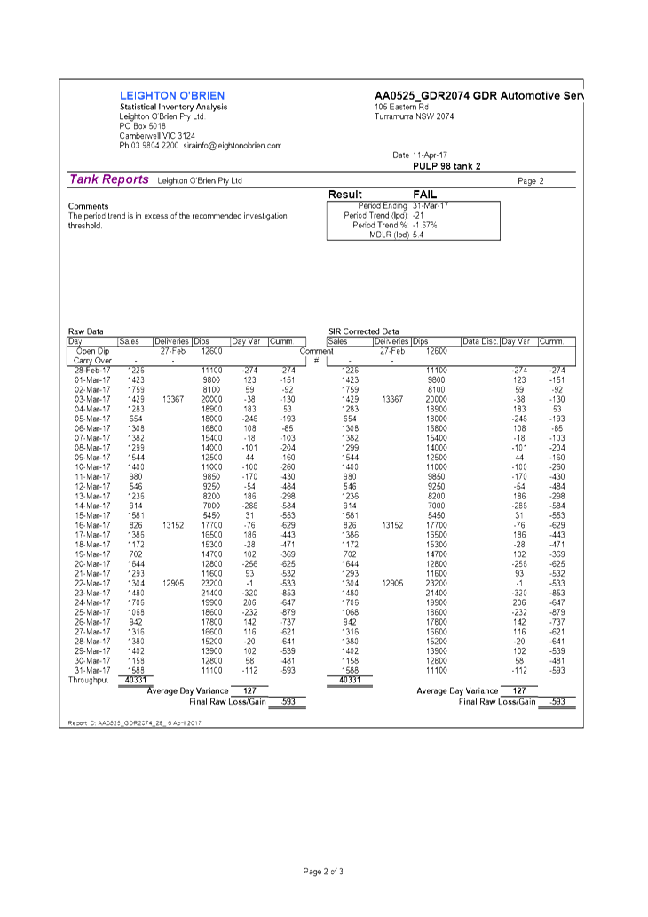
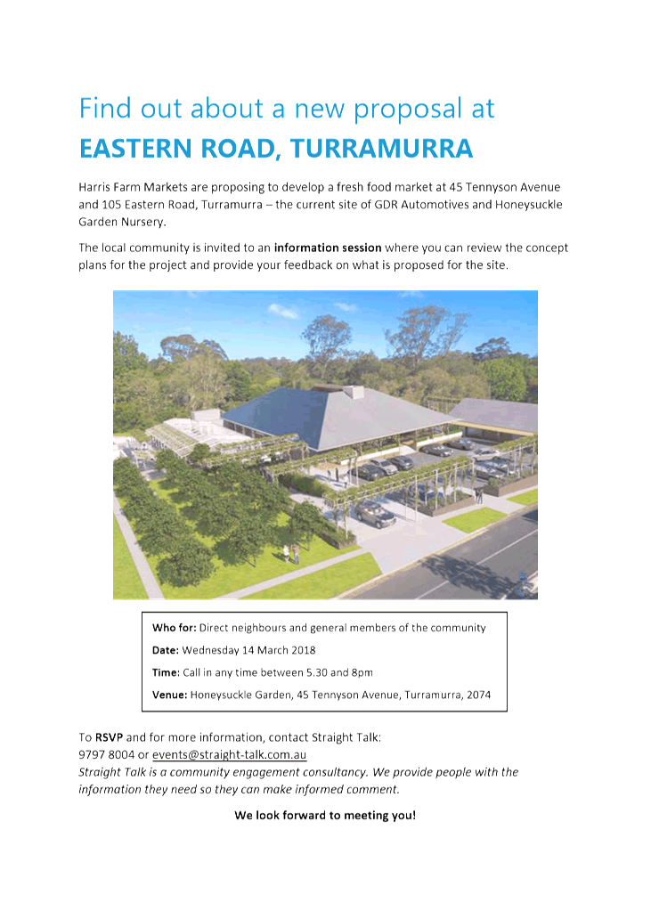
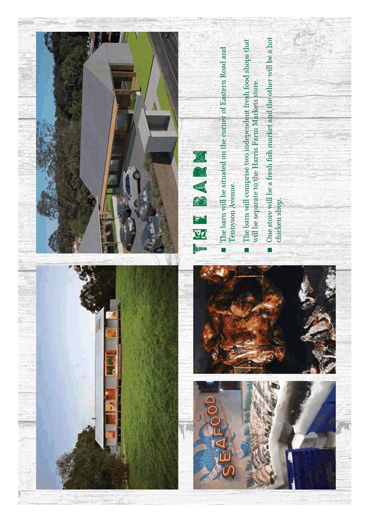
Planning Proposal for 45-47 Tennyson
Avenue and 105 Eastern Road, Turramurra.
EXECUTIVE
SUMMARY
|
purpose of report:
|
To refer the Planning Proposal for 45-47 Tennyson Road
and 105 Eastern Road, Turramurra on land currently operating as a plant
nursey and service station to the Ku-ring-gai Local Planning Panel for advice
as required by the Local Planning Panels Direction – Planning Proposals
issued by the Minister for Planning under Section 9.1 of the Environmental
Planning and Assessment Act 1979.
|
|
|
|
|
background:
|
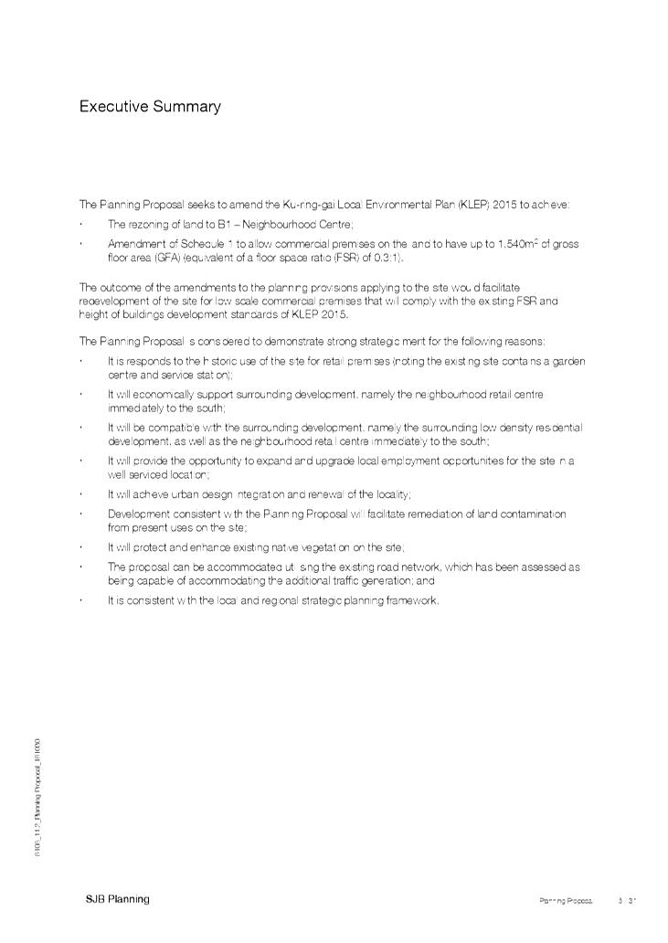
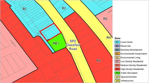
The Planning Proposal seeks to amend the Ku-ring-gai
Local Environmental Plan 2015 to:
1. rezone the land
from R2 (Low Density Residential) to B1 (Neighbourhood Centre); and
2. amend schedule 1
of the KLEP 2015 to allow commercial premises on the land to have up to 1,540
square metres of gross floor area.
The key objective of the proposal is to formalise the
existing, long term commercial uses on the site that are adjacent to the existing
Eastern Road Neighbourhood Centre.
|
|
|
|
|
comments:
|
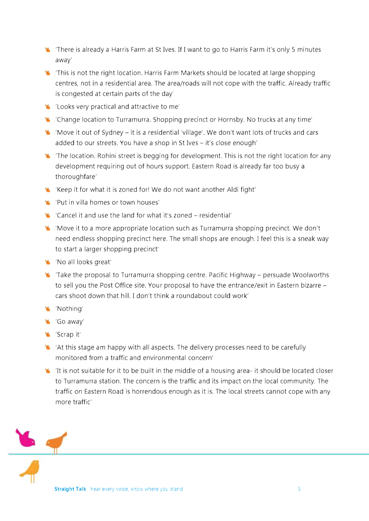
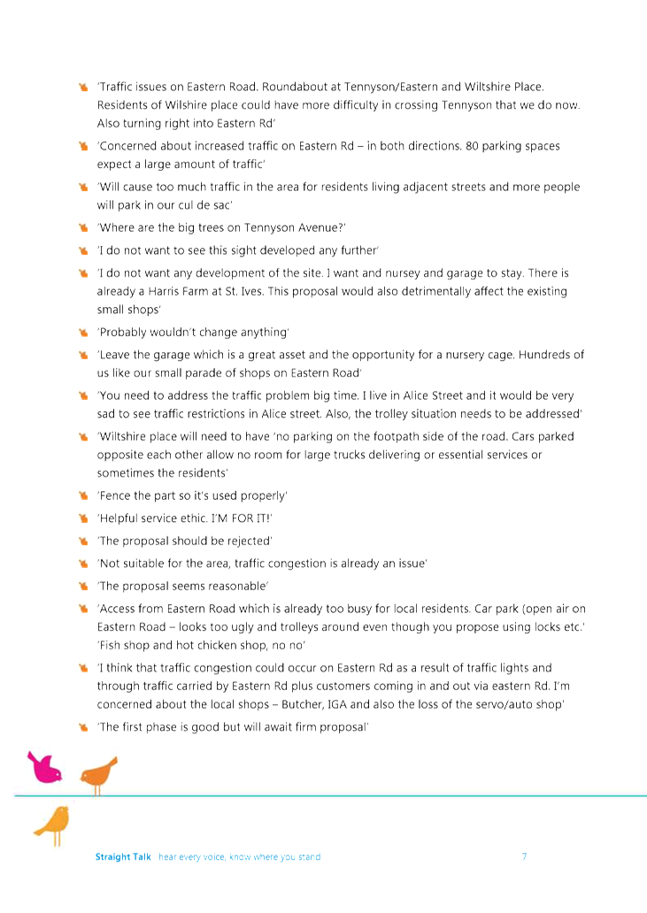
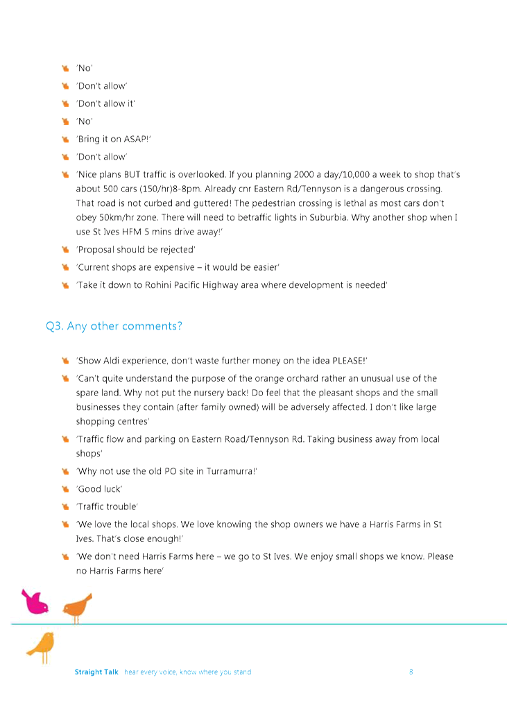
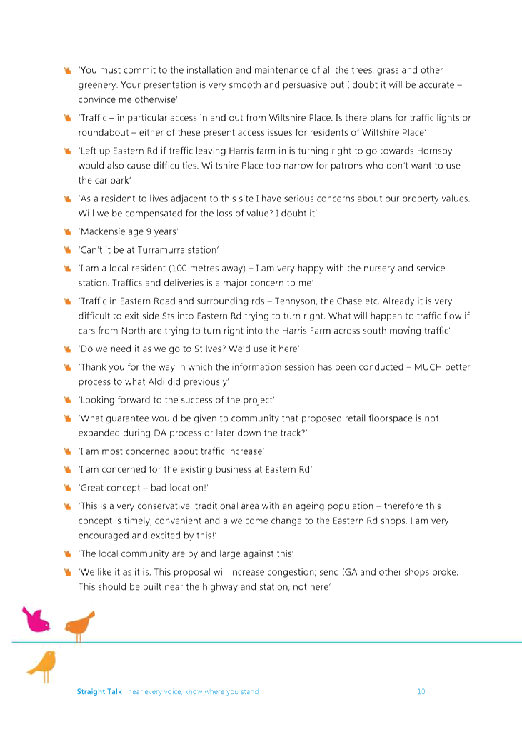
This report assesses of the Planning Proposal. It
addresses the key issues regarding the Planning Proposal prepared by SJB
Planning. Some changes to the Planning Proposal are recommended.
It is acknowledged that the existing uses on the site
complement other uses in the Centre. Expansion of the commercial function in
the local neighbourhood needs to fit into the overall, broader strategic
framework for Ku-ring-gai. It must also result in positive, safe and
practical benefits for the centre, its surrounding neighbourhood and the
community it serves.
|
|
|
|
|
recommendation:
|
That the Ku-ring-gai Local Planning Panel makes a
recommendation to Council that the Planning Proposal, as amended in this
report, be submitted to the Department of Planning and Environment for a
Gateway Determination.
|
Purpose of Report
To refer the Planning Proposal for 45-47 Tennyson Road and
105 Eastern Road, Turramurra on land currently operating as a plant nursey and
service station to the Ku-ring-gai Local Planning Panel for advice as required
by the Local Planning Panels Direction – Planning Proposals issued by the
Minister for Planning under Section 9.1 of the Environmental Planning and
Assessment Act 1979.
The Planning Proposal seeks to amend the Ku-ring-gai
Local Environmental Plan 2015 (KLEP 2015) by rezoning the site from R2 (Low
Density Residential) to B1 (Neighbourhood Centre).
See Attachment A4-A17 for detail.
Originally, SJB Planning presented an Amendment to Schedule
1 of KLEP 2015 to result in the following configuration:
· A 1,000
square metre building, possibly for an independent fresh food grocer (Note:
Harris Farm is stated in the Supplementary Planning Statement (Attachment A6);
· A 235 square
metre adjoining building (mainly along the Alice Street frontage), possibly for
a florist, nursery and café; and
· A 305 square
metre separate building on the corner of Eastern Road and Tennyson Avenue,
which is proposed to accommodate one or two speciality shops.
In August 2018 the Department of Planning and Environment
(DPE) introduced the following new definitions that are relevant to this
Planning Proposal i.e. garden centre, neighbourhood shops, and neighbourhood
supermarkets. The proposed retention of the FSR standard of 0.3:1 will allow
the desired maximum floor space of 1,540 square metres. Also, the new
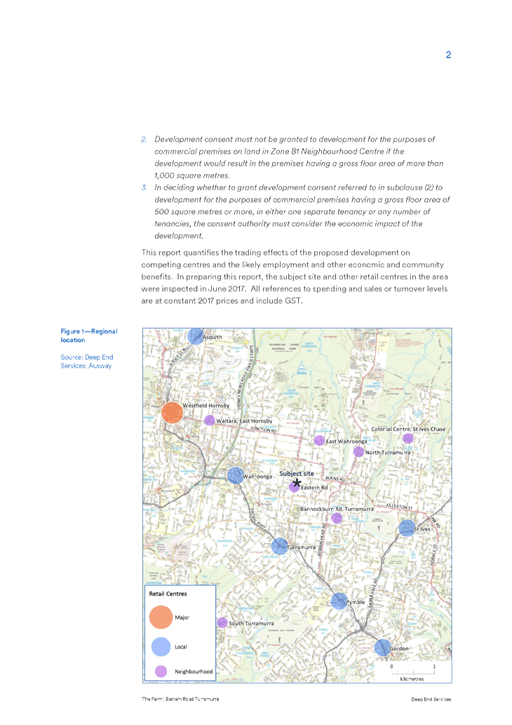
neighbourhood supermarket definition specifies a maximum floor area of
1000sq.m. It is important to note that this amount of floor space was
separately specified in the Planning Proposal as submitted.
As a result of these DPE changes, the proposed amendment to
Schedule 1 is considered unnecessary. By not limiting permissible land uses, or
specifying a particular building size, the recommended approach will also allow
greater flexibility regarding future (permissible) use and building
configuration on the site.
Background
Previous Planning Proposal
The subject site was part of a previous Planning Proposal
submitted by a different applicant. Discussions regarding the site and
the previous Planning Proposal with Aldi as the proponent have dated back to
2015. The first pre- Planning Proposal meeting was held on 27 May 2015.
The Planning Proposal was submitted to Council on 12 August
2015, which sought to make the following amendments to the KLEP 2015:
· rezone the
subject site from R2 Low Density Residential to B1 Neighbourhood Centre;
· amend the
Floor Space Ratio applying to the subject sites from 0.3: 1 to 0.75 :1; and
· amendment to
Schedule 1 – Additional Permitted Uses to allow a gross floor area of
1,955sqm for the purposes of an Aldi store and speciality shops on the subject
sites.
This Planning Proposal could have resulted in a maximum of
3,850 square metres of new floor space on the site.
The Planning Proposal was the subject of a Council report on
8 December 2015. Council resolved not to support the Planning Proposal on the
following grounds:
1. The
proposal is inconsistent with directions and actions in the Metropolitan
Strategy “A Plan for Growing Sydney” which seeks to undertake urban
renewal and growth within transport corridors and strategic centres in order to
create jobs that are closer to home. Specifically Directions 1.7, 2.2, 3.1 and
Actions 1.7.1, 2.2.2, and 3.1.1.
2. The
proposal is inconsistent with s.117 Directions under the Environmental Planning
and Assessment Act 1979, specifically:
• 3.4
Integrating Land Use and Transport
• 6.3
Site Specific Provisions
• 7.1
Implementation of “A Plan for Growing Sydney”
3. The
proposal is inconsistent with the objectives of Ku-ring-gai Council’s
Community Strategic Plan 2030 relating to the revitalisation of local centres
and managing the impacts of new development within centres.
4. The
proposal is inconsistent with the local service role and functions of
neighbourhood centres and will conflict with the hierarchy of commercial
centres in Ku-ring-gai.
5. The
proposal is inconsistent with the strategic directions and development
principles within the Ku-ring-gai Retail Centres Study 2005 (Hill PDA) and
Ku-ring-gai and Hornsby Subregional Employment Study 2008 (SGS Economics and
Planning) which seek to retain of the local service role and function of the
existing neighbourhood centres by limiting development capacity and encouraging
larger retail within the higher order centres.
6. The
proposal is inconsistent with the aims and objectives of the Ku-ring-gai Local
Environmental Plan 2015, specifically aim 1.2(g), objective of Clause 6.9(1)
and the objective of the B1 Neighbourhood Centre zone in that the proposal is
of a scale that is inappropriate for a neighbourhood centre, will service a
wider catchment than the surrounding residential area and will conflict with
the commercial hierarchy in Ku-ring-gai.
The Planning Proposal was subsequently submitted to the
Department of Planning and Environment (DPE) for a Gateway Review by the
proponent. The DPE refused the Review application on 9 March 2016. This fact
remains noted on the DPE rezoning review web page.
Planning Proposal
A summary of the Planning Proposal the subject of this
report can be found in the Purpose of this Report section earlier. Further
detail can also be found in the Planning Proposal section ahead. See Attachment
A4-A17.
A Pre-Planning Proposal meeting was held at Council on 21
March 2018. See Attachment A7, for the Minutes of this meeting.
The new Planning Proposal was initially registered with
Council on 27 August 2018. Council sent a letter outlining the additional
information required to complete the Planning Proposal on 5 October 2018. The
amended proposal was received and formally registered with Council on 31
October 2018.
The new Planning Proposal has not yet been publicly notified
by Council.
Key differences between the previous and current planning
proposals
The new Planning Proposal retains the existing FSR of 0.3:1
similar to the existing R2 (Low Density Residential) zone. The previous
proposal increased the FSR on the site to 0.75:1, which is equal to the
existing FSR in the existing, adjacent Eastern Road neighbourhood centre. The
new Planning Proposal specifies a maximum gross floor area of 1,540 square
metres, including a neighbourhood supermarket with a maximum gross floor area
of 1,000 square metres. The previous Planning Proposal had a maximum
gross floor area of 3,850 square metres, including a gross floor area for an Aldi
supermarket of 1,955 square metres.
The new Planning Proposal has reduced the potential gross
floor area on the site by 60% from the previous Planning Proposal. Further, the
size of the supermarket component has been reduced by almost 100%. The new
Planning Proposal will have significantly less impact than the previous
proposal, particularly in terms of the bulk, scale and function of future
development on the site.
The previous proposal specified Aldi as the main supermarket
tenant on the site. The new Planning Proposal remains more general, and
flexible, in terms of future uses and users of the site.
Site description and local context
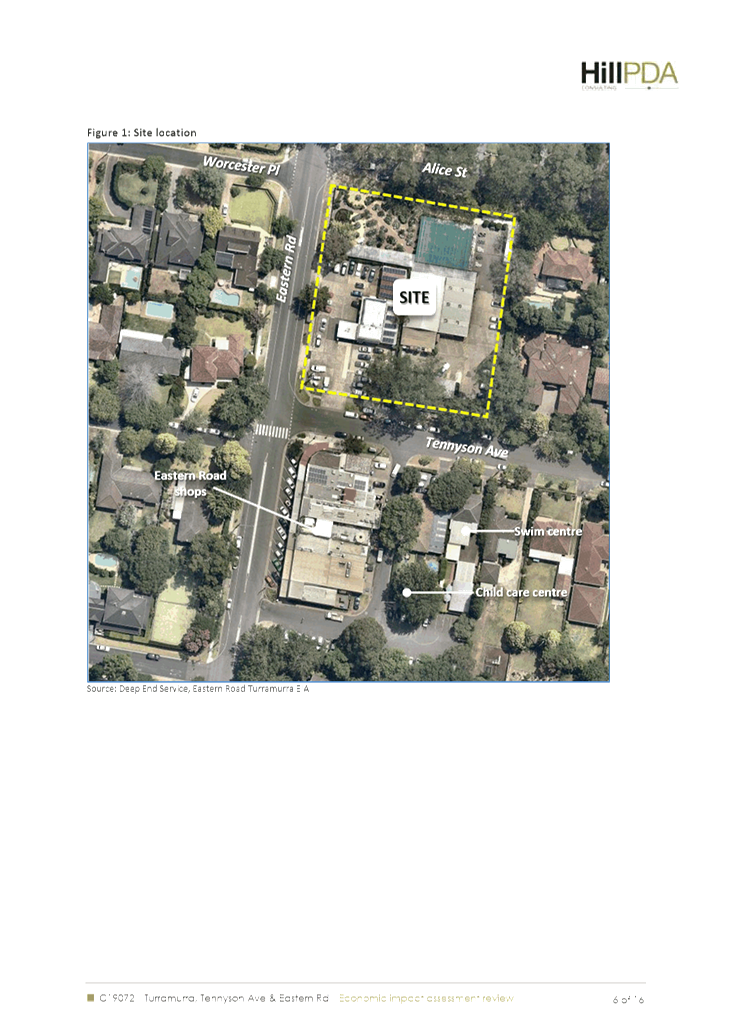
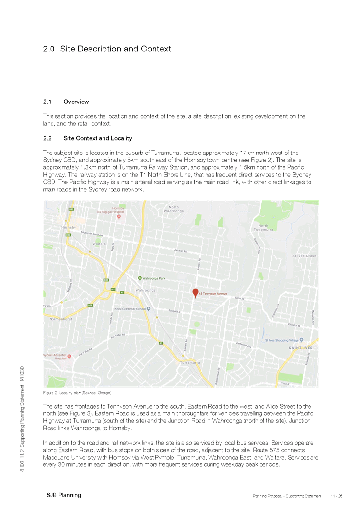
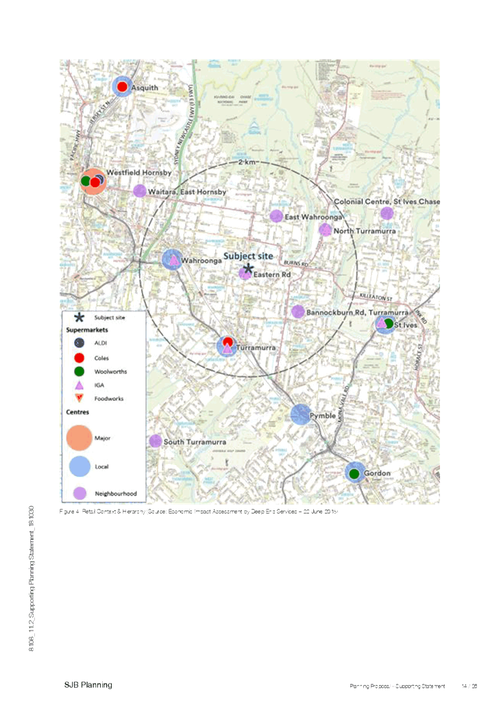
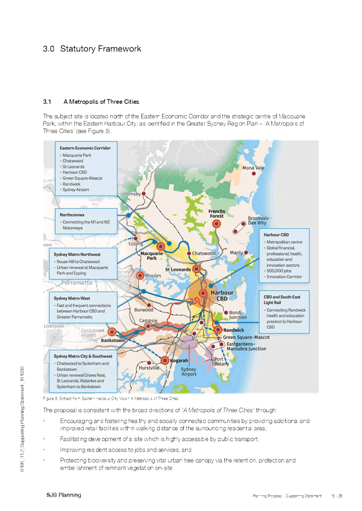
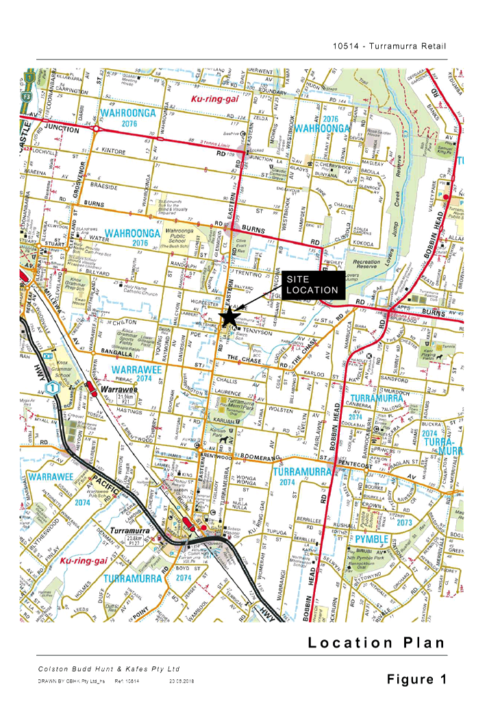
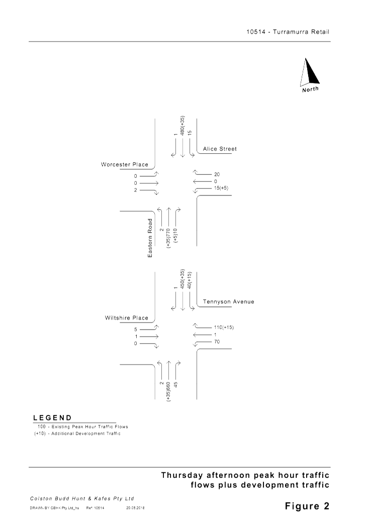
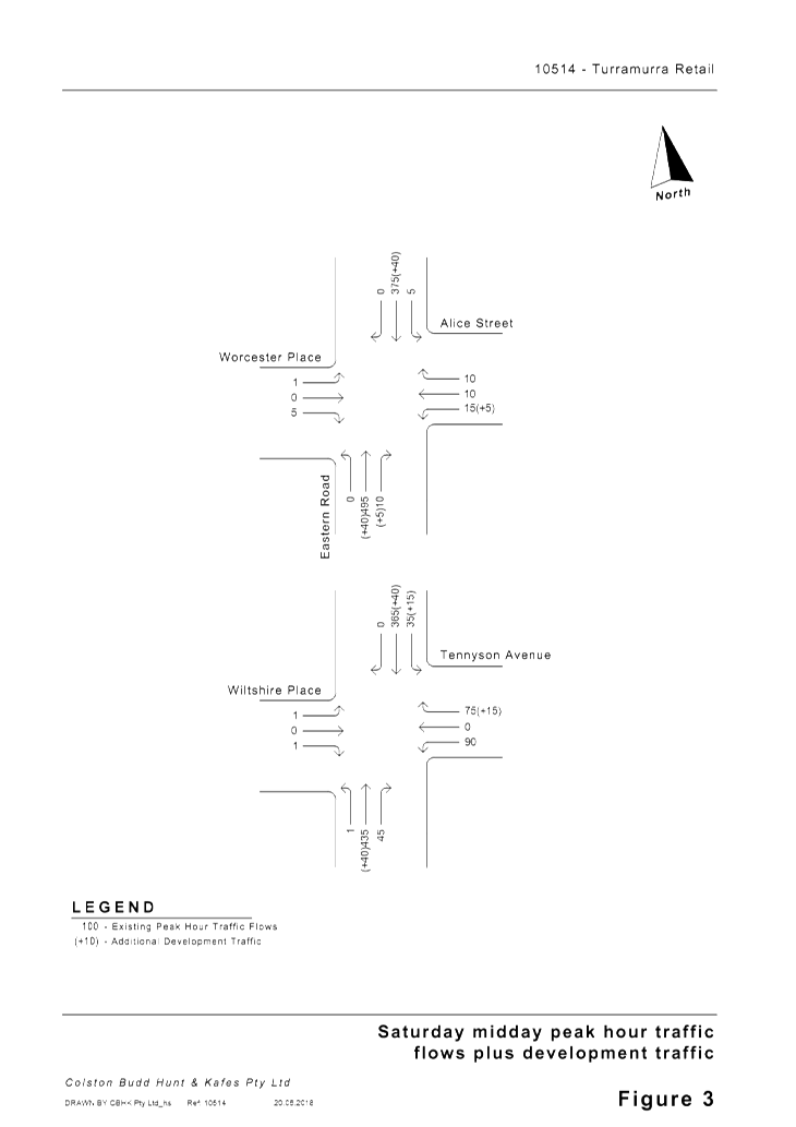
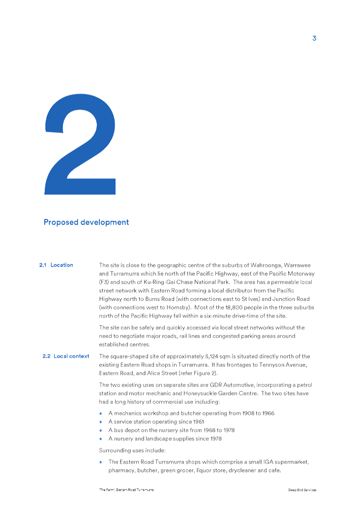
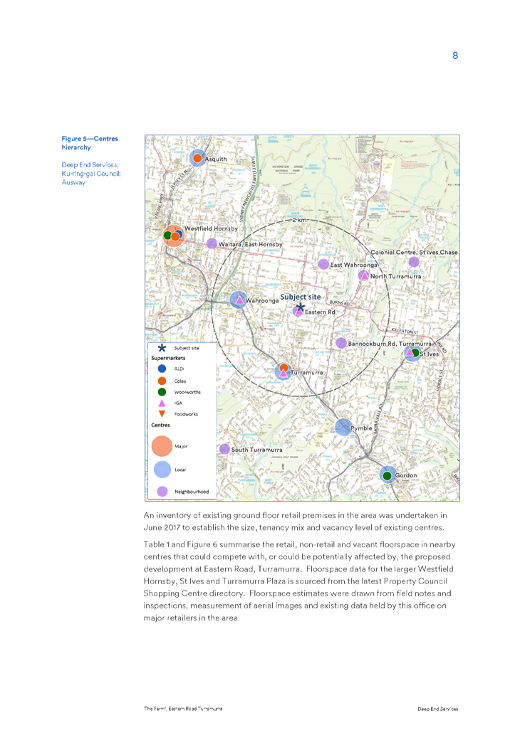
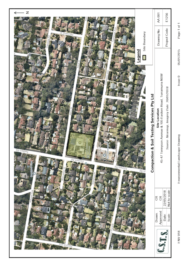
The site is located in Turramurra, 17 kilometres north-west
of the Sydney CBD and approximately 5 kilometres south-east of the Hornsby CBD.
The site is approximately 1.3 kilometres north of Turramurra Railway Station
and Turramurra Local Centre. It is 1.5 kilometres north of the Pacific Highway.
See Map 1.
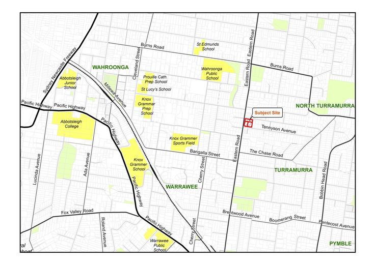 Map
1: Location of Site between Hornsby, Turramurra and St. Ives
Map
1: Location of Site between Hornsby, Turramurra and St. Ives
There is a local bus service from Macquarie University via
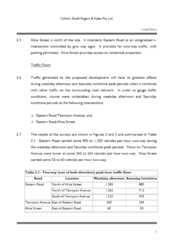
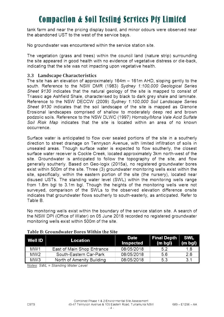
the Station to the site and on to Hornsby via Wahroonga. There are 14 services
per day from approximately 7am until 8pm Mondays to Fridays. There is another,
less frequent service to and from Wahroonga four times daily via the site on
week days (576T). Night and weekend buses are less frequent, or non-existent,
in the local neighbourhood.
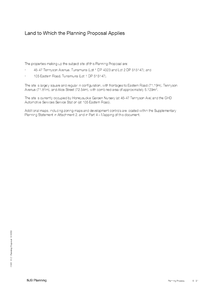
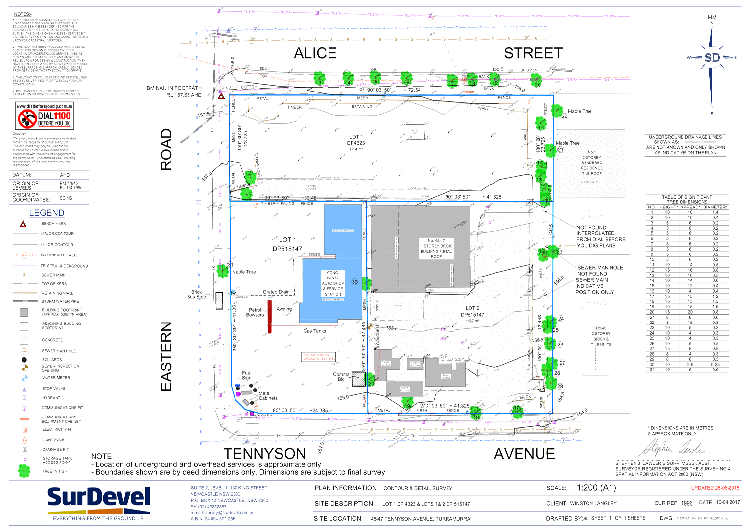
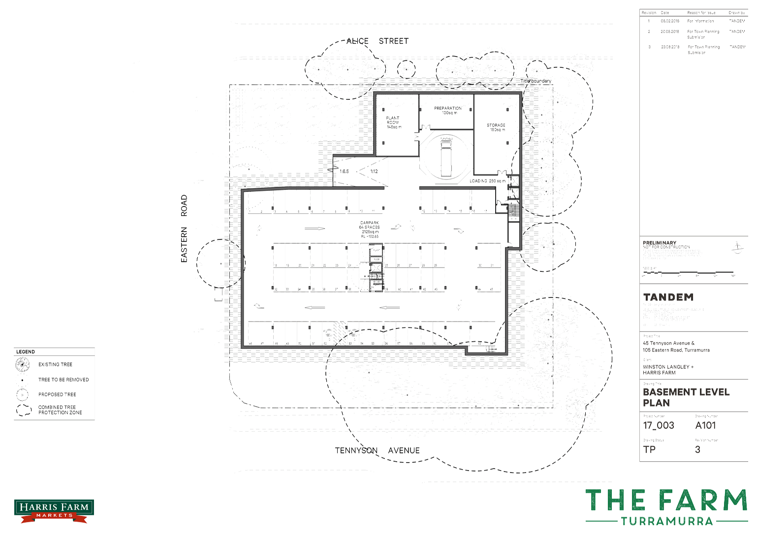
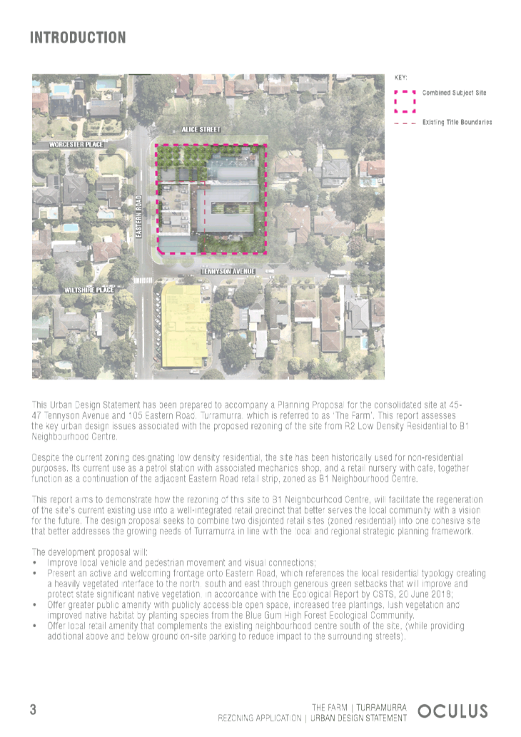
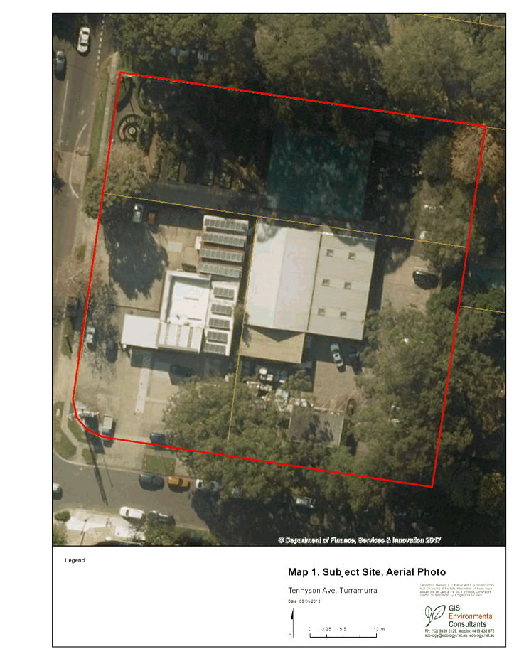
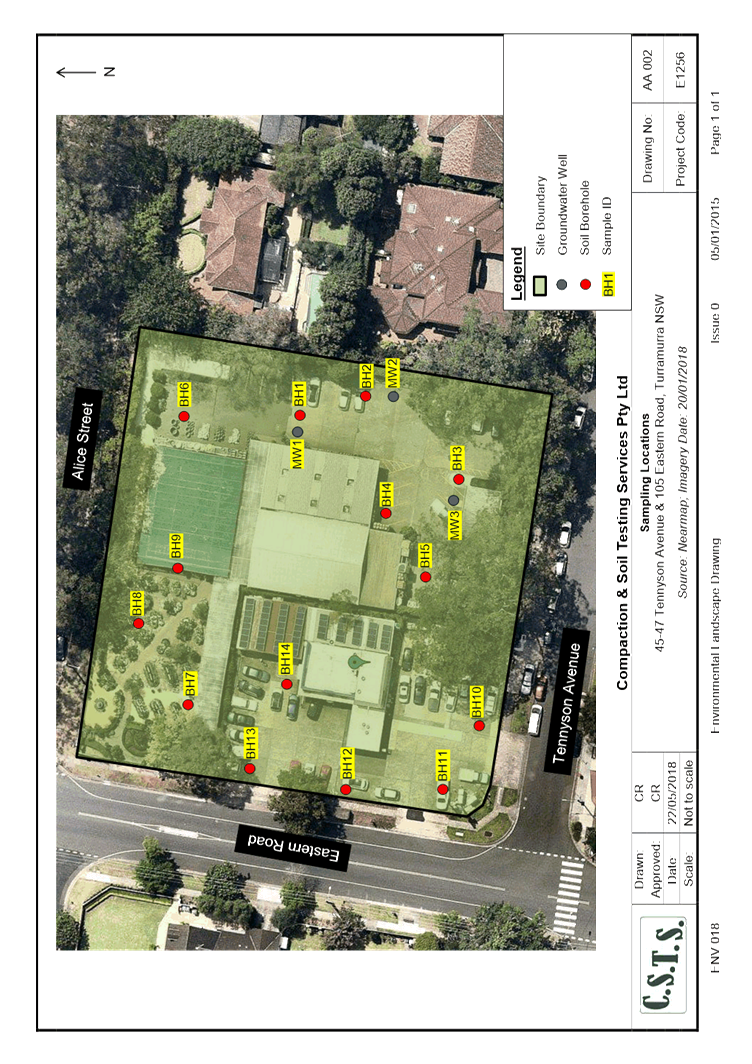
The site consists of two lots, at 45-47 Tennyson Avenue (Lot
1 DP 4323 and Lot 2 DP515147) and 105 Eastern Road, Turramurra, which is
identified as Lot 1 DP 515147. It is an almost square and has the following
frontages to 3 streets: Eastern Road (71.19m), Tennyson Avenue (71.81 m) and
Alice Street (72.54m). The total area of the site is 5129 square metres
(Council Geocortex map system estimates the site to be 5120 square metres).
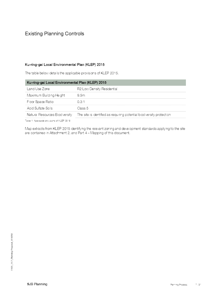
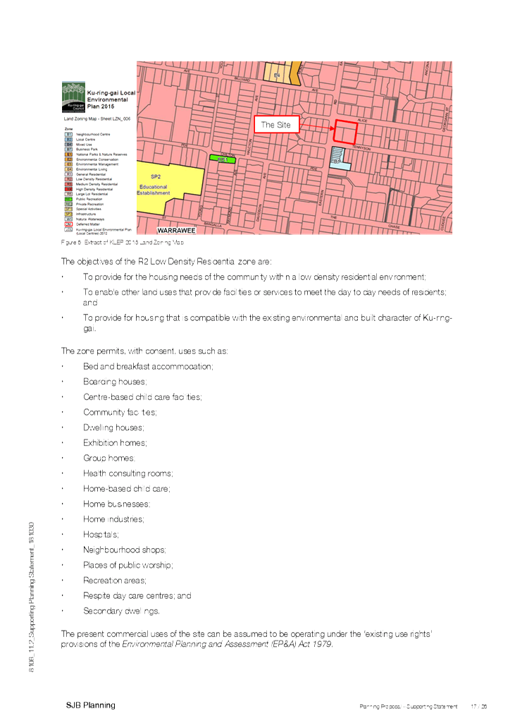
The site is currently zoned R2 (Low Density Residential)
under the Ku-ring-gai Local Environmental Plan 2015 (KLEP).
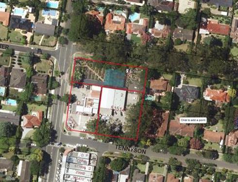
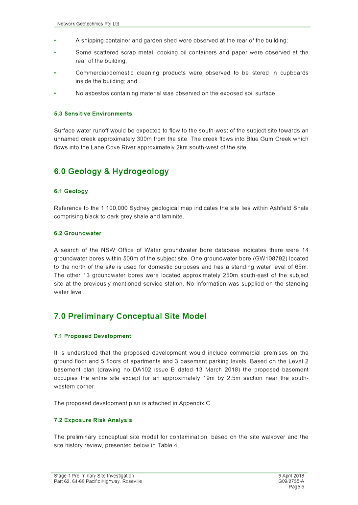
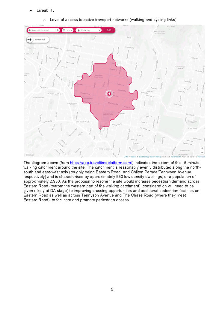
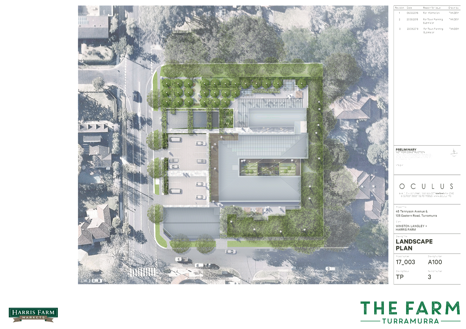
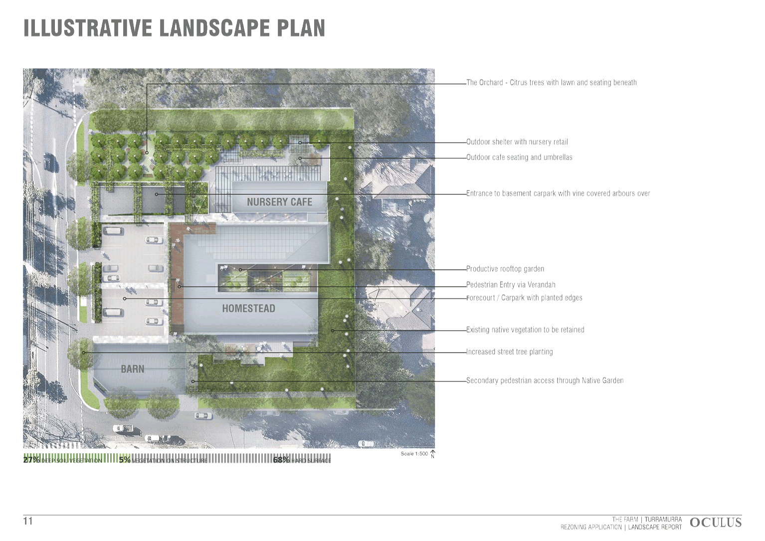
Image 1: Aerial photo of the site and surrounds. The
site is outlined in red
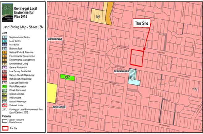
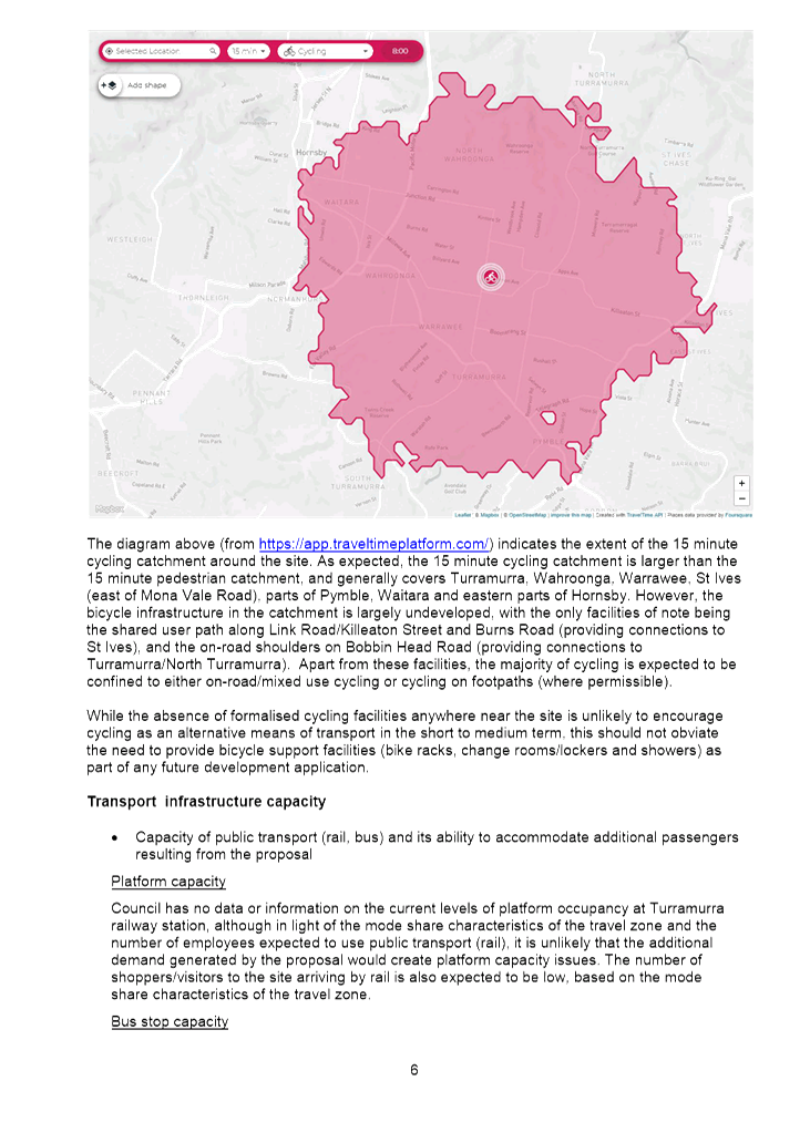
Image 2: Current Zoning Extract from KLEP 2015 –
R2 Low Density Residential (pink).
The site is outlined in red.
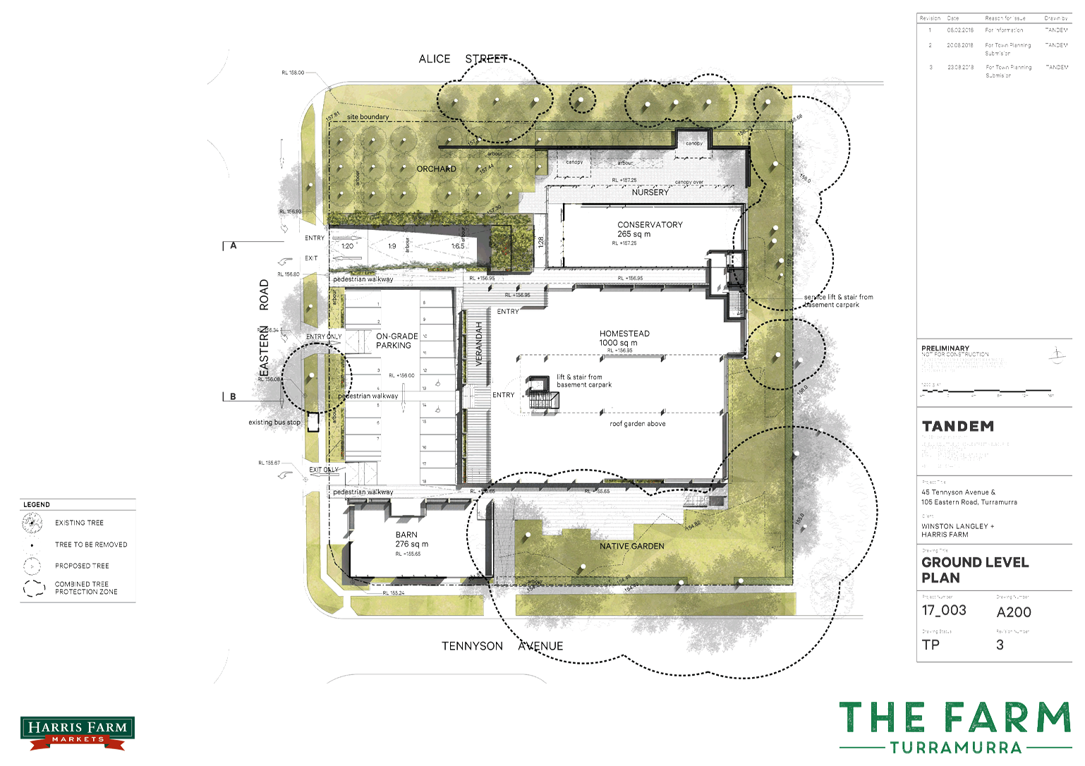
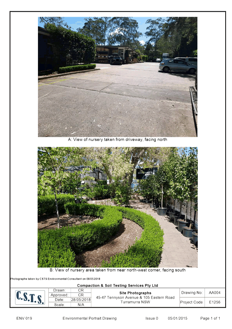
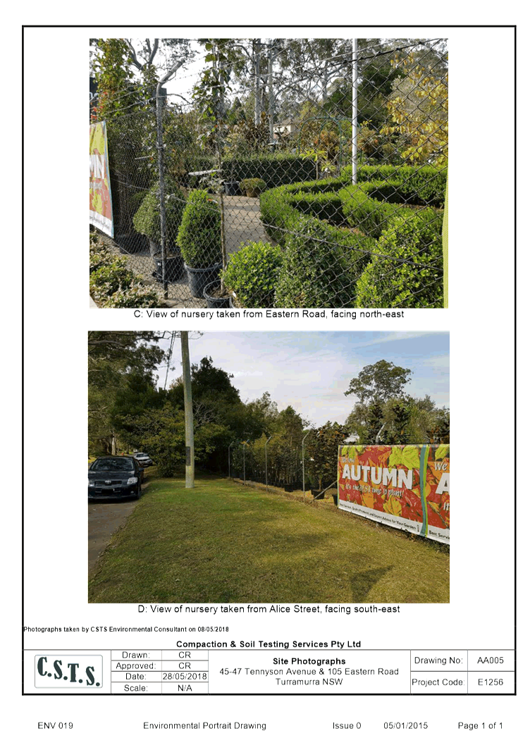
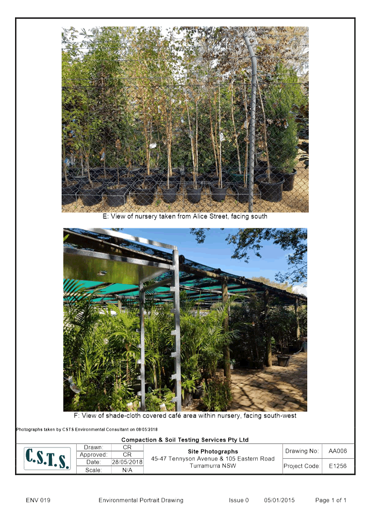
The Tennyson Avenue property is currently used for a garden
centre (Honeysuckle Garden Centre), associated car parking and structures.
There are 8 full time and 5-10 part time (seasonal) casual staff employed at
the nursery (applicant’s advice January 2019). The Eastern Road property
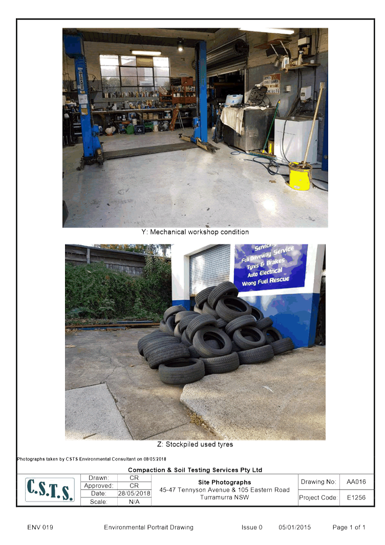
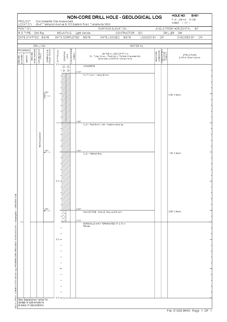
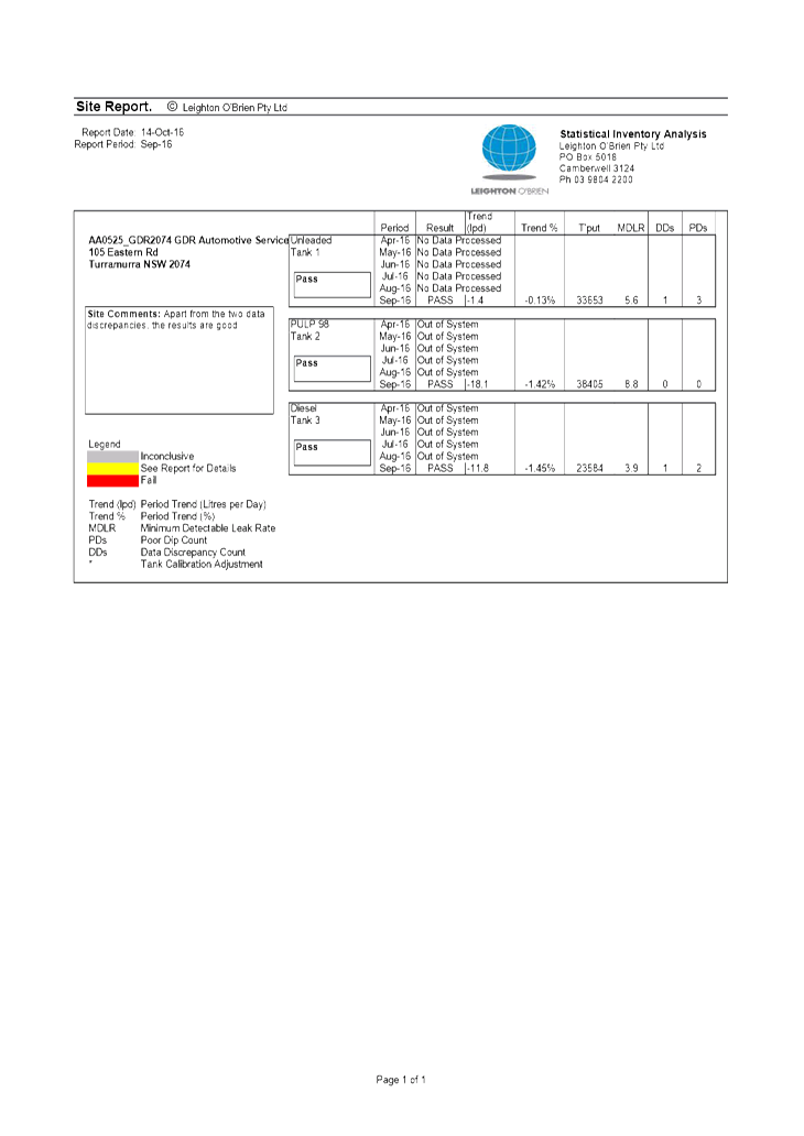
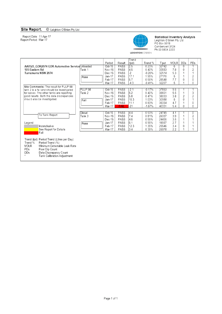
is used for a service station and associated vehicle mechanical workshop (GRD
Automotive Services) Service Station. There are 5 full time and 1 casual staff
employed by this business (pers. Comm. applicant January 2019). The existing
floor area of both businesses is 824 square metres. These existing uses are
long term, well established enterprises.
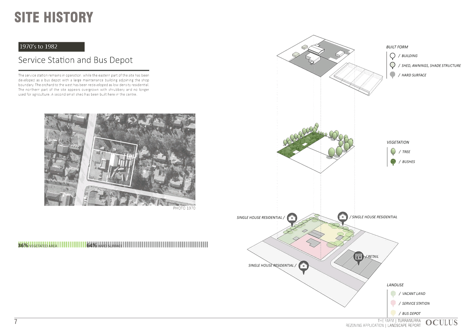
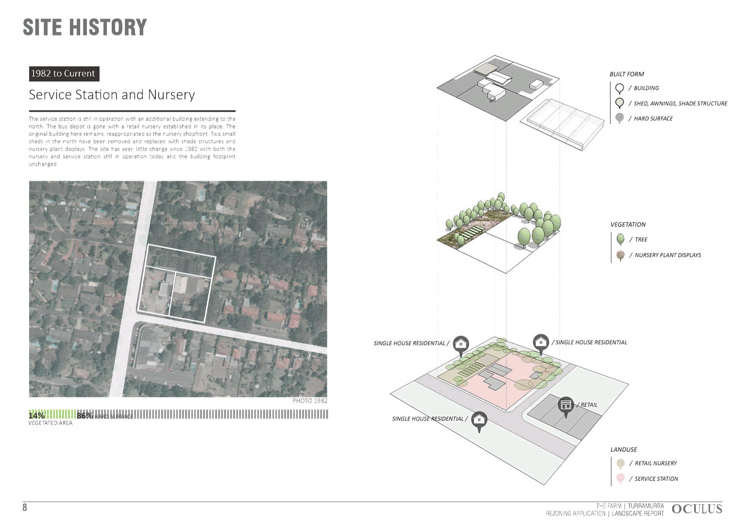
The garden centre property operated as an apple orchard and
possible market garden from the early 1900s. From 1954 to 1968 it was owned by
Ampol Petroleum Ltd., but it is likely to have been vacant by 1961. Between
1968-1978 it was used as a bus depot. From 1978 it has been used a nursery and
landscaping supply shop, and as a café and nursery since 2002. The other
property has been used as a service station and mechanical workshop since the
1950’s.
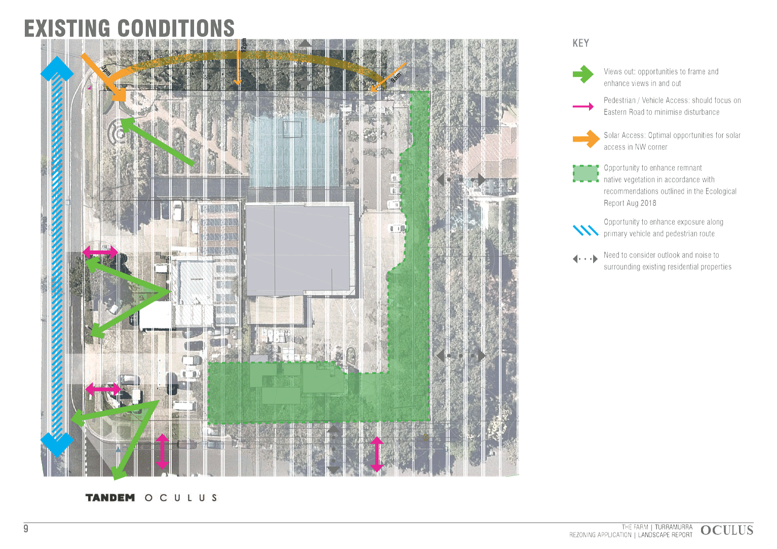
The site is generally level. There is a gentle fall from
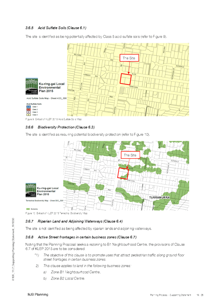
north to south of approximately 3 metres. See Attachment A5. The
majority of the site is unvegetated, however there is significant vegetation on
the eastern and southern edges of the site. This is discussed ahead in more
detail.
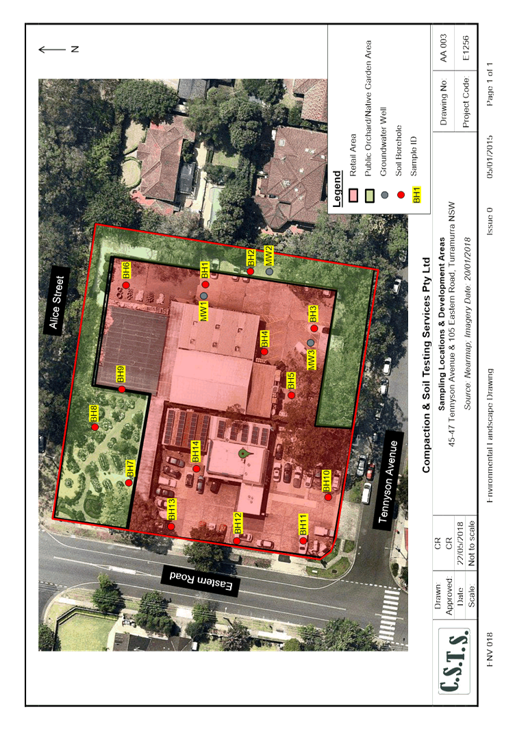
The site is located immediately north (across Tennyson Avenue)
of the existing Eastern Road shops. These shops and adjacent car parking areas
are zoned B1 (Neighbourhood Centre) under KLEP. The floor area of the existing
shops is approximately 1512 square metres. It is a well-established group of 7
shops that includes a small IGA supermarket (570 square metres), BWS Liquor
Store, butcher, pharmacy, fruit and vegetable shop, café and drycleaner.
All shops have remained occupied over time.
The total existing B1 Neighbourhood Centre zoned area is
approximately 3,684 square metres. This includes angled street front parking
and the car park (to the south and east of the existing shops) provide a total
of 55 car parking spaces (internal transport referral response December 2018)
in the following breakdown:
· Rear car
park 37 spaces;
· angle
parking along the Eastern Road frontage of 12 spaces;
· parallel
parking on the Tennyson Road frontage of 2 spaces; and
· parallel
parking on the Eastern Road frontage of 4 spaces.
The car park is accessed on the eastern side of the
commercial buildings by Tennyson Lane, and on their western side by Eastern
Road. The lane links Tennyson Avenue and Eastern Road in a reverse L
configuration.
Immediately east of the laneway in Tennyson Avenue is a
Kindergarten (Turramurra Beehive Child Care) and a privately operated Swimming
School (Turramurra Learn to Swim).
The site is surrounded by a low density residential area
that is zoned R2 (Low Density Residential) under the KLEP 2015. The area to its
north and west is typical of low density residential areas in Ku-ring-gai, with
high quality detached dwellings within large, established garden settings.
Immediately east of the site is a small group of townhouses.
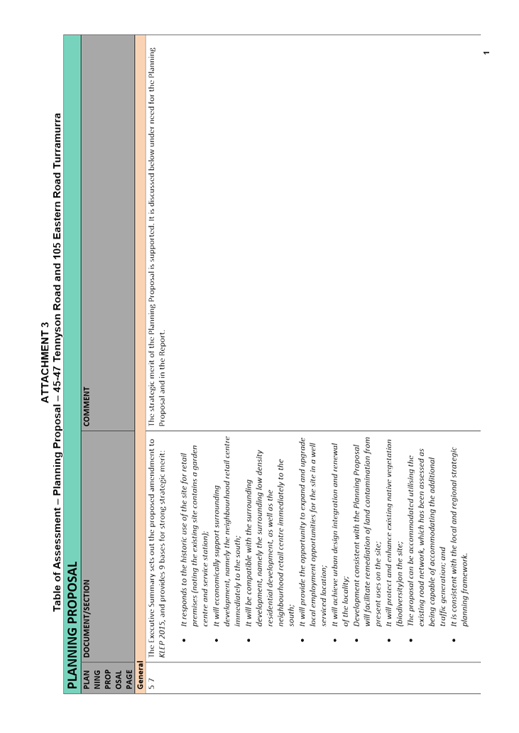
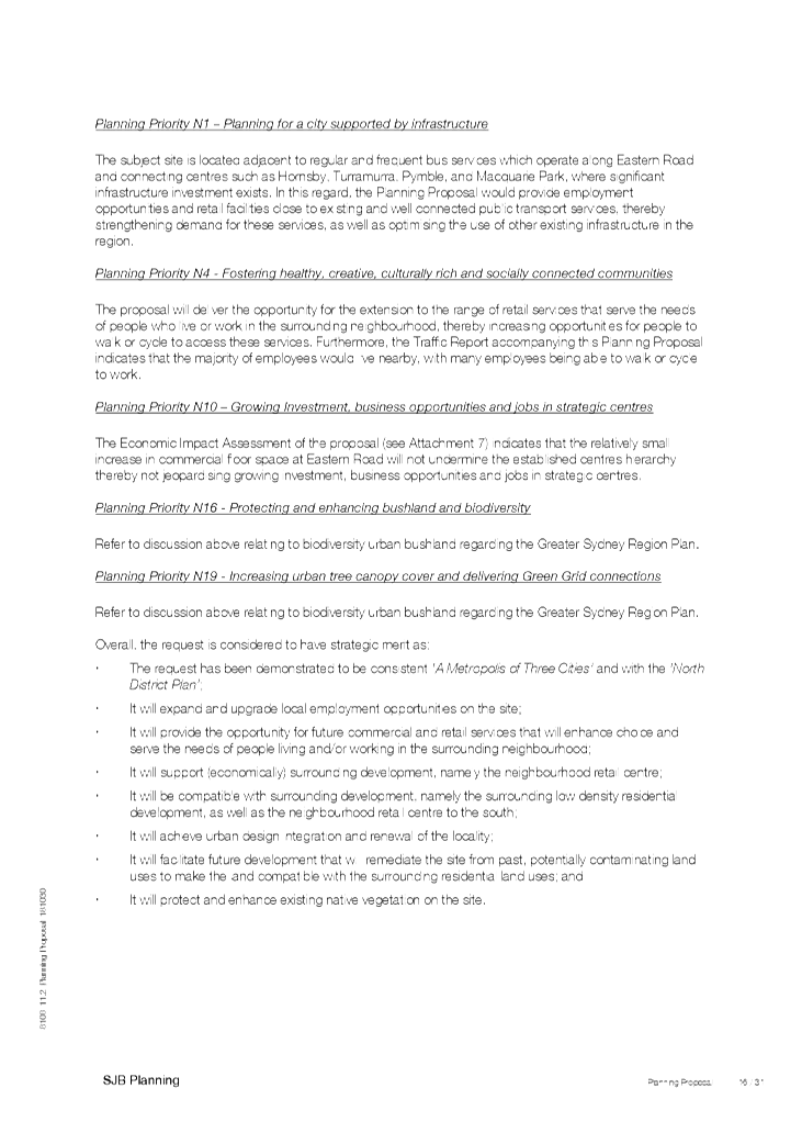
Reasons for the Planning Proposal
The Planning Proposal outlines the following reasons for the
proposed amendments to the KLEP 2015(p.5 Executive Summary):
· It
responds to the historic use of the site for retail premises (noting the
existing site contains a garden centre and service station);
· It will
economically support surrounding development, namely the neighbourhood retail
centre immediately to the south;
· It will
be compatible with the surrounding development, namely the surrounding low
density residential development, as well as the neighbourhood retail centre immediately
to the south;
· It will
provide the opportunity to expand and upgrade local employment opportunities
for the site in a well serviced location;
· It will
achieve urban design integration and renewal of the locality;
· Development
consistent with the Planning Proposal will facilitate remediation of land
contamination from present uses on the site;
· It will
protect and enhance existing native vegetation (biodiversity) on the site;
· The
proposal can be accommodated utilising the existing road network, which has
been assessed as being capable of accommodating the additional traffic
generation; and
· It is
consistent with the local and regional strategic planning framework.
The following additional merit was identified in the
Supplementary Planning Statement (Appendix 2 p.4) to further justify the
Planning Proposal:
· It will
provide services that will enhance choice and serve the needs of people living
and/or working in the surrounding neighbourhood.
The Planning Proposal
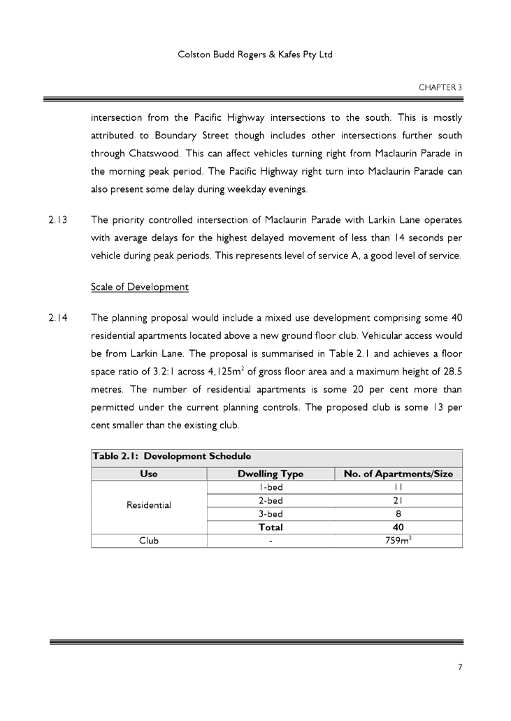
The Planning Proposal prepared by SJB Planning seeks
amendment to the KLEP 2015 to rezone the 5,129 square metre site from R2 (Low
Density Residential) zoning to B1 (Neighbourhood Centre).
Permissible uses in the B1 (Neighbourhood Centre) comprise: Bed
and breakfast accommodation; Boarding houses; Business premises; Centre-based
child care facilities; Community facilities; Health consulting rooms;
Home-based child care; Light industries; Medical centres; Neighbourhood shops;
Neighbourhood supermarkets; Respite day care centres; Roads; Shop top housing;
Water reticulation systems; Any other development not specified in item 2 or 4
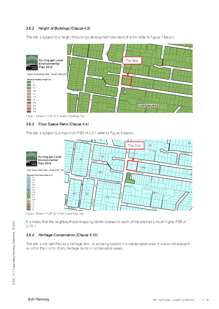
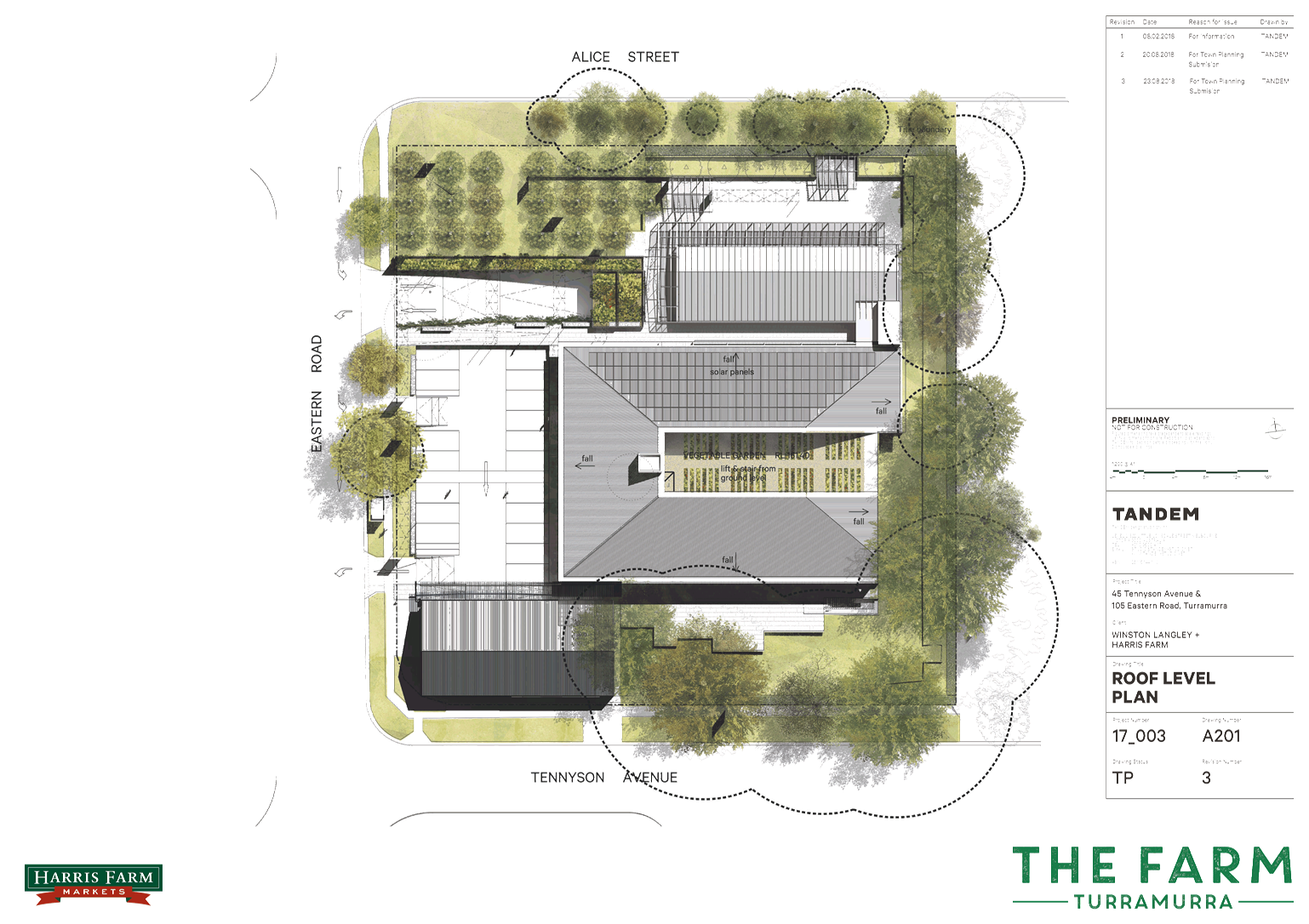
The existing Maximum Building Height of 9.5 metres and
maximum FSR of 0.3:1 LEP development standards are proposed to be retained for
the site. See Images ahead for details.
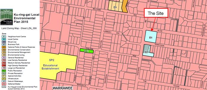
Image 3: Proposed zoning of the site to B1
Neighbourhood Centre as submitted by SJB Planning
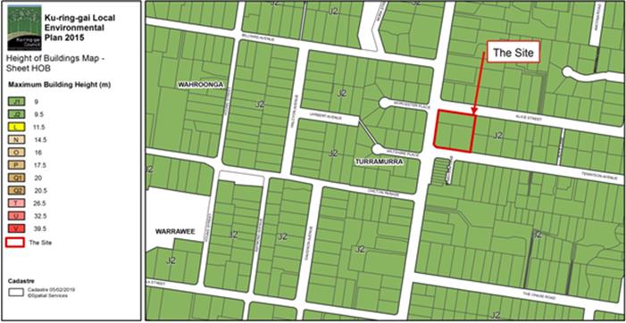
Image 4: Existing 9.5 metre height development
standard on the site.
This standard is proposed to be retained in the
Planning Proposal.
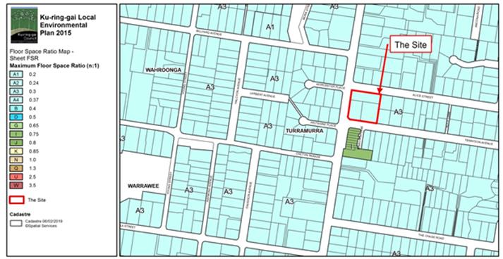
Image 5: Existing 0.3:1 FSR development standard on
the site.
This standard is proposed to be retained in the
Planning Proposal.
It is important to note that the proposed FSR development
standard is less on the site than for the adjacent existing Eastern Road
shopping centre (to the south). The latter area has a maximum FSR of 0.75:1.
See Image 5.
Schedule 1 Amendment
Clause 6.9(2) of KLEP 2015 states that Development
consent must not be granted to development for the purposes of commercial
premises on land in Zone B1 Neighbourhood Centre if the development would
result in the premises having a gross floor area of more than 1,000 square
metres. There is ambiguity in the wording of this clause. To clarify the
situation for future development, the applicant has proposed a Schedule 1
amendment to allow commercial premises maximum gross floor area (GFA) of
1,540 square metres on the site.
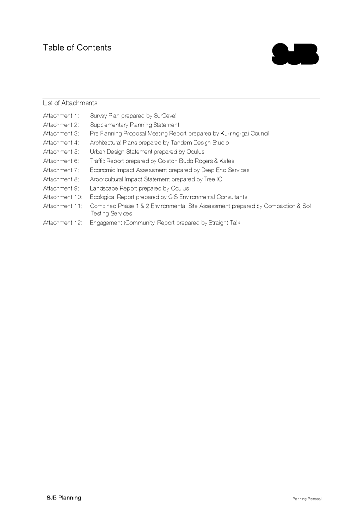
Supporting Studies
Several supporting studies form attachments to the Planning
Proposal. They provide information and further justify the Planning Proposal.
They are listed ahead and may be found at Attachment A5-A17 to this
report:
· Survey Plan
prepared by SurDevel
· Supplementary
Planning Statement
· Pre-Planning
Proposal Meeting Report prepared by Ku-ring-gai Council
· Architectural
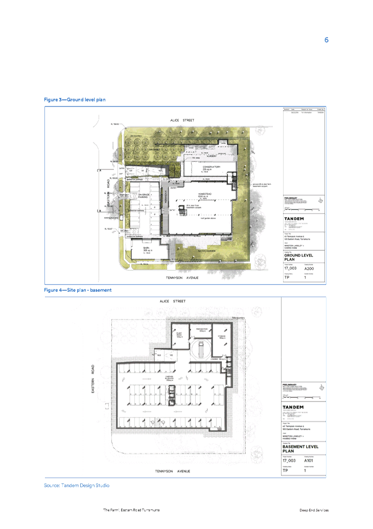
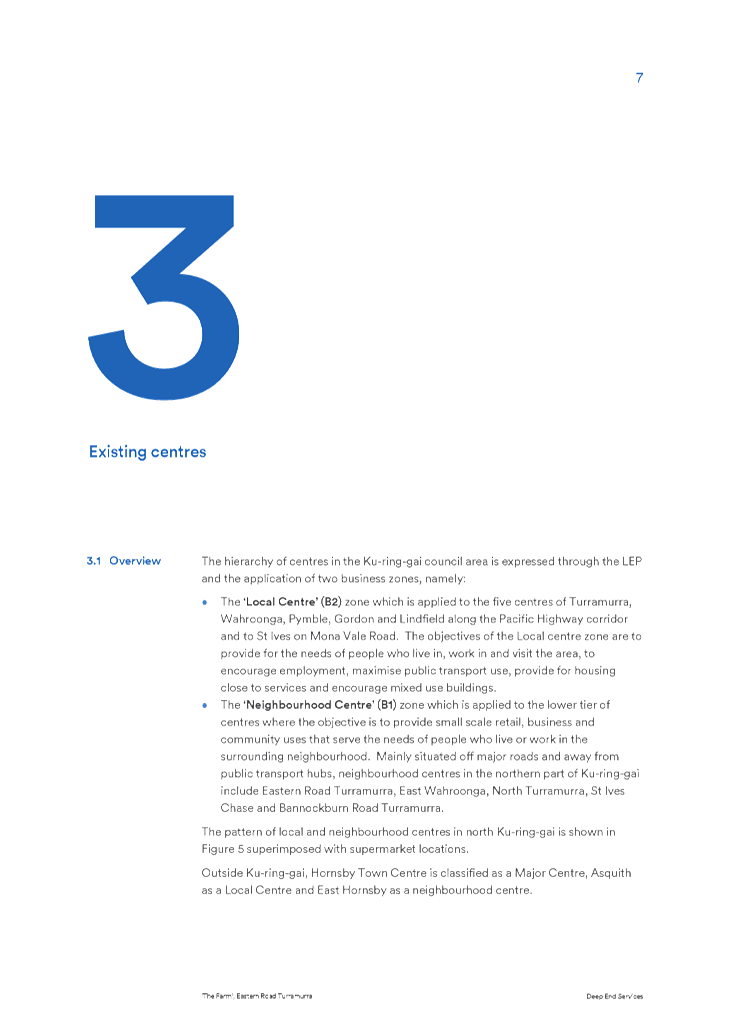
Plans prepared by Tandem Design Studio
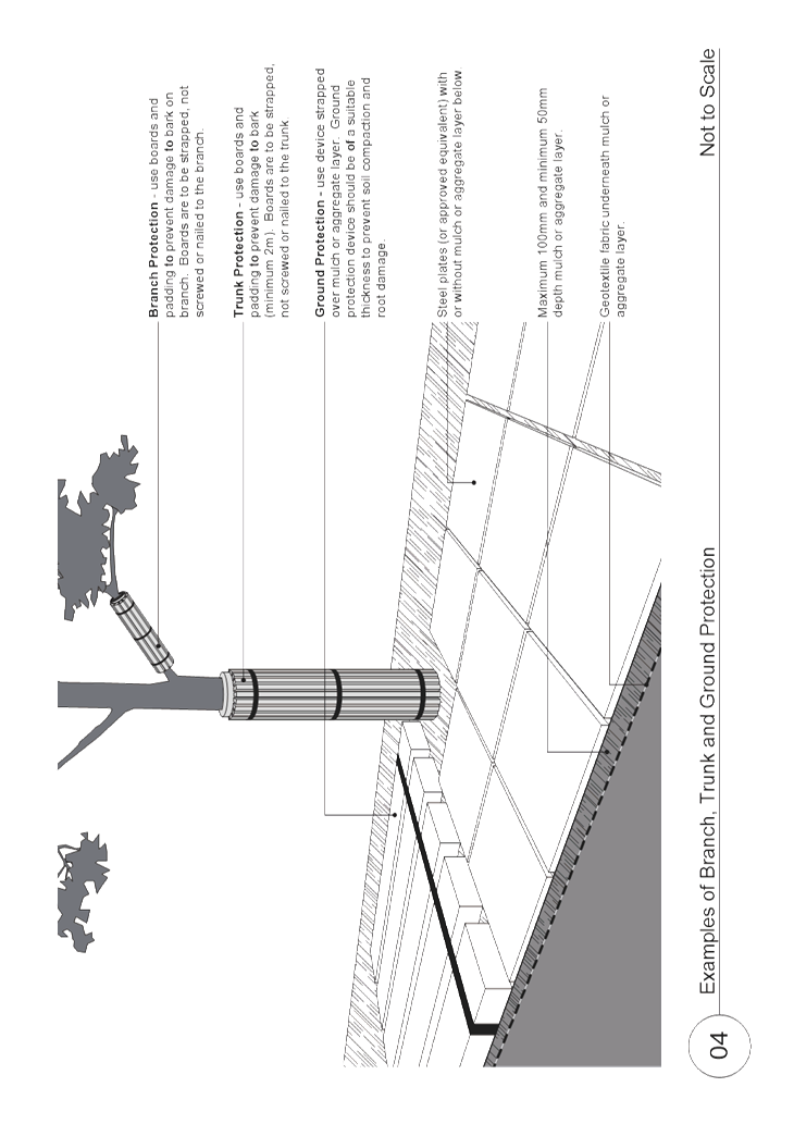
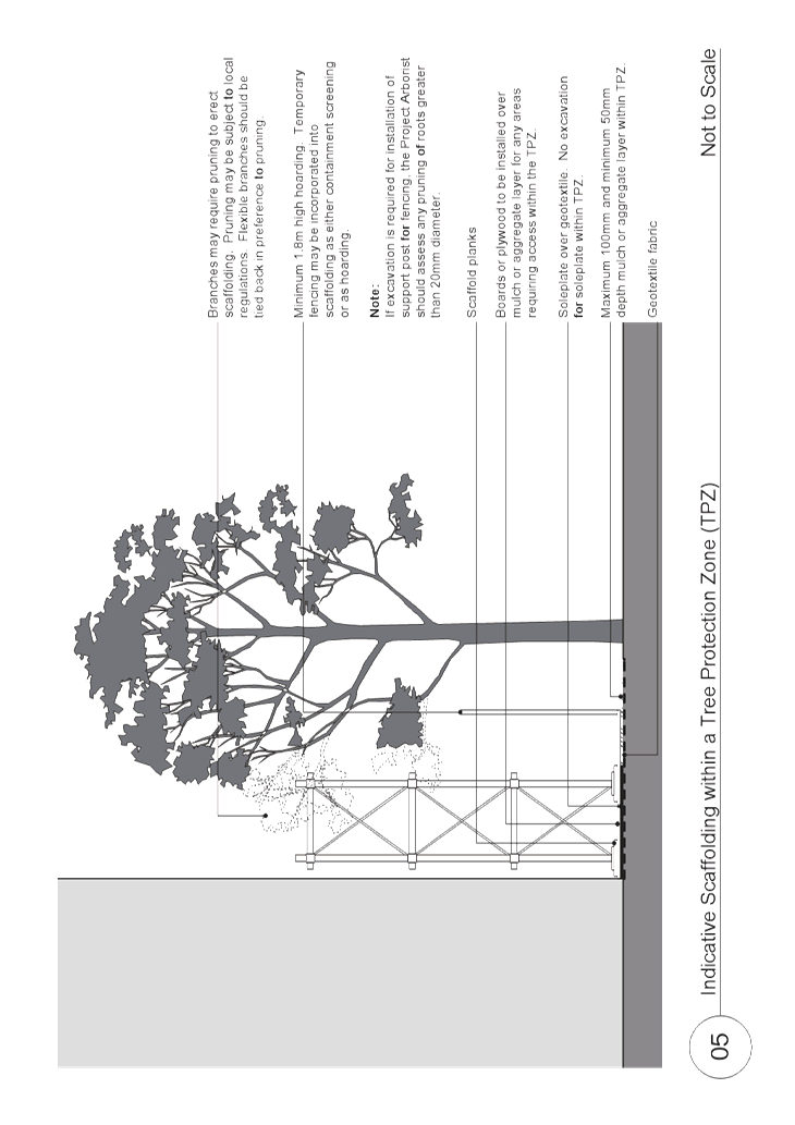
· Urban Design
Statement prepared by Oculus
· Traffic
Report prepared by Colston Budd Rogers & Kafes
· Economic
Impact Assessment prepared by Deep End Services
· Arboricultural
Impact Statement prepared by Tree IQ
· Landscape
Report prepared by Oculus
· Ecological
Report prepared by GIS Environmental Consultants
· Combined
Phase 1 & 2 Environmental Site Assessment prepared by Compaction & Soil
Testing Services
· Engagement
(Community) Report prepared by Straight Talk
The Architectural Plans and Urban Design Statement included
with the Planning Proposal provide an indication of possible type and scale of
built outcomes enabled by the Planning Proposal. Briefly, it comprises:
· a commercial
premises with a GFA of 1,000 square metres to be used as an independent fresh
food grocer (The Homestead);
· an adjoining
tenancy of 235 square metres to be used as a florist, nursery and café
along the Alice Street frontage (Conservatory/ Café Nursery); and
· a separate
retail building on the corner of Eastern Road and Tennyson Avenue of 305 square
metres to be used for 1 or 2 specialty shop tenancies (The Barn).
In considering the Planning Proposal, the building envelope
across the entire site has to be considered as any future application on the
site could potentially deliver alternative footprints and development of
differing bulk and scale than indicated in this Planning Proposal.
It is important to note that a Planning Proposal is not a
Development Application and does not consider the specific detailed matters for
consideration under Section 4.15 of Environmental Planning and Assessment
Act 1979 (previously Section 79C). A Planning Proposal relates only
to an LEP amendment. The proposed amendments need to be acceptable as a means
for facilitating certain outcomes on the site, regardless of the subsequent
approval or refusal of any future Development Application/s.
Key Points
If the Planning Proposal proceeds, the overall Eastern Road
shopping centre commercial floor area will increase from 2,336 square metres
(including 824 square metres for the existing service station and nursery),
plus 1,512 square metres (for the existing Eastern Road shops), to
approximately 3,052 square metres. The Planning Proposal will result in an
overall increase in B1 Neighbourhood Centre Eastern Road land area from 3,684
square metres. to 8,813 square metres.
Information on fifteen (15) areas zoned B1 Neighbourhood
Centres in the Ku-Ring-gai local government area has been complied and
tabulated. These 15 centres have a total gross floor area of 22,800 square
metres (approximate Dekho measurement). The Planning Proposal would result in a
potential increase in gross floor area of 716 square metres. This is considered
a very small increase of 3.1% in the overall Ku-ring-gai Neighbourhood Centre
context.
In its independent review of the economic assessment report,
Hill PDA state that the Eastern Road Neighbourhood Centre will not change in
terms of its position in the overall Ku-Ring-Gai Centre Hierarchy as a result
of the Planning Proposal. Importantly, the identified strategic need to have a
functional hierarchy of centres in Ku-ring-gai is maintained as a result of the
Planning Proposal.
Comments
Planning Proposal
Assessment
The Planning Proposal has
been evaluated by Council’s Urban Design, Development Assessment,
Transport, Natural Areas (Strategy and Environment) and Infrastructure teams.
See Attachment A2 for detail.
Analysis of the Planning Proposal and its attachments has
been conducted, and summarised in the Table of Assessment. See Attachment A1.
Internal Council Responses
The key issues raised in the Council officers’
assessments are as follows:
Natural Areas
The proposed building footprint needs to be designed to
further reduce impacts on the remnant Blue Gum High Forest (BGHF). This
could potentially be achieved through a reduction of areas of the site which
are not considered as ecologically significant (i.e. the orchard in the current
proposal), and the provision of greater buffers for the remnant BGHF
trees. Additional buffers could be achieved through site specific DCP
controls requiring a greater setback from the mapped BGHF located in the
south-eastern corner of the site. These issues are addressed via proposed
changes to the Planning Proposal, should it proceed to the Gateway, in the
Summary section at the end of this report.
The impacts associated with the removal of 5 trees including
2 native species (T30 a young Eucalyptus saligna and T1 a large Melaleaca
quinquenervia) through the current proposal is able to be offset onsite
with appropriate plantings, which would need to be clearly identified in a
vegetation management and replenishment plan.
A detailed survey and tree plan would be required to ensure
all retained trees remain viable, with suitable monitoring, vegetation
management and replenishment. Again, a better outcome could be achieved by
providing a greater buffer to retained trees or through alternative
construction methods.
The site is suitable for the proposed uses, and poses no
unacceptable risk to human health or the surrounding environment. The issue of
contamination will be addressed during the development process, and appropriate
management and monitoring put in place if required.
Transport
The Planning Proposal states that approximately 20 employees
would be working in the store at any one time. Based on the travel mode
characteristics of the travel zone, it is likely that 15 employees would drive
to work, 2 would be dropped off, 1 would arrive by train, 1 would walk and 1
would arrive by bus. While it is likely that around half of the employees would
originate from the Ku-ring-gai LGA, the site is still likely to be a highly
car-dependent site for journeys to work by employees.
It is unlikely that this additional demand for public
transport would place significant additional burden on existing services. The
existing public transport services would likely have the capacity to
accommodate any additional demand. Given the small public transport catchment
and unrestricted nature of on-street parking in the vicinity of the site, it is
likely to be highly car dependent for journeys to work.
As the proposal to rezone the site would increase pedestrian
demand across Eastern Road (to/from the western part of the walking catchment),
consideration will need to be given (likely at DA stage) to improving crossing
opportunities and additional pedestrian facilities on Eastern Road as well as
across Tennyson Avenue and The Chase Road (where they meet Eastern Road), to
facilitate and promote pedestrian access.
It is unlikely that the additional demand generated by the
proposal would create platform capacity issues at Turramurra Station. The
number of shoppers/visitors to the site arriving by rail is also expected to be
low, based on the mode share characteristics of the travel zone. There is a bus
stop directly outside the site and opposite the site. Services provide
connectivity to Turramurra railway station.
The estimated traffic generation of the Planning Proposal is
derived from the RTA Guide to Traffic Generating Developments for supermarkets
and specialty shops. The net increase in traffic generation (allowing for the
existing use) is estimated at additional 150 vehicle trips per hour (two-way)
during the weekday afternoon peak hour and 130 vehicle trips per hour (two-way)
during the Saturday peak hour. In terms of impacts to nearby intersections, the
Planning Proposal would result in a Level of Service A/B (good
operation/acceptable delays and spare capacity) for both the intersection of
Eastern Road and Tennyson Avenue and the intersection of Eastern Road and Alice
Street. Council’s Traffic Assessment section concurs with these figures
and level of service estimates.
Tennyson Road has a relatively narrow road pavement varying
from approximately 7.5m to 10m, and the question of the desirability of
carrying additional traffic in Tennyson Avenue, and whether traffic management
measures would need to be considered, would be a matter for a future
development application.
Any traffic management measures that reduce traffic
movements in Tennyson Avenue are likely to result in corresponding increases in
traffic movements along The Chase Road. The Chase Road is a collector road and
is already operating at around the maximum environmental traffic flows
suggested for a collector road (as outlined in the RTA Guide to Traffic
Generating Developments).
While not a consideration at this stage, the potential for
82 car spaces would be lower than required by the DCP but higher (per square
metre) than the parking provided for the existing shops. The
slightly-lower-than-DCP provision could be supported though, if a management
system was implemented to encourage turnover of the on-site spaces (e.g.
electronic parking management system or enforcement by Council’s
rangers). There are also 3-4 time-restricted parallel parking directly opposite
(on the western side of Eastern Road) which contribute to short stay parking supply
for public use.
The Traffic Assessment report that forms part of the
Planning Proposal indicates that the existing road infrastructure has capacity
to cater for the proposal. Council’s Traffic Assessment section concurs
with this conclusion.
Urban Design
The Planning Proposal is supported in principle. A site
specific DCP is required to provide Council’s detailed requirements.
Outcomes of the Planning Proposal include: increased public amenity; better
safety and surveillance; as well as an activation of the street front (flexible
parking and forecourt to Eastern Road) along the site.
Development Assessment
A DCP is required to guide development on the site,
particularly in regard to protecting significant vegetation. See Image 6 ahead.
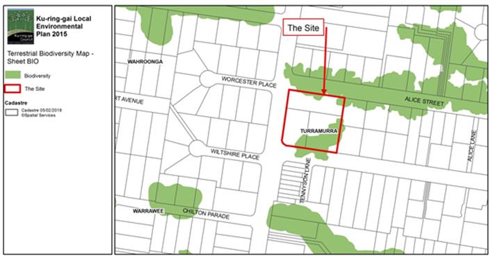
Image 6 Existing Terrestrial Biodiversity mapping will
remain unchanged as a result of the Planning Proposal.
Infrastructure
The imposition of the appropriate Development Contributions
would occur at the DA approval stage. Significant vegetation on the site needs
to be protected.
Conclusion on Internal Council Responses
There are no internal objections to the Planning Proposal.
With the provision of additional information, including more detailed
development information becoming available. Most of the issues that have been
raised will be addressed at the DA stage/s.
External Response to Deep End Services Economic
Justification Analysis
The following table identifies key issues raised in the
external review of the economic impact assessment (Attachment A3)
submitted as part of the Planning Proposal was undertaken by Hill PDA (engaged
by Council). It also identifies where review of the Deep End Services report is
needed. This review needs to occur if it is to go to the Gateway for a
Determination:
|
Hill PDA review consideration (Page references are
included in brackets).
|
RESPONSE by Hill PDA -recommended change
to Deep End Services report
|
|
The Deep End Services Report provides a fair
representation of the existing and proposed competitive hierarchy surrounding
the site.
|
Nil
|
|
The defined trade areas are considered to be reasonable.
However, the likely trade area is considered a little optimistic (p.7).
|
1. Contract
the trade area to the north and south (as suggested in Hill PDA report) and
rework the supply and demand assessment; or
2. Leave
the trade area as it is (contract slightly to exclude the area south of the
railway line) but existing retailers in the PTA must be included in the
supply demand forecasting
|
|
The population projections and identified socio economic
trends in the Deep End Services report are considered reasonable (p.8).
|
There was a double counting error which needs to be
corrected.
|
|
The estimated expenditure per capita has been estimated as
lower that the Deep End Services report (p.8).
|
The expected growth in retail
sales per capita needs to be adjusted to less than 1% per annum to be more
accurate.
|
|
The proposed Turramurra Community hub improvements would
increase the amount of trade directed away from the site (particularly within
the secondary trade areas). This would reduce the estimated capture rates
(p.10).
|
The figures needs to be
reviewed to include existing retailers in the PTA in the supply demand
modelling and also to revise likely capture rates following the opening of
the Turramurra Community Hub.
|
|
With the exception of Eastern Road (-9% shift in turnover
between 2017 and 2020) and Hornsby Westfield (-4.1%), all centres would
experience trade loss impacts as a result of the rezoning of less than 3.5%.
It is important to note that the impact on the whole centre will be net
positive as total retail sales is expected to increase by more than 80%.
Consumers will have a larger and wider retail offer at Eastern Road.
It is agreed that this would not change the Centre’s
overall status in the Ku-ring-gai’s commercial centre hierarchy.
|
Nil
|
|
Existing retailers on Eastern Road may experience some
initial loss (estimated 10-15%) depending on how they adapt, but the total
expanded centre as a whole will be positive since the centre will double its
retail offering and likely double its turnover. The Deep End Services report
doesn’t address the cumulative impacts from both the Planning Proposal
and the Turramurra Community Hub) (p.12).
|
The cumulative impacts of both
the planning proposal and the Turramurra Hub on existing retail centres needs
to be addressed.
|
|
In response to comments expressed in the Deep End Services
report, Coles and Woolworths do have supermarkets below 1,500 square metres.
The proposed controls would not prevent these operators from introducing
smaller format models (p.13).
|
Nil
|
|
The Deep End Services report estimates 50 full time and
part time staff in the supermarket. Hill PDA estimates 40 staff, based on
major operator figure of 1 worker per 25 square metre. The specialties could
employ up to 30 staff. Hill PDA estimates 20 staff, so the overall jobs on
site estimate is revised to 70 (p.14).
|
Nil, however, this could have implications for the number
of car parking spaces required in the future at the DA/s stage.
|
Regional, District and Local strategic merit
The Planning Proposal demonstrates consistency with the
relevant strategic local, district and regional principles.
Key points are outlined below with details included in the Attachment
A1 Table of Assessment attached to this Report.
1. Greater
Sydney Region Plan – “A Metropolis of Three Cities” March
2018
The subject site is located north of the Eastern Economic
Corridor and the strategic centre of Macquarie Park, within the Eastern Harbour
City, as identified in the Greater Sydney Region Plan – ‘A
Metropolis of Three Cities’ (see Figure 1).
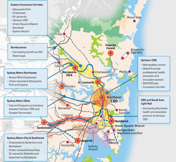
Figure 1: Extract from Eastern Harbour City Vision A
Metropolis of Three Cities
The Planning Proposal is consistent with the broad
directions of ‘A Metropolis of Three Cities’ through (Direction = D
and Objective = O):
· Encouraging
and fostering healthy and socially connected communities by providing
additional and improved commercial premises within walking distance of the
surrounding residential area (D3, O6, O7 and O8; D6, O14);
· Potential
for the enhancement of an existing neighbourhood centre (D3, O6 and O7);
· Facilitating
the upgrading and development of land adjacent to an existing neighbourhood
centre (D1, O3 and O4; D3, O6 and O7; D7, O22);
· Acknowledgement
of the purposes for which the land has been used for decades (D1; D3 O6, O7;
D5, O12; D7 O22);
· Rationalisation
of use on land which is well serviced by existing infrastructure, including
public transport (train and bus) (D1, O3 and O4; D3, O6 and O7);
· Increasing
opportunities for employment in the local area (D7, O22);
· Potential
provision of a wider range of goods and services on land adjacent to an
existing neighbourhood shopping centre (D3, O6 and O7; D7, O22);
· An
opportunity to protect local biodiversity that includes an identified
Endangered Ecological Community (D5, O13; D8 O27,O30; D10, O36 and O38);
· Preserving
and increasing vital urban tree canopy via the retention, protection and
embellishment of remnant vegetation on-site (D8, O27 and O30; D10, O36 and
O38);
· An
opportunity to create improved green spaces and shade on the land that will
reduce the impact of increased heat because of climate change (D5, O12; D8,
O27, O28 and O30; D10, O36 and 38); and
· The prospect
of an enriched local urban outcome, both from within and without the land (D3
O7; D5, O12; D7, O22; D8, O27 and O30; D10, O36 and O38).
Further detail on the Planning Proposal in relation to its
consistency with the Directions and Objectives can be found at Attachment
A1.
The Planning Proposal is considered to be consistent with
the Directions and Objectives of the Greater Sydney Region Plan ‘A
Metropolis of Three Cities’.
2. North District Plan
The Ku-ring-gai LGA is located within the North District
identified under the District Plans prepared by the Greater Sydney Commission.
The North District Plan has been prepared to give effect to A Metropolis of
Three Cities, the Region Plan that applies to the five districts that make up
the Greater Sydney Region.
The North District Plan has been prepared in accordance with
section 3.4 of the Environmental Planning and Assessment Act. As well as
providing a basis for strategic planning, it includes a number of Planning
Priorities that are to be considered by planning authorities in making
strategic planning decisions. The relevant Planning Priorities to the Planning
Proposal are addressed in the Attachment A1 of this Report.
The Planning Proposal is considered to be consistent with
the following key Planning Priorities of the North District Plan (Planning
Priority = N):
· The site is
well supported by existing infrastructure and services (N1and N12);
· An increased
range of goods and services for the local community, for many within an easy
walking distance (N3, N4, N6 and N10);
· Significant
vegetation will be conserved, protected and enhanced on the site (N16, N17,
N19); and
· Tree canopy
will be increased (N23).
3. Our Ku-ring-gai - Community
Strategic Plan 2038
Council’s Community Strategic Plan (CSP) 2038 was
adopted in June 2018. It reflects the aspirations and priorities of our
community into the future. It contains the community’s long term vision
for Ku-ring-gai along with long term objectives to achieve that vision.
The Strategic Plan 2038 includes the following six (6) key
themes:
1. Community, People and
Culture;
2. Natural Environment;
3. Places, Spaces and
Infrastructure;
4. Access, Traffic and
Transport;
5. Local Economy and
Employment; and
6. Leadership and
Governance.
The relevant and/or applicable themes/objectives of the
Strategic Plan 2038 are discussed in Attachment A1 of this Report.
The Planning Proposal is considered consistent with the
Themes and Objectives of the CSP 2038, and, in particular, the following:
· although not
required in the early stage, the applicant conducted its own community
engagement in March 2018 to determine and discuss issues (positive and
negative) (Themes 1 and 6);
· significant
vegetation will be conserved, augmented and enhanced (Themes 2 and 3);
· easy access
is available via a variety of means, including cycling and walking (Theme 4);
· additional
employment opportunities would be provided (Theme 5); and
· there would
be strengthening of the local business economy (Theme 5).
4. Our
Ku-ring-gai - Community Strategic Plan 2038 Delivery Program 2018-2021 and
Operational Plan 2018-2019
The Delivery Program outlines what Council intends to do
during its term of office, and acts as a point of reference for all principle
activities undertaken by Council. The Operational Plan details the specific
projects, programs and services for a 12 month period.
Council’s s.7.12 (previously S94A) Plan identifies
$300,000 for improvement works to Eastern Road shops (page 31 – works
program). There may also be money available in Council’s Capital Works
Program. Ideally, these could be coordinated so the work is done at the same
time as future development on the site. It is likely that a cash contribution
to top up Council’s project funds would be required to do the
design/consultation work. Additional Development Contribution levies would also
be conditioned in future development consents.
5. Ku-ring-gai Integrated
Transport Strategy July 2011
The site, nor the existing Eastern Road Neighbourhood
Centre, are not specifically discussed in this Strategy. However, the Planning
Proposal meets the applicable key objectives of the Strategy, particularly:
· Reducing
the need to travel and the length of trips;
· Providing
a choice of travel options for people and goods, and promoting sustainable
choices;
· Making it
safe and easy for people to access goods, services and destinations,
particularly by public transport; and
· Increasing
the share of trips by public transport, walking and cycling and reducing car
dependency
An increase in the size of the existing Eastern Road
neighbourhood centre will result in a greater range of goods and services being
offered within the existing catchment. Potentially, this will mean local people
can shop more locally more often; reducing the need for numerous
“external” car trips. Given the travel distance is reduced, the
possibility of walking and/ or cycling safely from home to the neighbourhood
centre is also increased. These factors are key net community benefits
resulting from the Planning Proposal.
The relevant, applicable themes and objectives of the
Strategy, are discussed in detail in Attachment A1.
6. Ku-ring-gai Sustainability
Vision 2008-2033
One of the identified key resident findings of the
Ku-ring-gai Sustainability Vision was the need to improve infrastructure in
neighbourhood shopping centres in the LGA. The Planning Proposal could act as a
catalyst for the upgrade of infrastructure in the Eastern Road Neighbourhood
Centre. Funds are available for this upgrade in Council’s Development
Contributions Plan as discussed earlier in this report.
The four (4) themes that emerged from the consultation
process include the themes of social, environmental, economic and governance.
The Planning Proposal is compliant with these themes. They are discussed in
more detail in Attachment A1 of this report.
7. State Environmental
Planning Policies (SEPPs), including draft SEPPs.
The Planning Proposal has been assessed against the
following relevant SEPP’s, and draft SEPPs:
· SEPP 55
– Remediation of Land;
· SEPP
(Infrastructure) 2007;
· SREP –
Hawkesbury- Nepean River; and
· Draft
Environment SEPP.
Further detail can be found in Attachment A1 of this
Report. The Planning Proposal is not inconsistent with the relevant SEPPs, and
draft SEPP.
8. s.9.1 Ministerial
Directions
The following relevant Directions have been considered as
part of the Planning Proposal:
· Business and
Industrial Zones;
· 3.1
Residential Zones;
· 3.4
Integrating Land Use and Transport;
· 5.10
Implementation of Regional Plans;
· 6.3 Site
specific Provisions; and
· 7.1
Implementation of A Plan for Growing Sydney
Further detail can be found in Attachment A1 of this
Report. The Planning Proposal is not inconsistent with the following relevant
s.9.1 Ministerial Directions: 1.1 Business and Industrial Zones; 3.4
Integrating Land Use and Transport; 5.10 Implementation of Regional Plans; 6.3
Site specific Provisions; and 7.1 Implementation of A Plan for Growing Sydney.
The Planning Proposal is justifiably inconsistent with
Direction 3.1 Residential Zones for a number of reasons:
· the land has
never been used for residential purposes;
· it will
utilise existing, available infrastructure; and is adjacent to the existing
Eastern Road Neighbourhood Centre;
· it provides
an opportunity for the enhancement of the existing, adjacent centre; as well as
significant vegetation on the site: and
· the proposed
scale of development is compatible with surrounding residential uses.
Importantly, it will better service the goods and services needs of the local
community.
9. Ku-ring-gai Retail Centres
Study 2005
In 2005 this Study recommended keeping the Eastern Road
neighbourhood centre as a “local” centre i.e. the smallest category
in the Study’s hierarchy. It also recommended “containing”
retailing (as opposed to dispersing or spreading it) to minimise travel times,
improve convenience and improve competition within existing retail centres. The
Study also identified a need to increase floor area to meet growth in demand.
This increase was to be based on the need to maintain a functional hierarchy of
centres and to balance the retail offer, competitiveness and accessibility for
consumers.
It recommended Turramurra as a district centre (20,000sq.m).
In the retail hierarchy (Attachment A11) it recommended that
Turramurra could have an expansion of up to 4,000 square metres. This was
incorporated in KLEP (Local Centres) 2012. It was intended that some of
this would be for the expansion of the 2 existing supermarkets, which were
considered too small for modern supermarkets. At this time, no additional
development has occurred in Turramurra following the Local Centres LEP.
In the Hill PDA’s independent review of the Planning
Proposal’s economic analysis (Deep End Services report), it is confirmed
that Turramurra’s status in the overall Ku-ring-gai commercial hierarchy
would be maintained. Although the Planning Proposal would cause some impacts,
the overall viability of the nearby Turramurra Community Hub would not be
threatened by the Planning Proposal.
The Hill PDA report does state that, post Planning Proposal,
the Eastern Road Neighbourhood Centre would remain in its current place below
Turramurra Local Centre.
The Ku-Ring-Gai Retail Centres Study also recommended:
7. Identify site suitable for
large scale development, by accommodating more efficient use of land and
building within or surrounding existing centres.
Although the Planning Proposal is not “large
scale” in terms of overall retail development (just 3.1% increase in
neighbourhood centre floor space in the Ku-ring-gai LGA), it will still result
in an increase the amount of gross floor area in the existing centre. In line
with the Study’s recommendation, it would result in the more efficient
use of land adjacent to an existing Centre.
The previous Planning Proposal (2015) provided a total of
3,850 square metres of additional floor area. The new Planning Proposal the
subject of this report provides for 1,540 square metres which is significantly
less. The maximum size of the neighbourhood supermarket is 1,000 square metres,
around half the size of the previous proposal.
The Planning Proposal conforms with the Recommendations of
the Study.
10. Ku-ring-gai
Local Environmental Plan 2015 (KLEP 2015)
Although the site is zoned R2
(Low Density Residential) it has been used for nursery and service station
purposes (commercial) for decades. The R2 zone objectives include:
· To
provide for the housing needs of the community within a low density residential
environment.
· To
provide for housing that is compatible with the existing environmental and
built character of Ku-ring-gai.
These objectives are not appropriate for or relevant to
ongoing commercial land uses on the site.
In contrast, the objective of the B1 (Neighbourhood Centre)
is:
To provide a range of small-scale retail, business and
community uses that serve the needs of people who live or work in the
surrounding neighbourhood.
The objective of this zone far more accurately reflects the
current and intended future uses of the land. If it proceeds as recommended in
this report, the rezoning will better inform all stakeholders of land uses at
the site. It will also facilitate greatly increased opportunity for improvement
and renewal over time.
There are likely to be multiplier effects for the
neighbourhood centre as a whole in the medium and longer term. In the Hill PDA
review of the economic assessment in the Planning Proposal, it is stated that
the existing retailers in the Eastern Road shops will experience some loss
depending on how they adapt or change but the expanded centre as a whole will
be strongly positive since the centre will double its retail offering and
likely double its turnover.
The Planning Proposal would provide significant net benefits
to the overall neighbourhood centre, as well as the surrounding community.
It is proposed to retain the existing Maximum Building
Height and Floor Space Ratio (FSR) development standards that apply to the
site. This will ensure that future development will be no higher than that permissible
in the adjacent, existing shopping centre. The site has a lesser FSR than the
existing shopping centre. As indicated in the development concept plans
provided in the Planning Proposal, the urban outcome on the site will not be a
traditional strip in style. There will be fewer but larger building footprints,
mostly underground vehicle and parking/ loading, a flexible parking/forecourt
area at Eastern Road level, and several open space areas.
If constructed in the future, the development concept plan
would result in a more contemporary outcome (including mostly underground
parking and good pedestrian circulation within the site) than the more
traditional strip style shops to the south.
The Planning Proposal demonstrates integration of the
objectives of the proposed B1 zone and development standards. The necessity for
the proposed amendment to Schedule 1 to allow a maximum 1540 square metres of
commercial floor space is discussed ahead in this report.
11. New definitions of neighbourhood shop, neighbourhood
supermarket and garden centre in the B1 (Neighbourhood Centre) zone.
On 31 August, 2018 the
Department of Planning and Environment introduced the following new definitions
that are relevant to the Planning Proposal. These definitions are now included
in KLEP:
garden centre means a building or place the principal
purpose of which is the retail sale of plants and landscaping and gardening
supplies and equipment. It may include a restaurant or cafe and the sale of any
of the following:
(a) outdoor
furniture and furnishings, barbecues, shading and awnings, pools, spas and
associated supplies, and items associated with the construction and maintenance
of outdoor areas,
(b) pets
and pet supplies,
(c) fresh
produce.
Note. Garden centres are a type of retail premises—see
the definition of that term in this Dictionary.
(7) Neighbourhood
shops If development for the purposes of a neighbourhood shop is permitted
under this Plan, the retail floor area must not exceed 100 square metres.
Note: This use has a maximum
retail floor area of 100 square metres.
(7AA) Neighbourhood
supermarkets If development for the purposes of a neighbourhood supermarket is
permitted under this Plan, the gross floor area must not exceed 1,000 square
metres.
Note: This
use has a maximum gross floor area of 1000 square metres.
The introduction of these new definitions does not have any
implications for the Planning Proposal i.e. there is no need to make any
changes to it. The new definitions will ensure that any neighbourhood
supermarket on the site is limited to a maximum of 1,000 square metres of floor
space.
It will result in/ allow the following
“possible” outcomes. It is important to note that other land uses
and development configurations would be possible under the rezoning:
· a neighbourhood
supermarket with a gross floor area of 1,000sq.m. This meets the terms of the
new definition;
· a garden
centre with an unspecified gross floor area (the planning proposal
estimates this use will occupy a gross floor area of 235 square metres).This
use meets the terms of the new definition; and
· 1 or 2
specialty shops with a total gross floor area of 305 square metres.
OTHER CONSIDERATIONS
“Competition” is not a Town Planning
Consideration
Often an excessive amount of consideration is given to
economic assessment in environmental planning matters involving commercial land
use. The following information provides a counter view to this. It is based on
previous Land Environment Court cases that have shaped ongoing best practice in
the planning profession. The legal approach outlined here has influenced the
recommendations of this report.
In the assessment of planning matters in any assessment is
not about solving economic competition problems between retailers, or
undermining the operation of a free market economy. Further, Section 4.15
Evaluation (previously s.79C in relation to DA’s) of the Environmental
Planning and Assessment Act, 1979 does not include the consideration of
loss of trade that might occur by any planned or existing businesses. These
matters are more appropriately dealt with via other legislation such as The Trades
Practices Act, and market forces (Extracted from a public submission to
Australian Consumer and Competition Grocery Inquiry by Urban Taskforce
Australia on 11 March 2008 by Urban Taskforce Australia).
This is well established in NSW case law. It is appropriate
to include Justice Stephen’s most quoted comment from Kentucky Fried
Chicken v Gantidis (1979) 140 CLR 675 at page 687:
“If the shopping
facilities presently enjoyed by a community or planned for it in the future are
put in jeopardy by some proposed development, whether that jeopardy be due to
physical or financial causes, and if the resultant community detriment will
not be made good by the proposed development itself, that appears to me to be a
consideration proper to be taken into account as a matter of town planning. It
does not cease to be so because the profitability of individual existing
businesses are at one and the same time also threatened by the new competition
afforded by that new development. However, the mere threat of competition to
existing businesses if not accompanied by a prospect of a resultant overall
adverse effect upon the extent and adequacy of facilities available to the
local community if the development be proceeded with, will not be a relevant
town planning consideration.”
The Planning Proposal includes an economic assessment which
Council has had independently reviewed. The Hill PDA review of the economic
assessment confirms the Planning Proposal’s (Deep End report) findings
that, while there will be a negative economic change for some retailers in the
existing Eastern Road Neighbourhood Centre, the expanded centre as a whole will
be strongly positive since the Centre will double its retail offer and likely
double its turnover.
The economic impact of the Planning Proposal on the existing
Eastern Road neighbourhood centre needs to be considered within the context
outlined in this section of the report.
Draft Development Control Plan (DCP)
It is recommended that a site specific draft Development
Control Plan (DCP) be prepared and publicly exhibited with the Planning
Proposal. The draft DCP would be prepared by Council in line with current best
practice. It needs to include the following controls to maximise positive
environmental outcomes for the site:
· Building
form and design;
· setbacks;
· scale;
· roof Form;
· building
footprint, including separation from tree driplines;
· building
envelopes;
· building
materials and finishes;
· open space;
· provision of
outdoor sun and shade areas to maximise comfort for all stakeholders;
· linkages and
internal - external circulation;
· protection
and enhancement of identified EEC vegetation, retention of tree canopy and
green space;
· vegetation
protection buffers;
· Vegetation
Management and Replenishment Plan;
· landscaping;
· sustainability,
re use and recycling;
· safety and
access for all modes;
· activation
and multi-use of the Eastern Road forecourt; and
· parking
– motor vehicle and bicycle.
Civic Improvement
As previously discussed, Council’s Development
Contributions Plan identifies funds for improvement works to Eastern Road
shops. There may also be funds available in Council’s capital works
program, subject to prioritisation. It is likely that a cash contribution to
top up Council’s project funds would be required to do the
design/consultation work. Additional Development Contribution levies would also
be conditioned in future development consent/s on the site.
SUMMARY OF RECOMMENDED CHANGES TO THE PLANNING PROPOSAL
On the assumption that the site is to be consolidated into
one lot, it is proposed to make some changes to KLEP 2015 not
sought via the SJB Planning Proposal. They are discussed below.
It is proposed to remove the existing, applicable
subdivision minimum lot size provision of 1unit per 930 square metres. This
will make the site consistent with the existing, adjacent Eastern Road Neighbourhood
Centre. See Images 7and 8 ahead for detail.
Image 7 Existing minimum lot size of 930 square metres
for the site is consistent with the surrounding R2 Low Density Residential
zoned neighbourhood.
Image 8 It is proposed to remove the minimum lot size
control on the site because of the proposed change in zoning. This is
consistent with the B1 zoned Eastern Road Shopping Centre to the south.
Image 9 Proposed B1 zoning extended across Tennyson
Avenue to link the proposed and existing Neighbourhood Centre zoning. This
zoning approach is consistent with best practice, required and is similar to
other comparable situations in Ku-ring-gai.
The proposed SJB Planning amendment to Schedule 1 constrains
both the size and the type of development on the site i.e. the maximum gross
floor space of “commercial premises” (only) on the land is 1,540
square metres.
The proposed amendment to Schedule 1 is considered
inappropriate and unnecessary. Permissible uses on the site do not need to be
constrained to commercial premises only. There are many other permissible uses
that may be appropriate for the site; if not now, then in the future. To
increase flexibility for future land use and development options i.e. to allow
a broader range of possible future land uses, it is considered better planning
to let the full range of permissible uses under the B1 Neighbourhood Centre
zoning apply to the site.
Further, the FSR development standard of 0.3:1 that already
applies to the site (and is proposed to be retained), will limit floor space to
1540 square metres. It is therefore unnecessary to replicate this limit via a
Schedule 1 amendment.
The DPE introduced new definitions of garden centre,
neighbourhood shops, and neighbourhood supermarket (with a maximum gross
floor area of 1000 square metres) in August 2018. The garden centre and
neighbourhood supermarket uses are proposed to form part of the future
development of the site, as per the Planning Proposal presented by SJB
Planning. These uses remain permissible uses if there is no change to Schedule
1, as recommended in this report.
integrated planning and reporting
Places,
Spaces and Infrastructure
|
Community Strategic
Plan Long Term Objective
|
Delivery Program
Term Achievement
|
Operational Plan
Task
|
|
P2.1 A robust planning framework is in place to deliver
quality design outcomes and maintain the identity and character of
Ku-ring-gai
|
Strategies, plans and processes are in place to
effectively manage the impact of new development
|
Implement and monitor the Local Environmental Plans and
supporting Development Control Plans
|
Governance Matters
The process for the
preparation and implementation of Planning Proposals is governed by the
provisions contained in the Environmental Planning and Assessment Act 1979
and the Environmental Planning and Assessment Regulation 2000.
Risk Management
This is a privately initiated
Planning Proposal. After the comments from the Local Planning Panel have been
received, Council will determine its position on this Planning Proposal i.e.
whether or not to send it to the DPE for a Gateway Determination to proceed to
public exhibition.
Financial Considerations
This is a private Planning
Proposal and Council’s Fees and Charges have been applied to cover the
Departmental costs of processing the Planning Proposal. Should the proposal
proceed to exhibition, advertising fees will be sought from the applicant as
per Council’s Fees and Charges.
Costs to develop the
recommended site specific DCP upon a favourable Gateway Determination will be
sought from the applicant in accordance with Council’s Fees and Charges.
Social Considerations
The applicant has submitted a
Planning Proposal to rezone the site to reflect its long term business uses,
and to provide an opportunity for urban renewal. This will expand the existing,
adjacent Eastern Road Neighbourhood Centre, and offer local residents a greater
range of shops and services close to home. Limits have been placed on the size
and scale of future development on the site. It is important to note that the
site will have a significantly less FSR than the existing shops to the south.
Detailed controls will be introduced via a site specific DCP if the Planning
Proposal proceeds to the Gateway and receives a favourable determination.
The provision of sufficient land to provide the services
required by the community needs to remain a top priority for Council. The
wording of the B1 Neighbourhood Centre zone objective reflects this
appropriately i.e. To provide a range of small-scale retail, business and
community uses that serve the needs of people who live or work in the
surrounding neighbourhood.
The Planning Proposal will
also act as a catalyst for enhancing the urban quality and outcomes of a larger
Neighbourhood Centre. As previously discussed, Council’s Development
Contributions Plan identifies funds for improvement works to the Eastern Road
Neighbourhood Centre. There may also be funds available in Council’s
capital works program. It is likely that a cash contribution to top up Council’s
project funds would be required to do the design/consultation work. Additional
Development Contributions levies would also be conditioned in future
development consents.
Environmental Considerations
All aspects of the proposal with
potential environmental impacts have been considered in the preparation of this
Local Planning Panel Report. The assessment has included the analysis of the
specialist reports included in the Planning Proposal.
Any specific development that
occurs on the site as a result of the proposal will be considered in detail at
the Development Application/s stage.
Community Consultation
Should the Planning Proposal
proceed to the Gateway and be approved for public exhibition, the DPE will
issue a list of agencies and stakeholders for consultation during the
exhibition period. Further local community consultation would be set out in the
Gateway Determination, and in accordance with the legislative requirements.
Internal Consultation
Internal consultation has
taken place for the preparation of this report. Council’s development
assessment, urban design, s.94, transport and natural areas staff have assessed
the Planning Proposal which has been addressed in this Report.
Summary
The existing uses on the site
do not represent the most “orderly and economic development on the
land” in the current conditions of 2019.
While both existing
enterprises provide important goods and services to the local community; they
do not contribute aesthetically in a positive way to the site, or the
neighbourhood. There is little architectural merit in any of the buildings. The
existing vegetation on the site that is identified in the biodiversity mapping
layer in KLEP 2015 has significant environmental merit. This vegetation is
recommended for conservation and augmentation.
There is a contamination
issue based on the historical use of part of the site. Council’s Natural
Areas specialist does not have objections to the Planning Proposal on these
grounds. It is considered this issue has solutions, either at the Planning
Proposal (post Gateway Determination) and/or development application stage.
There are no Council specialist objections to the Planning Proposal.
This Planning Proposal
presents Council with the opportunity to formalise and rationalise business
uses on the land, and to guide future development in a proactive, efficient and
positive way. The site is adjacent to the existing, well established and
successful Eastern Road Neighbourhood Centre. The Planning Proposal would
result in the expansion of the adjacent neighbourhood centre that is
immediately to the south. There would be positive economic benefits for
existing and future enterprises, and the centre as a whole. An increased
offering of goods and services would have benefits for the local community, including
the opportunity to shop close to home in an improved environment. It will also
provide a number of jobs, both in the construction and operation phases.
These net community benefits
are all in line with State Government and Council’s strategic framework.
It is well established in NSW
case law that economic competition issues between retailers is not a town
planning issue. The economic analysis of the Planning Proposal (and its
independent Hill PDA review commissioned by Council) has concluded that the
change in zoning would not alter the neighbourhood centre’s status in the
overall Ku-ring-gai retail hierarchy. The Planning Proposal would not affect
the overall viability of the Turramurra Community Hub. While existing retailers
in the Eastern Road shops may experience some loss following the Planning
Proposal, individual outcomes will depend on how they adapt to this local
change. The expanded centre as a whole will be strongly positive as the
neighbourhood centre will double its retail offering, and likely double its
turnover.
The rezoning could
potentially result in a much improved neighbourhood centre; including better
opportunities for a wider, complimentary range of goods and services; greater
pedestrian and cyclist links to the surrounding neighbourhood; as well as the
community benefits from the preservation of significant vegetation and
enhancement of the existing green space orchard area.
The Planning Proposal could
also become a catalyst for the provision of civic improvements that have been
previously identified by Council and the community. Council’s Development
Contributions Plan identifies funds for improvement works to the Eastern Road
Neighbourhood Centre. There may also be money available in Council’s
capital works program. Additional Development Contribution levies would also be
conditioned in future development consents.
The table ahead compares the
existing and proposed development standards and controls for the site:
|
KLEP 2015 Zoning,
Development Standards and Schedule 1
|
|
|
KLEP 2015 - Existing
|
KLEP 2015 - Proposed
|
|
Zoning
|
R2 (Low Density
Residential)
|
B1 (Neighbourhood Centre),
B1 zone boundary extended across Tennyson Avenue to be consistent with
current best practice. See Image 9 for detail.
|
|
Floor Space Ratio
|
0.3:1
|
0.3:1
|
|
Height of Building
|
9.5metres
|
9.5 metres
|
|
Minimum Lot Size
|
940sqm
|
Removed to be consistent
with the existing B1 zoned Eastern Road Neighbourhood Centre shops
|
|
Biodiversity mapping
|
Part area has biodiversity
significance
|
No change
|
|
Schedule 1
|
Not applicable
|
No change
|
The following points identify
the changes that need to be made to the SJB Planning Proposal before it is sent
to the DPE for a Gateway Determination, should Council resolve to do so after
it has been considered by the Local Planning Panel:
1. Continue
the B1 Neighbourhood Centre zoning across the roadway of Tennyson Avenue,
Turramurra in line with current best practice of covering the roadway with the
adjacent zoning;
2. remove
the minimum lot size provision from KLEP 2015 to enable lot
consolidation and increase options for flexible and innovative future
development;
3. make
no changes to Schedule 1 i.e. allow all Neighbourhood Centre zone permissible
uses and allow the FSR of 0.3:1 to determine 1540 square metres of GFA;
4. acknowledge
that the new definitions introduced by the State government in 2018 to the B1
Neighbourhood Centre zone create opportunities for uses such as neighbourhood
supermarkets and garden centres;
5. confirm
that the concept plans in terms of scale, location on the site and uses are
indicative, and by no means final. Further, the indicative development plans,
and related plans and documentation, need to have the proposed building
footprints changed to conserve EEC vegetation on the site. Some consideration
needs to be given to providing a suitable distance of buildings from tree
driplines. Documentation such as the urban design statement needs to be updated
to reflect this;
6. amendment
of the following aspects of the Economic Analysis prepared by Deep End
Services:
A. contract
the trade area to the north and south (as suggested in Hill PDA report) and
rework the supply and demand assessment; or, leave the trade area as it is
(contract slightly to exclude the area south of the railway line) but existing
retailers in the PTA must be included in the supply demand forecasting;
B. there
was a double counting error in the population growth which needs to be
corrected;
C. the expected growth in retail sales per
capita needs to be adjusted to less than 1% per annum to be more accurate;
D. the figures needs to be reviewed to
include existing retailers in the PTA in the supply demand modelling, and also
to revise likely capture rates following the opening of the Turramurra
Community Hub; and
E. the cumulative impacts of both the planning proposal and
the Turramurra Hub on existing retail centres needs to be addressed; and
7. Any
other editorial or content changes in the SJB Planning Proposal that may arise
as a result of the identified changes, or this report.
If Council subsequently agrees with the recommendations of
this report, and the DPE subsequently issues a favourable Gateway
Determination, it will be necessary for a draft DCP to be prepared and
processed by Council. This will provide detail, as well as guiding the scale
and form of new development, protecting adjacent neighbours and so on.
Consideration would need to be given to an improved street presentation,
retention of significant vegetation, better integration of the 2 areas
currently separated by Tennyson Avenue, safe and efficient circulation for all
users, and so on. The local community would be actively engaged to ensure the
success of the DCP. Future DA’s would allow opportunity for further
community engagement.
The rezoning of the site to a
B1 Neighbourhood Business zone would uphold the objects of the EPA Act,
particularly in relation to promoting the “social and economic welfare of
the community” and the “orderly and economic use and development of
land” It also reflects Council’s strategic aspirations for the
Ku-ring-gai local government area.
Importantly, the Planning
Proposal represents an opportunity to fulfil one of the DPE’ s primary
contemporary retail outcomes i.e. to cluster retail services to provide easy,
multi purpose and frequent shopping adjacent to an existing Neighbourhood
Centre.
The Planning Proposal has
been assessed against the Section 3.33 of the Environmental Planning and
Assessment Act 1979, and the Department of Planning and Environments A
Guide to Preparing Planning Proposals (August 2016). It is considered that
there is sufficient merit to enable the Planning Proposal to be submitted to
the Department of Planning and Environment for a Gateway Determination.
This report recommends that
the Ku-ring-gai Local Planning Panel makes a recommendation to Council that the
Planning Proposal be submitted to the Department of Planning and Environment
for a Gateway Determination.
|
Recommendation:
A. That
the Local Planning Panel endorse the contents of this report, including the
proposed amendments to the SJB Planning Proposal for 45-47 Tennyson Avenue
and 105 Eastern Road, Turramurra.
B. That
the Deep End Services Economic Assessment report needs to be reviewed in line
with this report if the Planning Proposal is to go to the Gateway for a
Determination.
C. That
the Ku-ring-gai Local Planning Panel makes a recommendation to Council that
the Planning Proposal for 45-47 Tennyson Avenue and 105 Eastern Road
Turramurra be submitted to the Department of Planning and Environment for a
Gateway Determination, subject to the amendments to detailed in this report,
and any other resultant editorial changes.
|
|
Lindsey Dey
Urban Planner - Specialist
|
Craige Wyse
Team Leader Urban Planning
|
|
Antony Fabbro
Manager Urban & Heritage Planning
|
Andrew Watson
Director Strategy & Environment
|
|
Attachments:
|
A1⇩
|
Table
of Assessment
|
|
2019/003024
|
|
|
A2⇩
|
Internal
Referral Responses
|
|
2019/003059
|
|
|
A3⇩
|
Hill
PDA Review of Economic Assessment
|
|
2019/062477
|
|
|
A4⇩
|
Planning
Proposal
|
|
2019/063563
|
|
|
A5⇩
|
Attachment
1: Survey Plan prepared by SurDevel
|
|
2019/063821
|
|
|
A6⇩
|
Attachment
2: Supplementary Planning Statement
|
|
2019/063819
|
|
|
A7⇩
|
Attachment
3: Pre Planning Proposal Meeting Report prepared by Ku-ring-gai Council
|
|
2019/063817
|
|
|
A8⇩
|
Attachment
4: Architectural Plans prepared by Tandem Design Studio
|
|
2019/063816
|
|
|
A9⇩
|
Attachment
5: Urban Design Statement prepared by Oculus
|
|
2019/063815
|
|
|
A10⇩
|
Attachment
6: Traffic Report prepared by Colston Budd Rogers & Kafes
|
|
2019/063813
|
|
|
A11⇩
|
Attachment
7: Economic Impact Assessment prepared by Deep End
|
|
2019/063811
|
|
|
A12⇩
|
Attachment
8: Arboricultural Impact Statement prepared by Tree IQ
|
|
2019/063808
|
|
|
A13⇩
|
Attachment
9: Landscape Report prepared by Oculus
|
|
2019/063807
|
|
|
A14⇩
|
Attachment
10: Ecological Report prepared by GIS Environmental Consultants
|
|
2019/063804
|
|
|
A15⇩
|
Attachment
11: Combined Phase 1 & 2 Environmental Site Assessment prepared by
Compaction & Soil Testing Services
|
|
2019/063803
|
|
|
A16⇩
|
Attachment
12: Engagement (Community) Report prepared by Straight Talk
|
|
2019/063801
|