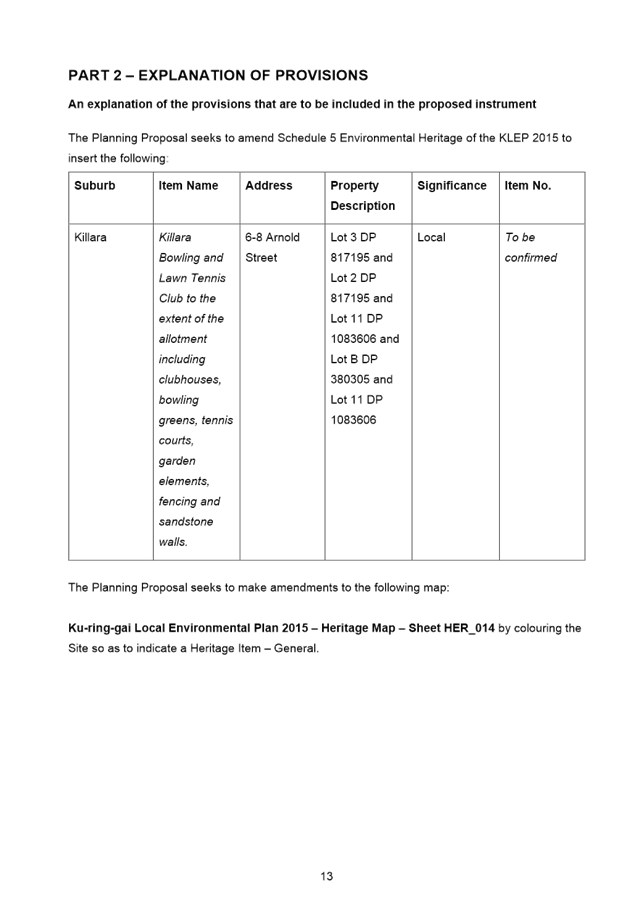
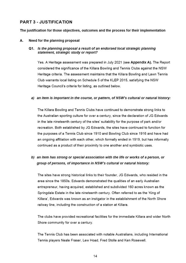
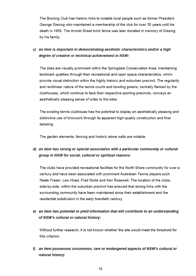
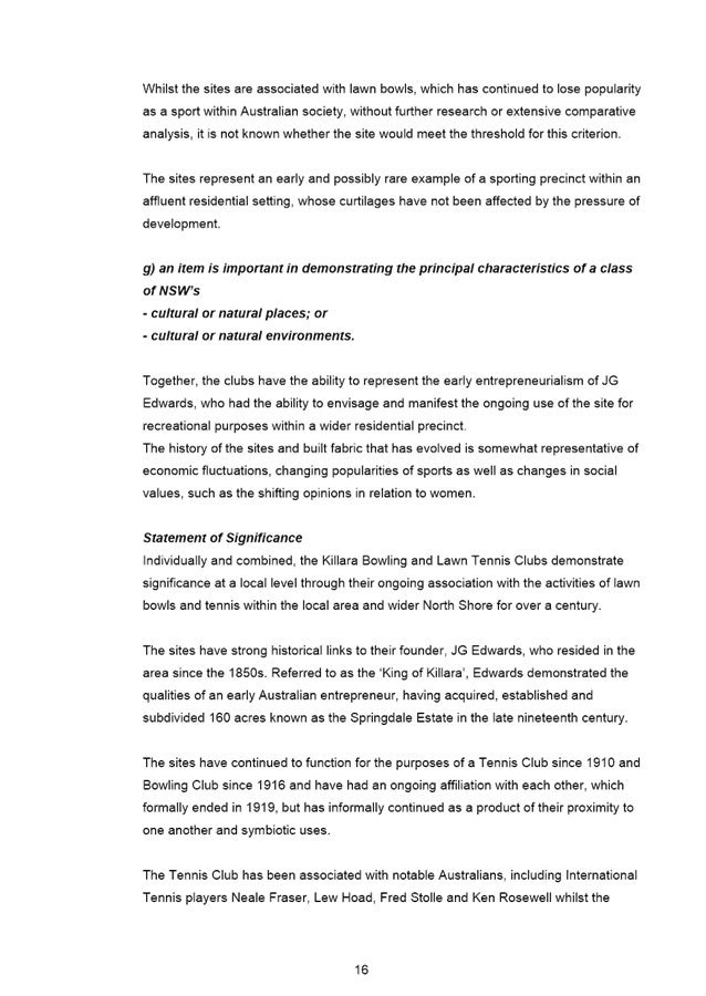
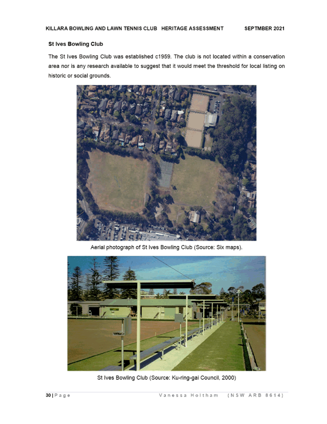
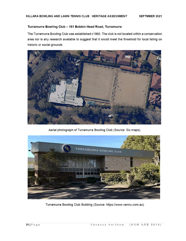
|
APPENDIX No: 1 - Development
Assessment Report
|
|
Item No: GB.2
|

ASSESSMENT REPORT
|
REPORT TITLE:
|
1A
Spencer Road, Killara – Demolition of existing structures and
construction of a residential flat building containing six units, landscaping
and basement parking
|
|
Application No:
|
DA0408/20
|
|
Property Details:
|
1A Spencer
Road, Killara
904.2sqm
R4 High
Density Residential
|
|
Ward:
|
Gordon
|
|
Proposal/Purpose:
|
Demolition
of existing structures and construction of a residential flat building
containing six units, landscaping and basement parking
|
|
Type of DEVELOPMENT:
|
Local
|
|
Applicant:
|
Mackenzie
Architects International
|
|
Owner:
|
The
Owners of Strata Plan 13 686
|
|
Date Lodged:
|
8 October
2020
|
|
Recommendation:
|
Approval
|
Purpose
of Report
To determine
Development Application No DA0408/20 for
the demolition of existing structures and construction of a residential flat
building containing six units, landscaping and basement parking.
This
application is reported to the Ku-ring-gai Local Planning Panel in accordance
with the Minister’s Section 9.1 Local Planning Panels Direction as it is
sensitive development to which State Environmental Planning Policy No
65—Design Quality of Residential Apartment Development (SEPP 65)
applies.
In addition,
the application is also reported to the Ku-ring-gai Local Planning Panel in
accordance with the Minister’s S 9.1 Local Planning Panels Direction, as
it proposes three departures from development standards in excess of 10%.
integrated
planning and reporting
Places, Spaces & Infrastructure
|
Community Strategic Plan Long
Term Objective
|
Delivery Program
Term Achievement
|
Operational Plan
Task
|
|
P2.1 A robust
planning framework is in place to deliver quality design outcomes and
maintain the identity and character of
Ku-ring-gai
|
Applications
are assessed in accordance with state and local plans
|
Assessments
are of a high quality, accurate and consider all relevant legislative
requirements
|
Executive Summary
|
Issues:
|
Floor
space ratio
Lot
size and dimensions
|
|
|
|
Submissions:
|
3
|
|
|
|
Land and
Environment Court:
|
N/A
|
|
|
|
Recommendation:
|
Approval
|
HISTORY
Site history:
The site has a history of residential use.
Previous applications history:
A Pre-DA
consultation was not undertaken with Council prior to the lodgement of this
Development Application.
Council’s records show a history
of applications relating to the site as follows:
|
Type
|
Application
|
Description
|
Decision
|
Date
|
|
DA
|
DA0012/12
|
Conversion of ground floor area to a 1 bedroom unit, car
port, render and landscape works
|
Withdrawn
|
13/03/2012
|
|
DA
|
DA0303/14
|
Demolish existing structures and construct a three-storey
residential flat building consisting of 10 units, landscaping and two
basement levels containing 15 spaces (including loading zone)
|
Approved
|
22/12/2015
|
|
Section 95A
|
DA0303/14
|
Section 95A extension of term of development consent
|
Approved
|
13/04/2016 lapsing 23/12/2018
|
|
Section 96
|
MOD0056/18
|
Modification to DA0303/14 proposing reduction in number
of units from 10 to 6 and various design changes
The building included two basement levels with 15 parking
spaces (including loading zone) but otherwise appears identical to the lodged
form of DA0408/20
|
Applicant declined to lodge a CC and advised they would
let the consent lapse
Refused
|
14/12/2018
18/01/2019
|
Current DA
|
Date
|
Action
|
|
8 October
2020
|
Application
lodged.
|
|
21 October
2020
|
The
application was notified to neighbouring property owners for a period of 28
days. Two submissions were received.
|
|
1 December
2020
|
Council sent
a letter to the applicant seeking additional information relating to more
detailed plans and LEP, DCP, ADG, urban design, engineering, landscape and
environmental health matters. The letter requested information within 21
days.
|
|
3 December
2020
|
Council sent
a letter t to the applicant seeking additional information relating to
ecology matters.
|
|
16 December
2020
|
The applicant
met with the Assessment Officer, Team Leader and Council’s urban design
consultant. Upon request, Council granted the applicant until 1 February 2021
to submit additional information.
|
|
2 February
2021
|
Upon request,
Council granted the applicant until 8 February 2021 to submit additional
information.
|
|
8 February
2021
|
The applicant
submitted:
1. an ecology report
2. an amended arborist report
3. an amended traffic report
4. amended architectural plans
5. amended landscape plans
6. an amended waste management plan
7. an amended SEPP 65 Design Verification
Statement
8. Lots 1 and 2 title search documents
|
|
9 February
2021
|
Council
advised the applicant that the additional information package failed to
include:
1. A cover letter detailing the
amendments, and
2. A new BASIX certificate.
Council
requested that these documents be submitted by 10 February 2021.
|
|
9 February
2021
|
The applicant
submitted a covering letter.
|
|
17 February
2021
|
The applicant
submitted a new BASIX certificate.
|
|
4 March 2021
|
Council
requested the applicant to clarify why the BASIX certificate divides the
building into a series of buildings.
|
|
18 March 2021
|
The applicant
submitted a new BASIX certificate.
|
|
7 April 2021
|
Council sent
a letter to the applicant advising that additional information that was
submitted on 8 & 9 February 2021 did not include all information or
design changes previously requested
(i.e. more detailed plans and LEP, DCP, ADG, urban design, engineering,
landscape, environmental health and ecology matters). The letter requested
that the application be withdrawn within 7 days.
|
|
12 April 2021
|
The applicant
requested additional time to address the outstanding matters.
|
|
13 April 2021
|
The
applicant was given two weeks to provide the information.
|
|
27 April 2021
|
The applicant
submitted:
1. a covering letter, including Lots 1
and 2 title search documents
2. an amended ecology report
3. a traffic letter
4. amended architectural plans
5. amended landscape plans
6. an amended SEPP 65 Design Verification
Statement
7. an amended BASIX certificate
8. an amended NatHERS certificate
|
|
5 May 2021
|
Council advised the applicant by email as follows
Ecology
The amended ecology report concludes
that the proposal
is likely to have a significant impact on Blue Gum High Forest…
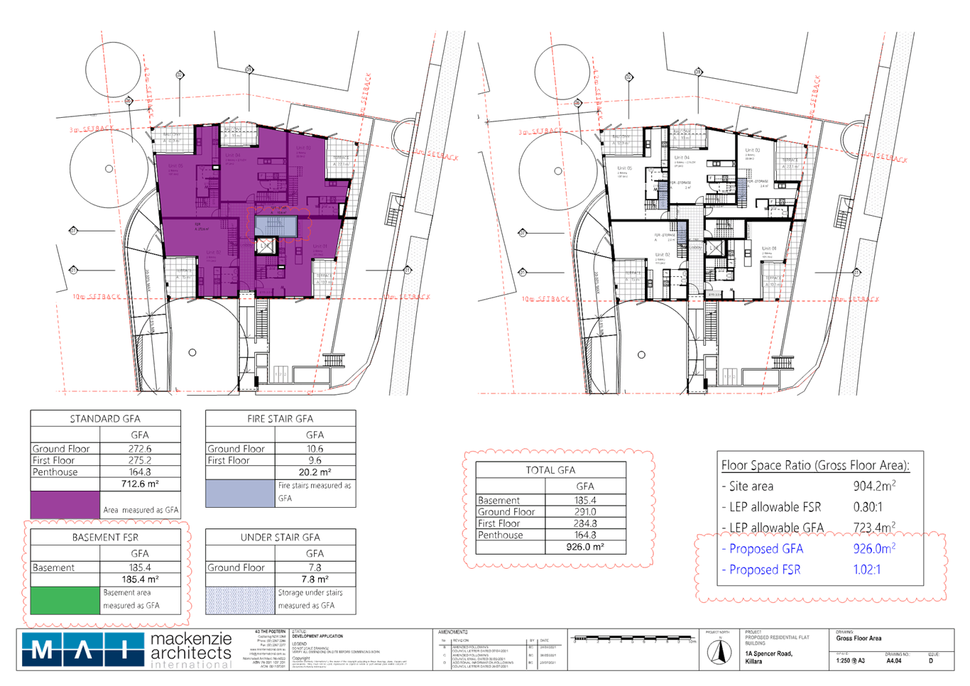
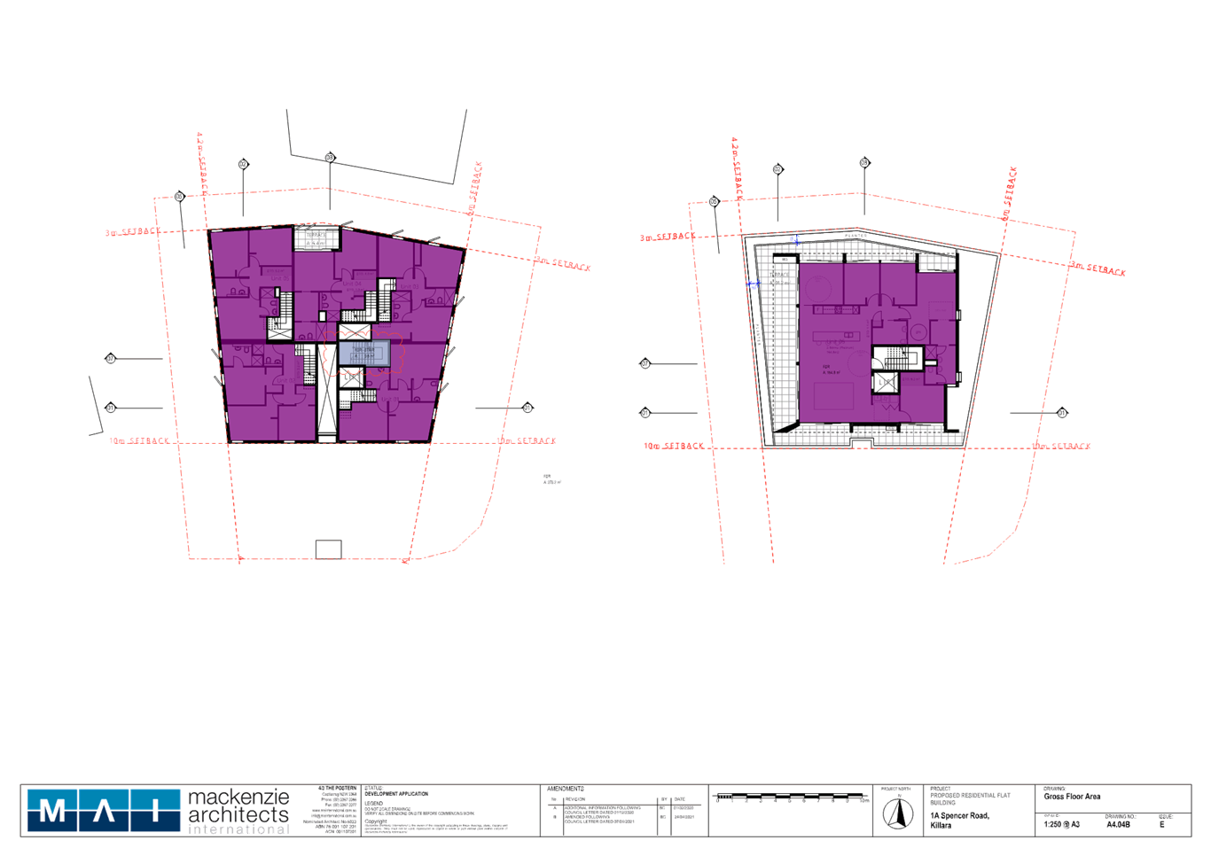
GFA
Plan No. A4.04 identifies that storage
areas beneath stairs as GFA, however A4.04B does not identify
1. stairs within units, or
2. the stairs from the penthouse to
levels 2 and 1
as GFA.
These stairs are not
‘common’ and thus would contribute to FSR. There is no power to
approve the application if the proposal exceeds the maximum permitted FSR
under Cl. 4.4 of the LEP without a suitable Clause 4.6 request.
|
|
8 May 2021
|
The applicant
submitted:
1. a Clause 4.6 variation request
addressing FSR
2. a traffic engineer’s statement
clarifying the parking provisions applicable to the proposal
3. plans demonstrating FSR calculations
and services areas & slab depths
|
|
26 July 2021
|
Council sent
a letter to the applicant describing that the car park partly rises more than
1m above existing ground level, does not wholly constitute a basement and
contributes to FSR.
|
|
28 July 2021
|
The amended
application was notified to neighbouring property owners for a period of 14
days. One submission was received.
|
|
2 August 2021
|
The applicant
submitted
1. a Clause 4.6 variation request
statement addressing FSR
2. plans demonstrating FSR calculations
|
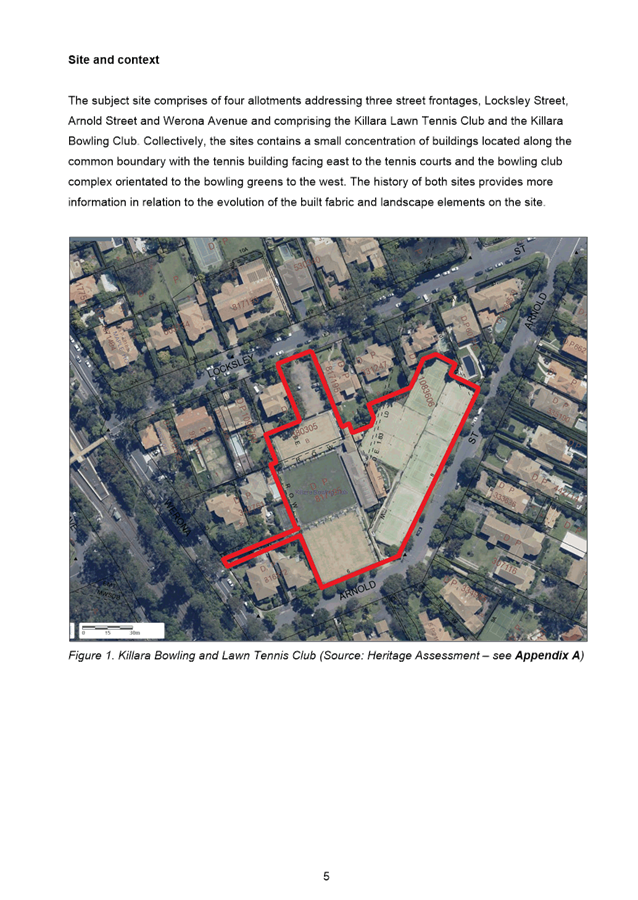
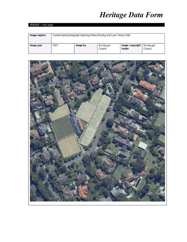
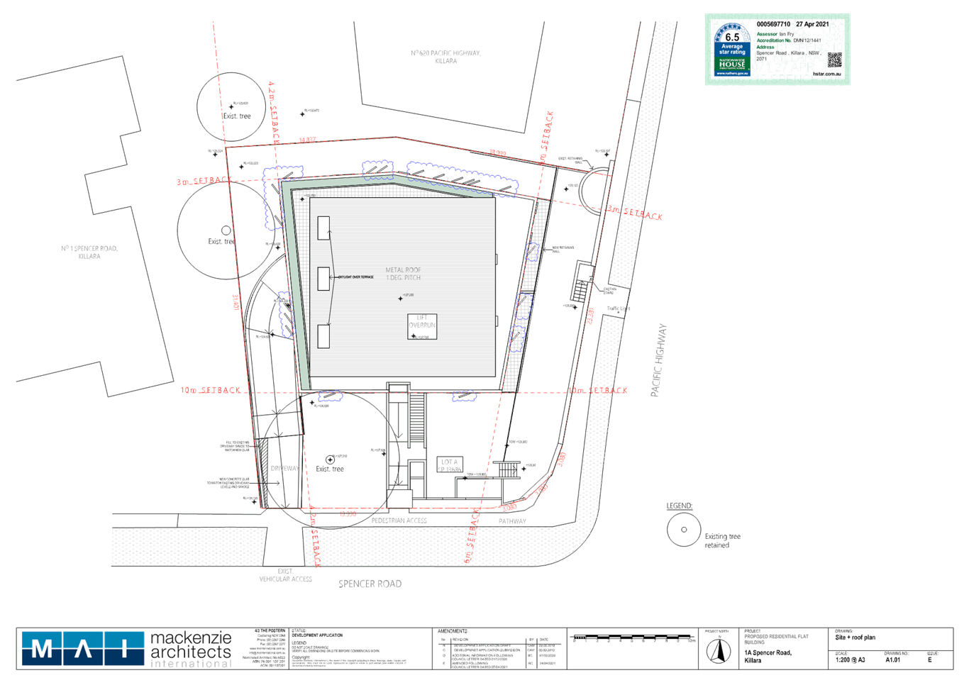
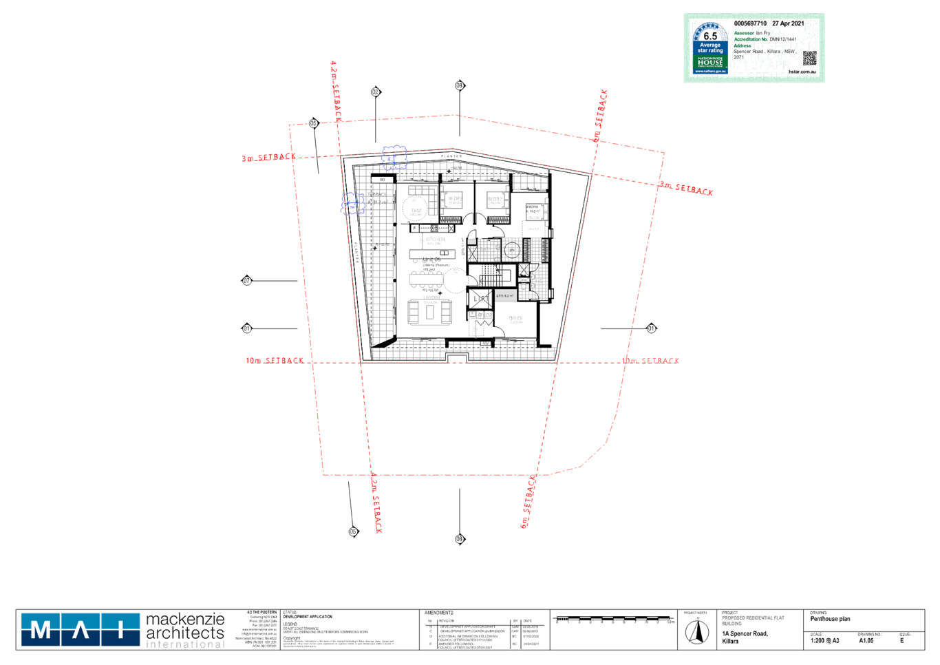
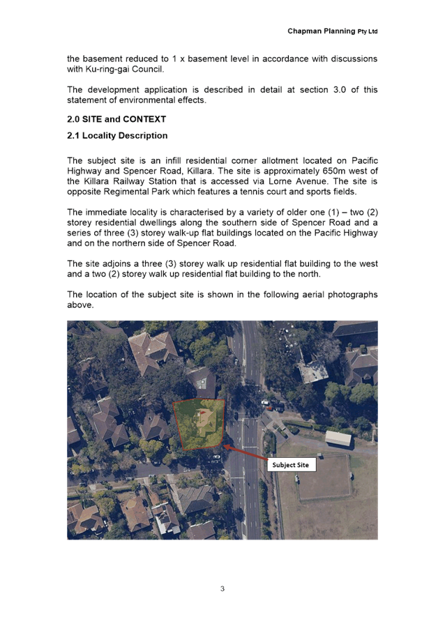
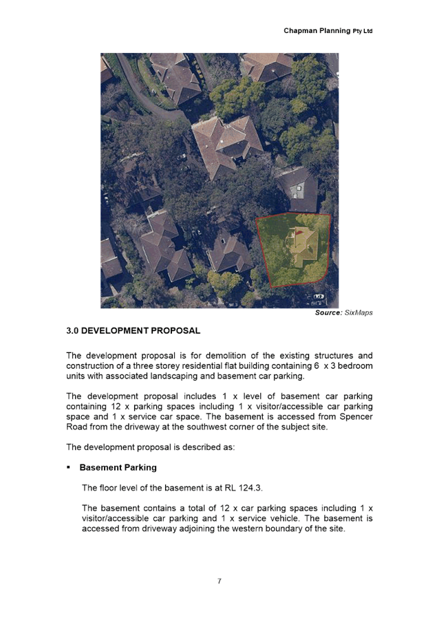
THE SITE
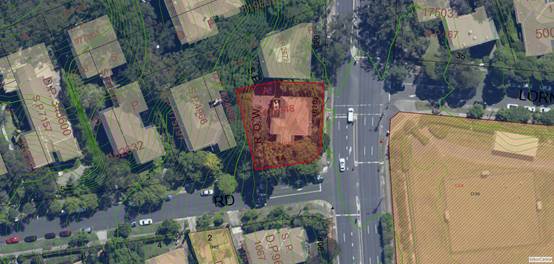
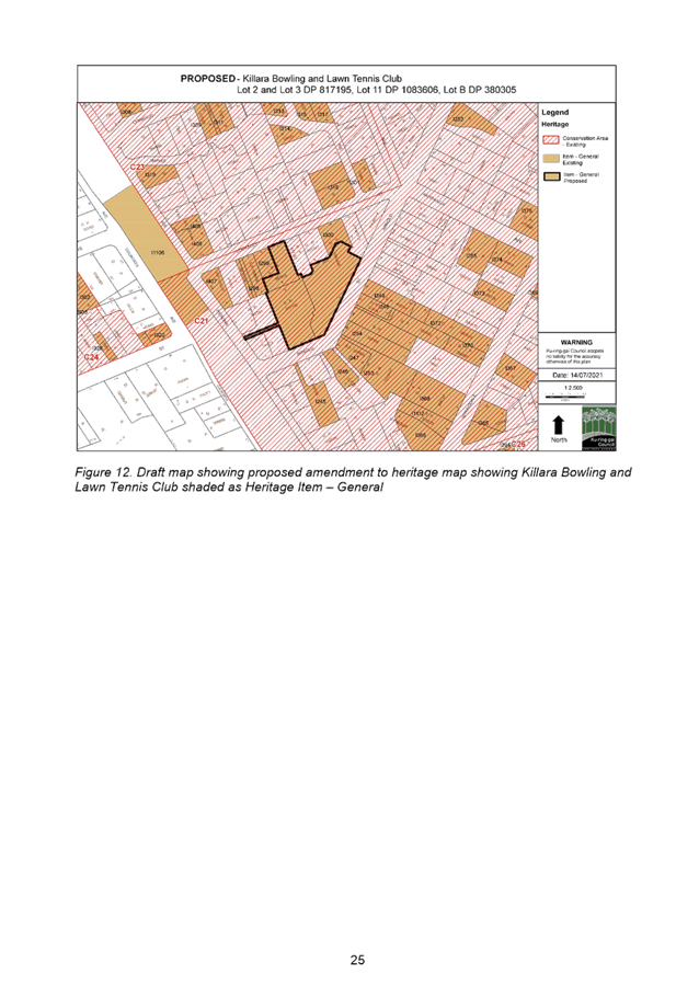
Figure 1: Aerial
photo of the subject site
Site description:
The site is
legally described as Lot A in Deposited Plan 412 948 and is subject to Strata Plan 13 686. The site is commonly known as 1A
Spencer Road, Killara and was formerly known as 610 Pacific Highway, Killara.
The site is
located on the north-western corner of Pacific Highway and Spencer Road. The
site has a frontage of 23.3m to Pacific Highway and 19.9m to Spencer Road.
It has irregular boundaries but is generally square in shape. The northern side
boundary has a length of 33.8m and the western side boundary has a length of
31.4m. The site area is 904.2sqm.
The site
contains a three storey strata titled residential flat building, containing two
apartments that is in a dilapidated condition. A concrete driveway is located
on the western end of the low, southern boundary which provides access to an at
grade concrete parking area in the north-western corner of the site. The
site also accommodates a number of small and medium sized trees, with the
majority of the vegetation concentrated along the western side of the site,
between the edge of the driveway and the western boundary. A 28m tall Agathis robusta (Kauri Pine) is located within the
Spencer Road frontage on the eastern side of the existing driveway. The Kauri
Pine is a large tree that dominates the street frontage and makes a significant
contribution to the landscaped character of the area.
The site has a
moderate cross-fall from the eastern boundary at 130.15 AHD to the western
boundary 125.45 AHD, with a level difference of 4.7m over a distance of
approximately 25m. There is a brick retaining wall on the eastern, Pacific
Highway, boundary of the site which is subject to an easement for support.
|
Constraint:
|
Application:
|
|
Visual character study category
|
1920-1945
|
|
Easements/rights of way
|
Easement
The application’s survey plan
identifies an ‘easement for support’ adjacent to the
retaining wall along the eastern boundary to the Pacific Hwy.
The proposal does not appear to
interfere with the easement.
|
|
Heritage Item - Local
|
No
|
|
Heritage Item - State
|
No
|
|
Heritage conservation area
|
No
|
|
Within 100m of a heritage item
|
Yes
|
|
Bush fire prone land
|
No
|
|
Natural Resources Biodiversity
|
Yes
|
|
Natural Resources Greenweb
|
Yes
|
|
Natural Resources Riparian
|
No
|
|
Within 25m of Urban Bushland
|
No
|
|
Contaminated
land
|
No
|
Surrounding development:
The
eastern end of Spencer Road and adjacent allotments along the Pacific Highway
contain a mix of 1960s to 1970s residential flat buildings, with heights of
between 3 and 4 storeys. The adjoining site to the north at 620 Pacific Highway
contains a 3 storey residential flat building and the adjoining site to the
west at 1 Spencer Road, contains a 4 storey residential flat building.
A
community park, known as Regimental Park, is located opposite the site on the
southern corner of Lorne Avenue and Pacific Highway. Regimental Park is a
heritage item that contains a water reservoir, bowling green, tennis courts and
playing fields. Killara Railway Station is located to the south-east of the
site. The walking distance between the subject site and the entrance to Killara
Railway Station is approximately 550 metres.
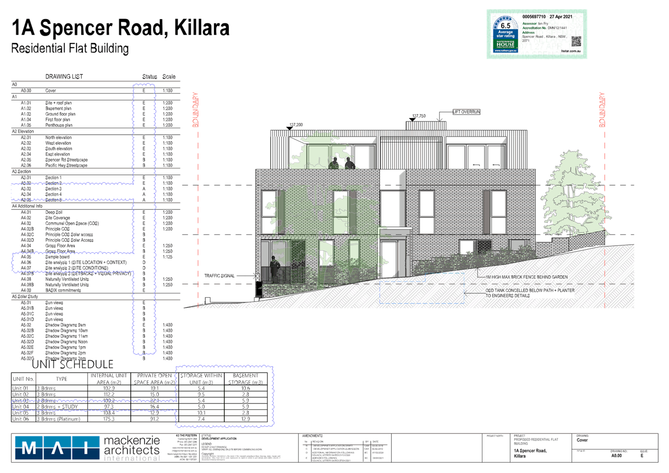
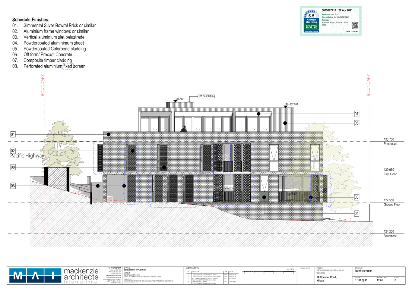
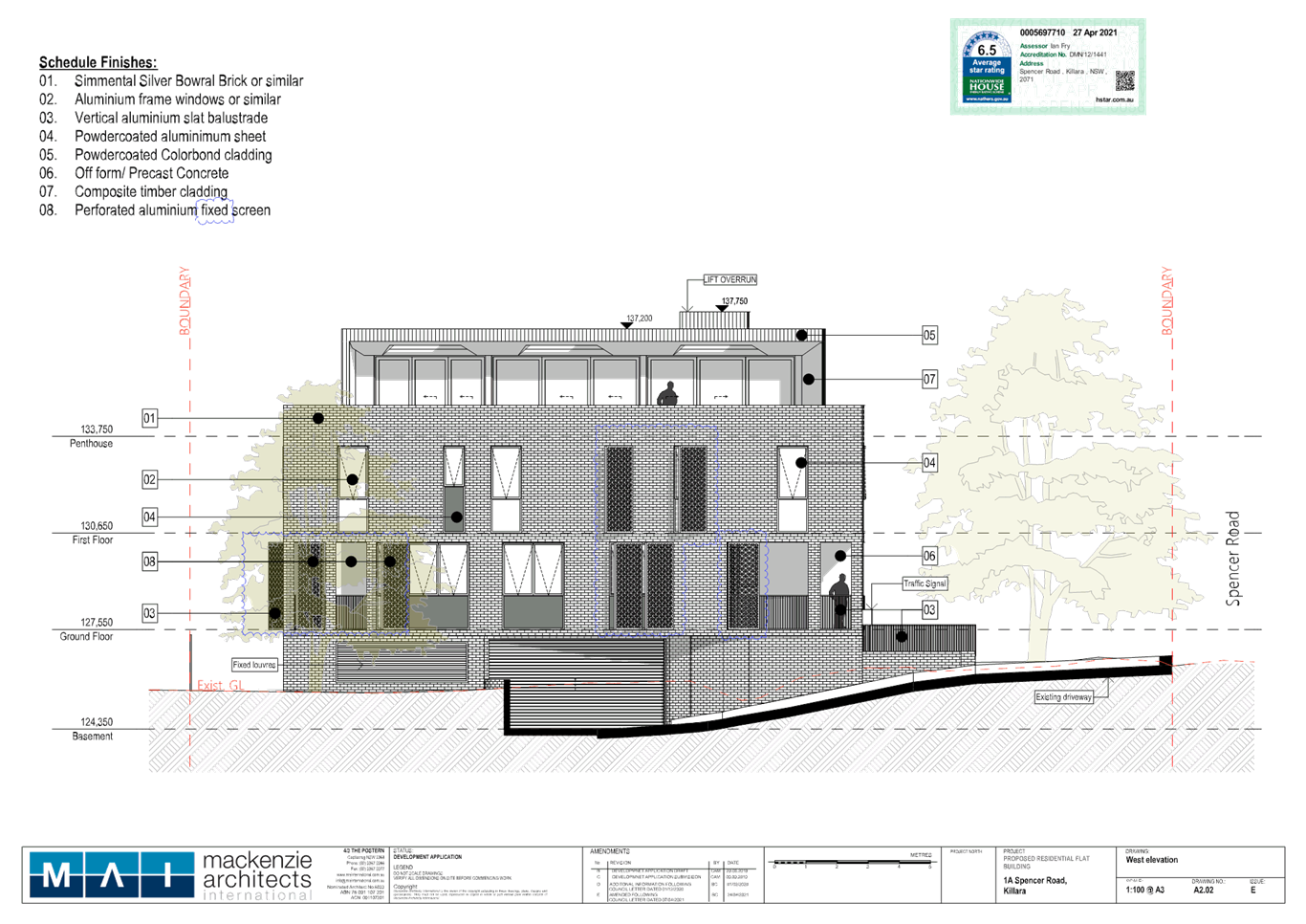
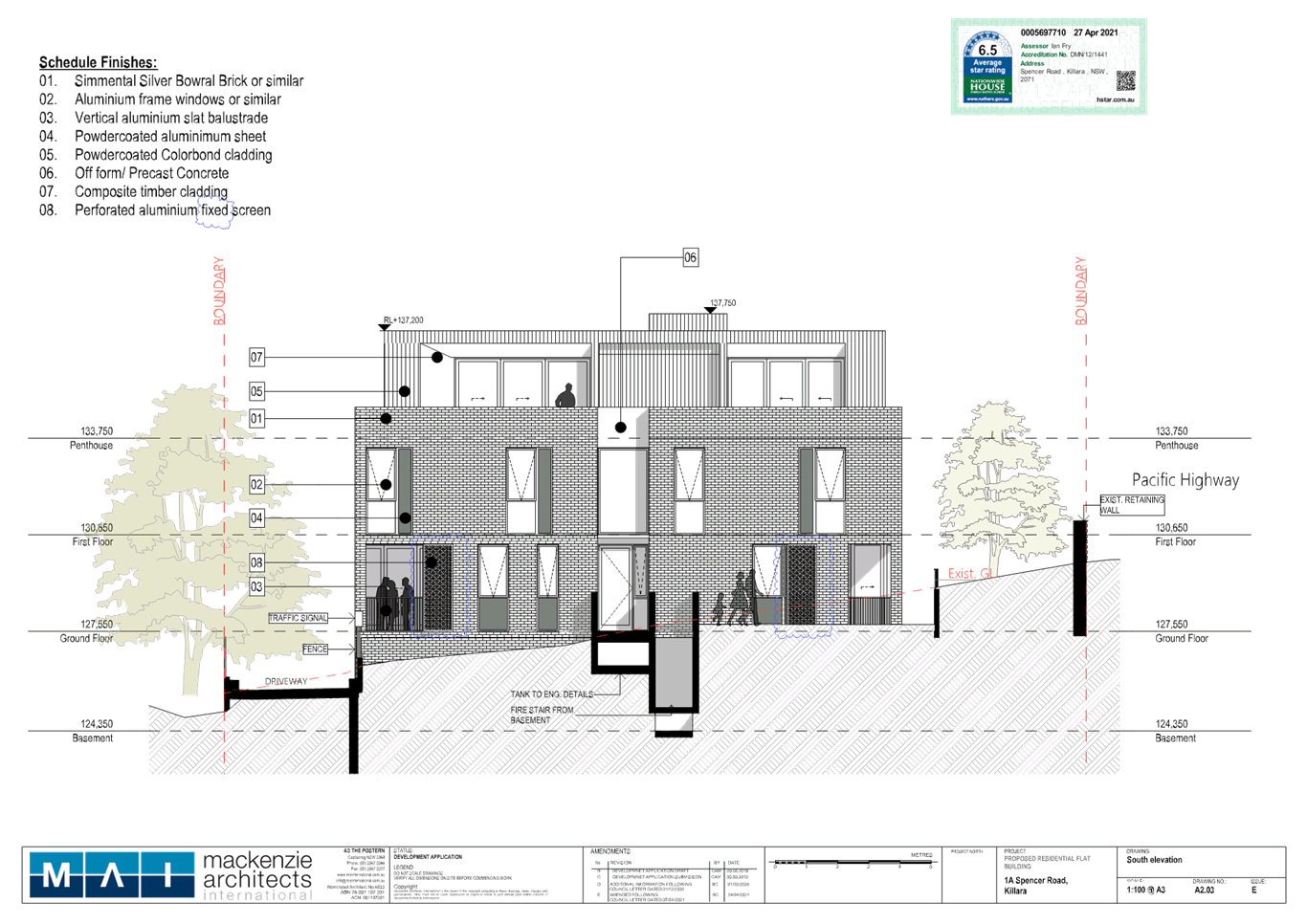
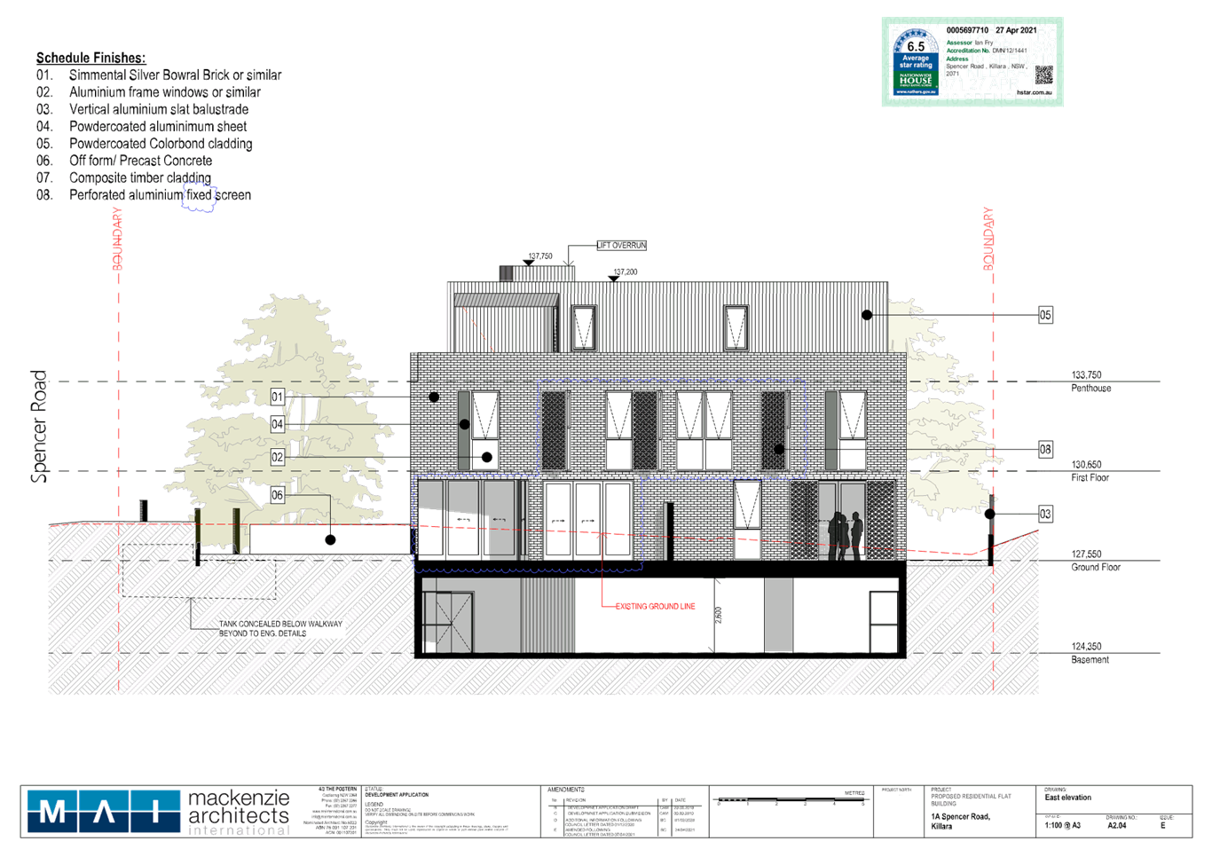
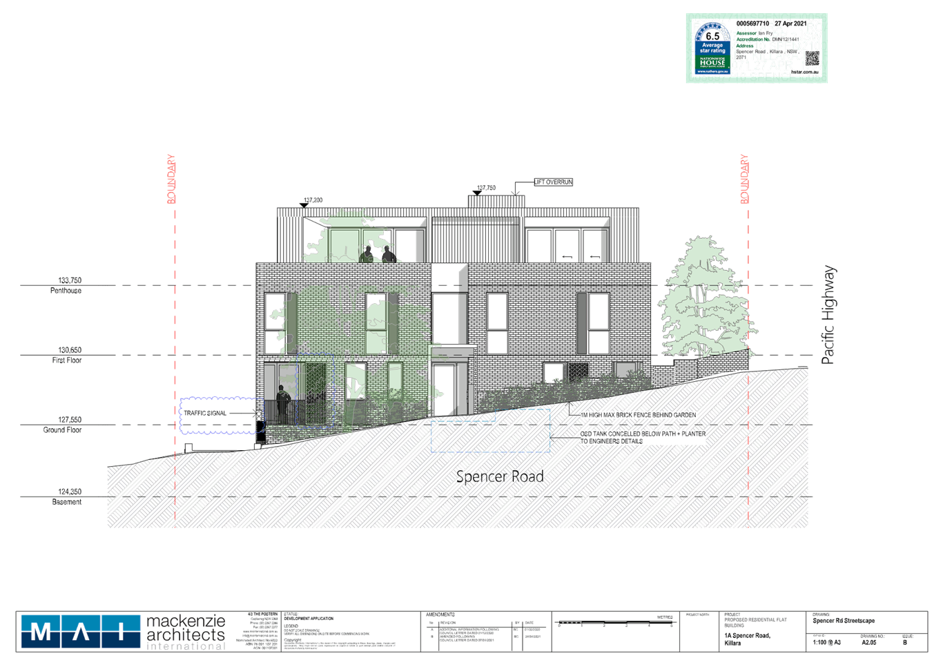
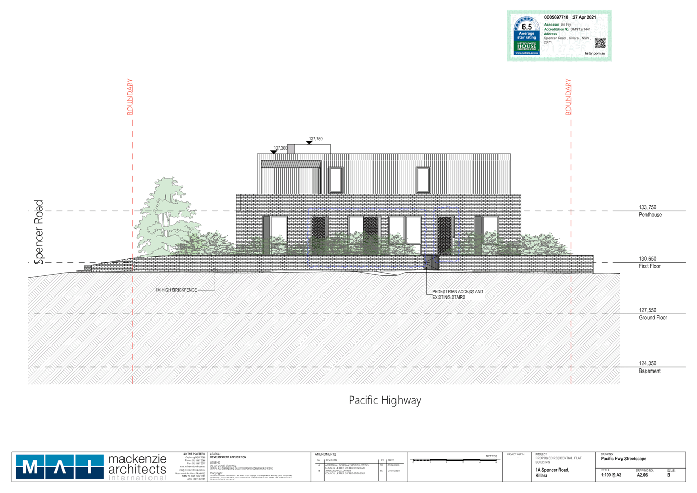
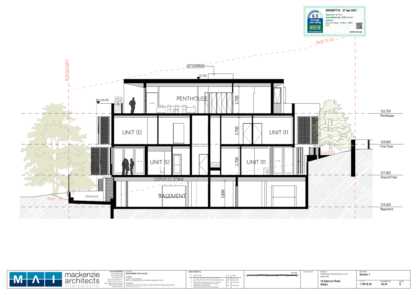
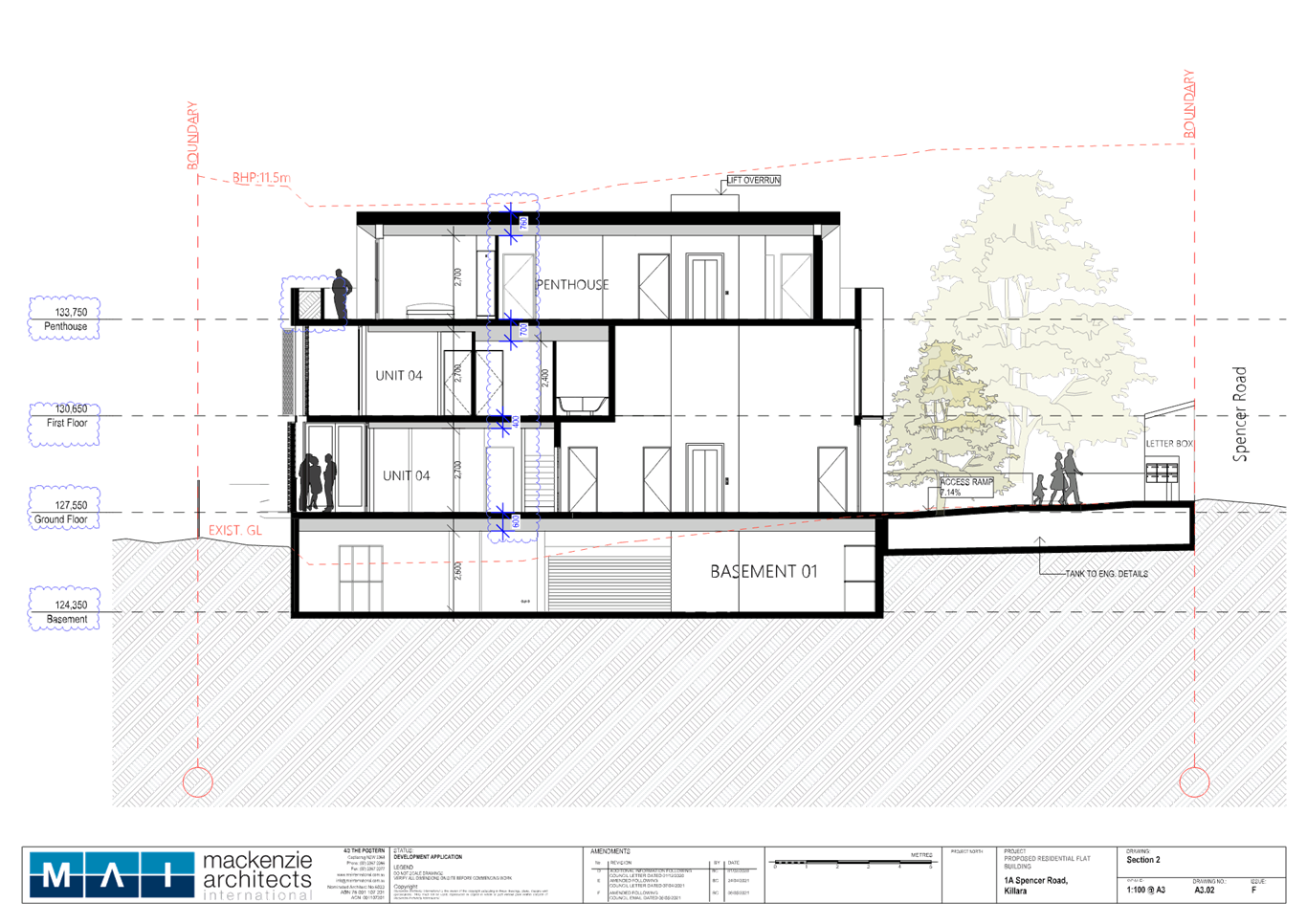
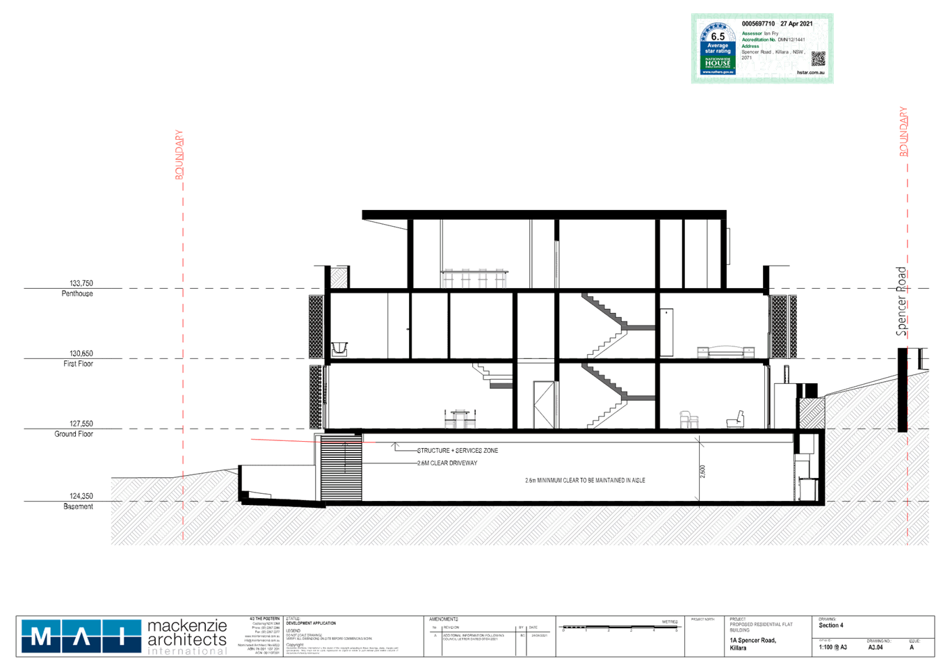
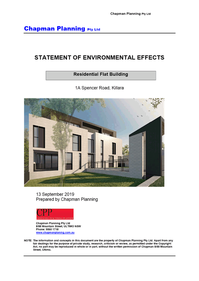
THE PROPOSAL
The application
proposes demolition of
existing structures and construction of a
three-storey residential flat building containing six units, landscaping works
and basement parking.
The
Statement of Environmental Effects describes the proposal, as follows:
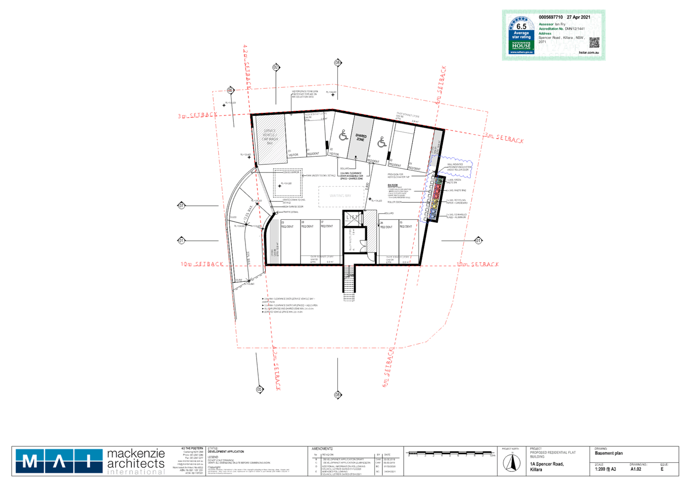
·
Basement
The basement is accessed from a driveway
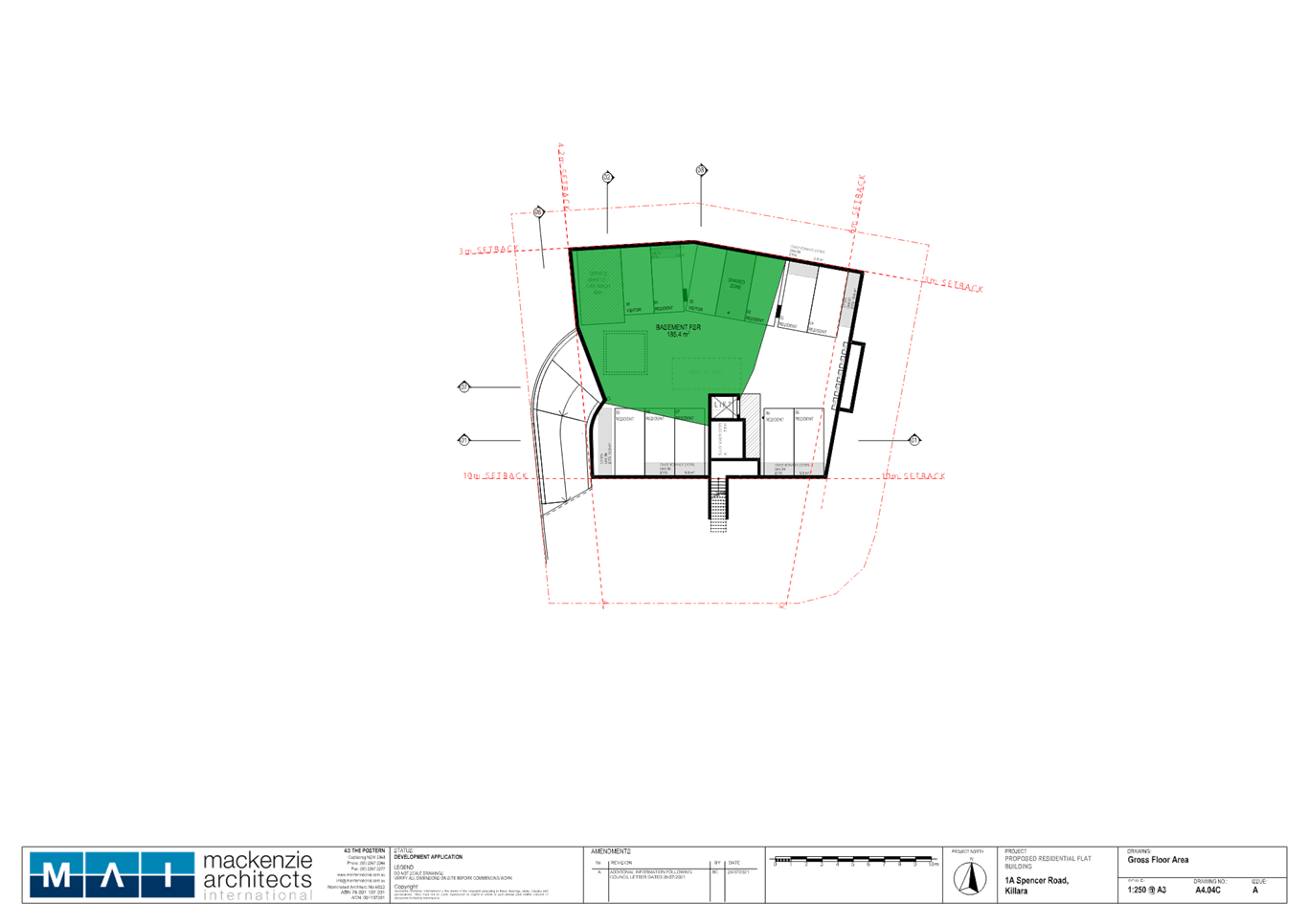
adjoining the western boundary and contains 12 parking spaces comprising:
o 1 x garbage collection / service vehicle
/ car wash bay space
o 2 x visitor spaces (i.e. 1 x accessible
space and 1x standard space)
o 9 x resident spaces (i.e. 1 x accessible
space and 8 x standard spaces).]
The basement includes residential
storage, lift access, bulky waste storage, and bin storage to the east.
·
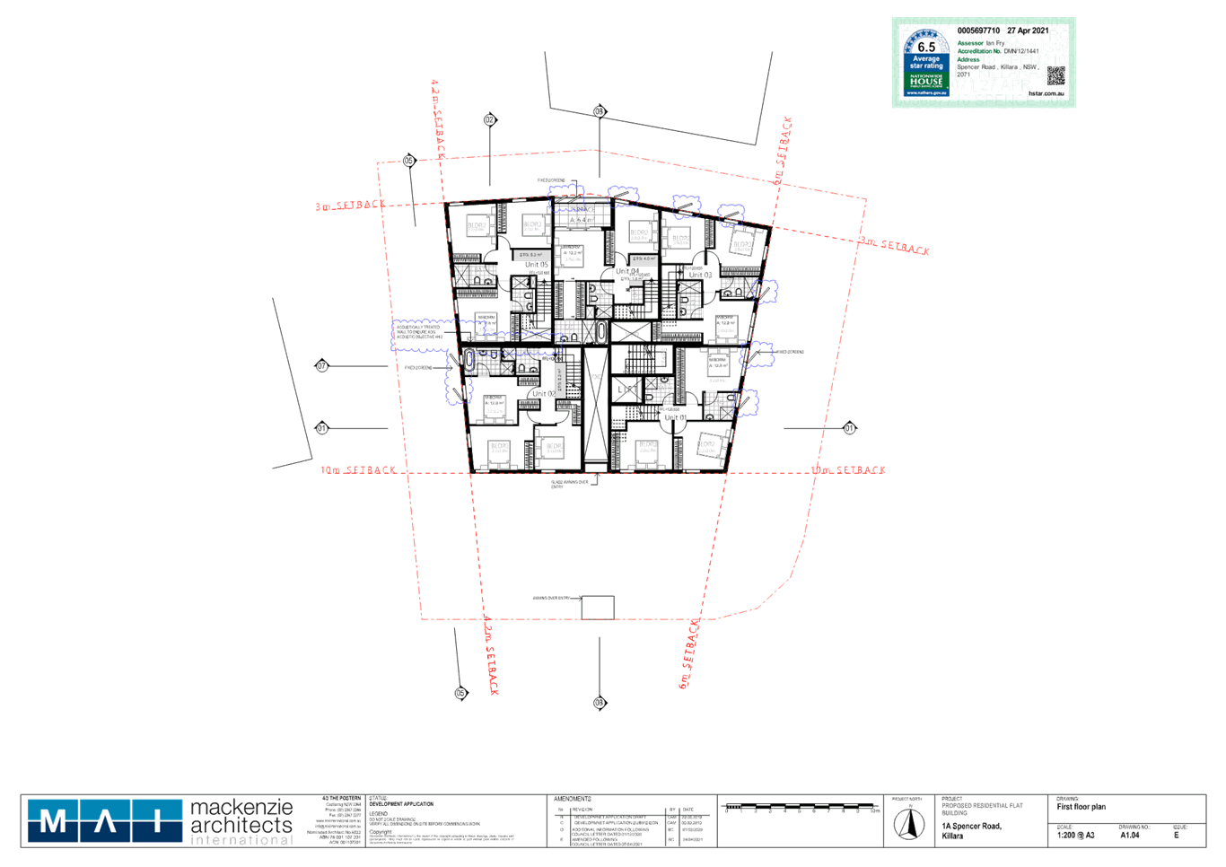
Ground Floor and
First Floor
The ground floor level and first floor
level contains five dwellings and a central lobby including Spencer Road
pedestrian access and basement lift access.
The units sizes range from
102.3sqm-111.2sqm and are ‘townhouse style’ with living and dining
areas at ground, internal stair access, bedrooms at first floor level and
terraces ranging in size from 14.2sqm-17.9sqm.
There are four corner/dual aspect units
and one single, north aspect unit (Unit 4). All units will receive greater than
2 hours solar access.
·
Penthouse Level
o The second storey (i.e. top level)
includes one 4-bedroom unit sized 177.5sqm with wraparound terrace sized
103.3sqm. The unit is accessed by lift from basement, ground floor level and
fire stairs.
·
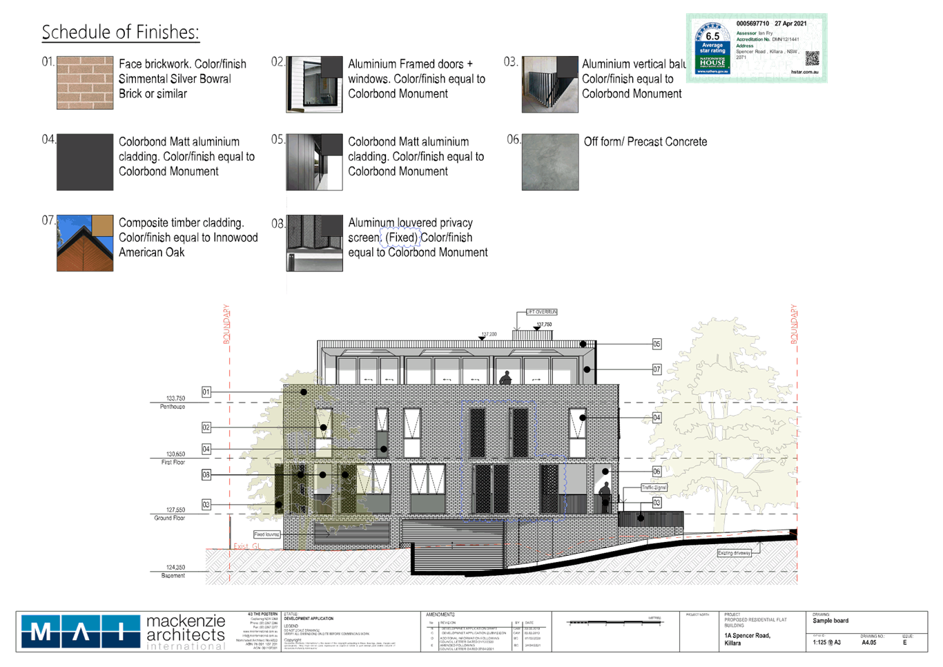
Materials
o The building will be face brick, pre
cast concrete, metal cladding, timber look cladding and black aluminium framed
windows and doors.
·
Landscape Works
o The development application includes the
removal of 5 trees notably including 2 trees to be removed to accommodate the
building footprint.
Unit 04 comprises
two bedrooms and a study. The remaining four units on the ground and first
floors each comprise three bedrooms.
There
are no proposed works to the existing vehicle crossing or in the road reserve.
The
application does not propose strata subdivision.
CONSULTATION
In
accordance with Appendix 1 of the Ku-ring-gai Community Participation Plan,
owners of surrounding properties were given notice of the application. In
response, submissions from the following were received:
1. K Ganin - 37 Warwick Street, Killara
dated 27 October 2020
2. L Carter - 11/1 Spencer Road, Killara
dated 20 November 2020
The submissions raised the following
issues:
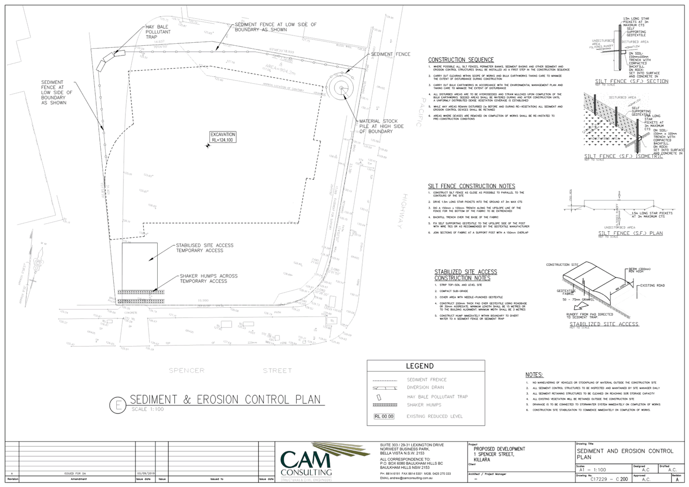
The geotechnical report expresses
concern that demolition and excavation may structurally damage 1 Spencer Road.
Request: A dilapidation report before demolition, dilapidation checks after
demolition, excavation and completion, and access to approved building
certifier, construction documents and final certificate.
The application included a geotechnical
report which recommended that:
Prior to any demolition or excavation
taking place at the site, we recommend that dilapidation surveys of adjoining
buildings, walls and pavements be carried out…
Dilapidation Surveys should be carried
out on the adjoining buildings that fall within the influence zone of the
excavation, which can be defined as a horizontal distance back from the edge of
the excavation of at least twice the excavation depth. During the excavation,
every care should be taken to not undermine or render unstable the footings of
any adjoining structure.
The
report also recommended inspection of the excavation once complete.
Council’s Development Engineer
commented:
The geotechnical recommendations
regarding excavation support, vibration monitoring, dilapidation reporting of
adjoining buildings and foundation design shall be carried out during
construction as specified within the report.
Council’s
Development Engineer has reviewed the geotechnical report and recommends that
dilapidation report/s are carried out on adjoining buildings within the zone of
influence.
The
floor level of the proposed basement is shown as 3.2m deep below existing
ground level on the northern elevation plan. The building at 620 Pacific
Highway to the north and the proposed building are separated by 5.2m. Any
Construction Certificate application must thereby include a dilapidation report
for 620 Pacific Highway (Conditions 8 and 100).
However,
the floor level of the proposed basement is shown as 2.7m deep below existing
ground level on the western elevation plan. The building at 1 Spencer Road to
the west and the proposed building are separated by a minimum 10.5m. The
geotechnical report would not require that a dilapidation report be prepared
for 1 Spencer Road.
The carpark will emit noise and
pollution to the building at 1 Spencer Road
The
basement does not include natural cross-ventilation. It is likely that the
overhead services zone in the basement shall include mechanical ventilation
directed to the fixed louvres on the western (1 Spencer Road) side.
The
basement includes 12 parking spaces serving six units. The building includes a
3m landscaped setback to the southern boundary. The neighbouring property
includes further landscaping and building separation.
The
basement will minimise noise and ‘pollution’ because it is
enclosing the area around parked cars, reducing sound emission. The development
will not result in a significant increase in traffic movement particularly in
relation to the site’s zoning and along the very busy Pacific Highway.
Further, it will improve upon the existing at grade parking near the
boundaries.
New building height and location will
overshadow and cause view loss to
1 Spencer Road
The
eastern elevation of the building at 1 Spencer Road is slightly splayed to the
north. The proposed building only overshadows this elevation of the
neighbouring building at 9am, however this elevation will continue to receive
direct sunlight 10am-1pm, thus satisfying requirement for a minimum 3
hours’ sunlight mid-winter.
The
site is to the east and upslope of 1 Spencer Road. The proposed building is
similar in position to the existing building. The proposed first and second
floors meet prescribed setbacks and are thereby within the expected building
footprint.
The
outlook from the neighbouring property that faces the subject site comprises
boundary landscaping and does not include any landmarks, water or other vista
or views. The proposal will not affect neighbouring landscaping and will not
unreasonably affect any views.
The proposal removes eight trees but
only retains two trees. Request: For privacy reasons, no trees be removed on
the eastern boundary of 1 Spencer Road.
On 8 February 2021 the applicant
submitted an amended arborist report that identifies Trees Nos 3, 8 and 10 that
are located along the western boundary of the subject site and noted:
1. T3 includes less than 10% canopy cover
and is declining;
2. T8 includes epicormic shoots, and
deadwood in the crown; and
3. T10 is a weed species.
The
report concludes that trees No. 3, 8 and 10 ‘fail the visual tree
assessment and/or are listed weed species recommended for removal’.
It is also noted that T3 is in the position of the proposed driveway.
The landscape plan proposes the
following replacements:
1. Replace T8 with Cheese tree (Glochidion
ferdinandi) that matures to a height and spread of 8-10m x 5-9m,
respectively;
2. Replace T10 with a Grey Ironbark tree (Eucalyptus
paniculata) that matures to a height and spread of 14-25m x 8-15m,
respectively; and
3. Plant a variety of other shrubs and
hedges along the boundary shared with 1 Spencer Road.
Additionally,
Council’s Landscape and Tree Assessment Officer supports the removal of
T8, subject to ecological concurrence and supports the removal of T10.
Council’s Ecological Assessment Officer also supports the removal of T8.
Council’s
Landscape and Tree Assessment Officer has recommended Condition 27
requiring supplementary evergreen shrub planting, that matures to at least 3m
high, along the northern and eastern side boundaries. In addition, the plans
show that Trees Nos 7 and 9 at 1 Spencer Road are to be retained. This planting
will assist in reducing privacy impacts along with the separation of 10.5m to
12m between the buildings.
The
proposal will reasonably retain existing landscaping and include new
landscaping, and the proposal will not unreasonably impact the visual privacy
at 1 Spencer Road.
The existing A. robusta tree (Kauri
Pine) will be impacted by driveway construction
The
applicant submitted amended plans and arborist report that retain the existing
driveway grades and levels. Council’s Landscape and Tree Assessment
Officer is satisfied that the amended proposal, subject to Conditions 18,
19, 20, 21, 22, 23, 24, 35, 80, 81, 82, 83, 84, 85, 86, 87 and 88, will
retain tree No. 2 (Kauri Pine).
Amended plans dated 8 February 2021, 27 April 2021 and 8 May 2021
In accordance with Appendix 1 of the Ku-ring-gai
Community Participation Plan, owners of surrounding properties were given
notice of the amended plans. In response, submissions from the following were
received:
1. L Carter - 11/1 Spencer Road, Killara
dated 6 September 2021
The
submission included the same content as previously submitted.
Amended plans dated 2 August 2021
Table 1-1 Motivation by Development Type in the Ku-ring-gai
Community Participation Plan specifies that ‘amendments to
undetermined DAs for all development types… where the environmental
impact will be the same of less than the original proposal’ shall be
notification type ‘A’. Section 2 in Appendix 1 specifies that:
No notification is necessary
except where, in the opinion of Council’s development assessment team
leader, the owners and occupiers of adjoining and neighbouring land would be
detrimentally affected in any manner described in 3 of this Part if the
development proposal was carried out.
On 2 August 2021 the applicant submitted amended plans
demonstrating FSR calculations. The applicant did not submit other plans or
alter the design of the proposal.
The plans were
not notified to surrounding residents as the plans do not contain amendments to
the design of the proposal and do not result in a greater environmental impact
than the original proposal.
Internal Referrals
Building Unit
Council’s Senior Building
Inspector reviewed the application and commented on the proposal as follows:
Class 2 building with
Class 7a carpark
A Building Code of Australia report was
submitted by Greenfield Certifiers dated 14 February 2018. It is noted that the
travel distance to an exit from the carpark storey is 24.78m exceeding the 20m
distance. Performance solution is proposed.
The proposed building design complies in
general with the Building Code of Australia (BCA) requirements. The proposal,
as amended, is satisfactory, subject to recommended conditions concerning
access (Condition 49), fire safety certificate (Condition 121)
and annual fire safety statement (Condition 136).
Ecology
Council's
Ecological Assessment Officer commented on the proposal as follows:
Summary
The
proposal is acceptable without conditions.
Assessment
|
Control
|
Proposed
|
Complies
|
|
Biodiversity Conservation
Act 2016
|
|
Section 7.3
The purpose of the Act is to maintain a healthy,
productive and resilient environment
|
Background
The Biodiversity Conservation Regulation 2017 (the BC Regulation)
sets out threshold levels for when the Biodiversity Offsets Scheme (BOS) will
be triggered. The threshold has two elements:
1. Area
Mapped on the Biodiversity Values Map
Whether the impacts occur
on an area mapped on the Biodiversity Values (BV) Map published by the Chief
Executive of the NSW Office of Environment and Heritage. Areas added to the
BV Map in the last 90 days are shown in dark purple.
However, proposed
development does not exceed the BOS threshold if a planning approval is
submitted before or during the 90-day period. The 90-day expiry date is
displayed in the Results Summary table of the evaluation report. The expiry
date does not apply to areas shown in light purple or areas with no
biodiversity values.
OR
2. Native
Vegetation
Whether the amount of
native vegetation being cleared exceeds a threshold area.
If clearing and other impacts exceeds either trigger, the
proposal will:
(i) constitute
‘biodiversity impacts’ under Clause 6.1 of the BC Regulation;
(ii) require a Biodiversity
Development Assessment Report (BDAR) to be submitted with the proposal; and
(iii) require entry into the
BOS.
Alternately, if clearing and other impacts do not exceed either
trigger, the test of significance detailed in Section 7.3 of the Biodiversity Conservation
Act 2016 (the BC Act) must be used to determine whether a local
development is likely to significantly affect any threatened species,
ecological communities or their habitats.
In the event that no native vegetation removal occurs within
lands mapped upon the BV map then the local development will not trigger he
requirement for a BDAR.
The site and proposal
1. Area Mapped on the BV Map
The
development will result in the removal of native vegetation mapped upon the
BV Map; However, as the DA was lodged prior to the 90 day period (24-02-2021)
the proposal does not trigger automatic entry into the BOS in this instance.
2. Native Vegetation
The western portion of the subject property is mapped as
containing plant community type (PCT 1237) Sydney Blue Gum - Blackbutt - Smooth-barked Apple moist
shrubby open forest on shale ridges of the Hornsby Plateau, Sydney Basin
Bioregion.
PCT 1237 corresponds with Blue Gum High Forest (BGHF)
listed as a Critically Endangered Ecological Community (CEEC) under the BC
Act.
An impact assessment has been prepared by Anne Clements
& Associates, which has been prepared in accordance with section 7.3 of
the BC Act. [Section 5.1 of] the impact assessment concludes as follows:
From applying the 5-part test, the
proposal is likely to have a significant impact on Blue Gum High
Forest on the subject site. The proposal removes:
1. Two of the two BGHF canopy trees
despite:
Tree 3 (Angophora floribunda)
identified in Advanced Treescape Consulting (2021) as not suitable for
retention with <10% canopy cover; and
Tree 3a (Eucalyptus paniculata)
suppressed within the canopy of Tree 3;
2. Two of the five small trees
characteristic of BGHF, despite:
being a poorly lopped and pruned known
weed native species Pittosporum undulatum largely within the sparse
canopy (<10% canopy cover) of Tree 3;
3. Part of the lawn areas with some
native component.
However, the proposed action (the loss
of <1% (approximately 260 m2) of at least 3.5 ha existing remnant BGHF
canopy in the locality) is not likely to significantly impact the local
occurrence of Blue Gum High Forest. A Species Impact Statement is not
required”.
The threatened species test of significance guidelines
states:
Where a significant effect is
determined to be likely an applicant for development consent under Part 4 of
the EP&A Act is required to prepare a BDAR.
Whilst the conclusion above from the impact assessment
concludes that the proposal will result in significant impacts upon the BGHF
within the subject site, no BDAR is deemed to be necessary in this instance.
The local occurrence of a community is defined below. As
the BGHF within the subject site is connected to a larger stand of BGHF, the
removal of BGHF within the subject site would not in itself result in a
significant impact upon the local occurrence of BGHF.
Local occurrence: The ecological community that occurs
within the study area. However, the local occurrence may include adjacent
areas if the ecological community on the study area forms part of a larger
contiguous area of that ecological community and the movement of individuals
and exchange of genetic material across the boundary of the study area can be
clearly demonstrated (OEH 2018).
Reference: Office of Environment and Heritage (OEH)
(2018) Threatened
Species Test of Significance Guidelines dated July 2018.
|
YES
|
|
State Environmental
Planning Policy No. 19 – Bushland in Urban Areas
|
|
Part 2 - Aims
The aim of the SEPP is to preserve bushland within urban
areas
|
The subject property does not adjoin ‘Urban
Bushland’ as such no further consideration deemed necessary under the
SEPP.
|
YES
|
|
Ku-ring-gai Local
Environmental Plan 2015
|
|
Part 6
Additional local provisions
Clause
6.3 –Biodiversity Protection
The objective of this clause is to protect maintain and
improve the diversity and condition of native vegetation and habitat
|
The native
vegetation within the site has been mapped as ‘Terrestrial
biodiversity’.
The proposed development seeks to
remove T3 Angophora
floribunda (Rough-barked Apple) & T8 Pittosporum undualatum
(Sweet Pittosporum) which form part of lands mapped Terrestrial biodiversity.
Approval was granted under the
development consent to DA0303/14 for removal of the aforementioned trees. The
proposed removal of T3 is accepted due to its poor health. The proposal
is considered to be consistent with clause 6.3 despite the removal of
biodiversity values.
|
YES
|
|
Ku-ring-gai Development Control Plan
|
|
Part 18 Biodiversity Controls
18.6 Category –Canopy Remnant
18.3 Category – Support for Core Biodiversity
Lands.
18.5 Category –Biodiversity Corridors and Buffer
Areas
|
The proposal is generally consistent with the relevant
controls under these parts.
The proposed removal of T3 from support for core lands is
accepted as the tree has been assessed by the consulting arborist to be in
poor health and located within the access
The proposed landscape planting of native canopy trees,
sub-canopy trees, shrubs and groundcovers will offset the loss of the T3-Angophora floribunda (Rough-barked
Apple) which is currently in decline and a number of Pittosporum
undulatum (Sweet Pittosporum) proposed for removal. Implementation of the
landscape planting will result in an enhancement to the remaining BGHF
onsite.
|
YES
|
Engineering
Council's
Development Engineer commented on the proposal, as follows:
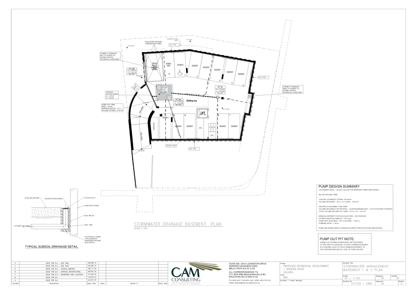
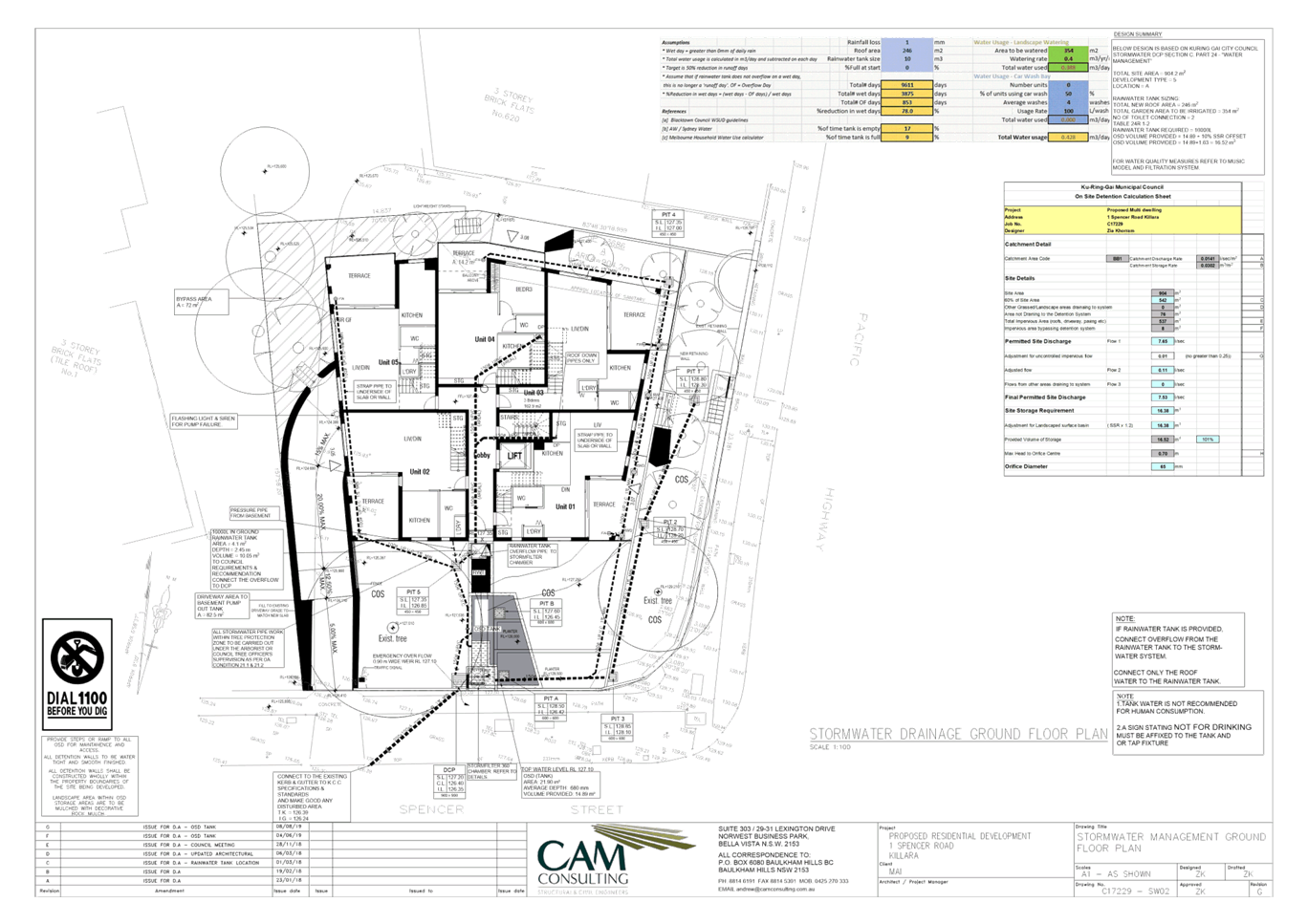
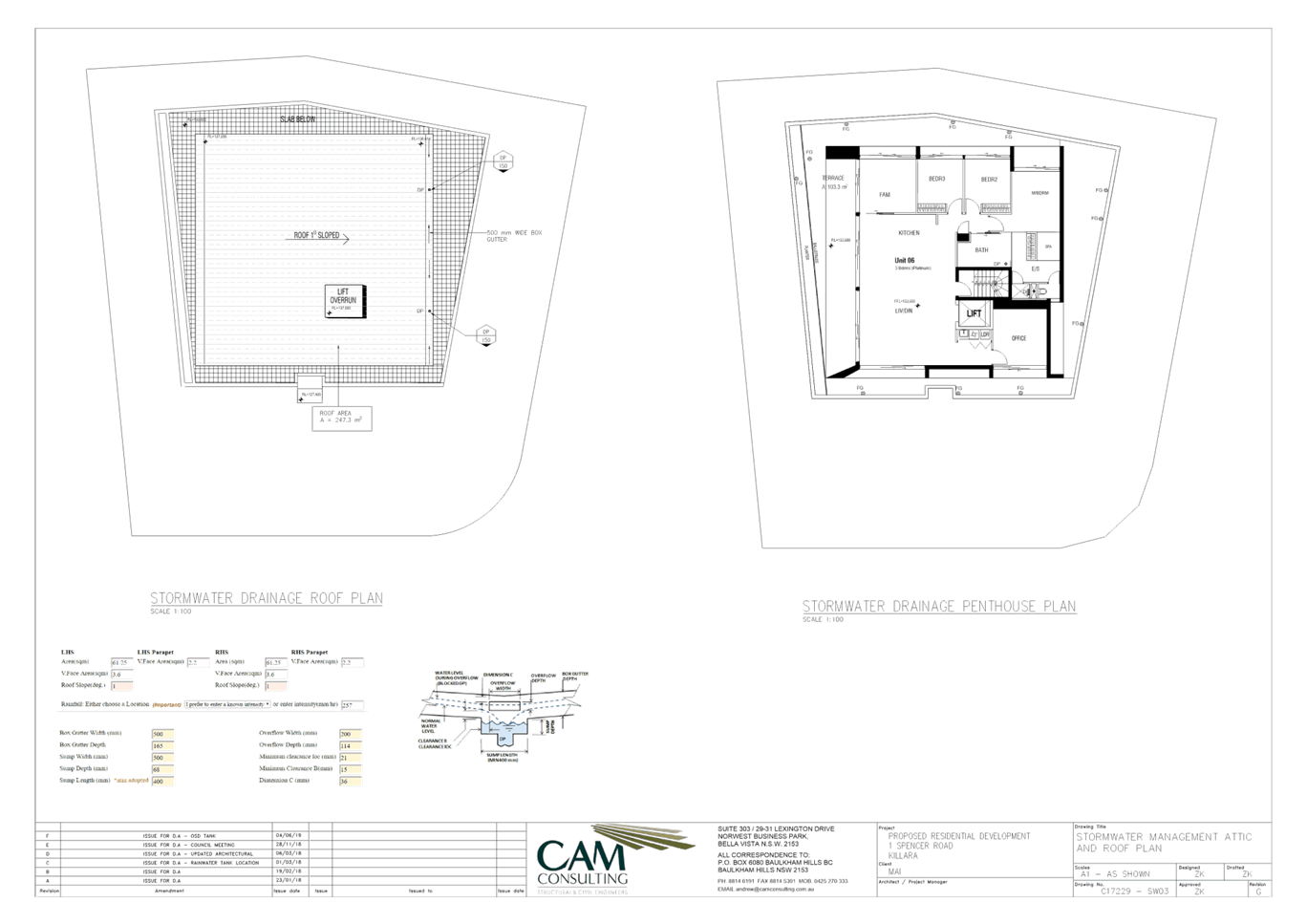
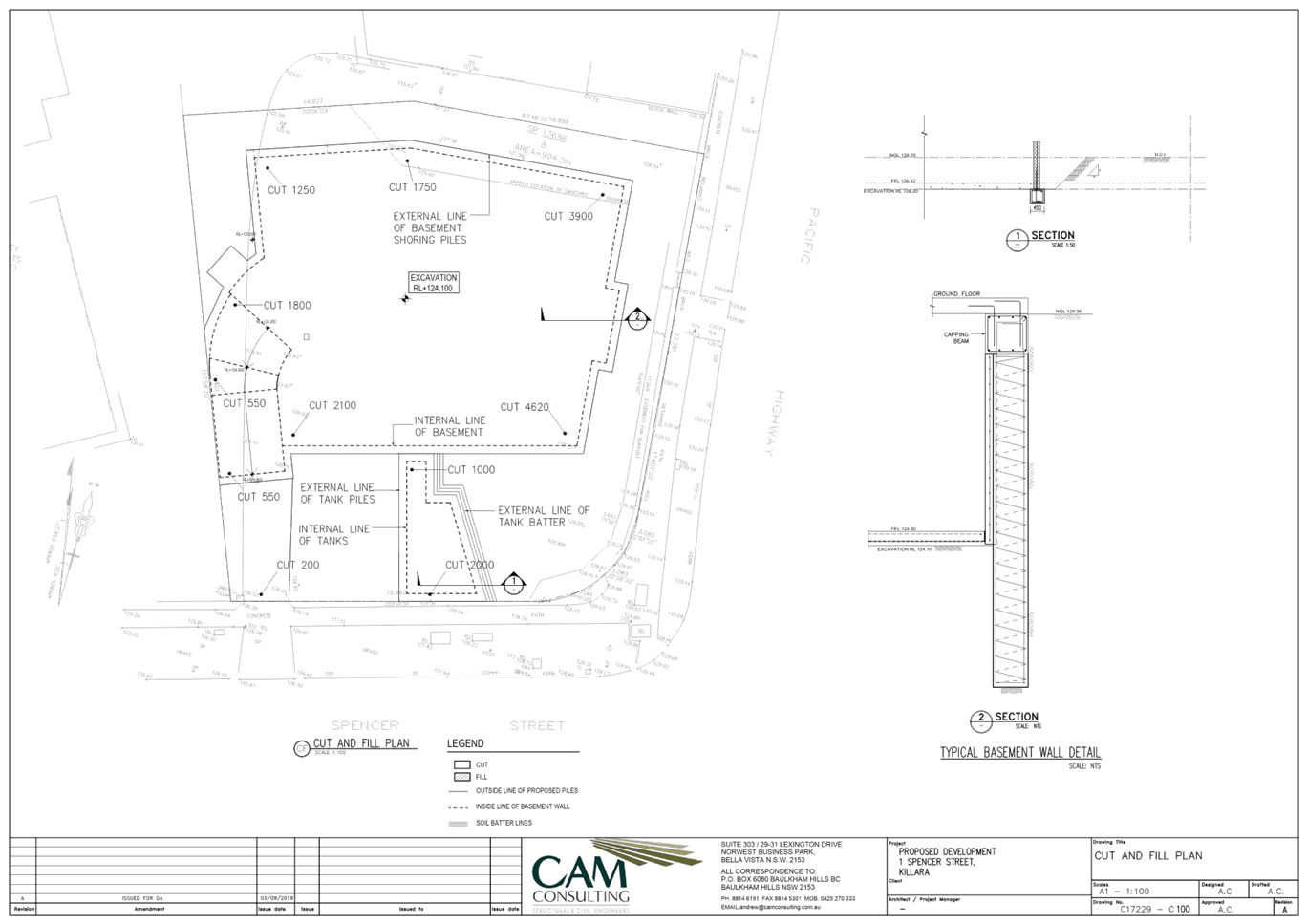
Water management
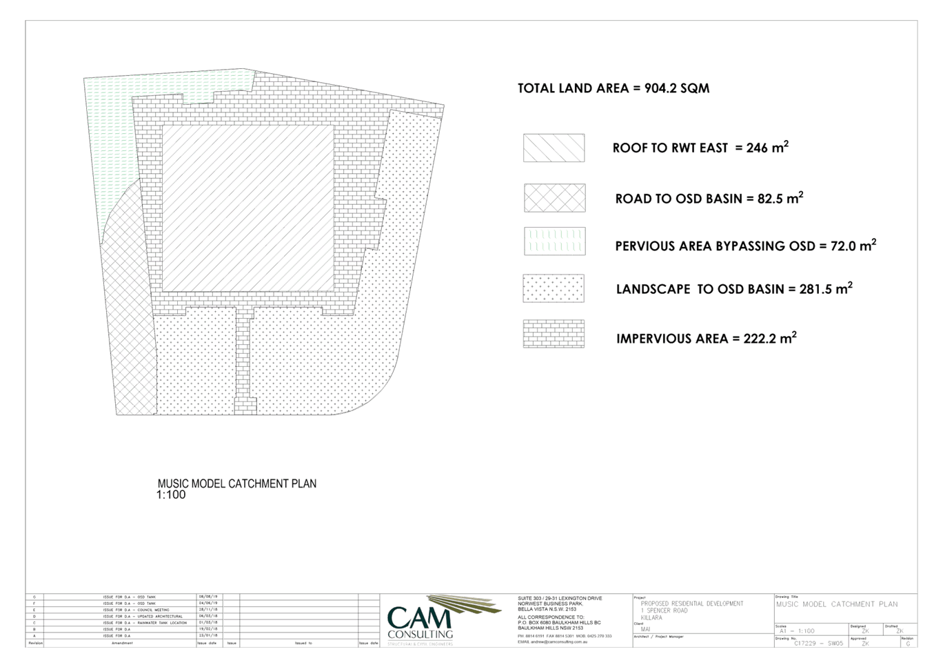
The subject site is a corner allotment
that slopes from the Pacific Highway frontage to the north-west corner of the
site with an approximate fall of 3.9m across the site.
The stormwater management plans,
prepared by CAM Consulting, show all of the roof area directed and conveyed to
a combined detention / retention tank comprising a total of 16.52m3
and 10,000L respectively located within the front setback. The overflow from
the detention system is directed to the existing kerb and gutter in Spencer
Road. The sizing of the detention system complies with Part 24C.5 of the DCP,
which has been based on 60% of the site area.
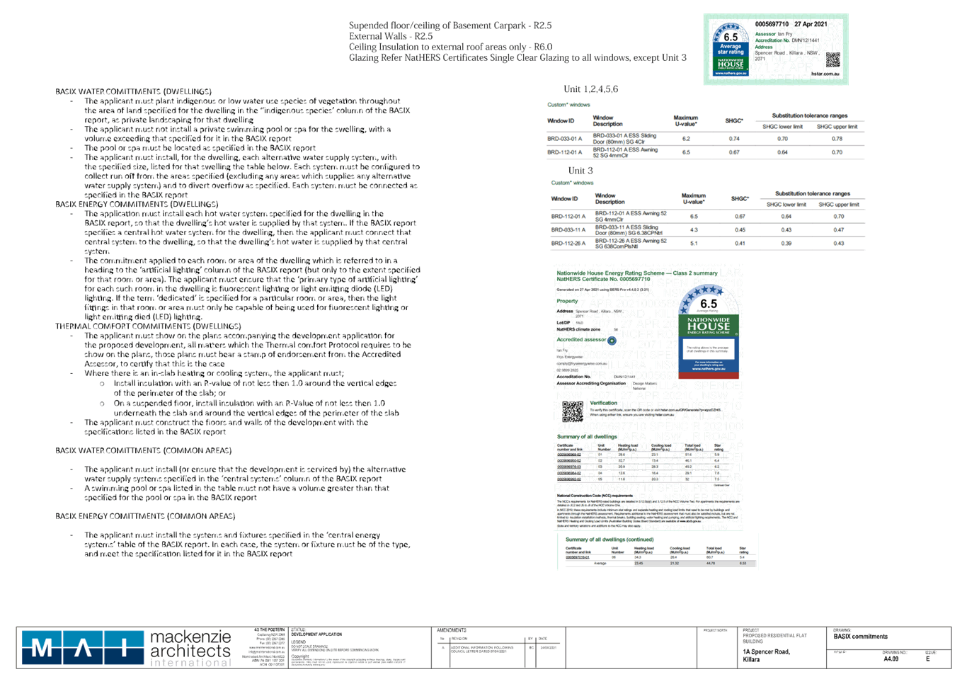
An updated BASIX Certificate has been
submitted, with the water commitments requiring a central water tank (rainwater
or stormwater) of 3,000 litres. The tank is also to be configured to collect
runoff from at least 365.8 square metres of roof area and irrigation of 362.2
square metres of common landscaped area. The BASIX water commitments have been
satisfied.
The Ground Floor Plan, South Elevation
Plan, East Elevation Plan, Spencer Road Streetscape Plan and Section 2 Plan
show ‘tank under to eng. details’ below the front path next to the
front boundary with Spencer Road.
It is proposed that the rainwater tank
of 10,000 litres to collect runoff from all roof areas and will be plumbed for
irrigation and toilet flushing.
The rainwater retention and re-use has
met the 50% reduction in runoff days (78% achieved) required under Volume C,
Part 24C.3 of the DCP. The methodology adapted, as per the water balance
model, is acceptable to satisfy the streamflow objectives.
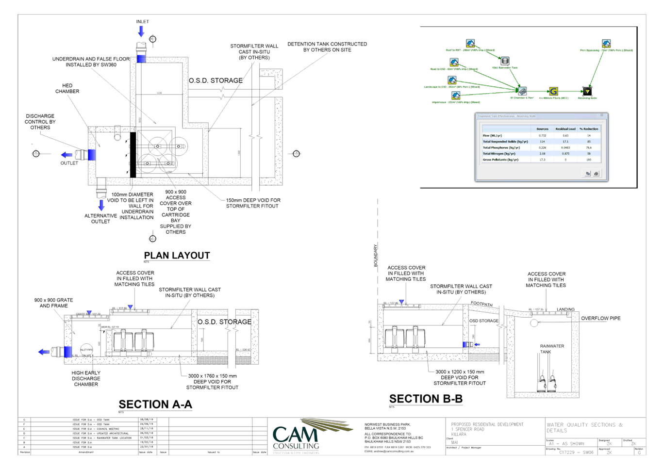
The pollutant load standards set out in
Part 24C.6 of the DCP have been satisfied using MUSIC Modelling. The plans
shows Stormwater 360 Storm Filters (OCEANGUARDS) within the on-site detention
tank as stormwater quality measures to improve stormwater runoff quality from
the subject site.
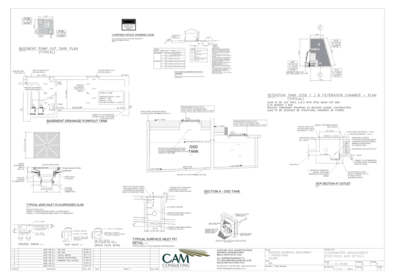
A pump-out system with
minimum storage capacity of 14.42m3 has been provided within the
basement carpark to drain the basement subsoil drainage and driveway area. It
has been conditioned that the rising main be directed to the on-site detention
tank rather to an external pit. The pump-out tank has been sized in accordance
with AS3500.3:2003 and DCP requirements.
The Stormwater Management Plan C17229
SW01-SW06 all issue ‘G’ dated 8 August 2019 and C100 and C200
issue ‘A’ dated 3 September 2019, prepared by CAM Consulting, is
listed in Condition 1.
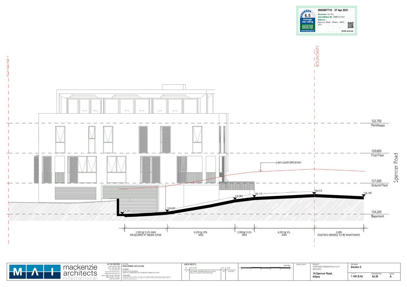
Vehicular access and
accommodation arrangements
The basement is accessed from Spencer
Road from the driveway at the southwest corner of the subject site.
The proposed development comprises of 6
units. According to the applicant’s traffic engineer, the parking
requirements have been assessed under the “Apartment Design Guide”.
The Design Guide states that sites
within 800m of a railway station or light rail stop can satisfy the minimum
parking requirements specified in the RMS “Guide to Traffic Generating
Developments” (October 2002) as follows:
Metropolitan Sub-Regional Centres
6 x 3 bedroom units @ 1.4 spaces per
unit = 8.4 spaces
Total resident parking = 9 spaces
(rounded to nearest integer)
6 units @ 1 visitor space per 5 units =
2 visitor space
The total parking required for the
residential component is 9 spaces plus 2 visitors. The plans shows a total of
11 car parking spaces and contains 9 residential car spaces, including 1
accessible and 2 visitor spaces, including 1 accessible space. The on-site
parking satisfies both the ADG parking requirements of SEPP 65 as well as the
DCP.
Vehicular access to the car parking
facility is to be provided via the existing 3.5m wide entry / exit driveway
crossing which ramps down to the basement entry level. The driveway width is
slightly less than the requirements of Part 22.2 of the DCP that stipulates a
minimum 3.7m however given the site constraints to protect the structural tree
roots, the proposed width is acceptable.
The use of the single lane driveway and
ramp is compliant with Clause 3.2.2 of AS2890.1:2004 given that the traffic
flows will be in the order of 3-4 peak hour vehicle movements.
There is adequate aisle length to
accommodate any queuing without any congestion. Convex mirrors and
holding/waiting bays are provided to manage vehicle circulation within the
basement parking level. In addition, a traffic signal is also proposed and
placed in a strategic location at the entry to the basement ramp. The signal is
set back 10m to the street upon the building, however the signal is elevated
1.3m above the street footpath level. It is recommended that, should the
application be approved, Condition 2 be imposed that requires the signal
to be lowered by 0.9m to sit at the height of the low, brick portion of the
internal brick and balustrade fence and to hang from the side of the low, brick
portion of this fence.
The signal has been designed to allow
only a single vehicle to utilise the carpark ramp at any one time and, under
recommended Condition 2, an entering vehicle would retain a clear line
of sight to the signal and would retain a 3.6m wide path at this point yet the
visibility of the signal would be minimised and not unreasonably impact the
public domain.
Sightlines at the property boundary are
also acceptable given its previous development type and retaining existing
driveway access point.
The service /car wash space can be
provided as part of the loading zone area. The minimum space dimension of 3.5m
x 6m has been satisfied.
The adaptable parking spaces are
compliant with the dimensions of AS2890.6 (2009) in terms of space width and
providing a shared area.
Swept turning path diagrams within the
traffic report have been submitted to confirm that a B99 vehicle will be able
to access the basement as well as demonstrating that a B85 design vehicle can
manoeuvre safely in the critical parking spaces, such that all vehicles will be
able to enter and exit the site in a forward direction at all times.
The internal driveway gradients, aisle
widths and car space dimensions are compliant with Australian Standard 2890.1
(2004) “Off-Street car parking”.
Traffic generation
According to the traffic generation
rates nominated by The Roads & Maritime Services (RMS) ‘Guide to
Traffic Generating Developments - 2002’, the development for the
residential use would generate approximately 3-4 peak hour vehicle trips for
the AM and PM respectively which would represent one vehicle trip every 15-20
minutes during the peak periods. The potential increase in traffic flows in
Spencer Road is not expected to have a significant effect on traffic flows or
on the operation of the nearby intersections with the arterial road network.
The report also confirms that the subject site will not cause any delays to
traffic, as there is adequate length of driveway crossing and sight distance.
Waste management
The waste storage and collection area is
located along the rear of the basement. Space is provided for 8 bins for waste,
paper and recycling, which satisfies the required bin requirements.
Whilst the swept path shown within the
Addendum to the Traffic Statement demonstrates that Council’s small rigid
vehicle is capable of reversing into the garbage truck bay and exiting the site
in a forward motion, the swept paths do however show the garbage truck crossing
over within the visitor space.
According to the ADG, it
clearly states under the Objectives 3J-3:
Supporting facilities within car parks,
including garbage, plant and switch rooms, storage areas and car wash bays can
be accessed without crossing car parking spaces.
In this instance, it has been
conditioned that the service vehicle/carwash bay be swapped with Visitor 01.
This will allow the garbage truck to safely manoeuvre within the dedicated
service/loading bay without crossing within another parking space (Condition
39).
A driveway longitudinal section starting
from the centreline of the public road to the basement carpark entry has been
provided. The driveway gradient of 5% for the first 6m as per AS2890.1:2004 is
shown as well as having a maximum 20% grade along the main access ramp to the
basement entry as required under Part 23.7(41).
The architectural plans (Drawing No.
A3.05/A) demonstrate that a minimum 2.6 metres clear headroom along the whole
of the travel path required for the small waste collection vehicle can be
provided.
Construction
management
An indicative construction traffic
management plan (CTMP)) has been submitted which is acceptable for DA purposes.
The CTMP demonstrates that the largest size truck to gain access to the site
during demolition and excavation will be a truck and dog whilst the largest
size truck to gain access to the site during general construction will be a
single bogie (MRV 8.8m or smaller SRV 6.4m in length).
Based on the scale of works and expected
construction vehicle movements, a detailed construction traffic management plan
would need to be submitted prior to the commencement of any works on site to
show truck routes and demonstrating how construction vehicles for all stages of
development will turn into the site without crossing the double lines in
Spencer Road. The size of the construction vehicle may possibly need to be
reduced in this instance.
A work zone will be required on Spencer
Road site frontage for the set down and pick up of materials. Condition 12
is recommended to that effect, including the need for approval by
Council’s Traffic Committee and the payment of the necessary fees.
Geotechnical
investigation
A geotechnical site assessment has been
carried out which included site observations and obtaining data from a previous
geotechnical investigation completed in 2006 with an updated geotechnical
report completed in 2014. Due to the ground slope, excavation to depths of
around 1.5m to 5m is estimated to be required to achieve the basement level.
The geotechnical assessment involved
drilling two deep boreholes. Subsurface conditions comprised fill to a depth of
2.5m. Residual silty clay was encountered beneath the fill grading into
extremely low and low strength shale to weathered shale found at depths of 1.5m
and 3.5m. Groundwater was measured in the boreholes at depths of 7.1m and 8.0m.
It should be noted that excavation to depths of up to 5m is proposed for the
basement and therefore groundwater seepage does not appear to be an issue.
In the event that groundwater will be
encountered, it is conditioned that the basement excavations are to be fully
tanked unless it can be demonstrated that ongoing dewatering will be less than
3ML/year AND the proposal is approved by NSW DPI Office of Water (Condition
32).
The geotechnical recommendations
regarding excavation support, vibration monitoring, dilapidation reporting of
adjoining buildings and foundation design shall be carried out during construction
as specified within the report.
Recommendation
There are no objections to the proposal,
subject to Conditions 1, 2, 12, 13, 17, 32, 33, 36, 37, 38, 39, 55, 56, 68,
74, 76, 100, 109, 110, 111, 112, 113, 114, 115, 116, 117, 118 and 119.
Environmental Health
Council's
Environmental Health Officer reviewed the architectural and other documentation
and raised no objection, subject to the following conditions relating to:
·
Residential amenity
during construction and operation (Conditions 1, 26, 42, 43, 45, 47, 54, 69,
70, 71, 72, 93, 103, 104, 106, 107, 108, 127, 131, 133 and 135)
·
Locating air
conditioner condenser units in the basement (Conditions 43 and 107)
·
Mitigation of noise
and vibration impacts generated from classified roads in accordance with Clause
102 of SEPP Infrastructure (Conditions 26, 47 and 103)
Heritage
Council's Heritage Advisor commented on
the proposal as follows:
Summary
The
building appears to be externally intact. However, the property is not heritage
listed and DA0303/14 included demolition
Ku-ring-gai Local Environmental Plan
2015
Clause
5.10 of Ku-ring-gai
Local Environmental Plan 2015 (the LEP) requires that before granting
consent to the proposed works Council must consider the effect of the works on
the heritage item, nearby items or conservation area concerned. Clause 5.10 (5)
allows Council to require a Heritage Impact Statement before granting consent.
Heritage status
|
KLEP 2015
|
Yes
|
|
Local
Heritage Item
|
No
|
|
Heritage
Conservation Area
|
No
|
|
Immediate
vicinity of a heritage item
|
Yes
(I306) Waterboard Regimental Park
|
|
Immediate
vicinity of a HCA
|
Yes
(C24) Marian St HCA
|
Statement of significance
Council’s
heritage inventory sheet has the following statement of significance for the
adjacent Heritage Conservation Area:
The Marian Street Heritage Conservation
Area is of high local historic and aesthetic significance as a good and largely
intact residential precinct characterised by streetscapes of high quality
examples of single detached houses from the Federation, Inter-war and Post-war
periods. The built context is enhanced by large garden settings, wide street
proportions, street plantings and remnant and planted native trees; elements
which are synonymous with the Ku-ring-gai area. The early grant boundaries,
estates and subdivision pattern significantly remain visible in the current
layout and pattern of development and late 19th and early to
mid-20th century building stock retains a high level of integrity. The early
development is also overlayed by later land subdivisions and some consolidation
and later development, which reflect changes in the wider rail and road
networks and ongoing evolution of the local and wider area. The area
substantially retains the original vision for the area with emphasis on
residential, recreational and cultural development.
Council’s
heritage inventory sheet has the following statement of significance for the
adjacent Heritage Item:
Killara Reservoir (Covered) (WS 60) is
one of a small group of covered reservoirs, and demonstrates the development of
technology used in covered reservoir construction, as well as the high level of
engineering expertise available in the MWS & DB. All covered reservoirs are
highly significant within the Sydney Water system, since all differ in
construction technology, design and architectural detailing. All therefore
contribute to our understanding of the development of covered reservoirs in
NSW. The listing includes the reservoir and all associated pipework, valves and
valve houses to the property boundary.
Historical background
The building dates from the mid to late
1930s and is characteristic of Inter-war functionalist (Art Deco) architecture.
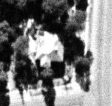
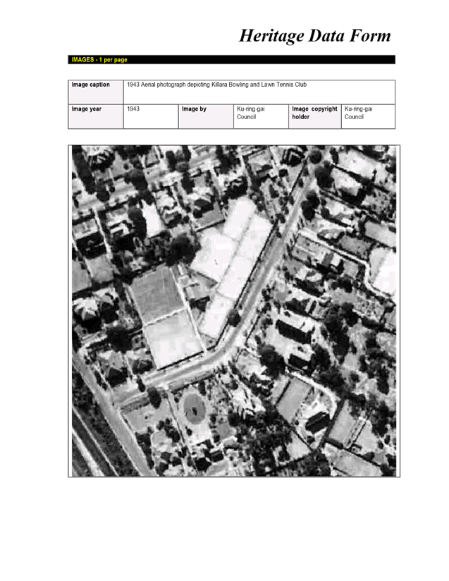
Figure
2: The Sixmaps 1943 Aerial shows the building existing with established
vegetation surrounding the site. Weir Phillips heritage report notes the
building being built circa 1950, which is known not to be the case.
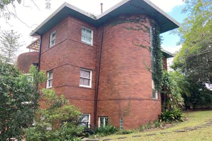
Figure
3: The building displays the architectural characteristics of Art Deco
Architecture of which was pioneered by Douglas Agnew in the Ku-ring-gai area.
Assessment
|
Development Controls
|
Complies
|
DEVELOPMENT IN THE VICINITY OF HERITAGE ITEMS
OR HERITAGE CONSERVATION AREAS (HCAS)
|
|
19F.1 Local Character and Streetscape
|
|
General
|
|
1 All development in the vicinity of a Heritage Item or
HCA is to include a Heritage Impact Statement.
|
YES
|
|
Built Form
|
|
2 Development on sites that either directly adjoin or are
in the vicinity of a Heritage Item or an HCA is to have regard to:
i) the form of the existing building or buildings
including height, roofline, setbacks and building alignment;
ii) dominant architectural language such as horizontal
lines and vertical segmentation;
iii) proportions including door and window openings,
bays, floor-to ceiling, heights and coursing levels;
iv) materials and colours;
v) siting and orientation;
vi) setting and context;
vii) streetscape patterns.
|
YES
|
|
Views
|
|
4 New development in the vicinity of a Heritage Item or
HCA is to demonstrate that it will not reduce or impair important views to
and from the Heritage Item from the public domain.
|
YES
|
|
19F.2 Building Setbacks
|
|
Setbacks
|
|
1 The front setback of development adjacent to a Heritage
Item or buildings within an HCA is to be greater than that of the Heritage
Item or building within the HCA. Where variations in setbacks exist, the
larger setback will apply
|
N/A
|
|
Residential Context
|
|
2 All medium and high density development is to have a
stepped facade to any common boundary with a Heritage Item or building within
the HCA. The facade is to be stepped back above an 8m height from natural
ground level as per Figure 19F.2-1. Facades greater than 8m high will not be
permitted adjacent to a Heritage Item or building with an HCA.
|
YES
|
|
3 In addition to the side and rear setback controls in
Section A of this DCP, new development adjacent to a Heritage Item or
building within an HCA, is to comply with the following:
i) adjacent development is to have a minimum 12m building
separation to the Heritage Item (more if setback requirements are not met
within the 12m) as per Figure 19F.2-2;
ii) adjacent development is to not exceed a facade height
of 8m from existing ground level, including balustrades;
iii) adjacent development with a building mass above 8m
high from existing ground level is to be stepped back an additional 6m from
the Heritage Item as per Figure 19F.2-2; Where variations in setbacks exist
the larger setback will apply.
|
YES
NO
YES
|
|
19F.3 Gardens and Landscaping
|
|
Gardens, Setting and Curtilage
|
|
1 Development in the vicinity of a Heritage Item or an
HCA is to:
i) retain original or significant landscape features
associated with the Heritage Item or HCA, or which contribute to its setting
ii) retain the established landscape character of the
Heritage Item or HCA.
iii) include appropriate screen planting on side and rear
boundaries.
|
N/A
YES
|
|
19F.4 Fencing
|
|
Fences on adjoining sites
|
|
1 New front fences on adjacent sites are to be no higher
than the front fences of the adjoining Heritage Item or HCA. Open and
transparent front fences such as timber or metal picket are preferred.
|
N/A
|
|
2 No metal panel fencing is to be constructed on any
boundary of a Heritage Item.
|
YES
|
General
The current building was constructed in
the mid-1930s and, upon inspection, presents as being highly intact externally.
External balconies and staircases appeared to have original materials and
remain in their original configuration. All windows appear to contain original
joinery, and the central curved ribbed glass highlight to the main stairwell is
intact.
It is to be noted that the condition of
the building has deteriorated and does not appear to be fully occupied. The
curved masonry wall (including ribbed glazing) forming the central stair within
the building contributes a very high degree of aesthetic significance to the
building and appears to be original.
The existing interwar flat building
demonstrates the key characteristics of the interwar functionalist style. The
building has the potential to have been designed by prominent Ku-ring-gai
-based inter-war architect, Douglas Agnew. .
However, it is noted that the subject
property is not heritage listed, nor falls within a conservation area. There
was also a relatively recent approval (DA0303/14) for the demolition of the
interwar flat building and the construction of a new apartment building to
replace it.
19F.2 Building Setbacks
Residential Context
Control No. 3 states:
In addition to the side and rear setback
controls in Section A of this DCP, new development adjacent to a Heritage Item
or building within an HCA, is to comply with the following:
ii) Adjacent development is to not
exceed a facade height of 8m from existing ground level, including balustrades;
Although the proposed development
features a façade height of more than 8m, there will be no impact to any
adjacent heritage items and HCA’s, as the subject site is located well
away from any places of heritage significance. The façade height will
not pose overshadowing or visual obstructions to or from any items of heritage
significance.
Adjacent heritage item
and conservation area
The location of the site and vicinity
items is such that the proposed flat building would not impact in its
visual scale relative to the vicinity heritage items.
Conclusion and
recommendation
The proposed RFB Development will have
no adverse impact on the adjacent heritage item, adjacent heritage conservation
area and items in the vicinity, subject to Conditions 10, 77 and 78.
There are no heritage provisions that prevent the demolition of the existing
building.
Landscaping
Council's
Landscape and Tree Assessment Officer has commented on the amended proposal as
follows:
|
Control
|
Proposed
|
Complies
|
|
State Environmental
Planning Policy (Building Sustainability Index: BASIX) 2004
|
|
Part 3 Aims
To encourage sustainable residential development
|
BASIX certificate 1035775M_05 dated 17/03/2021 has been
submitted with the application.
The certificate has a water score of 41 exceeding the
minimum target 40 water score.
The certificate nominates the following:
Common lawn area - 48.9
Common garden area – 325.3
Indigenous species area – 0.0sqm
Common taps (4 star rating) have been
provided
Dwelling 6 – 25sqm of private
garden and lawn
The BASIX certificate is consistent with the development
proposal for landscape matters.
|
YES
|
|
State Environmental
Planning Policy (Vegetation in Non-Rural Areas) 2017
|
|
Aims
To protect the biodiversity value of trees and other
vegetation and to preserve the amenity of non-rural areas through the
preservation of trees and other vegetation.
|
Trees
to be removed
The
development proposes the removal of Trees 1, 3, 4, 5, 8, & 10.
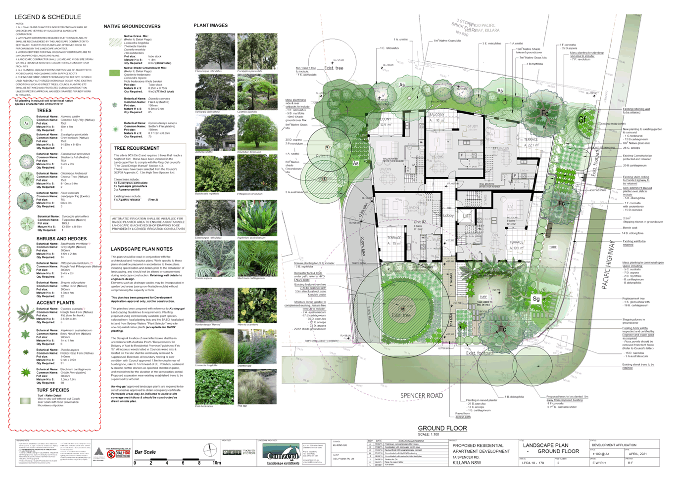
Tree 1 Jacaranda mimosifolia (Jacaranda)
The tree
is located at the southeast corner of the site. The tree is not shown on the
survey plan. This tree is visually prominent and provides streetscape amenity
however it exhibits several structural issues. There is no landscape
objection to the removal of this tree as a result.
Tree 3 Angophora floribunda (Rough-Barked
Apple)
The tree
is located to the western boundary of the site. The majority of the tree is
outwardly in good health typical of the species with a dead scaffolding limb
(which should be removed). There is evidence of drilling at the base of the
tree. Subject to ecological concurrence the trees removal to accommodate
development is accepted (consistent with previous consent).
There is
no landscape objection to the removal of Tree 4 Jacaranda mimosifolia (Jacaranda),
Tree 5 Ulmus sp. (Elm) and Tree 8 Pittosporum undulatum (Native
Daphne) that are poor specimens. Removal of Tree 8 is subject to
ecological concurrence.
Tree 10 is
a noxious weed and requires removal.
Tree 6 Magnolia grandiflora (Bull Bay Magnolia) a mature specimen
located towards the southeast site corner. The tree is outwardly in good
health and condition and with subsequent tree removal will become visually
prominent. The removal of the tree is not supported.
Tree 6
can be viably retained with the development proposal. Changes to the
landscape plan is conditioned (Condition 27).
Trees
to be retained
The
development proposes the retention of Tree 2 Agathis robusta (Kauri Pine)
The tree
is located towards the southwest corner and is the most significant tree on
site.
The root
mapping undertaken provides evidence of structural roots within the driveway
and west of the existing low wall. Root mapping within the area of the
proposed driveway determined that there were roots within the area of the
proposed driveway at 110mm depth at their shallowest. The root mapping did
not indicate the extent of impact as it omitted an area south west of the
base of the trunk. The trunk diameter is also shown inaccurately on the root
mapping diagram. This omitted area is largely within the 3.5m diameter
structural root zone.
To
preserve the long term viability of this tree the proposed driveway within
the tree protection zone has been relocated adjacent to the western boundary
and is to be constructed to match existing grades west of the existing
driveway edging. This edging and associated exposed roots are to be retained
and protected (Condition 35).
|
YES
|
|
Ku-ring-gai Development
Control Plan
|
|
Part 7A.6 Deep Soil
Landscaping and Part 13 Tree and Vegetation Preservation
|
|
To ensure landscape areas contribute to the garden
character and canopy of the Ku-ring-gai locality
|
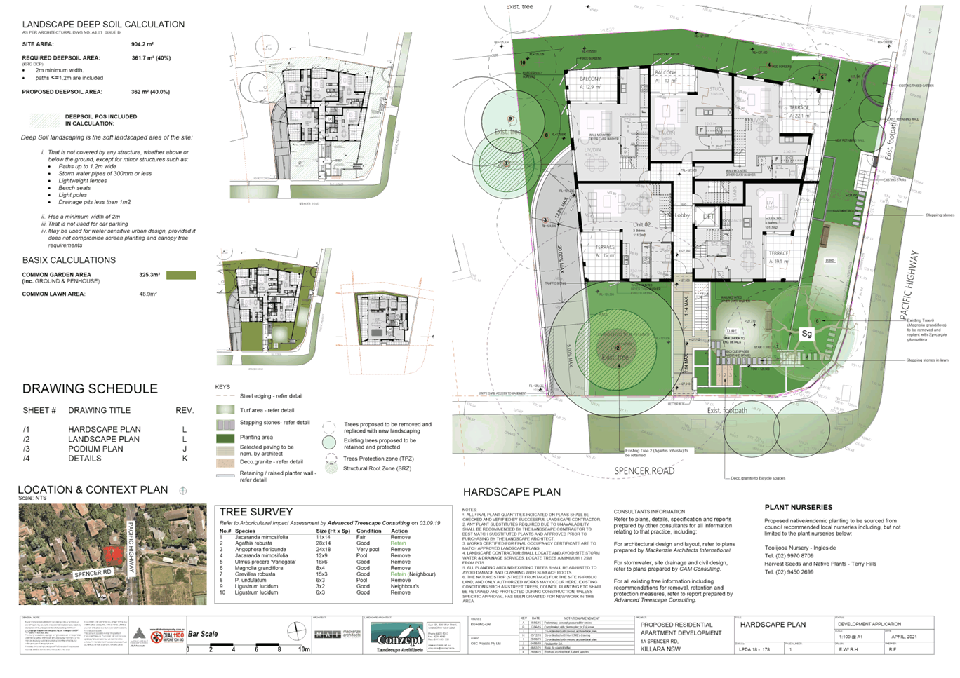
Site area 904.2m2
Numerical
compliance 40% (361m2)
Proposed
deep soil area 40% (362m2)
Areas
included in the applicant’s calculations are accepted.
|
YES
|
|
Tree replenishment and planting to soften the built form
and create a garden setting.
|
Sufficient tree replenishment has been included on the
landscape plan to satisfy the DCP Objectives
|
YES
|
|
Part 7C.2 Communal Open
Space
|
|
To provide adequate safe, useable, attractive and
accessible communal open space for residents
|
The
development provides the principal communal open space within the site
frontage to Spencer Road. The area includes an area of lawn and seating
suitable for resident use with perimeter planting for landscape amenity.
|
YES
|
|
Part 21
General Site Design
|
|
21.1 Earthworks and Slope
|
The extent
of grading is accepted.
|
YES
|
|
21.2 Landscape Design
To ensure the landscape design and species
selection is suitable to the site its context and considers the amenity of
residents and neighbours.
|
The
submitted landscape plan is acceptable, subject to Condition 27
requiring changes being.
Retention of Tree 6
Change of species selection for Ficus coronata (Sandpiper Fig)
Inclusion of exotic understorey tree
species to reflect the established landscape character.
Change of native species (Breynia) to appropriate evergreen screen
planting species for improved residential amenity.
Relocation of spatially conflicting
tree species with built landscape elements
Relocation f proposed tree
replenishment planting – Syncarpia
glomulifera /
Turpentine, to enable retention of Tree 6
Supplementary screening shrub planting
is recommended adjacent to the eastern / Pacific Hwy site boundary to enhance
resident amenity.
The
location of the driveway immediately adjacent to the western site boundary
excludes the ability of the development to provide amenity/screen planting
for the length of the driveway. While this is not a preferred landscape
outcome as the development is therefore reliant upon the landscape amenity
provided by the neighbouring site, in this circumstance the nil setback to
the driveway is accepted to enable the retention of Tree 2 which is the
dominant tree on site which is visually significant within the existing
landscape setting.
|
YES
|
Recommendation
The proposal, as amended,
is acceptable, from a landscape perspective, subject to Conditions 1, 18,
19, 20, 21, 22, 23, 24, 27, 34, 35, 80, 81, 82, 83, 84, 85, 86, 87, 88, 89, 90,
91 and 129.
Urban design
Council's Urban Design Consultant commented on the proposal as follows:
1. Documentation – Satisfied
Conditions 2, 48, 52, 125 and 126 address acoustic amenity,
natural ventilation and privacy at items 4, 5 and 9 below.
(a) Site Analysis – Satisfied.
The amended site analysis identifies surrounding noise and privacy
between properties and is adequate.
(b) Head clearances in basement
– Satisfied.
2. Design Verification Statement (DVS)
– Satisfied.
3. Winder stairs - Resolved
(a) Egress – Amendments have
deleted the winder stairs and now propose straight-run stair flights with full
half landing required for the proposed dual function of the private stair as a
required egress (subject to NCC compliance).
(b) Platinum Level housing - Amendments deleting Unit
06 winder stairs have now addressed Livable Housing Design stair requirements
It is noted the stair will not be a single straight-run required
for Platinum Level dwellings. However, the unit is on a single level and
the stair’s primary function is to provide a safe fire egress rather than
being relied upon for day-to-day use of the rooms. The unit achieves an
accessible path via a common lift, which is consistent with Platinum Level
units in apartment development.
4. Noise and natural ventilation –
Satisfied with DA Conditions – Architectural documents only refer to the
acoustic report requirements. Therefore, DA Conditions are required in order
that both SEPP Infrastructure provisions and SEPP 65 ADG are satisfied. See DA Condition
48. Background to reasons as follows:
(a) ADG 4J-1 has provisions for
relaxing natural cross ventilation and solar amenity and private open space and
balconies for highly impacted sites. It does not include relaxation of natural ventilation
to all habitable rooms required at 4B-1 and expects the design response has
implemented appropriate mitigation strategies (such as building type and unit
layouts.)
(b) Both SEPP Infrastructure and
ADG expect ventilation and acoustic amenity is achieved simultaneously.
However, the difference is that SEPP Infrastructure and SEPP 65 ADG have
different ventilation requirements.
SEPP
Infrastructure (as does the National Construction Code (the NCC))
allows for reliance on air-conditioning and to fully seal dwellings for
acoustic comfort – there is no requirement that all ventilation is
natural.
SEPP
65 Principle 6 Amenity via ADG 4B-1 requires that ALL ventilation to habitable
rooms must be natural not mechanical.
(c) The Acoustic Report (VIPAC, 1 August
2019) states:
All
bedrooms and living rooms that do not have a windows [sic] facing the West
façade require mechanical ventilation.
However,
this solution does not satisfy SEPP 65 ADG, it does satisfy ISEPP.
(d) ISEPP Infrastructure cl 102(3)(a) and
(b) provisions must be met in full. Therefore, Conditions 48 and 126
will require effective natural ventilation (not trickle vents) and acoustic
amenity are demonstrated prior to Construction Certificate and prior to any
Occupation Certificate being granted.
(e) Some mitigation has occurred –
facades are more solid and generally openings are more limited to the noise
source and balcony balustrades are solid.
5. Building separation – Satisfied
with Condition 2 for operable directional screening
(a) Additional information has
identified the rooms and windows of neighbouring units that may be affected by
the variation to ADG building separation. This will mostly impact the property
to the north, however privacy has been adequately mitigated through the
addition of fixed directional screens, and there will be no unreasonable
impacts from the minor variations in separation to the west.
(b) A DA condition to include
requirement for operable directional screens (Condition 2)
6. Solar and daylight amenity - Satisfied
(a) Solar access – Resolved –
Additional information confirms adequate ADG solar amenity is achieved for the
proposed development.
(b) Overshadowing – Resolved –
Additional information views-from-the-sun modelling shows some overshadowing
impact to the existing apartments at No 1 Spencer Rd, however adequate solar
amenity is retained for the neighbouring property.
(c) Daylight – Sufficiently
Resolved
(i) Unit 04: The area of the kitchen
receiving inadequate daylight does not impact on a task area of bench space.
(ii) Bedroom window sizes have been increased
to provide adequate daylight and outlook amenity and privacy screens have
addressed visual priacy.
7. Communal open space – Satisfied
(a) Amendments have relocated
primary communal open space (COS) to the south-eastern corner and eastern
setback and will achieve an accessible path of travel to satisfy ADG 3D-1 and Ku-ring-gai Development
Control Plan (the DCP) Part 7C.2, Control no. 6 requirements.
(b) The new location is contrary
to the DCP Part 7C.2, Control no. 4 which requires COS to be behind the
building line. However, the variation can be supported because the site is
small, has two street frontages, and topography is sloping.
The amended location achieves greater amenity as regards
accessibility, solar access, and direct and visual connection for residents and
an improved leafy setting with a higher quality landscape design.
The location being below the adjacent highway level will provide
some protection from traffic noise.
(c) Accessibility provisions
have been resolved.
8. Landscape – Satisfied.
(a) Northern setback – Amendments have
deleted the stairs. Resolved for urban design subject to Council’s
Landscape and Tree Assessment Officer’s requirements for deep soil width
for significant planting.
(b) Western setback – Resolved –
Impact of the driveway appears is unavoidable to retain the existing
significant Tree 2. Relocation of COS to the south-eastern and eastern side
resolves landscape interface along the west.
9. Noise and POS – Satisfied by DA
conditions for directional privacy screens (Condition 2).
DA
Conditions of approval will be necessary to ensure adequate visual privacy and
landscape amenity between habitable spaces of neighbouring properties as
required by SEPP 65 Principle 6 Amenity and the ADG.
Recommendation
The proposal, as amended,
is satisfactory, subject to Conditions 2, 3, 48, 51, 52, 124, 125, 126 and
134.
External Referrals
Sydney Water
Council
referred the application to Sydney Water and received the following response:
Sydney Water has reviewed the
application based on the information supplied and provides the following
comments to assist in planning the servicing needs of the proposed development.
Water Servicing
·
Potable water
servicing should be available via a 100mm CICL watermain (laid in 1962) on the
Pacific Highway.
·
Amplifications,
adjustments, and/or minor extensions may be required.
Wastewater Servicing
·
Wastewater
servicing should be available via a 225mm EW wastewater main (laid in 1940)
within the property boundary.
·
Amplifications,
adjustments, and/or minor extensions may be required.
This advice is not formal approval of
our servicing requirements. Detailed requirements, including any potential
extensions or amplifications, will be provided once the development is referred
to Sydney Water for a Section 73 application. More information about the
Section 73 application process is available on our web page in the Land
Development Manual.
Further advice and requirements for this
proposal can be found in Attachment 1.
Attachment 1
Sydney Water Servicing
A Section 73 Compliance Certificate
under the Sydney Water Act 1994 must be obtained from Sydney Water.
The proponent is advised to make an
early application for the certificate, as there may be water and wastewater
pipes to be built that can take some time. This can also impact on other
services and buildings, driveways or landscape designs.
Applications must be made through an
authorised Water Servicing Coordinator. For help either visit
www.sydneywater.com.au > Plumbing, building and developing > Developing
> Land development or telephone 13 20 92.
Building Plan Approval
The approved plans must be submitted to
the Sydney Water Tap in™ online service to determine whether the
development will affect any Sydney Water sewer or water main, stormwater drains
and/or easement, and if further requirements need to be met.
The Sydney Water Tap in™
online self-service replaces our Quick Check Agents as of 30 November 2015.
The Tap in™ service provides 24/7
access to a range of services, including:
·
building plan approvals
·
connection and
disconnection approvals
·
diagrams
·
trade waste
approvals
·
pressure
information
·
water meter
installations
·
pressure boosting
and pump approvals
·
changes to an
existing service or asset, e.g. relocating or moving an asset.
Sydney Water’s Tap in™
online service is available at:
https://www.sydneywater.com.au/SW/plumbing-building-developing/building/sydney-water-tap-in/index.htm
The
above requirements are incorporated in the recommended development consent as Condition
74.
Transport for NSW (TfNSW)
The proposed
development is located on Pacific Highway, a classified road, albeit
without direct vehicle access to Pacific Highway.
Council
referred the application to Transport for NSW (TfNSW), and received the
following response:
TfNSW has reviewed the submitted
information and notes that applicant has not provided a wider left-in/left-out
driveway access design. Notwithstanding, should Council determine this
application, TfNSW requests that the following requirements are included in any
consent issued for this application:
1. Transport for NSW (Roads) has previously
vested a strip of land as road along the Pacific Highway frontage of the
subject property, as shown by grey colour on the attached Aerial –
“X”. Transport for NSW (Roads) has also previously acquired an
easement for support over the subject property as shown by the brown colour on
the attached Aerial – “X”, defined by SP 13686 and noted on
title (Dealing D6129).
Any new building or structures, together
with any improvements integral to the future use of the site, are to be erected
clear of the identified easement and Pacific Highway boundary (unlimited in
height or depth). Access to the Transport for NSW (Roads) easement is not to be
denied and the integrity of the Transport for NSW (Roads) easement is not to be
compromised.
2. Detailed design plans and hydraulic
calculations of any changes to the stormwater drainage system are to be
submitted to TfNSW for approval, prior to the commencement of any works. Please
send all documentation to development.sydney@rms.nsw.gov.au.
A plan checking fee will be payable and
a performance bond may be required before TfNSW approval is issued.
3. The developer is to submit design
drawings and documents relating to the excavation of the site and support
structures to TfNSW for assessment, in accordance with Technical Direction
GTD2012/001. The developer is to submit all documentation at least six (6)
weeks prior to commencement of construction and is to meet the full cost of the
assessment by TfNSW. Documents should be submitted to Development.Sydney@rms.nsw.gov.au. If it is necessary to excavate
below the level of the base of the footings of the adjoining roadways, the
person acting on the consent shall ensure that the owner/s of the roadway
is/are given at least seven (7) day notice of the intention to excavate below
the base of the footings. The notice is to include complete details of the
work.
4. All demolition and construction vehicles
are to access the site via the local road network and are to be contained
wholly within the site. A construction work zone will not be permitted on the
Pacific Highway.
5. A Construction Pedestrian Traffic
Management Plan (CPTMP) detailing construction vehicle routes, number of
trucks, hours of operation, access arrangements and traffic control should be
submitted to Council for approval prior to the issue of a Construction Certificate.
6. A Road Occupancy Licence (ROL) should be
obtained from Transport Management Centre for any works that may impact on
traffic flows during construction activities. A ROL can be obtained through
https://myrta.com/oplinc2/pages/security/oplincLogin.jsf I
The
above requirements are included as Conditions 14, 15, 16, 67 and 95 of
the recommended development consent.
STATUTORY PROVISIONS
Biodiversity Conservation
Act 2016
Council’s
Ecological Assessment Officer has advised that proposal will not significantly
impact upon the local occurrence of Blue Gum High Forest (BGHF) and was
satisfied with the proposal.
State Environmental Planning Policy No. 19
– Bushland in Urban Areas
Council’s
Ecological Assessment Officer has advised that the site does not ‘urban Bushland’ and, as such, no
further consideration deemed necessary under this SEPP.
Sydney Regional
Environmental Planning Policy (Sydney Harbour Catchment) 2005
Matters for consideration under SREP 2005 include biodiversity,
ecology and environmental protection, public access to and scenic qualities of
foreshores and waterways, maintenance of views, control of boat facilities and
maintenance of a working harbour.
The site is not located in the Foreshores and Waterways Area. The
proposal is consistent with the matters for consideration under SREP 2005.
Draft Environment SEPP
The draft
Environment SEPP was exhibited from 31 October 2017 to 31 January 2018. The
consolidated SEPP proposes to simplify the planning rules for a number of water
catchments, waterways and urban bushland areas. Changes proposed include
consolidating a number of SEPPs, which include:
·
State Environmental
Planning Policy No. 19 – Bushland in Urban Areas
·
Sydney Regional
Environmental Plan No. 20 – Hawkesbury-Nepean River (No.2 1997)
·
Sydney Regional
Environmental Plan (Sydney Harbour Catchment) 2005
The proposal is
not inconsistent with the provisions of the draft SEPP.
State Environmental Planning Policy
(Building Sustainability Index: BASIX) 2004
On
27 April 2021 a valid BASIX certificate was submitted. The Certificate
demonstrates compliance with the provisions of the SEPP and adequately reflects
all amendments to the application (Conditions 1 and 102).
State Environmental Planning Policy
(Infrastructure) 2007
The
property has a frontage to a classified road, being Pacific Highway, and
consideration is required pursuant to Division 17, Clause 101 and 102 of the
SEPP.
Clause
101 requires a consent authority to be satisfied that, where practicable and
safe, vehicle access is not provided to the classified road, the classified
road will not be adversely affected, and the development includes measures to
ameliorate noise and emissions exposure.
Clause
102 requires the consent authority to consider any guidelines for a sensitive
use upon a road with an annual daily traffic volume of more than 20,000
vehicles. Clause 102 also requires the consent authority to be satisfied that
proposed residential accommodation will not be subject to certain noise levels.
The
proposal does not include direct vehicular access to Pacific Highway. The
proposal maintains the existing vehicle access at the furthest part of the
site’s frontages from Pacific Highway. The proposal does not constitute
traffic-generating development and is not considered to discernibly affect the
safety, efficiency or ongoing operation of the Pacific Highway.
Council's
Urban Design Consultant considered the proposal and commented:
1. The Design Verification Statement (DVS)
has adequately addressed the Pacific Highway as a noise source and is
satisfactory.
2. The proposal will simultaneously achieve
natural ventilation, comply with prescribed minimum acoustic insulation levels,
achieve acoustic amenity and satisfy both SEPP Infrastructure provisions and
SEPP 65 & the ADG subject to Conditions 48 and 126 that will require
effective natural ventilation (not trickle vents) and acoustic amenity to be
demonstrated prior to Construction Certificate and prior to any Occupation
Certificate being granted.
The
proposal is thereby consistent with Clause 101.
Clause
101 and 102 do not require the application to be referred to TfNSW or NSW RMS
for comment. Notwithstanding this, the application was referred to NSW RMS.
Refer to External Referrals – Transport for NSW (TfNSW) earlier in this
report.
State Environmental Planning Policy
(Vegetation in Non-Rural Areas) 2017
The SEPP commenced on 25 August 2017. The objective of the SEPP is to protect the
biodiversity values of trees and other vegetation and to preserve the amenity
of non-rural areas through the preservation of trees and other vegetation. The provisions of the SEPP generally
apply to the issuing of permits for clearing of vegetation and are not relevant
to the assessment of development applications which include tree removal.
The
merits of the proposed tree removal have been considered in the assessment of
the application by Council’s Landscape and Tree Assessment Officer and
Council’s Ecologist (see commentary under the heading ‘Internal
Referrals’).
State Environmental Planning Policy No.
55 – Remediation of Land
The
provisions of SEPP 55 and the draft SEPP require Council to consider the potential
for a site to be contaminated. The subject site has a history or residential
use, and there is no known fill across the site. As such, it is unlikely to
contain any contamination and further investigation is not warranted in this
case.
Draft Remediation of Land State
Environmental Planning Policy
The
Draft SEPP is a relevant matter for consideration as it is an Environmental
Planning Instrument that has been placed on exhibition. The explanation of
Intended Effects accompanying the draft SEPP advises:
As part of the review of SEPP 55,
preliminary stakeholder consultation was undertaken with Councils and industry.
A key finding of this preliminary consultation was that although the provisions
of SEPP 55 are generally effective, greater clarity is required on the
circumstances when development consent is required for remediation work.
The
draft SEPP does not seek to change the requirement for consent authorities to
consider land contamination in the assessment of development applications. The
subject site has been historically used for residential purposes. As such, it
is unlikely to contain any contamination and further investigation is not
warranted in this case.
State Environmental Planning Policy
No.65 - Design Quality of Residential Flat Development
SEPP
65 aims to improve the design quality of residential flat buildings across NSW.
The SEPP requires the assessment of any development application for residential
flat development against the design quality principles contained in the SEPP.
This has been undertaken by Council’s Urban Design Consultant.
Clause
50(1A) of the Environmental Planning and Assessment Regulation 2000
requires the submission of a Design Verification Statement (DVS) from the
building designer at lodgement of the development application. This
documentation has been submitted and is satisfactory.
The
SEPP also provides an assessment framework, the Apartment Design Guide (ADG),
for assessing ‘good design’.
As
such, the following consideration has been given to the requirements of the
SEPP and Apartment Design Guide.
Apartment Design Guide
Pursuant
to Clause 30(2) of SEPP 65 in determining a development application for a
residential flat building the consent authority is to take into consideration
the Apartment Design Guide (ADG).
The ADG describes:
Parts 3 and 4 of the ADG provide
objectives, design criteria and design guidance for the siting design and
amenity of apartment development.
The key to working with Parts 3 and 4 is
that a development needs to demonstrate how it meets the objective and design
criteria. The design criteria set a clear measurable benchmark for how the
objective can be practically achieved. If it is not possible to satisfy the
design criteria, applications must demonstrate what other design responses are
used to achieve the objective and the design guidance can be used to assist. in
this.
Not all sections within Parts 3 and 4
specify design criteria. In these instances the design guidance should be
referred to when demonstrating how an objective is being achieved.
SEPP 65 sets out certain matters in
Parts 3 and 4 that apply in place of development control plans. This removes
uncertainty when there are conflicting provisions for these matters in
development control plans.
The
following table is an assessment of the proposal against the guidelines
provided in the ADG.
|
ADG COMPLIANCE TABLE
|
|
Guideline
|
Compliance
|
|
Objective 3A-1
Site
analysis illustrates that design decisions have been based on opportunities
and constraints of the site conditions and their relationship to the
surrounding context
|
YES
|
|
Objective 3B-1
Building
types and layouts respond to the streetscape and site while optimising solar
access within the development
|
NO
|
|
Objective 3B-2
Overshadowing
of neighbouring properties is minimised during mid-winter
|
YES
|
|
Objective 3C-1
Transition
between private and public domain is achieved without compromising safety and
security
|
YES
|
|
Objective 3C-2
Amenity
of the public domain is retained and enhanced
|
YES
|
|
Objective 3D-1
An adequate area of communal open
space is provided to enhance residential amenity and to provide opportunities
for landscaping
|
YES
|
|
Design criteria
|
|
1
|
Communal
open space has a minimum area equal to 25% of the site (see figure 3D.3)
|
YES
|
|
2
|
Developments
achieve a minimum of 50% direct sunlight to the principal usable part of the
communal open space for a minimum of 2 hours between 9 am and 3 pm on 21 June
(mid-winter)
|
YES
|
|
Objective 3D-2
Communal
open space is designed to allow for a range of activities, respond to site
conditions and be attractive & inviting
|
NO
|
|
Objective 3D-3
Communal
open space is designed to maximise safety
|
YES
|
|
Objective 3D-4
Public
open space, where provided, is responsive to the existing pattern and uses of
the neighbourhood
|
N/A
|
|
Objective 3E-1
Deep soil zones provide areas on the
site that allow for and support healthy plant and tree growth. They improve
residential amenity and promote management of water and air quality
|
YES
|
|
[Deep soil zone] Design criteria
|
|
650sqm-1,500sqm
site area:
·
Min. 3m dimension
·
Min. 7% of site
area [63.29sqm]
|
YES
|
|
|
|
Objective 3F-1
Adequate building separation distances
are shared equitably between neighbouring sites, to achieve reasonable levels
of external and internal visual privacy
|
NO
|
|
Design criteria
|
|
Separation between windows and
balconies is provided to ensure visual privacy is achieved. Minimum required
separation distances from buildings to the side and rear boundaries are as
follows:
|
|
|
Building height
|
Habitable rooms and
balconies
|
Non-habitable rooms
|
Proposal
|
|
|
Up to 12m
(4 storeys)
|
6m
|
3m
|
Habitable rooms and balconies to northern
boundary: 3m
Habitable rooms and balconies to western
boundary: 4.2m
|
NO
NO
|
|
Note:
|
Separation distances between buildings on the
same site should combine required building separations depending on the type
of room (see figure 3F.2)
Gallery access circulation should be treated
as habitable space when measuring privacy separation distances between
neighbouring properties.
|
-
|
|
Objective 3F-2
Site
and building design elements increase privacy without compromising access to
light and air and balance outlook and views from habitable rooms and private
open space
|
NO
.
|
|
Objective 3G-1
Building
entries and pedestrian access connects to and addresses the public domain
|
NO
|
|
Objective 3G-2
Access,
entries and pathways are accessible and easy to identify
|
YES
|
|
Objective 3G-3
Large
sites provide pedestrian links for access to streets and connection to
destinations
|
N/A
|
|
Objective 3H-1
Vehicle
access points are designed and located to achieve safety, minimise conflicts
between pedestrians and vehicles and create high quality streetscapes
|
YES
|
|
Design guidance
|
|
Car
park access should be integrated with the building’s overall facade.
Design solutions may include:
·
The materials and
colour palette to minimise visibility from the street
·
Security doors or
gates at entries that minimise voids in the facade
·
Where doors are
not provided, the visible interior reflects the facade design and the
building services, pipes and ducts are concealed
|
N/A
YES
N/A
|
|
·
Access behind the
building line, lowest point of site and from secondary street
·
Access does not encroach
into side setbacks
·
Avoid headlight
glare into neighbouring rooms
·
Adequate
separation to street intersections
·
Screen garbage
collection
|
YES
NO
YES
YES
YES
|
|
Objective 3J-1
Car
parking is provided based on proximity to public transport in metropolitan
Sydney and centres in regional areas
|
YES
|
|
Design criteria
|
|
For
development on
sites that are within 800 metres of a railway station in the Sydney
Metropolitan Area, the
minimum car parking requirement for residents and visitors is set out in the
Guide to Traffic Generating Developments, or the car parking requirement
prescribed by the relevant council, whichever is less.
The
car parking needs for a development must be provided off street.
|
YES
|
|
Objective 3J-2
Parking
and facilities are provided for other modes of transport
|
YES
|
|
Objective 3J-3
Car
park design and access is safe and secure
|
YES
|
|
Objective 3J-4
Visual
and environmental impacts of underground car parking are minimised
|
NO
|
|
Objective 3J-5
Visual
and environmental impacts of on-grade car parking are minimised
|
N/A
|
|
Objective 3J-6
Visual
and environmental impacts of above ground enclosed car parking are minimised
|
N/A
|
|
Objective 4A-1
To optimise the number of apartments
receiving sunlight to habitable rooms, primary windows and private open space
|
YES
|
|
Design criteria
|
|
1
|
Living
rooms and private open spaces of at least 70% of apartments in a building
receive a minimum of 2 hours direct sunlight between 9 am and 3 pm at
mid-winter in the Sydney Metropolitan Area and in the Newcastle and
Wollongong local government areas
|
YES
|
|
2
|
In
all other areas, living rooms and private open spaces of at least 70% of
apartments in a building receive a minimum of 3 hours direct sunlight between
9 am and 3 pm at mid-winter
|
N/A
|
|
3.
|
A
maximum of 15% of apartments in a building receive no direct sunlight between
9 am and 3 pm at mid-winter
|
N/A
|
|
Objective 4A-2
Daylight
access is maximised where sunlight is limited
|
N/A
|
|
Objective 4A-3
Design
incorporates shading and glare control, particularly for warmer months
|
NO
|
|
Objective 4B-1
All
habitable rooms are naturally ventilated
|
YES
|
|
Objective 4B-2
The
layout and design of single aspect apartments maximises natural ventilation
|
NO
|
|
Objective 4B-3
The number of apartments with natural
cross ventilation is maximised to create a comfortable indoor environment for
residents
|
YES
|
|
Design criteria
|
|
1
|
At
least 60% of apartments are naturally cross ventilated in the first nine storeys
of the building. Apartments at ten storeys or greater are deemed to be cross
ventilated only if any enclosure of the balconies at these levels allows
adequate natural ventilation and cannot be fully enclosed
|
YES
|
|
2
|
Overall
depth of a cross-over or cross-through apartment does not exceed 18m,
measured glass line to glass line
|
N/A
|
|
Objective 4C-1
Ceiling height achieves sufficient
natural ventilation and daylight access
|
YES
|
|
Design
criteria
|
|
Minimum ceiling
height (measured from finished floor level to finished ceiling height) for
apartment and mixed use buildings
|
Proposal
|
YES
|
|
Habitable rooms
|
2.7m
|
Unit 06: 2.7m
|
YES
|
|
Non-habitable
|
2.4m
|
Unit 06: Unknown
|
YES
|
|
For 2 storey apartments
|
2.7m for main living area floor
|
Units 01 to 05:
Habitable rooms: 2.7m
Non-habitable rooms: 2.4m
|
YES
|
|
2.4m for second floor, where its area does
not exceed 50% of the apartment area
|
Units 01 to 05:
Habitable rooms: 2.7m
Non-habitable rooms: 2.4m
|
YES
|
|
Objective 4C-2
Ceiling
height increases the sense of space in apartments and provides for
well-proportioned rooms
|
YES
|
|
Objective 4C-3
Ceiling
heights contribute to the flexibility of building use over the life of the building
|
N/A
|
|
Objective 4D-1
The layout of rooms within an
apartment is functional, well organised and provides a high standard of
amenity
|
YES
|
|
Design
criteria
|
|
Apartments are required to have the
following minimum internal areas:
|
|
|
Apartment type
|
Minimum internal area
|
Proposal
|
|
2 bedroom
|
70sqm
|
N/A
|
N/A
|
|
3 bedroom
|
90sqm
+ second bathroom
= 95sqm
+ third, half bathroom
= 97.5sqm
|
Unit 01
3 bed + 2.5 baths): 101.7sqm
|
YES
|
|
Unit 02
(3 bed + 2.5 baths):
111.2sqm
|
YES
|
|
Unit 03
3 bed + 2.5 baths):
99.0sqm
|
YES
|
|
Unit 04
(2 beds, 1 study +
2.5 baths):
97.3sqm
|
NO
|
|
Unit 05
3 bed + 2.5 baths):
107.4sqm
|
YES
|
|
90sqm
+ second bathroom
= 95sqm
+ third, half bathroom
= 97.5sqm
+ fourth bedroom
= 109.5sqm
|
Unit 06
(3 beds, 1 study +
2 baths):
175.3sqm
|
YES
|
|
The
minimum internal areas include only one bathroom. Additional bathrooms
increase the minimum internal area by 5sqm each
A fourth
bedroom and further additional bedrooms increase the minimum internal area by
12sqm each
|
NO
|
|
Design criteria
|
|
Every
habitable room must have a window in an external wall with a total minimum
glass area of not less than 10% of the floor area of the room. Daylight and
air may not be borrowed from other rooms
|
YES
|
|
Objective 4D-2
Environmental performance of the
apartment is maximised
|
YES
|
|
Design criteria
|
|
1.
|
Habitable
room depths are limited to a maximum of 2.5 x the ceiling height
2.5
x 2.7m ceiling height = 6.75m max. depth
|
YES
|
|
2.
|
In
open plan layouts (where the living, dining and kitchen are combined) the
maximum habitable room depth is 8m from a window
|
YES
Unit 04 is max. 6m deep
|
|
Objective 4D-3
Apartment layouts are designed to
accommodate a variety of household activities and needs
|
YES
|
|
Design
criteria
|
|
1.
|
Master
bedrooms have a minimum area of 10sqm and other bedrooms 9sqm (excluding
wardrobe space)
|
NO
|
|
2.
|
Bedrooms
have a minimum dimension of 3m (excluding wardrobe space)
|
YES
|
|
3.
|
Living
rooms or combined living/dining rooms have a minimum width of 4m for 2 and 3 bedroom
apartments
|
NO
|
|
4.
|
The
width of cross-over or cross-through apartments are at least 4m internally to
avoid deep narrow apartment layouts
|
N/A
|
|
Objective 4E-1
Apartments provide appropriately sized
private open space and balconies to enhance residential amenity
|
YES
|
|
Design
criteria
|
|
1.
|
All apartments are required to have
primary balconies as follows:
|
|
|
|
Dwelling type
|
Minimum area
|
Minimum depth
|
YES
|
|
2 bedroom apartments
|
10sqm
|
2m
|
|
3+ bedroom apartments
|
12sqm
|
2.4m
|
|
|
The
minimum balcony depth to be counted as contributing to the balcony area is 1m
|
|
|
2.
|
For
apartments at ground level or on a podium or similar structure, a private
open space is provided instead of a balcony. It must have a minimum area of
15sqm and a minimum depth of 3m
|
NO
|
|
Objective 4E-2
Primary
private open space and balconies are appropriately located to enhance
liveability for residents
|
YES
|
|
Objective
4E-3
Private
open space and balcony design is integrated into and contributes to the
overall architectural form and detail of the building
|
YES
|
|
Objective 4E-4
Private
open space and balcony design maximises safety
|
YES
|
|
Objective 4F-1
Common circulation spaces achieve good
amenity and properly service the number of apartments
|
YES
|
|
Design criteria
|
|
1.
|
The maximum number of apartments off a
circulation core on a single level is eight
|
YES
|
|
2.
|
For
buildings of 10 storeys and over, the maximum number of apartments sharing a
single lift is 40
|
N/A
|
|
Objective 4F-2
Common
circulation spaces promote safety and provides for social interaction between
residents
|
YES
|
|
Objective 4G-1
Adequate, well designed storage is
provided in each apartment
|
YES
|
|
Design criteria
|
|
In addition to storage in kitchens,
bathrooms and bedrooms, the following storage is provided:
|
YES
|
|
Dwelling
type
|
Storage
size volume
|
Proposal
|
|
|
2
bedroom apartments
|
8m3
|
Unit
04: 10.9m3
|
|
3+ bedroom apartments
|
10m3
|
Unit 03: 11.3m3
|
|
At
least 50% of the required storage is to be located within the apartment
|
YES
|
|
Objective 4G-2
Additional
storage is conveniently located, accessible and nominated for individual
apartments
|
NO
|
|
Objective 4H-1
Noise
transfer is minimised through the siting of buildings and building layout
|
YES
|
|
Objective 4H-2
Noise
impacts are mitigated within apartments through layout and acoustic
treatments
|
YES
|
|
Objective 4J-1
In
noisy or hostile environments the impacts of external noise and pollution are
minimised through the careful siting and layout of buildings
|
YES
|
|
Objective 4J-2
Appropriate
noise shielding or attenuation techniques for the building design,
construction and choice of materials are used to mitigate noise transmission
|
YES
|
|
Objective 4K-1
A
range of apartment types and sizes is provided to cater for different
household types now and into the future
|
YES
|
|
Objective 4K-2
The
apartment mix is distributed to suitable locations within the building
|
YES
|
|
Objective 4L-1
Street
frontage activity is maximised where ground floor apartments are located
|
NO
|
|
Objective 4L-2
Design
of ground floor apartments delivers amenity and safety for residents
|
YES
|
|
Objective 4M-1
Building
facades provide visual interest along the street while respecting the
character of the local area
|
NO
|
|
Objective 4M-2
Building
functions are expressed by the façade
|
NO
|
|
Objective 4N-1
Roof
treatments are integrated into the building design and positively respond to
the street
|
YES
|
|
Objective 4N-2
Opportunities
to use roof space for residential accommodation and open space are maximised
|
YES
|
|
Objective 4N-3
Roof
design incorporates sustainability features
|
YES
|
|
Objective 4O-1
Landscape
design is viable and sustainable
|
YES
|
|
Objective 4O-2
Landscape
design contributes to the streetscape and amenity
|
YES
|
|
Objective 4P-1
Appropriate
soil profiles are provided
|
YES
|
|
Objective 4P-2
Plant
growth is optimised with appropriate selection and maintenance
|
YES
|
|
Objective 4P-3
Planting
on structures contributes to the quality and amenity of communal and public
open spaces
|
YES
|
|
Objective 4Q-1
Universal
design features are included in apartment design to promote flexible housing
for all community members
|
YES
|
|
Objective 4Q-2
A
variety of apartments with adaptable designs are provided
|
YES
|
|
Objective 4Q-3
Apartment
layouts are flexible and accommodate a range of lifestyle needs
|
YES
|
|
Objective 4U-1
Development
incorporates passive environmental design
|
YES
|
|
Objective 4U-2
Development
incorporates passive solar design to optimise heat storage in winter and
reduce heat transfer in summer
Adequate
natural ventilation minimises the need for mechanical ventilation
|
NO
|
|
Objective 4U-3
Adequate
natural ventilation minimises the need for mechanical ventilation
|
YES
|
|
Objective 4V-1
Potable
water use is minimised
|
YES
|
|
Objective 4V-2
Urban
stormwater is treated on site before being discharged to receiving waters
|
YES
|
|
Objective 4V-3
Flood
management systems are integrated into site design
|
YES
|
|
Objective 4W-1
Waste
storage facilities are designed to minimise impacts on the streetscape,
building entry and amenity of residents
|
YES
|
|
Objective 4W-2
Domestic
waste is minimised by providing safe and convenient source separation and
recycling
|
YES
|
|
Objective 4X-1
Building
design detail provides protection from weathering
|
NO
|
|
Objective 4X-2
Systems
and access enable ease of maintenance
|
YES
|
|
Objective 4X-3
Material
selection reduces ongoing maintenance costs
|
YES
|
|
|
|
|
|
|
|
|
|
|
|
An
assessment of the variations to the objectives and design criteria identified
in the compliance table is provided below.
Part 3B Orientation
Objective 3B-1: Building types and layouts respond to the streetscape and
site while optimising solar access within the development
Design Guidance:
·
Buildings along
the street frontage define the street, by facing it and incorporating direct
access from the street (see figure 3B.1).
·
Where the street
frontage is to the east or west, rear buildings should be orientated to the
north.
·
Where the street
frontage is to the north or south, overshadowing to the south should be
minimised and buildings behind the street frontage should be orientated to the
east and west (see figure 3B.2).
The
proposed building is not orientated to the street corner or the Pacific
Highway. The building does not incorporate direct access from the Pacific
Highway to the common lobby or to apartments. The proposed ground floor
apartments do not include street entries.
Parts
3 and 4 of the ADG include objectives, design criteria and design guidance. The
design criteria set clear measurable benchmarks for achieving objectives.
However, if it is not possible to satisfy the design criteria if there is no
criteria, the design guidance and other design responses can achieve the
objectives.
For
the following reasons, it is considered that the objective of this part is
achieved despite the variation to the Design Guidance:
i. The Pacific Highway is subject to high
volumes of traffic and associated noise and pollution. Consequently, limiting
access from this point is advantageous. In addition, the Pacific Highway does
not include on-street parking.
ii. Level differences limit potential connectivity
to the Pacific Highway. Notwithstanding this, the site retains its stairs that
are at ground level in the middle of the boundary to the Pacific Highway to the
common property surrounding the building.
iii. In addition, the site does not include
long frontages. The common entry to Spencer Road is not inconvenient, and the
property’s address is Spencer Road. The building includes elevated
balconies and windows that activate the building towards Spencer Road. The
building suitably addresses
this frontage.
iv. The terraces of Units 01 and 03 on the
eastern side of the building include level access to the front and rear
communal open spaces, respectively. To
help activate the street and improve access, it is recommended that a consent
condition requires gates be provided to each terrace (Condition 2).
In
consideration of the site conditions, the building design is appropriate.
Part 3D Communal & Public Open Space
Objective 3D-2: Communal open space is designed to allow for a range of
activities, respond to site conditions and be attractive & inviting
Design Guidance:
·
Facilities are
provided within communal open spaces and common spaces for a range of age
groups (see also 4F Common circulation and spaces), incorporating some of the
following elements:
·
seating for
individuals or groups
o barbecue areas
o play equipment or play areas
o swimming pools, gyms, tennis courts or
common rooms
·
The location of
facilities responds to microclimate and site conditions with access to sun in
winter, shade in summer and shelter from strong winds and down drafts.
·
Visual impacts of
services should be minimised, including location of ventilation duct outlets
from basement car parks, electrical substations and detention tanks.
The
site size and shape limits available communal open space to passive recreation.
The communal open space does not include an identifiable play area or
facilitate active recreation.
For
the following reasons, it is considered that the siting, design and amenity of
the proposal are satisfactory, despite the variations to the objective and
Design Guidance:
i. The proposal includes a good amount of
attractive landscaped area for passive recreation, including for the number of
units proposed.
ii. Each unit includes a terrace that, by their
size and shape, are usable and offer good amenity.
iii. The landscape plan shows a path between
the Pacific Highway stairs and the Spencer Road path, including over the 87.8sqm eastern landscaped area that is
minimum 3m wide and receives sunlight 9am-1pm, thereby drawing residents across and inviting use of the
landscaped areas.
iv. The application does not propose strata
subdivision or to restrict the landscaped areas surrounding the building to any
units.
v. The site is across the road from Regimental
Park that contains tennis courts, playing fields and opportunities for active
recreation.
In
consideration of the site conditions, the proposed open space is satisfactory.
Part 3F Visual Privacy
Objective 3F-1: Adequate building separation distances are
shared equitably between neighbouring sites, to achieve reasonable levels of
external and internal visual privacy
Design criterion 1: Habitable rooms and balconies of
buildings that are up to 12m (4 storeys) high are to include minimum 6m separation
to side and rear boundaries.
Objective 3F-2:
Site and building design
elements increase privacy without compromising access to light and air and
balance outlook and views from habitable rooms and private open space
Design Guidance:
·
Communal open
space, common areas and access paths should be separated from private open
space and windows to apartments, particularly habitable room windows. Design
solutions may include:
o setbacks
o solid or partially solid balustrades to
balconies at lower levels
o fencing and/or trees and vegetation to
separate spaces
o screening devices
o bay windows or pop out windows to
provide privacy in one direction and outlook in another
o raising apartments/private open space
above the public domain or communal open space
o planter boxes incorporated into walls
and balustrades to increase visual separation
o pergolas or shading devices to limit
overlooking of lower apartments or private open space
o on constrained sites where it can be
demonstrated that building layout opportunities are limited, fixed louvres or
screen panels to windows and/or balconies
·
Bedrooms, living
spaces and other habitable rooms should be separated from gallery access and
other open circulation space by the apartment’s service areas.
·
Balconies and private
terraces should be located in front of living rooms to increase internal
privacy.
·
Windows should be
offset from the windows of adjacent buildings.
·
Recessed
balconies and/or vertical fins should be used between adjacent balconies.
The proposed building is not set back
the required minimum of 6m to side and rear boundaries or to adjoining
buildings:
·
The proposed
building, including its habitable rooms and balconies, are set back 3m and 4.2m
to the northern (rear) and western (side) boundaries, respectively.
·
The building and the
low-rise residential flat building to the north at 610 Pacific Highway are
separated by 5.2m.
·
The building and the
residential flat building to the west at 1 Spencer Road are separated by
between 10.7m and 13m.
The
proposal does not satisfy Design Criterion 1.
The
proposed building includes privacy screens to windows on the northern elevation
that are directly opposite neighbouring windows. Some screens are fixed in
place, however the plans do not identify that all screens shall be fixed, and
the directionality of some screens does not preserve neighbouring privacy.
The
balconies on the ground and first floors of Unit 04 would permit overlooking
into the neighbouring window. The proposal does not include direction of fixed
screens to prevent overlooking.
The
proposal does not increase neighbouring privacy. The proposal does not satisfy
objective 3F-2.
Windows
are not sufficiently offset from neighbouring windows. The driveway limits
screen planting, and screen planting may not sufficiently screen overlooking
from the first floor. The proposal does not satisfy the Design Guidance.
It
is recommended that a consent condition requires the screens to be angled to
the north-east and north-west as appropriate, thereby preventing overlooking
into the neighbouring window but still enabling afternoon solar access,
ventilation and outlook (Condition 2). Council’s Urban Design
Consultant is satisfied that this condition will provide adequate solar access,
ventilation and outlook at the discretion of the residents of the subject
building whilst providing a high level of visual privacy for the adjoining
buildings. Subject to the condition, the development will meet the objectives
of this part.
Part 3G Pedestrian Access & Entries
Objective 3G-1:
Building entries and
pedestrian access connects to and addresses the public domain
·
Design Guidance:
·
Multiple entries
(including communal building entries and individual ground floor entries)
should be provided to activate the street edge.
·
Entry locations
relate to the street and subdivision pattern and the existing pedestrian
network.
·
Building entries
should be clearly identifiable and communal entries should be clearly
distinguishable from private entries.
·
Where street
frontage is limited and multiple buildings are located on the site, a primary
street address should be provided with clear sight lines and pathways to
secondary building entries.
The
proposed building is not orientated to the street corner or the Pacific
Highway. The building does not incorporate direct access from the Pacific
Highway to the common lobby or to apartments. The proposed ground floor
apartments do not include street entries.
For
the following reasons, it is considered that the objective of this part is
achieved despite the variation to the Design Guidance:
i. The Pacific Highway is subject to high
volumes of traffic and associated noise and pollution. Consequently, limiting
access from this point is advantageous. In addition, the Pacific Highway does
not include on-street parking.
ii. Level differences limit potential
connectivity to the Pacific Highway. Notwithstanding this, the site retains its
stairs that are at ground level in the middle of the boundary to the Pacific
Highway to the common property surrounding the building.
iii. Additionally, the site does not include
long frontages. The common entry to Spencer Road is not inconvenient, and the
property’s address is Spencer Road. The building includes elevated
balconies and windows that activate the building towards Spencer Road. The
building suitably addresses
this frontage.
iv. The terraces of Units 01 and 03 on the
eastern side of the building include level access to the front and rear
communal open spaces respectively. To
help activate the street and improve access, it is recommended that a consent
condition requires gates be provided to each terrace (Condition 2).
In
consideration of the site conditions, the building design is appropriate.
Part 3J Bicycle & Car Parking
Objective 3J-4: Visual and environmental impacts of
underground car parking are minimised
Design Guidance:
·
Excavation should
be minimised through efficient car park layouts and ramp design.
·
Car parking
layout should be well organised, using a logical, efficient structural grid and
double loaded aisles.
·
Protrusion of car
parks should not exceed 1m above ground level. Design solutions may include
stepping car park levels or using split levels on sloping sites
·
Natural
ventilation should be provided to basement and sub basement car parking areas.
·
Ventilation
grills or screening devices for car parking openings should be integrated into
the facade and landscape design.
The
car park includes mechanical ventilation but does have louvres on its western
side. The car park does not include louvres on other elevations and thereby
does not include natural ventilation.
The
car park in part protrudes more than 1m above ground level.
For
the following reasons, it is considered that the objective of this part is
achieved despite the variation to the Design Guidance:
i. The site has a moderate cross-fall from
the eastern boundary at 130.15 AHD to the western boundary 125.45 AHD, with a
level difference of 4.7m over a distance of approximately 25m.
ii. The location of the proposed driveway is
consistent with the existing driveway. The driveway is the maximum possible
distance from the Pacific Highway and at the lowest point of the street
frontage. The driveway connects to the lowest point of the building.
iii. The car park is mostly submerged into
the ground. The proposal
accounts for the cross-fall across the site and balances between providing
dwellings at ground level that include good access, light, outlook and amenity,
and that address the public domain, and reasonably minimising the volume of
excavation.
iv. The proposed building materials and form
are appropriate. The
building shall be within a landscaped setting. There are no unreasonable visual
impacts associated with the height or appearance of the car park.
v. The enclosure of the car park limits
noise emission to neighbouring properties. Conditions 44, 45, 47, 104, 105,
106 and 131 limit noise emission associated with mechanical ventilation
equipment and other noise generating plant including but not limited to air
conditions, car park exhaust, bathroom/toilet and garbage room exhaust, roller
shutter doors, lifts and pumps associated with rainwater reuse systems
according to an acoustic design report and strict sound levels and hours.
In
consideration of the site conditions/ constraints, the building design,
including the car park design including its mechanical ventilation, is
appropriate.
Part 4A Solar & Daylight Access
Objective 4A-3: Design incorporates shading and glare control, particularly
for warmer months
Design Guidance:
·
A number of the
following design features are used:
o balconies or sun shading that extend far
enough to shade summer sun, but allow winter sun to penetrate living areas
o shading devices such as eaves, awnings,
balconies, pergolas, external louvres and planting
o horizontal shading to north facing
windows
o vertical shading to east and
particularly west facing windows
o operable shading to allow adjustment and
choice
o high performance glass that minimises
external glare off windows, with consideration given to reduced tint glass or
glass with a reflectance level below 20% (reflective films are avoided)
The
eastern and western elevations do not include any shading or weather protection
to some windows or walls. For
the following reasons, it is considered that the siting, design and amenity of
the proposal are satisfactory despite the variations to the objective and
Design Guidance:
i. Each apartment to the eastern and
western elevations are dual aspect. Occupants can control heat & direct
sunlight through blinds or curtains and still receive daylight through large
glass doors that are recessed within and that open onto covered terraces &
balconies.
ii. Substantial landscaping surrounding the
building will provide shade during summer.
iii. Council’s Urban Design Consultant
is satisfied with Condition
2 which requires privacy screens with limited
operability that provide adequate direct sunlight, ventilation and outlook at
the discretion of the user but that restricts overlooking to the adjoining
buildings.
iv. The top floor only includes windows to
bathrooms upon the eastern elevation. The top floor includes a deep eave to the
western elevation.
Part 4B Natural Ventilation
Objective 4B-2:
The layout and design of
single aspect apartments maximises natural ventilation
Design Guidance:
·
Apartment depths
are limited to maximise ventilation and airflow (see also figure 4D.3)
·
Natural
ventilation to single aspect apartments is achieved with the following design
solutions:
o primary windows are augmented with
plenums and light wells (generally not suitable for cross ventilation)
o stack effect ventilation / solar
chimneys or similar to naturally ventilate internal building areas or rooms
such as bathrooms and laundries
o courtyards or building indentations have
a width to depth ratio of 2:1 or 3:1 to ensure effective air circulation and
avoid trapped smells
Unit
04 is single aspect. Unit 04 does not include secondary light or ventilation
source and is not double height.
For
the following reasons, it is considered that the objective of this part is
achieved despite the variations to the Design Guidance:
i. Unit 04 faces north and thereby receives
good solar access.
ii. The habitable rooms to Unit 04 are
limited to 6m deep. Its rooms are not distant to windows and include
‘good’ depth in Figure 4D.3 of the ADG.
iii. Unit 04 is near to ground level and
shall include good amenity through a landscaped outlook.
Part 4D Apartment Size & Layout
Objective 4D-1: The layout of rooms within an apartment is
functional, well organised and provides a high standard of amenity
Design criterion 1: Master bedrooms have a minimum area of
10sqm and other bedrooms 9sqm (excluding wardrobe space)
Design criterion 3: Living rooms or combined living/dining
rooms have a minimum width of 4m for 2 & 3 bedroom apartments
The
master bedroom in Unit 03 is 9.4sqm in size, excluding the wardrobe and the
area before door that are neither a size nor shape that contribute to usable
floor area.
The following rooms are not at least 4m
wide:
1. Unit 01 ‘dining’ area which
is only min. 2.7m wide
2. Unit 01 ‘living’ area which
is only min. 3.5m wide
3. Unit 05 ‘dining’ area which
is only min. 3.7m wide
4. Unit 06 ‘family’ room which
is only min. 3.6m wide
For
the following reasons, it is considered that the objective of this part is
achieved despite the variations to the Design Criteria:
i. The master bedroom in Unit 03 includes a
walk-in-robe. The master bedroom does not require space to access a robe across
one wall.
ii. The 0.6sqm shortfall in size to a single
room within three bedrooms to the Unit 03 is not considered to unreasonably
affect the amenity of that unit.
iii. All of the aforementioned rooms to 01,
Unit 05 and Unit 06 are dual aspect and part of an open plan layout, thereby
affording sufficient utility and amenity
iv. In addition, some of aforementioned
rooms between Unit 01, Unit 05 and Unit 06 splay to greater widths.
Part 4E Private Open Space &
Balconies
Objective 4E-1: Apartments provide appropriately sized
private open space and balconies to enhance residential amenity
Design criterion 1: Balconies to 2 bedroom apartments are
to be at least 2m deep, and balconies to 3 bedroom apartments are to be at
least 2.4m deep
Design criterion 2: Private open space, that is at least
15sqm and 3m deep, is to be provided instead of a balcony to ground level
apartments
The
balcony to Unit 04 is only 2.2m deep and 10sqm in size. Unit 04 comprises two
bedrooms and a ‘study’, however the size and shape of the study
suggests that it will constitute a bedroom. The balcony does not meet Design
Criterion 2,
The
terrace to Unit 01, excluding its narrow portion, is only 13.8sqm in area. The
terrace does not meet Design Criterion 2.
For
the following reasons, it is considered that the objective of this part is
achieved despite the variations to the Design Criteria:
i. Unit 04 faces north and thereby receives
good solar access.
ii. Unit 04 is near to ground level and
shall include good amenity through a landscaped outlook.
iii. Increased size of the balcony to Unit 04
would either compromise the minimum dimensions of rooms across the ground floor
or would encroach into 3m wide deep soil landscaped setback.
iv. The terrace to Unit 01 is afforded
sufficient amenity through its dual aspect and outlook and direct access to adjacent
communal open space.
Part 4G Storage
Objective 4G-2: Additional storage is conveniently located,
accessible and nominated for individual apartments
Design Guidance:
·
Storage not
located in apartments is secure and clearly allocated to specific apartments.
·
Storage is
provided for larger and less frequently accessed items.
·
Storage space in
internal or basement car parks is provided at the rear or side of car spaces or
in cages so that allocated car parking remains accessible.
·
If communal storage
rooms are provided they should be accessible from common circulation areas of
the building.
·
Storage not
located in an apartment is integrated into the overall building design and is
not visible from the public domain.
The
basement includes narrow storage adjacent to resident car parking spaces Nos 04
and 09, and over bonnet stores to six spaces. The storage requires spaces to be
vacant for access. The spaces are not considered to be readily accessible.
For
the following reasons, it is considered that the siting, design and amenity of
the proposal are satisfactory despite the variations to the objective and
Design Guidance:
i. The car park serves a low number of
units. A resident could temporarily move their vehicle partly within the
driveway contained in the basement without affecting access for others or a
high number of units.
ii. There is sufficient on-street parking
available in the surrounding area for residents to otherwise park vehicles if
necessary to access storage.
iii. Storage contained in the car park is
supplemented by dedicated storage contained in each unit and that is easily
accessed.
iv. An additional basement level or smaller
apartments would otherwise be necessary to accommodate storage elsewhere on
site.
Part 4L Ground Floor Apartments
Objective 4L-1: Street frontage activity is maximised where
ground floor apartments are located
Design Guidance:
·
Direct street
access should be provided to ground floor apartments.
·
Activity is
achieved through front gardens, terraces and the facade of the building. Design
solutions may include:
o both street, foyer and other common
internal circulation entrances to ground floor apartments
o private open space is next to the street
o doors and windows face the street
·
Retail or home office
spaces should be located along street frontages.
·
Ground floor
apartment layouts support small office home office (SOHO) use to provide future
opportunities for conversion into commercial or retail areas. In these cases
provide higher floor to ceiling heights and ground floor amenities for easy
conversion.
The
building does not incorporate direct access from the Pacific Highway to the
common lobby or to apartments. The proposed ground floor apartments do not
include street entries.
For
the following reasons, it is considered that the objective of this part is
achieved despite the variation to the Design Guidance:
i. The Pacific Highway is subject to high
volumes of traffic and associated noise and pollution. Consequently, limiting
access from this point is advantageous. In addition, the Pacific Highway does
not include on-street parking.
ii. Level differences limit potential
connectivity to the Pacific Highway. Notwithstanding this, the site retains its
stairs that are at ground level in the middle of the boundary to the Pacific
Highway to the common property surrounding the building.
iii. In addition, the site does not include
long frontages. The common entry to Spencer Road is not inconvenient, and the
property’s address is Spencer Road. The building includes elevated
balconies and windows that activate the building towards Spencer Road. The
building suitably addresses
this frontage.
iv. The terraces of Units 01 and 03 on the
eastern side of the building include level access to the front and rear
communal open spaces respectively. To
help activate the street and improve access, it is recommended that a consent
condition requires gates to be provided to each terrace (Condition 2).
In
consideration of the site conditions, the building design is appropriate.
Part 4M Facades
Objective 4M-1: Building facades provide visual interest
along the street while respecting the character of the local area
Design Guidance:
·
Design solutions
for front building facades may include:
o a composition of varied building
elements
o a defined base, middle and top of
buildings
o revealing and concealing certain
elements
o changes in texture, material, detail and
colour to modify the prominence of elements
·
Building services
should be integrated within the overall façade.
·
Building facades
should be well resolved with an appropriate scale and proportion to the
streetscape and human scale. Design solutions may include:
o well composed horizontal and vertical
elements
o variation in floor heights to enhance
the human scale
o elements that are proportional and
arranged in patterns
o public artwork or treatments to exterior
blank walls
o grouping of floors or elements such as
balconies and windows on taller buildings
·
Building facades
relate to key datum lines of adjacent buildings through upper level setbacks,
parapets, cornices, awnings or colonnade heights.
·
Shadow is created
on the facade throughout the day with building articulation, balconies and
deeper window reveals.
·
Objective 4M-2:
Building functions are expressed by the façade
·
Design Guidance:
·
Building entries
should be clearly defined Important corners are given visual prominence through
a change in articulation, materials or colour, roof expression or changes in
height.
·
The apartment
layout should be expressed externally through facade features such as party
walls and floor slabs.
The
proposed ground floor apartments do not include street entries. The first floor
is level with the Pacific Highway but does not include modulation and includes
little variation. The top floor includes blank wall without eaves to the
Pacific Highway. The proposal does not meet objective 4M-1.
The
proposed building is not orientated to the street corner or the Pacific
Highway. The building does not incorporate direct access from the Pacific
Highway to the common lobby or to apartments. The proposal does not meet
objective 4M-2.
For
the following reasons, it is considered that the objectives of this part are
achieved despite the variation to the Design Guidance:
i. The building includes a composition of
different elements between the predominant use of brick, recessed double height
lobby to the southern, Spencer Road elevation, balconies with balustrades,
privacy screens and cladding to the top floor.
ii. The cladding to and reduced size of the
top floor distinguishes it from the floors below.
iii. Balconies, terraces and eaves to the top
floor are deep, thereby providing shadow and perceived depth in reality.
iv. The Pacific Highway is subject to high
volumes of traffic and associated noise and pollution. Consequently, limiting
access from this point is advantageous. In addition, the Pacific Highway does
not include on-street parking.
v. Level differences limit potential
connectivity to the Pacific Highway. Notwithstanding this, the site retains its
stairs that are at ground level in the middle of the boundary to the Pacific
Highway to the common property surrounding the building.
vi. In addition, the site does not include
long frontages, and the property’s address is Spencer Road. The building
includes elevated balconies and windows that activate the building towards
Spencer Road. The building suitably
addresses this frontage.
vii. The terraces of Units 01 and 03 on the
eastern side of the building include level access to the front and rear
communal open spaces respectively. To
help activate the street and improve access, it is recommended that a consent
condition requires gates to be provided to each terrace (Condition 2).
In
consideration of the site conditions, the building design is appropriate.
Part 4U Energy Efficiency
Objective 4U-2: Development incorporates passive solar
design to optimise heat storage in winter and reduce heat transfer in summer.
Adequate natural ventilation minimises the need for mechanical ventilation
Design Guidance:
·
A number of the
following design solutions are used:
o the use of smart glass or other technologies
on north and west elevations
o thermal mass in the floors and walls of
north facing rooms is maximised
o polished concrete floors, tiles or
timber rather than carpet
o insulated roofs, walls and floors and
seals on window and door openings
o overhangs and shading devices such as
awnings, blinds and screens
·
Provision of
consolidated heating and cooling infrastructure should be located in a
centralised location (e.g. the basement)
The
eastern and western elevations do not include an eave, any shading or weather
protection to some windows or walls and thereby does not incorporate passive
solar design to some windows or walls.
For
the following reasons, it is considered that the siting, design and amenity of
the proposal are satisfactory despite the variations to the objective and
Design Guidance:
i. Each apartment to the eastern and
western elevations are dual aspect. Occupants can control heat & direct
sunlight through blinds or curtains and still receive daylight through large
glass doors that are recessed within and that open onto covered terraces &
balconies.
ii. Substantial landscaping surrounding the
building will provide shade during summer.
iii. Council’s Urban Design Consultant
is satisfied with Condition
2 which requires privacy screens with limited
operability that provide adequate direct sunlight, ventilation and outlook at
the discretion of the user but that restricts overlooking to the adjoining
buildings.
iv. The top floor only includes windows to
bathrooms upon the eastern elevation. The top floor includes a deep eave to the
western elevation.
Part 4X Building Maintenance
Objective 4X-1: Building design detail provides protection from weathering
Design Guidance:
·
A number of the
following design solutions are used:
o roof overhangs to protect walls
o hoods over windows and doors to protect
openings
o detailing horizontal edges with drip
lines to avoid staining of surfaces
o methods to eliminate or reduce planter
box leaching
o appropriate design and material
selection for hostile locations
The
eastern and western elevations do not include a roof overhang, any shading or
weather protection to some windows or walls and thereby does not incorporate
protection from weathering.
For
the following reasons, it is considered that the siting, design and amenity of
the proposal are satisfactory despite the variations to the objective and
Design Guidance:
i. The building consists of brick and
cladding. The materials are resistant to weathering.
ii. Substantial landscaping surrounding the
building will provide shade during summer and reduce exposure of windows to
wind and dust.
iii. Privacy screens shall protect windows.
Council’s Urban Design Consultant is satisfied with Condition 2 which requires privacy screens with limited operability that provide
adequate direct sunlight, ventilation and outlook at the discretion of the user
but that restricts overlooking to the adjoining buildings.
iv. The top floor only includes windows to
bathrooms upon the eastern elevation. The top floor includes a deep eave to the
western elevation.
Ku-ring-gai Local Environmental Plan 2015
Aims of the Plan
The subject
application has been assessed against the relevant aims of the plan. The
proposal satisfies these aims for the reasons given through the report. As a
consequence, the proposal is satisfactory in this regard.
Zoning and permissibility:
The site is
zoned R4 High Density Residential. The proposed development is defined as a
Residential Flat Building and is a permissible form of development in the zone.
Zone objectives:
The objectives of this zone which seek to:
·
To provide for the housing needs of the community within a high
density residential environment.
·
To provide a variety of housing types within a high density
residential environment.
·
To enable other land uses that provide facilities or services to
meet the day to day needs of residents.
·
To provide for high density residential housing close to public transport,
services and employment opportunities.
The development:
·
comprises a mix of
one two bedroom unit with the remaining being three bedroom units which
contribute to the availability of larger residential apartments in the locality
·
comprises a small
scheme of six units with a single basement level, which adds to the mix of
nearby smaller and larger higher density living development.
·
It is within within
600m walk of Killara Railway Station, providing housing close to public
transport.
The above demonstrates
the proposed development therefore upholds the relevant zone objectives.
Development standards:
Ku-ring-gai Local Environmental Plan 2015
|
Development standard
|
Proposed
|
Complies
|
|
Cl 4.3 -
Height of buildings:
Maximum
Building Height – 11.5m
|
RL 137.20 -
RL 125.76
= 11.44m
|
YES
|
|
Cl 4.4 -
Floor space ratio (FSR):
Subclause
(2)(c) Calculation – 0.8:1
Maximum Gross
Floor Area = 723.36sqm
|
1.02:1
926sqm
(+ 28.01%
(202.6sqm))
|
NO
|
|
Cl 6.6 -
Requirements for multi dwelling housing and residential flat buildings:
Subclause (2)
– Minimum Lot Size – 1,200sqm
|
904.2sqm
(- 24.65%
(295.8sqm))
|
NO
|
|
Cl 6.6 -
Requirements for multi dwelling housing and residential flat buildings:
Subclause
(2)(a) – Lots less than 1,800sqm in size – Minimum dimensions
(width and depth) of 24m
|
19.99m to
Spencer Road
(- 16.71%
(4.01m))
|
NO
|
|
|
23.38m to
Pacific Highway
(- 2.58%
(0.62m))
|
NO
|
Clause 4.6 Exceptions to development standards (Clause 4.4
Floor space ratio)
The Dictionary in the LEP includes:
basement means the space of a building where the
floor level of that space is predominantly below ground level (existing) and
where the floor level of the storey immediately above is less than 1 metre
above ground level (existing).
gross
floor area means the
sum of the floor area of each floor of a building measured from the internal
face of external walls, or from the internal face of walls separating the
building from any other building, measured at a height of 1.4 metres above the
floor, and includes—
(a) the area of a mezzanine, and
(b) habitable rooms in a basement or an
attic, and
(c) any shop, auditorium, cinema, and the
like, in a basement or attic,
but excludes—
(d) any area for common vertical
circulation, such as lifts and stairs, and
(e) any basement—
(i) storage, and
(ii) vehicular access, loading areas, garbage
and services, and
(f) plant rooms, lift towers and other areas
used exclusively for mechanical services or ducting, and
(g) car parking to meet any requirements of
the consent authority (including access to that car parking), and
(h) any space used for the loading or
unloading of goods (including access to it), and
(i) terraces and balconies with outer walls
less than 1.4 metres high, and
(j) voids above a floor at the level of a storey
or storey above.
Part 7B.1 Car
Parking Provision in Ku-ring-gai Development Control Plan includes the
following controls:
1 All residential flat
developments are to provide on-site car parking within basements.
4 The basement car park is
not to project more than 1.0m above existing ground level.
Note: Basements greater than 1m above the natural existing
ground level are counted as a storey for the purposes of this DCP and will be
included in the floor space ratio calculation as well as any control based on
the number of storeys.
The proposed
fire stair egress is 20.2sqm in size and serves a single penthouse unit (Unit
06). The stair is not ‘common’ and therefore does not meet
exclusion (d) within the definition of GFA.
The proposed
floor level of the ground floor is up to 1.8m high above existing ground level
at the north-western corner of the building. Consequently, 185.4sqm consisting
of car park, including its access, across the lower ground floor does not
constitute a basement and, by not meeting the controls in the DCP, does not
meet exclusion (g) within the definition of GFA.
Subsequently,
the proposed development breaches the Clause 4.4 floor space ratio development
standard contained in the LEP by 202.6sqm (28.01%).
The applicant
has made a request pursuant of Clause 4.6 to vary the standard (Attachment A5). An assessment of the variation request
is provided in the below table. Clause
4.6 provides flexibility in applying certain standards on the following
grounds:
The proposed
development breaches the Clause 4.4 floor space ratio development
standard contained in the LEP by 202.6sqm (28.01%).
The applicant
has made a request pursuant of Clause 4.6 to vary the standard (Attachment A5). Clause 4.6 provides
flexibility in applying certain development standards and an assessment of the
request to vary the development standard is provided below:
(1) The objectives of this clause are as
follows:
(a) to provide an appropriate degree of
flexibility in applying certain development standards to particular
development,
(b) to achieve better outcomes for and from
development by allowing flexibility in particular circumstances.
(2) Development consent may, subject to this
clause, be granted for development even though the development would contravene
a development standard imposed by this or any other environmental planning
instrument. However, this clause does not apply to a development standard that
is expressly excluded from the operation of this clause.
(3) Development consent must not be granted
for development that contravenes a development standard unless the consent
authority has considered a written request from the applicant that seeks to
justify the contravention by demonstrating:
(a) that compliance with the development
standard is unreasonable or unnecessary in the circumstances of the case, and
(b) that there are sufficient environmental
planning grounds to justify contravening the development standard.
(4) Development consent must not be granted
for development that contravenes a development standard unless:
(a) the consent authority is satisfied that:
(i) the applicant’s written request
has adequately addressed the matters required to be demonstrated by subclause
(3), and
(ii) the proposed development will be in the
public interest because it is consistent with the objectives of the particular
standard and the objectives for development within the zone in which the
development is proposed to be carried out, and
(b) the concurrence of the Director-General
has been obtained.
Whether compliance with the development standard is
unreasonable or unnecessary in the circumstances of the case.
The applicant
has submitted a statement
addressing Clauses 4.4 and 4.6 in the LEP. The statement included:
·
The variation to
the floor space ratio development standard is wholly attributed to the fire
stair egress and the basement being located out of ground. The proposed
external built form is materially the same as a built form which would comply
with the floor space ratio development standard as viewed from the public
domain.
·
The built form
complies with the setback, deep soil and building height standards confirming
the built form is compatible with the site of the land to be developed and its
context as an infill site within the high density residential zone.
The applicant
states that compliance with the development standard is unreasonable or
unnecessary, in summary for the following reasons:
·
The proposal is
consistent with the objectives of the standard and zone.
·
If the proposal
consisted of six single storey units, the fire egress stairs would be
‘common’ and therefore excluded from GFA calculations. The design
of the development with two storey units is a better planning outcome for the
site, providing additional unit typologies within the high density residential
zone.
·
The proposed
external built form is materially comparable with a built form that would
comply with the FSR standard.
·
Location of the
basement fully underground would preclude the economic development of this
isolated site. The proposal is not an overdevelopment of the infill site.
·
The number of car
parking spaces is not beyond Council’s numerical requirements.
·
The car parking is
at the lower part of the site.
The objectives
of the zone relate to housing needs and variety within a high density
residential environment close to public transport and services. The objectives
of the standard relate to a built form and scale compatible with the size of
the land, environmental constraints, context and different centres of
Ku-ring-gai.
The reasons given by the applicant are concurred with
because:
·
The proposed three-
and four- storey building includes similar siting, form and scale as the
adjoining buildings.
·
The proposal
includes good, ground floor access for each of the two-storey units, and the
proposal provides larger sized units in a relatively small scheme.
·
An alternate scheme
that includes single storey units on the ground and first floors would include
common vertical access to the first floor, thereby reducing FSR but would
provide the same building size, form and number of units but reduced
accessibility and amenity across the building.
·
The site is in upon
the major through-access road and is within walking distance of public
transport.
·
The proposal does
not include an excessive number of car parking spaces and minimises required
excavation.
The proposal
provides housing variety within a high density residential environment close to
public transport, and a built form compatible with the land, constraints and
its context, in accordance with the objectives of the zone and standard.
Therefore, compliance with the standard is unnecessary and unreasonable in the
circumstances of the subject case.
Whether there are sufficient environmental planning grounds
to justify contravening the development standard.
The
applicant states that, in summary, the following environmental planning grounds
justify contravening the development standard:
·
The site is an
isolated parcel of land. The amalgamation of adjoining strata-titled properties
is not feasible.
·
The large Kauri Pine
within the Spencer Road setback inhibits driveway depth and therefore basement
depth.
·
A design with two
levels of basement would preclude the development of the land.
·
The parking area
that is included in gross floor area within the basement sits underneath the
building footprint above, and its removal would not reduce building bulk or
height at upper levels.
·
Due to the
overshadowing of adjoining buildings, the proposal has been designed as
two-storey apartments. The proposal achieves good amenity for the subject
apartments.
·
The proposal is
orderly and economic use of the site that is compatible with the desired future
character for the area.
·
The proposal will
not adversely impact the nearby heritage item.
·
The proposal will
not unreasonably impact adjoining developments.
·
The built form
complies with the setback, deep soil and building height standards.
·
The proposal meets
the objectives of the design controls under the ADG and the DCP.
·
The proposal,
including the 5 x two storey units accessed at ground level provides a better
environmental outcome for the site, other than a development with single storey
units, with a shared fire stair, where the fire stair would be excluded from
gross floor area calculations.
The reasons given by the applicant are concurred with
because:
·
The proposal retains
tree T2 Kauri Pine within the front, southern setback to Spencer Road.
·
The proposed car
park is mostly submerged into the ground. The proposal accounts for the
cross-fall across the site and balances between providing dwellings at ground
level, minimising the height of the lower ground floor and minimising
excavation.
·
The entries and
living areas of units being upon the ground floor improves access to the units,
and a first floor to each unit improves light to and size of each unit.
·
The proposed three-
and four- storey building includes similar siting, form and scale as the
adjoining buildings.
·
The proposal
includes deep soil zones that are at least 3m wide around the perimeter of the
site.
·
The proposal does not unreasonably impact
neighbouring amenity or solar access and, subject to Condition 2, will
not unreasonably impact neighbouring visual privacy.
·
The proposal is
reasonably consistent with the objectives, design criteria and design guidance
contained in the ADG and the objectives and controls contained in the DCP.
The proposed
built form and density and are compatible with the size of the land. There are
sufficient environmental planning grounds to justify contravening the standard.
Whether the proposed development will be in the public
interest because it is consistent with the objectives for development within
the zone in which the development is proposed to be carried out.
The objectives of the R4 High Density Residential zone are:
·
To provide for
the housing needs of the community within a high density residential
environment.
·
To provide a
variety of housing types within a high density residential environment.
·
To enable other
land uses that provide facilities or services to meet the day to day needs of
residents.
·
To provide for
high density residential housing close to public transport, services and
employment opportunities.
The
applicant states that the
proposal is in the public interest as it is consistent with the zone and
standard objectives in summary for the following reasons:
·
The proposed
building includes a form that is appropriate for the corner site.
·
Site constraints
preclude car parking being wholly located within the basement.
·
The proposal adds to
available housing type.
·
The non-compliance
facilitates access at ground level.
·
The development
proposal presents a three storey form to Pacific Highway and Spencer Road,
consistent with the intensity of development anticipated for this site within
the high density residential zone.
·
The building is an
articulated/contemporary built form that is a suitable built form for this site
that is consistent with the context and scale of contemporary dwellings in the
locality.
The reasons given by the applicant are concurred with
because:
·
The proposed
building includes a common entry, balconies and windows that activate the
building towards and address Spencer Road, and the building includes less
windows to its secondary street frontage being to the Pacific Highway.
·
Level differences
limit potential connectivity to the Pacific Highway. Notwithstanding this, the
site retains its stairs that are at ground level in the middle of the boundary
to the Pacific Highway to the common property surrounding the building.
·
The proposed car
park is mostly submerged into the ground. The proposal accounts for the
cross-fall across the site and balances between providing dwellings at ground
level, minimising the height of the lower ground floor and minimising
excavation.
·
The entries and
living areas of units being upon the ground floor improves access to the units.
·
The proposed three-
and four- storey building includes similar siting, form and scale as the
adjoining buildings.
The proposal
provides housing variety within a high density residential environment close to
public transport in accordance with the objectives of the zone.
Whether the proposed development will be in the public
interest because it is consistent with the objectives of the development
standard.
The objectives of the development standard are:
(a) to enable development with a built form
and density that is compatible with the size of the land to be developed, its
environmental constraints and its contextual relationship,
(b) to provide for floor space ratios compatible
with a range of uses,
(c) to ensure that development density is
appropriate for the scale of the different centres within Ku-ring-gai,
(d) to ensure that development density
provides a balanced mix of uses in buildings in the business zones.
The
applicant states that the
proposal is in the public interest as it is consistent with the zone and
standard objectives in summary for the following reasons:
·
The proposed
building includes a form that is appropriate for the corner site.
·
Site constraints preclude
car parking being wholly located within the basement.
·
The proposal adds to
available housing type.
·
The non-compliance
facilitates access at ground level.
·
The development
proposal presents a three storey form to Pacific Highway and Spencer Road, consistent
with the intensity of development anticipated for this site within the high
density residential zone.
·
The building is an
articulated/contemporary built form that is a suitable built form for this site
that is consistent with the context and scale of contemporary dwellings in the
locality.
The reasons given by the applicant are concurred with
because:
·
The proposed
building includes a common entry, balconies and windows that activate the
building towards and address Spencer Road, and the building includes less
windows to its secondary street frontage being to the Pacific Highway.
·
Level differences
limit potential connectivity to the Pacific Highway. Notwithstanding this, the
site retains its stairs that are at ground level in the middle of the boundary
to the Pacific Highway to the common property surrounding the building.
·
The proposed car
park is mostly submerged into the ground. The proposal accounts for the
cross-fall across the site and balances between providing dwellings at ground
level, minimising the height of the lower ground floor and minimising
excavation.
·
The entries and
living areas of units being upon the ground floor improves access to the units.
·
The proposed three-
and four- storey building includes similar siting, form and scale as the
adjoining buildings.
The proposal
includes built form compatible with the land, constraints and its context in
accordance with the objectives of the standard.
Concurrence of the Planning Secretary
Planning
Circular PS 20-002 issued on 5 May 2020 informed Council that it may assume
concurrence for exceptions to development standards. However, any variation to
a numerical standard that exceeds 10% or relates to a non-numerical standard
must be considered by the Ku-ring-gai Local Planning Panel or the Sydney North
Planning Panel. As the variation to the numerical standard is more than 10% the
application has been referred to the Ku-ring-gai Local Planning Panel for
determination.
Any State or regional significant
planning matters raised by contravening the standard
The proposed
variation does not raise any State- or regionally-significant planning matters.
The public benefit of maintaining the
standard
The applicant’s justification
includes:
·
The proposal
presents as three storeys, consistent with the anticipated intensity for this
site and zone.
·
The site is an in-fill
site, and the proposal contributes to the variety of housing stock in the
locality.
·
The design of the
development with two storey units is a better planning outcome for the site,
providing additional unit typologies within the high density residential zone.
·
The variation to
the floor space ratio will present a better design outcome for the development.
·
The proposal and
the minor variation does not undermine the integrity of the standard and its
objectives, as well as the zoning objectives which have been adopted by Council
as being in the public interest.
·
The proposal does
not undermine the intent and effectiveness of the development standard or the
objectives of the floor space ratio standard and the zone ensuring the
resulting built form is compatible with the size of the land to be developed
and the envisaged character for the high density residential zone.
The reasons
given by the applicant are concurred with because the proposed variation
enables the redevelopment of the land with a built form that is comparable with
the adjoining buildings, that is reasonably consistent with provisions contain
in the ADG and LEP, and that provides satisfactory amenity to the subject site
but which does not unreasonably impact the amenity of neighbouring properties
or the public domain. The proposal is consistent with the objectives of the
standard.
Development standards that cannot be
varied.
The variation
to the development standard is not contrary to the requirements in subclauses
(6) or (8) of clause 4.6.
The
applicant’s justification establishes that compliance with the
development standard is unreasonable or unnecessary in the circumstances of the
case, there sufficient environmental planning grounds to justify contravening
the standard, the proposal is in the public interest because it is consistent
with the objectives of the standard and the objectives for development within
the R4 zone, and the proposal will not undermine the public benefit of the
standard.
The submitted
request to vary the standard is supported and applying flexibility in respect
to the FSR standard is considered appropriate in this circumstance. The development satisfies the criteria
outlined in Clause 4.6. The variation is considered acceptable as the proposal
has been designed to comply with provisions of the LEP and Ku-ring-gai
Development Control Plan.
Clause 4.6 Exceptions to development standards (Clause 6.6
Requirements for multi dwelling housing and residential flat buildings)
The proposed
development breaches the Clause 6.6 minimum lot size development standard and
the minimum width and depth of the lot development standard contained in the
LEP by 295.8m (24.65%) and 4.01m (2.58%), respectively.
The applicant
has made a request pursuant of Clause 4.6 to vary the standards (Attachment A6). Clause 4.6 provides
flexibility in applying certain development standards and an assessment of the
request to vary the development standard is provided below:
(1) The objectives of this clause are as
follows:
(a) to provide an appropriate degree of
flexibility in applying certain development standards to particular
development,
(b) to achieve better outcomes for and from
development by allowing flexibility in particular circumstances.
(2) Development consent may, subject to this
clause, be granted for development even though the development would contravene
a development standard imposed by this or any other environmental planning
instrument. However, this clause does not apply to a development standard that
is expressly excluded from the operation of this clause.
(3) Development consent must not be granted
for development that contravenes a development standard unless the consent
authority has considered a written request from the applicant that seeks to
justify the contravention by demonstrating:
(a) that compliance with the development
standard is unreasonable or unnecessary in the circumstances of the case, and
(b) that there are sufficient environmental
planning grounds to justify contravening the development standard.
(4) Development consent must not be granted
for development that contravenes a development standard unless:
(a) the consent authority is satisfied that:
(i) the applicant’s written request
has adequately addressed the matters required to be demonstrated by subclause
(3), and
(ii) the proposed development will be in the
public interest because it is consistent with the objectives of the particular
standard and the objectives for development within the zone in which the
development is proposed to be carried out, and
(b) the concurrence of the Director-General
has been obtained.
Whether compliance with the development standard is
unreasonable or unnecessary in the circumstances of the case.
The applicant
has submitted a statement
addressing Clauses 6.6 and 4.6 in the LEP. The statement included that compliance with the development
standard is unreasonable or unnecessary for the following reasons:
·
The proposed
residential flat building and site area is consistent with the objectives of
the site requirement standard, notwithstanding non-compliance with the
standard.
The objectives
of the standard relate to orderly and economic development, desired local
character, and generous landscaped areas and setbacks for amenity of adjoining
properties.
The reasons given by the applicant are concurred with
because:
·
The adjoining
properties are subject to strata title. In addition, the adjoining buildings
are of a height and scale anticipated by development controls. This suggests
that the adjoining properties could not accommodate further density if they
were to be redeveloped. In these circumstances, there is no reasonable
alternative of amalgamating and developing adjoining land.
·
The variations to
the standards enables the redevelopment of the site. The proposed three- and
four- storey building includes similar siting, form and scale as the adjoining
buildings.
·
The proposal
includes deep soil zones that are at least 3m wide around the perimeter of the
site.
·
The proposal retains
tree T2 Kauri Pine within the front, southern setback to Spencer Road.
Council’s Ecological Assessment Officer, Landscape and Tree Assessment
Officer and Urban Design Consultant are satisfied with the retention and
replacement of vegetation proposed across the site.
Whether there are sufficient environmental planning grounds
to justify contravening the development standard.
The
applicant states that, in summary, the following environmental planning grounds
justify contravening the development standard:
·
The site is an
underdeveloped parcel of land. The amalgamation of adjoining strata-titled
properties is not feasible.
·
The proposal is
orderly and economic use of the site that is compatible with the desired future
character for the area.
·
The proposal will
not adversely impact the nearby heritage item.
·
The proposal will
not unreasonably impact adjoining developments.
·
The proposal
achieves good amenity for the subject apartments.
·
The proposal
reasonably retains significant trees.
·
The proposal meets
the objectives of the design controls under the ADG and the aims of the LEP.
The reasons given by the applicant are concurred with
because:
·
The proposed three
and four storey building includes similar siting, form and scale as the
adjoining buildings.
·
The proposal
includes deep soil zones that are at least 3m wide around the perimeter of the
site.
·
The proposal does not unreasonably impact
neighbouring amenity or solar access and, subject to Condition 2, will
not unreasonably impact neighbouring visual privacy.
·
The entries and
living areas of units being upon the ground floor improves access to the units,
and a first floor to each unit improves light to and size of each unit.
·
The proposal
includes good, ground floor access for each of the two-storey units, and the
proposal provides larger sized units in a relatively small scheme.
·
The proposal retains
T2 within the front, southern setback to Spencer Road. Council’s
Ecological Assessment Officer, Landscape and Tree Assessment Officer and Urban
Design Consultant are satisfied with the retention and replacement of
vegetation proposed across the site.
·
The proposal is
reasonably consistent with the objectives, design criteria and design guidance
contained in the ADG and the objectives and controls contained in the DCP.
The proposed
built form and density and are compatible with the size of the land. There are
sufficient environmental planning grounds to justify contravening the standard.
Whether the proposed development will be in the public
interest because it is consistent with the objectives for development within
the zone in which the development is proposed to be carried out.
The objectives of the R4 High Density Residential zone are:
·
To provide for
the housing needs of the community within a high density residential
environment.
·
To provide a
variety of housing types within a high density residential environment.
·
To enable other
land uses that provide facilities or services to meet the day to day needs of
residents.
·
To provide for
high density residential housing close to public transport, services and
employment opportunities.
The
applicant states that the
proposal is in the public interest as it is consistent with the zone and
standard objectives in summary for the following reasons:
·
The proposed
building includes a form that is appropriate for the corner site close to
public transport, being Killara Railway Station and along the Pacific Highway,
and services.
·
The proposal adds to
available housing type.
·
The development
proposal presents a three storey form to Pacific Highway and Spencer Road,
consistent with the intensity of development anticipated for this site within
the high density residential zone.
·
The building is an articulated/contemporary
built form that is a suitable built form for this site that is consistent with
the context and scale of contemporary dwellings in the locality.
The reasons given by the applicant are concurred with
because:
·
The proposed
building includes a common entry, balconies and windows that activate the
building towards and address Spencer Road, and the building includes less
windows to its secondary street frontage being to the Pacific Highway.
·
Level differences
limit potential connectivity to the Pacific Highway. Notwithstanding this, the
site retains its stairs that are at ground level in the middle of the boundary
to the Pacific Highway to the common property surrounding the building.
·
The proposed three-
and four- storey building includes similar siting, form and scale as the
adjoining buildings.
·
The site is in upon
the major through-access road and is within walking distance of Killara
Station.
·
The proposal
includes good, ground floor access for each of the two-storey units, and the
proposal provides larger sized units in a relatively small scheme.
The proposal
provides housing variety within a high density residential environment close to
public transport in accordance with the objectives of the zone.
Whether the proposed development will be in the public
interest because it is consistent with the objectives of the development
standard.
The objectives of the development standard are:
(a) to provide site requirements for
development for the purposes of multi dwelling housing and residential flat
buildings so as to provide for the orderly and economic development of
residential land while maintaining the local character, and
(b) to ensure that lot sizes and dimensions
of medium and high density residential sites allow for generous landscaped
areas and setbacks to ensure the amenity of adjoining properties and to support
the desired future character of these areas.
The
applicant states that the
proposal is in the public interest as it is consistent with the standard
objectives in summary for the following reasons:
·
The site is an
underdeveloped parcel of land.
·
The amalgamation of
adjoining strata-titled properties is not feasible.
·
The proposal
maintains a cohesive streetscape and landscape setting.
·
The proposed 3m
setbacks allow for deep soil landscape corridors, including retention of
significant trees, and adequate separation to the adjoining three storey
residential flat building.
The reasons given by the applicant are concurred with
because:
·
At present, the site
contains two x four-bedroom apartments that, including balconies, are
approximately 191sqm and 225sqm in size. There is a large difference between
this size and the floor space ratio limit prescribed for the site under the
LEP, and the site is zoned R4 High Density Residential under the LEP.
·
The proposed three-
and four- storey building includes similar siting, form and scale as the
adjoining buildings.
·
The proposal and
adjoining buildings are of a height and scale anticipated by development
controls. This also suggests that the adjoining properties could not
accommodate further density if they were to be redeveloped, thereby reducing
opportunity for amalgamation and redevelopment. In addition, there is no
reasonable alternative of developing adjoining land given the existence of
strata titled residential flat buildings.
·
The proposal retains
T2 within the front, southern setback to Spencer Road. Council’s
Ecological Assessment Officer, Landscape and Tree Assessment Officer and Urban
Design Consultant are satisfied with the retention and replacement of
vegetation proposed across the site.
The proposal
maintains local character and landscaped setting. The proposal represents
orderly and economic development of the land. The proposal is consistent with
the objectives of the standard.
Concurrence of the Planning Secretary
Planning
Circular PS 20-002 issued on 5 May 2020 informed Council that it may assume
concurrence for exceptions to development standards. However, any variation to
a numerical standard that exceeds 10% or relates to a non-numerical standard
must be considered by the Ku-ring-gai Local Planning Panel or the Sydney North
Planning Panel. As the variation to the numerical standard is more than 10% the
application has been referred to the Ku-ring-gai Local Planning Panel for
determination.
Any State or regional significant
planning matters raised by contravening the standard
The proposed
variation does not raise any State- or regionally-significant planning matters.
The public benefit of maintaining the
standard
The applicant’s justification includes:
·
The public
benefit of maintaining the development standard is not considered significant
because the variation to the site requirement will present a better design
outcome for the development with the proposed variation allowing for the orderly
and economic development of the site with a form of development that is
consistent with the objectives of the R4 High Density Residential zone.
The
applicant’s justification also includes that the request for flexibility
in numeric compliance with the standard is specific to the subject site
conditions.
The adjoining
properties are subject to strata title. In addition, the adjoining buildings
are of a height and scale anticipated by development controls. This suggests
that the adjoining properties could not accommodate further density if they
were to be redeveloped. In these circumstances, there is no reasonable
alternative of amalgamating and developing adjoining land.
The variations
to the standards enable the redevelopment of the site. The proposal includes a
built form and unit typology that is compatible and desired in the local area.
Development standards that cannot be
varied.
The variation
to the development standard is not contrary to the requirements in subclauses
(6) or (8) of clause 4.6.
The
applicant’s justification establishes that compliance with the
development standard is unreasonable or unnecessary in the circumstances of the
case, there sufficient environmental planning grounds to justify contravening
the standard, the proposal is in the public interest because it is consistent
with the objectives of the standard and the objectives for development within
the R4 zone, and the proposal will not undermine the public benefit of the
standard.
The submitted
request to vary the standards is supported and applying flexibility in respect
of the minimum lot size and the minimum size & depth of the lot is
considered appropriate in this circumstance. The development satisfies the criteria outlined in Clause
4.6. The variations are considered acceptable as the proposal has been designed
to comply with provisions of the LEP and Ku-ring-gai Development Control Plan.
Part 5 Miscellaneous provisions
Clause 5.10 Heritage conservation
The subject
site does not contain a heritage item and is not in a
heritage conservation area but is located within 100m of a heritage item. The
proposed works do not affect any known archaeological or Aboriginal objects or
Aboriginal places of heritage significance.
The application has been considered by Council’s
Heritage Advisor who was satisfied with the proposal, subject to conditions.
Part 6 Additional local provisions
Clause 6.1 Acid sulphate soils
The site
subject of the proposed work is mapped as Class 5 land. The proposed works are
not within 500m of adjacent Class 1, 2, 3 or 4 land that is below 5 metres
Australian Height Datum and by which the water table is likely to be lowered
below 1 metre AHD on adjacent Class 1, 2, 3 or 4 land. As a consequence, the
proposal is acceptable with respect to acid sulphate soils.
Clause 6.2 Earthworks
Clause 6.2 (3) requires the consent authority to consider:
(a) the likely disruption of, or any
detrimental effect on, drainage patterns and soil stability in the locality of
the development
(b) the effect of the development on the
likely future use or redevelopment of the land
(c) the quality of the fill or the soil to
be excavated, or both
(d) the effect of the development on the
existing and likely amenity of adjoining properties
(e) the source of any fill material and the
destination of any excavated material
(f) the likelihood of disturbing relics
(g) the proximity to, and potential for
adverse impacts on, any waterway, drinking water catchment or environmentally
sensitive area
(h) any appropriate measures proposed to
avoid, minimise or mitigate the impacts of the development
Proposed
excavation is limited to a storey deep near a local ridgeline, and the proposed
lower ground floor is set back minimum 3m to each boundary. The proposal is
unlikely to affect drainage patterns, soil stability, any water body or any
environmentally sensitive area. In addition, Council’s Development
Engineer has recommended Condition 32 which requires that the basement
excavations are to be fully tanked, unless it can be demonstrated that ongoing
dewatering will be less than 3ML/year AND the proposal is approved by NSW DPI
Office of Water, in the event that groundwater is encountered.
The adjoining
properties are subject to strata title. In addition, the adjoining buildings
are of a height and scale anticipated by development controls. This suggests
that the adjoining properties will not be redeveloped. In addition, the
proposed excavation will not affect the structural integrity of adjoining
properties and will include appropriate measures to manage the impacts of the
development, subject to Condition 68 recommended by Council’s
Development Engineer and Conditions 69, 70, 71 and 72 recommended by
Council’s Environmental Health Officer.
The proposal
retains 3m wide deep soil zones and includes substantial planting within these
zones around the perimeter of the site. The proposal will not unreasonably
affect the amenity of adjoining properties.
The
site is highly modified within a residential area and does not contain any rock
outcrops or significantly old trees. The site is unlikely to include any
relics.
The site has a
history of residential use, as such, it is unlikely to contain any
contamination. Conditions
94 and 99 require excavated
earth to be disposed responsibly at waste management facility and appropriate
records to be kept.
The
proposal is consistent with the objectives of this clause.
Clause 6.3 Biodiversity protection
The
site is mapped as land
comprising biodiversity significance. Council’s
Ecological Assessment Officer is satisfied with the proposed development.
Clause 6.5 Stormwater and water sensitive urban design
The objectives
of this clause is to avoid or minimise the adverse impacts of urban stormwater
on the land on which development is to be carried out, adjoining properties,
native bushland, waterways and groundwater systems.
Council’s
Development Engineer is satisfied that the proposed development has been
designed to manage urban stormwater run-off as per the requirements of the LEP,
subject to conditions.
Policy Provisions (DCPs, Council policies,
strategies and management plans)
Ku-ring-gai Development Control Plan
Part 1A.5 General aims of the DCP
The proposed
development has been assessed against the general
aims of this DCP and is
found to be acceptable in all relevant respects for the reasons given
throughout this report.
Part 2: Site analysis
A site analysis
which identifies the existing characteristics of the site and the surrounding
area has been provided as part of the development application. The site
analysis is considered to satisfy the objectives of this part of the DCP.
Part 7: Residential Flat Buildings
Clause 6A
Development Control Plans Cannot Be Inconsistent with Apartment Design Guide in
SEPP 65 includes:
(1) This clause applies in respect of the objectives, design
criteria and design guidance set out in Parts 3 and 4 of the Apartment Design
Guide for the following—
(i) visual privacy,
(ii) solar and daylight access,
(iii) common circulation and spaces,
(iv) apartment size and layout,
(v) ceiling heights,
(vi) private open space and balconies,
(vii) natural ventilation,
(viii) storage
(2) If a development control plan contains provisions that
specify requirements, standards or controls in relation to a matter to which
this clause applies, those provisions are of no effect.
(3) This clause applies regardless of when the development
control plan was made.
In addition,
the ADG describes that ‘Parts 3 and 4 of this Apartment Design Guide that
are referred to in SEPP 65 will prevail over any inconsistency. This
removes uncertainty when there are conflicting provisions for these matters in
development control plans.
The proposed
development has been assessed against the this Part as follows:
|
COMPLIANCE
TABLE
|
|
Development Control
|
Proposed
|
Complies
|
|
Part 7 Residential Flat Buildings
|
|
7A.1 – Local character and streetscape
|
|
Designed
by registered architect
|
So
designed
|
YES
|
|
Provide a
garden setting with buildings surrounded by landscaped gardens, including
canopy trees, on all sides.
|
So
designed
|
YES
|
|
Design
components are to be based on local high quality characteristics
|
Brick
|
YES
|
|
Integrate
with surrounding sites by appropriate scale, minimising overshadowing, and
integrating soft landscaping
|
Successfully
integrated.
|
YES
|
|
Development
on visually prominent sites is to include colours and finishes sensitive to
the locality and include landscaping
|
Colours
and finishes are appropriate.
|
YES
|
|
7A.2 – Site Layout
|
|
Entry points
from all street frontages
|
Building
does not include entry to or address Pacific Highway or the site’s
corner position
|
NO
|
|
Hard
landscaping minimised
|
Minimised
|
YES
|
|
Minimal
visual impact of driveways
|
Driveway
positioned on low part of site
|
YES
|
|
Maintain 3
hours of direct sunlight between 9am and 3pm on 21 June to living rooms,
primary private open spaces and communal open spaces of adjoining residential
flat buildings
|
The
eastern elevation of 1 Spencer Road is slightly splayed to the north. The
proposed building only overshadows this elevation of 1 Spencer Road at 9am.
This elevation will continue to receive direct sunlight 10am-1pm
|
YES
|
|
7A.3 – Building Setbacks
|
|
i) Street setback minimum 10m
|
10m
to Spencer Road
|
YES
|
|
ii) For corner sites, minimum 10m on both
frontages
|
6m to
Pacific Highway
|
NO
|
|
2m
articulation zone behind street setback and ≤40% occupied by building
|
Spencer
Road:
1. 1.6m width articulated across 17.6m
wide building
|
NO
|
|
|
2. 97.1% (1.1sqm of 38.0sqm) occupied by
building
|
NO
|
|
|
Pacific
Highway:
1. Nil width articulated across 17.2m
wide building
|
NO
|
|
|
2. 100% occupied by building
|
NO
|
|
Building
line to street parallel, or stepped for angled sites
|
Parallel
|
YES
|
|
Side setback
(excluding driveways)
Sites <1,800sqm for buildings
≤3 storeys: Min. 3m
|
3m to
northern boundary (620 Pacific Highway)
|
YES
|
|
|
4.2m
to western boundary (1 Spencer Road)
|
YES
|
|
Side setback
for driveways: Min. 6m
|
Nil
|
NO
|
|
Side and
rear setbacks at a zone interface
|
|
N/A
|
|
7A.4 – Building Separation
|
|
|
|
N/A
|
|
7A.5 – Site coverage
|
|
Max
30% of the site area
[Max.
271.3sqm]
|
56.68%
(512.5sqm)
(+
241.2sqm)
|
NO
|
|
7A.6 – Deep soil landscaping
|
|
A
minimum deep soil landscaping area of 40% for a site area less than 1,800sqm
[Min. 361.7sqm]
|
40.1%
(362.6sqm)
|
YES
|
|
Min.
1 tall tree per 400sqm
[=
3x tall trees for 904.2sqm site]
|
1x
existing Kauri Pine
1x
proposed Grey Ironbark
1x
proposed Turpentine
|
YES
|
|
7B – Access and parking
|
|
7B.1 – Car parking provision
|
|
All
parking within basement
|
1.8m
above ex. ground level at north-western corner
|
NO
|
|
Basement
car park areas are to be consolidated under building footprint
|
Bin
store projects beneath eastern elevation
|
NO
|
|
Ramps
must be double lane (two-way)
|
Single
width with traffic light system
|
NO
|
|
Car
parking does not project more than 1m above existing ground level
|
1.8m
above ex. ground level at north-western corner
|
NO
|
|
Single
lane aisles, straight ramps and tunnels max 12.0m in length.
|
18m
|
NO
|
|
Direct
and continuous internal pedestrian access from basement car park is provided
to each level of the building
|
Lift
inside
Stairs
inside/ outside
|
YES
|
|
Car
park entry behind building line
|
Side
elevation vehicle entry
|
YES
|
|
Min. car parking*:
|
|
|
|
2 bedrooms
|
1.25 spaces
|
Nil
|
N/A
|
|
≥3 bedrooms
|
2 spaces
|
9 spaces
|
NO
|
|
Visitors
|
1 space per 4 units
|
2
spaces
|
YES
|
|
*Note:
Studies are counted as bedrooms under Part 22R.1 of the DCP
[6x
3-bedroom units = 12 spaces required]
[2x
visitor spaces required]
|
|
|
|
Min.
1x accessible visitor space per 6 units
|
1x
accessible visitor space
|
YES
|
|
Min.
1x visitor space with tap for car-washing
|
1x
visitor space with tap
|
YES
|
|
At
least one car share space is provided.
|
Nil
|
NO
|
|
Signposted
temporary service/ removalist vehicle space, min. 3.5m x 6m with
min. 7m wide manoeuvring area
|
Insufficient
manoeuvring arrangements
|
NO
|
|
7B.2 – Bicycle parking and support facilities provision
|
|
A
minimum of 1 bicycle space per 5 units provided within the residential car
park area
|
3
outside spaces
|
NO
|
|
A
minimum of 1 bicycle space per 10 units provided for visitors in the visitor
car park area
|
3
outside spaces
|
NO
|
|
7C – Building design and sustainability
|
|
7C.2 – Communal open space
|
|
At
least 10% of the site area must be provided as communal open space. Each
parcel of space must be min. 5m long/wide
[90.4sqm
required]
|
70.7sqm
+ 49.9sqm
= 120.6sqm
|
YES
|
|
A single parcel of communal open
space:
|
|
|
|
1. Min. area of 80sqm
|
70.7sqm
|
NO
|
|
2. Min. dimensions of 8m
|
7.1m
|
NO
|
|
3. At or above finished ground level
behind the building line
|
Existing
ground level
|
YES
|
|
4. Disabled access
|
Nil
|
NO
|
|
5. 3 hours solar access to min. 50% of
the space on 21 June
|
Southern
side
|
NO
|
|
Secondary communal open space has a
minimum dimension of 5.0m
|
5.7m
on southern side
|
YES
|
|
|
3m on
eastern and northern sides
|
NO
|
|
|
4.2m
on western side
|
NO
|
|
Surveillance from 2 apartments, no
entrapment areas and well lit
|
So
designed
|
YES
|
|
Shared
facilities such as BBQs, shade structures, play equipment and seating
provided in the communal open space
|
Bench
seats to southern and eastern areas
|
YES
|
|
Garden maintenance storage, water and
drainage connections provided
|
No
garden maintenance provided
|
NO
|
|
7C.3 – Ground floor apartments
|
|
Walls and change in level
differentiates common areas and private outdoor areas
|
So
differentiated.
|
YES
|
|
Gates
from each ground floor apartment private open space into common areas
|
No
gate shown to terraces of eastern units
|
NO
|
|
No
subterranean rooms to any part of any apartment
|
None
proposed
|
YES
|
|
No
ground floor apartments created as a result of excessive excavation.
|
None
proposed
|
YES
|
|
No
dwelling walls have direct contact to soil and below the adjacent ground
level
|
None
proposed
|
YES
|
|
Internal
finished floor level and private open space is not to be more than 0.9m below
existing ground level at the building line
|
1.2m
below ex. ground level
|
NO
|
|
Where
apartments are not more than 0.9m below the existing ground level, ground
level adjacent to the building levelled to the finished floor level for a
distance of 3.0m from the building line
|
As
above
|
N/A
|
|
7C.4 – Apartment mix and accessibility
|
|
Range
of apartment sizes (one-, two- and three- bedroom) and types included within
the development
|
No
one- or two- bedroom apartments
|
NO
|
|
Mix
of one-, two- and three- bedroom
apartments located on the ground level
|
No
one- or two- bedroom apartments
|
NO
|
|
All
apartment the Silver Level under the Liveable Housing Design Guidelines
|
Units
01 to 05
|
YES
|
|
15%
of the dwellings meet the Platinum Level under the Liveable Housing Design
Guidelines.
|
Unit
06
|
YES
|
|
At
least 70% of all dwellings are visitable
|
All
units include level access
The
entries & ground floor toilets to Unit 01 and 04 could be widened to
facilitate access
|
YES
|
|
7C.5 – Building entries
|
|
Buildings
address the street either:
· with main entrances to lift lobbies
directly accessible and visible from the street; or
|
Directly
accessible from street
|
YES
|
|
· with the path to the building entry
readily visible from the street where site configuration is conducive to
having a side entry.
|
|
N/A
|
|
Entry
foyers no more than 1m above ground level.
|
Foyer
is 0.44m above 127.11 assumed level
|
YES
|
|
All
entry areas are well lit and designed to avoid any concealment or entrapment
areas; with no light spill.
|
All
areas are so designed
|
YES
|
|
Lockable mail boxes are provided close
to the street; at 90 degrees to the street, meet Australia Post standards and
integrated with front fences or building entries.
|
So designed
|
YES
|
|
Large
development sites provide clear entries, sight lines and way finding signs
|
|
N/A
|
|
Both
street frontages are addressed with entry points and direct level access
|
Building
does not include entry to or address Pacific Highway or the site’s
corner position
|
NO
|
|
Building
entry paths min 1.2m wide, within the common area with 1.2m on either side
for landscape planting
|
1.6m
in centre of front yard
|
YES
|
|
1.5m
wide common circulation corridors and 1.8m wide at lifts
|
1.55m
wide hall
1.8m
wide lift
|
YES
YES
|
|
7C.6 – Building form and facades
|
|
Designed to
avoid entrapment areas
|
So
designed
|
YES
|
|
No
single wall plane exceeds 81sqm
|
Max.
76.2sqm (western elevation of first floor)
|
YES
|
|
Wall
plane depth varies by min. 0.6m
|
Nil
|
NO
|
|
Modulated and
designed to avoid:
·
large flat walls
undifferentiated
·
window openings
applied treatments
·
one single
predominant finish or material
|
Balconies
and terraces are recessed into building form
Fixed
and operable privacy screens articulate façade
|
YES
|
|
Air
conditioning units not located on building façade or within private
open space
|
Top floor Unit 06 air conditioning
upon balcony facing Spencer Road but below balustrade height
|
NO
|
|
Notches,
slots or indentations in the perimeter of the building are to be at least as
wide as they are deep.
|
Entry is 1.6m wide yet only 0.7m deep
|
NO
|
|
No
balconies run full length of building façade
|
Unit
06 includes balconies across whole Spencer Road and western elevations
|
NO
|
|
Shading/glare
control devices that articulate façade
|
Provided
|
YES
|
|
Balconies
do not include continuous transparent balustrades
|
Aluminium
balustrades mitigated by fixed and operable privacy screens
|
YES
|
|
Balconies
do not project more than 1.5m
|
Balconies
and terraces are recessed into building form
|
YES
|
|
Corner
buildings address both frontages
|
Building
does not include entry to or address Pacific Highway or the site’s
corner position
|
NO
|
|
Continuous
length of any elevation does not exceed 36m.
|
Max.
18.7m long western elevation
|
YES
|
|
7C.7 – Building storeys
|
|
Sites with the following maximum
building heights under the LEP are to have a maximum number of storeys above
the basement as follows:
|
11.5m height limit (11.44m proposed
height) but 4 storeys proposed
|
NO
|
|
Maximum
building height
|
Maximum
number of storeys
|
|
11.5m
|
3
|
|
14.5m
|
4
|
|
7C.8 – Top storey design and roof forms
|
|
GFA does not exceed 60% of the floor
below
|
Unit
06 GFA (164.8sqm)
÷
First
floor GFA (284.8sqm)
=
57.87%
|
YES
|
|
Articulated and set back 2.4m from
outer face of floors below
|
Varied
to Pacific Highway, northern and western elevations
|
YES
|
|
|
2m
to Spencer Road elevation
|
NO
|
|
Service elements (plant, air
conditioning, solar panels, lift overruns etc.) integrated into overall
design
|
Unit 06 air conditioning upon balcony
facing Spencer Road but below balustrade height
|
YES
|
|
|
Plant
& remaining air conditioning contained in basement
|
N/A
|
|
|
Lift
core contained in building centre
|
YES
|
|
Minimum 0.6m eaves
|
Nil
to eastern elevation
|
NO
|
|
7C.9 – Laundry and air clothes drying facilities
|
|
Each
apartment has access to an external air clothes drying area, e.g. a screened
balcony, a terrace or common area
|
The
terraces to street-facing units do not include screens, can comply subject to
Condition 2
|
YES
|
|
External
air clothes drying areas are screened from public and common open space areas
|
|
N/A
|
|
7C.10 – Fencing
|
|
Fences
in street set back not higher than:
·
0.9m if of solid
construction
·
1.2m if of open
construction
|
1m
high brick fence to Spencer Road
|
NO
|
|
Solid
front fence maximum 1.8m and set back minimum 2m on busy roads or from noise
sources only
|
No
change to existing brick fence to Pacific Highway
|
N/A
|
|
Fences
stepped to follow natural contours
|
|
YES
|
|
Hedges/shrubs
along the entire front boundary do not exceed 1.2m, and 1.8m on busy roads
|
The
amended Landscape Plan proposes Breynia oblongifolia (Coffee bush)
1.5m high adjacent to Spencer Road boundary subject to Condition 27.
|
YES
|
|
|
The
amended Landscape Plan proposes ‘existing Camellia to be protected and
retained’ adjacent to Pacific Highway boundary.
|
N/A
|
|
External
finishes are robust and graffiti resistant
|
|
YES
|
|
Fence
heights to ground floor private open space, courtyards etc. do not exceed:
·
1.2m to any street
frontage
·
1.8m to any side
or rear boundary (max 1.2m high solid and a minimum 30% transparent component
above).
|
|
N/A
|
An assessment of the
variations to the controls identified in the compliance table is provided
below.
Part 7A.2 Site Layout
Control No. 5 states that,
‘where a site has two or more frontages, the buildings are to address and
provide building entry points from all street frontages.’
Objectives relate to
landscaped garden setting with tall trees and established character, including
architectural themes and building scale & setbacks.
The
proposed building is not orientated to the street corner or the Pacific
Highway. The building does not incorporate direct access from the Pacific
Highway to the common lobby or to apartments. The proposed ground floor
apartments do not include street entries.
For
the following reasons it is considered that the objectives of this part are
achieved despite the variation to the control:
i. The Pacific Highway is subject to high
volumes of traffic and associated noise and pollution. Consequently, limiting
access from this point is advantageous. In addition, the Pacific Highway does
not include on-street parking.
ii. Level differences limit potential
connectivity to the Pacific Highway. Notwithstanding this, the site retains its
stairs that are at ground level in the middle of the boundary to the Pacific
Highway to the common property surrounding the building.
iii. In addition, the site does not include
long frontages. The common entry to Spencer Road is quickly discerned and not
inconvenient, and the property’s address is Spencer Road. The building
includes elevated balconies and windows that activate the building towards
Spencer Road. The building suitably
addresses this frontage.
iv. The proposal retains 3m wide deep soil
zones and includes substantial planting, including retention of significant
trees, within these zones around the perimeter of the site. The proposal
includes adequate separation to the adjoining buildings and will not unreasonably
affect the amenity of adjoining properties.
In
consideration of the site conditions, the building design is appropriate.
Part 7A.3 Building Setbacks –
Street Setback
Control No. 1 states that,
‘on corner sites, or sites with multiple street frontages, the street
boundary setback in 1(i) above [10m] applies on all street frontages.’
Objectives relate to garden
setting, effective deep soil area with tall trees, viewed bulk of buildings
from neighbouring properties & the street, alignment & rhythm of built
form, deep soil landscaping between buildings (including on smaller sites) and
setbacks that respond to site conditions (including topography).
The proposed building is set
back 6m to Pacific Highway, where the DCP requires a minimum 10m setback. The
adjoining building at 620 Pacific Highway is set back 8.2m.
For
the following reasons it is considered that the objectives of this part are
achieved despite the variation to the control:
i. The proposed building is lower than the adjoining
building to the Pacific Highway, thereby mitigating the proposed reduced
setback.
ii. The proposal retains 3m wide deep soil
zones and includes substantial planting, including retention of significant
trees, within these zones around the perimeter of the site.
iii. The property’s address is Spencer
Road. Existing fencing to the Pacific Highway and the proposed fencing and
building design identifiably denote that the Pacific Highway is the secondary
street frontage to the site. The building includes a 10m setback to Spencer
Road.
iv. The building includes elevated balconies
and windows that activate the building towards Spencer Road. The building
suitably addresses this
frontage.
v. The proposed building setback will be
within a garden setting and will not unreasonably affect the amenity of the
Pacific Highway.
Part 7A.3 Building Setbacks –
Articulation Zone
Control No. 3 states that
‘residential flat buildings are to provide a 2.0m articulation zone
behind the street setback, and no more than 40% of this zone (in plan) is to be
occupied by the building.’
Objectives relate to garden
setting, effective deep soil area with tall trees, viewed bulk of buildings
from neighbouring properties & the street, alignment & rhythm of built
form, deep soil landscaping between buildings (including on smaller sites) and
setbacks that respond to site conditions (including topography).
The common entry is the only
articulated portion of building facing Spencer Road. The entry is only 2.9% of
the prescribed articulation zone.
In addition, the building is
17.2m long to Pacific Highway. The first floor will present as a flat wall to
the Pacific Highway.
For
the following reasons, it is considered that the objectives of this part are
achieved despite the variation to the control:
i. The ground floor includes deep openings
accommodating terraces with balustrades that are different in material to the
walls.
ii. The second, top floor is set back from
all elevations of that part of the building below and includes a different form
and materials.
iii. The building is low rise, thereby
reducing visual bulk of the building, its impact and the necessity to include
articulation.
iv. The proposal includes substantial
planting, including retention of significant trees, within the 10m front
setback to Spencer Road and the 3m setback to the Pacific Highway and retains
the landscaped garden setting of the site.
v. Council’s Urban Design Consultant
assessed the proposal with respect to the ADG and is satisfied with the building’s
presentation to Spencer Road and the Pacific Highway.
Part 7A.3 Building Setbacks –
Driveway
Control No. 8 states that
‘driveways are to be set back a minimum of 6m from the side boundary
within the street setback.’
Objectives relate to garden
setting, effective deep soil area with tall trees, viewed bulk of buildings
from neighbouring properties & the street, alignment & rhythm of built
form, deep soil landscaping between buildings (including on smaller sites) and
setbacks that respond to site conditions (including topography).
The driveway is not set back
the recommended 6m to the western side boundary.
For
the following reasons, it is considered that the objectives of this part are
achieved despite the variation to the control:
i. The location of the proposed driveway is
consistent with the existing driveway. The driveway must be the maximum
possible distance from the Pacific Highway, and the driveway is at the lowest
part of the site, thereby minimising cut and visual intrusion to the public
domain.
ii. The driveway is single-vehicle width and
its location retains the Kauri Pine tree that adds significant amenity to the
site and Spencer Road. The proposal also includes substantial planting within
the 10m front setback to Spencer Road and retains the landscaped garden setting
of the site
Part 7A.5 Site Coverage
Control No. 1 states that ‘the site coverage
may be up to a maximum of 30% of the site area.
Objectives relate to future
landscape & built character of the area, tree canopy, viable landscaping,
stormwater run-off, and common areas that support gardens around buildings.
The site, at 904.2sqm in
size, is subject to a prescribed maximum site coverage of 30% or 271.3sqm. The
application proposes site coverage of 56.68% (512.5sqm), which exceeds the
prescribed maximum coverage by 241.2sqm.
For
the following reasons, it is considered that the objectives of this part are
achieved despite the variation to the control:
i. The proposal includes 3m wide deep soil
landscaped area surrounding the building. The proposal reasonably retains
existing trees and the landscape plan maintains tree canopy and a landscaped
setting of the site.
ii. The number and size of communal open
space is considered to be satisfactory for the size of the site and demand
associated with the proposed number of units.
iii. The proposal includes tanks managing
stormwater in accordance with Part 24 of the DCP and to Council’s
Development Engineer’s satisfaction.
Part 7B.1 Car Parking Provision
Part 7B.1 includes the following
controls:
1 All
residential flat developments are to provide on-site car parking within
basements.
2 Basement
car park areas are to be consolidated under building footprints.
3 The use
of single lane tunnels and single lane spiral ramps is not permitted.
4 The
basement car park is not to project more than 1.0m above existing ground level.
5 Single
lane aisles, straight ramps and tunnels are to be a maximum of 12.0m in length
9 12
residential car parking spaces required.
14 A clearly
signposted parking bay for temporary parking of service and removalist vehicles
is to be provided. The space is to have the following standards:
(i) a minimum dimension of 3.5m x 6m; and
(ii) a minimum manoeuvring area 7m wide.
15 At least one car
share space is to be provided.
Objectives
relate to car parking that does not increase the bulk and scale of the
building, detract from garden setting or compromise deep soil planting, and
adequate access to and number of spaces.
The proposed
floor level of the ground floor is up to 1.8m high above existing ground level
at the north-western corner of the building. Consequently, 185.4sqm consisting
of car park, including its access, across the lower ground floor does not
constitute a basement: The car park does not meet Controls No. 1 and 4.
The proposed bin store
within the basement car park projects beneath the eastern elevation. The bin
store is thus not consolidated under the building footprint: The bin store does
not meet Control No. 2.
The proposal includes a
single-vehicle driveway. The proposal does not meet Controls Nos 3 and 5.
The proposal includes only
nine car parking spaces: The proposal does not meet Control No. 9.
For
the following reasons, it is considered that the objectives of this part are
achieved despite the variation to the controls:
i. The site has a moderate cross-fall from
the eastern boundary at 130.15 AHD to the western boundary 125.45 AHD, with a
level difference of 4.7m over a distance of approximately 25m.
ii. The location of the proposed driveway is
consistent with the existing driveway. The driveway must be the maximum
possible distance from the Pacific Highway, and the driveway is at the lowest
part of the site, thereby minimising cut and visual intrusion to the public
domain.
iii. The driveway is single-vehicle width and
cannot be widened without the removal of the Kauri Pine, which is a significant
tree that requires retention because of its inherent values to the streetscape
and site. The proposal retains this tree.
iv. The proposal includes substantial
planting within the 10m front setback to Spencer Road and retains the
landscaped garden setting of the site.
v. The proposal otherwise includes 3m wide
deep soil landscaped area surrounding the building. The proposal reasonably
retains existing trees and the landscape plan maintains tree canopy and a
landscaped setting of the site.
vi. The car park is mostly submerged into
the ground. The proposal accounts for the cross-fall across the site and
balances between providing dwellings at ground level that include good access,
light, outlook and amenity, and that address the public domain, and reasonably
minimising the volume of excavation.
vii. The proposed building materials and form
are appropriate. The building shall be within a landscaped setting. There are
no unreasonable visual impacts associated with the height or appearance of the
car park.
viii. The enclosure of the car park limits
noise emission to neighbouring properties. Conditions 44, 45, 47, 104, 105, 106 and 131 limit noise emission associated with
mechanical ventilation equipment and other noise generating plant including but
not limited to air conditions, car park exhaust, bathroom/toilet and garbage
room exhaust, roller shutter doors, lifts and pumps associated with rainwater
reuse systems according to an acoustic design report and strict sound levels
and hours.
ix. Council’s Development Engineer has
commented that:
“There is adequate
aisle length to accommodate any queuing without any congestion. Convex mirrors
and holding/waiting bays are provided to manage vehicle circulation within the
basement parking level. In addition a traffic signal is also proposed and
placed in a strategic location at the entry to the basement ramp.”
x. The number of car parking spaces
complies with the Guide to Traffic Generating Developments and Design Criterion
no. 1 under Objective 3J-1 of the ADG.
xi. Council’s Development Engineer has
identified that there is insufficient manoeuvring arrangements for a garbage
collection vehicle. Council’s Development Engineer has recommended Condition 29 requiring the waste vehicle space and a
visitor car space to be switched, thereby allowing necessary entry and egress
for a waste vehicle.
The proposal comprises a
driveway that is single vehicle-width with a traffic light system and, in the
basement, a vehicle waiting bay. The default arrangement is for a vehicle to
enter the driveway and progress into the basement car park, and any vehicles
seeking to exit the car park are to wait in the identified waiting bay.
Traffic light systems are
not part of a high quality streetscape. The
proposed signal is set back 10m to the street upon the building, however the
signal is elevated 1.3m above the street footpath level. It is recommended that Condition 2
require:
1. the signal to be lowered by 0.9m to sit
at the height of the low, brick portion of the internal brick and balustrade
fence and to hang from the side of the low, brick portion of this fence,
2. a ‘Stop on red signal’ sign
to be erected adjacent to the external traffic light system, and
3. the external traffic light system only
comprise a red light that is illuminated only when a vehicle is exiting the car
park,
thereby negating an external
green light or constant illumination. Under the recommended condition, an entering vehicle would retain a
clear line of sight to the signal and would retain a 3.6m wide path at this
point yet the visibility of the signal would be minimised and not unreasonably
impact the public domain.
The proposal, subject to
consent conditions, is satisfactory with respect to traffic and parking
arrangements and its appearance.
Part 7B.2 Bicycle Parking
Control No. 1 requires
on-site, secure bicycle parking spaces in the basement car park.
Objectives require adequate,
safe and accessible bicycle parking.
The proposed bicycle parking
spaces are adjacent to the front boundary.
For
the following reasons, it is considered that the objectives of this part are
achieved despite the variation to the control:
i. The spaces are accessed by a pedestrian
path that is sufficiently wide and that does not include steps.
ii. The spaces are readily accessible to
visitors, including without relying upon intercom entry or restriction of a
garage door.
iii. The location is considered to activate
the front yard and contribute to its identification as communal, not private,
open space.
Part 7C.2 Communal Open Space
Part 7C.2 includes the following
controls:
2 At least
one single parcel of primary communal open space is to be provided with the
following requirements:
(i) a minimum
area of 80sqm; and
(ii) a minimum
dimension of 8m.
5 Secondary
communal open spaces are to have a minimum dimension of 5.0m and may be
provided on roof tops.
6 Access
to and within the primary communal open space is to be provided for people with
a disability Part 2 Section 7 of AS1428.
8 At least
50% of the area of the primary communal open space and any Secondary communal
open space are to receive direct sunlight for at least two hours between 9am
and 3pm on 21st June.
13 Garden
maintenance storage areas, drainage and connections to water taps are to be provided
with the Primary communal open space. Secondary communal open spaces are to
have adequate connections to water for maintenance purposes.
Objectives
relate to safe, usable communal spaces that are not submerged, include solar
access, respond to site context, do not impact visual privacy and include
adequate features.
The
proposal includes perimeter open space areas. The largest and second largest
areas are between the building and Spencer Road. The first area is 7.1m wide
and 70.7sqm in size. The second area is 5.7m wide and 49.9sqm in size.
The
first area contains existing tree T2 Kauri Pine. The area does not include
access for people with disabilities.
The
proposal does not include a garden maintenance storage area.
The
first and second areas face south. The first area will not receive two
hours’ sunlight at mid-winter: The area does not meet Control No. 6.
For
the following reasons, it is considered that the objectives of this part are
achieved despite the variation to the controls:
i. Topographical constraints, distance from
building entries, and the Pacific Highway limit access and utility of other
areas across the site. Notwithstanding this, all garden areas are common
property, and all other garden areas are at least 3m wide and face east, north
or west and so receive at least 3 hours’ sunlight during mid-winter.
ii. The first communal open space area does
not include access for people with disabilities, however, the second area
includes such access and, due to existing trees and proposed planting, the
second area is of greater amenity and utility.
iii. In total, the site includes communal
open space in excess of 80sqm.
iv. In addition, each unit includes at least 2 hours’
solar access or face north.
v. Clause 6A of SEPP 65 describes that
provisions related to common circulation and spaces within the ADG prevail over
any similar provisions contained in a DCP.
vi. Residential flat buildings commonly rely
on contractors to complete garden maintenance. These contractors use utilities
vehicles that store much necessary equipment. Alternately, should the present
and future owner/s of the development wish to commonly own and maintain garden
maintenance equipment, there is sufficient site area to accommodate a small
store below fence height within the garden without affecting the landscape
presentation or amenity of the site.
Part 7C.3 Ground Floor Apartments
Control
No. 3 requires ‘a
gate is to be provided from each ground floor apartment private open space into
common areas where practical.’
Control
No. 8 states that ‘the internal finished floor level of any part of a
ground floor apartment and/or private open space is not to be more than 0.9m
below existing ground level at the building line.’
Objectives
relate to adequate outlook, access, excavation and limited noise reception.
The
terraces of Units 01 and 03 on the eastern side of the building include level
access to the front and rear communal open spaces respectively. Units 01 and 03
are 1.2m below existing ground level at the building line.
For
the following reasons, it is considered that the objectives of this part are
achieved despite the variation to the control:
i. It is recommended that consent
conditions require gates be provided to each terrace (Condition 2).
ii. The site has a moderate cross-fall from
the eastern boundary at 130.15 AHD to the western boundary 125.45 AHD, with a
level difference of 4.7m over a distance of approximately 25m.
iii. The ground floor is elevated upon its
western side. The proposal accounts for the cross-fall across the site and
balances between providing dwellings at ground level that include good access,
light, outlook and amenity, and that address the public domain, and reasonably
minimising the volume of excavation.
iv. The apartments and their terraces also
include level access to their southern and northern sides, thereby providing a
sense of open space.
v. Clause 6A of SEPP 65 describes that
provisions related to apartment size & layout, private open space & balconies
and natural ventilation within the ADG prevail over any similar provisions
contained in a DCP.
The proposal is reasonably
consistent with the objectives that underpin the controls of this Part.
Part
7C.4 Apartment Mix & Accessibility
Control No. 1 requires
‘a range of apartment sizes (one, two, three bedroom) and a mix of types are to be included within the
development.’
Objectives relate to
increased housing diversity and choice (apartment sizes and types), including for
seniors, people with disabilities and families, and flexible housing for
changing requirements into the future.
Unit
04 comprises two bedrooms and a ‘study’, however, the size &
shape of the study suggests that it will constitute a bedroom. The proposed building thereby comprises
six 3-bedroom apartments. The building does not include any one- or two-
bedroom apartments.
For
the following reasons, it is considered that the objectives of this part are
achieved despite the variation to the control:
i. The applicant’s Clause 4.6
variation request described that the design of the development with two storey
units is a better planning outcome for the site, providing additional unit
typologies within the high density residential zone.
ii. The proposal provides larger sized
units and the third bedrooms can function as a study. The proposal thereby
provides flexibility for occupants. The scheme also comprises a small number of
units.
iii. The entries of units being upon the
ground floor improves access to the units.
iv. The living areas of units being upon the
ground floor, and the bedrooms of units being upon the first floor, improves
separation between spaces for acoustic privacy and amenity.
The proposal satisfies the
objectives of this Part.
Part 7C.5 Building Entries
Control No. 11 states that
‘buildings on corner sites are to address both street frontages and provide entry points and
direct level access from both street frontages.’
Objectives relate to entries
being identifiable.
The
proposed building is not orientated to the street corner or the Pacific
Highway. The building does not incorporate direct access from the Pacific
Highway to the common lobby or to apartments. The proposed ground floor
apartments do not include street entries.
For
the following reasons, it is considered that the objectives of this part are
achieved despite the variation to the control:
i. The Pacific Highway is subject to high
volumes of traffic and associated noise and pollution. Consequently, limiting
access from this point is advantageous. In addition, the Pacific Highway does
not include on-street parking.
ii. Level differences limit potential
connectivity to the Pacific Highway. Notwithstanding this, the site retains its
stairs that are at ground level in the middle of the boundary to the Pacific
Highway to the common property surrounding the building.
iii. In addition, the site does not include
long frontages. The common entry to Spencer Road is quickly discerned and not
inconvenient, and the property’s address is Spencer Road. The building
includes elevated balconies and windows that activate the building towards
Spencer Road. The building suitably
addresses this frontage.
iv. The terraces of Units 01 and 03 on the
eastern side of the building include level access to the front and rear
communal open spaces respectively. To
help activate the street and improve access, it is recommended that a consent
condition require gates be provided to each terrace (Condition 2).
v. The proposal retains 3m wide deep soil
zones and includes substantial planting, including retention of significant
trees, within these zones around the perimeter of the site. The proposal
includes adequate separation to the adjoining buildings and will not unreasonably
affect the amenity of adjoining properties.
In
consideration of the site conditions, the building design is appropriate.
Part 7C.6 Building Form &
Façades
Part
7C.6 includes the following controls:
6 Air
conditioning units are to be located within the basement or within the roof
structure of the upper most roof. Air conditioning units are not to be located
on the building facade or on top of a flat roof or terrace, or within private
or communal open spaces.
9 Notches,
slots or indentations in the perimeter of the building are to be at least as
wide as they are deep.
12 All building
facades are to be articulated with wall planes varying in depth by not less
than 0.6.
19 Balconies that run
the full length of the building facade are not permitted.
22 Street corners are
to be emphasised architecturally.
Objectives relate to limited
unarticulated length, building façades that respond to the environment,
the street frontage & gardens, integrated building elements, articulation
that does not compromise liveability, and distinct articulation on corner
sites.
The air conditioning unit
proposed for Unit 06 on the second, top floor is upon its balcony. The air
conditioning unit does not meet Control No. 6.
The proposed common building
entry is 1.6m wide and 0.7m deep. The entry does not meet Control No. 9.
Proposed external walls of
the first floor are flush upon the external walls of the ground floor. The
walls do not vary in depth. The walls do not meet Control No. 12.
Unit 06 includes a southern
side balcony that is the full length of the building façade, including
without a planter boxes at its corners to limit trafficable area and for
landscaping and variation. The balcony does not meet Control No. 18.
The proposed building is not
orientated to the street corner or the Pacific Highway. The building does not
incorporate direct access from the Pacific Highway to the common lobby or to
apartments. The building does not meet Control No. 22.
For
the following reasons, it is considered that the objectives of this part are
achieved despite the variations to the controls:
i. The unit can be placed below the height
of the solid balustrade and Unit 06 includes two other balconies of generous
sizes.
ii. The entry lobby is double height and
comprises a different material to the adjacent walls. The entry indentation is
distinguishable.
iii. The ground floor includes deep openings
accommodating terraces. The size of each wall is limited relatively speaking for
a residential flat building.
iv. The balconies to Unit 06 include planter
box
v. Unit 06 comprises a penthouse unit: Its
form is not unusual and will not unreasonably impact Spencer Road.
vi. The Pacific Highway is subject to high
volumes of traffic and associated noise and pollution. Consequently, limiting
access from this point is advantageous. In addition, the Pacific Highway does
not include on-street parking.
vii. Level differences limit potential
connectivity to the Pacific Highway. Notwithstanding this, the site retains its
stairs that are at ground level in the middle of the boundary to the Pacific
Highway to the common property surrounding the building.
viii. In addition, the site does not include
long frontages. The common entry to Spencer Road is quickly discerned and not
inconvenient, and the property’s address is Spencer Road. The building
includes elevated balconies and windows that activate the building towards
Spencer Road. The building suitably addresses this frontage.
ix. The proposal retains 3m wide deep soil
zones and includes substantial planting, including retention of significant
trees, within these zones around the perimeter of the site. The proposal
includes adequate separation to the adjoining buildings and will not unreasonably
affect the amenity of adjoining properties.
x. Council’s Urban Design Consultant
assessed the proposal with respect to the ADG and is satisfied with the
building’s presentation to Spencer Road and the Pacific Highway.
In
consideration of the site conditions, the building design is appropriate.
Part 7C.7 Building Storeys
Control
No. 1 requires sites that are subject to maximum building heights of 11.5m and
14.5m to be a maximum three and four storeys, respectively, above the basement.
Objectives relate to
responding to the site and internal amenity.
The site is subject to an
11.5m height limit. The proposed building is 11.44m high, however the building
comprises four storeys.
For
the following reasons, it is considered that the objectives of this part are
achieved despite the variation to the controls:
i. The site has a moderate cross-fall from
the eastern boundary at 130.15 AHD to the western boundary 125.45 AHD, with a
level difference of 4.7m over a distance of approximately 25m.
ii. The car park across the lower ground
floor is mostly submerged into the ground, and each apartment to the eastern and western elevations are
dual aspect. The proposal accounts for the cross-fall across the site and
balances between providing dwellings at ground level that include good access,
light, outlook and amenity, and that address the public domain, and reasonably
minimising the volume of excavation.
iii. The proposed building materials and form
are appropriate. The building shall be within a landscaped setting. There are
no unreasonable visual impacts associated with the height of the building.
Part
7C.8 Top Storey Design & Roof Forms
Control No. 2 states that
‘the top storey of a building is to be set back a minimum of 2.4m from
the outer face of the floors below on all sides (roof projection is allowed
beyond the outer face of the top storey).’
Control No. 5 states that
‘roof design is to
respond to solar access and prevailing weather with the use of eaves, skillion
roofs, awnings and the like with a minimum overhang of 0.6m.’
Objectives relate to visual
bulk, overshadowing and environmental performance.
The proposed second, top
floor is set back 2m from the outer face of the floor below along the southern,
Spencer Road elevation where a minimum 2.4m is required. The floor does not
include any eaves on its eastern elevation facing Pacific Highway.
For
the following reasons, it is considered that the objectives of this part are
achieved despite the variation to the control:
i. The second floor is the third storey.
The 0.4m setback shortfall to the top floor of a low rise building, along one
elevation and which is the southern elevation, will not unreasonably overshadow
neighbouring properties or the public domain unreasonably or impact Spencer
Road.
ii. Each apartment to the eastern and
western elevations are dual aspect. Occupants can control heat and direct
sunlight through blinds or curtains and still receive daylight through large
glass doors that are recessed within and that open onto covered terraces and
balconies.
iii. Substantial landscaping surrounding the
building will provide shade during summer.
iv. Council’s Urban Design Consultant
is satisfied with Condition 2 which requires privacy screens with
limited operability that provide adequate direct sunlight, ventilation and
outlook at the discretion of the user but that restricts overlooking to the
adjoining buildings.
v. The top floor only includes windows to
bathrooms upon the eastern elevation. The top floor includes a deep eave to the
western elevation.
vi. The building consists of brick and
cladding. The materials are resistant to weathering.
vii. The size of each wall is limited
relatively speaking for a residential flat building. There are no unreasonable
visual impacts associated with the height or appearance of the building.
The proposal is satisfactory
with respect to controls and objectives in this Part.
Part
7C.10 Fencing
Control
No. 1 states:
Front boundary fences and walls (to a
public street) and side boundary fences within the street setback are not to be
higher than:
(i) 0.9m if of closed construction (such as
masonry, lapped and capped timber or brushwood fences); or
(ii) 1.2m if of open construction (such as
open paling and picket fences).
Note: Open fencing includes: panels set into a timber frame or
between brick piers, where any solid base is not taller than 0.9m, and panels
are spaced pickets, palings, or lattice.
Objectives relate to open
landscape character, streetscape, visual amenity and privacy.
The brick fence proposed to
Spencer Road is 1m high and solid. Surrounding properties either do not include
fencing, continuous planting or the delineation of the front property boundary
or include low stone or brick fences.
At present, the site
includes a high fence to the Pacific Highway. It is not necessary for acoustic
or visual privacy reasons for the fence to Spencer Road to be higher than 0.9m.
The proposed height of fence
is inconsistent with Control No. 1 and the streetscape. It is recommended that
a consent condition reduces its height to 0.9m (Condition 2).
Ku-ring-gai Development Control Plan
Section B
Part 15 – Land Contamination
The
subject site has a history or residential use, and there is no known fill
across the site. As such, it is unlikely to contain any contamination and
further investigation is not warranted in this case.
Part 18 – Biodiversity
The site is
mapped as land comprising biodiversity significance.
Council’s
Ecological Assessment Officer is satisfied that the proposed development will
not result in significant impacts contrary to the objectives of these
provisions in relation to the diversity and condition of native vegetation,
fauna and habitat.
Part 19 – Heritage and
Conservation Areas
The subject
site does not contain a heritage item and is not in a
heritage conservation area but is located within 100m of a heritage item.
The application has been considered by Council’s
Heritage Advisor who raised no objection, subject to conditions.
Part 20 – Development near Road or
Rail noise
The
proposal has been assessed against the relevant provisions contained under this
Part. The proposal does not include changes to the Pacific Highway boundary,
including its fence. Council’s Urban Design Consultant has recommended
consent conditions addressing potential noise impact from Pacific Highway and
ensuring compliance with SEPP Infrastructure and other legislation (Conditions
2, 48 and 126).
The
proposed development is consistent with these provisions as there will not be a
significant impacts on the road from construction including excavation, noise,
air quality, vibration or to the safety to users of the site or the road
subject to conditions. As a result the development meets the relevant
objectives of the controls.
Ku-ring-gai Development Control Plan
Section C
|
Development
Control
|
Proposed
|
Complies
|
|
Part 21 General Site Design
|
|
21.1 – Earthworks and slope
|
|
Accommodate development
within natural slope. Resolve level changes within the building footprint
such as by:
i) stepping
buildings down a site; and
ii) locating
the finished ground floor level as close to existing ground level as
practicable.
|
Building is not stepped
|
NO
|
|
Landscape cut
or fill should not be more than 600mm above or below natural ground line.
|
1.2m front yard cut
|
NO
|
|
Min. 6m width
between retaining walls
|
Min. achieved
|
YES
|
|
Maintain
existing ground level within 2m from any boundary
|
Bicycle racks adjacent to
Spencer Road
|
NO
|
|
Limit slope
for embankments to 1:6 (grassed) and 1:3 (soil stabilising vegetation)
|
No change
|
N/A
|
|
Retaining
walls, excavated and filled areas shall be located and constructed to have no
adverse impact on all trees and neighbouring structures.
|
So located
|
YES
|
|
Minimise
altered groundwater flows
|
Minimised
|
YES
|
|
Retaining
walls on low and medium residential density sites must not exceed 1m in
height above existing ground level. Where greater level change over the site
is required, the site should be terraced
|
Achieved
|
YES
|
|
21.2 – Landscape Design
|
|
Appropriate
and sensitive site planning and design
|
So designed
|
YES
|
|
Planting
more than 300m from bushland
25%
of trees and shrubs local native species
|
25% achieved
|
YES
|
|
Part 22 - General access and parking
|
|
22.1 – Equitable Access
|
|
·
Compliance with
DDA demonstrated
|
Complies
|
YES
|
|
·
Entry access ramps
located within the site and does not dominate the front façade
|
So designed
|
YES
|
|
·
Access ways for pedestrians
and for vehicles are separated
|
Access ways are separated
|
YES
|
|
Residential only
Multi
Dwelling Housing, Residential Flat Buildings and Shop Top Housing within
Mixed Use developments provide access to, and between, dwellings and parking
in accordance with the Livable Housing Guidelines as stipulated in Part 6
Multi Dwelling Housing, Part 7 Residential Flat Buildings and Part 8 Mixed
Use Development.
|
Lift and stairs access
|
YES
|
|
22.2 – General vehicle access
|
|
Secondary
streets
|
Access from secondary
street
|
YES
|
|
Minimise
width and number of vehicle access points
|
Minimised
|
YES
|
|
Access
driveways set back at least 10m from street intersections
|
20m
|
YES
|
|
Min.
3m between vehicle and pedestrian access
|
7.4m
|
YES
|
|
Vehicle
crossing width is acceptable for intensity of use proposed
|
No change
|
YES
|
|
Vehicles
must exit in a forward direction
|
Exit is in forward
direction
|
YES
|
|
Vehicle
entries are integrated into the external façade and are finished in a
high quality material
|
So integrated and finished
|
YES
|
|
Retaining
walls associated with driveways maximum height of 1.2m
|
1.2m
|
YES
|
|
No
driveways are longer than 30m unless a passing bay is provided
|
18m
|
YES
|
|
22.3 – Basement car parking
|
|
Logical
and efficient basement design AS2890.1
|
So designed
|
YES
|
|
Appropriate
ceiling floor to ceiling heights and ventilation provided:
|
|
|
|
·
2.5m for parking
area for people with a disability;
|
2.2m
|
NO
|
|
·
2.6m for residential
waste collection and manoeuvring area
|
2.6m
|
YES
|
|
Basement
is fully tanked
|
Subject to Condition
29
|
YES
|
|
Unimpeded
access to visitor parking and waste recycling rooms
|
‘Mesh
garage door’ encloses basement car park
|
NO
|
|
Ventilation
grilles and screening devices are integrated into the landscape design
|
Integrated
|
YES
|
|
Vehicles
access ways are not in close proximity to doors and windows of habitable
rooms
|
Driveway is
directly beneath and adjacent to Unit 02
|
NO
|
|
Safe
and accessible intercom access provided
|
‘Swipe
card access to basement’ is on passenger side of entering vehicles
|
NO
|
|
22.4 – Visitor parking
|
|
Visitor
parking located behind a security grille with an intercom system to gain
entry
|
‘Mesh
garage door’ encloses basement car park
|
YES
|
|
At
least one visitor space is accessible and designed in accordance with
AS2890.6
|
1x accessible
visitor space
|
YES
|
|
22.5 – Parking for people with a disability
|
|
Accessible
spaces are signposted and have a continuous path of travel to the principal
entrance or a lift
|
So designed
|
YES
|
|
22.6 – Pedestrian Movement within Car Parks
|
|
Pathways
designed in accordance with AS1428.1
|
So designed
|
YES
|
|
Marked
pedestrian pathways have clear sightlines, appropriate lighting, are visible,
conveniently located and constructed of non-slip material
|
So designed
|
YES
|
|
22.7 – Bicycle Parking and facilities
|
|
Bicycle
parking and storage facilities satisfy AS2890.3
|
Satisfied
|
YES
|
|
Ease
access from a roadway
|
Access is via
public footpath, private footpath and front yard
|
NO
|
|
Bicycle
access paths have a minimum width of 1.5m
|
So designed
|
YES
|
|
Part 23 – Building Design and
Sustainability
|
|
23.3 – Sustainability of Building Materials and
23.4 – Materials and Finishes
|
|
External
walls constructed of high quality and durable materials
|
So designed
|
YES
|
|
Use
of materials and colours creates well-proportioned facades and minimises
visual bulk
|
Appropriate
colours & materials used.
|
YES
|
|
23.5 – Roof Terraces and Podiums
|
|
|
|
N/A
|
|
23.6 – Building Services
|
|
Services
and related structures are to be located within basements, or concealed
within the façade, with appropriate access
|
Basement includes
overhead services zone
|
YES
|
|
Air-conditioning
units are well screened and do not create adverse noise impacts
|
Air
conditioning units contained in basement
|
YES
|
|
23.7 – Waste Management
|
|
Efficient,
effective and sustainable waste management practices
|
So designed
|
YES
|
|
23.8 – Acoustic Privacy
|
|
Design
minimises impact of internal and external noise sources
|
Same room
uses do not share walls or include noise buffers, subject to Conditions
46, 48 and 126.
|
YES
|
|
23.9 – Visual Privacy
|
|
Visual
privacy maintained for occupants and for neighbouring dwellings
|
Unit 04 GF
and 1F balconies face neighbouring bedroom – Screens would compromise
light
|
NO
|
|
23.10 – Construction, Demolition and Disposal
|
|
Satisfactory
Environmental Site Management Plan
|
Satisfactory
|
YES
|
Part 21.1 Earthworks & Slope
Part 21.1 includes the following controls:
1 Development
must be accommodated within the natural slope of the land. Level changes across
the site are to be primarily resolved within the building footprint. This may
be achieved by:
(i) stepping buildings down a site; and
(ii) locating the finished ground floor level
as close to existing ground level as practicable.
3 Landscape cut
or fill should not be more than 600mm above or below natural ground line.
5 Existing
ground level is to be maintained for a distance of 2m from any boundary.
Objectives
relate to respecting topography, trees, water flows, land stability, damage to
adjoining buildings, and minimising excavated materials.
The
proposal excavates up to 1.2m deep to accommodate the ground floor on its
eastern side, and the ground floor rises approximately 1.9m above existing
ground level on its western side. The proposed bicycle racks to the front,
Spencer Road boundary, and the driveway to the western side boundary, require
excavation.
For
the following reasons, it is considered that the objectives of this part are
achieved despite the variations to the controls:
i. The building is 17.6m long to Spencer
Road. The maintenance of a single level across the floorplate is not considered
to unreasonably affect the building’s presentation to the street.
ii. The location of the proposed driveway is
consistent with the existing driveway. The driveway must be the maximum
possible distance from the Pacific Highway, and the driveway is at the lowest
part of the site, thereby minimising cut and visual intrusion to the public
domain.
iii. The driveway is single-vehicle width and
retains T2 which is a significant tree with inherent values to the streetscape
and site.
iv. The bicycle racks adjacent to the Spencer Road boundary
will not unreasonably affect site contours or the public domain.
v. The proposal includes substantial
planting within the 10m front setback to Spencer Road and retains the
landscaped garden setting of the site.
vi. The proposal otherwise includes 3m wide deep soil
landscaped area surrounding the building. The proposal reasonably retains
existing trees and the landscape plan maintains tree canopy and a landscaped
setting of the site.
vii. The proposal includes adequate
separation to the adjoining buildings and will not unreasonably affect the
amenity of adjoining properties.
viii. Council’s Urban Design Consultant assessed the
proposal with respect to the ADG and is satisfied with the building’s
presentation to Spencer Road.
Part 22.3 Basement Car Parking
Part 22.3 includes the following
controls:
2 The
minimum height between floor level and an overhead obstruction is to be 2.2m,
except for the following:
(i) 2.5m for parking area for people with a
disability; and
(ii) 2.6m for residential waste collection
and manoeuvring area.
7 Vehicle
access ways to basement car parking must not be located in direct proximity to
doors or windows of habitable rooms.
Objectives
relate to efficiency, safety, security and use of the street.
The
Basement Plan notates ‘2.2m min. clearance over car spaces + aisle
area’.
On 8 May 2021, the applicant submitted a
section plan showing:
1. In the basement above 2.6m is a 0.6m
deep area comprising a services zone and ground floor slab;
2. On the ground, first and second floors
above 2.7m there is a 0.4m deep area comprising a services zone and ground
floor slab.
It
is considered that there is sufficient internal height in the basement to
accommodate a 2.5m high ceiling. It is recommended that consent conditions ensure
that the basement includes 2.5m internal heights to aisles and parking spaces (Condition
2).
The
proposed driveway is directly beneath and adjacent to Unit 02, however this
unit is dual aspect.
Occupants can close windows to facing the driveway and still receive daylight
and ventilation from the Spencer Road elevation.
Part 22.7 Bicycle Parking &
Facilities
Control
No. 1 requires
‘bicycle parking and storage facilities are to [include…] ii) easy
access from a bicycle lane or roadway with appropriate signage.’
Objectives relate to
functional, secure parking.
The proposed bicycle parking
spaces are adjacent to the front boundary.
Access is via public footpath, private footpath and front yard.
The spaces require a cyclist
to dismount, however, the spaces are readily visible and their location is
considered to activate the front yard.
Part 23.9 Visual Privacy
Control No. 1 requires:
Private open spaces and principal living
spaces of the proposed dwelling/s and adjacent dwellings are to be protected
from direct or unreasonable overlooking from all new residential and
non-residential developments. Siting and design measures to achieve this
include:
(i) Use of distance or slope;
(ii) Appropriate dwelling layout;
(iii) Off-setting windows in relation to
adjacent windows;
(iv) Use of obscure glass or highlight
windows;
(v) Screening devises such as fences,
louvres, translucent screens, perforated panels, trellises and courtyard walls;
(vi) Using louvres. Screen panels to windows
and balconies;
(vii) Using solid or semi-transparent
balustrades or screens to balconies or terraces;
(viii) Off-setting balconies in relation to
adjacent balconies;
(ix) Using recessed balconies and/ or
vertical fins between adjacent private balconies;
(x) Using deep sills with planter boxes or
incorporating planter boxes into walls or balustrades;
(xi) Providing vegetation as a screen between
spaces;
(xii) Utilising pergolas or shading devices to
limit overlooking of lower building levels or communal and private open space.
Objectives
relate to minimising visual privacy impacts, ensuring high standards of visual
privacy for low density residential development, and maintaining outlook,
ventilation, solar access and function of internal & external spaces.
Clause
6A of SEPP 65 describes that provisions related to visual privacy within the
ADG prevail over any similar provisions contained in a DCP.
The
proposed building includes privacy screens to windows on the northern elevation
that are directly opposite neighbouring windows. Some screens are fixed in
place, however the plans do not identify that all screens shall be fixed, and
the directionality of some screens does not preserve neighbouring privacy.
The
balconies on the ground and first floors of Unit 04 would permit overlooking
into the neighbouring window. The proposal does not include direction of fixed
screens to prevent overlooking.
Windows
are not sufficiently offset from neighbouring windows. The driveway limits
screen planting, and screen planting may not sufficiently screen overlooking
from the first floor. The proposal does not satisfy the Design Guidance.
It
is recommended, that a consent condition requires the screens to be angled to
the northeast and northwest as appropriate, thereby preventing overlooking into
the neighbouring window but still enabling afternoon solar access, ventilation
and outlook (Condition 2). Council’s Urban Design Consultant is
satisfied that the condition will provide adequate solar access, ventilation
and outlook at the discretion of the residents of the subject building whilst
providing a high level of visual privacy for the adjoining buildings. Subject
to the condition, the development will meet the objective of this part.
Part 24 – Water management
Council’s
Development Engineer is satisfied that the proposed development has been
designed to manage urban stormwater run-off as per the requirements of the DCP,
subject to Conditions 17, 33, 68, 111 and 112.
Ku-ring-gai Contributions Plan 2010
At present, the site contains two
four-bedroom apartments. The application proposes six apartments that contain
at least three bedrooms, including Unit
04 which comprises two bedrooms and a ‘study’, however the study to
Unit 04, its size & shape suggests that it will constitute a bedroom.
The following contributions are required
for
1. Demolition of 2x ≥3-bedroom units,
and
2. Construction of 6 x ≥3-bedroom
units:
|
Development Contributions Plan 2010 (7.11)
|
|
Infrastructure Type
|
Total
|
|
LGA Wide Local Recreational &
Cultural
|
$10,155.00
|
|
Southern Area Local Parks &
Sporting Facilities
|
$71,865.92
|
|
Development Contributions Total
|
$82,020.92
|
The
above Development Contributions Total is
required to be paid prior to the issue of the Construction Certificate (Condition
61).
regulation
Clause 92(1)(b) of the Environmental Planning & Assessment
Regulation 2000 requires the consent authority to consider the provisions
of Australian Standard AS 2601-1991: The demolition of structures. The
demolition of existing structures will be carried out in accordance with a work plan and statement of compliance
that will be required to be submitted to the Principal
Certifier prior to the commencement of any works. A
condition to this effect has been included in the recommendation section of
this report (Condition 29).
Likely Impacts
The
likely impacts of the development have been considered within this report and
are deemed to be acceptable, subject to conditions.
Suitability of the
Site
The
site is suitable for the proposed development for the reasons given throughout
the report.
Public Interest
The public interest is best served by
the consistent application of the requirements of the relevant Environmental
Planning Instruments, and by the Panel ensuring that any adverse effects on the
surrounding area and the environment are minimised. The proposal has been
assessed against the relevant environmental planning instruments and is deemed
to be acceptable. On this basis, the proposal is not considered to raise any
issues that are contrary to the public interest.
Conclusion
Having regard
to the provisions of section 4.15 of the Environmental Planning and
Assessment Act 1979, the proposed development is considered to be
satisfactory.
RECOMMENDATION
PURSUANT TO SECTION 4.16(1) OF THE
ENVIRONMENTAL PLANNING AND ASSESSMENT ACT 1979
A. THAT
the Ku-ring-gai Local Planning Panel, as the consent authority, is of the
opinion that the request submitted under clause 4.6 to vary the floor space
ratio development standard in Clause 4.4(2) of KLEP 2015 has met the requirements
of Clause 4.6(3). The Panel is also of the opinion that strict compliance with
the development standard is unreasonable and unnecessary in the circumstances
of the case and that there are sufficient environmental planning grounds to
justify the variation to the development standard.
B. THAT
the Ku-ring-gai Local Planning Panel, as the consent authority, is of the
opinion that the request submitted under Clause 4.6 to vary the lot size and
dimensions development standards in Clause 6.6 of KLEP 2015 has met the
requirements of clause 4.6(3). The Panel is also of the opinion that strict
compliance with the development standards is unreasonable and unnecessary in
the circumstances of the case and that there are sufficient environmental
planning grounds to justify the variation to the development standards.
C. THAT
the Ku-ring-gai Local Planning Panel, as the consent authority, being satisfied
that the proposed development will be in the public interest, grant development
consent to DA0408/20 for demolition of existing structures and construction of
a residential flat building containing six units, landscaping and basement
parking at 1A Spencer Road, Killara NSW 2071 subject to conditions. Pursuant to Section 4.53 of the Environmental
Planning and Assessment Act 1979, this consent lapses if the approved works
are not physically commenced within
five years of the date of
the Notice of Determination.
SCHEDULE A: Conditions of Consent:
The conditions of consent are as follows:
Conditions
that identify approved plans:
1. Approved
architectural plans and documentation (new development)
The
development must be carried out in accordance with the plans and documentation
listed below and endorsed with Council’s stamp, except where amended by
other conditions of this Development Consent:
|
Plan no.
|
Drawn by
|
Dated
|
|
Architectural Plans
|
|
A0.00,
titled Cover, rev. E
|
Mackenzie
Architects International
|
24/04/2021
|
|
A1.01,
titled Site + Roof Plan, rev. E
|
Mackenzie
Architects International
|
24/04/2021
|
|
A1.02,
titled Basement Plan, rev. E
|
Mackenzie
Architects International
|
24/04/2021
|
|
A1.03,
titled Ground Floor Plan, rev. E
|
Mackenzie
Architects International
|
24/04/2021
|
|
A1.04,
titled First Floor Plan, rev. E
|
Mackenzie
Architects International
|
24/04/2021
|
|
A1.05,
titled Penthouse Plan, rev. E
|
Mackenzie
Architects International
|
24/04/2021
|
|
A2.01,
titled North Elevation, rev. E
|
Mackenzie
Architects International
|
24/04/2021
|
|
A2.02,
titled West Elevation, rev. E
|
Mackenzie
Architects International
|
24/04/2021
|
|
A2.03,
titled South Elevation, rev. E
|
Mackenzie
Architects International
|
24/04/2021
|
|
A2.04,
titled East Elevation, rev. E
|
Mackenzie
Architects International
|
24/04/2021
|
|
A2.05,
titled Spencer Rd Streetscape, rev. B
|
Mackenzie
Architects International
|
24/04/2021
|
|
A2.06,
titled Pacific Hwy Streetscape, rev. B
|
Mackenzie
Architects International
|
24/04/2021
|
|
A3.01,
titled Section 1, rev. E
|
Mackenzie
Architects International
|
24/04/2021
|
|
A3.02,
titled Section 2, rev. F
|
Mackenzie
Architects International
|
05/05/2021
|
|
A3.03,
titled Section 3, rev. A
|
Mackenzie
Architects International
|
24/04/2021
|
|
A3.04,
titled Section 4, rev. A
|
Mackenzie
Architects International
|
24/04/2021
|
|
A3.05,
titled Section 5, rev. A
|
Mackenzie
Architects International
|
24/04/2021
|
|
A4.05,
titled Sample Board, rev. E
|
Mackenzie
Architects International
|
24/04/2021
|
|
A4.09,
titled BASIX Commitments rev. E
|
Mackenzie
Architects International
|
24/04/2021
|
|
Landscape Plans
|
|
LPDA
18 - 178, page no. 1, titled Hardscape Plan, rev. L
|
Conzept
Landscape Architects
|
26/04/21
|
|
LPDA
18 - 178, page no. 2, titled Landscape Plan - Ground Floor, rev. L
|
Conzept
Landscape Architects
|
26/04/21
|
|
LPDA
18 - 178, page no. 3, titled Landscape Plan - Roof Podium - Specification,
rev. L
|
Conzept
Landscape Architects
|
04/09/19
|
|
LPDA
18 - 178, page no. 4, titled Details, rev. K
|
Conzept
Landscape Architects
|
27/04/21
|
|
Stormwater Management Plans
|
|
C
17 229 – SW01, titled Stormwater Management Basement 1 & 2 Plan,
rev. G
|
CAM
Consulting
|
08/08/19
|
|
C
17 229 – SW01, titled Stormwater Management Basement 1 & 2 Plan,
rev. G
|
CAM
Consulting
|
08/08/19
|
|
C
17 229 – SW02, titled Stormwater Management Ground Floor Plan, rev. G
|
CAM
Consulting
|
08/08/19
|
|
C
17 229 – SW03, titled Stormwater Management Attic and Roof Plan, rev. F
|
CAM
Consulting
|
04/06/19
|
|
C
17 229 – SW04, titled Stormwater Management Restrictions and Details,
rev. G
|
CAM
Consulting
|
08/08/19
|
|
C
17 229 – SW05, titled Music Model Catchment Plan, rev. G
|
CAM
Consulting
|
08/08/19
|
|
C
17 229 – SW06, titled Water Quality Sections & Details, rev. G
|
CAM
Consulting
|
08/08/19
|
|
C
17 229 – C100, titled Cut and Fill Plan, rev. A
|
CAM
Consulting
|
03/09/19
|
|
C
17 229 – C200, titled Sediment and Erosion Control Plan, rev. A
|
CAM
Consulting
|
03/09/19
|
|
Document(s)
|
Dated
|
|
Acoustic
Report, ref. no. 20E-17-0194-TRP-8150726-2,
prepared by Vipac Engineers and Scientists Limited,
|
1
Aug 2019
|
|
Arborist
Report, ref. 1a Spencer Road Killara NSW 2071,
prepared by Advanced Treescape Consulting
|
February
2021
|
|
BASIX
Certificate No. 1 035 775 M_07, prepared by Frys Energywise
|
27
April 2021
|
|
Ecological
Assessment Report, ref. 1A Spencer Road, Killara (SP 13 686), prepared by Dr
AnneMarie Clements Joelan Sawyer
|
27
April 2021
|
|
Fire
Safety Statement, ref. Re: Egress from Carpark,
prepared by Greenfield Certifiers
|
14
Feb 2018
|
|
Geotechnical
Report, ref. 27 942 V1 rpt.rev2, rev. no. 1,
prepared by JK Geotechnics
|
28
August 2019
|
|
Heritage
Impact Statement, ref. J3 536, 1A Spencer Road Killara,
prepared by Weir Phillips
|
August
2019
|
|
SEPP
65 Design Verification Statement, iss. C, ref. 1A Spencer Road, Killara,
prepared by Mackenzie Architects International
|
27
April 2021
|
|
Traffic
and Car Parking Assessment, ref. 1A Spencer Road, Killara,
prepared by Hemanote Consultants Pty Ltd
|
08/02/2021
|
|
Traffic
and Car Parking Assessment Addendum Statement, ref. Reply to RFI – 1A
Spencer Road, Killara, prepared by Hemanote Consultants Pty Ltd
|
27
April 2021
|
|
Traffic
and Car Parking Assessment Addendum Statement, ref. Reply to RFI – 1A
Spencer Road, Killara, prepared by Hemanote Consultants Pty Ltd
|
6
May 2021
|
|
Waste
Management Plan, iss. B, ref. Proposed Residential Development at 1A Spencer
Road, Killara, prepared by Mackenzie Architects International Pty Ltd
|
06.02.2021
|
Reason: To
ensure that the development is in accordance with the Development Consent.
2. Amended
architectural plans
Prior
to the issue of any Construction Certificate, the Certifier shall be satisfied
that the approved plans, listed in Condition 1 of this Development Consent,
have been amended in accordance with the requirements of this condition as well
as other conditions of this Development Consent:
(a) To
ensure waste collection access, adequate general access and accessibility, the
ceiling height to aisles and parking spaces in the basement must be at least
2.6metres high.
(b) To
ensure a high quality streetscape outcome as far as practicable yet continue to
ensure safe vehicle movements,
(i) The external traffic light system is to
be lowered by 0.9m to sit at the height of the low, brick portion of the
internal brick and balustrade fence and is to hang from the side of the low,
brick portion of this fence,
(ii) The external traffic light system must
only comprise a red light that is illuminated only when a vehicle is exiting
the car park, and
(iii) A ‘Stop on red signal’ or
similar sign is to be erected adjacent to the external traffic light system,
(c) To
help activate the street and improve access, the terraces of Units 01 and 03 on
the eastern side of the building are to include gates to the front and rear
communal open spaces, respectively. Each gate is to be at least 1m wide and no
more than 1.2m high.
(d) To
ensure the safety and security of residents, each ground level entry to the
development must be provided with an intercom system.
(e) To
ensure visual privacy to No. 620 Pacific Highway but to also ensure that
north-eastern light is still provided to the subject site, the privacy
screen to the window of Bedroom 2 on the first floor of Unit 04, of the
northern elevation of the proposed building, must be limited to opening between
0 and 45 degrees. In addition, the privacy screen must contain fixed louvres
and must not include openings of more than 25% of the surface area of privacy
screen/s.
(f) To
ensure visual privacy to No. 620 Pacific Highway but to also ensure that
north-western light is still provided to the subject site, the two privacy
screens to the terrace to the main bedroom on the first floor of Unit 04, which
is at on the northern elevation of the proposed building, must instead be
mirrored in their position on the outer face of the terrace. In addition, the
screens must be limited to opening between 0 and 45 degrees, must contain fixed
louvres and must not include openings of more than 25% of the surface area of
the privacy screen/s.
(g) To
ensure visual privacy to No. 1 Spencer Road but to also ensure that
north-western light is still provided to the subject site, the window of the
main bedroom on the first floor of Unit 05, which is on the western elevation
of the proposed building, must include a privacy screen that replicates the
screen to the window of the main bedroom on the first floor to Unit 02. This
screen must be limited to opening between 0 and 45 degrees, must contain fixed
louvres and must not include openings of more than 25% of the surface area of
the privacy screen/s.
(h) To
ensure visual privacy to No.1 Spencer Road but to also ensure that north-western
light is still provided to the subject site, the fixed privacy screen to the
window of the dining room on the ground floor of Unit 05, which is at the
western elevation of the proposed building, must be replaced with two privacy
screens that replicate the screens to the window of the living room on the
ground floor to Unit 02. These screens must be limited to opening between 0 and
45 degrees, must contain fixed louvres and must not include openings of more
than 25% of the surface area of the privacy screen/s.
(i) To
ensure visual privacy to No. 1 Spencer Road to the east but also to ensure that
north-western light is still provided to the subject site, the fixed privacy
screens to the windows of the ensuite and main bedroom on the first floor of
Unit 02, which are at the western elevation of the proposed building, must be
limited to opening between 0 and 45 degrees. In addition, the privacy screens
must contain fixed louvres and must not include openings of more than 25% of
the surface area of the privacy screen/s.
(j) To
ensure visual privacy to No.1 Spencer Road but also to ensure that
north-western light is still provided to the subject site, the fixed privacy
screens to the window of the living room on the ground floor of Unit 02, which
is at the western elevation of the building, must be limited to opening between
0 and 45 degrees. In addition, the privacy screen must contain fixed louvres
and must not include openings of more than 25% of the surface area of the
privacy screen/s.
(k) The
proposed brick fence to Spencer Road is to be no more than 0.9m high above
footpath level.
Reason: To
ensure appropriate, accessibility, circulation, streetscape presentation safety
and privacy is afforded by the development.
3. Universal
and accessible housing
Prior
to the issue of any Construction Certificate, evidence from an appropriately
qualified Liveable Housing Accredited Assessor/Access consultant shall be
prepared as follows:
(a) Platinum
Level Housing
At least 15% of the units
are designed to Platinum Level under the Liveable Housing Design Guidelines.
(b) Silver
Level Housing
All units are designed to
Silver Level under the Liveable Housing Design Guidelines.
(c) Visitable
dwellings
At least 70% of units are a
visitable housing unit as defined in AS 4299-1995 Adaptable Housing.
Reason: To
ensure universal and equitable access is provided.
4. Inconsistency
between documents
In
the event of any inconsistency between conditions of this consent and the drawings/documents
referred to above, the conditions of this Development Consent prevail.
Reason: To
ensure that the development is in accordance with the Development Consent.
Conditions to
be satisfied prior to demolition, excavation or construction:
5. Asbestos
works
All work involving asbestos products and materials, including
asbestos-cement-sheeting (ie. fibro), must be carried out in accordance with
the guidelines for asbestos work published by Safework NSW.
Reason: To
ensure public safety.
6. Notice
of commencement
At
least 48 hours prior to the commencement of any demolition, excavation or
building works, a notice of commencement of building works and appointment of
the Principal Certifier form shall be submitted to Council.
Reason: Statutory
requirement.
7. Notification
of builder’s details
Prior to the commencement of any works, the Principal Certifier
shall be notified in writing of the name and contractor licence number of the
owner/builder intending to carry out the approved works.
Reason: Statutory
requirement.
8. Dilapidation
survey and report (private property)
Prior
to the commencement of any works, the Applicant must obtain a dilapidation
report, and the Principal Certifier shall be satisfied that the report has been
completed and submitted to Council, on the visible and structural condition of the
southern side of the building, internally and externally, at No. 620 Pacific
Highway.
The
dilapidation report must include a photographic record of adjoining properties
detailing their physical condition, both internally and externally, including
such items as walls ceilings, roof and structural members. The report must be
completed by a consulting structural/geotechnical engineer as determined
necessary by that professional based on the excavations for the proposal and
the recommendations of the submitted geotechnical report.
In
the event that access for undertaking the dilapidation survey is denied by a
property owner, the Applicant must demonstrate in writing to the satisfaction
of the Principal Certifier that all reasonable steps have been taken to obtain
access and advise the affected property owner of the reason for the survey and
that these steps have failed.
Note: A copy of the
dilapidation report is to be provided to Council prior to the commencement of
any works. The dilapidation report is for record keeping purposes only and may
be used by the Applicant or affected property owner to assist in any civil
action required to resolve any dispute over damage to adjoining properties
arising from works.
Reason: To
record the structural condition of likely affected properties before works
commence.
9. Dilapidation
survey and report (public infrastructure)
Prior
to the commencement of any works, the Applicant must obtain a dilapidation
report on the public infrastructure and the Principal Certifier shall be satisfied
that a dilapidation report on the visible and structural condition of all
structures of the following public infrastructure has been completed and
submitted to Council:
·
full road pavement
width, including kerb and gutter, of Spencer Road and Pacific Highway over the
site frontage, including the full intersection
·
retaining wall to
Pacific Highway
·
all driveway
crossings and laybacks opposite the subject site
The
report must be completed by a consulting structural/civil engineer. Particular
attention must be paid to accurately recording (both written and photographic)
existing damaged areas on the aforementioned infrastructure so that Council is
fully informed when assessing any damage to public infrastructure caused as a
result of the development.
The
Applicant may be held liable to any recent damage to public infrastructure in
the vicinity of the site, where such damage is not accurately recorded by the
requirements of this condition prior to the commencement of works.
A
written acknowledgment from Council must be obtained (attesting to this
condition being appropriately satisfied) and submitted to the Principal
Certifier prior to the commencement of any excavation works.
Reason: To
record the structural condition of public infrastructure before works commence.
10. Archival
recording of buildings
Prior
to the commencement of any works, the Principal Certifier shall be satisfied
that an archival report has been submitted to Council’s Heritage Advisor.
The
report must consist of an archival standard photographic record of the building
(internally and externally) and its garden and views from the street showing
its relationship to neighbouring properties and the streetscape.
The
report is to include one (1) copy of the following:
·
Information provided
in an Albox binder & slip cover (or similar);
·
High resolution
images shall be 6” x 4” and printed on archival quality paper and
contained within 6” x 4” Acid-Free photo sleeves;
·
Thumbnail images
shall also be printed on archival quality paper and contained within A4
Acid-Free sleeves;
·
Scaled Site Plan
showing location of each photograph and the direction which the images were
taken;
·
A photographic
catalogue sheet with digital file No. cross-referenced to the Site Plan;
·
The report is to be
downloaded onto two (2) USBs.
The
USBs are to put in a sealed envelope displaying the title, DA number and
address and is to be submitted to the Heritage Advisor for approval.
Written
acknowledgement from Council must be obtained, attesting to this condition
being satisfied and submitted to the Certifier, prior to the issue of any
Construction Certificate
Note: Archival
quality photos can be printed at a professional photo shop.
Reason: To
ensure there is a historical record of buildings to be altered or demolished.
11. Construction
traffic management plan
A
construction traffic management plan (CTMP) is to be submitted to Council and
approved prior to the commencement of any works.
The
plan is to consist of a report with traffic control plans attached.
The
report is to contain commitments which must be followed by the demolition and
excavation contractor, builder, owner and subcontractors. The CTMP applies to
all persons associated with demolition, excavation and construction of the
development. The report is to contain the following:
·
construction vehicle
routes for approach and departure to and from all directions, showing loaded
and empty vehicles
·
a site plan showing
entry and exit points
·
swept paths on the
site plan showing access and egress for a 12.5 metres long heavy rigid vehicle
and 19.0 metres articulated vehicle
·
swept path analysis
plans showing the existing trees being retained and their tree protective
fencing requirements (consistent with this Development Consent) these plans
shall be to scale to ensure that truck access and tree fencing requirements do
not conflict
·
show locations for
site offices and materials storage areas which are to be located outside the
tree protection zones
·
number of trucks,
hours of operation and access arrangements
The traffic control plans are to be
prepared by a RMS accredited consultant. One traffic control plan must be
provided to Council for each of the following stages of the works:
·
demolition
·
excavation
·
concrete pour
·
construction of
vehicular crossing and reinstatement of footpath
·
traffic control for
vehicles reversing into or out of the site
Traffic
controllers must be in place at the site entry and exit points to control heavy
vehicle movements in order to maintain the safety of pedestrians and other road
users.
No
loaded trucks on Treatts Road or Park Avenue railway bridge will be permitted.
Other railway bridges will require the applicant to provide approval from Transport for NSW (TfNSW) for all
vehicles over 4.5t gross vehicle mass as well as obtaining a permit under the
National Heavy Vehicle Regulator (NHVR) if required by Heavy Vehicle National
Law (HVNL)
When
a satisfactory CTMP is received and the relevant fees paid in accordance with
Council’s adopted fees and charges, a letter of approval will be issued
with conditions attached. Traffic management at the site must comply with the
approved CTMP as well as any conditions in the letter issued by Council. No
works may be carried out unless Council has approved the CTMP.
Reason: To comply with Transport for NSW (TfNSW)
requirements and to ensure that appropriate measures have been made to minimise
impacts upon surrounding roads during the construction phase.
12. Work
zone
Prior
to the commencement of any works, a works zone is to be provided in Spencer
Road, subject to the approval of the Ku-ring-gai Local Traffic Committee.
No
loading or unloading must be undertaken from the public road or nature strip
unless within a works zone which has been approved and paid for.
In
the event the work zone is required for a period beyond that initially approved
by the Ku-ring-gai Local Traffic Committee, the Applicant shall make a payment
to Council for the extended period in accordance with Council’s schedule
of fees and charges for work zones prior to the extended period commencing.
Reason: To
ensure that appropriate measures have been made to minimise impacts upon
surrounding roads during the construction phase.
13. Temporary
construction exit
A
temporary construction exit, together with necessary associated temporary
fencing, shall be provided prior to commencement of any work on the site and
shall be maintained throughout the duration of construction works.
Reason: To
reduce or prevent the transport of sediment from the construction site onto
public roads.
14. TfNSW
requirement – Road Occupancy Licence
A
Road Occupancy Licence (ROL) should be obtained from Transport Management
Centre for any works that may impact on traffic flows during construction
activities. A ROL can be obtained through
https://myrta.com/oplinc2/pages/security/oplincLogin.jsf
Reason: To
comply with Transport for NSW (TfNSW) requirements.
15. TfNSW
requirement – Design drawings and documents for excavation
Design
drawings and documents relating to the excavation of the site and support
structures are to be submitted to Transport for NSW (TfNSW) for assessment, in
accordance with Technical Direction GTD2012/001.
All
documentation is to be submitted at least six (6) weeks prior to commencement
of construction and is to meet the full cost of the assessment by TfNSW.
Documents should be submitted to Development.Sydney@rms.nsw.gov.au
If
it is necessary to excavate below the level of the base of the footings of the
adjoining roadways, the person acting on the consent shall ensure that the
owner/s of the roadway is/are given at least seven (7) day notice of the
intention to excavate below the base of the footings. The notice is to include
complete details of the work.
Reason: To
comply with TfNSW requirements.
16. TfNSW
requirement – Detail design plans and hydraulic calculations
Detailed
design plans and hydraulic calculations of any changes to the stormwater
drainage system are to be submitted to Transport for NSW (TfNSW) for approval,
prior to the commencement of any works. Please send all documentation to development.sydney@rms.nsw.gov.au.
A
plan checking fee will be payable and a performance bond may be required before
TfNSW approval is issued.
Reason: To
comply with TfNSW requirements.
17. Erosion
and drainage management
No
works shall commence until an erosion and sediment control plan is submitted to
and approved by the Principal Certifier. The plan shall comply with the
guidelines set out in the Landcom manual ‘Managing Urban Stormwater:
Soils and Construction’. Erosion and sediment control works shall be
implemented in accordance with the erosion and sediment control plan.
Reason: To
protect the natural environment.
18. Tree
protection fencing
Prior to the commencement of any works,
the tree protection zone of the listed trees is to be fenced off at the
specified radius from the trunk/s to prevent any activities or storage of
material within the fenced area. The fence/s shall be maintained intact until
the completion of all demolition/building work.
|
Tree/Location
|
Radius in metres
|
|
T2
Agathis robusta (Kauri Pine) Spencer Rd site frontage
|
Eastern
side of existing driveway, 1.0m offset from southern side of proposed
building, Spencer Rd site frontage, 5.0m east
|
|
T6
Magnolia grandiflora (Bull Bay Magnolia) South east site
corner/Pacific Hwy frontage
|
2.0m
west, 4.0m elsewhere
|
Reason: To
protect existing trees.
19. Tree
protective fencing type galvanised mesh
Prior to the commencement of any works, tree protection fencing
shall be constructed of galvanised pipe at 2.4 metres spacing and connected by
securely attached chain mesh fencing to a minimum height of 1.8 metres.
Reason: To protect existing trees.
20. Tree
protection signage
Prior to the commencement of any works, tree protection signage is
to be attached to the tree protection fencing, displayed in a prominent
position and repeated at 10 metres intervals or closer where the fence
changes direction. Each sign shall contain in a clearly legible form, the name,
address and telephone number of the developer/builder and project arborist as
well as the words:
Tree protection zone/No access.
This fence has been installed to prevent damage to the
tree/s and their growing environment both above and below ground.
Reason: To
protect existing trees.
21. Tree
protection mulching
Prior to the commencement of any works, the tree protection zone
is to be mulched to a depth of 100mm with composted organic material.
The mulch is to be replenished so as to be consistent with the
above requirement throughout the duration of construction works.
Reason: To
protect existing trees.
22. Ground
protection - avoiding soil compaction
Prior
to the commencement of any works, temporary measures, to avoid root damage and
soil compaction, are to be installed in accordance with Section 4.5.3 (figure
4) of the current version AS4970 Protection of trees on development sites,
within the specified radius of the following listed tree/s if ANY
vehicular/mechanical/repeated pedestrian access is required at ANY time:
|
Tree/Location
|
|
T2 Agathis robusta (Kauri Pine)
/ 6.0m Spencer Rd site frontage
|
Reason: To protect
existing trees.
23. Inspection
of tree protection measures
Upon installation of the required tree protection measures, an
inspection is to be conducted by the project arborist or the Principal Certifier
to verify that tree protection measures comply with all relevant conditions of
this Development Consent.
Reason: To
protect existing trees.
24. Project
arborist
Prior to the commencement of any works, a project arborist
shall be engaged to ensure all tree protection measures and works are carried
out in accordance with the conditions of this Development Consent.
The
project arborist shall have a minimum AQF Level 5 qualification with a minimum
of 5 years’ experience. Details of the arborist including name, business
name and contact details shall be provided to the Principal Certifier with a
copy provided to Council.
Reason: To
protect of existing trees.
25. Construction
waste management plan
Prior
to the commencement of any works, the Principal Certifier shall be satisfied
that a waste management plan, prepared by a suitably qualified person, has been
prepared in accordance with the waste management controls in Ku-ring-gai
Development Control Plan (the DCP).
The
plan shall address all issues identified in the DCP, including but not limited
to: the estimated volume of waste and method for disposal for the construction
and operation phases of the development.
Note: The plan shall
be provided to the Principal Certifier.
Reason: To
ensure appropriate management of construction waste.
26. Noise
and vibration management plan
Prior
to the commencement of any works, a noise and vibration management plan is to
be prepared by a suitably qualified expert addressing the likely noise and
vibration from demolition, excavation and construction of the proposed
development and provided to the Principal Certifier. The management plan is to
identify amelioration measures to achieve the best practice objectives of
Australian Standard 2436-2010 - Guide to noise and vibration control on
construction, demolition and maintenance sites and NSW Department of
Environment and Climate Change Interim Construction Noise Guidelines.
The report shall be prepared in consultation with any geotechnical report that
itemises equipment to be used for excavation works.
The management plan shall address, but
not be limited to, the following matters:
·
identification of
the specific activities that will be carried out and associated noise sources
·
identification of
all potentially affected sensitive receivers, including residences, churches,
commercial premises, schools and properties containing noise sensitive
equipment
·
the construction
noise objective specified in the conditions of this consent
·
the construction
vibration criteria specified in the conditions of this consent
·
determination of
appropriate noise and vibration objectives for each identified sensitive
receiver
·
noise and vibration
monitoring, reporting and response procedures
·
assessment of
potential noise and vibration from the proposed demolition, excavation and
construction activities, including noise from construction vehicles and any
traffic diversions
·
description of
specific mitigation treatments, management methods and procedures that will be
implemented to control noise and vibration during construction
·
construction
timetabling to minimise noise impacts including time and duration restrictions,
respite periods and frequency
·
procedures for
notifying residents of construction activities that are likely to affect their
amenity through noise and vibration
·
contingency plans to
be implemented in the event of non-compliances and/or noise complaints
Reason: To
protect the amenity of surrounding residents during construction.
Conditions
to be satisfied prior to the issue of the construction certificate:
27. Amendments
to approved landscape plan
Prior
to the issue of any Construction Certificate, the Certifier shall be satisfied
that the approved landscape plan(s), listed below and endorsed with
Council’s stamp, have been amended in accordance with the requirements of
this condition as well as other conditions of this Development Consent:
|
Plan no.
|
Drawn by
|
Dated
|
|
LPDA
18 – 178 Rev L Landscape Plan Ground Floor
|
Conzept
|
26/04//2021
|
The above landscape plan(s) shall be
amended as follows:
·
Tree 6 shall be
shown to be retained
·
The proposed
planting of Ficus coronata (Sandpiper Fig) within the Spencer Rd site
frontage shall be amended to a Pyrus calleryana ‘Bradford’
·
The proposed
planting of Ficus coronata (Sandpiper Fig) adjacent to the northern site
boundary shall be amended to a Glochidion ferdinandii (Cheese Tree)
·
The proposed
planting of Glochidion ferdinandii (Cheese Tree) adjacent to the
northeast site corner shall be amended to a Pyrus calleryana
‘Bradford’ and centrally located within the existing curved
masonry wall.
·
The proposed
planting of Breynia oblongifolia (Coffee Bush) shall be amended to Photinia
‘Red Robin’.
·
The proposed
planting of Syncarpia glomulifera / Turpentine shall be relocated 8.0m
to the north within the eastern side setback, to enable retention of Tree 6.
·
The eastern lawn
area shall be deleted and supplementary screening shrub planting, capable of
attaining a height of 4.0m, shall be planted adjacent to the eastern / Pacific
Hwy site boundary, with the continuation of the proposed stepping stone path.
·
The proposed
planting of Acmena smithii (Lillypilly) within the northern setback
shall be amended to Waterhousea floribundum (Weeping Lillypilly).
·
The plant schedule
shall be amended accordingly.
·
Notation is to be
placed on plan that the existing sandstone edging adjacent to the eastern side
of the driveway, and the exposed roots is to be retained. No filling above the
exposed roots is approved.
Prior
to the issue of any Construction Certificate, the Certifier shall be satisfied
that the landscape plan has been amended as required by this condition.
An
amended plan, prepared by a landscape architect or qualified landscape designer
shall be submitted to the Certifier.
Reason: To ensure adequate landscaping of the
site.
28. Compliance
with BASIX Certificate
Prior
to the issue of any Construction Certificate, the Certifier shall be satisfied
that all commitments listed in the approved BASIX Certificate (referred to
under Condition 1 of this Development Consent) are detailed on the plans
forming the Construction Certificate.
Reason: Statutory
requirement.
29. Statement
of compliance with Australian Standards
The
demolition work shall comply with the provisions of Australian Standard AS2601:
2001 The Demolition of Structures. The applicant must provide work plans
required by AS2601: 2001 and a written statement from a suitably qualified
person that the proposal contained in the work plan comply with the safety
requirements of the Standard. The work plan and the statement of compliance
shall be submitted to the satisfaction of the Principal Certifier prior to the
commencement of any works.
Reason: To
ensure compliance with the Australian Standards.
30. Long
service levy
A
Construction Certificate shall not be issued until any long service levy
payable under Section 34 of the Building and Construction Industry Long
Service Payments Act 1986 (or where such levy is payable by instalments,
the first instalment of the levy) has been paid. Council is authorised to
accept payment. Where payment has been made elsewhere, proof of payment is to
be provided to Council.
Reason: Statutory
requirement.
31. Builder’s
indemnity insurance
The
Applicant, builder, developer or person who does the work on this development,
must arrange builder’s indemnity insurance and submit the certificate of
insurance in accordance with the requirements of Part 6 of the Home Building
Act 1989 to the Certifier for endorsement of the plans accompanying the
Construction Certificate.
It
is the responsibility of the Applicant, builder or developer to arrange the
builder's indemnity insurance for residential building work over the value of
$20,000. The builder's indemnity insurance does not apply to commercial or
industrial building work or to residential work valued at less than $20,000,
nor to work undertaken by persons holding an owner/builder's permit issued by
the Department of Fair Trading (unless the owner/builder's property is sold
within 7 years of the commencement of the work).
Reason: Statutory
requirement.
32. Basement
excavation to be fully tanked
Prior
to the issue of any Construction Certificate, the Certifier is to be satisfied
that the basement has been designed as a fully tanked structure as per the
requirement of Part 24 C.3(8) of Ku-ring-gai Development Control Plan (the
DCP), unless the Certifier is satisfied that ongoing dewatering will be less
than 3ML/year and the proposal is approved by NSW DPI Office of Water.
Reason: To
protect the environment.
33. Stormwater
quality control
Prior
to issue of any Construction Certificate, the Certifier is to be satisfied that
stormwater treatment measures for the proposed development have been designed
in accordance with the requirements of Part 24C.6 of Ku-ring-gai Development
Control Plan (the DCP) and is to be included with the plans and specifications
accompanying any Construction Certificate. Any variation to the approved
proprietary device as shown on the stormwater management plans listed in
Condition 1 of this Development Consent will require a lodgement of a Section
4.55 application to Council for amendment of the consent.
Reason: To
protect the environment.
34. Excavation for services
Prior to the issue of any Construction Certificate, the Certifier
shall be satisfied that no proposed underground services (ie: water, sewerage,
drainage, gas or other service) unless previously approved by conditions of
consent, are located beneath the canopy of any tree protected under Ku-ring-gai
Development Control Plan (the DCP), located on the subject allotment and
adjoining allotments.
Reason: To
protect existing trees.
35. Driveway
design near trees
Prior
to the issue of any Construction Certificate, the Certifier shall be provided
with and approve a driveway design endorsed by an arborist with a minimum AQF
Level 5 qualification. The driveway works within the specified radius of the
trunk/s of the following tree/s shall be constructed at or above existing
grades and be of a design that ensures adequate water infiltration and gaseous
exchange to maintain the tree/s root system is maintained:
|
Tree/Location
|
Radius in metres
|
|
T2 Agathis robusta (Kauri Pine)
Spencer Rd site frontage
|
10.0m
|
Reason: To
protect existing trees.
36. Driveway
crossing levels
Prior to issue of any Construction
Certificate, driveway and associated footpath levels for any new, reconstructed
or extended sections of driveway crossings between the property boundary and
road alignment must be obtained from Council. Such levels are only able to be
issued by Council under the Roads Act 1993. All footpath crossings,
laybacks and driveways are to be constructed according to Council's
specifications "Construction of Gutter Crossings and Footpath
Crossings".
Specifications
are issued with alignment levels after completing the necessary application
form at Council’s Customer Services counter and payment of the assessment
fee. When completing the request for driveway levels application from Council,
the Applicant must attach a copy of the relevant development application
drawing which indicates the position and proposed level of the proposed
driveway at the boundary alignment.
This
development consent is for works wholly within the property. Development
consent does not imply approval of footpath or driveway levels, materials or
location within the road reserve, regardless of whether this information is
shown on the development application plans. The grading of such footpaths or
driveways outside the property shall comply with Council's standard
requirements. The suitability of the grade of such paths or driveways inside
the property is the sole responsibility of the Applicant and the required
alignment levels fixed by Council may impact upon these levels.
The
construction of footpaths and driveways outside the property in materials other
than those approved by Council is not permitted.
Reason: To
provide suitable vehicular access without disruption to pedestrians and
vehicular traffic.
37. Driveway
grades - basement carparks
Prior
to the issue of the Construction Certificate, longitudinal driveway sections
are to be prepared by a qualified civil/traffic engineer and be submitted for
to and approved by the Certifier These profiles are to be at 1:100 scale along
both edges of the proposed driveway, starting from the centreline of the
frontage street carriageway to the proposed basement floor level. The
civil/traffic engineer shall provide specific written certification on the
plans that:
·
vehicular access
ramp along the path of travel to the garbage loading/unloading area can be
obtained using grades of 20% (1 in 5) maximum,
·
vehicular access can
be obtained using grades of 25% (1 in 4) maximum, and
·
all changes in grade
(transitions) comply with Australian Standard 2890.1 -“Off-street car
parking” (refer clause 2.5.3) to prevent the scraping of the underside of
vehicles
If a new driveway crossing is proposed,
the longitudinal sections must incorporate the driveway crossing levels as
issued by Council upon prior application.
Reason To
provide suitable vehicular access without disruption to pedestrian and
vehicular traffic.
38. Basement
car parking details
Prior
to issue of any Construction Certificate, certified parking layout plan(s) to scale
showing all aspects of the vehicle access and accommodation arrangements must
be submitted to and approved by the Certifier. A qualified civil/traffic
engineer must review the proposed vehicle access and accommodation layout and
provide written certification on the plans that:
·
all parking space
dimensions, driveway and aisle widths, driveway grades, transitions,
circulation ramps, blind aisle situations and other trafficked areas comply
with Australian Standard 2890.1 - 2004 “Off-street car parking”
·
a clear height
clearance of 2.6 metres (required under Part 23.7 ‘Waste
Management’ for waste collection trucks is provided over the
designated garbage collection truck manoeuvring areas within the basement and
all other areas within the basement required for garbage collection truck
manoeuvring
·
Council and its
contractor requires unimpeded access to the waste storage facility within the
development for the purpose collecting waste and recycling materials.
·
Security doors or
gates installed leading to the waste storage area are to be keyed to
Council’s master key to allow unimpeded access.
·
the vehicle access
and accommodation arrangements are to be constructed and marked in accordance
with the certified plans
Reason: To
ensure that parking spaces are in accordance with the Development Consent.
39. Car
parking allocation
Car parking within the development shall
be allocated as follows:
|
Resident car spaces
|
9
|
|
Visitor spaces
|
2
|
|
Total spaces
|
11
|
Each
adaptable dwelling must be provided with car parking complying with the
dimensional and location requirements of AS2890.1 - parking spaces for
people with disabilities. The car parking allocated within the basement
must be amended to demonstrate accessible spaces are allocated to units
(designated accessible units).
At
least one visitor space shall also comply with the dimensional and location
requirements of AS2890.1 - parking spaces for people with disabilities.
The
service vehicle/carwash bay shall be swapped with Visitor 01 to ensure that Council’s small waste rigid vehicle is
capable of reversing into the service vehicle/carwash bay and exiting the site in a forward motion, without
traversing into a parking space.
The
car parking shall be dedicated to the corresponding units based on bedroom
numbers as approved and cannot be sold separately.
Consideration
must be given to the means of access from disabled car parking spaces to other
areas within the building and to footpath and roads and shall be clearly shown
on the plans submitted with any Construction Certificate.
Reason: To
ensure equity of access and appropriate facilities are available for people
with disabilities in accordance with federal legislation.
40. Number
of bicycle spaces
The
site shall provide three bicycle spaces that are designed in accordance with
AS2890.3. Details shall be submitted to the satisfaction of the Certifier prior
to the issue of any Construction Certificate.
Reason: To
provide for alternative modes of transport to and from the site.
41. Recycling
and waste management
Prior
to the issue of any Construction Certificate, the Certifier shall be satisfied
that the development provides a common garbage collection/separation area
sufficient in size to store all wheelie garbage bins and recycling bins
provided by Council for the number of units in the development in accordance with
Ku-ring-gai Development Control Plan (the DCP). Access to the basement and the
garbage collection point is to be provided to Council’s Waste Collection
Services.
The waste management is to identify who
has responsibility for:
·
the cleaning of
waste rooms and waste service compartments
·
the transfer of bins
within the property, and to the collection point once the development is in use
Reason: Effective
waste management and recycling.
42. Waste
and recycling storage facilities- residential flat building
The
Certifier must be satisfied that the waste storage room shall be located within
the basement and will be of adequate size to contain the waste and recycling
bins. The waste storage room shall be covered and all internal walls rendered
and coved at the floor/wall intersection. The floor is to be graded and
appropriately drained to the sewer and a tap with hot and cold water is to be
located in close proximity to facilitate cleaning. Details of the waste storage
room demonstrating compliance with the above shall be provided to the Certifier
prior to the issue of any Construction Certificate.
Reason: To protect amenity and to prevent
environmental pollution.
43. Location
of air conditioning condensers
Prior
to the issue of any Construction Certificate, the Certifier shall be satisfied
that architectural plans display that:
(a) The
air conditioning condenser for Unit 06 is below balustrade height; and
(b) All
air conditioning condensers will be located within the basement.
Reason: To
minimise noise impacts on surrounding properties and to improve the appearance
of the approved development.
44. Design
and construction of mechanical ventilation
Prior
to the issue of any Construction Certificate, the Certifier shall be satisfied
that plans and specifications demonstrate that the installation of mechanical
ventilation systems will comply with:
·
The
National Construction Code
·
Australian
Standard 1668
·
Australian
Standard 3666 where applicable
Reason: To
protect the amenity of occupants and neighbouring properties.
45. Design
and construction of mechanical ventilation
Prior
to the issue of any Construction Certificate, plans and specification complying
with the requirements of the National Construction Code Volume 1 Part F4
and the Australian Standard 1668 parts 1 and 2- The use of ventilation and air
conditioning in buildings- Fire and smoke control in buildings shall be
submitted to and approved by the Certifier.
Reason:
To ensure compliance with standards for mechanical ventilation.
46. Noise
from road and rail (residential only)
Prior
to the issue of any Construction Certificate, the Certifier shall be satisfied
that the development will be acoustically designed and constructed to ensure
that the following LAeq levels are not exceeded:
(a) in any bedroom in
the building 35 dB(A) at any time between 10 pm and 7 am
(b) anywhere else in
the building (other than a garage, kitchen, bathroom or hallway) 40 dB(A) at
any time
Plans
and specifications of the required acoustic design shall be prepared by a
practicing acoustic engineer and shall be submitted to the Certifier prior to
the issue of any Construction Certificate.
Reason: To
minimise the impact of road/rail noise on the occupants of the approved
development.
47. Acoustic
design report
An
acoustic design report shall be prepared by an appropriately qualified acoustic
consultant and submitted to the Certifier with the application for any
Construction Certificate. The acoustic design report shall identify all
mechanical ventilation equipment and other noise generating plant including,
but not limited to air conditioners, car park exhaust, bathroom/toilet and
garbage room exhaust, roller shutter doors, lifts and pumps associated with
rainwater reuse systems proposed as part of the approved development.
The
acoustic design report shall provide acoustic design detailing and
recommendations to address any potential noise impacts to ensure that the
operation of an individual piece of equipment or operation of equipment in
combination will not be audible within any habitable room in any residential
occupancy before 7.00am and after 10.00pm. Outside of these restricted hours
noise from an individual piece of equipment or in combination shall not be
greater than 5dB(A) above the background noise (LA90, 15 min) when measured at
the nearest adjoining property boundary.
A
Construction Certificate shall not be issued unless the Certifier is satisfied
that the acoustic design report satisfies the requirements of this condition
and that the proposal will be constructed in accordance with its requirements.
Reason: To
comply with best practice standards for acoustic amenity.
48. Acoustic
amenity, natural ventilation and natural cross-ventilation in noisy locations
Prior to the
issue of any Construction Certificate, all noise affected habitable rooms must
demonstrate a design that enables sufficient natural air movement for natural
ventilation to the satisfaction of a suitably qualified and practising
ventilation engineer, that simultaneously ensures LAeq requirements at Condition 46 of this Development Consent
are not exceeded.
Reason: To comply with State Environmental
Planning Policy No 65 – Design Quality of Residential Apartment
Development (SEPP 65) for natural and cross-ventilation, acoustic amenity
and sustainability, Building Code of Australia and Australian Standards.
49. Access
for people with disabilities (residential)
Prior
to the issue of any Construction Certificate, the Certifier shall be satisfied
that access for people with disabilities to and from and between the public
domain and residential units is provided. Consideration must be given to the
means of dignified and equitable access.
Compliant
access provisions for people with disabilities shall be clearly shown on the
plans submitted with the Construction Certificate. All details shall be
provided prior to the issue of any Construction Certificate. All details shall
be prepared in consideration of the Disability Discrimination Act, and
the relevant provisions of AS1428.1, AS1428.2, AS1428.4 and AS 1735.12.
Reason: To
ensure the provision of equitable and dignified access for all people in
accordance with disability discrimination legislation and relevant Australian
Standards.
50. Adaptable
units
Prior to the issue of any Construction
Certificate, the Certifier shall be satisfied that the nominated adaptable
unit/s nominated in the development application, Unit 06, is/are designed as
Class C Adaptable Housing in accordance with the provisions of Australian
Standard AS4299-1995: Adaptable Housing and a notice placed on the power box identifying this/these unit/s
as adaptable.
Evidence
from an appropriately qualified professional demonstrating compliance with this
standard is to be submitted to and approved by the Certifier prior to the issue
of any Construction Certificate.
Reason: To ensure adaptability of units for
disabled access.
51. Liveable
housing guidelines- platinum and silver level
Prior to the
issue of any Construction Certificate, an independent and accredited Livable
Housing Australia Assessor is to submit Stage 1 – Provisional Mark
Certification certifying that detailed plans and construction drawings
demonstrate full compliance with the requirements of each standard within the Liveable
Housing Design Guidelines,
and as identified within the accessibility report prepared by Accessible
Building Solutions dated 16.05.2019 as follows:
(a) All apartments identified as Silver Level; and
(b) Apartment 06 identified as Platinum Level.
Reason: To ensure Ku-ring-gai’s housing
strategy for equitable and dignified access to housing for all people is
constructed.
52. Ceiling
heights and waterproofing
Prior
to the issuing of any Construction Certificate, design documentation is to
verify compliance with development standard State Environmental Planning
Policy No 65 – Design Quality of Residential Apartment Development
(SEPP 65) cl 30 (1)(c) at Apartment Design Guide (ADG) Part 4C minimum
unobstructed floor-to-ceiling heights and that compliant and effective
waterproofing and water-shedding is achieved.
The
roof, floor, and external walls, including all penetrations, inclusions and
perimeter edges, must prevent the ingress of water and water vapour to all
parts of a building to a standard that would be expected to require no
maintenance for a minimum period of 30 years. This includes all:
(a) internal spaces of residential dwellings
(b) areas used for storage,
(c) external private and communal ope spaces
(including accessible provisions at thresholds)
(d) basement areas
(e) protection of services
An independent
expert qualified in waterproofing, construction, and experienced in design,
building remediation, and peer review is to carry out an independent audit of all design
documentation and verify:
(a) compliant and effective water-proofing,
water-shedding and façade design
(b) floor-to-ceiling heights are
compliant with the development standard
Reason: To ensure adequate
floor-to-floor height for resident amenity and to promote the prevention of
future water-proofing defects.
53. Prohibition
of external service pipes and the like
Proposed
water pipes, waste pipes, stack work, duct work, mechanical ventilation plant
and the like must be located within the building. Details confirming compliance
with this condition must be shown on Construction Certificate plans and
detailed with Construction Certificate specifications. Required external vents
or vent pipes on the roof or above the eaves must be shown on Construction
Certificate plans and detailed with Construction Certificate specifications.
External vents or roof vent pipes must not be visible from any place unless
detailed upon development consent plans. Where there is any proposal to fit
external service pipes or the like, this must be detailed in an application to
modify this Development Consent (S4.55) and submitted to Council for
determination.
Vent
pipes required by Sydney Water must not be placed on the front elevation of the
building or front roof elevation. The Applicant, owner and builder must protect
the appearance of the building from the public place and the appearance of the
streetscape by elimination of all external services excluding vent pipes
required by Sydney Water and those detailed on the Development Consent plans.
Reason: To protect the streetscape and the aesthetic integrity of
the approved development.
54. Outdoor
lighting
Prior
to the issue of any Construction Certificate, the Certifier shall be satisfied
that all outdoor lighting will comply with AS/NZS 4282:2019 Control of the
obtrusive effects of outdoor lighting and be mounted, screened and directed
in a way that it does not create a nuisance or light spill on to buildings on
adjoining lots or public places.
Lighting
at vehicle access points to the development must be provided in accordance with
AS/NZS 1158 Set:2010 Lighting for roads and public spaces.
Details
demonstrating compliance with these requirements are to be submitted to the
Certifier prior to the issue of a Construction Certificate.
Reason: To
provide high quality external lighting for security without adverse impacts on
public amenity from excessive illumination.
55. Ausgrid
requirements
Prior
to issue of any Construction Certificate, Ausgrid must be contacted regarding
power supply for the subject development. A written response, detailing the
full requirements of Ausgrid (including any need for underground cabling,
substations or similar within or in the vicinity of the development) shall be
submitted and approved by the Certifier for approval prior to issue of any
Construction Certificate.
Any
structures or other requirements of Ausgrid shall be indicated on the plans
issued with the Construction Certificate, to the satisfaction of the Certifier
and Ausgrid. The requirements of Ausgrid must be met in full prior to issue of
an Occupation Certificate.
Reason:
To ensure compliance with the requirements of Ausgrid.
56. Utility
provider requirements
Prior
to issue of any Construction Certificate, the Applicant must make contact with
all relevant utility providers whose services will be impacted upon by the
development. A written copy of the requirements of each provider, as determined
necessary by the Certifier, must be obtained. All utility services or
appropriate conduits for the same must be provided in accordance with the
specifications of the utility providers.
Reason: To
ensure compliance with the requirements of relevant utility providers.
57. Underground
services
All
electrical services (existing and proposed) shall be undergrounded from the
proposed building on the site to the appropriate power pole(s) or other
connection point. Undergrounding of services must not disturb the root system
of existing trees and shall be undertaken in accordance with the requirements
of the relevant service provided. Documentary evidence that the relevant
service provider has been consulted and that their requirements have been met
is to be provided to the Certifier prior to the issue of any Construction
Certificate. All electrical and telephone services to the subject property must
be placed underground and any redundant poles are to be removed.
Reason: To
provide infrastructure that facilitates the future improvement of the
streetscape by location of service lines below ground.
58. Telecommunications
infrastructure
Prior
to the issue of any Construction Certificate, satisfactory documentary evidence
shall be provided to the Certifier that arrangements have been made for the
installation of fibre-ready facilities to each apartment, so as to enable fibre
to be readily connected to any dwelling or unit that is being or may be
constructed.
Reason: To
ensure that telecommunications infrastructure is provided in accordance with
the Commonwealth Telecommunications Act 1997.
Conditions to
be satisfied prior to the issue of the construction certificate or prior to demolition, excavation or construction (whichever comes first):
59. Infrastructure
damage security bond and inspection fee
To
ensure that any damage to Council property as a result of construction activity
is rectified in a timely matter:
(a) All
work or activity undertaken pursuant to this development consent must be
undertaken in a manner to avoid damage to Council property and must not
jeopardise the safety of any person using or occupying the adjacent public
areas.
(b) The
applicant, builder, developer or any person acting in reliance on this consent
shall be responsible for making good any damage to Council property and for the
removal from Council property of any waste bin, building materials, sediment,
silt, or any other material or article.
(c) The
Infrastructure damage security bond and infrastructure inspection fee must be
paid to Council by the applicant prior to both the issue of any Construction
Certificate and the commencement of any earthworks or construction.
(d) In
consideration of payment of the infrastructure damage security bond and
infrastructure inspection fee, Council will undertake such inspections of
Council Property as Council considers necessary and will also undertake, on
behalf of the applicant, such restoration work to Council property, if any,
that Council considers necessary as a consequence of the development. The
provision of such restoration work by the Council does not absolve any person
of the responsibilities contained in (a) to (b) above. Restoration work to be
undertaken by Council referred to in this condition is limited to work that can
be undertaken by Council at a cost of not more than the Infrastructure damage
security bond payable pursuant to this condition.
(e) Release
of the bond – Upon receipt of an Occupation Certificate, Council will
undertake an inspection of Councils Infrastructure and release the bond if no
damage is found.
For development relating to more than 2
dwellings, there will be a six months holding period after the receipt of the
final occupation certificate, after which you may request Council to return any
bond monies.
If there is damage found to Council
property the bond will not be released until the damage has been rectified to
Council’s satisfaction.
(f) In
this condition:
“Council property” includes
any road, footway, footpath paving, kerbing, guttering, crossings, street
furniture, seats, letter bins, trees, shrubs, lawns, mounds, bushland, and
similar structures or features on any road or public road within the meaning of
the Local Government Act 1993 (NSW) or any public place; and
“Infrastructure damage security
bond and infrastructure inspection fee” means the Infrastructure damage
security bond and infrastructure inspection fee as calculated in accordance
with the Schedule of Fees & Charges adopted by Council as at the date of
payment and the cost of any inspections required by the Council of Council
property associated with this condition.
Reason: To
maintain public infrastructure.
60. Construction
Certificate plans
The
Construction Certificate plans must be consistent with the approved plans and
documents referred to in Condition No. 1 of this Development Consent.
Reason: To
ensure that the works are carried out in accordance with the Development
Consent.
61. Section
7.11 Local infrastructure contributions
This development is subject to a development contribution
calculated in accordance with Ku-ring-gai Contributions Plan 2010, being a Contributions
Plan in effect under the Environmental Planning and Assessment Act, as
follows:
|
Key Community
Infrastructure
|
Amount
|
|
Local recreation and
cultural facilities; Local social facilities
|
$10,155.00
|
|
Local parks and local
sporting facilities
|
$71,865.92
|
|
Total:
|
$82,020.92
|
The contribution specified above is subject to indexation and will
continue to be indexed to reflect changes in the Consumer Price Index (All
Groups Sydney) and Established House Price Index (Sydney) until paid in
accordance with Ku-ring-gai Contributions Plan 2010 subject to the requirement
of any Ministerial Direction in effect under s7.17 which limits the maximum
amount of local infrastructure contributions payable in this area.
Prior to payment, please contact Council directly to verify the
current contribution payable.
The contribution shall be paid to Council prior to the issue of
any Construction Certificate, Linen Plan or Occupation Certificate, whichever
comes first in accordance with Ku-ring-gai Contributions Plan 2010.
Note: Copies
of Council’s Contributions Plan can be viewed at Council Chambers at 818
Pacific Hwy Gordon or on Council’s website at www.kmc.nsw.gov.au
<http://www.kmc.nsw.gov.au>.
Reason: To ensure the provision, extension
or augmentation of the Key Community Infrastructure identified in Ku-ring-gai
Contributions Plan 2010 that will, or is likely to be, required as a
consequence of the development.
Conditions to
be satisfied during the demolition, excavation and construction phases:
62. Prescribed
conditions
The
applicant shall comply with any relevant prescribed conditions of development
consent under clause 98 of the Environmental Planning and Assessment
Regulation. For the purposes of section 4.17 (11) of the Environmental
Planning and Assessment Act, the following conditions are prescribed in
relation to a development consent for development that involves any building
work:
1. the
work must be carried out in accordance with the requirements of the Building
Code of Australia
2. in
the case of residential building work for which the Home Building Act 1989
requires there to be a contract of insurance in force in accordance with Part 6
of that Act, that such a contract of insurance is in force before any works
commence
3. if
the development involves an excavation that extends below the level of the base
of the footings of a building, structure or work (including any structure or
work within a road or rail corridor) on adjoining land, the person having the
benefit of the development consent must, at the person’s own expense:
(a) protect
and support the building, structure or work from possible damage from the
excavation
(b) where
necessary, underpin the building, structure or work to prevent any such damage
Reason: Statutory requirement.
63. Approved
plans to be on site
A copy of all approved and certified plans, specifications and
documents incorporating conditions of consent and certification (including the
Construction Certificate if required for the work) shall be kept on site at all
times during the demolition, excavation and construction phases and must be
readily available to any officer of Council or the Principal Certifier.
Reason: To
ensure that the development is in accordance with the determination.
64. Hours
of work
Demolition,
construction work and deliveries of building material and equipment must not
take place outside the hours of 7.00am to 5.00pm Monday to Friday and 8.00am to
12 noon Saturday. No work and no deliveries are to take place on Sundays and
public holidays.
Demolition
and/or excavation using machinery of any kind must be limited to between 7.00am
and 5.00pm Monday to Friday, with a respite break of 45 minutes between 12 noon
and 1.00pm. No demolition and/or excavation using machinery of any kind is to
occur on Saturdays, Sundays or public holidays.
Where
it is necessary for works to occur outside of these hours (i.e. placement of
concrete for large floor areas on large residential/commercial developments or
where building processes require the use of oversized trucks and/or cranes that
are restricted by Transport for NSW (TfNSW) from travelling during daylight
hours to deliver, erect or remove machinery, tower cranes, pre-cast panels,
beams, tanks or service equipment to or from the site), approval for such
activities will be subject to the issue of an "outside of hours works
permit" from Council as well as notification of the surrounding properties
likely to be affected by the proposed works.
Note: Failure to obtain a
permit to work outside of the approved hours will result in regulatory action.
Reason: To
ensure reasonable standards of amenity for occupants of neighbouring
properties.
65. Site
notice
A
site notice shall be erected on the site prior to any work commencing and shall
be displayed throughout the works period. The site notice must:
·
be prominently
displayed at the boundaries of the site for the purposes of informing the
public that unauthorised entry to the site is not permitted
·
display project
details including, but not limited to the details of the builder, Principal
Certifier and structural engineer
·
be durable and
weatherproof
·
display the approved
hours of work, the name of the site/project manager, the responsible managing
company (if any), its address and 24 hour contact phone number for any
inquiries, including construction/noise complaint are to be displayed on the
site notice
·
be mounted at height
of 1.6 metres above natural ground on the perimeter hoardings/fencing and is to
state that unauthorised entry to the site is not permitted
Reason: To
ensure public safety and public information.
66. Construction
signage
All construction signs must comply with
the following requirements:
·
are not to cover any
mechanical ventilation inlet or outlet vent
·
are not illuminated,
self-illuminated or flashing at any time
·
are located wholly
within a property where construction is being undertaken
·
refer only to the
business(es) undertaking the construction and/or the site at which the
construction is being undertaken
·
are restricted to
one such sign per property
·
do not exceed 2.5m2
·
are removed within
14 days of the completion of all construction works
Reason: To
ensure compliance with Council's controls regarding signage.
67. TfNSW
requirement – easement and its structures not to be compromised
All
demolition and construction vehicles are to access the site via the local road
network and are to be contained wholly within the site. A construction work
zone will not be permitted on the Pacific Highway.
Transport
for NSW (Roads) has previously vested a strip of land which is public property
as road along the Pacific Highway frontage of the subject property. Transport
for NSW (Roads) has also previously acquired an easement for support over the
subject property adjacent to the Pacific Highway frontage, defined by SP 13686
and noted on title (Dealing D6129).
Any
new building or structures, together with any improvements integral to the
future use of the site, are to be erected clear of the identified easement and
Pacific Highway boundary (unlimited in height or depth). Access to the
Transport for NSW (Roads) easement is not to be denied and the integrity of the
Transport for NSW (Roads) easement is not to be compromised.
Reason: To
comply with TfNSW requirements.
68. Compliance
with submitted geotechnical report
A
contractor with specialist excavation experience must undertake the excavations
for the development and a suitably qualified and consulting geotechnical
engineer must oversee the excavation. Geotechnical aspects of the development
work, namely
·
appropriate
excavation method and vibration control,
·
support and
retention of excavated faces, and
·
hydro-geological
considerations
must
be undertaken in accordance with the recommendations of the Geotechnical Report
Ref:27492V1rpt.rev2, dated 28 August 2019 and prepared by JK Geotechnics Pty
Ltd.
Excavation and construction works also must not interfere
with the integrity of the retaining wall to Pacific Highway.
Prior
approval must be obtained from all affected property owners, including Council,
where rock anchors (both temporary and permanent) are proposed below adjoining
property(ies).
Reason: To
ensure the safety and protection of property.
69. Vibration
Vibration emitted from activities
associated with the demolition, excavation, construction and fitout of
buildings and associated infrastructure shall satisfy the values referenced in
Table 2.2 of the Environment Protection Authority Assessing Vibration - a
Technical Guideline.
Reason: To
protect residential amenity during construction.
70. Control
of construction noise (Australian Standard)
During excavation, demolition and
construction phases, noise generated from the site shall be controlled in
accordance with best practice objectives of AS 2436-2010 and NSW Environment
Protection Authority Interim Construction Noise Guidelines.
Reason: To
protect the amenity of neighbouring properties
71. Control
of construction noise (Noise and vibration management plan)
During
any demolition, excavation or building works, noise generated from the site
shall be controlled in accordance with the recommendations of the approved
noise and vibration management plan.
Reason: To
ensure reasonable standards of amenity to neighbouring properties.
72. Dust
control
During
excavation, demolition and construction, adequate measures shall be taken to
prevent dust from affecting the amenity of the neighbourhood. The following
measures must be adopted:
·
physical barriers
shall be placed around or over dust sources to prevent wind or activity from
generating dust
·
earthworks and scheduling
activities shall be managed to coincide with the next stage of development to
minimise the amount of time the site is left cut or exposed
·
all materials shall
be stored or stockpiled at the best locations
·
the ground surface
should be dampened slightly to prevent dust from becoming airborne but should
not be wet to the extent that run-off occurs
·
all vehicles
carrying spoil or rubble to or from the site shall at all times be covered to
prevent the escape of dust
·
all equipment wheels
shall be washed before exiting the site using manual or automated sprayers and
drive-through washing bays
·
gates shall be
closed between vehicle movements and shall be fitted with shade cloth
·
cleaning of
footpaths and roadways shall be carried out at least daily
·
no advertising or
signage is permitted to be attached to dust cloth material.
Reason: To
protect the environment and the amenity of surrounding properties.
73. Services
Where
required, the adjustment or inclusion of any new utility service facilities
must be carried out in accordance with the requirements of the relevant utility
authority. These works shall be at no cost to Council. It is the
applicant’s responsibility to make contact with the relevant utility
authorities to ascertain the impacts of the proposal upon utility services
(including water, phone, gas and the like). Council accepts no responsibility
for any matter arising from its approval to this application involving any
influence upon utility services provided by another authority.
Reason: Provision
of utility services.
74. Sydney
Water Section 73 Compliance Certificate
A
Section 73 Compliance Certificate under the Sydney Water Act 1994 must
be obtained from Sydney Water. The proponent is advised to make an early
application for the certificate, as there may be water and wastewater pipes to
be built that can take some time. This can also impact on other services and
buildings, driveways or landscape designs. Applications must be made through an
authorised Water Servicing Coordinator. For help either visit www.sydneywater.com.au > Plumbing, building and developing
> Developing > Land development or telephone 13 20 92.
In
addition, the approved plans must be submitted to the Sydney Water Tap
in™ online service to determine whether the development will affect any
Sydney Water sewer or water main, stormwater drains and/or easement, and if
further requirements need to be met. The Sydney Water Tap in™ online
self-service replaces our Quick Check Agents as of 30 November 2015. The Tap
in™ service provides 24/7 access to a range of services, including:
·
building plan
approvals
·
connection and
disconnection approvals
·
diagrams
·
trade waste
approvals
·
pressure information
·
water meter
installations
·
pressure boosting
and pump approvals
·
changes to an
existing service or asset, e.g. relocating or moving an asset
Sydney
Water’s Tap in™ online service is available at: https://www.sydneywater.com.au/SW/plumbing-building-developing/building/sydney-water-tap-in/index.htm
Reason: Statutory
requirement
75. Erosion
control
Temporary
sediment and erosion control and measures are to be installed prior to the
commencement of any works on the site. These measures must be maintained in
working order during construction works up to completion. All sediment traps
must be cleared on a regular basis and after each major storm and/or as
directed by the Principal Certifier and Council officers.
Reason: To
protect the environment from erosion and sedimentation.
76. Survey
and inspection of waste collection clearance and path of travel
At
the stage when formwork for the ground floor slab is in place and prior to
concrete being poured, a registered surveyor is to:
1. Ascertain
the reduced level of the underside of the slab at the driveway entry.
2. Certify
that the level is not lower than the level shown on the approved DA plans.
3. Certify
that the minimum headroom of 2.6 metres will be available for the full path of
travel of the small waste collection vehicle from the street to the collection
area.
This
certification is to be provided to Council’s Development Engineer prior
to any concrete being poured for the ground floor slab.
No
work is to proceed until Council has undertaken an inspection to determine
clearance and path of travel.
At
the stage when formwork for the ground floor slab is in place and prior to
concrete being poured, Council’s Development Engineer and Waste Contract
Coordinator to carry out an inspection of the site to confirm the clearance
available for the full path of travel of the small waste collection vehicle from
the street to the collection area. This inspection may not be carried out by a
private certifier because waste management is not a matter listed in Clause 161
of the Environmental Planning and Assessment Regulation 2000.
Reason: To ensure access will be available for
Council’s contractors to collect waste from the collection point.
77. Salvage
and re-use of existing material
Existing
external bricks that are in good condition are to be carefully removed during
the works and securely stored in a place protected from damage, damp and
sunlight. The salvaged bricks are to be re-used externally in the new work, or
if this is not possible, forwarded to an appropriate registered business
dealing in salvaged building elements and materials.
Reason: To
ensure the continuing heritage significance of the heritage item.
78. Recycling
of building material (general)
During
demolition and construction, the Principal Certifier shall be satisfied that
building materials suitable for recycling have been forwarded to an appropriate
registered business dealing in recycling of materials. Materials to be recycled
must be kept in good order.
Reason: To
facilitate recycling of materials.
79. Combustibility
of external walls and cladding
External walls, including attachments, must comply with the
relevant requirements of the Building Code of Australia (BCA) and the Building
Products (Safety) Act 2017. Prior to the issue of any Construction
Certificate the Certifier must:
1. Be
satisfied that suitable evidence is provided to demonstrate that the products
and systems proposed for use or used in the construction of external walls,
including finishes and cladding such as synthetic or aluminium composite
panels, comply with the relevant requirements of the BCA and the Building
Products (Safety) Act 2017; and
2. Ensure
that the documentation relied upon in the approval processes includes an
appropriate level of detail to demonstrate compliance with the BCA as proposed
and as built and does not include a building product listed as unsafe or banned
under the Building Products (Safety) Act 2017.
80. Arborist’s
inspection and reporting
The
tree/s to be retained shall be inspected and monitored by an AQF Level 5
arborist in accordance with the current version of AS4970 - Protection of trees
on development sites during and after completion of development works to ensure
their long term survival.
The
Principal Certifier must be provided with reports by the project arborist
within 7 days of the inspection detailing date, trees no, location and species,
tree health, compliance with conditions of the Development Consent, description
of the works inspected, description of any impacts to trees and any
rectification or and mitigation works prescribed and or undertaken.
Regular
inspections and documentation from the arborist to the Principal Certifier are
required but not limited to the following times or phases of work:
|
Tree/location
|
Time of inspection
|
|
T2 Agathis robusta (Kauri Pine)
Spencer Rd site frontage
|
*Immediately prior (one week) to the
commencement of ANY works on site
*Certification of tree protection
measures as required by consent conditions
*Direct supervision of demolition
works within a 12.0m radius *Direct supervision of excavation works within a
12.0m radius
*At three monthly intervals during
construction
*At the completion of all works on
site
|
|
T6
Magnolia grandiflora (Bull Bay Magnolia) Southeast site corner/Pacific
Hwy site frontage
|
*Immediately
prior (one week) to the commencement of ANY works on site
*Certification
of tree protection measures as required by consent conditions
*At
three monthly intervals during construction
*At
the completion of all works on site
|
All
works as recommended by the project arborist are to be undertaken by an
experienced arborist with a minimum AQF Level 3 qualification.
Reason: To
ensure protection of existing trees.
81. Landscape
works near trees
To
avoid tree impacts, all landscape works such as soil preparation, soil
spreading, mulching and planting shall be carried out by hand within the
specified radius of the following trees.
|
Tree/location
|
Radius in metres
|
|
T2 Agathis robusta (Kauri Pine)
Spencer Rd site frontage
|
10.0m
|
|
T6 Magnolia grandiflora (Bull
Bay Magnolia) South-eastern site corner/Pacific Hwy site frontage
|
4.0m
|
|
T7
Grevillea robusta (Silky Oak) Adjacent to western site boundary in
neighbouring site
|
5.0m
|
Reason: To
protect existing trees.
82. Cutting
of tree roots and branches
Where it is unavoidable, tree roots and branches severed for the
purposes of constructing the approved works shall be cut cleanly by hand, by an
experienced arborist/horticulturist with a minimum AQF Level 3 qualification.
All pruning works shall be undertaken as specified in Australian Standard 4373-
Pruning of Amenity Trees. The arborist/horticulturalist shall provide a report
to the Certifier confirming compliance with this condition.
Reason: To
protect existing trees.
83. Retention
of tree roots
No
tree roots of 50mm or greater in diameter located within the specified radius
of the trunk/s of the following tree/s shall be severed or injured in the
process of any works during the construction period. All pruning of roots less
than 50mm in diameter shall be undertaken by an experienced
arborist/horticulturalist, with a minimum AQF Level 3 qualification.
|
Tree/location
|
Radius in metres
|
|
T2 Agathis robusta (Kauri Pine)
Spencer Rd site frontage
|
5.5m north, 5.0m east, 10.0m elsewhere
|
|
T6 Magnolia grandiflora (Bull
Bay Magnolia) South-eastern site corner/Pacific Hwy site frontage
|
4.0m
|
|
T7
Grevillea robusta (Silky Oak) Adjacent to western site boundary in
neighbouring site
|
5.0m
|
Reason: To
protect existing trees.
84. Approved
tree works
Prior
to the commencement of any works, the following is to be undertaken to the
specified trees:
|
Tree/location
|
Approved tree works
|
|
Trees
1, 3, 4, 5, 8, & 10 On site
|
Removal
|
1. All
trees are to be clearly tagged and identified in accordance with the
specifications in the arborist report prior to the removal or pruning of any
tree/s.
2. Canopy
and/or root pruning shall be undertaken by an experienced
arborist/horticulturist, with a minimum AQF Level 3 qualification.
3. All
root or canopy pruning works shall be undertaken as specified in the current
version of AS 4373 - Pruning of Amenity Trees.
Removal
or pruning of any other tree on the site is not approved, excluding species and
works exempt under Ku-ring-gai Development Control Plan (the DCP).
Reason: To
ensure that the development is in accordance with the Development Consent.
85. Excavation
near trees
No
mechanical excavation shall be undertaken within the specified radius of the
trunk/s of the following tree/s until root pruning, by hand digging and/or air
knife to a depth of 600mm, is undertaken by an experienced
arborist/horticulturist, with a minimum AQF Level 3 qualification at the
basement excavation line. The arborist/horticulturist shall provide a report to
the Principal Certifier confirming compliance with this condition:
|
Tree/location
|
Radius in metres
|
|
T2 Agathis robusta (Kauri Pine)
Spencer Rd site frontage
|
11.0m
|
Reason: To
protect existing trees.
86. Hand
excavation
All
excavation within the specified radius of the trunk/s of the following tree/s
shall be carried out by hand digging and/or by an air knife and shall be
supervised by an experienced arborist/horticulturist, with a minimum AQF Level
3 qualification. The arborist /horticulturalist shall provide a report to the
Principal Certifier confirming compliance with this condition:
|
Tree/location
|
Radius in metres
|
|
T2 Agathis robusta (Kauri Pine)
Spencer Rd site frontage
|
5.5m north, 5.0m east, 10.0m elsewhere
|
|
T6 Magnolia grandiflora (Bull
Bay Magnolia) South-eastern site corner/Pacific Hwy site frontage
|
4.0m
|
|
T7
Grevillea robusta (Silky Oak) Adjacent to western site boundary in
neighbouring site
|
5.0m
|
Reason: To
protect existing trees.
87. Thrust
boring/directional drilling
Excavation
for the installation of any services within the specified radius of the trunk/s
of the following tree/s shall utilise the thrust boring or directional drilling
method:
1. The
tunnelling shall be carried out at least 600mm beneath natural ground level.
2. The
launching pit for the tunnelling machine shall be located outside the tree
protection zone (defined in the current version of AS4970-Protection of trees
on development sites) of any tree unless approved in writing by the project
arborist.
|
Tree/location
|
Radius in metres
|
|
T2 Agathis robusta (Kauri Pine)
Spencer Rd site frontage
|
5.5m north, 5.0m east, 10.0m elsewhere
|
|
T6 Magnolia grandiflora (Bull
Bay Magnolia) South-eastern site corner/Pacific Hwy site frontage
|
4.0m
|
|
T7
Grevillea robusta (Silky Oak) Adjacent to western site boundary in
neighbouring site
|
5.0m
|
Reason: To
protect and minimise damage to existing trees.
88. No
storage of materials beneath trees
No activities, soil compaction, storage or disposal of materials
shall take place beneath the canopy of any tree protected under Ku-ring-gai
Development Control Plan (the DCP) at any time unless specified in other conditions
of this consent.
Reason: To
protect existing trees.
89. Removal
of refuse
All builders' refuse, spoil
and/or material unsuitable for use in landscape areas shall be removed from the
site on completion of the building works.
Reason: To protect
the environment.
90. Canopy
replenishment trees to be planted
The canopy replenishment trees to be planted shall be maintained
in a healthy and vigorous condition until they attain a height of 5 metres when
they will be protected by Ku-ring-gai Development Control Plan (the DCP). Any
of the trees found faulty, damaged, dying or dead shall be replaced with the
same species.
Reason: To
maintain the treed character of the area.
91. Removal
of weeds
All urban environmental weed species as listed in the Biosecurity
Act 2015 (NSW), Council’s Weed Management Policy and/or weed species
listed within Ku-ring-gai Development Control Plan (the DCP) shall be removed
from the property prior to completion of building works/
Reason: To
protect the environment.
92. Toilet
facilities
Toilet facilities must be
available or provided at the work site before works begin and must be
maintained until the works are completed at a ratio of one toilet plus one
additional toilet for every 20 persons working at the site. Each
toilet must:
1. be a standard
flushing toilet connected to a public sewer, or
2. have
an on-site effluent disposal system approved under the Local Government Act 1993 <https://www.legislation.nsw.gov.au/>,
or
3. be a temporary chemical closet
approved under the Local Government Act 1993 <https://www.legislation.nsw.gov.au/>.
Reason:
Statutory requirement.
93. Garbage
receptacle
A garbage receptacle must be
provided at the work site before works begin and must be maintained until all
works are completed. The garbage receptacle must have a tight fitting lid and
be suitable for the reception of food scraps and papers. The receptacle lid
must be kept closed at all times, other than when garbage is being deposited.
Reason: To ensure
appropriate construction site waste management and to avoid injury to wildlife.
94. Maintenance
of site
All materials and equipment
must be stored wholly within the work site unless an approval to store them
elsewhere is held.
Waste materials (including
excavation, demolition and construction waste materials) must be managed on the
site and then disposed of at a waste management facility.
Any run-off and erosion
control measures required must be maintained within their operating capacity
until the completion of the works to prevent debris escaping from the site into
drainage systems, waterways, adjoining properties and roads.
During
construction:
·
all
vehicles entering or leaving the site must have their loads covered, and
·
all
vehicles, before leaving the site, must be cleaned of dirt, sand and other
materials, to avoid tracking these materials onto public roads.
At the completion of the works,
the work site must be left clear of waste and debris.
Reason: To
ensure the site is appropriately maintained.
95. TfNSW
requirement –vehicular access via the Pacific Highway is not
permitted
All
demolition and construction vehicles are to access the site via the local road
network and are to be contained wholly within the site. A construction work
zone will not be permitted on the Pacific Highway.
Reason: To
comply with TfNSW requirements.
96. Road
opening permit
The
opening of any footway, roadway, road shoulder or any part of the road reserve
shall not be carried out without a road opening permit being obtained from
Council (upon payment of the required fee) beforehand.
Reason: Statutory requirement (Roads
Act 1993 Section 138) and to maintain the integrity of Council’s
infrastructure.
97. Use
of road or footpath
During
excavation, demolition and construction phases, no building materials, plant or
the like are to be stored on the road or footpath without written approval
being obtained from Council beforehand. The footpath shall be kept in a clean,
tidy and safe condition during building operations. Council reserves the right,
without notice, to rectify any such breach and to charge the cost against the
applicant/owner/builder, as the case may be.
Reason: To
ensure safety and amenity of the area.
98. Road
reserve safety
All
public footways and roadways fronting and adjacent to the site must be
maintained in a safe condition at all times during the course of the
development works. Construction materials must not be stored in the road
reserve. A safe pedestrian circulation route and a pavement/route free of trip
hazards must be maintained at all times on or adjacent to any public access
ways fronting the construction site. Where public infrastructure is damaged,
repair works must be carried out when and as directed by Council officers.
Where pedestrian circulation is diverted on to the roadway or verge areas,
clear directional signage and protective barricades must be installed in
accordance with AS1742-3 (2009) “Manual for Uniform Traffic Control
Devices for Work on Roads”. If pedestrian circulation is not
satisfactorily maintained across the site frontage, and action is not taken
promptly to rectify the defects, Council may undertake proceedings to stop
work.
Reason: To
ensure safe public footways and roadways during construction.
99. On
site retention of waste dockets
All
demolition, excavation and construction waste dockets are to be retained on
site, or at suitable location, in order to confirm which facility received
materials generated from the site for recycling or disposal.
each
docket is to be an official receipt from a facility authorised to accept the
material type, for disposal or processing
this
information is to be made available at the request of an authorised Council
officer.
Reason: To protect the environment.
100. Post-construction
dilapidation report
A
suitably qualified person shall prepare a post construction dilapidation report
at the completion of the construction works. This report is to ascertain
whether the construction works created any structural damage to adjoining
buildings, infrastructure and roads. The report is to be submitted to the
Principal Certifier. In ascertaining whether adverse structural damage has
occurred to adjoining buildings, infrastructure and roads, the Principal Certifier
must:
·
compare the
post-construction dilapidation report with the pre-construction dilapidation
report
·
have written
confirmation from the relevant authority that there is no adverse structural
damage to their infrastructure and roads
A
copy of this report is to be forwarded to Council at the completion of
construction works.
Reason: Management
of records.
101. Site
fencing
The
site must be secured and fenced prior to works commencing. All
excavation, demolition and construction works shall be properly guarded and
protected with hoardings or fencing to prevent them from being dangerous to
life and property.
If
the work involved in the excavation, demolition or construction of the
development is likely to cause pedestrian or vehicular traffic in a public
place to be obstructed or rendered inconvenient, or building involves the
enclosure of a public place, a hoarding or fence must be erected between the
work site and the public place.
If
necessary, a hoarding is to be erected, sufficient to prevent any substance
from, or in connection with, the work falling into the public place (note that
separate approval is required prior to the commencement of works to erect a
hoarding or temporary fence on public property).
The
work site must be kept lit between sunset and sunrise if it is likely to be
hazardous to persons on public property.
The
site shall be secured/locked to prevent access at the end of each day.
Any
hoarding, fence or awning is to be removed when the construction work has been completed.
Reason: To
ensure public safety.
Conditions to
be satisfied prior to the issue of an Occupation Certificate:
102. Compliance
with BASIX Certificate
Prior
to the issue of an Occupation Certificate, the Principal Certifier shall be satisfied
that all commitments listed in approved BASIX Certificate (referred to under
Condition No 1) have been complied with.
Reason: Statutory
requirement.
103. Intrusive
acoustic controls
Prior
to the issue of an Occupation Certificate, the Principal Certifier shall be
satisfied that the recommendations in Section 7 of Acoustic Assessment for DA,
document No 20E-17-0194-TRP-8150726-2, prepared by VIPAC dated 1 August 2019
have been applied in the construction of the development. Written advice
from an acoustic engineer is to be submitted to the Principal Certifier
confirming that the acoustic construction measures achieve the noise objectives
specified in the acoustic assessment.
Reason: To
protect the amenity of the occupants.
104. Mechanical
ventilation
Following completion, installation and testing of all the
mechanical ventilation systems
the installation and performance of these systems must comply
with:
·
The
National Construction Code
·
Australian
Standard 1668
·
Australian
Standard 3666 where applicable.
The Principal Certifier shall be satisfied of the above prior to
the issue of any Occupation Certificate.
Reason: To protect the amenity of occupants and
neighbouring properties.
105. Construction
of mechanical ventilation
Prior
to the issue of any occupation certificate, the Principal Certifier shall be
satisfied that the construction of the mechanical ventilation is in accordance
with the Australian Standard 1668 parts one and two -The use of ventilation and
air conditioning in buildings- Fire and smoke control in buildings.
If
a private certifier is used, the final inspection of the ventilation fit out
shall be carried out by a suitably qualified person. Documentation is to be
submitted to the Principal Certifying Authority certifying compliance with all
relevant requirements
Reason: To
ensure compliance with standards for mechanical ventilation.
106. Mechanical
noise control
Prior
to the issue of an Occupation Certificate, the Principal Certifier shall be
satisfied that the mechanical ventilation systems and other plant, including
but not limited to air conditioners, car park and garbage room exhaust, roller
shutter doors, lifts and pumps associated with rain water reuse systems when in
operation either as an individual piece of equipment or in combination with
other equipment will not be audible within any habitable room in any
residential occupancy before 7.00am and after 10.00pm. Outside of these
restricted hours noise from an individual piece of equipment or in combination
shall not be greater than 5dB(A) above the background noise (LA90, 15 min) when
measured at the nearest adjoining property boundary. The background (LA90, 15
min) level is to be determined without the source noise present. Written
confirmation from an acoustic engineer that the development achieves the above
requirements is to be submitted to the Principal Certifier.
Reason: To protect the amenity of occupants and
neighbouring properties.
107. Location
of air conditioning condensers
Prior
to the issue of an Occupation Certificate, the Principal Certifier shall be
satisfied that all air conditioning condensers are located in the basement.
Reason: To minimise noise impacts on surrounding
properties and to improve the appearance of the approved development.
108. Waste
and recycling storage facilities- residential flat building
Prior
to the issue of an Occupation Certificate, the Principal Certifier shall be
satisfied that the waste storage room has been installed in the basement and is
of adequate size to contain the waste bins. The waste storage room must be
covered and all internal walls must be rendered and coved at the floor/wall
intersection. The floor must be graded and appropriately drained to the sewer
and a tap with hot and cold water must be located in close proximity to
facilitate cleaning.
Reason: To protect amenity and to prevent
environmental pollution.
109. Easement
for waste collection
Prior
to the issue of an Occupation Certificate, an easement for waste collection is
to be created under Section 88B of the Conveyancing Act 1919. The terms
of the easement are to be generally in accordance with Council’s draft
terms for an easement for waste collection and shall be to the satisfaction of
Council’s Development Engineer.
Reason: To
permit legal access for Council, Council’s contractors and their vehicles
over the subject site for waste collection.
110. Retention
and re-use positive covenant
Prior
to issue of an Occupation Certificate, the a positive covenant and restriction
on the use of land under Section 88E of the Conveyancing Act 1919,
burdening the property with the requirement to maintain the site stormwater
retention and re-use facilities on the property shall be created.
The
terms of the instruments are to be generally in accordance with the Council's
"draft terms of Section 88B instruments for protection of retention and
re-use facilities" and to the satisfaction of Council (refer to the Water
Management Part 24R.8.2 of Ku-ring-gai Development Control Plan (the DCP)). For
existing titles, the positive covenant and the restriction on the use of land
is to be created through an application to the NSW Land Registry Services in
the form of a request using forms 13PC and 13RPA. The relative location of the
reuse and retention facility, in relation to the building footprint, must be
shown on a scale sketch, attached as an annexure to the request forms.
Registered
title documents showing the covenants and restrictions must be submitted to and
approved by the Principal Certifier prior to issue of an Occupation
Certificate.
Reason: To
ensure appropriate storm-water management.
111. Certification
of drainage works
Prior to issue of an Occupation
Certificate, the Principal Certifier is to be satisfied that:
1. The
stormwater drainage works have been satisfactorily completed in accordance with
the approved Construction Certificate drainage plans.
2. The
minimum retention and on-site detention storage volume requirements of Part 24
‘Water Management’ of Ku-ring-gai Development Control Plan (the
DCP) have been achieved. Council’s On-Site Detention And Retention
Certification sheet shall be completed.
3. Retained
water is connected and available for use.
4. All
grates potentially accessible by children are secured.
5. Components
of the new drainage system have been installed by a licensed plumbing
contractor in accordance with the Plumbing and Drainage Code AS3500.3 2018 and
the Building Code of Australia.
6. All
enclosed floor areas, including habitable and garage floor levels, are
safeguarded from outside stormwater runoff ingress by suitable differences in
finished levels, gradings and provision of stormwater collection devices.
7. Ensure
that the rising main from the pump-out pit is directed to the on-site detention
tank.
8. Ensure
that stormwater Pit 3 as depicted on the approved Construction Certificate
drainage plans is relocated outside the Easement for Support as identified by
the approved survey plan.
Evidence
from a qualified and experienced consulting civil/hydraulic engineer
documenting compliance with the above is to be provided to Council prior to the
issue of an Occupation Certificate.
Reason: To
ensure appropriate stormwater management.
112. Stormwater
quality control positive covenant/restriction
Prior
to issue of an Occupation Certificate, a positive covenant and restriction on
the use of land under Section 88E of the Conveyancing Act 1919,
burdening the owner with the requirement to maintain the stormwater quality
control devices (i.e. Bio-retention, Stormfilter devices, enviropods) on the
lot shall be created.
The
terms of the instruments are to be to the satisfaction of Council. For existing
titles, the positive covenant and the restriction on the use of land is to be
created through an application to the NSW Land Registry Services. The relative
location of the stormwater quality control devices, in relation to the building
footprint, must be shown on a scale sketch, attached as an annexure to the
request forms.
Registered
title documents, showing the covenants and restrictions, must be submitted and
approved by the Principal Certifier prior to issue of an Occupation
Certificate.
Reason: To
ensure appropriate stormwater management.
113. Works
as executed plans for stormwater management and disposal (dual occupancy and
above)
Prior
to issue of an Occupation Certificate, a registered surveyor must provide a
works as executed survey of the completed stormwater drainage and management
systems. The survey must be submitted to and approved by the Principal
Certifier prior to issue of an Occupation Certificate. The survey must
indicate:
·
as built (reduced)
surface and invert levels for all drainage pits
·
gradients of
drainage lines, materials and dimensions
·
as built (reduced)
level(s) at the approved point of discharge to the public drainage system
·
as built location
and internal dimensions of all detention and retention structures on the
property (in plan view) and horizontal distances to nearest adjacent boundaries
and structures on site
·
the achieved storage
volumes of the installed retention and detention storages and derivative
calculations
·
as built locations
of all access pits and grates in the detention and retention system(s),
including dimensions
·
the size of the
orifice or control fitted to any on-site detention system
·
dimensions of the
discharge control pit and access grates
·
the maximum depth of
storage possible over the outlet control
·
top water levels of
storage areas and indicative RL’s through the overland flow path in the
event of blockage of the on-site detention system
The
works as executed plan(s) must show the as built details above in comparison to
those shown on the drainage plans approved with the Construction Certificate
prior to commencement of works. All relevant levels and details indicated must
be marked in red on a copy of the Certifier stamped construction certificate
stormwater plans.
Reason: To
ensure appropriate stormwater management.
114. Basement
pump-out maintenance
Prior
to issue of an Occupation Certificate, the Principal Certifier shall be
satisfied that a maintenance regime has been prepared for the basement
stormwater pump-out system.
A
maintenance regime specifying that the system is to be regularly inspected and
checked by qualified practitioners is to be prepared by a suitable qualified
professional and provided to the Principal Certifier.
Reason: To
ensure appropriate stormwater management.
115. OSD
positive covenant/restriction
Prior
to issue of an Occupation Certificate, a positive covenant and restriction on
the use of land under Section 88E of the Conveyancing Act 1919,
burdening the owner with the requirement to maintain the on-site stormwater
detention facilities on the lot shall be created.
The
terms of the instruments are to be generally in accordance with the Council's
"draft terms of Section 88B instrument for protection of on-site detention
facilities" and to the satisfaction of Council (refer to the Water
Management Part 24R.8.1 of Ku-ring-gai Development Control Plan (the DCP)). For
existing titles, the positive covenant and the restriction on the use of land is
to be created through an application to the NSW Land Registry Services in the
form of a request using forms 13PC and 13RPA. The relative location of the
on-site detention facility, in relation to the building footprint, must be
shown on a scale sketch, attached as an annexure to the request forms.
Registered
title documents, showing the covenants and restrictions, must be submitted and
approved by the Principal Certifier prior to issue of an Occupation
Certificate.
Reason: To
ensure appropriate stormwater management.
116. On-site
detention system marker plate
A
marker plate is to be permanently attached and displayed within the immediate
vicinity of the On-Site Detention System prior to the issue of the Occupation
Certificate.
This
marker plate can be purchased from Council.
Reason: To prevent unlawful alteration.
117. Sydney
Water Section 73 Compliance Certificate
Prior
to issue of an Occupation Certificate, the Section 73 Sydney water Compliance
Certificate must be obtained and submitted to the Principal Certifier.
Reason: Statutory
requirement.
118. Certification
of as-constructed driveway/carpark - RFB
Prior to issue of an Occupation
Certificate, the Principal Certifier is to be satisfied that:
1. The
as-constructed car park complies with the approved Construction Certificate
plans.
2. The completed
vehicle access and accommodation arrangements comply with Australian. Standard
2890.1 - 2004 “Off-Street car parking" in terms of minimum parking
space dimensions.
3. Finished
driveway gradients and transitions will not result in the scraping of the
underside of cars.
4. No
doors, gates, grilles or other structures have been provided in the access
driveways to the basement carpark, which would prevent unrestricted access for
internal garbage collection from the basement garbage storage and collection
area.
5. The
development complies with vehicular headroom requirements of Australian
Standard 2890.1 - “Off-street car parking”,
6. 2.6 metres
height clearance for waste collection trucks (refer Part 23.7 of Ku-ring-gai
Development Control Plan (the DCP)) are met from the public street into and
within the applicable areas of the basement carpark.
Evidence
from a suitably qualified and experienced traffic/civil engineer demonstrating
compliance with the above is to be provided to and approved by the Principal
Certifier prior to the issue of an Occupation Certificate.
Reason: To
ensure that vehicular access and accommodation areas are compliant with
Australian Standards and the Development Consent.
119. Reinstatement
of redundant crossings and completion of infrastructure works
Prior
to issue of an Occupation Certificate, and upon completion of any works which
may cause damage to Council’s property, the Principal Certifier must
receive a signed inspection form from Council which states that the following
works in the road reserve have been completed:
1. new
concrete driveway crossing in accordance with levels and specifications issued
by Council
2. removal
of all redundant driveway crossings and kerb laybacks (or sections thereof) and
reinstatement of these areas to footpath, turfed verge and upright kerb and
gutter (reinstatement works to match surrounding adjacent infrastructure with
respect to integration of levels and materials)
3. full
repair and resealing of any road surface damaged during construction
4. full
replacement of damaged sections of grass verge to match existing
5. reconstruction
of kerb and gutter with associated road pavement restoration for the full
frontage of the development site
6. full
repair of any damage to retaining wall to Pacific Highway
This
inspection may not be carried out by the Principal Certifier because
restoration of Council property outside the boundary of the site is not a
matter listed in Clause 161 of the Environmental Planning and Assessment
Regulation 2000.
All
works must be completed in accordance with the General Specification for the
Construction of Road and Drainage Works in Ku-ring-gai Council, dated November
2004. The Occupation Certificate must not be issued until all damaged public
infrastructure caused as a result of construction works on the subject site
(including damage caused by, but not limited to, delivery vehicles, waste
collection, contractors, sub-contractors, concrete vehicles) is fully repaired
to the satisfaction of Council. Repair works shall be at no cost to Council.
Reason: To
protect the public infrastructure.
120. Infrastructure
repair
Prior
to issue of an Occupation Certificate and upon completion of any works which
may cause damage to Council’s property, the Principal Certifier must be
satisfied that any damaged public infrastructure caused as a result of
construction works (including damage caused by, but not limited to, delivery vehicles,
waste collection, contractors, sub-contractors, concrete vehicles) is fully
repaired to the satisfaction of Council and at no cost to Council.
Reason: To
protect public infrastructure.
121. Fire
safety certificate
Prior
to the issue of an Occupation Certificate, the Principal Certifier shall be
satisfied that a fire safety certificate for all the essential fire or other
safety measures forming part of this Development Consent has been completed and
provided to Council.
Reason: To
ensure suitable fire safety measures are in place.
122. Combustibility
of external walls and cladding
Prior to the issue of any
Occupation Certificate the Principal Certifier must:
1. Be
satisfied that suitable evidence is provided to demonstrate that the products
and systems proposed for use or used in the construction of external walls,
including finishes and cladding such as synthetic or aluminium composite
panels, comply with the relevant requirements of the BCA and the Building
Products (Safety) Act 2017; and
2. Ensure
that the documentation relied upon in the approval processes includes an
appropriate level of detail to demonstrate compliance with the BCA as proposed
and as built and does not include a building product listed as unsafe or banned
under the Building Products (Safety) Act 2017.
Reason: To
ensure the safety of occupants.
123. Accessibility
Prior to the issue of an
Occupation Certificate, the Principal Certifier shall be satisfied that:
·
the lift design and
associated functions are compliant with AS 1735.12 & AS 1428.2
·
the level and
direction of travel, both in lifts and lift lobbies, is audible and visible
·
the controls for
lifts are accessible to all persons and control buttons and lettering are
raised
·
international
symbols have been used with specifications relating to signs, symbols and size
of lettering complying with AS 1428.2
·
the height of
lettering on signage is in accordance with AS 1428.1 - 2009 and the signs and
other information indicating access and services incorporate tactile
communication methods in addition to the visual methods
Reason: To
facilitate disabled access.
124. Silver
and platinum units
Prior to the
issue of any Occupation Certificate, an independent and accredited Livable
Housing Australia Assessor is to submit Stage 2 – Final Mark
Certification certifying that the constructed building demonstrates full
compliance with the requirements of each standard within the Liveable Housing
Design Guidelines, and as identified within the accessibility report prepared
by Accessible Building Solutions dated 16.05.2019 as follows:
(a) All apartments identified as Silver
Level; and
(b) Apartment 06 identified as Platinum
Level.
Reason: To ensure Ku-ring-gai’s housing
strategy for equitable and dignified access to housing for all people is
constructed.
125. Ceiling
heights and waterproofing
Prior
to the issuing of an occupation certificate, design documentation is to verify
compliance with development standard State
Environmental Planning Policy No 65 – Design Quality of Residential
Apartment Development
(SEPP 65) cl 30
(1)(c) at Apartment Design Guide (ADG) Part 4C minimum unobstructed
floor-to-ceiling heights and that compliant and effective waterproofing and
water-shedding is achieved.
The
roof, floor, and external walls including all penetrations and inclusions and
perimeter edges must prevent the ingress of water and water vapour to all parts
of a building to a standard that would be expected to require no maintenance
for a minimum period of 30 years. This includes all:
(a) internal spaces of
residential dwellings,
(b) areas used for storage,
(c) external private and
communal open spaces (including accessible provisions at thresholds),
(d) basement areas, and
(e) protection of services.
An
independent expert qualified in waterproofing, construction, and experienced in
design, building remediation, and peer review is to carry out site inspections
post-construction for compliance with effective waterproofing; and compliance
with NCC and Codes, and conformity with the construction documentation; and
verify
(a) verify compliant and
effective water-proofing, water-shedding and façade design, and
(b) floor-to-ceiling heights are
compliant with the development standard.
SEPP
65 cl 30 (1)(c) at ADG Part 4C minimum unobstructed floor-to-ceiling heights
are to be verified by survey.
Reason: To ensure adequate
floor-to-floor height for resident amenity and to promote the prevention of
future water-proofing defects.
126. Acoustic
amenity, natural ventilation and natural cross-ventilation in noisy locations
Prior to the
issue of an Occupation Certificate, all noise affected habitable rooms must
demonstrate a design that enables sufficient natural air movement for natural
ventilation to the satisfaction of a suitably qualified and practising
ventilation engineer, that simultaneously ensures LAeq requirements at Condition
46 titled Noise from road and rail (residential only) are not exceeded.
Reason: To facilitate natural and
cross-ventilation, acoustic amenity and sustainability.
127. Outdoor
lighting
Prior to the issue of the Occupation Certificate, the Principal
Certifier shall be satisfied that all outdoor lighting will comply with AS/NZS
4282:2019 Control of the obtrusive effects of outdoor lighting and is
mounted, screened and directed in a way that does not create a nuisance or
light spill on to buildings on adjoining lots or public places.
Lighting at vehicle access points to the development must be
provided in accordance with AS/NZS 1158 Set:2010 Lighting for roads and
public spaces.
Reason: To
provide high quality external lighting for security without adverse impacts on
public amenity from excessive illumination.
128. Clotheslines
and clothes dryers
Prior to the issue of an Occupation Certificate, the Principal
Certifier shall be satisfied that the units either have access to an external
clothes line located in common open space or will have a mechanical clothes
dryer installed.
Reason: To
provide access to clothes drying facilities.
129. Completion
of landscape works
Prior to the issue of an
Occupation Certificate, the Principal Certifier is to be satisfied that all
landscape works have been undertaken in accordance with the approved plan(s)
and conditions of this development consent.
Reason: To
ensure that the landscape works are consistent with the Development Consent.
Conditions to
be satisfied at all times:
130. No
door restricting internal waste collection in basement
At
all times, the basement garbage storage and collection area is to be accessible
by Council’s Waste Collection Services. No doors, grilles, gates or other
devices shall be provided in any location which would prevent this service.
Where a gate, door or the like is to be erected, unimpeded access to the
garbage collection point is to be provided by other means through written
agreement with Council’s Waste Collection Services.
Reason: To
facilitate access to the garbage collection point.
131. Noise
control
Noise
levels associated with any mechanical plant, mechanical exhaust ventilation,
air conditioning unit/s and/or rainwater re-use system(s) installed on the
premises shall not be audible within any habitable room in any other
neighbouring residential premises before 7.00am and after 10.00pm. Outside of
these restricted hours noise levels associated with any mechanical plant,
mechanical exhaust ventilation, air conditioning unit/s and/or rainwater re-use
system(s) installed on the premises, either as an individual piece of
equipment or in combination, shall not emit a noise level greater than 5dB(A)
above the background noise (LA90, 15 min) when measured at the nearest
adjoining property boundary. The background (LA90, 15 min) level is to be
determined without the source noise present.
Reason: To protect the
amenity of neighbouring residential occupants and neighbouring properties.
132. Use
of car parking
The
visitor car parking spaces are to be clearly identified and are to be for the
exclusive use of visitors to the site. On site permanent car parking spaces are
not to be used other than by an occupant or tenant of the development. Any
occupant, tenant, lessee or registered proprietor of the development site or
part thereof shall not enter into an agreement to lease, license or transfer
ownership of any car parking spaces to those other than an occupant, tenant or
lessee of the building. These requirements are to be enforced through a
restrictive covenant placed on title pursuant to Section 88B of the Conveyancing
Act, 1919.
Reason: To
ensure parking spaces are used in accordance with the Development Consent.
133. Loading
and unloading
At
all times, all loading and unloading of service vehicles in connection with the
use of the premises shall be carried out wholly within the site.
Reason: To
ensure safe traffic movement.
134. Storage
Prior
to occupancy certificate, all storage required by the Apartment Design Guide
(ADG) 4G-1 and 4G-2 is to be constructed within all dwellings:
(a) At the following rates:
Studio apartments: 4m3
1-bedroom: 6m3
2-bedroom: 8m3
3+-bedrooms: 10m3
And
(b) All storage to a maximum of
50% of (i) above is to be constructed and allocated if located elsewhere
outside the dwelling; and
(c) All storage is to be
full-height and a minimum depth of 600mm; and
(d) Storage calculations excludes
bedroom wardrobes, kitchen cupboards and pantries, bathrooms, laundry cupboards
accommodating appliances and tub.
Reason: To ensure adequate minimum
storage for bulkier items.
135. Outdoor
lighting
All external lighting must:
1. Comply
with AS/NZS 4282:2019: Control of the obtrusive effects of outdoor lighting and
2. Be
mounted, screened and directed in a way that it does not create a nuisance or
light spill on to buildings on adjoining lots or public places.
Lighting
at vehicle access points to the development must be provided in accordance with
AS/NZS 1158 Set: 2010 Lighting for roads and public spaces.
Reason: To
protect the amenity of surrounding properties.
136. Annual
fire safety statement
Each 12 months after the installation of essential fire or other
safety measures, the Owner of a building must provide the Council with an
Annual Fire Safety Statement for the building. In addition, a copy of the
Statement must be given to the NSW Fire Commissioner and a third copy must be
displayed prominently in the building.
Reason: To
ensure maintenance of essential statutory fire safety measures.