Ordinary
Meeting of Council
TO
BE HELD ON Tuesday, 26 April 2022 AT 7:00PM
Level
3, Council Chamber
Agenda
** ** ** ** ** **
NOTE:
For Full Details, See Council’s Website –
https://www.krg.nsw.gov.au under the
link to business papers
The Livestream can be viewed here:
https://www.krg.nsw.gov.au/Council/Council-meetings/Council-meeting-live-stream
Disclaimer: All Ku-ring-gai Council Ordinary Meetings of
Council are livestreamed for on-demand viewing on the KMC website. Although
Council will do its best to ensure the public is excluded from the livestream,
Council cannot guarantee a person’s image and/or voice won’t be
broadcast. Accordingly, attendance at Council meetings is considered consent by
a person for their image and/or voice to be webcast. Council accepts no
liability for any damage that may result from defamatory comments made by
persons attending meetings. As per clause 15.21 of Council’s Code of
Meeting Practice, a person must not live stream or use an audio recorder, video
camera, mobile phone or any other device to make a recording or photograph of
the proceedings of a meeting of the council or a committee of the council
without the prior authorisation of the council.
In accordance with clause 3.23 of the Model Code of Meeting Practice,
Councillors are reminded of the oath or affirmation of office made under
section 233A of the Act, and of their obligations under the Council’s
Code of Conduct to disclose and appropriately manage conflicts of interest.
Please refer to
Part 4 of Council’s Code of Conduct for Pecuniary Interests and Part 5 of
Council’s Code of Conduct for Non-Pecuniary Interests.
The Oath or
Affirmation taken is as below:
Oath:
I [name of
Councillor] swear that I will undertake the duties of the office of
Councillor in the best interests of the people of the Ku-ring-gai Local
Government area and the Ku-ring-gai Council, and that I will faithfully and
impartially carry out the functions, powers, authorities and discretions vested
in me under the Local Government Act 1993 or any other Act to the best
of my ability and judgement.
Affirmation:
I [name of
Councillor] solemnly and sincerely declare and affirm that I will undertake
the duties of the office of Councillor in the best interests of the people of
the Ku-ring-gai Local Government area and the Ku-ring-gai Council, and that I
will faithfully and impartially carry out the functions, powers, authorities
and discretions vested in me under the Local Government Act 1993 or any
other Act to the best of my ability and judgement.
APOLOGIEs
DECLARATIONS OF INTEREST
Documents Circulated to Councillors
Confirmation of Reports to be
Considered in Closed Meeting
NOTE:
That in accordance with the provisions of Section 10 of the Local
Government Act 1993, all officers’ reports be released to the press and
public, with the exception of following confidential report(s) and attachments:
C.1 NSW
Heritage Act 1977
In accordance with 10A(2)(e):
Attachment 1: Preliminary heritage assessment - 64 Rosebery Road,
Killara
Attachment 2: Preliminary heritage assessment - 64 St Johns Avenue,
Gordon
NOTE:
That in accordance with the provisions of Section 10 of the Local
Government Act 1993, all officers’ reports be released to the press and
public, with the exception of confidential attachments to the following General
Business reports:
GB.10 Marian
Street Theatre
In accordance with 10A(2)(d)(ii):
Attachment 1: MST Schematic Design Cost Estimate
In accordance with 10A(2)(d)(ii):
Attachment 2: MST Cost Shift Analysis
GB.11 Divestment
of Council land at 47 Warrane Road Roseville Chase
In accordance with 10A(2)(c):
Attachment 1: Valuations
GB.12 Council
land - 97 Babbage Road Roseville Chase
In accordance with 10A(2)(c):
Attachment 2: Confidential Attachment - NBV valuation for 97 Babbage
Road Roseville Chase
GB.13 Ku-ring-gai
High School - Northern Sydney & Beaches Hockey Association Proposal to
Upgrade Existing Facilities
In accordance with 10A(2)(d)(i):
Attachment 5: Final Cost Estimate November 2021
In accordance with 10A(2)(d)(i):
Attachment 6: Revised Cost Estimate
CONFIRMATION OF MINUTEs
Minutes
of Ordinary Meeting of Council 13
File: S02131
Meeting held 15 March 2022
Minutes numbered 41 to 54
minutes from the Mayor
Petitions
PT.1 Petition supporting
Council's planning proposal to rezone this site (Killara Lawn Tennis Bowling
Club) RE2 and list the site as a local heritage item 25
File: S13316
Dear Sir
I strongly support maintaining
the recreational area with RE2 zoning.
I have been a member of Killara
Bowling Club for over 10 years and a resident since 1968 and until recently
lived a stone throw from the wonderful green oasis that is the Bowling Club and
Tennis Club. I have been appalled at the spread of redevelopment of the region,
the loss of trees and the lack of attention to gardens that was once a feature
of the area. I am also well aware of the historic nature of the
“Recreation Area” created by J.G. Edwards, the “father of Killara”
and I am strongly in favour of maintaining this area i.e. the Bowling Club and
Tennis Club as a recreational oasis in Killara.
I am NOT in favour of the
proposal put forward by some members of the Bowling Club to sell off the
bowling Club land to finance another bowling club and strongly support the
proposal to merge with the Tennis Club.
In summary as a resident of over
50 years, I am strongly in favour of the zoning category of RE2 – never
to be developed as residential.
I actually spoke at the public
forum on November 9, 2021 on the heritage aspect of the site, all three of us
who spoke favoured the site being heritage listed.
Back in 2007 I did a Heritage
course run jointly by Council and the Historical Society. To learn the ropes
the study centred on Gordon but, having lived and worked in Killara for over 50
years, I started an intense study of the May25/1831 land grant of 160 acres
that forms the heart of Killara and which includes the Bowling and Tennis clubs
site.
I have written articles for the
Historian – my article on Marian St alone is 21 pages long and over the
years I have also given talks on the subject. From the beginning JG Edwards
called the site ‘Killara Recreation Ground’.
At a meeting on February 25, 2022
at KBC of which I am a member, there were three letters for us to select one
and sign and they were also taking signatures from members who wished to oppose
Council’s proposal. There was nothing to take or sign if you wished to
agree to the proposal.
I feel so strongly about all this
I decided to collect some signatures of those living in the area who want to
agree to Council’s proposal. Hence the attached 315 signatures.
Recommendation:
That the petition be received and
referred to the appropriate Officer of Council for attention.
GENERAL BUSINESS
i.
The Mayor to invite Councillors to
nominate any item(s) on the Agenda that they wish to have a site inspection.
ii.
The Mayor to invite Councillors to
nominate any item(s) on the Agenda that they wish to adopt in accordance with
the officer’s recommendation allowing for minor changes without debate.
GB.1 Investment
Report as at 31 March 2022 27
File: FY00623/4
To present Council’s
investment portfolio performance for March 2022.
Recommendation:
That the summary of investments
performance for March 2022 be received and noted; and that the Certificate of
the Responsible Accounting Officer be noted and the report adopted.
GB.2 Disclosures
of Interest Returns 34
File: CY00440/10
To table Council’s
Disclosure of Interest Returns Register in accordance with Schedule 1 of
the Ku-ring-gai Council Code of Conduct (the Code).
Recommendation:
That the tabling of the
Disclosure of Interest Returns Register by Councillors be noted.
GB.3 Minutes of
Audit, Risk & Improvement Committee meetings held on 10 June 2021 and 2
September 2021 37
File: CY00458/10
To provide Council with a copy of
the Minutes from the Audit, Risk & Improvement Committee meetings held on
10 June 2021 and 2 September 2021.
Recommendation:
Council receives and notes this
report.
GB.4 The Novus
Foundation 2022 Gala Dinner 48
File: CY00368/12
To advise Council of the
opportunity to purchase tickets for the Novus Foundation Gala Dinner on 27 May
2022.
Recommendation:
That:
A. Council
purchase a sponsorship package of a table of 10 tickets for the Novus
Foundation 2022 Gala Dinner for $3,500; and
B. Councillors
who are interested in attending the dinner advise the General Manager by 6 May
2022.
GB.5 Integrated
Planning and Reporting - Plans for Public Exhibition 52
File: S13365
To note that Council will be
required publicly exhibit the Draft Community Strategic Plan (CSP), Resourcing
Strategy, Delivery Program and Operational Plan, prepared under the NSW Office
of Local Government’s (OLG) Integrated Planning and Reporting Framework.
Recommendation:
That Council note that
Council’s Community Strategic Plan and supporting plans will be
circulated and published as late papers.
GB.6 Project
Status Report 56
File: FY00621/4
To provide Council with the
Project Status Report reflecting results for January, February, and March 2022.
Recommendation:
That Council receive and note the
Project Status Report for January, February and March 2022
GB.7 Review of
Domestic Waste Management Charges / IPART Draft Report 61
File: S02294
To seek Council`s endorsement of
a submission to the IPART Review of Domestic Waste Management Service Charges
and endorse the NSROC Draft submission to IPART.
Recommendation:
That the General Manager be
delegated to lodge Council’s submission to IPART on their review of the
Domestic Management Charges in accordance with the responses provided to the
IPART questions contained in this report, and that Council endorse the draft
NSROC submission to IPART.
GB.8 Review of Mobile
Devices for Community Re-Use 111
File: S11623
To introduce a new service
associated with donating used mobile devices to charitable organisations.
Recommendation:
That Council initiates the
replacement of the Mobile Muster Bins with Reconnect Project Bins and to enter
a Memorandum of Understanding to outline the processes and responsibilities for
using this service.
GB.9 Sustainable
Recreation Advisory Group Minutes - 4 April 2022 115
File: S13163
That
Council receive and note the minutes from the Sustainable Recreation Advisory
Group (‘SRAG’) meeting held on 4 April 2022.
Recommendation:
That
Council receive and note the Sustainable Recreation Advisory Group minutes from
4 April 2022.
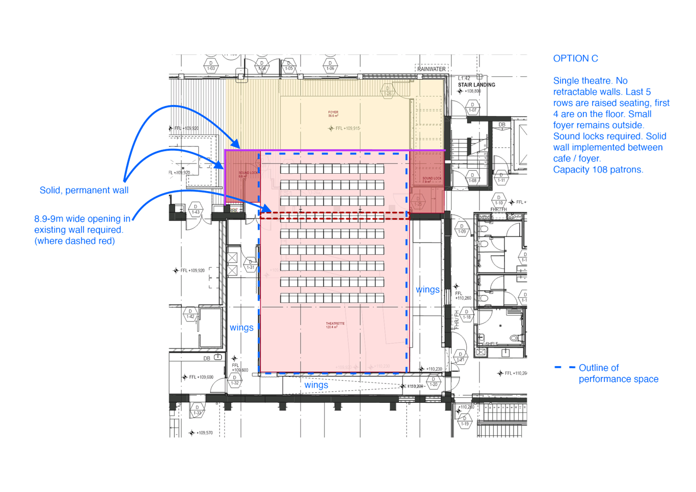
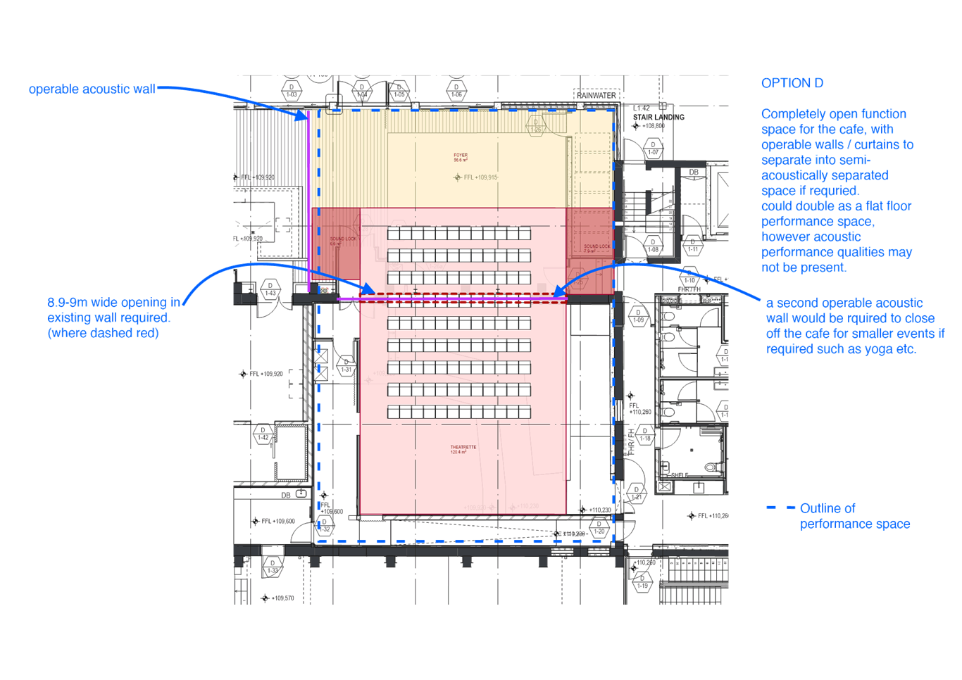
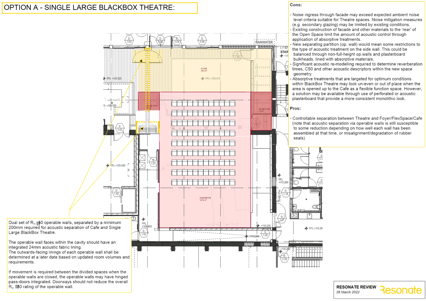
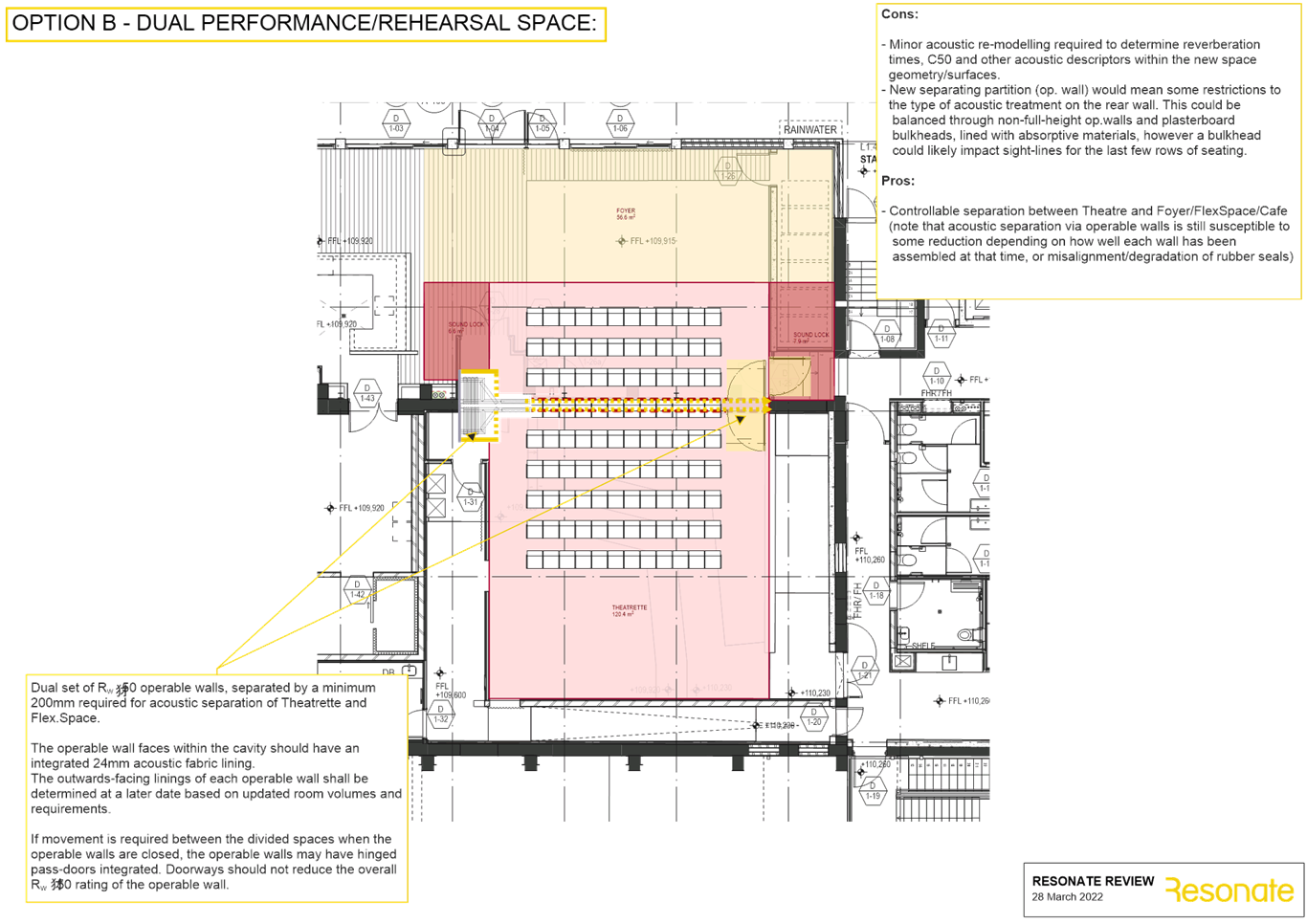
GB.10 Marian
Street Theatre 120
File: S12062-3
To update Council on the Marian
Street Theatre project.
Recommendation:
That Council receives and notes
updates contained within this report and notes the revised cost estimate for
the project.
GB.11 Divestment
of Council land at 47 Warrane Road Roseville Chase 145
File: S09878
To obtain Council approval for
the divestment of 47 Warrane Road, Roseville Chase.
Recommendation:
That Council approves the
divestment of 47 Warrane Road, Roseville Chase following its rezoning in Ku-ring-gai
Local Environmental Plan 2015 and in accordance with Council’s
Acquisition and Divestment of Land Policy and as set out in this report and
that the net proceeds be used to part fund the Marian Street Theatre upgrade.
GB.12 Council land
- 97 Babbage Road Roseville Chase 150
File: S09767
To report back to Council the
conclusions of an independent ecological assessment of 97 Babbage Road,
Roseville Chase.
Recommendation:
That Council proceed with the
divestment of 97 Babbage Road, in accordance with Council’s Acquisition
and Divestment of Land Policy and as set out in this report and that the net
proceeds be used to part fund the Marian Street Theatre upgrade.
GB.13 Ku-ring-gai
High School - Northern Sydney & Beaches Hockey Association Proposal to
Upgrade Existing Facilities 214
File: S13203
The purpose of this report is to
update Council on discussions with Northern Sydney and Beaches Hockey
Association (NSBHA) and the Department of Education in relation to the proposal
for a synthetic hockey pitch at Ku‑ring-gai High School.
Since Council last considered
this matter in July 2021 there have been significant changes to what this
project looks like and how the other parties see Council being involved going
forward.
Recommendation:
That Council determines in
principle that it is prepared to be licensee for the proposed synthetic field, subject
to agreement of suitable terms in a heads of agreement, licence agreement, and
project deed (if necessary) with Schools Infrastructure NSW and quarantines its
contribution to the project until the determination of the 2021/22 Multi-Sport
Community Facility Fund, after which the matter is reassessed.
GB.14 Gilroy Road
Temporary Cycleway - Project Evaluation 236
File: S12998
To consider the status of the
temporary separated cycleway in Gilroy Road, Turramurra.
Recommendation:
That the pop-up cycleway in
Gilroy Road be retained until the integrated 2-way separated cycleway
identified in the Public Domain Plan for Turramurra is constructed.
GB.15 Planning
Proposal for 8a, 14 and 16 Buckingham Road, Killara 257
File: S13022
For Council to consider the
private Planning Proposal that has been lodged for 8a, 14 and 16 Buckingham
Road, Killara.
Recommendation:
That the Planning Proposal, as
amended by this report, be submitted to the Department of Planning and
Environment for a Gateway Determination.
GB.16 Ku-ring-gai
Public Domain Plan - Gordon - Post exhibition 298
File: S12249
To present the draft Ku-ring-gai
Public Domain Plan Volume 2 – Gordon for Council adoption.
Recommendation:
That Council adopts Volume 2
(Gordon) of the Ku-ring-gai Public Domain Plan.
GB.17 Lindfield
Local Centre - Traffic Management Plan 381
File: S12474
To advise Council that Transport
for NSW (TfNSW) has given its concurrence to Council’s preferred traffic
management scheme for Lindfield local centre; and to clarify the basis for
funding and delivery of the proposed traffic management measures.
Recommendation:
That Council note TfNSW
concurrence for Council’s adopted traffic management option and that
Council endorse the funding and delivery recommendations as set out in this
report.
GB.18 Minutes of
the February 2022 Flood Risk Management Committee Meeting 397
File: S10746
For Council to consider and note
the minutes of the Flood Risk Management Committee meeting held on
21 February 2022 (Attachment A1).
Recommendation:
That Council receives and notes
the Minutes of the Flood Risk Management Committee meeting held on
22 February 2022.
Extra Reports Circulated to Meeting
Motions of which due Notice has
been given
NM.1 Illegal tree
removal in Ku-ring-gai 404
File: CY00142/14
Notice
of Motion from Councillors Lennon and Taylor, A dated 7 April 2022
The endemic tree canopy remaining
in Ku-ring-gai is unique in maturity and beauty. Unfortunately, Ku-ring-gai
lost 2.4 percentage points of urban forest cover between 2013 and 2020
according to the Centre for Urban Research at RMIT University and Greener
Spaces Better Places. During the same period, the Northern Beaches increased
urban forest cover by +2.7 points.
One of the critical factors
driving the loss of urban cover in Ku-ring-gai has been the illegal removal of
trees. Council's current activities to address this issue include issuing
penalty notices, criminal investigations, and pursuing consequences through
courts of law. Unfortunately, the current penalty notices are not an effective
deterrent and criminal investigations can be hampered by a lack of evidence.
Council is looking to enhance current measures for pursuing investigations and
preventing illegal removal through community education.
We, therefore, move:
That staff provide a briefing to
councillors and provide a report back to the August 2022 Ordinary Meeting of
Council with additional measures to reduce illegal tree removal.
Recommendation:
That the above Notice of Motion
as printed be adopted.
NM.2 Footpaths in
Ku-ring-gai 405
File: S09113/11
Notice of Motion from Councillor Smith
dated 8 April 2022
During my election campaign I had
the privilege of meeting and listening to members of my community regarding
many issues. One of the key themes I heard was the need for new footpaths to
service our aging population, parents with prams who are developing our next
generation and school children who need safe access to and from their school.
An assessment of the current
footpath network reveals that there is a total of 398km of footpath across the
LGA and sadly St Ives Ward has only 54km. It has been presented to Councillors
that an additional 268km of footpath is required to ensure every street has at
least one footpath.
Council has allocated $5.2m for
footpaths in next year’s draft budget, of which $537,000 is allocated to
new footpaths. This is a moderate increase from previous years however based on
Council’s footpath prioritisation program only 6 streets will benefit
from a newly constructed footpath.
If we are serious about improving
access for our residents then the budget needs to increase substantially.
Modelling shows that it would take about 88 years to build a footpath in every
street if the annual budget was increased to $1m, 71 years if Council spent
$1.25m and 59 years if Council spent $1.5m annually.
In my view, the need for
footpaths is a priority and they need to be built as soon as possible whilst
balancing funding for ongoing maintenance and upgrades.
I, therefore, move:
That all future budgets for new
footpaths be increased to $1.25 million until every street in Ku-ring-gai has
at least one footpath for the benefit of the community. Funding for the new
footpaths is to be allocated from the annual footpath renewal budget which
forms part of the overall footpath budget.
Recommendation:
That the above Notice of Motion
as printed be adopted.
BUSINESS WITHOUT NOTICE – SUBJECT TO CLAUSE 9.3 OF code
of meeting practice
Questions With Notice
QN.1 Account of losses and
recovering costs from Support Marian Street Theatre Committee (or
Philanthropist) resulting from NM3 of 15 February 2022 OMC 407
File: S12062
InspectionS– SETTING OF TIME, DATE AND RENDEZVOUS
Confidential Business to be dealt
with in Closed Meeting
C.1 NSW Heritage
Act 1977
File: S10066
In accordance
with the Local Government Act 1993 and the Local Government (General)
Regulation 2005, in the opinion of the General Manager, the following
business is of a kind as referred to in section 10A(2)(e), of the Act, and
should be dealt with in a part of the meeting closed to the public.
Section 10A(2)(e) of the Act
permits the meeting to be closed to the public for business relating to
information that would, if disclosed prejudice the maintenance of law.
This matter is classified
confidential under section 10A(2)(e) because it
It is not in the public interest
to release this information as it would prejudice the
maintenance of law.
Report by
Manager Urban & Heritage Planning
John McKee
General
Manager
** ** ** ** ** **
Minute Ku-ring-gai
Council Page
MINUTES OF Ordinary Meeting of Council
HELD ON Tuesday, 15 March 2022
|
Present:
|
The Mayor, Councillor J Pettett (Chairperson)
Councillor G Taylor (Comenarra Ward)
Councillors S Lennon & B Ward (Gordon Ward)
Councillors S Ngai & A Taylor (Roseville Ward)
Councillors C Kay & M Smith (St Ives Ward)
Councillor C Spencer & K Wheatley (Wahroonga Ward)
|
|
|
|
|
Staff Present:
|
General Manager (John McKee)
Director Community (Janice Bevan)
Director Corporate (David Marshall)
Director Development & Regulation (Michael
Miocic)
Director Operations (George Bounassif)
Director Strategy & Environment (Andrew Watson)
Corporate Lawyer (Jamie Taylor)
Manager Corporate Communications (Virginia Leafe)
Manager Governance and Corporate Strategy (Christopher M
Jones)
Governance Support Officer/ Minutes Secretary (Nicole
Kratochvil)
|
The Meeting
commenced at 7:00PM
The Mayor offered
the Prayer
DECLARATIONS
OF INTEREST
The Mayor
referred to the necessity for Councillors and staff to declare a Pecuniary
Interest/Conflict of Interest in any item on the Business Paper.
No Interest
was declared.
DOCUMENTS
CIRCULATED TO COUNCILLORS
The Mayor referred to the
documents circulated in the Councillors’ papers and advised that the
following matters would be dealt with at the appropriate time during the
meeting:
|
Refer:
|
MM.1 - Proposed contribution to the NSW flood recovery
effort - Mayoral Minute from the Mayor to Councillors.
GB.9 - Revised Delivery Program 2018-2022 and Operational
Plan 2021-2022: December Biannual Report - Report GB.9 was
circulated previously to Councillors on
4 March 2022. GB.9 replaced report GB.2.
|
|
Memorandums:
|
QN.1- For the purpose of transparency and good governance
- Memorandum from the Director Strategy & Environment dated 10
March 2022 to Mayor, Councillors and General Manager containing a supplementary
answer to the question with notice.
|
|
41
|
Confirmation
of Reports to be considered in closed meeting
File: CY00368/12
|
|
|
.
|
|
|
Resolved:
(Moved: Councillors Spencer/Smith)
That in accordance with the provisions of Section 10 of
the Local Government Act 1993, all officers’ reports be released to the
press and public, with the exception of confidential attachments to the
following General Business reports:
GB.4 Draft Overt Electronic Surveillance in Public
Places Policy
In accordance with 10A(2)(e):
Attachment 2: Lander
& Rogers legal advice
QN.1 For the Purpose of Transparency and Good
Governance
In accordance with 10A(2)(a):
Attachment 3: Attachment
A2 to the Memorandum from Director Strategy & Environment dated 28
February 2022 - Email from the potential philanthropist dated 17 July 2021
CARRIED
UNANIMOUSLY
|
CONFIRMATION
OF MINUTEs
|
42
|
Minutes
of Ordinary Meeting of Council
File: CY00368/12
|
|
|
Meeting held 15 February 2022
Minutes numbered 09 to 40
|
|
|
Resolved:
(Moved: Councillors Wheatley/Ward)
That Minutes numbered 09 to 40 circulated to Councillors
were taken as read and confirmed as an accurate record of the proceedings of
the Meeting.
CARRIED
UNANIMOUSLY
|
minutes
from the Mayor
|
43
|
Proposed
contribution to the NSW flood recovery effort
File: S02727
Vide: MM.1
|
|
|
The last two weeks have been nothing short of devastating
for many areas of our State.
Ku-ring-gai has thankfully been spared the worst of the
flood’s effects, but there are many people in western Sydney who have
suffered great damage and loss.
Losses have been even greater in northern NSW in the
Lismore and Ballina communities, with some heartbreaking stories emerging of
uninhabitable homes, businesses destroyed, and personal possessions lost
forever.
Sadly, people have also lost their lives to the worst
floods in living memory.
The scale of this disaster is such that every level of
government needs to step up and provide assistance. I know that many in our
community are coordinating practical help such as donations, food deliveries
and replacement household goods. Thank you for everything you are doing to
assist those communities in the worst hit areas.
In recognition of the scale of this disaster and the huge
rebuilding effort required, I would like to propose that Ku-ring-gai Council
provide immediate assistance in the form of a $5,000 donation to the
following charities:
$3,000 to GIVIT (all donations go directly to flood
victims)
$1,000 to the Salvation Army
$1,000 to the Red Cross
These charities are providing immediate on the ground
support to those who are in most need.
|
|
|
Resolved:
(Moved: Mayor Pettett)
That Council approve a one-off donation of $5,000 split
between the charities outlined in this Mayoral Minute.
CARRIED
UNANIMOUSLY
|
Recommendations
from Committee
|
44
|
Minutes
of Ku-ring-gai Traffic Committee 23 February 2022
File: CY00022/14
Vide: RC.1
|
|
|
Meeting held 23 February 2022
Minutes numbered KTC01 to KTC03.
|
|
|
Resolved:
(Moved: Councillors Spencer/Wheatley)
That:
A. In
respect to Minutes numbered KTC01 and KTC02, Council adopt the Committee
recommendation.
B. In
respect to Minute numbered KTC03, this is to be brought back to the next
Traffic Committee meeting for review.
CARRIED
UNANIMOUSLY
|
GENERAL
BUSINESS
|
45
|
Investment
Report as at 25 February 2022
File: FY00623/4
Vide: GB.1
|
|
|
To present Council’s investment portfolio
performance for February 2022.
|
|
|
Resolved:
(Moved: Councillors
Spencer/Smith)
That:
A. The summary of investments and performance for February 2022
be received and noted.
B. The Certificate of the Responsible Accounting Officer be
noted and the report adopted.
CARRIED
UNANIMOUSLY
|
|
46
|
Amended
Code of Meeting Practice
File: S02211
Vide: GB.3
|
|
|
To present Council with a draft updated Code of
Meeting Practice consistent with the Office of Local Government’s (OLG)
Circular of 29 October 2021 for consideration and public exhibition.
|
|
|
Resolved:
(Moved: Councillors Spencer/Lennon)
That:
A. Pursuant
to section 361 of the Local Government Act 1993, Council place the draft Code
of Meeting Practice in Attachment A1 on public exhibition for 28 days.
B. A
report be brought to Council in June 2022 summarising the public response and
providing a final version of the draft Code of Meeting Practice, for
adoption.
CARRIED
UNANIMOUSLY
|
|
47
|
Draft
Overt Electronic Surveillance in Public Places Policy
File: S13433
Vide: GB.4
|
|
|
To seek Council’s endorsement of a draft
Overt Electronic Surveillance in Public Places Policy for the purposes of
public exhibition.
|
|
|
Resolved:
(Moved: Councillors Spencer/Wheatley)
A. That
Council endorse the revised draft Overt Electronic
Surveillance in Public Places Policy (dated February 2022) for public
exhibition and that the results of the exhibition are reported back to
Council prior to finalising the document.
CARRIED
UNANIMOUSLY
|
|
48
|
Draft
Middle Harbour Southern Catchments Flood Study for Public Exhibition
File: S12267
Vide: GB.5
|
|
|
To place the Draft Middle Harbour –
Southern Catchments Flood Study on public exhibition.
|
|
|
Resolved:
(Moved: Councillors Spencer/Ward)
A. That
Council places Draft Middle Harbour – Southern Catchments
Flood Study on public exhibition for a period of 28 days.
B. That
all properties identified on the Mainstream and Overland Flood Planning Area
and Probable Maximum Flood maps in the Draft Middle Harbour –
Southern Catchments Flood Study are directly notified about the public
exhibition.
C. That
following the public exhibition period, feedback is provided to BMT to inform
the final Middle Harbour – Southern Catchments Flood Study.
D. That
the final Middle Harbour – Southern Catchments Flood Study
is presented to Council for endorsement, with any amendments and corrections.
CARRIED
UNANIMOUSLY
|
|
49
|
Water
Sensitive City Strategy and Policy – Post exhibition
File: S13479
Vide: GB.6
|
|
|
For Council to adopt the exhibited Water Sensitive
City Policy (2021) and draft Ku-ring-gai Water Sensitive City
Strategy (2022) with amendments as outlined in this report.
|
|
|
Resolved:
(Moved: Councillors Spencer/Smith)
A. That Council
endorses the Water Sensitive City Policy (2021) with amendments
as outlined in this report.
B. That Council
endorses the Ku-ring-gai Water Sensitive City Strategy (2022)
with amendments as outlined in this report and to produce a graphic designed
document suitable for Council’s website.
C. That a copy of
the endorsed policy and strategy are placed on Council’s website.
CARRIED
UNANIMOUSLY
|
|
50
|
Ku-ring-gai
Public Domain Plan - Volume 1, Volume 2 - Turramurra, Volume 3
File: S12249
Vide: GB.7
|
|
|
To present the draft Ku-ring-gai Public Domain Plan
Volume 1, Volume 2 (Turramurra only) and Volume 3 for Council adoption.
|
|
|
Resolved:
(Moved: Councillors Spencer/Smith)
A. It
is recommended that Council adopt Volume 1, Volume 2 (Turramurra), and Volume
3 (Technical Manual) of the Draft Ku-ring-gai Public Domain Plan as
attached to this report.
CARRIED
UNANIMOUSLY
|
|
|
Revised
Delivery Program 2018-2022 and Operational Plan 2021-2022 - December
Bi-Annual Report
File: FY00382/14
Vide: GB.2
|
|
|
To report to Council on the progress of the Revised
Delivery Program 2018-2022 and Operational Plan 2021-2022, for the six month
period July to December 2021.
|
|
|
Recommendation:
That the results for the December 2021 six month progress
and exception report for the Delivery Program 2018-2022 and Operational Plan
2021-2022 be received and noted.
Note: Please refer to item GB.9
which replaced item GB.2.
|
|
51
|
Revised
Delivery Program 2018-2022 and Operational Plan 2021-2022: December Biannual
Report
File: FY00382/14
Vide: GB.9
|
|
|
To report to Council on the progress of the Revised
Delivery Program 2018-2022 and Operational Plan 2021-2022, for the period
July to December 2021.
|
|
|
Resolved:
(Moved: Councillors Spencer/Smith)
That:
A. The six (6)
month progress review of the Revised Delivery Program 2018-2022 and
Operational Plan 2021-2022 for the period July to December 2021 be received
and noted.
B. Proposed
additions and changes to 2021-22 tasks, as discussed and recommended in this
report, to be included in the Operational Plan 2021-2022.
CARRIED
UNANIMOUSLY
|
|
52
|
Employment
Zones Reform
File: S12792
Vide: GB.8
|
|
|
To inform Council of the Employment Zones Reform that
is currently being undertaken by the Department of Planning and Environment.
|
|
|
Resolved:
(Moved: Councillors Smith/Spencer)
That Council write to the local state Members of
Parliament expressing Council’s concerns with the proposed amalgamation
of the B1 local centre zone with the B2 neighbourhood centre zone.
CARRIED
UNANIMOUSLY
|
Motions
of which due Notice has been given
|
53
|
Walkway
in Turramurra
File: S02444/14
Vide: NM.1
|
|
|
Notice
of Motion from Councillor Wheatley dated 24 February 2022
Dr Lydie Nashar is an active member of the local community
in Turramurra. On Thursday, February 17, I was privileged to meet Lydie and
inspect her work in the walkway between Princes Street and Avalon Street and
part of the walkway from Avalon Street to Pentecost Avenue, Turramurra.
Her motivation and vision have been prompted by her
passion for gardens and desire to create a tranquil and beautiful space for
the enjoyment of the neighbourhood. Lydie has been upgrading this walkway
since 1991 at her own expense and in her own time. During the visit, I was
approached by many residents who genuinely believed that the walkway should
be named after Lydie.
As I understand it, there are strict guidelines set by the
Geographical Names Board about naming public places and that it would
unfortunately not meet the criteria. I do strongly agree with the local
residents that recognition should be given to Lydie for her service to the
local community in beautifying this area.
I, therefore, move:
That the General Manager investigate options available for
onsite recognition to acknowledge Dr Lydie Nashar for her efforts in
establishing and beautifying this walkway.
|
|
|
Resolved:
(Moved: Councillors Wheatley/A. Taylor)
That the above Notice of Motion as printed be adopted and
that options be brought back to Council at the May 2022 ordinary meeting of
council.
CARRIED
UNANIMOUSLY
|
|
54
|
Marian
Street Theatre Design
File: S12062
Vide: NM.2
|
|
|
Notice
of Motion from Councillors Lennon, Pettett and Ward dated 25 February 2022
On 15 February 2022 Council resolved as follows:
That Council suspend, for a
maximum of three months, work by Council staff and consultants associated
with the current proposed design of the Marian Street Theatre. The delay will
enable the Save Marian Street Theatre Committee in consultation with local
residents with expertise in commercial theatre and experts known to them to
review the current proposed design of the theatre and to bring any
suggestions they make as a result of that review to Council.
This motion seeks authority for Council staff and other
resources to be assigned to the review.
We, therefore, move:
A. That
staff work with the Deputy Mayor Cr Ward and Cr Lennon to consult with the
Save Marian Street Theatre Committee and other interested parties to review
the design of the Marian Street Theatre.
B. That
consultants be made available as required to facilitate the review.
C. That
the review be undertaken urgently, and staff provide a progress report to the
Ordinary Meeting of Council on 26 April 2022.
D. That
work on further developing and documenting the current proposed design remain
suspended until the review has been reported to Council.
|
|
|
Resolved:
(Moved: Councillors Pettett/Smith)
A.
That Council rescinds its decision of 15
February 2022 Council “That Council suspend, for a maximum of three
months, work by Council staff and consultants associated with the current
proposed design of the Marian Street Theatre. The delay will enable the Save
Marian Street Theatre Committee in consultation with local residents with
expertise in commercial theatre and experts known to them to review the
current proposed design of the theatre and to bring any suggestions they make
as a result of that review to Council.”
B. That
detailed documentation of the project continues in the same manner that was
occurring prior to 15 February 2022.
For the
Resolution: The
Mayor, Councillor Pettett, Councillors Kay, Ngai, Smith, Spencer and Wheatley
Against
the Resolution: Councillors
Lennon, A. Taylor, G. Taylor and Ward
CARRIED
|
QUESTIONS WITH NOTICE
|
|
For
the Purpose of Transparency and Good Governance
File: S12062
Vide: QN.1
|
|
|
QUESTION:
Question from Councillor for Wahroonga Ward Councillor
Cedric Spencer dated 25 February 2022
For the purpose of transparency and good governance,
will the General Manager provide a report for Councillors
with details and timeline in relation to the dealings of Marian Street
Theatre involving the so called philanthropist (or "investor"),
Councillor Ward, staff, other councillors, and certain Committee Members of
Support Marian Street Theatre?
Dealings should include activities and representations
made by the various parties during and before this term of council, as
Director Watson stated at the February OMC that Councillor Ward had brought
the philanthropist investor to meet with him and former Mayor Anderson before
this term.
RESPONSE:
The response consisted of the three attachments (A1-A3) in
the Ordinary Meeting of Council Agenda. An additional memorandum was provided
to the Mayor, Councillors and General Manager:
Supplementary
Answer by Director Strategy & Environment
At
the OMC of Council being held on 15 March 2022, Councillor Spencer raised the
following Question With Notice:
will the General Manager provide a report for Councillors
with details and timeline in relation to the dealings of Marian Street
Theatre involving the so called philanthropist (or "investor"),
Councillor Ward, staff, other councillors, and certain Committee Members of
Support Marian Street Theatre?
Dealings should include activities and representations
made by the various parties during and before this term of council, as
Director Watson stated at the February OMC that Councillor Ward had brought
the philanthropist investor to meet with him and former Mayor Anderson before
this term.
Further
to memorandum dated 28 February 2022 in relation to this matter, former Mayor
Anderson has advised that her recollection of events is different to those
put forward in that memorandum, and that there was no longstanding
relationship, with the potential philanthropist. The former Mayor also
advises that, among other things, her referral of the matter to the General
Manager was because the matter was Operational in nature.
Former
Mayor Anderson confirmed that there had been no meeting or telephone contact
between herself and the potential philanthropist on this matter.
|
The Meeting closed
at 8.11PM
The Minutes of the
Ordinary Meeting of Council held on 15 March 2022 (Pages 1 - 24) were confirmed
as a full and accurate record of proceedings on 26 April 2022.
__________________________ __________________________
General
Manager Mayor
/ Chairperson
|
Ordinary
Meeting of Council - 26 April 2022
|
PT.1 / 1
|
|
|
|
|
Item
PT.1
|
S13316
|
Petition
supporting Council's planning proposal to rezone this site (Killara Lawn Tennis
Bowling Club) RE2 and list the site as a local heritage item
Dear Sir
I strongly support maintaining the recreational area with
RE2 zoning.
I have been a member of Killara Bowling Club for over 10
years and a resident since 1968 and until recently lived a stone throw from the
wonderful green oasis that is the Bowling Club and Tennis Club. I have been
appalled at the spread of redevelopment of the region, the loss of trees and
the lack of attention to gardens that was once a feature of the area. I am also
well aware of the historic nature of the “Recreation Area” created
by J.G. Edwards, the “father of Killara” and I am strongly in
favour of maintaining this area i.e. the Bowling Club and Tennis Club as a
recreational oasis in Killara.
I am NOT in favour of the proposal put forward by some
members of the Bowling Club to sell off the bowling Club land to finance
another bowling club and strongly support the proposal to merge with the Tennis
Club.
In summary as a resident of over 50 years, I am strongly in
favour of the zoning category of RE2 – never to be developed as
residential.
I actually spoke at the public forum on November 9, 2021 on
the heritage aspect of the site, all three of us who spoke favoured the site
being heritage listed.
Back in 2007 I did a Heritage course run jointly by Council
and the Historical Society. To learn the ropes the study centred on Gordon but,
having lived and worked in Killara for over 50 years, I started an intense
study of the May25/1831 land grant of 160 acres that forms the heart of Killara
and which includes the Bowling and Tennis clubs site.
I have written articles for the Historian – my article
on Marian St alone is 21 pages long and over the years I have also given talks
on the subject. From the beginning JG Edwards called the site ‘Killara
Recreation Ground’.
At a meeting on February 25, 2022 at KBC of which I am a
member, there were three letters for us to select one and sign and they were
also taking signatures from members who wished to oppose Council’s
proposal. There was nothing to take or sign if you wished to agree to the
proposal.
I feel so strongly about all this I decided to collect some
signatures of those living in the area who want to agree to Council’s
proposal. Hence the attached 315 signatures.
Recommendation:
That the petition be received and referred to the
appropriate Officer of Council for attention.
|
Ordinary
Meeting of Council - 26 April 2022
|
GB.1 / 1
|
|
|
|
|
Item
GB.1
|
FY00623/4
|
|
|
6 April 2022
|
Investment Report as at 31 March 2022
EXECUTIVE
SUMMARY
|
PURPOSE OF REPORT:
|
To present Council’s
investment portfolio performance for March 2022.
|
|
|
|
|
background:
|
Council’s investments are reported monthly to
Council in accordance with the Local Government Act 1993, the Local
Government (General) Regulation 2005 and Council’s Investment Policy.
|
|
|
|
|
comments:
|
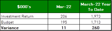
The net return on investments for the financial year
to end of March 2022 was $1,973,000, against an annual budget of $1,713,000
giving a year-to-date favourable variance of $260,000.
|
|
|
|
|
recommendation:
|
That the summary of investments performance
for March 2022 be received and noted; and that the Certificate of the
Responsible Accounting Officer be noted and the report adopted.
|
Purpose of Report
To present Council’s investment portfolio performance
for March 2022.
Background
Council’s investments are reported monthly to Council
in accordance with the Local Government Act 1993, the Local Government
(General) Regulation 2005 and Council’s Investment Policy.
Comments
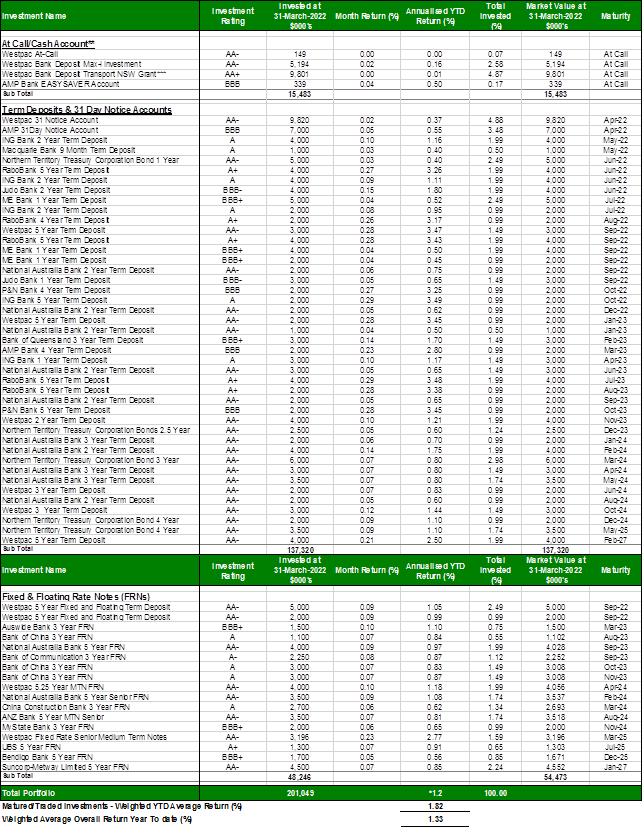
Investment Portfolio Performance Snapshot
The table below provides the investments portfolio
performance against targets identified in Council’s Investment Policy as
well as other key performance indicators based on industry benchmarks.
Cumulative
Investment Returns against Budget
The net return on investments for the financial year to the
end of March 2022 was $1,973,000 against an annual budget of $1,713,000 giving
a year-to-date favourable variance of $260,000 as shown in the table below.
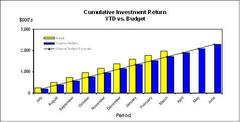
A comparison of the
cumulative investment returns against year to date budget is shown in the Chart
below.
Cash
Flow and Investment Movements
Council’s total cash and
investment portfolio at the end of March was $201,049,000 compared to
$202,231,000 at the end of February 2022, a net cash outflow of $1,182,000 due
to creditor payments.
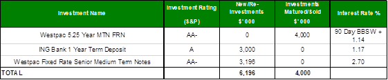
One investment has matured
during the month of March 2022. Two new investments were made.
Investment
Performance against Industry Benchmark
Overall during the month of
March the investment performance was above the industry benchmark. The
benchmark is specific to the type of investment and the details are provided
below. AusBond Bank Bill Index is used for all Council’s investments.
Table 1 -
Investments Performance against Industry Benchmarks

Table 2
below provides a summary of all investments by type and performance during the
month.
Table
2 - Investments Portfolio Summary during March 2022
*
Weighted average returns
**
Funds in at-call/short term accounts are working funds kept for the purpose of
meeting short term cash outflows. At the time of investing interest
rates were comparable or more competitive to other equivalent investments.
At-call investments portfolio is being monitored on a regular basis to ensure
funds are reinvested at higher rates when opportunities arise, whilst also
keeping and adequate balance for short-term cash outflows.
***
During December 2021, Council received a $9.8M grant from Transport NSW for
Lindfield Village Hub Car Park. As part of the grant’s terms &
conditions, Council is required to keep the funds in an independent at call
account for audit purposes.
Investment
by Credit rating and Maturity Profile
The allocation of
Council’s investments by credit rating and the maturity profile are shown
below:
integrated
planning and reporting
Leadership & Governance
|
Community Strategic Plan Long Term Objective
|
Delivery Program
Term Achievement
|
Operational Plan
Task
|
|
L2.1 Council rigorously manages its financial resources
and assets to maximise delivery of services
|
Council maintains and improves its long term financial
position and performance
|
Continue to analyse opportunities to expand the revenue
base of Council
|
Governance
Matters
Council’s investments are made in accordance with the
Local Government Act (1993), the Local Government (General) Regulation 2005 and
Council’s Investment Policy.
Section 212 of the Local Government (General) Regulation
2005 states:
(1) The
responsible accounting officer of a council:
(a) must
provide the council with a written report (setting out details of all money
that the council has invested under section 625 of the Act) to be presented:
(i) if
only one ordinary meeting of the council is held in a month, at that meeting,
or
(ii) if
more than one such meeting is held in a month, at whichever of those meetings
the council by resolution determines, and
(b) must
include in the report a certificate as to whether or not the investment has
been made in accordance with the Act, the regulations and the council’s
investment policies.
(2) The report must be made up to
the last day of the month immediately preceding the meeting.
Risk
Management
Council manages the risk associated with investments by
diversifying the types of investment, credit quality, counterparty exposure and
term to maturity profile.
Council invests its funds in accordance with The Ministerial
Investment Order.
All investments are made with consideration of advice from
Council’s appointed investment advisor, CPG Research & Advisory.
Financial
Considerations
The budget for interest on investments for the financial
year 2021/2022 is $2,292,000. Of this amount approximately $1,539,300 is
restricted for the benefit of future expenditure relating to development contributions,
$273,900 transferred to the internally restricted Infrastructure & Facility
Reserve, and the remainder of $478,800 is available for operations.
Social Considerations
Not applicable.
Environmental Considerations
Not applicable.
Community
Consultation
None undertaken or required.
Internal
Consultation
None undertaken or required.
Certification -
Responsible Accounting Officer
I hereby certify that the investments listed in the attached
report have been made in accordance with Section 625 of the Local Government
Act 1993, clause 212 of the Local Government General Regulation 2005 and
Council’s Investment Policy.
Summary
As at 31
March 2022:
· Council’s
total cash and investment portfolio is $201,049,000.
· The
net return on investments for the financial year to March 2022 was $1,973,000
against an annual budget of $1,713,000, giving a YTD favourable variance of
$260,000.
|
Recommendation:
That:
A. The summary of investments and performance for March 2022 be
received and noted.
B. The Certificate of the Responsible Accounting Officer be
noted and the report adopted.
|
|
Tony Ly
Financial Accounting Officer
|
Angela Apostol
Manager Finance
|
|
David Marshall
Director Corporate
|
|
|
Ordinary
Meeting of Council - 26 April 2022
|
GB.2 / 1
|
|
|
|
|
Item
GB.2
|
CY00440/10
|
|
|
2 March 2022
|
Disclosures of Interest Returns
EXECUTIVE
SUMMARY
Purpose of Report
To table Council’s Disclosure of Interest Returns
Register in accordance with Schedule 1 of the Ku-ring-gai Council Code of
Conduct (the Code).
Background
The Code places specific obligations on Councillors, council
delegates and council staff involved in making decisions or giving advice on
council matters to act honestly and responsibly in carrying out their
functions.
Councillors and designated persons need to complete and
lodge a written disclosure of interest return. The form of the return is
prescribed in Schedule 2 of the Code of Conduct. This obligation to lodge
returns is a protection for Councillors, designated persons and the community.
The results of Council elections were announced on 21
December 2021, and Councillors must complete and lodge a Disclosure of Interest
return within 3 months of becoming a Councillor (i.e. 21 March 2022).
Comments
Returns were received from all Councillors and designated
persons, and have been collated into a register.
Under the Code of Conduct, the General Manager must table
the register of returns at the first meeting after the lodgement date. Councils
must make it available for inspection to any member of the public upon request,
in accordance with the Government Information (Public Access) Act 2009.
integrated planning and reporting
Leadership and Governance
|
Community Strategic Plan Long Term Objective
|
Delivery Program
Term Achievement
|
Operational Plan
Task
|
|
The organisation is recognised and distinguished by its
ethical decision-making, efficient management, innovation and quality
customer service.
|
Council's Governance framework is developed to ensure
probity and transparency.
|
Comply with the requirements of the Local Government Act
and Regulations.
|
Governance Matters
Clause 4.23 of the Code of Conduct (the Code) requires the
lodgement of returns disclosing interests of Councillors and designated
persons.
Risk Management
Disclosure of pecuniary interests is an important element of
Council’s risk management framework by mitigating against behaviours
likely to bring Council into disrepute, improper or unethical behaviours, or
misuse of position to obtain private benefits.
Summary
The Code places specific obligations on Councillors, council
delegates and council staff involved in making decisions or giving advice on
council matters to act honestly and responsibly in carrying out their
functions.
Councillors and designated persons need to complete and
lodge a written disclosure of interest return. The form of the return is
prescribed in Schedule 2 of the Code of Conduct.
Under the Code of Conduct, the General Manager must table
the register of returns at the first meeting after the lodgement date. Council
must make the register available for inspection to any member of the public
upon request.
|
Recommendation:
That the tabling of the Disclosure of Interest Returns
Register be noted.
|
|
Nicole Kratochvil
Governance Support Officer
|
Christopher M Jones
Manager Governance & Corporate Strategy
|
|
Ordinary
Meeting of Council - 26 April 2022
|
GB.3 / 1
|
|
|
|
|
Item
GB.3
|
CY00458/10
|
Minutes of Audit, Risk & Improvement
Committee meetings held on 10 June 2021 and 2 September 2021
EXECUTIVE
SUMMARY
Purpose of Report
To provide Council with a copy of the Minutes from the
Audit, Risk & Improvement Committee meetings held on 10 June 2021 and 2
September 2021.
Background
The Audit, Risk & Improvement Committee resolved to
provide Council with a copy of the adopted Minutes.
Comments
The Minutes of the Audit, Risk & Improvement Committee
are provided to Council for information.
integrated planning and reporting
Leadership and governance
|
Community Strategic
Plan Long Term Objective
|
Delivery Program
Term Achievement
|
Operational Plan
Task
|
|
The organisation is recognised
and distinguished by its ethical decision-making, efficient management,
innovation and quality customer service.
|
Integrated risk management, compliance and internal
control systems are in place to identify, assess, monitor and manage risks
throughout the organisation.
|
Manage, coordinate, support and facilitate the effective
operation of Council's Internal Audit function.
|
Governance Matters
To improve governance and transparency with respect to the
operation of the Audit, Risk & Improvement Committee.
Risk Management
There are no risk management considerations associated with
this report.
Financial Considerations
There is no financial impact associated with this report.
Social Considerations
There are no social
implications associated with this report.
Environmental Considerations
There are no environmental implications associated with this
report.
Community Consultation
Not applicable.
Internal Consultation
Not applicable.
Summary
A copy of the Minutes from
the Audit, Risk & Improvement Committee meetings held on 10 June 2021 and 2
September 2021 are attached.
|
Recommendation:
Council receive and note the contents of this report.
|
|
Jennie Keato
Manager People and Culture
|
|
|
Attachments:
|
A1 ⇩ ⇩
|
Audit
Risk & Improvement Committee Minutes 10 June 2021
|
|
2022/101656
|
|
|
A2⇩
|
Audit
Risk & Improvement Committee Minutes 2 September 2021
|
|
2022/101659
|
|
APPENDIX No: 1 - Audit
Risk & Improvement Committee Minutes 10 June 2021
|
|
Item No: GB.3
|
|
APPENDIX
No: 2 - Audit
Risk & Improvement Committee Minutes 2 September 2021
|
|
Item No: GB.3
|
|
Ordinary
Meeting of Council - 26 April 2022
|
GB.4 / 1
|
|
|
|
|
Item
GB.4
|
CY00368/12
|
|
|
8 April 2022
|
The Novus Foundation 2022 Gala Dinner
EXECUTIVE
SUMMARY
|
purpose of report:
|
To advise Council of the
opportunity to purchase tickets for the Novus Foundation Gala Dinner on 27
May 2022.
|
|
|
|
|
background:
|
The Novus Foundation is a collaboration of the
McCarroll Automotive Group and the Rotary Club of Wahroonga. The
Foundation’s role is to develop and support local projects directed at
the welfare of youth.
Council has been associated with the Novus Foundation
for a number of years, and (prior to COVID) supported the event by purchasing
a sponsorship table each year.
|
|
|
|
|
comments:
|
Proceeds from the Novus Foundation fundraising in 2022
will support Stepping Stone House, StreetWork and beCentre in collaboration
with Rotary Club of Wahroonga.
Individual tickets for the dinner are $179.88 per
person and sponsorship packages (tables of 10) are available for $3,500,
$5,700 and $11,000.
|
|
|
|
|
recommendation:
|
That:
A. Council purchase
a sponsorship package of a table of 10 tickets for the Novus Foundation 2022
Gala Dinner for $3,500; and
B. Councillors who
are interested in attending the dinner advise the General Manager by 6 May
2022.
|
Purpose of Report
To advise Council of the opportunity to purchase tickets for
the Novus Foundation Gala Dinner on 27 May 2022.
Background
The Novus Foundation is a collaboration of the McCarroll
Automotive Group and the Rotary Club of Wahroonga. The Foundation’s role
is to develop and support local projects directed to youth welfare.
The foundation’s major fundraising event is the annual
Gala Dinner, to be held on 27 May this year. Between 500 and 600 people
regularly attend this dinner supported by the community and local businesses.
The foundation has raised more than $1.8 million for beneficiaries over the
last 14 years.
Council has been associated with the Novus Foundation for a
number of years, and (prior to COVID) supported the event by purchasing a
sponsorship table each year.
Comments
The Novus Foundation will be holding a Gala Dinner on
Saturday 27 May 2022 at Miramare Gardens Function Centre, Terrey Hills. The
Novus Foundation’s beneficiaries for 2022 are:
· Stepping Stone
House: Stepping Stone House provides homeless and at-risk youth with
accommodation and personal development to help them become independent and the
very best they can be. It focuses on wellness, skills for life and emotional
resilience to build children and young people’s wellbeing and independence.
· be Centre:
be Centre supports children and families whose lives have been impacted by
trauma such as domestic violence, physical or sexual abuse, neglect or other
serious life challenges.
· StreetWork: StreetWork
aims to change the lives of at-risk disadvantaged youth in Sydney’s
North, aiming to break the cycle of crime, destructive family relationships,
rejection and isolation, learning difficulties, substance abuse and more.
Individual tickets for the Gala Dinner are $179.88 (ticket
plus booking fee) per person and sponsorship packages (tables of 10) are
available for $3,500, $5,700 and $11,000.
Further information can be found on the website: https://www.novusfoundation.org.au/
integrated
planning and reporting
|
Community Strategic Plan Long Term Objective
|
Delivery Program
Term Achievement
|
Operational Plan
Task
|
|
An equitable and inclusive community that cares and
provides for its members.
|
Access has increased for communities that face barriers to
using social services and facilities.
|
Implement priority recommendations and programs from
Council’s Youth Strategy.
|
Governance
Matters
Attendance at functions and events are provided for in the
Councillor Expenses and Facilities Policy, including attendance by accompanying
persons.
Risk
Management
No significant risks.
Financial
Considerations
Under the Councillor Expenses
and Facilities Policy, Council will meet the reasonable cost of attendance at
functions and events held by charities and community organisations relevant to
the LGA or Council’s wider interest.
Social
Considerations
By supporting the Novus Foundation, Council is contributing
to the health and welfare of youth in the local community. Attendance at the
Gala Dinner will enable Councillors to meet members of the community and learn
about individual projects from representatives of various community
organisations.
Environmental
Considerations
Nil
Community
Consultation
Nil
Internal
Consultation
Nil
Summary
Council has the opportunity to
purchase tickets for the Novus Foundation Gala Dinner to be held on 27 May 2022
at Miramare Gardens Function Centre at Terrey Hills. This supports
Council’s commitment to a more equitable and inclusive community that
cares and provides for its members.
|
Recommendation:
That:
A. Council
purchase a sponsorship package of a table of 10 tickets for the Novus
Foundation 2022 Gala Dinner for $3,500; and
B. Councillors
who are interested in attending the dinner advise the General Manager by
Friday 6 May 2022.
|
|
Christopher M Jones
Manager Governance & Corporate Strategy
|
Nicole Kratochvil
Governance Support Officer
|
|
David Marshall
Director Corporate
|
|
|
Ordinary
Meeting of Council - 26 April 2022
|
GB.5 / 1
|
|
|
|
|
Item
GB.5
|
S13365
|
Integrated Planning and Reporting - Plans
for Public Exhibition
EXECUTIVE
SUMMARY
|
purpose of report:
|
To note that Council will be
required publicly exhibit the Draft Community Strategic Plan (CSP),
Resourcing Strategy, Delivery Program and Operational Plan, prepared under
the NSW Office of Local Government’s (OLG) Integrated Planning and
Reporting Framework.
|
|
|
|
|
background:
|
The NSW Local Government Act 1993 requires Council to
review its CSP following election of a new Council. Council must also have a
long-term Resourcing Strategy outlining the resources required to perform its
functions and strategies set out in the CSP. Council must also establish a
new Delivery Program after each election to cover the principal activities of
the Council over its term, and an Operational Plan must be adopted before the
beginning of each financial year.
|
|
|
|
|
comments:
|
Council is developing its plans incorporating
community feedback on priorities and aspirations, in consideration of local
environmental, economic and civic leadership issues, social justice
principles, and relevant State, metropolitan and regional plans.
To allow for Council’s IP&R documentation
to reflect a potential variation to general income under guidelines only
released last week, Council’s Community Strategic Plan and supporting
plans will be circulated and published as late papers prior to the April
Ordinary Meeting of Council.
|
|
|
|
|
recommendation:
|
That Council note that
Council’s Community Strategic Plan and supporting plans will be
circulated and published as late papers.
|
Purpose of Report
To note that Council will be required publicly exhibit the
Draft Community Strategic Plan (CSP), Resourcing Strategy, Delivery Program and
Operational Plan, prepared under the NSW Office of Local Government’s
(OLG) Integrated Planning and Reporting Framework.
Background
The NSW Local Government Act 1993 requires Council to review
its CSP following election of a new Council. Council must also have a long-term
Resourcing Strategy outlining the resources required to perform its functions
and strategies set out in the CSP. Council must also establish a new Delivery
Program after each election to cover the principal activities of the Council
over its term, and an Operational Plan must be adopted before the beginning of
each financial year.
Comments
The Independent Pricing and Regulatory Tribunal (IPART) is
accepting an additional round of 2022-23 Special Variation (ASV) applications
from councils regarding the rate peg assumed for the year. IPART’s
guidelines were not released until 6 April 2022 (ref: Council Circular 22-07),
but will have a significant impact on Council’s resourcing strategy and
other plans.
To allow for Council’s IP&R documentation to
reflect a potential variation to general income, Council’s Community
Strategic Plan and supporting plans will therefore be circulated and published
as late papers prior to the April Ordinary Meeting of Council.
integrated planning and reporting
Leadership and Governance
|
Community Strategic
Plan Long Term Objective
|
Delivery Program
Term Achievement
|
Operational Plan
Task
|
|
A shared long-term vision for Ku-ring-gai underpins
strategic collaboration, policy development and community engagement.
|
The priorities of our community are reflected in the
Ku-ring-gai Community Strategic Plan and inform Council’s policy
development, decision-making and program delivery.
|
Prepare, exhibit and adopt a revised Community Strategic
Plan for Ku-ring-gai in response to identified community and strategic
priorities, challenges and opportunities.
|
Governance Matters
Section 402 of the Local Government Act 1993 requires that
Council have a Community Strategic Plan (CSP) that has been developed and
endorsed by the Council.
Section 403 of the Act requires that Council have a long
term Resourcing Strategy for the provision of resources required to implement
the strategies in the CSP. The Resourcing Strategy includes long-term financial
planning, asset management planning and workforce management.
Section 404 requires Council to prepare a Delivery Program
to implement the strategies established in the CSP, within the resources
identified under the Resourcing Strategy. Section 405 requires Council to have
an Operational Plan that details activities to be pursued during the year as
part of the Delivery Program.
Risk Management
Integrated Planning and Reporting
is a core element of Council’s risk management framework, by
demonstrating effective financial and asset management policy and processes,
and the rationale and implications of funding decisions. It also provides a
framework for identifying, managing and reporting risks.
Financial Considerations
Council’s Resourcing Strategy will identify the
resources required to implement the long-term objectives in the CSP. It will
include long-term financial planning, workforce management planning and asset
management planning. The Long-Term Financial Plan will include:
· projected income
and expenditure, balance sheet and cash flow statement
· the planning
assumptions used to develop the plan
· sensitivity
analysis highlighting factors and assumptions most likely to affect the plan,
and financial modelling for different scenarios.
Community Consultation
The draft CSP has been informed by
community research, engagement and consultation. A summary of community
feedback from initial engagement and consultation activities will be included
in a Discussion Paper supporting the release of the CSP. Council will
communicate the release of the draft plans through its communications channels
to raise awareness and encourage feedback through the public exhibition period.
Internal Consultation
Councillors have been consulted on
the vision and long-term objectives in the CSP, and priorities for this term of
Council for inclusion in the Delivery Program.
Summary
The NSW Local Government Act 1993 requires Councils and
communities to review their Community Strategic Plan (CSP) following election
of a new Council. All councils must also have a long-term Resourcing Strategy
outlining the resources required to perform its functions and strategies set
out in the CSP. Councils must also establish a new Delivery Program after each
election to cover the principal activities of the council over its term.
To allow for Council’s IP&R documentation to
reflect a potential variation to general income under guidelines only released
last week, Council’s Community Strategic Plan and supporting plans will
be circulated and published as late papers prior to the April Ordinary Meeting
of Council.
Recommendation:
That Council note that Council’s Community Strategic
Plan and supporting plans will be circulated and published as late papers.
|
Helen Lowndes
Integrated Planning Coordinator
|
Christopher M Jones
Manager Governance & Corporate Strategy
|
|
Ordinary
Meeting of Council - 26 April 2022
|
GB.6 / 1
|
|
|
|
|
Item
GB.6
|
FY00621/4
|
EXECUTIVE
SUMMARY
Purpose of Report
To provide Council with the Project Status Report reflecting
results for January, February, and March 2022.
Background
On 22 May 2018, a Notice of Motion (NOM) was considered by
Council regarding the development of a monthly Project Status Report. As
a result, Council resolved the following:
A. That
a Capital and Operational Projects Report is to be tabled at an ordinary
meeting of council each month. The reporting will commence in FY19 with a
report for the period of July 2018.
B. That
the report should include any progress made in the month as well as a progress
summary for the financial year to date. Where there has been no progress in the
month, it is acceptable to acknowledge that nothing has progressed. And where a
project has yet to commence, it is acceptable to note the expected start date.
C. That
council staff may use their discretion in deciding whether any additional
columns of information should be presented.
D. That
the reported projects should include, but are not limited to, those that are
mentioned in Council’s Delivery Program and Operational Plan. For
brevity, council staff may choose to aggregate some projects or set a
reasonable threshold for reporting purposes.
E. That
the current and historical monthly reports should be easily found on the
Ku-ring-gai Council website (i.e. not just through searching council agenda
items). One possibility is to create a page for the monthly Capital and
Operational Projects Reports under “Current works and upgrades”.
F. That
after the first six months of the report, the Councillors and Directors should
discuss whether the frequency of the report should be adjusted.
On 14 May 2019, Council resolved to extend the reporting
timeframe from monthly to a quarterly report:
C.
That the reporting timeframe be changed from monthly to quarterly
In accordance with Part A of the NOM of 22 May 2019, the
attached report is for the period January, February
and March 2022.
Comments
Reporting on projects is currently undertaken through:
· Quarterly
Financial Reports;
· Bi-annual reports
on the progress of the Delivery Program & Operational Plan; and
· Annual Report.
On 14 May 2019, a Council decision altered the reporting
timeframe for the Project Status Report from a monthly to quarterly.
It was noted that while projects are reported to Council and
the community through other statutory reports, the frequency of quarterly
reporting is a more informative, reliable and recurring method to update
Council and the community.
Council staff has prepared the Project Status Report based
on the following criteria:
· Capital projects
delivering community/public infrastructure;
· Threshold applied
to total budget per project – greater than or equal to $250k;
· No operational
projects are included; and
· Any specific
project that Councillors wish to be included in the report.
The reporting timeframe, the Project Status Report attached
to this report will represents results for February, March, and April 2022.
integrated planning and reporting
Leadership & Governance
|
Community Strategic
Plan Long Term Objective
|
Delivery Program
Term Achievement
|
Operational Plan
Task
|
|
The organisation is recognised and distinguished by its
ethical decision-making, efficient management, innovation and quality
customer service.
|
Council's Governance framework is developed to ensure
probity and transparency.
|
Business papers and associated minutes are published in an
accurate and timely manner for public scrutiny and to encourage community
participation.
|
Governance Matters
The Project Status Report will be submitted to Council the
first meeting following the end of each quarter. This will ensure progress
during the relevant quarter is captured within the Project Status Report.
Risk Management
The Project Status Report is
not generated through Council’s corporate information and financial
systems. As such, it is reliant on key staff to provide input and to
critique.
The Project Status Report
will be reviewed by the relevant Director and General Manager prior to
reporting to Council.
Financial Considerations
There are no financial
implications associated with this report. The financial status, including
allocated budgets of projects, is reported to Council through a range of
statutory reporting:
· Delivery Program
& Operational Plan, including adopted annual capital budget;
· Quarterly Budget
Reports (projects proposed for budget adjustments);
· Bi-annual reports
on the progress of the Delivery Program & Operational Plan; and
· Annual Report
& Annual Financial Statements.
Social Considerations
Not applicable.
Environmental Considerations
Not applicable.
Community Consultation
Not applicable.
Internal Consultation
General Manager and
Directors, along with staff from Corporate, Civic, Operations and Strategy
& Environment have contributed to the structure and content of the Project
Status Report
Summary
On 22 May 2018, a Council decision resolved to alter the
reporting timeframe for the Project Status Report from monthly to a quarterly.
Projects are reported to Council and the community through a
number of other reports quarterly, bi-annually and yearly. However, the
quarterly frequency of the Project Status Report is expected to provide a more
informative, reliable and recurring method of results.
The Project Status Report for April 2022 has been prepared
based on the following criteria with results from February, March and April
2022.
· Capital projects
delivering community/public infrastructure;
· Threshold applied
to total budget per project – greater than or equal to $250k;
· No operational
projects are included; and
· Any specific
project that Councillors wish to be included in the report
Recommendation:
That:
A. Council
receive and note the Project Status Report for April 2022.
B. The
Project Status Report be placed on Council’s website.
|
Attachments:
|
A1⇩
|
Project
Status Report - Jan - March 2022
|
|
2022/098484
|
|
APPENDIX No: 1 - Project
Status Report - Jan - March 2022
|
|
Item No: GB.6
|
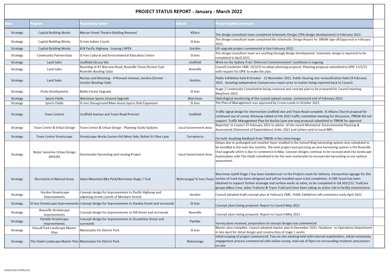
|
Ordinary
Meeting of Council - 26 April 2022
|
GB.7 / 1
|
|
|
|
|
Item
GB.7
|
S02294
|
Review of Domestic Waste Management
Charges / IPART Draft Report
EXECUTIVE
SUMMARY
Purpose of Report
To seek Council`s endorsement of a submission to the IPART
Review of Domestic Waste Management Service Charges and endorse the NSROC Draft
submission to IPART.
Background
The
Independent Pricing and Regulatory Tribunal of NSW (IPART) is currently
reviewing domestic waste management (DWM) charges levied by NSW local councils.
IPART
released a discussion paper in August 2020 and have followed up with a report
‘Review of Domestic Waste Management Charges Draft Report December
2021’, which is attached.
IPART
is seeking submissions on the draft report which are due by 29 April 2022.
Comments
IPART
propose to publish a benchmark waste peg that reflects the average annual
change in costs of providing DWM services. IPART propose to publish a
report on councils whose charges increased more than the benchmark waste
peg. They would review the councils’ information about cost drivers
and where councils cannot justify the increase in their charges, they may
consider regulating the individual council’s charges or implementing a
binding waste peg.
While
IPART have decided not to set a limit on annual DWM charges for 2022-23, the
proposed benchmark waste peg for 2022-23 is only 1.1%. There is a risk
that Council waste services will become unsustainable, consistent with the
general financial position of many NSW councils under the rate pegging regime.
IPART
also propose recommending that OLG publish pricing principles to guide councils
on how they should recover the costs of providing DWM services. The proposed
principles are:
1.
DWM revenue should equal the efficient
incremental cost of providing the DWM services.
2.
Councils should publish details of all
the DWM services they provide, the size of the bin, the frequency of the
collection and the individual charges for each service.
3.
Within a council area, customers that
are:
a.
imposing similar costs for a particular
service should pay the same DWM charge
b.
paying the same DWM charge for a
particular service should get the same level of service.
4.
Any capital costs of providing DWM
services should be recovered over the life of the asset to minimise price
volatility.
The main concern with the pricing principles is that
councils may only recover the ‘efficient incremental cost’ of
providing the DWM services. There is minimal guidance as to how this
would be calculated, but it is likely that the amount of overheads able to be
recovered from the DWM charge would reduce. Currently Council recovers a proportional
share of overheads relative to other council services, for an amount of
approximately $1.8 million in 2022/23.
Council has a detailed financial model in place that
calculates total overheads for the service. This includes corporate overheads,
such as customer relations, management support, Finance services (revenue
accounting, accounts payable), procurement, regulatory & operation
services, records management, IT support, human resources, building rental.
Currently Council allocates 11% in overhead costs on DW service unit. These
costs are reasonable considering the total DWM operational budget of
approximately $20m per annum.
IPART note that if the revenue from DWM charges reduce under
their methodology, councils may apply for a special rates variation to recover
the gap. However, this would result in significant additional costs and
create uncertainty for councils in planning for the future.
IPART Seeks Comment on their December 2021 report:
1.
Do you think the proposed annual benchmark waste peg will
assist Councils in setting their DWM charges?
The proposed
annual benchmark waste peg is not supported as:
· Council
waste costs vary significantly from benchmarked costs due to service level,
density, demographics, and timing of service introductions compared to other
councils
· It
would incentivise councils to provide low service levels, prioritise cost over
innovation and delivering best-practice services.
· It
would pose a significant barrier to delivery of council targets and the NSW
Waste and Sustainable Materials Strategy (WaSM) targets.
· It
would increase risk to the successful roll-out of new services such as food
organics and garden organics (FOGO), which the EPA has mandated by 2030.
· The
peg may not represent the real costs of providing the service and is subject to
limitations in the IPART pricing methodology
· It
would increase the regulatory cost for councils and the state government.
· Council
waste services may become unsustainable, consistent with the general financial
position of many NSW councils under the rate pegging regime.
2.
Do you think the pricing principles will assist councils
to set DWM charges to achieve best value for ratepayers?
The primary
impact of the pricing principles would be the requirement that council
overheads allocated to the DWM service be the incremental cost rather than a
proportional amount relative to all council services. This is unlikely to
improve value for money as overhead costs will be less visible when transferred
to the general council budget rather than remaining part of the DWM charge.
If pricing
principles are introduced that result in reducing DWM revenue, councils would
be left to rebalance the reduced DWM charges with general rates which impacts
on the Council`s general financial position or alternatively Council would be
required to apply for a special rates variation application. Imposing a
requirement for special rates variations to make up for lost DWM revenue would
therefore result in significant additional costs and create uncertainty for
councils in planning for the future. This would also be inconsistent with the
Local Government Act that requires Councils to levy the community for the
reason costs of providing the domestic waste services.
3.
Would it be helpful to Councils if further detailed
examples were developed to include in the Office of Local Government’s
Council Rating and revenue raising manual to assist in implementing the pricing
principles?
The pricing principles proposed
in the IPART discussion paper are very brief and require further detailed
development, including the provision of examples, before implementation.
Northern Sydney Regional Organisation of Councils
(NSROC) Submission
The Northern Sydney Regional Organisation of Councils
(NSROC) worked together with its members, the eight local government Councils,
to incorporate their views on the issue and make a submission to the
Independent Pricing and Regulatory Tribunal’s Draft Report on the Review
of the Domestic Waste Management Charge –December 2021.
The submission provides overarching feedback opposing the
waste peg and supporting the benchmarking approach proposed in IPART’s
2020 discussion paper. The submission provides more detailed comments on the
draft decisions and the issues for which comment is sought on IPART’s
paper as well as setting out NSROC’s preferred approach.
An extract from the NSROC submission highlighting the
overarching feedback is presented below:
“.. NSROC opposes the approach which IPART has
proposed involving a state wide benchmark waste peg and recommends that IPART
instead consider an alternative approach more similar to what was envisaged in
the Local Council Domestic Waste Management Charges Discussion Paper
issued in August 2020. Pricing principles could then be established that
reflect the reality of modern waste management and the delivery of services
that are for the benefit of domestic residential properties. These
views appear to be shared by the majority of councils in NSW and to be
supported by waste industry bodies, and we strongly urge you to consider
adapting your approach to reflect them. ..”
Ku-ring-gai Council has been involved in discussions with
NSROC during the review process and shares the same views as expressed in their
submission which is also consistent with Councils’ comments in this
report, therefore it is recommended that Council endorses/adopts NSROC
Submission to the Independent Pricing and Regulatory Tribunal.
NSROC’s Submission to the Independent Pricing and
Regulatory Tribunal’s is attached to this Report ( Attachment A2).
integrated planning and reporting
Leadership and Governance
|
Community Strategic
Plan Long Term Objective
|
Delivery Program
Term Achievement
|
Operational Plan
Task
|
|
A shared long-term vision for Ku-ring-gai underpins
strategic collaboration, policy development and community engagement.
|
Council's responses to government policy and reforms are
guided by and aligned with the adopted Community Strategic Plan 'Our
Community Our Future 2030'.
|
Analyse and provide appropriate submissions to government
proposals affecting the local government industry.
|
Governance Matters
Nil
Risk Management
Nil
Financial Considerations
The IPART pricing principles
would reduce the costs able to be recovered from the DWM charge, impacting on
council financial sustainability.
Social Considerations
Nil
Environmental Considerations
If the IPART recommendations are
implemented, there will be risks to the NSW Waste and Sustainable Materials
Strategy targets and new services such as food organics and garden
organics.
Community Consultation
Nil
Internal Consultation
Nil
Summary
IPART
is currently reviewing domestic waste management charges levied by NSW local
councils.
IPART have published draft recommendations for DWM charges
as follows:
· Publish a benchmark waste peg
· Publish an annual report on council DWM charge increases
· Publish pricing principles (that would reduce the costs
able to be recovered from the DWM charge)
It is
considered that the changes proposed to the DWM charges would reduce the
quality of domestic waste services, discourage waste recycling and recovery,
and detrimentally impact on council financial sustainability.
It is
proposed that Council makes a submission in response to the IPART Draft Report
as outlined in the body of this Report.
NSROC
prepared a submission to the Independent Pricing and Regulatory Tribunal which
expresses the view of its’ eight Council members and is also consistent
with Council’s view.
It is proposed that Council adopts
NSROC’s submission to IPART, noting there may be minor changes from
current to final draft.
Recommendation:
A) That
the General Manager be delegated to lodge Council’s submission to IPART
on their review of the Domestic Management Charges in accordance with the
responses provided to the IPART questions contained in this report.
B) That
Council endorses the draft NSROC submission to IPART.
|
Colin Wright
Manager Waste & Cleaning Services
|
Angela Apostol
Manager Finance
|
|
David Marshall
Director Corporate
|
George Bounassif
Director Operations
|
|
Attachments:
|
A1 ⇩ ⇩
|
Review
of Domestic Waste Management Charges Draft Report December 2021
|
|
2022/085954
|
|
|
A2 ⇩ ⇩
|
NSROC
Draft Submission IPART Review of Domestic Waste Management Charges DWMC
|
|
2022/097622
|
|
APPENDIX No: 1 - Review
of Domestic Waste Management Charges Draft Report December 2021
|
|
Item No: GB.7
|
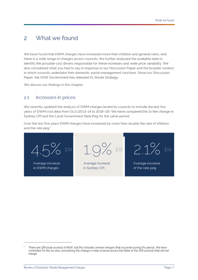
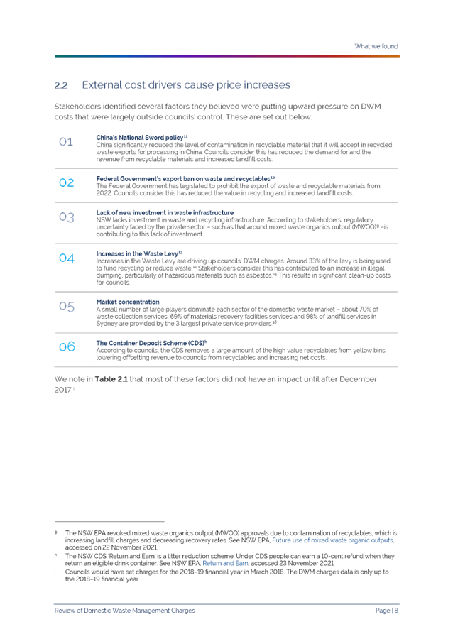
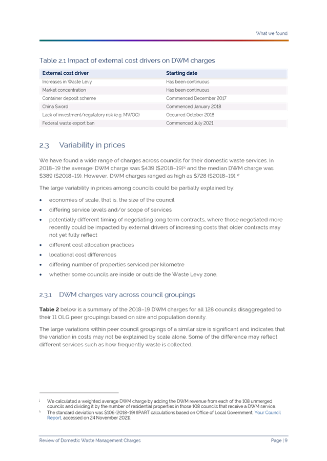
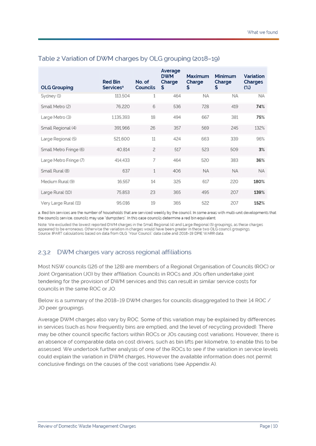
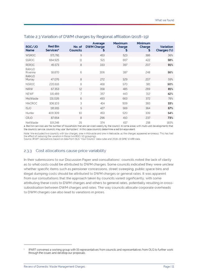
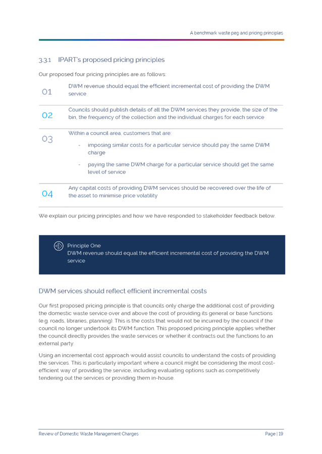
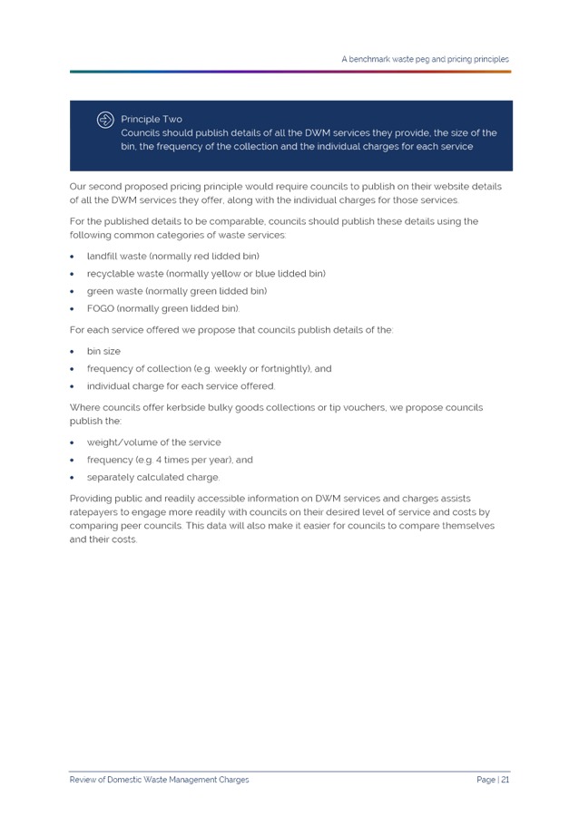
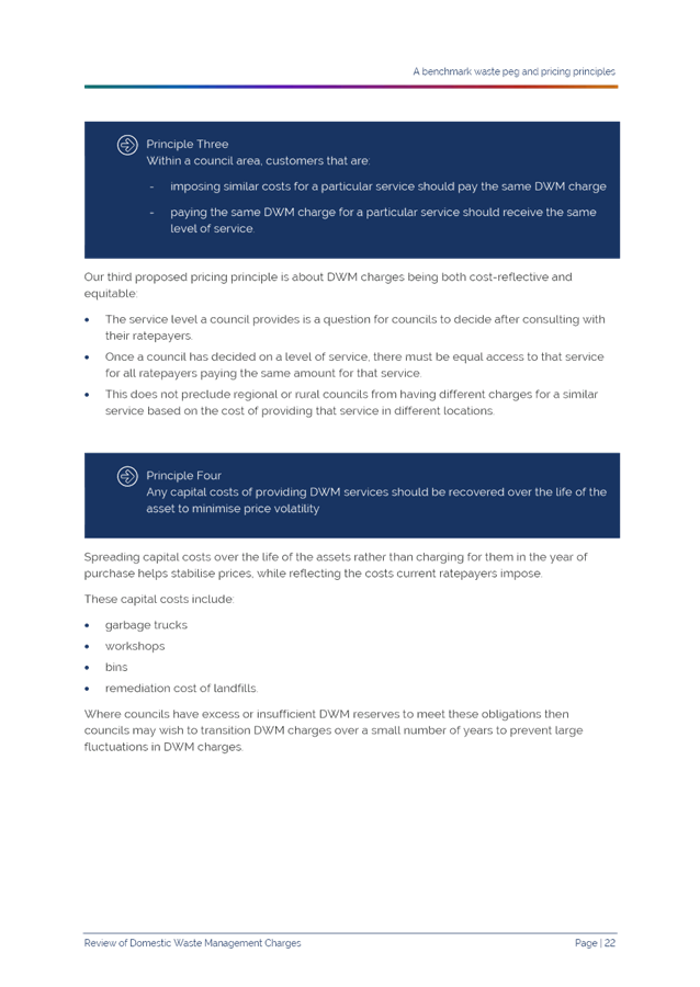
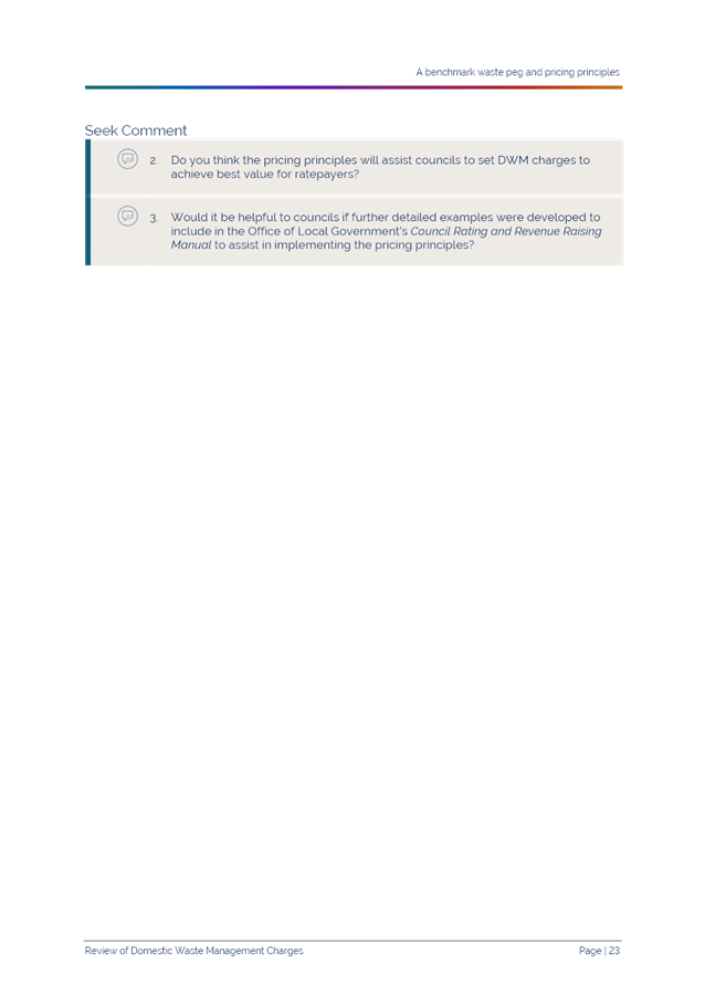

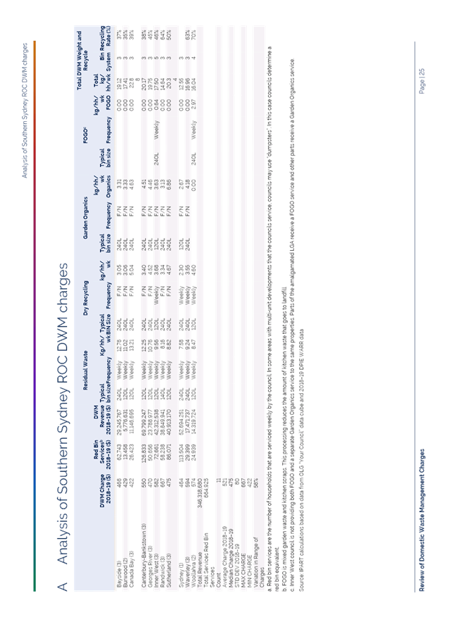
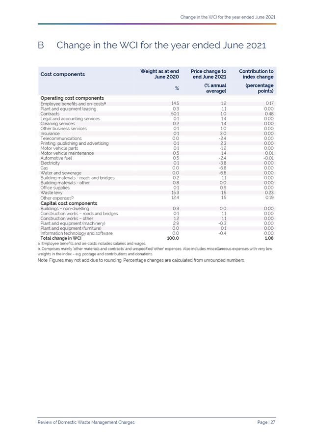
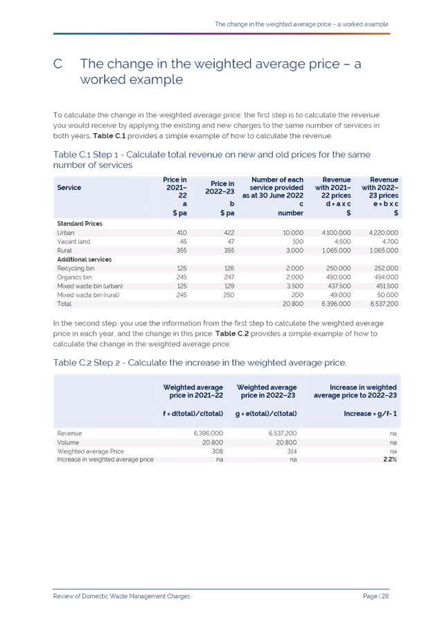
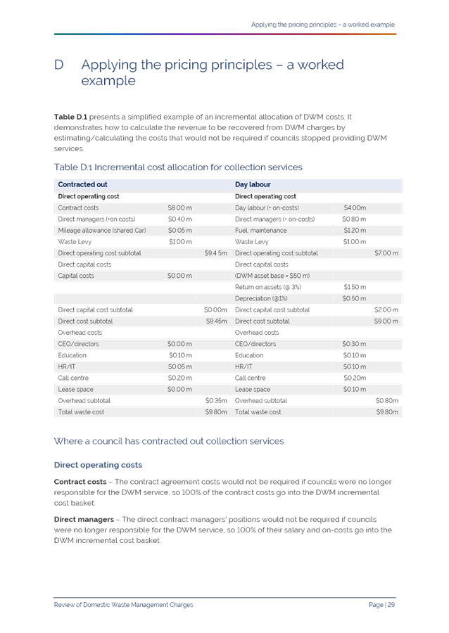
|
APPENDIX
No: 2 - NSROC
Draft Submission IPART Review of Domestic Waste Management Charges DWMC
|
|
Item No: GB.7
|
|
Ordinary
Meeting of Council - 26 April 2022
|
GB.8 / 1
|
|
|
|
|
Item
GB.8
|
S11623
|
Review of Mobile Devices for Community
Re-Use
EXECUTIVE
SUMMARY
Purpose of Report
To introduce a new service associated with donating used
mobile devices to charitable organisations.
Background
At the Ordinary Meeting of Council dated 16 November 2021,
Councillor Kay moved the following motion:
There is an estimate of 23 million mobile phones sitting
unused in drawers and garages all over Australia, plus tablets and laptops that
have been broken or been put aside in favour of a newer model.
Ku-ring-gai Council has had a mobile phone recycling program
in place since 2007, with several drop off points that include the Council
Chambers and 4 Libraries within the LGA. Gordon Library has a recycle station
which is for phones, batteries, globes, and cartridges. The other 3 libraries
have a lockable recycling stand (see attached image).
Council has been recycling phones with Mobile Munster since
2018. Mobile Muster is managed by AMTA (Australian mobile telecommunications
association) on behalf of members which include all the major handset
manufacturers (Alcatel, Apple, HMD Global, HTC, Huawei, Google, Microsoft,
Motorola, Oppo, Samsung, ZTE) and network carriers (Optus, Telstra, Vodafone).
Mobile Muster is the product stewardship program of the
telecommunications industry and is accredited by the federal government. It is
voluntarily funded by all the major handset manufacturers and network carriers
to provide a free mobile phone recycling program in Australia to the highest
environmental standard.
Recycling means that the phone is separated into components
for the purpose of landfill diversion. Over 95% of the materials in a phone are
recycled through this program.
Munster do not provide a program where the phone is donated
to charitable organisations.
Rather than separating unwanted phones for recycling, I
believe that they still have a purpose for local support agencies including
women’s shelters, refugee services and youth outreach program. I have
become aware that programs exist such as the Reconnect Project whereby
technicians repair and securely clean all data from broken and unwanted devices
to make them ready for use by people in need in the community
I, therefore, move that:
A. Council
investigate providers and the process utilised to manage the end to end
collection, data management and donation of used devices (tablets and phones)
that are disposed of by the community at Council’s libraries and customer
service including any costs associated with the program.
B. Council
receive a report for consideration detailing the outcome of the investigation
by March 2022.
Council unanimously resolved “that the above Notice of
Motion as printed be adopted”.
Comments
As prescribed in the Notice of Motion Council`s current
service provider for recovering mobile device is Mobile Muster. This is a free
service where the devices are delivered to a recycling processing facility for
dismantling and recycling of the device’s componentry. The process is an industry
based funded service from the manufactures of the many devices available
throughout Australia.
The Reconnect Project (RP) is a program that repairs and
securely cleans donated phone devices and donates them to charities or people
in need. The RP is funded through grants and donations from the public. The RP
has capacity to accept smartphones, tablets and laptops to be repaired and made
available for support agencies including women’s shelters, refugee
services, youth outreach or someone fleeing a domestic abuse situation.
The average cost to repair and clean a device is about $100
per unit which is paid for by the RP. Those devices that are not
repairable are passed onto the Industry based recycling provider Mobile Muster.
There is no cost to Council associated with the program. The
implementation would require Council to strategically provide secure collection
boxes whereby members of the community can place their unwanted device. The
locations of the devices would include all Council Libraries and at the
Customer Service Counter in Council’s administration building.
Furthermore, a memorandum of understanding between RP and
Ku-ring-gai Council is required to outline the process and responsibilities for
the acceptance and data cleansing of the unwanted devices.
integrated planning and reporting
Nature Environment
|
Community Strategic
Plan Long Term Objective
|
Delivery Program
Term Achievement
|
Operational Plan
Task
|
|
N5.1 A community progressively
reducing its consumption of
resources and leading in recycling
and
reuse.
|
N5.1.1: The community is
effectively engaged in improved
waste
reduction, reuse and recycling
|
N5.1.1.1: Deliver effective and efficient
waste
management services.
|
Governance Matters
A memorandum of understanding between RP and Ku-ring-gai
Council is required to outline the process and responsibilities for the
acceptance and data cleansing of the unwanted devices.
Risk Management
Council`s Information
Technology has raised the matter of security with phones that have not been properly
data wiped and reset when placed in the collection boxes. It is considered this
could be minimised by having sufficient information provided to inform
residents on having the data removed from their devices. RP have also indicated
that where data has not been fully removed, they can have this completed
professionally before repairs and reissuing to agencies.
Financial Considerations
There are no costs to Council
associated with the implementation of this program.
Social Considerations
The service will benefit
charities and communities in need.
Environmental Considerations
The devices are being
re-used. Devices that cannot be repaired are forwarded to Mobile Munster for
dismantling.
Community Consultation
Not required
Internal Consultation
Customer Service Section has
been consulted on the proposed change of service provider for recovering mobile
devices.
Summary
Council`s current recycler for mobile devices is Mobile
Muster. This is a free service where the devices are delivered to a recycling
processing facility for dismantling and recycling of the device’s
componentry. The process is an industry based funded service from the
manufactures of the many devices available throughout Australia.
It is proposed to replace this service with the Reconnect
Project to repair and clean used devices prior to donating the devices to
charitable organisations and communities in need. Council will be required to
provide secure collection boxes at libraries and the administration building
whereby members of the community can donate their devices. The RP manage the
entire process from collection, to repairs including data cleansing and
donating the phones to charitable organisations. This service will be
bound by a memorandum of understanding between Council and RP.
There is no cost to Council for this service.
Recommendation:
A. That
Council initiates the replacement of the Mobile Muster Bins with Reconnect
Project collection boxes at the Libraries and customer service area in the
administration building.
B. The
General Manager execute a memorandum of understanding outlining roles and
responsibilities of both parties.
|
Colin Wright
Manager Waste & Cleaning Services
|
|
|
Ordinary
Meeting of Council - 26 April 2022
|
GB.9 / 1
|
|
|
|
|
Item
GB.9
|
S13163
|
Sustainable Recreation Advisory Group
Minutes - 4 April 2022
EXECUTIVE
SUMMARY
Purpose of Report
That Council receive and note the
minutes from the Sustainable Recreation Advisory Group (‘SRAG’)
meeting held on 4 April 2022.
Background
Council is required to consider
and receive the minutes of the SRAG and to make them publicly available via
Council’s website. SRAG minutes are confirmed by SRAG prior to being
presented at the OMC.
Comments
The SRAG met on 4 April 2022 and
discussed issues relating to recreation in natural areas. The minutes of the
meeting have been attached to this report as Attachment A1.
integrated planning and reporting
Theme 3: Places, Spaces and
Infrastructure
|
Community Strategic
Plan Long Term Objective
|
Delivery Program
Term Achievement
|
Operational Plan
Task
|
|
Recreation, sporting and leisure
facilities are available to meet the community’s diverse and changing
needs.
|
A program is being implemented
to improve existing recreation, sporting and leisure facilities and
facilitate the establishment of new facilities.
|
Implement priority actions from
the Recreation in Natural Areas strategy.
|
Governance Matters
The
SRAG provides advice on sustainable recreation matters and assists with the
promotion, understanding and appreciation of natural areas. While not a
decision-making body, the group plays an important function in shaping
Ku-ring-gai's future. This advisory group is also an important link for
Council's communication with the community.
Risk Management
The
SRAG will help Council manage risk in regards to recreation in
Ku-ring-gai’s natural areas by providing knowledge and feedback to ensure
that recreation in natural areas is conducted in a safe, environmentally
sustainable and socially responsible manner.
Financial Considerations
There
are no specific financial implications associated with the creation and
management of the advisory group. Staff resources will be dedicated to the
advisory group primarily from the Environment and Sustainability team.
Social Considerations
Participation
in recreational activities is an important contributor to mental health,
general well-being and quality of life, boosting self-esteem and personal
growth. The advisory group helps Council increase community participation in
recreation in natural areas in a safe, environmentally sustainable and socially
responsible manner.
Environmental Considerations
The
SRAG helps Council ensure recreation in natural areas is conducted in an
environmentally sustainable and socially responsible manner. Additionally, the
provision of recreation opportunities seeks to promote a sense of stewardship
within the community.
Community Consultation
The
SRAG helps Council ensure that recreation in natural areas is conducted in an
environmentally sustainable and socially responsible manner. The group is made
up of community members and facilitates ongoing consultation with the
community.
Internal Consultation
The
SRAG is facilitated by Council staff. Where relevant, consultation with
other Departments may occur, in particular with Council’s staff in the
Operations Department.
Summary
Council
is required to receive and note the minutes of the SRAG and to make them
publicly available via Council’s website. SRAG minutes are confirmed by
SRAG prior to being presented at the OMC.
Recommendation:
That Council receive and note the
Sustainable Recreation Advisory Group minutes from 4 April 2022.
|
Sybylla Brown
Natural Areas Program Leader
|
Jacob Sife
Manager Environment & Sustainability
|
|
Andrew Watson
Director Strategy & Environment
|
|
|
Attachments:
|
A1 ⇩ ⇩
|
Sustainable
Recreation Advisory Group Meeting Minutes - 4 April 2022
|
|
2022/098218
|
|
APPENDIX No: 1 - Sustainable
Recreation Advisory Group Meeting Minutes - 4 April 2022
|
|
Item No: GB.9
|
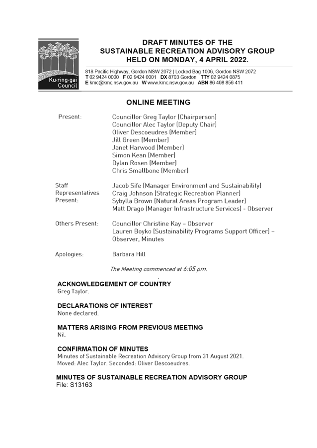
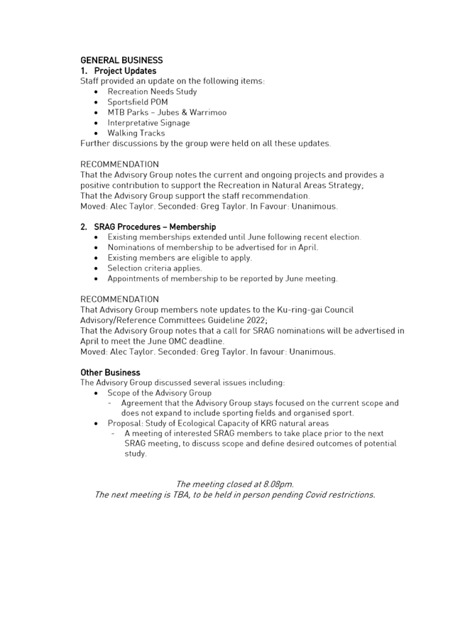
|
Ordinary
Meeting of Council - 26 April 2022
|
GB.10 / 1
|
|
|
|
|
Item
GB.10
|
S12062-3
|
EXECUTIVE
SUMMARY
Purpose of Report
To update Council on the Marian Street Theatre project.
Background
The Marian Street Theatre (MST) operated as a local theatre
for over 40 years until 2013 and prior to that was used as a theatre or public
hall since being built in 1906.
Council closed the Marian Street Theatre in December 2013 to
undertake urgent lighting, electrical and other associated upgrades but due to
the building’s deteriorated state, the Theatre has remained closed ever
since.
Council resolved on 8 May 2018 to undertake the renewal of
Marian Street theatre and to allocate funds to the project in Council’s
Long Term Financial Plan. As per the resolution, the project was (and still is)
to be funded by asset sales. To date, these asset sales have not been realised.
In 2018 Council staff began investigation into the state of
the building (due diligence reporting) followed by design work of a DA to
re-open the building. The DA was approved in August 2021. Following a
Council adopted Notice of Motion in April 2021 to use funds from general revenue
(once the DA was approved) to progress tender documentation of the MST project,
the design consultant team re-mobilised and work on design development began in
November 2021. The consultant team have recently completed schematic design (to
approximately 70% documentation) and an updated cost estimate for construction
works has been completed (see Confidential Attachment A1).
Comments
This report seeks to update Council on the status of the
design and associated cost estimate. The report also contains notes (Attachment
A3) from the design review meeting with the Mayor and Councillors, 16 March
2022.
Vision for
Proposed Theatre Performance Spaces
The renovated MST will focus on building a vibrant,
multi-use arts venue with a strong focus on drama. The vision for the future of
the theatre is set out below:
“MST will be
Ku-ring-gai’s innovative new community performance space. It will provide
a stage for a diverse range of expressive entertainers, from professional
artists to talented community performers, who will deliver a program of
stimulating and engaging productions for the community.
As well as a theatre experience
visitors will enjoy café facilities and multi-purpose spaces, all
connecting sensitively with the surrounding natural environment. MST will
honour its live theatrical traditions.
The focus will be on content
diversity, which will include live performances, musical experiences and new
productions. Our goal will be promoting creativity, originality and inclusivity
for anyone who enjoys the delight of great live performances.”
The project vision is further emphasised as;
“The new image for a
‘theatre’ is that of a community living room – a place that
is open as needed and always active - with informal programming, a variety of
live performance genre, and an atmosphere that is buzzing and welcoming. New
spaces have enlarged lobbies where high quality drinks and snacks are available
for sale over longer periods of time. These spaces are informal but physically
attractive and inclusive in the ways they are designed and animated. They are
warm and inspirational - welcoming a variety of live performance media and
diverse audiences - rather than one-dimensional, cold and institutional,
thereby inviting the community to interact.”
Key
Components of the Theatre
Multiple rehearsal and performance spaces have been
carefully selected to build ‘a theatre eco-system’.
Seven discrete spaces comprise the ‘eco-system’:
• a
main Theatre Auditorium space with 249 seats;
• a
smaller experimental Theatrette space with 63 seats;
• an
acoustically resonant Rehearsal Space with 60 seats on flat floor;
• a
Flexible Community space;
• a
commercial Cafe;
• a
Main Foyer space with connection to the main auditorium; and
• an
outdoor amphitheatre, which connects the cafe through to the park and existing
children’s playground.
Design
Review
The project Architects and Council staff met with the Mayor
and Councillors 16 March 2022 to review the current design. Notes from the
meeting are included at Attachment A3 and a summary of a request to
review combining the theatrette and community spaces can be seen at Attachment A4.
The consensus from the design team for the layout change is not positive due to
there being many constraints including budget and structural issues.
If Council requires this change to be made, the instruction
should be given as soon as possible as there will be significant program and
documentation impacts (particularly for structure). At the present time this
matter is not being actioned.
Cost
Estimate
An independent Quantity
Surveyor (QS) has provided a cost estimates for the design at completion of
schematic design (approximately 70% design development) Confidential Attachment
A1. Progress on this item was delayed because of Council’s
decision to suspend work on the project earlier this year.
The estimated project Cost is now some $21,959,596, a
variance of +$5,655,960 when compared to the DA cost estimate prepared two
years ago in February 2020 ($16,303,637). Note these are ‘whole of
project’ costs including design of which a large amount has already been
paid for.
The construction estimate is now some $18,673,126, a
variance of +$ 4,809,489 from the DA estimate of $ 13,863,637. The likelihood
of escalation has been raised a number of times in briefings with Councillors
in recent months.
The shift analysis (Confidential Attachment A2)
provides detail on the variances between the schematic design estimate and the
DA estimate. In summary, points of divergence are as follows:
· The DA design was
priced in February 2020 and there have been some significant impacts on the
construction industry since that time. Escalation would be approx. 8% (equating
to a revised value for the DA estimate of $17.6m). Certain materials (such as
steel and concrete) have gone up in cost significantly - more than 20%.
Additionally, scarcity of materials has also seen an increase in costs.
· Services + Theatre
Equipment revised estimates equate to a large portion of the increase, of which
there is a:
o ~$550k increase for theatre
equipment, where the consultant has advised that this is due to the addition of
the LED screen to Marian Street (+$110k);
o design development of Audio
($150k) and LED lighting ($75k) and an increase in pricing equating to +25%
(remainder ~$130k);
o ~$1,653k increase for
mechanical services based on design development and modelling for the
auditorium;
o ~$109k increase to align with
latest design + include for sanitary fixtures and fittings;
o ~$611k increase to align with
latest design + accommodate for the substation (~$350k trade cost) + smoke
curtain (~$75k trade cost); and
o ~$62k increase based on
indicative pricing from lift contractors.
· upper floors (up
~$403k) due to the detailed structural design which is now available and has
significantly more structural steel than anticipated. The latest design also
sees additional areas being demolished and replaced on L2 (notably under the
auditorium seating, which was previously to be retained);
· scope creep in terms
of the amount of new structure has had an impact on the structural costs and
the demolition costs (~$150k);
· due to a
‘condition of consent’ requiring the building to be
‘earthquake proof’ (usually only required for new buildings) a
significant amount of more steel columns have been incorporated into the design
(~$156k);
· development of the
detail around landscape, walkways and roads has increased project costs by
approx. ~$350k, this includes:
o further details around the
suspended grated plastic ramp to the amphitheatre, which was previously price
as a timber deck on grade but now details suspended structure with piering and
more structural steel than was previously anticipated (~$150k);
o detailed soft
landscaping/planting schedule (~$50k)
o bulk earthworks plan for
external works showing more cut and fill across the site (~$40k); and
o additional retaining walls and
suspended slab elements for the paving to create the over-hangs desired as
opposed to the slab on grade previously priced (~$50k).
Additionally, the amounts noted above only reflect trade
cost increases which attract on-costs, the likes of which include: contractors
preliminaries & margin, design contingency, construction contingency and
professional and authority fees.
Council is requested to note the Schematic Design Cost
Estimate included in Confidential Attachment A1.
integrated planning and reporting
Community,
People and Culture
|
Community Strategic Plan
Long Term Objective
|
Delivery Program
Term Achievement
|
Operational Plan
Task
|
|
C2 - Cultural Diversity and
Creativity
|
C2.1 A harmonious community
that respects, appreciates, celebrates and learns from each other and values
our evolving cultural identity.
|
Achieve development consent
and progress detailed documentation for the tender of Marian Street Theatre
|
|
C4 - Healthy Lifestyles
|
C4.1 A community that embraces healthier lifestyle choices
and practices.
|
Deliver and support programs and events that improve the
wellbeing of the community.
|
|
P8 Improving the standard of our infrastructure
|
P8.1 An improved standard of infrastructure that meets the
community’s service level standards and Council’s obligations as
the custodian of our community assets.
|
Our public infrastructure and assets are planned, managed
and funded to meet community expectations, defined levels of service and
address inter-generational equity.
|
Governance Matters
The Council resolution of 8
May 2018 placed the renewal of the Marian Street Theatre in the Long Term
Financial Plan. Council confirmed its resolve to re-establish the theatre with
an adopted Notice of Motion in April 2021 to use funds from general revenue to
progress tender documentation of the project.
Risk Management
Key risks are summarised as follows:
Risk 1 – No ‘asset sale’ funds are
available for construction of the project
There is a risk to Council’s broader financial
position if asset sales are not achieved to fund the project as currently
reflected in Council’s Long Term Financial Plan and Operational Program
and Delivery Plan.
Risk 2 – The final design exceeds the budget
There is a risk that the cost
of construction will continue to rise. Should tenders for construction exceed
the budget a report outlining options would be submitted to Council requesting
either amendments to the design or additional funds to cover the increase.
Risk 3 – Council reputation if the project is not
delivered
Council’s reputation is not at risk from its decision
to proceed with the project, rather, there is a reputational risk if the
project is not delivered.
Financial Considerations
The 2021/22 budget and long term financial plan provides a
total project budget of $16.7m (including $1.4m already spent to date), which
is funded from general revenue ($1.8m) and asset sales ($14.9m).
There is a separate report on the agenda for this Council Meeting regarding the
forthcoming budget, outlined below.
The draft 2022/23 budget and long term financial plan
provides funding of $23.8m (including $1.4m already spent to date), which is
funded from general revenue ($1.8m) and a loan of $22m to be repaid from asset
sales. The budget of $23.8m is 8% higher than the latest cost estimate of
$21.9m, to provide a modest buffer.
Note that there is a proposed change to the funding strategy
in 2022/23 with the use of loan borrowing to ensure the project is not delayed
waiting for asset sales revenue. Council should note that this approach
comes with increased financial commitment and risk. In addition, being
the redevelopment of an old theatre building, Council should proceed with the
project on the basis that it accepts there may be further increases to project
costs.
It has previously been
estimated that the theatre would require an operational subsidy of around $0.7m
pa. This has also been included in the long term financial plan from
2024/25 onwards and funded from general revenue.
Social Considerations
The proposal will achieve the following positive social and
economic outcomes:
· provide new and
improved creative, performance and community spaces, as well as a new cafe for
use by the broader community;
· provide improved
accessibility for people with disabilities and building upgrades in line with
current BCA, access and fire safety standards;
· provide
improvements to the public open space known as Selkirk Park; and
· ensure the ongoing
use of the Marian Street Theatre, which is currently vacant and disused.
The provision of additional community infrastructure,
providing both indoor and outdoor community spaces will ensure that the Marian
Street Theatre becomes a vibrant and popular place to meet and recreate for all
ages.
Environmental
Considerations
There are no environmental issues arising from this report. All
environmental impacts have been considered and assessed as part of the DA
process.
Community
Consultation
Consultation with the
community has occurred on numerous occasions with regard to the provision of
live theatre in Ku-ring-gai.
Specific to this project, Council established a Marian
Street Theatre Committee Reference Group. The reference group consisted of
Councillors, members of the Save Marian Street Theatre Committee, theatre and
arts cultural specialists, and members of the community. This committee had a
role in informing the direction and outcomes of the rejuvenated theatre.
An event day was also held in Selkirk Park on Sunday, 17
November 2019 to inform the broader community of progress and design of the
project.
Further community consultation was undertaken through public
notification of the DA.
Internal Consultation
GMD is the project owner and sponsor of the project.
The Major Projects Steering Committee and Major Project
Advisory Committee are regularly informed and have had input into advancement
of the project.
Summary
The consultant design team have recently completed Schematic
Design (to approximately 70% documentation) and an updated cost estimate for
construction works has been completed (see Confidential Attachment A1).
The cost of construction is now expected to be beyond the DA estimate (February
2020) in the realm of $5m (approximately $6m over the 2020 total project budget
when including design and contingencies etc). Given current pressures within
the construction section, it is possible that further costs increases may occur
prior to a construction contract being awarded.
In finalising design development and tender documentation it
is advantageous to determine the project budget. The construction documentation
can be tailored to delivery within the set budget.
The project architects and council staff met with the
Councillors on 16 March 2022 to review the current design. Notes from the
meeting are included at Attachment A3 and a summary of a request to
review combining the theatrette and community spaces can be seen at Attachment
A4.
Recommendation:
A. That
Council receive and note updates contained within this report.
B. That
Council notes the revised cost estimate for the project at completion of
Schematic design (approximately 70% design development) included in Confidential
Attachment A1.
C. That
Council notes further cost increases may occur prior to a construction contract
being awarded and during construction.
D. If
Council proceeds it accepts the risk of project costs and financial commitment
increasing.
|
Dean Payne
Project Leader – Strategy & Environment
|
Andrew Watson
Director Strategy & Environment
|
|
Attachments:
|
A1
|
MST
Schematic Design Cost Estimate
|
|
Confidential
|
|
|
A2
|
MST
Cost Shift Analysis
|
|
Confidential
|
|
|
A3⇩
|
Minutes
- Design Review Meeting
|
|
2022/097132
|
|
|
A4⇩
|
Theatrette
revised design - Pros and Cons
|
|
2022/094394
|
|
APPENDIX No: 3 - Minutes
- Design Review Meeting
|
|
Item No: GB.10
|
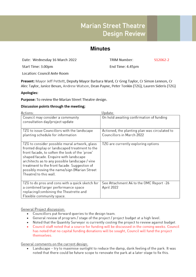
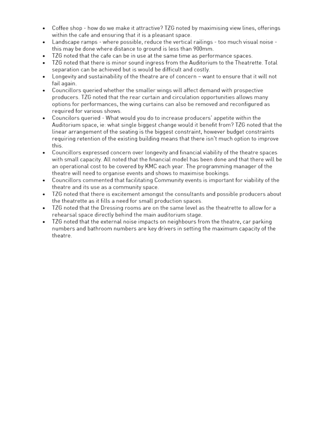
|
APPENDIX
No: 4 - Theatrette
revised design - Pros and Cons
|
|
Item No: GB.10
|
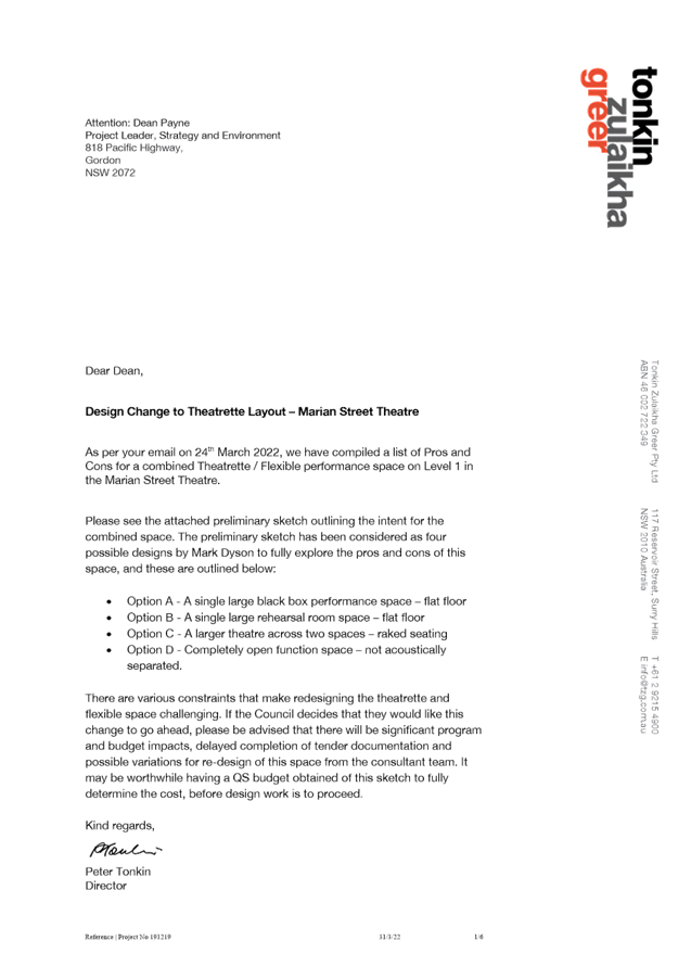
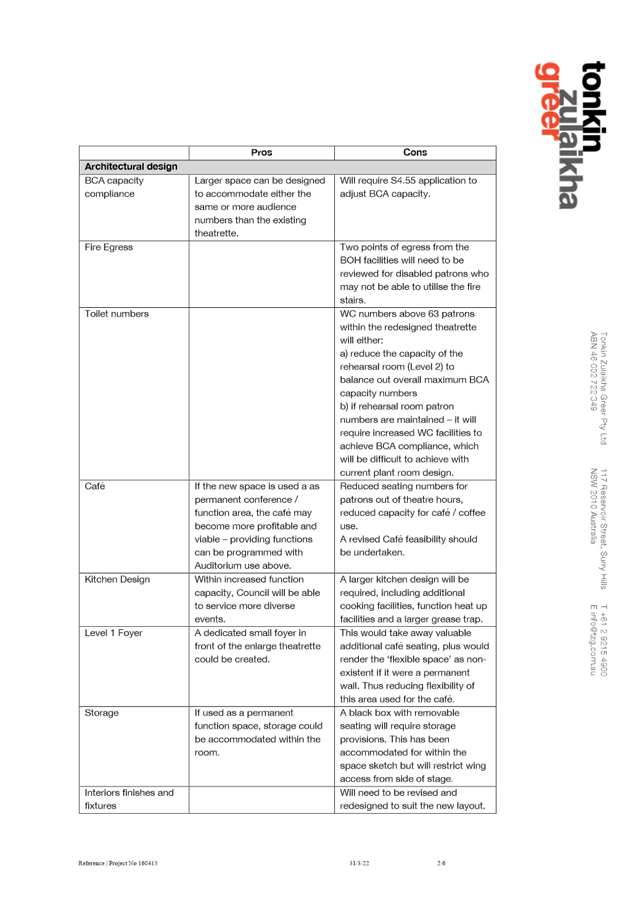
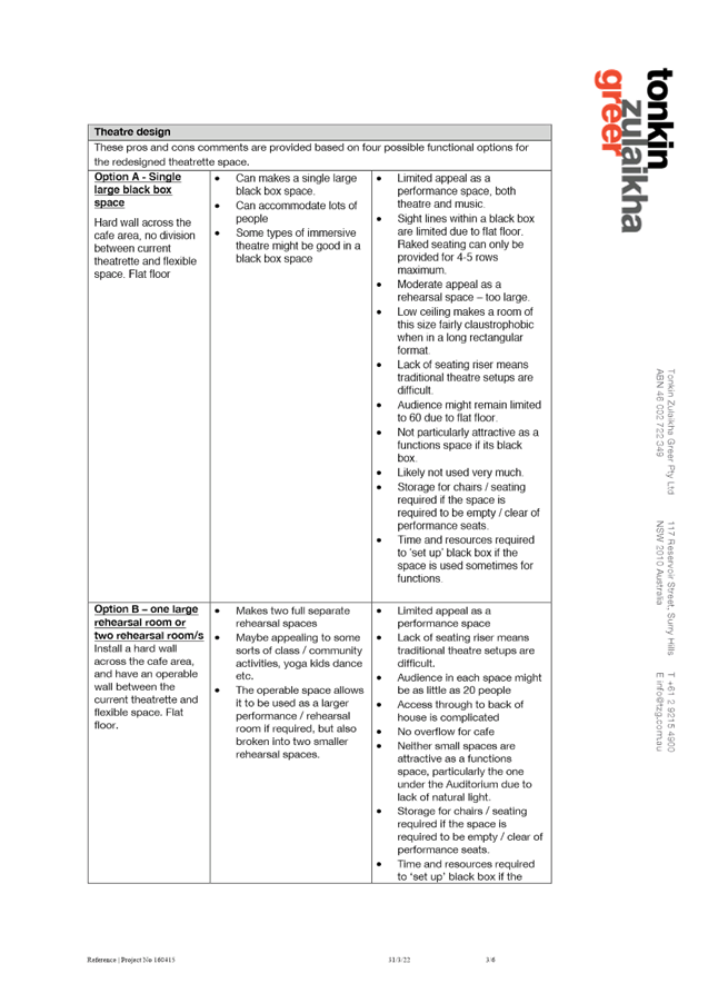
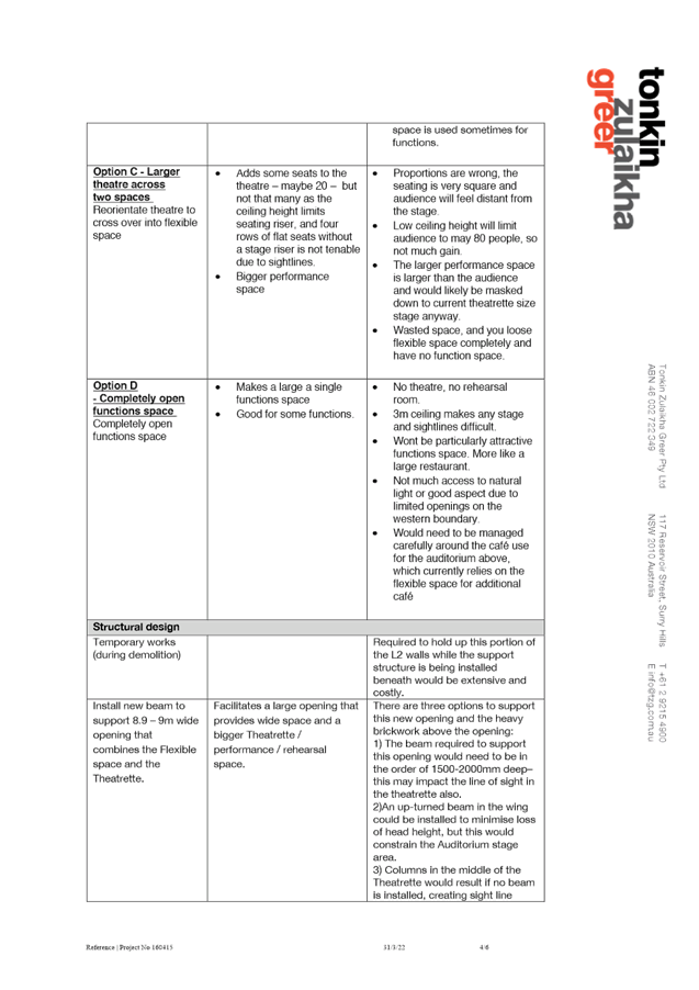
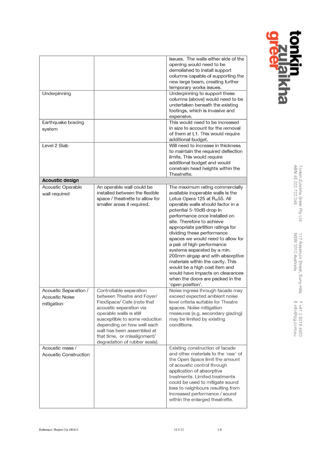
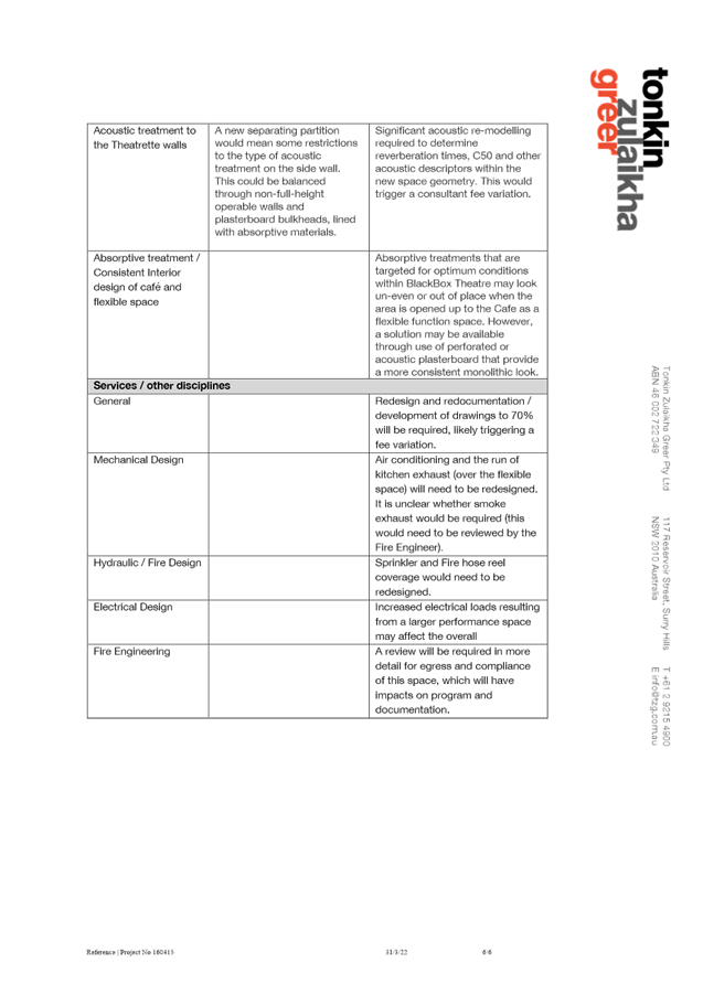
|
Ordinary
Meeting of Council - 26 April 2022
|
GB.11 / 1
|
|
|
|
|
Item
GB.11
|
S09878
|
Divestment of Council land at 47 Warrane
Road Roseville Chase
EXECUTIVE
SUMMARY
|
purpose of report:
|
To obtain Council approval for
the divestment of 47 Warrane Road, Roseville Chase.
|
|
|
|
|
background:
|
At its meeting of 15 February 2022, Council resolved
to adopt the planning proposal for 47 Warrane Road, Roseville Chase for the
rezoning of the subject land from RE1 Public Recreation to R2 Low Density
Residential and that a request be submitted to the Department of Planning,
Industry and Environment to make the necessary amendments to the Ku-ring-gai
Local Environmental Plan 2015.
|
|
|
|
|
comments:
|
The subject land comprises the
former East Roseville Bowling Club which Council leased to the Club since the
1950s to 2017 when it vacated the site and is now surplus to Council’s
needs.
Proceeds from the divestment of 47 Warrane Road,
Roseville Chase and other asset sales are integral to the overall funding of
priority projects identified in the Ku-ring-gai Long Term Financial Plan and
the Delivery Program 2018-2022 and Operational Plan 2021/2022 such as the
Marian Street Theatre upgrade.
|
|
|
|
|
recommendation:
|
That Council approves the
divestment of 47 Warrane Road, Roseville Chase following its rezoning in Ku-ring-gai
Local Environmental Plan 2015 and in accordance with
Council’s Acquisition and Divestment of Land Policy and as set out in
this report and that the net proceeds be used to part fund the Marian Street
Theatre upgrade.
|
Purpose of Report
To obtain Council approval for the divestment of
47 Warrane Road, Roseville Chase.
Background
At its meeting of 15 February 2022 Council considered the
submissions received during the public exhibition of the planning proposal for
47 Warrane Road, Roseville Chase and resolved:
A.
Council adopt the planning proposal to rezone land at 47 Warrane Road,
Roseville Chase.
B.
That the planning proposal be submitted to the Department of Planning, Industry
and Environment in accordance with Section 3.36 of the Environmental Planning
and Assessment Act 1979 and that the Department of Planning, Industry and
Environment be requested to make the plan.
C.
Delegation be given to the General Manager and Director Strategy and
Environment to correct any errors or inconsistencies in the planning proposal
prior to it being submitted to the Department of Planning, Industry and
Environment for finalisation.
D.
Those persons who made a submission be notified of Councils decision.
E. That a
site-specific Development Control Plan be prepared for the subject site based
on the site-specific controls contained in
Section 3.8 of the Urban Design Study.
Comments
47 Warrane Road, Roseville Chase is Council owned land which
had been leased since the 1950s to 2017 to the East Roseville Bowling Club. In
2017 the East Roseville Bowling Club terminated the lease with Council and
vacated the site when the Club merged with the Lindfield Bowling Club. The site
has been vacant since 2017 and comprises four separate lots (Lots 33 and 34 DP
3285, Lot 3 DP 26343 and Lot B DP 403780) totalling 10,110 m2.
The land is surplus to Council’s needs and has
significant value as an R2 Low Density Residential development site. The
confidential attachment summarises independent valuation advice Council staff
have obtained as to the market value of the site based on the R2 Low Density
Residential zoning [Confidential Attachment A1).
Asset sales are a key assumption in Council’s adopted
Resourcing Strategy and Long Term Financial Plan. Proceeds from the divestment
of 47 Warrane Road Roseville Chase, are integral to meeting the
community’s expectation to fund social infrastructure projects including
the Marian Street Theatre upgrade.
integrated planning and reporting
Theme 6 – Council is well led, managed and supported
by ethical organisations which deliver projects and services to the community
by listening, advocating and responding to their needs.
|
Community Strategic
Plan Long Term Objective
|
Delivery Program
Term Achievement
|
Operational Plan
Task
|
|
L2.1: Council rigorously manages its financial resources
and assets to maximise delivery of services.
|
L2.1.1: Council maintains and improves its long term
financial position and performance.
|
L2.1.1.4: Progress Council approved property acquisitions
and divestments.
L2.1.1.5: Improve financial returns from Council’s
property portfolio.
|
Governance Matters
The divestment of Council owned
land requires a resolution of Council to proceed. Council’s
Acquisition and Divestment of Land Policy also requires an open competitive
process of divestment to be adopted utilising one of the following methods:
·
Expression of interest – usually used for unusual
properties capable of a variety of development, difficult to determine a market
value.
·
Tender – least common and used predominantly in high
value, limited market situations.
·
Auction – the most open and public method, favoured
by government, but reliant on high levels of competition. Often achieves a
quick sale. Can fail in poor market.
·
Private Treaty – most common, where an asking price
is set and negotiated with individuals, usually through a real estate agent
(who can be an independent third party to the negotiation process) and can
arise after an unsuccessful Auction.
The R2 Low Density Residential zoning enables low density
housing that is compatible the single dwelling character of the locality or as a
seniors development consistent the new Housing SEPP which limits the type of
seniors housing that can be developed to that undertaken by Land and Housing
Corporation or a retirement village operator.
On this basis, it is proposed to divest the subject land by
public auction. An expert local real estate agent will be appointed to
facilitate the divestment by public auction. The reserve will be set based on
independent valuation advice obtained from two expert valuers prior to auction
in accordance with Council’s Acquisition and Divestment of Land Policy.
Risk Management
There is a significant risk to Council’s overall
budget position if asset sales are not achieved. There is also a reputation
risk to Council in terms of community expectations if it fails to proceed with
key social infrastructure projects.
Council also has the responsibility to manage its property
portfolio in the public interest. Utilising the services of independent expert
valuers for the purpose of setting the reserve price will ensure Council
receives fair market value for the land.
Contract documentation will be prepared by Council’s
solicitors to ensure Council’s interests are protected.
Financial Considerations
47 Warrane Road Roseville
Chase is a valuable site for an R2 Residential Low-Density development and the
divestment of the land presents an opportunity for Council to meet the
community’s expectations to address key social community infrastructure
such as the Marian Theatre. Asset sales are integral to Council’s capacity
to deliver these services to the community.
Social Considerations
The divestment of the land will assist in the provision of
additional housing within the Ku-ring-gai municipality.
Environmental Considerations
Due to past land uses and
activities on the site, a Stage 1 Preliminary and Stage 2 Detailed Site
Investigation have been undertaken which confirm there is some contamination on
the land. Remediation will be carried out to make the site suitable for future
residential use.
Community Consultation
There has been extensive
community consultation conducted through Council’s planning proposal to
rezone the land.
Internal Consultation
There has been internal
discussion in relation to the proposed divestment of the site within
Council’s Strategy and Environment, Operations and Corporate departments.
Summary
At its meeting of 15 February 2022,
Council resolved to adopt the planning proposal for 47 Warrane Road, Roseville
Chase for the rezoning of land from RE1 Public Recreation to R2 Low Density
residential, and that a request be submitted to the Department of Planning,
Industry and Environment to make the necessary amendments to the Ku-ring-gai
Local Environmental Plan 2015.
47 Warrane Road, Roseville Chase is Council owned land which
had been leased since the 1950s to 2017 to the East Roseville Bowling Club, at
which time the Club terminated its lease with Council. The land is surplus to
Council’s needs and has significant value as an R2 development site.
Asset sales are a key assumption in Council’s adopted
Resourcing Strategy and Long Term Financial Plan. Proceeds from the divestment
of 47 Warrane Road are integral to meeting the community’s expectation to
fund social infrastructure projects such as the conservation and refurbishment
of the Marian Street Theatre.
The divestment is proposed to be by way of public auction
and in accordance with Council’s Acquisition and Divestment of Land
Policy. The reserve price is to be set based on independent valuation advice
provided by 2 expert valuers. It is also recommended that in the event the
property does not achieve the reserve price set at auction that Council
authorise the General Manager and/or his delegate to negotiate within a
variance of 10% of the reserve price.
The net proceeds of the sale are to be allocated to
Council’s Infrastructure and Facilities Reserve and utilised for projects
budgeted to be funded from asset sales such as the Marian Street Theatre
upgrade.
Recommendation:
A. That
Council approves the divestment of 47 Warrane Road, Roseville Chase in
accordance with Council’s Acquisition and Divestment of Land Policy for
sale by public auction once the land is formally rezoned to R2 in the Ku-ring-gai
Local Environmental Plan 2015.
B. That
Council authorises the General Manager and/or his delegate to set the auction
reserve price, which is to be established in accordance with advice received by
two separate independent valuation reports.
C. In the
event the subject site does not achieve the reserve price set at auction that
Council authorise the General Manager and/or his delegate to negotiate within a
variance of 10% of the reserve price.
D. That
Council authorises the Mayor and General Manager to execute all documentation
and affix the Council Seal if required, to all documents associated with the
conveyance and any future transactions for the divestment of the land.
E. That
the net proceeds from the sale of 47 Warrane Road, Roseville Chase be allocated
to Council’s Infrastructure and Facilities Reserve and utilised for
projects budgeted to be funded from asset sales such as the Marian Street
Theatre upgrade.
|
Vince Rago
Property Program Coordinator
|
Antony Fabbro
Manager Urban & Heritage Planning
|
|
Steve Johnson
Manager Property
|
Andrew Watson
Director Strategy & Environment
|
|
Attachments:
|
A1
|
Valuations
|
|
Confidential
|
|
Ordinary
Meeting of Council - 26 April 2022
|
GB.12 / 1
|
|
|
|
|
Item
GB.12
|
S09767
|
Council land - 97 Babbage Road Roseville
Chase
EXECUTIVE
SUMMARY
|
purpose of report:
|
To report back to Council the
conclusions of an independent ecological assessment of 97 Babbage Road,
Roseville Chase.
|
|
|
|
|
background:
|
At the OMC of 13 June 2017 and 15
June 2021, Council resolved to divest 97 Babbage Road, Roseville Chase. At
its OMC of July 2021 Council, resolved ‘that an independent
consultant be engaged by Council to assess the apparent anomalies between
claims being made by the community and the material upon which Council relied
when considering this matter in 2018’. The claimed
“anomalies” related to the ecological attributes and significance
of the site.
|
|
|
|
|
comments:
|
At the OMC of June 2021 (OMC124,
C.3) Council resolved to divest from surplus land at 97 Babbage Road,
Roseville Chase (the site) in accordance with Council’s Acquisition
and Divestment of Land Policy.
Following this resolution, Councillors received objections
from a number of residents and a petition against the sale of the land. The
objectors and petition characterised the site as ecologically significant and
questioned the potential impact of developing the site. This conflicted with
the information presented by Council. Council engaged an independent
ecological consultant to deliver a Flora and Fauna Impact Assessment Report
(FFA) for future development of the site. The report confirms that
development of the site will not result in significant ecological impacts.
|
|
|
|
|
recommendation:
|
That Council proceed with the
divestment of 97 Babbage Road, in accordance with Council’s
Acquisition and Divestment of Land Policy and as set out in this report and
that the net proceeds be used to part fund the Marian Street Theatre upgrade.
|
Purpose of Report
To report back to Council the conclusions of an independent
ecological assessment of 97 Babbage Road, Roseville Chase.
Background
At the OMC of 26 May 2015 which followed a public hearing,
Council resolved that 97 Babbage Road, Roseville Chase be reclassified as
operational land, for a planning proposal be lodged to rezone the land as E4
Environmental Living, for anomalies related to the subdivision line be
investigated, and that a further report be brought back to Council regarding
future subdivision and divestment.
At the OMC of 13 June 2017, Council resolved to approve the
divestment of 97 Babbage Road, Roseville Chase, subject to a further report
outlining the manner of divestment, pricing information and a further
resolution and delegations prior to preparing the property for market.
In a further report to the OMC of June 2021 (OMC124, C.3),
Council resolved to divest from surplus land at 97 Babbage Road, Roseville
Chase (the site) in accordance with Council’s Acquisition and
Divestment of Land Policy.
At the OMC of July 2021, in relation to the divestment of 97
Babbage Road, Roseville Chase, Council resolved ‘that an
independent consultant be engaged by Council to assess the apparent anomalies
between claims being made by the community and the material upon which Council
relied when considering this matter in 2018’. The anomalies related
to the ecological attributes and significance of the site.
Council has received and reviewed the Flora and Fauna Impact
Assessment Report (FFA) which is attached to this report as Attachment A1.
Comments
Subsequent to resolutions of Council of 13 June 2017 and 15
June 2021, which endorsed divestment of 97 Babbage Road, in June/July 2021
Councillors received objections to the sale of the land. The objectors
characterised the site as ecologically significant and questioned the potential
impact of developing the site. This conflicted with the information presented
by Council.
To address this inconsistency, an independent consultant was
engaged to deliver a FFA for future development at 97 Babbage Road, Roseville
Chase, NSW 2069 (Lot 47/-/DP13444).
The FFA included a number of general and specific survey
techniques, including:
· identifying and
recording the vegetation communities present on the subject land, with a focus
on identifying any threatened ecological communities (TEC);
· searching for
threatened species, species diagnostic of threatened ecological communities and
priority weeds;
· recording opportunistic
sightings of any fauna species seen or heard within the immediate surrounds of
the subject land;
· identifying and
recording the locations of threatened fauna habitat such as important nesting,
roosting or foraging microhabitats;
· targeting the
habitat of any threatened and regionally significant fauna including:
o tree hollows (habitat for
threatened large forest owls, parrots, cockatoos and arboreal mammals);
o caves and crevices (habitat
for threatened reptiles, small mammals and microbats);
o termite mounds (habitat for
threatened reptiles and the echidna);
o soaks (habitat for threatened
frogs and dragonflies);
o wetlands (habitat for
threatened fish, frogs and water birds);
o drainage lines (habitat for
threatened fish and frogs);
o fruiting trees (food for
threatened frugivorous birds and mammals);
o flowering trees (food for
threatened nectarivores mammals and birds);
o trees and shrubs supporting
nest structures (habitat for threatened birds and arboreal mammals), and
o any other habitat features
that may support fauna (particularly threatened) species;
· assessing the
connectivity and quality of the vegetation within the subject land and
surrounding area; and
· identifying the
species and habitat values of all trees proposed to be removed.
The consultant was also provided the full list of species
and all photos submitted by residents and asked to consider this within the
FFA.
Following the assessment of the site, the consultant
concluded it is ‘unlikely that the proposed development will cause
significant effects to the local or regional persistence of a viable local
population of any species of threatened fauna or flora.’
The Flora and Fauna Report goes on to state:
‘It is not likely that
any threatened flora species occur naturally within the Subject Property. The
habitat is overgrown with dense weed infestations and has been managed
historically through infill planting, mowing and other gardening activities.
The proposed development may
contribute localised effects to habitat for threatened fauna. The primary
habitat consisted of a native tree canopy which is likely to provide forage and
roost habitat for locally common, mobile threatened fauna species, including
Grey-headed Flying-fox (Pteropus poliocephalus), Powerful Owl (Ninox strenua)
and vulnerable microbats.
The Subject Property did not
contain any potential breeding habitat for threatened species. There was one
hollow-bearing Eucalyptus punctata with a medium sized hollow (~10cm diameter)
occurring on the Subject Property. This hollow was shallow (the entire extent
could be seen from the opening) and low to the ground (~1.5m above ground
level), thus not suitable breeding habitat or substantial shelter for any
species.
Large remnant Angophora costata
on the Subject Property had thin dead branches with small cracks/crevices
however these were not substantial enough to provide habitat to any vertebrate
species.
A Test of Significance pursuant
to section 7.3 of the BC Act was undertaken to assess the extent of impact for
each threatened species considered as having potential to utilise habitat
within the Subject Land.
It is unlikely that the
proposed development will cause significant effects to the local or regional
persistence of a viable local population of any species of threatened fauna or
flora.’
The independent Flora and Fauna report (Attachment
A1) supports advice previously put to Council that the subject site is
appropriate for divestment and could support a residential development in line
with the existing local planning controls, without causing significant
ecological impact.
integrated planning and reporting
THEME 6 – Council is well led, managed and supported
by ethical organisations which deliver projects and services to the community
by listening, advocating and responding to their needs.
|
Community Strategic
Plan Long Term Objective
|
Delivery Program
Term Achievement
|
Operational Plan
Task
|
|
L2.1 Council rigorously manages its financial resources
and assets to maximise delivery of services
|
L2.1.1: Council maintains and improves its long term
financial position and performance
|
L2.1.1.4: Progress Council approved property acquisitions
and divestments
L2.1.1.5: Improve financial returns from Council’s
property portfolio
|
Governance Matters
Council’s Acquisition
and Divestment of Land Policy governs the processes required to be carried
out to facilitate the divestment of Council land. Expert independent valuation
advice has been secured to ensure the divestment of the land reflects market
value.
Risk Management
Council has the
responsibility to manage its property portfolio in the best interests of
ratepayers. Retention of the land serves very limited (if any) public benefit
and incurs ongoing liability risks.
Council’s solicitors
will be engaged to prepare the Contract for the Sale of Land to ensure
Council’s interests are protected.
Financial Considerations
Independent valuation advice has
been obtained from an expert valuer, indicating the market value of the land to
be in the $1.5 to $1.6 million range. (Confidential Attachment A2).
Council will appoint a local
real estate agent to manage the divestment of the land by public auction in
company with Council’s property staff.
Council’s draft budget for
2022/23 is the subject of a separate report to this Council meeting and
includes funding for the Marian Street Theatre upgrade project, which is also
the subject of a report on this agenda. Funding for the MST upgrade ultimately
relies on being funded from surplus and redundant property assets.
Social Considerations
Divestment from the subject
site may impact a small number of residents which directly adjoin the property
and who benefit from the vacant lot. However, the site provides only very
limited public benefit and access is highly restricted. Divestment of this
property and investment in other assets with higher public value has an overall
positive impact for the community.
Environmental Considerations
The environmental impact of divestment and development of
the site at 97 Babbage road, Roseville has been considered within the FFA. The
independent Flora and Fauna report supports the recommendation previously put
to Council that the subject site is appropriate for divestment and could
support a residential scale development in line with the existing local
planning controls, without causing significant ecological impact.
COMMUNITY CONSULTATION
Regarding the divestment of the subject land, Council
conducted a public hearing to reclassify the land from community to operational
in accordance with the then section 57 of the Environmental Planning and
Assessment Act 1979 and the Local Government Act 1993.
internal CONSULTATION
In compiling this report, discussions have been held between
the relevant staff from Council’s Strategy and Environment, Operations,
and Corporate directorates.
Summary
At the OMC of 13 June 2017, Council resolved to approve the
divestment of 97 Babbage Road, Roseville Chase, subject to a further report
outlining the manner of divestment, pricing information and a further
resolution and delegations prior to preparing the property for sale.
An updated report to the OMC of June 2021 (OMC124, C.3),
Council resolved to divest from surplus land at 97 Babbage Road, Roseville
Chase (the site) in accordance with Council’s Acquisition and
Divestment of Land Policy.
A further report to the OMC
of July 2021, specifically in relation to the divestment of 97 Babbage Road,
Roseville Chase, Council resolved ‘that an independent
consultant be engaged by Council to assess the apparent anomalies between
claims being made by the community and the material upon which Council relied
when originally considering this matter in 2018’. The anomalies
related to the claimed ecological attributes and significance of the site.
To address this matter, an
independent consultant was engaged to deliver a Flora and Fauna Impact
Assessment Report (FFA) for future development at 97 Babbage Road, Roseville
Chase, NSW 2069 (Lot 47/-/DP13444).
The independent Flora and Fauna report supports advice
previously put to Council that the subject site is appropriate for divestment
and could support a residential scale development in line with the existing
local planning controls, without causing significant ecological impact.
Irregularities associated with the original lot boundaries
and the road reserve have also been resolved by survey and there are no
significant works nor any other impediment to the divestment now proceeding.
It is intended to engage a local real estate agent for the
purpose of managing the divestment of the land by public auction. Council has
obtained expert independent valuation advice on the market value of the land,
indicating the market value of the land to be in the $1.5 to $1.6 million
range.
It is recommended that Council authorises the General
Manager and/or his delegate to seek further independent valuation advice for
the purpose of setting the reserve price at the level recommended by the expert
valuer. In the event that the property does not achieve the reserve price at
auction that Council authorises the General Manager and/or his delegate to
negotiate a contract price that is in line with further valuation advice and
Council’s Acquisition and Divestment of Land Policy.
The net proceeds of the sale are to be allocated to
Council’s Infrastructure and Facilities Reserve and utlilised for
projects budgeted to be funded from asset sales such as the Marian Street
Theatre upgrade.
Recommendation:
A. That Council proceed with the divestment of 97 Babbage
Road, in accordance with Council’s Acquisition and Divestment of Land Policy;
B. That
Council authorises the General Manager and/or his delegate to seek further
independent valuation advice for the purpose of setting a reserve price for
sale by public auction, and to negotiate any contract terms and conditions
required to protect Council’s interest. Negotiations are to follow the
strict protocols and procedures set out in Council’s Acquisition and
Divestment of Land Policy;
C. Council
authorises the Mayor and General Manager to execute all documentation
associated with the conveyancing and any future transactions as set out within
this report; and
D. Council
authorises the Seal of Council be placed on all necessary documentation if
required.
E. That
the net proceeds from the sale of 97 Babbage Road, Roseville Chase be allocated
to Council’s Infrastructure and Facilities Reserve and utilised for
projects budgeted to be funded from asset sales such as funding the Marian Street Theatre upgrade.
|
Vince Rago
Property Program Coordinator
|
Jacob Sife
Manager Environment & Sustainability
|
|
Steve Johnson
Manager Property
|
Andrew Watson
Director Strategy & Environment
|
|
Attachments:
|
A1 ⇩ ⇩
|
Flora
and Fauna Assessment - 97 BabbageRoad, Roseville Chase
|
|
2021/392000
|
|
|
A2
|
Confidential
Attachment - NBV valuation for 97 Babbage Road Roseville Chase
|
|
Confidential
|
|
APPENDIX No: 1 - Flora
and Fauna Assessment - 97 BabbageRoad, Roseville Chase
|
|
Item No: GB.12
|
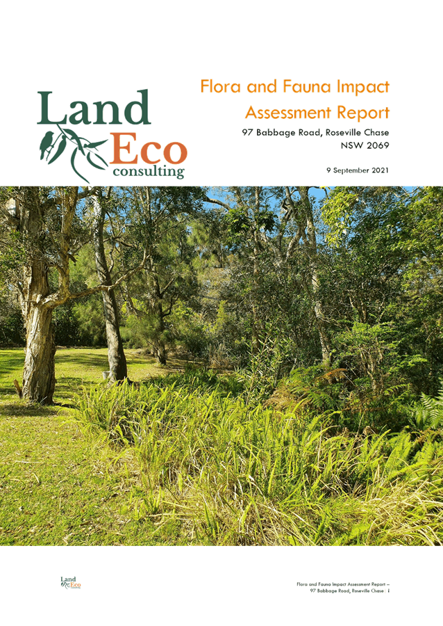

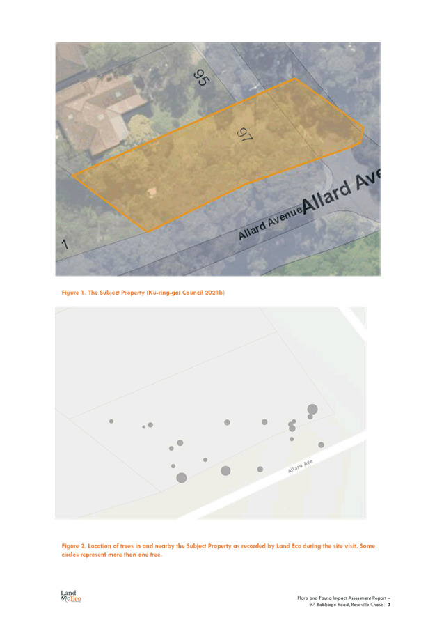
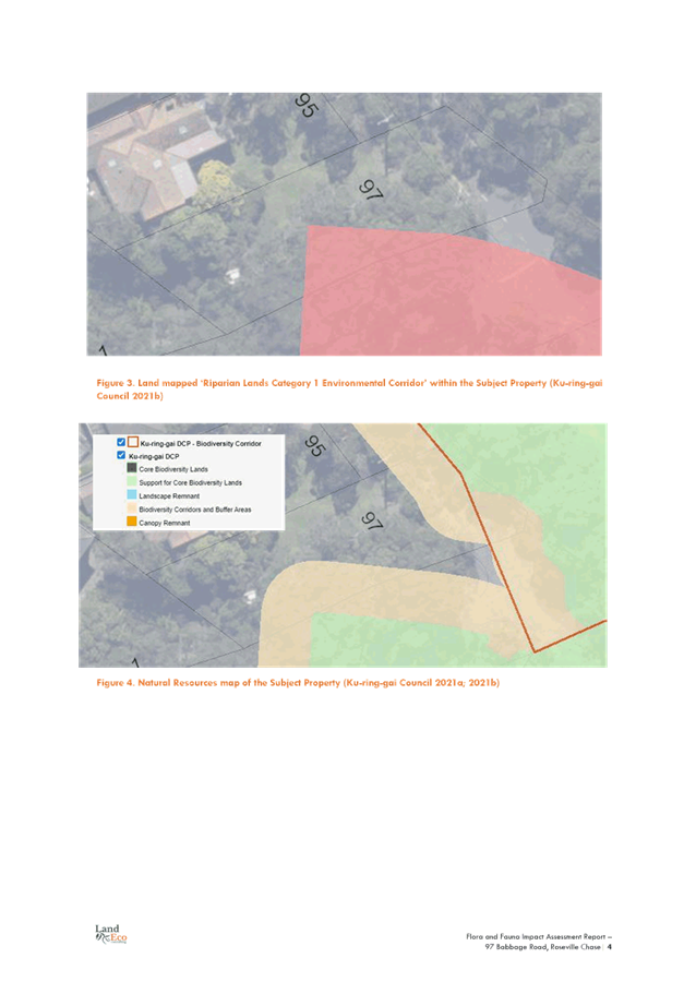
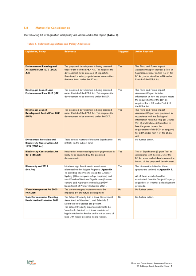
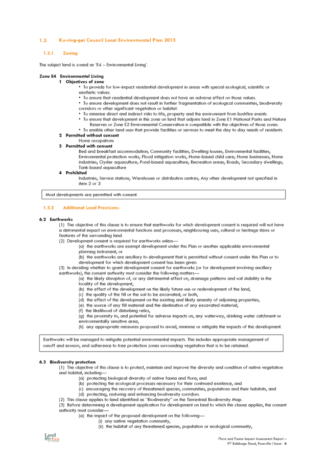
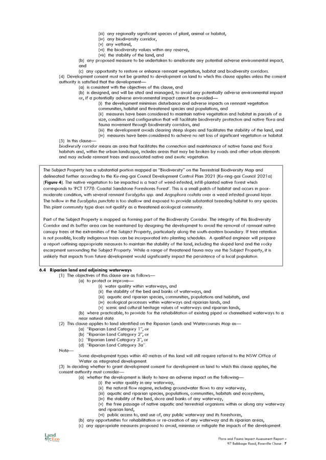
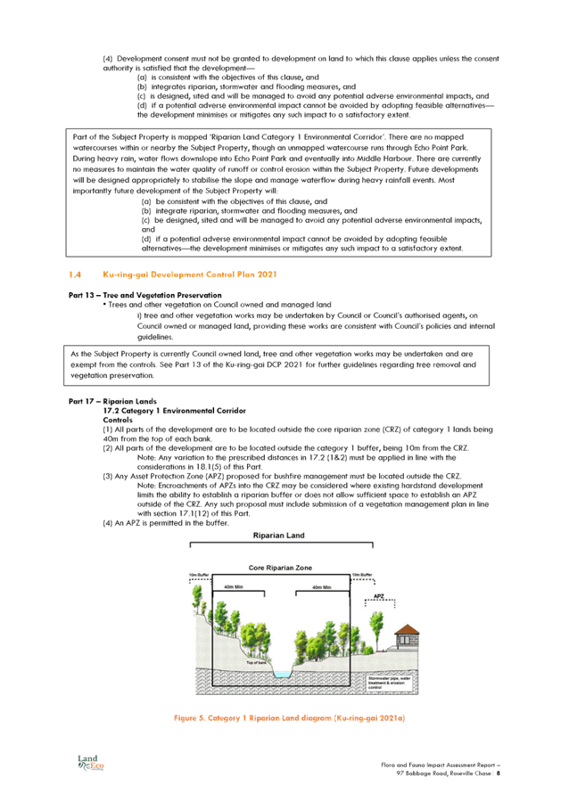
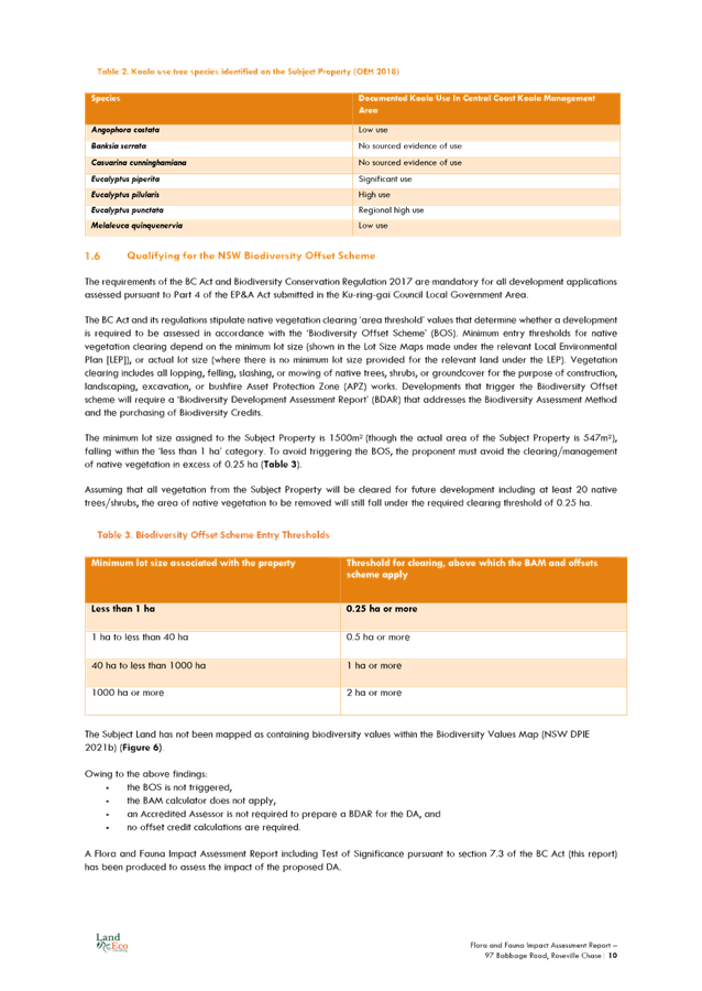
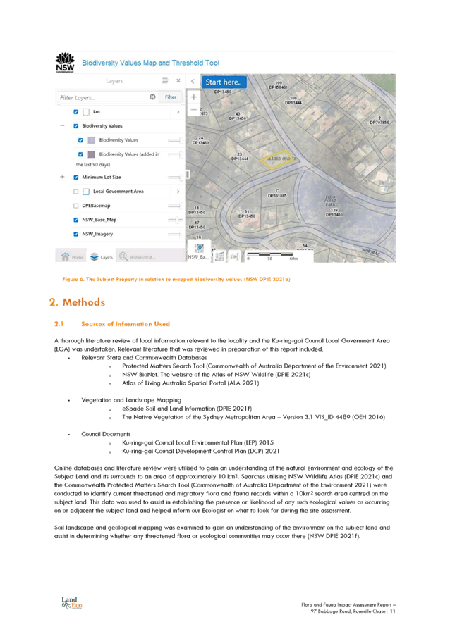
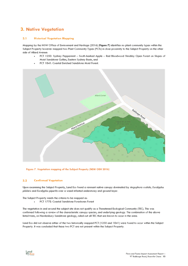
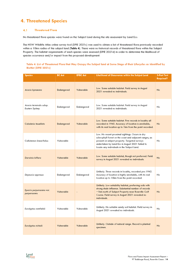
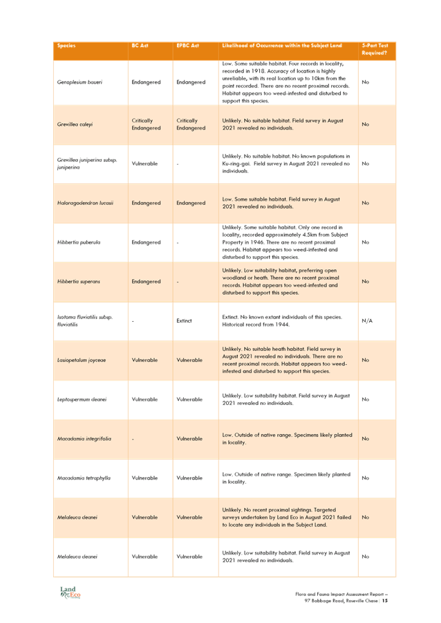
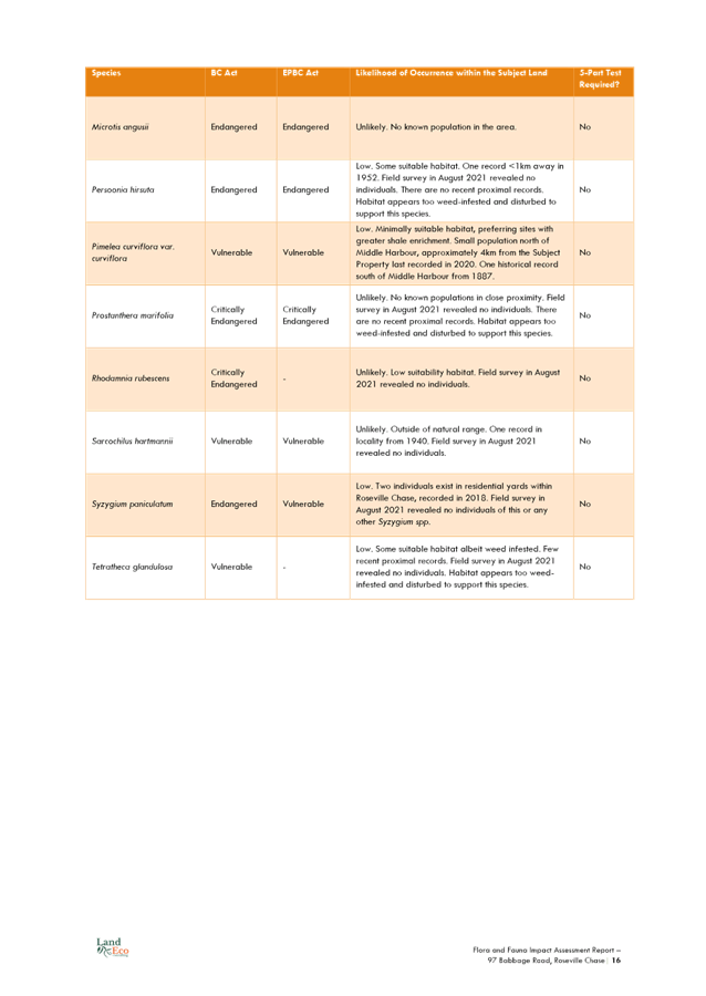
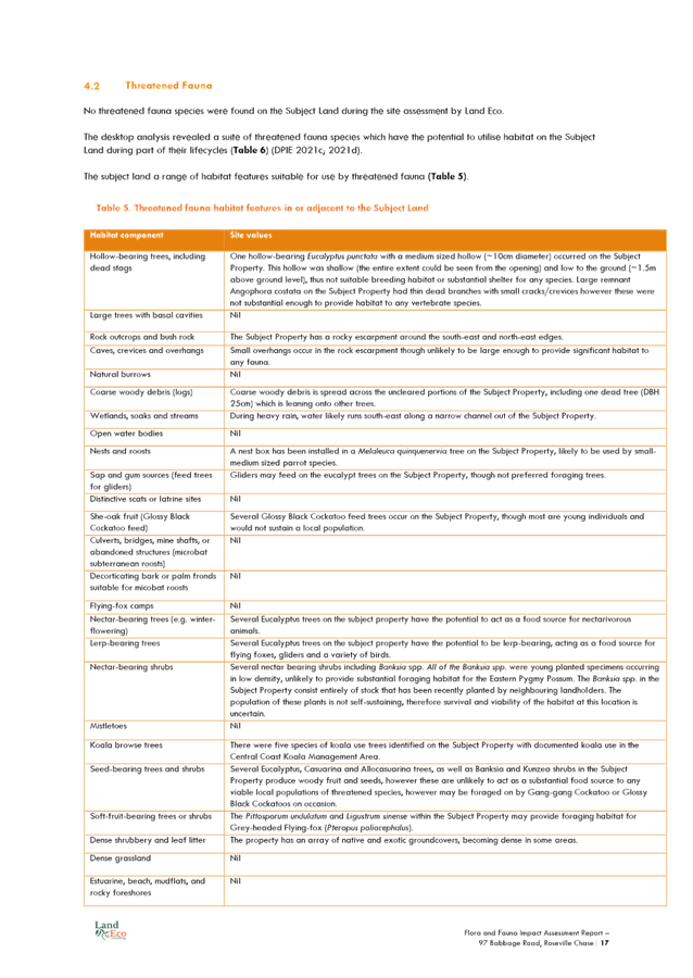
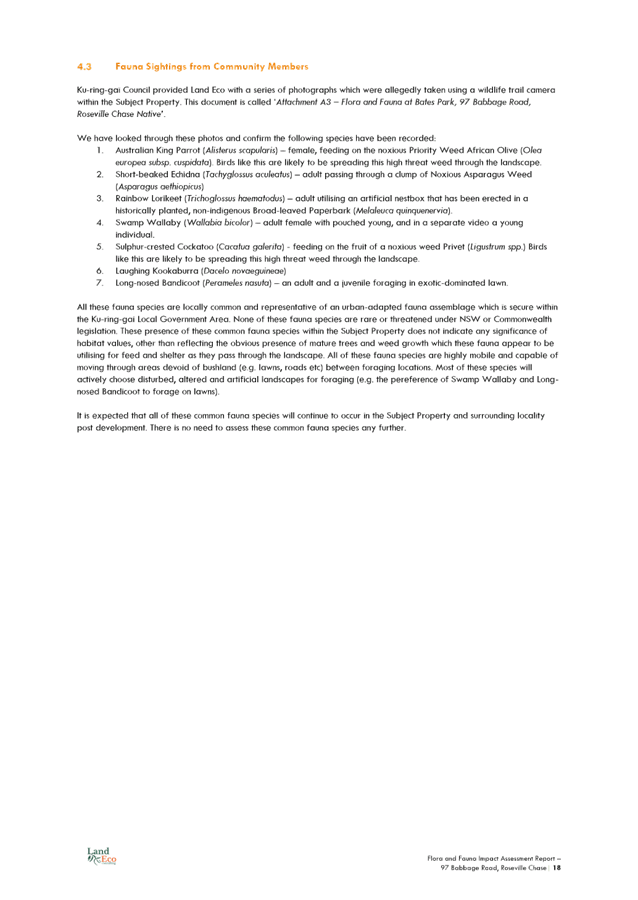
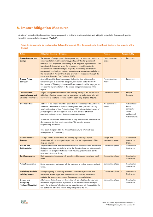

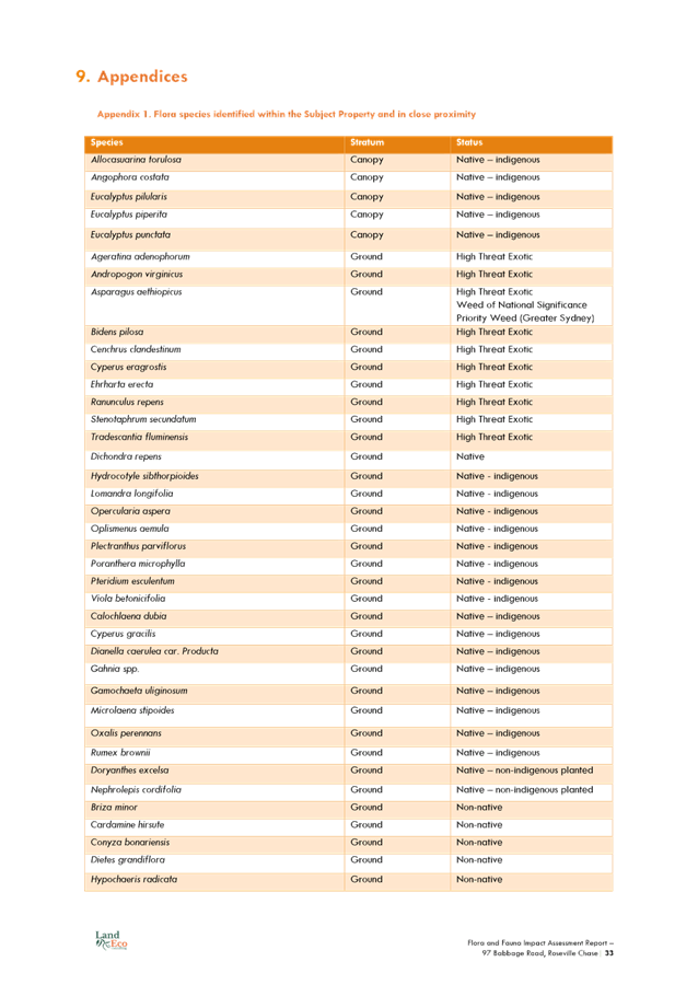
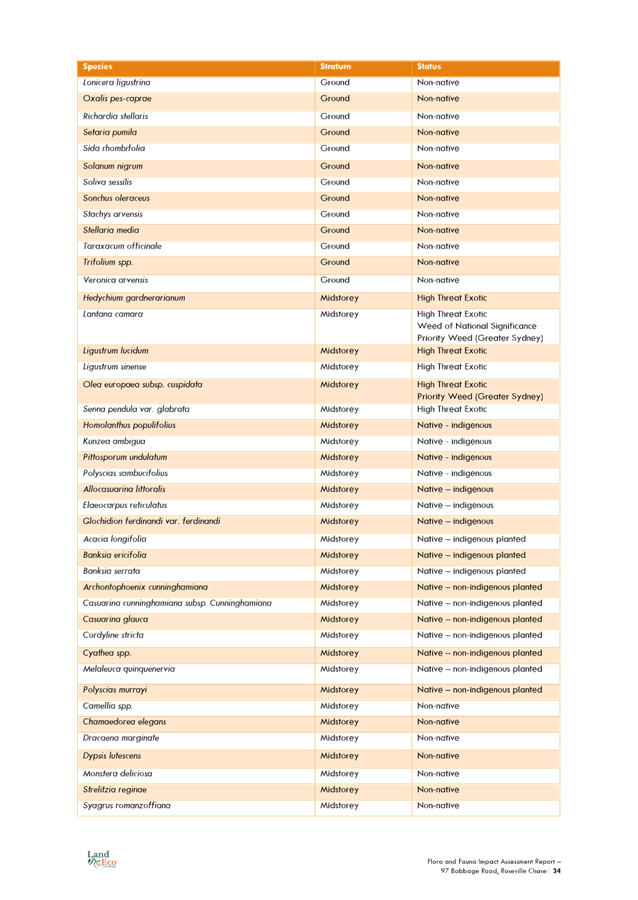

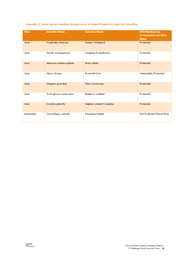
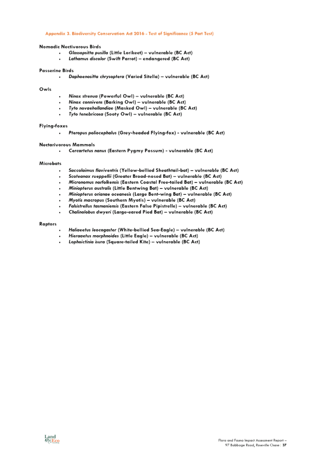
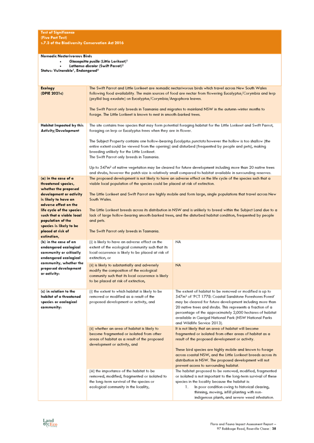
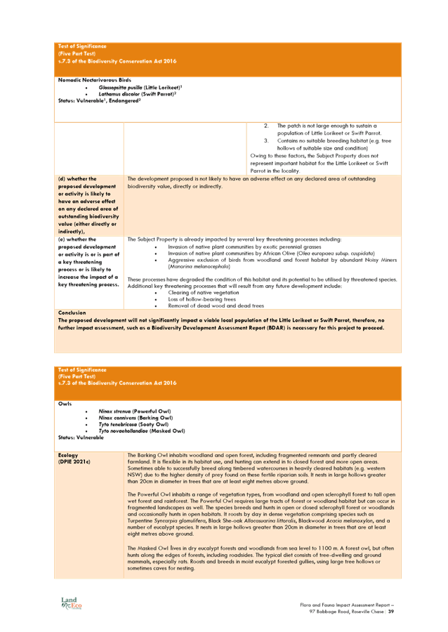
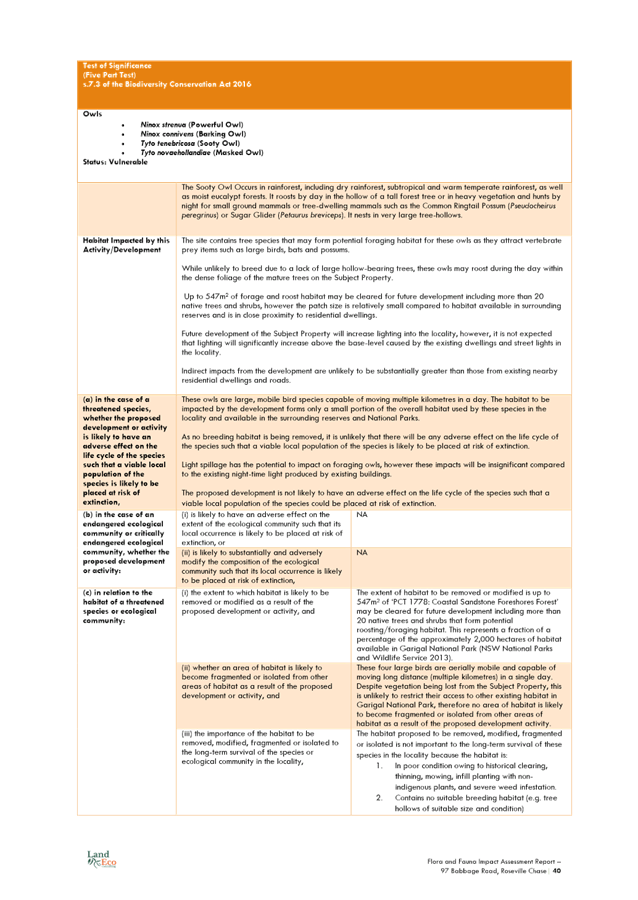
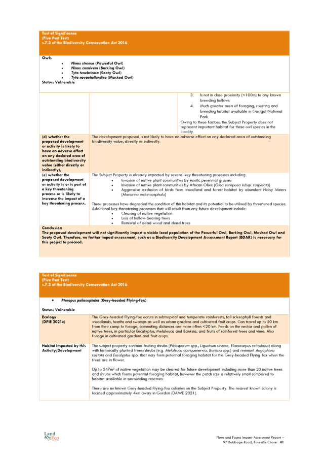
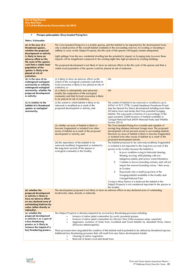

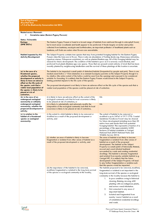
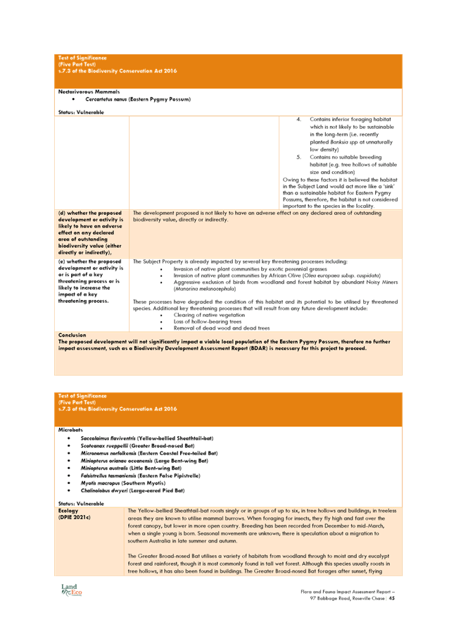
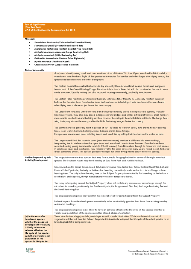
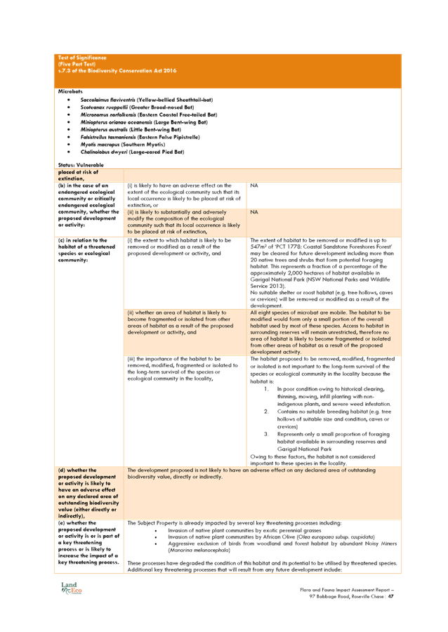
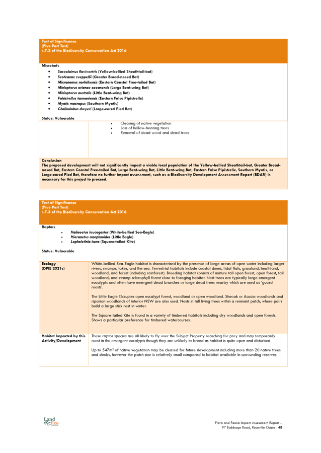
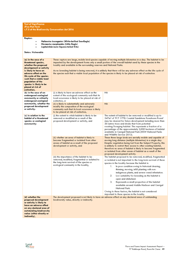
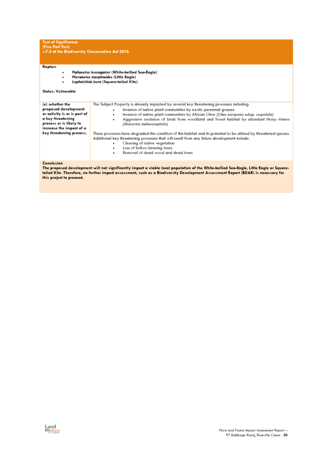

|
Ordinary
Meeting of Council - 26 April 2022
|
GB.13 / 1
|
|
|
|
|
Item
GB.13
|
S13203
|
Ku-ring-gai High School - Northern Sydney
& Beaches Hockey Association Proposal to Upgrade Existing Facilities
EXECUTIVE
SUMMARY
|
purpose of report:
|
The purpose of this report is to
update Council on discussions with Northern Sydney and Beaches Hockey
Association (NSBHA) and the Department of Education in relation to the
proposal for a synthetic hockey pitch at Ku‑ring-gai High School.
Since Council last considered this matter in July 2021
there have been significant changes to what this project looks like and how
the other parties see Council being involved going forward.
|
|
|
|
|
background:
|
After investigations spanning
several years, Council in March 2021 determined that Barra Brui Sportsground
was not a suitable site for a synthetic hockey field, primarily
on the basis of planned intensity of use and lack of sufficient car
parking for peak periods of usage.
Council subsequently resolved
that in the absence of other suitable alternative sites, Ku‑ring-gai
High School was a prospective alternate site for NSBHA as contemplated by
Council’s decision of 16 March 2021, and further, Council reiterated
its decision of 16 March 2021 to quarantine its contribution of $1,116,814 ex
GST for a maximum period of 12 months from that date.
|
|
|
|
|
comments:
|
It has always been
Council’s preference that NSBHA, who have occupied a site at
Ku-ring-gai High School (KHS) for some thirty years, remain at that site as a
direct tenant of the DoE.
In the absence of any other
alternative sites in the local government area, NSBHA are in ongoing
discussions with the Department of Education for the full redevelopment of
the existing pitch within the grounds of KHS.
|
|
|
|
|
recommendation:
|
That
Council determines in principle that it is prepared to be licensee for the
proposed synthetic field, subject to agreement of suitable terms in a
heads of agreement, licence agreement, and project deed (if necessary) with
Schools Infrastructure NSW and quarantines its contribution to the project
until the determination of the 2021/22 Multi-Sport Community Facility Fund,
after which the matter is reassessed.
|
Purpose of Report
The purpose of this report is to update Council on
discussions with Northern Sydney and Beaches Hockey Association (NSBHA) and the
Department of Education in relation to the proposal for a synthetic hockey
pitch at Ku‑ring-gai High School.
Since Council last considered this matter in July 2021 there
have been significant changes to what this project looks like and how the other
parties see Council being involved going forward.
Background
After investigations spanning several years, at its meeting
of 16 March 2021 Council determined that Barra Brui Sportsground was not a
suitable site for a synthetic hockey field, primarily on the basis of planned
intensity of use and lack of sufficient car parking for peak periods of usage.
Council resolved, inter alia:
“That:
A. The
proposed hockey facility does not proceed at Barra Brui Sportsground
B. Council
Officers continue to liaise with the NSBHA to find an alternate site within the
Ku-Ring-Gai Local Government Area and report back to Council with the outcome
of the investigation
C. Council
quarantine their contribution of $1,116,814 ex GST for a maximum period of 12
months.
D. Council
Officers write to the Office of Sport and Sport Australia advising them of
Council’s resolution and formally request the quarantine of grant funding
until an alternate site is determined.
E. Council
Officers write to the NSBHA and Scouts NSW advising them of Council’s
resolution.”
At its meeting of 20 July 2021, upon consideration of a
further status update report, Council resolved:
A. That
Council notes in the absence of other suitable alternative sites, the
identification of Ku‑ring-gai High School by Northern Sydney and
Beaches Hockey Association as an alternate site within the Ku-ring-gai
Local Government Area, as contemplated by Council’s decision of
16 March 2021.
B. That
Council reiterates its decision of 16 March 2021 to quarantine its contribution
of $1,116,814 ex GST for a maximum period of 12 months from that date.
C. Council
lodge grant variation with Sport Australia to have a $500,000 under the Sport
Australia Community Sport Infrastructure Fund re-allocated from the Barra Brui
amenities upgrade to unisex, accessible and ambulant toilets, a kitchen space,
changing rooms, and store rooms at Samuel King Oval.
Comments
The impact of Council’s decisions of March and July
2021 were effectively to open the door to further investigation of the use of
Ku-ring-gai High and to quarantine Council’s funding contribution, net of
internal costs, to March 2022.
In the intervening period, Hockey continues to have ongoing
discussions with:
· the Office of
Sport about transferring their existing grant from the Barra Brui project to
Ku-ring-gai High School;
· the Office of
Sport in relation to alternate grant funding opportunities; and
· Council, the
Department of Education, and Schools Infrastructure NSW about, inter alia:
o concept plans;
o broader community access to
the site;
o preferred head tenant
arrangements;
o operational costs and capital
replacement; and
o approval’s pathways and
responsibilities.
During the caretaker period
prior to the December local elections, the NSW Government opened the $200
million 2021/22 Multi-Sport Community Facility Fund (Monday 29 November 2021).
It is understood that in its discussions with the Office of Sport, NSBHA was
advised “the former grant at Barra Brui would have close to zero chance
of being transferred to KHS (and will be rescinded).” Consequently, NSBHA
applied in the 2021/2022 grant round.
Because of the restrictions on
decision making during the caretaker period, it was not possible to report this
matter to Council. Grant applications closed on Friday 25 February 2022.
In December 2021 Council provided NSBHA with a letter of
support for Round 1 of the 2021/22 Multi-Sport Community Facility Fund. This
letter of support was based on Council’s decision of March 2021 to
quarantine funds for the project, and Council’s July 2021 decision to
consider Ku‑ring-gai High School as a site for the synthetic hockey pitch
based on the proposal before Council at the time, being a preliminary concept
drawing prepared by NSBHA is provided at Attachment A1 and a preliminary
scope of work is provided at Attachment A2. Details of the
amenities building upgrade are found at Attachment A3 and the pitch
layout at Attachment A4.
NSBHA obtained a letter of consent from the landowner
(Department of Education) to submit the grant application.
In the absence of consideration by Council, changes to the
way the project was intended to be delivered arising subsequent to a letter of
support being given in December 2021 necessitated a more qualified letter of
support to be issued in February 2022, viz.:
……………At
its meeting of 20 July 2021, Council resolved, in part:
A. That
Council notes in the absence of other suitable alternative sites, the
identification of Ku‑ring-gai High School by Northern Sydney and
Beaches Hockey Association as an alternate site within the Ku-ring-gai
Local Government Area, as contemplated by Council’s decision of
16 March 2021.
B. That
Council reiterates its decision of 16 March 2021 to quarantine its contribution
of $1,116,814 ex GST for a maximum period of 12 months from that date.
At the time of writing,
Council’s potential commitment to this project is $1.0 million. Council
grants consent to the subject grant application making reference to
Council’s contribution to the project.
Further resolution of Council
is required in relation to such matters as Council entering into a Deed of
Licence with the Department of Education to operate the synthetic sports ground
at KHS outside school hours, including regular maintenance of the
facilities and future asset renewal and replacement.……………
Notwithstanding that NSBHA had been dealing with SINSW in
relation to a project concept plan since early 2021, it was only in early 2022
that SINSW came to the realisation that the curtilage of the State Heritage
listed Bini Dome at the Ku-ring-gai High School site would be a significant
constraint on the location of car parking included in the concept plan at Attachment
A1.
Council staff had raised this as an issue to be addressed in
its report to Council of 20 July 2021, which stated:
Preliminary
review of the site and the proposal indicates any environmental review will
need to address such issues as:
· State
heritage listed Bini Dome;
· bushfire
affectation;
· riparian
zone issues;
· endangered
ecological communities; and
· traffic
and parking.
This list
is not purported to be exhaustive.
According to the EPA Act,
exempt development may be carried out under Part 5 of the Act if the
development is of ‘minimal environmental impact’.
At risk of oversimplifying the last seven months:
· NSBHA has decided
to seek new grant funding rather than seeking to transfer its original grant
from one site to another.
· Schools
Infrastructure NSW would prefer Council to be the licensee rather than NSBHA.
This would necessitate Council being responsible for:
o bookings;
o operational costs;
o maintenance costs;
o capital replacement, etc.
All this is at no cost to DoE who
would have access to the facility at no cost until 4.00pm on school days (hours
yet to be negotiated).
· The constraints
imposed by the Bini Dome curtilage has caused NSBHA, in early February 2022, to
remove car parking and access from its 2021/2022 grant application. In this
respect, from Council’s perspective, separate parking and access is
considered essential to allow maximum use of the facility immediately after
ordinary school hours rather than when teachers leave and extracurricular
activities at the school cease. At a meeting between stakeholders on 8 April
2022 SINSW advised that it was key a key objective of DoE to provide parking in
excess of normal school requirements within school grounds. Given
Council’s experience with community expectations around traffic and
parking in relation to the former proposal at Barra Brui Sportsfield, this issue
is not negotiable.
· Replacement of the
existing synthetic surface would likely follow a different approvals path to
any carparking and access. The first requiring a review of Environment Factors
under Part V of the EPA Act, the second requiring a development application
under Part IV. This is solely a matter for SINSW. From Council’s
perspective, this could see Stage 1 works considered under an REF and
carparking, the subject of a separate development application, not approved,
not supported by the school, or simply not forthcoming at all.
In respect of car parking, the report to Council 20 July
2021 noted:
“In the event this
project proceeds, it is anticipated that there can be some cost savings to
Council if it designs and delivers the expanded car parking facilities in
accordance with any approvals obtained by the Department of Education.”
That no parking is included in the 2022 grant application
and may not be approved/included at all is of concern.
The table below summaries other changes in issues and responsibilities
that have arisen as the project shifted from Barra Brui, through Council
consideration of relocation to KHS in July 2021, to the proposal now being
considered by Council.
|
Issue
|
Barra Brui
Project
|
Project at KHS
as at Council Consideration in July 2021
|
Project at KHS
as at April 2022
|
|
NSBHA Greater Sydney Sports Facility Fund grant
|
Secure
|
Unknown
|
Subject to consideration in a new grant round
|
|
Licensee
|
NSBHA
|
NSBHA
|
Council
|
|
Operational Costs
|
NSBHA
|
NSBHA
|
Council
|
|
Capital Replacement
|
NSBHA
|
NSBHA
|
Council
|
|
Maintenance
|
NSBHA
|
NSBHA
|
Council
|
|
After Hours General Public Access
|
Yes
|
Possibly if facility separately fenced
|
No
|
|
Dedicated Parking
|
Yes
|
Yes
|
No
|
|
Consent/review Authority
|
Council (REF)
|
SINSW (REF)
|
Field – SINSW (REF)
Parking and Access – SINSW
(DA)
|
|
Construction Authority
|
Council
|
SINSW
|
SINSW
|
|
Project REF documentation
|
Council (Project Funded)
|
SINSW (Hockey Funded)
|
NSBHA (Self Funded)
|
In the intervening period Council has commissioned:
· Otium
Planning Group Pty Ltd to undertake the Ku-ring-gai Multi-Use Hockey Field Feasibility study,
November 2021 (Confidential Attachment A5); and
· Blue Stone
Management to undertake a preliminary cost plan to determine the projects costs
for completion on the school site, (Confidential Attachment A6).
While these documents have been shared with both NSBHA and
DoE, and indeed NSBHA has advised they do not necessarily accept the findings
of the reports, the work was commissioned to assist Council determine if NSBHA
had sufficient funds to carry out the project given that construction cost risk
would effectively be transferred to Council under the current iteration of the
project and secondly, to assist Council gain an understanding whether the
project would generate sufficient income to cover full replacement costs and
operating costs.
Council is in the early stages of undertaking a Recreation
Needs Study that will provide a detailed review of the current recreation needs
of the community and to inform the future development of recreation in the Local
Government Area. The study will cover all facets of community recreation, from
walking the dog, MTB, and community sports, including. This with the Recreation
Strategy will guide Council in the development of future recreation development
and to get the maximum value of our open space to the benefit of the community.
integrated planning and reporting
Theme 1
Community, People and Culture
|
Community Strategic
Plan Long Term Objective
|
Delivery Program
Term Achievement
|
Operational Plan
Task
|
|
C4.1.1 A range of cultural, recreational and leisure
facilities and activities are available to encourage social interaction and
stimulate everyday wellbeing.
|
Programs are delivered in collaboration with agencies and
partners to encourage healthy and active lifestyles.
|
Develop and implement sports programs in co-operation
with, or by supporting local sporting clubs and providers.
|
Theme 3 Places, Spaces and Infrastructure
|
Community Strategic
Plan Long Term Objective
|
Delivery Program
Term Achievement
|
Operational Plan
Task
|
|
P6.1.1 Partnerships are
established with community groups and organisations to optimise the
availability and use of sporting, recreation and leisure facilities.
|
Engage with community partners
to improve Council’s sporting and recreational facilities.
|
Pursue improvement of sporting
and recreational facilities through partnerships, grant funding and other
external funding opportunities.
|
Governance Matters
The Department of Education
is owner of the subject land. The DoE would be responsible for statutory
approvals and/or environmental review under the Environmental Planning and
Assessment Act, 1979.
It is likely that there would
need to be a three-way Heads of Agreement between Council, the Department of
Education and NSBHA in relation to implementation of the project. The current
position of SINSW/DoE is that similar to the Joint Use Sports Courts at St
Ives, construction of the Hockey Facility would be managed by SINSW and all
costs (including variations and over-runs) would effectively be underwritten by
Council. This was always understood.
Similarly, whereas in July
2021 Council did not see itself as being involved in the ongoing maintenance of
the facility, the current position of SINSW and NSBHA is that Council would be
responsible for bookings, maintenance and operational costs and replacement
costs of the synthetic filed for the duration of any licence. Council would be
the “head” tenant with Department of Education, and Hockey simply a
user of the facility.
Risk Management
Grant funding from Sport Australia for amenities upgrades
has already been forfeited.
There is also the risk that grant funding from the NSW
Office of Sport to the value of $2,720,000.00 may not be available to this
project subject to the outcomes of the 2021/22 Multi-Sport Community Facility
Fund.
NSBHA appears to have accepted advice from the NSW Office of
Sport that a variation application to move the existing grant from Barra
Brui Sportsground to Ku-ring-gai High School site would be unsuccessful. That
is not a matter for Council.
It came to light at the meeting of stakeholders on 8 April
2022 that Northern Suburbs Football Association has come to financial
arrangements directly with the school principal in relation to access to the
existing turf field and teachers car park at KHS. This puts additional
pressure on already limited on-site car parking and provides challenges to the
financial modelling underpinning the project.
Financial Considerations
The Department of Education has advised NSBHA that they are
not prepared to put any funds towards the project.
While this is certainly Council’s experience with
other “joint” projects with DoE, the situation is perhaps
compounded by the fact Ku-ring-gai High School is not a sports high school and
does not have a hockey program. The school itself does not require a facility
of the nature and specification required by NSBHA.
In the event Council determines not to be involved in this
project, removal, replacement, or remediation of the existing facility would be
a matter for DoE and NSBHA.
In terms
of Council and the NSBHA, the parties’ funding commitments towards the
project when it was located at Barra Brui Sportsground are broadly outlined
below:
· $2,250,000
ex GST secured by NSBHA through the Greater Sydney Sports Facility Fund to assist
with funding the artificial playing surface and clubhouse building
refurbishment.
· $250,000 ex GST
cash contribution from NSBHA, noting that $200,000 ex GST of these funds will
be received by Council prior to the Request for Tender for constructing The
Facility, with the remaining $50,000 ex GST received by Council prior to 1
December 2021.
· NSBHA have noted
their previous commitment and financial guarantee of $500,000 ex GST from a
local hockey family (as per NSBHA’s proposal titled “Project
Plan” dated 7 December, 2018) has been withdrawn from the project,
however additional funds can be raised by NSBHA if required and subject to
agreement between the parties.
· $500,000 ex GST
awarded to NSBHA through the Sport Australia Community Sport Infrastructure
Fund to assist with funding the building refurbishment.
· Council will
contribute up to a maximum of $1,116,814 ex GST towards the project (including
the costs of preliminary environmental assessments up to the date of signing of
this memorandum), replacing its original $250,000 ex GST contribution as per
the Funding Agreement. This contribution must be allocated towards project
management services, including environmental assessment, consultation and
planning approvals regarding The Facility, and any capital requirements arising
for Council regarding the development of playing surface, ancillary parking and
access, as the project is further defined. Council’s contribution is not
available for refurbishment of the existing amenities building given its source
from s.7.11 contributions.
When Council last considered this matter in July 2021, it
was anticipated that all these funding sources and allocations would remain in
place for any alternate project.
Sport Australia subsequently advised they were not prepared
to transfer the $500,000 Community Sport Infrastructure grant to Ku-ring-gai
High as the original grant program explicitly excluded schools from making
application.
Following advice from Sport Australia, Council in July 2021
resolved to, inter alia, ……..” lodge grant variation with
Sport Australia to have a $500,000 under the Sport Australia Community Sport
Infrastructure Fund re-allocated from the Barra Brui amenities upgrade to
unisex, accessible and ambulant toilets, a kitchen space, changing rooms, and
store rooms at Samuel King Oval.
Council was subsequently advised that it had been
unsuccessful in seeking to vary the grant. Consequently, this element of the
original funding package is no longer available to either NSBHA or Council.
Given the rules of apportionment that apply to
Council’s projects, it would not be acceptable to see the NSBHA
contribution reduce below the amounts outlined above, otherwise the overall
quantum of Council’s contribution may need to be revisited.
Council’s contribution was always premised on the
facility at Barra Brui Sportsground being made available for other users
outside booked time by the NSBHA. This principle remains a fundamental
objective in negotiating any HoA going forward.
In the event additional parking is not provided on site,
Council access to the field may be further restricted beyond the hours modelled
to allow staff to exit the site first.
Council’s funding for this project is from
s.7.11/s.7.12. This funding source is available for new assets, not
replacement of the existing hockey pitch. The key elements Council was
funding are not included in the Stage 1 scope of works the subject of the
current grant application. At the same time, the Stage 1 application
effectively relies on Council’s funds as part of a
“co-contribution”.
Social Considerations
Notwithstanding that work on
this project at KHS started more than 12 months ago, it is being carried out
under the broad terms of an MoU between Council and the Department of Education
through School Infrastructure NSW (SINSW) adopted by Council in November 2021.
The MoU allows both parties to explore a partnership arrangement for
cross-sharing resources and knowledge to the benefit of the schools and the
local community.
In the event suitable public
access arrangements can be negotiated with the Department of Education and
NSBHA, the inclusion of a synthetic surface at Ku-ring-gai High School will
provide increased social benefits for the community and enable better
utilisation of facilities.
The site has been used as a synthetic sports field for some
30 years and additional impacts, albeit at an early stage in the design and
documentation process, are anticipated to be minimal. Existing parking
pressure on surrounding local streets would only be alleviated by the provision
of additional on-site parking, which could be designed and constructed as
additional hard surface sports courts for daytime use by the school, or simply
used by the school for parking.
It would be necessary to work
with the local community to both shape and manage expectations relating to
increased usage of a site, which would occur as a consequence of this project
proceeding. Consideration towards the local residents and ongoing
management with user groups will be required from Council to minimise any such
impacts that may occur from usage.
Environmental Considerations
Under Part 5 of the Environmental
Planning and Assessment Act 1979 (EPA Act), the Department of Education has
a responsibility to consider the likely environmental impact of any proposed
activity. It should be noted that there is already a synthetic playing field at
this location which is past its useful life and is being completely rebuilt as
part of this proposal.
The DoE must identify all potential
impacts of the proposed hockey facility at Ku-ring-gai High School and consider
the scale and significance of any such impacts, to determine whether the
proposal should proceed, be modified/ reviewed or not undertaken at all.
Preliminary review of the site
and the proposal indicates any environmental review will need to address such
issues as:
· State
heritage listed Bini Dome;
· bushfire
affectation;
· riparian
zone issues;
· endangered
ecological communities; and
· traffic
and parking.
This list is not purported to be
exhaustive but is a matter for SINSW to manage.
According to the EPA Act,
exempt development may be carried out under Part 5 of the Act if the
development is of ‘minimal environmental impact’.
Community Consultation
To be carried out by the
Department of Education, in conjunction with other parties to the project, as
required by DoE procedures for project approvals.
Internal Consultation
Staff from Council’s
Operations, Corporate, and Strategy and Environment Departments are aware of
this proposal.
Summary
From Council’s perspective, it has always been
preferable that NSBHA, who have occupied a site at Ku-ring-gai High School for
some thirty years, remain at that site as a direct tenant of DoE.
Since Council last considered this matter in July 2021 there
have been significant changes to what this project looks like and how the other
parties see Council being involved going forward.
Schools Infrastructure NSW would prefer Council to be the
licensee rather than NSBHA. This would necessitate Council being responsible
for:
o bookings;
o operational costs;
o maintenance costs;
o capital replacement, etc.
In short, Council would take full risk for taking bookings
and generating sufficient revenues to cover operating costs and replacement of
the synthetic surface at appropriate times during the life of the licence.
While modelling underpinning the project indicates it is viable, charge out
rates are at the upper end of what is being charged in the market, project
specifications, particularly lighting, are beyond what Council ordinarily
provides for night-time use.
Given that the Stage 1 project as reflected in NSBHA’s
final 2021/22 Multi-Sport Community Facility Fund grant application does not
include elements crucial to Council’s out of hours use of the facility
such as car parking, Council’s ongoing support for this project needs to
be qualified.
Recommendation:
A. That
Council determines in principle that it is prepared to be licensee for the
proposed synthetic field, being responsible for such things as:
a. bookings;
b. operational
costs;
c. maintenance
costs;
d. capital
replacement, etc.,
subject to agreement of suitable
terms in a heads of agreement, licence agreement, and project deed (if
necessary) with Schools Infrastructure NSW.
B. That
Council advise Northern Sydney and Beaches Hockey Association that its
financial contribution to this project is subject, but not limited to,
provision of all the key elements of the concept plan considered by Council in
July 2021, particularly an appropriate number of, and suitably located,
off-street car parking spaces separate from those required by the school for
its ordinary use.
C. That
Council advises Northern Sydney and Beaches Hockey Association and Schools
Infrastructure NSW that that its financial contribution to this project is
subject, but not limited to, agreement of suitable terms in a heads of
agreement, licence agreement and project deed (if necessary).
D. That
Council quarantine its contribution of one million dollars ex GST until the
determination of the 2021/22 Multi-Sport Community Facility Fund, after which
the matter is reassessed.
E. That
if Council proceeds it accepts the risk of project costs and financial
commitment increasing.
|
Andrew Watson
Director Strategy & Environment
|
|
|
Attachments:
|
A1 ⇩ ⇩
|
Final
concept drawing
|
|
2022/100973
|
|
|
A2⇩
|
Concept
Drawing Explanatory Notes
|
|
2022/100974
|
|
|
A3⇩
|
Amenity
Building Design drawings
|
|
2022/100976
|
|
|
A4⇩
|
Polytan
- Multi-sport Overlay Rev 2
|
|
2022/100980
|
|
|
A5
|
Final
Cost Estimate November 2021
|
|
Confidential
|
|
|
A6
|
Revised
Cost Estimate
|
|
Confidential
|
|
APPENDIX No: 1 - Final
concept drawing
|
|
Item No: GB.13
|
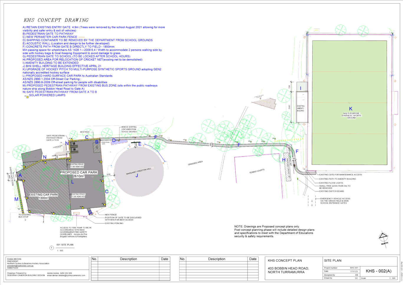
|
APPENDIX No: 2 - Concept
Drawing Explanatory Notes
|
|
Item No: GB.13
|
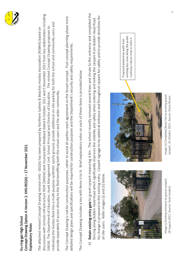


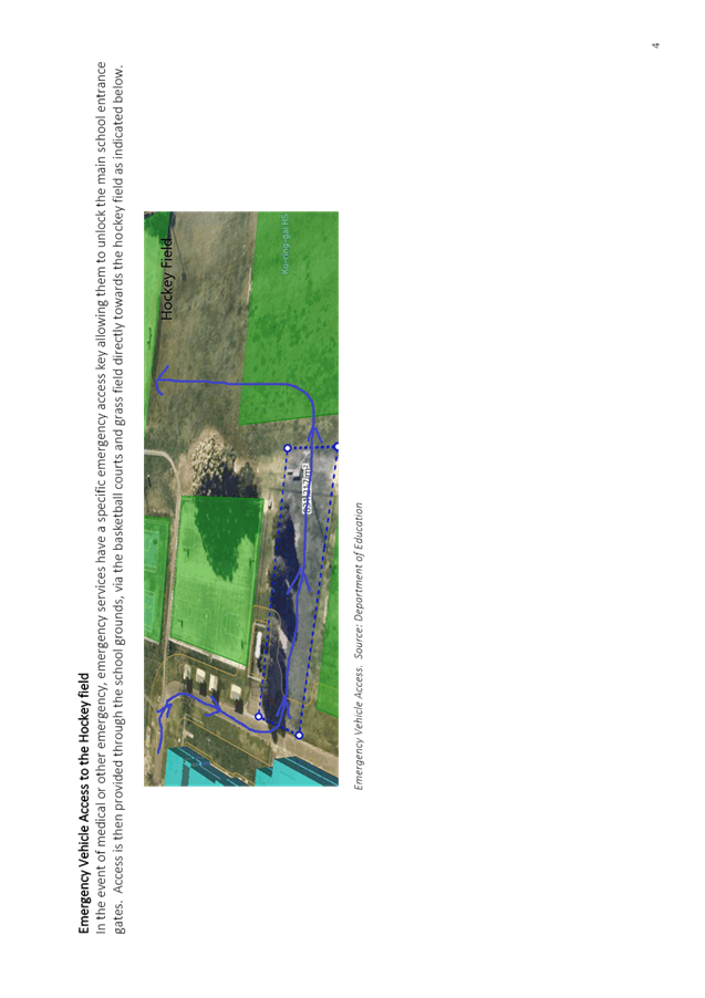
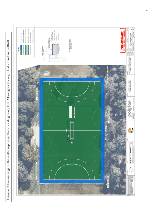
|
APPENDIX
No: 3 - Amenity
Building Design drawings
|
|
Item No: GB.13
|
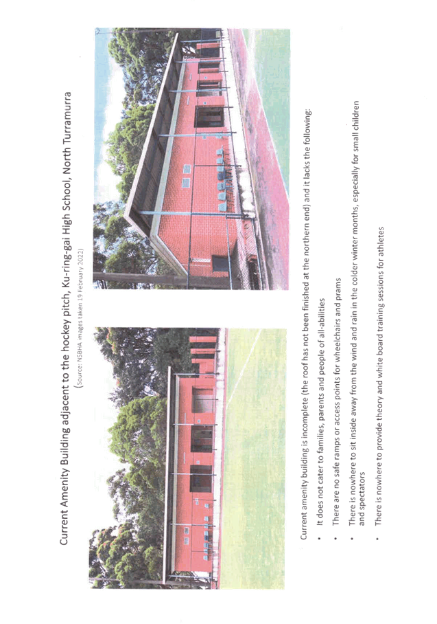
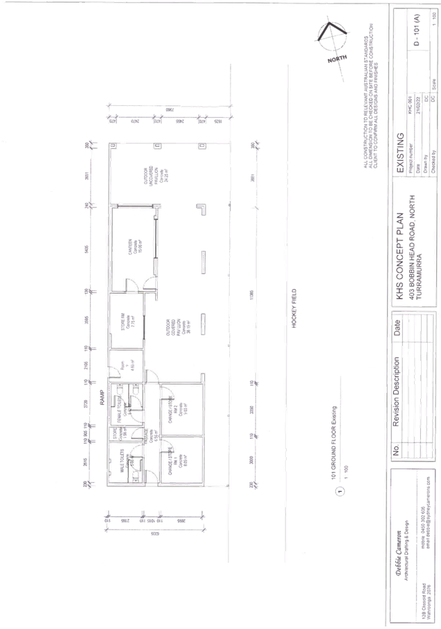
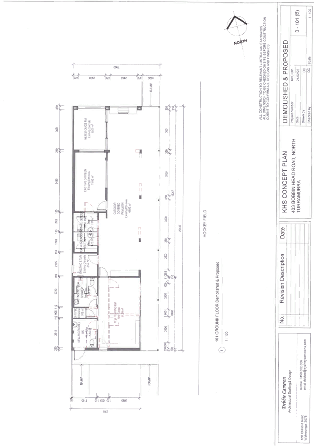
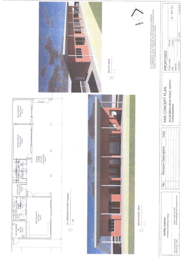
|
APPENDIX
No: 4 - Polytan
- Multi-sport Overlay Rev 2
|
|
Item No: GB.13
|
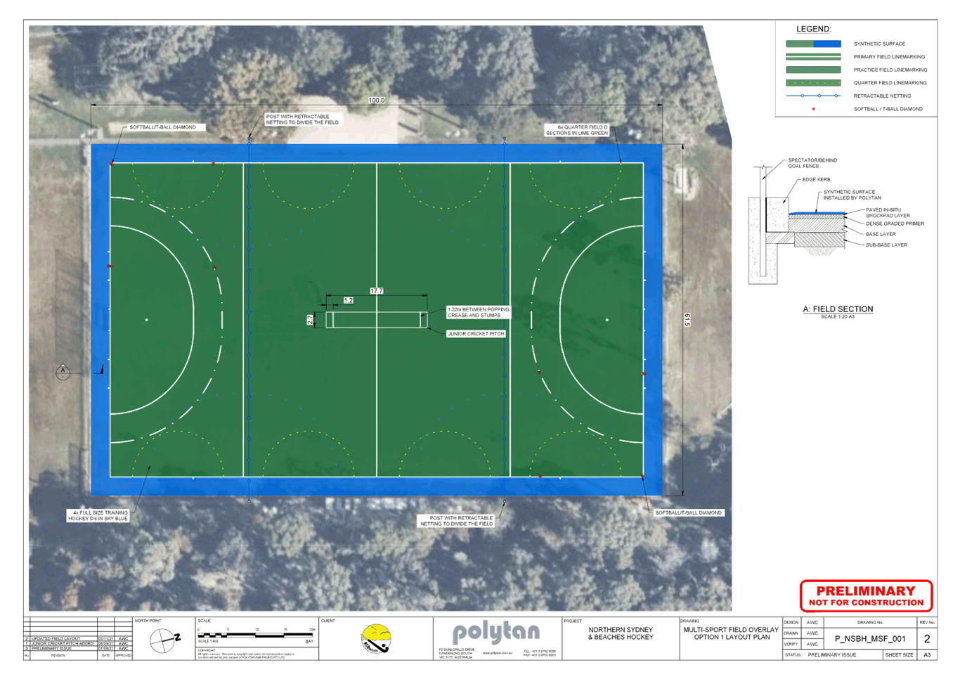
|
Ordinary
Meeting of Council - 26 April 2022
|
GB.14 / 1
|
|
|
|
|
Item
GB.14
|
S12998
|
Gilroy Road Temporary Cycleway - Project Evaluation
EXECUTIVE
SUMMARY
|
purpose of report:
|
To consider the status of the
temporary separated cycleway in Gilroy Road, Turramurra.
|
|
|
|
|
background:
|
The Streets as Shared Spaces program provides
one-off grant funding to support local councils to test and pilot
quick-response demonstration projects and strategic pilots that temporarily
adapt streets to support healthier, safer and more resilient communities.
Considering the COVID-19 pandemic, Council staff applied for funding to
implement a “pop-up” (temporary) cycleway between Turramurra
Memorial Park and Eastern Road, via Karuah Park and Gilroy Road, and the
nomination was successful. The installation was completed around March 2021.
|
|
|
|
|
comments:
|
Once installation of the cycleway
was completed, bicycle monitoring was conducted for approximately 10 weeks.
In terms of average daily counts recorded along the cycleway, the peak counts
compare favourably with counts recorded at some established cycleways
elsewhere in Sydney, which indicates the cycleway in Gilroy Road has the
capacity to serve as an effective and permanent sustainable transport route.
|
|
|
|
|
recommendation:
|
That the pop-up cycleway in
Gilroy Road be retained until the integrated 2-way separated cycleway
identified in the Public Domain Plan for Turramurra is constructed.
|
Purpose of Report
To consider the status of the temporary separated cycleway
in Gilroy Road, Turramurra.
Background
In May 2020, the then NSW Department of Planning, Industry
and Environment (DPIE), working with Transport for NSW (TfNSW), established a
$15 million Streets as Shared Spaces grant program. Councils were encouraged to
apply for grants for temporary projects to deliver short-term improvements to
streets and public spaces, to make them safer and more attractive during COVID
restrictions and into the future.
The Streets as Shared Spaces program provides one-off grant
funding to support local councils to test and pilot new and innovative ideas
for streets as safe, shared public spaces. The program provided funding to
quick-response demonstration projects and strategic pilots that temporarily
adapt streets to support healthier, safer and more resilient communities.
In light of the COVID-19 pandemic more people have been walking and cycling,
particularly for recreation, and physical distancing requirements impacted
everyday activities that require gathering in streets, from waiting at a busy
intersection to outdoor dining.
In response to this, Council staff applied for funding to
implement a “pop-up” (temporary) cycleway between Turramurra
Memorial Park and Eastern Road, via Karuah Park and Gilroy Road (Attachment
A1). The objectives were twofold:
1. To
provide a safe, separated cycling connection between Turramurra shops and
Karuah Park/Turramurra Memorial Park and beyond and thereby supporting cycling
as a healthy and sustainable mode of travel, and recreation for recreation
purposes, during the COVID-19 pandemic; and
2. To
trial the integrated 2-way separated cycleway identified in the Public Domain
Plan for Turramurra (Attachment A2), which was since adopted by Council
on 15 March 2022.
The funding application was successful and the pop-up
cycleway was delivered by reallocating the road space occupied by 9 short
stay/42 long stay kerbside car parking spaces on the northern and western sides
of Gilroy Road (between Eastern Road and Brentwood Avenue) to form a 2.4m wide
2-way cycleway, separated from the adjacent traffic lane with bolt-on plastic
kerbs and bollards/wands. At the northern stub of Gilroy Road, the cycleway is
in the form of on-road/mixed use facility, due to the low traffic volumes in
this section. Through Karuah Park, a shared user path was constructed in
asphalt, by widening the existing internal path on the eastern and southern
perimeter of Karuah Oval. The works also included the installation of two new
pedestrian refuge islands, to improve safety for pedestrians and bicycles
crossing Gilroy Road at the intersection of Eastern Road and crossing of
Brentwood Avenue on the western side of Gilroy Road.
To connect to Turramurra Memorial Park, a short section of
2.4m wide 2-way cycleway (also separated from the adjacent traffic lane through
bolt-on plastic kerb and bollards/wands) was installed on Karuah Road between
the access roads of Karuah Park and Turramurra Memorial Park. This was road
space that was not previously part of a traffic lane or kerbside car parking,
although minor adjustments to a bus layover space were made to accommodate it.
The installation was completed around March 2021.
The Public Domain Plan for Turramurra foreshadows a separated
cycleway on the same section/length of Gilroy Road, but integrated with the
surrounding streetscape.
Comments
Once installation of the cycleway was completed, 3 sessions
of formal bicycle monitoring were conducted through the use of automated
(pneumatic tube) counters in the cycleway as follows:
1. an
initial session from 11 June 2021 - 1 July 2021 (COVID-19 movement restrictions
mostly relaxed);
2. from
20 July 2021 – 9 August 2021 (COVID-19 movement restrictions imposed);
and
3. from
16 December 2021 – 28 January 2022 (COVID-19 movement restrictions
relaxed).
for a total of approximately 10 weeks of counts. During
these counting periods, just under 1,700 bicycle trips were recorded, with the
following average daily counts:
|
Date of counts- Gilroy Rd (inclusive)
|
Average daily
count
|
|
11 June 2021 -17 June 2021
|
16
|
|
18 June 2021 -24 June 2021
|
9
|
|
25 June 2021 -1 July 2021
|
34
|
|
20 July 2021 -26 July 2021
|
40
|
|
27 July 2021 -2 August 2021
|
55
|
|
3 August 2021 -9 August 2021
|
48
|
|
16 December 2021 -22 December 2021
|
16
|
|
23 December 2021 -29 December 2021
|
14
|
|
30 December 2021 -5 January 2022
|
19
|
|
21 January 2022 – 27 January 2022
|
13
|
During the counting periods, some people riding bicycles
were choosing to cycle in the traffic lanes on Gilroy Road rather than in the
separated cycleway, although the counts at the end of 2021 indicated these were
in the minority compared to the number of people riding in the cycleway.
For context, according to City of Sydney cycling data, RMS
Cycling Statistics and TfNSW Open Data Hub, the cycleways below recorded the
following average daily usage:
|
Location
|
Year
|
Average daily
count
|
|
Intersection of Portman Street and Geddes Avenue (Zetland)
|
2021
|
43
|
|
Intersection of New South Head Road and Neild Avenue (Paddington)
|
2020
|
78
|
|
Liverpool to Parramatta Rail Trail (Cabramatta)
|
2018
|
35
|
|
Liverpool to Parramatta Rail Trail (Guildford)
|
2018
|
50-80
|
|
Crestwood Reserve cycleway (Baulkham Hills)
|
2018
|
50
|
|
Hawthorne Canal cycleway (Haberfield)
|
2018
|
70
|
|
Hawthorne Canal cycleway (Haberfield)
|
2019
|
81
|
|
Rouse Hill to Parramatta separated cycleway, Darcy Road
(Westmead)
|
2018
|
85
|
|
Rouse Hill to Parramatta separated cycleway, Darcy Road
(Westmead)
|
2019
|
76
|
In terms of average daily counts recorded along the Gilroy
Road cycleway, the peak counts compare favourably with these counts that were
recorded at established cycleways elsewhere in Sydney, which indicates the
cycleway in Gilroy Road has the capacity to serve as an effective and permanent
sustainable transport route with the potential to further increase usage
through expansion/extension/connections. This may include a potential future
connection through Turramurra Memorial Park and along local roads to Burns Road
(broadly consisted with the Ku-ring-gai Bike Plan), where existing separated
cycling facilities along Burns Road provide connections to St Ives and
Wahroonga.
integrated planning and reporting
Theme 3 (Places, Spaces and Infrastructure) and Theme 4
(Access, Traffic and Transport):
|
Community Strategic
Plan Long Term Objective
|
Delivery Program
Term Achievement
|
Operational Plan
Task
|
|
P4.1: Our centres offer a broad range of shops and
services
and contain lively urban village spaces and places where
people can live, work, shop, meet and spend leisure time.
|
Plans to revitalise local centres are being progressively
implemented and achieve quality design and sustainability outcomes in
collaboration with key agencies, landholders and the community.
|
Implement Public Domain Masterplans for the local centres
and concept plans for key precincts.
|
|
T1.1 A range of integrated
transport choices are available to enable effective movement to, from and
around Ku-ring-gai.
|
Connections are provided to public transport that are
accessible to all age groups and match the travel needs of the community.
|
An improvement plan is being implemented for bikeways,
pedestrian facilities and footpath networks having regard for the access,
health and recreational needs of the community.
|
Governance Matters
Council adopted the Public
Domain Plan for Turramurra in March 2022. In the plan, the designed future
character of Gilroy Road is a tree-lined boulevard with a strong link between
Turramurra Memorial Park / Karuah Park and the Local Centre for cyclists and
pedestrians. A separated cycleway and wide pedestrian paths, along with street
tree planting will form part of the Green Grid, connecting the Local Centre and
Cameron Park with Karuah Park, and then to Lovers Jump Creek riparian corridor.
Garden beds and canopy trees will cool the street and create a park-like
environment in the street corridor. Refer Figure 1.
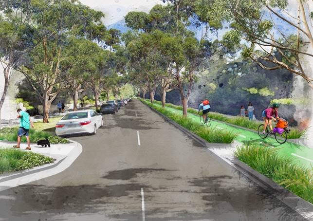
Figure 1 – Artist’s impression Gilroy Road Upgrade including
separated cycleway from Ku-ring-gai Public Domain Plan – Volume 2,
Turramurra.
In 2021 TfNSW adopted a Road User Space Allocation Policy (Attachment
A3), which requires allocation of physical and temporal road user space
safely and equitably to support the movement of people and goods, and place
objectives. One of the principles by which TfNSW
allocates road user space is by considering all road users in the following
order of priority/importance:
1. Walking
(including equitable access for people of all abilities);
2. Cycling
(including larger legal micro-mobility devices);
3. Public
transport;
4. Freight
and deliveries; and point to point transport ahead of
5. General
traffic and on-street parking for private motorised vehicles.
The cycling facilities provided in Gilroy Road would be
consistent with the hierarchy of road user space allocation in this policy.
Risk Management
If Council does not approve
to continue the tenure of the pop-up cycleway, the conditions of the Streets as
Shared Spaces grant require that the temporary facilities be removed. Given the
positive results of the trial, there is the opportunity to retain the pop-up
cycleway for the benefit of the wider community until the integrated 2-way
separated cycleway identified in the Public Domain Plan for Turramurra is
constructed as part of the streetscape upgrade for Gilroy Road.
Financial Considerations
The pop-up cycleway was
funded by DPIE, and the cost of the project to date is approximately $250,000.
The total funding received from the grant was $337,090. These funds have been
used for maintenance of the cycleway and publicity. The funding will also be
used for the removal of the temporary infrastructure. If the cycleway is
retained, some ongoing maintenance will be required to ensure the temporary
facilities function effectively until the permanent works are in place.
Social Considerations
Cycling is an important
travel mode for both solely bicycle-based journeys as well as parts of trips
which involve bus, rail or car journeys. Communities and town centres with
walking and cycling at the forefront of design provide attractive, liveable
areas with high levels of street activity, improved safety for all ages and
abilities, and a high quality of environment. Cycleable environments facilitate
greater public transport use and also contribute to healthy communities through
the encouragement of physical activity. According to research undertaken by
TfNSW in 2013, 48% of potential riders are “interested but concerned”,
and in this research, over 70% of customers stated that they would ride a
bicycle if they had access to safe cycling routes.
Some existing commuters that
used to park in Gilroy Road to access the station have had to park in a
different location or further away to access the station, or travel to other
nearby railway stations to park, although the pop-up cycleway has provided
opportunities for other residents and workers in the northern parts of
Turramurra to access the station and shops by bicycle, who may not have
otherwise done so due to the absence of a separated cycling facility.
Environmental Considerations
Council has acknowledged,
through the Ku-ring-gai Integrated Transport Strategy and the Ku-ring-gai Bike
Plan, that active transport modes such as cycling provide environmental
benefits including reducing greenhouse gas and noise emissions of transport. The
Climate Change Policy and accompanying action plan adopted by Council in 2021
includes more support for the community to reach zero emissions.
Studies show that a high
proportion of car trips are less than 5km, so by encouraging active transport
through the delivery of safe, separated cycleways, Council will be supporting
the community to help it reduce its emissions from transport.
Community Consultation
Due to the temporary nature
of the pop-up cycleway and the accelerated timeframes for its implementation
under the grant funding agreement, the normal approvals and consultation
processes were not required. Transport for NSW issued special COVID-19 traffic
regulation delegations to councils that authorised temporary works including
road works and the erection, installation or placing of traffic control
facilities provided that the proposal was published on the council website, and
conspicuous notices were displayed along the route or area of the affected road
and adjacent roads. Written notice to local emergency services, including
police, fire and ambulance services was also required.
Community notification was in
the form of advising the local community of Council’s plan to install the
temporary cycleway through various means. Letter box drops of flyers describing
the project were delivered to the residents in Gilroy Road, Eastern Road,
Turramurra Avenue and Brentwood Avenue in December 2020, two months before
construction began (Attachment A4). A dedicated web page was created
with information on the proposal, Frequently Asked Questions and options to
provide feedback. Two weeks prior to construction, 10 signs were erected around
Gilroy Road and adjacent streets to inform the community of the installation of
the cycleway with images and plans of the proposal (Attachment A5), in
accordance with the TfNSW delegation to Councils. The community were invited to
submit their comments on the proposal before and after the installation of the
cycleway. There were also media releases regarding the grant being awarded to
Council and the pending installation of the cycleway in the lead up to the
construction.
Over the course of the trial,
200 comments were received from the community; 13 of these were supporting the
facility, 16 were neutral and 171 raising objection to it. Most of the
objections originated from residents living outside of Gilroy Road, with
reasons for objection mostly revolving around the perception of little/no use
of the facility by people riding bicycles, although the data collected
demonstrates otherwise.
Several comments highlighted
the loss of commuter parking. While it is acknowledged that some existing
commuters that used to park in Gilroy Road to access the station would have to
temporarily park in a different location or further away to access the station,
the pop-up cycleway would also open up opportunities for other residents and
workers in the northern parts of Turramurra to access the station and shops by
bicycle, who may not have otherwise done so due to the absence of a separated cycling
facility. The loss of short stay parking adjacent to Cameron Park was another
theme in the comments from the community, although during the operation of the
trial it was noted that there were other short stay parking opportunities on
Eastern Road and the northern section of Rohini Street, as well as in the
Gilroy Lane/Turramurra Avenue car park.
Other comments revolved
around the unsightly appearance of the facility (temporary materials) and this
is understandable given it is a temporary facility, however the permanent
facility it is trialling (see Figure 1 above) would be fully integrated into an
upgraded streetscape with street trees, lighting and footpath
widening/upgrades.
The road width in Gilroy Road
and its effects on vehicle circulation was another issue raised in comments
received during the trial. Similar to other traffic calming treatments though,
the new road width in Gilroy Road still allows 2 vehicles to pass, but at a
much lower speed than before, which helps to improve amenity and safety for
residents and all road users, although some refinements are expected to be made
as part of the permanent facility shown in Figure 1 above.
Internal Consultation
Consultation was undertaken
with Council’s Waste Services, Traffic Operations and Sustainability
during the planning, installation or operation of the temporary cycleway.
Summary
The Streets as Shared
Spaces program provides one-off grant funding to support local councils to
test and pilot quick-response demonstration projects and strategic pilots that
temporarily adapt streets to support healthier, safer and more resilient
communities. In light of the COVID-19 pandemic, Council staff applied for
funding to implement a “pop-up” (temporary) cycleway between
Turramurra Memorial Park and Eastern Road, via Karuah Park and Gilroy Road, and
the nomination was successful. The installation was completed around March 2021.
Once installation of the
cycleway was completed, bicycle monitoring was conducted for approximately 10
weeks. In terms of average daily counts recorded along the cycleway, the peak
counts compare favourably with counts recorded at some established cycleways
elsewhere in Sydney, which indicates the cycleway in Gilroy Road has the
capacity to serve as an effective and permanent sustainable transport route.
Recommendation:
That the pop-up cycleway in Gilroy Road be retained until
the integrated 2-way separated cycleway identified in the Public Domain Plan
for Turramurra is constructed.
|
Joseph Piccoli
Strategic Traffic Engineer
|
Bill Royal
Team Leader Urban Design
|
|
Maria Rigoli
Public Domain Co-ordinator – Local Centres
|
Antony Fabbro
Manager Urban & Heritage Planning
|
|
Andrew Watson
Director Strategy & Environment
|
|
|
Attachments:
|
A1 ⇩ ⇩
|
Gilroy
Road and Karuah Park - pop-up cycleway plan
|
|
2020/368006
|
|
|
A2⇩
|
Gilroy
Road Turramurra - extract of Public Domain Plan
|
|
2022/082042
|
|
|
A3⇩
|
Transport
for NSW Road User Space Allocation Policy
|
|
2021/047335
|
|
|
A4⇩
|
Streets
as Shared Spaces - Gilroy Road Separated Cycleway - information flyer
|
|
2021/033835
|
|
|
A5⇩
|
Gilroy
Road Cycleway - A1 notification boards - January 2021
|
|
2022/081889
|
|
APPENDIX No: 1 - Gilroy
Road and Karuah Park - pop-up cycleway plan
|
|
Item No: GB.14
|
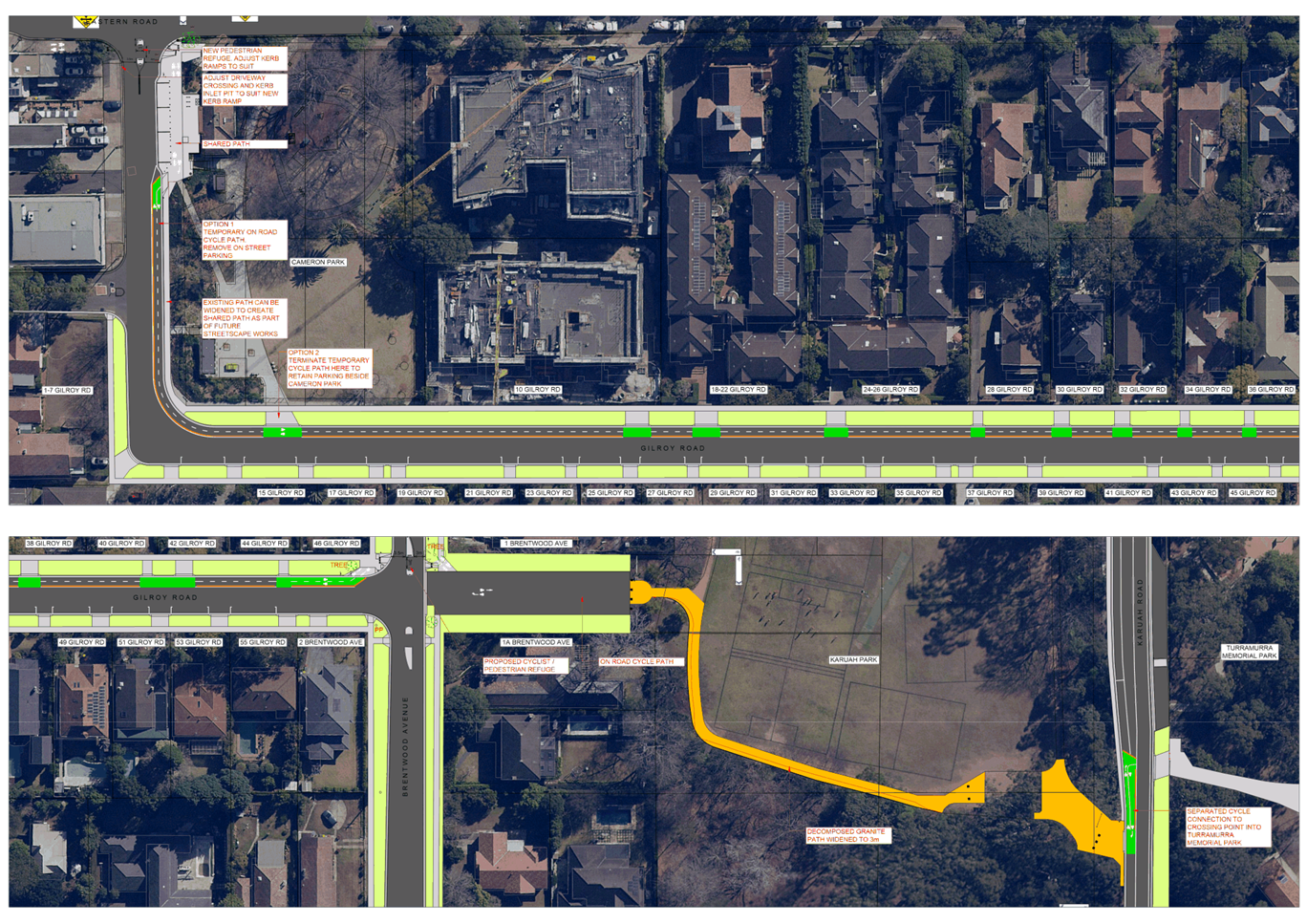
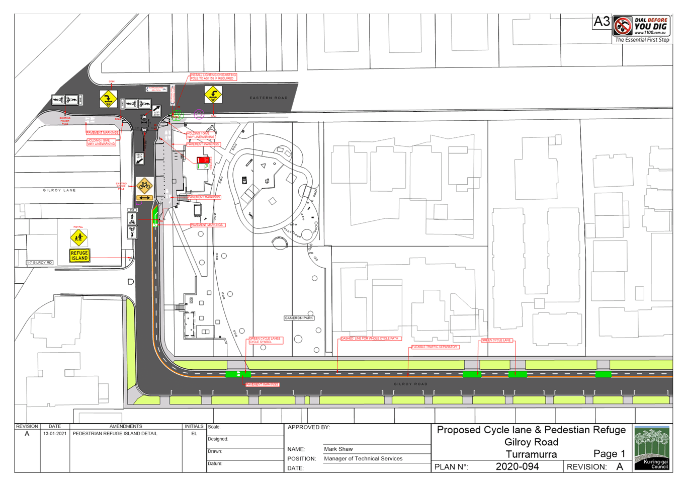
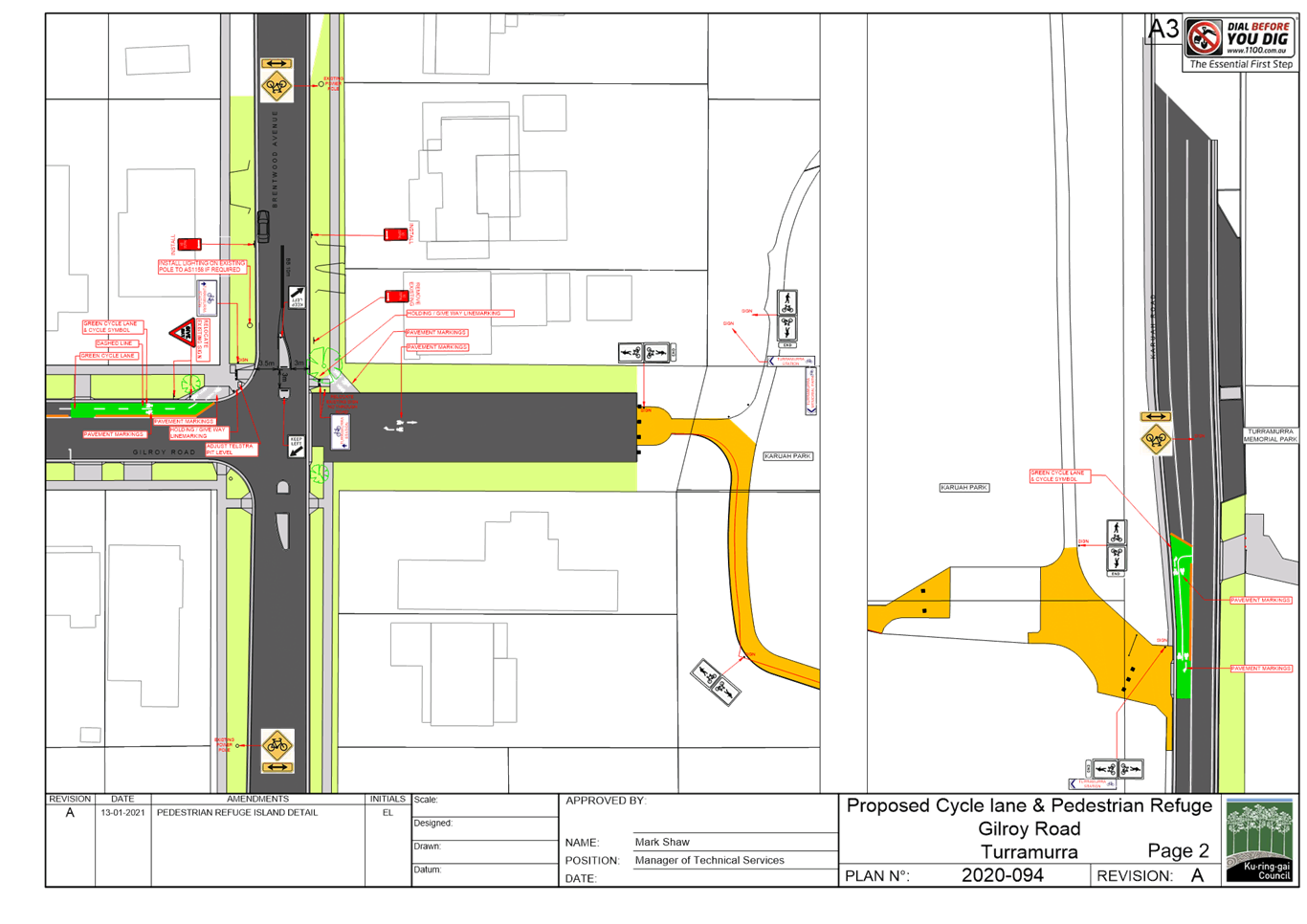
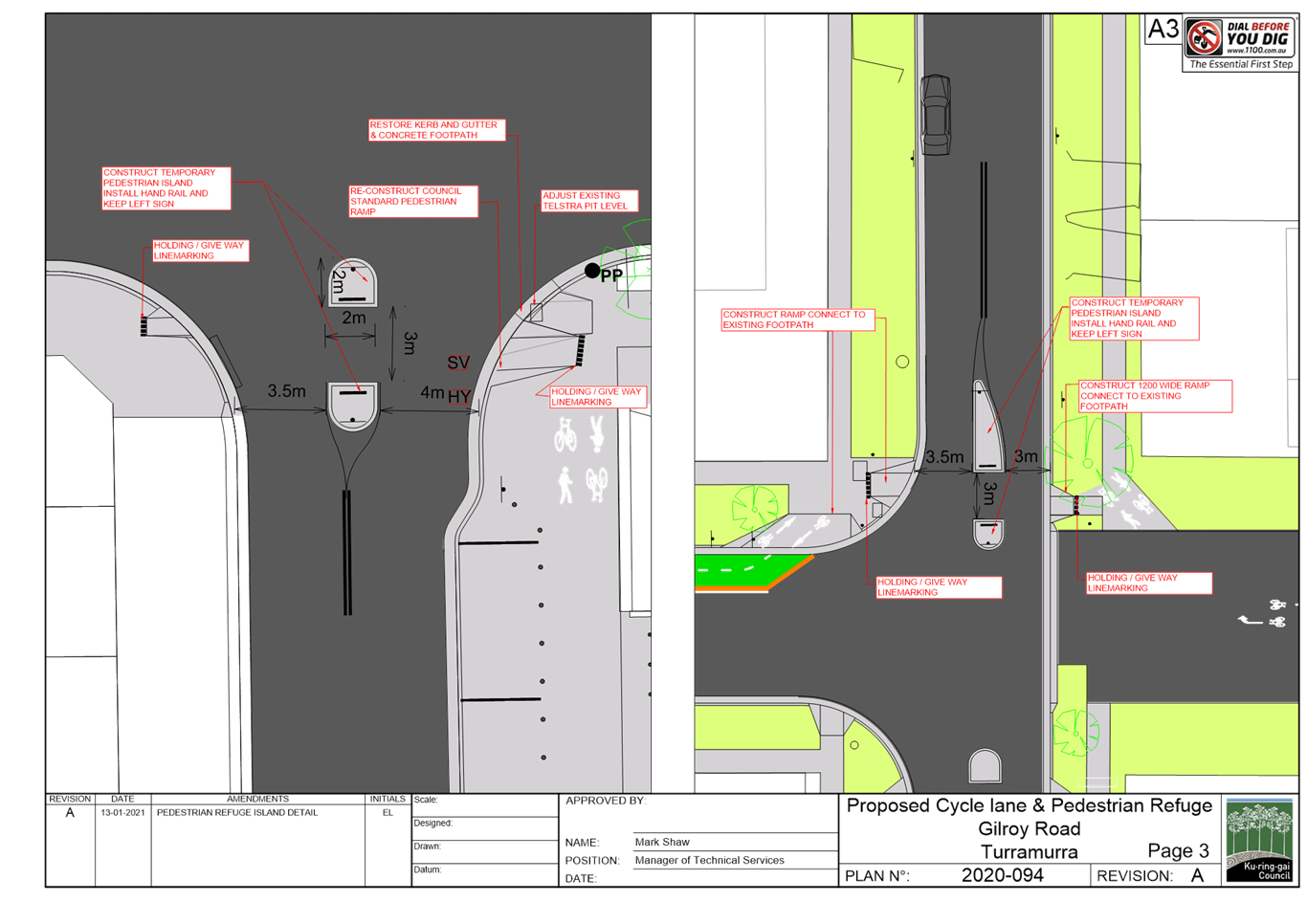
|
APPENDIX
No: 2 - Gilroy
Road Turramurra - extract of Public Domain Plan
|
|
Item No: GB.14
|
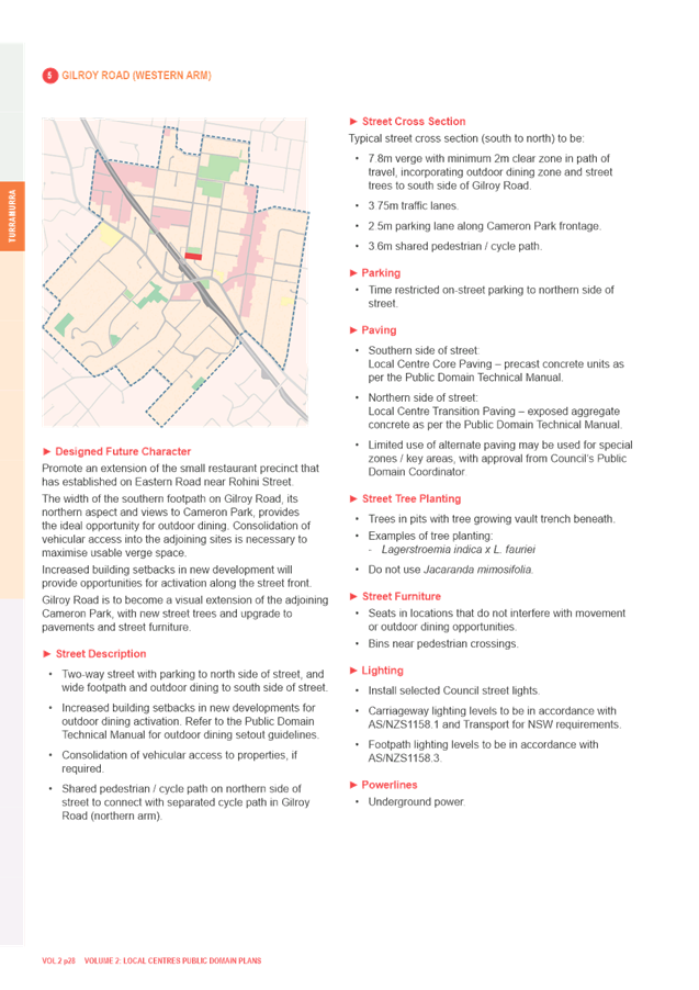
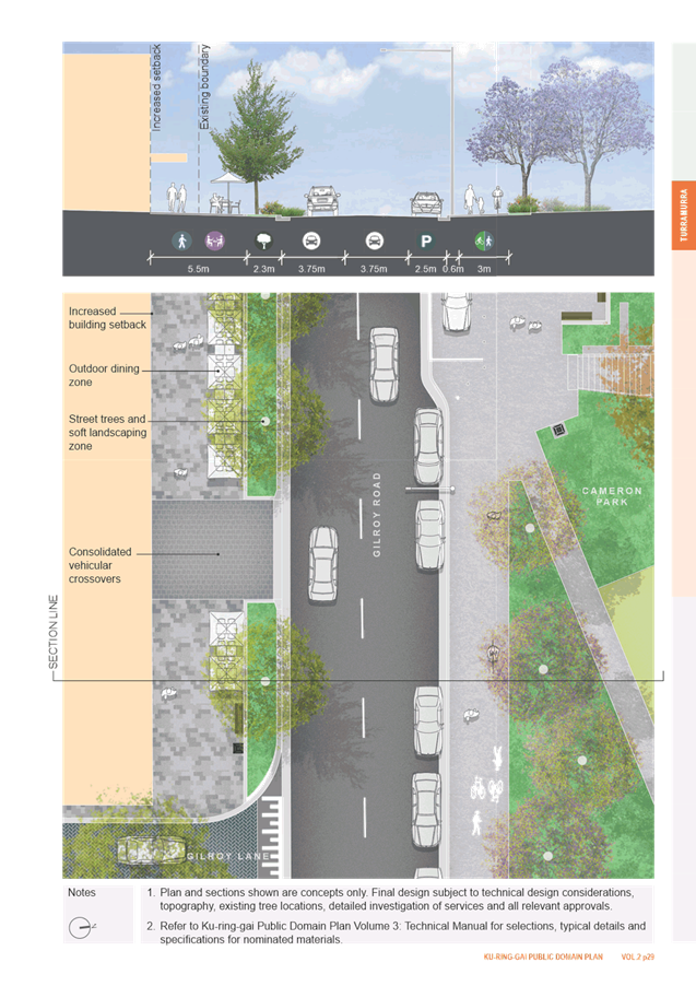
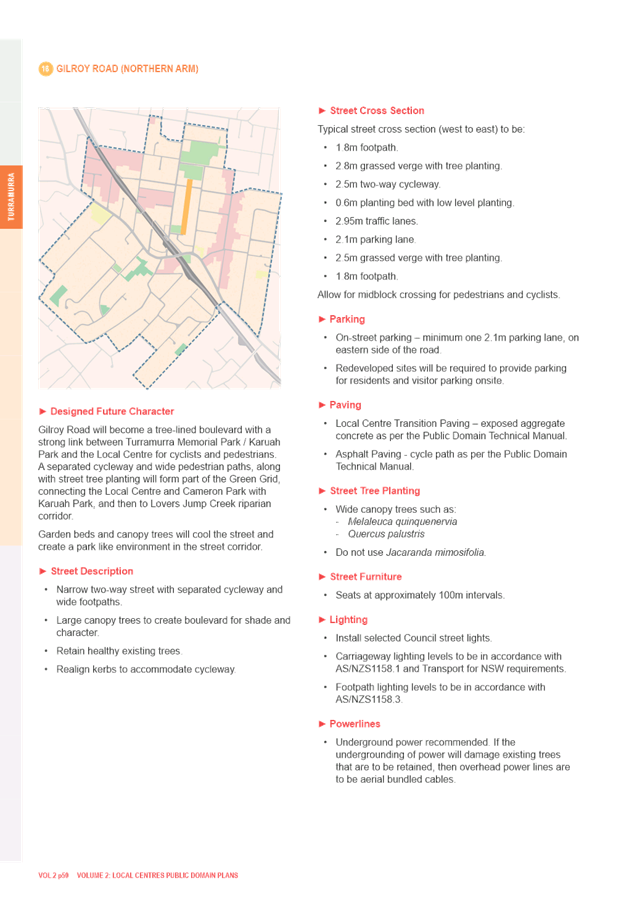
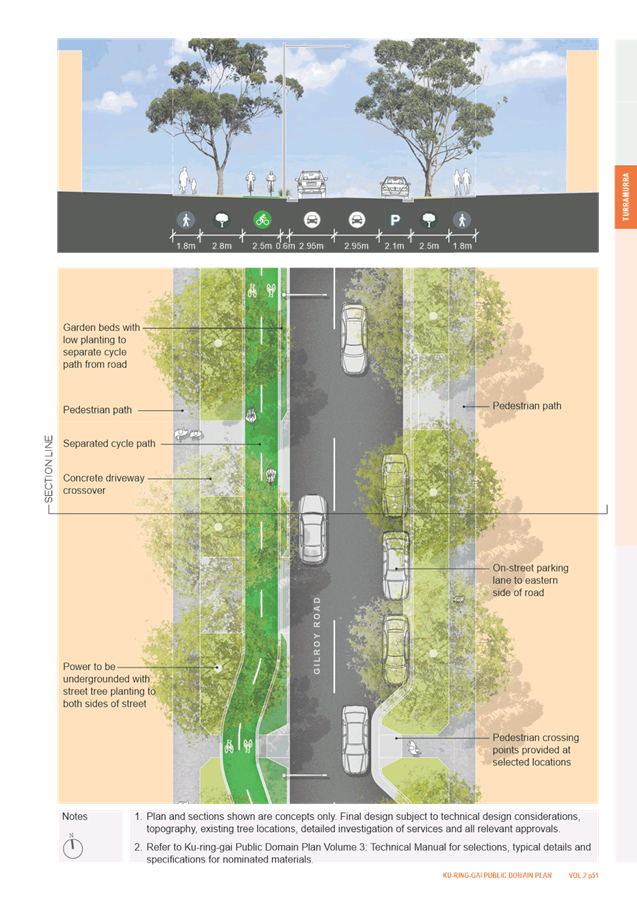
|
APPENDIX
No: 3 - Transport
for NSW Road User Space Allocation Policy
|
|
Item No: GB.14
|
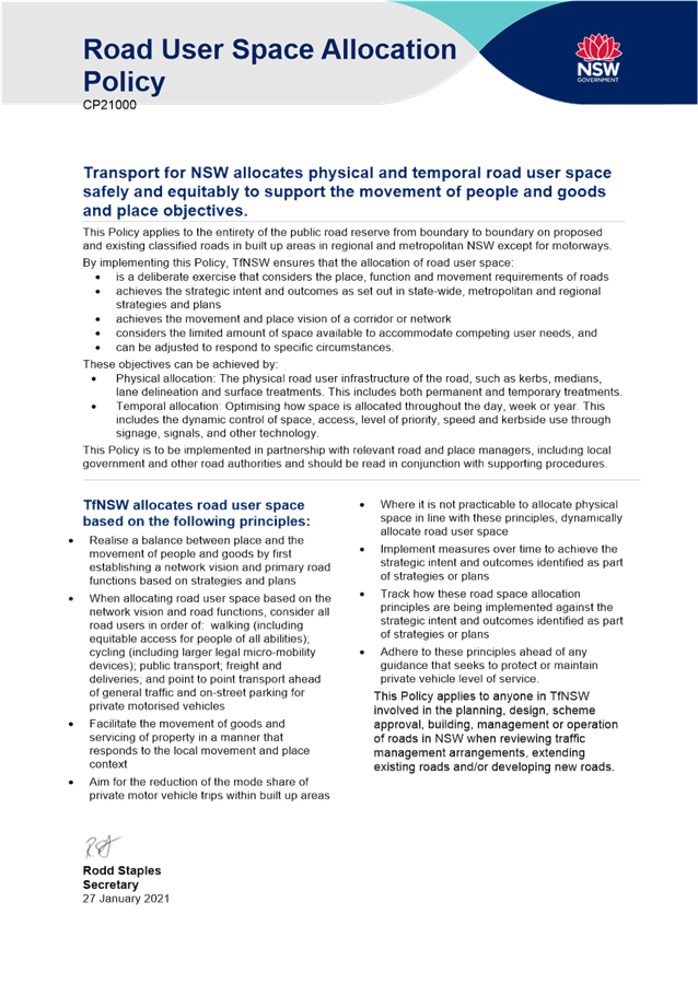

|
APPENDIX
No: 4 - Streets
as Shared Spaces - Gilroy Road Separated Cycleway - information flyer
|
|
Item No: GB.14
|
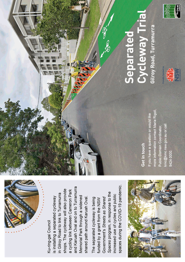
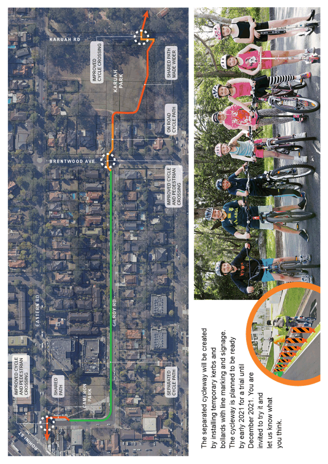
|
APPENDIX
No: 5 - Gilroy
Road Cycleway - A1 notification boards - January 2021
|
|
Item No: GB.14
|
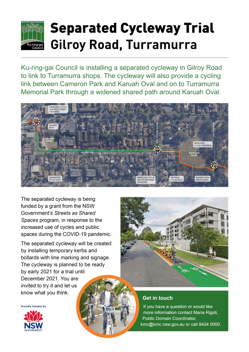
|
Ordinary
Meeting of Council - 26 April 2022
|
GB.15 / 1
|
|
|
|
|
Item
GB.15
|
S13022
|
Planning Proposal for 8a, 14 and 16
Buckingham Road, Killara
EXECUTIVE
SUMMARY
Purpose of Report
For Council to consider the private Planning Proposal that
has been lodged for 8a, 14 and 16 Buckingham Road, Killara.
Background
A formal pre-Planning Proposal meeting was held with the
proponent and Council staff on 12 December 2018 to discuss the proposal to
the amend the zoning of the site. The pre-Planning Proposal meeting report is included
at Attachment A1.
The Planning Proposal was submitted on 26 October 2020. The
Planning Proposal documentation was incomplete. Following the submission of
revised documentation and payment of fees, the assessment of the Planning
Proposal formally commenced on 3 August 2021.
Site
Description and Local Context
The sites that are the subject of this Planning Proposal
are:
· 8a Buckingham
Road, Killara (Lot 2 DP414101)
· 14 Buckingham
Road, Killara (Lot 4 DP520573)
· 16 Buckingham
Road, Killara (Lot 3 DP520573)
The site the subject of the Planning Proposal comprises
three battle-axe allotments, on the southern side of Buckingham Road. The site
has a combined site area of 4,989sqm.
The topography of the sites falls from the north to the
south, with the battle-axe handle of 8a Buckingham Road having a steep
fall from the street and the site being significantly lower than the heritage
item and dwellings at 10 and 12 Buckingham Road. The subject sites then have a
significant fall to the Killara Golf Club.
The subject sites are currently zoned R2 Low Density
Residential and developed with two storey dwelling houses.
To the west and north of the site is also zoned R2 Low
Density Residential and comprises low density residential development. To the
east of the site is a 4-5 storey residential flat building zoned R4 High
Density Residential.
The site adjoins two local heritage items:
· To the north
– I255 ‘Southdean’ dwelling house, 10 Buckingham Road,
Killara
· To the west
– I257 dwelling house, 22 Buckingham Road, Killara
Also within the immediate vicinity is the Killara Golf Club
Clubhouse, putting green, fairway and gardens which are listed as a local
heritage item.
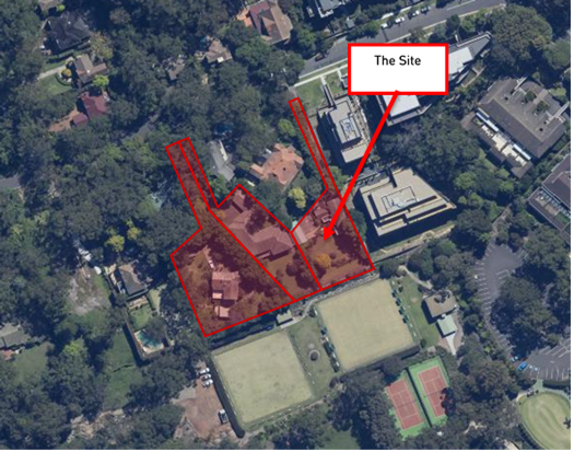
Image 1: Subject
site aerial view
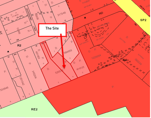
Image 2: Subject
site and surrounding zoning
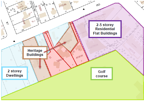
Image 3: Subject
site and existing surrounding context
Killara Golf Course Planning Proposal and Potential
Development
The southern boundary of the subject site adjoins the
Killara Golf Club. This area of the Killara Golf Club adjoining the site was
subject to a private Planning Proposal and in 2019 was rezoned to R4 High
Density Residential and associated development standards which would enable
development of residential flat buildings to a maximum height of 5 storeys
adjoining 6a Buckingham Road, and to a maximum height of 3 storey along the
boundary shared with the subject site.
An excerpt from the Urban Design Study submitted with the
Killara Golf Club Planning Proposal is included at Image 4 (below) and shows
the development outcomes enabled on the Golf Course site adjoining 8a, 14 and
16 Buckingham Road.
The rezoning by the Killara Golf Club was to preserve the
club’s options in the future as to how it may wish to use the land. To
date, no Development Application has been lodged for residential development on
the Killara Golf Club site.
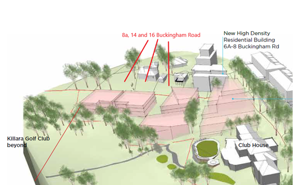
Image 4: Excerpt
from Killara Golf Planning Proposal
Comments
Original
Proposal and Initial Assessment
The Planning Proposal that was originally submitted to
Council sought to:
· Rezone to R4 High
Density Residential;
· apply a Height of
Buildings development standard of 17.5m (5 storey) on 8a and 16 Buckingham
Road, and retain the 9.5m (2 storey) on 14 Buckingham Road;
· apply a Floor
Space Ratio of 1.3:1 on all sites;
· apply a Minimum
Lot Size of 1,200sqm on all sites.
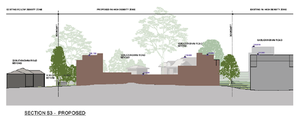 Image 5: Excerpt
from original submitted Urban Design Study - Indicative Built Form
Image 5: Excerpt
from original submitted Urban Design Study - Indicative Built Form
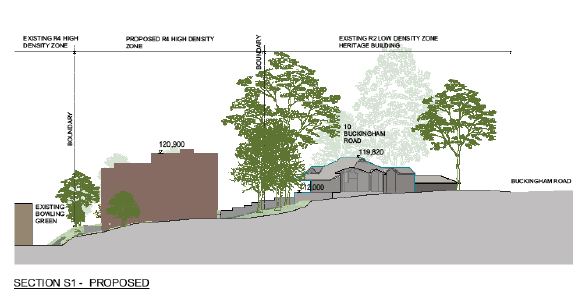
Image 6: Excerpt
from original submitted Urban Design Study - Indicative Built Form
Following a site inspection and preliminary assessment,
Council notified the applicant that it had significant concerns with the built
form outcomes enabled by the proposed amendments sought within the Planning
Proposal, specifically the 17.5m height and 1.3:1 floor space ratio which do
not provide an appropriate interface or transition to the adjoining sites which
include heritage items and low density dwellings. The applicant was advised
that the Planning Proposal in its current form would not be supported and was
given the option to either proceed with the assessment of Planning Proposal as
originally submitted or invited to submit amended documents to address Councils
concerns.
Envelope testing was undertaken by Council’s Urban
Designer to understand what would be appropriate development standards across
the site and recommended that:
· Building heights
reduced on the eastern and western ends of the site, to allow for up to 3
storey at western end and part 3/part 4 on eastern end due to topography. The
two storey component in the centre of the site is suitable as it permits view
lines to be retained from the heritage item at 10 Buckingham Road over the site
and future development on the golf course.
· Floor space ratio
should be a result of working back from height, setbacks, deep soil to
determine what can be achieved, not just the standard 1.3:1 applied across all
the sites. The testing found an indicative a gross floor area of 3225sqm (based
on a deduction of 30% for wall thickness, services, balconies, lifts and stairs
from the total building envelopes) and an
indicative FSR of 0.64:1.
· Building envelope
broken up into three separate sections across the site in order to reflect the
pattern of subdivision and surrounding low density development context.
· 2 storey built
form adjoining the low density residential dwellings and heritage items, with 3rd
storey component having greater setback.
Amended Proposal and Proposed Amendments
to KLEP 2015
The applicant submitted an
amended Planning Proposal, Urban Design Study and Heritage Impact Statement
Addendum to address Council’s concerns.
The amended Planning Proposal is included at Attachment
A2. Several supporting studies form appendixes to the Planning Proposal,
and have been provided to justify the amendments. The Appendixes are included
at Attachment A3-A11.
The Planning Proposal seeks to amend the Ku-ring-gai
Local Environmental Plan 2015 to rezone the sites from R2 Low Density
Residential to R4 High Density Residential and amend the development standards
applying to the site as follows:
|
KLEP 2015 – Zoning and Development Standards
– 8a, 14 and 16 Buckingham Road, Killara
|
|
|
Existing
|
Proposed
|
|
Zoning
|
R2 Low Density
Residential
|
R4 High Density
Residential
|
|
Floor Space Ratio
|
0.3:1
|
0.81:1
|
|
Height of Buildings
|
9.5m
|
RL115.50 for
western and eastern sides of site
RL110.50 for
central portion of site
|
|
Minimum Lot Size
|
840sqm
|
1,200sqm
|
|
Site Specific Provision
|
N/A
|
Site-specific local
provision or map for amalgamation of subject lots prior to redevelopment for
purposes of a residential flat building
|
Merit
A Planning Proposal is not a
Development Application and does not consider the specific detailed matters for
consideration under Section 4.15 of the Environmental Planning and
Assessment Act 1979. A Planning Proposal only relates to an LEP amendment
and cannot be tied to a specific development. The proposed amendments need to
be acceptable as an outcome on the site regardless of the subsequent approval
or refusal of any future Development Application.
A Planning Proposal must demonstrate the site specific and
strategic merit of the proposed amendments. The following is an assessment of
the relevant merits of the Planning Proposal:
Site
Specific Assessment
· Zoning –
History, Surrounding Context and Proposed
The subject sites are currently zoned R2 Low Density
Residential. To the west and north of the site is also zoned R2 Low Density
Residential. To the east and south of the site is zoned R4 High Density
Residential.
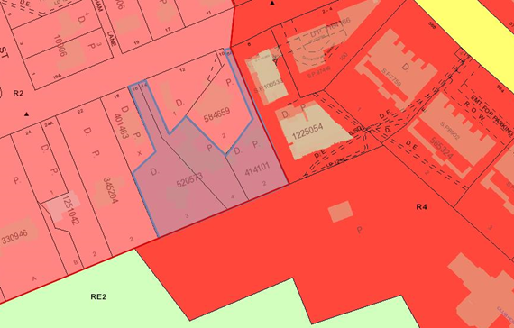
Image 7: Excerpt
from KLEP 2015 zoning map
The Minister’s gazettal of LEP No 194 and No 200 in
2004 made provisions which allowed development up to 5 storeys to occur on land
zoned Residential 2(d3). This created the situation where 4-5 storey apartment
buildings could be developed immediately adjacent to single residential houses.
This is what occurred to 8a Buckingham Road, Killara, and the site is known as
an interface site.
An Interface Study was undertaken by in 2011 to understand
the impact of the existing and potential 5 storey development on the identified
interface sites, and to recommend planning solutions for the interface sites.
The most common approach was the use of the R3 Medium Density Residential zone
to enable the development of townhouses on the interface sites to act as a transition
between the high density and low density.
The interface study assessed 8a Buckingham Road and noted:
This property is located to the west of the high density
residential zone. It is also located down slope of the potential development
site. Future development would potentially cause overlooking and overshadowing
issues due to the accentuated height of the development. The vegetation on the
common boundary will provide limited privacy screening.
The interface study assessed the potential for overshadowing
to be medium-high, the potential for overlooking to be high and the overall
impact to be significant. Despite this, the assessment found that the upzoning
of 8a Buckingham Road (as a single site) to R3 Medium Density was not suitable
due to the site providing a curtilage to the adjoining heritage item and due to
the size and configuration the site would not be able to develop successfully
on its own.
The area of the Killara Golf Club adjoining the
subject site to the south was rezoned through a private Planning Proposal to R4
High Density Residential in 2019, which took into specific consideration the
potential impacts on the adjoining low density residential dwellings of 8a, 14
and 16 Buckingham Road.
It is acknowledged that the subject sites are
interface sites, as they adjoin R4 High Density Residential zoned land to the
east and south. However, the context of the adjoining low density residential
zoned land and dwellings to the west and north, including heritage items needs
to be taken into consideration, alongside the residential flat building at 6a
Buckingham Road and the potential development outcomes on the Killara Golf
Course site.
The proposed R4 High Density Residential zone,
with a reduced height limit (i.e. not the standard 17.5m/5 storey as discussed
in greater detail below) is considered appropriate in the surrounding context
as it provides an appropriate transition and interface to surrounding sites.
The proposed R4 High Density Residential zone is considered more appropriate
than using an R3 Medium Density Residential zone on the sites, as the R4 zone
permits residential flat buildings which have a reduced development footprint
and facilitates greater setbacks, compared to a townhouse style development
under an R3 Medium Density Residential zone. This is especially important for
the adjoining heritage items, low density dwellings and significant trees.
An R4 zoning with a reduced height limit has been
used elsewhere in Ku-ring-gai as a response to address interface impacts between
high density sites and heritage items/low density sites.
· Height
The Planning Proposal seeks to amend the Height of Buildings
development standard on the site from 9.5m to a maximum RL115.50 for western
and eastern portions of the site and a maximum RL110.50 for central portion of
site. The proposed boundaries of the RLs follow the existing lot boundaries
(see Image 9 – proposed height of building map below).
o 8a Buckingham Road –
maximum RL115.50
o 14 Buckingham Road –
maximum RL110.50
o 16 Buckingham Road - maximum
RL115.50
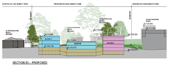
Image 8: Excerpt
from Urban Design Study
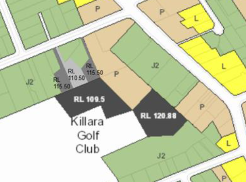
Image 9:
Proposed Height of Buildings Map – Planning Proposal
The use of maximum RLs across the site rather than a just
proposing a standard 9.5m/11.5m height is supported as it provides greater
certainty and control over the development outcomes enabled by the Planning
Proposal.
The proposed RLs of a maximum RL115.50 for western and
eastern sides of site and a maximum RL110.50 for central portion of site, would
enable development for at part 3/part 4 storey building at the eastern end of
the site, up to 3 storeys on the western end of the site, and 2 storey
component within the central portion of the site.
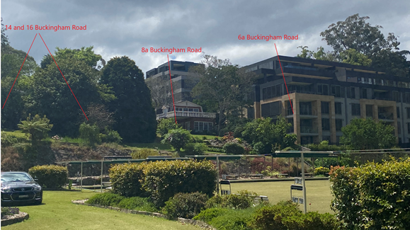
Image 10: Context of subject sites, existing
residential flat building development and golf course
In the assessment of the
Planning Proposal for the Killara Golf Course, due to impacts on the adjacent
low density dwellings at 8a, 14, 16 and 22 Buckingham Road, Killara an
amendment was required which required a reduction in height adjacent to the
Buckingham Road properties boundary to a maximum RL109.5, which would enable
development of residential flat buildings to a maximum 3 storey height.
Images 11 and 12 (below) are
excerpts from the Urban Design Study submitted with the Planning Proposal for
the subject site and demonstrates the relationship between built form enabled
on the Killara Golf Course, the proposed built form enabled on the subject
sites, and the adjoining heritage item at 10 Buckingham Road.
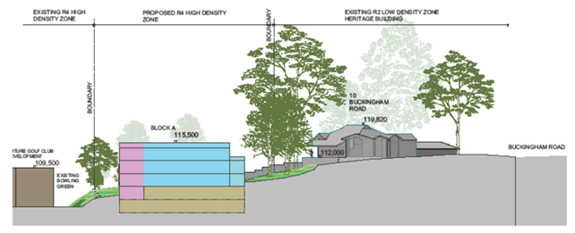
Image 11: Relationship between Planning Proposal on
subject sites, potential development on golf course and 10 Buckingham Road.
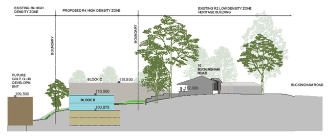
Image 12: Relationship between Planning Proposal on
subject sites, potential development on golf course and 10 Buckingham Road.
The proposed maximum building height development standards
across the site respond to the surrounding context and provide an appropriate
step down and transition of height from the adjoining residential flat building
development at 6a Buckingham Road to the adjoining R2 Low Density Residential
zoned properties to the north and west. The maximum RL110.50 in the central
portion of the site will enable the setting of the heritage item to be
maintained, with views over Block B towards the south and Killara Golf Couse.
The proposed maximum building height development standards
also respond appropriately to the changes in topography between the subject
site, the adjoining low density residential sites and the Killara Golf Course.
The proposed maximum building height development standards
are appropriate in the context of the adjoining development.
While it is noted that the Planning Proposal is proposing a
maximum RL of 110.50 for the central portion of the site, the 3D View
Perspective (PP401 of the Urban Design Study) shows a lift overrun exceeding
above the proposed maximum height of buildings. The lift overrun does not
appear on any other plan drawings or sections in the Urban Design Study. The
Urban Design Study also includes references to and annotations of a
‘landscape podium’ on the rooftop within the central portion of the
site (PP301, 302 and 303). It is assumed that the lift overrun is to access
this ‘landscape podium’. As this is a Planning Proposal, and
not a Development Application, consideration of detailed design is not
appropriate and is not considered as part of the assessment. A Planning
Proposal cannot be tied to a particular development design outcome on the site.
It is recommended that the references and images of the lift overrun and
landscape podium be deleted from the Urban Design Study and Planning Proposal.
· Floor Space Ratio
The Planning Proposal seeks to amend the KLEP 2015 floor
space ratio development standard applying on the sites from 0.3:1 to 0.81:1.
(Note: Part 2 Explanation of Provisions of the
Planning Proposal states the proposed floor space ratio is 1.81:1 – however
all other parts of the Planning Proposal and Urban Design Study state 0.81:1 is
proposed).
The Urban Design Study includes a breakdown of how the floor
space ratio was derived (Proposed Envelope Plan PP107). The total area of the
building envelopes are very similar to the testing undertaken by
Council’s Urban Designer, however the Urban Design Study has allowed for
a 25% reduction for wall thickness, services, balconies instead of the 30% used
by Council’s Urban Designer. The Apartment Design Guide indicates that a
building envelope should be 25-30% greater than the achievable floor area to
allow for building components that do not count as floor space but contribute
to building design and articulation. In this regard the use of 25% is
acceptable.
The Urban Design Study outlines that the total building
envelopes – 25% provides a Gross Floor Area of 3476.12m2. This
results in a floor space ratio of 0.7:1 across the entire subject site
in accordance with the LEP definition.
The Urban Design Study then provides a floor space ratio for
the ‘effective density’, whereby the area of the battle-axe handles
have been excluded from the total site area, which results in a floor space
ratio of 0.81:1.
The Planning Proposal is seeking to use the ‘effective
density’ of 0.81:1 as the proposed amendment to the maximum floor space
ratio on the site. This is incorrect and not supported. A maximum floor space
ratio of 0.81:1 across the site would result in a development outcome that is
bigger, bulkier and more dense than that modelled in the Urban Design Study,
and is not appropriate for the surrounding context.
The Urban Design Study analysis of testing the building
envelopes and site area as per the LEP definition supports a maximum floor
space ratio of 0.7:1. A floor space ratio of 0.7:1 will deliver an
‘effective density’ of 0.81:1 on the area of the site that is
developable.
It is recommended that Planning Proposal be amended to a
maximum floor space ratio of 0.7:1.
· Site Specific Local
Provision for Site Amalgamation
The Planning Proposal seeks to include a site-specific local
provision or map to require amalgamation of the lots (8a, 14 and 16 Buckingham
Road) prior to a redevelopment for the purposes of a residential flat building.
No further detail or analysis is provided in the Planning Proposal as to the
site-specific provision for site amalgamation.
It is a concern that lots, which are all over 1,200sqm,
could be developed individually without any consolidation. Due to the battle
axe nature of the lots and constraints such as topography and heritage, the
best outcome is for the lots to be amalgamated and developed as one
consolidated site. This will ensure that any the any future residential
development on the site allows for generous landscaped areas and setbacks to
ensure the amenity and adjoining properties and curtilage to the heritage item
is maintained.
The inclusion of a site-specific local provision which
requires the subject sites to be amalgamated to enable development of a
residential flat building is supported. However, as both multi dwelling housing
and residential flat buildings are permitted within the proposed R4 High
Density Residential zone, the site-specific provision should require lot
consolidation for both these uses, not just residential flat buildings as
proposed.
Clause 6.6 of the KLEP 2015 currently requires that
development consent must not be granted for multi dwelling housing or a
residential flat building unless the lot has an area of at least 1,200m2.
An amendment to Clause 6.6 Requirements for Multi Dwelling
Housing and Residential Flat Buildings could be made, which requires that
development for the purposes of multi dwelling housing or a residential flat
building on the site would need a minimum lot size of 4,300m2.
(Note: 6.6(4) outlines that the area of access
handles is not including in calculating the lot size for the purpose of this
clause, so accordingly the minimum lot size proposed is 4,300sqm which is the
site area excluding the access handles and not 4,989 which is the total site
area).
Clause 6.6 already contains a site-specific provision for
sites at Turramurra on the Pacific Highway, which sets a minimum lot size of
5,000sqm for the erection of multi dwelling housing or a residential flat
building, as outlined below:
3) Despite subclause (2),
development consent must not be granted for the erection of multi dwelling
housing or a residential flat building on a lot on land identified as
“Area 1” on the Lot Size Map unless the lot has an area of at least
5,000 square metres.
A similar site-specific provision could be made for the
subject site, as follows:
3a) Despite subclause (2),
development consent must not be granted for the erection of multi dwelling
housing or a residential flat building on a lot on land identified as
“Area 2” on the Lot Size Map unless the lot has an area of at least
4,300sqm.
It is recommended that the Planning Proposal be amended to
include the draft site-specific provision (above), which requires a minimum lot
size of 4,300sqm for the development of either multi dwelling housing or a
residential flat building on the site. The Minimum Lot Size Map in Part 4
Mapping of the Planning Proposal is also required to be amended to identify the
subject sites as ‘Area 2’ for the purpose of this clause.
· Minimum Lot
Size
The Planning Proposal seeks to amend the KLEP 2015 minimum
lot size development standard from 840sqm to 1200sqm.
A lot size of 1200sqm is the standard minimum lot size that
has been applied throughout Ku-ring-gai for sites zoned R4 High Density
Residential, and this is consistent with the 1,200sqm minimum lot size required
under Clause 6.6 for the development of multi dwelling housing or residential
flat buildings permitted in the R3 Medium Density and R4 High Density zones.
As discussed above under Site-Specific Local Provision
for Site Amalgamation, the Planning Proposal seeks to include a
site-specific local provision requiring the amalgamation of the three sites for
the development of a residential flat building, and a minimum lot size of
4,300sqm is recommended. To reinforce the requirement for lot
consolidation and ensure consistency between the minimum lot size required
under Clause 6.6 for the development of multi dwelling housing and residential
flat buildings and the minimum lot size under Clause 4.1 and the Minimum Lot
Size Map, it is recommended that the Planning Proposal be amended to propose a
minimum lot size of 4,300sqm.
· Traffic and
Transport
A Traffic and Transport Study was submitted with the
original Planning Proposal and has not been updated with the amended Planning
Proposal, however the amended dwelling yield is 36-40 apartments (vs 34-40 in
the original proposal) so there is no real change to the traffic study in terms
of traffic generation. The Traffic and Transport Study includes diagrams from
the original Urban Design Study and should be amended so as to include the
revised diagrams in order to avoid confusion.
In assessing the Planning Proposals impact on traffic and
transport matters, consideration is had to s9.1 Ministerial Directions related
to:
o 3.1 Residential zones
The objectives of this
direction are (in part):
(b) to
make efficient use of existing infrastructure and services and ensure that new
housing has appropriate access to infrastructure and services.
o 3.4 Integrating Land Use and
Transport
The objective of this
direction is to ensure that urban structures, building forms, land use
locations, development designs, subdivision and street layouts achieve the
following planning objectives (in part):
(a) improving
access to housing, jobs and services by walking, cycling and public transport;
(b) increasing
the choice of available transport and reducing dependence on cars;
(c) reducing
travel demand including the number of trips generated by development and the
distances travelled, especially by car.
Council’s Strategic Transport Engineer has
reviewed the proposal and provided the following key points:
Public Transport, and Journey
to Work
Image 13 (below) shows the
catchment within 30 minutes of public transport travel time of the subject
site.
Image
13: Travel Time Map – 30minute Public Transport Catchment
Source:
Walkscore.com. Includes walking distance/time to access public transport
The travel catchment extends (in
a north-south direction) to employment areas and strategic centres of
Chatswood, St Leonards and nearly as far as south as North Sydney. Northerly,
it extends as far as Hornsby. The 30 minute catchment is much more limited in
the east-west direction, barely extending to the eastern edge of Macquarie
Park.
The Table – Journey to
Work (below) is an extract from the 2016 Census of Journey to Work that the
majority of residents living in the area travel to work destinations largely in
the City, and to destinations generally along the North Shore railway. As a
result, a relatively high proportion of trips to work are undertaken by rail
due to the proximity to Killara railway station, and the places of work are
shown in the catchment map above as generally being within 30 minutes travel by
public transport. There are also approximately 12% of work trips that were made
by walking and cycling.
Overall, the subject site would
provide relatively good access to jobs by public transport.
|
|
Mode of Travel
|
|
|
|
Car, as driver
|
Train
|
Bicycle
|
Walked only
|
Worked at home
|
Total
|
|
Destination
|
Blacktown
|
6
|
|
|
|
|
6
|
|
City and Inner South
|
9
|
11
|
|
|
|
20
|
|
North Sydney and Hornsby
|
18
|
7
|
|
4
|
6
|
35
|
|
Ryde
|
|
3
|
4
|
|
|
7
|
|
Total
|
33
|
21
|
4
|
4
|
6
|
68
|
Table: Journey to Work
Walkability
Improving Transport Choice
– Guidelines for planning and development (DUAP 2001) suggests best
practice is achieved when key land uses are located within walking distance of
each other (e.g. shops, library, childcare centres, cinemas, bus/rail
interchange).
Image 14 (below) shows an
indication of the 10 minute walking catchment from the subject site.
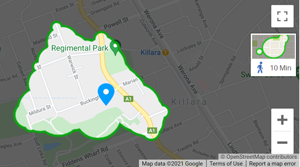
Image
14: Travel Time Map – 10m Walking Catchment
Source:
Walkscore.com
The 10 minute walking catchment
is relevant when assessing access to shops and services by walking, and
therefore discouraging the number of trips generated and the distances
travelled by car.
Page 7 of the Planning Proposal makes
the following comments in relation to access to employment, shops,
services/facilities and leisure/recreation: …
Local Killara shops are located to the north and local
Lindfield shops are located to the south of the subject site. Larger centres
are located to the north at Gordon and Hornsby; Chatswood to the south and the
City within 30 minutes of the site.
The subject site is close to educational facilities such as
the Lindfield and Killara Public Schools and independent schools such as
Ravenswood School for Girls, Holy Family Catholic School and Newington College
Preparatory School.
The
proposed increase in housing density in proximity to existing well established
infrastructure will optimise its use.
The table below lists the
distance and walking time to key facilities:
|
Key land use
|
Walking distance*
|
Walking time*
|
|
Killara Golf Club
|
0.45km
|
6 mins
|
|
Selkirk Park
|
0.5km
|
7 mins
|
|
Marian Street Theatre
|
0.5km
|
7 mins
|
|
Regimental Park
|
0.55km
|
8 mins
|
|
Daystars Child Care Centre
|
0.75km
|
10 mins
|
|
Greengate
Hotel
|
0.75km
|
11
mins
|
|
Holy
Family Catholic School
|
1.1km
|
14
mins
|
|
Killara
Public School
|
1.1km
|
14
mins
|
|
Coles
Lindfield
|
1.3km
|
15
mins
|
|
Lindfield
Medical Practice
|
1.3km
|
16
mins
|
|
Ravenswood
School
|
1.4km
|
18
mins
|
|
Lindfield
Village Hub (future library, community facilities, supermarket, childcare,
urban open space)
|
1.5km
|
18
mins
|
|
Commonwealth
Bank
|
1.5km
|
18
mins
|
|
Harris
Farm Lindfield Avenue (future)
|
1.5km
|
19
mins
|
|
Australian
Post Lindfield
|
1.6km
|
20
mins
|
|
Lindfield
Executive Centre (medical suites)
|
1.7km
|
21
mins
|
|
Lindfield
Village Pharmacy
|
1.6km
|
21
mins
|
|
Lindfield
Library (current)
|
1.7km
|
22
mins
|
|
Lindfield
Public School
|
2.1km
|
26
mins
|
Table:
Key facilities – Distance and Time from subject site
*source:
Google Maps
The majority of these basic
facilities are located outside the convenient 10 minute walking catchment. Some
nearby parks and a child care centre are located in close proximity to the
site, while other key services and facilities such as supermarkets, pharmacies,
medical centres and the majority of schools are located some distance further.
It is likely, therefore, that future residents of this site will likely be using
cars to access basic services and facilities more than would a residential site
located in the either Lindfield or Gordon local centre.
Cycling Accessibility
Image 15 (below) shows the
30-minute cycling catchment from the subject site.
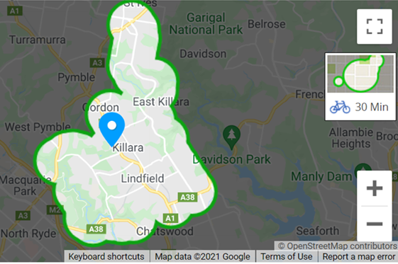
Image
15: Travel Time Map – 30minute Cycling Catchment
Source:
Walkscore.com
The 30-minute cycling catchment
is larger than the pedestrian catchment, but the bicycle network in the
catchment is largely undeveloped, with very few dedicated facilities currently
provided. The majority of current cycling is expected to be confined to either
on-road/mixed use cycling or cycling on footpaths (where permissible). This
catchment borders Chatswood, and after verifying on Google Maps, is also within
30 minutes bike ride to Macquarie Park. While there is a relatively high
proportion of trips to work by bicycle from this travel zone, the absence of
useful lengths of safe, separated cycling facilities anywhere near the site is
unlikely to further encourage cycling as an alternative means of local
transport or travel to work in the short to medium term.
Traffic Generation
The assessment estimates traffic generation of 11
vehicle trips during the am and pm commuter peaks. Analysis of the impacts of
the generation of this proposal and the traffic generation from the recently
gazetted land use changes at Killara Golf Club suggests the intersection of
Pacific Highway and Buckingham Road and intersection of Pacific Highway and
Fiddens Wharf Road would continue to operate at satisfactory levels of service.
· Heritage
The site adjoins two local heritage items:
o To the north – I255
‘Southdean’ dwelling house, 10 Buckingham Road, Killara
o To the west – I257
dwelling house, 22 Buckingham Road, Killara
Also within the immediate vicinity is the Killara Golf Club
Clubhouse, putting green, fairway and gardens which are listed as a local
heritage item.
A Heritage Impact Statement was submitted with the original
Planning Proposal, and an addendum heritage statement was submitted alongside
the amended proposal. Councils Heritage Planner has reviewed the amended
proposal the following is a summary of the key issues:
Setbacks
Block C is proposed to be a minimum of almost 13m from the
heritage item at 22 Buckingham Road, which would be an acceptable lineal
distance. However, the distance needs to be managed in relation to the overall
height, massing and envelope.
Block A is proposed to be a minimum of approximately 18.6m
from the heritage item at 10 Buckingham Road at the point indicated on the
urban design concept drawings. Whilst this may vary depending on how the
dimension is measured, the separation is likely to exceed 15m at any given
point.
Whilst the topography places the development in a visually
prominent location when viewed over the Golf Course from the south, the
entirety of the development is substantially physically distanced from Killara
Golf Club.
Building Envelopes
As noted in the Urban Design Study section (Images 8, 11 and
12 of this report) , the form of the proposed building envelopes has been
amended and improved from a heritage perspective to reflect the comments
provided by Council, principally in relation to heritage and urban design.
The setting of the heritage item at 10 Buckingham Road
appears to be well maintained with views over Block B towards the south and
Killara Golf Course indicated.
The relationship of Block C to the heritage item at 22
Buckingham Road is challenged. Whilst more than 12m setback is likely to be
achieved on the ground, the relationship of the building massing and height
above 8m (aligned within the principles of the DCP) may need to be refined and
guided in the site specific DCP. The overall wall lengths and distribution of
massing needs to be sensitive to the adjoining heritage item.
Additional building massing between the subject sites and
heritage item that is Killara Gold Club and its expanded curtilage is permitted
by the Killara Golf Club Planning Proposal. There is an expectation therefore,
that any impacts of a development in the subject location are negated by the
intervening development. Notwithstanding this and as noted above, the heritage
item at No.10 Buckingham Road maintains views over the new building massing
towards the Golf Course.
Landscape
The revised landscape concept plan prepared by Paul
Scrivener indicates that considerable vegetated buffers are envisaged along the
west, south and east boundaries of the site. In addition, vegetation provided
along the northern boundary to the heritage item at 10 Buckingham Road and
flanking the access driveway from Buckingham Road. Such vegetation is essential
to support an overall Planning Proposal of the scale on these sites from a heritage
perspective. This will be a requirement that should be carefully articulated in
the site specific DCP.
· Biodiversity
The site includes areas mapped on the KLEP 2015 Biodiversity
map (Clause 6.3) and Greenweb within the Ku-ring-gai DCP (Part 18). An Arborist
Report and Ecological Constraints Assessment have been submitted with the
Planning Proposal. Councils Team Leader Natural Areas has reviewed the Planning
Proposal and provided the following key points:
Arborist Report
The arborist report does not map the existence of two Eucalyptus
saligna, forming part of the Blue Gum High Forest Critically Endangered
Ecological Community (CEEC) listed under the NSW Biodiversity Conservation (BC)
Act 2016. These two trees are located within adjoining properties and
overhanging the north east and south east of 16 Buckingham Road
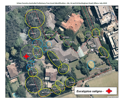
Image
16: Amended Preliminary Tree Asset Identification Map – plus
missing Eucalyptus
saligna,
forming part of the Blue Gum High Forest CEEC listed under the NSW BC Act 2016.
Source:
base map, Amended Preliminary Tree Asset Identification (Urban Forestry 2021)
Ecological Constraints Assessment
The Ecological Constraints Assessment (Cumberland Ecology
2020) report maps only trees within the site and does not include canopy
overhanging the subject site. As such it fails to map in the existence of Blue
Gum High Forest formed by three Eucalyptus saligna adjoining and
overhanging the north east and south east of 16 Buckingham Road.
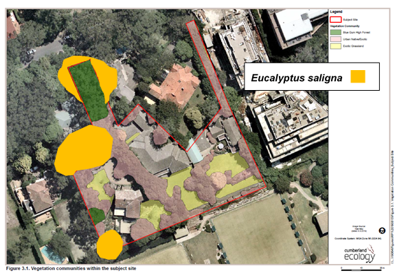
Image 17: Ecological
Constraints Assessment – Showing Eucalyptus saligna,
forming part of
the Blue Gum High Forest CEEC listed under the NSW BC Act 2016.
Source: Base map,
Ecological Constraints Assessment (Cumberland Ecology 2020)
Impacts on Blue Gum High Forest - Building Footprint and
Driveway
Assessment of the indicative building footprint as outlined
in the Urban Design Study suggest that impacts to the existing Blue Gum High
Forest adjoining and within the site can be avoided. However, as no detailed
tree protection zones are provided, it is uncertain. Further assessment at DA
stage will need to be undertaken to assess and protect these trees. As such it
is important to note that future reduction of this building area may be required
to avoid impact / encroachment upon this tree (including both root impacts and
the need to prune and allow for future growth and space between building and
tree – thereby reducing future need to prune).
Furthermore, deliberate designing and retention of the
separated driveways should enable long term retention of the existing Blue Gum
High Forest (forming part of the CEEC listed under the NSW BC Act 2016).
This will primarily be done through application of Councils
Ku-ring-gai LEP Part 6.3 and Ku-ring-gai DCP Part 8, Biodiversity provisions.
Biodiversity Mapping and Greenweb Mapping
It has been identified that Biodiversity mapping within
these provisions is more extensive than occurring within the site. Updating the
Biodiversity (Greenweb) mapping through a site specific DCP would provide
greater clarify for future developers.
Site Specific DCP
Should a site-specific DCP be proposed additional factors
that would benefit Ku-ring-gai’s Urban Forest and protect Blue Gum High
Forest include:
o updated Greenweb mapping (DCP
biodiversity provision mapping);
o a requirement for deliberate
designing and retention of the separated driveways to protect large canopy
trees; and
o a landscape plan including
planting of native trees (including Blue Gum High Forest species).
· Site Access
The Urban Design Study provides two options for vehicle and
pedestrian access into the site:
o Entry and exit via the access
handles at 14 and 16 Buckingham Road (west) and pedestrian access via 8a
Buckingham Road access handle (east); or
o entry via 8a Buckingham Road
access handle (east) and exist via 16 Buckingham Road access handle (west),
with pedestrian entry and exit via 14 Buckingham Road access handle.
Site access is not a matter for consideration in the assessment
of a Planning Proposal other than ensuring the site will have the opportunity
to provide access to the road should development on the sites under the
proposed LEP amendments be realised in the future.
Site access and the preferred configuration and location it
is something that could be addressed as part of the site-specific DCP to
support the Planning Proposal.
Key considerations in the location of the vehicle and
pedestrian entry and exit are:
o tree protection requirements
to ensure the significant trees and vegetation located along the existing
battle axe driveways of 14 and 16 Buckingham Road are able to be retained;
o travel paths when walking
to/from Killara Station;
o minimum widths and
accessibility requirements; and
o impacts on heritage items, and
landscape buffering requirements.
Strategic
Merit Assessment
· Greater Sydney
Region Plan and North District Plan
The Planning Proposal is consistent with the objectives of
the Greater Sydney Region Plan – A Metropolis of Three Cities, in
particular:
o Objective 4. Infrastructure
use is optimised
o Objective 10. Greater housing
supply
o Objective 11. Housing is more
diverse and affordable
o Objective 13. Environmental
heritage is identified, conserved and enhanced
o Objective 14. Integrated land
use and transport creates walkable and 30-minute cities
o Objective 27. Biodiversity is
protected, urban bushland and remnant vegetation is enhanced
o Objective 30. Urban tree
canopy cover is increased
A Metropolis of Three Cities outlines that
liveability incorporates access to housing, transport and employment, as well
as social, recreational, cultural and creative opportunities. Provision of
housing close to public transport and services and facilities improves the
opportunity for people to walk and cycle to local shops and services. Heritage
and biodiversity is protected and enhanced. The proposal is consistent with
these principles.
The Planning Proposal is consistent with the planning
priorities of the North District Plan, in particular:
o Planning Priority N1. Planning
for a city supported by infrastructure
o Planning Priority N5.
Providing housing supply, choice and affordability, with access to jobs,
services and public transport
o Planning Priority N6. Creating
and renewing great places and local centres, and respecting the districts
heritage
o Planning Priority N12.
Delivering integrated land use and transport planning and a 30-minute city
o Planning Priority N16.
Protecting and enhancing bushland and biodiversity
The Planning Proposal will allow for additional housing
supply in a location that enables good access via public transport to key
strategic centres such as Chatswood, St Leonards and Hornsby. The Planning
Proposal has been amended to ensure the built form outcomes on the site are
compatible with the protection of the adjoining heritage items and protection
of significant trees on the site and adjoining sites. The Planning Proposal is
therefore in accordance with the North District Plan priorities to focus housing
in locations that support the 30-minute city and provide access to jobs,
services and public transport, as well as the priorities to respect heritage
and protect biodiversity.
· Ku-ring-gai
Local Strategic Planning Statement
The Ku-ring-gai Local Strategic Planning Statement (LSPS)
came into effect on 19 March 2020 and provides a 20 year vision and local
planning priorities and associated actions for land use planning in
Ku-ring-gai. The Planning Proposal is consistent with the following local planning
priorities:
o K3. Providing housing close to
transport, services and facilities to meet the existing and future requirements
of a growing and changing community
o K4. Providing a range of
diverse housing to accommodate the changing structure of families and
households and enable ageing in place
o K12. Managing change and
growth in a way that conserves and enhances Ku-ring-gai’s unique visual
and landscape character
o K13. Identifying and
conserving Ku-ring-gai’s environmental heritage
o K21. Prioritising new
development and housing in locations that enable 30minute access to key
strategic centres
o K28. Improving the condition
of Ku-ring-gai’s bushland and protecting native terrestrial and aquatic
flora and fauna and their habitats
o K29. Enhancing the
biodiversity values and ecosystem function services of Ku-ring-gai’s
natural assets
o K30. Improving the quality and
diversity of Ku-ring-gai’s urban forest
o K31. Increasing, managing and
protecting Ku-ring-gai’s urban tree canopy
While the Planning Proposal is consistent with the
overarching local planning priority to provide housing close to transport,
services and facilities, the LSPS provides specific details about each centre,
its suitability for additional housing and timing.
The LSPS sets out that the Killara Secondary Local
Centre is suitable for additional housing, and it contains a local railway
station or bus routes on an arterial road corridor, and meet the criteria for
30minute access to a strategic centre and is supported by retail and other
services. The timing for future housing delivery in the Killara centre is
identified as 2031-2036. This Planning Proposal seeks to bring forward the
timing of housing delivery in the centre, which is inconsistent with the LSPS.
The Planning Proposal seeks to provide an ‘interface solution’ for
the subject sites and respond to the immediate surrounding context of the
subject sites, including the adjoining high density development at 6a
Buckingham Road, as well as the potential future high density development on
the adjoining Killara Golf Course. It is considered that there is sufficient
justification to support the Planning Proposal and delivery of housing in this
location prior to the 2031-2036 period, as it will result in a better planning
outcome.
The Planning Proposal is consistent with the
principles for the location of additional housing as set out in the LSPS:
o Locate high density housing
types within a 10min walk (800m radius) of Primary and Secondary Local Centres:
Gordon, Lindfield, Turramurra, St Ives (subject to the provision of priority
bus infrastructure), Roseville, Killara, Pymble and Wahroonga
o Locate medium density built
forms and other housing types on interface and transition areas where they
function as a buffer between differing scale of building or differing land use
types
o In considering areas for
future medium and high density housing form, the following areas are to be
avoided:
o Heritage conservation areas.
o Areas of visual or aesthetic
quality and character.
o Areas within or affecting
scenic and cultural landscapes.
o Areas of intact tree canopy
where the built form does not sit under the canopy.
o Areas with multiple
constraints including steep topography.
o Areas with environmental
values.
o Areas that are bushfire prone
and with evacuation risk.
o Centres with limited transport
and service access until improvements are implemented.
The sites the subject of the Planning Proposal are interface
sites, whereby they already adjoining high density development at 6a Buckingham
Road, and will adjoining future high density development on the Killara Golf
Course. The Planning Proposal seeks to provide an interface and appropriate
transition between the high density developments, and the adjoining low density
residential area. The development standards proposed and the built form
outcomes enabled by the Planning Proposal will function as a buffer and
transition between differing scale of building, while respecting and conserving
the heritage significance of adjoining heritage items and amenity of low
density residential dwellings. The sites the subject of the Planning Proposal
are not constrained by a Heritage conservation area, scenic or cultural
landscape or bushfire prone land. While the site does have areas of intact tree
canopy and environmental values, the proposed scale of the built form will be 3
storeys which will comfortably sit under the canopy and located outside of
areas of environmental value to ensure significant trees will be retained and
protected.
· Ku-ring-ai
Housing Strategy and Housing Strategy Approval Letter Conditions
Council’s adopted Ku-ring-gai Housing Strategy
provides all new dwellings to 2036 from capacity within the existing planning
controls and zoning. As the Planning Proposal is seeking to upzone the site and
amend the development controls to enable delivery of more housing on the site,
it is inconsistent with the Housing Strategy.
The amendments sought by the Planning Proposal will enable
the delivery of an addition 36-40 dwellings on the site.
In approving the Ku-ring-gai Housing Strategy, the
Department of Planning afnd Environment issued a number of approval conditions,
one of which is:
6. Council
is to commit to a work program to identify areas for additional medium density
housing opportunities outside of primary local centres such as Roseville Chase,
Killara, Pymble, Wahroonga, West Gordon and North St Ives as identified in the
Ku-ring-gai LSPS for potential delivery in the 2031 to 2036 period. A Planning
Proposal(s) for these centres is to be submitted to the Department for a
Gateway determination by December 2023. Where this work is not pursued by
Council the Department welcomes place-based approaches by landowner/developers
to explore opportunities for additional medium density housing in locations
that are well serviced by transport, services and facilities
At OMC 16 November 2021 Council resolved to reject the
Housing Strategy conditions of approval. As Council has not committed to a work
program, the subject Planning Proposal submitted by the landowners is
consistent with the requirements of Condition 6. The Planning Proposal will
enable a medium density built form outcome on the site in an area that is close
to public transport, services and facilities.
(Note: While the Planning Proposal seeks to rezone
the site to R4 High Density Residential, the development standards proposed, 3
storey and an FSR of 0.7:1, are consistent with and in the case of the FSR
lower than the development standards for medium density development throughout
Ku-ring-gai).
· Section 9.1
Ministerial Directions and State Environmental Planning Policies (SEPPs)
The Planning Proposal is not inconsistent with the State
Environmental Planning Policies (SEPPs) applicable to the site. Many of these
SEPPs contain detailed provisions and controls which would only apply at the
Development Application stage. It is noted that the Planning Proposal contains
assessment against SEPPs that have been repealed – specifically the
Affordable Rental Housing SEPP, SEPP Seniors and SEPP 70. These SEPPs have been
replaced by SEPP Housing 2021, and it is recommended that the Planning Proposal
be amended to include assessment against the new SEPP Housing 2021. This is
noted in the Table of Amendments at Attachment A12.
The Planning Proposal is consistent with the applicable s9.1
Ministerial Direction, specifically those relating to:
o 2.3 Heritage Conservation
o 3.1 Residential Zones
o 3.4 Integration of Land Use
and Transport
The Planning Proposal is justifiably inconsistent with
direction 6.3 Site Specific Provisions. The Planning Proposal seeks to include
a site-specific provisions which would require:
o a minimum lot size which is
larger than usually required in Ku-ring-gai for the development of a
residential flat building. The purpose of the site-specific provision for the
site is to ensure that the 3 sites the subject of the Planning Proposal are
developed together as one consolidated site, rather than potentially 1 or 2 out
of the three being developed.
o Site-specific development
standards including height of buildings using RLs and floor space ratio
The objective of direction 6.3 is to discourage
unnecessarily restrictive site-specific planning controls, and 4(c) outlines
that a Planning Proposal must allow that land use on the relevant land
without imposing any development standards or requirements in addition to those
already contained in the principal environmental planning instrument being
amended.
(6) notes that a Planning Proposal may be inconsistent with
this direction, if the provisions are of a minor significance.
In order to ensure that future development on the site
enabled by the Planning Proposal responds appropriately to the surrounding
context, comprising high density, low density and heritage items, as well as
responding appropriately to site constraints such as changes in topography,
there is a need for site-specific provisions and development standards. It is
considered the inconsistency with direction 6.3 is minor in nature and
justifiable in order to ensure the best built form outcomes on the site.
Amendments
required to be made to Planning Proposal Documents
The assessment of the Planning Proposal has found that there
are a number of errors, inconsistencies, and lack of detail or analysis
provided within the documents. There are other amendments required as a result
of Council’s assessment, such as the amendment to the Floor Space Ratio
and Minimum Lot Size development standards.
A table of amendments is included at Attachment A12
which details the required amendments to be made to the Planning Proposal if
Council is to support it being submitted to the Department of Planning and
Environment for a Gateway Determination and proceed to public exhibition.
Site-Specific
DCP
In order to provide more certainty and clarity regarding the
built form outcomes on the site under the amendments proposed within the
Planning Proposal, it is recommended that a site-specific Development Control
Plan (DCP) be prepared and exhibited concurrently with the Planning Proposal,
should it receive a Gateway Determination.
The site-specific DCP should include detailed controls
regarding:
· built form,
including wall lengths and massing;
· setbacks from
adjoining heritage items, low density residential dwellings and significant
trees including canopy to be retained;
· upper level
setbacks of building envelopes;
· ensure appropriate
curtilage areas to adjoining heritage items;
· pedestrian and
vehicle access to the site ensuring retention and protection of large canopy
trees;
· building envelope
to ensure it is broken up into 3 separate section across the site in order to
reflect the pattern of subdivision and surrounding low density development
context;
· roof forms;
· landscaping,
including buffer areas to heritage items and requirement for landscape plan
including planting of native trees (including Blue Gum High Forest species);
and
· updated Greenweb
mapping (DCP biodiversity provision mapping).
Ku-ring-gai
Local Planning Panel Advice
In accordance with Local Planning Panels Direction –
Planning Proposals issued by the Minister for Planning under Section 9.1 of the
Environmental Planning and Assessment Act 1979, the planning proposal
was referred to the Ku-ring-gai Local Planning Panel (KLPP) on 14 March 2022.
The KLPP provided the following advice (Attachment A13):
A. The
Planning Proposal, amended as per the Table of Amendments (Attachment A12)
be submitted to the Department of Planning, Industry and Environment (sic) for
a Gateway Determination
B. That
a site-specific Development Control Plan be prepared for the site and exhibited
concurrently with the Planning Proposal, should it receive a Gateway
Determination
integrated planning and reporting
Theme 3: Places, Spaces and Infrastructure
|
Community Strategic
Plan Long Term Objective
|
Delivery Program
Term Achievement
|
Operational Plan
Task
|
|
P1.1 Ku-ring-gai’s unique visual character and
identity is maintained
|
P1.1.1 Strategies, plans and processes are in place to
protect and enhance Ku-ring-gai’s unique visual and landscape character
|
P1.1.1.1 Continue to review the effectiveness of existing
strategies, plans and processes across all programs.
|
|
P2.1 A robust planning framework is in place to deliver
quality design outcomes and maintain the identity and character of
Ku-ring-gai
|
P2.1.1 Land use strategies, plans and processes are in
place to effectively managed the impact of new development
|
P2.1.1.2 Continue to review the effectiveness of existing
strategies, local environmental plans, development control plans and
processes across all programs
|
Governance Matters
The process for the
preparation and implementation of Planning Proposals is governed by the provisions
contained in the Environmental Planning and Assessment Act 1979 and the Environmental
Planning and Assessment Regulation 2000. A flow chart of the planning
proposal process is included at Attachment A14, and indicates what stage
this planning proposal is currently at, and the next steps involved.
If Council fails to make a
decision within 90 days (from the commencement of the review of the
application) or if Council makes a decision to not support the Planning
Proposal, the proponent can request the Department of Planning and Environment
for a Rezoning Review.
Local Planning Panels
Direction – Planning Proposals issued by the Minister for Planning under
Section 9.1 of the Environmental Planning and Assessment Act 1979 requires
Council to refer all Planning Proposals prepared after 1 June 2018 to the Local
Planning Panel for advice, before the Planning Proposal is forwarded to the
Minister for a Gateway Determination under Section 3.34 of the Environmental
Planning and Assessment Act 1979.
Risk Management
This is a privately initiated
Planning Proposal. Council needs to determine its position on the matter as to
whether the Planning Proposal should be sent to the Department of Planning and
Environment for a Gateway Determination and proceed to public exhibition.
Council risks damage to its
reputation if it does not undertake strategic land use planning in an effective
and timely manner.
Financial Considerations
The Planning Proposal was
subject to the relevant application fee under Council’s 2021/2022 Schedule
of Fees and Charges. The cost of the review and assessment of the Planning
Proposal is covered by this fee.
Social Considerations
The amendments sought by the
Planning Proposal will enable the delivery of 36-40 dwellings on the subject
site to meet the existing and future requirements of a growing and changing
community.
Environmental Considerations
The subject site includes
areas mapped on the KLEP 2015 Biodiversity map (Clause 6.3) and Greenweb within
the Ku-ring-gai DCP (Part 18). An Arborist Report and Ecological Constraints
Assessment have been submitted with the Planning Proposal. Council’s Team
Leader Natural Areas has reviewed the Planning Proposal and the potential
environment impacts of the Planning Proposal have been considered in this assessment.
Further detailed consideration of environmental impacts will be included in the
site-specific DCP, and any future development that may occur on the site as a
result of the proposal.
Community Consultation
In the event that the
Planning Proposal is issued a Gateway Determination by the Department of
Planning and Environment, the Planning Proposal would be placed on statutory
public exhibition in accordance with the requirements of the Gateway
Determination, and Council’s Community Participation Plan.
Internal Consultation
The assessment of the
Planning Proposal has included internal consultation with Council’s staff
with expertise in planning, heritage, traffic and transport and biodiversity
and has informed the recommendations of this Report. External Urban Design
advice was provided on the assessment of the Planning Proposal.
Summary
A Planning Proposal has been
submitted for 8a, 14 and 16 Buckingham Road, Killara which seeks to make the
following amendments to the Ku-ring-gai Local Environmental Plan 2015:
· Rezone
from R2 Low Density Residential to R4 High Density Residential;
· amend
Height of Buildings development standard;
· amend
Floor Space Ratio development standard;
· amend
Minimum Lot Size development standard;
· site
specific local provision requiring amalgamation of lots prior to development
for the purposes of a residential flat building.
The Planning Proposal has been assessed and found to have
sufficient strategic and site-specific merit to enable it to proceed to Gateway
Determination and public exhibition, subject to the amendments outlined in Attachment
A12.
Recommendation:
A. That
the planning proposal be amended in accordance with the recommendations in this
report and Table of Amendments (Attachment A12).
B. That
the planning proposal (as amended) be submitted to the Department of Planning
and Environment for a Gateway Determination in accordance with section 3.34 of
the Environmental Planning and Assessment Act 1979
C. That
delegation be given to the General Manager and Director of Strategy and
Environment to verify all amendments are in accordance with the recommendations
in this report and Table of Amendments (Attachment A12) prior to
forwarding to the Department of Planning and Environment.
D. That
Council requests to be authorised as the local plan-making authority to
exercise the functions under Section 3.36(2) of the Environmental Planning
and Assessment Act 1979.
E. That
a site-specific DCP be prepared in accordance with the details in this report,
and Council’s Fees and Charges.
F. That
upon receipt of a Gateway Determination, the public exhibition of the planning
proposal and site-specific DCP is carried out in accordance with the
requirements of the Environmental Planning and Assessment Act 1979,
Environmental Planning and Assessment Regulation 2000, the Gateway
Determination and the Ku-ring-gai Community Participation Plan
G.
That a report be brought back at the end of the exhibition process.
|
Alexandra Plumb
Acting Senior Urban Planner
|
Antony Fabbro
Manager Urban & Heritage Planning
|
|
Craige Wyse
Team Leader Urban Planning
|
Andrew Watson
Director Strategy & Environment
|
|
Attachments:
|
A1
|
PRE-PLANNING
PROPOSAL MEETING REPORT - 8A, 14 & 16 BUCKINGHAM ROAD, KILLARA
|
Excluded
|
2022/045679
|
|
|
A2
|
PLANNING
PROPOSAL JANUARY 2022 - 8A, 14 16 BUCKINGHAM ROAD KILLARA
|
Excluded
|
2022/045678
|
|
|
A3
|
URBAN
DESIGN STUDY REV 2 - January 2022 - Planning Proposal 8A 14 16
BUCKINGHAM ROAD KILLARA
|
Excluded
|
2022/045692
|
|
|
A4
|
TRAFFIC
REPORT - Planning Proposal 8A, 14 & 16 BUCKINGHAM ROAD, KILLARA
|
Excluded
|
2022/045697
|
|
|
A5
|
Additional
TRAFFIC RESPONSE - Planning Proposal - 8A, 14 & 16 BUCKINGHAM
ROAD, KILLARA
|
Excluded
|
2022/045698
|
|
|
A6
|
STATEMENT
OF HERITAGE IMPACT - Planning Proposal 8A, 14 & 16 BUCKINGHAM ROAD,
KILLARA
|
Excluded
|
2022/045700
|
|
|
A7
|
ADDENDUM
TO STATEMENT OF HERITAGE IMPACT - 8A 14 16 BUCKINGHAM ROAD KILLARA -
January 2022
|
Excluded
|
2022/045702
|
|
|
A8
|
ECOLOGICAL
CONSTRAINTS ASSESSMENT - Planning Proposal 8A, 14 & 16 BUCKINGHAM
ROAD, KILLARA
|
Excluded
|
2022/045714
|
|
|
A9
|
TREE
ASSET IDENTIFICATION - Planning Proposal 8A, 14 & 16 BUCKINGHAM ROAD,
KILLARA
|
Excluded
|
2022/045717
|
|
|
A10
|
SURVEY
- 8A & 14 BUCKINGHAM ROAD, KILLARA
|
Excluded
|
2022/045707
|
|
|
A11
|
SURVEY
- 16 BUCKINGHAM ROAD, KILLARA
|
Excluded
|
2022/045711
|
|
|
A12⇩
|
Table
of Amendments - Buckingham Road Planning Proposal
|
|
2022/045362
|
|
|
A13⇩
|
KLPP
Advice 14 March 2022 - Planning Proposal for 8a, 14 and 16 Buckingham Road,
Killara
|
|
2022/076162
|
|
|
A14⇩
|
Planning
Proposal Process Flowchart
|
|
2022/068797
|
|
APPENDIX No: 12 - Table
of Amendments - Buckingham Road Planning Proposal
|
|
Item No: GB.15
|
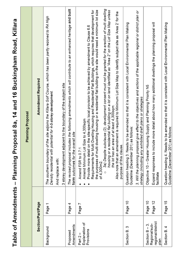
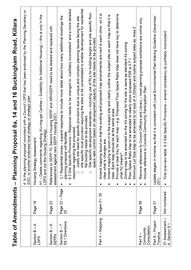
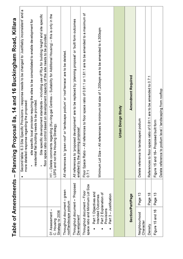
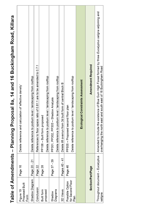
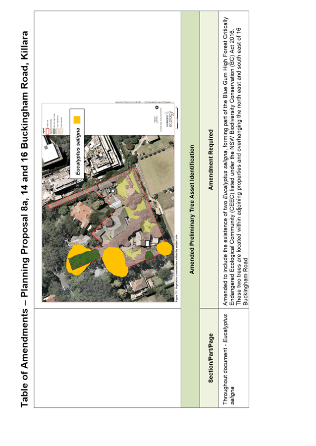
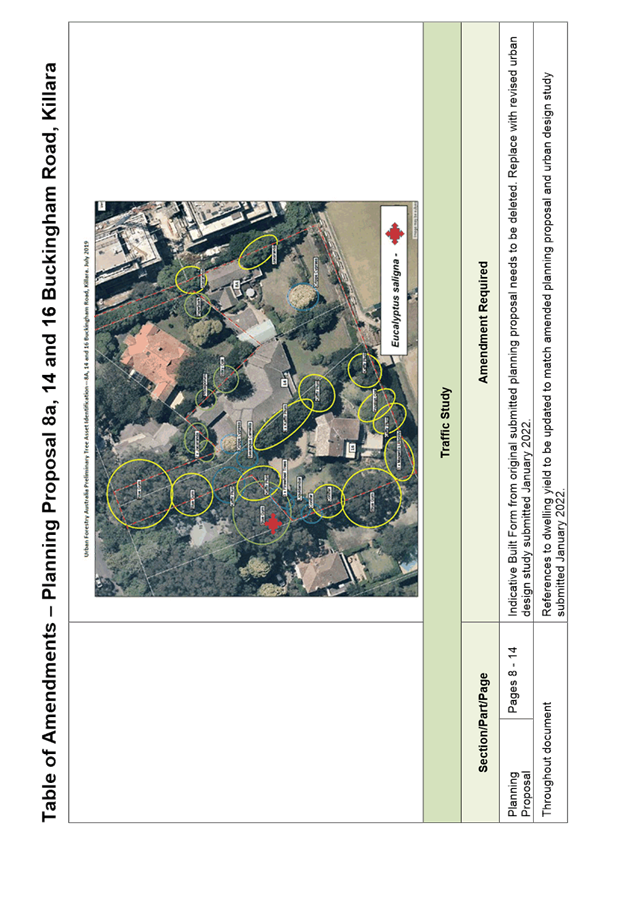

|
APPENDIX
No: 13 - KLPP
Advice 14 March 2022 - Planning Proposal for 8a, 14 and 16 Buckingham Road,
Killara
|
|
Item No: GB.15
|
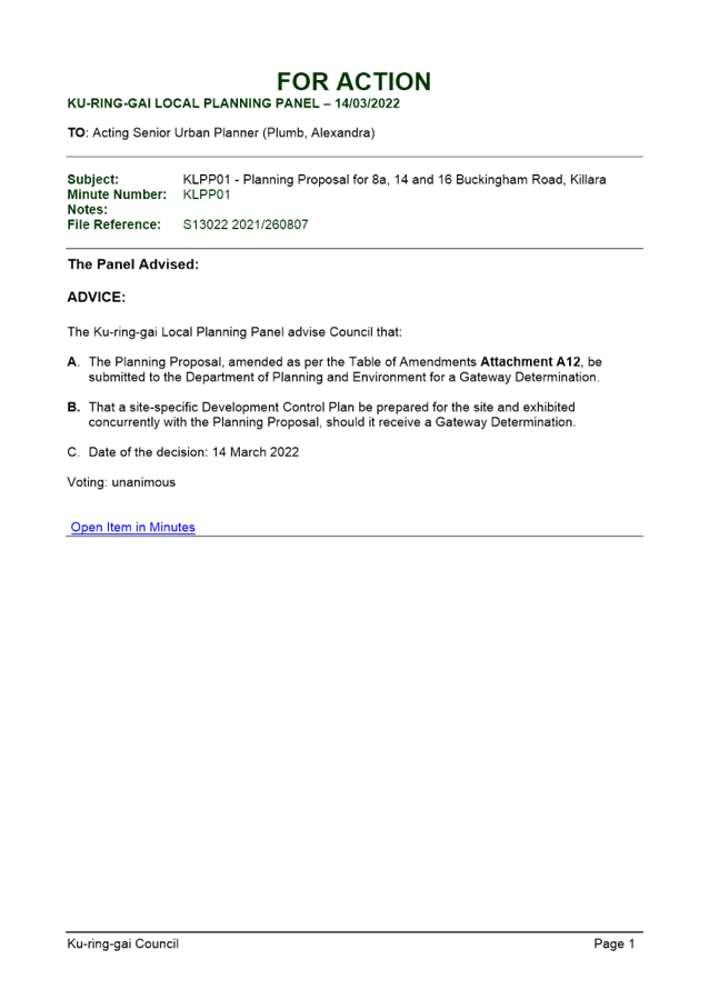
|
APPENDIX No: 14 - Planning
Proposal Process Flowchart
|
|
Item No: GB.15
|
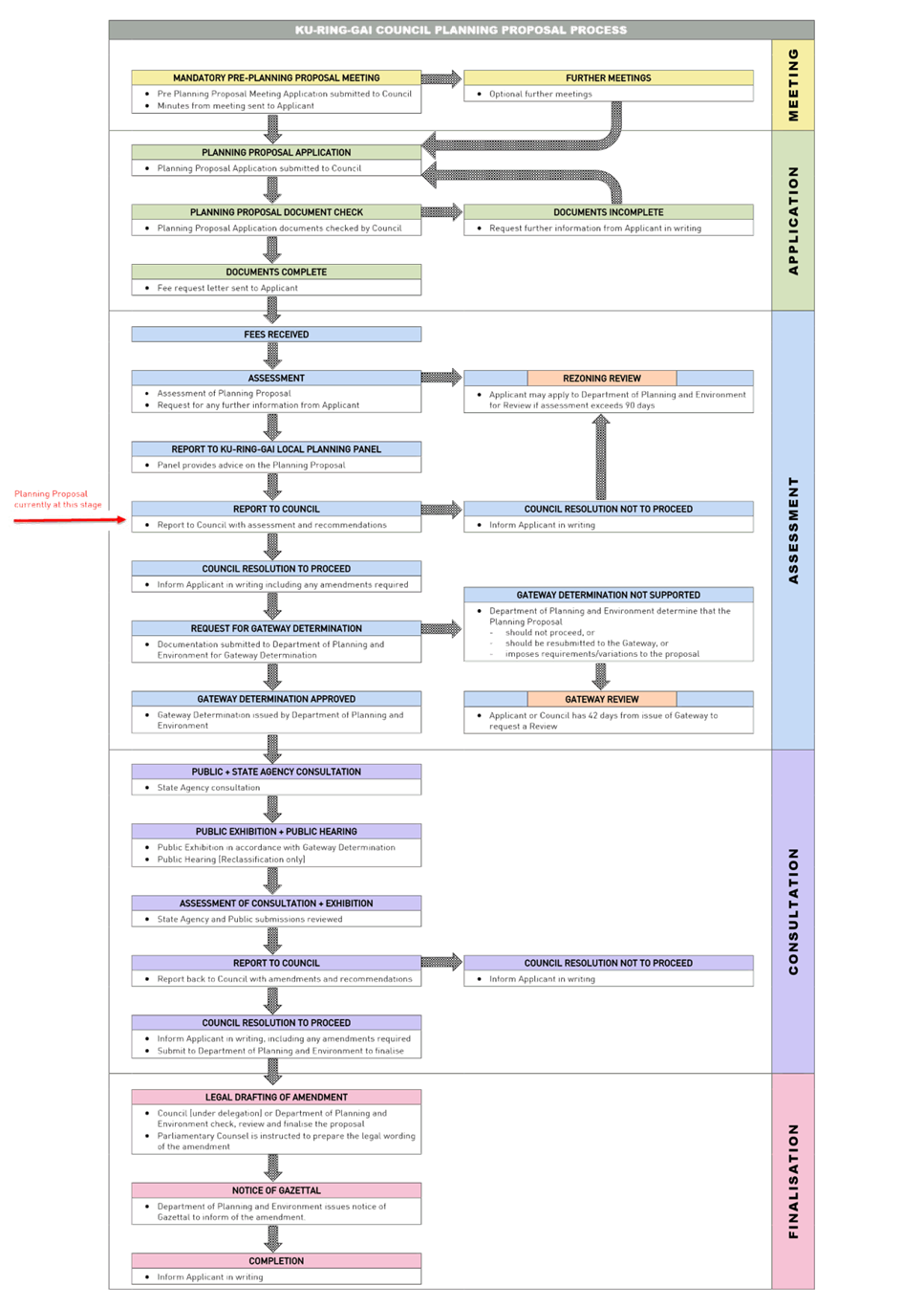
|
Ordinary
Meeting of Council - 26 April 2022
|
GB.16 / 1
|
|
|
|
|
Item
GB.16
|
S12249
|
Ku-ring-gai Public Domain Plan - Gordon -
Post exhibition
EXECUTIVE
SUMMARY
|
purpose of report:
|
To present the draft Ku-ring-gai
Public Domain Plan Volume 2 – Gordon for Council adoption.
|
|
|
|
|
background:
|
The Town Centres Public Domain Plan, 2010 (PDP
2010) has been in effect for 12 years and has served Council well, enabling
the delivery of a number of projects through funding collected from
development contributions
A review of the PDP 2010 has been undertaken to
reflect changing community needs, recent State Government guidelines and
standards, and the priorities and actions within the Ku-ring-gai Local
Strategic Planning Statement.
|
|
|
|
|
comments:
|
Following the adoption of Ku-ring-gai Public Domain
Plan Volume 1, Volume 2 (Turramurra) and Volume 3 on 15 March 2022 and
after the completion of the site inspection for Gordon, this report presents
the draft Ku-ring-gai Public Domain Plan Volume 2 (Gordon).
|
|
|
|
|
recommendation:
|
That Council adopts Volume 2
(Gordon) of the Ku-ring-gai Public Domain Plan.
|
Purpose of Report
To present the draft Ku-ring-gai Public Domain Plan
Volume 2 – Gordon for Council adoption.
Background
On November 23, 2010, Ku-ring-gai Council adopted the Ku-ring-gai
Council Town Centres Public Domain Plan 2010 (PDP 2010); the Plan has been
in effect for 12 years and has served Council well, enabling the delivery of a
number of projects through funding collected from development contributions.
Delivered projects for Gordon include the Gordon Bus Interchange; Beans Farm
Road and Hansons Way. Projects in the delivery phase include Wade Lane and St
Johns Avenue Streetscape Upgrade; Fitzsimons Lane and Pacific Highway (north)
Streetscape Upgrade.
Revision of the PDP 2010 was necessary to reflect changing
community needs, recent State government guidelines and standards, and the
priorities and actions within the Ku-ring-gai Local Strategic Planning
Statement.
At the Ordinary Meeting of Council 8 December 2020, Council
was presented with the Draft Ku-ring-gai Public Domain Plan. The Plan
included specific chapters for Gordon, Lindfield, and Turramurra local centres.
It was resolved:
“That Council adopt
the draft Ku-ring-gai Local Centres Public Domain Plan for public
exhibition and after the exhibition a further report be brought back to
Council.”
The draft KPDP was placed on public exhibition from 5 March
2021 until 19 April 2021. The outcomes of the public exhibition were reported
back to OMC 15 June 2021. At that meeting Council resolved:
“That the matter be
deferred to enable an inspection of the sites identified in the Ku-ring-gai
Public Domain Plan being the three town centres of Lindfield, Turramurra and
Gordon.”
A number of attempts were subsequently made by staff to
schedule site inspections for Councillors during 2021 however COVID 19
restrictions and the caretaker period prior to the 2021 Council elections meant
the site inspections were postponed until early 2022.
A Councillor site inspection for Lindfield was held on 14
February 2022, and for Turramurra on 21 February 2022.
A Councillor site inspection for Gordon was held on 29 March
2022.
At the Ordinary Meeting of Council 15 March 2022, Council
adopted Ku-ring-gai Public Domain Plan Volume 1, Volume 2 –
Turramurra (only) and Volume 3.
This report represents the draft KPDP Volume 2 –
Gordon only for Council consideration.
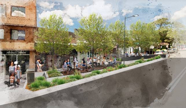
Artist’s impression – St Johns Avenue,
Gordon streetscape upgrade
Comments
This report presents the following sections of the draft
Ku-ring-gai Public Domain Plan:
- Volume
2 – Gordon Public Domain Plan.
The draft Ku-ring-gai Public Domain Plan (KPDP) has
been prepared to provide guidance on the planning, design and construction of
streets, roads, parks, car parks and other public spaces.
Volume 2 – Local Centres Public
Domain Plans for Gordon (Attachment A1):
· sets
out objectives for each local centre;
· sets
desired future character and provides concept designs for streetscapes and
public open spaces; and
· nominates
examples of appropriate street trees.
The Gordon public domain plan
provides concept plans for the Gordon local centre. To ensure a coherent,
well-coordinated rollout of the concept design and desired future character of
the local centre, it is vital that all contributors adhere to the concept
design and deliver a quality outcome.
The KPDP provides guidelines and
concept designs for all stakeholders, planners, designers and developers
– public or private, large or small scale – who intend to carry out
works within the public domain areas of the Ku-ring-gai Local Centres. The KPDP
must be read in conjunction with the Local Environment Plan, the Development
Control Plans and the Ku-ring-gai Contributions Plan 2010.
The delivery of the public domain renewal projects will be
led by Council and largely funded through development contributions. Funding is
currently available for a number of projects identified in the KPDP, however
many are not and will require the continued collection of development
contributions to realise all listed projects. Delivery of some portions of the
public domain works will be redevelopment of sites with works completed by
developers directly via Voluntary Planning Agreements or Works-in-Kind type
agreements.
Projects currently identified under the Ku-ring-gai
Contributions Plan 2010 will be prioritised for delivery. Additional
projects will be added as Development Contribution funding becomes available.
Streetscape projects for Gordon programmed for delivery within the next five
years include St Johns Avenue (eastern end), Fitzsimons Lane, part of Merriwa
Street, and Pacific Highway western side (north of Merriwa Street).
It must be noted that the plan presented in the KPDP are
high-level concept plans that represent desired long-term outcomes. In most
instances additional funding or further studies, collaboration with Transport
for NSW, changes to the LEP and DCP or targeted community consultation, or all
of these, will be required to realise these designs. Though the design intent
has been demonstrated, the final design may be delivered differently.
Following public exhibition in March/ April 2021, Council
received submissions from the community and internal and external stakeholders.
There were no comments specific to Gordon, however some internal
amendments have been made that are listed in Table 1 (below).
|
TABLE
1 – Amendments for clarity, additional information or updates to
designs.
|
|
|
Summary
of key submission comments requiring amendments
|
Reason
|
Affected
sections/pages
|
|
1
|
Removal
of right turn lane into St Johns Avenue from Pacific Highway
|
To
align with adopted traffic plan for Gordon
|
Illustrative
Plan
|
|
2
|
Adjustments
to signalised intersection at Ravenswood Avenue and Pacific Highway
|
To
align with adopted traffic plan for Gordon
|
Illustrative
Plan
|
integrated planning and reporting
Places,
Spaces and Infrastructure
|
Community Strategic Plan Long Term Objective
|
Delivery Program
Term Achievement
|
Operational Plan
Task
|
|
Long Term Objective P4.1: Our centres offer a broad range of shops and
services and contain lively urban village spaces and places where people can
live, work, shop, meet and spend leisure time.
|
P4.1.1: Plans to revitalise local centres are being
progressively implemented and achieve quality design and sustainability
outcomes in collaboration with key agencies, landholders and the community
|
P4.1.1.1: Implement the Ku-ring-gai Public Domain Plan and
Technical Manual and review and update as required.
P4.1.1.2: Implement Public Domain Masterplans for the local
centres and concept plans for key
precincts.
P4.1.1.6: Prepare streetscape concept plans for identified
precincts in Gordon Local Centre
consistent with the Public
Domain Plan.
P4.1.1.11: Integrate all transport modes for the primary
local centres through the Public Domain Plan, Traffic and Transport studies
in collaboration with Transport for NSW (TfNSW).
|
Governance Matters
The Ku-ring-gai Public
Domain Plan is consistent with the following strategies and plans:
NSW Government
· North
District Plan;
· Cycleway
Design Toolbox 2020;
· Austroads
Guide to Road Design Part 6A: Paths for Walking and Cycling 2021;
· NSW
Government Movement and Place Framework;
· Transport
for NSW Road User Space Allocation Policy;
· NSW
Crime Prevention Through Environmental Design Guidelines
Ku-ring-gai Council
· Ku-ring-gai
Local Strategic Planning Statement;
· Ku-ring-gai
Development Control Plan;
· Ku-ring-gai
Community Strategic Plan 2038;
· Ku-ring-gai
Contributions Plan, 2010;
· Activate
Ku-ring-gai Program;
· Ku-ring-gai
Town Centre Public Domain Plan 2010;
· Draft
Ku-ring-gai Pedestrian Access and Mobility Plan;
· Access
and Disability Inclusion Plan 2020 -2024; and
· Ku-ring-gai
Council Climate Change Policy 2020.
Risk Management
A key risk is that
Development Contributions will slow, and funding will fall short of the cost of
the proposed works in the KPDP. Funds are currently available for some projects
however the complete delivery of proposed works will rely upon further
development contributions and possibly grant money from the State Government.
Some elements of the KPDP rely upon redevelopment to deliver outcomes shown
including the Community Hubs. The KPDP also foreshadows amendments to the
Ku-ring-gai DCP to incorporate setbacks and land dedication in certain
locations. These amendments will be made during reviews or
‘housekeeping’ amendments to the KDCP.
A further risk is the
proposed restructuring of the infrastructure contributions planned by NSW
Government. The restructure may reduce the amount of contributions Council may
collect from developments for the purposes of streetscape improvements, this is
because public domain works are currently excluded from the Essential Works
List which will become mandatory for all Contributions Plans.
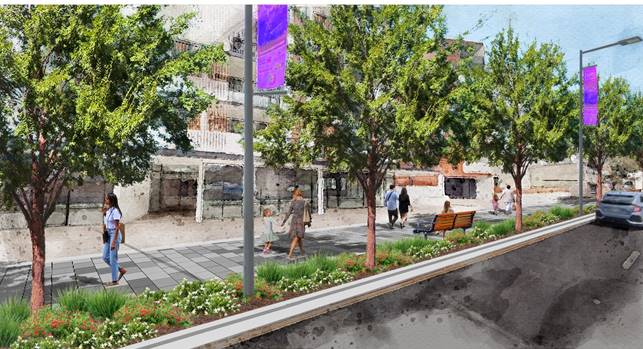
Artist’s impression – Pacific Highway,
Gordon streetscape upgrade, north of Merriwa Street.
Financial Considerations
Strategy and Environment
staff have been working with Finance Department and Operations to establish a five-year
program to deliver streetscape upgrades across the Local Centres. There are
currently development contribution funds available for the projects for the
period 2021-2025.
Local Centre Streetscape
Improvements Program
|
Local Centre
|
Streets included
|
LTFP funds
(S 7.11)
|
Commence construction
|
|
Gordon
|
St Johns Avenue, Wade Lane,
Henry Street (part), Werona Avenue (part)
|
$9.5M
|
2022
|
|
Gordon
|
Fitzsimons Lane, Merriwa street (part) and Pacific Highway
(north streetscape)
|
$4.5M
|
TBC
|
Consultant quantity surveyors have
prepared a preliminary cost plan, of all the works proposed in the draft KPDP,
including funded and unfunded projects. These costings will inform the
development of future work programs as well as any future amendments to the
Ku-ring-gai Contributions Plan, or preparation of a new contributions plan.
The extent of the works will be
finalised once a cost report has been prepared by a quantity surveyor. This
will ensure the scope of works is consistent with the available budget.
Possible changes to development
contributions being contemplated by the State Government may curtail revenue in
the outer years of the Long Term Financial Plan which may require adjustments
to projects. Likewise, reliance of the “pooling” provisions in the
2010 contributions plan may result in funds for some projects not being
available in later years if funds are not repaid.
Social Considerations
Improved public domain
environments will encourage walking and cycling by residents that could
potentially increase community health and increase the chances of meeting and
interacting with others in the community.
Improved street environments
will encourage residents and visitors to interact and linger around the retail
core and eateries, on any day and night, activating the centres.
Upgraded pedestrian movement corridors and crossing points
will improve safety in the local centres.
Covid Impacts
The public domain plan will assist Council in working with
the State Government initiatives to support local businesses to expand outdoor
dining where appropriate and ensuring public amenity and safety are maintained
in accordance with covid planning requirements.
Environmental Considerations
Additional tree planting will
provide shade and add to the urban canopy of Ku-ring-gai. The shading from the
trees will not only benefit users of the streets, but will cool the adjoining
premises, potentially reducing cooling requirements and electrical bills.
Significant trees will be
protected and retained. New trees planted in tree pits will have stormwater
diverted from the kerb and gutter into the tree pits which will filter the
stormwater before ultimately entering the stormwater system if the water is not
absorbed by the trees and plants. This assists in providing additional water to
the planting during rain events.
Where possible, indigenous
tree species will be selected for tree planting. However, other factors such as
street character, soil and planting conditions, solar access to adjacent
properties, space constraints, maintenance and community consultation will all
be considered when selecting the tree species.
Improved public domain
environments such as footpaths, providing safer crossing points for pedestrians
and formalisation of some cycle routes will encourage more people to walk and
ride to the local centres, leaving the car behind, benefiting the environment.
Quality durable materials
will be used to ensure longevity and remove the need for regular replacements
and costly repair. Most of the public domain materials selected may be recycled
at the end of their usable life.
Community Consultation
On 8 December 2020, Council
adopted the reported Draft Ku-ring-gai Public Domain Plan for public
exhibition and was reported back to Council in June 2021. Community
consultation was undertaken through the exhibition of the Draft Ku-ring-gai
Public Domain Plan. A community consultation strategy was developed in
conjunction with Council’s Communication team prior to releasing the
documents for public exhibition.
The KPDP was on public
exhibition from 5 March 2021 until 19 April 2021, inclusive, longer than the
required 28 days specified in the Community Participation Plan. In addition to
notification on Council’s website, the Draft Ku-ring-gai
Public Domain Plan was notified by way of two E-newsletters (13,500
subscribers), Business E-news (1,500 subscribers), as well as suburb specific
e-news.
The Enliven Ku-ring-gai event
held in St Johns Avenue, Gordon on 5 March 2021 was used to promote the KPDP
exhibition. Council officers were present on the day to inform the community of
the imminent streetscape upgrade works for Wade Lane and St Johns Avenue and
the KPDP for Gordon.
The draft public domain plans for Gordon were presented to
Transport for NSW at a workshop with a number of representatives from both
Transport for NSW and Council. Comments from Transport for NSW have been taken
on board and changes made to the draft KPDP.
Council officers also invited
number of authorities and State Government agencies to review the KPDP and to
provide comment. These included:
Internal Consultation
A series of internal
workshops were conducted with a number of departments including Operations,
Strategy and Environment, and Development and Regulation for the Gordon
Public Domain Plan.
A summary of the draft Public
Domain Plan for Gordon was presented to the previous Councillors through a
Councillor briefing sessions held on 7 October 2020. No issues of concern were
raised by the Councillors.
The draft KPDP was circulated
to all Council staff who attended the workshops associated with the preparation
of the KPDP and others that were considered stakeholders of the plan. No
additional comments were received from internal stakeholders.
Councillors were made aware
of the public exhibition and invited to comment through direct email.
A Councillor briefing about
the submissions received and the proposed changes to the KPDP was held on 25
May, 2021.
Site inspections
In accordance with Council’s resolution of 15 June,
2021, a site inspection for Gordon was held on 29 March 2022.
An overview of the proposed concept design for Gordon was
presented to the attending Councillors. Electronic copies of the information
sheets for Gordon distributed on the day have since been emailed to all
Councillors.
A summary of the questions / issues raised at the Gordon
site inspections has been provided in Attachment 2.
Summary
The draft Ku-ring-gai
Public Domain Plan provides guidelines and concept designs to ensure a
coherent, well-coordinated rollout of the concept design and desired future
character of the local centres. Adherence to the KPDP can deliver a quality
outcome for our local centres.
The KPDP Volume 2 (Gordon)
has been reviewed and commented upon by the community, council officers,
Councillors and external stakeholders and State agencies. No comments were
received for Gordon. Some minor amendments have been made to align with the
traffic plan for Gordon.
Overall, the KPDP is
supported by the community and the adoption of this plan will assist in
delivering an improved public domain outcome for the Gordon local centre.
Recommendation:
That Council adopt Ku-ring-gai Public Domain Plan Volume
2 (Gordon) as attached to this report.
|
Maria Rigoli
Public Domain Co-ordinator – Local Centres
|
Bill Royal
Team Leader Urban Design
|
|
Antony Fabbro
Manager Urban & Heritage Planning
|
Andrew Watson
Director Strategy & Environment
|
|
Attachments:
|
A1 ⇩ ⇩
|
Ku-ring-gai
Public Domain Plan - Volume 2 - Gordon
|
|
2022/093170
|
|
|
A2⇩
|
Public
Domain Plan - Gordon site inspection notes
|
|
2022/100587
|
|
APPENDIX No: 1 - Ku-ring-gai
Public Domain Plan - Volume 2 - Gordon
|
|
Item No: GB.16
|
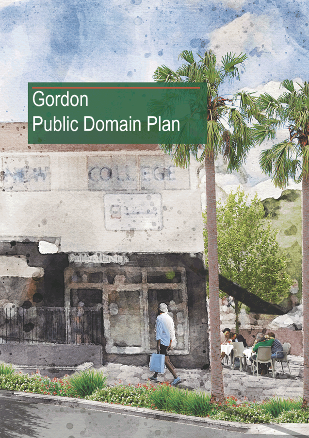
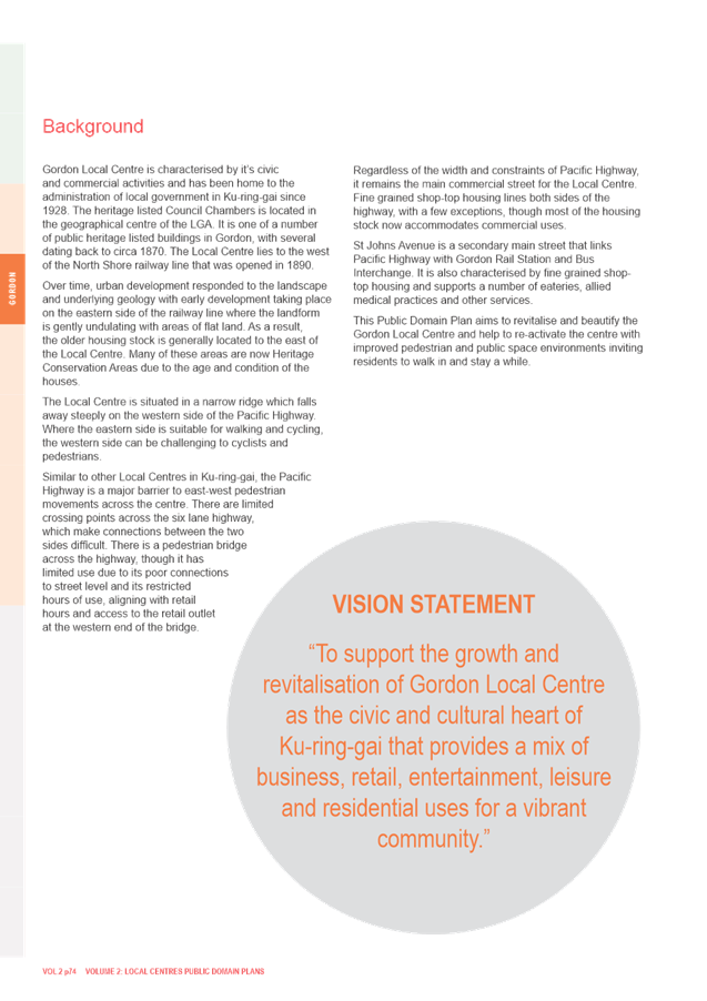
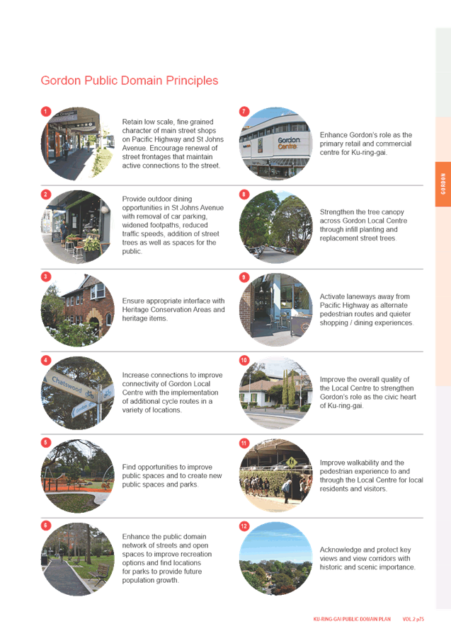
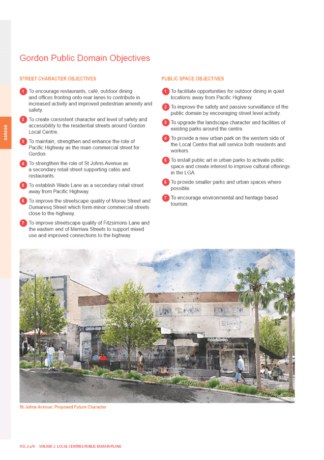
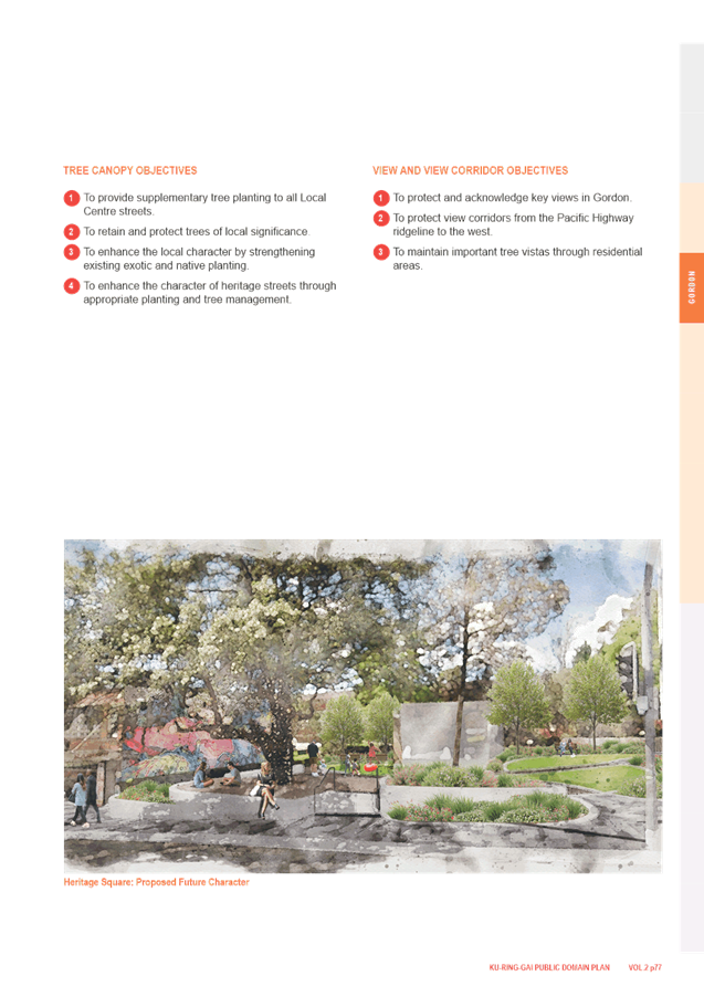
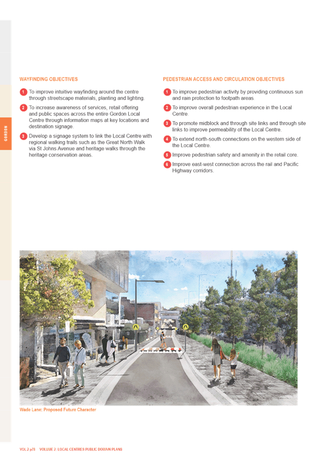
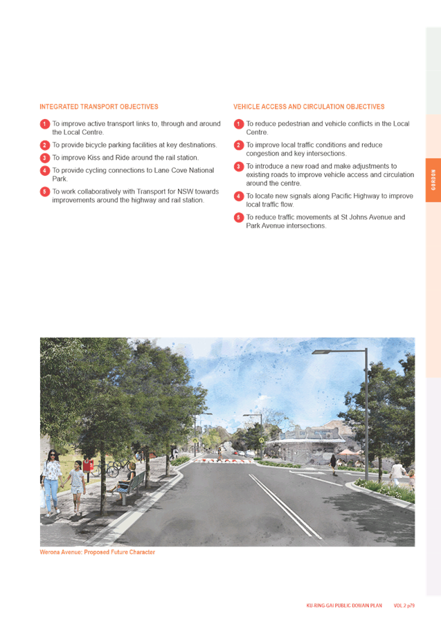
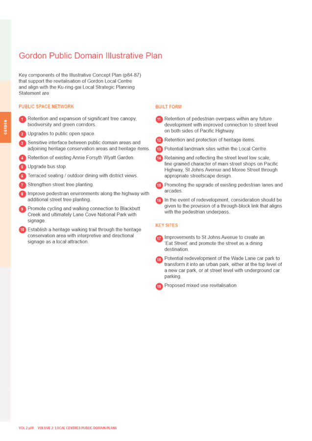
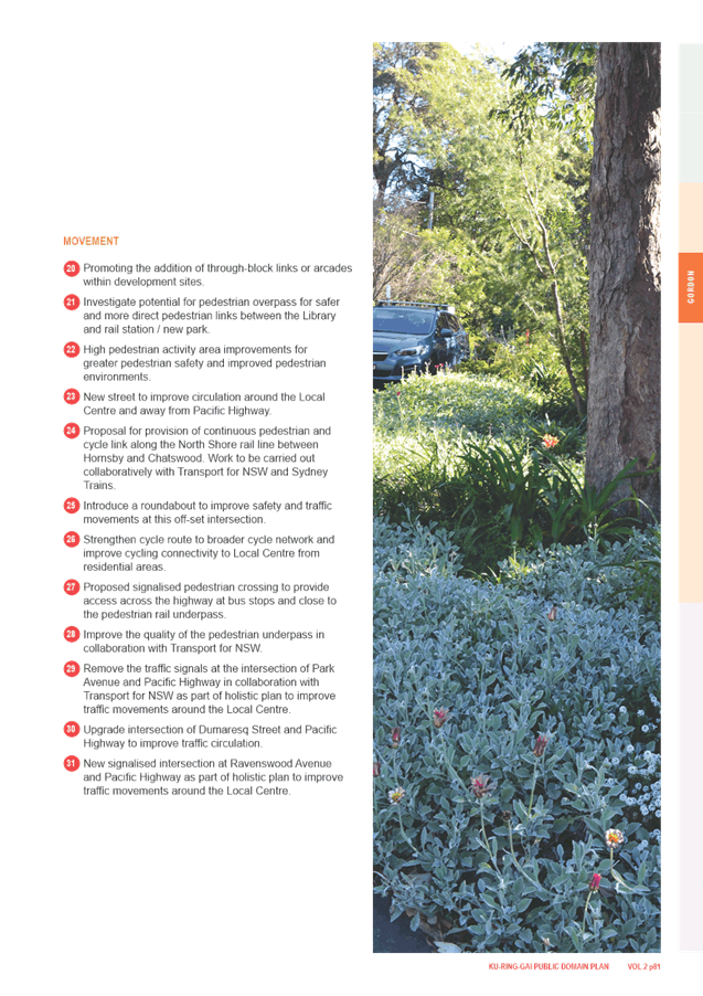
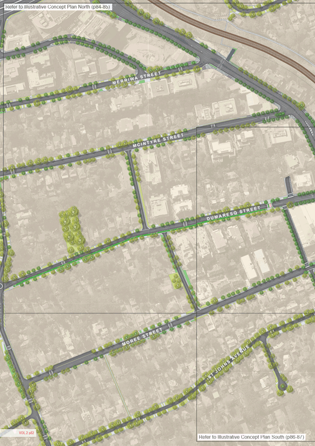
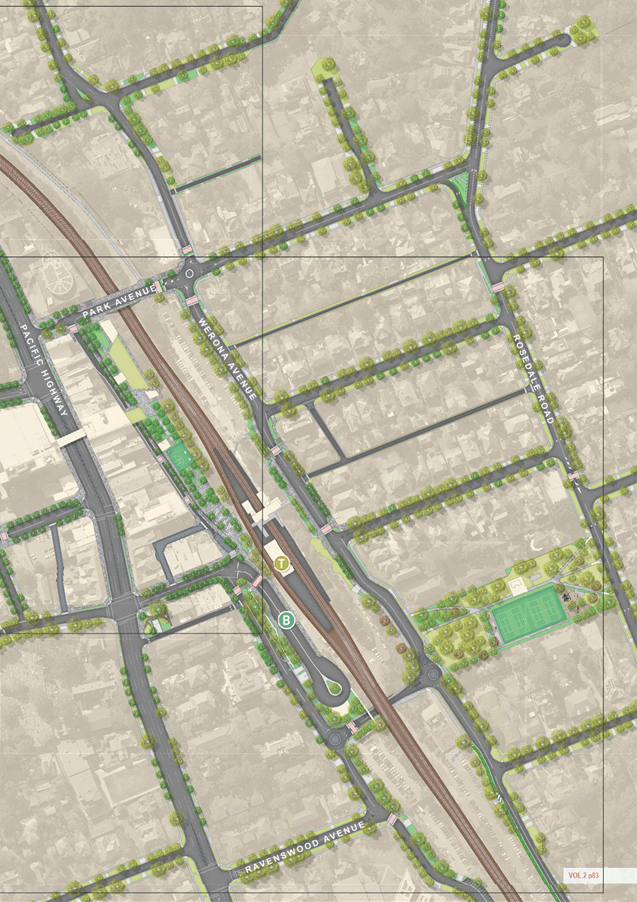
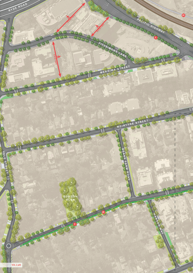
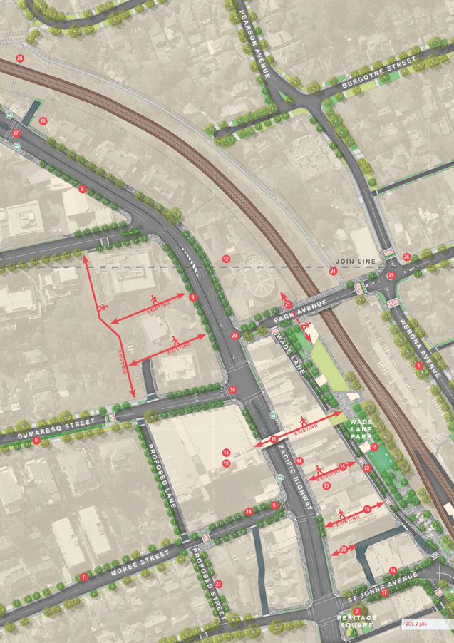
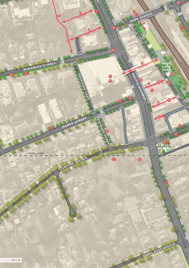
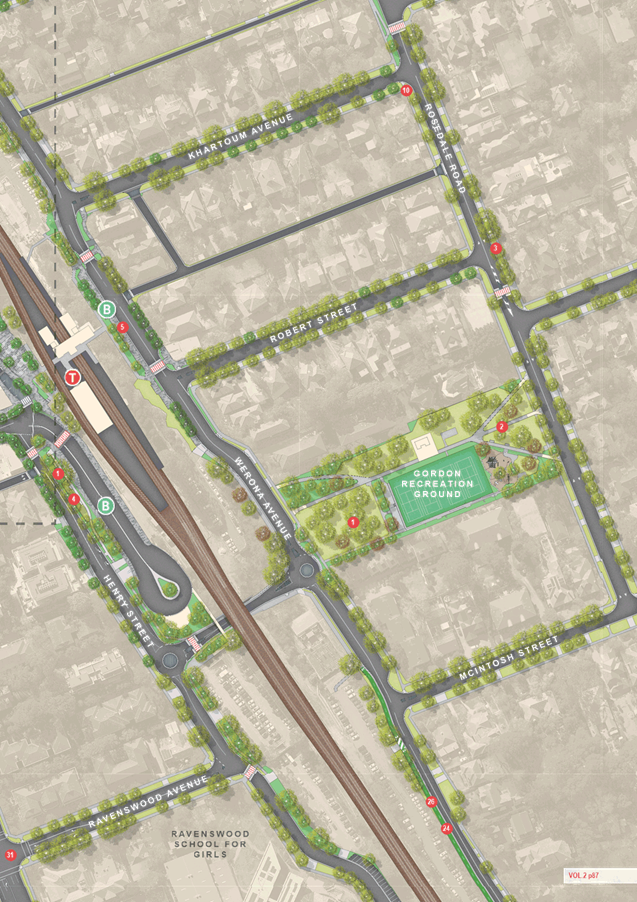
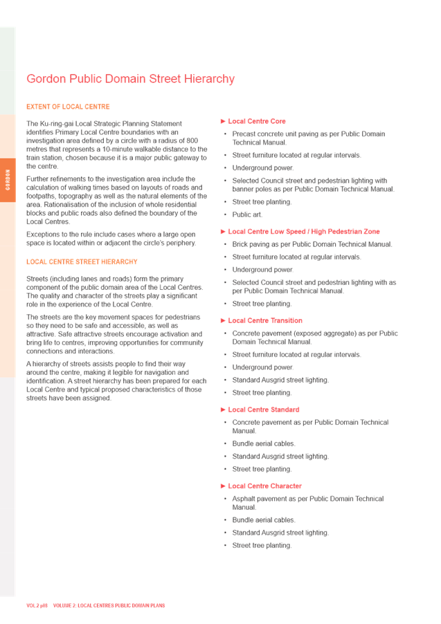
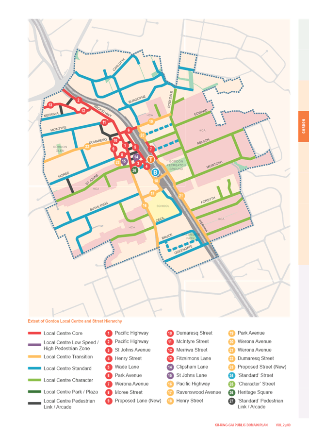
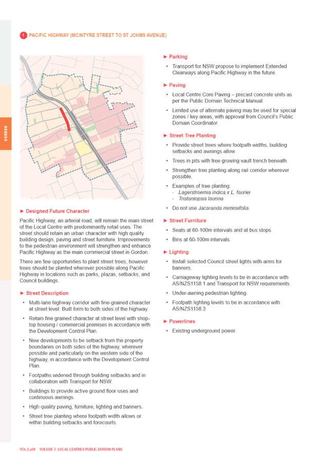
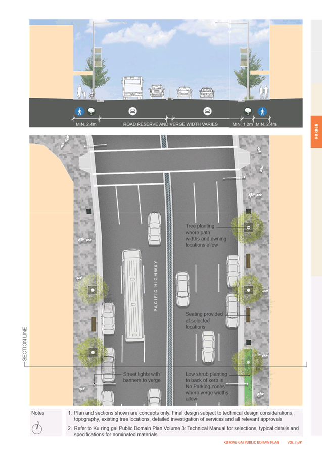
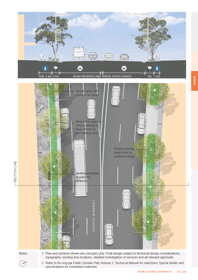
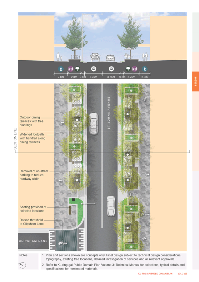
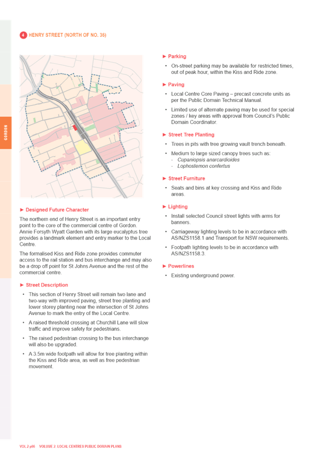
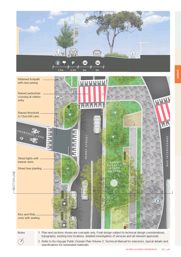
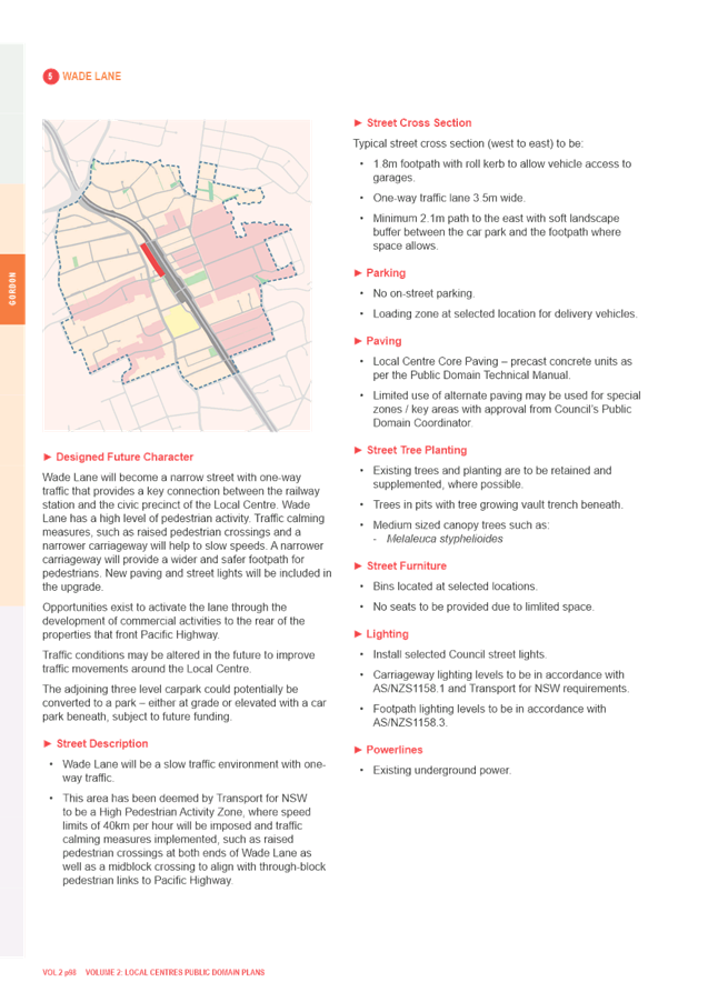
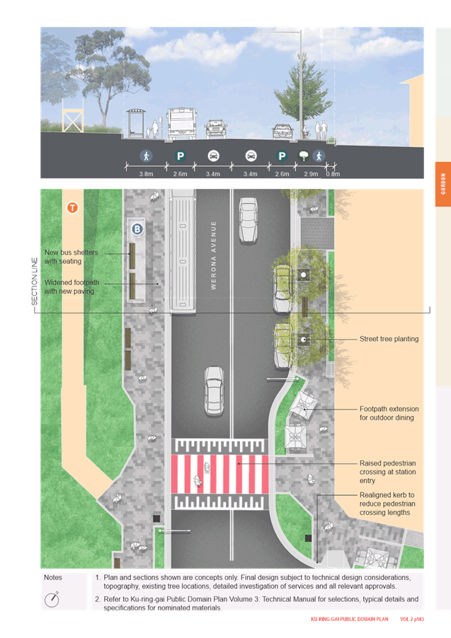
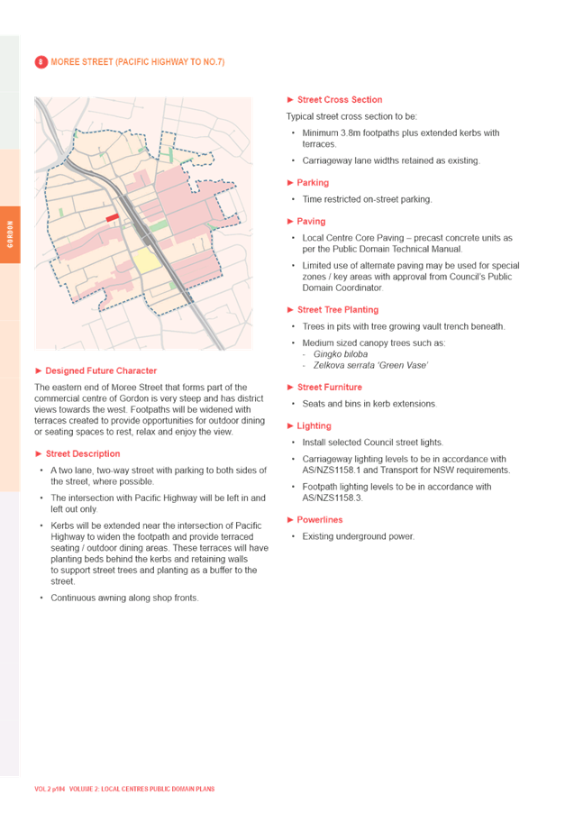
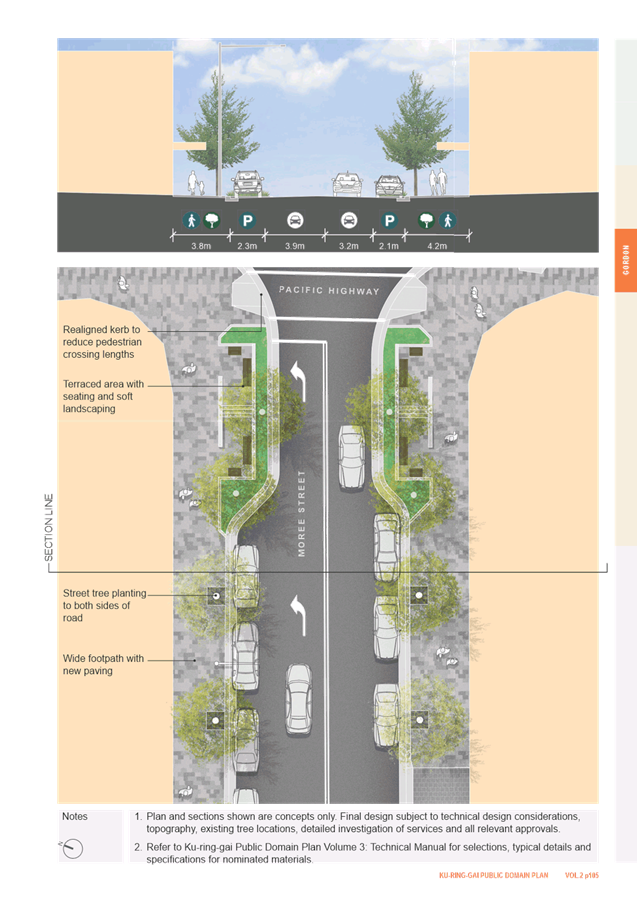

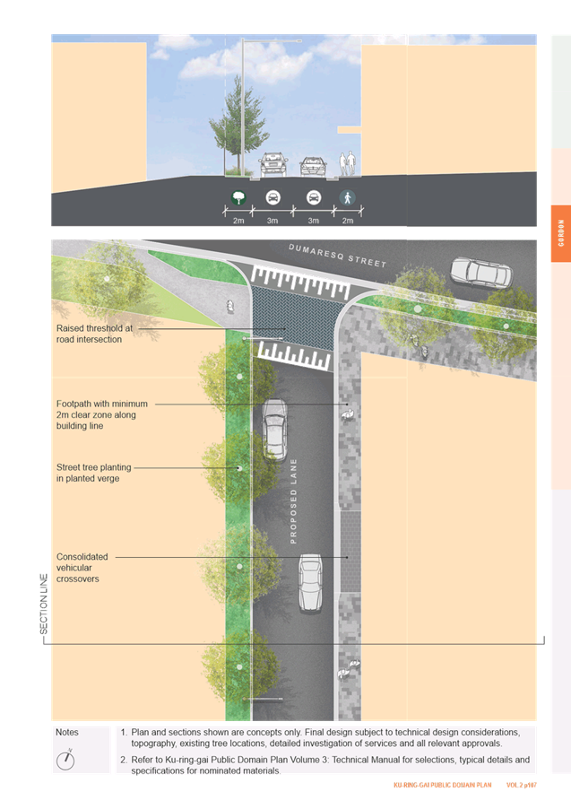
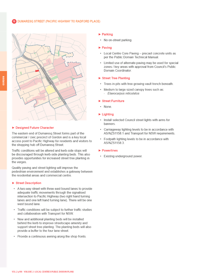
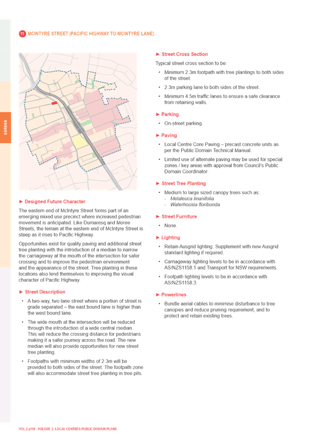
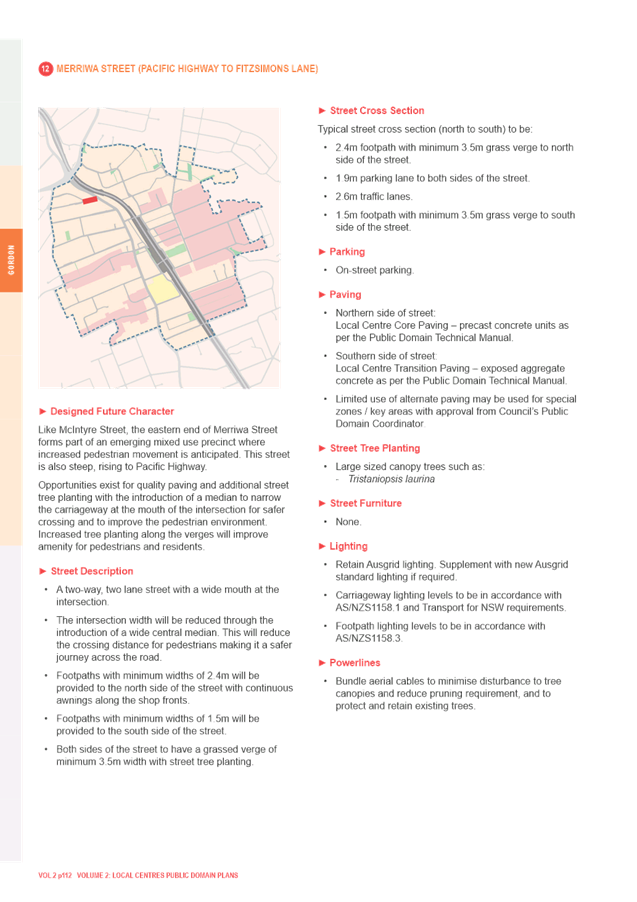
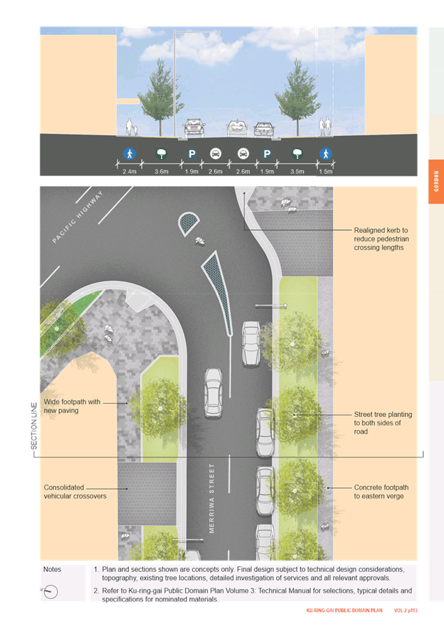

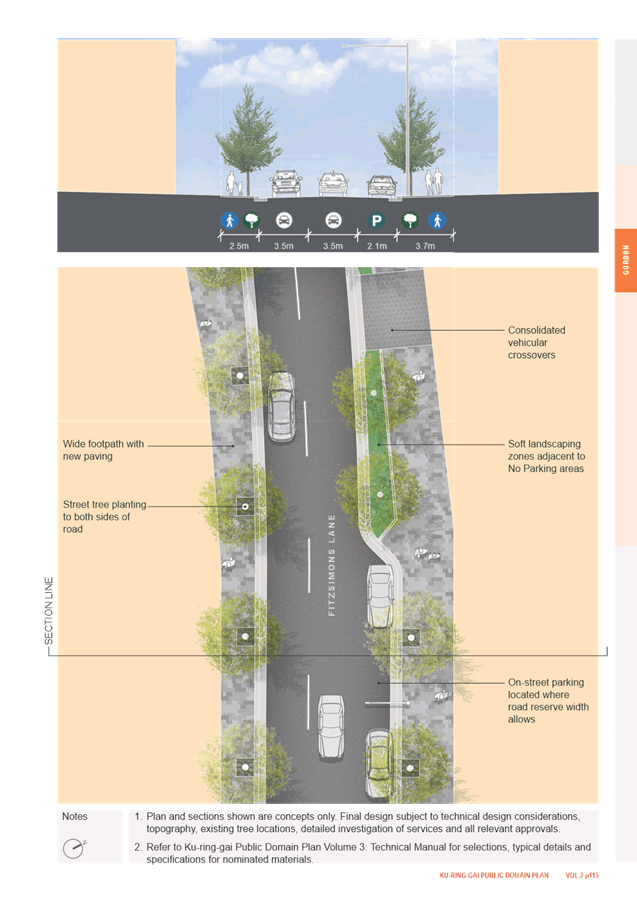
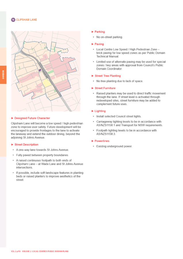
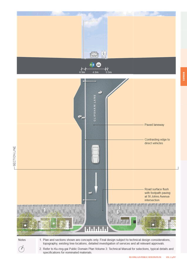

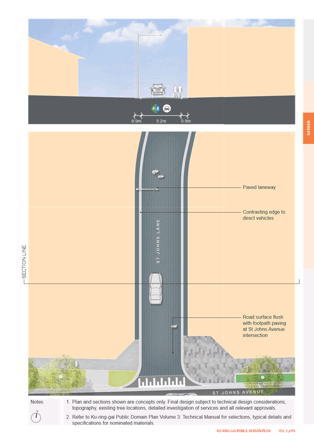
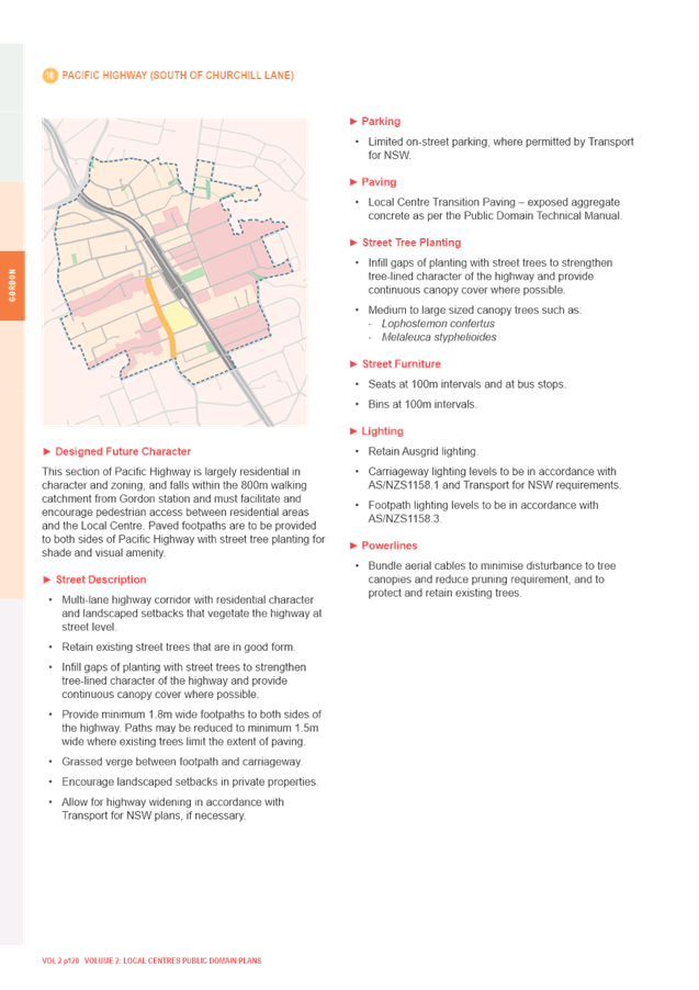
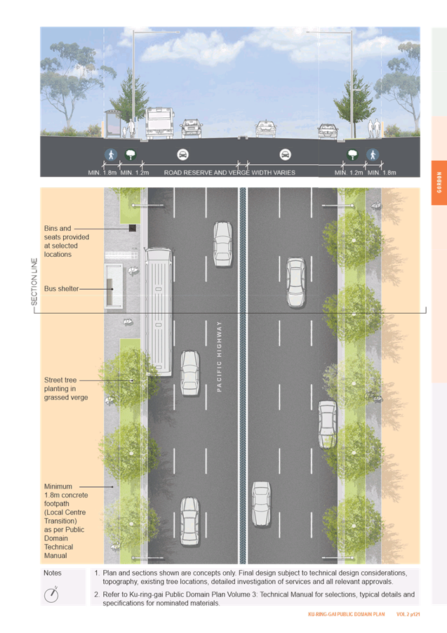

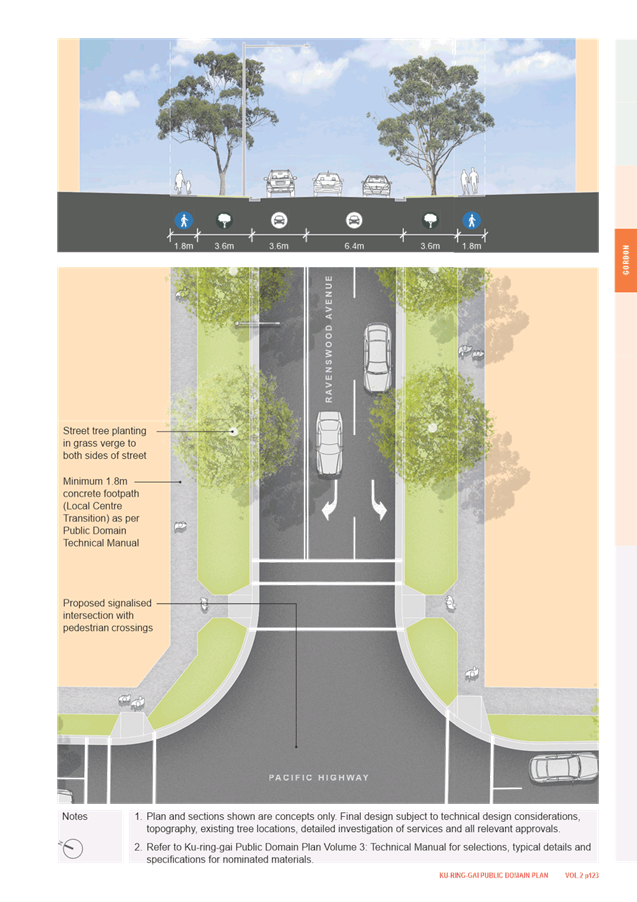
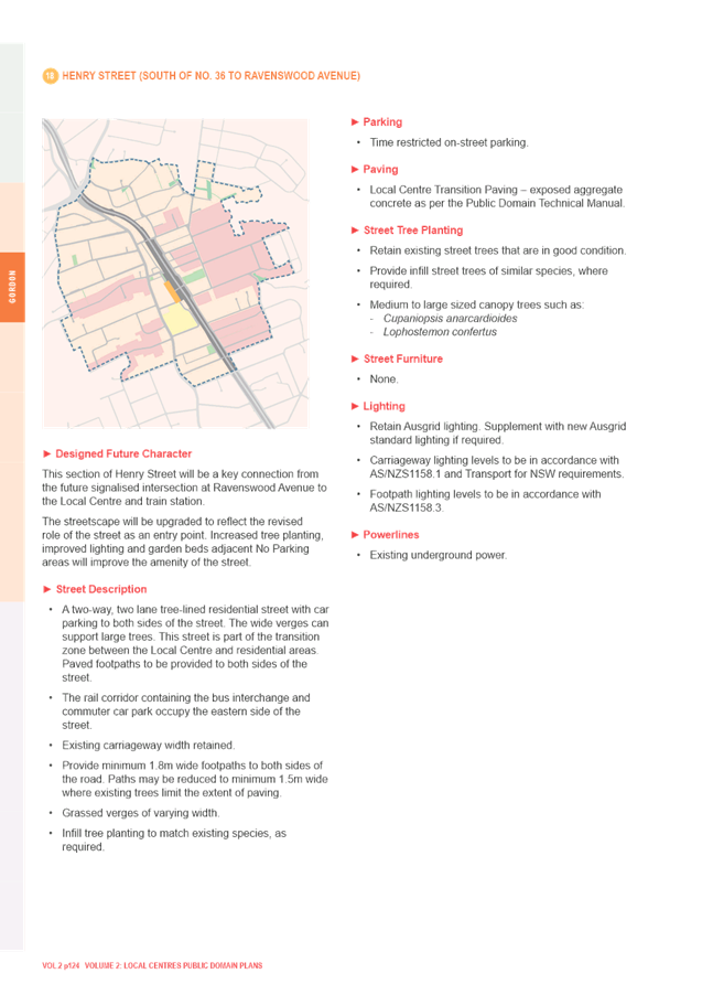
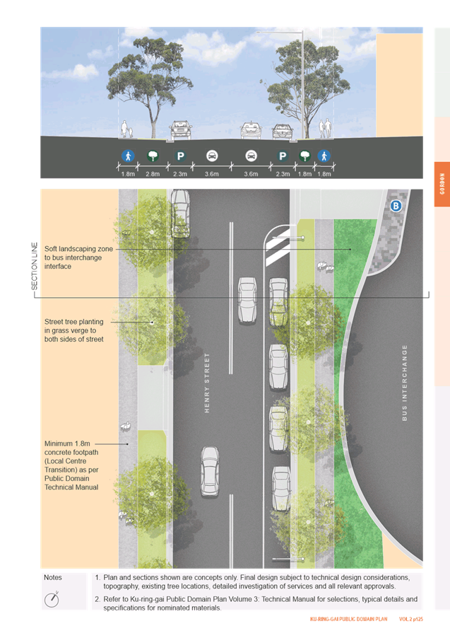
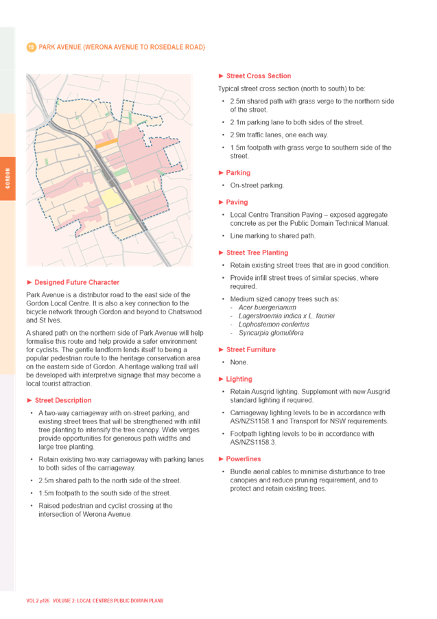
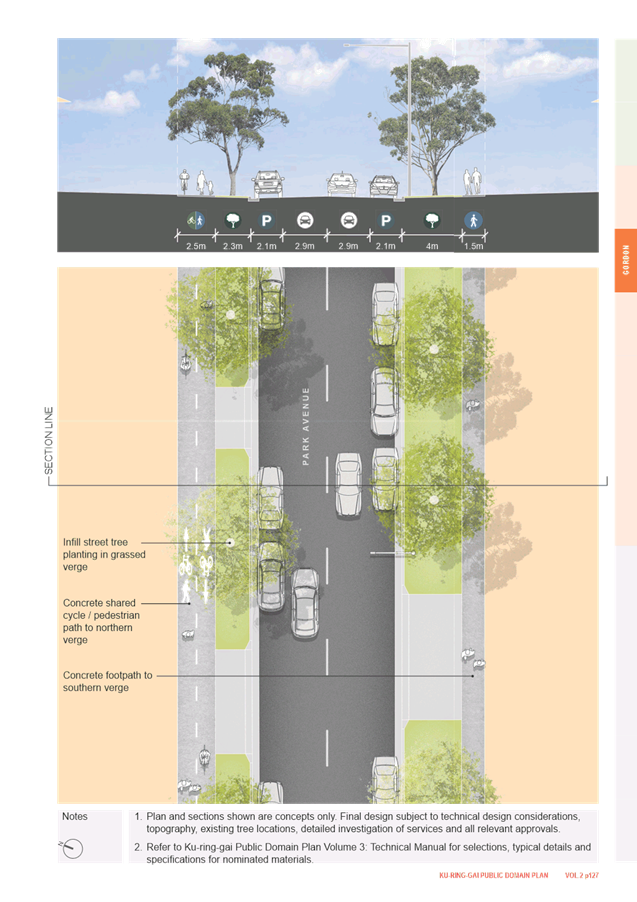
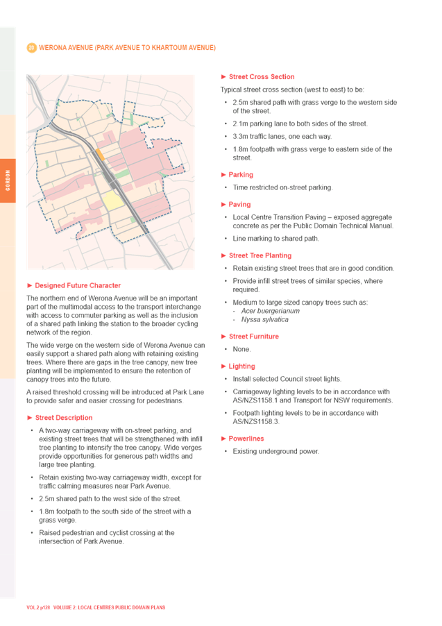
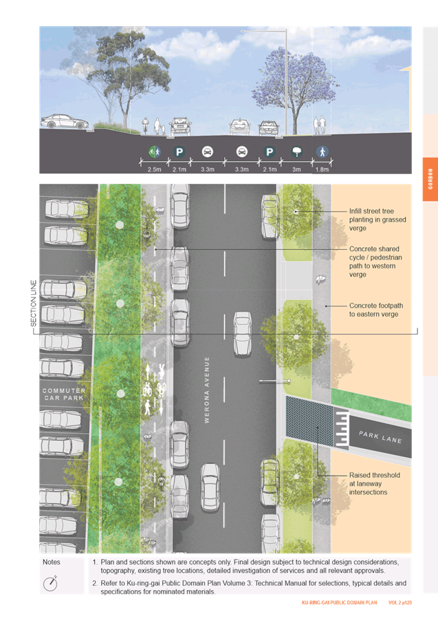
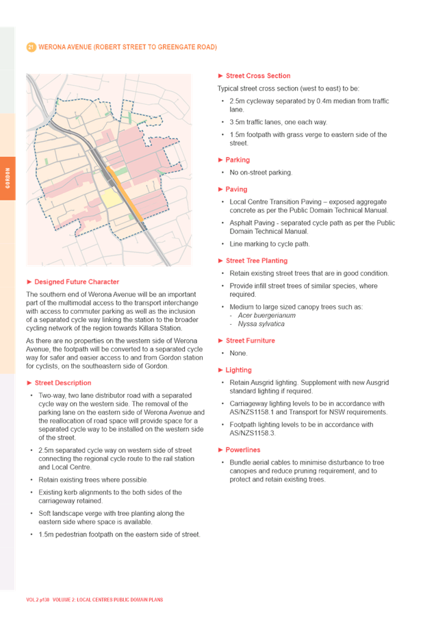
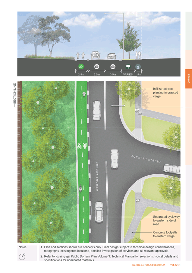
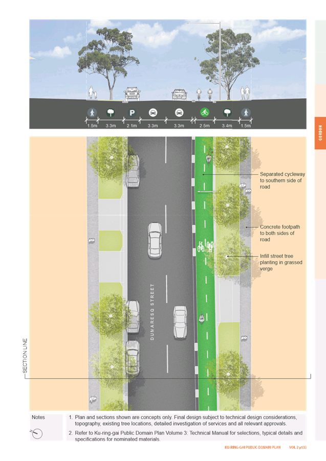
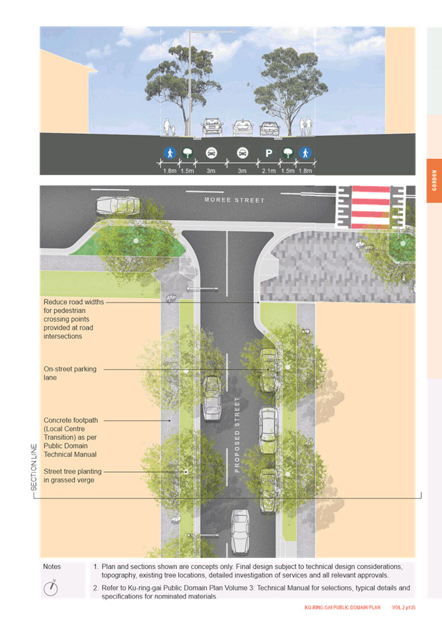
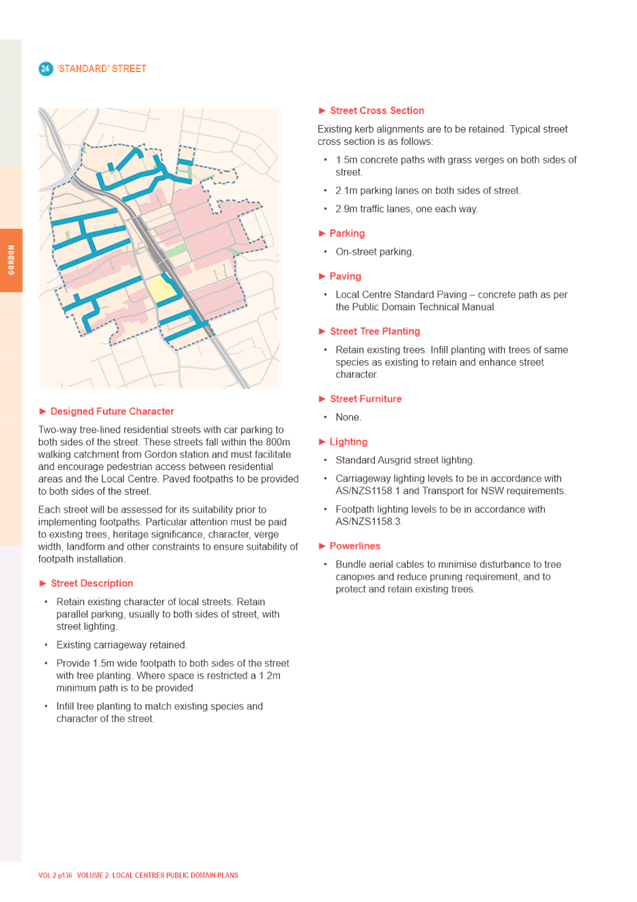
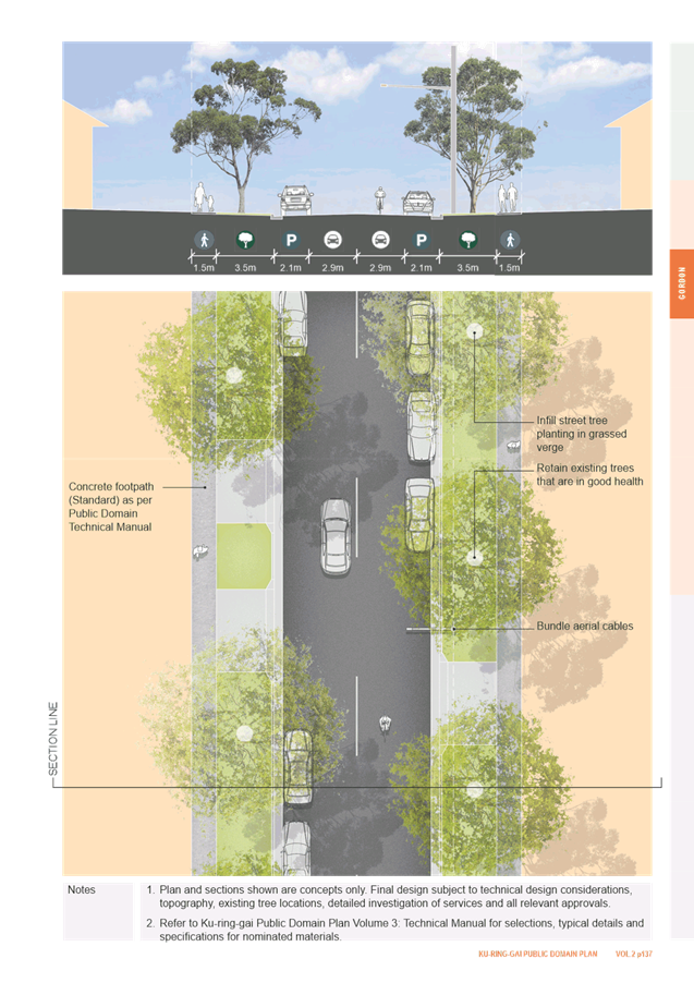
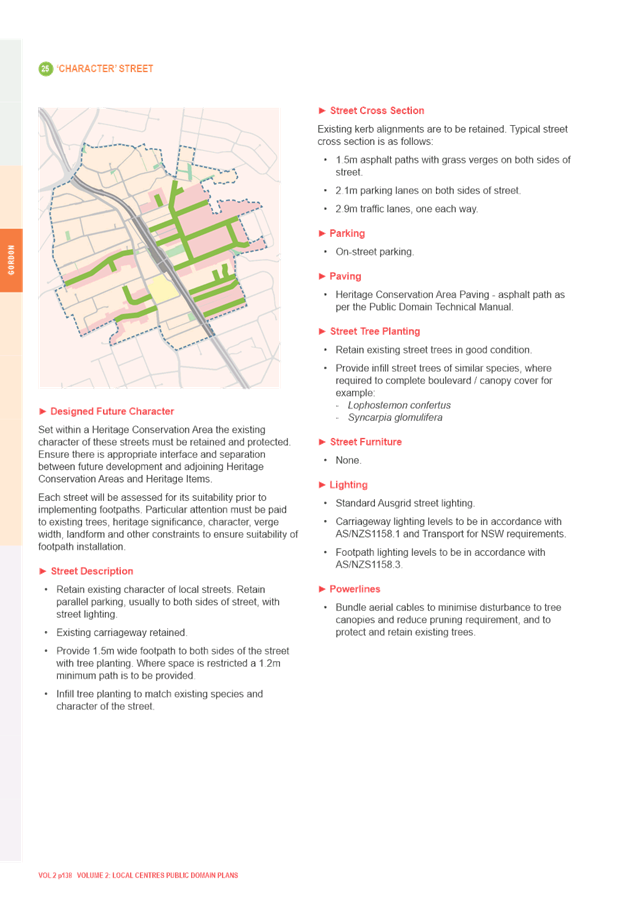
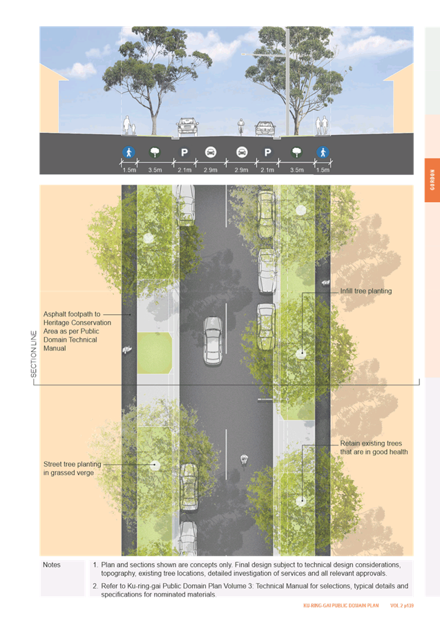
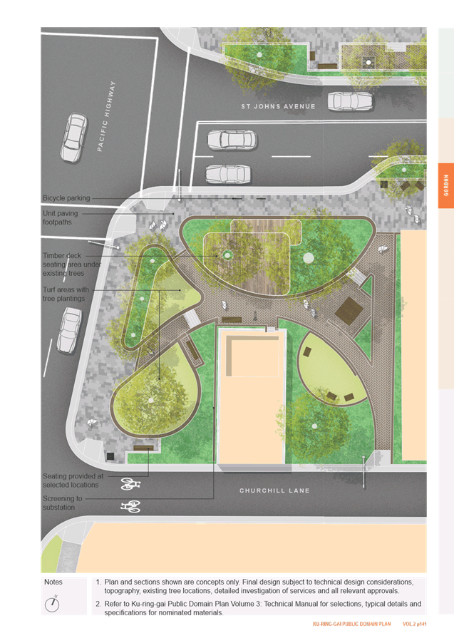
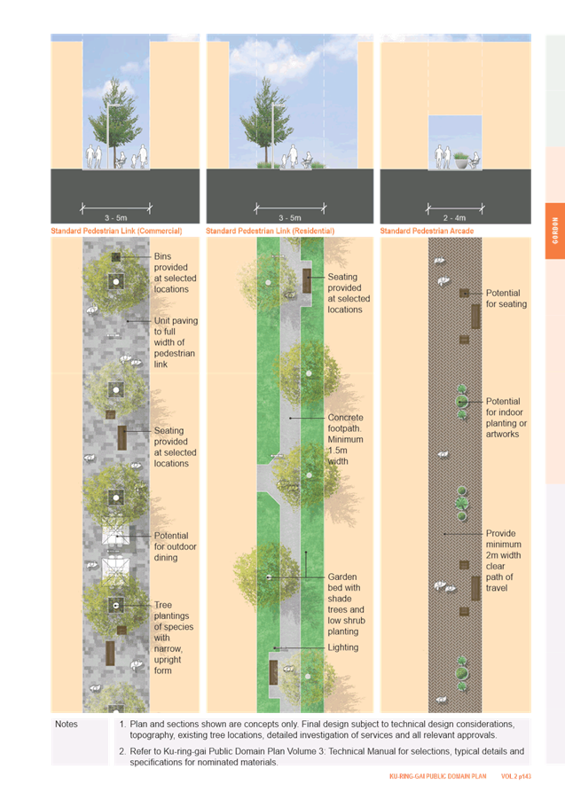

|
APPENDIX
No: 2 - Public
Domain Plan - Gordon site inspection notes
|
|
Item No: GB.16
|
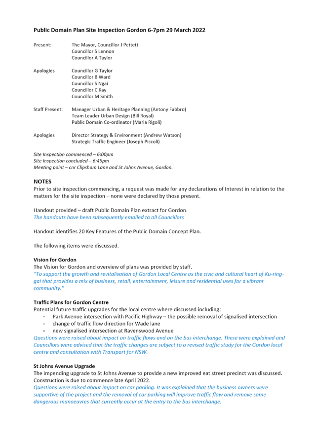
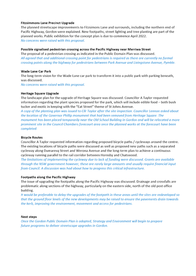
|
Ordinary
Meeting of Council - 26 April 2022
|
GB.17 / 1
|
|
|
|
|
Item
GB.17
|
S12474
|
Lindfield Local Centre - Traffic
Management Plan
EXECUTIVE
SUMMARY
Purpose of Report
To advise Council that Transport for NSW (TfNSW) has given its
concurrence to Council’s preferred traffic management scheme for
Lindfield local centre; and to clarify the basis for funding and delivery of
the proposed traffic management measures.
Background
At the Ordinary Meeting of Council
held on 10 November 2015, Council adopted a traffic management scheme for
Lindfield local centre, for submission to TFNSW for concurrence. The traffic
management scheme was developed to support the Lindfield Village Hub (LVH)
Master Plan and consider the cumulative impact of other planned growth in the
Lindfield local centre. With respect to traffic management, Council resolved:
H. That Council adopt
in principle the Traffic Management Option 1C of the Lindfield Local Centre
Transport Network Model Study 2013/14 and submit it to Roads and Maritime
Services [now Transport
for NSW] for concurrence.
The adopted traffic management scheme was subsequently
submitted to TFNSW and in the intervening years staff worked closely with TFNSW
however concurrence was only given to certain elements of the scheme. Up until
recently a number of issues remained unresolved particularly in relation to the
signalised pedestrian crossing on Pacific Highway adjoining the rail station
entry and the intersection of Pacific Highway, Balfour Street and Havilah Road.
The Lindfield Village Hub Planning Proposal was publicly
exhibited in 2021 supported by a Transport Impact Assessment that included
evaluation of the majority of the proposed upgrades in Council’s adopted Traffic Management Option 1C (Attachment
A1), since these would directly and indirectly relate to the Lindfield
Village Hub.
TfNSW has reviewed all intersection upgrades and road
modification proposals within the LVH Planning Proposal and through its review (Attachment
A2), has now effectively given its concurrence to Council’s adopted
traffic management scheme
Comments
TfNSW has given its concurrence to
a traffic scheme for Lindfield local centre which allows Council to move
forward with the delivery of a range of intersection upgrades and road
modifications.
In its response to the Lindfield Village Hub Planning
Proposal, Transport for NSW provided concurrence for the following intersection
upgrades and road modifications:
1. New
traffic signals - intersection Pacific Highway and Beaconsfield Parade;
2. relocation
of mid-block pedestrian signals - Pacific Highway near Tryon Place;
3. new
traffic signals - intersection Pacific Highway and Strickland Avenue;
4. road
closure to traffic – Bent Street between Pacific Highway and Bent Lane;
5. modifications
to existing traffic signals to ban right turn movement from Havilah Road to
Pacific Highway, and other modifications - intersection of Pacific Highway and
Balfour Street/Havilah Road;
6. localised
widening of Pacific Highway to accommodate extension of existing right turn bay
on the Pacific Highway for vehicles turning into Balfour Street - intersection
of Pacific Highway and Balfour Street/Havilah Road;
7. modifications
to existing laneway for one-way traffic flow (southbound) – Woodford Lane;
8. new
traffic signals - intersection Lindfield Avenue and Tryon Road;
9. localised
road widening on Grosvenor Road to accommodate an additional approach lane -
Grosvenor Road at Pacific Highway; and
10. modifications
to existing laneway for one-way traffic flow (southbound) – Bent Lane
between Bent Street and Balfour Avenue.
A number of these locations were identified in the
LVH Transport Impact Assessment as directly supporting the Lindfield Village
Hub Planning Proposal therefore it is recommended that the delivery (including,
design, construction, approvals and funding) of the above intersection upgrades
and road modifications be the responsibility of the selected development
partner for the Lindfield Village Hub project. The works are:
· New traffic
signals - intersection of Pacific Highway and Beaconsfield Parade;
· relocation of
mid-block pedestrian signals - Pacific Highway near Tryon Place;
· road closure
– Bent Street between Pacific Highway and Bent Lane;
· modifications to
existing traffic signals - intersection of Pacific Highway and Balfour
Street/Havilah Road;
· modifications to
existing laneway – Woodford Lane; and
· modifications to
existing laneway – Bent Lane between Bent Street and Balfour Street.
The remaining upgrade works
are not directly related to the Lindfield Village Hub and relate to network
upgrades to support the current and future traffic conditions across the
centre. It is recommended that the following works are the responsibility of
Council to deliver:
· Localised road widening
on Grosvenor Road to accommodate an additional approach lane - Grosvenor Road
at Pacific Highway;
· new traffic
signals - intersection Lindfield Avenue and Tryon Road;
· new traffic
signals - intersection Pacific Highway and Strickland Avenue;
· extension of right
turn bay on Pacific Highway into Balfour Street - intersection of Pacific
Highway and Balfour Street/Havilah Road.
Table 1 summarises the recommended delivery mechanism and
funding sources for intersection upgrades and road modifications across
Lindfield local centre.
|
Table 1 – Recommended Delivery Mechanism and Funding
Source for Proposed Road infrastructure – Lindfield Local Centre
|
|
|
Location
|
Proposed
road infrastructure
|
Delivery
Mechanism
|
Funding
source
|
|
1
|
Intersection
Pacific Highway and Beaconsfield Parade
|
New
traffic signals with pedestrian crossing facilities
|
Delivered
as part of Lindfield Village Hub project
|
LVH
|
|
2
|
Pacific
Highway near Tryon Place
|
Relocation
of mid-block pedestrian activated signals
|
Delivered
as part of Lindfield Village Hub project
|
LVH
|
|
3
|
Intersection
Pacific Highway and Strickland Avenue
|
New
traffic signals with pedestrian crossing facilities
|
Delivered
by Council as a capital works project
|
Council
|
|
4
|
Bent
Street between Pacific Highway and Bent Lane
|
Closure
to vehicle traffic and installation of pedestrian plaza
|
Delivered
as part of Lindfield Village Hub project
|
LVH
|
|
5
|
Intersection
of Pacific Highway and Balfour Street/Havilah Road -
|
Modifications
to existing signals to ban right turn movement from Havilah Road into Pacific
Highway, and other associated modifications (such as line markings etc.)
|
Delivered
as part of Lindfield Village Hub project
|
LVH
|
|
6
|
Intersection
Pacific Highway and Balfour Street/Havilah Road
|
Localised
widening of Pacific Highway to accommodate extension of existing right turn
bay on the Pacific Highway for vehicles turning into Balfour Street.
|
Delivered
by Council as a capital works project.
May
require land acquisition or land dedication through future redevelopment of
adjoining site.
|
Council
|
|
7
|
Woodford
Lane
|
Modification
to existing laneway to convert to one-way traffic flow (southbound)
|
Delivered
as part of Lindfield Village Hub
|
LVH
|
|
8
|
Intersection
Lindfield Avenue and Tryon Road
|
Removal
of existing mid-block pedestrian activated signals on Lindfield Avenue and
installation of new traffic signals with pedestrian crossing facilities at
intersection of Tryon Road and Lindfield Avenue
|
Delivered
by Council as a capital works project - part of Lindfield Avenue Streetscape
Works
|
Council
|
|
9
|
Grosvenor
Road at intersection with Pacific Highway
|
Localised
road widening to accommodate an additional approach lane on Grosvenor Road
|
Delivered
by Council as a capital works project
|
Council
|
|
10
|
Bent
Lane between Bent Street and Balfour Avenue.
|
Modifications
to existing laneway for one-way traffic flow (southbound)
|
Delivered
as part of Lindfield Village Hub
|
LVH
|
integrated planning and reporting
|
Community Strategic
Plan Long Term Objective
|
Delivery Program
Term Achievement
|
Operational Plan
Task
|
|
T3.1: An accessible public transport and regional
road network that meets the diverse and changing needs of the community.
|
A strategic access, traffic and transport plan is being
implemented for the Northern Sydney Region.
|
Plan for works in response to development in local
centres.
|
|
P4.1: Our centres offer a broad range of shops and
services and contain lively urban village spaces and places where people can
live, work, shop, meet and spend leisure time.
|
P4.1.1: Plans to revitalise local centres are being
progressively implemented and achieve quality design and sustainability
outcomes in collaboration with key agencies, landholders and the community
|
P4.1.1.1: Implement the Ku-ring-gai Public Domain
Plan and Technical Manual and review and update as required.
P4.1.1.2: Implement Public Domain Masterplans for
the local centres and concept plans for key precincts.
P4.1.1.8: Prepare streetscape concept plans for
identified precincts in Lindfield Local Centre consistent with the Public
Domain Plan.
P4.1.1.11: Integrate all transport modes for the
primary local centres through the Public Domain Plan, Traffic and Transport
studies in collaboration with Transport for NSW (TfNSW).
|
Governance Matters
The recommendations in this
report are consistent with the following Council strategies and plans:
- Ku-ring-gai Local Strategic Plan
- Ku-ring-gai DCP
- Town Centres Public Domain Plan, 2010
- Ku-ring-gai Contributions Plan, 2010
Risk Management
This report addresses to key
risks:
- The inability for Council to deliver planned
traffic infrastructure and modifications identified in the Lindfield Local Centre Transport Network
Model Study due to substantial shortfalls in funding arising from
the S7.11 apportionment principle in the Ku-ring-gai Contributions Plan 2010
and the escalation of construction costs which have risen significantly more
than the general escalation applied to the entire Contributions Plan.
- To clarify the scope of the Lindfield Village
Hub responsibilities in relation to delivering TfNSW local traffic
requirements. This will help Council fine-tune budget assumptions and also the
scope of works in the Lindfield Village Hub Bid documents that will be issued
to market.
- Clarifying
delivery and funding for the proposed extension of right turn bay on Pacific
Highway into Balfour Street. In the LVH Transport Impact Assessment, the
modelling results for 2024 with the LVH development (notional LVH opening year)
show that the overall operation of the intersection would deteriorate during
all peak hours. This is generally due to increased demand for the right turn
from the Pacific Highway to Balfour Street, which will exceed the available
capacity (currently 25 metre / 4 vehicle right turn bay storage). Therefore,
the right turn bay on Pacific Highway into Balfour Street would need to be
extended to cater for the additional demand generated by the LVH. TfNSW
supports the lengthening of the right turn bay and requires that the length of
the extension be verified through further intersection modelling. The area
around the northern approach is highly constrained, particularly on the western
side with the new Coles development, heritage building and electricity
substation. This restricts opportunities for widening Pacific Highway to enable
the right turn bay to be extended. It would be difficult if not impossible for
the Lindfield Village Hub to deliver this work as land acquisition/dedication
is likely to be required. It is therefore recommended that Council deliver this
work as part of a long term delivery plan.
- Clarifying
delivery and funding for the proposed improvement on Grosvenor Road at Pacific
Highway which was identified as part of the traffic management scheme for
Lindfield local centre adopted by Council in 2015. The intersection is located
at the edge of the study area and was considered to be one of the constraints
on the Pacific Highway corridor through Lindfield (the other being the
intersection of Pacific Highway and Balfour Street/Havilah Road). The suggested
improvement was proposed on the basis that additional intersection capacity on
Grosvenor Road could reduce green time for Grosvenor Road – and therefore
increase green time for Pacific Highway – providing benefits for all
approaches. However, there is no timetable or funding for delivery, and this
project is not identified in the works program of the Ku-ring-gai Contributions
Plan 2010 or any other capital works program.
Financial Considerations
The delivery of the proposed
intersection upgrades and road modifications identified in this report will be
the responsibility of Council or the selected development partner for the
Lindfield Village Hub project.
Where Council is identified
as responsible for funding and delivery of proposed intersection upgrades and
road modifications the following sources have been identified:
- Development Contributions (S 7.11); and
- Funds from the sale of Balfour Lane,
Lindfield.
Development Contributions
A substantial shortfall in
funding is expected for traffic signal infrastructure and modification of key
intersections identified in the Ku-ring-gai Contributions Plan 2010.
It is noted that S7.11
development contributions will typically form a minor part of overall funding
of major traffic facilities due to “apportionment”, or the process
by which the assessed demand or cost is related specifically to the development
from which contributions may be sought. Apportionment seeks to ensure that new
development only pays its share or portion of the cost of the facility or work
for which it has created a demand. For major traffic facilities in Ku-ring-gai
(such as traffic signals), the apportionment to new development is usually
significantly less than 100% due to Ku-ring-gai being a brownfields LGA. For
example, regarding the modifications to the intersection of Pacific Highway and
Balfour Street/Havilah Road, the apportionment of this project cost is
discounted to 27% of estimated total construction cost (at the time of
development of the contributions plan). Similarly, for the new traffic signals
at the intersection of Pacific Highway and Strickland Avenue, the apportionment
is 48% of the estimated total construction cost and the apportionment for the
new traffic signals at the intersection of Lindfield Avenue and Tryon Road is
44% of the estimated total construction cost.
The shortfall is further
exacerbated by the escalation of actual construction costs which have risen
significantly more than the general escalation applied to the entire
Contributions Plan.
Funds from Sale of Balfour
Lane, Lindfield
In order to make up for the
shortfall in S 7.11 funds it is recommended that Council utilise the funds from
the sale of Balfour Lane, Lindfield for the design and construction of road
infrastructure in Lindfield.
The use of the proceeds of
the sale is restricted by the Roads Act 1993 to “…acquiring
land for public roads or for carrying out road work on public roads”.
Roads Act 1993 -
Division 6 Miscellaneous
43 Disposal of
land comprising former public road owned by council
(1) This section applies to land vested in a council and
forming part of a former public road.
(2) Land to which this section applies is operational land for
the purposes of the Local Government Act 1993 unless, before the land becomes
vested in the council, the council resolves that it is to be community land, in
which case the land is community land.
(3) If the land is disposed of by sale, the proceeds of sale (less
the costs of the sale) are to be paid to the council.
(4) Money received by a council from the proceeds of sale of the land
is not to be used by the council except for acquiring land for public roads or
for carrying out road work on public roads.
Other potential funding
sources
Council may be eligible for
grants from the Australian Government Black Spot and/or NSW Safer Roads Program
or other grant funding sources subject to the project meeting the
program’s eligibility criteria.
In some cases, there may be
potential for a Voluntary Planning Agreement (VPA) to dedicate land and/or
works-in-kind where the timing and location of future redevelopment aligns.
Social Considerations
The ability to move around Ku-ring-gai easily has a major
influence on the liveability of our community and viability of our economy.
Residents seek local services, shops, social and recreational opportunities to
be readily accessible to where they live, work, play and spend time socially.
Businesses and services also need to be accessible to customers and able to
efficiently receive and send goods.
Our local and regional road network needs to be managed
effectively to reduce congestion, particularly around local centres, to
maximise the efficiency of parking and to improve safety and accessibility for
pedestrians, cyclists and motorists
Environmental Considerations
There are no direct
environmental considerations arising from this report.
Community Consultation
The proposed intersection
upgrades and road modifications formed part of the broader planning process for
the Lindfield Village Hub. The community was invited to make submissions to the
Planning Proposal for the Lindfield Village Hub, including the Transport Impact
Assessment, and these submissions were reviewed as part of the assessment of
the Planning Proposal.
The proposals also formed
part of the community consultation undertaken for the Lindfield Public Domain
Plan in 2010 and 2021.
Planning for the new traffic signals at the intersection of
Lindfield Avenue and Tryon Road has already commenced, with traffic signal
modelling completed and traffic signal design well advanced. It is proposed to
deliver the new signals as part of the streetscape upgrade works to Lindfield
Avenue and Tryon Road. A concept plan for this project has been adopted by
Council for exhibition.
Internal Consultation
The Major Projects Unit,
Operations and Finance Departments have been consulted in the preparation of
this report.
Summary
In 2015 Council adopted a traffic management scheme for
Lindfield local centre, for submission to TFNSW for concurrence. The adopted
traffic management scheme was subsequently submitted to TFNSW and in the
intervening years staff worked closely with TFNSW however concurrence was only
given to certain elements of the scheme. Up until recently a number of issues
remained unresolved. TFNSW has reviewed all intersection upgrades and road
modification proposals within the LVH Planning Proposal and through its review,
has now effectively given its concurrence to Council’s adopted traffic
management scheme.
Table 1 set outs the recommended delivery
mechanism and funding source for proposed road infrastructure across Lindfield
local centre.
A number of these locations were identified in the
LVH Transport Impact Assessment as directly supporting the Lindfield Village
Hub Planning Proposal. This report recommends the delivery (including, design,
construction, approvals and funding) of these intersection upgrades and road
modifications will be the responsibility of the selected development partner
for the Lindfield Village Hub project.
The remaining upgrade works
are not directly related to the Lindfield Village Hub and relate to network
upgrades to support the current and future traffic conditions across the
centre. This report recommends that these works be the responsibility of Council
and/or other parties (by way of VPAs or the like) to deliver.
To cover the anticipated
substantial shortfall in in S7.11 funding this report recommends that Council
utilise the proceeds from the sale of Balfour Lane, Lindfield to fund the
design and construction of road infrastructure for which it is responsible for.
Recommendation:
That Council:
A. Note
that TFNSW has given concurrence to Council’s adopted traffic management
option for Lindfield local centre;
B. Endorse
the proposed road infrastructure, delivery mechanisms and funding
recommendations as set out in Table 1 of this report; and
C. Approve
the use of proceeds from sale of Balfour Lane, Lindfield to cover shortfall in
S7.11 funds and consistent with the requirements of the Roads Act 1993.
|
Bill Royal
Team Leader Urban Design
|
Joseph Piccoli
Strategic Traffic Engineer
|
|
Maria Rigoli
Public Domain Co-ordinator – Local Centres
|
Antony Fabbro
Manager Urban & Heritage Planning
|
|
Andrew Watson
Director Strategy & Environment
|
|
|
Attachments:
|
A1⇩
|
Lindfield
Local Centre – Traffic Management Option 1C
|
|
2015/072510
|
|
|
A2⇩
|
TfNSW
Response - Lindfield Village Hub Planning Proposal 18 June 2021
|
|
2021/179493
|
|
APPENDIX No: 1 - Lindfield
Local Centre – Traffic Management Option 1C
|
|
Item No: GB.17
|
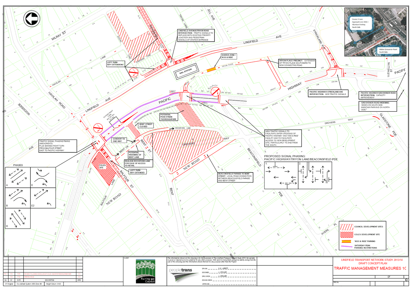
|
APPENDIX No: 2 - TfNSW
Response - Lindfield Village Hub Planning Proposal 18 June 2021
|
|
Item No: GB.17
|
|
Ordinary
Meeting of Council - 26 April 2022
|
GB.18 / 1
|
|
|
|
|
Item
GB.18
|
S10746
|
Minutes of the February 2022 Flood Risk
Management Committee Meeting
EXECUTIVE
SUMMARY
Purpose of Report
For Council to consider and note the minutes of the Flood
Risk Management Committee meeting held on 21 February 2022 (Attachment
A1).
Background
The Flood Risk Management Committee, an advisory committee
of Council, is an essential step in the NSW Government’s floodplain risk
management process, as per the NSW Floodplain Development Manual (2005).
Comments
At the meeting held on 21 February 2022 the Flood Risk
Management Committee business paper report discussed the following items:
Confirmation of the Minutes
Minutes from the 16 February 2021
meeting were formally adopted.
General Business
1. Procedures
for the new FRMC term
The committee was updated on the
nomination procedures and requirements for the upcoming term of the flood risk management
committee.
Recommendation:
· Committee members
note updated to the Ku-ring-gai Council Advisory/Reference Committee Guideline
2022;
· A call for FRMC
nominations is advertised in March/April to meet the June OMC deadline
2. NSW
Government Flood Updates
The committee was updated on the
NSW flood-prone land package that commenced in July 2021 and the current
consultation on the update of the NSW Floodplain Development Manual and its
supporting toolkit.
Recommendation:
· Committee members
note updates resulting from the NSW flood-prone land package;
· Committee members
provide any comments on the draft Flood Risk Management Manual Package updates
to staff by 9 March 2022.
3. Current
Flood Study Updates
To provide updates on flood
studies currently being undertaken in Ku-ring-gai, including:
· Middle Harbour
– Southern Catchments Flood Study (Presentation from Consultants BMT)
· Middle Harbour
Northern Catchments Flood Study
· Lane Cove Northern
Catchments Flood Study
· Operational Flood
Projects including further funding applications and website updates.
Recommendation:
· The Committee
notes updates on the ongoing flood studies and operational projects;
· The Committee
endorse the Draft Middle Harbour Southern Catchments Flood Study to be reported
to Council for Public Exhibition (reported March 2022 OMC)
integrated planning and reporting
Community, People and Culture
|
Community Strategic
Plan Long Term Objective
|
Delivery Program
Term Achievement
|
Operational Plan
Task
|
|
An aware community able to prepare and respond to the risk
to life and property from emergency events.
|
Emergency Management Plans are developed and implemented,
in partnership with emergency service agencies and key stakeholders.
|
Complete floodplain risk management study in consultation
with Flood Risk Management Committee and investigate priority actions.
|
Governance Matters
The Flood Risk Management
Committee, with community, industry and government representation will act as
an advisory committee to Council for the development of all flood studies and
flood risk management studies and plans.
Risk Management
The recent floods in various
parts of Australia have highlighted the importance of floodplain risk
management and have raised public awareness of the need for all councils to
provide landowners with the best possible information on the risk of flooding
to their property.
Financial Considerations
The Committee is an Advisory Committee and does not have the
power to incur expenditure or to bind Council.
Social Considerations
Members should be aware that
activities of the Committee have a number of implications for property owners
and members of the community. The results of flood studies and flood risk
management studies and plans can impact on property values, insurance premiums,
planning controls and options for future development.
Environmental Considerations
The NSW Floodplain
Development Manual (2005) clearly identifies the need for flood risk management
to take into account the principles of ecologically sustainable development and
to consider ways of “maintaining and enhancing riverine and floodplain
ecology in the development of floodplain risk management plans” (section
1.1.2)
Community Consultation
The Flood Risk Management
Committee is an Advisory Committee of Council and includes members from the
local community and relevant State agencies,
Internal Consultation
Council staff have been
nominated to attend the Committee meetings.
Summary
At the meeting held on 21 February 2022 the Flood Risk
Management Committee business paper report discussed the following items:
· Procedures for the
new FRMC term;
· NSW Government
Flood Updates; and
· Current Flood
Study Updates.
The committee recommendations have been provided in the
comments section of this report.
Recommendation:
That Council receives and notes the Minutes of the
Flood Risk Management Committee meeting held on 21 February 2022 (Attachment
A1).
|
Sophia Findlay
Water and Catchments Program Leader
|
Jacob Sife
Manager Environment & Sustainability
|
|
Andrew Watson
Director Strategy & Environment
|
|
|
Attachments:
|
A1⇩
|
Minutes
of Flood Risk Management Committee Meeting - 21 February 2022
|
|
2022/101275
|
|
APPENDIX No: 1 - Minutes
of Flood Risk Management Committee Meeting - 21 February 2022
|
|
Item No: GB.18
|
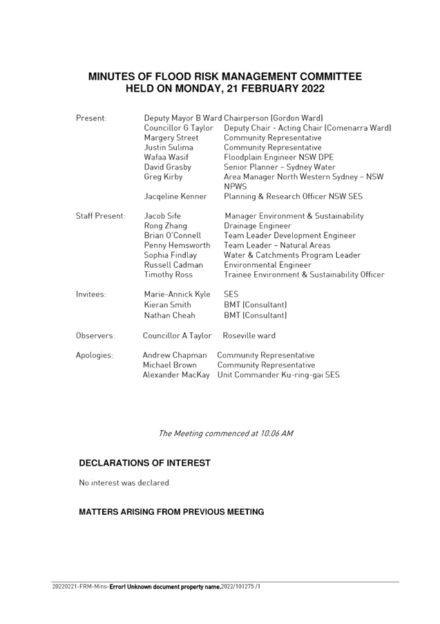
|
Ordinary
Meeting of Council - 26 April 2022
|
NM.1 / 1
|
|
|
|
|
Item
NM.1
|
CY00142/14
|
Illegal
tree removal in Ku-ring-gai
Notice of Motion from Councillors Lennon
and Taylor, A dated 7 April 2022
The endemic tree canopy remaining in Ku-ring-gai is unique
in maturity and beauty. Unfortunately, Ku-ring-gai lost 2.4 percentage points
of urban forest cover between 2013 and 2020 according to the Centre for Urban
Research at RMIT University and Greener Spaces Better Places. During the same
period, the Northern Beaches increased urban forest cover by +2.7 points.
One of the critical factors driving the loss of urban cover
in Ku-ring-gai has been the illegal removal of trees. Council's current
activities to address this issue include issuing penalty notices, criminal
investigations, and pursuing consequences through courts of law. Unfortunately,
the current penalty notices are not an effective deterrent and criminal
investigations can be hampered by a lack of evidence. Council is looking to
enhance current measures for pursuing investigations and preventing illegal
removal through community education.
We, therefore, move:
That staff provide a briefing to councillors and provide a
report back to the August 2022 Ordinary Meeting of Council with additional
measures to reduce illegal tree removal.
Recommendation:
That the above Notice of Motion as printed be adopted.
|
Councillor Simon Lennon
Councillor for Gordon Ward
|
Councillor Alec Taylor, A
Councillor for Roseville Ward
|
|
Ordinary
Meeting of Council - 26 April 2022
|
NM.2 / 1
|
|
|
|
|
Item
NM.2
|
S09113/11
|
Footpaths
in Ku-ring-gai
Notice of Motion from Councillor Smith
dated 8 April 2022
During my election campaign I had the privilege of meeting
and listening to members of my community regarding many issues. One of the key
themes I heard was the need for new footpaths to service our aging population,
parents with prams who are developing our next generation and school children
who need safe access to and from their school.
An assessment of the current footpath network reveals that
there is a total of 398km of footpath across the LGA and sadly St Ives Ward has
only 54km. It has been presented to Councillors that an additional 268km of
footpath is required to ensure every street has at least one footpath.
Council has allocated $5.2m for footpaths in next
year’s draft budget, of which $537,000 is allocated to new footpaths.
This is a moderate increase from previous years however based on
Council’s footpath prioritisation program only 6 streets will benefit
from a newly constructed footpath.
If we are serious about improving access for our residents
then the budget needs to increase substantially. Modelling shows that it would
take about 88 years to build a footpath in every street if the annual budget
was increased to $1m, 71 years if Council spent $1.25m and 59 years if Council
spent $1.5m annually.
In my view, the need for footpaths is a priority and they
need to be built as soon as possible whilst balancing funding for ongoing
maintenance and upgrades.
I, therefore, move:
That all future budgets for new footpaths be increased to
$1.25 million until every street in Ku-ring-gai has at least one footpath for
the benefit of the community. Funding for the new footpaths is to be allocated
from the annual footpath renewal budget which forms part of the overall
footpath budget.
Recommendation:
That the above Notice of Motion as printed be adopted.
|
Councillor Martin Smith
Councillor for St Ives Ward
|
|
|
Ordinary
Meeting of Council - 26 April 2022
|
QN.1 / 1
|
|
|
|
|
Item
QN.1
|
S12062
|
Account
of losses and recovering costs from Support Marian Street Theatre Committee (or
Philanthropist) resulting from NM3 of 15 February 2022 OMC
QUESTION:
Question from Councillor for Wahroonga Ward Councillor
Cedric Spencer dated 8 April 2022
Will the General Manager provide all costs resulting from
delaying the Marian Street Theatre project from 15 February to 15 March 2022
and advice Council if he intends to recover the losses from Support Marian
Street Theatre Committee (or Philanthropist) as submitted by Councillors
Barbara Ward and Simon Lennon during their debate at the 15 February 2022 OMC?
1. In
his speech, Councillor Simon Lennon said, among other things,
“So as I say with
a heavy heart, I ask us to pause for three months to consider this work. Let me
add to the philanthropists behind this, and that's a good word for funding this
work, they're willing to put their hands in their pockets so there will be no
cost to Council while this work is done. To produce ideas to then bring before
council staff. To work with council staff, to work with architects and to work
with the council together to make this exciting project even better. So, I
commend the motion to you, thank you.”
2. In
her response to a question by Councillor Christine Kay in relation to the
assurance of costs, Councillor Barbara Ward said, among other things,
“Through you, Mr Mayor. No, it isn't in writing. However, the person who
has come forward I have the utmost trust in him to deliver. I’m sure he'd
be willing to give us a piece of paper if that is what was required, Councillor
Kay”.
3. In
closing, Mayor Pettett said, among other things,
“Okay. So,
Councillor I’ll just jump on top of that one. You've actually got a
verbal go-ahead, shall we say? Obviously you can vouch for this person and are
very comfortable with them? Councillor Kay, any further questions?”
|
Councillor Cedric Spencer
Councillor for Wahroonga Ward
|
|
|
Attachments:
|
A1⇩
|
Transcript
of NM3 Marian Street Theatre from the Ordinary Meeting of Council on 15
February 2022
|
|
2022/102481
|
|
APPENDIX No: 1 - Transcript
of NM3 Marian Street Theatre from the Ordinary Meeting of Council on 15
February 2022
|
|
Item No: QN.1
|