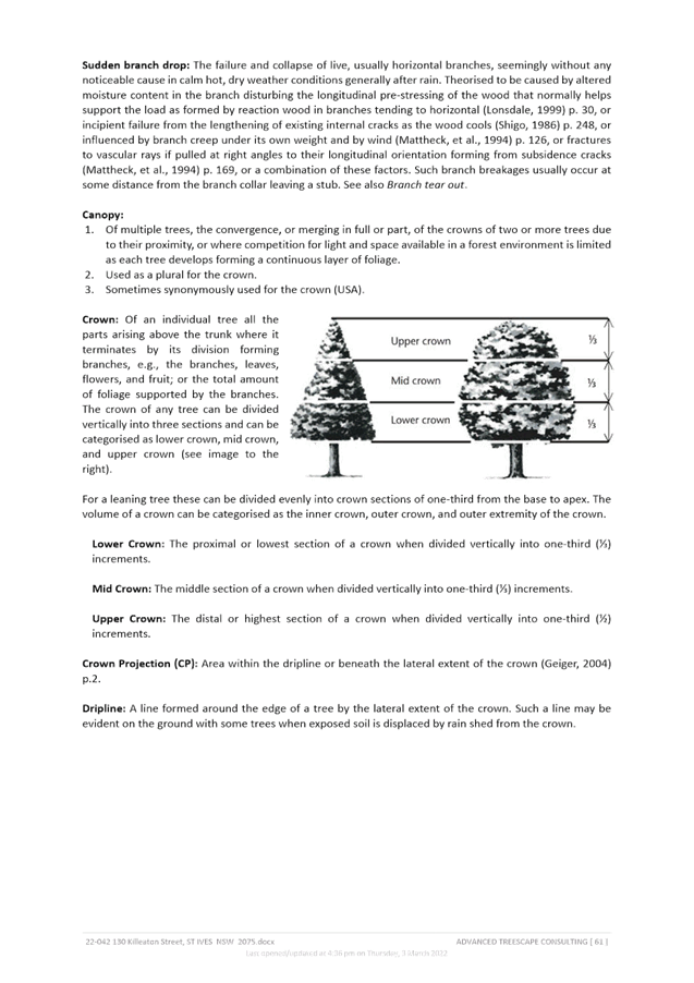
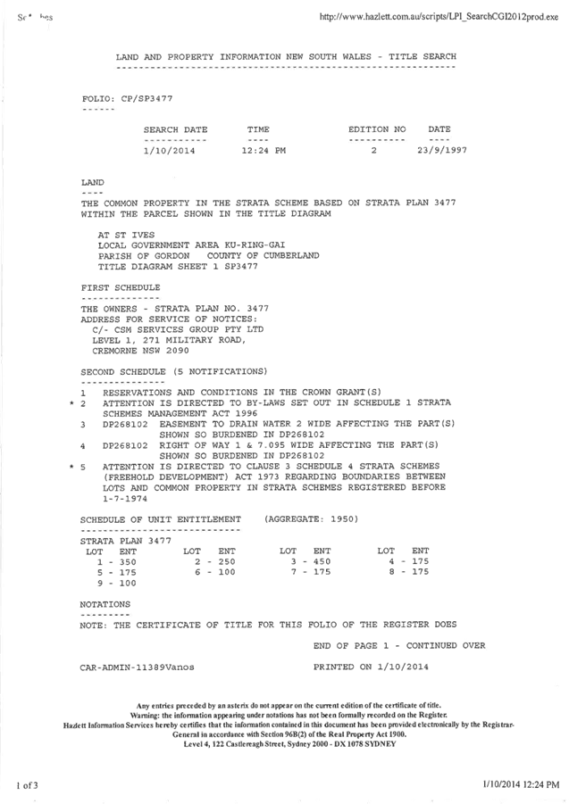
|
Ku-ring-gai Local Planning Panel Meeting - 19 September 2022 |
GB.1 / 1 |
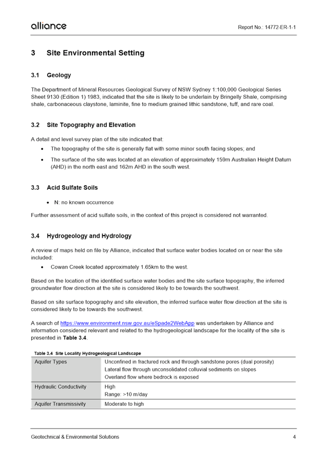
|
|
|
|
Item GB.1 |
S13685 |
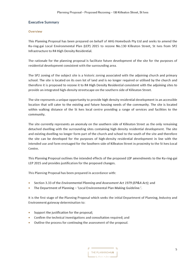
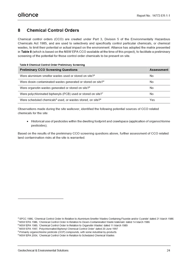
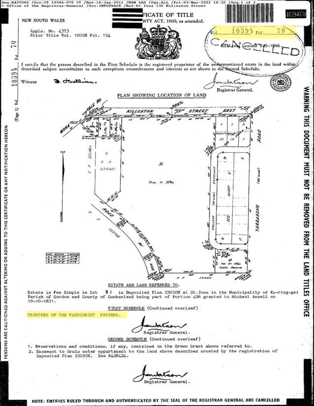
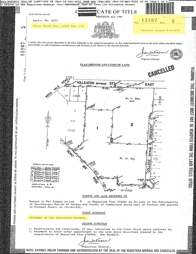
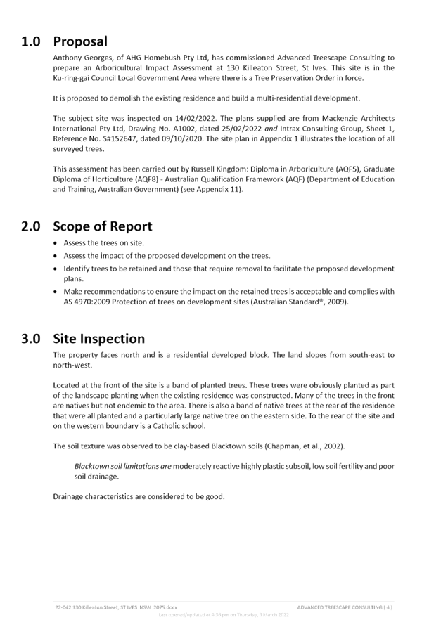
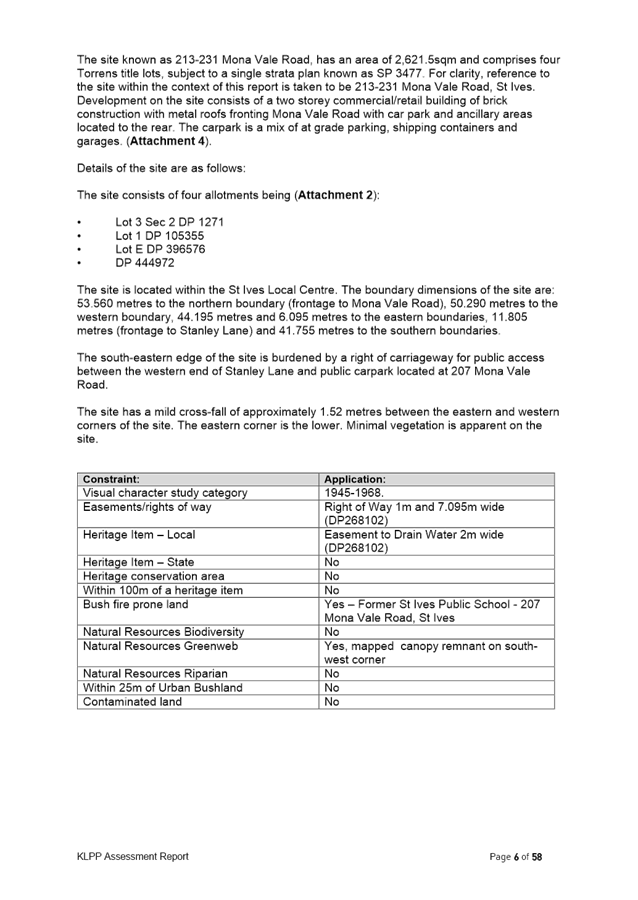
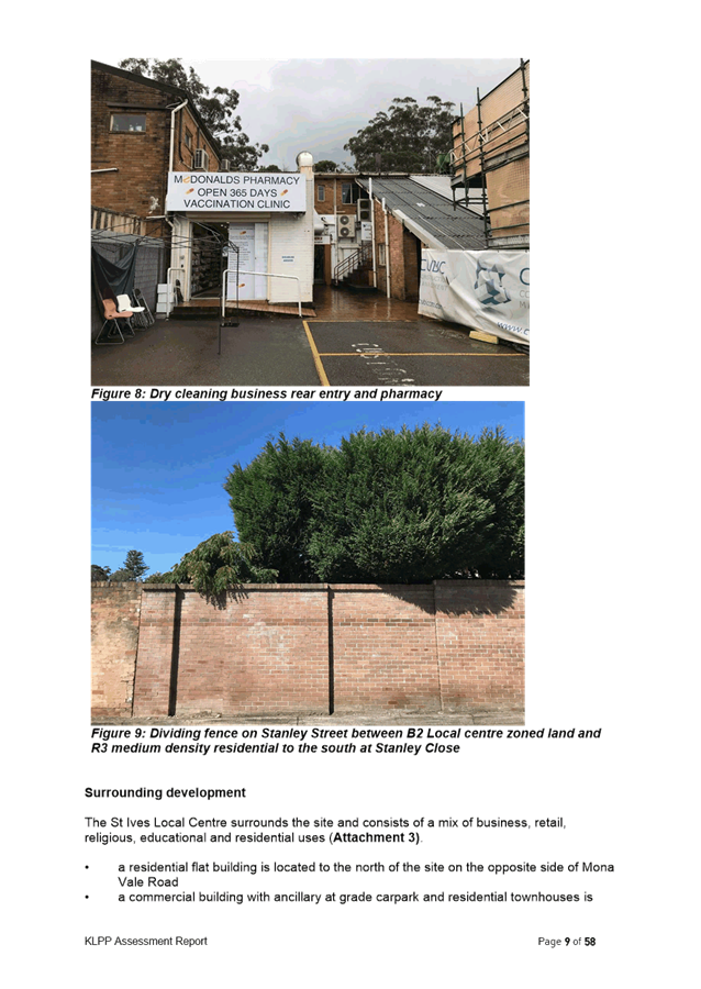
Planning Proposal for 130 Killeaton Street, St Ives
EXECUTIVE SUMMARY
Purpose of Report
To refer the Planning Proposal for 130 Killeaton Street, St Ives to the KLPP for advice as required by the Local Planning Panels Direction – Planning Proposals issued by the Minister for Planning under Section 9.1 of the Environmental Planning and Assessment Act 1979.
Background
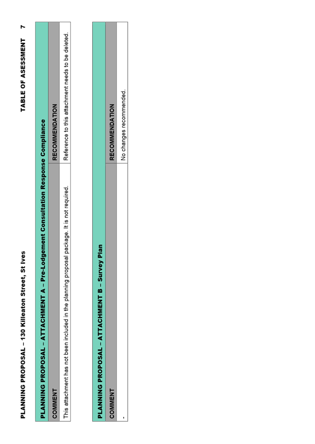
A formal pre-Planning Proposal meeting was held on 15 December 2021 to discuss the proposal to amend the zoning of the site from SP2 Infrastructure (Educational Establishment) to R4 High Density Residential. The pre-Planning Proposal meeting report is included at Attachment A1.
The Planning Proposal was submitted on 31 March 2022. The Planning Proposal was incomplete. Following the submission of revised documentation and payment of fees, the assessment formally commenced on 15 June 2022. The Planning Proposal is included at Attachment A2, the appendices to the Planning Proposal are included at Attachment A3 – Attachment A9.
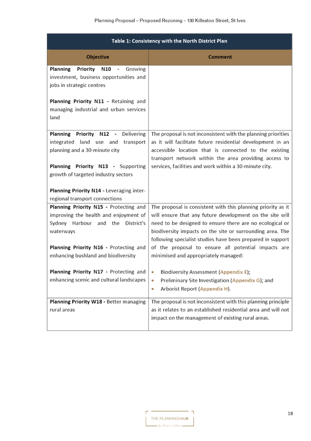
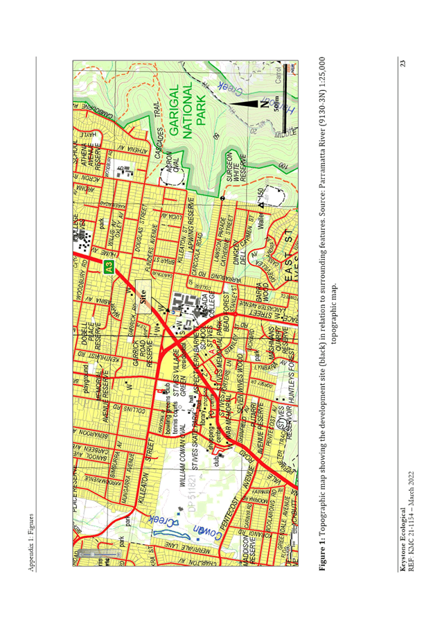
Site Description and Local Context
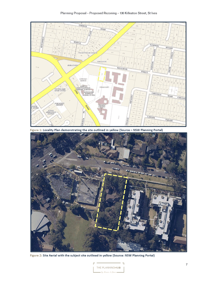
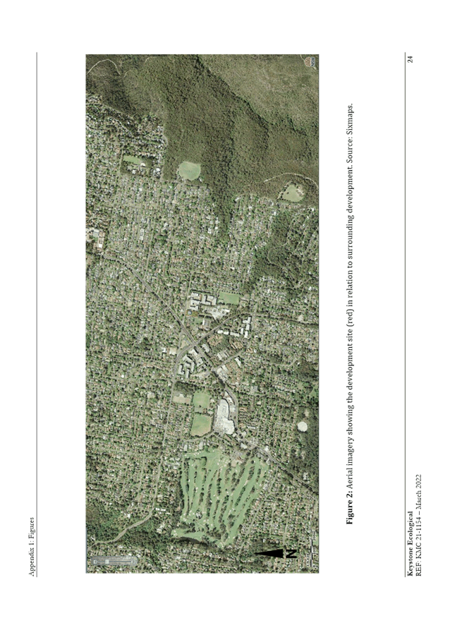
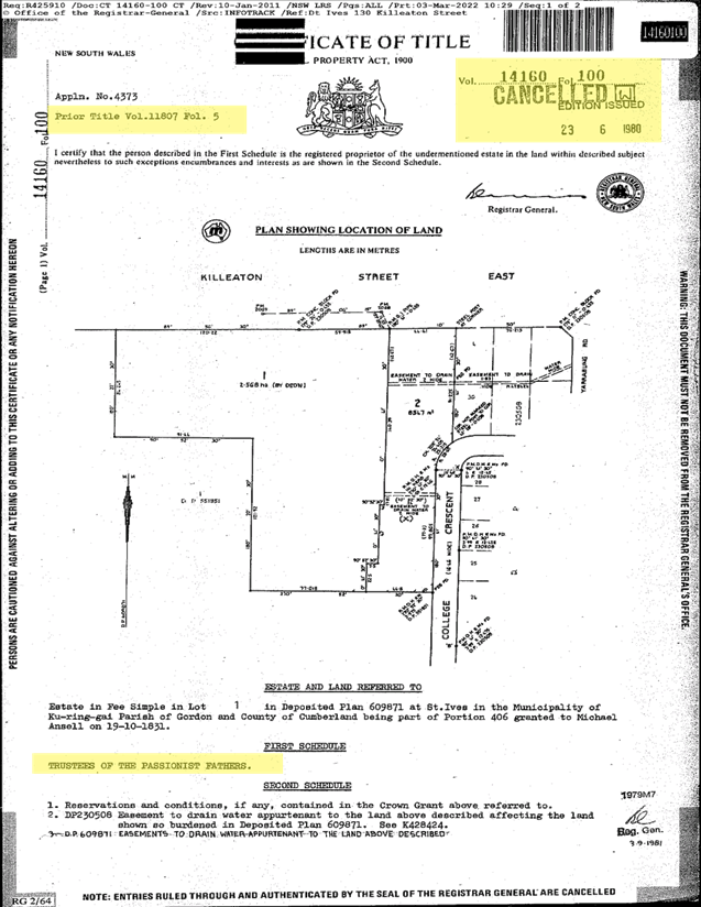
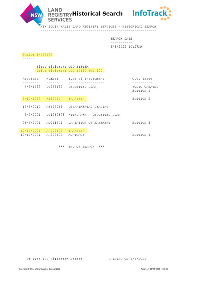
The site that is the subject of the Planning Proposal is 130 Killeaton Street, St Ives Lot 1 DP 748682. The site has an area of 2,803m2 with a frontage of 35m to Killeaton Street and a depth of 84m. The site currently contains a two-storey brick dwelling and is accessed from Killeaton Street to the north.
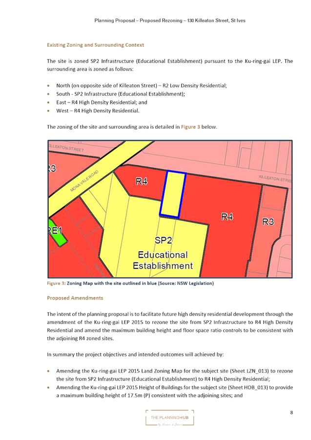
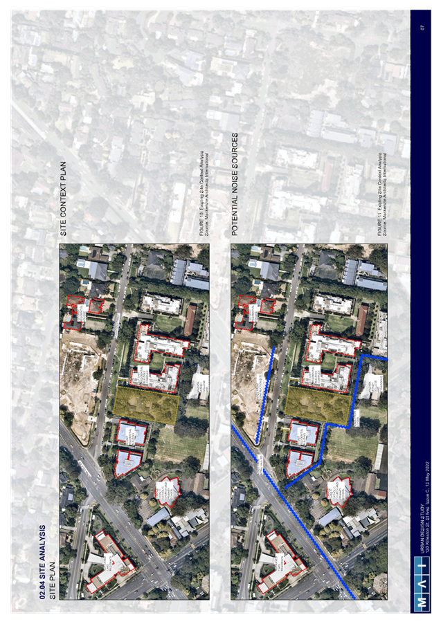
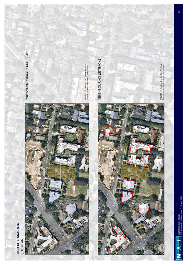
The site sits within an established residential area characterized by new residential flat buildings to the east and west on R4 High Density Residential zoned land and a two storey aged care facility that is currently under construction to the north of the site. The site adjoins the Corpus Christi Catholic Church and Primary School to the south-west and the Kehillat Masada Synagogue and College to the south-east on SP2 Educational Establishment zoned land.
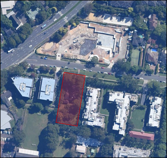
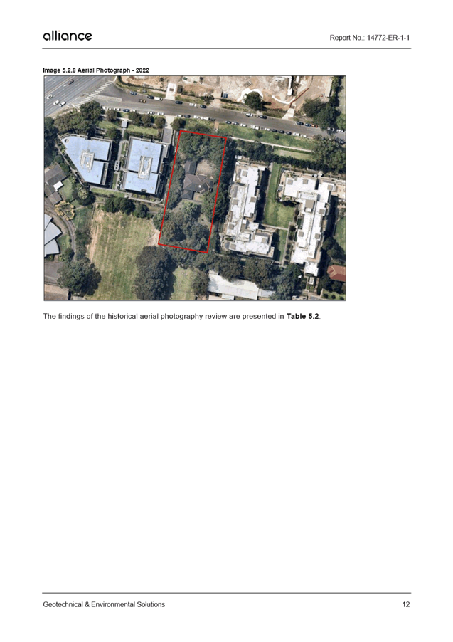
Figure 1. Subject site aerial view

Figure 2. Subject site and existing surrounding context
Comments
Planning Proposal and the Proposed Amendments to KLEP 2015
The Planning Proposal for 130 Killeaton Street, St Ives that was submitted to Council for assessment seeks to:
· amend the Ku-ring-gai LEP 2015 Land Zoning Map for the subject site (Sheet LZN_013) to rezone the site from SP2 Infrastructure (Educational Establishment) to R4 High Density Residential;
· amend the Ku-ring-gai LEP 2015 Height of Buildings for the subject site (Sheet HOB_013) to provide a maximum building height of 17.5m (P) consistent with the adjoining sites; and
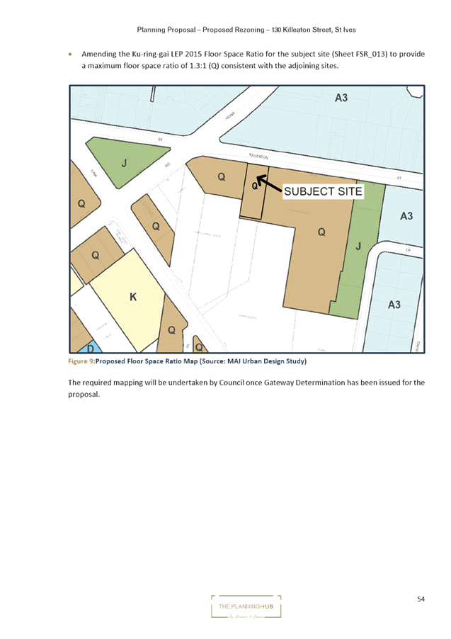
· amend the Ku-ring-gai LEP 2015 Floor Space Ratio for the subject site (Sheet FSR_013) to provide a maximum floor space ratio of 1.3:1 (Q) consistent with the adjoining sites.
Merit
A Planning Proposal is not a Development Application and does not consider the specific detailed matters for consideration under Section 4.15 of the Environmental Planning and Assessment Act 1979. A Planning Proposal only relates to an LEP amendment and cannot be tied to a specific development. The proposed amendments need to be acceptable as an outcome on the site regardless of the subsequent approval or refusal of any future development application.
A Planning Proposal must demonstrate the site specific and strategic merit of the proposed amendments. The following is an assessment of the relevant merits of the Planning Proposal:
Site Specific Assessment
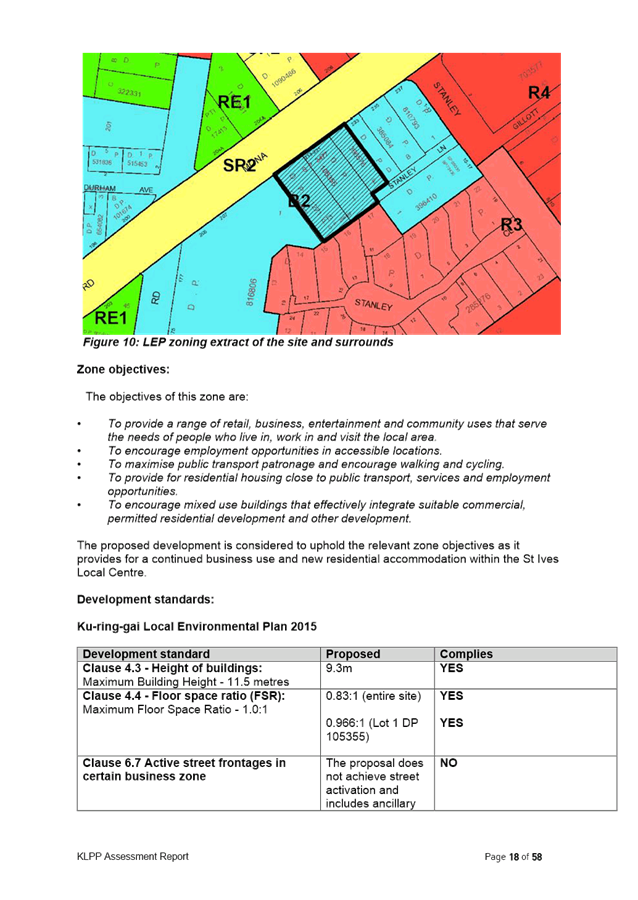
· Zoning – Surrounding context and proposed amendments
The subject site is currently zoned SP2 Infrastructure (Educational Establishment), with R4 High Density to the east and west and SP2 Infrastructure (Educational Establishment) to the south.
The Planning Proposal seeks to rezone the site to R4 High Density Residential. The proposed R4 High Density Residential zone is considered appropriate in the surrounding context.

Figure 3. Excerpt from Urban Design Study – Proposed Zoning Map
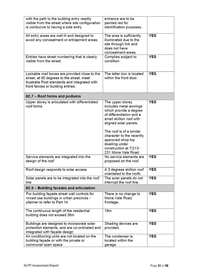
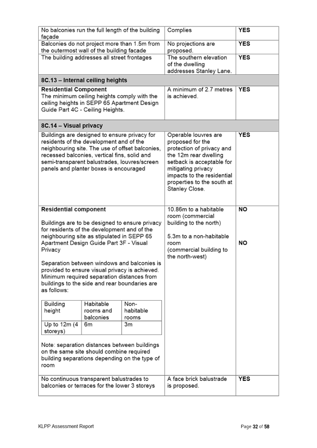
· Height, Built Form and Scale
Being currently zoned SP2 Infrastructure (Educational Establishment) the Height of Buildings and Floor Space Ratio development standards do not currently apply to the site. The Planning Proposal seeks to amend the Height of Buildings development standard on the site to 17.5m and the Floor Space Ratio standard to provide a maximum floor space ratio of 1.3:1.

Figure 4. Excerpt from Urban Design Study - Proposed Height of Buildings Map

Figure 5. Excerpt from Urban Design Study – Proposed Floor Space Ratio Map

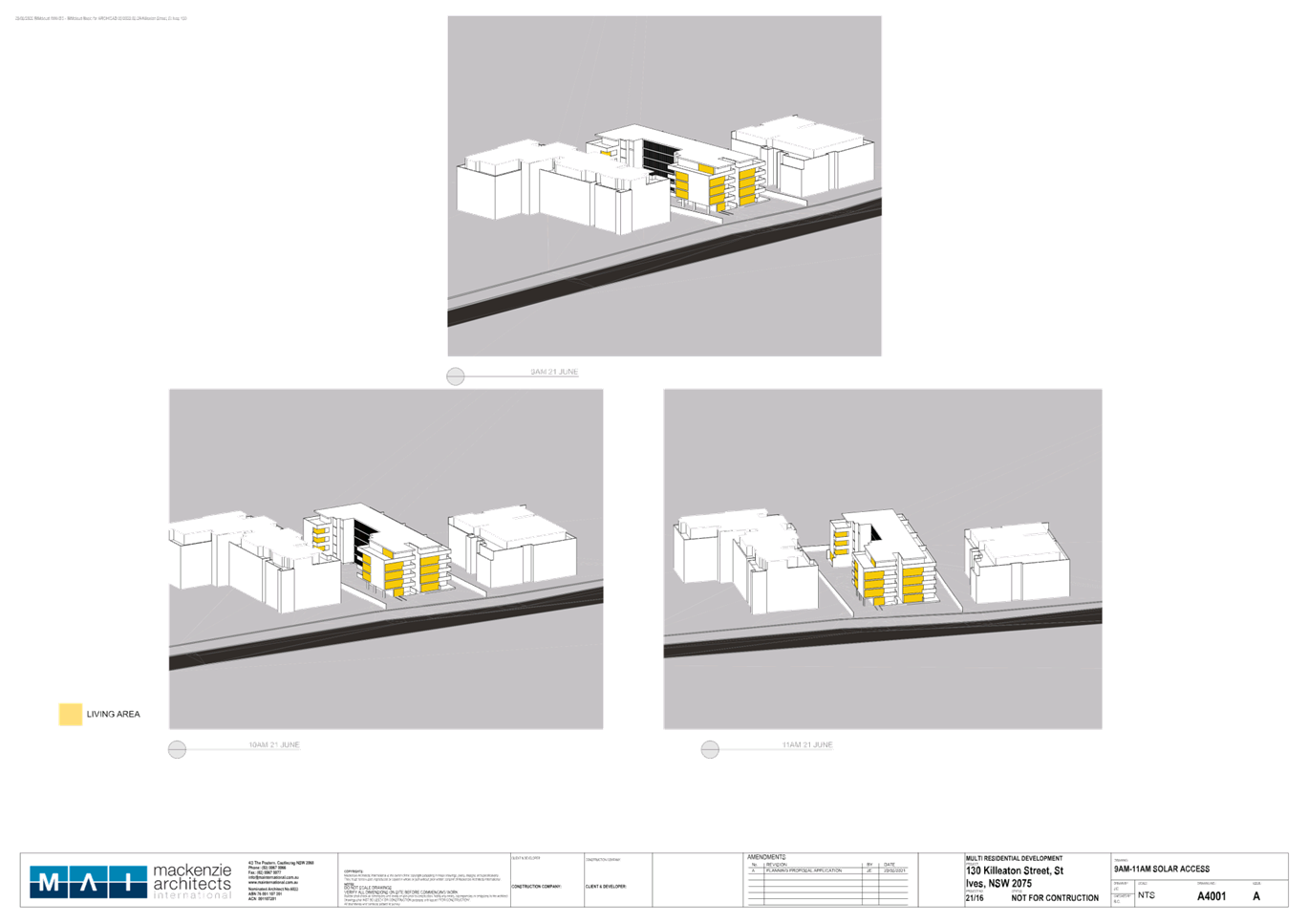
Figure 6. Excerpt from Urban Design Study – concept massing
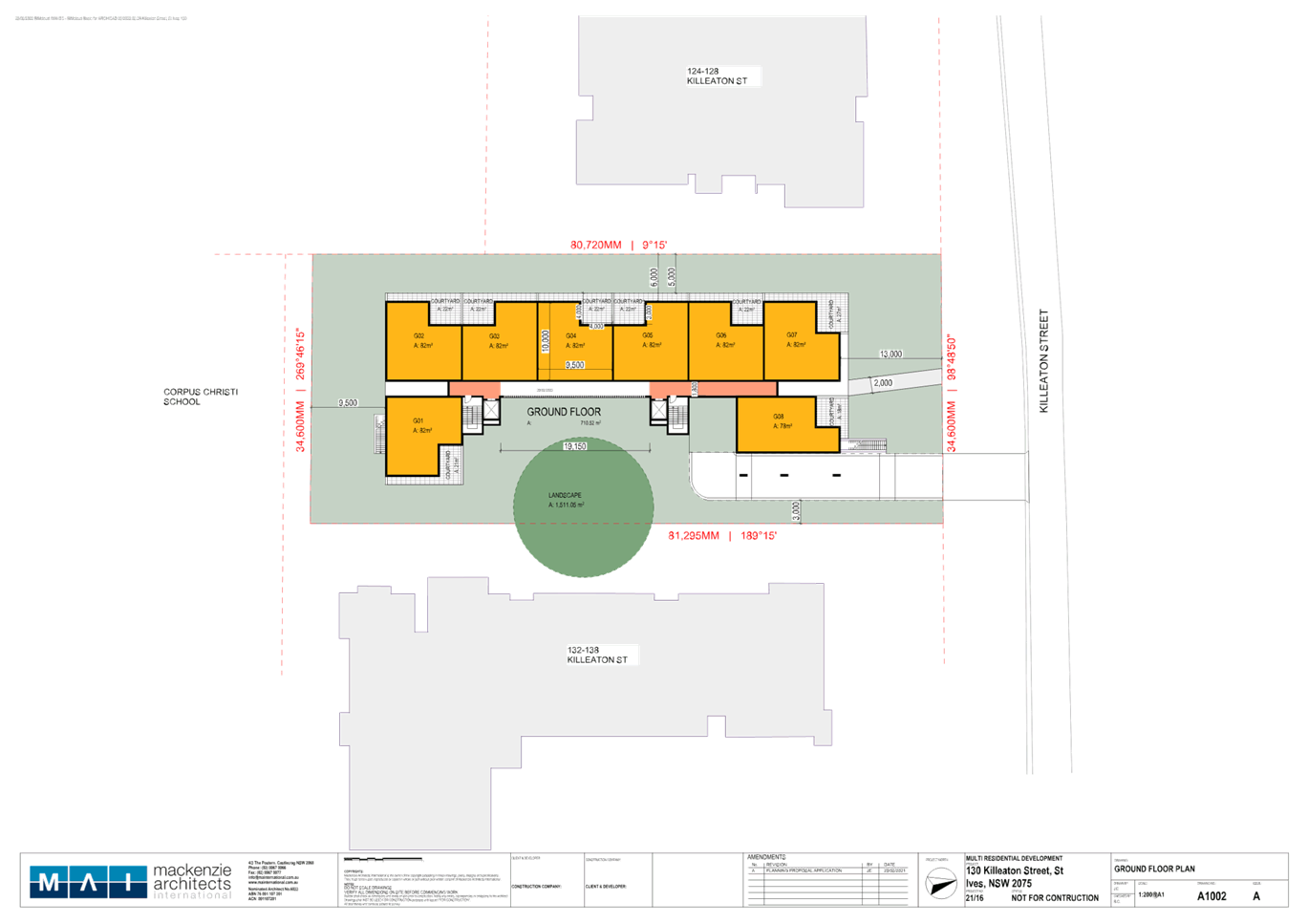
The Concept Architectural Plans are included at Attachment A4 and the Urban Design Study is included at Attachment A5. The massing proposes a 5-storey rectangular built form with the main part of the building aligned to an east-west orientation. Given the scale of the adjoining developments which comprise of 4-5 storey apartment developments, the proposed height of 5-storeys is a suitable response to this site and context.
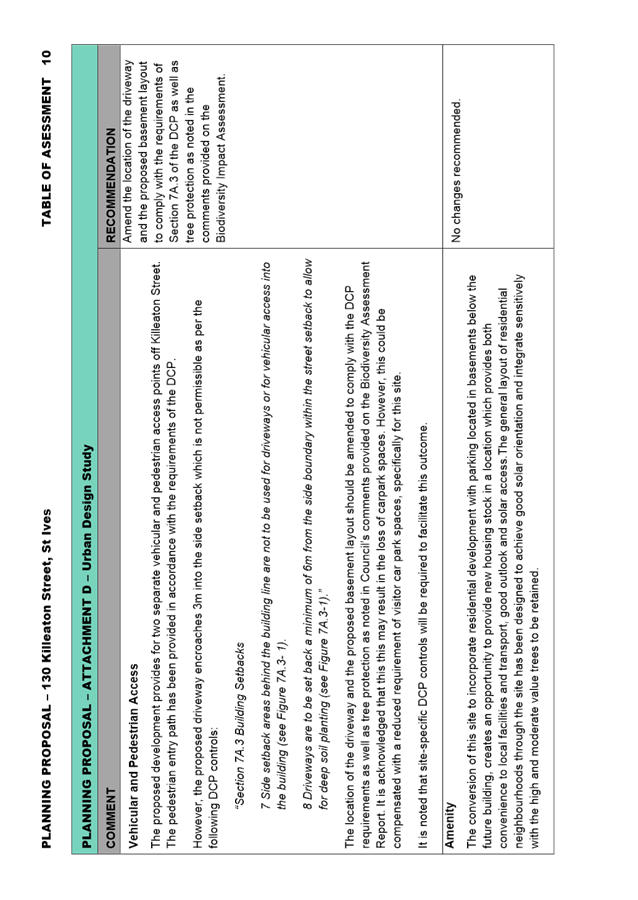
While a Planning Proposal only relates to an LEP amendment and cannot be tied to a specific development outcome, it is important that the urban design study supporting the Planning Proposal presents a concept development scheme that is compliant with Council’s DCP and the Apartment Design Guide (ADG) as well as responds to any specific development constraints on the site. An analysis of the Concept Architectural Plans and Urban Design Study has been undertaken by Council’s Urban Design Project Officer and is included in Table of Assessment at Attachment A10. This analysis identifies the following required amendments to the concept plans and Urban Design Study:
· Amend the urban design of the proposed plan by varying the depth of the wall planes, supplemented with architectural elements.
· Modify the western elevation of the building to comply with controls 16 and 17 of Section 7C.6 of the DCP.
· Amend the design to ensure compliance with the top floor GFA allowance within the DCP.
· Include a separate diagram showing Site Coverage Calculations required to be submitted.
· Amend the location of the driveway and the proposed basement layout to comply with the requirements of Section 7A.3 of the DCP as well as tree protection as noted in the comments provided on the Biodiversity Impact Assessment.
· Traffic and Transport
A Traffic and Transport Report has been submitted with the Planning Proposal and is included at Attachment A7.
Council’s Strategic Transport Engineer has reviewed the documents and provided the following key points. A more detailed traffic and transport analysis is included in the Table of Assessment, at Attachment A10.
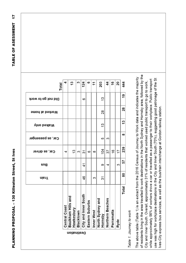
Public Transport and Journey to Work
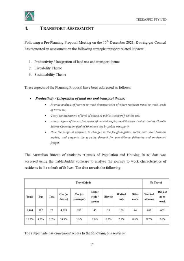
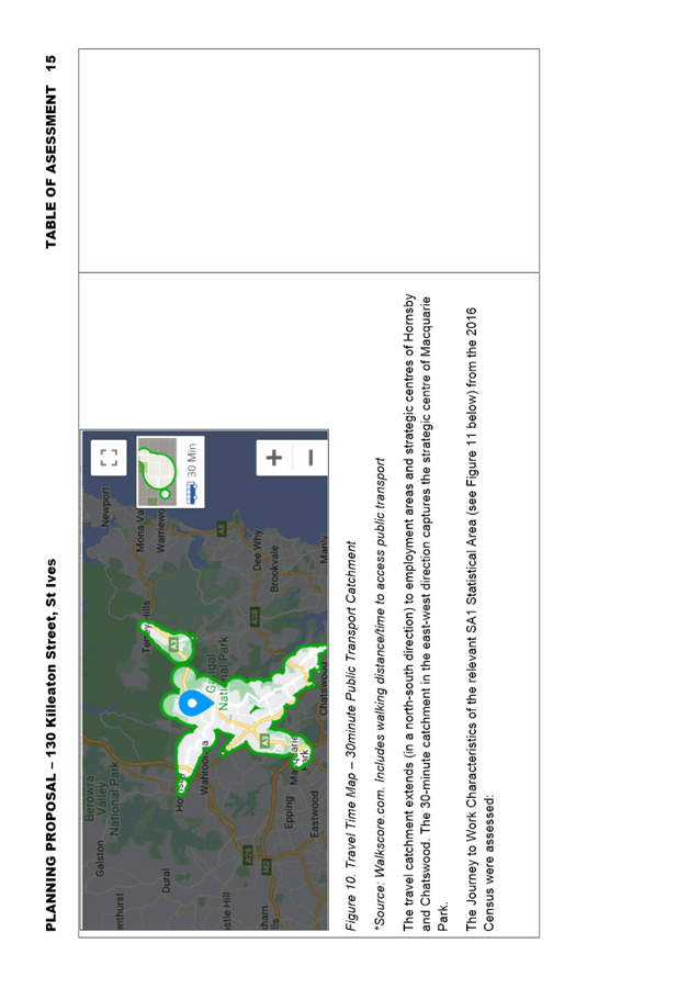
An assessment of the 30-minute Public Transport Catchment and 2016 Census Journey to Work Data has determined that, overall, the subject site would provide relatively good access to jobs by public transport.
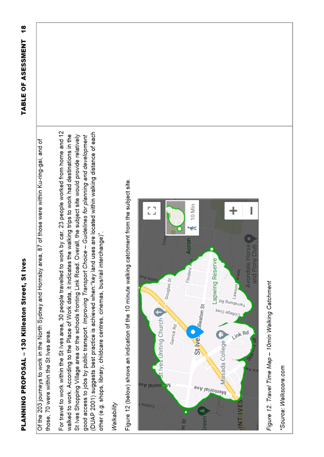
Walkability
Improving Transport Choice – Guidelines for planning and development (DUAP 2001) suggests best practice is achieved when: “key land uses are located within walking distance of each other (e.g. shops, library, childcare centres, cinemas, bus/rail interchange)”. An assessment of the 10-minute Walking Catchment has identified that, while some nearby parks, child care centres, schools and churches are located within 10 minutes’ walk from site, other key services and facilities such as supermarkets, pharmacies, medical centres, open space/recreation and other schools are located some distance further. It is likely, therefore, that future residents of this site will likely (to a large degree) be using private cars to access basic day-to-day services and facilities.
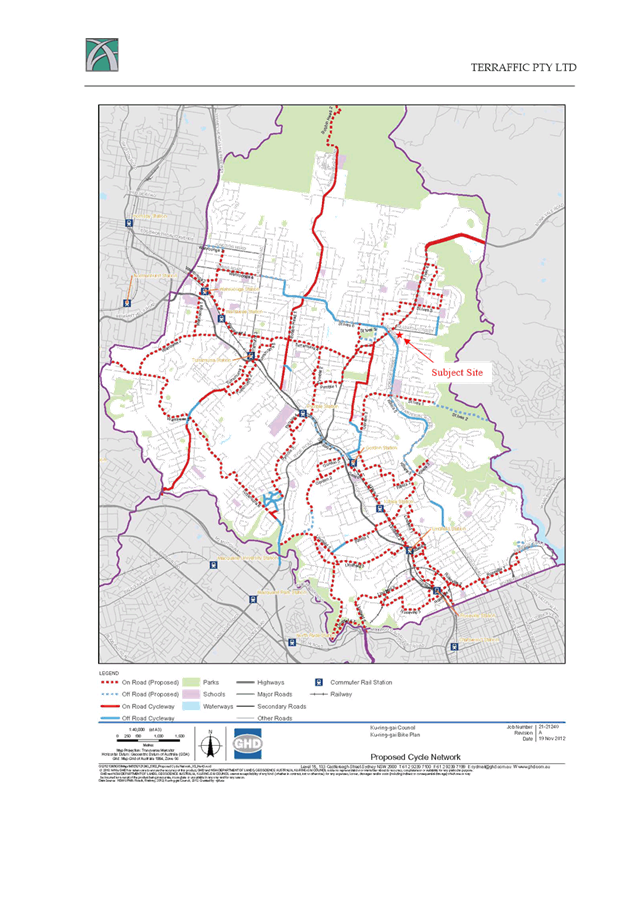
Cycling Accessibility
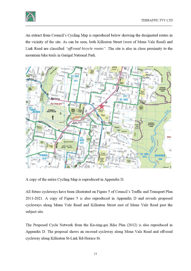
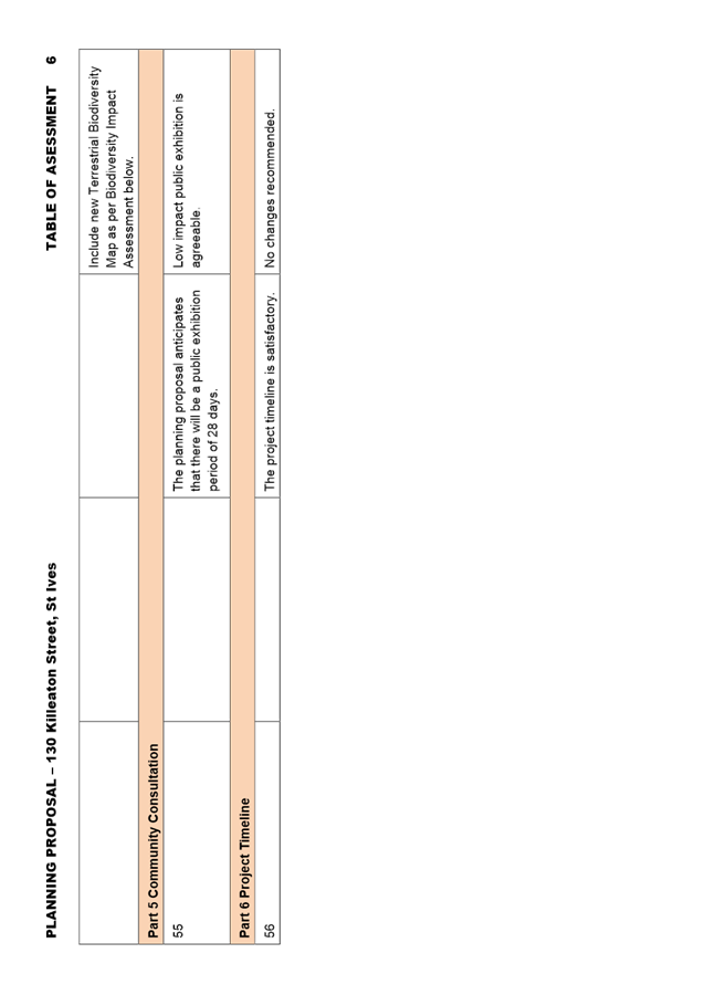
An assessment of the 30-minute Cycling Catchment has determined that the bicycle network in the catchment is only somewhat developed. This catchment extends to Hornsby and most of the main centres in Ku-ring-gai along the T1 North Shore railway line. The site is located close to an existing shared user path which runs around the outskirts of the St Ives centre. Completion of missing links would provide better connections to Gordon, Wahroonga and the Barra Brui locality, as well as the St Ives centre itself (as part of the draft Public Domain Plan). Otherwise, the majority of current cycling activity is expected to be confined to either on-road/mixed use cycling or cycling on footpaths (where permissible).
Transport Infrastructure Capacity
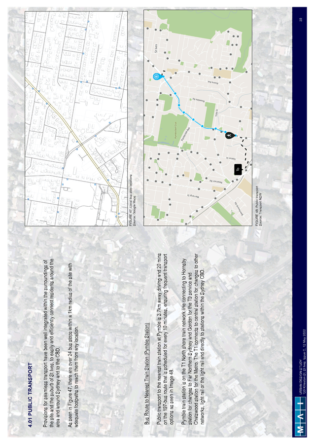
There is a bus stop within 150m (2 minutes’ walk) from the site, on Mona Vale Road. The corresponding stop is on the opposite side of Mona Vale Road and is approximately 300m (4 minutes’ walk) from the site. These bus stops provide convenient access to routes 194 (St Ives to City), 194X (St Ives to City Express), 195/196 (Belrose and St Ives Chase to Gordon), 197 (Mona Vale to Macquarie University via Gordon) and 582 (St Ives Shopping Centre to Gordon) services. The stop on the eastern side of Mona Vale Road is equipped with a shelter, while the stop on the western side is provided with a seat and concrete pad.
To access the Hornsby strategic centre, bus stops on Killeaton Street near Memorial Avenue provide the closest access to the route 591 service, which connects St Ives and Hornsby. These stops are 550m (7 minutes) and 650m (9 minutes) walk from the site. These stops also provide access to the 594 service (North Turramurra to City). There are no dedicated passenger facilities (e.g. bench seats or shelters) at these stops.

Figure 7. Bus Stops and Service near the Site
Strategic Transport Planning
Improvements to the 194 service (St Ives – City) were made approximately 2 years ago, which include increased off-peak and weekend daytime service frequency, and extended span of hours later in the evening.
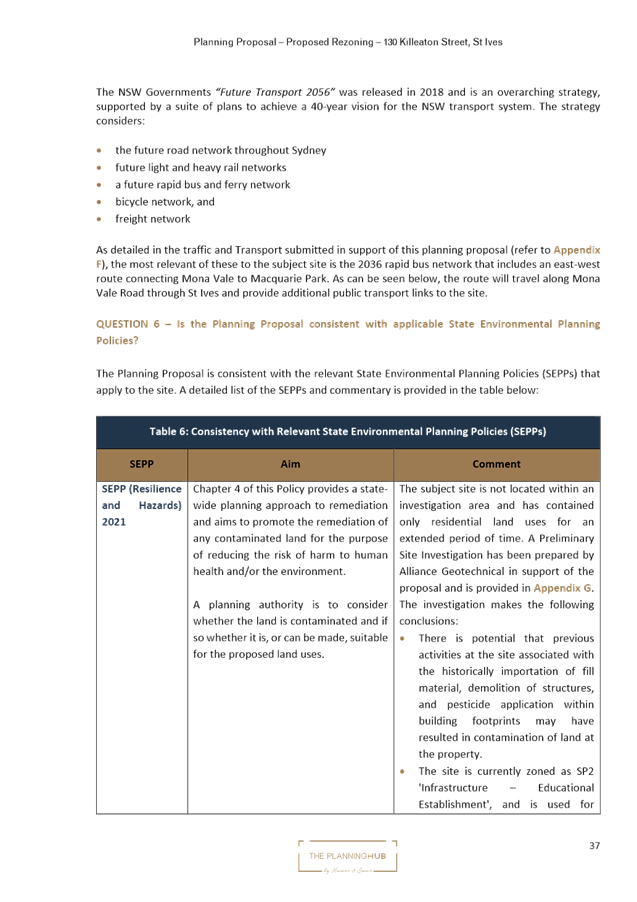
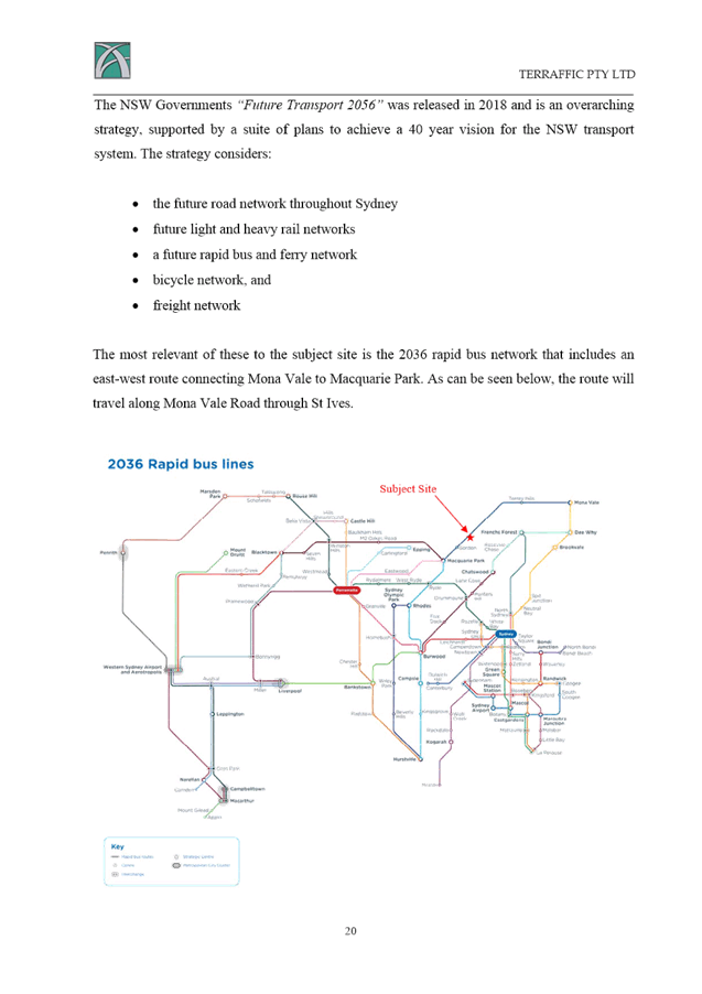
Transport for NSW have advised that prior to the last State election the Government made a commitment prior to 2023 to introduce new weekday peak hour express services between Mona Vale and Macquarie Park that bypass Gordon (known as the 197X Mona Vale – Macquarie Park service). These new services would save some travel time for passengers travelling between Macquarie Park and St Ives/Northern Beaches, as the service would not have to divert to Gordon station. To date, there has been no update from Transport for NSW regarding the 197X service.
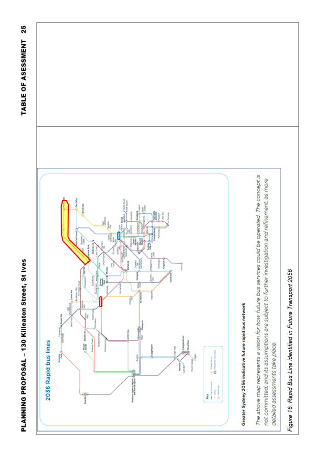
The Traffic, Transport and Parking Report notes that Future Transport 2056 identifies a rapid bus line between Mona Vale and Macquarie Park by 205. Other than acknowledge the future rapid bus line, the Traffic, Transport and Parking Report does not discuss its timing or present any discussion/consultation with Transport for NSW regarding timeframes or implementation. If the Planning Proposal proceeds to Gateway, Transport for NSW will be providing a response as part of consultation with state agencies. Clarification regarding future upgrade to bus services and the Rapid Bus Line would be provided by Transport for NSW as part of that process.
Councils along the Mona Vale Road/Ryde Road/Lane Cove Road corridor are aligned in their support for improved services along the corridor and are advocating to Transport for NSW to bring forward planning for the initiative. From the Ku-ring-gai Local Strategic Planning Statement (LSPS), Council has an action to advocate to Transport for NSW to increase the priority and accelerate the delivery of infrastructure improvements identified in Future Transport 2056 that connects Ku-ring-gai internally and with nearby centres, including improvements to bus connections from Mona Vale to Macquarie Park (followed by Bus Rapid Transit).
Travel time on Ryde Road/Lane Cove Road portion of the corridor (between Pacific Highway and Waterloo Road) during morning peak periods can be up to 30 minutes, and currently, journey times of buses travelling between St Ives and Macquarie Park are significantly impacted by these delays, resulting in travel times longer than timetabled. It is likely, therefore, that the new 197X Mona Vale – Macquarie Park service will be impacted by delays on the Ryde Road segment of the route. Bus service improvements along this corridor, including extension of operating times, bus priority measures and journey time reliability are important to ensure public transport is competitive with private vehicles, as well as enhance connectivity and bring significant Strategic Centres (such as Macquarie Park) and Health/Education Precincts within 30 minutes by public transport.
In recognition of this, one of the actions to address Planning Priority K2 of the LSPS (to provide housing close to transport, services and facilities to meet the existing and future requirements of a growing and changing community) is to: “Implement planning responses in St Ives subject to infrastructure improvements (medium-long term).”
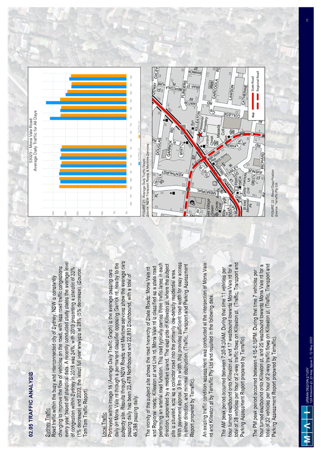
Traffic generation and intersection analysis
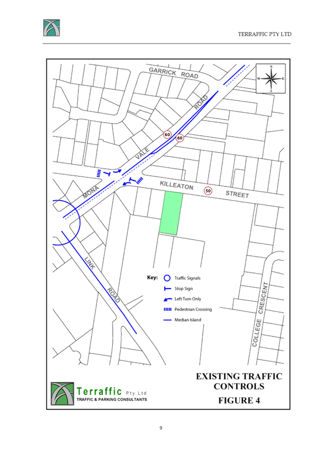
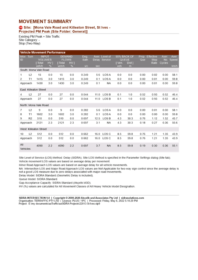
Traffic surveys were undertaken by the proponent in February 2022 at the intersection of Mona Vale Road and Killeaton Street during the AM and PM peak periods. This intersection operates as a left in/left out arrangement.
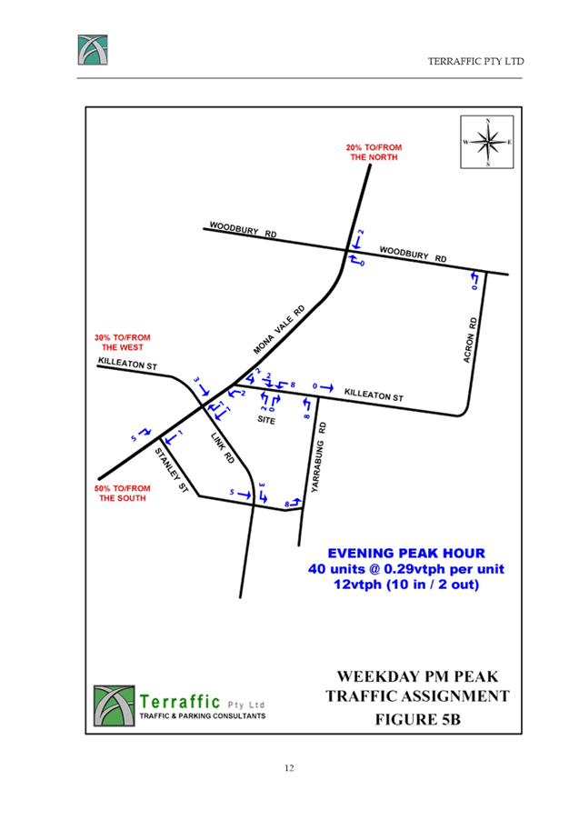
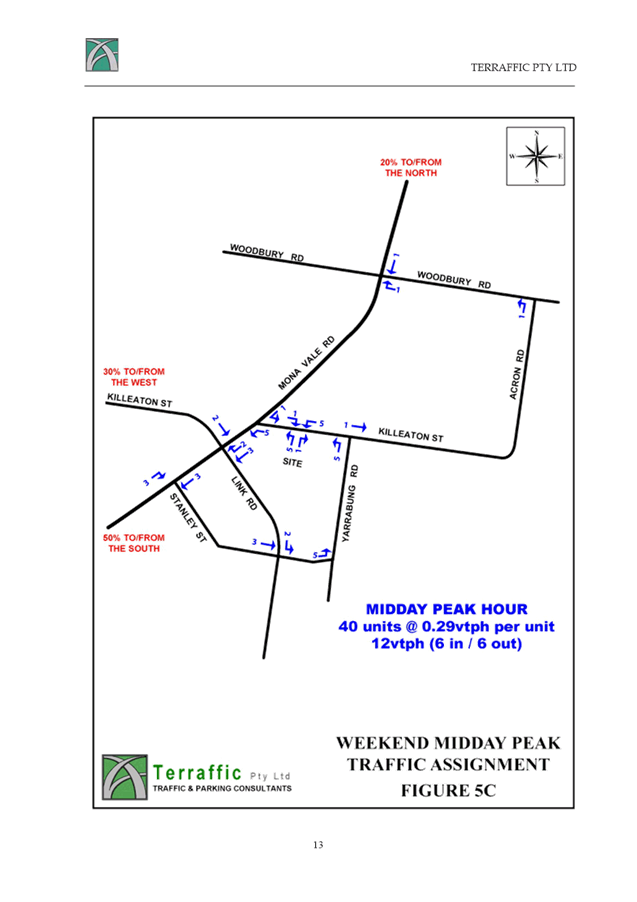
A traffic generation rate of 0.29 vehicle trips per dwelling during the AM and PM peak hours was used to assess the traffic impacts of the proposal. For an expected yield of 40 residential dwellings, this resulted in a traffic generation of 12 vehicle trips (two-way) during the AM and PM peak hours. These were distributed to the surrounding road network based on expected destinations guided by the Journey to Work data. The resulting levels of service at the intersection of Mona Vale Road and Killeaton Street from the Traffic, Transport and Parking Report are shown in Figure 8 below.

Figure 8. Excerpt from Traffic, Transport and Parking Report – SIDRA analysis
Given the low additional traffic generation at the intersection, the proposal has very minimal impacts to its operation, continuing to operate at Level of Service B. However, in the Traffic, Transport and Parking Report, there is no commentary or evidence of discussions with Transport for NSW regarding future proposals for the Mona Vale Road corridor in St Ives. If the Planning Proposal proceeds to Gateway, Transport for NSW will be providing a response as part of consultation with state agencies. Any further details or clarification on planned upgrades to the Mona Vale Road corridor through St Ives would be provided by Transport for NSW as part of that process.
Yarrabung Road has been identified as a road which would form part of a vehicle trip to access the site from the south. Yarrabung Road is a collector road in Council’s road hierarchy, and Council’s most recent traffic counts in Yarrabung Road were undertaken in 2016 and indicate average weekday traffic flows of 4,800 vehicles per day (two-way) and 85% traffic speeds of 54km/h. Indicatively, the peak hour traffic flows would be in the order of 450-480 vehicles per hour.
For residential collector roads, RMS (now Transport for NSW) guidelines indicate that traffic flows of 300 vehicles per hour is an environmental goal, and 500 vehicles per hour is a suggested maximum performance standard.
As a result of the proposal, traffic flows are expected to increase by up to 8 vehicle trips per hour in Yarrabung Road (which would occur in the PM peak period). This equates to an average of 1 additional vehicle trip in Yarrabung Road every 7-8 minutes which is a modest amount of traffic increase and unlikely to result in significant additional impacts.
· Biodiversity
Biodiversity Impact Assessment and KLEP 2015 Mapping
The Biodiversity Impact Assessment submitted with the Planning Proposal is included at Attachment A6. Council’s Natural Areas Program Leader has reviewed the document and provided the following key points:
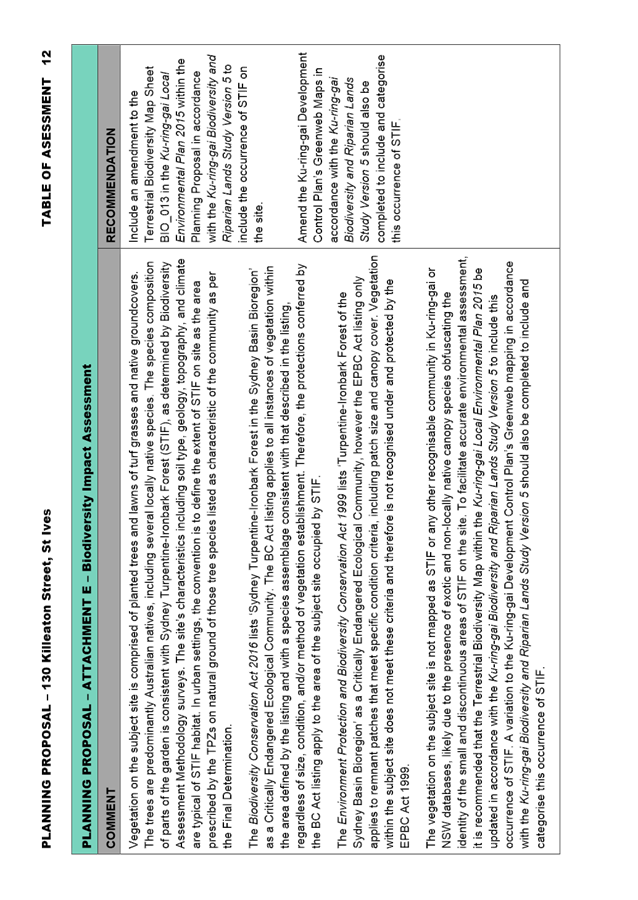
The vegetation on the subject site is comprised of planted trees and lawns of turf grasses and native groundcovers. The trees are predominantly Australian natives, including several locally native species. The species composition of parts of the garden is consistent with Sydney Turpentine-Ironbark Forest (STIF), as determined by Biodiversity Assessment Methodology surveys. The site’s characteristics including soil type, geology, topography, and climate are typical of STIF habitat. In urban settings, the convention is to define the extent of STIF on site as the area prescribed by the tree protection zones (TPZ) on natural ground of those tree species listed as characteristic of the community as per the Final Determination.
The Biodiversity Conservation Act 2016 (BC Act) lists ‘Sydney Turpentine-Ironbark Forest in the Sydney Basin Bioregion’ as a Critically Endangered Ecological Community. The BC Act listing applies to all instances of vegetation within the area defined by the listing and with a species assemblage consistent with that described in the listing, regardless of size, condition, and/or method of vegetation establishment. Therefore, the protections conferred by the BC Act listing apply to the area of the subject site occupied by STIF.
The Environment Protection and Biodiversity Conservation Act 1999 (EPBC Act) lists ‘Turpentine-Ironbark Forest of the Sydney Basin Bioregion’ as a Critically Endangered Ecological Community, however the EPBC Act listing only applies to remnant patches that meet specific condition criteria, including patch size and canopy cover. Vegetation within the subject site does not meet these criteria and therefore is not recognised under and protected by the EPBC Act 1999.
The vegetation on the subject site is not mapped as STIF or any other recognisable community in Ku-ring-gai or NSW databases, likely due to the presence of exotic and non-locally native canopy species obfuscating the identity of the small and discontinuous areas of STIF on the site.
To facilitate accurate environmental assessment, it is recommended that the Terrestrial Biodiversity Map Sheet BIO_013 in the Ku-ring-gai Local Environmental Plan 2015 be updated in accordance with the Ku-ring-gai Biodiversity and Riparian Lands Study Version 5 to include this occurrence of STIF. A variation to the Ku-ring-gai Development Control Plan’s Greenweb Maps in accordance with the Ku-ring-gai Biodiversity and Riparian Lands Study Version 5 should also be completed to include and categorise this occurrence of STIF. Updating the Terrestrial Biodiversity Map Sheet to include the occurrence of STIF on the site will ensure that KLEP 2015 Clause 6.3 Biodiversity protection will apply to the site and any future development will be assessed against the provisions of the clause.
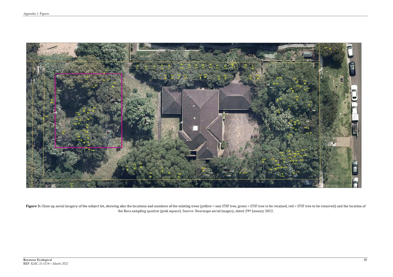
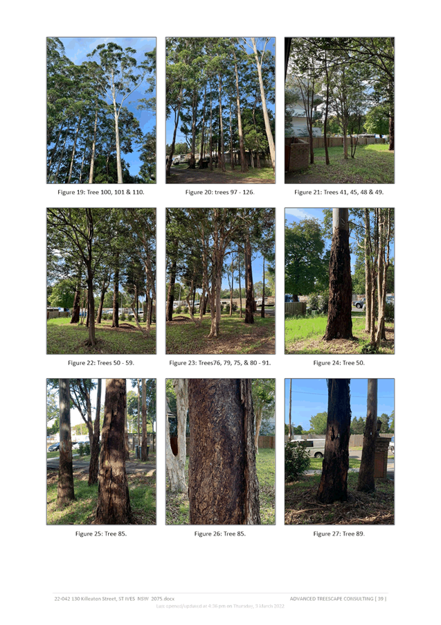
The Biodiversity Impact Assessment identifies that 30 individual trees of 7 species within the site comprise STIF. However, the BIA does not identify 4 Eucalyptus pilularus amongst these (Trees 30, 43, 44, and 66). Eucalyptus pilularis is characteristic of STIF as per the Sydney Turpentine-Ironbark Forest in the Sydney Basin Bioregion Final Determination 2019. Additionally, the BIA does not identify 3 Syncarpia glomulifera and 1 Angophora costata growing in adjoining Lots but with TPZs likely to extend into the site. These trees form part of the local occurrence of STIF and need to be captured in the amended Terrestrial Biodiversity Map Sheet in the LEP and the amended Greenweb Maps in the DCP. These amendments are noted in the Table of Assessment at Attachment A10.
The Biodiversity Impact Assessment recommends a management plan be developed to guide planting on site. The BIA states the planting palette should include Blue Gum High Forest Species. Due to the presence of STIF on site and the absence of BGHF, it is recommended that the planting palette should instead be comprised of STIF species. The inclusion of Corymbia maculata in the planting palette is not supported. This species will not aid in the conservation of STIF and its inclusion on the basis of foraging habitat for Grey-headed Flying-fox is not considered a priority as alternative STIF species fulfil this objective.
A floorspace ratio of 1.3:1 will result in some loss of STIF vegetation. The BIA calculates a loss of STIF totalling approximately 354 square metres resulting from the proposed development. Given the degraded condition of the STIF vegetation on site and its isolation from significant vegetation patches and corridors, this impact to STIF vegetation is considered acceptable with the proviso that losses are offset in accordance with Council’s Biodiversity Offsetting Code of Practice. It is desirable that impacts to STIF be minimised, which would require redesign to reduce the number of STIF trees the building footprint encroaches on. In addition to minimising impacts to STIF, such a redesign would also support the retention of threatened species habitat on the site. Suggested amendments to the design include the relocation of the driveway several metres east, clear of the SRZs of Trees T111 to the west and T88 to the east. This would reduce the number of STIF trees removed to facilitate the driveway from four (T104, T111, T112 & T113) to zero and increase the number of High significance trees (as per Appendix 4 of the Arborist Report) from one (T107) to two (T91 & T92). This required amendment is noted in the Table of Assessment at Attachment A10.
Furthermore, the proposed design does not identify utility locations. Utilities would need to be located within the driveway and building footprint to avoid further impacts to trees and biodiversity.
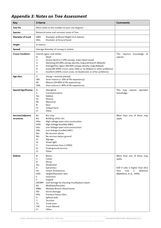
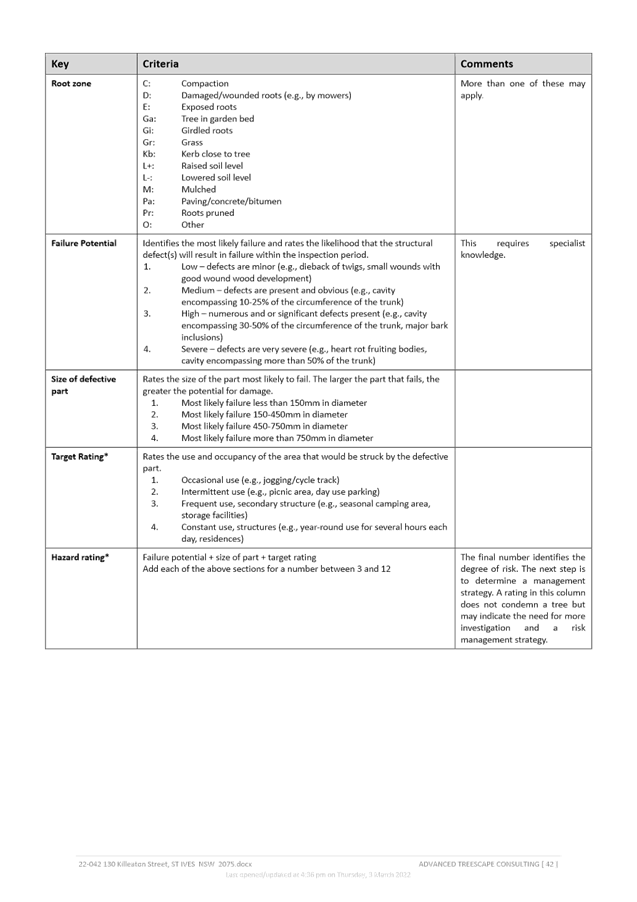
Arborist Report
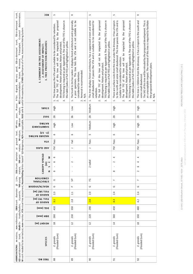
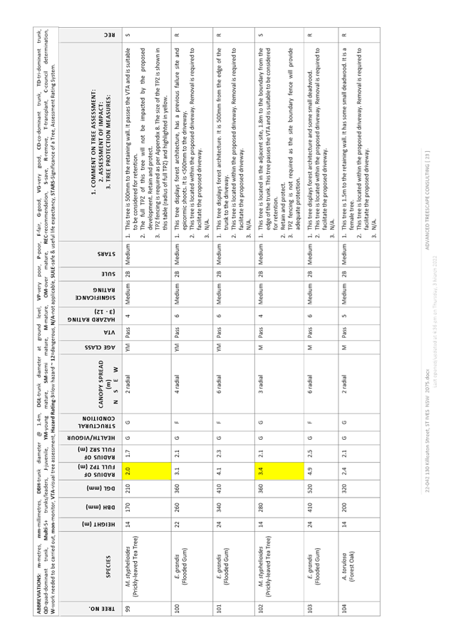
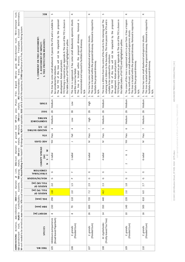
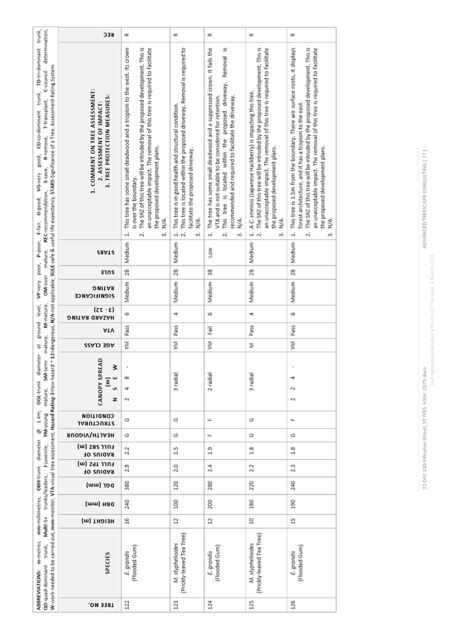
The Arborist Report submitted with the Planning Proposal is included at Attachment A9. Council’s Natural Areas Program Leader has reviewed the document and provided the following key points:
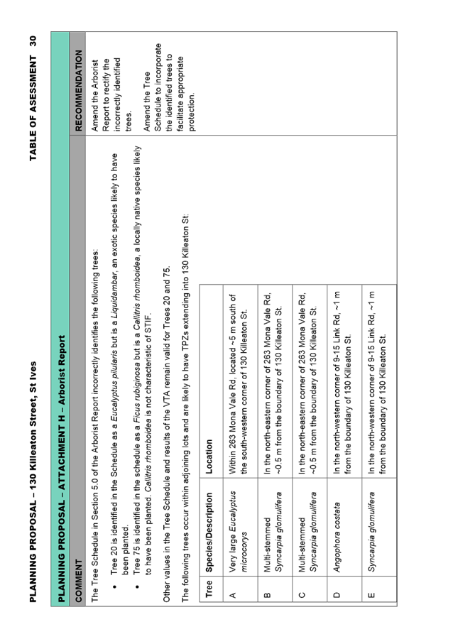
The Tree Schedule in Section 5.0 of the Arborist Report incorrectly identifies the following trees:
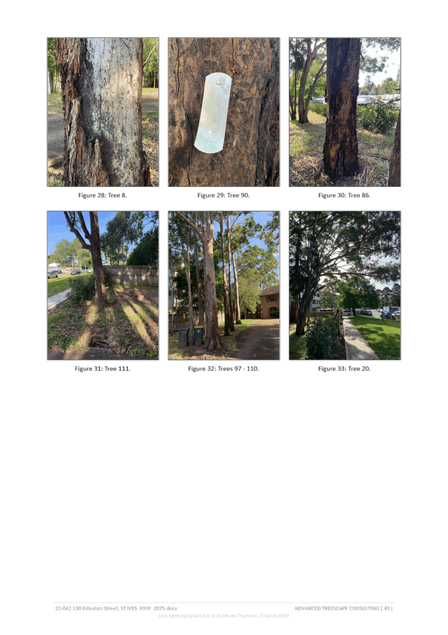
· Tree 20 is identified in the Schedule as a Eucalyptus pilularis but is a Liquidambar, an exotic species likely to have been planted.
· Tree 75 is identified in the schedule as a Ficus rubiginosa but is a Callitris rhomboidea, a locally native species likely to have been planted. Callitris rhomboidea is not characteristic of STIF.
Other values in the Tree Schedule and results of the VTA remain valid for Trees 20 and 75.
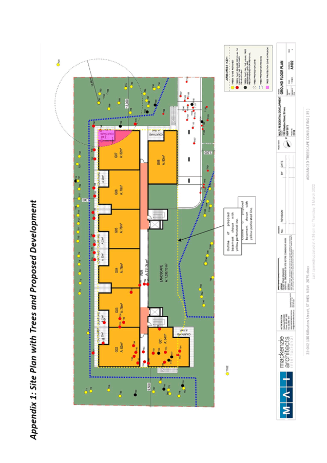
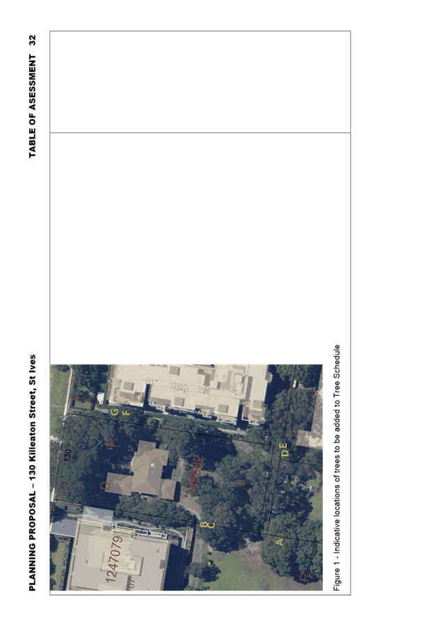
The following trees occur within adjoining lots and are likely to have TPZs extending into 130 Killeaton Street:
|
Tree |
Species/Description |
Location |
|
A |
Very large Eucalyptus microcorys |
Within 263 Mona Vale Rd, located ~5 m south of the south-western corner of 130 Killeaton St. |
|
B |
Multi-stemmed Syncarpia glomulifera |
ln the north-eastern corner of 263 Mona Vale Rd, ~0.5 m from the boundary of 130 Killeaton St. |
|
C |
Multi-stemmed Syncarpia glomulifera |
ln the north-eastern corner of 263 Mona Vale Rd, ~0.5 m from the boundary of 130 Killeaton St. |
|
D |
Angophora costata |
In the north-western corner of 9-15 Link Rd, ~1 m from the boundary of 130 Killeaton St. |
|
E |
Syncarpia glomulifera |
In the north-western corner of 9-15 Link Rd, ~1 m from the boundary of 130 Killeaton St. |
|
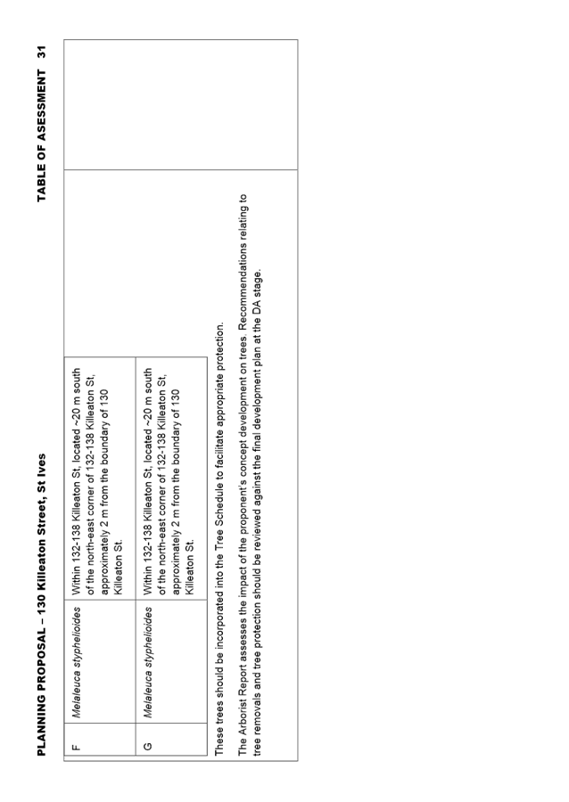
F |
Melaleuca styphelioides |
Within 132-138 Killeaton St, located ~20 m south of the north-east corner of 132-138 Killeaton St, approximately 2 m from the boundary of 130 Killeaton St. |
|
G |
Melaleuca styphelioides |
Within 132-138 Killeaton St, located ~20 m south of the north-east corner of 132-138 Killeaton St, approximately 2 m from the boundary of 130 Killeaton St. |
Table 1. Recommended additions to the Tree Schedule

Figure 9. Indicative locations of trees to be added to Tree Schedule
These trees should be incorporated into the Tree Schedule to facilitate appropriate protection. These required amendments are noted in the Table of Assessment at Attachment A10.
The Arborist Report assesses the impact of the proponent’s concept development on trees. Recommendations relating to tree removals and tree protection should be reviewed against the final development plan at the DA stage.
· Contamination
The Preliminary Site Investigation submitted with the Planning Proposal is included at Attachment A8. The report identifies a potential for contaminants that may present a risk to terrestrial ecosystems. However, the Preliminary Site Investigation assumes that the nature of the proposed development will result in loss of potential ecological receptors (i.e. fauna) from the site, and on that basis determines that further assessment of terrestrial ecosystem risks is not warranted. However, the recommendations of the Biodiversity Impact Assessment seek to retain biota comprising potential receptors on site. Therefore, potential contamination and associated terrestrial ecological risks should be characterised in a Detailed Site Investigation at the DA stage.
Strategic Merit Assessment
· Greater Sydney Region Plan and North District Plan
The Planning Proposal is consistent with the objectives of the Greater Sydney Region Plan – A Metropolis of Three Cities, in particular:
- Objective 4. Infrastructure use is optimised;
- Objective 10. Greater housing supply;
- Objective 11. Housing is more diverse and affordable;
- Objective 14. Integrated land use and transport creates walkable and 30-minute cities;
- Objective 27. Biodiversity is protected, urban bushland and remnant vegetation is enhanced.
A Metropolis of Three Cities outlines that liveability incorporates access to housing, transport and employment, as well as social, recreational, cultural and creative opportunities. Provision of housing close to public transport and services and facilities improves the opportunity for people to walk and cycle to local shops and services. The plan advocates for the protection and enhancement of biodiversity values. The proposal is consistent with these principles.
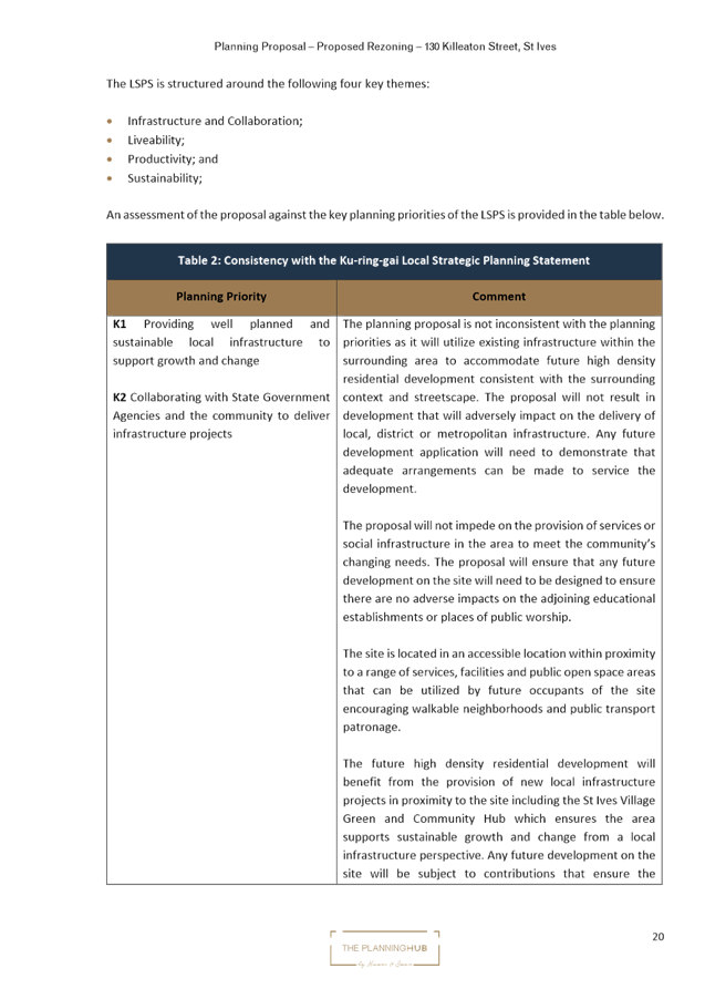
The Planning Proposal is consistent with the planning priorities of the North District Plan, in particular:
- Planning Priority N1. Planning for a city supported by infrastructure;
- Planning Priority N5. Providing housing supply, choice and affordability, with access to jobs, services and public transport;
- Planning Priority N6. Creating and renewing great places and local centres, and respecting the districts heritage;
- Planning Priority N12. Delivering integrated land use and transport planning and a 30-minute city;
- Planning Priority N16. Protecting and enhancing bushland and biodiversity.
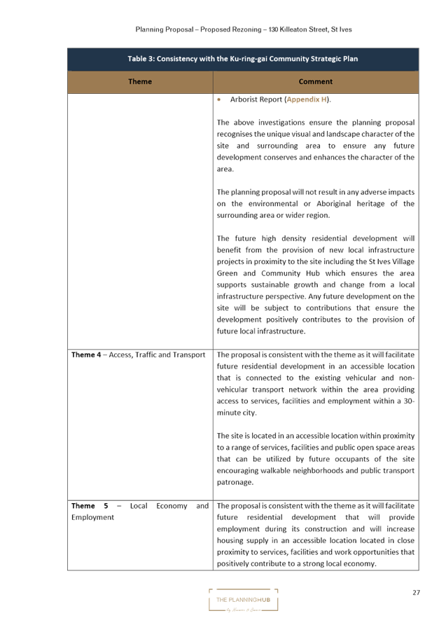
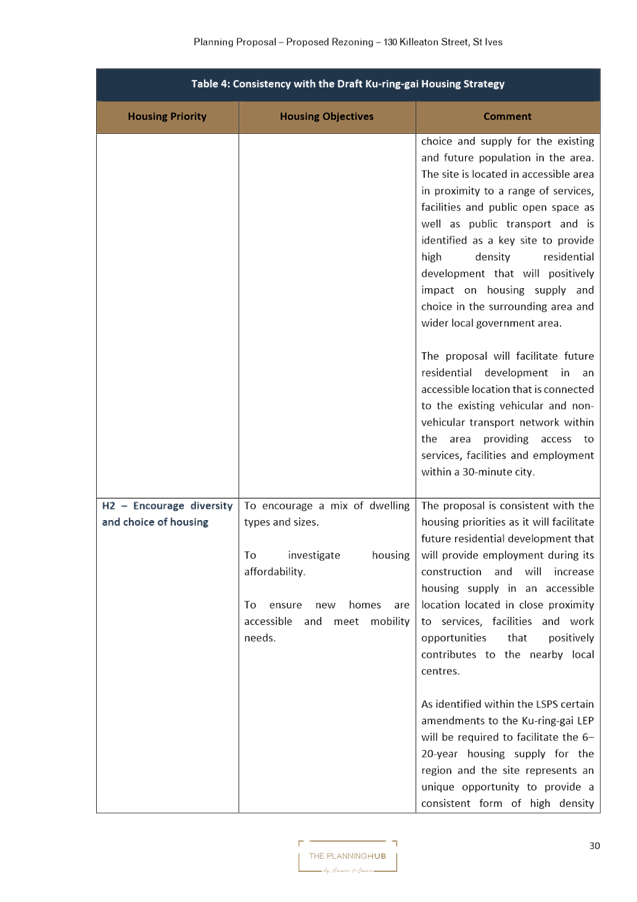
The Planning Proposal will allow for additional residential land that can be developed to provide housing choice and supply for the existing and future population in the area. The site is located in an accessible area in proximity to a range of services, facilities and public open space as well as public transport. The Planning Proposal is therefore in accordance with the North District Plan priorities to focus housing in locations that support the 30-minute city and provide access to jobs, services and public transport, as well as the priorities to protect biodiversity.
· Ku-ring-gai Local Strategic Planning Statement
The Ku-ring-gai Local Strategic Planning Statement (LSPS) came into effect on 17 March 2020 and provides a 20 year vision and local planning priorities and associated actions for land use planning in Ku-ring-gai. The Planning Proposal is consistent with the following local planning priorities:
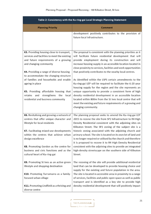
- K3. Providing housing close to transport, services and facilities to meet the existing and future requirements of a growing and changing community;
- K4. Providing a range of diverse housing to accommodate the changing structure of families and households and enable ageing in place;
- K12. Managing change and growth in a way that conserves and enhances Ku-ring-gai’s unique visual and landscape character;
- K21. Prioritising new development and housing in locations that enable 30minute access to key strategic centres;
- K31. Increasing, managing and protecting Ku-ring-gai’s urban tree canopy.
This Planning Proposal seeks to allow for approximately 40 additional dwellings in the centre prior to the provision of the rapid bus line between Mona Vale and Macquarie Park, which is inconsistent with the LSPS. Should the Planning Proposal proceed to Gateway, Transport for NSW will be providing a response as part of consultation with state agencies. Clarification regarding future upgrade to bus services and the Rapid Bus Line would be provided by Transport for NSW as part of that process. Council’s Strategic Transport Engineer has reviewed the Transport and Parking Report submitted with the Planning Proposal, which indicates a modest amount of traffic increase as a result of the proposal which is unlikely to result in significant additional impacts. It is noted that Council’s LSPS includes an action to advocate to Transport for NSW to increase the priority and accelerate the delivery of infrastructure improvements identified in Future Transport 2056 that connects Ku-ring-gai internally and with nearby centres, including improvements to bus connections from Mona Vale to Macquarie Park (followed by the Bus Rapid Transit).
The Planning Proposal is generally consistent with the principles for the location of additional housing as set out in the LSPS:
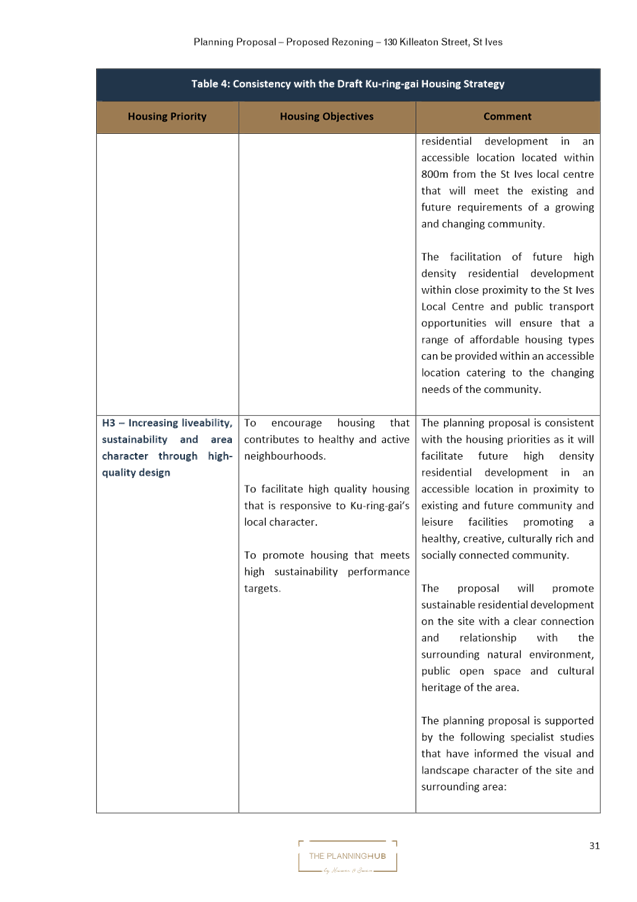
- Stage housing delivery around centres of retail and economic activity that are serviced by the North Shore railway line or major bus routes along arterial roads, including provision of housing diversity, affordability and accessibility.
- Locate high density housing types within a 10min walk (800m radius) of Primary and Secondary Local Centres: Gordon, Lindfield, Turramurra, St Ives (subject to the provision of priority bus infrastructure), Roseville, Killara, Pymble and Wahroonga.
- In considering areas for future medium and high density housing form, the following areas are to be avoided:
o Heritage conservation areas.
o Areas of visual or aesthetic quality and character.
o Areas within or affecting scenic and cultural landscapes.
o Areas of intact tree canopy where the built form does not sit under the canopy.
o Areas with multiple constraints including steep topography.
o Areas with environmental values.
o Areas that are bushfire prone and with evacuation risk.
o Centres with limited transport and service access until improvements are implemented.
Given that the scale of the adjoining developments that comprise of 4-5 storey apartment developments, the proposed height of 5-storeys is a suitable response to this site and context. The development standards proposed and the built form outcomes enabled by the Planning Proposal are consistent with the adjoining R4 High Density Residential zoned sites. The sites the subject of the Planning Proposal are not constrained by a Heritage conservation area, scenic or cultural landscape or bushfire prone land.
The vegetation on the subject site is comprised of planted trees and lawns of turf grasses and native groundcovers. The trees are predominantly Australian natives, including several locally native species. The species composition of parts of the garden is consistent with Sydney Turpentine-Ironbark Forest (STIF), as determined by Biodiversity Assessment Methodology surveys. The floorspace ratio of 1.3:1 will result in some loss of STIF vegetation resulting from the proposed development. Given the degraded condition of the STIF vegetation on site and its isolation from significant vegetation patches and corridors, this impact to STIF vegetation is considered acceptable with the proviso that losses are offset in accordance with Council’s Biodiversity Offsetting Code of Practice. As detailed in the proposed amendments, relocation of the driveway would ensure the impact to STIF vegetation is minimised.
This Planning Proposal seeks to allow for approximately 40 additional dwellings in the centre prior to the provision of the rapid bus line between Mona Vale and Macquarie Park, which is inconsistent with the LSPS. Given the relatively small number of additional dwellings that could be facilitated by the Planning Proposal, this inconsistency is considered to be minor. Nevertheless, should the Planning Proposal proceed to Gateway, Transport for NSW will be providing a response as part of consultation with state agencies
· Ku-ring-gai Housing Strategy and Housing Strategy Approval Letter Conditions
Council’s adopted Ku-ring-gai Housing Strategy provides all new dwellings to 2036 from capacity within the existing planning controls and zoning. As the Planning Proposal is seeking to rezone the site and amend the development controls to enable delivery of residential housing on the site, it is inconsistent with the Housing Strategy.
The amendments sought by the Planning Proposal will enable the delivery of approximately 40 dwellings on the site. In approving the Ku-ring-gai Housing Strategy, the Department of Planning, Industry and Environment issued a number of approval conditions, one of which is:
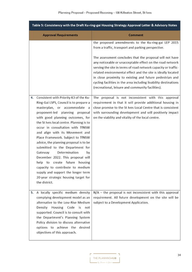
6. Council is to commit to a work program to identify areas for additional medium density housing opportunities outside of primary local centres such as Roseville Chase, Killara, Pymble, Wahroonga, West Gordon and North St Ives as identified in the Ku-ring-gai LSPS for potential delivery in the 2031 to 2036 period. A Planning Proposal(s) for these centres is to be submitted to the Department for a Gateway determination by December 2023. Where this work is not pursued by Council the Department welcomes place-based approaches by landowner/developers to explore opportunities for additional medium density housing in locations that are well serviced by transport, services and facilities.
At OMC 16 November 2021 Council resolved to reject the Housing Strategy conditions of approval. As Council has not committed to a work program, the subject Planning Proposal submitted by the landowners is consistent with the requirements of Condition 6. The Planning Proposal will enable a high density built form outcome on the site in an area that is close to public transport, services and facilities.
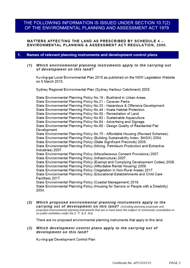
· Section 9.1 Ministerial Directions and State Environmental Planning Policies (SEPPs).
The Planning Proposal is not inconsistent with the State Environmental Planning Policies (SEPPs) applicable to the site. Many of these SEPPs contain detailed provisions and controls which would only apply at the Development Application stage.
The Planning Proposal is consistent with the applicable s9.1 Ministerial Direction, specifically those relating to:
- 5.1 Integrating Land Use and Transport
- 6.1 Residential Zones
The objective of direction 6.3 is to discourage unnecessarily restrictive site-specific planning controls, and 4(c) outlines that a Planning Proposal must allow that land use on the relevant land without imposing any development standards or requirements in addition to those already contained in the principal environmental planning instrument being amended. (6) notes that a Planning Proposal may be inconsistent with this direction, if the provisions are of a minor significance.
In order to ensure that future development on the site enabled by the Planning Proposal responds appropriately to the biodiversity values identified on the site, there is a need to update the Terrestrial Biodiversity Map in the KLEP 2015 and Greenweb Maps in the DCP. It is considered that if this action is inconsistent with direction 6.3, it is minor in nature and justifiable to ensure the best built form outcomes on the site.
Amendments required to be made to the Planning Proposal and the supporting documentation
The assessment of the Planning Proposal has found that there are a number of errors, inconsistencies and lack of detail or analysis provided within the documents that require adjustment. There are other amendments required as a result of Council’s assessment, such as incorporating an amendment to the KLEP 2015 Terrestrial Biodiversity Map as part of the Planning Proposal and amending the Greenweb Maps in the DCP.
The Table of Assessment included at Attachment A10 details the required amendments to be made to the Planning Proposal if Council is to support it being submitted to the Department of Planning and Environment for a Gateway Determination and proceed to public exhibition.
integrated planning and reporting
Theme 3: Places, Spaces and Infrastructure
|
Community Strategic Plan Long Term Objective |
Delivery Program Term Achievement |
Operational Plan Task |
|
P1.1 Ku-ring-gai’s unique visual character and identity is maintained
|
P1.1.1 Strategies, plans and processes are in place to protect and enhance Ku-ring-gai’s unique visual and landscape character |
P1.1.1.1 Continue to review the effectiveness of existing strategies, plans and processes across all programs.
|
|
P2.1 A robust planning framework is in place to deliver quality design outcomes and maintain the identity and character of Ku-ring-gai |
P2.1.1 Land use strategies, plans and processes are in place to effectively managed the impact of new development |
P2.1.1.2 Continue to review the effectiveness of existing strategies, local environmental plans, development control plans and processes across all programs |
Governance Matters
The process for the preparation and implementation of Planning Proposals is governed by the provisions contained in the Environmental Planning and Assessment Act 1979 and the Environmental Planning and Assessment Regulation 2000.
If Council fails to make a decision within 90 days (from the commencement of the review of the application) or if Council makes a decision to not support the Planning Proposal, the proponent can request the Department of Planning and Environment for a Rezoning Review.
Local Planning Panels Direction – Planning Proposals issued by the Minister for Planning under Section 9.1 of the Environmental Planning and Assessment Act 1979 requires Council to refer all Planning Proposals prepared after 1 June 2018 to the Local Planning Panel for advice, before the Planning Proposal is forwarded to the Minister for a Gateway Determination under Section 3.34 of the Environmental Planning and Assessment Act 1979.
Risk Management
This is a privately initiated Planning Proposal. Council needs to determine its position on the matter as to whether the Planning Proposal should be sent to the Department of Planning and Environment for a Gateway Determination and proceed to public exhibition.
Council risks damage to its reputation if it does not undertake strategic land use planning in an effective and timely manner.
Financial Considerations
The Planning Proposal was subject to the relevant application fee under Council’s 2021/2022 Schedule of Fees and Charges. The cost of the review and assessment of the Planning Proposal is covered by this fee.
Social Considerations
The amendments sought by the Planning Proposal will enable the delivery of approximately 40 dwellings of varying sizes on the subject site to meet the existing and future requirements of a growing and changing community.
Environmental Considerations
The vegetation on the subject site is not mapped as STIF or any other recognisable community in Ku-ring-gai or NSW databases, likely due to the presence of exotic and non-locally native canopy species obfuscating the identity of the small and discontinuous areas of STIF on the site. A Biodiversity Impact Assessment and an Arborist Report have been submitted with the Planning Proposal. Council’s Natural Areas Program Leader has reviewed the Planning Proposal and the potential environmental impacts of the Planning Proposal have been considered in this assessment.
To facilitate accurate environmental assessment, it is recommended that an amendment to the relevant Terrestrial Biodiversity Map Sheet in the Ku-ring-gai Local Environmental Plan 2015 be incorporated into the Planning Proposal as well as a variation to the DCP’s Greenweb Maps in accordance with the Ku-ring-gai Biodiversity and Riparian Lands Study Version 5 to include and categorise this occurrence of STIF. Updating the Terrestrial Biodiversity Map Sheet to include the occurrence of STIF on the site will ensure that Clause 6.3 Biodiversity protection will apply to the site and any future development must be consistent with the provisions of the clause.
Community Consultation
In the event that the Planning Proposal is issued a Gateway Determination by the Department of Planning and Environment, the Planning Proposal would be placed on statutory public exhibition in accordance with the requirements of the Gateway Determination, and Council’s Community Participation Plan.
Internal Consultation
The assessment of the Planning Proposal has included internal consultation with Council’s staff with expertise in planning, urban design, traffic and transport and biodiversity and has informed the recommendations of this Report.
Summary
The Planning Proposal has been assessed and found to have sufficient strategic and site specific merit to enable it to proceed to Gateway Determination and public exhibition, subject to the amendments outlined in Attachment A10 including the following:
· Planning Proposal (Attachment A2)
- Include an analysis that considers the objectives of the Greater Sydney Region Plan in Section B of the Planning Proposal.
- Include the amendment to the Terrestrial Biodiversity Map in Part 4 of the Planning Proposal.
· Concept Architectural Plans and Urban Design Report (Attachments A4 and A5)
- Amend the urban design of the proposed plan by varying the depth of the wall planes, supplemented with architectural elements.
- Modify the western elevation of the building to comply with controls 16 and 17 of Section 7C.6 of the DCP.
- Amend the design to ensure compliance with the top floor GFA allowance within the DCP.
- Include a separate diagram showing Site Coverage Calculations.
- Amend the location of the driveway and the proposed basement layout to comply with the requirements of Section 7A.3 of the DCP as well as tree protection as noted in the comments provided on the Biodiversity Impact Assessment.
· Biodiversity Impact Statement (Attachment A6)
- Amend the planting palette to be comprised of STIF species.
- Amend to Arborist Report to rectify the incorrectly identified trees.
· Arborists Report (Attachment A9)
- Amend the Tree Schedule within the Arborist Report to incorporate the identified trees to facilitate appropriate protection.
Should the Planning Proposal proceed, it should be accompanied by an amendment to the Ku-ring-gai Development Control Plan to update the Greenweb Map to be consistent to the proposed amendments to the Terrestrial Biodiversity in the KLEP 2015.
That the Ku-ring-gai Local Planning Panel advises Council that:
The Planning Proposal, amended as per the Table of Assessment at Attachment A10, be submitted to the Department of Planning and Environment for a Gateway Determination.
|
Angela Smidmore Urban Planner |
Craige Wyse Team Leader Urban Planning |
|
Antony Fabbro Manager Urban & Heritage Planning |
Andrew Watson Director Strategy & Environment |
|
Attachments: |
A1 |
Pre-Planning Proposal Meeting Report |
|
2022/014813 |
|
|
A2 |
Planning Proposal |
|
2022/222442 |
|
|
A3 |
B. Survey Plan |
|
2022/222456 |
|
|
A4 |
C. Concept Architectural Plans |
|
2022/222459 |
|
|
A5 |
D. Urban Design Report |
|
2022/222460 |
|
|
A6 |
E. Biodiversity Impact Assessment |
|
2022/222468 |
|
|
A7 |
F. Traffic and Transport Report |
|
2022/222472 |
|
|
A8 |
G. Preliminary Site Investigation |
|
2022/222475 |
|
|
A9 |
H. Arborist Report |
|
2022/222477 |
|
|
A10 |
Table of Assessment |
|
2022/194828 |