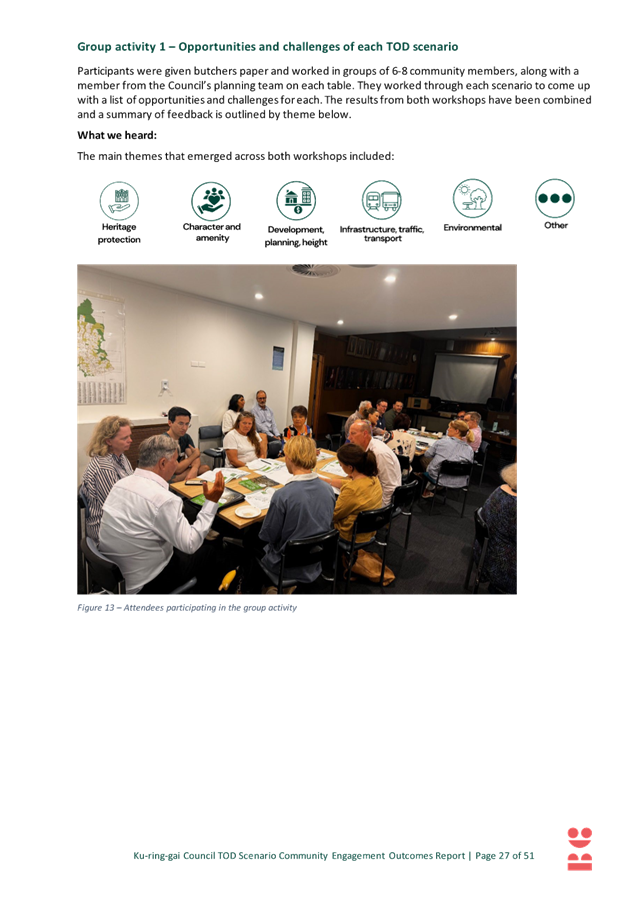
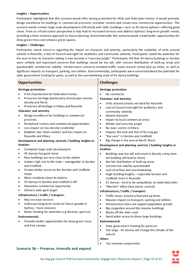
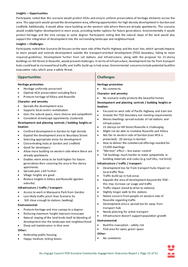
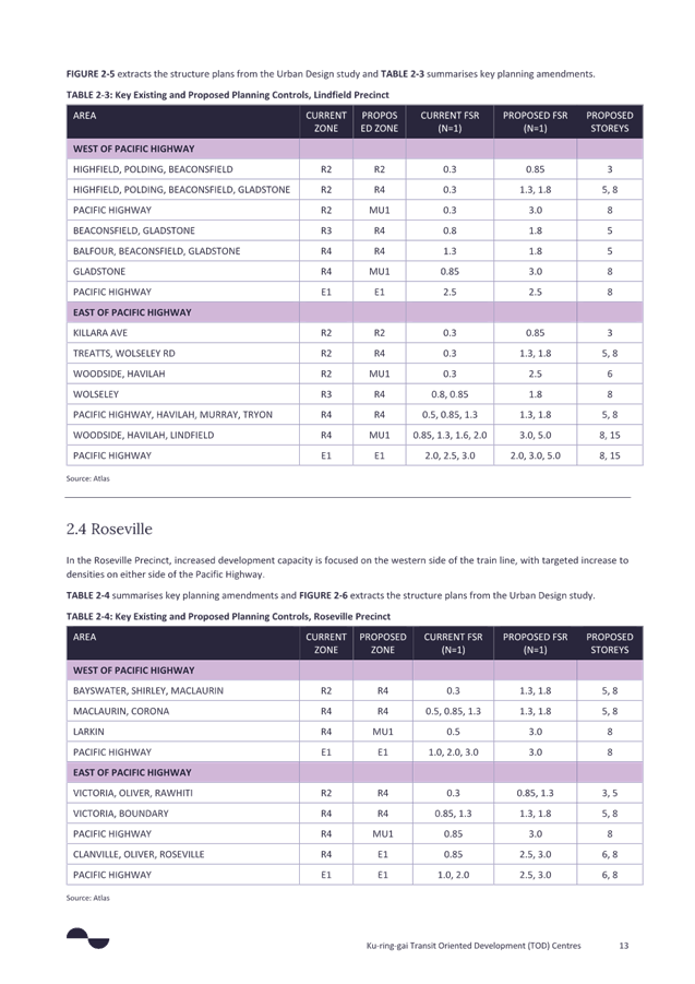
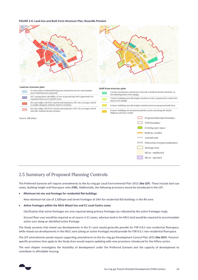
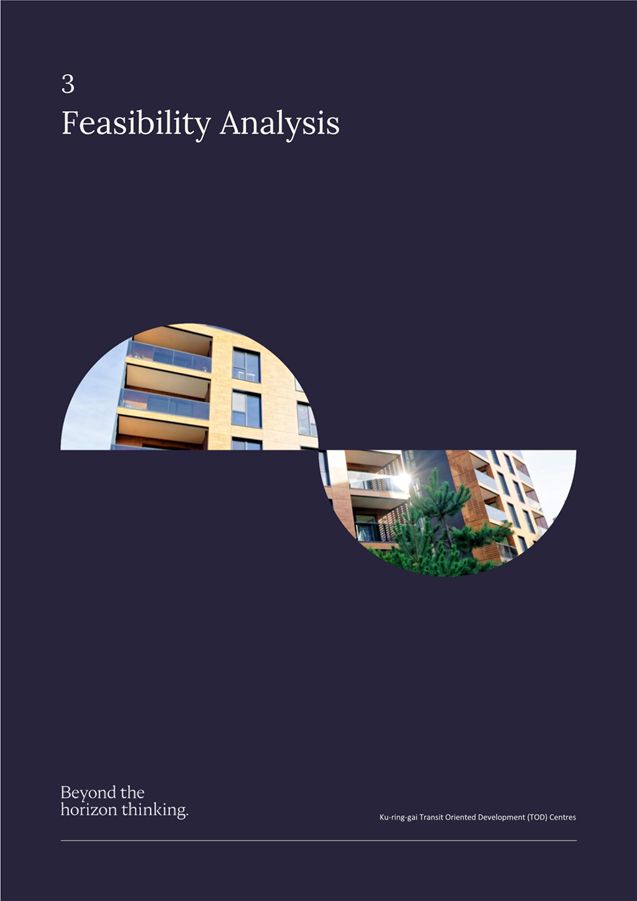
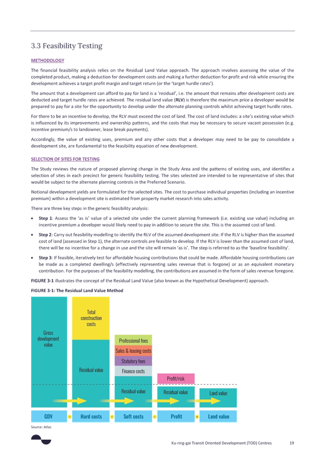
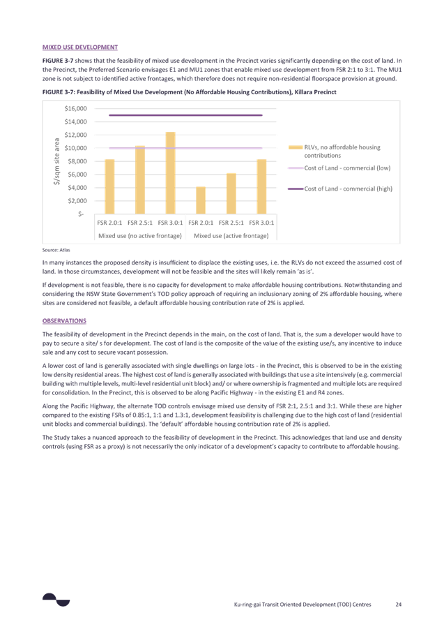
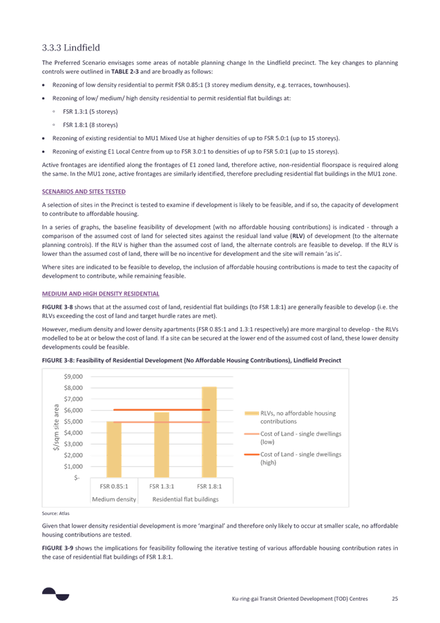
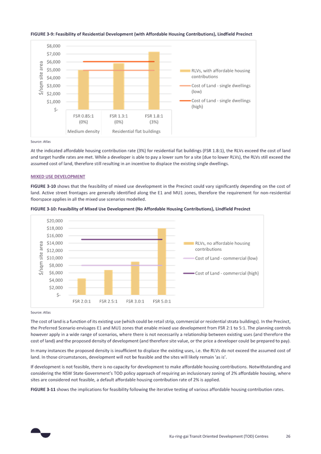
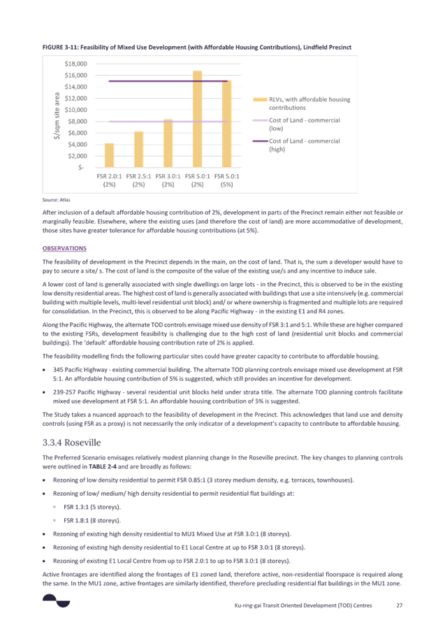
|
Extraordinary Meeting - 31 March 2025 |
GB.1 / 1 |
|
|
|
|
Item GB.1 |
S14427 |
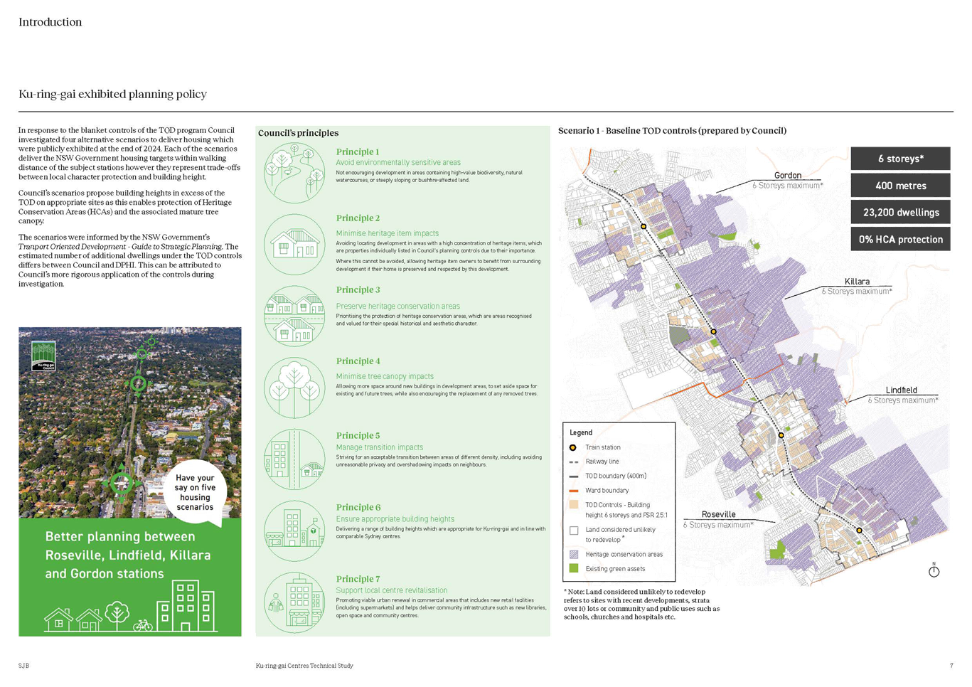
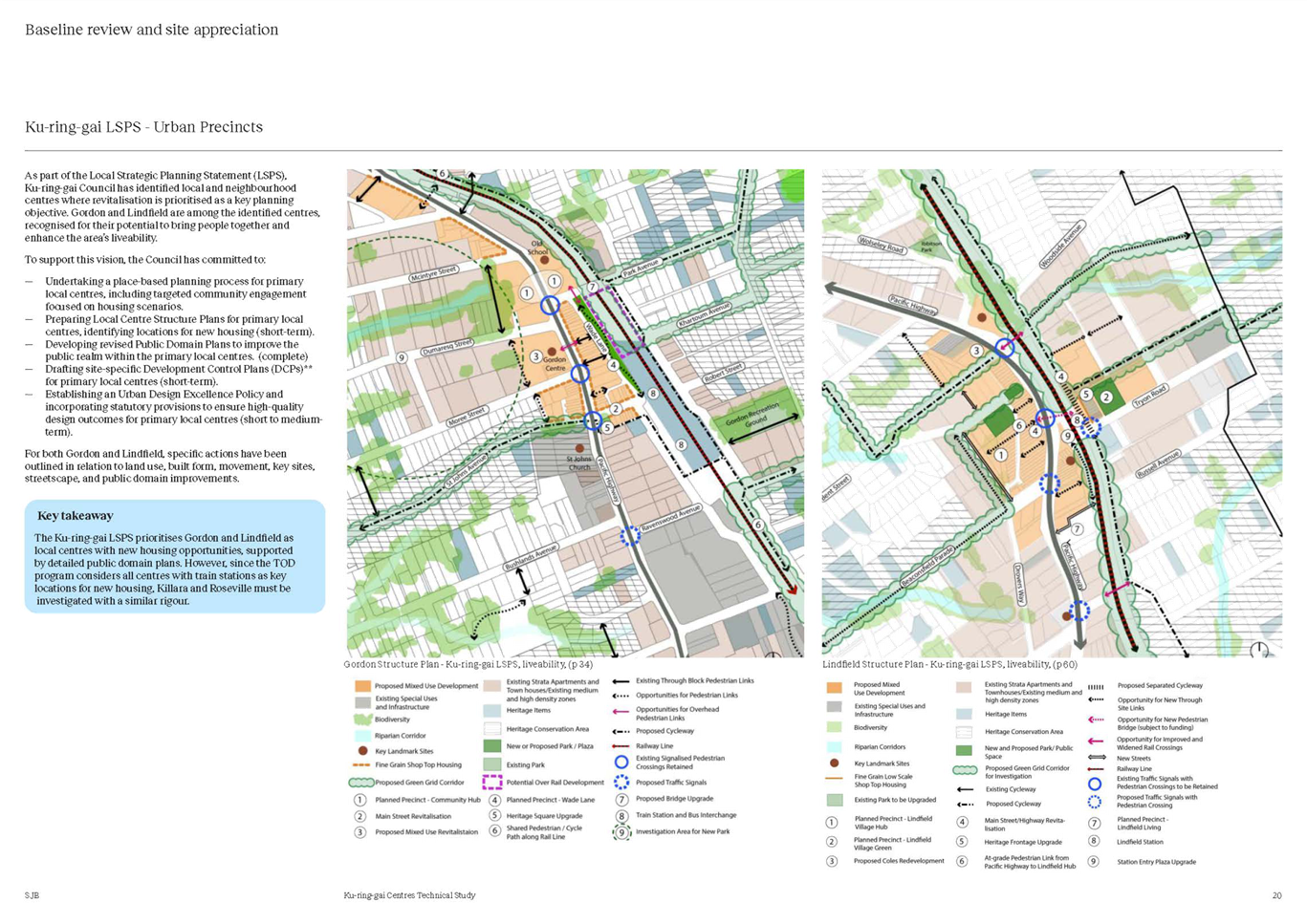
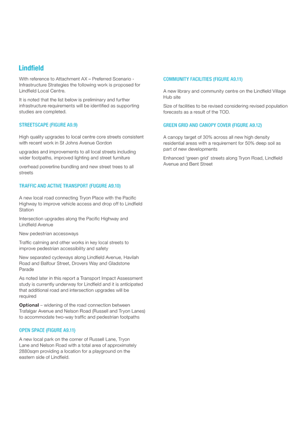
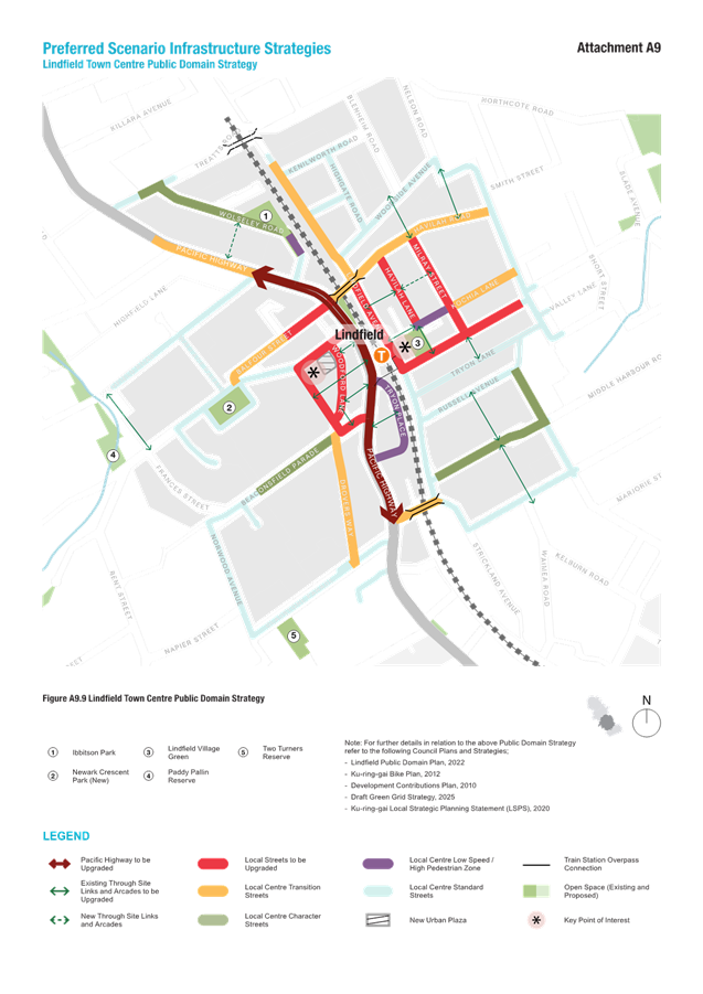
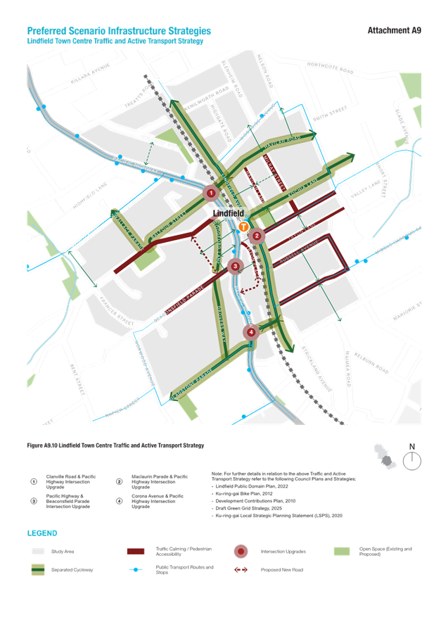
TOD alternatives - post-exhibition - preferred scenario, masterplan and implementation strategy
EXECUTIVE SUMMARY
PURpose
To seek Council endorsement of a Preferred Scenario and Implementation Strategy for public exhibition.
Background
At the Extraordinary Meeting of Council of 30 October 2024 Council resolved to:
A. Receive and note the contents of this report on alternative scenarios to the TOD SEPP amendments for the corridor between Roseville and Gordon stations.
B. Note that the base case (Scenario 1) represents the TOD SEPP as gazetted, not planning controls that pre-existed the TOD amendments.
C. Note that the primary objectives for the alternate scenarios outlined in this report are:
i. to retain and protect Heritage Conservation Areas (HCAs);
ii. to improve urban canopy outcomes; and
iii. meet the dwelling targets stipulated by the State Government for the TOD Program.
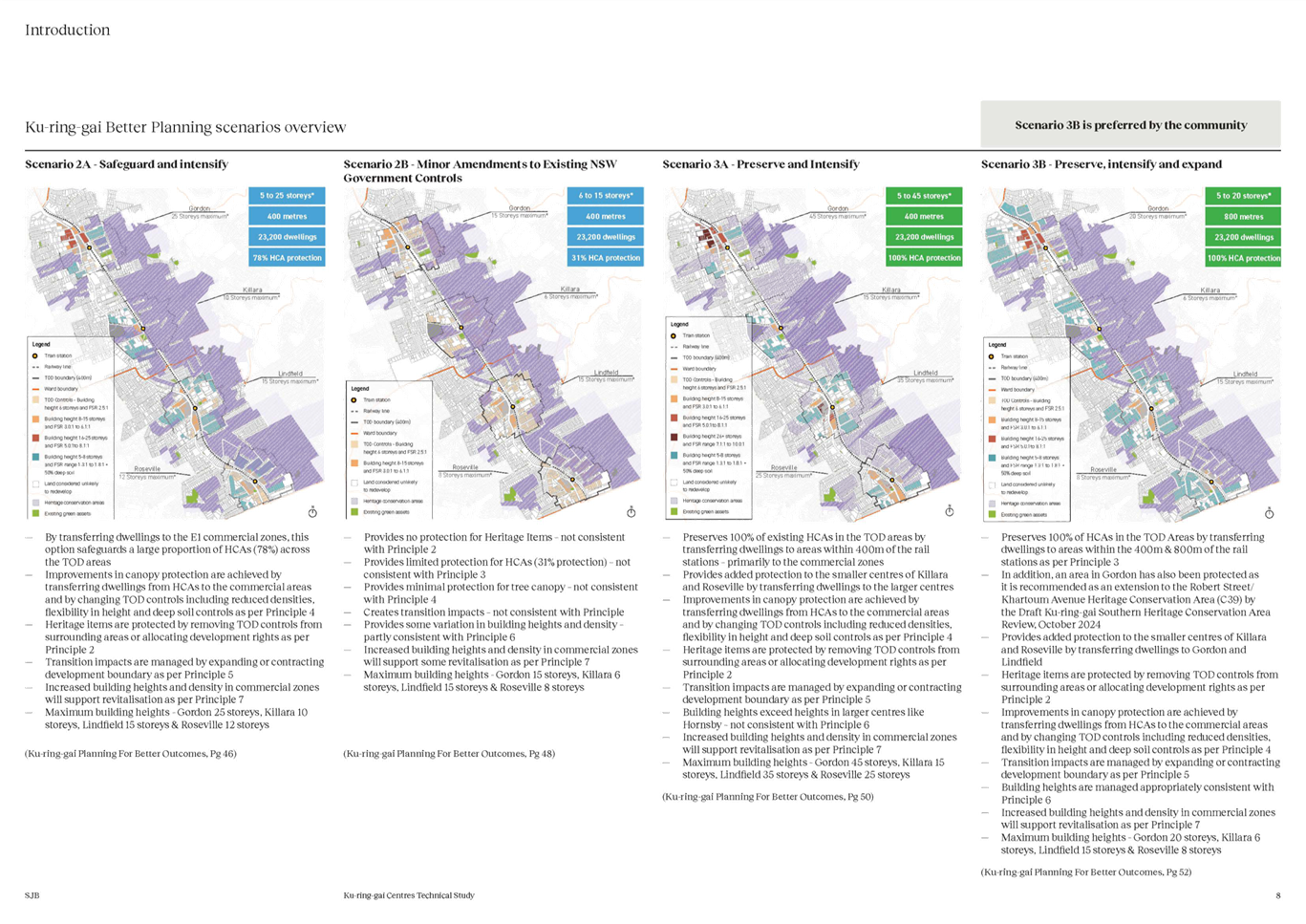
D. Place Scenario 1 TOD (base case) on public exhibition for comparative purposes.
E. Place Scenario 2 on public exhibition.
F. Place Scenario 3a on public exhibition.
G. Place Scenario 3b on public exhibition.
H. Place Scenario 2b on public exhibition, noting it requires further development prior to exhibition, as per the memorandum from the Director Strategy and Environment dated 29 October 2024.
I. Note that a report will be submitted to Council’s February Ordinary Meeting outlining the outcomes of community engagement in relation to alternative scenarios to the TOD SEPP amendments.
This report is in response to resolutions D through to I inclusive.
Comments
This report will describe the process of developing a Preferred Scenario and accompanying studies for Council consideration, specifically:
1. Identifying the community preference – what is the best outcome in terms of community and planning?
2. Refining the community preference – what inputs have been considered?
3. Describing the Preferred Scenario – how does it differ from Scenario 3b?
4. Comparison between TOD and Council’s Preferred Scenario - how does it differ from Scenario 1 (the TOD).
5. Evaluating the Preferred Scenario – how does it compare with TOD?
6. Implementation Strategy – how will the Preferred Scenario be converted to an LEP and DCP?
7. Infrastructure Strategies – what community infrastructure is required to support the additional population?
8. Supporting Studies – what other studies are underway or will be required?
9. Affordable Housing – what will the contributions be?
10. Interaction with Low and Mid-rise SEPP – what are the potential impacts of this new policy?
1. Identification of the Community’s Preference
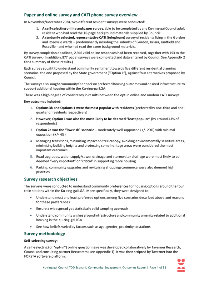
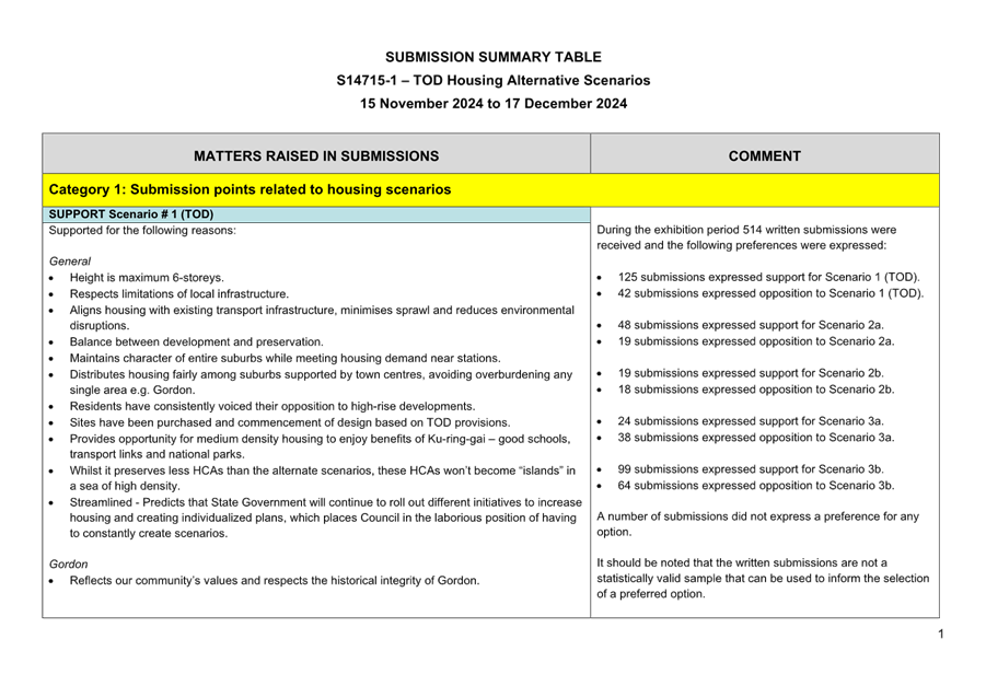
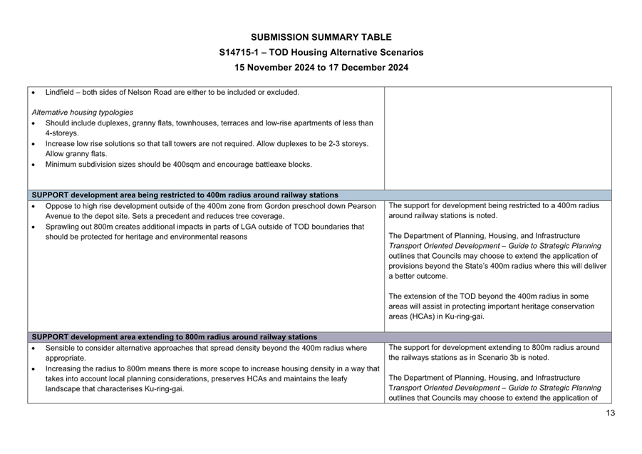
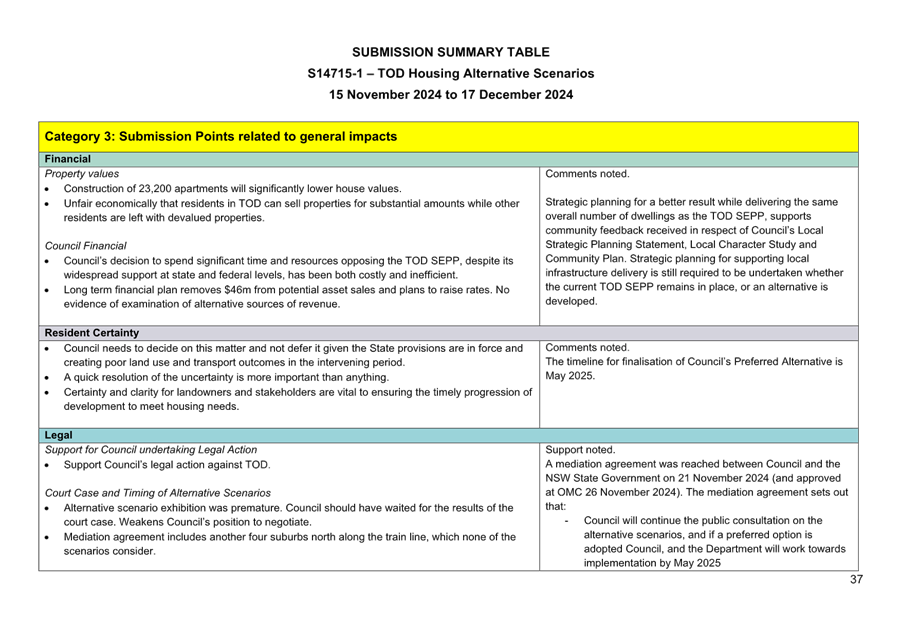
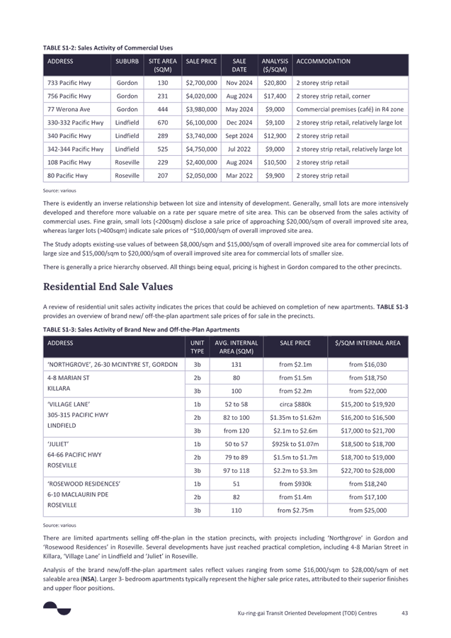
Council held a 4-week public exhibition of Council’s Alternative TOD Scenarios from 15 November 2024 to 17 December 2024. Council sought feedback on five housing scenarios and residents were offered a variety of ways to get involved and provide feedback, further detail is provided in the Consultation section of this report.
Assessing the exhibited scenarios and identifying a community preference has involved consideration of:
- the results of community surveys;
- the results of community workshops; and
- written submissions.
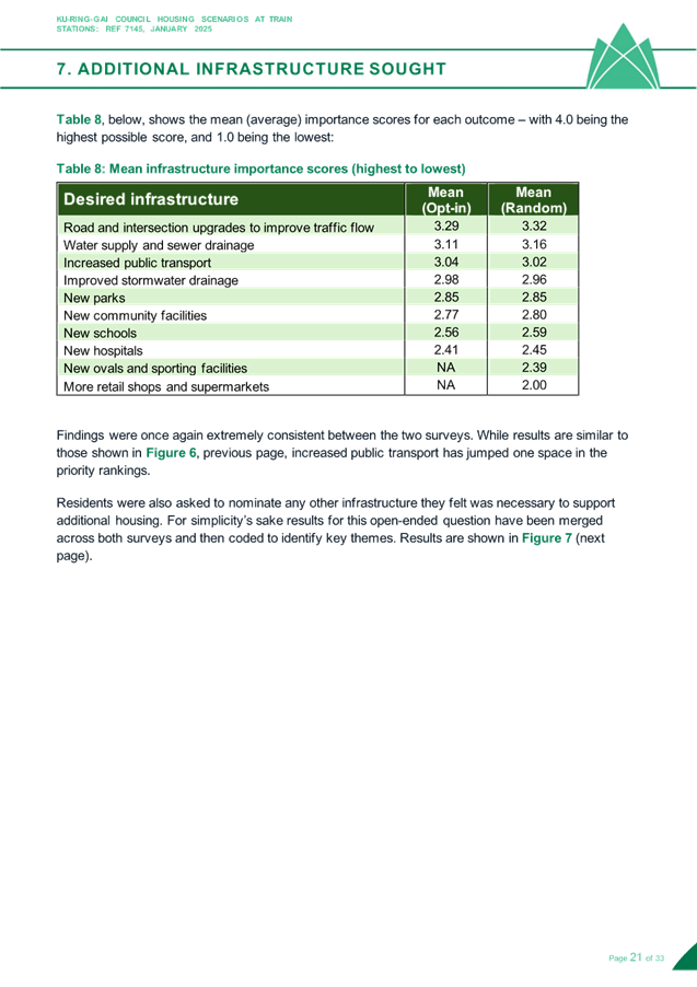
Survey Results
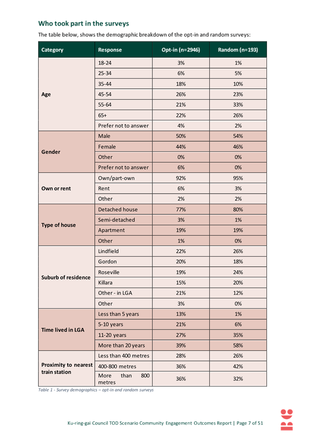
Taverner Research Group (Taverner) were engaged to prepare a survey that would assist Council to understand the community preferences for housing options around the four train stations of Gordon, Killara, Lindfield and Roseville. The methodology and results of the survey are documented in a report which is attached to this report at Attachment A1 – TOD Engagement Outcomes Report Revised - Becscomm – February 2025.
The survey involved a two-tier approach involving:
:
- a self-selecting online and paper survey, able to be completed by any Ku-ring-gai Council resident who had read the background materials supplied by Council; and
- a randomly selected, representative survey of residents living in the Gordon and Roseville wards and who had read the background materials.
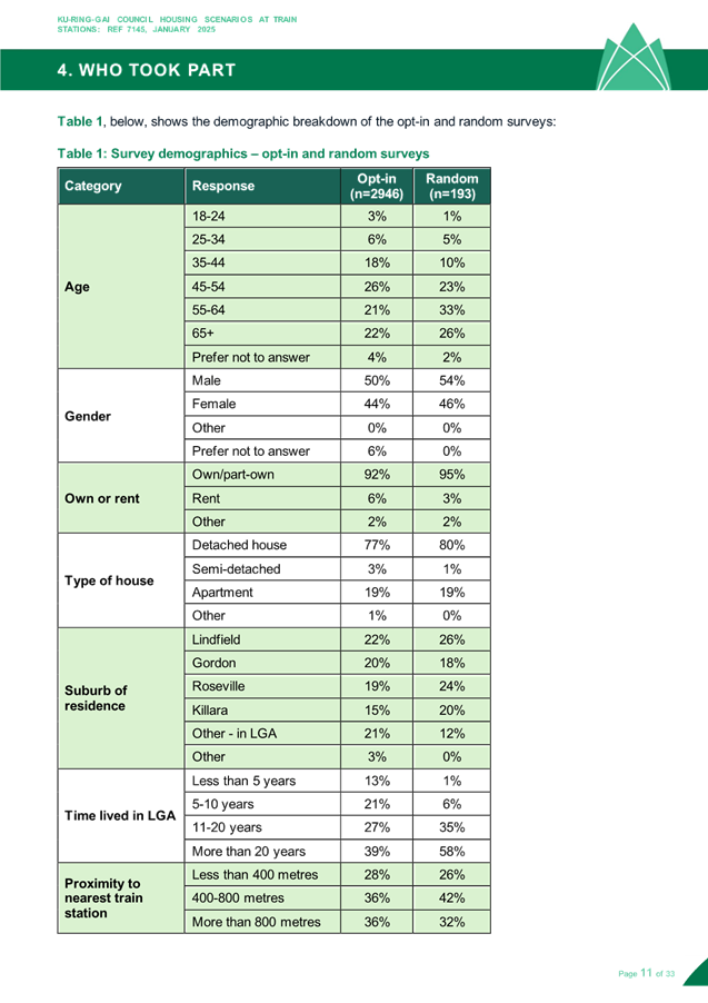
The final sample size was over 3,000 people including 2,946 residents for the opt-in survey and 193 residents for the representative survey. The large sample size can give Council a high degree of confidence that the results would replicate the views of the Ku-ring-gai adult community (to within +/- 1.8% at the 95% confidence level).
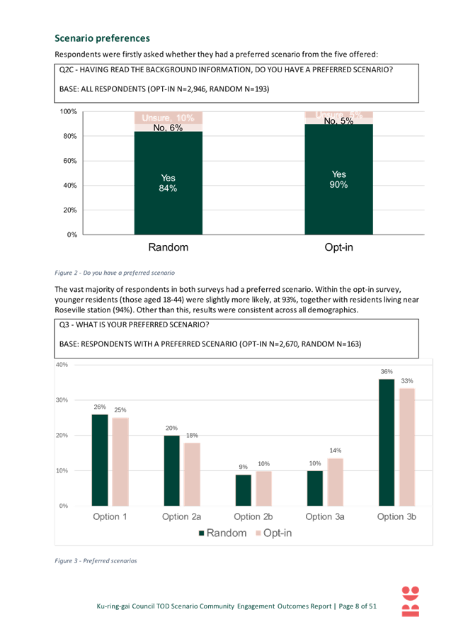
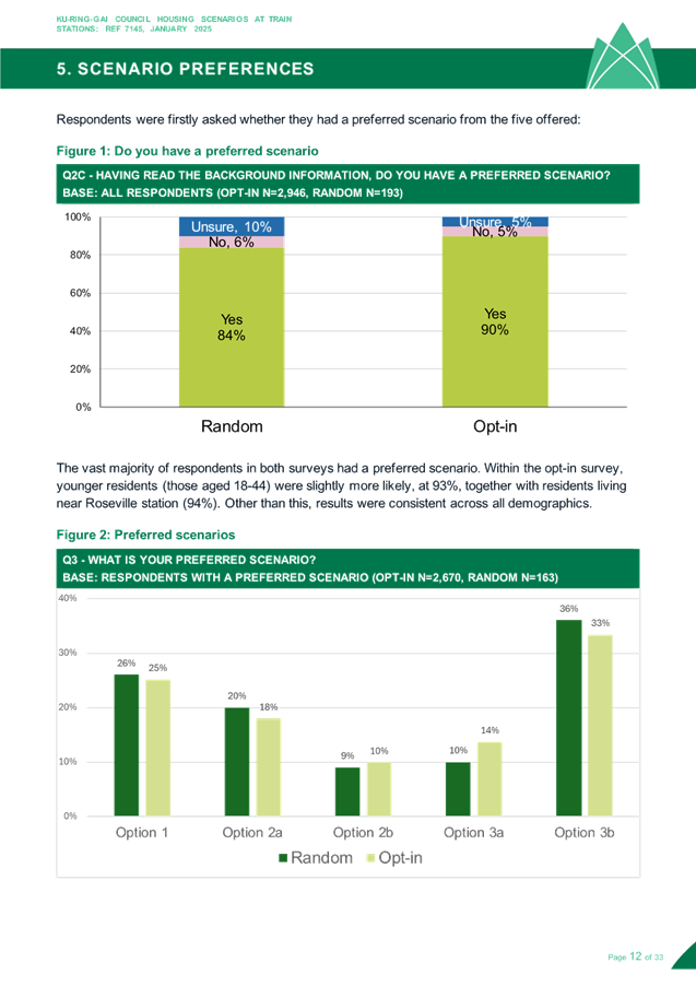
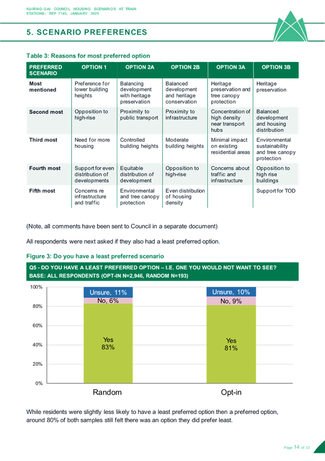
Also of note was that most respondents in both surveys had a preferred scenario, indicating the 5 scenarios provided a comprehensive choice, and few people were left unable to select a preference.
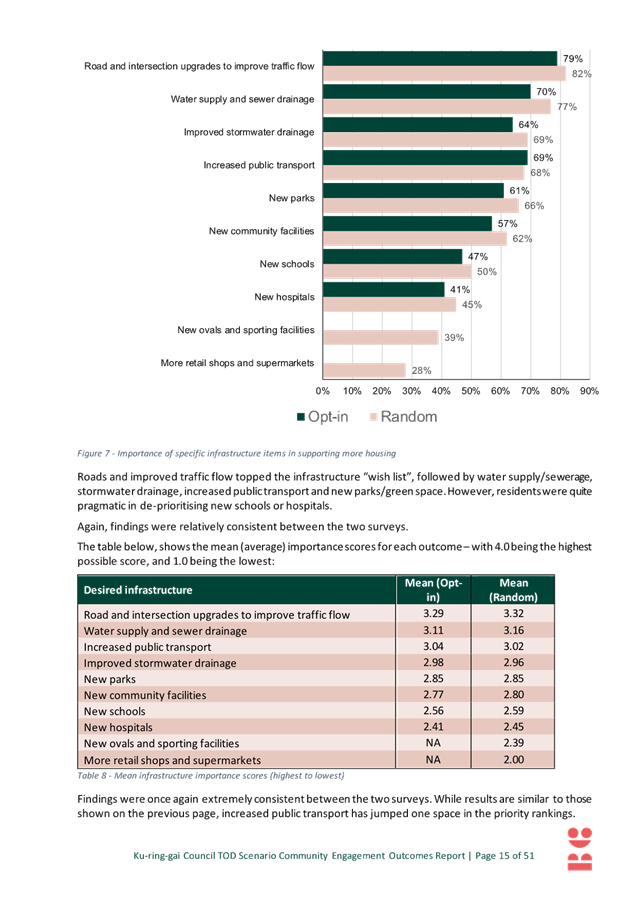
Survey Results - Most Preferred
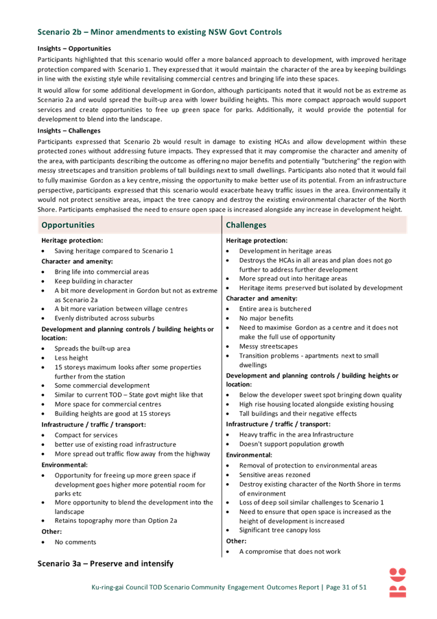
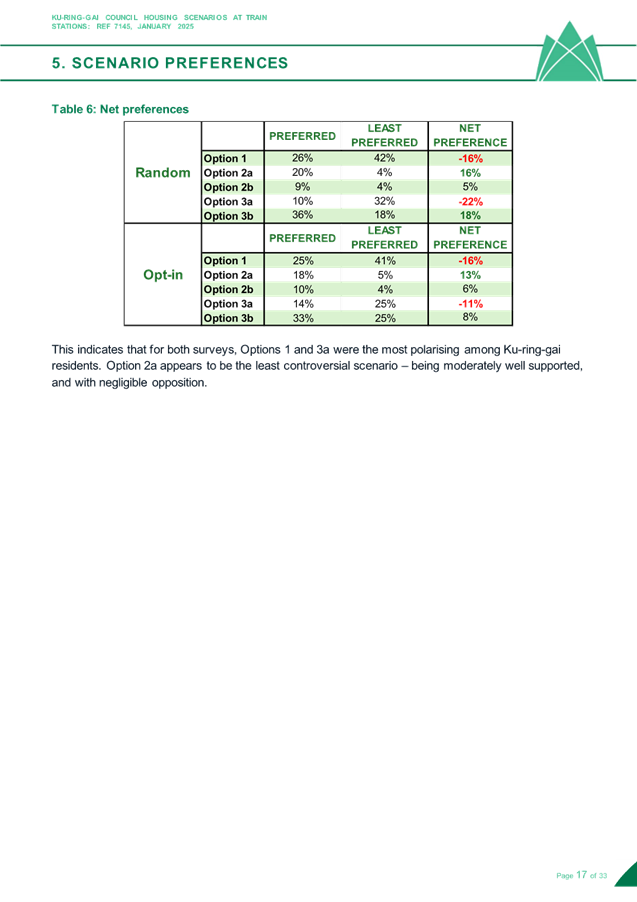
The results of the survey are as follows:
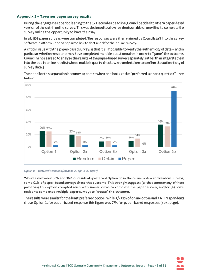
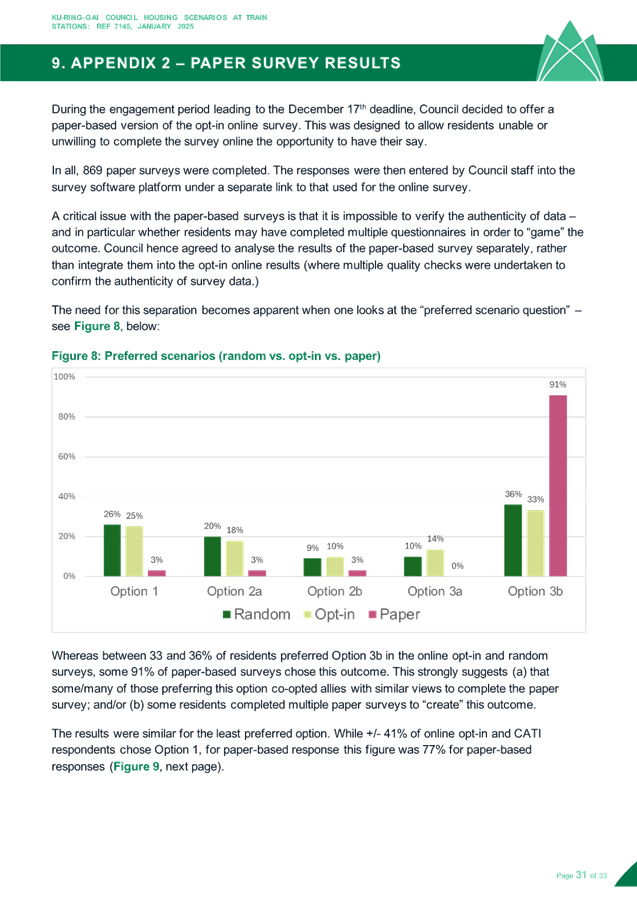
- Option 3b was the preferred scenario in both surveys (36% random, 33% opt-in);
- Option 1 was the second preference in both surveys (26% and 25%);
- Option 2a was the third preference in both surveys (20% and 18%); and
- Options 2b and 3a gathered relatively little support (9-10% & 10-14% respectively).
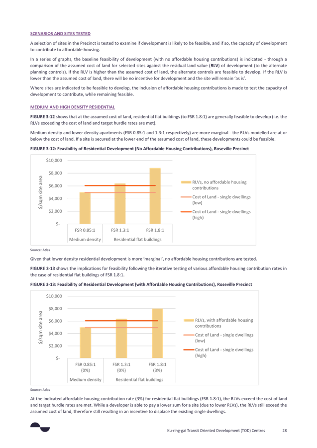
Council’s alternative scenarios (2a, 2b, 3a & 3b) considered together were preferred by approximately ¾ of all respondents across both surveys, whereas Option 1 was preferred by only ¼ of respondents across both surveys.
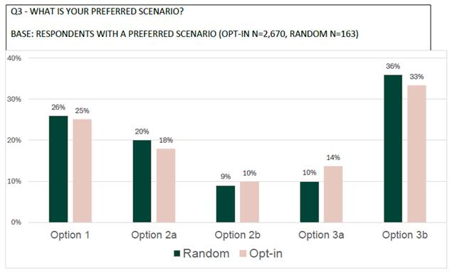 Figure 1 – survey results
– most preferred
Figure 1 – survey results
– most preferred
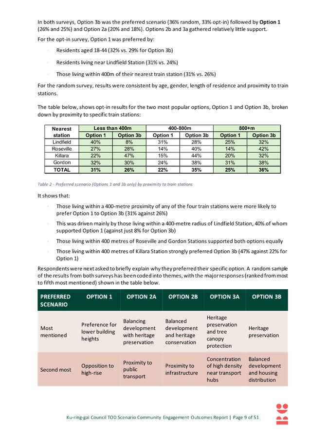
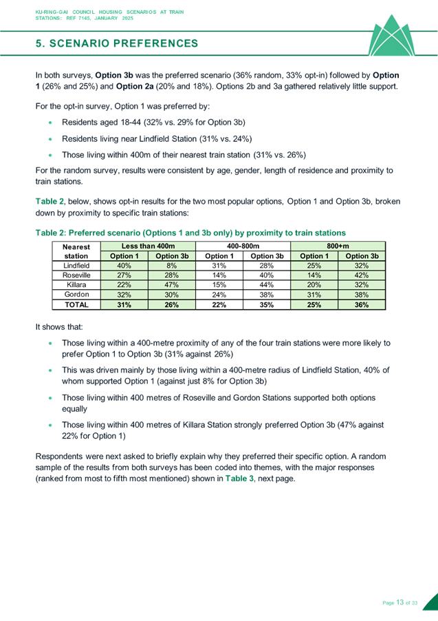
Residents living within a 400-metre proximity of any of the four train stations were more likely to prefer Option 1 to Option 3b by a margin of 5% (31% against 26%). This was particularly notable for those living within a 400-metre radius of Lindfield Station, 40% of whom supported Option 1 against just 8% for Option 3b (difference of 32%). Those living within 400 metres of Roseville and Gordon Stations supported both options equally, while those living within 400 metres of Killara Station strongly preferred Option 3b by a margin of 25% (47% against 22% for Option 1).
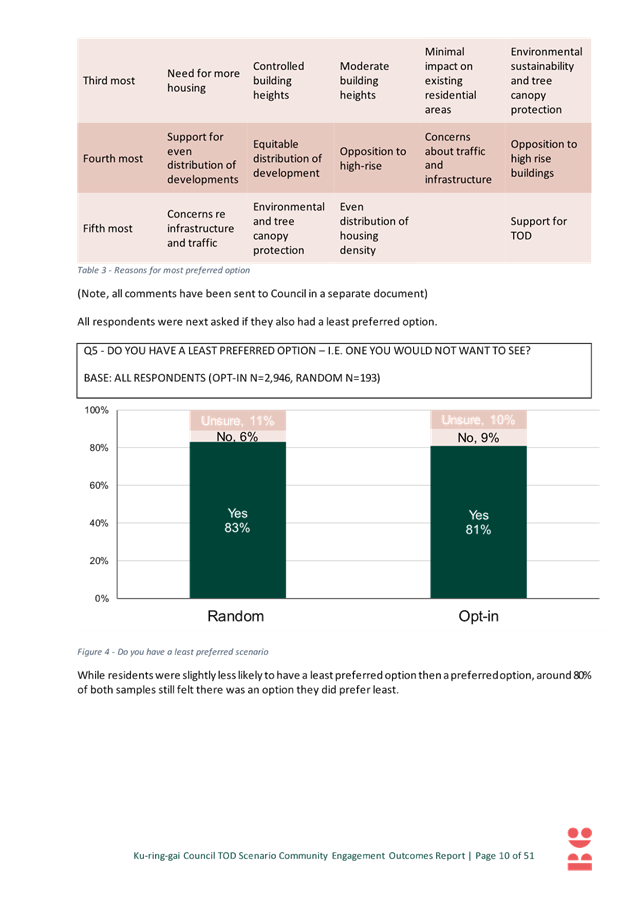
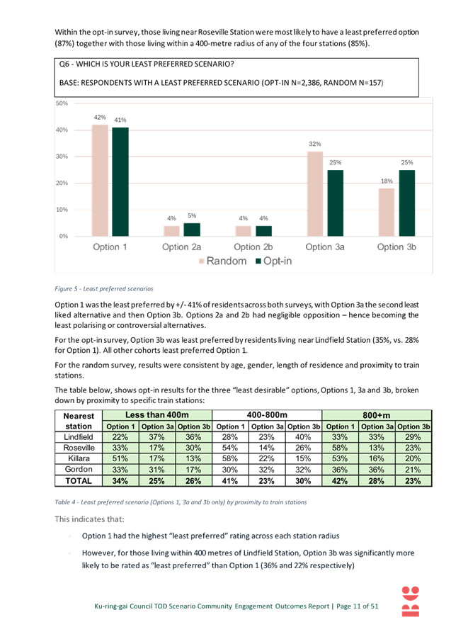
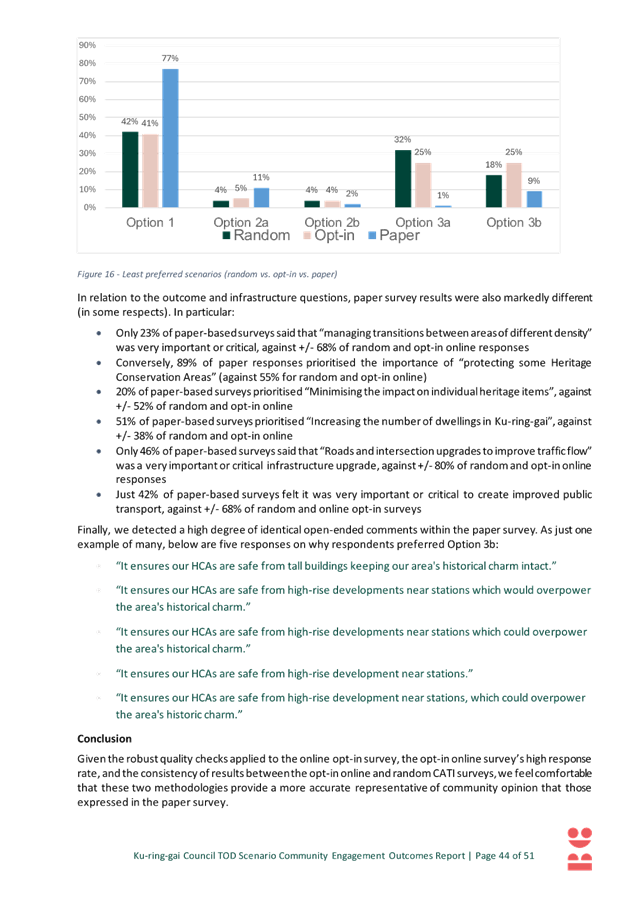
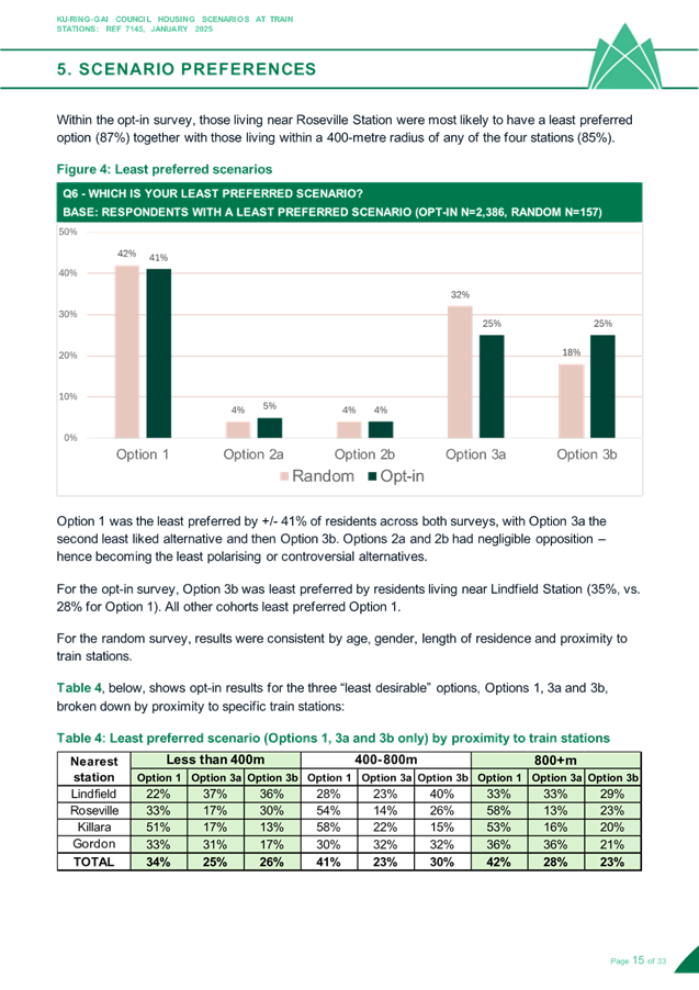
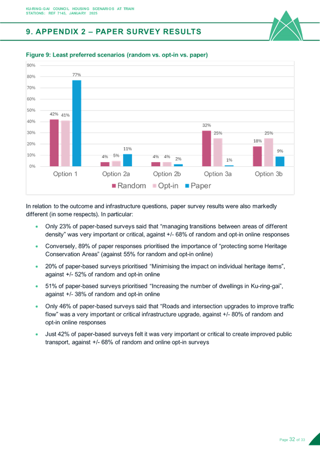
Survey Results - Least Preferred
Residents were asked which of the options are least preferred, the results of the survey are as follows:
- Option 1 was the least preferred by about 41% of residents across both surveys;
- Option 3a was the second least liked alternative (32% random, 25% opt-in);
- Option 3b the third least liked (18% random, 25% opt-in); and
- Options 2a and 2b had negligible opposition.
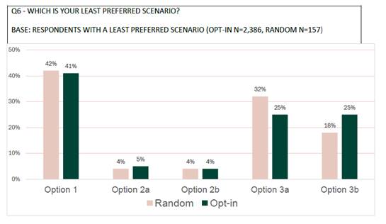
Figure 2 - Survey Results - Least Preferred
When the opt-in results for the three “least desirable” options are broken down by proximity to specific train stations Option 1 had the highest “least preferred” rating across each station radius. However, for those living within 400 metres of Lindfield Station, Option 3b was significantly more likely to be rated as “least preferred” than Option 1 (36% and 22% respectively). Conversely, those living in proximity to Killara and Gordon Stations were significantly more likely to oppose Option 1. These results are broadly consistent with the most preferred.
When the most and least preferred options are netted out (i.e. most minus least) the results for both surveys show Options 1 and 3a were the most polarising among Ku-ring-gai residents. Option 2a appears to be the least controversial scenario – being moderately well supported, and with negligible opposition.
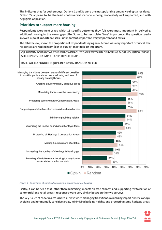
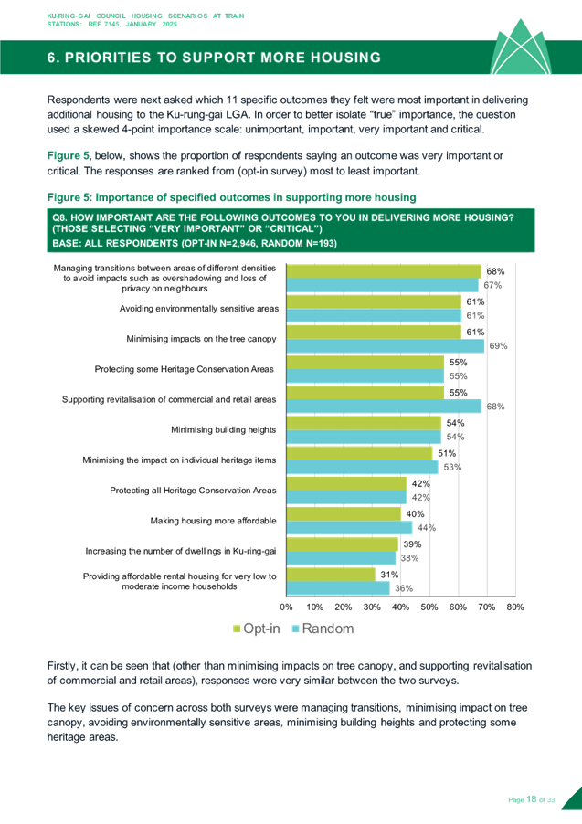
Survey Results – Outcomes to Support More Housing
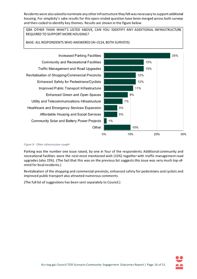
Respondents were asked which 11 specific outcomes they felt were most important in delivering additional housing to the Ku-rung-gai LGA. The responses are ranked below from (opt-in survey) most to least important.
1. Managing transitions between areas of different densities to avoid impacts such as overshadowing and loss of privacy on neighbours;
2. Avoiding environmentally sensitive areas;
3. Minimising impacts on the tree canopy;
4. Minimising building heights;
5. Protecting some Heritage Conservation Areas;
6. Supporting revitalisation of commercial and retail areas;
7. Minimising the impact on individual heritage items;
8. Making housing more affordable;
9. Increasing the number of dwellings in Ku-ring-gai;
10. Protecting all Heritage Conservation Areas; and
11. Providing affordable rental housing for very low to moderate income households
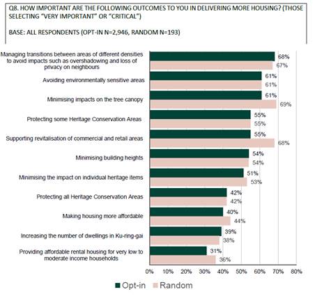
Figure 3 - Survey Results – Importance of Specified Outcomes to Support More Housing
Survey Results – Discussion
The surveys provided residents with the opportunity for surface-level engagement. Many respondents opposed high-rise development, especially near heritage areas. Self-selecting online/paper surveys captured strong pre-existing views, while phone surveys provided a broader but less detailed perspective.
The major concerns include heritage protection, tree canopy loss, minimising building heights, and infrastructure (traffic, roads, parking).
Based on the results of the survey the community’s preferred alternative is scenario 3b which is characterised by full protection of HCAs, moderate building heights, and extension of the development area to 800m from the rail station. The concept of an extended development area is unique to option 3b therefore it may be interpreted that the community is willing to trade-off additional spread of development to maintain moderate building heights. Both Option 3b and 3a protected 100% of the HCAs and together they received 46-47% support. In contrast to 3b, option 3a received low levels of support, the difference may be explained by the proposed building heights in 3a which are up to 45 storeys. This supports the observation that the community may prefer to spread development (as per 3b) than concentrate it into very tall buildings (as per 3a).
The overall preference for 3b is consistent with the survey results showing the communities top three outcomes to support more housing are: managing transition impacts, avoiding environmentally sensitive areas and minimising impacts on tree canopy – all which 3b manages appropriately. Residents living in proximity to Killara station were significantly more likely to favour 3b (47%) given a large percentage of residents in this area live in HCAs or heritage items this might indicate many residents wish to stay living in this context and are not necessarily as motivated by potential windfall uplift available via the TOD.
Option 1 was the second most preferred option however it was also the least preferred by residents across both surveys. Scenario 1 is Council’s interpretation of the TOD and was presented to the community for comparative purposes. It is also notable that Lindfield residents living within a 400-metre proximity of Lindfield train station preferred option 1 by a significant margin. This is an interesting result given Lindfield has already experienced high levels of infill development. One explanation is that Lindfield residents may be more willing to accept density as they have already experienced considerable urban renewal, and the positive outcomes that come with this such as new cafes, restaurants and modern supermarkets.
Scenario 1, 2a and 2b are similar in that they all present different levels of protection for HCAs and together received 53%-55% of support. The preference for 2a is consistent with the survey results showing the communities top outcomes to support more housing which ranked Protecting some heritage conservation areas as the 5th most important consideration over Protecting all heritage conservation areas which ranked as 10th out of 11 outcomes. The preference for 2a may indicate that this option hit the right balance between heritage protection and other considerations, as noted by Taverner:
“Option 2a appears to be the least controversial scenario – being moderately well supported, and with negligible opposition”.
Recruited Workshops
Council engaged consultants (Becscomm) to manage two recruited in-person community workshops held at the Ku-ring-gai Council Chambers in Gordon. The report documenting methodology and results is attached to this report Attachment A1 – TOD Engagement Outcomes Report Revised - Becscomm – February 2025.
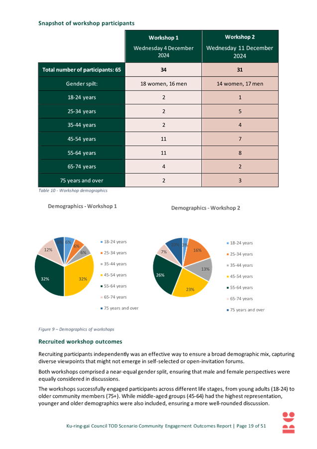
The workshops were independently recruited by Taverner Research and independently facilitated by Becscomm. Attendees were recruited residents or business owners from the suburbs of Roseville, Killara, Lindfield, or Gordon. There were 65 attendees over two nights representing a spread of demographics including age and gender and qualification metrics. All attendees live in, or own a business in Roseville, Killara, Lindfield, or Gordon
Workshops Results - Most and Least Preferred
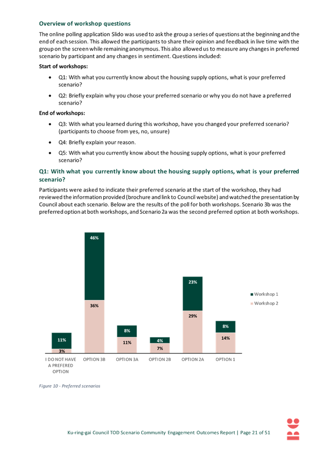
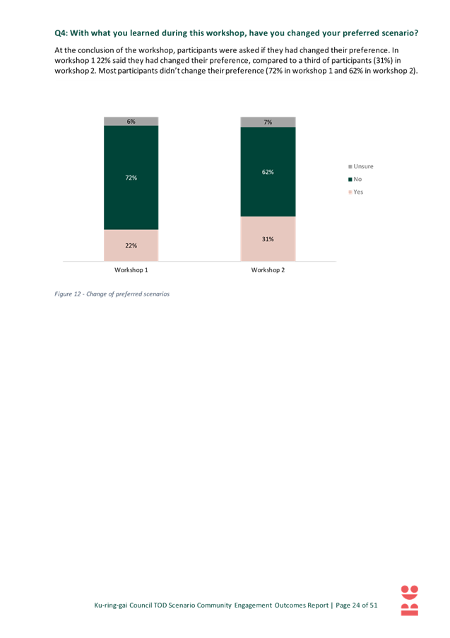
The results of the workshop are as follows:
- Scenario 3b was the clear preference at the end of both workshops (workshop 1 - 48% and workshop 2 - 57%);
- Scenario 2a was the second preferred option at the end of both workshops (38% and 22% respectively);
- Option 1 had low levels of support at both workshops (3% and 13%); and
- 2b and 3a were the least supported at both workshops (7% & 4% and 3% & 4% respectively).
Becscomm note in relation to option 3b that:
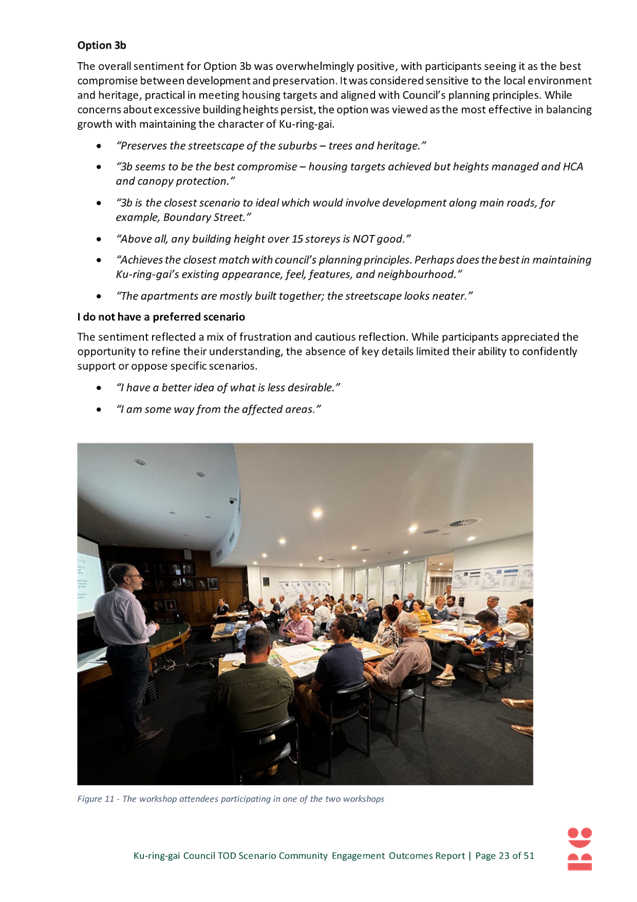
“[t]he overall sentiment for Option 3b was overwhelmingly positive, with participants seeing it as the best compromise between development and preservation. It was considered sensitive to the local environment and heritage, practical in meeting housing targets, and aligned with council’s planning principles. While concerns about excessive building heights persist, the option was viewed as the most effective in balancing growth with maintaining the character of Ku-ring-gai”.
And in relation to 2a:
“The overall sentiment for Option 2a was positive, with participants recognising it as a well-balanced, practical, and moderate approach to development. Its focus on preserving the area’s character, heritage, and environmental appeal while enabling sensible density makes it an appealing compromise. However, there remains strong resistance to overly tall buildings, reinforcing the desire for controlled and thoughtful urban growth”.
Workshop Results - Discussion
While the surveys captured initial opinions, often opposing high-rise development the workshops enabled deeper discussion and learning as well as more informed decision-making, leading to greater acceptance of balanced solutions like Option 2a. This highlights the value of interactive engagement alongside static survey responses.
Exposure to different perspectives led to more openness to compromise rather than outright opposition. Participants recognised trade-offs and acknowledged some density was necessary if well-managed.
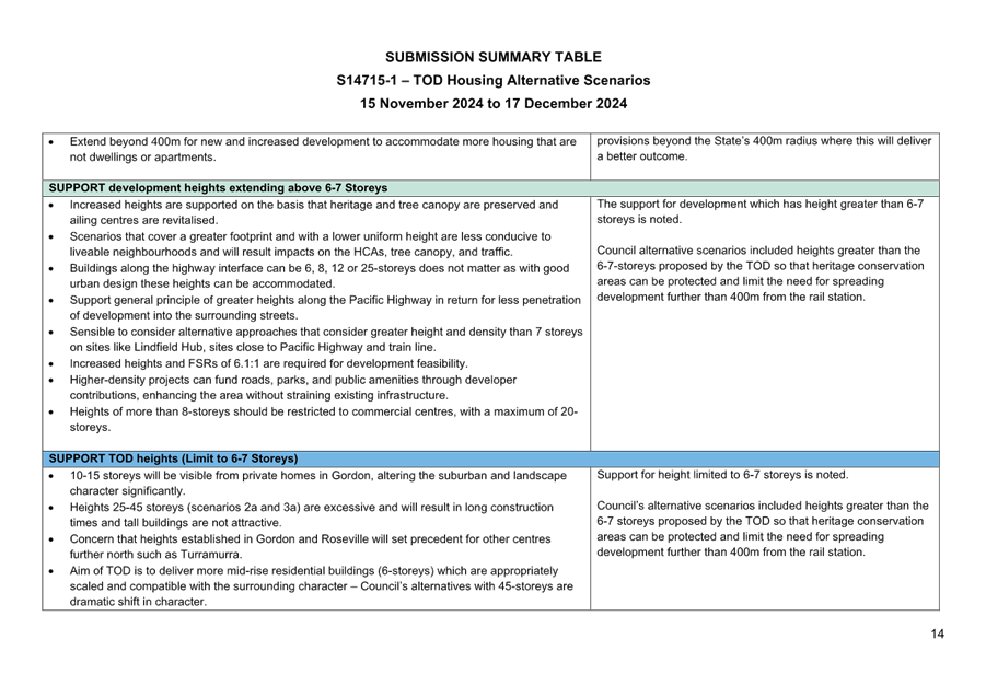
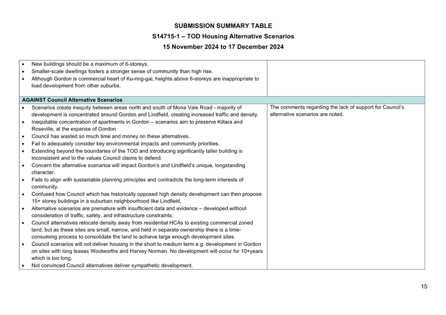
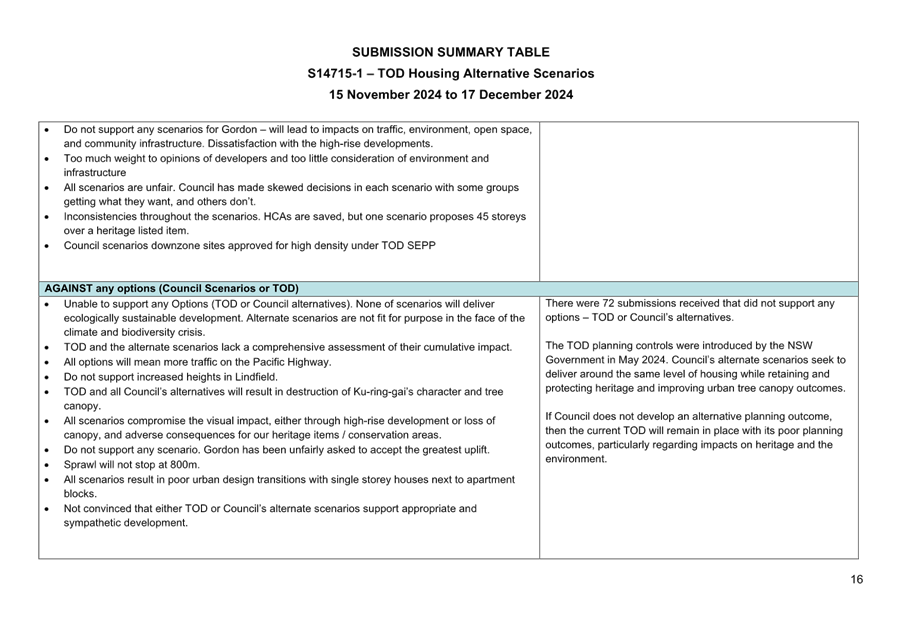
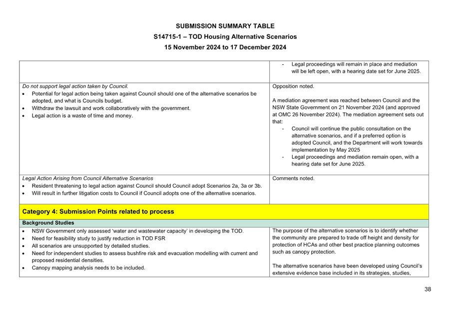
Written Submissions
Council received 514 written submissions. Of these, 316 indicated a preferred option/s:
- Scenario 1 received 126 submissions in support and 42 against
- Option 2a received 48 submissions in support and 19 against
- Scenario 2b received 19 submissions in support and 18 against
- 3a received 24 submissions in support and 38 against
- Option 3b received 99 submissions in support and 64 against
Additionally:
- 72 submissions were received which did not support either the TOD or any of the exhibited Council alternative scenarios.
- 57 form submissions were received (the form letter provided space for submitters to write their name, address, signature and date and then provided a standard letter the content of which objected to the exhibited alternative scenarios and requested the current TOD provisions remain in place)
The written submissions are not a statistically valid sample that can be used to inform the selection of a preferred option, it is also highly likely that there is significant overlap between the pool of submissions and the pool of surveys. However, it is interesting to note that the scenarios that received the most attention are options are 1, 3b and 2a and the least 2b and 3a, this outcome is consistent with both the survey and workshops results.
Submissions were received from:
- Ku-ring-gai residents;
- community groups such as FOKE, Support Lindfield, A Better Outcome Under TOD (ABOUT), Pearson Avenue Precinct Preserve & Protect; and
- architects and planning consultants on behalf of property owners seeking site specific outcomes
A Submission Summary Table is included at Attachment A2. This table summarises the matters raised within the submissions under themes and Councils comments in response.
In addition to support or opposition to a preferred scenario, the key themes raised within the submissions related to the following:
Key Theme - Amendments to Scenarios / Alternative Areas for Housing
Submissions suggested amendments to specific scenarios and suburbs including changes to building heights and locations for development to be included or excluded. Submissions also suggested alternative areas that were thought to be suitable for additional housing such as the centres of Turramurra, St Ives, Wahroonga, Pymble and Pymble Business Park.
Staff Response
The suggestions for alternative areas for housing are noted however in developing alternatives to the TOD Council is required to confine itself to the identified station precincts in the TOD SEPP. The suggested amendments to alternative scenarios are noted and where relevant have been consider during the refinement process.
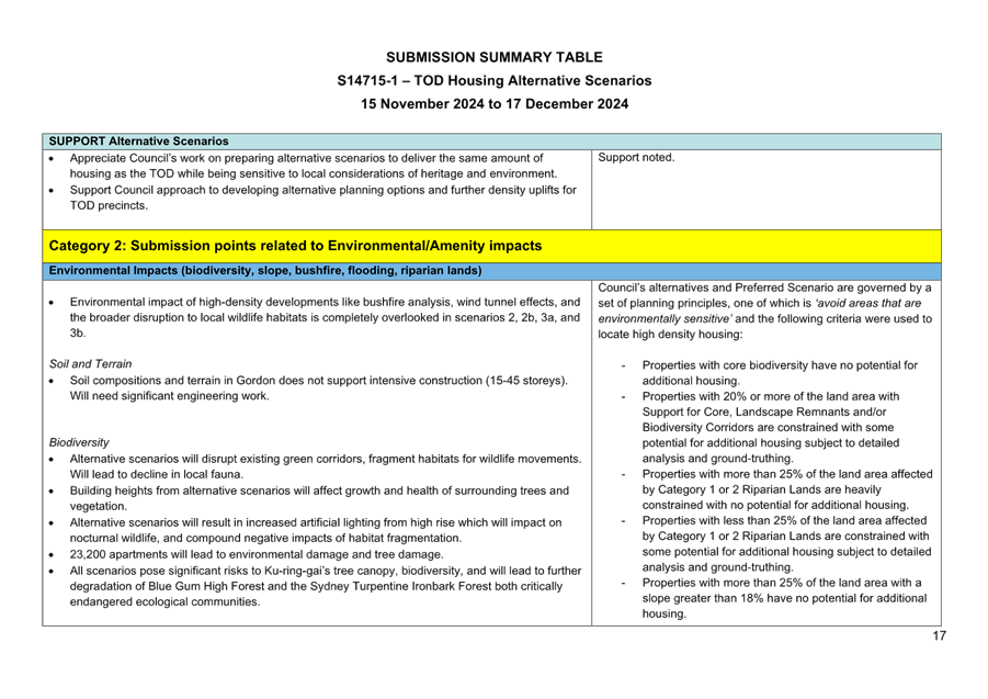
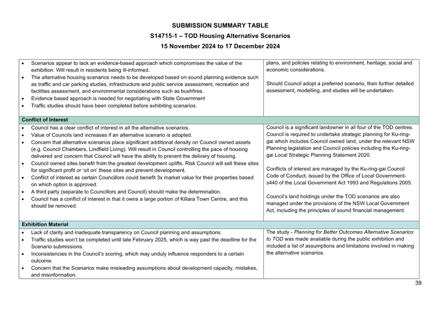
Key Theme - Environmental such as biodiversity, tree canopy, flooding, bushfire
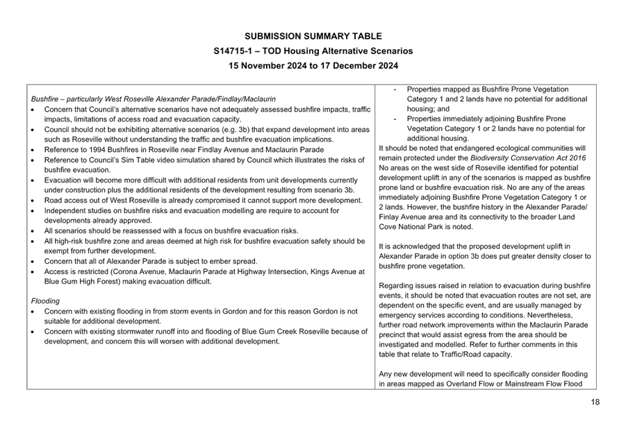
Submissions raised concern that development arising from the alternative scenarios would result in negative impacts to Ku-ring-gai’s significant tree canopy, biodiversity and Critically Endangered Ecological Communities including Blue Gum High Forest and Sydney Turpentine Ironbark Forest. Submissions raised concerns regarding the bushfire and evacuation risk, particularly from West Roseville. Submission also raised concern regarding existing flooding and worsening flooding events due to additional development.
Staff Response
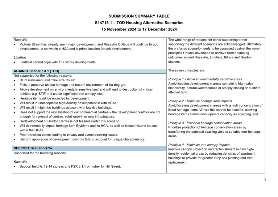
Council’s alternative and preferred scenario are guided by a set of planning principles, one of which is “avoid areas that are environmentally sensitive” and seeks to avoid locating high density residential in the following environmentally sensitive areas:
· sites with more than 20% high value on the Terrestrial Biodiversity Map;
· sites with more than 25% category 1 and 2 Riparian Lands;
· sites with more than 25% area with a slope greater than 18%;
· sites mapped as Bushfire Prone Vegetation Category 1 and 2; and
· sites immediately adjoining Bushfire Prone Vegetation Category 1 and 2.
Any new development will need to specifically consider flooding in areas mapped as Overland Flow or Mainstream Flow Flood Planning Area. New development will also need to specifically consider council’s Water Management DCP controls including requirements for rainwater re-use and on-site detention systems.
No areas on the west side of Roseville identified for uplift in the alternative scenarios are mapped as bushfire prone land or bushfire evacuation risk, and none are immediately adjoining Bushfire Prone Vegetation Category 1 or 2 land. With regards to evacuation, this is dependent on the specific bushfire event and managed by emergency services. Further road networks improvements in the Maclaurin Parade precinct would assist egress from the area and should be investigated.
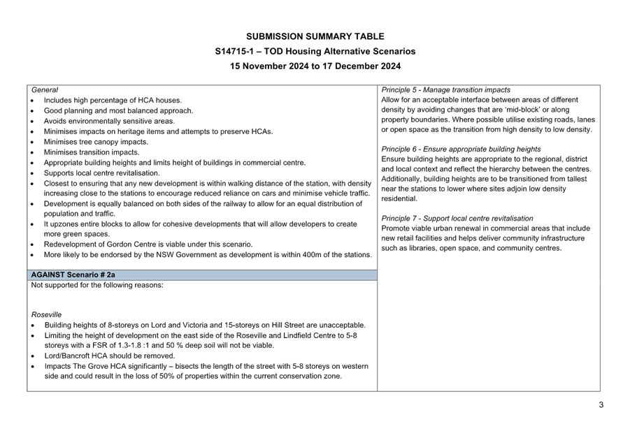
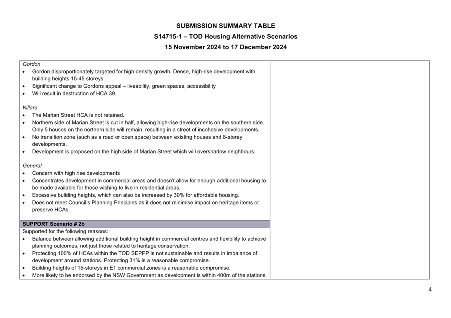
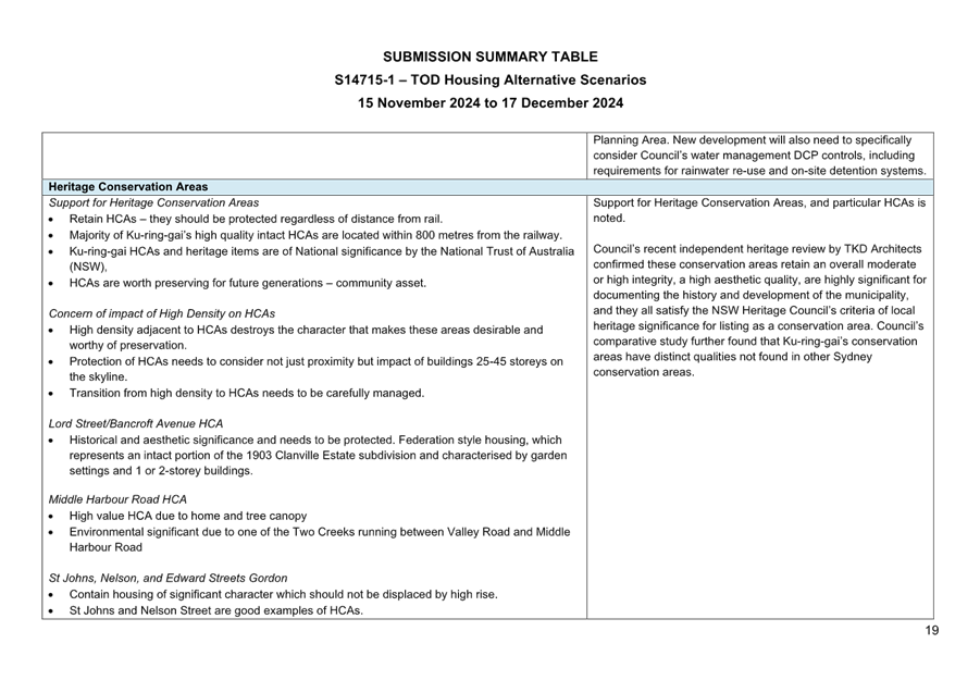
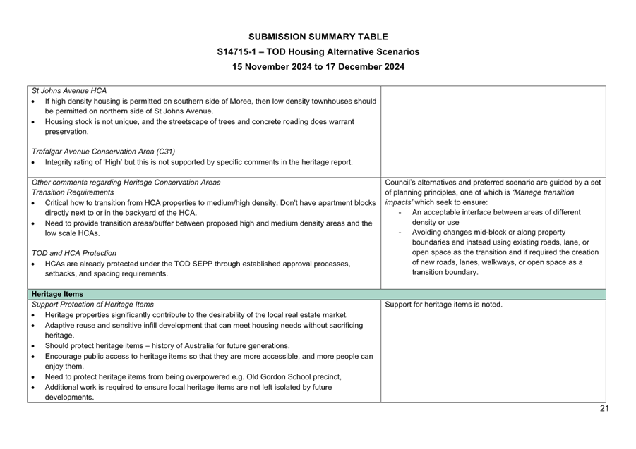
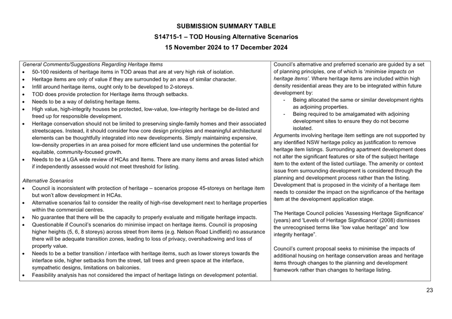
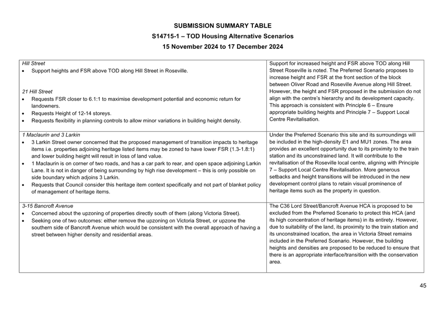
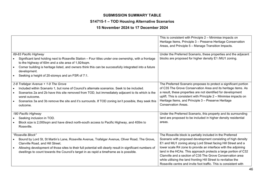
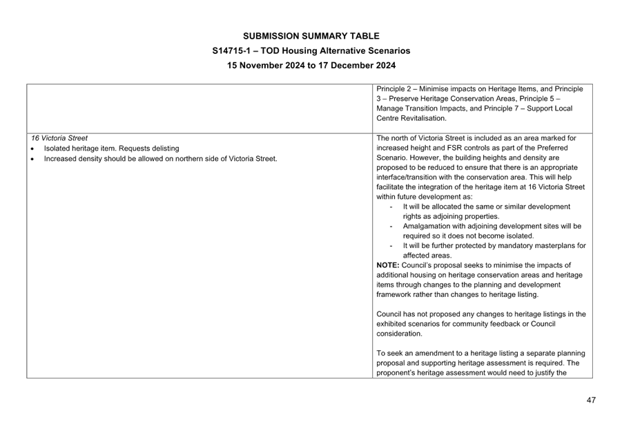
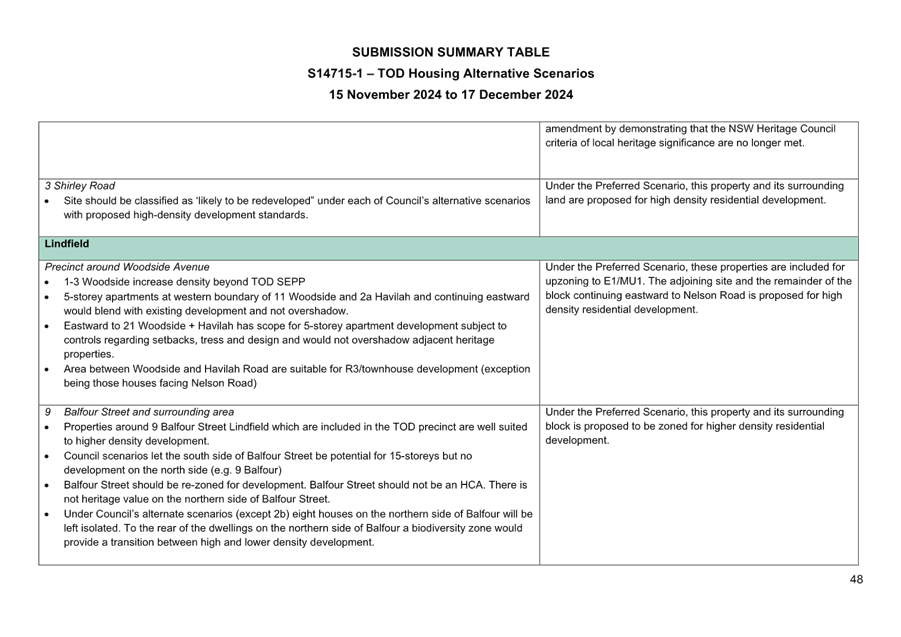
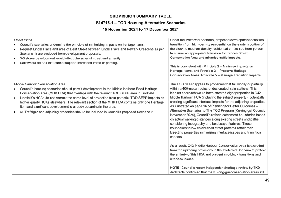
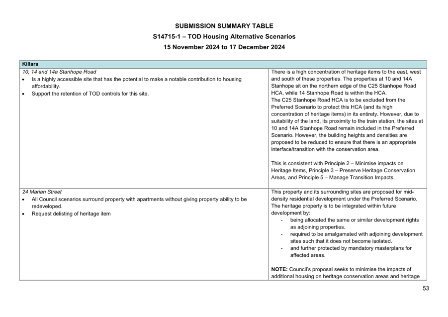
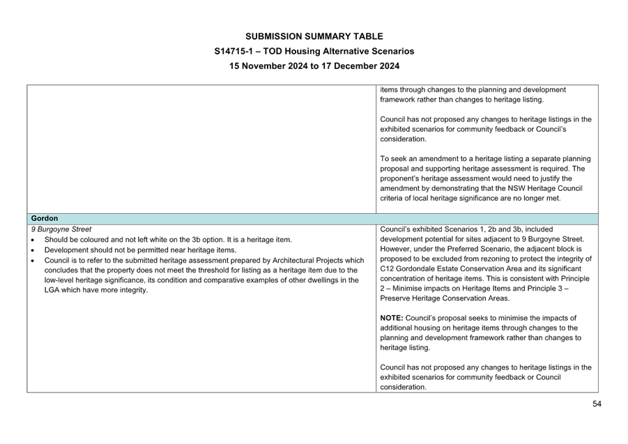
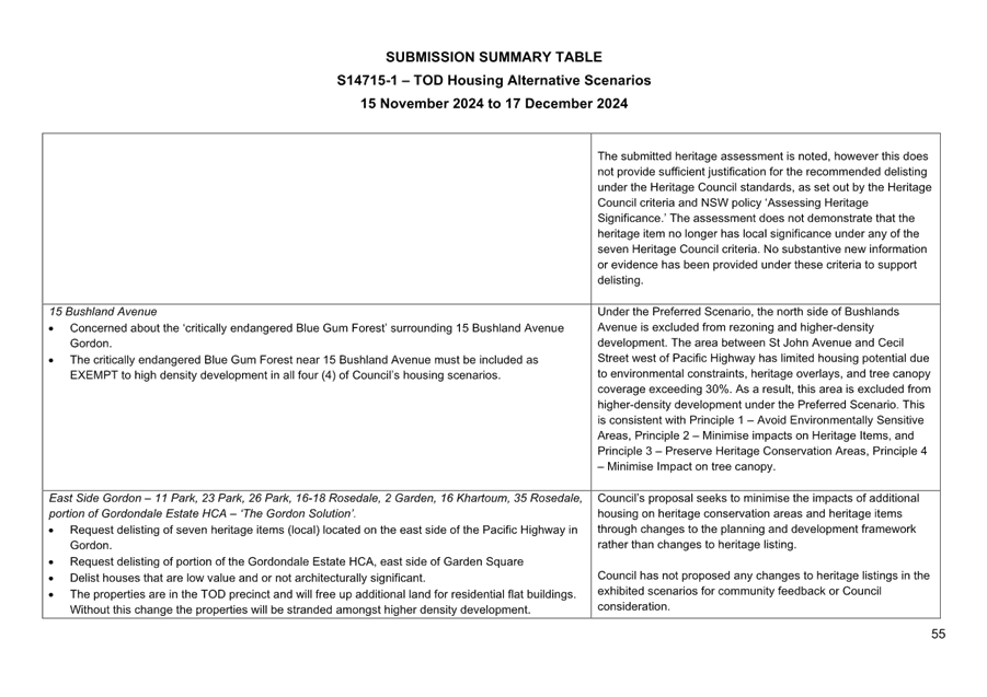
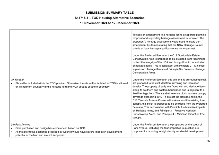
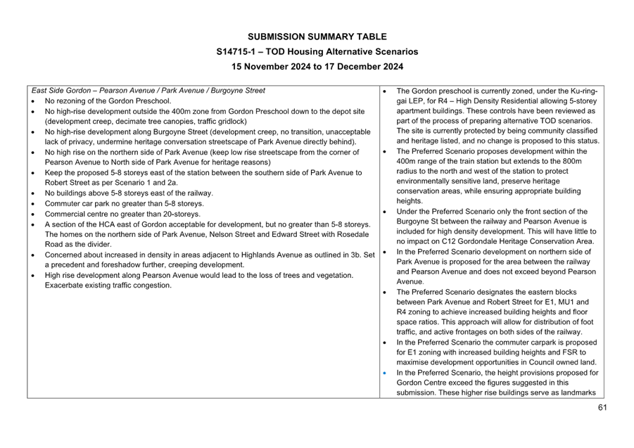
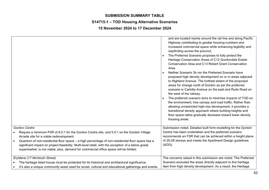
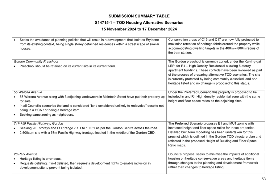
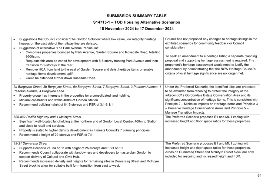
Key Theme - Heritage Items and Heritage Conservation Areas
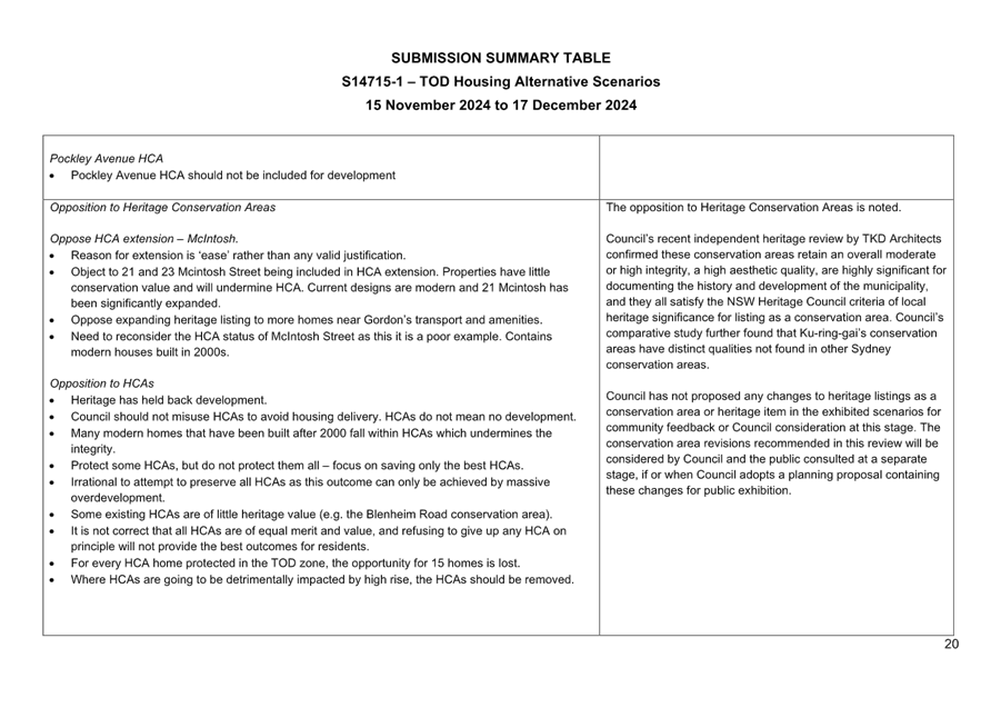
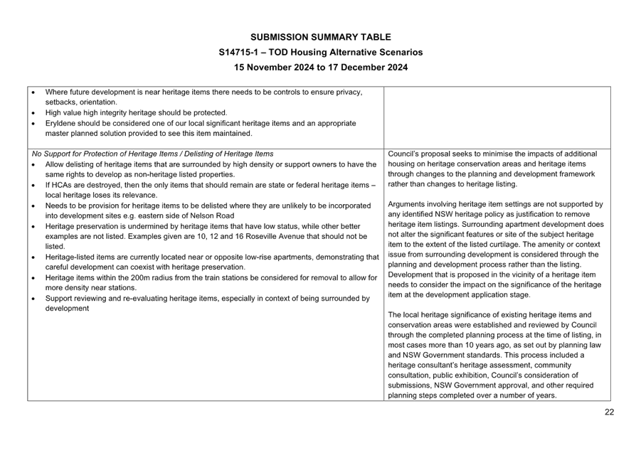
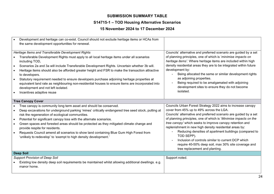
Submissions were received in support of the protection of both heritage items and heritage conservation areas, with concerns raised regarding the impact on high density development on heritage and highlighting the need to provide for transitions between high density and heritage. Submissions were also received which did not support heritage, with requests for delisting of heritage items and HCAs. Submissions were received from owners of heritage items requesting transferable development rights.
Staff Response
Council’s alternative and preferred scenarios are guided by a set of planning principles, two of which are ‘minimise impacts on heritage items’ and ‘Manage transition impacts’. Council’s proposal seeks to minimise the impacts of additional housing on heritage conservation areas and heritage items through changes to the planning and development framework rather than changes to heritage listing.
Council has not proposed any changes to listings as a conservation area or heritage item in the exhibited scenarios for community feedback or Council consideration at this stage.
Where heritage items are included within high density residential areas they are to be integrated within future development by:
· being allocated the same or similar development rights as adjoining properties; and
· being required to be amalgamated with adjoining development sites to ensure they do not become isolated.
Key Theme - Traffic and Parking
Submissions noted the existing traffic congestion on roads and particular the Pacific Highway, and raised concern that development arising from the alternative scenarios would result in further negative impacts to the road network, noting that people would drive and not just rely on public transport. Particular concern was raised with the road network and exits from West Roseville in the Maclaurin/Corona/Findlay area. Submissions noted existing parking issues around stations and the need to ensure adequate parking for new developments.
Staff Response
Council is undertaking assessment of traffic impacts of the TOD SEPP, as well as the alternative and preferred scenarios to better understand any transport infrastructure requirements to accommodate additional dwellings in the four precincts, with a focus on encouraging active transport to the station and shops.
As part of Council’s assessment of the transport impacts in Roseville precinct, discussions are being held with TfNSW regarding improvements to the intersections of Pacific Highway and Maclaurin Parade. To improve additional connectivity for West Roseville and to reduce the demand at the intersection of Pacific Highway and Maclaurin Parade consideration is being given to a new access road between Pockley Avenue and Shirely Road. The extent of 5-8 storey apartments on the southern side of Alexander Parade as part of Scenario 3b, and in the Maclaurin block are recommended for removal as part of the preferred option to, among other things, reduce demand on the intersection of Pacific Highway and Maclaurin Parade.
Key Theme - Infrastructure
Submissions noted that infrastructure – road, rail, bus, schools, open space, water, sewage, stormwater etc – were already at capacity and inadequate for further increases in development. Submissions questions how the required infrastructure would be paid for.
Staff Response
The NSW Government prior to giving effect to the TOD SEPP would have been in a situation to consult with State Agencies regarding the provision and/or upgrade of state infrastructure arising from the anticipated development. Council’s alternative and preferred option provide for the same total amount of dwellings/population. Councils existing s7.11 local infrastructure contributions plan will continue to levy for local infrastructure. Additionally, developments in the Greater Sydney Area attract state infrastructure contributions (Housing and Productivity Contributions (HAPs)).
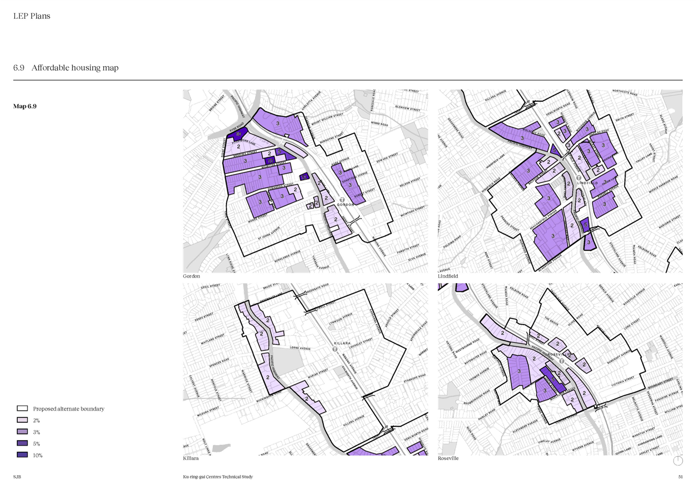
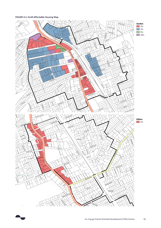
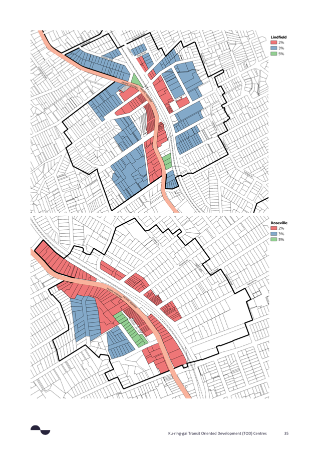
Key Theme - Affordable Housing
Submissions noted that the proposed 2% affordable housing contribution was inadequate, and more was required. Submissions supported affordable housing being provided in perpetuity. Submission did not agree with the bonus 30% height under the Housing SEPP, and concerns that this would revert to market housing after 15years.
Staff Response
The Department of Planning, Housing and Infrastructure Transport Orientated Development – Guide to Strategic Planning outlines that in terms of strategic planning for alternatives for the TOD SEPP, ‘In the first instance the prescribed affordable housing rate within the Housing SEPP will apply (2%). In the event that a council takes a different rate or approach, we expect that Councils will prepare an affordable housing contribution scheme that prescribes the rate and mechanism for delivering affordable housing’. Council’s consultants have analysed the feasibility for key sites for the provision of affordable housing at 2% as a minimum, and then tested to see if sites have capacity to contribute to higher Affordable Housing rates (>2%) and based on this analysis have proposed different affordable housing contributions rates in different areas. This is discussed in more detail further in the report.
The infill affordable housing density bonuses in the Housing SEPP apply to all land in Greater Sydney, and it is unlikely that the Department of Planning, Housing and Infrastructure will allow and exemption to these optional provisions.
Key Theme - Development uptake and viability
Submissions raised a range of concerns regarding development feasibility and the likelihood of sites to be developed. There were concerns that no feasibility testing had been undertaken regarding proposed controls relating to FSR, deep soil, site amalgamations, strata and heritage.
Staff Response
Council has engaged consultants to undertake feasibility analysis on a range of sites, this is discussed later in this report.
Key Theme – Planning and Consultation Process
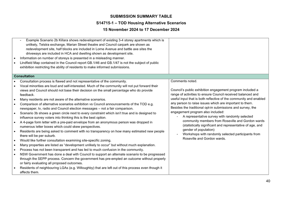
Submissions raised concerns regarding the consultation process relating to timing, notification and exhibition material. Submissions noted support and opposition for the legal action against the NSW State Government. Submissions raised concern regarding a perceived Council conflict of interest in the alternative scenarios in relation to Council owned land and uplift.
Staff Response
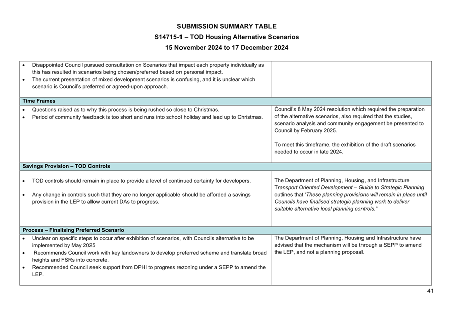
Council’s engagement program for the public exhibition including a whole range of activities to ensure Council is in a strong position to receive balanced and useful input that is both reflective of the community and allows any person to raise issues which are important to them. Council’s 8 May 2024 resolution which required the preparation of the alternative scenarios, also required that the studies, scenario analysis and community engagement be presented to Council by February 2025. To meet this timeframe, the exhibition of the draft scenarios needed to occur in late 2024.
Council is a significant landowner in all four of the TOD centres. Council is required to undertake strategic planning for Ku-ring-gai which includes Council owned land, under the relevant NSW Planning legislation and Council policies including the Ku-ring-gai Local Strategic Planning Statement 2020. Council’s land holdings under the TOD scenarios are also managed under the provisions of the NSW Local Government Act - including the principles of sound financial management.
In addition to the above many site-specific or area-specific submissions were received seeking site specific outcomes. These site-specific submissions are addressed separately in this report, and in detail in the Submission Summary Table Attachment A2.
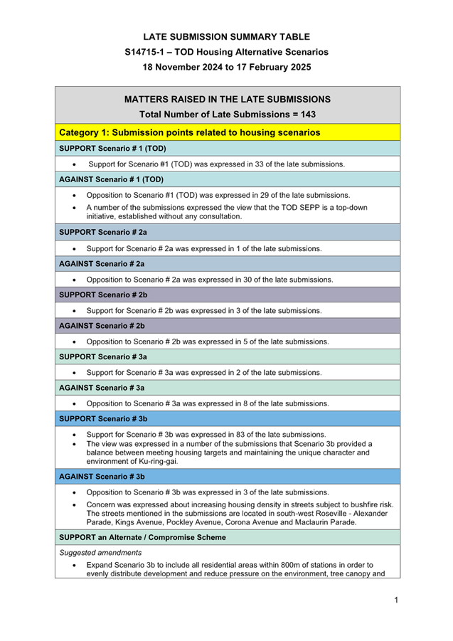
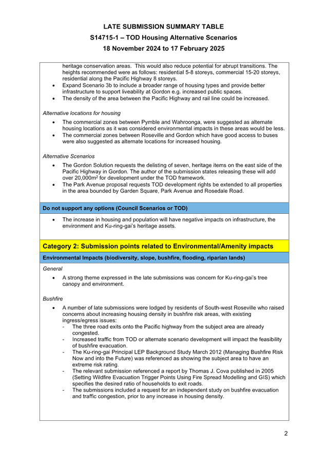
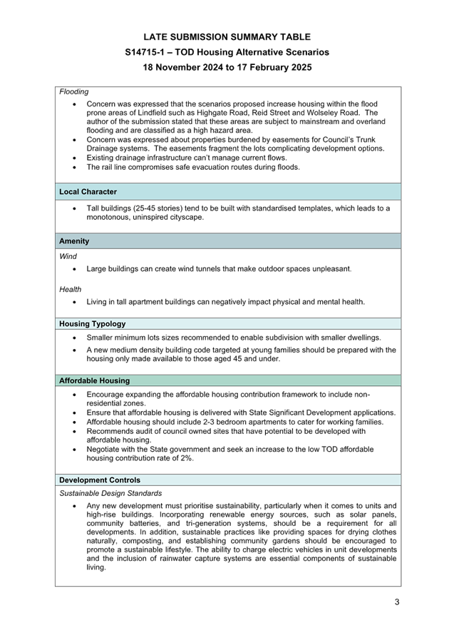
143 late submissions were received after the close of the public exhibition period on 17 December 2024, with some received up until mid-February 2025. The late submissions have been summarised and included at Attachment A3 – Late Submission Summary Table. The Late Submission Summary Table only includes matters that were not already included in the Submission Summary Table. No Council comment is provided in response to the late submissions.
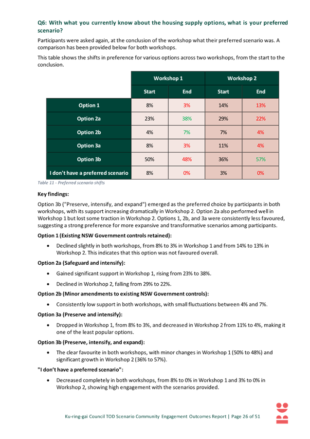
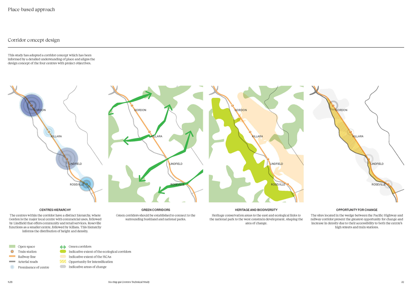
2. Refinement of Community Preference (Scenario 3b)
Based on the discussion above Scenario 3b is the community’s preferred option.
Scenario 3b is characterised by protection of HCAs, moderate building heights, and extension of the development area to 800m from the rail station. The preference for 3b can be seen as an indication of the community’s willingness to trade-off additional spread of development to avoid extreme building heights.
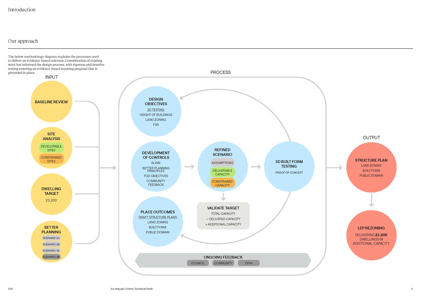
Council staff have worked closely with consultants SJB Urban to refine and develop a Preferred Scenario. The refinement process has resulted in the removal of certain areas and reductions in building height and density in other areas which, in turn, has resulted in a dwelling yield that was below the DPHI target.
To balance a reduction of dwellings, new areas have been added and building height and density has increased in other locations. This process was iterative until a final refined scenario was developed. This work was supported by SJB Urban who undertook detailed built form modelling to ensure the Preferred Scenario will be generally consistent with Council’s DCP, minimise overshadowing and address interface impacts as much as possible, as well as comply with the Apartment Design Guide (ADG).
SJB Urban also prepared a model to estimate the planning capacity of the Preferred Scenario. This information is available in Attachment A4 – Ku-ring-gai Centres Technical Study – SJB Urban, February 2025.
The process of refining Scenario 3b has also included:
· consultation with staff from the Department of Planning, Housing and Infrastructure (DPHI);
· a review of site-specific or area-specific written submissions;
· feasibility analysis that identified sites where increased height and density is required when compared to Scenario 3b; and
· consideration of Development Applications and State Significant Development Applications.
Consultation with DPHI
During January and February 2025 Council staff have met with DPHI representatives several times. During these meetings the DPHI have confirmed that the total dwelling capacity for the four TOD precincts is calculated at 23,054 dwellings and that Council will need to at least match this number in the Preferred Scenario.
DPHI have an in-house model used to calculate planning capacity. Council submitted a preliminary set of maps (land use zone, height and FSR) to DPHI on 14th February 2024. DPHI have undertaken a review of the draft maps to determine the planning capacity and has found Council’s Preferred Scenario has the capacity to deliver the required dwellings. DPHI did not provide the exact yield calculated by their own analysis of Council’s scenario.
DPHI have also confirmed the planning pathway will be an amendment to the KLEP via an amendment to the TOD SEPP and that an exemption from the Affordable Housing bonus 30% scheme is unlikely.
During the meetings DPHI have given in principle support to:
· extend beyond the 400m TOD boundary (as per Scenario 3b);
· transfer dwellings between TOD suburbs (as per Scenario 3b);
· upzone heritage items and include in the total planning capacity (as per Scenario 3b);
· remove HCAs or reduce their size or leave HCAs in place and zone through them;
· include RE1 zones for new parks and SP2 zones for new local roads, supported by reservations; and
· inclusion of 3-4 storey apartment buildings on interface areas.
All these matters are subject to Ministerial approval.
The DPHI have indicated they require justification for the following:
· where Council is proposing no uplift in HCAs within the 400m TODs; and
· where Council is proposing to reduce FSR (i.e. downzoning) in non-HCA areas within the 400m TODs.
Council asked DPHI whether Low and Mid-Rise provisions could be ‘switched off’ by Council’s alternate TOD plan. The Department’s response was that the Low and Mid-Rise (LMR) reforms have been applied to areas around the existing TOD precincts. If the TOD precinct is expanded and is more generous than the LMR controls, Council’s controls would naturally supersede the LMR controls in those locations. The Department would support including these areas in the masterplans.
In terms of savings and transitional provisions that may apply in the TOD precincts DPHI have indicated the following:
· DPHI is committed to including savings and transitional arrangements for development applications;
· similar savings and transitional arrangements have recently been used for the Accelerated TOD precincts; and
· this includes saving development applications lodged but not yet determined as well as saving State Significant applications (SSDAs) where they are lodged or have a valid SEARs.
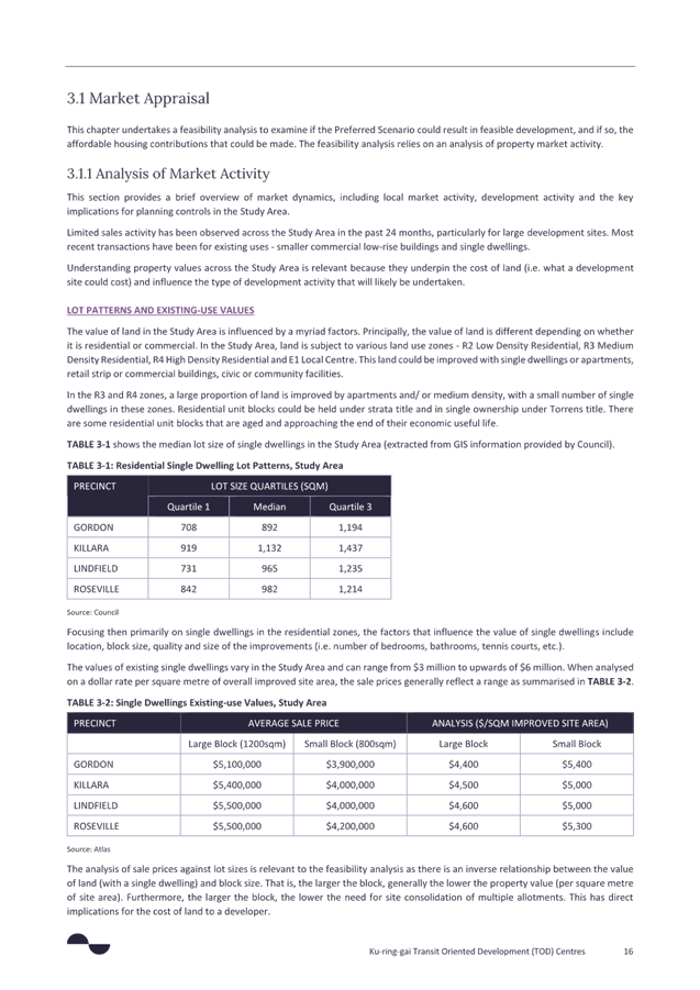
Development Applications
As of 24 February 2025, there are nine State Significant Applications listed on the NSW Government website, it appears that all of these have now been issued Planning Secretary’s environmental assessment requirements (SEARs).
The location and details (where available) of the applications are shown on Figures 4, 5 and 6 below. Based on information available the applications represent a minimum of 1,100 dwellings with heights typically 9-10 storeys and all include the 30% Affordable Housing bonus.
SSD applications numbered 1, 2, 3, 4, 6, 8 and 9 in the Figures below, are all located within areas that are proposed for high density in Council’s Preferred Scenario however, the proposed density and height of the developments are not consistent with the intent of Council’s Preferred Scenario. Inconsistencies relate to Principle 4 - Minimise impacts on the tree canopy, Principle 5 - Manage transition impacts and Principle 6 - Ensure appropriate building height.
SSD applications numbered 5 and 7 in the Figures below, are located within HCAs outside the Preferred Scenario development area. The location, height and density of these applications are inconsistent Council’s Preferred Scenario. Inconsistencies relate to Principle 2 - Minimise impacts on Heritage Items, Principle 3 - Preserve Heritage Conservation Areas, Principle 4 - Minimise impacts on the tree canopy, Principle 5 - Manage transition impacts and Principle 6 - Ensure appropriate building height.
It is Council’s preference that these current SSD proposals not be “saved”, and further, that a moratorium on further such applications being lodged either with the Department or Council be put in place as soon as Council commences final public exhibition of its preferred scenario.
The General Manager has recently corresponded with DPHI’s Deputy Secretary Planning, Land Use Strategy and Housing in these terms. At the time of writing this report, a response had not been received.
It is recommended that Council make a request to DPHI that none of the State Significant Applications listed on the NSW Government website be saved due to the significant inconsistencies with Council’s Preferred Scenario, specifically advising DPHI that:
“Council is concerned that some proposals currently working through the SSD system might be prejudicial to any alternate scenario it might adopt. This is particularly the case where transition between different densities and housing typologies that Council might seek to apply are juxtaposed against out of scale development reflected in some current DSSD proposals. It is also Council’s preference to include development uplift for individual heritage items where they would otherwise be “isolated” by adjoining TOD development. This would allow their integration into a larger master planned site and not leave them stranded.
It is further recommended that Council make a request to DPHI that any further SSD applications lodged and/or declared after the writing of this report not be accepted or subsequently saved for the reasons outlined above.
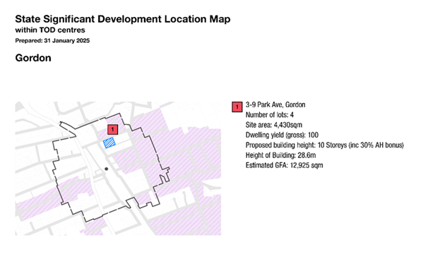
Figure 4 – Current State Significant Development Applications - Gordon
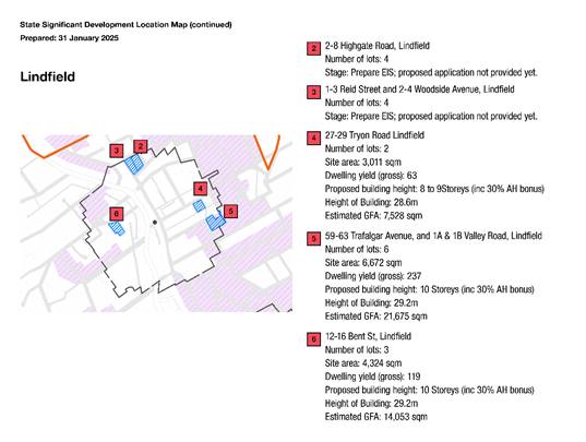
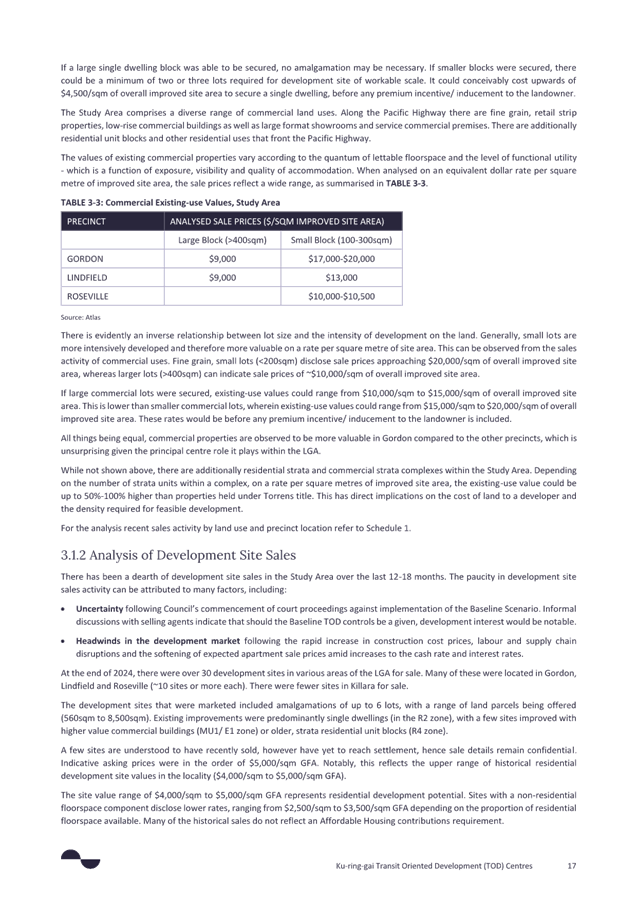
Figure 5 – Current State Significant Development Applications – Lindfield
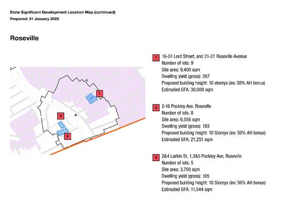
Figure 6 – Current State Significant Development Applications – Roseville
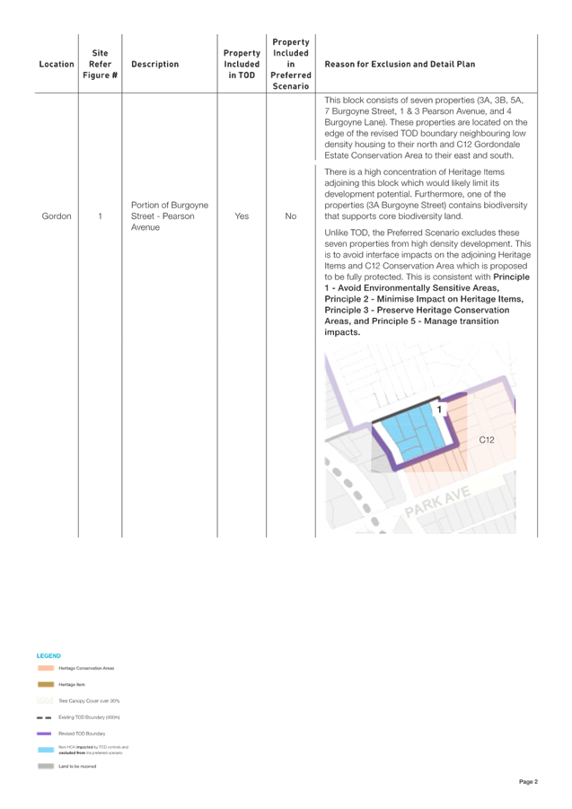
In addition to the nine SSD applications outlined above, the Minister for Planning and Public Spaces made a Ministerial Order on 17 March 2025 to declare the sites at 3A, 3B, 5A and 7 Burgoyne Street; 4 Burgoyne Lane; 1 & 3 Pearson Avenue, Gordon to be a State Significant Development site. This was a result of an EOI application submitted to the NSW Housing Delivery Authority for the development of residential flat buildings including affordable housing on the site.
At the time of writing this report no further details on the application were available.
Written submissions – site-specific or area-specific
Where residents made written submissions commenting on specific properties or areas they generally fell into the following categories:
· the majority of submissions were requests and support for new development, increased density or other significant changes related to a specific property, street or area;
· some submissions requested exclusion of a property or area from Council scenarios; and
· other submissions expressed concerns and/or requested particular areas be protected due to environmental constraints, character or heritage significance.
The following figures show the approximate location of the relevant submission and the particular concern raised. These have been considered during the refinement process.
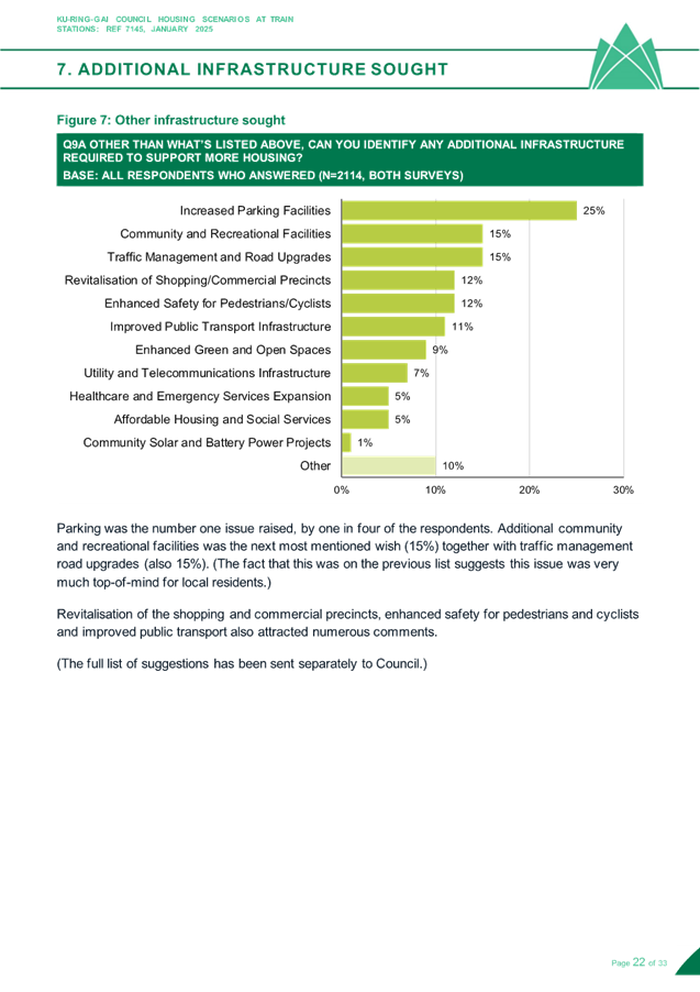
Figure 7 provides an overview of written community submissions specific to a site or area. Each marker on the map indicates a submission’s general location. When multiple submissions request the same or similar action, a single marker is used to represent the group, with slight offsets applied for clarity. Submissions have been categorised into three main themes based on their primary focus:
· Yes, to development/change: Requests and support for new development, increased density, or significant changes to current use.
· No, to development/change: Request for exclusion of a site or area from Council scenarios
· Support for Character and Environmental Protection: Concerns regarding the natural environment and requests to preserve and protect areas of environmental significance, heritage conservation areas and heritage items.
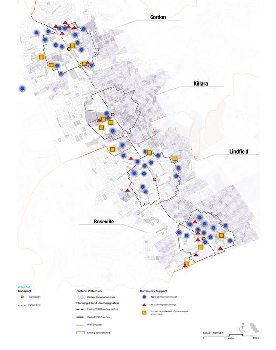
Figure 7 – Map of location-specific written submissions
In reading the map of location-specific written submissions (Figure 7) the following assumptions and limitations should be considered.
· Some submissions may address multiple themes but have been categorised based on their primary concern for mapping clarity.
· This map shows the spatial distribution of submissions but does not indicate the relative weight, detail, or number of signatories for each submission.
· The absence of markers in an area does not necessarily indicate lack of community interest, only that no formal submissions were received for that location.
· Where submissions covered large areas or multiple sites, they have been mapped to their primary location of concern.
Figures 8-11 below provide a snapshot of the comments that characterise the submissions. A full summary of all submissions is available in Attachment A2 – Submissions Summary Table.
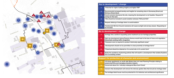
Figure 8 – Summary of location-specific written submissions – Gordon
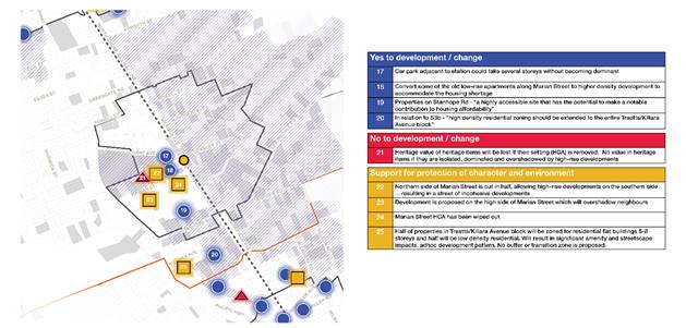
Figure 9 – Summary of location-specific written submissions – Killara
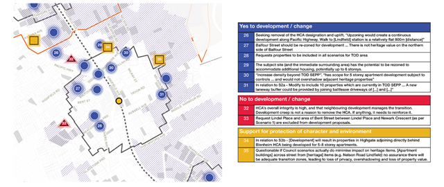
Figure 10 – Summary of location-specific written submissions – Lindfield
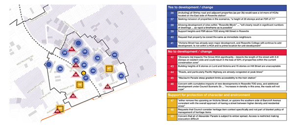
Figure 11 – Summary of location-specific written submissions - Roseville
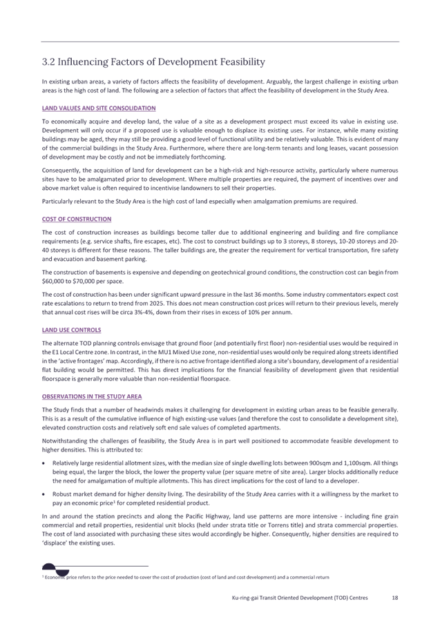
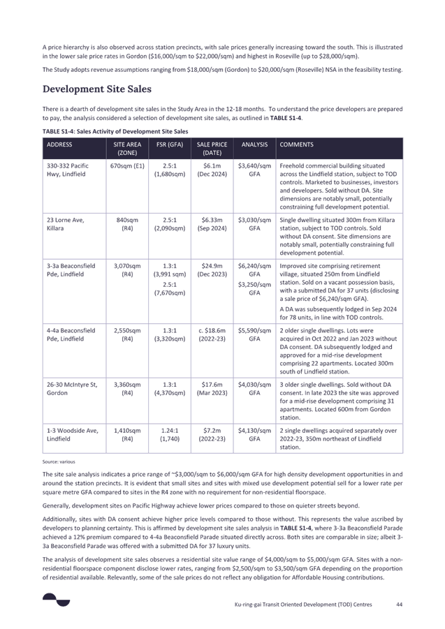
Development feasibility analysis
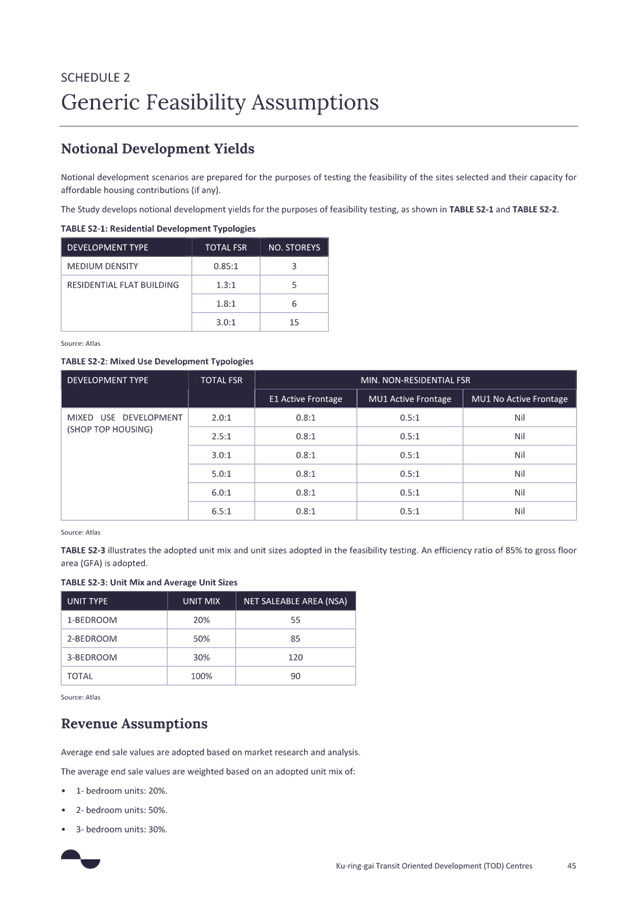
Atlas Economics (Atlas) were engaged by Council to carry out a financial feasibility analysis to assist with development of a preferred scenario and Affordable Housing contribution requirements to accompany the implementation of new planning controls. The final report is attached at Attachment A10 - Affordable Housing Feasibility Analysis, Atlas Economics, March 2025
The objective of the study was to investigate the capacity of development to contribute to affordable housing. The study carries out a feasibility analysis of an alternate TOD area around the station precincts of Roseville, Lindfield, Killara and Gordon. The feasibility analysis is predicated on the Preferred Scenario and its associated planning controls.
The study recognises that development feasibility in the study area will vary. Lot and ownership patterns as well as the nature of existing uses and buildings collectively influence the cost of site consolidation and the likelihood of development as a realistic and feasible proposition. These accordingly influence the feasibility of the alternate planning controls for development.
The study carries out the following tasks:
· Market appraisal, including an analysis of market activity and prices paid for existing uses/ buildings and development sites.
· Feasibility testing of a sample of sites in the Precincts to investigate if development is feasible, and where feasible, the capacity to contribute to affordable housing.
· Aggregation of observations for the purposes of making recommendations on policy settings and implementation.
Atlas was also engaged to provide advice on value capture opportunities on specific sites.
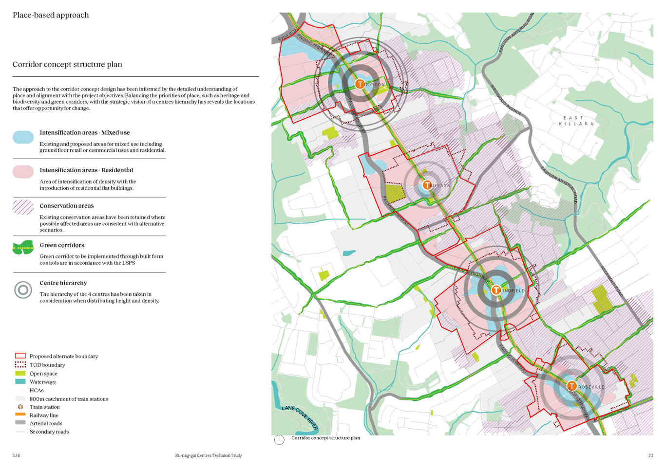
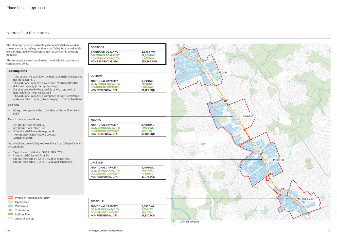
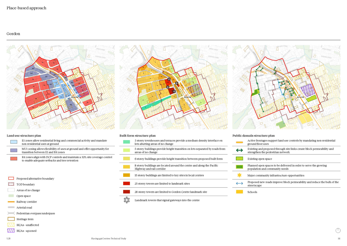
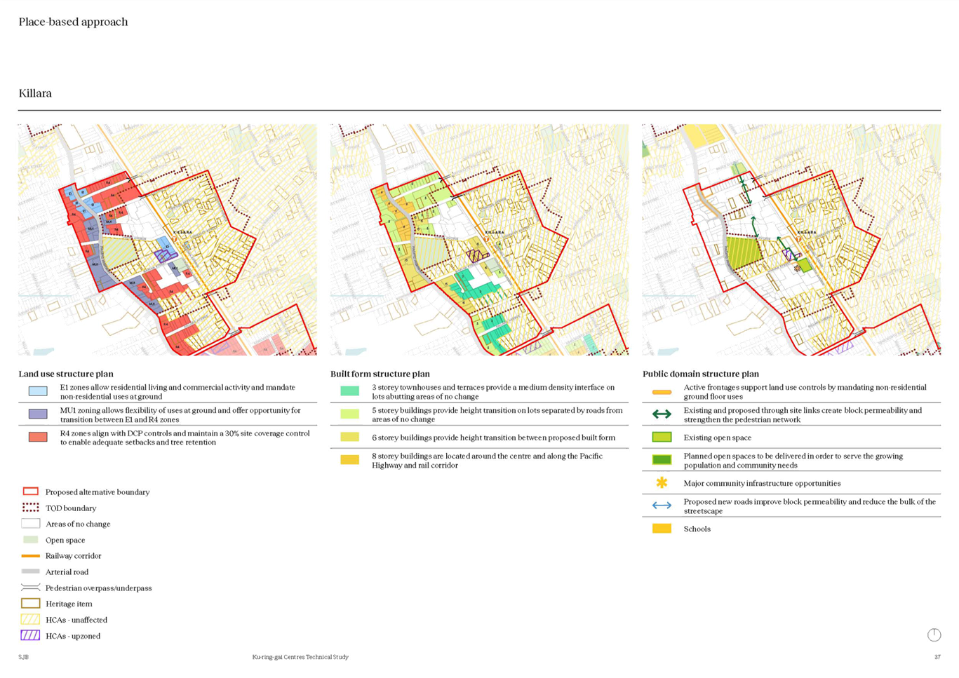
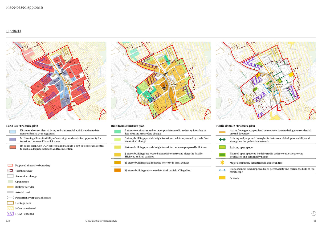
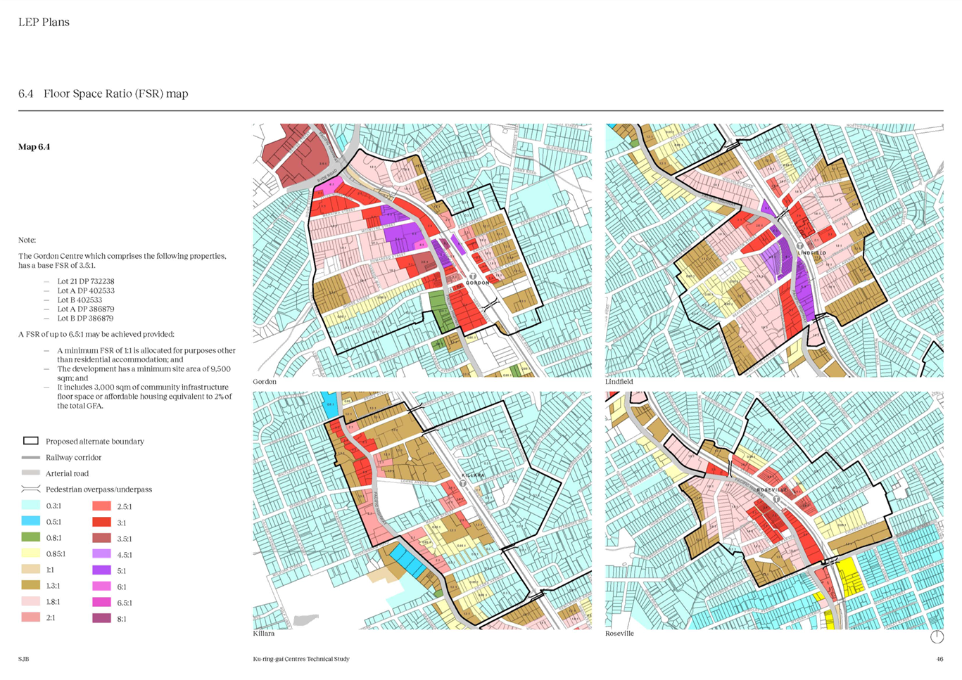
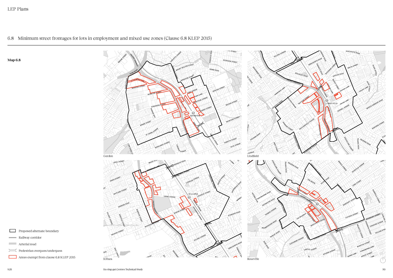
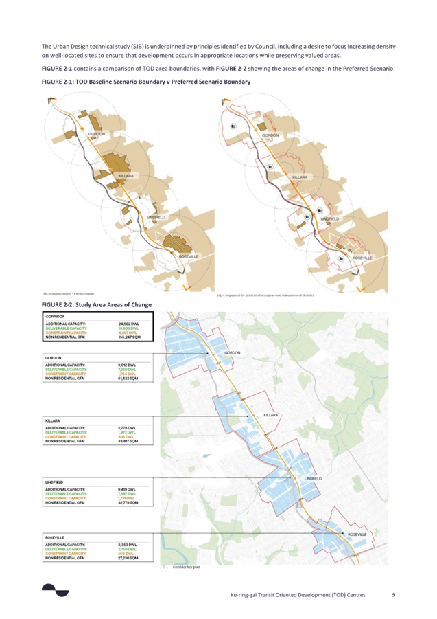
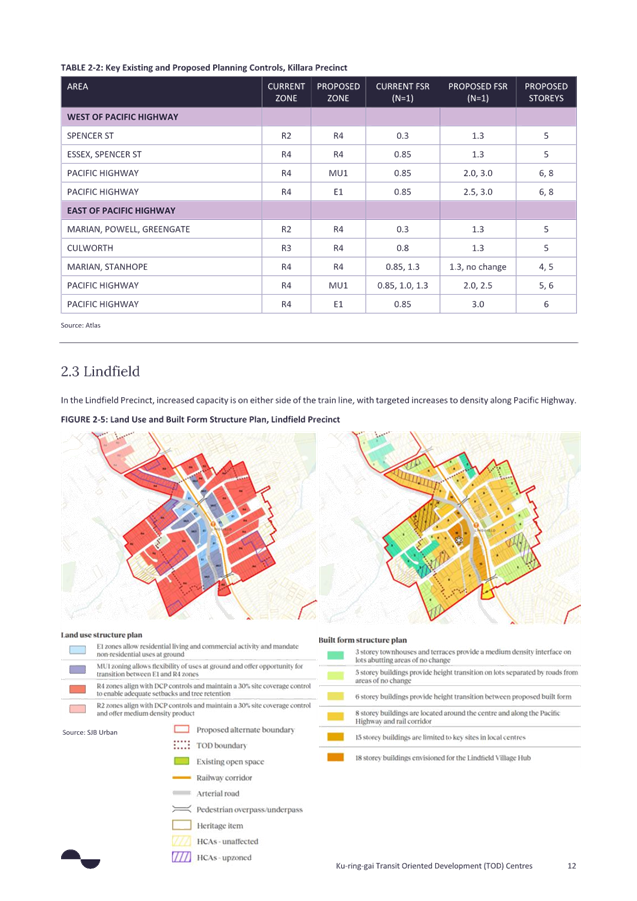
3. Description of the Preferred Scenario (3b refined)
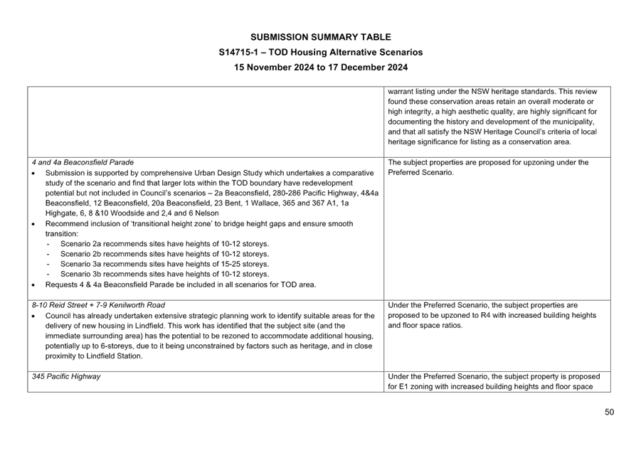
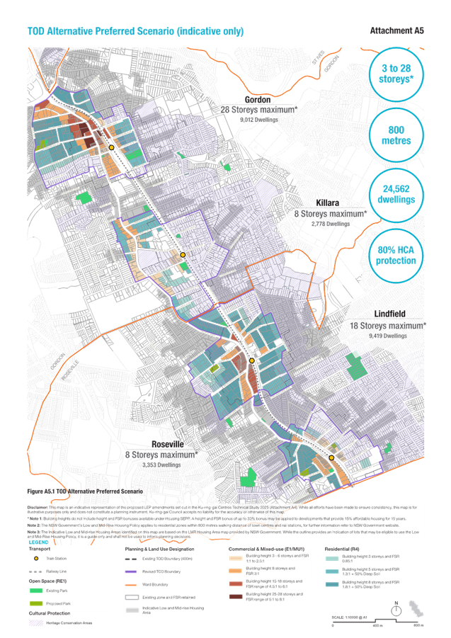
The Preferred Scenario (refer Figure 12) is a refined version of Scenario 3b which meets the DPHI dwelling targets and maintains building heights like those proposed in Scenario 3b. The preferred Scenario is also included as Attachment A5 – TOD Alternative Preferred Scenario.
Summary of key statistics:
· Building heights 3-28 storeys
· Density FSR range 0.85:1 to 8.0:1
· Number of dwellings 24,562 (Based on SJB consultants estimates)*
· Extent within 800 metres from stations
· HCAs protected 80%
· Heritage Items Protected 69%
Dwelling numbers have been balanced across the centres to reflect the centre hierarchy, with the greatest number of dwellings in Lindfield and Gordon, followed by Roseville, and the lowest number of dwellings in Killara:
· Gordon – additional capacity for 9,012 dwellings*
· Killara – additional capacity for 2,778 dwellings*
· Lindfield – additional capacity for 9,419 dwellings*
· Roseville – additional capacity for 3,353 dwellings*
*Note – final verification of dwelling yield subject to DPHI review and approval
Council staff are still engaged in a modelling verification process with the DPHI which will serve to clarify the difference, if any, between Council and SJB modelling and that carried out by the Department.
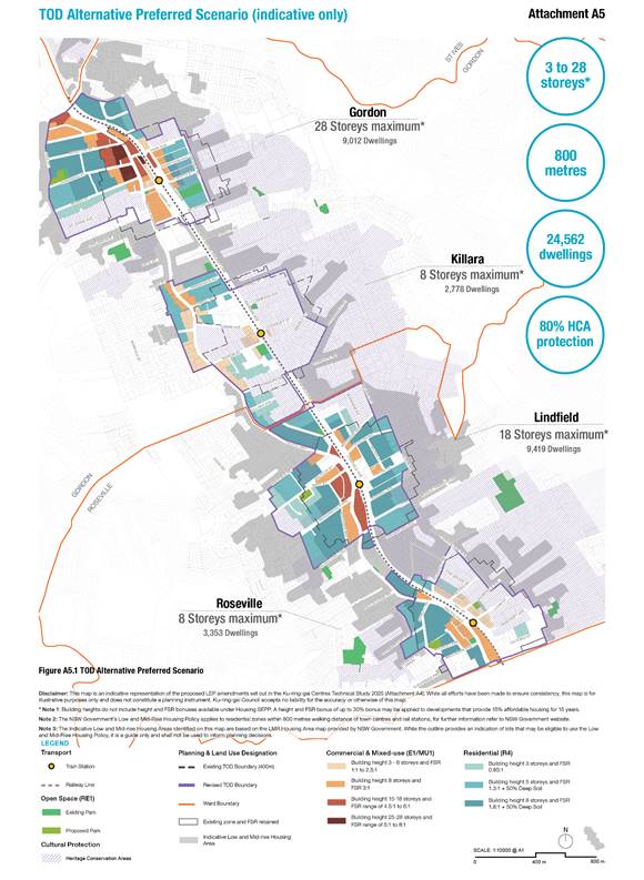
Figure 12 – TOD Alternative - Preferred Scenario
Note: This is an indicative representation of the “Preferred Scenario” for illustrative purposes only. Any reference in this report and any diagrams not otherwise included in Attachment A4 – Ku-ring-gai Centres Technical Study – SJB March 2025 (Part 05 (Implementation Strategy) and Part 06 (LEP Plans)) should similarly be considered as being illustrative only.
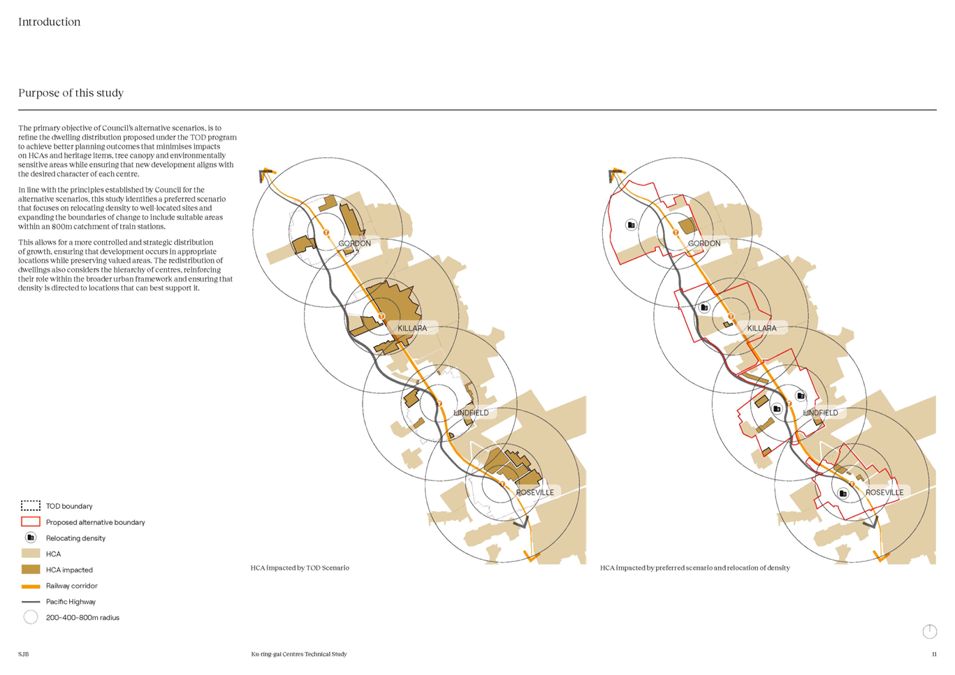
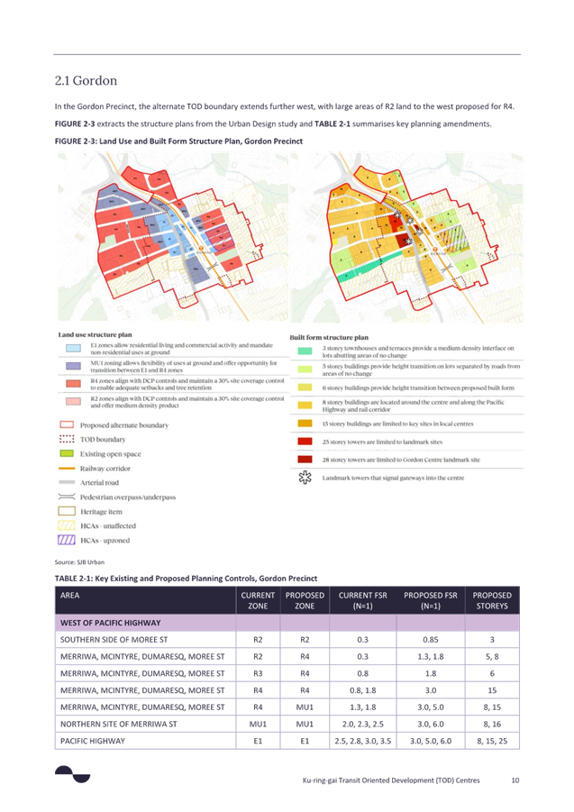
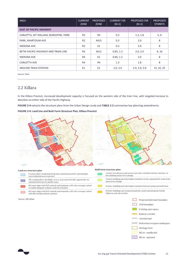
The boundary of the Preferred Scenario has been expanded in some locations and contracted in others to balance dwelling yields. At the same time reductions in building height and density in areas are balanced by added building height and density in other locations. In summary the Preferred Scenario varies from Scenario 3b in the following areas:
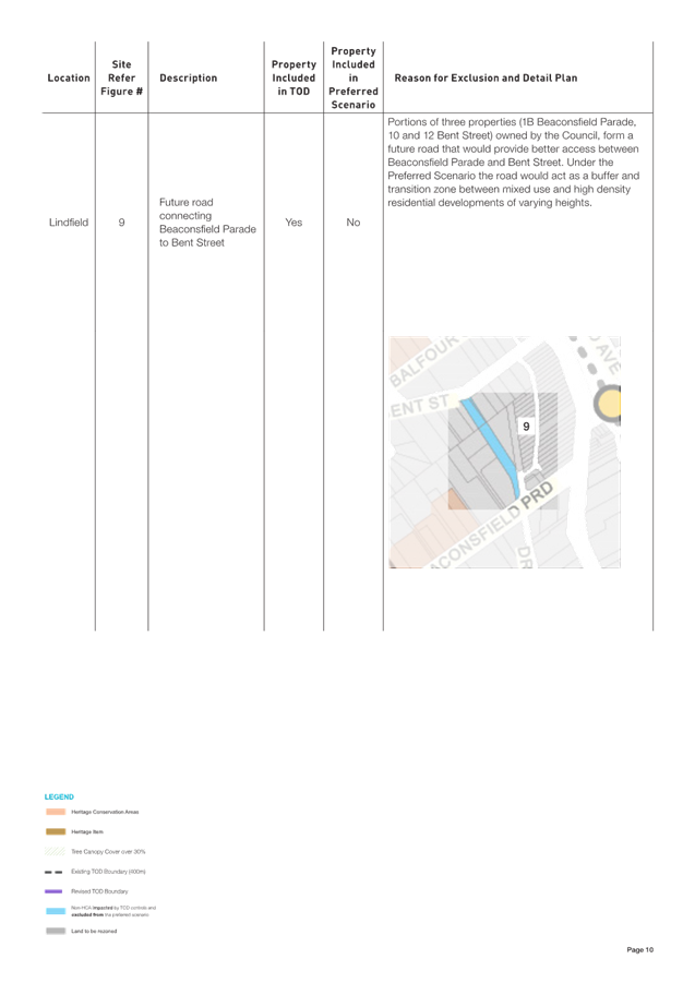
· Some areas proposed as high density residential in Scenario 3b have been removed from the preferred scenario and retained as low density residential. The reason for this change is primarily to manage transition impacts, protect heritage and avoid environmentally sensitive lands. These areas include Alexander Parade, Roseville; Kenilworth Road, Lindfield; and Burgoyne Lane, Gordon.
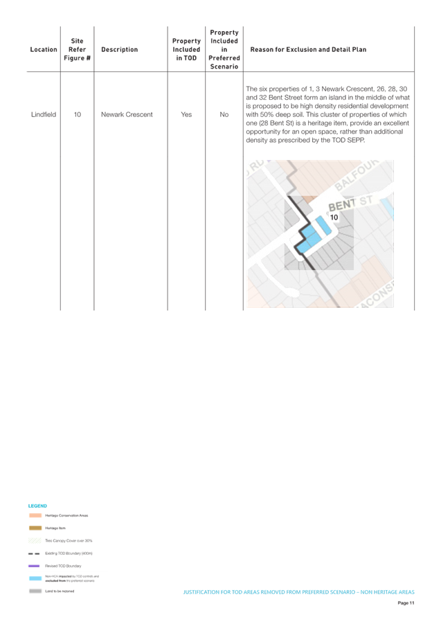
· Some areas proposed as high density residential in Scenario 3b are proposed as RE1 zones or SP2 zones in the preferred scenario, most notably Newark Crescent, Lindfield and an area between Shirley Road and Pockley Avenue, Roseville.
· The Preferred Scenario includes additional R4, E1 or MU1 zones which were not included in Scenario 3b, to balance the loss of dwellings from areas that have been removed or reduced in density/height. Most notably these include an area of land between Park Avenue and Robert Street, Gordon proposed as R4 zone; an area of land on the western side of the Pacific Highway in Killara, between Essex Street and Buckingham Road, proposed for R4 and E1 zones; an area on the corner of Marian Street and Culworth Avenue, Killara proposed for E1 zone; and an area bounded by Pacific Highway, Treatts Road and Wolseley Road, Lindfield proposed for R4.
· the preferred scenario proposes to manage transition impacts in certain areas (proposed for 5-8 storeys in Scenario 3b) by reducing heights to 3-storeys, these include land on the southern side of Moree Street, Gordon; Killara Avenue, Killara; land between Stanhope Road and Marian Street, Killara; Highgate Road, Lindfield; Lindel Place and Newark Crescent, Lindfield; an area of land between Highfield Road and Bent Street in Lindfield; and Victoria Avenue, Roseville.
· Overall, the building height ranges proposed in Scenario 3b have remained as exhibited, with the most notable exceptions being:
· Lindfield Village Hub building height increased from 15-storeys to 18-storeys as a result of built form modelling; and
· Gordon Centre building height increased from 25-storeys to 28-storeys as a result of built form modelling and feasibility analysis.
4. Comparison between TOD and Council’s Preferred Scenario
The preferred scenario is described and compared with the TOD under the following headings:
1. TOD areas removed or downzoned
2. TOD areas upzoned
3. New areas added to TOD (upzoned)
4. Heritage Items – upzoned or removed
DPHI have specifically requested written justification where the Preferred Scenario varies from the TOD where Council is proposing to:
· exclude HCA areas currently affected by the TOD (proposed down-zoning);
· include HCA areas currently affected by the TOD (proposed amendment to planning controls); or
· reduce FSR of a property in non-HCA areas currently within the TOD area (proposed down-zoning).
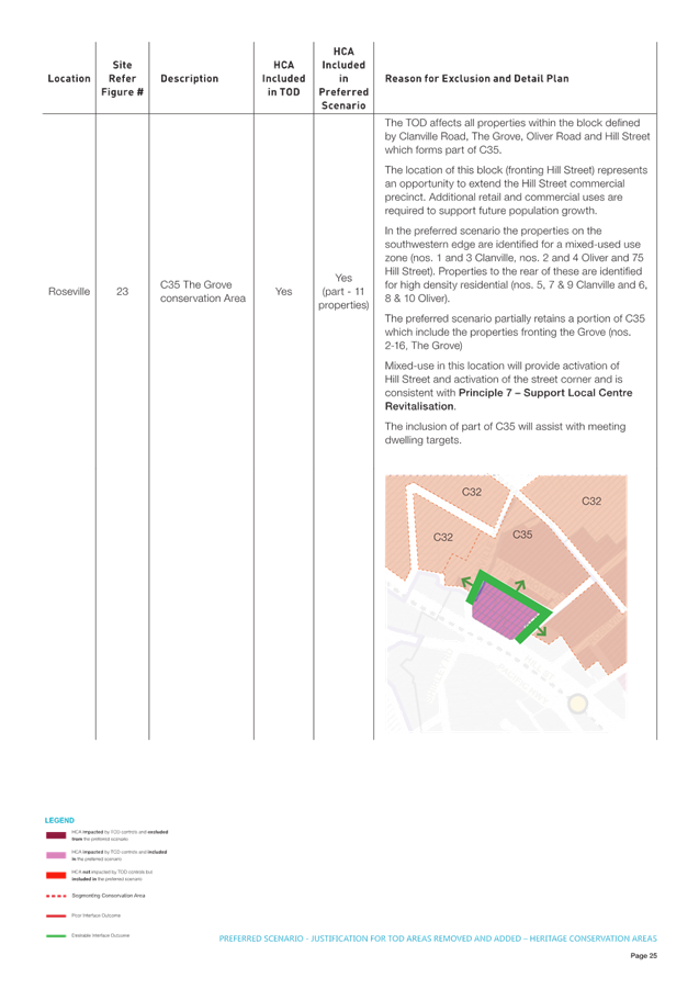
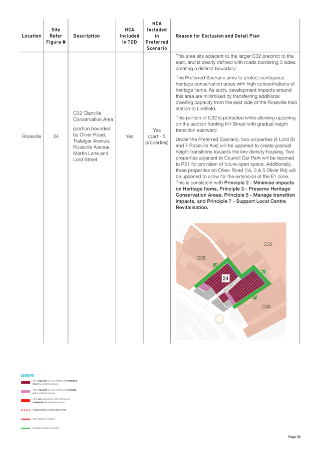
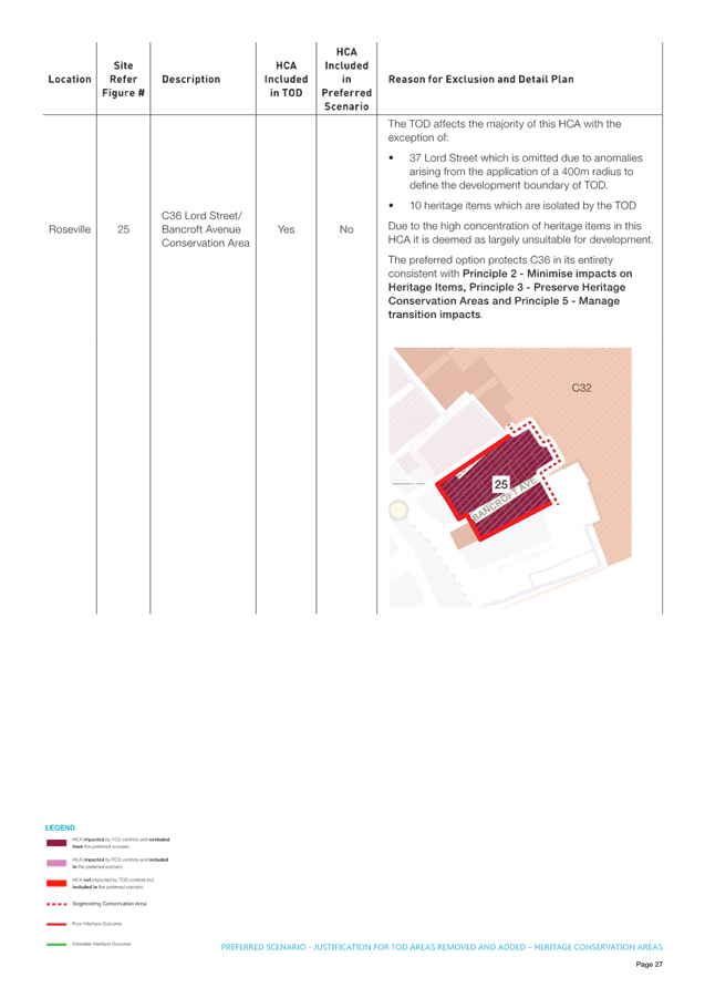
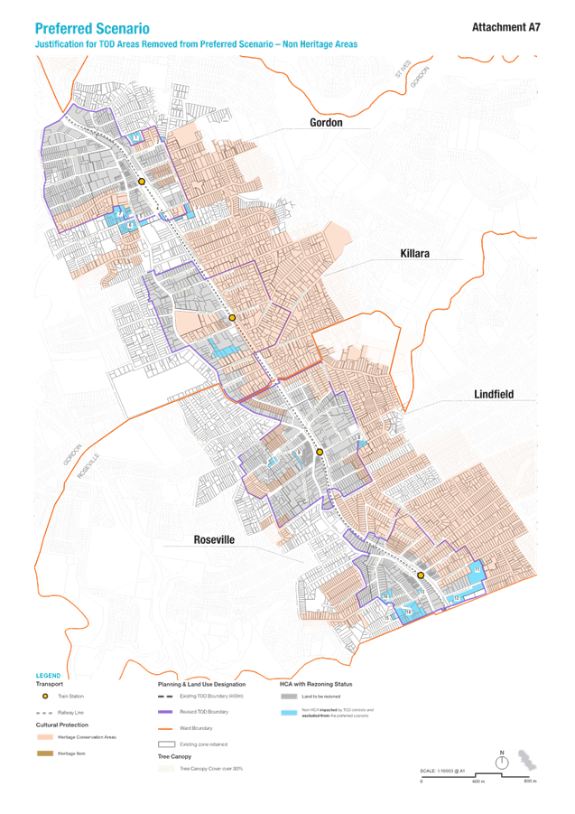
The following discussion provides an overview of the rationale for exclusion, downzoning or upzoning of areas in the Preferred Scenario. A detailed rationale for the exclusion or downzoning of areas from the Preferred Scenario is available in Attachment A6 – Preferred Scenario - Justification for TOD Areas Removed and Added – Heritage Conservation Areas and Attachment A7 – Preferred Scenario - Justification for TOD Areas Removed from Preferred Scenario – Non-Heritage Areas.
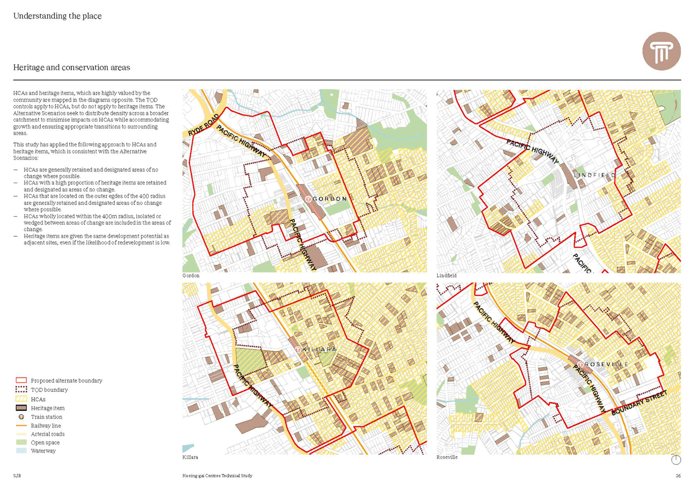
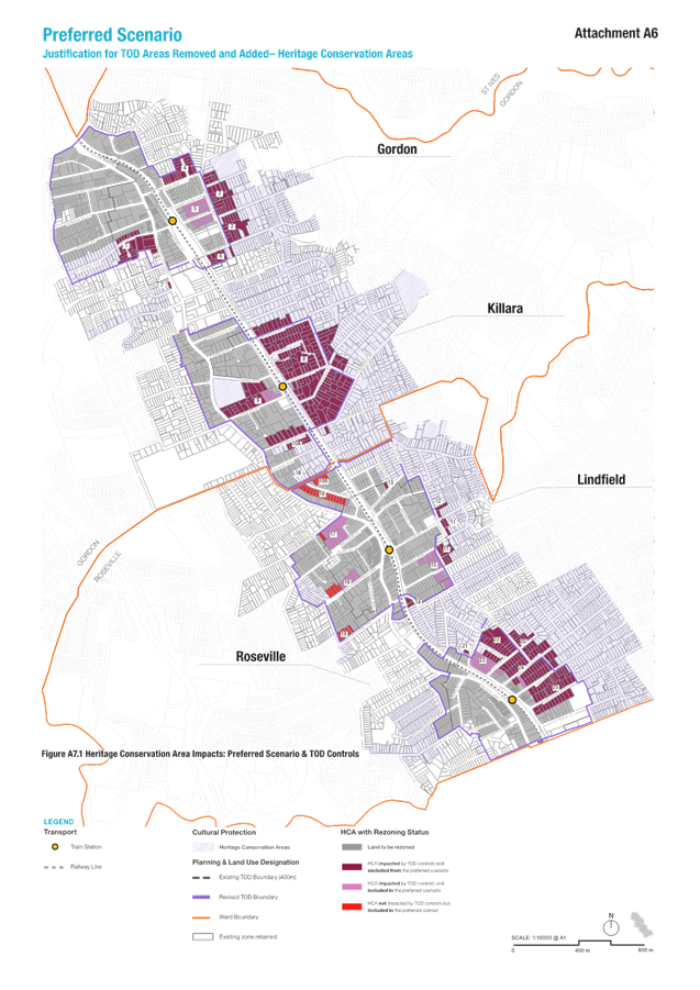
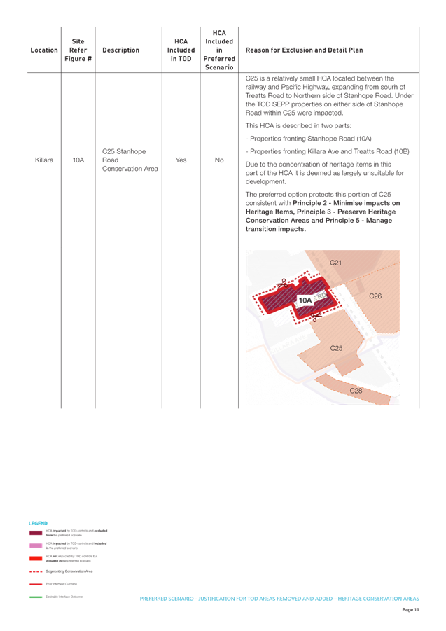
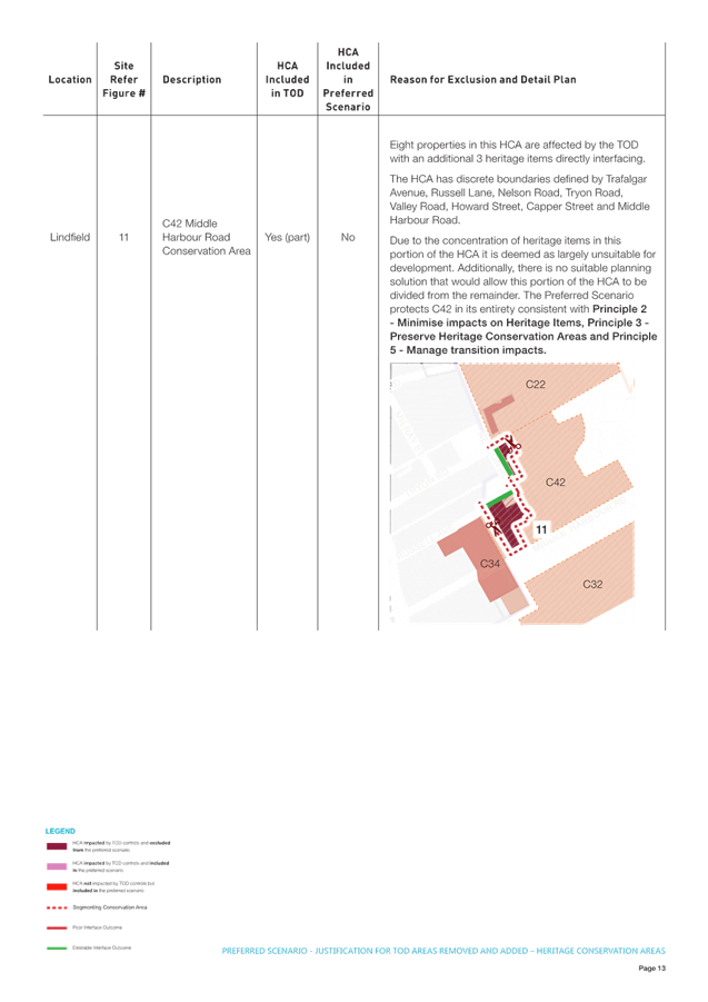
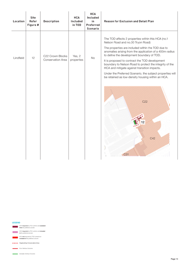
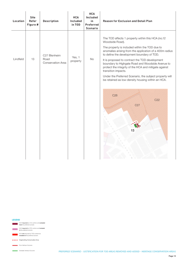
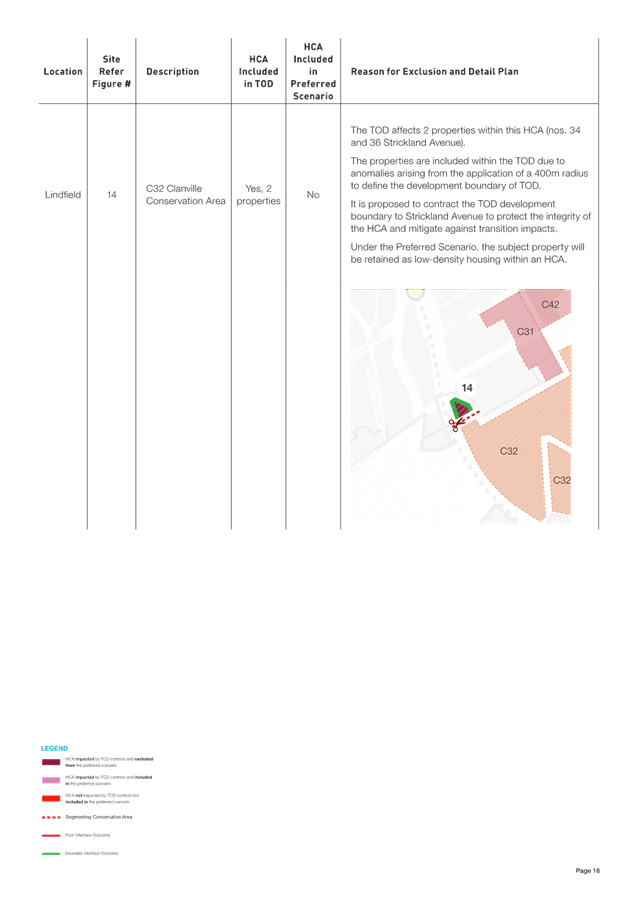
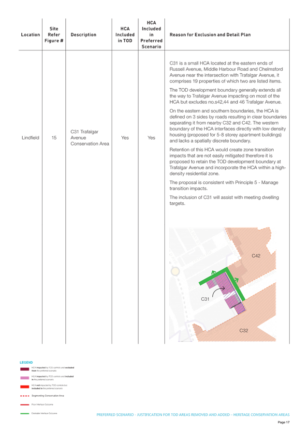
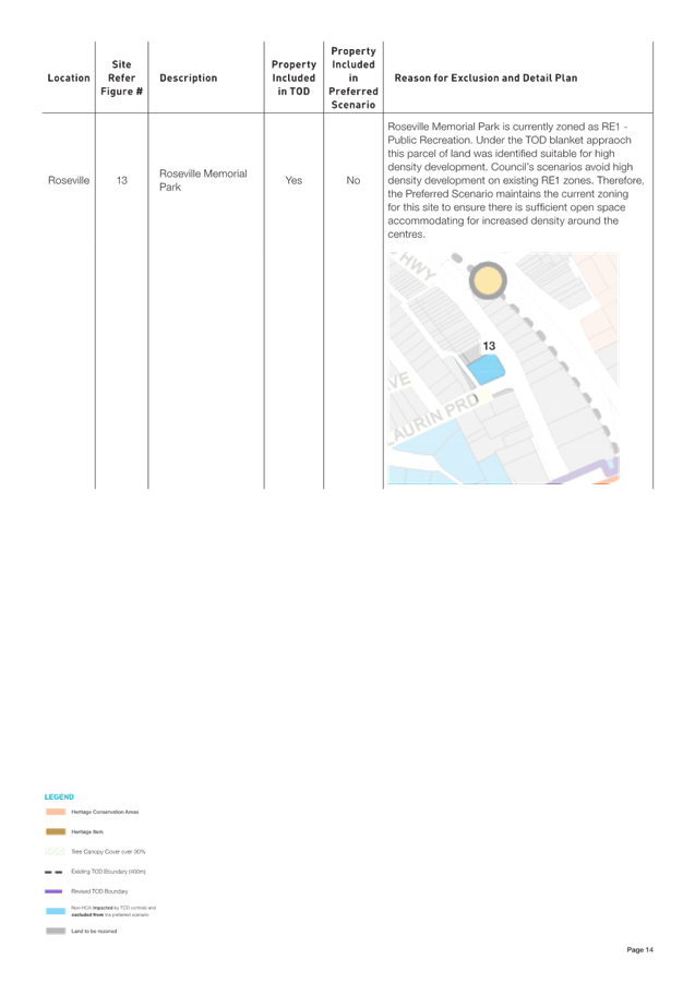
TOD areas removed (Figure 13)
Heritage Conservation Areas (HCAs)
Within the TOD area all properties within HCAs are currently impacted, this represents 100% of the areas. As shown in Figure 13, the Preferred Scenario proposes to protect approximately 80% of HCAs by removing the TOD controls and retaining the R2 - low density residential zone. This represents a ‘downzoning’ or reduction in development potential from 6-storeys and 2.5:1 to 2-storeys and 0.3:1. The TOD and ADG controls would be replaced with the Ku-ring-gai DCP, Part 4 – Dwelling Houses and Part 19 - Heritage Items and Heritage Conservation Areas.
Points to note:
· a key objective for Council in preparing alternative scenarios is to protect heritage conservation areas;
· the community has indicated a clear preference for Scenario 3b;
· the community survey ranked “Protecting some heritage conservation areas” as the 5th most important consideration for residents while “Protecting all heritage conservation areas” was ranked 10th.; and
· Principle 3 is to prioritise the protection of HCAs by transferring the potential dwelling yield to suitable non-heritage areas.
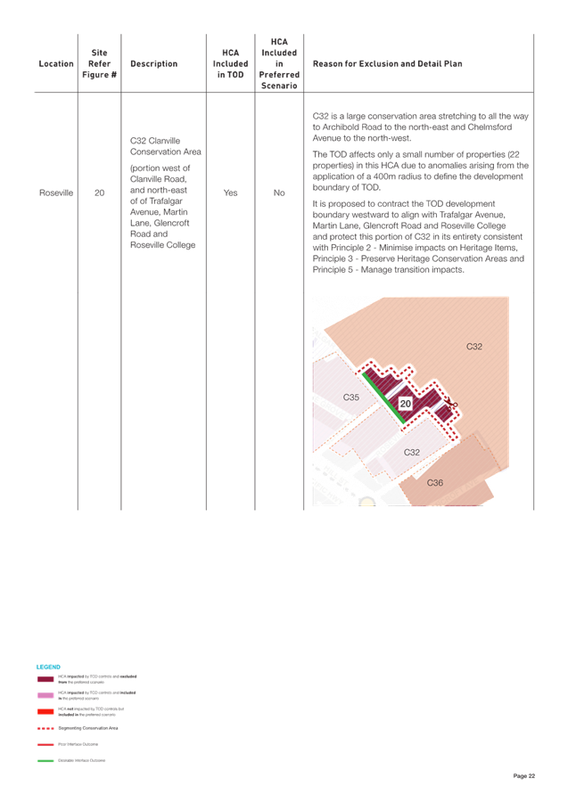
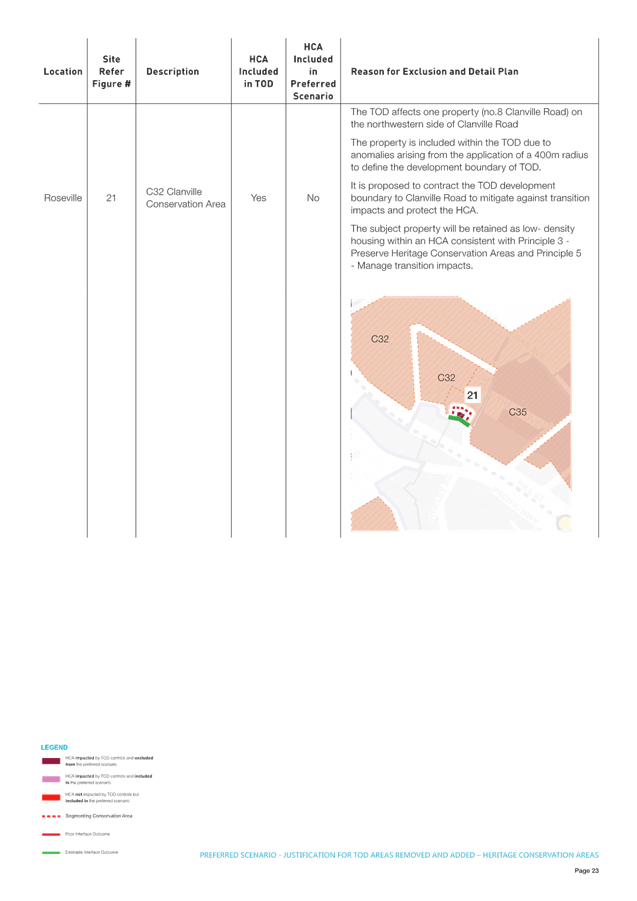
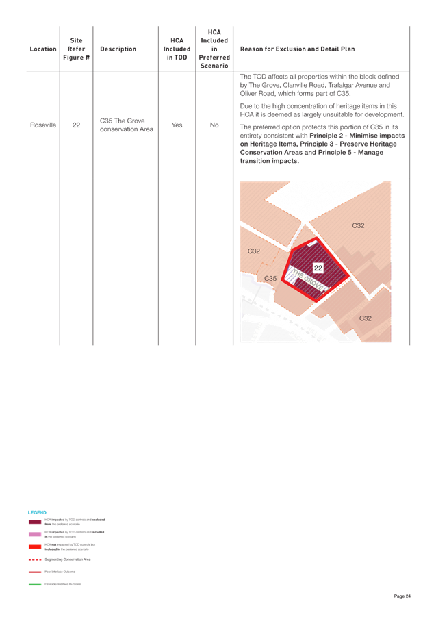
There are several reasons for exclusion of HCAs from the Preferred Scenario, these generally fall into the following categories:
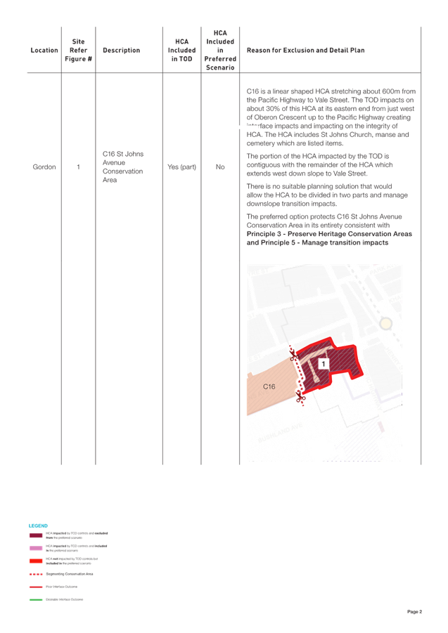
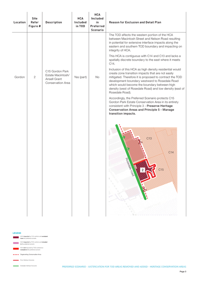
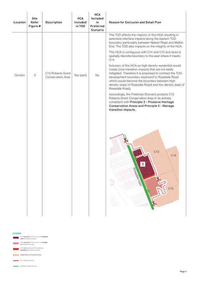
· Where the TOD affects a small number of properties within a larger HCA that is unaffected by TOD. These anomalies generally arise because of the application of a 400m radius to define the development boundary of the TOD. The solution is to contract the development boundary to the nearest local road and protect the whole HCA.
· Where a portion of an HCA is impacted by the TOD which is contiguous with an HCA unaffected by the TOD and there is no spatially discrete boundary between the two. In these cases, the whole HCA is protected as there is no suitable planning solution that would allow the HCA to be split in two parts and manage transition impacts.
· Where the TOD affects a portion of an HCA resulting in potential for extensive interface impacts along the TOD boundary.
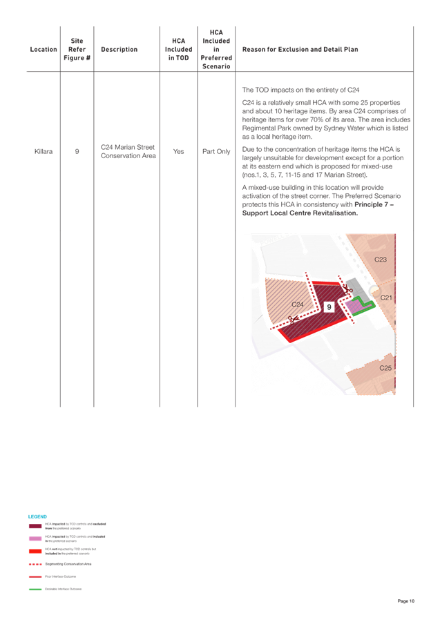
· Where the TOD includes an HCA with features such as a high proportion of heritage items and/or irregular street and block patterns that would significantly limit development potential and result in a fragmented development pattern.
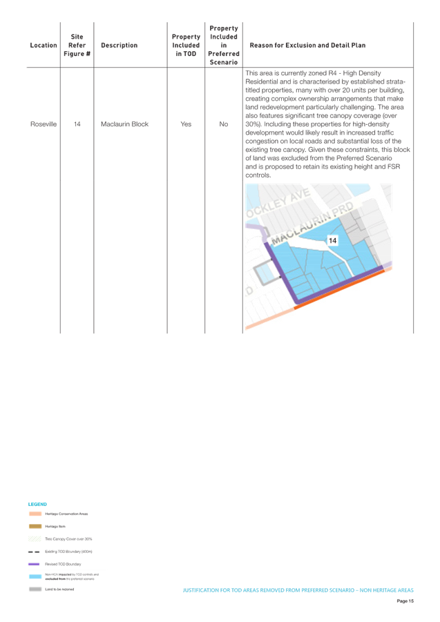
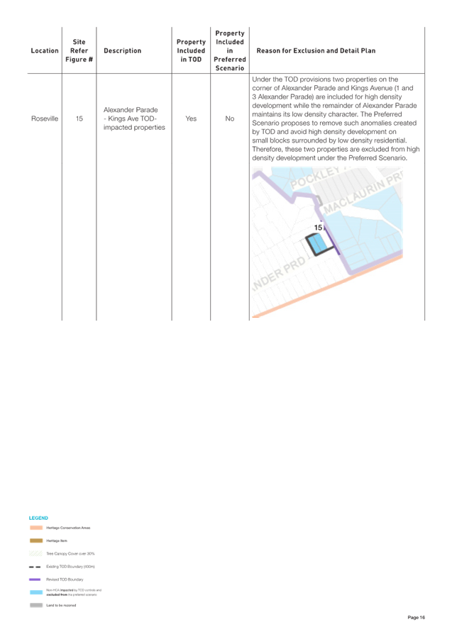
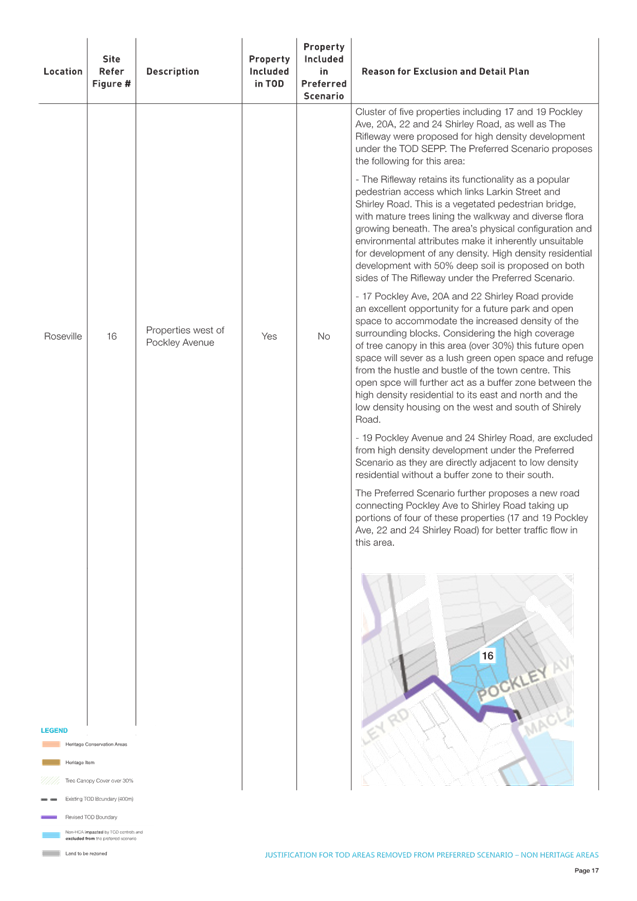
Non-Heritage Areas
The Preferred Scenario, consistent with Scenario 3b, proposes to remove certain non-HCA areas currently within TOD, by removing the TOD controls and retaining the R2 - Low Density Residential zone (Figure 13). This represents a ‘downzoning’ or reduction in development potential from 6-storeys and 2.5:1 to 2-storeys and 0.3:1. The TOD and ADG controls would be replaced with the relevant parts of the Ku-ring-gai DCP.
In other cases, where Council has identified suitable locations for new parks or local roads the TOD controls are proposed to be replaced with SP2 – Local Infrastructure or RE1 – Public Recreation. This also represents a down-zoning from the TOD, subject to Council’s Acquisition and Divestment Policy and the Land Acquisition (Just Terms Compensation) Act 1991.
Points to note:
· the community has indicated a clear preference for Scenario 3b which specifically excludes some TOD areas to minimise impacts in accordance with Council’s planning principles; and
· the survey results show the communities top three outcomes to support more housing are “managing transition impacts”, “avoiding environmentally sensitive areas” and “minimising impacts on tree canopy”.
There are several reasons for exclusion of non-heritage areas from the Preferred Scenario, these generally fall into the following categories:
· avoiding locating high density residential in environmentally sensitive areas including biodiversity and riparian lands as per Principle 1;
· minimising impacts on heritage items consistent with Principle 2;
· improving canopy protection consistent with Principle 2;
· managing transition impacts by expanding or contracting the development boundary as per Principle 5; and
· providing for new local parks and local roads in strategic locations to address infrastructure needs arising from population growth.
TOD areas downzoned (Figure 13)
Heritage Conservation Areas
The Preferred Scenario proposes to incorporate approximately 20% of HCAs within high density residential areas, similar to Scenario 2a, but not to the same extent. It is proposed to replace the TOD controls with a R4-High Density Residential zone. This represents a downzoning from 6-storeys and 2.5:1 to 5 to 8-storeys and 1.3:1 to 1.8:1.
The TOD and ADG controls would be replaced with the Ku-ring-gai DCP, Part 7 – Residential Flat Buildings. It is proposed to retain the heritage listing of the portion of the HCA affected as there is no basis on heritage grounds to remove the listing. It also means that any future development applications will be subject to considerations under Cl 5.10 of the KLEP 2015.
Points to note:
· a key objective for Council in preparing alternative scenarios is to meet the State government’s housing targets arising from the TOD program;
· residents ranked “Increasing the number of dwellings in Ku-ring-gai” as 9th above “Protecting all Heritage Conservation Areas” which was ranked 10th; and
· “Protecting some heritage conservation areas” was ranked 5th, higher than “Protecting all heritage conservation areas” which was ranked as 10th.
Selection of HCAs for inclusion is based on Principle 3 – Preserve Heritage Conservation Areas which acknowledges that:
· all HCAs are assumed to be of equal value and worthy of protection under NSW Heritage Council criteria for local heritage significance and
· the decision not to protect all or part of an HCA is based on planning considerations alone rather than heritage considerations.
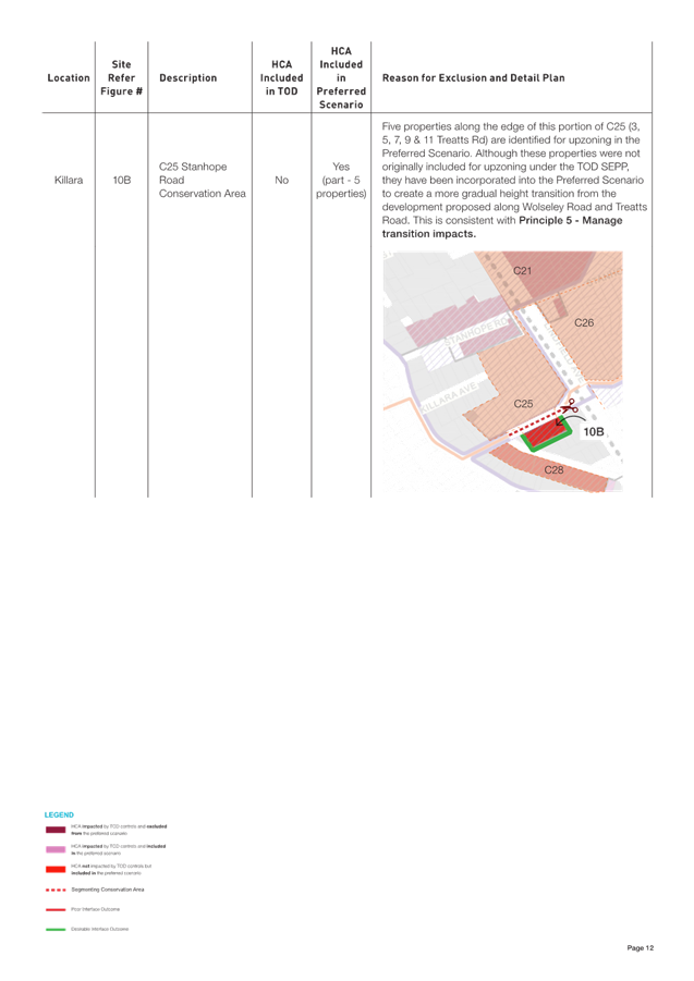
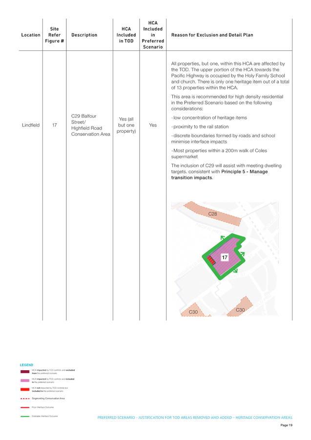
In certain cases, the Preferred Scenario includes some HCAs within the development area for broad strategic reasons:
· to meet dwelling targets;
· to address interface impacts;
· to minimise development spread;
· to maintain acceptable building heights (as per Scenarios 2a and 3b); and
· to support revitalisation of the centres.
HCAs that are proposed for higher density in the Preferred Scenario are characterised by:
· a low concentration, or absence, of heritage items;
· a location within proximity to the rail station;
· a spatially discrete boundary such as a local road or open space;
· discontinuity with adjoining HCAs; and/or
· a location suitable for mixed use development.
Non-Heritage Areas
The Preferred Scenario, consistent with Scenario 3b, proposes a range of building heights and FSRs in high density residential zones to better protect existing trees and minimise long term impacts on canopy cover. These changes are broadly applied and represent a down-zoning to much of the R2 and R4 lands currently affected by the TOD. In high density residential areas, the TOD controls (2.0:1 FSR and building height of 6-storeys) are proposed to be replaced with reduced densities (FSR 0.85 to 1.8:1) and a building height range of 3 to 8-storeys. In these areas the TOD and ADG controls would be replaced with the controls from Ku-ring-gai DCP.
Points to note:
· the survey results show residents ranked “managing transitions between areas of different densities to avoid impacts such as overshadowing and loss of privacy on neighbours” as the number 1 most important and “minimising impacts on tree canopy” as the 3rd most important outcome for additional housing;
· the community has a clear preference for Scenario 3b which proposes that all new high-density residential areas would have reduced height and densities (when compared to the TOD); and
· the preference for Scenario 3b is a clear acknowledgement that the community is willing to trade-off the spreading of development (beyond the TOD) to protect tree canopy and address interface impacts (noting that reduced densities will require more spread to accommodate the same number of dwellings as the TOD).
There are several reasons for down-zoning TOD areas in the Preferred Scenario, these generally fall into the following categories:
· to better protect existing trees and minimise long term impacts on canopy cover consistent with Principle 3 - Improve canopy protection;
· to achieve a minimum canopy cover target of 30% in R4 – High Density Residential areas;
· to allow inclusion of minimum deep soil requirements (40-50% of site area), maximum site coverage controls (30%), and increased tree replenishment and planting requirements consistent with Council’s current DCP controls for apartment buildings; and
· to introduce landscape setbacks and upper-level building setbacks, consistent with Council’s current DCP controls for apartment buildings, for greater building separation and stepping of building heights consistent with Principle 5 – Managing transition impacts.
Built form modelling has been undertaken to ensure the proposed FSR can be achieved within the nominated maximum building heights.
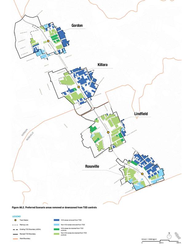
Figure 13 – TOD Areas Removed or Downzoned
TOD Areas upzoned (Figure 14)
The Preferred Scenario, consistent with Scenario 3b, proposes significantly greater building height and density in existing E1 – Local Centre zones to facilitate revitalisation of the centres and focus growth close to the rail station. In addition, the Preferred Scenario proposes to add new areas of MU1 or E1 to increase the capacity of the centres to provide retail and commercial services to cater for future population growth. These changes represent significant upzoning (increased FSR and building height) when compared to the TOD. Further, they provide the opportunity for commercial and service functions not otherwise allowed for by the TOD controls.
Points to note:
· the community has a clear preference for Scenario 3b which proposes to transfer dwelling yield to the commercial areas to protect local character;
· the preference for Scenario 3b is a clear acknowledgement that the community is willing to trade-off greater height (within limits) and density in the commercial areas to protect low density residential environments; and
· the community ranked “Supporting revitalisation of commercial and retail areas” as the 6th most important outcome in delivering additional housing to the Ku-rung-gai LGA.
There are several reasons for up-zoning TOD areas in the Preferred Scenario, these generally fall into the following categories:
· in existing E1 zones the TOD FSR of 2.5:1 is considered insufficient, in most cases, to encourage redevelopment of existing commercial properties (and in many cases is less than current provisions in the KLEP), in these cases an FSR of between 3.0:1 and 8.0:1 is proposed to facilitate revitalisation of the centres consistent with Principle 7 - Support Local Centre Revitalisation;
· where new E1 or MU1 zones are proposed and a higher FSR is required to facilitate revitalisation consistent with Principle 7; and
· in both cases, as above, building heights are increased from 6 to 7-storeys under the TOD to 8-storeys up to 28-storeys under the Preferred Scenario.
Built form modelling has been undertaken to ensure the proposed FSR can be achieved within the nominated maximum building heights.
Non-TOD areas Upzoned (Figure 14)
Heritage Conservation Areas
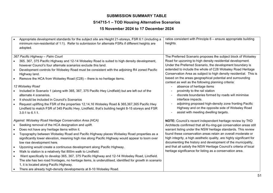
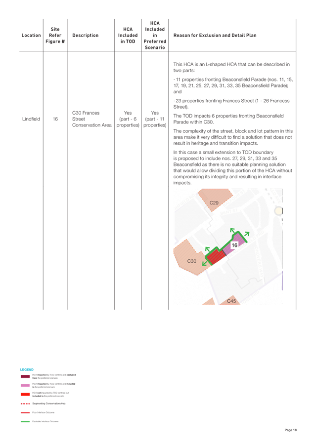
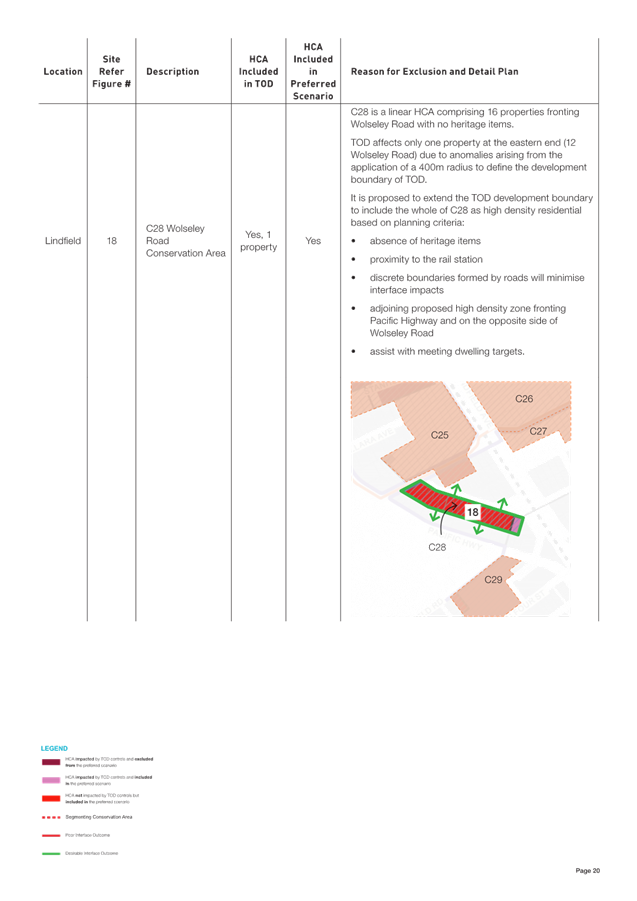
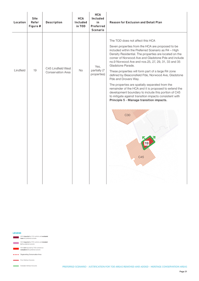
The preferred Scenario proposes to include parts of HCAs outside the TOD boundary that are not currently affected by the TOD. These include:
· C45 Lindfield West Conservation Area (part)
· C28 Wolseley Road Conservation Area (part)
· C30 Frances Street Conservation Area (part).
The affect properties would be upzoned from R2 low density to R4 high density an increase in development potential FSR from 0.3:1 to between 0.85:1 and height from 2-storeys to between 3 to 8 storeys. The applicable controls would be replaced with the Ku-ring-gai DCP, Part 7 – Residential Flat Buildings. It is not proposed to remove the heritage listing of the portion of the HCA affected as there is no basis on heritage grounds to remove the listing.
Points to note:
· the survey results show residents ranked “managing transitions between areas of different densities to avoid impacts such as overshadowing and loss of privacy on neighbours” as the number 1 most important outcome for additional housing; and
· the preference for Scenario 3b is a clear acknowledgement that the community is willing to trade-off the spreading of development (beyond the TOD) to address interface impacts (noting that reduced densities will require more spread to accommodate the same number of dwellings as the TOD).
The Preferred Scenario includes some HCAs within the development area primarily to address interface or transition impacts.
HCAs that are proposed for higher density in the Preferred Scenario are characterised by:
· a low concentration, or absence, of heritage items;
· a location within close proximity to the rail station;
· a spatially discrete boundary such as a local road or open space; and
· discontinuity with adjoining HCAs.
Non-Heritage Areas
· to the northwest and west of Gordon broadly defined by Vale Street, Mona Vale Road, Carlotta Avenue and Pearson Avenue;
· to the west of the Pacific Highway and around Greengate Avenue, Killara;
· to the southwest of Lindfield between Highfield Road and Gladstone Parade and to the northwest around Treatts Road; and
· to the west of Shirley Road, Roseville.
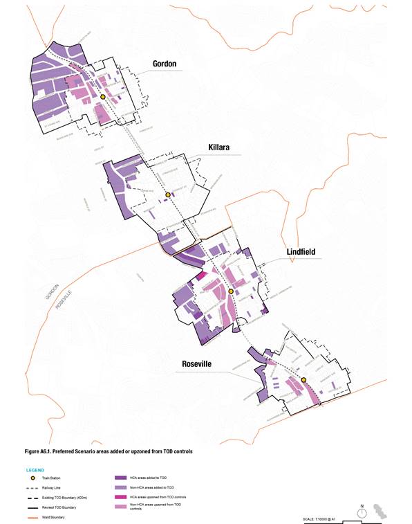
Figure 14 – TOD Areas Added or Upzoned
Heritage Items Upzoned or Removed
Within the Preferred Scenario there is a total of 174 properties listed as heritage items. The Preferred Scenario proposes to protect approximately 120(69%) heritage items by removing the TOD controls and retaining the dwellings within the R2 - low density residential zone and retaining the heritage listing. The TOD and ADG controls would be replaced with the Ku-ring-gai DCP, Part 4 – Dwelling Houses and Part 19 - Heritage Items and Heritage Conservation Areas.
In the minority of cases (54 items or 31%) the Preferred Scenario proposes to retain heritage items within R4 high density residential areas or E1/MU1 zones. In these instances, measures are proposed to protect both the owner of the property and the heritage value of the dwelling:
· the heritage listed property is zoned for R4 high density residential consistent with adjoining properties;
· the heritage listed property is allocated a building height and FSR the same as surrounding properties; and
· minimum lot sizes are defined to ensure the item must be included within a development.
In the future site-specific development controls will be developed for these sites which will form part of the Ku-ring-gai DCP.
5. Evaluation of the Preferred Scenario
Principle 1 - Avoid environmentally sensitive areas
Principle 2 - Minimise impacts on Heritage Items
Principle 3 - Preserve Heritage Conservation Areas
Principle 4 - Minimise impacts on the tree canopy
Principle 5 - Manage transition impacts
Principle 6 - Ensure appropriate building heights
Principle 7 - Support Local Centre Revitalisation
The Preferred Scenario has been assessed against the TOD SEPP using these seven principles to ensure it delivers stronger outcomes in the areas Council considers most important. This evaluation has confirmed that the Preferred Scenario successfully achieves its intended objectives and outperforms the TOD SEPP in key areas.
A detailed breakdown of the evaluation is provided below, and all maps are in Attachment A8 - Evaluation of the Preferred Scenario.
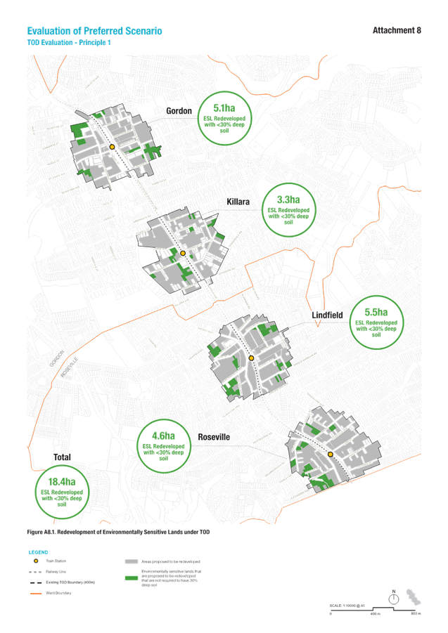
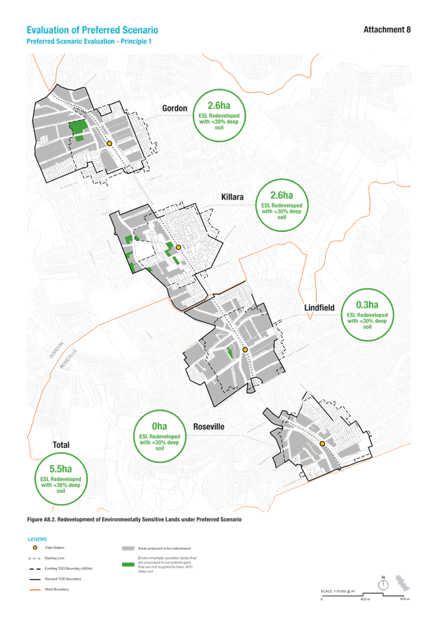
Principle 1 - Avoid environmentally sensitive lands (ESL)
· the Preferred Scenario would result in a 68% improvement when compared to the TOD.
· measured as the area of environmentally sensitive lands (ESL) proposed for high density development where development controls require less than 50% of the site area as deep soil.
· Area of impact reduced from 18.4ha under TOD to approximately 5.9ha under Preferred Scenario.
Discussion
Principle 1 is to avoid locating high density residential and mixed use in environmentally sensitive areas. Environmentally sensitive areas have been classified as:
· properties which contain core biodiversity;
· properties with 20% or more of the land area containing biodiversity that supports core biodiversity, contains landscape remnants or is a biodiversity corridor;
· properties with 25% or more of the land area affected by category 1 or 2 riparian lands; and
· properties that contain category 1 or 2 bushfire prone vegetation.
Under the TOD SEPP, all environmentally sensitive sites within a 400-metre radius of Gordon, Killara, Lindfield, and Roseville stations are identified for redevelopment. With a minimum deep soil requirement of 7% (as per the ADG), most vegetation that qualifies these sites as environmentally sensitive would likely be impacted. As a result, it has been estimated that the TOD could lead to the loss of approximately 18.4 hectares of environmentally sensitive land. This can be seen in Figure 16.
The Preferred Scenario aims to preserve as much environmentally sensitive land as possible while still achieving housing targets and supporting development near stations and centres. This is accomplished in two ways:
· first, by avoiding locating new development within environmentally sensitive sites where feasible, and
· second, by increasing the minimum deep soil requirement to 50% for residential zones, ensuring the retention of biodiversity and riparian areas.
Across the four centres, this approach could result in only 5.9 hectares of environmentally sensitive land potentially impacted, which is a reduction of 12.5 hectares compared with TOD. Furthermore, these impacts are expected in areas designated for development with deep soil zones below 50%, such as E1 and MU1 zones. This can be seen in Figure 17
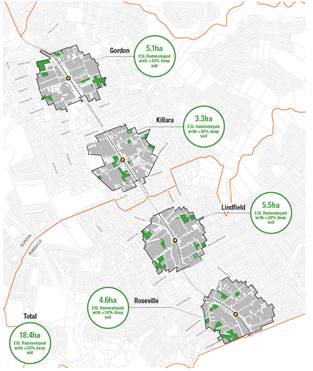
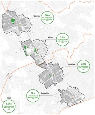
Figure 16 - TOD Evaluation – ESL Lands Figure 17 – Preferred Scenario Evaluation – ESL Lands
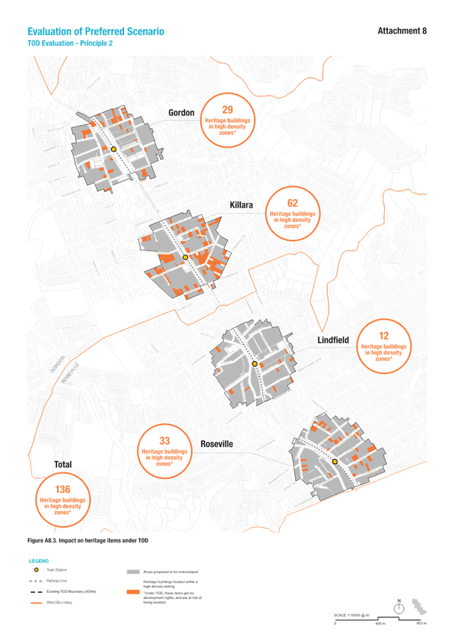
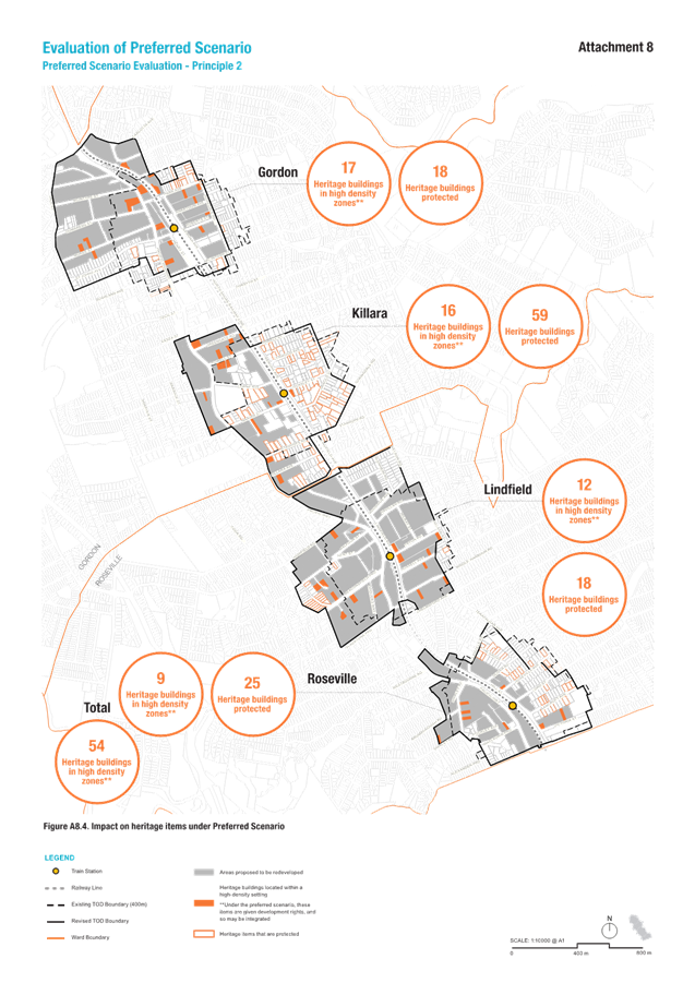
Principle 2 - Minimise impacts on Heritage Items
Summary
· the Preferred Scenario would result in a 69% improvement when compared to the TOD.
· measured as the number of heritage items retained in low density residential environments.
· number of heritage items impacted reduced from 136 under the TOD to 54 heritage items under Preferred Scenario.
Discussion
The TOD SEPP excludes heritage items entirely and offers no incentives for their inclusion within future development sites. Surrounding properties, however, are permitted to seek approval for up to six-storey apartment buildings, increasing the risk that heritage items will be overshadowed, overlooked, and left out of context. As a result, these heritage properties become effectively isolated or ‘stranded’ within a high-density residential setting. Under the TOD, 136 heritage items are at risk of being isolated within high-density zones, as illustrated in Figure18.
In contrast, the Preferred Scenario prioritises the protection of heritage items through two key strategies:
· first, by directing development away from areas with high concentrations of heritage items, such as Heritage Conservation Areas, and
· second, by granting heritage properties located within high-density areas the same development rights as neighbouring sites.
Using this approach, the Preferred Scenario will fully protect 120 heritage items, meaning they will be located within low-density residential zones, preserving their existing setting. Where this has not been possible and heritage items have been situated within high-density areas under the Preferred Scenario those properties will receive the same development rights as adjacent sites, allowing them to be integrated into larger projects through adaptive reuse, with potential impacts managed through thoughtful design. This is illustrated in Figure 19.
Figure 18 - TOD Evaluation – Heritage Items Figure 19 – Preferred Scenario Evaluation – heritage items
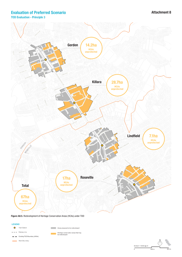
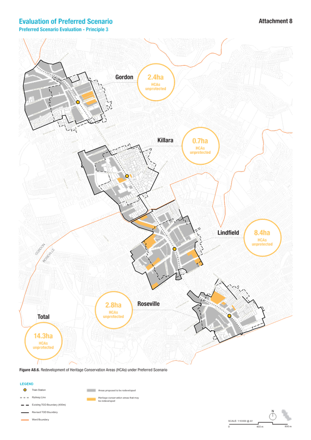
Principle 3 - Preserve Heritage Conservation Areas
· the Preferred Scenario would result in an 80% improvement when compared to the TOD measured as the area of HCA land zoned for high density development; and
· the area of HCAs impacted is reduced from 67ha under the TOD to 14.3ha under Preferred Scenario.
As a result of Ku-ring-gai’s historic pattern of development being concentrated along the northern railway line, the TOD disproportionally impact the HCAs. Under the TOD, HCAs are not considered a constraint to development. There is a total of 67 hectares of HCAs within a 400-metre radius of Gordon, Killara, Lindfield, and Roseville stations that are potentially impacted. This impacts Killara the most, with 28.7 hectares of HCA land at risk. This can be seen in Figure 20.
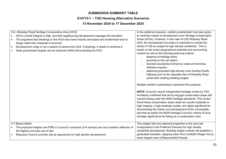
The Preferred Scenario aims to avoid development in HCAs wherever possible. To ensure their preservation, the Council commissioned an independent review of 28 existing HCAs to validate their listings and boundaries in accordance with NSW heritage standards. This review, conducted by TKD Architects, confirmed that all HCAs meet the NSW Heritage Council’s threshold for local heritage significance. Where avoidance is not feasible, planning principles—rather than heritage principles—have guided redevelopment decisions. The Preferred Scenario prioritises the protection of HCAs that:
· contain a high concentration of heritage items;
· are located more than 200 metres from a railway station; and/or
· are continuous with adjoining HCAs outside the 800-metre study boundary
Figure 21 shows the Preferred Scenario proposes to incorporate approximately 14.3 hectares of HCA land within high density residential areas which is a reduction of 52.7 hectares compared with TOD SEPP. A detailed discussion and justification for inclusion of HCAs within the Preferred Scenario can be found in Attachment A7.
Figure 20 - TOD Evaluation – Heritage Conservation Areas Figure 21 – Preferred Scenario Evaluation – Heritage Conservation Areas
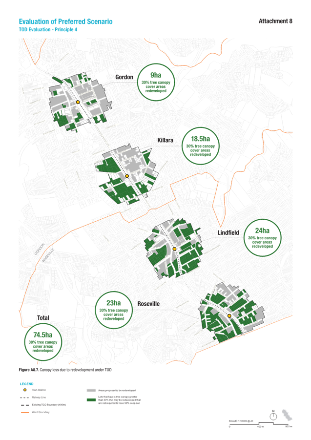
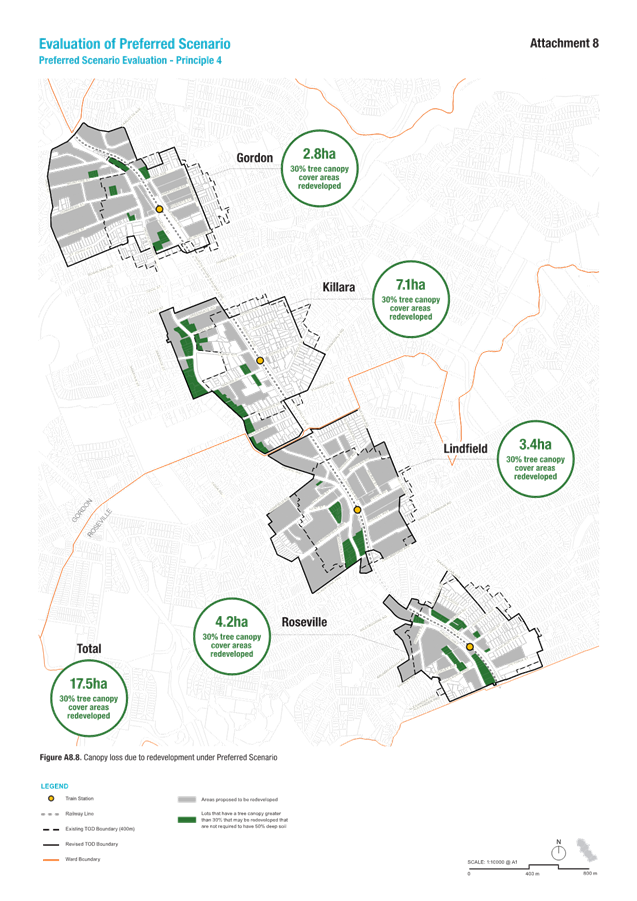
Principle 4 - Minimise impacts on the tree canopy
Summary
· the Preferred Scenario would result in a 76% improvement when compared to the TOD;
· measured as the area of land with 30% canopy cover or greater proposed for high density development and where development controls require less than 50% of site area as deep soil; and
· area of impact reduced from 74ha under the TOD to 17.5ha under Preferred Scenario.
Discussion
The TOD SEPP is expected to have a significant impact on canopy cover, as it permits high-density redevelopment in areas with existing high tree canopy coverage (over 30%). It includes minimal provisions for protecting existing trees or requiring new plantings. Under this scenario, all rezoned sites designated for redevelopment would be subject to a minimum 7% deep soil requirement, as outlined in the ADG, meaning it would not be feasible to replace the existing canopy on site. As a result, redevelopment could lead to significant tree canopy loss across approximately 75 hectares of land, as illustrated in Figure 22.
The Preferred Scenario prioritises the protection of existing tree canopy cover while also creating opportunities for its expansion. All high-density residential areas are subject to a minimum 50% deep soil requirement, which will result in no net loss of canopy. The primary area where canopy protection is limited is along the highway corridor, within employment lands, where retail and commercial developments typically have larger building footprints and active frontages extending to the street. As a result, redevelopment in these areas is expected to result in canopy loss across approximately 17.5 hectares, which is a reduction of 57.5 hectares compared with TOD SEPP. This is as shown in Figure 23.
Figure 22 - TOD Evaluation – Canopy Cover Figure 23 – Preferred Scenario Evaluation – canopy cover
Principle 5 - Manage transition impacts
Summary
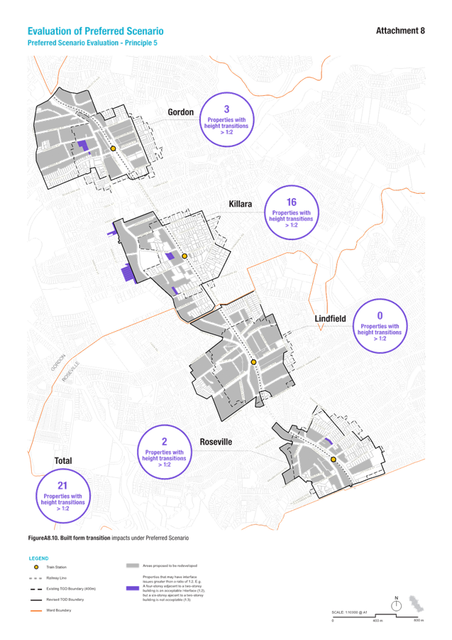
· the Preferred Scenario would result in a 93% improvement when compared to the TOD;
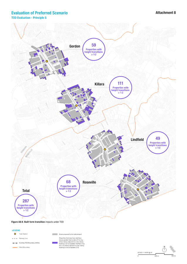
· measured as the number of properties with a height transition threshold of greater than 1:2 for properties that share a boundary (this means that a four-storey building adjacent to a two-storey dwelling is acceptable while a 5-storey building would result in transition impacts); and
· the number of properties impacted is reduced from 287 properties under the TOD to 21 properties under the Preferred Scenario.
Discussion
Interface issues occur when there are significant changes in building scale and land use, often leading to excessive privacy loss or overshadowing. To assess potential interface challenges across a large site area, a height transition threshold of 1:2 is considered appropriate for neighbouring properties that share a boundary. This means that a four-storey building adjacent to a two-storey dwelling is acceptable (1:2), whereas a six-storey building next to a two-storey dwelling (1:3) would create an imbalance and be deemed inappropriate.
The Low and Mid Rise (LMR) policy came into effect on 28 February 2025. Under this policy, R3 and R4 zones within an 800m walking distance of stations are eligible for mid-rise development, while R2 zones within the same distance are eligible for low-rise development. The areas surrounding the TOD SEPP precincts in Gordon, Killara, Lindfield, and Roseville are predominantly zoned R2. As the LMR policy does not alter the existing height of building standard, development in these areas is expected to remain largely two-storey dwellings, although at a higher density, such as two-storey townhouses.
The TOD SEPP applies to residential and employment land within 400 metres of the four railway stations, excluding heritage sites. In many cases, upzoning is not defined by roads, a common approach for managing height and land use transitions. As a result, significant transition impacts may occur mid-block along the TOD boundary. Under the TOD, 287 properties could experience interface impacts. This is as shown in Figure 24. The largest centre impacted is Killara, with 111 properties at risk of experiencing interface issues – the majority of these being heritage items.
The community identified their top priority when considering increased housing supply as “Managing transitions between areas of different densities to minimise impacts such as overshadowing and loss of privacy". The Preferred Scenario addresses transition impacts primarily by rezoning high-density areas to cover entire blocks or by gradually stepping down building heights mid-block (e.g., transitioning from 8 storeys to 5 storeys). Figure 25 shows that the Preferred Scenario may impact on only 21 properties. It is anticipated that these impacts will be managed through site-specific DCP controls.
Principle 6 - Ensure appropriate building heights
The TOD SEPP proposes a maximum building height of 22m for residential flat buildings and 24m for shop-top housing. Delivering 23,200 dwellings under this uniform height limit would come at the cost of environmentally sensitive land, tree canopy, and heritage protections.
During community consultation on the alternative scenarios, Principles 1, 3, 4, 5, and 7 were identified as higher priorities than Principle 6: ensuring appropriate building heights. In response, the Preferred Scenario prioritises these elements first, shaping building heights accordingly to ensure the 23,200-dwelling target is met without compromising key environmental and heritage protections.
As such, there is no comparable metric to measure the success of Principle 6. Building heights under the Preferred Scenario are considered appropriate in that they are only slightly higher than those exhibited in Scenario 3b, with 28-storeys in Gordon, 8-storeys in Killara, 18-storeys in Lindfield, and 8-storeys in Roseville, whilst achieving better outcomes across all other Principles.
Consultants has tested these heights to confirm they are feasible from a built form perspective and comply with ADG requirements.
Principle 7 - Support Local Centre Revitalisation
Summary
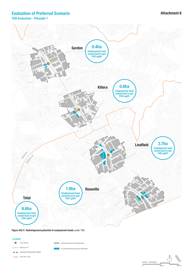
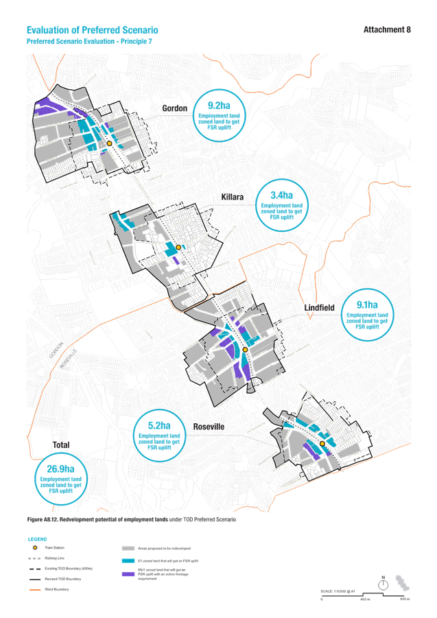
· the Preferred Scenario would result in an 85% improvement when compared to the TOD; and
· measured as the area of land upzoned for commercial and retail uses that would provide a range of services for residents the area of land increased from 6.6ha under the TOD to 43.4ha under the Preferred Scenario.
Discussion
The TOD program is not a “centres” policy and does not include incentives or initiatives to expand commercial or community facilities within the TOD station precincts. Under the TOD SEPP, existing sites within E1 centres are proposed to increase to a 2.5:1 FSR. However, many sites within the four station precincts already have an FSR at or above this level, providing little incentive for redevelopment. For example, in Gordon, only 4,100 sqm of E1 land would receive an uplift under the TOD program. Overall, approximately 6.6 hectares of E1 land would be rezoned for increased density. This can be seen in Figure 26.
Feasibility studies commissioned by Council indicate that many of these E1 sites are unlikely to be viable for redevelopment under the TOD framework. As a result, the TOD scenario may create or maintain a ‘doughnut’ effect where high-density residential development surrounds the retail and commercial centre while the core itself remains largely unchanged.
Unlike the TODD SEPP, the Preferred Scenario identifies additional land for E1 and MU1 uses, providing greater opportunities for mixed-use development. This expansion supports urban renewal in commercial centres alongside residential growth, enabling the development of retail facilities such as supermarkets, commercial spaces, and community amenities like libraries and community centres. Under the Preferred Scenario, 43.4 hectares of employment land would experience uplift, with the majority concentrated in Gordon, the area's primary centre. This can be seen in Figure 27.
Feasibility studies on key sites within the centres confirm that increased retail, commercial, and community infrastructure is achievable, ensuring redevelopment effectively supports population growth.
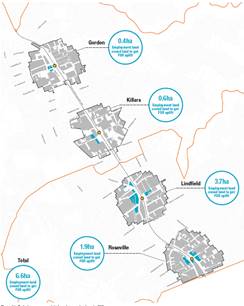
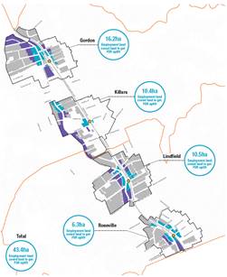
Figure 26 - TOD Evaluation – Revitalisation of centres Figure 27 – Preferred Scenario Evaluation – Revitalisation of Centres
6. Preferred Scenario - Implementation Strategy
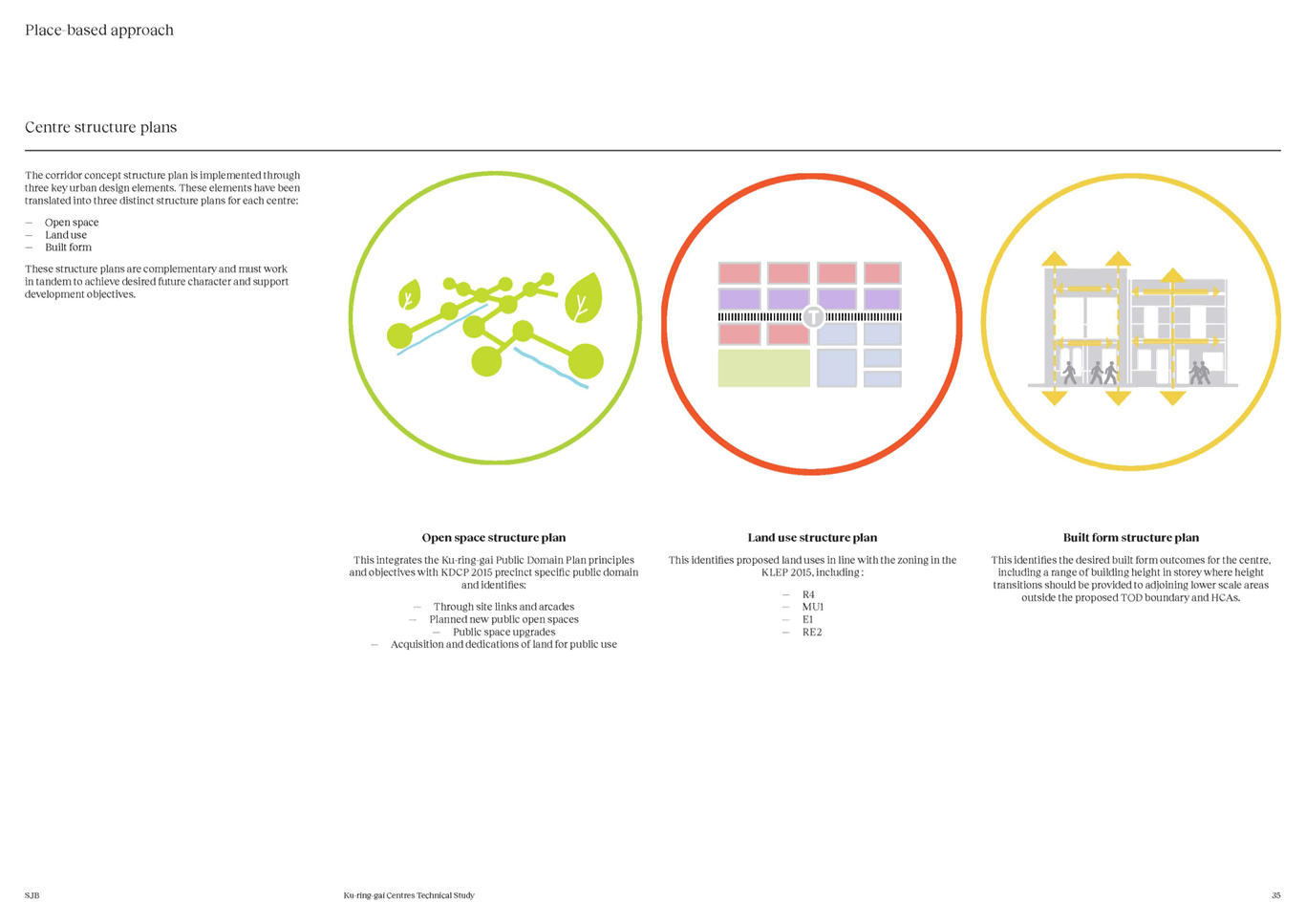
Consultants SJB Urban were engaged by Council to prepare a strategy for implementing the Preferred Scenario. This work covers the key changes to Council’s planning controls in response to the preferred scenario and the mechanisms to deliver the specific place-based (open space, connections) and housing (affordable) outcomes. The Implementation Strategy is outlined in Part 5 and 6 of Attachment A4 – Ku-ring-gai Centres Technical Study – SJB March 2025.
The Preferred Scenario will be implemented through amendments to the Ku-ring-gai Local Environmental Plan 2015 (KLEP) and Ku-ring-gai Development Control Plan (KDCP). It is intended that the KLEP amendments will be made by the Minister for Planning via a self-repealing SEPP. The required amendments to the KDCP will be made by Council.
Ku-ring-gai Local Environmental Plan 2015 (KLEP) Amendments
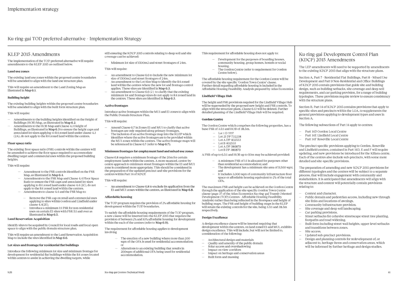
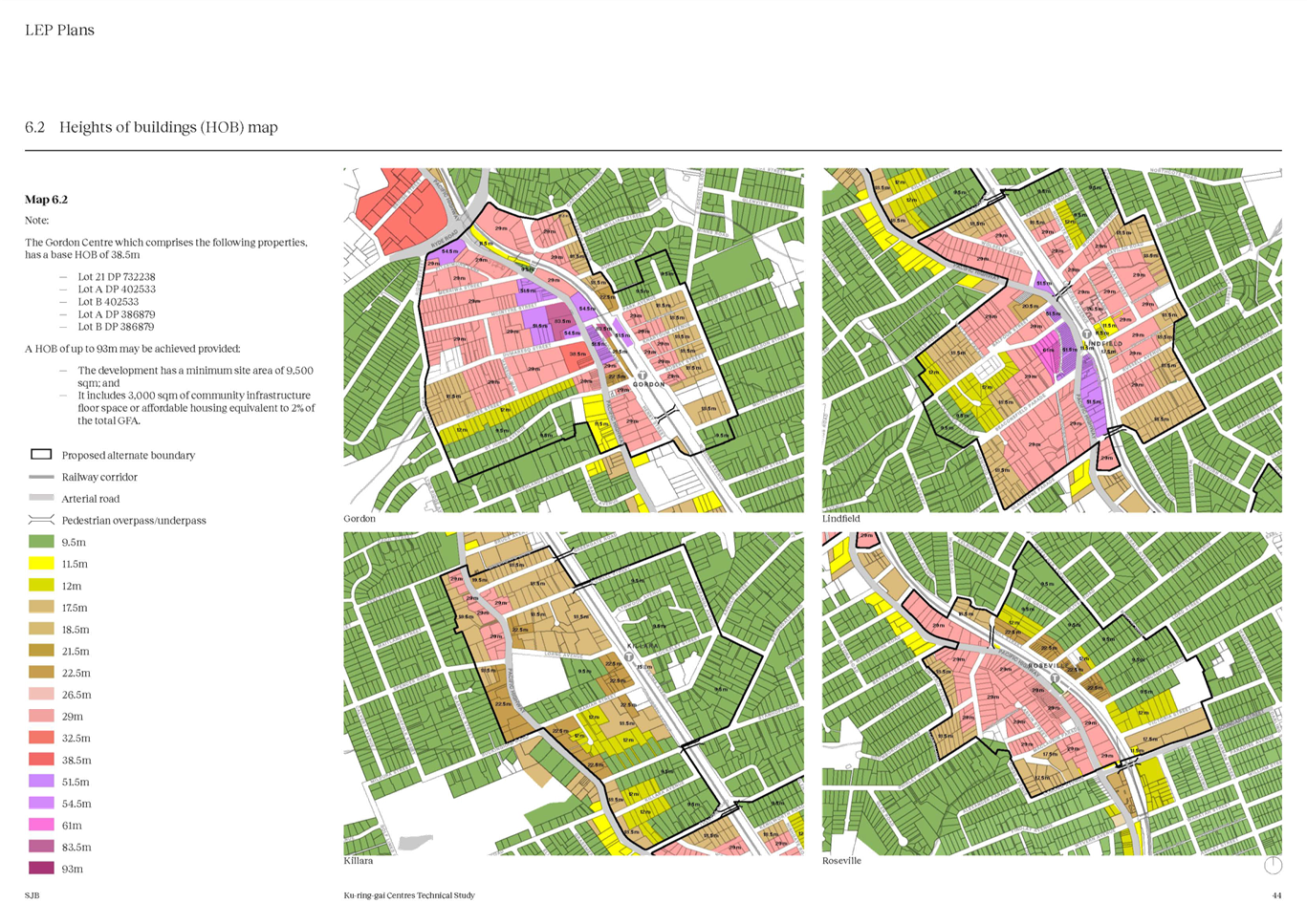
The key amendments that need to be made to the KLEP to implement the preferred scenario structure plans include the following:
Land use zone maps
The existing land use zones within the proposed centre boundaries will be amended to align with the land use structure plan. This will be achieved largely through the use of the R4, E1 and MU1 zones. The proposed new local parks are proposed to be zoned RE1- Public open space and the proposed new road in Roseville is to be zoned SP2 – Local road.
Refer to Attachment A4 – Ku-ring-gai Centres Technical Study – Part 6.1
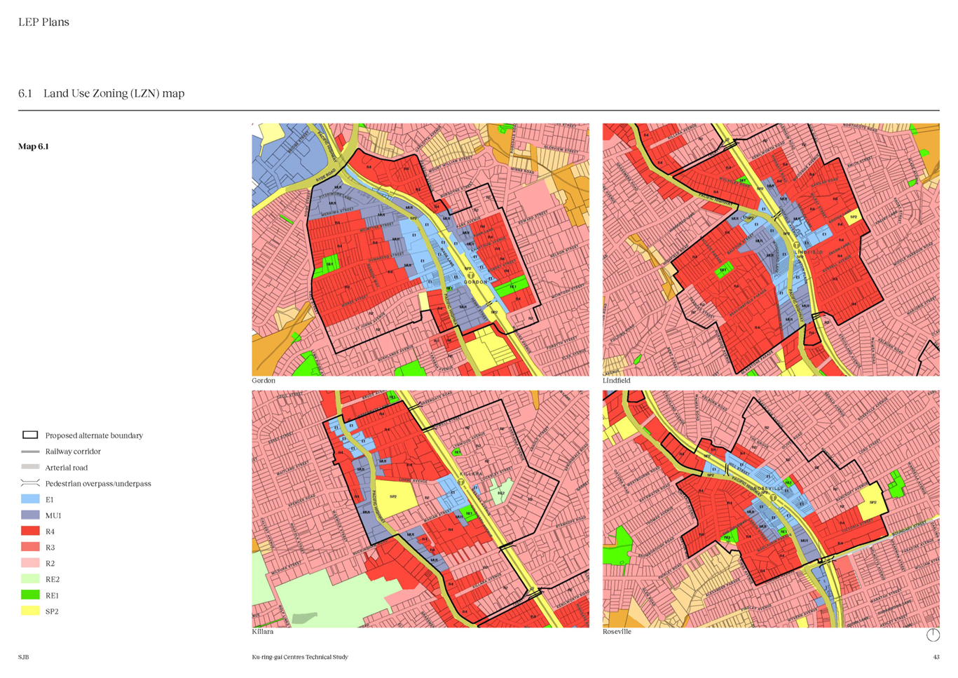
Height of Building maps
The existing building heights within the proposed centre boundaries will be amended to align with the built form structure. This will require amendments to the HOB Map and Clause 4.3 of the KLEP to ensure the height caps and associated lot sizes applying to R4 zoned land do not apply to the R4 zoned land within the centres boundary.
Refer to Attachment A4 – Ku-ring-gai Centres Technical Study – Part 6.2 and 6.3
FSR maps
The existing floor space ratio (FSR) controls within the centres will be amended to achieve the floor space required to accommodate dwelling target and commercial uses within the proposed building heights. This will require amendments to the FSR Map and Clause 4.4 to ensure the FSR caps and associated lot sizes applying to R4 zoned land not apply to the R4 zoned land within the centres boundary.
It is also proposed to remove the FSR cap on retail and commercial uses applying to sites within Gordon and Lindfield under clause 4.4(2E) and introduce a minimum 1:1 FSR for non-residential
uses on certain E1 sites with FSR 5:1 and over.
Refer to Attachment A4 – Ku-ring-gai Centres Technical Study – Part 6.4 and 6.5
Land Reservation Acquisitions maps
The preferred scenario and structure plan identifies a number of sites to be acquired by Council for local open space and a new local road (refer to Attachment A9 – Preferred Scenario - Infrastructure Strategies) In order for Council to reserve this land for the identified future public purposes, the sites are required to be identified on the ‘Land Reservations Acquisition Map’ in the KLEP.
The ‘Land Reservations Acquisition Map’ works in conjunction with Clause 5.1 – ‘Relevant acquisition authority’ of the KLEP. This clause prescribes that the Council will be responsible for acquisition in relation to land reserved for local open space and local roads.
The following lands are identified to be zoned RE1- Public Recreation or SP2 – Local Road and identified on the Land Reservation Acquisitions Map as part of the Preferred Scenario:
a) For the purposes of open space - nos.63, 63A, 65 Dumaresq Street and nos.12 & 12A Vale Street, Gordon total area approximately 6,359sqm (total park area including Gordon Glen approximately 8,670sqm.
b) For the purposes of open space – nos.26, 28, 30 & 32 Bent Street & nos.1 and 3 Newark Crescent, Lindfield (area approximately 4,165sqm).
c) For the purposes of open space – no.3 Roseville Avenue, Roseville (area 913sqm).
d) For the purposes of open space and local road - Nos.15 & 17 Pockley Avenue, nos. 22 and 20A Shirley Road, Roseville (park area approximately 3,760sqm & road area approximately 1,200sqm).
Refer to Attachment A4 – Ku-ring-gai Centres Technical Study – Part 6.6
Active Frontages map
The Public Domain Structure Plan identifies locations for active frontages within the MU1 and E1 zones. To ensure that the KLEP aligns with the structure plans. This will require the inclusion of an active frontage map into the KLEP which identifies where the active frontages are to be provided within the MU1 zones within the centres.
Refer to Attachment A4 – Ku-ring-gai Centres Technical Study – Part 6.7
Minimum frontages for employment land and mixed-use zones
Clause 6.8 of the KLEP requires a minimum frontage of the 20m for certain employment lands within the centres. To provide for a more nuanced, centre by-centre approach to minimum street frontages within the E1 and MU1 zone, it is proposed to amend Clause 6.8 to exclude its application from the E1 and MU1 zones within the centres. Appropriate minimum street frontage requirements can be considered in the preparation of the updated precinct and site provisions for the centres within Part 14 of KDCP.
Refer to Attachment A4 – Ku-ring-gai Centres Technical Study – Part 6.8
Affordable housing
The TOD program requires the provision of 2% affordable housing for development within the TOD boundaries. In order to satisfy the TOD affordable housing requirements a new clause and associated map will be inserted into the KLEP that requires the provision of between 2% and 10% affordable housing for development within each of the centres based on feasibility analysis by Atlas Economics.
The Gordon Centre
The Preferred Scenario would enable a mixed-use development of FSR 6.5:1 and 93 metres (28 storeys) on the Gordon Centre with a non-residential floorspace requirement of FSR 1:1. The application of the default affordable housing contribution rate of 2% is also recommended.
Council has identified the Gordon Centre as being suitable for the provision of a community facility (3,000sqm), which could made be in lieu of the mandatory 2% affordable housing contributions required under the TOD SEPP provisions for all development. It is proposed that a clause be included in the KLEP that provides the landowner the choice of development under the existing KLEP controls, or to the alternate TOD controls while making a contribution to public benefit. This would be delivered by way of a voluntary planning agreement.
The proposed draft LEP clause is included in Section 4.2.2 of Attachment A10 - Affordable Housing Feasibility Analysis, Atlas Economics, March 2025. The maximum can be achieved through the application of the clause rather than being reflected in height and floorspace maps. The FSR and height of building maps in the KLEP will retain the existing controls for the site, being 3.5:1 and 38.5m respectively.
Lindfield Village Hub
The height and FSR provisions required for the Lindfield Village Hub will be superseded by the proposed new height and FSR controls. To align with the structure plans, Clause 6.13 of the KLEP will be deleted. Further detailed planning of the Lindfield Village Hub will be required.
Design Excellence
A design excellence clause will be inserted requiring that development within the centres, on land zoned E1 and MU1, exhibits design excellence. This will include, but will not be limited to, consideration of the following:
· architectural design and materials;
· quality and amenity of the public domain;
· solar access and overshadowing;
· impact on view corridors;
· impact on heritage and conservation areas; and
· built form and massing.
Ku-ring-gai Development Control Plan (KDCP) Amendments
The proposed KLEP amendments outlined above will need to be supported by amendments to the existing KDCP to ensure that it aligns with the structure plans.
Section A of the KDCP provides detailed controls that guide site and building design, such as building setbacks, site coverage and deep soil requirements, and car parking provision, for a range of building typologies. These provisions require review to ensure consistency with the structure plans and the new building typologies that will result from the revised height and FSRs applying in the KLEP. This will include, but not limited to, the following:
· Part 7 - Residential Flat Buildings;
· Part 8 – Mixed Use Development; and
· Part 9 - Non-Residential and Office Buildings.
Section B, Part 14 of KDCP contains provisions that apply to specific sites and precincts within the LGA, to supplements the general provisions applying to development types and uses in Section A. The current precinct specific provisions applying to Gordon (Part 14D), Lindfield (Part 14E) and Roseville (Part 14F) centres will require updating, and new provisions be introduced for the Killara centre. Each of the centres also include sub-precincts, with some more detailed and site-specific provisions.
The preparation of amended and new KDCP provisions for different typologies and the centres will be subject to a separate statutory planning process, that will include engagement with community and stakeholders.
7. Preferred Scenario - Infrastructure Strategies
Draft Infrastructure Strategies have been prepared for the four centres. Attachment 9 – Preferred Scenario - Infrastructure Strategies describes the work proposed in relation to:
· Streetscape;
· Open Space;
· Community Facilities;
· Green grid and Canopy Cover; and
· Traffic and Active Transport.
The strategies reflect current Council policy in relation to infrastructure delivery as per the:
· Ku-ring-gai Local Strategic Planning Statement (LSPS),
· Ku-ring-gai DCP,
· Local Centres Public Domain Plan,
· Ku-ring-gai Contributions Plan,
· draft Green Grid Strategy,
· Ku-ring-gai Bike Plan;
· Ku-ring-gai Community Facilities Strategy; and
· Traffic and transport plans for Gordon and Lindfield.
The work in the strategies and any future infrastructure provision will be funded via a number of mechanisms including S7.11 and S7.12 contributions, Voluntary Planning Agreements.
New local parks and new local roads
The strategies indicate new policy particularly in relation to provision of open space. A total of 28,700sqm of additional park area is proposed, of this about 13,000sqm is new land that will require acquisition by Council. The open space proposals are:
· conversion of the former Gordon Bowling Club land to a new recreation area and local park (approximately 12,800sqm owned by Council);
· a large new local park in Gordon incorporating five properties on the corner of Vale Street and Dumaresq Street, with an area of approx. 6,400sqm (total acquisition area remaining about 4,300sqm);
· a new local park on incorporating six properties on Newark Crescent and Bent Street, Lindfield (total acquisition area approximately 4,100sqm);
· a new local park in Roseville on Council’s Lord Street carpark and two adjoining properties on Roseville Avenue. The total area of the park will be approx. 3,500sqm (total acquisition area remaining about 900sqm); and
· a new local park in Roseville between Pockley Avenue and Shirley Road (total acquisition area of approximately 3,760sqm) incorporating all or part of four properties on Pockley Avenue and Shirley Road, Roseville.
In addition to the above a new local road is proposed in Roseville in the same location:
- a new two-way local road connecting Pockley Avenue with Shirley Road providing alternative vehicle access via Shirley Road to the Pacific Highway as well as pedestrian access.
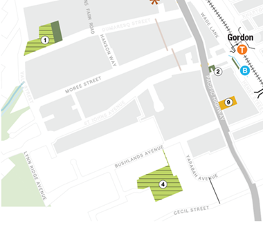
Figure 28 – New parks proposed for Gordon – former bowling club (shown as no.4) & Dumaresq Street (shown as no.1)
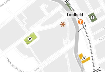
Figure 29 – New parks proposed for Lindfield - Newark Crescent (shown as no.2)
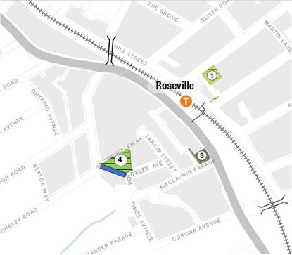
Figure 30 – New park proposed for Roseville – Pockley Avenue (shown as no.4)
and new road connection between Pockley Avenue and Shirley Road (shown in blue)
The new park shown in Figures 30 is of a size consistent with Council’s Open Space Acquisition Strategy being about 3,760sqm. This park option (notes 2 and 4 above, has been incorporated into the Preferred Scenario for consideration by Council.
The possible costs of the optional new parks and roads discussed above, as well as the prospective costs of the parks and roads discussed previously under the heading “Land Reservation Acquisitions maps” were discussed with Councillors at the briefing scheduled for 26 March 2025.
8. Preferred Scenario - Supporting Studies
At the same time as preparing a Preferred Scenario Council is undertaking a number of supporting studies:
· A review of Council’s S7.11 Development Contributions Plan (Ku-ring-gai Contributions Plan 2010)
· Transport Impact Assessment Studies
· Affordable Housing Strategy
· Affordable Housing Contributions Scheme
· Development Feasibility Analysis
The progress of these studies is summarised below.
S7.11 Development Contributions Plan - Local Infrastructure Contributions
Ku-ring-gai Council currently has a s7.11 (direct demand) contributions plan that applies to all residential development across the LGA that generates a direct nett additional demand for capital infrastructure, as well as to all non-residential development in the local centres where mixed use shop-top housing is permitted. This contributions plan was written for the last phase of redevelopment around the local centres along the railway line / Pacific Highway corridor plus St Ives on Mona Vale Road and was adopted in 2010. The current strategic planning for the Transport Oriented Development Areas provides for a comparable dwelling yield to the current TOD SEPP now in effect. This growth potential represents a considerable intensification over the current situation and gives rise to new demands for additional supporting infrastructure. It is essential that Ku-ring-gai now enters a review phase that will deliver infrastructure to support the new development, supported by the detailed studies that are currently either underway or recently completed.
Ku-ring-gai Contributions Plan 2010 currently benefits, in the Local Centres areas only, from an exemption to the Ministerial Direction capping contributions but this cap remains in place outside those catchments and is duly applied. The $20,000 cap has not been inflated since it was first issued in 2009 whereas, over the past 15+ years, the contribution rates in Ku-ring-gai have increased with inflation, particularly in respect of the cost of acquiring land in one of the most expensive areas in Sydney. This means that Ku-ring-gai cannot continue to deliver comparable local infrastructure to support even more intensive use – especially new local parks, civic spaces and link roads, without exceeding the $20,000 cap. This means that the draft review of the contribution plan will also need to be reviewed by IPART before it can come into effect. This will require regular liaison with IPART by a team of professional staff from each of the areas of infrastructure funding and delivery expertise as well as regular progress reports and/or briefings to council. This report includes a recommendation that seeks formal endorsement of this approach.
Open Space
The areas around the TOD stations were first developed in the late Victorian / early Federation period and, with the exception of Gordon Pleasure Grounds, there were no large local parks in these four local centres. Under the current contributions plan, Ku-ring-gai Council has delivered new parks in the southern areas including Greengate Park, largely funded by the recent development in Bruce Avenue, Lorne Avenue and Culworth Street, and along the Pacific Highway, the Lindfield Village Green and public domain works in St Johns Avenue in Gordon to widen footpaths and deliver seating and passive recreation areas. This process needs to continue.
The review of the s7.11 contributions plan needs to analyse the needs of a highly urbanised precinct, noting that high density residents have limited access to private open space, and consider the practicality of requiring and designing new parks for intensive urban use. It is likely that the total quantum of open space will be limited by cost, but that the design will need to cater for a variety of uses. Council has considerable experience in this with the delivery of Greengate Park, Boyds Orchard Park and Cameron Park to name three of the seven parks Ku-ring-gai has delivered under the current contributions plan.
Elsewhere in this report, under the heading “Preferred Scenario - Infrastructure Strategies”, a number of core and optional locations for new local open space and road connections are discussed. If adopted and included in a new reservations map, these new infrastructure elements would need to be reflected in a new development contributions plan. Identification of land as reservations will effectively prioritise them over other competing and in some cases as yet unquantified demands on the overall pool of development contributions arising from development around the TOD stations. Further, given that such prospective acquisitions can be owner initiated, they could be front loaded in any contributions cash flows.
Community Facilities
Community facilities represent a major challenge for infrastructure delivery. To deliver adequate supporting infrastructure, Council needs to continue to exceed the arbitrary uninflated cap in areas of intensive densification. To achieve this, the contributions plan must be reviewed by the Independent Pricing and Regulatory Tribunal (IPART). In assessing a draft contribution plan IPART is bound by the Essential Works List (EWL) – a list of infrastructure endorsed by the Department of Planning for inclusion in a contribution plan that seeks to levy above the cap. The EWL explicitly excludes provision for the construction of community facilities (only including the purchase of land). This means that Ku-ring-gai must seek more innovative ways of delivering community infrastructure such as joint venture developments leveraging the value of Council land and asset sales together with effective use of the income received to date under the current s7.11 contributions plan, which will continue to be paid from any outstanding consent conditions issued during the life of this plan, gradually diminishing over time.
Preferred Scenario - Transport Impact Assessment Studies
Transport Impact Assessment Studies are currently being undertaken in each of the four TOD areas of Roseville, Lindfield, Killara and Gordon. More information on these studies can be found in the section below.
Works arising from these studies will be costed and included in the draft review of the contributions plan. Works in the Ku-ring-gai Contributions Plan 2010 (in response to developments in local centres) have already been included in the Long-Term Financial Plan, along with indicative timings. These works are typically development or Council project driven, and their delivery will ultimately depend on the timing of developments or Council-initiated projects occurring in the centres.
Roseville TOD Precinct
Transport consultants are assessing the existing transport situation and the transport impacts of the NSW Government's TOD SEPP as well as Council's alternative scenario. The Transport Impact Assessment (TIA) study area extends beyond the TOD precinct and is roughly bounded by Archbold Road, Boundary Street, Pacific Highway and Clanville Road, and includes the area west of Pacific Highway (Maclaurin Parade, Corona Avenue and Shirley Road) which is a key area of interest.
Testing has commenced on the effects of the TOD SEPP on the surrounding road network, where any opportunities for improvements will be identified. If/when Council adopts an alternative housing scenario, this will also be tested. Key transport-related works already identified in the Development Contributions Plan 2010 that are being re-assessed include road widening on Pacific Highway to accommodate 3 northbound lanes and fully controlled right turns into Maclaurin Parade. Other improvement opportunities being considered in the assessment of the TOD SEPP and Council's alternative (if/when adopted by Council) include upgrades identified in the Roseville Public Domain Plan, a new local access road between Pockley Avenue and Shirley Road, walking and cycling infrastructure and reduced speed limits to encourage active transport to the station and shops, dedicated car share spaces near development sites to reduce car ownership and dependence, and bicycle parking at key locations. Any new transport infrastructure identified in the TIA will inform the review of the Contributions Plan.
Lindfield TOD Precinct
During the development of the Lindfield Village Hub Planning Proposal, a Transport Impact Assessment (TIA) was prepared which incorporated study area extents not dissimilar to the Lindfield TOD precinct. The TIA also included a 10-year growth scenario that factored in background growth, and road/intersection upgrades were recommended based on this growth scenario. Transport for NSW gave approval to the road upgrades, and these form the basis of planned works in the Lindfield TOD Precinct, as well as active transport improvements identified as part of the Lindfield Public Domain Plan.
Of the road upgrades approved by Transport for NSW, detailed design is currently underway for new traffic signals at the intersection of Pacific Highway and Strickland Avenue, for modifications to the intersection of Pacific Highway and Balfour Street/Havilah Road and for the new traffic signals at the intersection of Lindfield Avenue and Tryon Road (which form part of the Lindfield Avenue and Tryon Road Streetscape Upgrade project). Development of the Lindfield Village Hub would trigger a separate series of upgrades, including new traffic signals at the intersection of Pacific Highway and Beaconsfield Parade, the creation of a new Drovers Way between Beaconsfield Parade and Bent Street, and modifications to Woodford Lane.
Killara TOD Precinct
With similar scope to the Roseville TOD Precinct, the Killara TOD Precinct Transport Impact Assessment (TIA) is being developed. The study extents are roughly the area bounded by Greengate Road/Essex Street to the north, Karranga Avenue to the east, Fiddens Wharf Road/Killara Avenue to the south and Norfolk Street to the west and is larger than the TOD precinct. Current progress includes the development of the base model (existing situation), which is currently being assessed by Transport for NSW (TfNSW). Once TfNSW approves the base model, assessment of the transport impacts of the NSW Government's TOD SEPP as well as Council's alternative scenario will be undertaken. Killara is not an identified centre in the Ku-ring-gai Contributions Plan 2010, but active transport improvements to facilitate station access along with other road infrastructure improvements will be considered as part of the testing and recommendations, which will be used as inputs to the Contributions Plan review.
Gordon TOD Precinct
Building upon a transport analysis already undertaken for Gordon Town Centre in 2022/23 which has similar study extents to the Gordon TOD Precinct, consultants have commenced using this work as a basis to prepare the Gordon TOD Precinct TIA. The TIA will assess the transport impacts of the NSW Government's TOD SEPP as well as Council's alternative scenario. The study area is bordered roughly by Ryde Road/Mona Vale Road (to the north), Bruce Avenue/Cecil Street (to the south) and Vale Street (to the west). Staff have already been in discussions with Transport for NSW regarding proposed road upgrades in the Ku-ring-gai Contributions Plan 2010 from the 22/23 analysis, and the TIA will help to progress and refine those proposals as well as advance planning for active transport and improvements identified in the Gordon Public Domain Plan. Transport upgrade works are typically development driven – for example, if the Gordon Centre were to redevelop, it would likely trigger several road upgrades, including the modification of the intersection of Pacific Highway and Park Avenue/Dumaresq Street. Any additional transport infrastructure over that already identified Ku-ring-gai Contributions Plan 2010 will be considered in the Contributions Plan review.
9. Preferred Scenario - Affordable Housing & On-Site Infrastructure Contributions
Affordable Housing Contributions
The Department of Planning, Housing and Infrastructure Transport Orientated Development – Guide to Strategic Planning outlines that in terms of strategic planning for alternatives for the TOD SEPP, ‘In the first instance the prescribed affordable housing rate within the Housing SEPP will apply (2%). In the event that a council takes a different rate or approach, we expect that Councils will prepare an affordable housing contribution scheme that prescribes the rate and mechanism for delivering affordable housing’.
Council’s consultants have analysed the feasibility for the provision of affordable housing at 2% as a minimum, and then tested to see if sites have capacity to contribute to higher Affordable Housing rates (>2%). Refer Attachment A10 - Affordable Housing Feasibility Analysis, Atlas Economics, March 2025.
The study outlines that the capacity of development to contribute to affordable housing varies, and sites that are the recipient of large planning uplift are not necessarily always feasible or have the greatest capacity to contribute to affordable housing. This is due to:
· existing uses on a site, the associated value (which contributes to the cost of land to a developer) and costs that may be necessary to secure vacant possession (e.g. lease break payments, incentive premiums);
· sites with fragmented lot and ownership patterns are challenging and costly to consolidate. This is the case for the core of the four centres, where there is fine grain strip retailing; and
· existing commercial uses being more valuable than residential uses.
Based on the feasibility testing Councils consultants have derived proposed affordable housing contribution rates for developments. The study recommends different affordable housing contributions rates for different areas, ranging from 0%, 2%, 3%, 5% and10%. Refer to the Affordable Housing Rates Map in Attachment A4 – Ku-ring-gai Centres Technical Study – SJB Urban, February 2025 for the areas of different affordable housing contribution rates.
There are a few different rates proposed, and even in the same proposed zone and density the affordable housing % rate can be different. This is because:
· the current zone and FSR could be different; or
· the existing buildings vary in their cost to a developer to purchase.
There are also several instances where the proposed FSR may be high (e.g. 5:1) but the proposed affordable housing % is low. This is because:
· the existing buildings are valuable and lot patterns are fine grain and fragmented, which means that it is expensive for a developer to amalgamate together a site that is large enable for development; or
· the existing buildings are valuable and the cost to obtain vacant possession is high.
Sites where there are higher rates proposed are generally:
· sites are already approved for development and could already be clear; or
· the existing buildings are single dwelling and the proposed FSR is high.
The affordable housing % rates are generally slightly lower in the proposed E1 zones, as these sites have a larger non-residential requirement and due to existing buildings will be more costly for a developer to consolidate. This is compared to the proposed MU1 zones which only require ground floor non-residential along active street frontages and the existing zone is residential (R2, R3 or R4) which means it would be cheaper for a developer to acquire a development site.
The study recommends that no (0%) affordable housing rates apply to areas proposed for FSR 0.85:1 (medium density) and FSR 1.3:1 (4-5 storey) to encourage the development of diverse housing forms. There is a risk that to burden these sites with a 2% contribution rate may result in development not being feasible.
The affordable housing % rates and feasibility analysis are proposed to be taken forward into a draft Affordable Housing Contributions Scheme (AHCS) to support the TOD programme and will allow the delivery of affordable housing in perpetuity by way of a monetary contribution in lieu of dedication of dwellings in kind in perpetuity. Currently, as Council does not have an AHCS, any affordable housing contributions must be in-kind (dwellings). This is not the preferred form of contribution for Community Housing Providers, as it results inefficient management of scattered affordable housing dwellings in different buildings being subject to high strata and other service provider costs.
The AHCS will detail the governance of contributions collected and how the contributions will be used.
On-Site Infrastructure Contributions
The Gordon Centre (802-808 Pacific Highway) is an enclosed neighbourhood centre anchored by Woolworths and Harvey Norman. It is an important community asset, playing an important role servicing the retail, non-retail and commercial needs of the catchment. The Gordon Village Arcade (767 Pacific Highway) is connected to the Gordon Centre by a pedestrian bridge over Pacific Highway.
Council has identified the Gordon Centre as being suitable for the provision of a community facility (3,000sqm), which could made be in lieu of affordable housing contributions. The landowner would therefore have the choice of development under the existing LEP controls, or to the alternate TOD controls while making a contribution to public benefit. An LEP clause has been prepared to provide for this outcome. As discussed previously, the maximum can be achieved through the application of the site specific Gordon Town Centre clause (page 37 of the Atlas Economics Ku-ring-gai Transit Oriented Development (TOD) Centres - Affordable Housing Feasibility Analysis (Attachment A10) rather than being reflected in height and floorspace maps. The FSR and height of building maps in the KLEP will retain the existing controls for the site, being 3.5:1 and 38.5m respectively.
10. Preferred Scenario – Interaction with Low and Mid-rise SEPP
The NSW Government released the Low and Mid-Rise Housing Policy (LMR) on 28 February 2025. The planning controls apply to residential areas within 800 metres walking distance of 171 town centres and train stations across metropolitan Sydney, the Central Coast, Illawarra-Shoalhaven and Hunter regions. The government has indicated that this policy is expected to deliver up to 112,000 homes across NSW over the next 5 years.
The policy will permit the following in R2 zones:
- Dual Occupancies
o 2 dwellings on one lot
o Minimum lot size 450 m2
o Maximum floor space ratio 0.65:1
o Maximum height of building 9.5 m (2-storeys)
- Multi-dwelling Housing
o 3 or more dwellings on 1 lot
o Minimum lot size 600 m2
o Maximum floor space ratio 0.7:1
o Maximum height of building 9.5 m (2-storeys)
- Multi-dwelling houses (terraces)
o 3 or more terraces on 1 lot
o Minimum lot size 500 m2
o Maximum floor space ratio 0.7:1
o Maximum height of building 9.5 m (2-storeys)
- Residential flat buildings
o 3 or more apartments on 1 lot
o Minimum lot size 500 m2
o Maximum floor space ratio 0.8:1
o Maximum height of building 9.5 m (2-storeys)
In terms of how the LMR will interact with Council’s Preferred Scenario, the following points are noted:
· the policy applies to Gordon, Killara, Lindfield and Roseville;
· the policy does not apply within the TOD area measured as a radius of 400m from the rail station;
· for Gordon and Lindfield, the policy applies within 800m walking distance measured from the edge of the E1 zone;
· for Killara and Roseville, the policy applies within 800m walking distance measured from the rail station; and
· heritage conservation areas are not excluded from the policy.
Under the Preferred Scenario the majority of HCAs are impacted in part or fully by the LMR. This is concerning because one of the key drivers for preparing alternative TOD scenarios was to protect heritage. In discussions with DPHI they have advised that:
- if the TOD precinct is expanded as a result of Council’s alternative plan and the development controls are more generous under Council’s plan than the LMR controls, then Council’s controls would replace the LMR controls in those locations (the western side of Gordon for example).
This implies that if Council wished to protect additional areas of HCAs around the TOD centres this would require:
· extending the TOD boundary to include all or part HCAs areas affected by the LMR;
· calculating the area of land removed from the LMR; and
· identifying additional residential areas to compensate for the areas removed from the LMR.
Two approaches have been considered.
The first is a hybrid TOD boundary shown in Figure 35. This option would in part retain the current TOD boundary in the areas where no expansion is proposed under the Preferred Scenario, and in other parts establish a new boundary that would follow extent of proposed rezonings. In the new areas the boundary generally follows roads or HCA boundaries. One of the issues with this approach is that by leaving the TOD boundary in place Council would be being inconsistent with its own principles particularly with regard Principle 5 – Manage Transition Impacts which aims to:
· ensure any future changes to planning controls allow for an acceptable interface between areas of different density or use;
· avoid changes that are ‘mid-block’ or along property boundaries; and
· utilise existing roads, lanes or open space as the transition from high density to low density.
This option fully protects 5 HCAs most notably:
· C16 St Johns Avenue Conservation Area
· C12 Gordondale Estate Conservation Area
· C17 Gordon Park Conservation Area
· C23 Lynwood Avenue Conservation Area
· C36 Lord Street/Bancroft Avenue Conservation Area
Under this option 78 properties within HCAs would be protected within the TOD boundary and retained as R2 Low Density Residential. These properties would be effectively removed from the LMR and are not proposed to be upzoned under the Preferred Scenario. As a result, an additional 9ha of land would need to be provided elsewhere in addition to the Preferred Scenario to compensate for the loss of yield under the LMR (subject to discussion with DPHI).
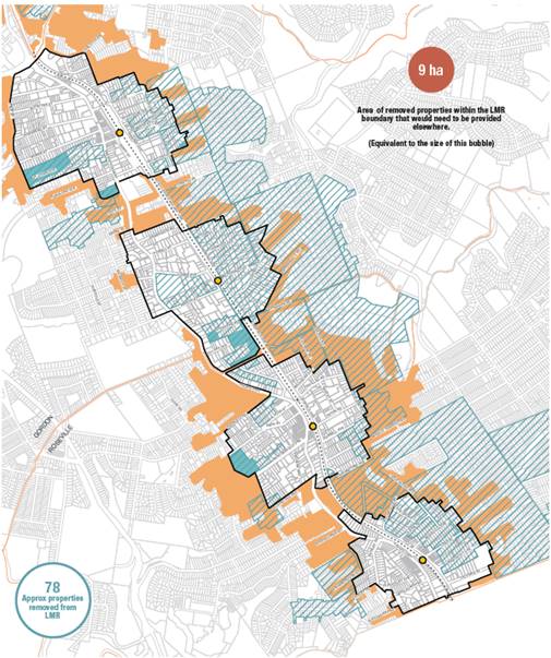
Figure 35 – Hybrid TOD Boundary
The second approach (Figure 36) is to discard the TOD boundary and define a completely new boundary around each of the centres. The new boundary utilises roads or HCA boundaries and includes whole HCAs where possible. The boundary of the Preferred Scenario has been expanded in some locations and contracted in others. This approach is consistent with Principle 5 – Manage Transition Impacts and will avoid changes to planning controls that are ‘mid-block’ or along property boundaries.
This option fully protects 6 HCAs:
· C16 St Johns Avenue Conservation Area
· C12 Gordondale Estate Conservation Area
· C17 Gordon Park Conservation Area
· C23 Lynwood Avenue Conservation Area
· C36 Lord Street/Bancroft Avenue Conservation Area
· C27 Blenheim Road Conservation Area (not protected in option1)
This approach would protect 117 properties within HCAs within the new TOD boundary. These properties would be effectively removed from the LMR however the new boundary also excludes another 134 properties which would subsequently fall under the LMR resulting in a net gain of 17 properties to the LMR. Subject to approval from DPHI there would be no requirement for compensatory zoning of additional lands.
This boundary has been adopted for use in all mapping.
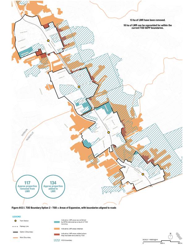
integrated planning and reporting
Theme – Places, Spaces and Infrastructure
|
Community Strategic Plan Long Term Objective |
Delivery Program Term Achievement |
Operational Plan Task |
|
P2.1 A robust planning framework is in place to deliver quality design outcomes and maintain the identity and character of Ku-ring-gai |
P2.1.1 Land use strategies, plans and processes are in place to effectively manage the impact of new development |
P2.1.1.1 Commence development of plans and strategies as required by the Greater Sydney Commission’s North District Plan. |
Governance Matters
Council’s Integrated Planning and Reporting documents are based on a set of long-standing community values and aspirations which will fundamentally be undermined by implementation of the State Government’s Transport Oriented Development (TOD) Program and proposed Low and Mid-Rise Housing SEPP.
Risk Implication statement
There are a number of risks identified in Council’s Enterprise Risk Management System relevant to planning for the TODs, these being:
|
Risk # |
Risk Name |
How effective are the existing controls? |
Residual Risk rating |
Is the Residual Risk Outside the appetite? |
|
1210.1 |
Council planning does not meet future population and demographic needs resulting in sub-optimal housing and facilities - Urban and Heritage Planning Unit |
Satisfactory |
18 |
Outside |
|
1210.2 |
Changes to local planning controls through the transport Orientated Development and Low and Mid-rise SEPP changes resulting in State Government Policy intervention |
Weak |
18 |
Outside |
|
90.1 |
Removal of exemption from cap to s7.11 contributions resulting in insufficient revenue to provide infrastructure to support growing population - Urban & Heritage Planning Unit |
Satisfactory |
18 |
Outside |
Actions required to mitigate the impacts of these risks, all of which remain outside appetite include:
· on going monitoring of State Government legislation and District Plan requirements;
· development of alternative scenarios to the TOD SEPP to obtain concurrence of State Government to implement alternative planning controls for growth around station precincts;
· prepare and update the s7.11 contributions plan concurrent with comprehensive strategic planning to provide for housing options, particularly arising from NSW State Government initiatives in the TOD areas; and
· prepare, report and submit commentary on NSW Government initiatives concerning Local Infrastructure Contributions as and when required to protect council’s interests.
These matters are all addressed in this report.
If Council does not make a determination on its alternative TOD scenarios, the existing NSW State Government TOD SEPP will remain in place and may result in a major reputational risk to Council with a long-term loss of trust and support from large sections of community.
Financial Considerations
The preparation of the TOD Scenarios has required significant staff resources, additional studies, and programs to prepare and review the information e.g., public consultation and engagement, Development Feasibility Study, Traffic Studies, Heritage Conservation area assessments and CAD and graphic software.
In a number of areas these additional costs are outside the 2024/2025 approved budget and will need to be addressed in the third quarter budget review. Some costs associated with developing Council’ Preferred Scenario were addressed in the second quarter budget review of 2024/25 ($300k). Other costs are still being incurred, such as those relating to exhibition of the Preferred Scenario recommended by way of this report.
Social Considerations
The preparation of the TOD Scenarios includes the planning for additional housing choice around the transport nodes, along with supporting the local centres revitalising with opportunities for new retail facilities and new community infrastructure such as new libraries, open space and community centres.
Environmental Considerations
The preparation of the TOD Scenarios has been premised on a series of environmental principles including avoiding environmentally sensitive areas by not encouraging development in areas containing high biodiversity, natural watercourses, steeply sloping land or Bushfire affected lands and the principle of minimising tree canopy impacts- allowing more space around new buildings in development areas, to set aside space for existing and future trees, while also encouraging the replacement of any removed trees.
Community Consultation
Since early December 2023 when it was first announced, with formal release for limited consultation with impacted councils on 18 December 2023 only, Council has effectively been engaged in an ongoing program of community education, information sharing, and consultation and engagement in relation to the TOD Program. Council’s response has also extended to legal action in the Land and Environment Court and a submission to the Legislative Council’s Portfolio Committee No. 7 – Planning and Environment inquiry into the Development of the Transport Oriented Development Program.
Feedback from this ongoing consultation and engagement program helped determine the scope of the alternate TOD scenarios put on public exhibition in November 2024 and the primary objectives of this planning exercise, being to deliver the dwelling yield embodied in the State Government’s TOD SEPP amendments while protecting where possible HCAs and urban canopy outcomes.
In October 2024 when it adopted a consultation and communication program for exhibiting the TOD alternative scenarios, Council was cognisant of the Department of Planning, Housing and Infrastructure’s (DPHI’s) then recently released “Transport Oriented Development –Guide to strategic planning” In construction its own draft consultation program, Council was minded to have as close as possible to a standard consultation and engagement program for a project of this nature rather than the truncated consultation recommended by DPHI.
Alternative Scenarios - Community Engagement overview and methods
An extensive process of community engagement ran from Friday 15 November to Tuesday 17 December 2024. The key objectives were to:
- Ascertain the community preferred option out of the five scenarios.
- Identify concerns from the community about the scenarios, and local factors that may necessitate changes.
Engagement Methods
The engagement process was wide ranging and included the following engagement approaches:
|
Engagement method |
Participation |
|
Representative telephone survey for community members from Gordon and Roseville wards. Conducted by independent research agency (Taverner). Objective was to get a random sample of community sentiment to ensure accurate account of community views. |
· 193 completes |
|
Two recruited representative workshops for community members from Gordon and Roseville wards. Held on 4 December and 11 December at Council Chambers. Participants recruited by independent research agency (Taverner) and paid stipend to attend. Purpose of the recruited workshops was to capture representative community viewpoint. Sessions facilitated by external consultant (Becscomm). |
· Wednesday 4 Dec – 34 attendees · Wednesday 11 Dec – 31 attendees |
|
Online engagement portal including maps Hosted on Council’s Engagement Hub site with other related materials and link to opt in survey. |
· Total page visits – 37,011 · Unique visitors – 12,561 · Doc downloads – 20,108 |
|
Opt-in community survey Open to all community members and hosted by Taverner link accessible via Council engagement hub site and provided via email. Printed versions were also available |
· Online – 2946 completes (verified*) · Paper – 869 completes |
|
Public meetings x2 Held at Council Chambers on 25 November and 9 December. Session consisted of presentation and Q&A |
· Monday 25 November – 120 attendees · Monday 9 December – 90 attendees |
|
Online forum Webinar delivered via zoom. Session consisted of presentation followed by Q&A |
· Thursday 21 November – 93 attendees |
|
Two community drop-in sessions Held at Council chambers and Gordon Library on 2 and 7 December respectively. Staff we available to discuss scenarios and answer questions. |
· Wednesday 2 December – 24 attendees · Saturday 7 December – 27 attendees |
|
Written submissions Received via email and mail |
514 submissions plus 143 late submissions |
*4,075 online surveys were completed. Following rigorous checking by Taverner to remove duplicate and “bot”-generated surveys 1,129 records were removed which included 460 surveys believed to be completed by one individual, and 40 by another. The final online sample size was hence n=2,946.
Communications/promotion methods
Information about the project and opportunities to participate were promoted as follows.
|
Communications/promotion methods |
Details |
|
Printed brochure Containing detailed information about the scenarios including maps and written descriptions and background information. |
Available at: · Council’s customer service centre · Gordon and Lindfield Libraries |
|
Letter Sent to property owners/ occupants in Roseville and Gordon Wards |
· 26,995 letters arrive on or around 15 November |
|
Press advertising Advertisements promoting the engagement process |
· North Shore Times · Sydney Observer · The Post |
|
Media release Details project and opportunities for community participation to council’s media contact list |
Distributed Friday 15 November to over 40 local and national media contacts |
|
Social media posts Designed to promote project – included posts and boosted advertising |
· Facebook – Ku-ring-gai – 15 November, 13 December · Facebook – Majors page – 15 November |
|
E-newsletters Electronic newsletters sent to Council subscribers list via Campaign Monitor |
· Ku-ring-gai News e-news (37,865 subscribers) - 15 November, 29 November, 13 December · Business E-news (1814 subscribers) - 21 November · Business Bulletin (20,972 subscribers) - 19 November · Yoursay E-news, (1187 subscribers) - 25 November · Special planning e-news (2046 subscribers) 18 November |
|
Council website and the engagement hub site. Engagement hub site included: · Maps and explanation of the scenarios · A video showing 3d representation of each scenario · Background information including reports and weblinks · Extensive FAQ · Video of online forms (after the event) and presentation slides. |
· Total page visits – 37,011 · Unique visitors – 12,561 · Doc downloads – 20,108 |
|
Outdoor signage Banners, posters and digital advertising |
· 60 Council-owned bus shelters across LGA. · Banner outside Council Chamber and Roseville Memorial Park. · On the electronic billboard over the Pacific Highway at Gordon. |
Engagement results
Much of the engagement process was facilitated by external consultant Becscomm. This process was codesigned and delivered collaboratively with Council staff and covered:
- surveys (telephone, online and printed);
- recruited workshops; and
- community drop-in sessions.
The report in Attachment A1 provides full details of the process and results relating to the above.
Other engagement
Council also undertook other engagement to supplement the work by Becscomm as follows.
Written submissions
Council sought community feedback via written submissions. 514 written submissions were received via email and mail with feedback capture about scenario preference and details location/property specific information for planning staff consideration. See Attachment A2 Submission Summary Table for more details.
Community Forums
Council staff delivered three public forums:
- 2 x face to face held at Council Chambers on 25 November (120 attendees) and 9 December (90 attendees).
- 1 online forum held on 21 November This session was recorded and placed on council’s website for people to access when convenient. 152 people register and 93 people attended.
The sessions provided a detailed presentation about the scenarios, outlining key features, how they addressed the planning principles and other background information. The community were invited to then ask questions.
Summary of the key issues raised at the in person and online forums
Below is a summary of the key issues raised at the in person and online forums which were addressed in the meetings and via an update to the FAQs on the council’s website, The themes and issues were also given consideration when selecting the preferred scenario.
Density and distribution
- Rationale behind height variations between suburbs (particularly Roseville vs. Lindfield)
- Clarification on specific scenarios (especially 2b) and interpretation of mapping
- Concerns about tall buildings (25-45 stories) on ridgelines
- Requests for shadow diagrams to assess impacts
Environmental considerations
- Amount of tree canopy loss across different scenarios
- Bushfire evacuation challenges with increased density
- Environmental impact assessments and cumulative effects of multiple developments
Heritage issues
- Legal status and risk to heritage properties under various scenarios
- Protection measures for heritage items surrounded by high-density development.
- Questions about Council's application of "integrity ratings" in conservation decisions
- Potential delisting of heritage properties in Transport Oriented Development zones
Infrastructure and services
- Traffic management around bottlenecks and highway access points
- Public transport capacity and commuter parking provisions
- Planning for essential services (water, schools, healthcare)
- Management of transitional zones between high- and low-density areas
Process and implementation
- Status of Council's legal challenge to NSW planning changes
- Concerns about survey methodology and potential manipulation
- Questions about properties deemed "unlikely to develop" despite location
Alternative approaches
- Suggestions for more distributed medium-density housing (townhouses, duplexes)
- Consideration of extending planning beyond the four identified suburbs
- Potential for combining elements from different scenarios
- Questions about including other Council-owned sites in planning
Preferred Scenario – Proposed Community Engagement Overview – April 2025
In late 2024 the Department of Planning, Housing and Infrastructure (DPHI) released a document titled “Transport Oriented Development –Guide to strategic planning”.
In respect of community consultation for planning within TOD precincts, the guide says:
Consultation
While we expect councils to undertake consultation, this consultation may be shorter than the normal consultation period outlined in Council’s Community Participation Plan.
A targeted 2 week public exhibition is considered reasonable because:
• The intended uplift in the Transport Oriented Development precincts has already been communicated through the Transport Oriented Development program and these are precincts where the NSW Government has made it clear that growth is happening.
• The adequacy of State and local infrastructure to accommodate the anticipated growth has already been considered. Heritage considerations have already been taken into account.
In late 2024 a condensed consultation period of 2 weeks as recommended in the guidelines was not considered appropriate based on Council’s ordinary engagement principles. This is articulated in Council’s Community Engagement Policy, which states that engagement should be “undertaken appropriately for the scope and impact of the project” and “is inclusive and accessible for the community to participate”.
Similarly, it is also noted that a 14-day exhibition period would not have met the policy’s requisite minimum 28-day exhibition period.
Further, in respect of community consultation, the guide says it will:
…….help councils to undertake local planning in a swifter way to make sure that the intended effect of the Transport Oriented Development provisions is achieved as quickly as possible. This approach could represent a new way for councils and the Department of Planning, Housing and Infrastructure to work together to deliver local planning outcomes.
If councils choose to conduct further community consultation, this must be carried out prior to the scheduled finalisation date for the Transport Oriented Development precinct. Otherwise the Transport Oriented Development provisions will take effect and remain in place until suitable alternative local planning controls are developed.
Councils should consult with agencies in the NSW Government that might have advice as a result of impacts not considered in detail by the Transport Oriented Development provisions, or local planning results in impacts greater than envisaged by the Transport Oriented Development provisions. Councils should discuss with the Department of Planning, Housing and Infrastructure on which agencies to consult with on local planning.
Proposed exhibition material is to be shared with the Department’s Local Planning and Council Support and Housing Policy and Codes teams for validation prior to commencing community consultation.
It needs to be highlighted that consultation in relation to the process in which Council is currently engaged is not mandated by the Environmental Planning and Assessment Act, 1979.
Consultation and engagement undertaken by Council to this point has far exceeded the requirements of the “Transport Oriented Development –Guide to strategic planning”. Within the time available, the hard completion date established by Council’s legal action, and the imperative to curtail as much as possible SSD applications which might be prejudicial to any alternate scenario Council might adopt, a further full exhibition period of 28 days is not achievable, on this basis, it is intended that a three-week exhibition only of Council’s Preferred Scenario be undertaken. This will allow Council to meet its commitments under the mediation agreement in relation to Ku-ring-gai Council v State of New South Wales (Land and Environment Court proceedings 2024.00173748), being to “work towards implementation of that proposal in or before May 2025”.
Council will inform the community and promote opportunities to have their say via:
· A letter to all landowners and occupants in Roseville and Gordon Wards providing summary information and a link to the website and a self-selecting online survey.
· A letter to all landowners affected by Land Acquisition
· E-newsletters:
o Ku-ring-gai (Approx 38k subscribers)
o Housing (2k subscribers)
o YourSay (2k subscribers)
o Business connections (2k subscribers)
· Direct email to those involved in phase 1 engagement (and provided an email address)
· Social media – Facebook, Instagram and LinkedIn
· Council website
· Council Engagement Hub
· Leaflets in Council’s Customer Service Centre and Libraries
Taverner Research Group (Taverner) have again been engaged to prepare, conduct, and report on a web-based survey to assist Council to understand the community feedback on the Preferred Scenario. At the time of writing survey questions were being finalised. Limited opportunity for free text feedback will be made available to catch site specific issues. Submissions outside the survey portal developed for this notification are not able to be analysed or reported on. Council is effectively only notifying stakeholders of the preferred option presented in this report which has been developed from Option 3b as exhibited by Council in late 2024. The Preferred Scenario considers the results of earlier extensive public consultation and engagement as well as the overarching requirement to meet quite challenging State Government dwelling targets.
Next Steps Following Community Engagement on Preferred Scenario
Upon endorsement by Council, the final draft document package would be provided to the DPHI to commence their final review of Council’s Preferred Scenario.
A three-week exhibition period would commence shortly after Council’s Extraordinary meeting scheduled for 31 March; public exhibition would likely conclude in the week commencing 22 April 2025
.
It is anticipated that Taverner would require 10 working days to prepare a report on survey responses, likely complete sometime week commencing 5 May. This material would be reviewed and incorporated in a report to Council, likely to be held in the last week of May 2025.
Once adopted by Council, the final document package would be provided to the Department of Planning, Housing and Infrastructure to complete their review, then to be implemented through amendments to the Ku-ring-gai Local Environmental Plan 2015 (KLEP). It is intended that the KLEP amendments will be made by the Minister for Planning via a self-repealing SEPP.
The requisite amendments to the KDCP will be made by Council.
Internal Consultation
Councillors have been briefed on the TOD alternative scenarios and the proposed community engagement strategy, preferred scenario, master planning and Implementation Strategy on several occasions throughout 2024 and more recently 9 January, 6 February and 13 February 2025.
Summary
The preferred option presented in this report has been developed from Option 3b as exhibited by Council in late 2024. The preferred option considers the results of public consultation and the overarching requirement to meet quite challenging State Government dwelling targets.
Where there are deviations from the exhibited option, these are discussed in detail in this report. In large measure, the preferred scenario could be said to reflect the community’s expectations in relation to more appropriate development around railway stations than reflected in the initial TOD controls. The preferred option seeks to preserve and retain the core elements of Ku-ring-gai’s unique urban character within the challenging requirements established by the State Government
The preferred option has been developed with the original set of principles established by Council to guide the preparation of alternative TOD scenarios:
Principle 1 - Avoid environmentally sensitive areas
Principle 2 - Minimise impacts on Heritage Items
Principle 3 - Preserve Heritage Conservation Areas
Principle 4 - Minimise impacts on the tree canopy
Principle 5 - Manage transition impacts
Principle 6 - Ensure appropriate building heights
Principle 7 - Support Local Centre Revitalisation
There is little doubt that implementation of the TOD controls, and to a lesser extent the Preferred Scenario presented in this report, will have a profound and fundamental impact on the character of Ku-ring-gai.
By testing alternate scenarios, the original TOD controls, and the preferred option against the seven principles established by Council at the commencement of this master planning process, it can be demonstrated that the Preferred Scenario would mitigate some of the most significant negative outcomes embodied in the original TOD controls.
That Council:
B. Note that the following lands are identified to be zoned RE1- Public Recreation or SP2 – Local Road and identified on the Land Reservation Acquisitions map:
a. For the purposes of open space - nos.63, 63A, 65 Dumaresq Street and nos.12 & 12A Vale Street, Gordon total area approximately 6,359sqm (total park area including Gordon Glen approximately 8,670sqm.
b. For the purposes of open space – nos.26, 28, 30 & 32 Bent Street & nos.1 and 3 Newark Crescent, Lindfield (area approximately 4,165sqm).
c. For the purposes of open space – no.3 Roseville Avenue, Roseville (area 913sqm).
d. For the purposes of open space and local road - Nos.15 & 17 Pockley Avenue, nos. 22 and 20A Shirley Road, Roseville (park area approximately 3,760sqm & road area approximately 1,200sqm).
C. Note the commencement of a review of the current s7.11 contributions plan (Ku-ring-gai Contributions Plan 2010) to cater for the increased local infrastructure demands of intensive redevelopment in the TOD areas and commence liaison with IPART with a view to being able to levy above the 2009 $20,000 threshold.
D. Make a request to DPHI that no State Significant Applications in the TOD precincts be saved due to the significant inconsistencies with Council’s TOD Preferred Scenario.
|
Bill Royal Team Leader Urban Design |
Craige Wyse Team Leader Urban Planning |
|
Andrew Watson Director Strategy & Environment |
|
|
Attachments: |
A1 |
A1 TOD scenarios-engagement outcomes report-Becscomm-final |
|
2025/060734 |
|
|
A2 |
A2 Submission Summary Table |
|
2025/062487 |
|
|
A3 |
A3 Late submission Summary Table |
|
2025/069606 |
|
|
A4 |
A4 Ku-ring-gai Centres Technical Study, March 2025 |
|
2025/090592 |
|
|
A5 |
A5 TOD Alternative Preferred Scenario |
|
2025/090172 |
|
|
A6 |
A6 Preferred Scenario - Justification for TOD Areas Removed and Added – Heritage Conservation Areas |
|
2025/080897 |
|
|
A7 |
A7 Justification for TOD Areas Removed from Preferred Scenario – Non Heritage Areas |
|
2025/080905 |
|
|
A8 |
A8 Evaluation of Preferred Scenario |
|
2025/089644 |
|
|
A9 |
A9 Preferred Scenario Infrastructure Strategies |
|
2025/090164 |
|
|
A10 |
A10 Affordable Housing Feasibility Analysis March 2025 |
|
2025/089398 |