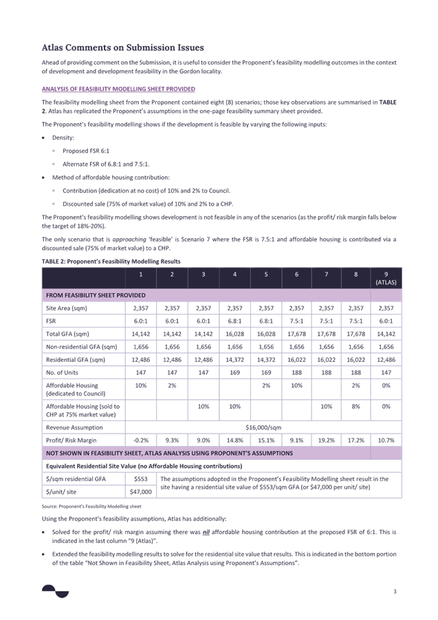
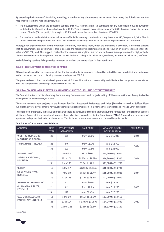
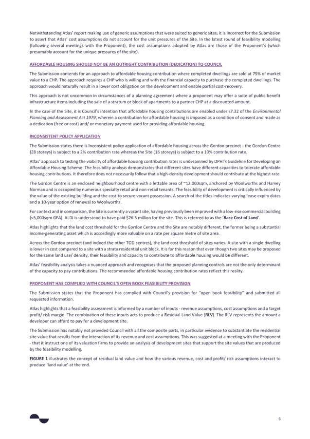
|
Extraordinary Meeting - 22 May 2025 |
GB.1 / 1 |
|
|
|
|
Item GB.1 |
S14846-2 |
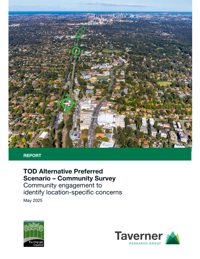
TOD alternative - preferred scenario - proposed amendments - post exhibition
EXECUTIVE SUMMARY
Purpose of Report
To advise Council of the outcomes of the public exhibition and to recommend amendments to the exhibited version of the Implementation Strategy and Maps.
Background
At the Extraordinary Meeting of Council of 31 March 2025 Council resolved to:
A. Endorse the Preferred Scenario for exhibition, as represented by the Ku-ring-gai TOD Preferred Alternative in Part 05 (Implementation Strategy) and Part 06 (LEP Plans) of the Ku-ring-gai Centres Technical Study, and other supporting information as attached to this report, for a 3-week period in the manner described in this report.
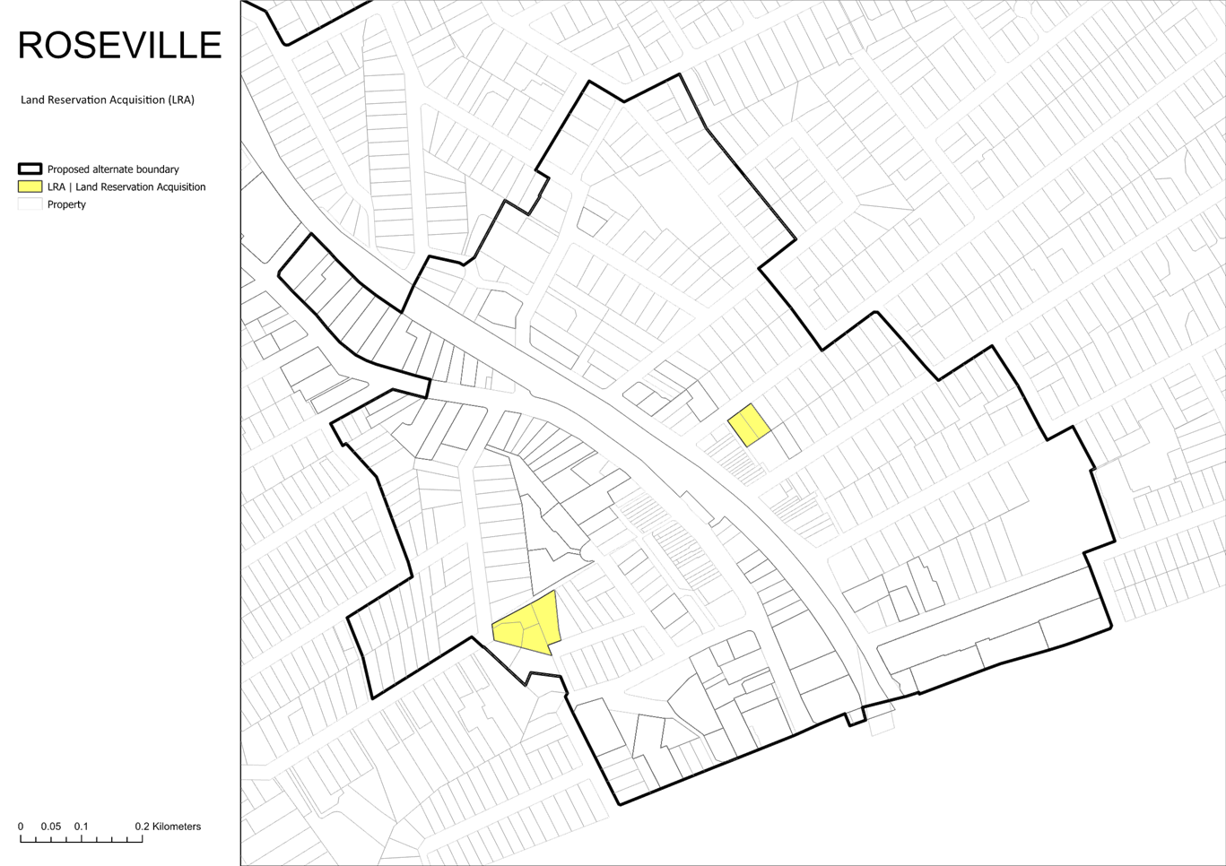
B. Note that the following lands are identified to be zoned RE1- Public Recreation or SP2 – Local Road and identified on the Land Reservation Acquisitions map:
a. For the purposes of open space - nos.63, 63A, 65 Dumaresq Street and nos.12 & 12A Vale Street, Gordon total area approximately 6,359sqm (total park area including Gordon Glen approximately 8,670sqm.
b. For the purposes of open space – nos.26, 28, 30 & 32 Bent Street & nos.1 and 3 Newark Crescent, Lindfield (area approximately 4,165sqm).
c. For the purposes of open space – no.3 Roseville Avenue, Roseville (area 913sqm).
d. For the purposes of open space and local road - Nos.15 & 17 Pockley Avenue, nos. 22 and 20A Shirley Road, Roseville (park area approximately 3,760sqm & road area approximately 1,200sqm).
C. Note the commencement of a review of the current s7.11 contributions plan (Ku-ring-gai Contributions Plan 2010) to cater for the increased local infrastructure demands of intensive redevelopment in the TOD areas and commence liaison with IPART with a view to being able to levy above the 2009 $20,000 threshold.
D. Make a request to DPHI that no State Significant Applications in the TOD precincts be saved due to the significant inconsistencies with Council’s TOD Preferred Scenario.
Comments
The NSW Government introduced the Transport-Oriented Development SEPP in May 2024, allowing 6–7 storey buildings within a five-minute walk of selected Sydney train stations. This policy affects four Ku-ring-gai town centres: Gordon, Killara, Lindfield, and Roseville.
In response Ku-ring-gai Council is exploring alternative ways to accommodate new housing while preserving the area’s valued heritage and environmental assets. This includes developing four alternative housing scenarios which, along with the State Government’s TOD SEPP, were publicly exhibited between 15 November and 17 December 2024.
The feedback from this exhibition process, together with a range of technical and planning studies, led to Council developing and adopting a TOD Alternate Preferred Scenario.
Council’s TOD Alternate Preferred Scenario was exhibited for 3-weeks in April 2025. Engagement, comprising an opt-in survey accessible from Council’s YourSay portal, was designed to test resident views on, and identify any specific concerns that may further influence the Preferred Scenario.
What did Council consult on?
Ku-ring-gai Council sought community feedback on proposed changes to the Ku-ring-gai Local Environmental Plan (KLEP 2015), consistent with Council’s adopted Preferred Scenario for Transport Oriented Development around Roseville, Lindfield, Killara and Gordon stations. Council developed the Preferred Scenario after considering community feedback and expert technical advice.
The KLEP 2015 is a key planning document that guides how land can be used and developed across Ku-ring-gai. A central part of the LEP are its zoning and planning control maps, which are used in the assessment of new development proposals and land acquisition.
What did residents say?
The results of the community survey are documented in the report prepared by Taverner Research Group TOD Alternative Preferred Scenario – Community Survey Community engagement to identify location-specific concerns, May 2025 (refer Attachment A1). A summary is provided below:
1. The majority of residents agreed that Council’s proposed plan aligns with its seven underlying planning principles. In particular:
- 70% agreed that it (fully or partially) preserved heritage conservation areas.
- 69% agreed that it minimised heritage item impacts, and avoided environmentally sensitive areas.
- 66% agreed that it supported local centre revitalisation.
- However, “only” 56% agreed that it managed transition impacts, and just 52% said that it ensured appropriate building heights – suggesting these remain issues of concern to many residents.
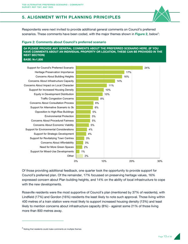
2. In general comments, one-quarter of those taking part expressed support for Council’s preferred scenario. However, a further 17% noted concerns about preserving local heritage, 16% took issue with proposed building heights, and 14% were unsure how local infrastructure would keep pace with future developments.
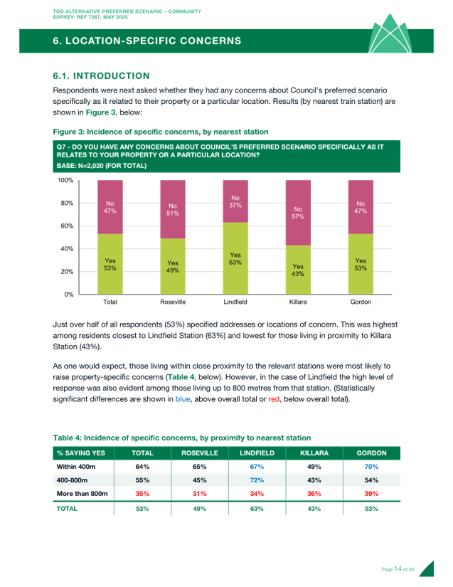
3. Just over half of all respondents had concerns that were specific to a property or location – this included 63% of Lindfield residents, and 64% of those living within 400 metres of an affected train station.
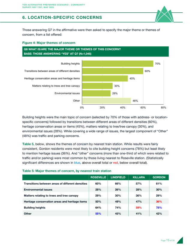
4. Major issues raised included proposed building heights (from 70% of those with location-specific concerns), transitions between areas of different densities (60%) and heritage conservation areas/items (45%).
Key issues raised in comments relating to specific locations
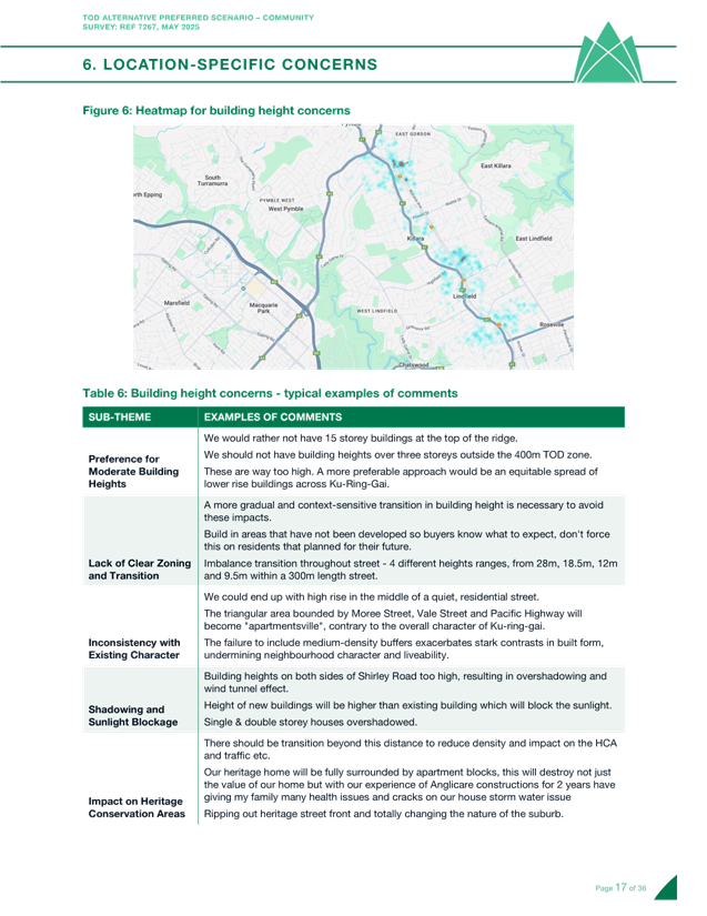
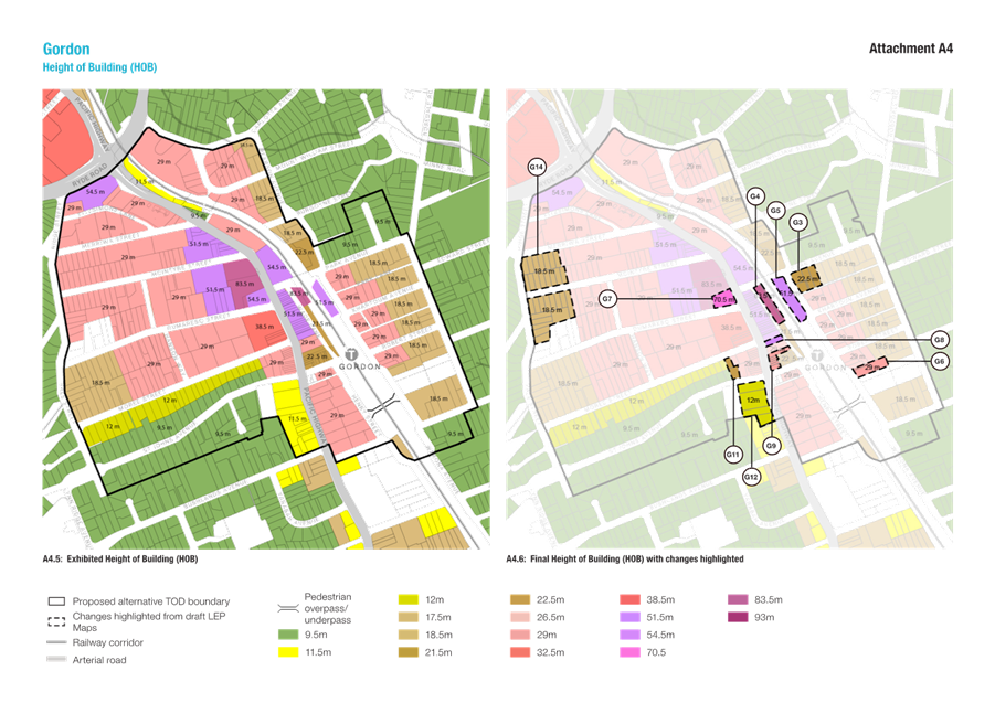
Building height concerns
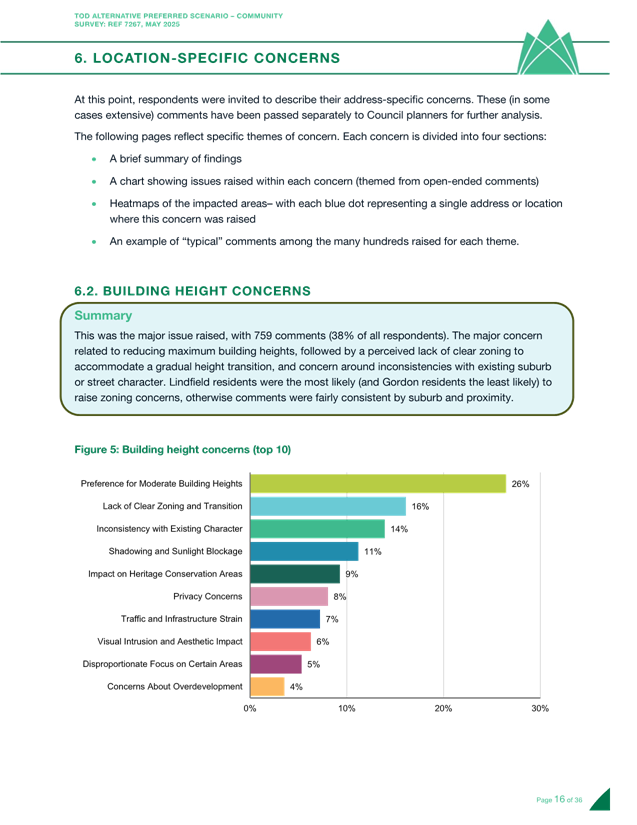
Building height emerged as the primary concern, mentioned by 759 respondents. Most comments advocated for reducing maximum building heights, with additional concerns about insufficient zoning for gradual height transitions and inconsistencies with existing neighbourhood character. Lindfield residents were most likely to raise zoning concerns, while Gordon residents were least likely. Comments were otherwise consistent across suburbs and proximity to transit.
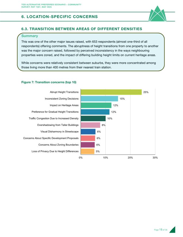
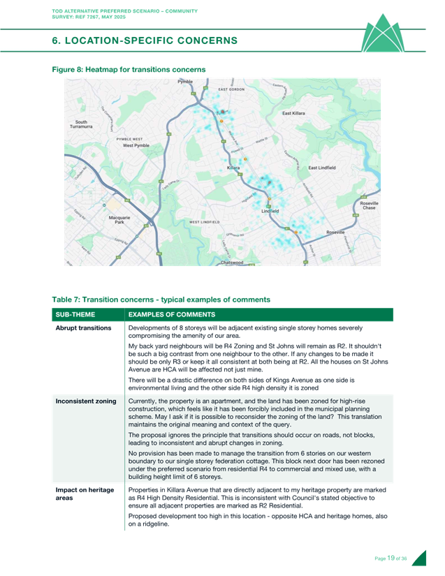
Transition between areas of different densities
Approximately one-third of respondents (653) raised concerns about transitions between density zones. The main issue was abrupt height changes between adjacent properties, followed by perceived inconsistencies in zoning of neighbouring properties and the impact of varying building height limits on heritage areas. These concerns were more prevalent among residents living beyond 400 metres from train stations, though they appeared across all suburbs.
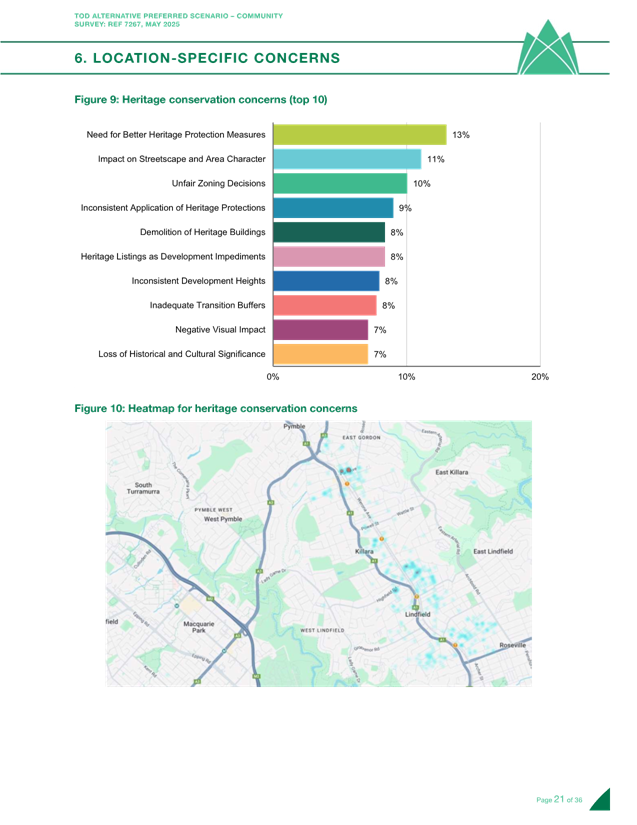
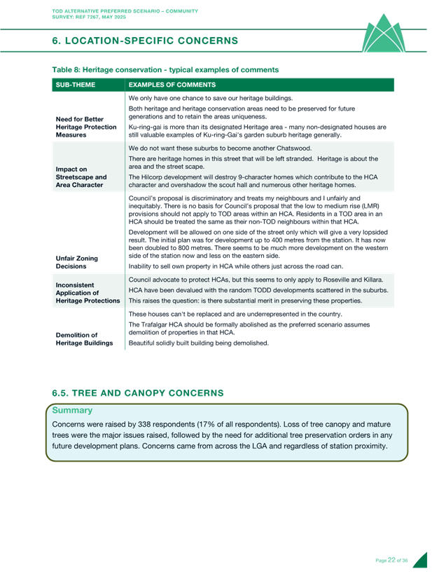
Heritage conservation
Heritage preservation was highlighted by 495 respondents, with comments focusing on the need for stronger heritage protection measures, concerns about removing heritage protections from local streetscapes, and perceptions of unfair zoning decisions affecting heritage properties. These concerns were distributed evenly throughout the LGA regardless of proximity to transit stations.
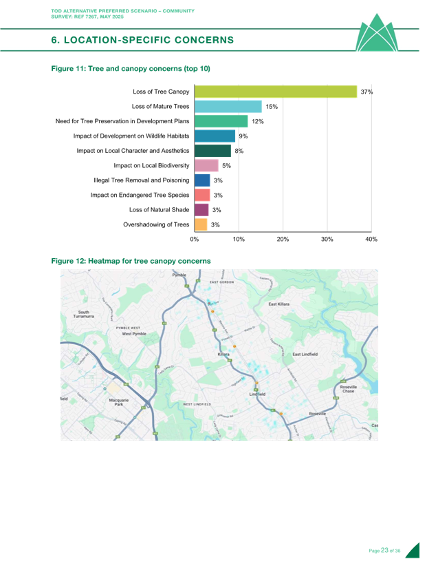
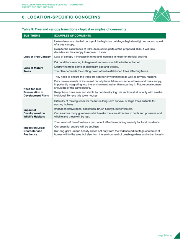
Tree and canopy preservation
Tree-related concerns were raised by 338 respondents, primarily regarding loss of mature trees and canopy coverage. Many called for additional tree preservation orders in future development plans. These concerns were consistent across all areas of the LGA and across various distances from stations.
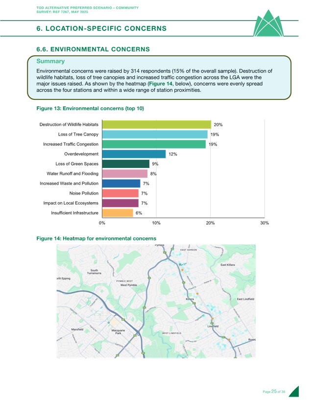
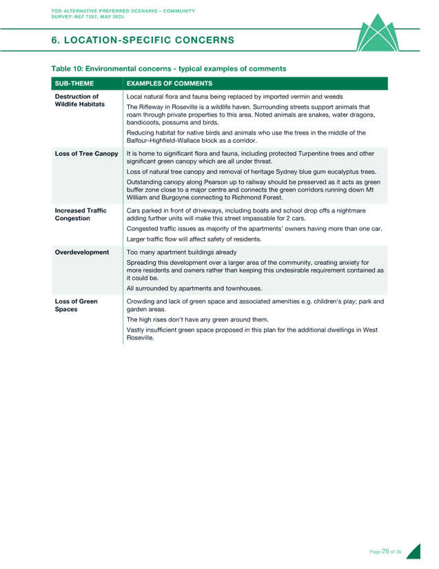
Environmental considerations
Environmental issues were mentioned by 314 respondents, focusing on wildlife habitat destruction, canopy loss, and increased traffic congestion. The concerns were evenly distributed across all four station precincts and at various distances from stations.
Additional concerns
Other issues were raised by 517 respondents, with traffic congestion and safety being the predominant concern by a significant margin. These concerns were consistent across all suburbs and station proximities.
Written comments
Over 290 written comments were received and focused predominantly on property/location specific matters. A summary of the themes arising from submissions received up until COB 25April 2025 have been tabulated and included at Attachment A2. The 26 submissions received after this date have also been read and considered by Council’s planning staff. The key themes in the written comments align with the results seen in the survey and were considered by planners when developing the final Preferred Scenario as outlined in this report. The written submissions were accompanied by three petitions. The first two petitions which relate to reducing density in Bromborough Road, Ontario and Thomas Avenue, Roseville included 89 and 87 signatures. The second petition which related generally to the suburb of Lindfield included two signatures. All submissions and the petitions have been made available to the Councillors
Location specific matters
Survey comments, heat maps, and written submissions revealed a range of location-specific concerns across the study area. These inputs were carefully analysed, and where consistent issues were identified, further detailed investigation was undertaken. In response, some minor changes have been made to the plan, which are outlined in this report.
The heat maps below illustrate the density of submissions by location, highlighting where community feedback was most concentrated. While areas with a higher number of submissions were examined more closely, the number of responses alone did not determine whether changes were made. Each comment was considered on its merit, and greater volume did not necessarily equate to greater influence.
Gordon received the highest volume of location-specific feedback, with particular focus on the areas around Park Avenue and Pearson Avenue. Lindfield followed, with feedback clustered around Woodside Avenue, Kenilworth Road, and Highfield Road. Roseville’s feedback was more evenly distributed, though notable concentrations occurred near Shirley Road and Bromborough Road. Killara had the least amount of location-specific feedback, with a small cluster emerging around Lorne Avenue.
|
Gordon:
|
|
Killara:
|
|
Lindfield:
|
|
|
|
Roseville:
|
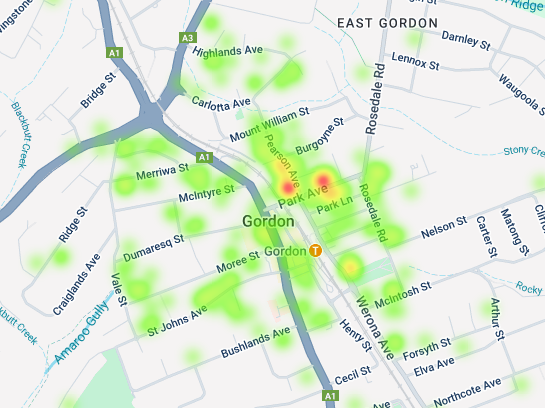
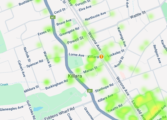
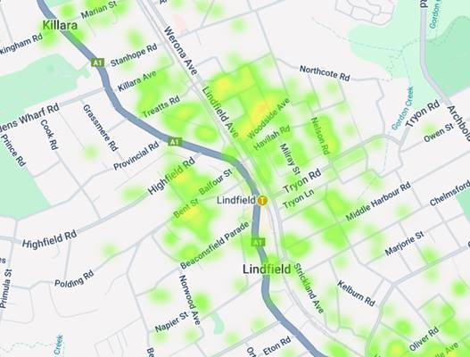
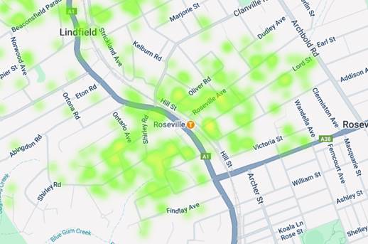
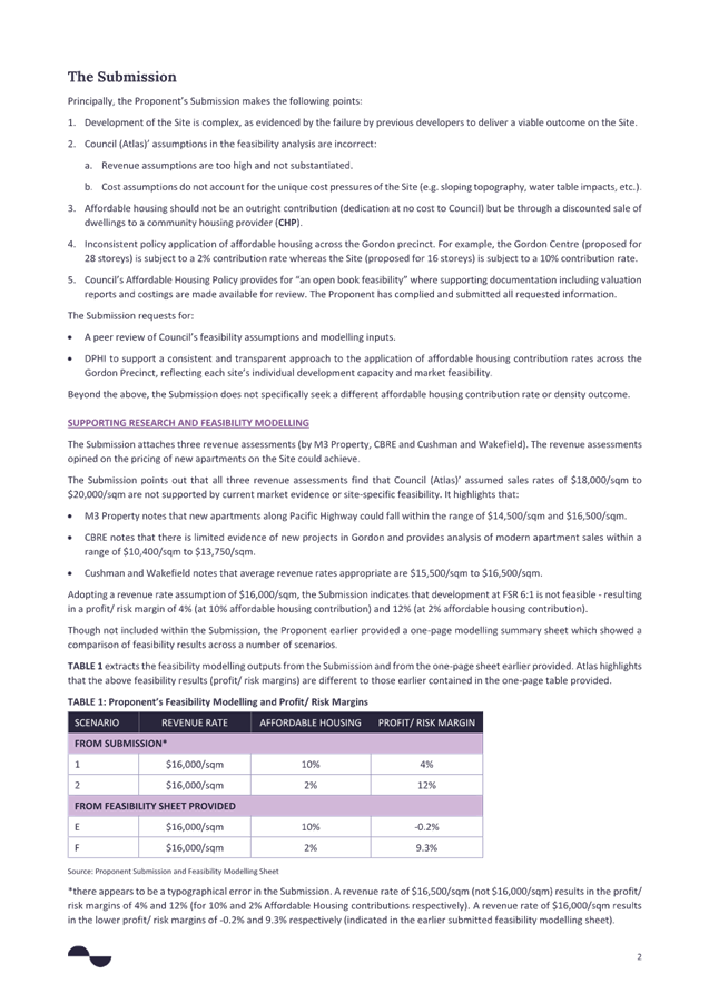
Figure 1 – Results of Community Survey - ‘Heat Maps”
What amendments are proposed to the Preferred Scenario?
The Ku-ring-gai Local Environmental Plan 2015 (KLEP 2015) is being updated to support and implement Council’s TOD Alternative Preferred Scenario. The changes to the KLEP 2015 include updates to land zoning, building height limits, and development density allowed on each site. In some centres, existing planning rules will be refined or replaced to reflect more up-to-date priorities and design principles.
Council have committed to submitting an alternative TOD plan to the NSW Government by the end of May 2025. To achieve this deadline an extraordinary meeting of Council has been scheduled to deal with this matter. Community consultation on the preferred scenario was for a period of 21 days. This condensed consultation timeframe was necessary to comply with NSW Government deadlines.
The time available for staff to review submissions is significantly reduced, for this reason the review has involved prioritising input received through Council’s on-line survey:
· The results of the survey as it relates to a specific property or a particular location.
· The ‘heat map’ was a particularly useful guide to areas of greatest concern.
Survey responses in these ‘hotspots’ were reviewed in more detail, and if deemed necessary, were considered for amendments.
Council also received a large volume of written submissions via email, these included emails from residents and groups of residents, as well as emails with attached reports prepared by consultants representing single or groups of landowners. Council strongly encouraged providing feedback through the survey, however all submissions have been read and reviewed by Council planning staff.
The scope and nature of amendments to the exhibited plans is limited. Broadly this report considers an amendment where the review of submissions has identified one or more of the following:
· Mapping errors or omissions;
· inconsistent application of principles; and
· opportunities for upzoning to balance amendments in other locations that have resulted in a reduction in dwelling numbers.
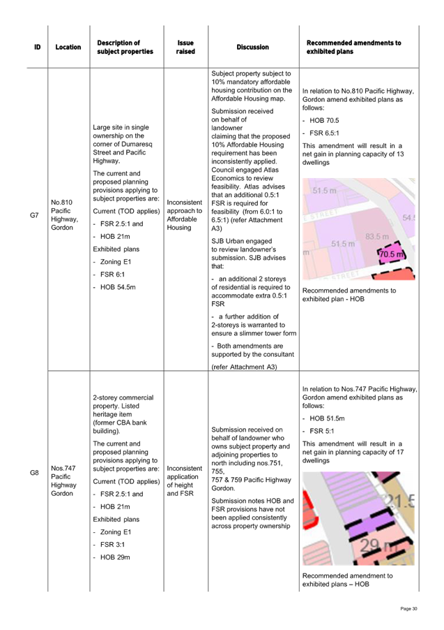
Claims for increases in development rights (more height or more FSR) have generally not been considered unless a review has found adequate justification has been given particularly based on factors noted above. The reason for this is that changes in development rights would result in an increase/decrease in dwelling numbers, this would trigger a review of development rights in other areas to increase/reduce dwelling numbers. The cumulative impact of such changes would be beyond the scope of what can be achieved in the available time. Into the future there is always the option for landowners to lodge their own a private planning proposal to Council to seek further amendments to the final endorsed plan. Council received landowner submissions for two sites in Gordon that justified detailed review. Both sites are in single ownership and are considered important catalyst sites for the revitalisation of Gordon. The sites are:
· ‘Aldi site’ - 810 Pacific Highway, Gordon
· ‘Gordon Centre’ - 784-808 Pacific Highway, Gordon
The review of the submissions was undertaken by SJB Urban and Atlas Economics and the findings are included in Attachment A3.
Proposed amendments to LEP Maps
A review of resident feedback has identified a number of amendments to the exhibited LEP maps. A detailed justification for these amendments has been prepared and is set out in Attachment A4. The exhibited maps and proposed map amendments are identified in Attachment A5. The amended LEP map set for Council endorsement is in Attachment A6.
Most of the amendments relate to adjustments to building height (generally reducing heights) to reduce transition impacts and ensuring the principle is applied consistently across the plans. This responds directly to the survey findings which reveal that transition between areas of different densities was one of the main topics of concern (selected by 60% of those with address- or location-specific concerns). Taverner state that:
“The abruptness of height transitions from one property to another was the major concern raised, followed by perceived inconsistency in the ways neighbouring properties were zoned, and the impact of sharply differing building height limits on current heritage areas”.
Other amendments relate to:
· Mapping errors;
· inconsistent application of HOB provisions & mapping error;
· inconsistent approach to Affordable Housing;
· inconsistent application of HOB and FSR;
· development feasibility;
· incorrect HOB and FSR provisions applied;
· inconsistent approach to applying land use zone; and
· inconsistent approach to heritage protection.
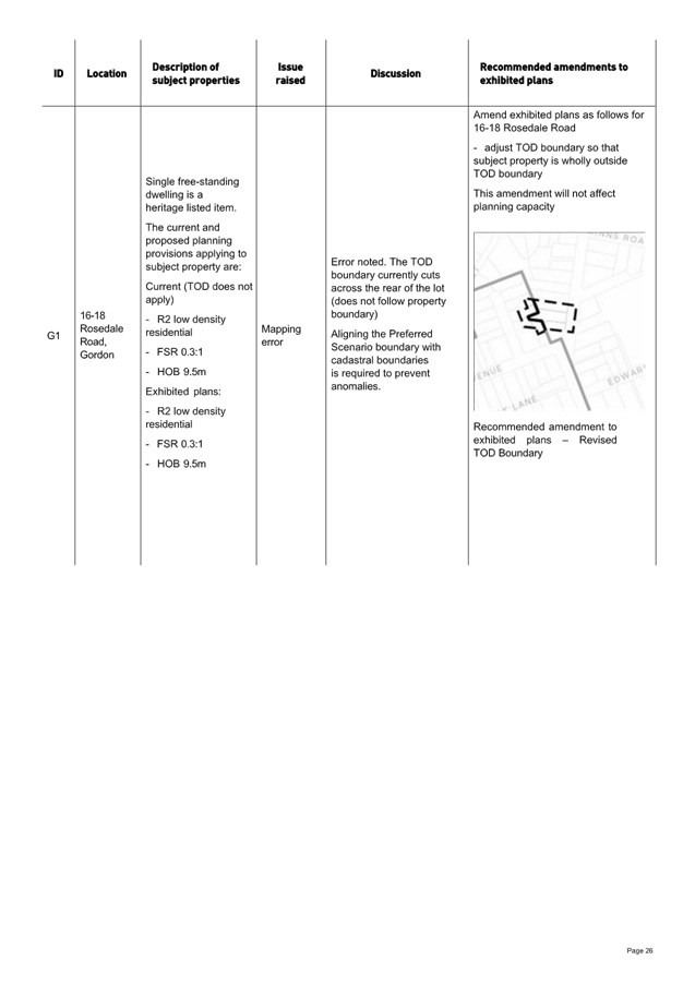
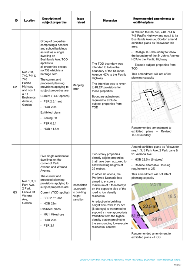
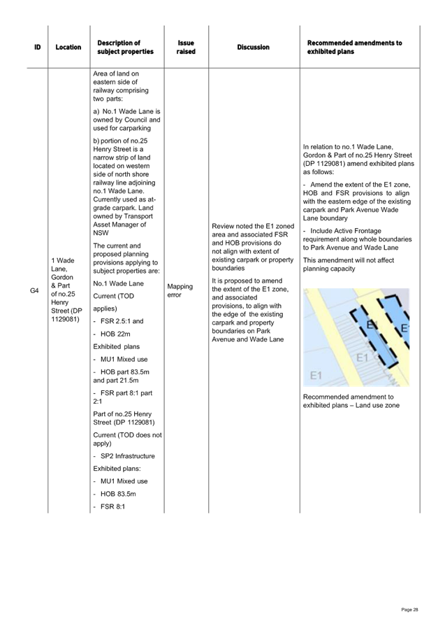
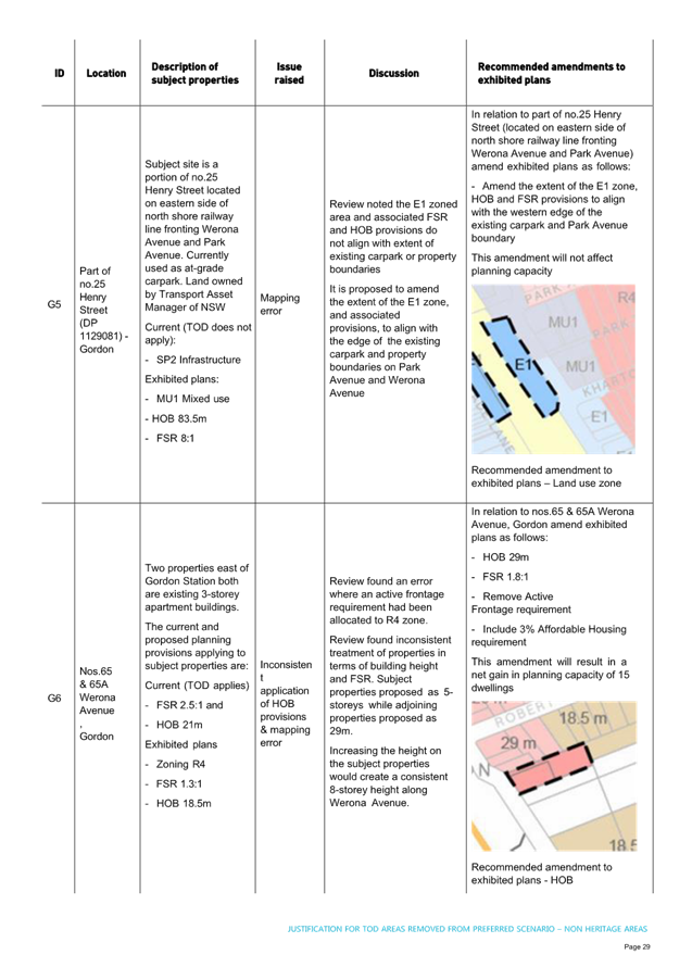
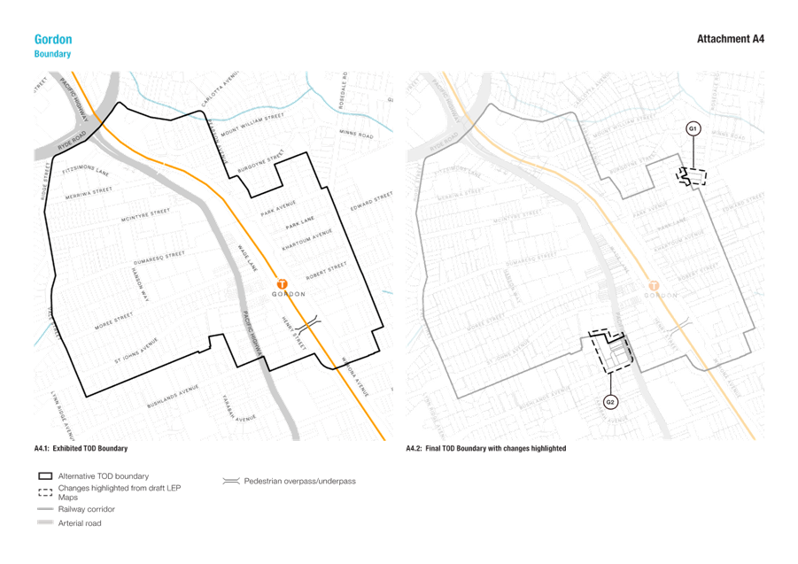
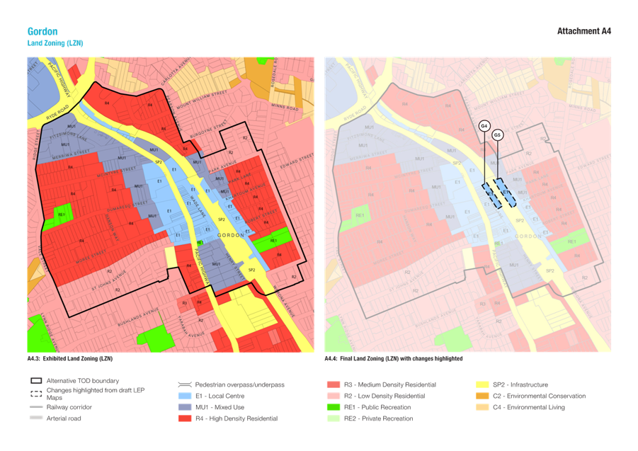
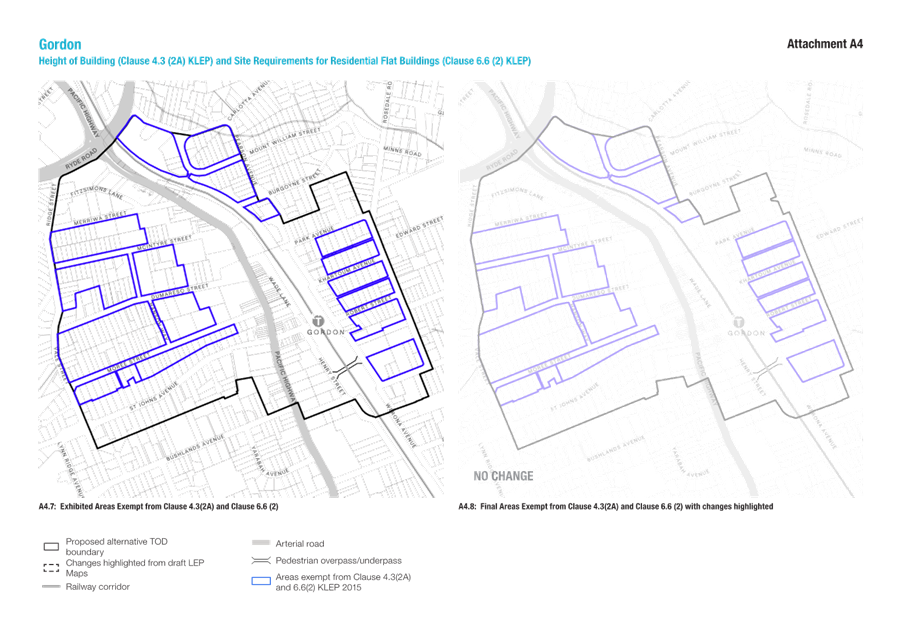
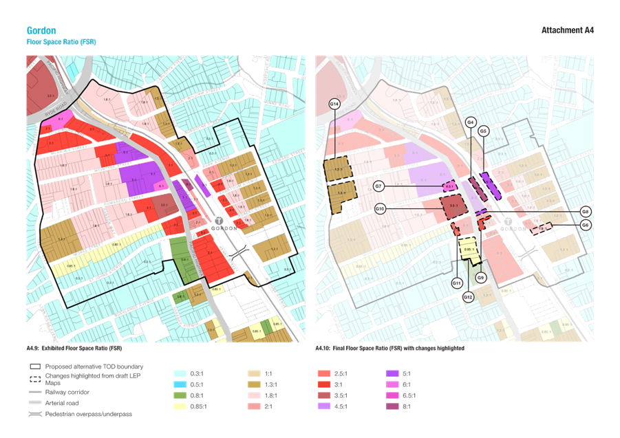
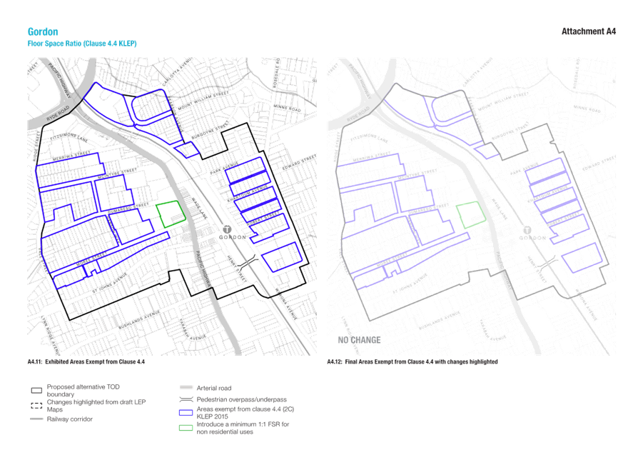
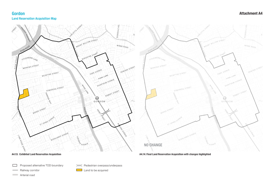
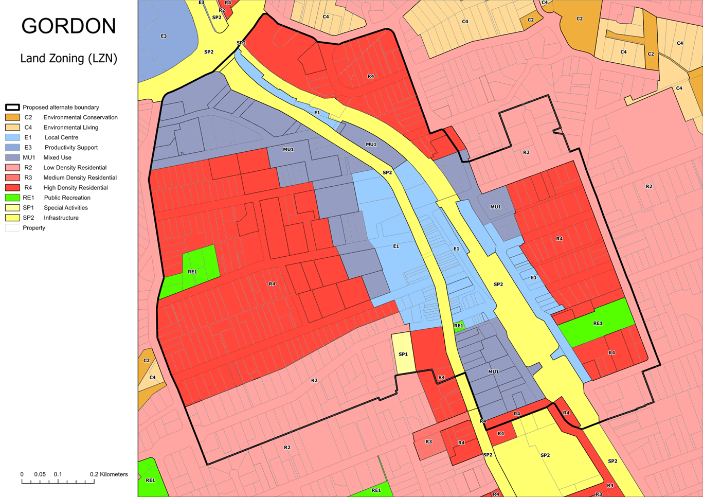
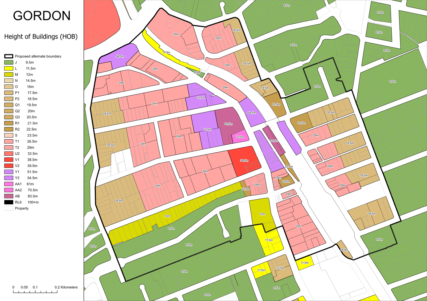
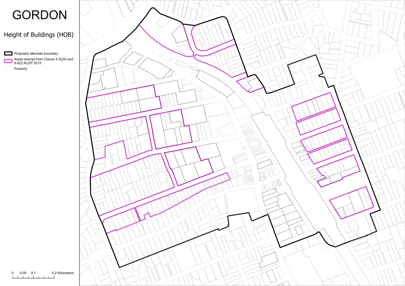
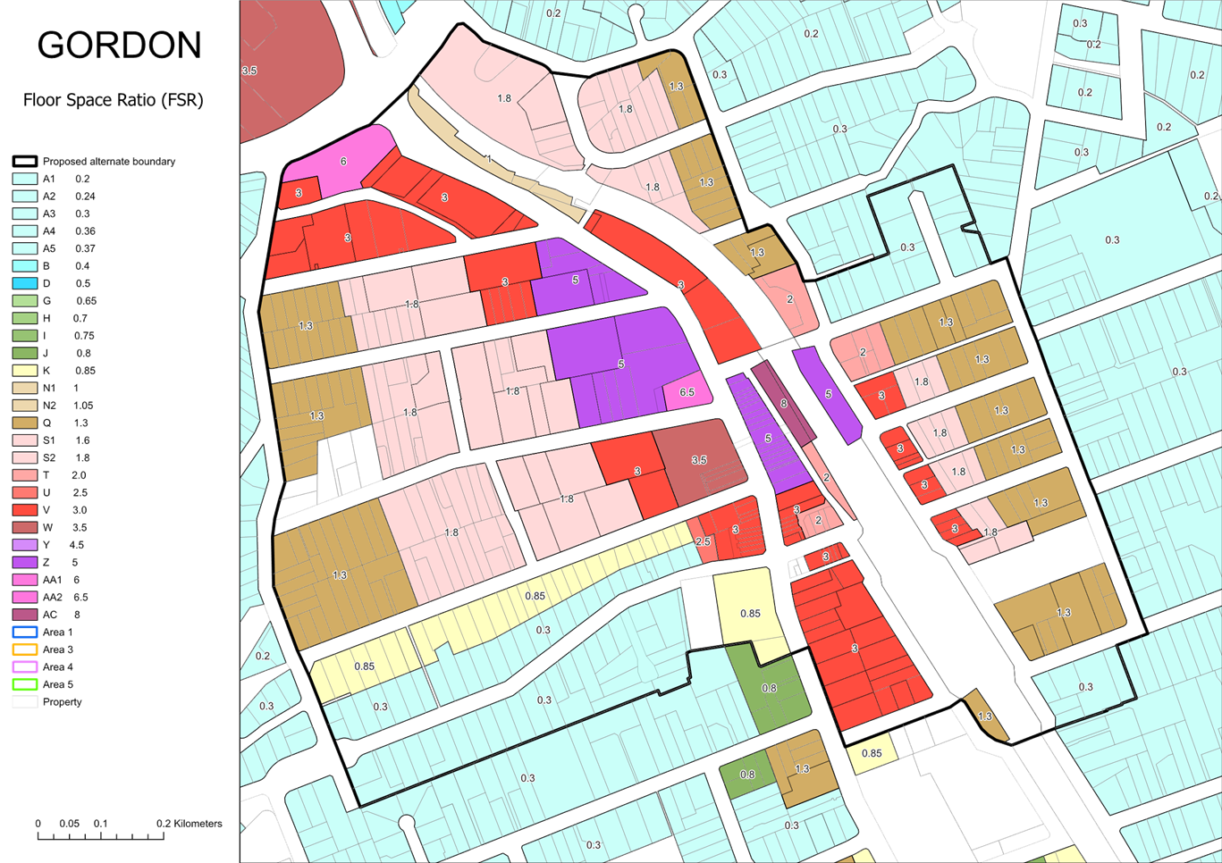
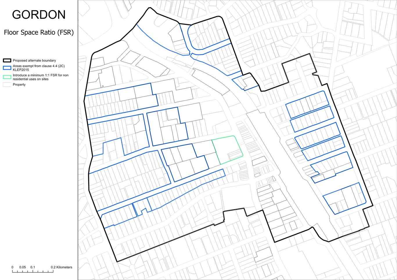
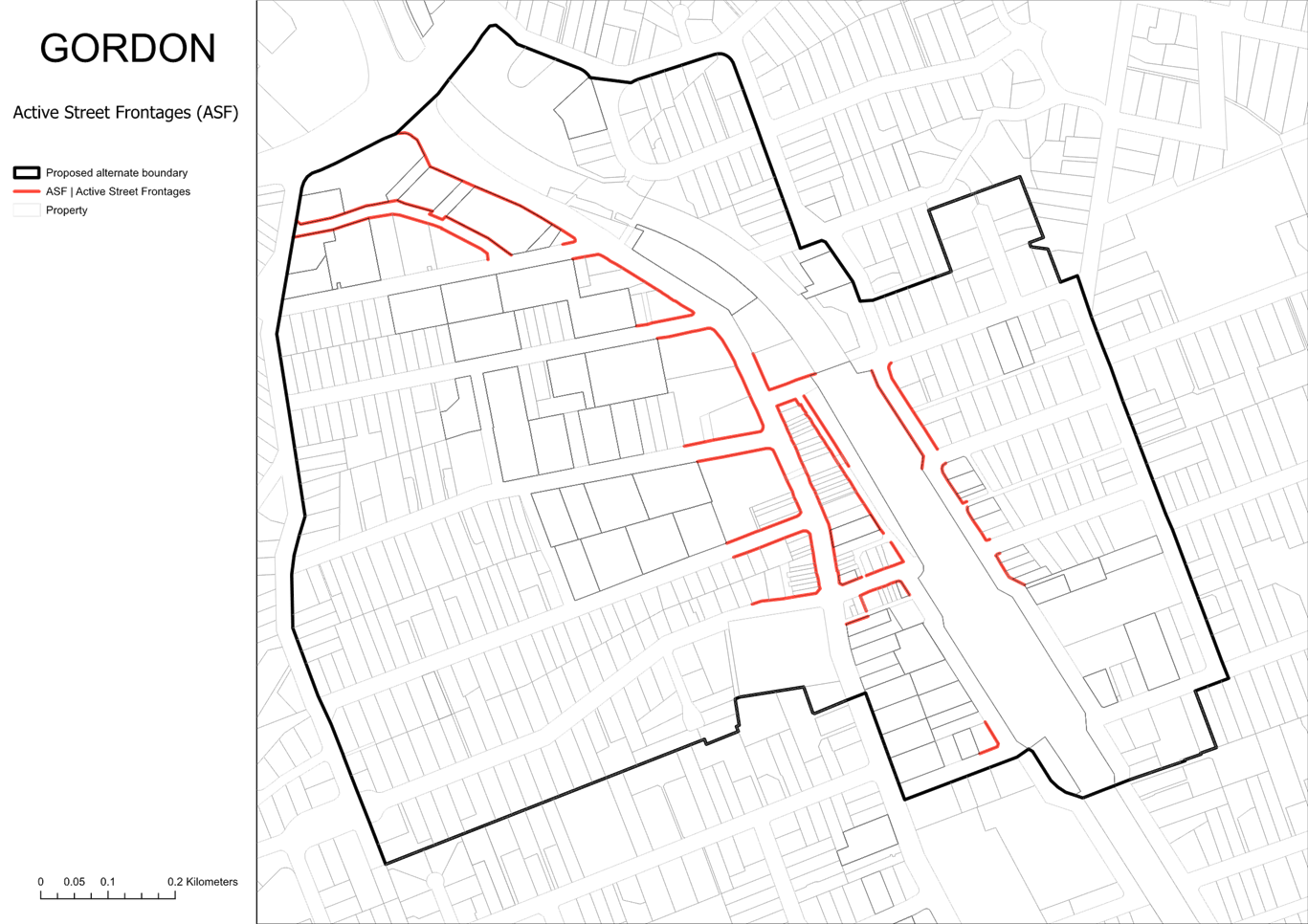
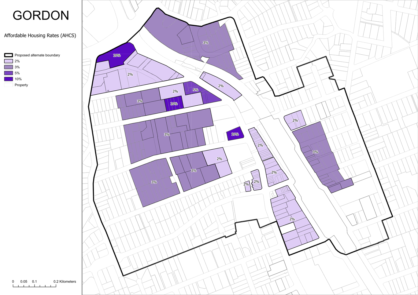
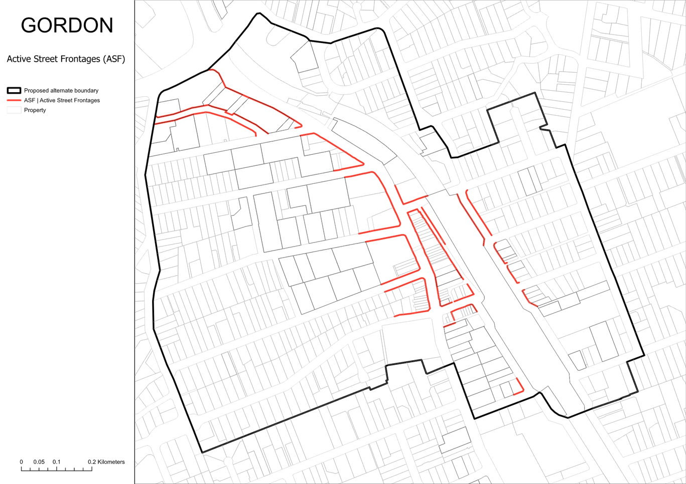
Gordon
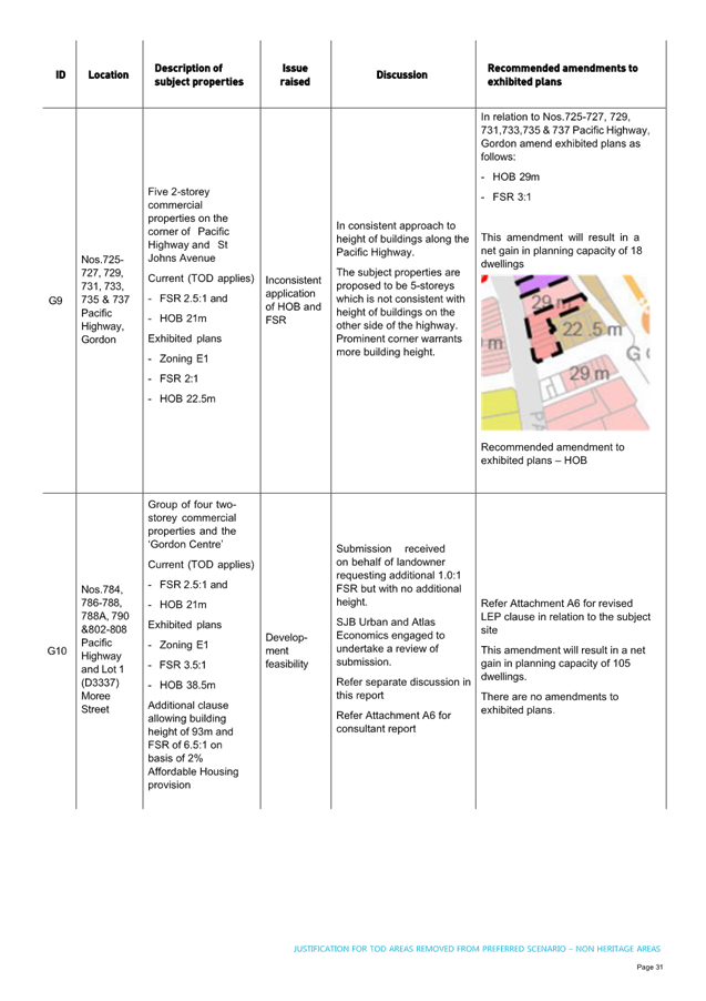
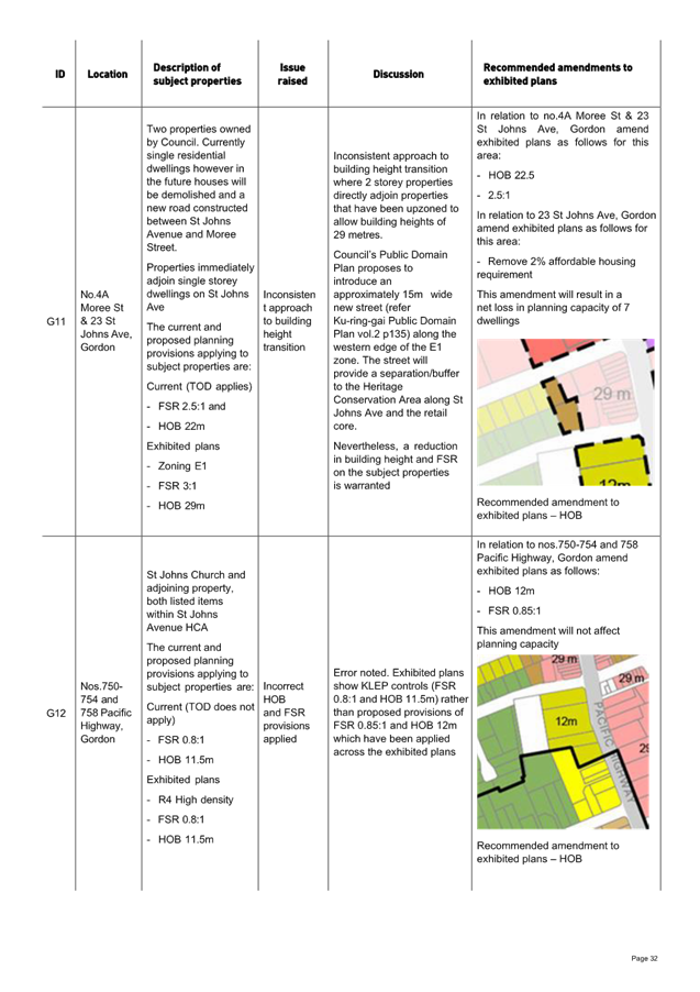
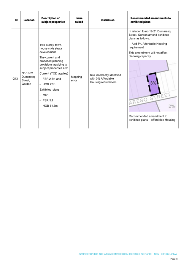
The recommended amendments to the Gordon maps are summarised in Figure 2-4 below. Refer Attachments A4 and A5 for details.
The amendments result in a increase of 30 dwellings
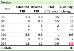
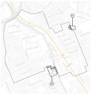
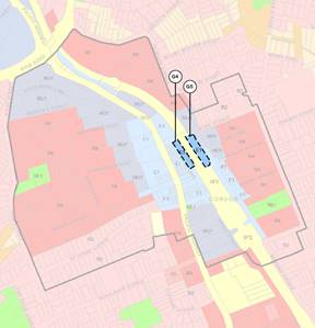
Figure 2 – Gordon – Proposed TOD Boundary and land use zone amendments
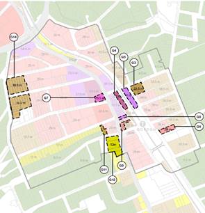
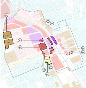
Figure 3 – Gordon – Proposed Height of Building and land use zone amendments
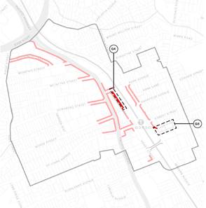
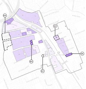
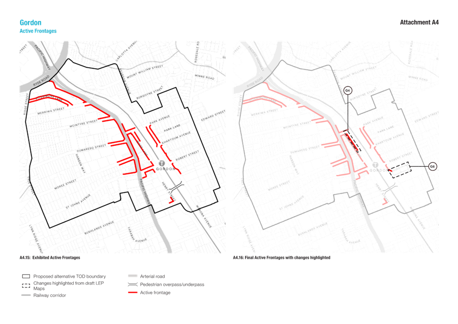
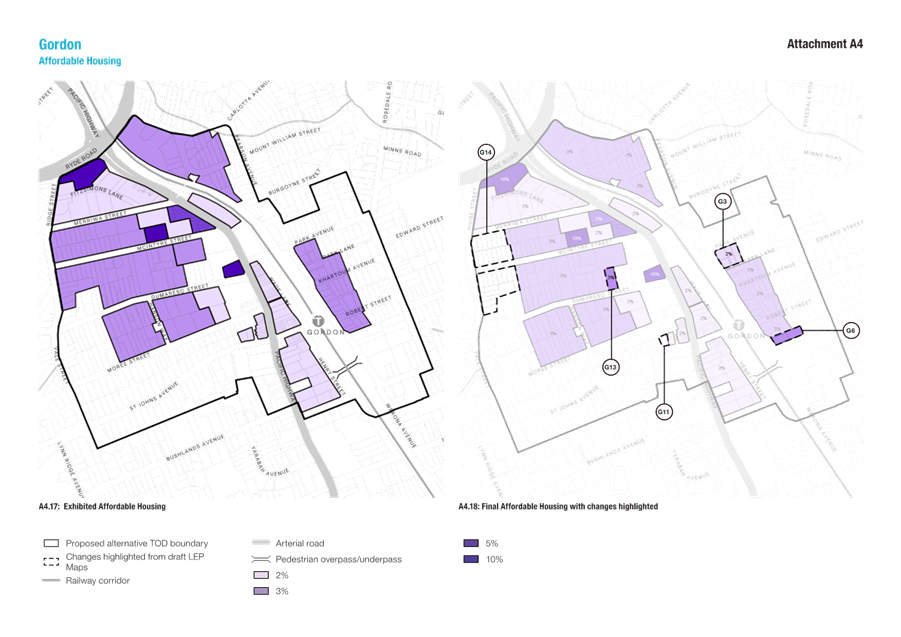
Figure 4 – Gordon – Proposed Active Frontage and Affordable Housing amendments
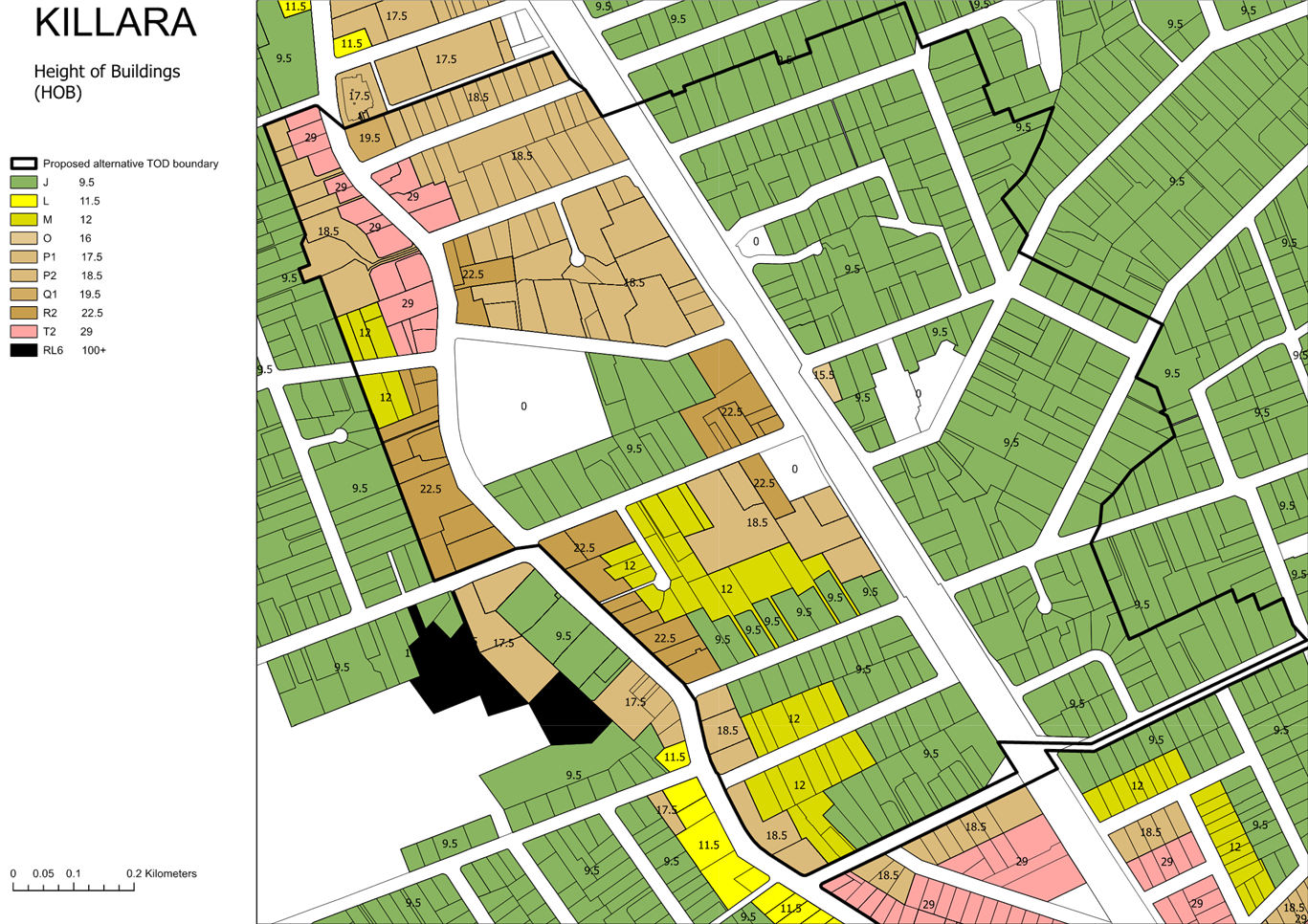
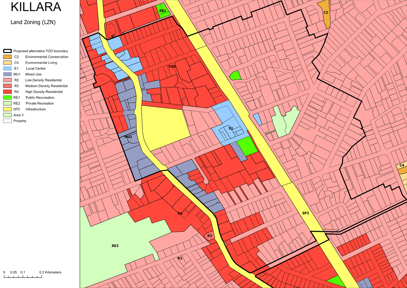
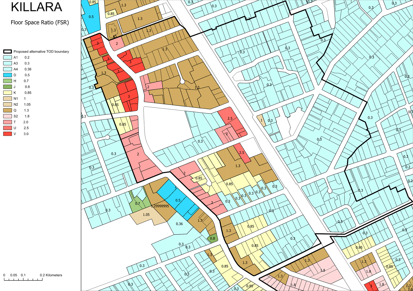
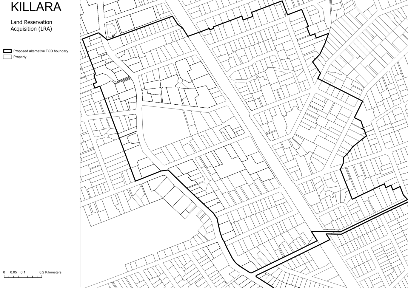
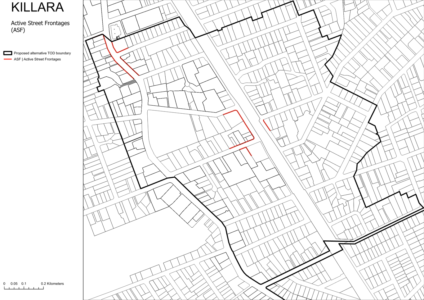
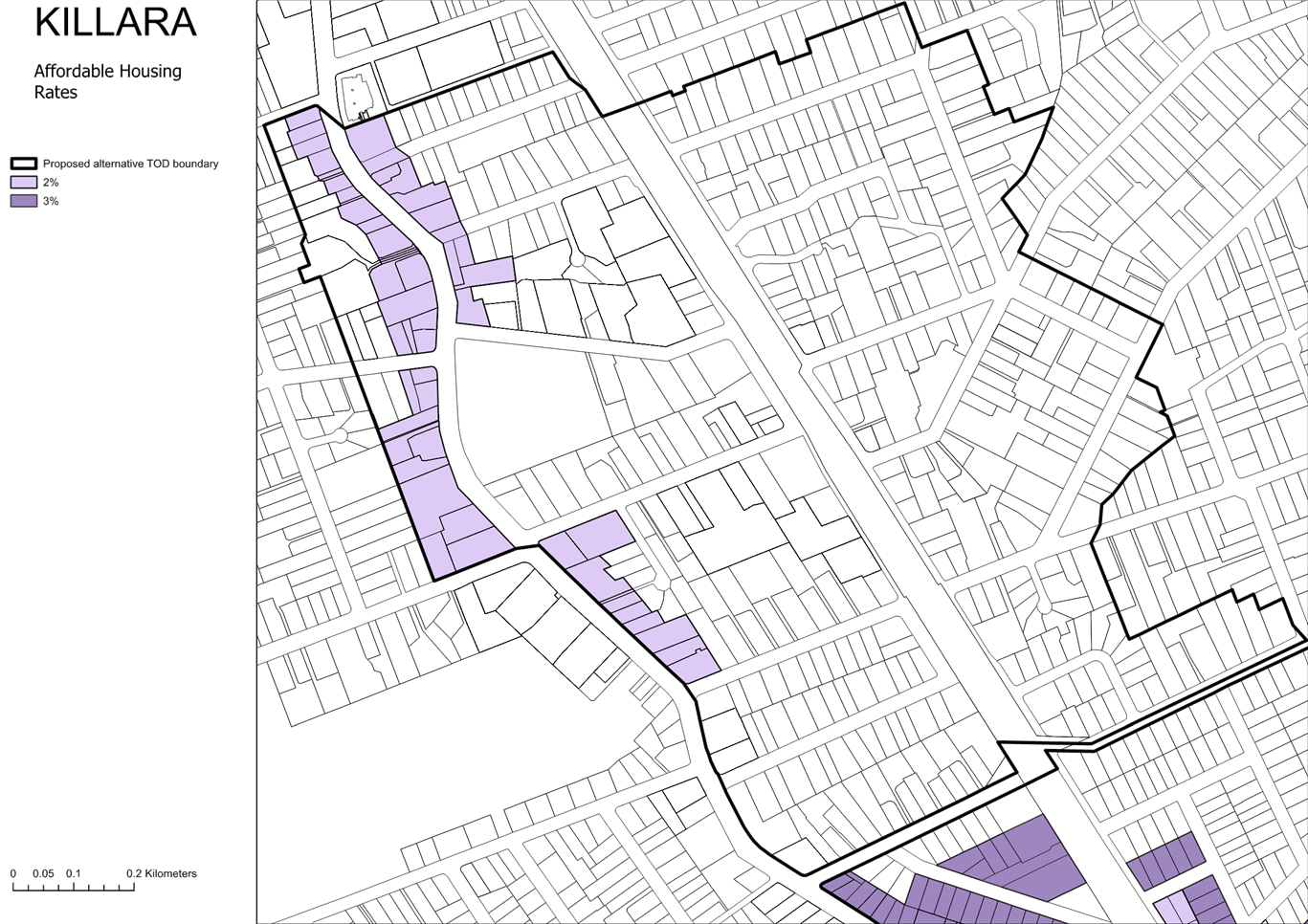
Killara
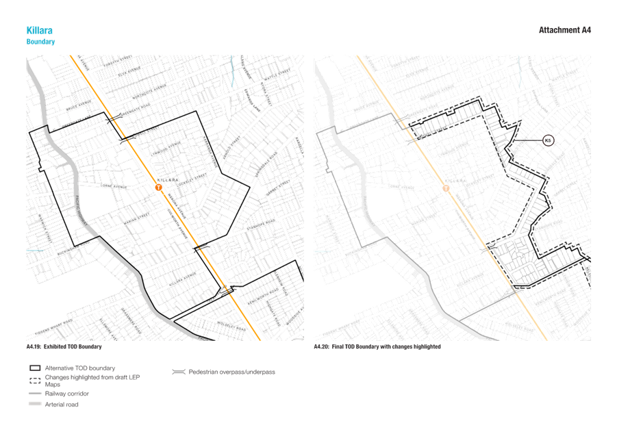
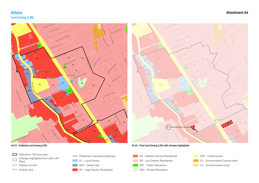
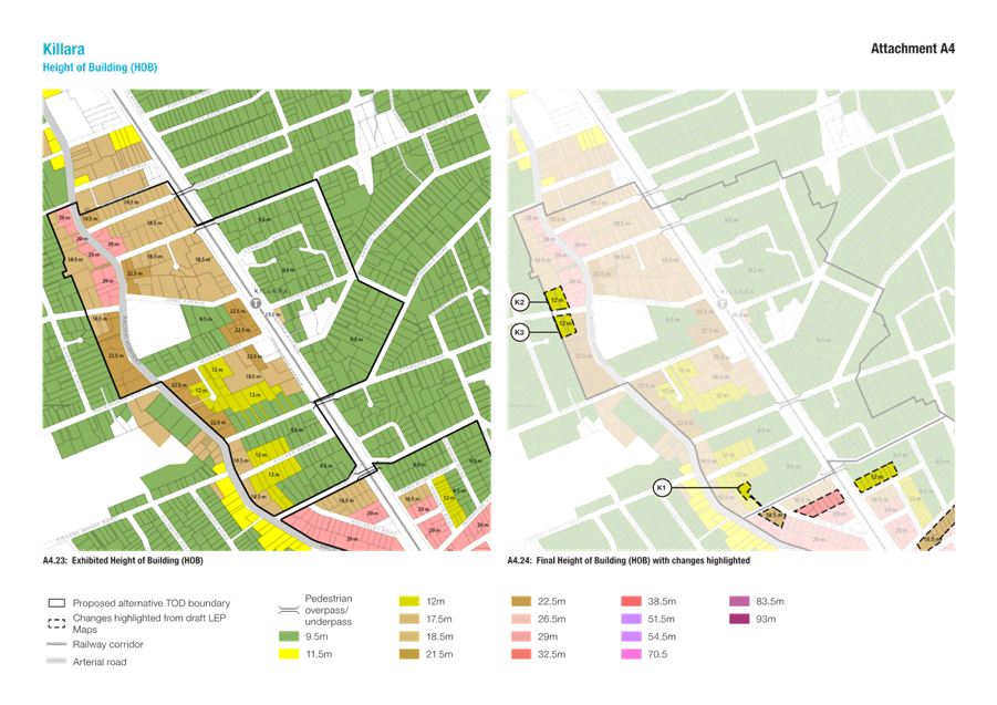
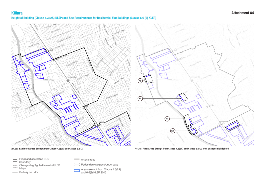
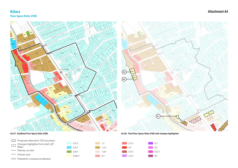
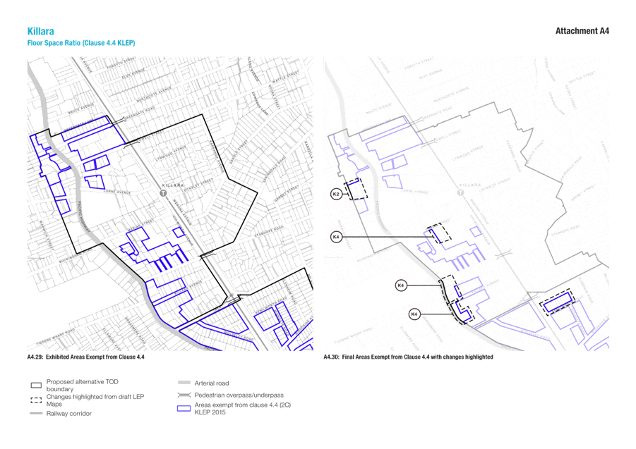
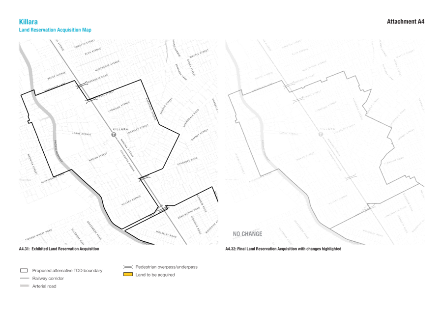
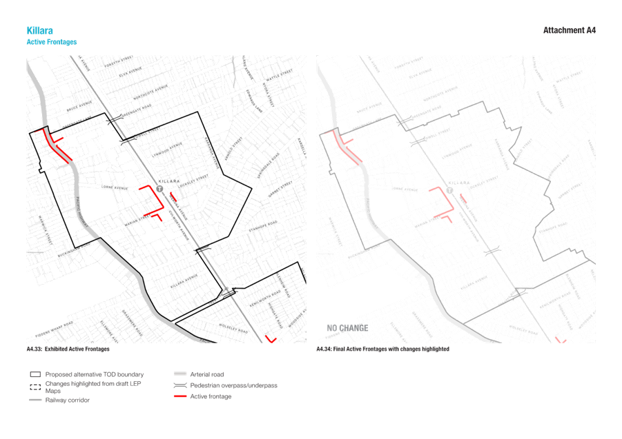
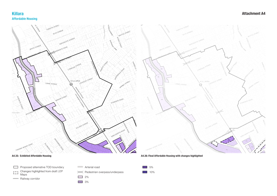
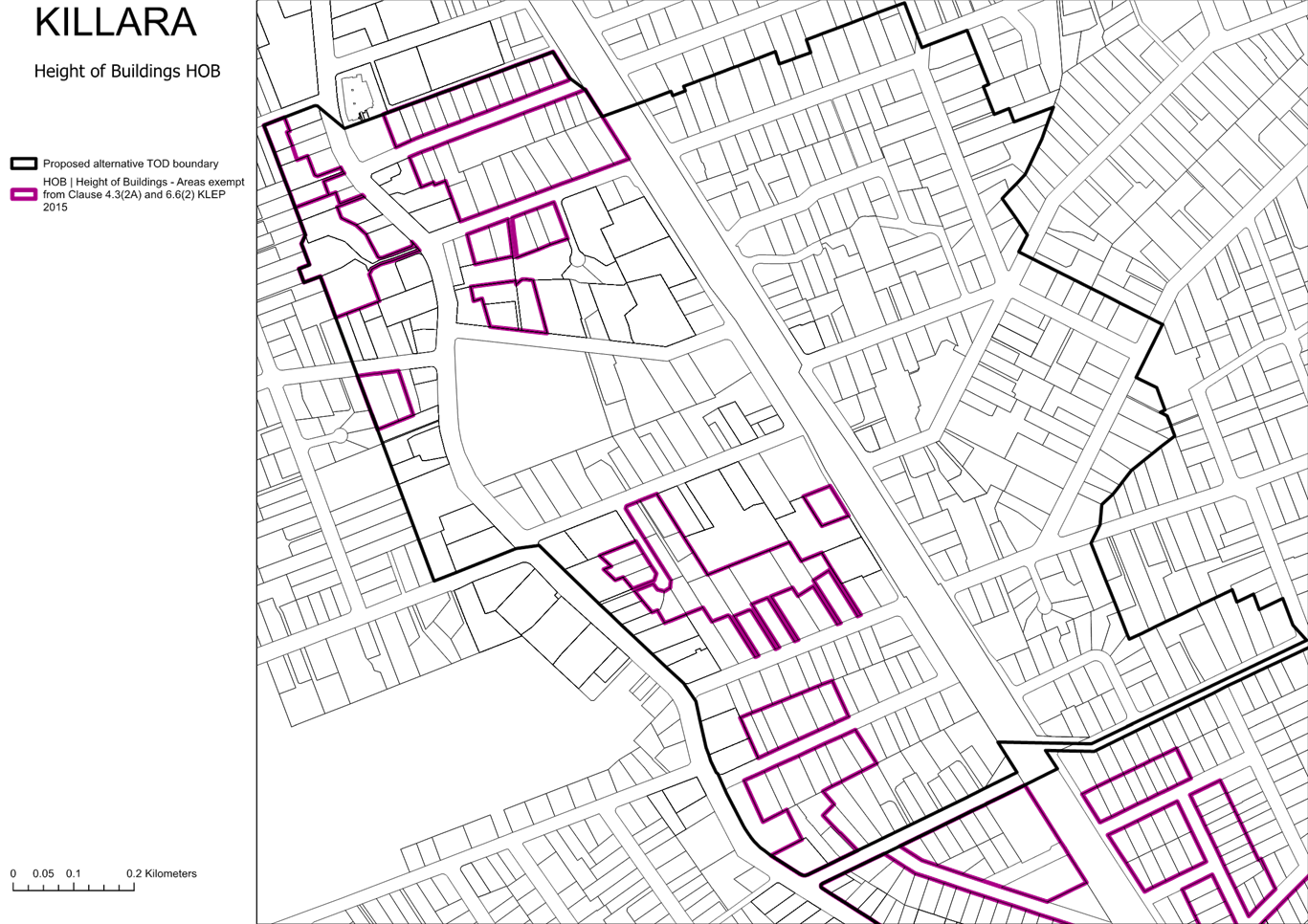
The recommended amendments to the Killara maps are summarised in Figure 5-6 below. Refer Attachments A4 and A5 for details.
The amendments result in a reduction of 38 dwellings
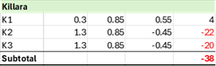
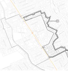
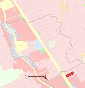
Figure 5 – Killara – Proposed TOD boundary and Land Use zone amendments
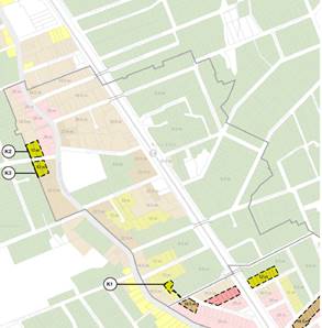
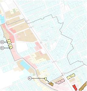
Figure 6 – Killara – Proposed Height of Building and Floorspace Ratio amendments
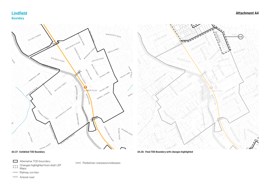
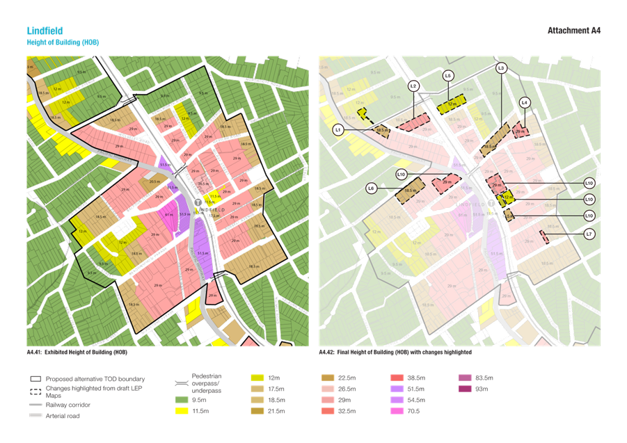
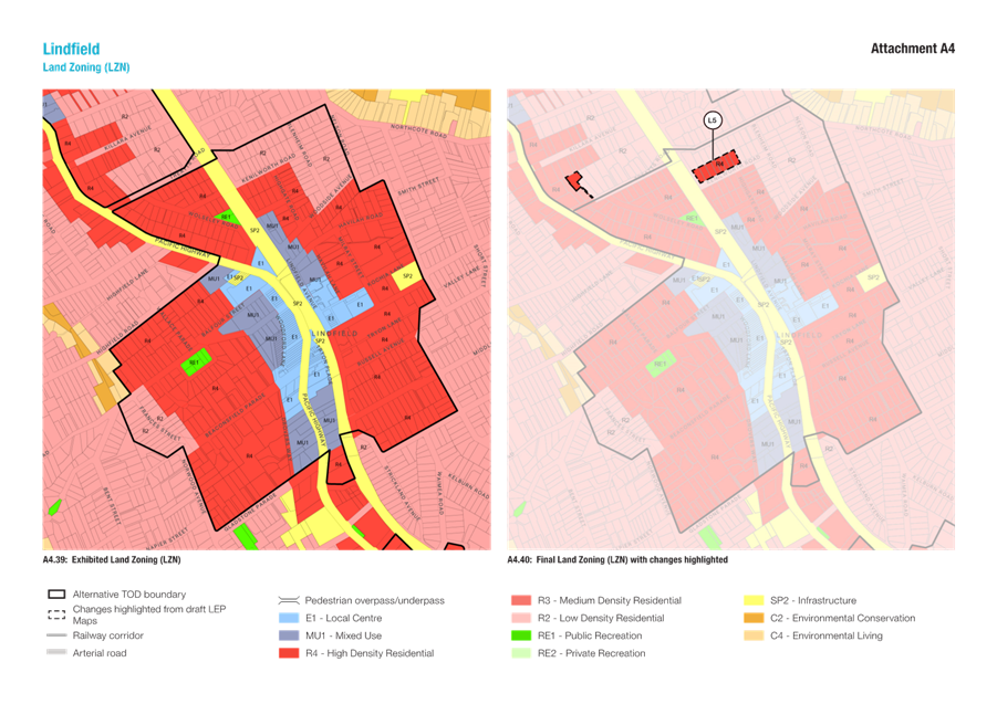
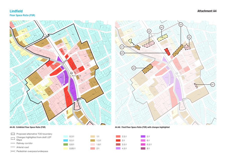
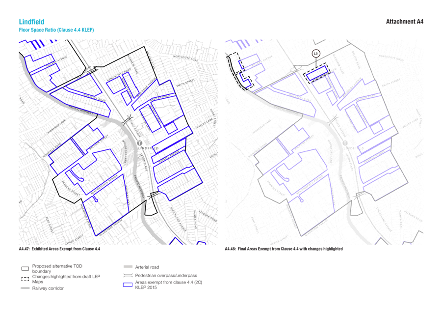
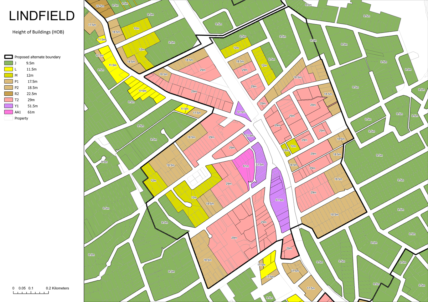
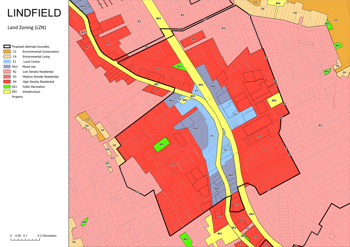
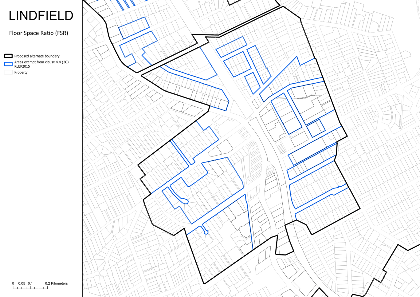
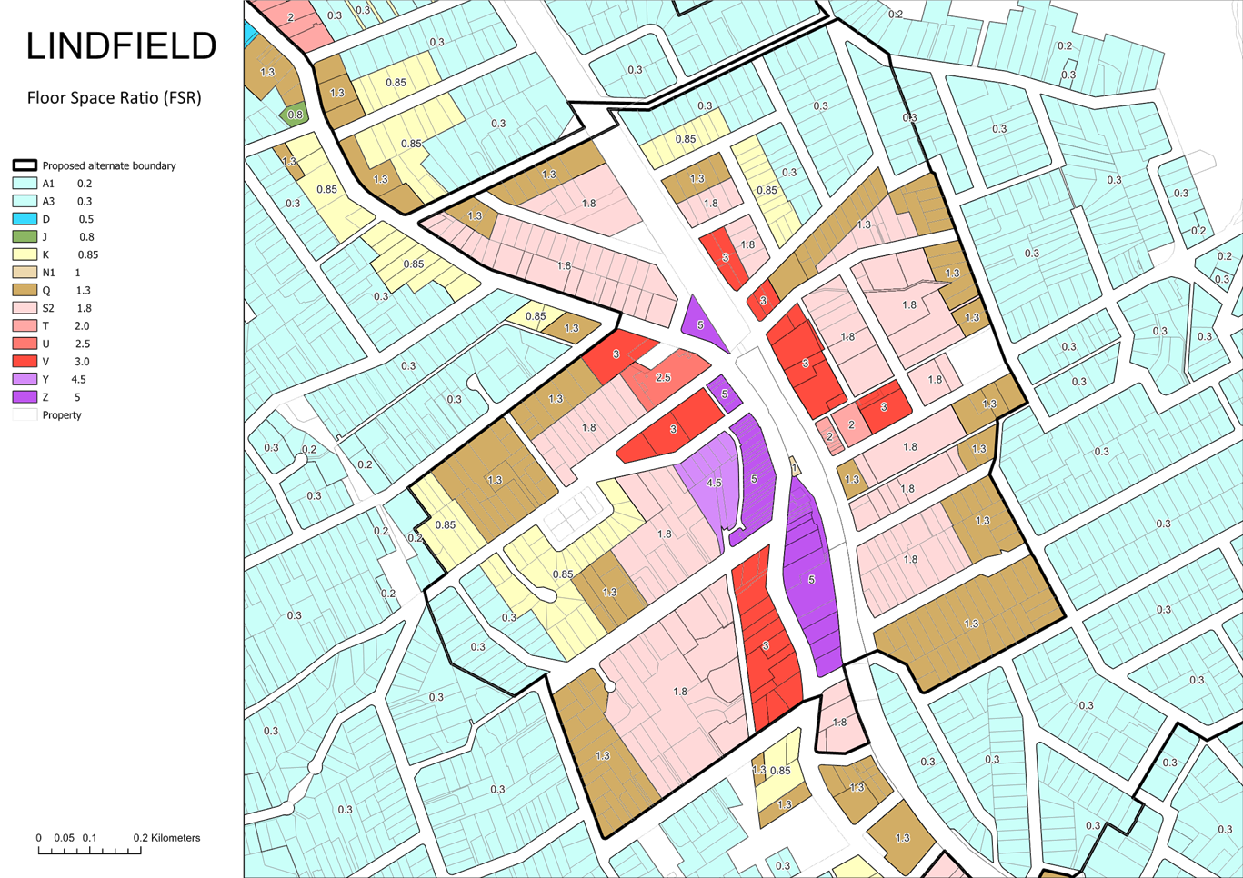
Lindfield
The recommended amendments to the Lindfield maps are summarised in Figure 7-9 below. Refer Attachments A4 and A5 for details.
The amendments result in a increase of 13 dwellings.
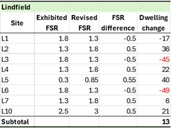
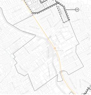
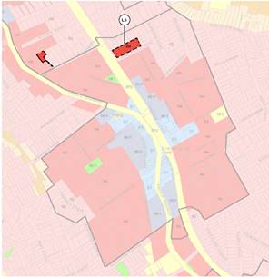
Figure 7 – Lindfield – Proposed TOD boundary and land use zone amendments
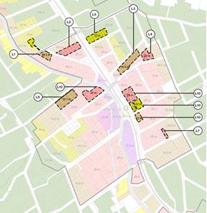
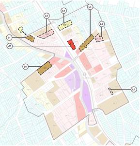
Figure 8 – Lindfield – Proposed height of building and floor space ratio amendments
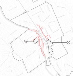
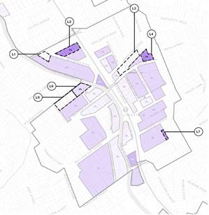
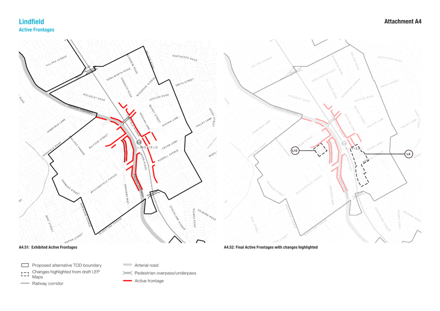
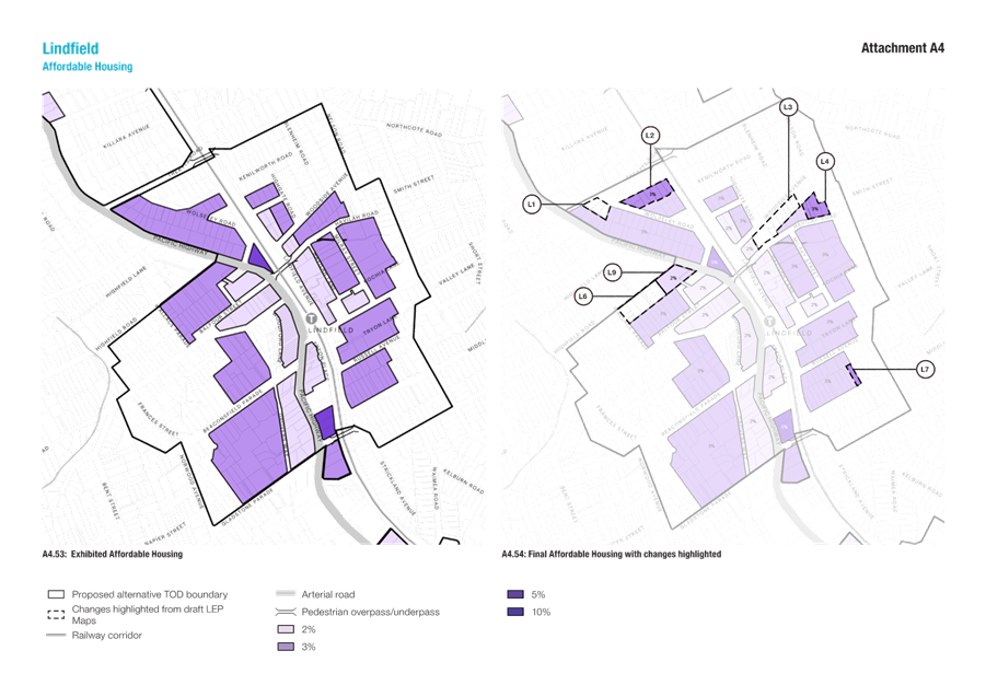
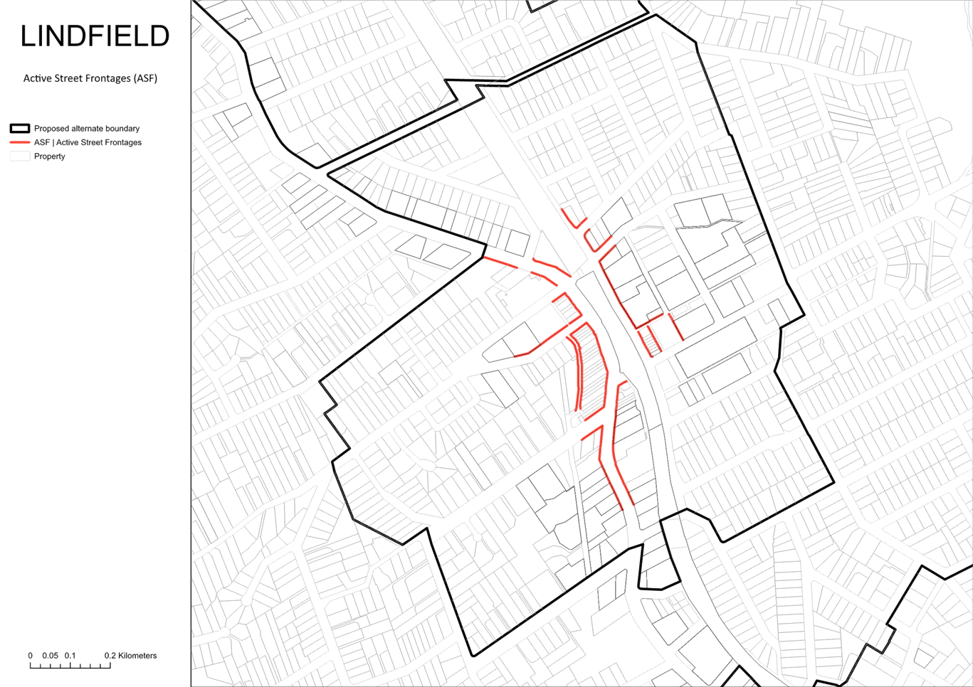
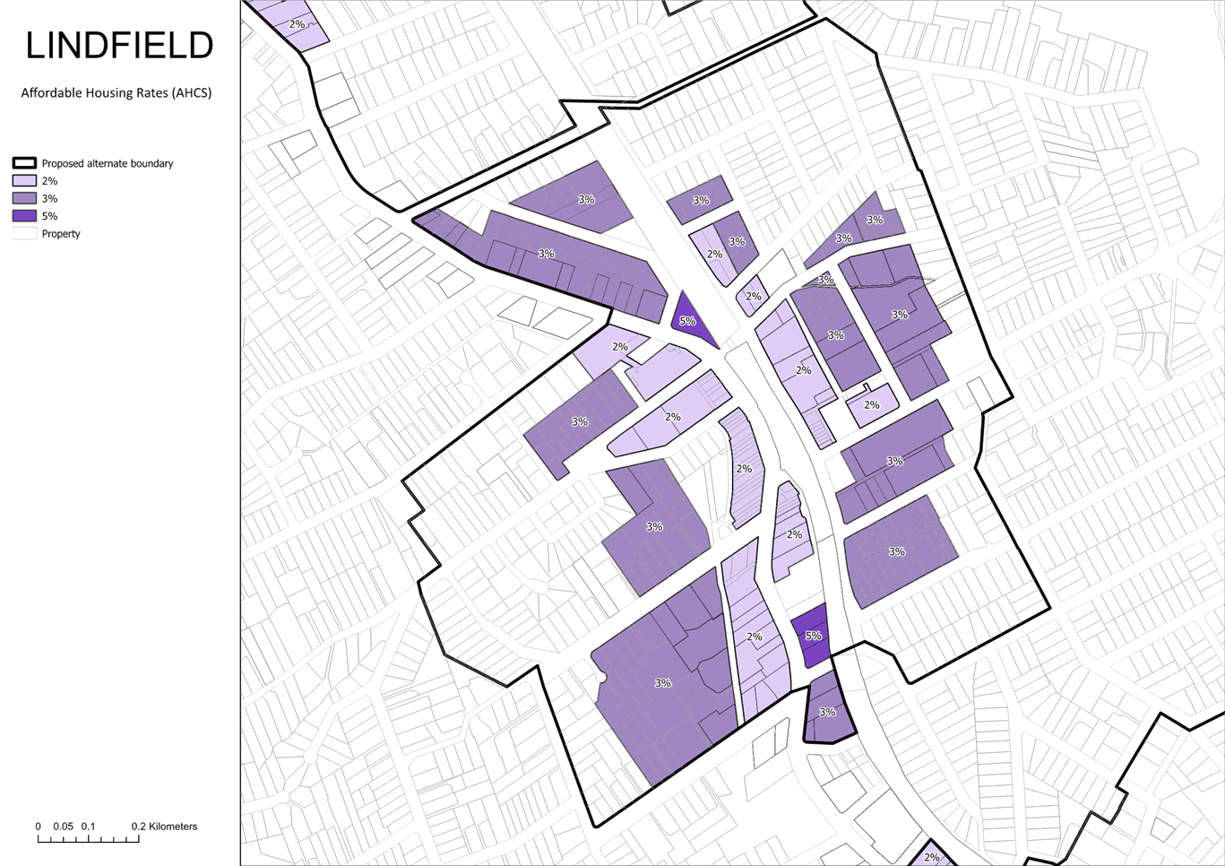
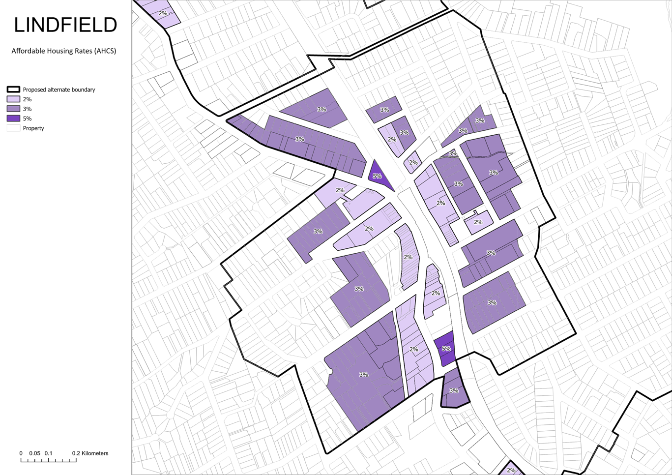
Figure 9 – Lindfield – Proposed active frontage and affordable housing amendments
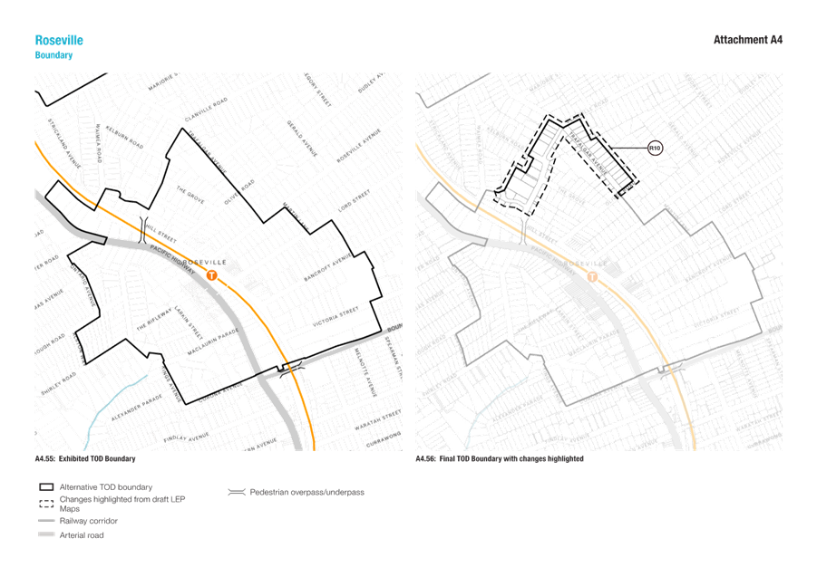
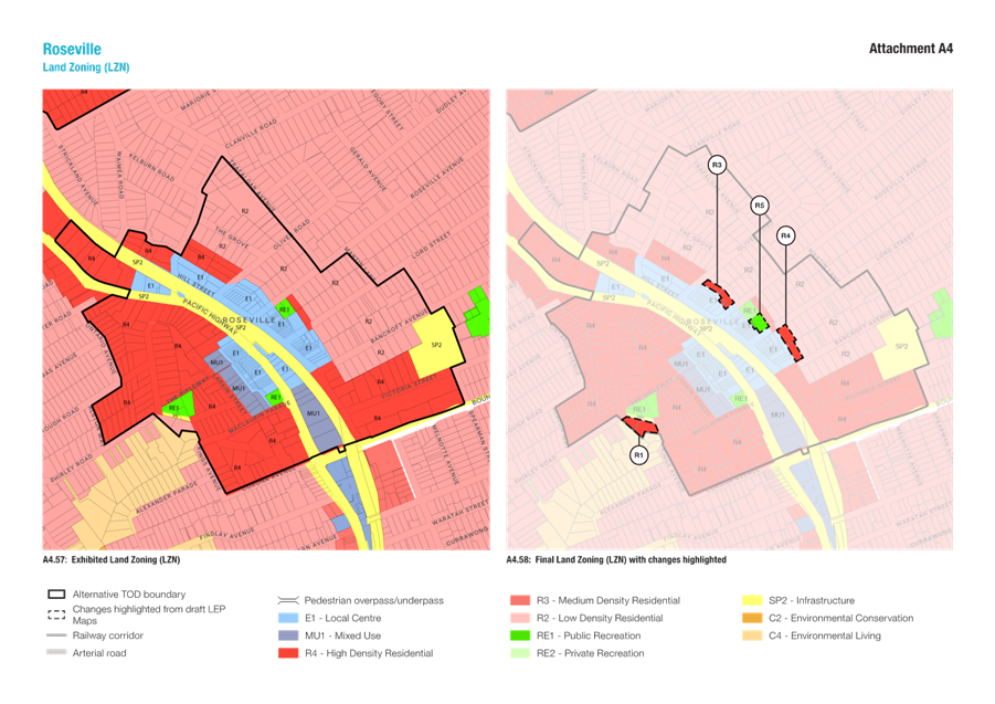
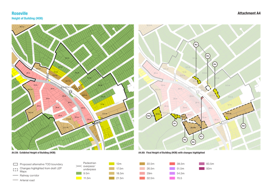
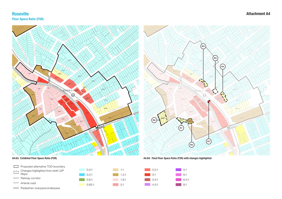
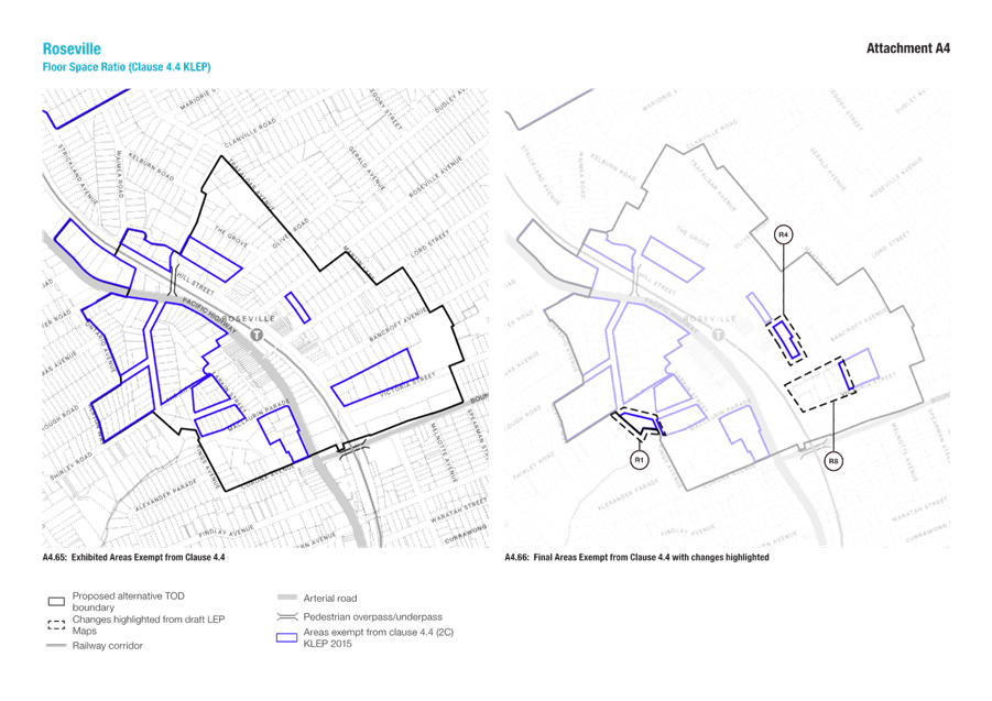
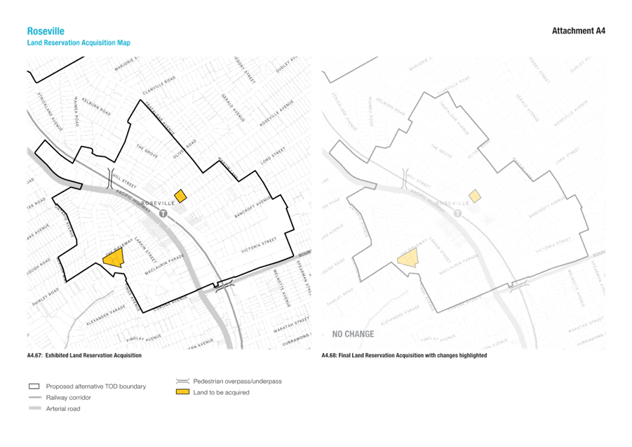
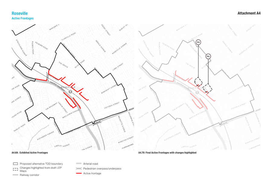
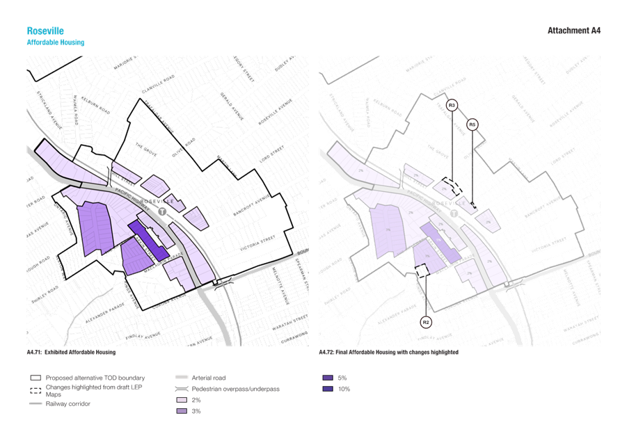
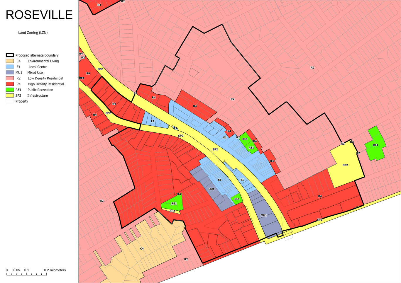
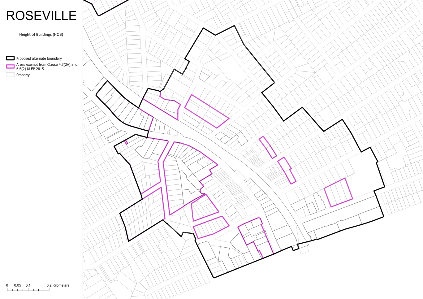
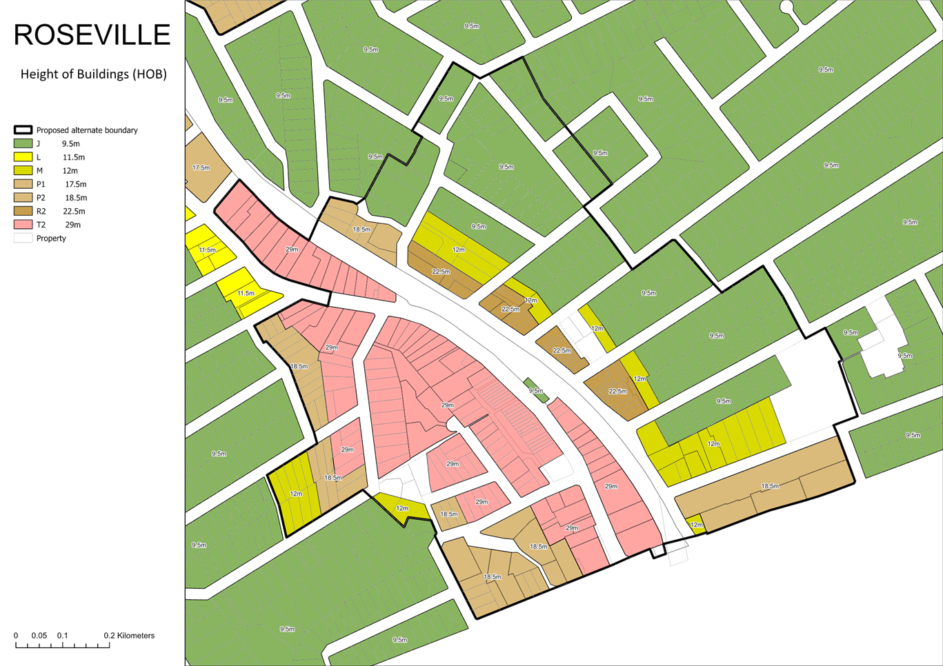
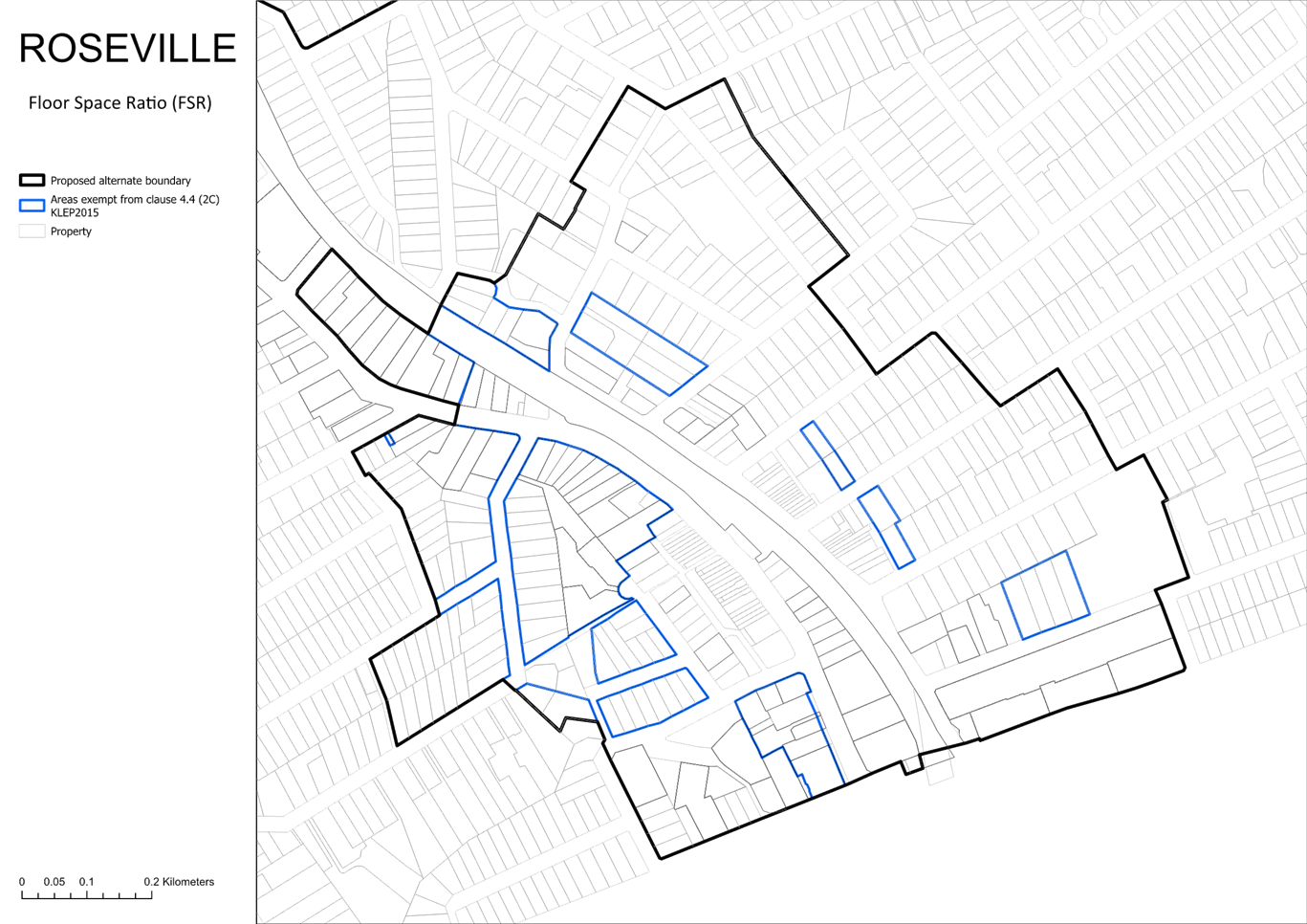
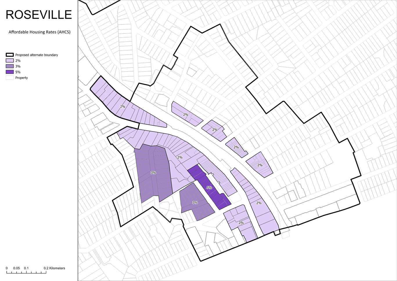
Roseville
The recommended amendments to the Lindfield maps are summarised in Figures 10-12 below. Refer Attachments A4 and A5 for details.
The amendments result in a reduction of 111 dwellings.
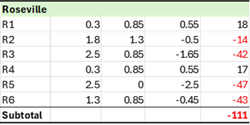
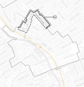
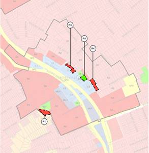
Figure 10 – Roseville – Proposed TOD boundary and land use zone amendments
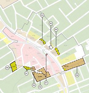
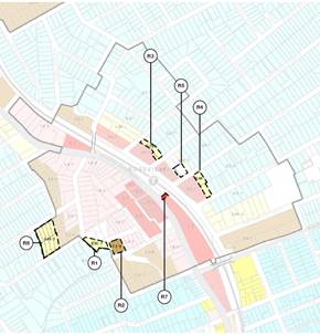
Figure 11 – Roseville – Proposed height of building and floor space ratio amendments
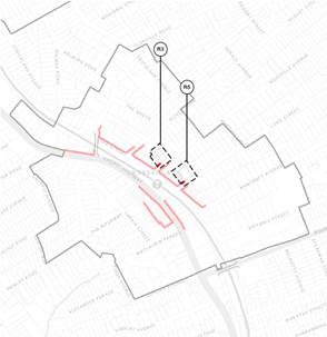
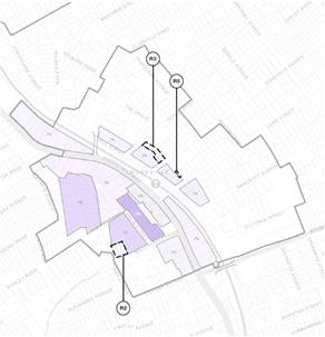
Figure 12 – Roseville – Proposed active frontage and affordable housing amendments
Proposed amendments to LEP Clauses
The Preferred Scenario will be implemented through amendments to the Ku-ring-gai Local Environmental Plan 2015 (KLEP) and Ku-ring-gai Development Control Plan (KDCP) as well as amendments to State Environmental Planning Policy (Housing) 2021. The exhibition documents for Council’s Preferred Scenario included an Implementation Strategy that identified the key changes to Council’s planning controls including proposed changes specific clauses within the KLEP.
A review of submissions and feedback from the exhibition period identified LEP drafting amendments required to more effectively implement the final alternate scenario. Also, further drafting has been undertaken for the new additional local provisions that are proposed to be included within the KLEP. A copy of the new provisions and an explanation of their intent is included as Attachment A7. These provisions have been drafted with the assistance of SJB Planning and Council’s legal team.
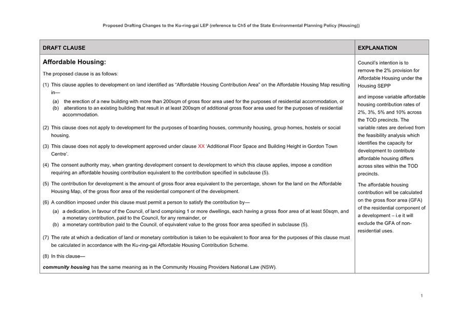
Affordable housing
The TOD program requires the provision of 2% affordable housing for development within the TOD boundaries. Council’s intention is to remove the 2% provision for Affordable Housing under the Housing SEPP and impose variable affordable housing contribution rates of 2%, 3%, 5% and 10% across the TOD precincts. The variable rates are derived from the feasibility analysis by Atlas Economics which identifies that the capacity for development to contribute affordable housing differs across sites within the TOD precincts.
The affordable housing contribution will be calculated on the gross floor area (GFA) of the residential component of a development – i.e. it will exclude the GFA of non-residential uses.
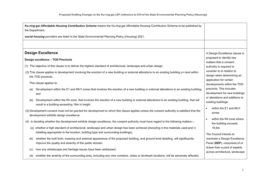
Design Excellence
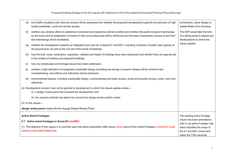
A Design Excellence clause is proposed to be included in the KLEP requiring that development within the TOD precincts exhibit design excellence. The proposed clause identifies key matters that a consent authority is required to consider in relation to design when determining an application for certain developments. This includes development for new buildings or alterations and additions to existing buildings within the E1 and MU1 zones and within the R4 zone where the building exceeds 18.5m.
The clause will require Council to establish a Design Excellence Panel (DEP), comprised of or drawn from a pool of experts across architecture, landscape architecture, urban design or related fields of its choosing. The DEP would take the form of a sitting panel to assess any developments to which this clause applies.
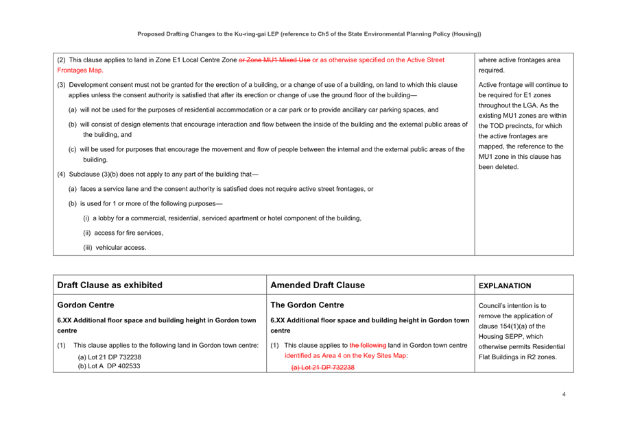
Active Frontages
The KLEP currently contains an active street frontages clause (6.7 Active Street Frontages in Zones E1 and MU1). It is proposed that this existing active frontage clause be amended to refer to an active frontage map which identifies the areas of the E1 and MU1 zoned land within the TOD precincts where active frontages are required.
Active frontage will continue to be required for E1 zones throughout the LGA. As the existing MU1 zones are within the TOD precincts, for which the active frontages are mapped, the reference to the MU1 zone in this clause is proposed to be deleted.
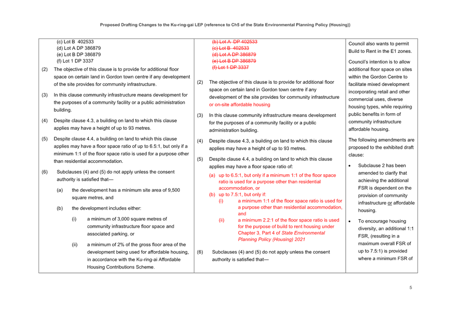
The Gordon Centre
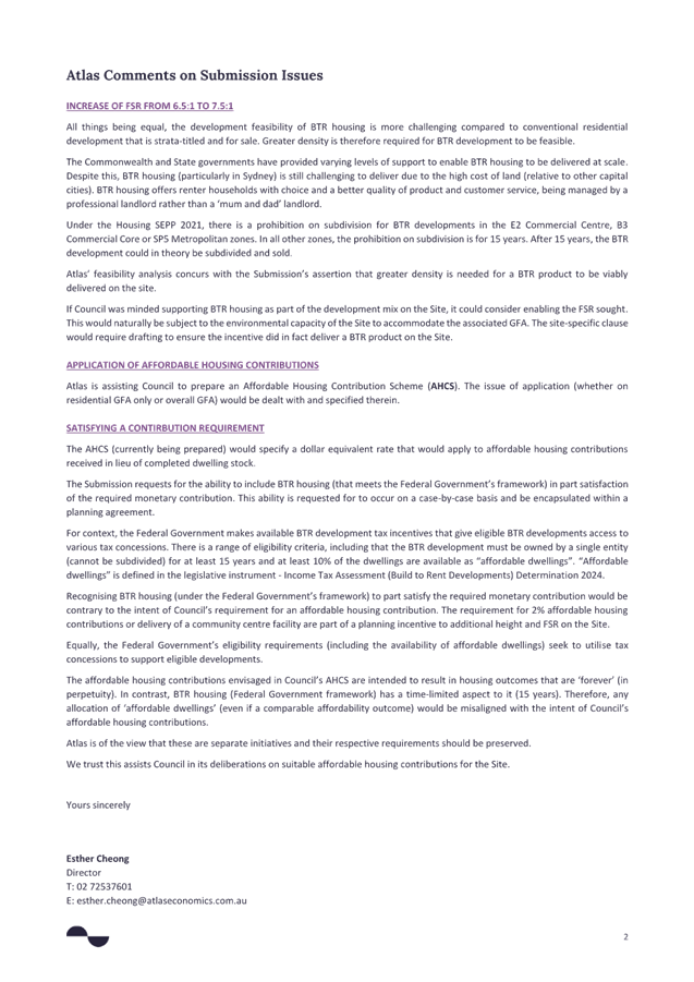
The Preferred Scenario included a site-specific clause for the Gordon Centre that would enable a mixed-use development of FSR 6.5:1 and 93 metres (28 storeys) with a non-residential floorspace requirement of FSR 1:1. This would be on the condition that any development included a minimum of 3,000 square metres of community infrastructure floor space or 2% affordable housing.
A submission was made by the landowner raising a number of concerns with the clause. A review of the submission was undertaken by SJB Urban and Atlas Economics and the findings are included in Attachment A3.
The intention of the site-specific clause for the Gordon Centre is to allow additional floor space on site to facilitate mixed development incorporating retail and other commercial uses, diverse housing types (including Build to Rent), while requiring public benefits in the form of community infrastructure or affordable housing. Following consideration of the issues raised in the landowner’s submission and further analysis undertaken by SJB Urban and Atlas Economics, the following amendments are proposed to the exhibited draft clause:
· Subclause 2 has been amended to clarify that achieving the additional FSR is dependent on the provision of community infrastructure or affordable housing.
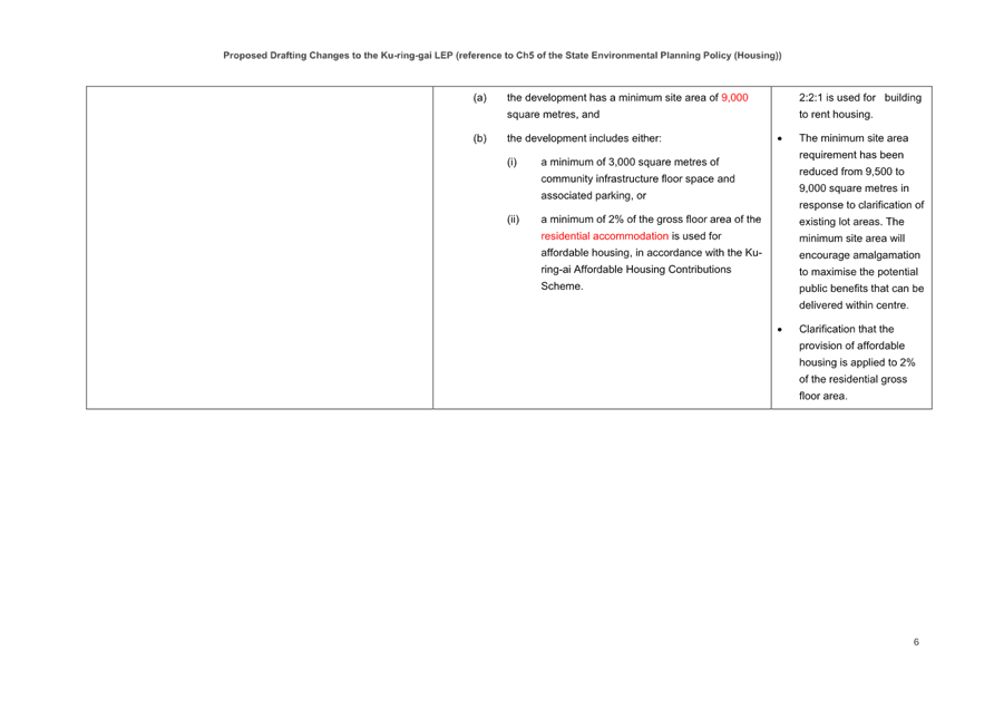
· To encourage housing diversity, an additional 1:1 FSR, (resulting in a maximum overall FSR of up to 7.5:1) is provided where a minimum FSR of 2:2:1 is used for build-to-rent housing.
· The minimum site area requirement has been reduced from 9,500 to 9,000 square metres in response to clarification of existing lot areas. The minimum site area will encourage amalgamation to maximise the potential public benefits that can be delivered within centre.
· Clarification that the provision of affordable housing is applied to 2% of the residential gross floor area.
The amended clause is included at Attachment A7.
Minimum frontages for employment land and mixed-use zones
The current Clause 6.8 of the KLEP requires a minimum frontage of 20m for certain employment lands within the centres. The exhibited preferred scenario and implementation plan proposed to amend Clause 6.8 to exclude its application from the E1 and MU1 zones within the centres in the TOD precincts. The reason for this was to provide for a more nuanced, centre by-centre approach to minimum street frontages within the E1 and MU1 zone via updated precinct and site provisions for the centres within Part 14 of KDCP.
However, upon further review it is considered that the current Clause 6.8 of the KLEP should continue to apply within the TOD precinct in its current form. Therefore, this proposed amendment will no longer proceed.
Amendments to State Environmental Planning Policy (Housing) 2021
The implementation of Preferred Scenario will require amendments to the Ku-ring-gai Local Environmental Plan 2015 (KLEP) as well as amendments to State Environmental Planning Policy (Housing) 2021. It is intended that the KLEP and SEPP Housing amendments will be made by the Minister for Planning via a self-repealing SEPP.
It is intended that Council’s four alternate TOD precincts remain as ‘TOD Areas’ under Chapter 5 of SEPP Housing SEPP. However, the applicable development standards, affordable housing provisions and other relevant provisions will be those contained in the KLEP rather than Chapter 5 of SEPP Housing SEPP.
The significance of the precincts remaining as ‘TOD Areas’ is that the low and mid-rise (LMR) provisions of Chapter 6 of SEPP Housing will not apply to these areas. Removal from Chapter 5 completely would mean that LMR provisions would override the new KLEP provisions, completely undermining the significant planning work undertaken by Council in developing the alternate TOD scenario. This would include permitting medium density housing typologies in the protected low density heritage conservation areas and allowing residential flat buildings with significantly higher heights and densities within the expanded R4 zones with no transition considerations.
To ensure Council’s TOD alternative is implemented in a way that ensures Council’s intended outcomes, Council staff will need to work closely with DPHI and Parliamentary Counsel on the drafting of the written instrument for a self-repealing SEPP. To this end, SJB Planning and Council’s lawyers are preparing a draft written instrument that would detail the amendments required to the KLEP and SEPP Housing to implement Council’s proposed scheme. This will be submitted to DPHI, along with the maps, to help ensure the final amending SEPP achieves Council’s desired outcomes.
Development Control Plan (DCP)
In addition to the changes to the LEP, amendments will also need to be made to the Ku-ring-gai Development Control Plan (KDCP). These will provide further details about new development design, including provisions for building setbacks, landscaping, parking, and the relationship of new buildings to their surrounding context. The aim is to ensure development not only meets housing and employment targets but also contributes positively to the character and quality of life in our centres.
Section A of the KDCP provides detailed controls that guide site and building design, such as building setbacks, site coverage and deep soil requirements, and car parking provision, for a range of building typologies. These provisions require review to ensure consistency with the structure plans and the new building typologies that will result from the revised height and FSRs applying in the KLEP.
This will include, but not limited to, the following:
· Part 7 - Residential Flat Buildings;
· Part 8 – Mixed Use Development; and
· Part 9 - Non-Residential and Office Buildings.
Section B, Part 14 of KDCP contains provisions that apply to specific sites and precincts within Ku-ring-gai that supplements the general provisions applying to development types and uses in Section A.
The proposed final alternate scenario will require review and updating of the current precinct specific provisions applying to Gordon (Part 14D), Lindfield (Part 14E) and Roseville (Part 14F) centres. A new Part will need to be introduced for Killara as no such section for this centre in the DCP.
Each of the centres also include sub-precincts, with some more detailed and site-specific provisions. Following consideration of submissions, it is identified that there is a need for amendments to the DCP to address broader strategic issues. This includes consideration of mechanisms to encourage appropriate site amalgamation in mixed-use zones and around heritage items in R4 and MU1 zones. There is also a need for further consideration of suitable development controls that are supplemented by Character statements and site-specific controls.
A number of components within each precinct/site will need to be considered. These include:
· Urban Precincts and key sites such as the Gordon Centre and Lindfield Village Hub;
· Public Domain and Pedestrian Access
· Community Infrastructure;
· Building Setbacks;
· Built Form;
· Heritage including site-specific development controls around heritage items within R4 – High Density Residential zones and MU1 – Mixed Use zone; and
· Environmental Protection and Bushfire Protection where relevant.
The preparation of amended and new KDCP provisions for different typologies and the centres will be subject to a separate statutory planning process, that will include engagement with community and stakeholders. This process will be carried out parallel with DPHI reviewing Council’s final alternate scenario and undertaking the required drafting to implement the required amendments to the KLEP and SEPP Housing to implement Council’s plans.
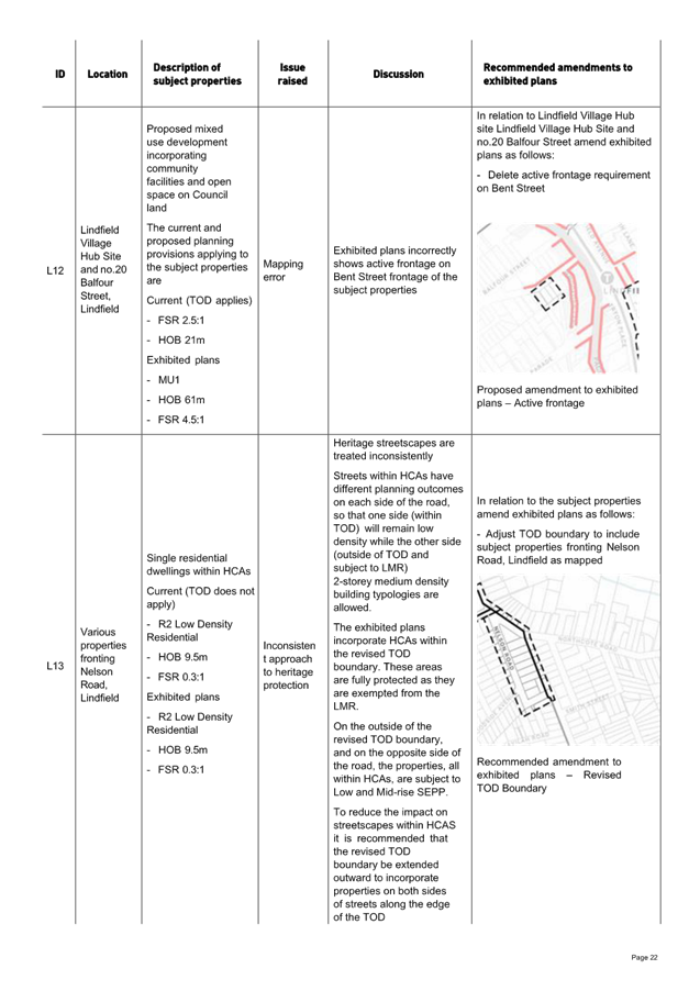
Heritage Conservation Areas (HCAs)
Council’s survey found that heritage conservation concerns was one of the higher rated concerns by residents, with 495 respondents (23% of the total) offering comments. In their report Taverner states:
“The largest proportion of these were related to a need to find better heritage preservation measures, the impact of removing heritage protection from local streetscapes, and perceptions of unfair zoning decisions impacting some heritage properties. These comments/concerns were widely spread across the LGA and were relatively consistent regardless of train station proximity”.
Taverner provide samples of comments:
“Council’s proposal is discriminatory and treats my neighbours and I unfairly and inequitably. There is no basis for Council’s proposal that the low to medium rise (LMR) provisions should not apply to TOD areas within an HCA.”
“Residents in a TOD area in an HCA should be treated the same as their non-TOD neighbours within that HCA.”
“Development will be allowed on one side of the street only which will give a very lopsided result.”
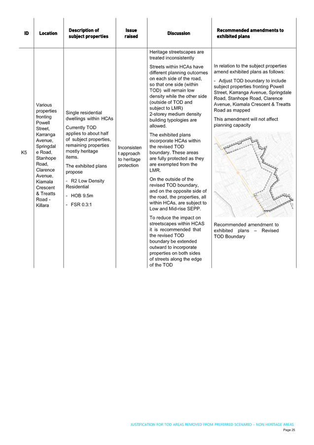
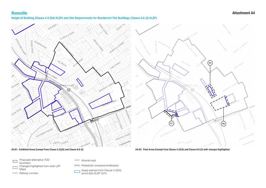
The development of the Preferred Scenario involved defining an alternative TOD boundary around each of the centres utilising roads or HCA boundaries and including whole HCAs where possible. The boundary of the Preferred Scenario has been expanded in some locations and contracted in others compared to the NSW government TOD. This approach is consistent with Principle 5 – Manage Transition Impacts and will avoid changes to planning controls that are ‘mid-block’ or along property boundaries.
The exhibited alternative TOD boundary protects 117 properties within HCAs by excluding them from the Low to Mid Rise (LMR) zone and its associated controls. At the same time, it adds 134 properties to the LMR zone—these were previously within the original TOD boundary and not subject to LMR controls. This results in a net increase of 17 properties within the LMR zone. Overall, the exhibited TOD boundary is estimated to create capacity for an additional 325 dwellings above what was originally expected under the LMR zoning.
The exhibited plans incorporate six HCAs within the revised TOD boundary. These areas are fully protected as they are exempted from the LMR. However, on the outside of the revised TOD boundary, and on the opposite side of the road, the properties, all within the same HCAs, are subject to Low and Mid-rise SEPP.
The interaction between the Low and Mid-rise SEPP and Council’s alternative TOD boundary has resulted in heritage streetscapes being treated inconsistently. Streets within HCAs will have different planning outcomes on each side of the road, so that one side (within TOD) will remain low density while the other side (outside of TOD) is subject to LMR allowing 2-storey medium density building typologies. From a heritage point of view consistency of streetscape is an important quality to protect.
Following the exhibition of the Preferred Scenario, further refinements to the Alternative TOD boundary are proposed in response to submissions and to provide better protection for HCAs.
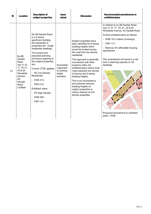
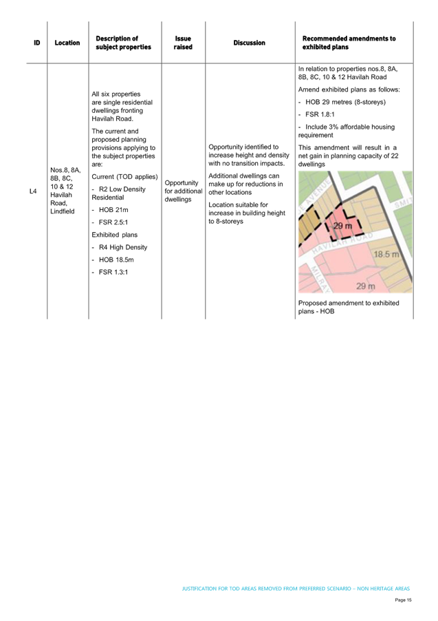
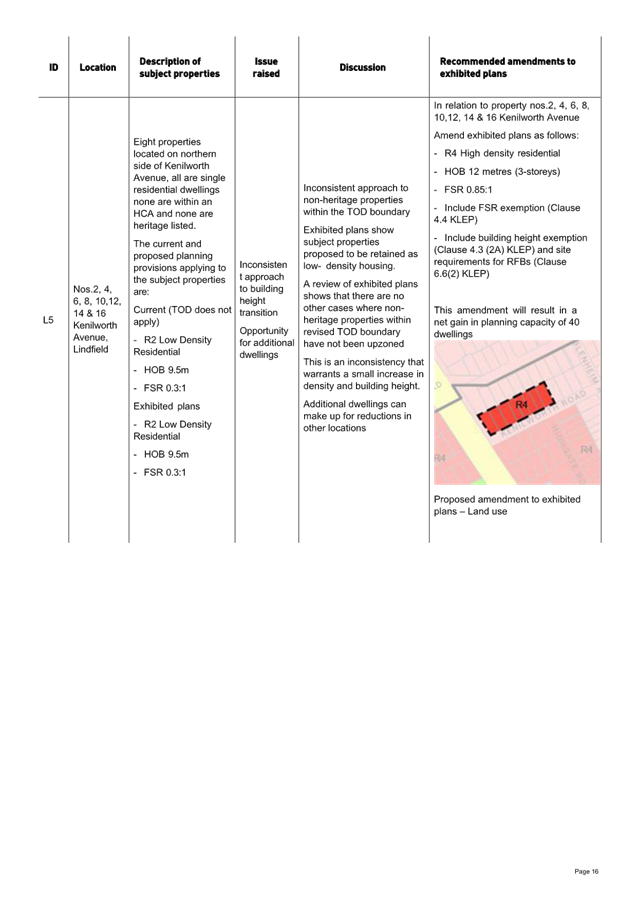
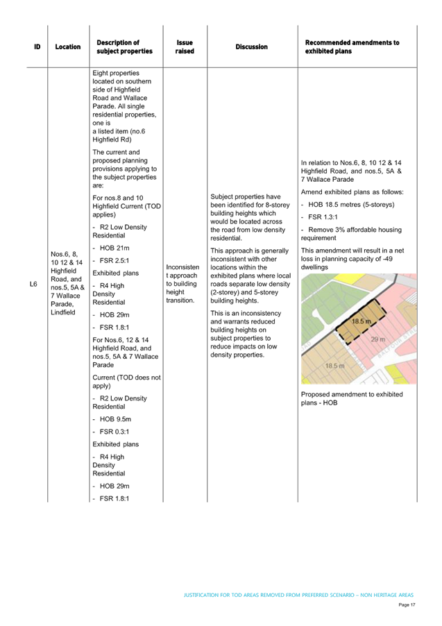
To reduce the impact on streetscapes within HCAs the Alternative TOD boundary has been extended outward to incorporate properties on both sides of streets along the edge of the TOD. This includes along Powell Street, Karranga Avenue, Springdale Road, Stanhope Road, Treatts Road, Nelson Road, Clanville Road and Trafalgar Avenue. These areas have been analysed in detail in Attachment A4.
The amended TOD boundary (shown in Attachment 4 and Attachment 5) protects 250 properties within HCAs by excluding them from the Low to Mid Rise (LMR) zone and its associated controls. At the same time, it adds 128 properties to the LMR zone—these were previously within the original TOD boundary and not subject to LMR controls. This results in a net decrease of 122 properties within the LMR zone. We estimate that this change would reduce LMR capacity by approximately 170 dwellings compared to what was originally expected under the previous LMR zoning.
However, this reduction is minimal in the broader context. The Amended Preferred Scenario is expected to deliver approximately 24,460 dwellings—exceeding the State Government’s target of 22,580 by around 1,880 dwellings. A reduction of 170 dwellings within the LMR zone is therefore not considered significant. It is also important to note that the intent of the Low to Mid Rise Housing Policy is to provide a greater diversity of housing - bridging the gap between freestanding houses and high-rise apartments. The Amended Preferred Scenario responds to this by introducing a new R4 zone within the TOD boundary, with a height of building (HOB) limit of 12 metres and a floor space ratio (FSR) of 0.85:1. This zone is expected to deliver outcomes similar to those intended under the LMR policy.
The exhibited plans, subject to approval from DPHI, would have no requirement for compensatory zoning of additional lands as a result of the boundary change.
Heritage Items
The Preferred Scenario makes significant improvements when compared to the TOD. The Preferred Scenario will fully protect 120 heritage items, meaning they will be located within low-density residential zones, preserving their existing setting; 54 heritage items have been situated within high-density areas.
Despite a 69% improvement over the TOD, the survey results show that the impacts on homes that are listed heritage items remains a concern for residents. Impacts on heritage items are exacerbated by State Significant Development Applications (SSDAs) many of which directly adjoin heritage items. This is an outcome Council has specifically sought to avoid in the Preferred Scenario by allocating the same development rights to heritage items as adjacent properties which in turn provides further protection by triggering the ‘site isolation’ control in Part 3 of the Ku-ring-gai DCP.
It is recommended that Council commission an independent preliminary review of all heritage items proposed to be retained in the TOD or alternative scenario areas envisaged to have controls varied from those under KLEP 2015, or items that are impacted directly by development applications including for SSDs that rely on controls contained in the TOD SEPP. The purpose of this review is to seek to identify any items that may warrant a more detailed assessment to determine if they continue to meet the criteria for local significance, taking into account NSW heritage standards, guidelines, legislation and case law. It is noted that the context of many heritage items may be likely to change significantly under the TOD SEPP or Council’s alternate plan, and this will be considered in the review.
Planning Capacity
Latest capacity modelling for the Amended Preferred Scenario (post-exhibition) shows that the four centres can accommodate about 24,500 new dwellings. This broadly matches the yield from the Exhibited Preferred Scenario and remains well above the State’s target of 22,580 total capacity. Growth is distributed hierarchically - approximately 9,000 dwellings in Gordon, 9,400 in Lindfield, 2,800 in Killara and 3,300 in Roseville – so that the highest densities are concentrated near town centres services while sensitive edges remain lower rise and impact is reduced on heritage and tree canopy streetscapes.
Furthermore, State Significant Development Applications (SSDAs) at SEARS stage or already lodged within the TOD areas across the four centres, have the capacity to contribute a further ~1,570 dwellings, in addition to Council’s Amended Preferred Scenario. If all bonus height and FSR provisions are fully taken up, the theoretical yield would rise to about 2,770 additional dwellings. This built-in “head room” provides a strategic buffer that allows Council to refine zoning, adjust built form controls or respond to site-specific heritage considerations without jeopardising overall supply.
That flexibility is critical in proposing further boundary adjustments aimed at minimising impacts on Heritage Conservation Areas. Analysis of the HCAs and Low and Mid-Rise interfaces highlight several precincts where upzoning would border small or fragmented conservation areas, creating inverted densities and undermining the intent of HCA protection. Council therefore proposes to further refine the TOD boundary to include the Low and Mid-rise parcels already located within HCAs, adding only minor extensions where a coherent streetscape is essential. It can be demonstrated that surplus capacity from the Amended Preferred Scenario and lodged SSDAs would absorb this change, ensuring the planning capacity stays well above the State target and delivering a supply-neutral, heritage-conscious outcome that aligns with Council Planning Principles and broader housing objectives.
State Significant Development Applications
SSDA Dwelling yields
At the time of writing this report, within the existing TOD areas there have been 19 State Significant Development Applications (SSDAs) under the In-fill affordable housing provisions of SEPP Housing that have had Secretary Environmental Assessment Requirements (SEARS) issued, of these applications, 8 are at exhibition stage.
At this stage, no SSDAs within TOD areas have been approved. There is also no guarantee that any SSDA will be approved in the form it is lodged or approved at all. Therefore, it is difficult to determine actual final additional dwellings these applications yield over and above the potential dwelling yield of the alternate TOD scenario. As result, the potential dwelling yields for the sites subject to SSDAs have been calculated based on the underlying TOD controls i.e. FSR of 2.5:1 (without the bonus) and assumed apartment sizes of 90sqm. This net additional yield from each of the existing SSDA sites are provided in the Table below,
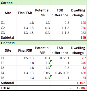
Based on these assumptions, the current SSDA sites are likely to add 1,569 dwellings (without the 30% bonus) over and above the dwelling capacity of Council’s alternate TOD Scenario. Of these 1,569 dwellings, 580 dwellings are from the sites where the SSDs are lodged and on exhibition. To offset this potential additional dwelling yield, Council may wish to consider reducing development capacity within other locations of the Alternate TOD precincts.
Table – Net Additional Yield from State Significant Development Applications
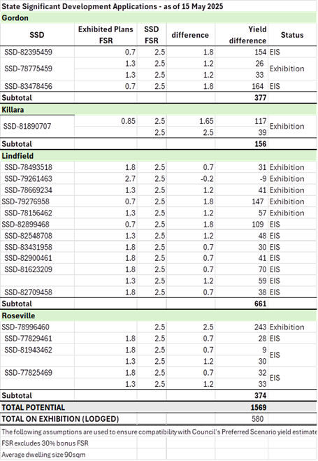
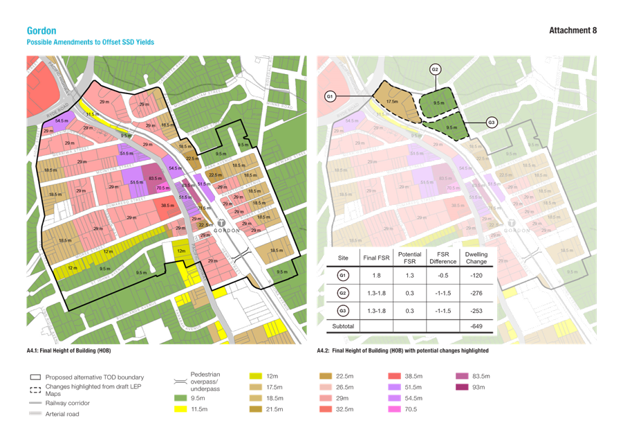
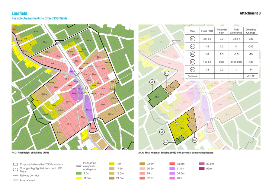
Potential options to offset the additional yield from SSDs have been identified. Attachment A8 outlines the sites and the proposed building heights used to estimate potential yield reductions. Three such sites are located in Gordon, north-east of the railway line near Carlotta and Pearson Avenue. In Lindfield, five sites have been identified - two between Highfield Road and Bent Street, and three between Beaconsfield Parade and Gladstone Parade.
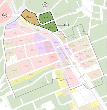
Figure 13: Potential HOB amendments in Gordon
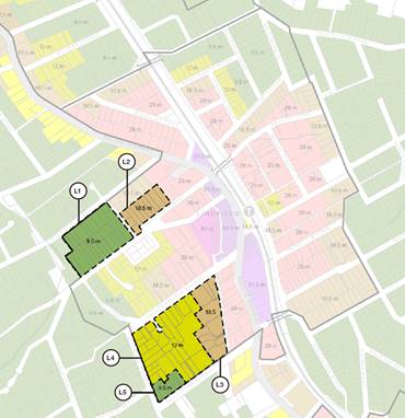
Figure 14: Potential HOB amendments in Lindfield
If all the identified sites were reduced as proposed, the total residential yield across the four centres could decrease by approximately 1,800 dwellings, as shown in the Table below. These options are presented for Council’s consideration, with flexibility to reduce the capacity of all, some, or none of the identified sites.
Table - Potential yield reductions that could be applied to the Amended Preferred Scenario
Savings provisions for SSDAs
Council has ongoing concerns that some proposals currently working through the SSD system might be prejudicial to any alternate scenario it might adopt. This is particularly the case where transition between different densities and housing typologies that Council might seek to apply are juxtaposed against out of scale development reflected in some current SSDAs. Also, Council’s alternate TOD Scenario includes development uplift for individual heritage items where they would otherwise be “isolated” by adjoining TOD development. This would allow their integration into a larger master planned site and not leave them stranded.
It has been Council’s stated preference that these current SSDAs not be “saved”, and further, that a moratorium on further such applications being lodged either with the Department or Council be put in place.
At the EMC of 31 March 2025, Council resolved the following in relation to the saving of SSDAs:
D. Make a request to DPHI that no State Significant Applications in the TOD precincts be saved due to the significant inconsistencies with Council’s TOD Preferred Scenario.
The Director Strategy & Environment wrote to DPHI Deputy Secretary on 3 April with Council’s request. On 15 April 2025 DPHI advised via email the following:
In response to Item D (‘Make a request to DPHI that no State Significant Applications in the TOD precincts be saved due to the significant inconsistencies with Council’s TOD Preferred Scenario’) of the resolution and in line with my earlier correspondence with Mr David Marshall on 28 March 2025, I confirm the following:
· The TOD SEPP planning controls currently apply to TOD precincts within the Ku-ring-gai LGA. Applications can be lodged now for proposed development within the TOD precincts.
· Once council submits an alternative scheme to the Department, Government will look to prevent the lodgement of further development applications until such time as an alternative scheme is finalised.
· This is to reduce the risk of proposed development undermining the alternative scheme.
· Government intends that all development applications (including State Significant development applications) that are lodged but not determined prior to the submission of an alternative scheme, will be assessed and determined in accordance with the controls that applied when the application was lodged.
· Secretary’s Environmental Assessment Requirements that have been issued but not responded to prior to the submission of an alternative scheme will not be saved.
This advice identifies the point at which Council submits its alternative scheme to the Department will be the point at which SSDAs and development applications that are lodged but not determined will be saved. This would involve the SSDAs that have proceeded to the public exhibition phase. Applications which have SEARs issued but where an EIS had not been finalised and lodged would not be saved. The Department have also indicated that they will prevent the lodgement of further development applications until such time as an alternative scheme is finalised.
Council has sought advice from the Department on the statutory mechanisms that will be used to save existing applications and prevent the lodgement of any further applications. At the time of writing this report no such advice had been provided by the Department. This issue remains of considerable concern to Council and the community.
Traffic and transport planning
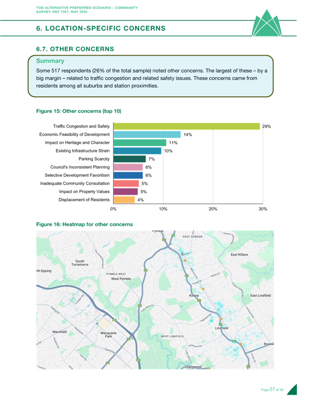
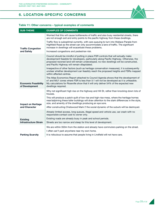
Taverner find that some 517 respondents (26% of the total sample) noted other concerns.
The largest of these issues, by a significant margin, related to traffic congestion and related safety issues. These concerns came from residents among all suburbs and station proximities, and included comments along the following themes:
· Increased traffic flows/congestion, and impacts to pedestrian safety;
· additional demand for on-street parking from new dwellings, and impacts to vehicular access/circulation on local streets and on-street parking availability for existing residents; and
· limited access to/from Pacific Highway.
Transport Impact Assessment Studies have been or are currently being undertaken in each of the four TOD areas of Roseville, Lindfield, Killara and Gordon. Works arising from new studies will be costed and recommended for inclusion in the draft review of the contributions plan. Works in the Ku-ring-gai Contributions Plan 2010 (in response to developments in local centres) have already been included in the Long-Term Financial Plan, along with indicative timings. These works are typically development or Council project driven, and their delivery will ultimately depend on the timing of developments or Council-initiated projects occurring in the centres.
Roseville TOD Precinct
Transport consultants have assessed the existing transport situation and the transport impacts of the NSW Government's TOD SEPP. Key transport-related works already identified in the Development Contributions Plan 2010 that have been re-assessed include road widening on Pacific Highway to accommodate 3 northbound lanes and fully controlled right turns into Maclaurin Parade. A Transport Response is being developed, to mitigate the impacts of new development and to create a centre with improved walkability/bicycle access to the shops and station.
Any new transport infrastructure identified in the TIA will inform the review of the Contributions Plan, including:
· Improved local access on the western side of Roseville with a new street between Pockley Avenue and Shirley Road;
· new and upgraded walking and cycling infrastructure and reduced speed limits to encourage active transport to the station and shops; and
· dedicated car share vehicles within and near development sites to reduce car ownership and dependence, and bicycle parking at key locations.
This new infrastructure will also be tested as part of the assessment of Council’s preferred alternative housing scenario. Other improvement opportunities being considered in the assessment of the TOD SEPP and Council's preferred alternative scenario (if adopted by Council) include upgrades identified in the Roseville Public Domain Plan.
Lindfield TOD Precinct
During the development of the Lindfield Village Hub Planning Proposal, a Transport Impact Assessment (TIA) was prepared which incorporated study area extents not dissimilar to the Lindfield TOD precinct. The TIA also included a 10-year growth scenario that factored in background growth, and road/intersection upgrades were recommended based on this growth scenario. Transport for NSW gave in-principal approval to the road upgrades, and these form the basis of planned works in the Lindfield TOD Precinct, as well as active transport improvements identified as part of the Lindfield Public Domain Plan. The provision of dedicated car share vehicles within and near development sites will incentivise reduced private car ownership.
Of the road upgrades approved by Transport for NSW, detailed design is currently underway for new traffic signals at the intersection of Pacific Highway and Strickland Avenue, which has reached the 50% design stage. Detailed design has also commenced for modifications to the intersection of Pacific Highway and Balfour Street/Havilah Road, which is approaching 50% design completion. New traffic signals at the intersection of Lindfield Avenue and Tryon Road (which form part of the Lindfield Avenue and Tryon Road Streetscape Upgrade project) are at the 90% design stage. It is estimated that construction of stage one of the Streetscape Upgrade will begin in early 2026 subject to environmental/service approvals and a successful outcome of Council’s tender processes.
Development of the Lindfield Village Hub would trigger a separate series of public domain, pedestrian facilities and road upgrades, including:
· New traffic signals at the intersection of Pacific Highway and Beaconsfield Parade;
· the creation of the new Drovers Way between Beaconsfield Parade and Bent Street, and
· modifications to Woodford Lane.
Killara TOD Precinct
With similar scope to the Roseville TOD Precinct, the Killara TOD Precinct Transport Impact Assessment (TIA) is being developed. Killara is not an identified centre in the Ku-ring-gai Contributions Plan 2010, but active transport improvements to facilitate station access along with other road infrastructure improvements will be considered as part of the testing and recommendations, which will be used as inputs to the contributions plan review. Assessment of the NSW Government's TOD SEPP has commenced, with analysis of Council's preferred alternative scenario commencing shortly.
Transport improvements being considered include new and upgraded walking and cycling infrastructure and reduced speed limits to encourage active transport to the station and shops, dedicated car share vehicles within and near development sites to reduce car ownership and dependence, and bicycle parking at key locations. Investigations are also underway for improvements to the intersection of Pacific Highway and Stanhope Road/Fiddens Wharf Road.
Gordon TOD Precinct
Building upon transport analysis undertaken for Gordon Town Centre in 2022/23, consultants used this work as a basis to prepare the Gordon TOD Precinct TIA. Staff have already been in discussions with Transport for NSW regarding proposed road upgrades in the Ku-ring-gai Contributions Plan 2010 from the 22/23 analysis. These include:
· Modification of the intersection of Pacific Highway and Park Avenue/Dumaresq Street;
· modification to the intersection of Pacific Highway and St Johns Avenue;
· changes to traffic circulation in St Johns Avenue, Wade Lane and Park Avenue;
· new local street connecting St Johns Avenue and Moree Street; and
· new traffic signals at the intersection of Pacific Highway and Ravenswood Avenue
The TIA will help to progress and refine those proposals as well as advance planning for active transport and improvements identified in the Gordon Public Domain Plan. Planning for the provision of on-street car share vehicles and within new developments encourages residents to reduce private car ownership while at the same time providing access to additional vehicles for occasional car trips.
Assessment of the transport impacts of the NSW Government's TOD SEPP has commenced, with Council's preferred alternative to follow shortly. Any additional transport infrastructure over that already identified Ku-ring-gai Contributions Plan 2010 will be recommended for inclusion in the Contributions Plan review.
Transport upgrade works are typically development driven – for example, if the Gordon Centre were to redevelop, it would likely trigger several public domain and road upgrades, including the modification of the intersection of Pacific Highway and Park Avenue/Dumaresq Street.
Infrastructure funding
Ku-ring-gai Council’s current s7.11 Local Infrastructure Contributions Plan will need to be comprehensively reviewed to consider the infrastructure demands arising directly from unprecedented concentrated high-density redevelopment. It is essential that the revised plan be an IPART-reviewed contributions plan to enable contribution rates above the uninflated 2009 “cap” imposed on most s7.11 contributions by Ministerial Direction. This requirement is a direct result of the need for land acquisition for new road links and new parks relative to the considerable cost of land acquisition in Ku-ring-gai.
It is acknowledged that Ku-ring-gai has benefited from an exemption from this cap in the areas immediately surrounding the railway stations (and St Ives) where redevelopment was originally planned in 2010/2012, but these boundaries are outdated and bear little resemblance to the TOD areas. The current contributions plan was drafted based on pro-rata per capita contributions and can remain in place until it is replaced, however, higher-density development outside of the original centres’ areas will be subject to the cap of a maximum of $20,000 for each dwelling authorised by the consent.
The review process is already underway, as formerly endorsed at the 31 March EMC. A multi-disciplinary team has been established within Council to oversee this review and initial approaches to IPART to commence the process are being made. Further, IPART’s report into the revision of their own processes for assessing s7.11 contributions plans was issued in mid-April 2025.
A comprehensive gap analysis of supporting documentation is underway with reference to stormwater management. As indicated in other sections, comprehensive traffic and transport studies are also underway which will inform the works programme for each of the TOD precincts. Land for new parks is also being targeted based on council’s existing open space acquisition strategy targeting areas of intensive development that are poorly served by existing local open space.
Ku-ring-gai Council completed Public Domain strategies for most of the larger centres relatively recently (2022), except for Killara, which will also need a Public Domain strategy as a result of the targeted redevelopment around its railway station precinct to ensure funding for the delivery of comparable supporting infrastructure. Unfortunately, community facilities infrastructure is explicitly excluded from an IPART reviewed contributions plan as a result of the Essential Works List. Consequently, an integrated financial strategy for community facilities like library expansion, will need to be developed in parallel with this review.
integrated planning and reporting
Theme – Places, Spaces and Infrastructure
|
Community Strategic Plan Long Term Objective |
Delivery Program Term Achievement |
Operational Plan Task |
|
P2.1 A robust planning framework is in place to deliver quality design outcomes and maintain the identity and character of Ku-ring-gai. |
P2.1.1 Land use strategies, plans and processes are in place to effectively manage the impact of new development. |
P2.1.1.1 Commence development of plans and strategies as required by the Greater Sydney Commission’s North District Plan. |
Governance Matters
Council’s Integrated Planning and Reporting documents are based on a set of long-standing community values and aspirations which will fundamentally be undermined by implementation of the State Government’s Transport Oriented Development (TOD) Program and proposed Low and Mid-Rise Housing SEPP.
Risk Implication statement
There are a number of risks identified in Council’s Enterprise Risk Management System relevant to planning for the TODs, these being:
|
Risk # |
Risk Name |
How effective are the existing controls? |
Residual Risk rating |
Is the Residual Risk Outside the appetite? |
|
1210.1 |
Council planning does not meet future population and demographic needs resulting in sub-optimal housing and facilities - Urban and Heritage Planning Unit |
Satisfactory |
18 |
Outside |
|
1210.2 |
Changes to local planning controls through the transport Orientated Development and Low and Mid-rise SEPP changes resulting in State Government Policy intervention |
Weak |
18 |
Outside |
|
90.1 |
Removal of exemption from cap to s7.11 contributions resulting in insufficient revenue to provide infrastructure to support growing population - Urban & Heritage Planning Unit |
Satisfactory |
18 |
Outside |
Actions required to mitigate the impacts of these risks, all of which remain outside appetite include:
· Ongoing monitoring of State Government legislation and District Plan requirements;
· development of alternative scenarios to the TOD SEPP to obtain concurrence of State Government to implement alternative planning controls for growth around station precincts;
· prepare and update the s7.11 contributions plan concurrent with comprehensive strategic planning to provide for housing options, particularly arising from NSW State Government initiatives in the TOD areas; and
· prepare, report and submit commentary on NSW Government initiatives concerning Local Infrastructure Contributions as and when required to protect council’s interests.
These matters are all addressed in this report.
If Council does not decide on an alternative TOD scenario, the existing NSW State Government TOD SEPP will remain in place and may result in a major reputational risk to Council with a long-term loss of trust and support from large sections of community.
Financial Considerations
The preparation of the TOD Scenarios has required significant staff resources, additional studies, and programs to prepare and review the information e.g., public consultation and engagement, Development Feasibility Study, Traffic Studies, Heritage Conservation area assessments and CAD and graphic software.
In a number of areas these additional costs are outside the 2024/2025 approved budget and will need to be addressed in the third quarter budget review. Some costs associated with developing Council’s Preferred Scenario were addressed in the second quarter budget review of 2024/25 ($300k). Other costs are still being incurred, such as those relating to exhibition of the Preferred Scenario recommended by way of this report.
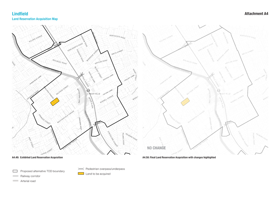
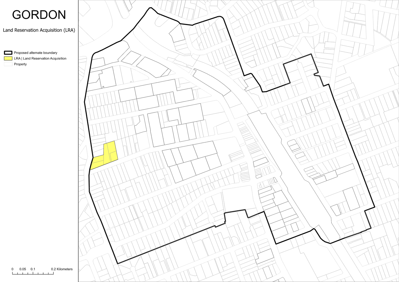
Land Acquisition
Council’s Preferred TOD alternative includes the proposed acquisition of a number of properties for open space and new road links. They are intended to be identified as acquisitions in a reservations map to be gazetted as part of the package of planning controls forming an alternative to the TOD. Council is proposed to be the nominated acquisition authority for these reservations.
Some of these prospective acquisitions have been previously adopted by Council, and partially implemented, though not always reflected in LEP reservations (Roseville Avenue and Dumaresq Street for example). The need for others arises specifically because of extra demand generated by the TOD or a Council alternative to the TOD (Pockley/Shirley and Bent/Newark).
Proposed rezoning for future land acquisition understandably has a significant impact on owners and their families. Council acknowledges this. Council has an ongoing role to plan for future needs for public land for the whole of the community.
The time and timeframes of the current proposals for acquisition have been driven by factors emanating from actions of the NSW government, and it is acknowledged that this has led to a greatly expedited process of public consultation. Council also recognises the uncertainty arising, particularly in relation to timing, amenity impacts, and the valuation of compensation.
It is instructive to note that:
· The compulsory acquisition of land for public purposes, including open space, is a long-established part of the planning system and follows a structured legal process.
· Acquisition is generally not immediate and in the past Council has not initiated compulsory acquisition, with a preference for acquisition at a mutually convenient time. It is expected that Council will use the power to compulsorily acquire sparingly in the future.
· Council will endeavour to acquire land by negotiation if and when requested by an owner. Owner initiated compulsory acquisition can also be triggered in cases of hardship.
· The process for compulsory acquisition, including compensation, is governed by the Land Acquisition (Just Terms Compensation) Act 1991, which includes independent valuation by the Valuer General.
· Whilst Council can indicate planning intent and facilitate owner-initiated acquisition requests where appropriate, Council is not the final arbiter of compensation offers under compulsory acquisition.
It is appreciated that the level of compensation payable in the event of acquisition will be matter of the highest interest to some property owners, however Council is unable to give detailed advice on this to owners. It is appropriate in all cases that owners seek the guidance of their own independent valuation and legal advice. Ultimately, in any compulsory acquisition process, the Valuer General will determine the market value in accordance with the Act, based on the applicable planning controls and relevant market information at the time of acquisition.
Council will strive that its actions embody fairness, transparency, sensitivity and accountability, and we commit to keeping affected residents informed as the planning process progresses.
In the past, Council has purchased land for public open space and road improvements by negotiation or on the open market. It has not been uncommon for there to be a decade between the first purchase of land for a particular park and purchase of the last land parcel for that park. The exceptions have been owner initiated compulsory acquisition and opportunistic acquisitions where a land holding of sufficient size and suitable location has been offered to Council by a party that has agglomerated them.
Once the proposed acquisitions are gazetted, there will be an obligation on Council to purchase them at some point in the future. Therefore, it is possible that Council could be required to acquire numerous properties within a short space of time. It is estimated that the total of the proposed acquisitions could amount to circa $100m.
This level of commitment for property acquisition is not built into the current development contributions plans. However, as of March 2025 there is $105m in the development contribution reserves, collected for various purposes, which may be accessed if required for acquisitions (borrowed) and repaid from future contributions when received. This could potentially impact on the timing of delivery of some planned projects, depending on the timing of acquisitions and the collection of future contributions. It would also be possible, as a last resort, to borrow funds from a bank and repay from future contributions.
The funding of the proposed acquisitions is a cash flow timing issue. In the past Council has generally received in the order of $10m to $20m in development contributions and associated interest per annum. This will substantially escalate in the future noting that even at the capped rate of $20,000 per dwelling, for example, 20,000 new dwellings in the four TOD areas alone would generate some $400m in development contributions.
The reservation of properties for open space and new road links in the proposed new housing plan is critical to support the incoming population. If these properties are not reserved now, they may be developed and the opportunity for acquisition lost.
Social Considerations
The preparation of the TOD Scenarios includes the planning for additional housing choice around the transport nodes, along with supporting the local centres revitalising with opportunities for new retail facilities and new community infrastructure such as new libraries, open space and community centres.
Environmental Considerations
The preparation of the TOD Scenarios has been premised on a series of environmental principles including avoiding environmentally sensitive areas by not encouraging development in areas containing high biodiversity, natural watercourses, steeply sloping land or bushfire affected lands and the principle of minimising tree canopy impacts - allowing more space around new buildings in development areas, to set aside space for existing and future trees, while also encouraging the replacement of any removed trees.
A Transport response is being developed, to mitigate the environmental impacts of new development with improved initiatives for walkability and active transport access to the shops and stations
Community Consultation
Community input was invited on the Preferred Scenario to ensure they were aware of and able to make comments and raise issues or concerns with Council.
The feedback period spanned 21 days (from 2 to 22 April 2025). This is shorted than the Council standard 28-days but was necessary to meeting meet state government deadlines. This engagement represents the second phase of consultation, building on initial community consultation that was conducted in late 2024.
Phase 1 consultation- scenario options
Development of Preferred Scenario was informed by an extensive process of ccommunity engagement undertaken from November-December 2024. The aim of this process was to:
· Ascertain the community’s preferred option out of the five scenarios;
· identify concerns about the scenarios; and
· local factors that may necessitate changes.
The scenarios under consideration were:
Option 1 (Existing NSW Government controls retained)
Option 2a (Safeguard and intensify)
Option 2b (Minor amendments to existing NSW Government controls)
Option 3a (Preserve and intensify)
Option 3b (Preserve, intensify, and expand)
Engagement Methods
The engagement process was wide ranging and included the following engagement approaches:
Representative telephone survey for community members from Gordon and Roseville wards – 193 participants
Two recruited representative workshops for community members from Gordon and Roseville wards.
Online engagement portal including maps
Opt-in community survey – approx. 3000 participants
Public meetings x2 – 200 attendees
Online forum - approx. 90 attendees
Two community drop-in sessions – approx. 50 attendees
Written submissions – 293
The first phase of engagement found that:
Option 3b was the most preferred scenario across all feedback methods.
Surveys ranked Option 1 second, but workshops favoured Option 2a.
Option 1 was also the most disliked in surveys (41% opposition), while Option 2a had little opposition (~4%).
Phase 2 - Preferred Scenario (subject of this report)
As outlined above, community feedback was conducted over a 21-day period (2-22 April, 2025) and focused primary on a survey conducted by Taverner Research who were employed to support Council navigate the project on a shorted than normal timeframe.
The survey was supplemented with written comments received via email and verbal feedback at a community drop-in session.
Information about the project and opportunities to participate were promoted as follows:
|
Communications/promotion methods |
Details |
|
Letter Sent to property owners/ occupants in Roseville and Gordon Wards |
· Approx 27,000 letters |
|
Sent to all participants of phase 1 engagement (who provided contact details) |
· 660 |
|
Press advertising Advertisements promoting the engagement process |
· North Shore Times · Sydney Observer · The Post |
|
Media release Details project and opportunities for community participation to council’s media contact list |
Distributed Wednesday 2 April too over 40 local and national media contacts |
|
Social media posts Designed to promote project – |
· Facebook – Ku-ring-gai – 1505 reach, 119 engagement |
|
E-newsletters Electronic newsletters sent to Council subscribers list via Campaign Monitor |
· Ku-ring-gai News e-news (38k subscribers) - · Business E-news (1.8k subscribers) - · Yoursay E-news, (1187 subscribers) · Housing e-news (2046 subscribers) |
|
Council website and the engagement hub site. Engagement hub site included: · Details maps and explanations of the preferred scenario · Background information including reports and weblinks · Extensive FAQ |
· Total page visits – 12341 · Unique visitors – 5270 · Doc downloads – 8444 |
Engagement process
Survey
The focus for engagement was the survey delivered and managed by Taverner research. The aim was to collect feedback on Council's alternative to the NSW Government's TOD Planning Controls and assess how well the community believed that the preferred scenario aligns with the seven core planning principles which formed the basis of the project. Feedback was also sought to identify specific property matters, create a heatmap of concern clusters (which may necessitate changes), and analyse response variations by demographics, location, and proximity to transport.
The survey had 2,020 verified responses.
The full details of the results can be seen in Taverner’s report in Attachment A1.
Community Drop in sessions
Council staff ran a community drop-in session on Monday, 14 April. Approximately 80 groups attended (120 individuals) to discuss the preferred scenario with Council planning staff. The majority of matters discussed related to individual properties and circumstances, with staff providing clarity around the scenario as it affected individual properties and answered questions on range of matters including timescales, process.
Feedback from the session were recorded and investigated along with feedback captured in the other feedback mechanisms.
Written comments
Although Council requested that all feedback should be made via the survey (to assist in meeting tight deadlines) 293 items of written feedback were received via our Housing email address. Some of these were significant submissions outlining a range of feedback, predominantly on property/location specific matters.
Internal Consultation
Throughout the process of preparing TOD alternatives Councillors have been briefed on the scenarios, community engagement, preferred scenario, and implementation strategy on several occasions throughout 2024 and on the following dates in 2025: 9 January, 6 February and 13 February, 26 March and 2 May 2025.
The General Manager, Director Strategy and Environment and senior Council staff have met regularly with representatives from DPHI during the development of the Preferred Scenario.
Summary
The exhibited plans have been reviewed based on feedback received from residents and advice provided by consultants.
Capacity modelling of the Amended Preferred Scenario (post-exhibition) shows that the four centres can accommodate about 24,500 new dwellings. This broadly matches the yield from the Exhibited Preferred Scenario and remains well above the State’s target of 22,580 total capacity. Overall, the impact of the amendments on dwelling yield is negligible, it is estimated the changes made to the exhibited plans result in a loss of 106 dwellings.
Most of the amendments relate to adjustments to building height (generally reducing heights) to reduce transition impacts and ensuring the principle is applied consistently across the plans. This responds directly to the survey findings which reveal that transition between areas of different densities was one of the main topics of concern. Further adjustments to the TOD boundary are proposed to improve the protection of HCAs and resident amenity.
The most significant risk to Council’s Alternative Scenario is the State Significant Development Application (SSDAs). At the time of writing this report there have been 19 State Significant Development Applications (SSDAs). Council estimates the current SSDA sites are likely to add 1,569 dwellings (without the 30% bonus) over and above the dwelling capacity of Council’s alternate TOD Scenario. This report provides potential options to offset the additional yield from SSDs in Gordon and Lindfield.
That Council:
A. Adopt the draft LEP maps at Attachment A6 and draft clauses at Attachment A7 subject to the amendments outlined in Attachment A8 to reduce yield to offset additional dwellings reflected in known State Significant Development Applications.
B. Submit the amended LEP maps and clauses and a revised implementation strategy reflecting these amendments to DPHI for the purposes of preparing a State Environmental Planning Policy to implement Council’s alternate TOD scheme.
D. Commence preparation of all required amendments to the Ku-ring-gai DCP including site-specific development controls and site amalgamation controls around all heritage items within R4 – High Density Residential zones. That the draft DCP amendments be reported back to Council for endorsement prior to public exhibition.
E. Commence preparation of a Public Domain Plan (PDP) for Killara and amendments to PDP for Gordon, Lindfield and Roseville.
F. That Council authorise the Director of Strategy and Environment to correct any anomalies in the documentation to be submitted to the NSW DPHI.
|
Stephanie Griffiths Senior Urban Designer |
Fae Sarshoghi Urban Design Projects Officer |
|
Bill Royal Team Leader Urban Design |
Craige Wyse Team Leader Urban Planning |
|
Andrew Watson Director Strategy & Environment |
|
|
Attachments: |
A1 |
Community Survey Report |
|
2025/149920 |
|
|
A2 |
Review of Community Feedback |
|
2025/149481 |
|
|
A3 |
Atlas and SJB Consultants Reviews |
|
2025/151228 |
|
|
A4 |
Assessment Summary Table |
|
2025/150520 |
|
|
A5 |
Proposed amendments to exhibited maps |
|
2025/149603 |
|
|
A6 |
Draft Local KLEP Maps |
|
2025/152750 |
|
|
A7 |
Draft Local KLEP Clauses |
|
2025/151483 |
|
|
A8 |
Possible Amendments to Reduce Yield |
|
2025/151667 |